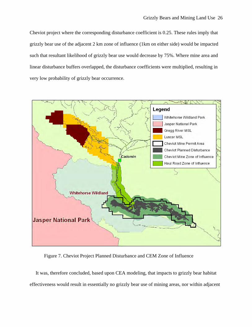
The grizzly bear habitat effectiveness model (HEM) was used in west-central Alberta for
Cumulative Environmental Assessments (1996 and 1999) of the Cheviot open pit coal mine
project. This thesis tested HEM predictions regarding the Cheviot mine with empirical data. The
HEM outputs were disproved for grizzly bear response to mining land use. Further, when tested
at the mining land use scale, current Resource Selection Function (RSF) modelling is not
predictive of grizzly bear occurrence. Grizzly bear movement paths prior to and during mine
disturbance determined that mining land use does not present significant landscape or regional
barriers to grizzly bears. This study examined regional and mining land use opportunities and
risks pertaining to grizzly bears. I provide a critical review of the Cheviot CEA process and the
implications of commitments made by governments and conclude with recommendations for
mining land use and regional planning for grizzly bear protection.
Keywords: Grizzly bear, Ursus arctos horribilis, Habitat effectiveness model, Resource selection function, Models, Cheviot mine, Mining, Land Use, FMFGRP, Environmental impact assessment, Cumulative environmental assessment, Alberta “The role of model testing is not to prove the truth of a model, which is impossible because models are never a perfect description of reality. Rather, testing should help identify the weakest aspects of models so they can be improved”. (McCarthy, M.A., Possingham, H.P., Day, J.R., and Tyre, A.J., 2001).
Grizzly Bears and Effects of Mining iii
Acknowledgements
Maturana states that “the journey is the destiny”. This journey has been one at times
seemingly very private and introvert. At other junctures, I have felt hands around me; supporting,
encouraging, and coaching. To many individuals I am very grateful. My wife, Francine: recently
and gracefully earning your own Masters; I owe you thanks for showing me how it can be done
and inspiring me. Hannah, Mathieu, and Luke: you are the greatest kids that a Dad could have. I
have learned how much I long to be with you and will never take you for granted. Mom and Dad:
always with your words of love and optimism; you are truly appreciated.
I am grateful to Elk Valley Coal’s Cardinal River Operations (CRO). This is the ‘little mine
on the front range of the Rockies’ that has stirred my passion in pursuing this study among many
others. Of course this organization is the sum of its people: fine individuals and friends. Nick
Burt, whose immediate enthusiasm and endorsement was the catalyst in this endeavor. Mark
Pearson, a great mentor for me to work along side. Your sponsorship helped to buffer me so that
I might keep focus. To our environment team, Greg Ross, Curtis Brinker, Christian Weik, Devon
Walker and Derek Elliot and all the ‘Coop Kids’: this is a project that could not have been
completed without your commitment to keeping all other initiatives moving ahead. To John
Kansas, my advisor: our professional paths have crossed for over ten years. It was my privilege
to have you to brainstorm with and to seek understanding. Gord Stenhouse, thank you! Your
timely, patient, and steady guidance and keen insights were very much appreciated.
I am very aware that these and many other unnamed supporters collectively made a
meaningful contribution through this journey. My dependence has been humbling. I am grateful.
Grizzly Bears and Effects of Mining iv
Table of Contents
Abstract ........................................................................................................................................... ii Acknowledgements........................................................................................................................ iii Table of Contents........................................................................................................................... iv List of Figures ................................................................................................................................ vi List of Tables ............................................................................................................................... viii List of Acronyms ........................................................................................................................... ix Chapter One: Introduction .............................................................................................................. 1
The Grizzly Bear as a Valued Ecosystem Component ............................................................... 1 Case Study: Grizzly Bear and the Cheviot Open Pit Coal Mine ................................................ 1
Cheviot Project Regulatory Background ................................................................................ 1 Study Area .............................................................................................................................. 5 Mine Land Use and Reclamation............................................................................................ 7
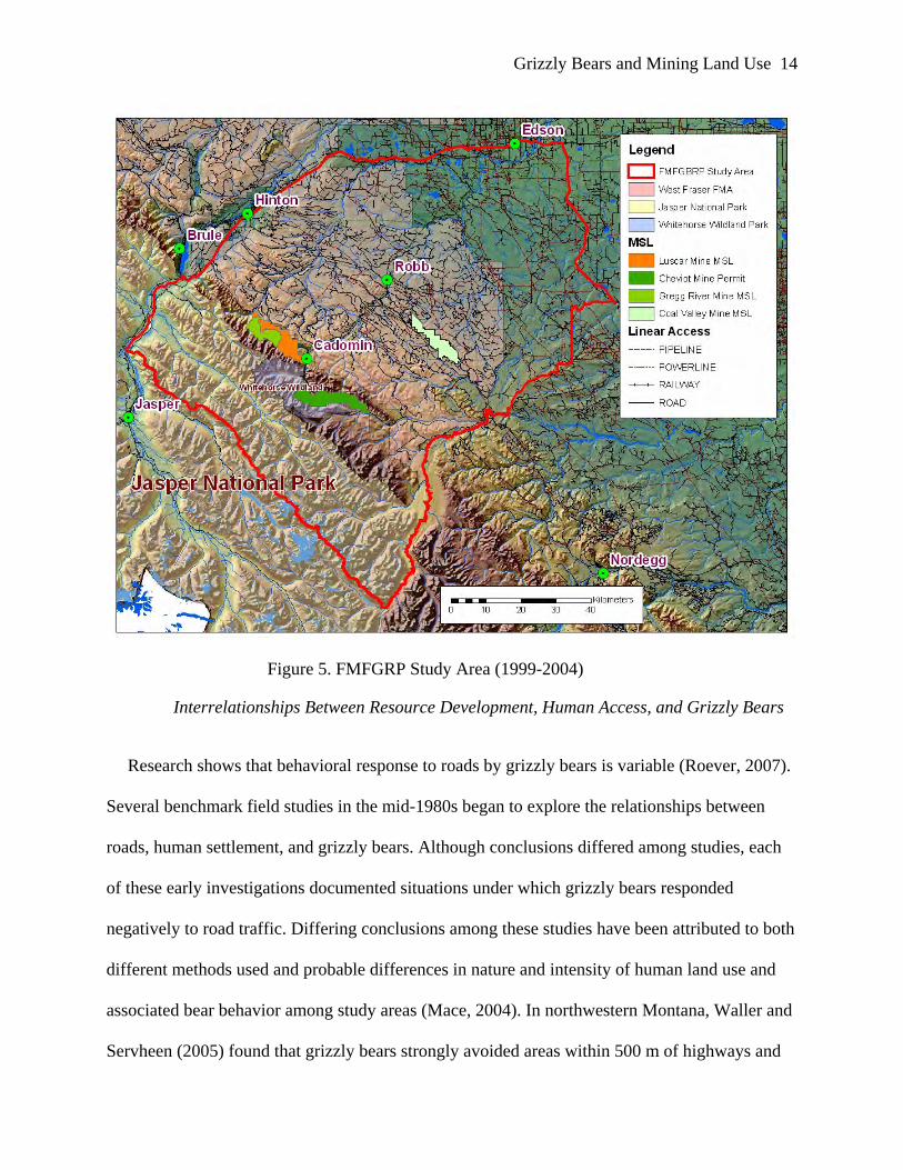
Foothills Model Forest Grizzly Bear Research Program.......................................................... 12 Interrelationships Between Resource Development, Human Access, and Grizzly Bears ........ 14 Thesis Hypothesis and Objectives ............................................................................................ 18
Research Problem ................................................................................................................. 18 Thesis Objectives .................................................................................................................. 18 Research Hypothesis............................................................................................................. 19 Research Questions............................................................................................................... 19
Chapter Two: Testing of the Cheviot 1996 Grizzly Bear CEA Model: Habitat Effectiveness for Mining Land Use .......................................................................................................................... 21
HEM and its use in Cheviot CEA for Grizzly Bears ................................................................ 22 Modeled Disturbance Routine for Mining Land Use ........................................................... 24 Foothills Model Forest Grizzly Research Program: Five Years of Field Study ................... 28
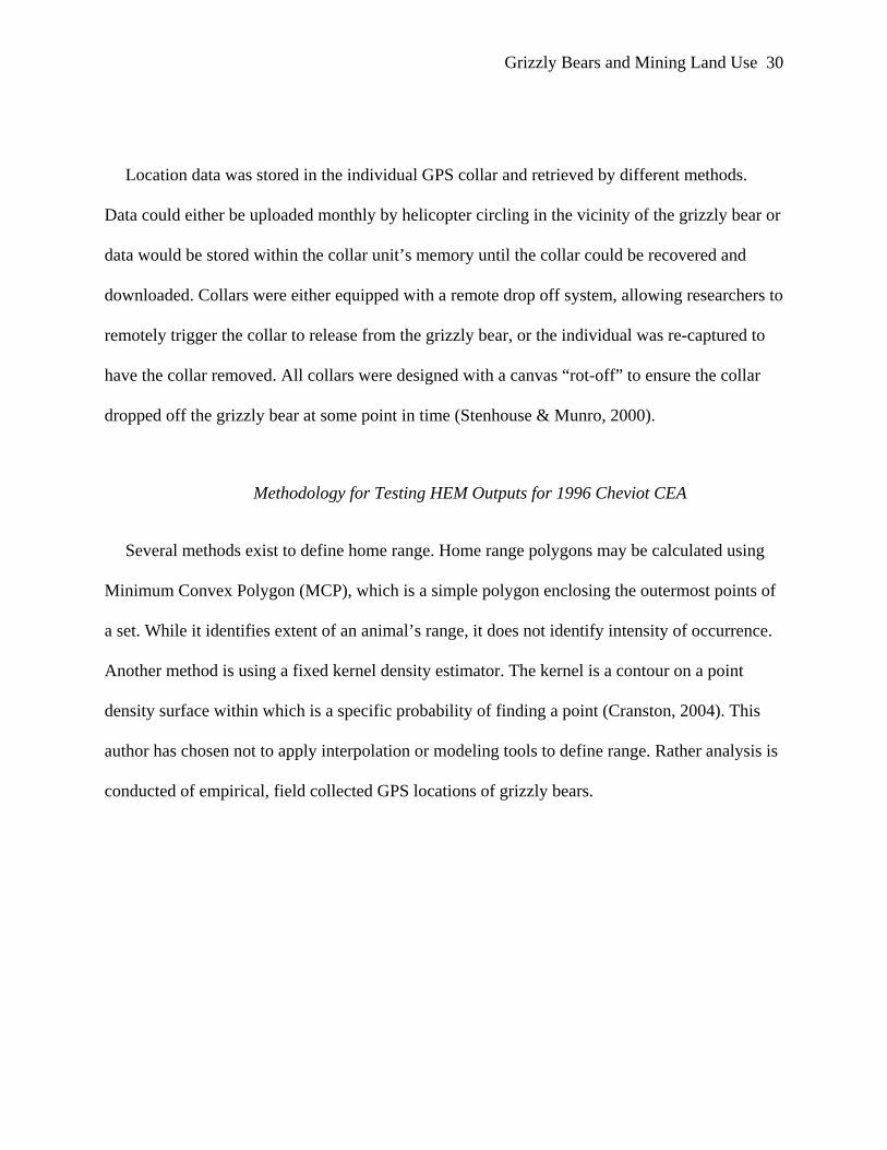
Methodology for Testing HEM Outputs for 1996 Cheviot CEA ............................................. 30 Results....................................................................................................................................... 32 Discussion and Conclusion ....................................................................................................... 34
HEM and its Use for Modeling Grizzly Bear Response to Disturbance .............................. 34 HEM and its Use in Cheviot CEA for Grizzly Bears ........................................................... 35
Chapter Three: Testing New Modeling Tools Developed for Grizzly Bears: RSF Applicability for Mining Land Use..................................................................................................................... 38
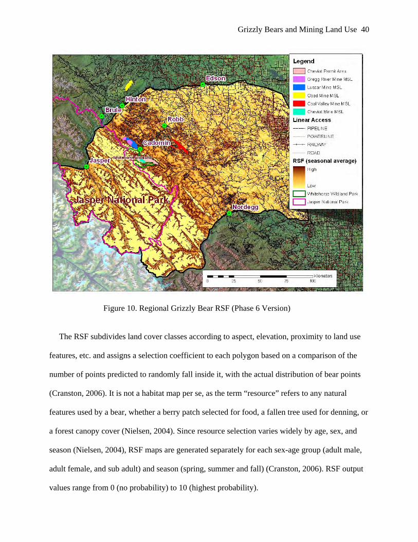
Testing the Resource Selection Function Model ...................................................................... 38 RSF and its Use in Regional Planning for Grizzly Bears ..................................................... 39
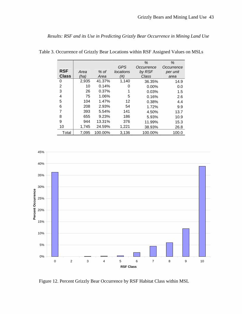
Methodology for Testing RSF on Mining Land Use ................................................................ 41 Results: RSF and its Use in Predicting Grizzly Bear Occurrence in Mining Land Use........... 43 Conclusion and Recommendations........................................................................................... 45
Chapter Four: Case Study of Grizzly Bears and Mining Land Use.............................................. 47 Grizzly Bear Home Range and Mining Land Use .................................................................... 47 G008 & G040 Research Methodology ..................................................................................... 48 Results of Grizzly Bear Occurrence and Mining Land Use Analysis ...................................... 51
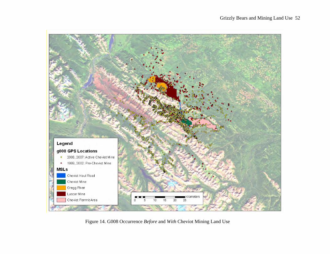
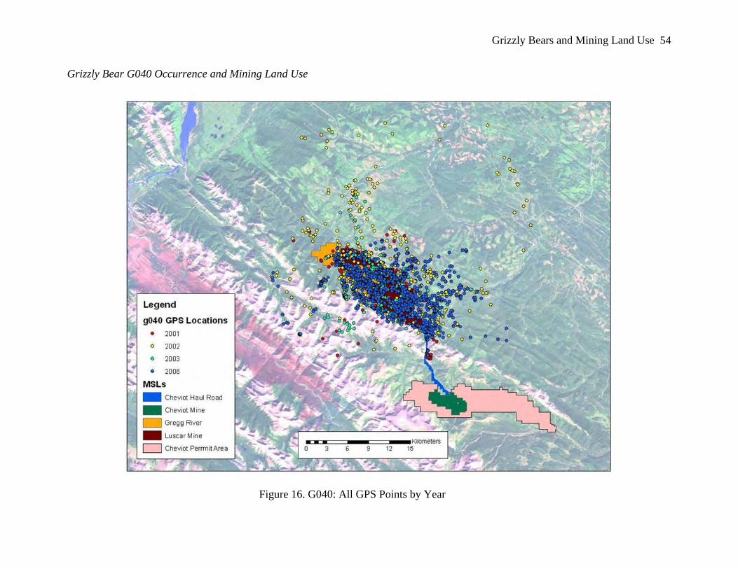
Grizzly Bear G008 Occurrence and Mining Land Use......................................................... 51 Grizzly Bear G040 Occurrence and Mining Land Use......................................................... 54
Results of Grizzly Bear Movement and Mining Land Use Analysis........................................ 56
Grizzly Bears and Effects of Mining v
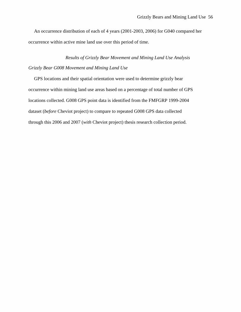
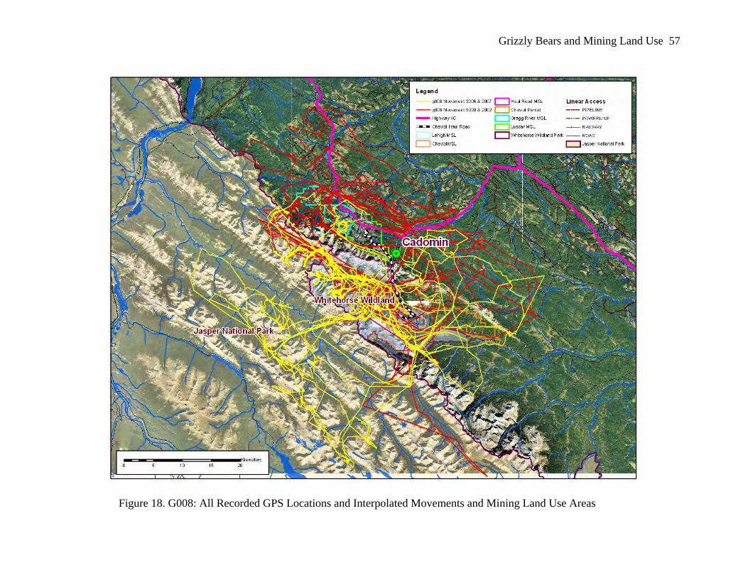
Grizzly Bear G008 Movement and Mining Land Use.......................................................... 56 Grizzly Bear G040 Movement and Mining Land Use.......................................................... 59
Conclusion ................................................................................................................................ 62 Chapter Five: Implications of Research Results and Recommendations for Mining Land Use and Regional Grizzly Bear Management............................................................................................. 66
Managing Human-Caused Mortality ........................................................................................ 67 Human-caused grizzly bear mortality: State of the science.................................................. 68 Alberta................................................................................................................................... 70 NES Region .......................................................................................................................... 71
Managing Human-Caused Mortality to Optimize Mining Land Use Gains............................. 72 Fate of Grizzly Bear G040 and Cubs in 2006....................................................................... 72 Mining Land Use and Regional Grizzly Bear Protection ..................................................... 73 Path Forward for Grizzly Bear Management: Post-Mining Land Use Closure Planning..... 77
Development and Implementation of Alberta Yellowhead Strategic Framework.................... 85 Implications of Cheviot Case Study for EIA and Follow Up: Lessons Learned. ..................... 91 Recommendations for Mine Land Use and Regional Planning for Grizzly Bear Conservation................................................................................................................................................... 92
Mining Industry .................................................................................................................... 92 Government........................................................................................................................... 93 Partnerships........................................................................................................................... 95
References..................................................................................................................................... 98 Appendix 1: Animal Welfare and Research Permits 2006 ......................................................... 108 Appendix 2: Animal Welfare and Research Permits 2007 ......................................................... 118
Grizzly Bears and Effects of Mining vi
List of Figures
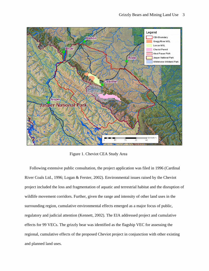
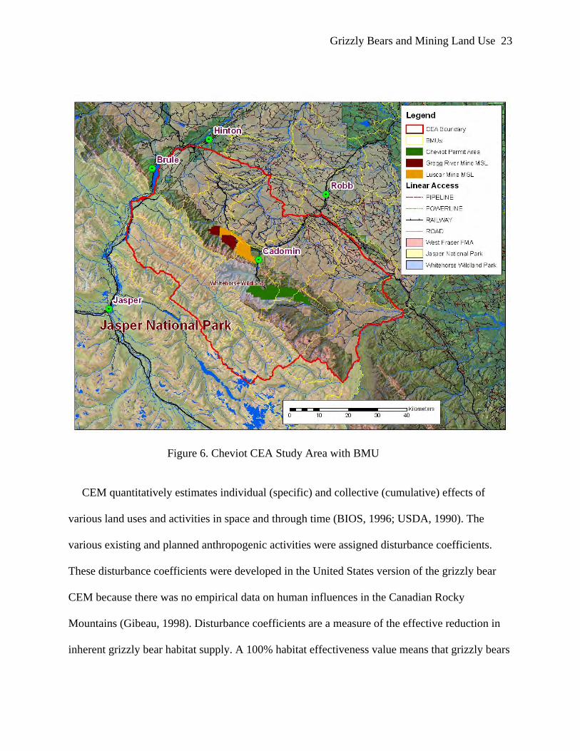
Figure 1. Cheviot CEA Study Area ................................................................................................ 3
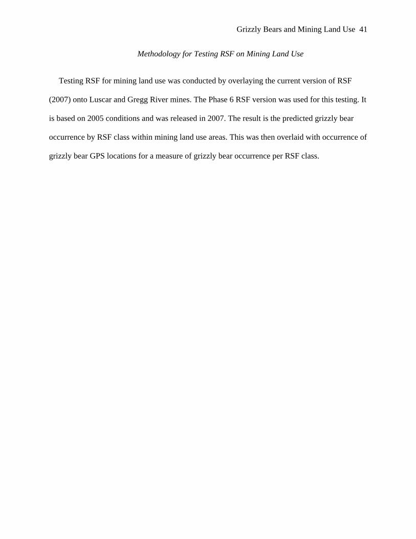
Figure 11. All Grizzly Bear Points within Luscar and Gregg River Mine MSLs with RSF Assigned Values (1-10)......................................................................................... 42
Figure 12. Percent Grizzly Bear Occurrence by RSF Habitat Class within MSL ........................ 43
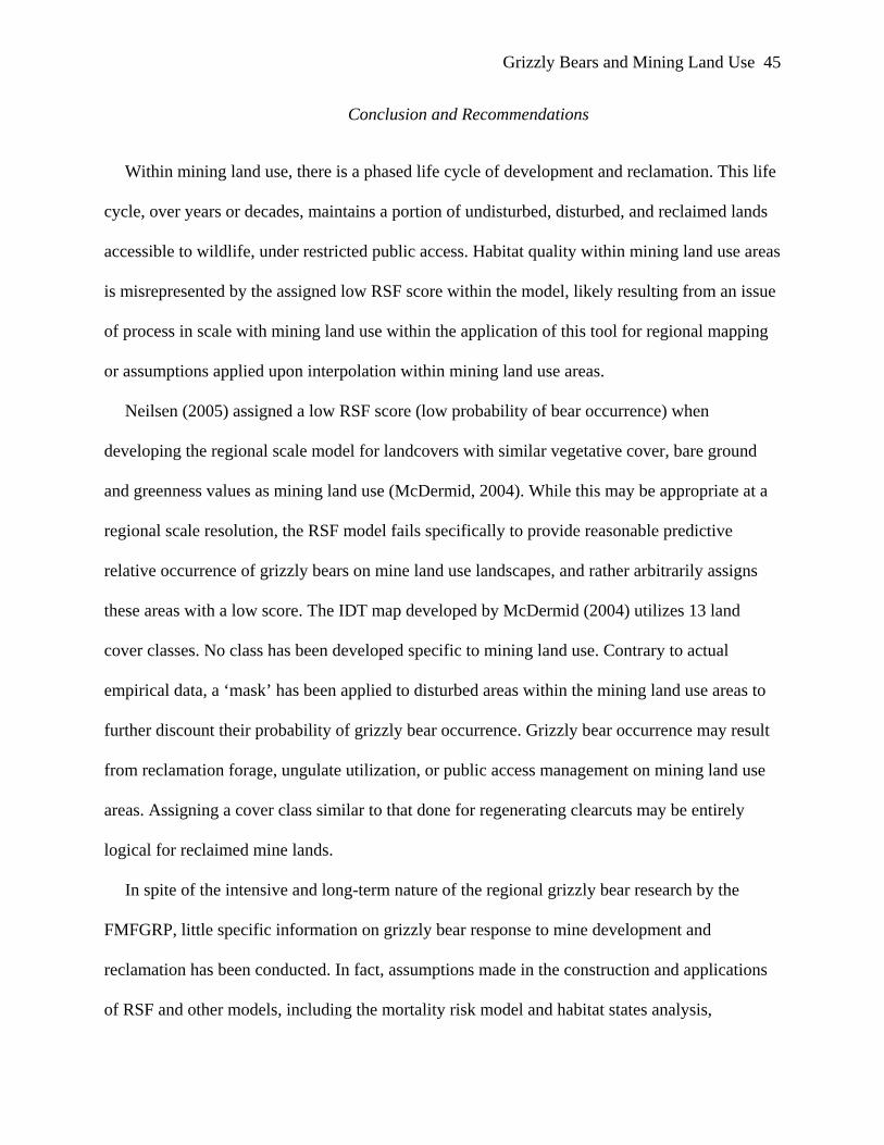
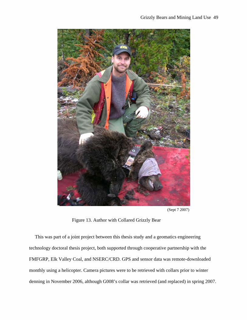
Figure 13. Author with Collared Grizzly Bear ............................................................................. 49
Figure 14. G008 Occurrence Before and With Cheviot Mining Land Use................................... 52
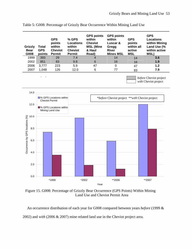
Figure 15. G008: Percentage of Grizzly Bear Occurrence (GPS Points) Within Mining Land Use and Cheviot Permit Area ...................................................................... 53
Figure 16. G040: All GPS Points by Year.................................................................................... 54
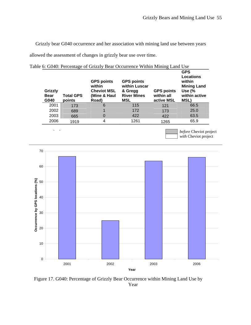
Figure 17. G040: Percentage of Grizzly Bear Occurrence within Mining Land Use by Year....................................................................................................................... 55
Figure 18. G008: All Recorded GPS Locations and Interpolated Movements and Mining Land Use Areas..................................................................................................... 57
Figure 19. G008: Interpolated Movements Before and With Cheviot Mining Land Use ............. 58
Figure 20. G040 Movement Within and Adjacent to Luscar/Gregg River Mining Land Use (2006)............................................................................................................. 60
Grizzly Bears and Effects of Mining vii
Figure 21. Summary of Known Mortalities (1999-2005) of Grizzly Bears within the Yellowhead Ecosystem......................................................................................... 76
Figure 22. Locations of Known Grizzly Bear Mortality Locations (1999-2004)......................... 77
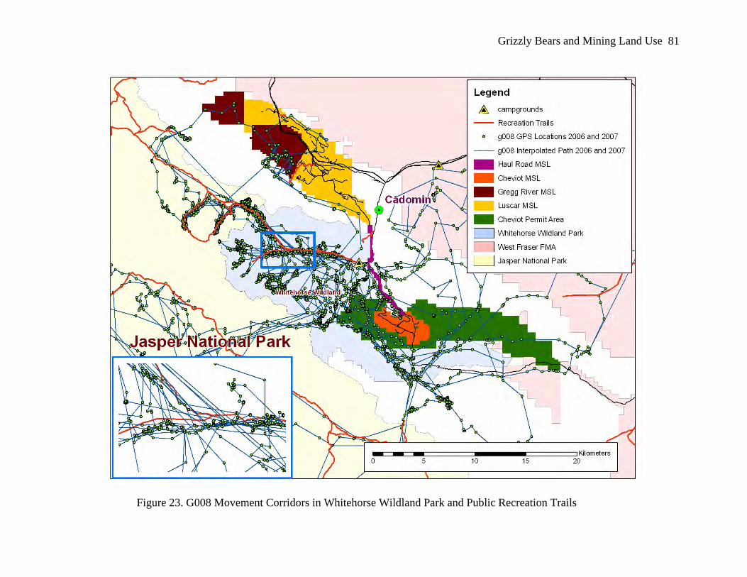
Figure 23. G008 Movement Corridors in Whitehorse Wildland Park and Public Recreation Trails................................................................................................... 81
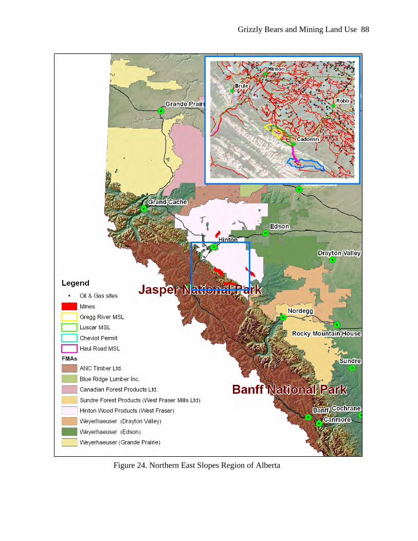
Figure 24. Northern East Slopes Region of Alberta ..................................................................... 88
Grizzly Bears and Effects of Mining viii
List of Tables
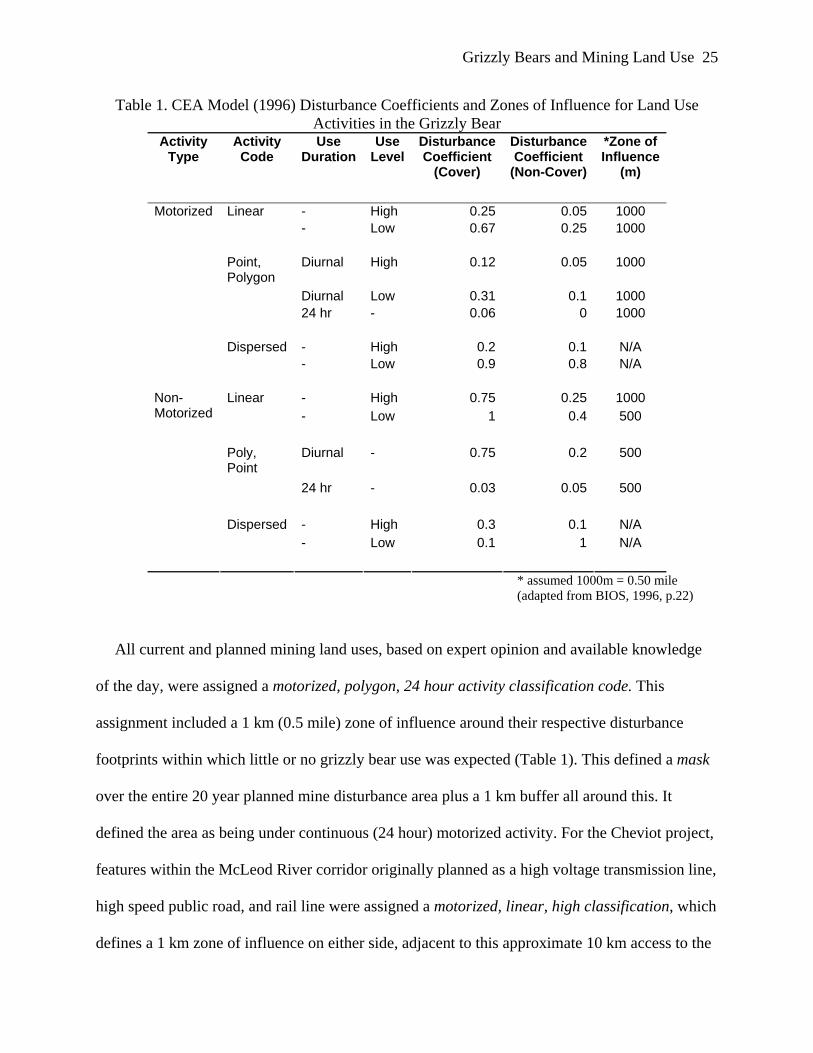
Table 1. CEA Model (1996) Disturbance Coefficients and Zones of Influence for Land Use Activities in the Grizzly Bear ........................................................................ 25
Table 2: Individual Grizzly Bear Occurrence Within Luscar and Gregg River Mines Disturbance ........................................................................................................... 33
Table 3. Occurrence of Grizzly Bear Locations within RSF Assigned Values on MSLs ............ 43
Table 4: Capture Information for Grizzly Bears G008 and G040 ................................................ 51
Table 5: G008: Percentage of Grizzly Bear Occurrence Within Mining Land Use ..................... 53
Table 6: G040: Percentage of Grizzly Bear Occurrence Within Mining Land Use ..................... 55
Table 7: Summary of Known Mortalities (1999-2005) of Grizzly Bears Within the Yellowhead Ecosystem......................................................................................... 75
Grizzly Bears and Effects of Mining ix
List of Acronyms
AEUB: Alberta Energy & Utilities Board
AENV: Alberta Environment
AEP: Alberta Environmental Protection
BMA: Bear management area
CRC: Cardinal River Coals Limited
CEA: Cumulative effects assessment
CEM: Cumulative effects model
Cheviot Project: Cheviot open pit coal mine project
DC: Disturbance coefficient
EIA: Environmental Impact Assessment
FMFGRP: Foothills Model Forest Grizzly Research Program
GIS: Geographic information system
GPS: Geographic positioning system
HEM: Habitat effectiveness model
JNP: Jasper National Park
NESERC: Northern East Slopes Environmental Resources Committee
RSF: Resource selection function
ZOI: Zone of influence
Grizzly Bears and Mining Land Use 1
Chapter One: Introduction
The Grizzly Bear as a Valued Ecosystem Component
Understanding factors that influence and predict grizzly bear distribution and abundance is
fundamental to their conservation (Apps, McLellan, Woods, & Proctor, 2004). Like many large
mammalian carnivores, grizzly bears have been considered to be sensitive to human-induced
landscape change due to their low population density, low fecundity, limited ability to disperse
across open or developed habitat, and other traits that may lower their ecological resilience
(Weaver, Paquet, & Ruggiero, 1996). This makes this animal a potential focal species for use in
regional wildlife conservation planning. As such the grizzly bear has been used throughout North
America as an umbrella species for the management of multiple land use impacts on regional
landscapes (Carroll, Paquet, Noss, & Strittholt, 1998). Conditions necessary for the long-term
persistence of grizzly bears have potential to form the framework within which other elements of
regional-scale conservation planning may be efficiently addressed and human land uses and
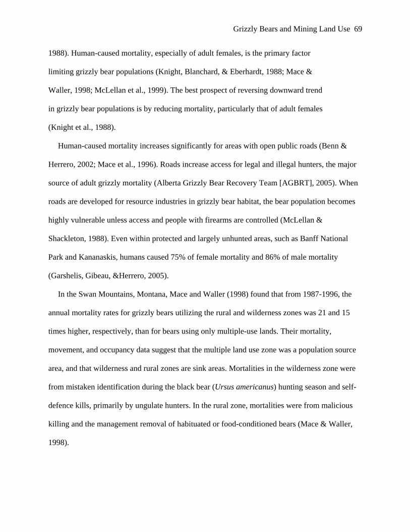
Waller, 1998; McLellan et al., 1999). The best prospect of reversing downward trend
in grizzly bear populations is by reducing mortality, particularly that of adult females
(Knight et al., 1988).
Human-caused mortality increases significantly for areas with open public roads (Benn &
Herrero, 2002; Mace et al., 1996). Roads increase access for legal and illegal hunters, the major
source of adult grizzly mortality (Alberta Grizzly Bear Recovery Team [AGBRT], 2005). When
roads are developed for resource industries in grizzly bear habitat, the bear population becomes
highly vulnerable unless access and people with firearms are controlled (McLellan &
Shackleton, 1988). Even within protected and largely unhunted areas, such as Banff National
Park and Kananaskis, humans caused 75% of female mortality and 86% of male mortality
(Garshelis, Gibeau, &Herrero, 2005).
In the Swan Mountains, Montana, Mace and Waller (1998) found that from 1987-1996, the
annual mortality rates for grizzly bears utilizing the rural and wilderness zones was 21 and 15
times higher, respectively, than for bears using only multiple-use lands. Their mortality,
movement, and occupancy data suggest that the multiple land use zone was a population source
area, and that wilderness and rural zones are sink areas. Mortalities in the wilderness zone were
from mistaken identification during the black bear (Ursus americanus) hunting season and self-
defence kills, primarily by ungulate hunters. In the rural zone, mortalities were from malicious
killing and the management removal of habituated or food-conditioned bears (Mace & Waller,
1998).
Grizzly Bears and Mining Land Use 70
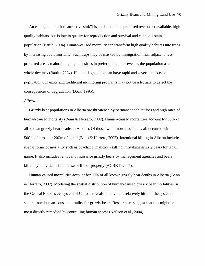
An ecological trap (or “attractive sink”) is a habitat that is preferred over other available, high
quality habitats, but is low in quality for reproduction and survival and cannot sustain a
population (Battin, 2004). Human-caused mortality can transform high quality habitats into traps
by increasing adult mortality. Such traps may be masked by immigration from adjacent, less-
preferred areas, maintaining high densities in preferred habitats even as the population as a
whole declines (Battin, 2004). Habitat degradation can have rapid and severe impacts on
population dynamics and traditional monitoring programs may not be adequate to detect the
consequences of degradation (Doak, 1995).
Alberta
Grizzly bear populations in Alberta are threatened by permanent habitat loss and high rates of
human-caused mortality (Benn & Herrero, 2002). Human-caused mortalities account for 90% of
all known grizzly bear deaths in Alberta. Of those, with known locations, all occurred within
500m of a road or 200m of a trail (Benn & Herrero, 2002). Intentional killing in Alberta includes
illegal forms of mortality such as poaching, malicious killing, mistaking grizzly bears for legal
game. It also includes removal of nuisance grizzly bears by management agencies and bears
killed by individuals in defense of life or property (AGBRT, 2005).
Human-caused mortalities account for 90% of all known grizzly bear deaths in Alberta (Benn
& Herrero, 2002). Modeling the spatial distribution of human-caused grizzly bear mortalities in
the Central Rockies ecosystem of Canada reveals that overall, relatively little of the system is
secure from human-caused mortality for grizzly bears. Researchers suggest that this might be
most directly remedied by controlling human access (Neilson et al., 2004).
Grizzly Bears and Mining Land Use 71
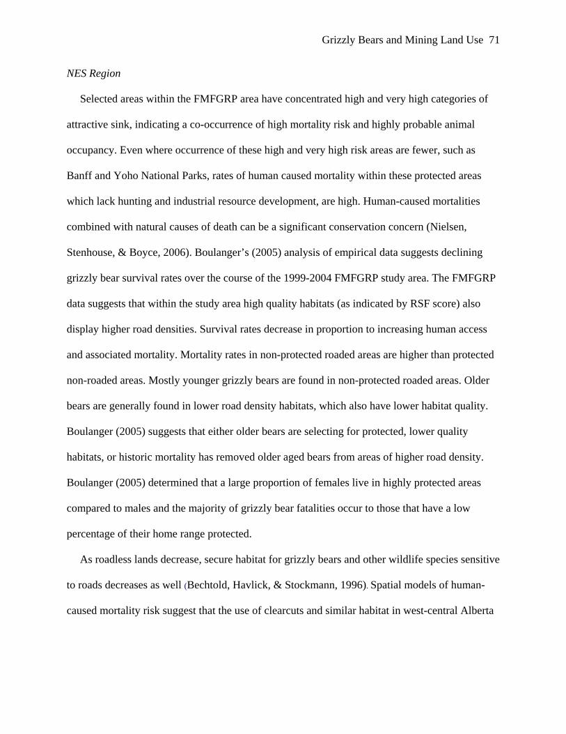
NES Region
Selected areas within the FMFGRP area have concentrated high and very high categories of
attractive sink, indicating a co-occurrence of high mortality risk and highly probable animal
occupancy. Even where occurrence of these high and very high risk areas are fewer, such as
Banff and Yoho National Parks, rates of human caused mortality within these protected areas
which lack hunting and industrial resource development, are high. Human-caused mortalities
combined with natural causes of death can be a significant conservation concern (Nielsen,
Stenhouse, & Boyce, 2006). Boulanger’s (2005) analysis of empirical data suggests declining
grizzly bear survival rates over the course of the 1999-2004 FMFGRP study area. The FMFGRP
data suggests that within the study area high quality habitats (as indicated by RSF score) also
display higher road densities. Survival rates decrease in proportion to increasing human access
and associated mortality. Mortality rates in non-protected roaded areas are higher than protected
non-roaded areas. Mostly younger grizzly bears are found in non-protected roaded areas. Older
bears are generally found in lower road density habitats, which also have lower habitat quality.
Boulanger (2005) suggests that either older bears are selecting for protected, lower quality
habitats, or historic mortality has removed older aged bears from areas of higher road density.
Boulanger (2005) determined that a large proportion of females live in highly protected areas
compared to males and the majority of grizzly bear fatalities occur to those that have a low
percentage of their home range protected.
As roadless lands decrease, secure habitat for grizzly bears and other wildlife species sensitive
to roads decreases as well (Bechtold, Havlick, & Stockmann, 1996). Spatial models of human-
caused mortality risk suggest that the use of clearcuts and similar habitat in west-central Alberta
Grizzly Bears and Mining Land Use 72
result in an ecological trap situation, where animals lack the cues necessary to distinguish the
high-risk condition (Nielsen, 2005).
Neilsen (2005) modeled forest resource development scenarios, including road density and
clearcuts over a predicted 100 year period for different development scenarios. Despite a
potential 10% increase in animal density and potential carrying capacity, effective (secure)
territory units will decline by over 50%. All effective territories, even by year 30, will be located
within or adjacent to protected mountain parks, suggesting a substantial decline in foothills
populations. Without addressing habitat occupancy and mortality concurrently, attractive sink
conditions may be developing where animals are drawn to locations where survival is low
(Knight, Blanchard, & Eberhardt, 1988). This low survival is due primarily to human-caused
mortality. To be effective, a grizzly conservation strategy must consider the status of the entire
regional metapopulation over an area that encompasses both the source and sink populations
(Carroll, Noss, & Paquet, n.d.).
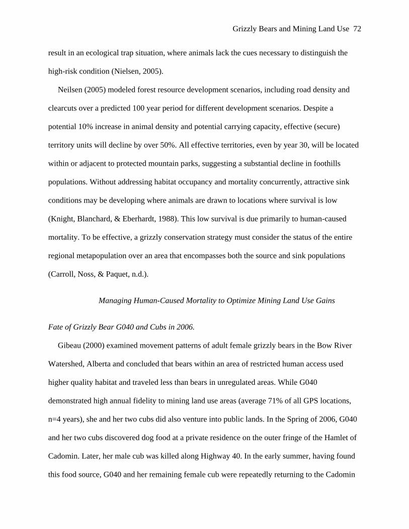
Managing Human-Caused Mortality to Optimize Mining Land Use Gains
Fate of Grizzly Bear G040 and Cubs in 2006.
Gibeau (2000) examined movement patterns of adult female grizzly bears in the Bow River
Watershed, Alberta and concluded that bears within an area of restricted human access used
higher quality habitat and traveled less than bears in unregulated areas. While G040
demonstrated high annual fidelity to mining land use areas (average 71% of all GPS locations,
n=4 years), she and her two cubs did also venture into public lands. In the Spring of 2006, G040
and her two cubs discovered dog food at a private residence on the outer fringe of the Hamlet of
Cadomin. Later, her male cub was killed along Highway 40. In the early summer, having found
this food source, G040 and her remaining female cub were repeatedly returning to the Cadomin
Grizzly Bears and Mining Land Use 73
residence to consume dog food. With this repeat behavior, based upon the provincial bear
response matrix, the government agency deemed that she presented a human safety risk and
intervention was warranted. She and her female cub were therefore captured by Alberta Fish &
Wildlife and translocated; and thus extracted from the regional grizzly bear population. G040
had spent 8 years on this landscape within the same vicinity without prior concern or adverse
human interaction. Arguably, this food conditioning in 2006 might have been most readily
mediated by alternate means of intervention, such as ensuring proper storage of dog food, rather
than removal of the two grizzly bears. G040’s fate, and that of both of her cubs, was similar in
nature to that of her father, G017, who was illegally killed in 2003; furthering the loss of mature
grizzly bears to the population. Wilson (2003) found that grizzly bear deaths in the U.S. tend to
be concentrated on the periphery of core habitats. While not necessarily on the periphery of these
mining land use areas, this is a similar fate for many bears within the region. Schwartz et al
(2006) demonstrated that humans are the single greatest cause of grizzly bear deaths and suggest
that efforts to minimize conflicts between people and bears represent a major component of any
management program directed at long-term conservation.
Mining Land Use and Regional Grizzly Bear Protection
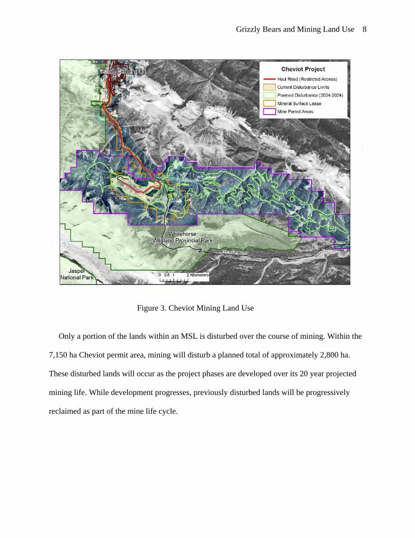
A key mining land use attribute, independent of habitat quality, is public access management.
Currently, all existing and recent mining land use areas in this case study remain under existing
MSL disposition; thus restricting public access and prohibiting hunting. In the thirty five years of
continuous open pit mining in the area, there is no record of any human-caused grizzly bear
mortality (vehicular or other) as a direct result of mining activity. Although human-caused
mortality has not occurred within mining land use areas, some grizzly bears whose home ranges
included the Luscar and Gregg River mines studied from 1999 to 2004, have been killed. These
Grizzly Bears and Mining Land Use 74
consisted of 2 females and 5 male grizzly bears. All grizzly bears were killed outside of the
MSLs and on public lands under provincial jurisdiction.
Grizzly Bears and Mining Land Use 75
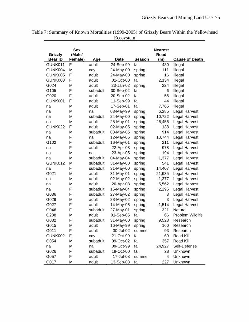
Table 7: Summary of Known Mortalities (1999-2005) of Grizzly Bears Within the Yellowhead Ecosystem
Grizzly Bear ID
Sex (Male/
Female) Age Date Season
Nearest Road (m) Cause of Death
GUNK011 F adult 24-Sep-99 fall 430 Illegal GUNK004 M coy 24-May-00 spring 111 Illegal GUNK005 F adult 24-May-00 spring 16 Illegal GUNK003 F adult 01-Oct-00 fall 2,134 Illegal G024 M adult 23-Jan-02 spring 224 Illegal G105 F subadult 30-Sep-02 fall 6 Illegal G020 F adult 20-Sep-02 fall 56 Illegal GUNK001 F adult 11-Sep-99 fall 44 Illegal na M adult 17-Sep-01 fall 7,765 Illegal na M na 03-May-99 spring 6,285 Legal Harvest na M subadult 24-May-00 spring 10,722 Legal Harvest na M adult 25-May-01 spring 26,456 Legal Harvest GUNK022 F adult 02-May-05 spring 138 Legal Harvest na M subadult 08-May-05 spring 914 Legal Harvest na F na 12-May-05 spring 10,744 Legal Harvest G102 F subadult 16-May-01 spring 211 Legal Harvest na F adult 22-Apr-03 spring 978 Legal Harvest na M na 23-Apr-05 spring 194 Legal Harvest na M subadult 04-May-04 spring 1,377 Legal Harvest GUNK012 M subadult 31-May-00 spring 541 Legal Harvest na F subadult 31-May-00 spring 14,407 Legal Harvest G021 M adult 31-May-01 spring 21,935 Legal Harvest na M adult 02-May-02 spring 1,377 Legal Harvest na M adult 20-Apr-03 spring 5,562 Legal Harvest na F subadult 15-May-04 spring 2,295 Legal Harvest G036 F subadult 27-May-02 spring 8 Legal Harvest G029 M adult 28-May-02 spring 3 Legal Harvest G027 F adult 14-May-05 spring 1,514 Legal Harvest G046 F subadult 27-May-01 spring 321 Natural G208 M adult 01-Sep-05 fall 66 Problem Wildlife G032 F subadult 31-May-00 spring 9,523 Research G015 M adult 16-May-99 spring 160 Research G011 F adult 30-Jul-02 summer 93 Research GUNK002 F coy 21-Oct-99 fall 69 Road Kill G054 M subadult 09-Oct-02 fall 357 Road Kill na M na 09-Oct-99 fall 24,927 Self-Defense G026 F subadult 19-Oct-00 fall 28 Unknown G057 F adult 17-Jul-03 summer 4 Unknown G017 M adult 13-Sep-03 fall 227 Unknown
Grizzly Bears and Mining Land Use 76
0
2
4
6
8
10
12
14
16
18
20
Illegal LegalHarvest
Natural ProblemWildlife
Research Road Kill Self-Defense
Unknown
Num
ber o
f Kno
wn
Hum
an C
ause
d M
orta
litie
s (1
999-
2005
)
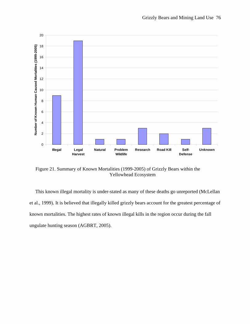
Figure 21. Summary of Known Mortalities (1999-2005) of Grizzly Bears within the Yellowhead Ecosystem
This known illegal mortality is under-stated as many of these deaths go unreported (McLellan
et al., 1999). It is believed that illegally killed grizzly bears account for the greatest percentage of
known mortalities. The highest rates of known illegal kills in the region occur during the fall
ungulate hunting season (AGBRT, 2005).
Grizzly Bears and Mining Land Use 77
Figure 22. Locations of Known Grizzly Bear Mortality Locations (1999-2004)
Some grizzly bears forage within close proximity to human developments such as roads.
These bears suffer much higher mortality rates (Mace & Waller, 1998). It is of critical
importance to review the current state of knowledge regarding human-caused grizzly bear
mortality and its implications to the persistence of this species within the region.
Path Forward for Grizzly Bear Management: Post-Mining Land Use Closure Planning
The Cheviot 1996 and 1999 CEAs employed what was deemed fitting and scientifically
appropriate tools of the day. Since that time, there has been an evolution of knowledge and tools
appropriate for use in conservation of grizzly bear populations in the region. We now know that
Grizzly Bears and Mining Land Use 78
the reclaimed portions of mining land use areas are attractive food sources for grizzly bears
directly and unequivocally to precise management direction or actions, especially for low-density
species such as grizzly bears. (Mace, 2004). However, it was determined that the best scientific
information available would be used in application of the Strategic Framework along with
adaptive management (Skrenek, Hodgins, & Stenhouse, 2002). Adaptive management and
monitoring designed to lead to greater understanding would greatly facilitate management goals
of conserving these ecosystem processes and functions (Gaines, Singleton, & Ross, 2003).
In the Government of Canada (Canada)’s response to the 2000 Cheviot Project AEUB-CEAA
joint review panel decision, Canada committed that it would continue to collaborate with
provincial land use agencies to ensure effective, long-term protection of grizzly bear habitat
values through the Strategic Framework and other joint land use initiatives (Fisheries and Ocean
Canada (2000). Canada would pursue the development of appropriate public accountability
mechanisms to report on the progress of the Strategic Framework and related initiatives. Canada
declared that this interagency collaboration would be a key tool in the protection of the
conservation values of JNP. Given the scale of current and projected future land use activities
identified by the joint review panel, Canada affirmed that timely implementation of
Grizzly Bears and Mining Land Use 91
scientifically-based landscape condition targets were required with or without a Cheviot Project
(Fisheries and Ocean Canada, 2000).
Implications of Cheviot Case Study for EIA and Follow Up: Lessons Learned.
Persistence and the maintenance of the current distribution of grizzly bears throughout the
region will require managing human caused grizzly bear mortality. Further, inductive modeling
for the purposes of project-specific impact assessment continues to be used (Kansas, 2002b) and,
as such, may have significant land use management implications. The use of inductive modeling
often requires the use of datasets and/or assumptions determined elsewhere, and approaches that
are forced to utilize and stress the precautionary principle. Even empirically and regionally
specific based RSF models are prone to potentially erroneous assumptions and simplifications
made in the modeling process (Kansas, 2003). It is imperative that use of both accurate data and
rigorous predictive tools to inform management decisions be utilized. Grizzly bear habitat
effectiveness, or implied utilization, alone is not a valid measure of a proposed industrial
development’s impacts on local or regional grizzly bear populations. Limitations exist in
applying these models at a scale which approximates an individual bear management unit
(BMU). Care must be taken in the application of these models for single project EIA (Kansas,
2003). The models are more predictive to indicate overall condition of a larger landscape within
and among BMUs. Notably however, the models are not sensitive to small-scale development
changes within a single BMU (Cardiff, 2002). This thesis has concluded that the CEA model
disturbance coefficients for mining land use were incorrect and thus render the issue of scale of
analysis secondary.
It is important for conservation biologists and managers to incorporate into conservation
planning an explicit understanding of the relationship between habitat selection and habitat
Grizzly Bears and Mining Land Use 92
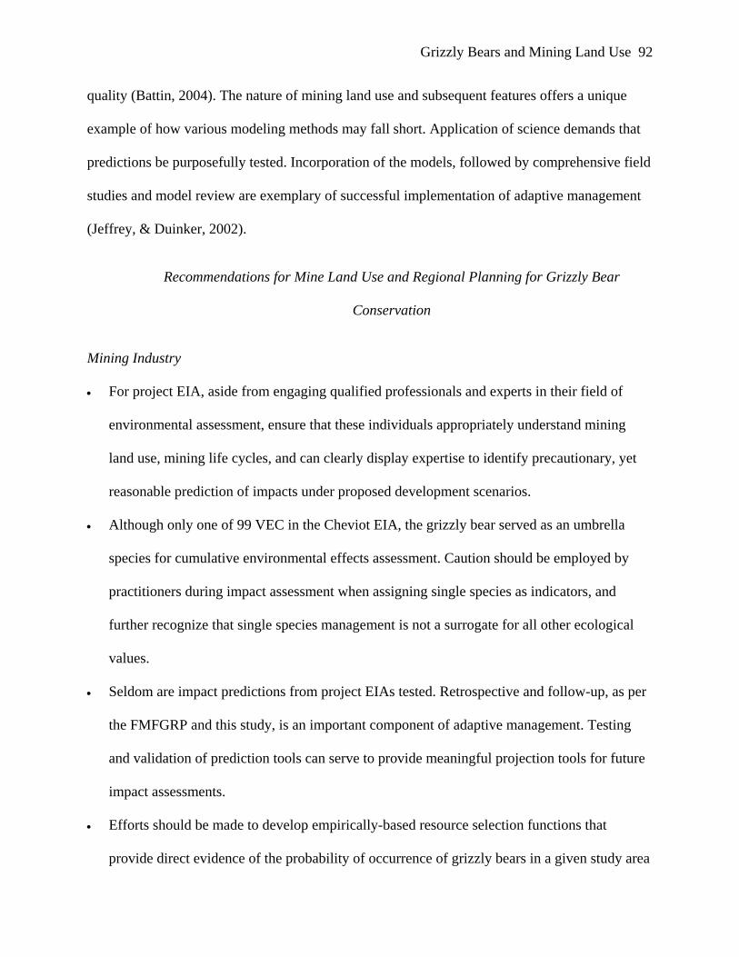
quality (Battin, 2004). The nature of mining land use and subsequent features offers a unique
example of how various modeling methods may fall short. Application of science demands that
predictions be purposefully tested. Incorporation of the models, followed by comprehensive field
studies and model review are exemplary of successful implementation of adaptive management
(Jeffrey, & Duinker, 2002).
Recommendations for Mine Land Use and Regional Planning for Grizzly Bear
Conservation
Mining Industry
• For project EIA, aside from engaging qualified professionals and experts in their field of
environmental assessment, ensure that these individuals appropriately understand mining
land use, mining life cycles, and can clearly display expertise to identify precautionary, yet
reasonable prediction of impacts under proposed development scenarios.
• Although only one of 99 VEC in the Cheviot EIA, the grizzly bear served as an umbrella
species for cumulative environmental effects assessment. Caution should be employed by
practitioners during impact assessment when assigning single species as indicators, and
further recognize that single species management is not a surrogate for all other ecological
values.
• Seldom are impact predictions from project EIAs tested. Retrospective and follow-up, as per
the FMFGRP and this study, is an important component of adaptive management. Testing
and validation of prediction tools can serve to provide meaningful projection tools for future
impact assessments.
• Efforts should be made to develop empirically-based resource selection functions that
provide direct evidence of the probability of occurrence of grizzly bears in a given study area
Grizzly Bears and Mining Land Use 93
of specific cultural and ecological conditions and the behavioral adaptations of grizzly bears
given these conditions. Arbitrary suitability ratings of habitat types should be avoided.
• Throughout an industrial project life cycle, the proponent should regularly engage in a review
process and given current state of knowledge, measure performance metrics, and improve
plans as appropriate based on the premise of adaptive management.
• Resource development proponents have the shared responsibility to promote the evolution of
knowledge and tools to mitigate grizzly bear impacts. Innovation, validation, and application
of new tools should be pursued. Partnerships with government agencies, academia, and
communities of interest should be encouraged and fostered.
• Share gained knowledge and embrace input from communities of interest. Engage these in
planning processes and scenario development. Regulators, academics, and the public at large
need to understand the mining life cycle. Awareness dispels myth and allows informed
dialogue.
Government
Specific grizzly bear conservation measures
• AGBRT recommendations, as included with the Alberta Grizzly Bear Recovery Plan, should
be implemented. Regional programs to reduce human caused mortality in grizzly bear prime
protection areas should capitalized. As identified and explored in this research, specific
opportunities for mining land use areas are available for highly productive grizzly bear safe-
harbours, and should be vigorously pursued.
• Regional enforcement tools and awareness programs should be implemented rather than wide
spread public access restrictions and area closures. Enforcement tools should include
Grizzly Bears and Mining Land Use 94
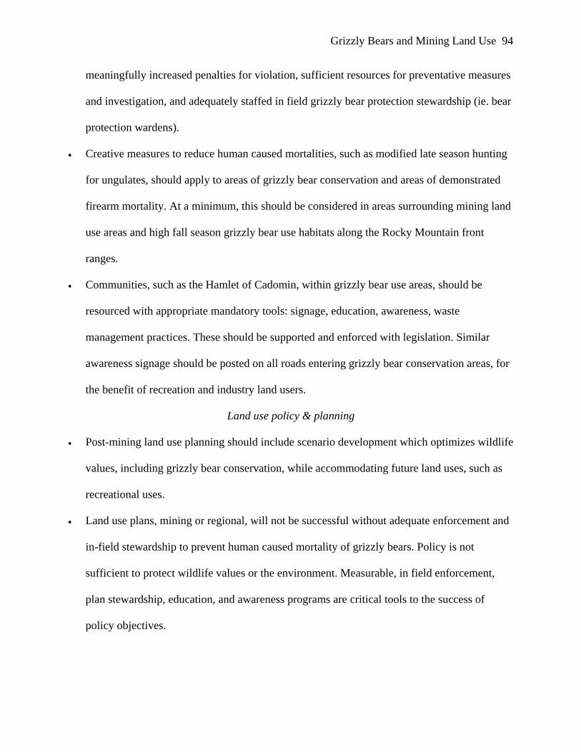
meaningfully increased penalties for violation, sufficient resources for preventative measures
and investigation, and adequately staffed in field grizzly bear protection stewardship (ie. bear
protection wardens).
• Creative measures to reduce human caused mortalities, such as modified late season hunting
for ungulates, should apply to areas of grizzly bear conservation and areas of demonstrated
firearm mortality. At a minimum, this should be considered in areas surrounding mining land
use areas and high fall season grizzly bear use habitats along the Rocky Mountain front
ranges.
• Communities, such as the Hamlet of Cadomin, within grizzly bear use areas, should be
resourced with appropriate mandatory tools: signage, education, awareness, waste
management practices. These should be supported and enforced with legislation. Similar
awareness signage should be posted on all roads entering grizzly bear conservation areas, for
the benefit of recreation and industry land users.
Land use policy & planning
• Post-mining land use planning should include scenario development which optimizes wildlife
values, including grizzly bear conservation, while accommodating future land uses, such as
recreational uses.
• Land use plans, mining or regional, will not be successful without adequate enforcement and
in-field stewardship to prevent human caused mortality of grizzly bears. Policy is not
sufficient to protect wildlife values or the environment. Measurable, in field enforcement,
plan stewardship, education, and awareness programs are critical tools to the success of
policy objectives.
Grizzly Bears and Mining Land Use 95
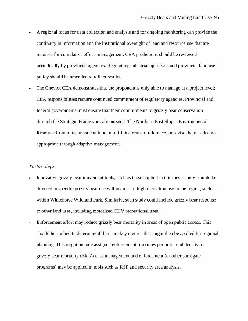
• A regional focus for data collection and analysis and for ongoing monitoring can provide the
continuity in information and the institutional oversight of land and resource use that are
required for cumulative effects management. CEA predictions should be reviewed
periodically by provincial agencies. Regulatory industrial approvals and provincial land use
policy should be amended to reflect results.
• The Cheviot CEA demonstrates that the proponent is only able to manage at a project level;
CEA responsibilities require continued commitment of regulatory agencies. Provincial and
federal governments must ensure that their commitments to grizzly bear conservation
through the Strategic Framework are pursued. The Northern East Slopes Environmental
Resource Committee must continue to fulfill its terms of reference, or revise them as deemed
appropriate through adaptive management.
Partnerships
• Innovative grizzly bear movement tools, such as those applied in this thesis study, should be
directed to specific grizzly bear use within areas of high recreation use in the region, such as
within Whitehorse Wildland Park. Similarly, such study could include grizzly bear response
to other land uses, including motorized OHV recreational uses.
• Enforcement effort may reduce grizzly bear mortality in areas of open public access. This
should be studied to determine if there are key metrics that might then be applied for regional
planning. This might include assigned enforcement resources per unit, road density, or
grizzly bear mortality risk. Access management and enforcement (or other surrogate
programs) may be applied in tools such as RSF and security area analysis.
Grizzly Bears and Mining Land Use 96
• Inductive modeling tools should be applied only at appropriate scales and validated using site
specific empirical data. These tools may apply assumptions developed and tested elsewhere
that do not apply in specific EIA conditions. These models are relatively well standardized
and outputs are easily interpreted, making them valuable tools for decision makers and for
communication. Caution should be used in their application to ensure that project parameters
are well understood by the modeler and that assumptions are appropriate for site specific
conditions. These should be supported with empirical data.
• Further technology development for long term empirical monitoring of grizzly bear
movements should be encouraged. Monitoring technologies which are less invasive and
minimize direct human-grizzly bear interaction should be pursued. These may include multi-
year, robust equipment with fully remote data downloading capability.
• The Cheviot project was the catalyst to a world class grizzly bear research program. The
FMFGRP has since continued to evolve and expand across the province. This partnership of
governments, industry, and academia exemplifies the outstanding innovation and knowledge,
and development and application of tools that can result from enterprise with common
purpose. Focused research should be based on prioritization of needs by these partners.
Restricting public access into grizzly bear range is presented by many conservation biologists
as a cause-effect relationship to reduce human caused mortality. Such a recommendation is not
necessarily responsive to the people of Alberta. As a management solution, it may be detrimental
to the grizzly bear conservation initiative. Closing areas will not modify human behavior –
required to reduce intentional human caused grizzly bear mortality; allowing people to use and
respect these areas provide formative opportunities to endorse and encourage support for
conservation measures, while promoting education opportunities. This thesis has demonstrated
Grizzly Bears and Mining Land Use 97
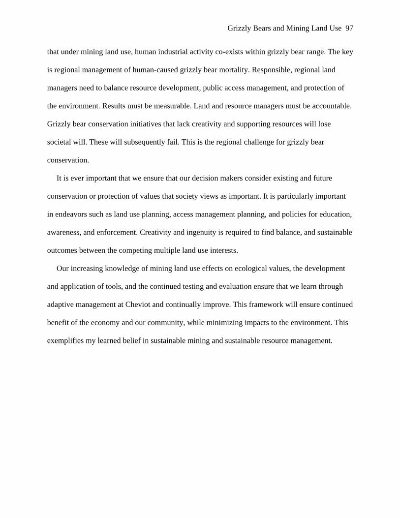
that under mining land use, human industrial activity co-exists within grizzly bear range. The key
is regional management of human-caused grizzly bear mortality. Responsible, regional land
managers need to balance resource development, public access management, and protection of
the environment. Results must be measurable. Land and resource managers must be accountable.
Grizzly bear conservation initiatives that lack creativity and supporting resources will lose
societal will. These will subsequently fail. This is the regional challenge for grizzly bear
conservation.
It is ever important that we ensure that our decision makers consider existing and future
conservation or protection of values that society views as important. It is particularly important
in endeavors such as land use planning, access management planning, and policies for education,
awareness, and enforcement. Creativity and ingenuity is required to find balance, and sustainable
outcomes between the competing multiple land use interests.
Our increasing knowledge of mining land use effects on ecological values, the development
and application of tools, and the continued testing and evaluation ensure that we learn through
adaptive management at Cheviot and continually improve. This framework will ensure continued
benefit of the economy and our community, while minimizing impacts to the environment. This
exemplifies my learned belief in sustainable mining and sustainable resource management.
Grizzly Bears and Mining Land Use 98
References Alberta Energy and Utilities Board - Canadian Environmental Assessment Agency (AEUB- CEAA). (1997). Decision 97-8 Report of the EUB-CEAA Joint Review Panel, Cheviot Coal Project, Mountain Park Area, Alberta, Cardinal River Coals Ltd. Calgary, AB/Hull, ON: Author. Retrieved September 1, 2007 from http://www.eub.ca/docs/documents/decisions/1997/D97-08.pdf Alberta Energy and Utilities Board - Canadian Environmental Assessment Agency (AEUB- CEAA). (2000). Decision 2000-59 Report of the EUB-CEAA Joint Review Panel, Cheviot Coal Project, Mountain Park Area, Alberta, Cardinal River Coals Ltd. Calgary, AB/Hull, ON: Author. Retrieved September 1, 2007 from http://www.eub.ca/docs/documents/decisions/2000/2000-59.pdf Alberta Environmental Appeals Board. (January, 1999). Parry et. al. vs. Regional Director, Northern East Slopes Region, Alberta Environmental Protection, Re: Cardinal River Coals Ltd.(18 January, 1999). Calgary, AB: Author. December 8, 2007 from http://www.eab.gov.ab.ca/dec/98-246%20and%2098-248.htm Alberta Environmental Appeals Board. (2003, May 16). Gadd vs. Director, Central Region, Regional Services, Alberta Environment Re: Cardinal River Coal, Cheviot and Luscar Mine. (Appeal No. 03-004-DOP). Calgary, AB: Author. Retrieved December 8, 2007 from http://www.eab.gov.ab.ca/dec/03-004-DOP.pdf Alberta Environmental Appeals Board. (2004a). Gadd vs. Director, Central Region, Regional Services, Alberta Environment Re: Cardinal River Coals Ltd. (8 October, 2004) (Preliminary Motions, Appeal Nos. 03-150, 03-151 and 03-152ID1). Calgary, AB: Author. Retrieved December 8, 2007 from http://www.eab.gov.ab.ca/dec/03-150-152-ID1-Cardinal%20River- Oct%208,%202004.pdf Alberta Environmental Appeals Board. (2004b). Gadd vs. Director, Central Region, Regional Services, Alberta Environment Re: Cardinal River Coals Ltd. (12 October, 2004). (Appeal Nos. 03-150, 03-151 and 03-152-ID2). Calgary, Ab: Author. Retrieved December 8, 2007 from http://www.eab.gov.ab.ca/dec/03-150-152-ID2-Oct%2012,%202004.pdf Alberta Environmental Appeals Board. (2004c). Higgins vs. Director, Central Region, Regional Services, Alberta Environment Re Cardinal River Coals Ltd. (27 October, 2004). (Appeal No. 04-053-D). Calgary, AB: Author. Retrieved December 8, 2007 from http://www.eab.gov.ab.ca/dec/04-053-D-Oct%2027,%202004.pdf Alberta Environmental Appeals Board. (2005a). Higgins vs. Director, Central Region, Regional Services, Alberta Environment Re Cardinal River Coals Ltd. (11 January, 2005). (Appeal No. 04-053-RD). Calgary, AB: Author. Retrieved December 8, 2007 from http://www.eab.gov.ab.ca/dec/04-053-RD-Jan%2011,%202005.pdf
Grizzly Bears and Mining Land Use 99
Alberta Environmental Appeals Board. (2005b). Higgins vs. Director, Central Region, Regional Services, Alberta Environment Re Cardinal River Coals Ltd. (26 August, 2005). (Appeal No. 04-054-D). Calgary, AB: Author. Retrieved December 8, 2007 from http://www.eab.gov.ab.ca/dec/04-054-D.pdf Alberta Environmental Appeals Board. (2007). Higgins vs. Director, Central Region, Regional Services, Alberta Environment re Cardinal River Coals Ltd. (30 March, 2007). (Appeal No. 04-054-D2). December 8, 2007 from http://www.eab.gov.ab.ca/dec/04-054-D2.pdf Alberta Environmental Protection (EPA). (1995). Cardinal River Coals Ltd. terms of reference for the proposed Cheviot Mine development environmental impact assessment. Edmonton, AB: Author. Alberta Grizzly Bear Recovery Team. (2005). Draft Alberta grizzly bear recovery plan. (Alberta Species Risk Recovery Plan No. x). Edmonton, AB: Alberta Sustainable Resource Development, Fish and Wildlife Division. Apps, C. D. (1993). Cumulative effects assessment for large carnivores: A literature review and development strategy for the Canadian Rockies. Ottawa, ON: Canadian Parks Service. Apps, C. D., McLellan, B. N., Woods, J. G., & Proctor, M. F. (2004). Estimating grizzly bear distribution and abundance relative to habitat and human influence. Journal of Wildlife Management, 68(1), 138-152. AXYS Environmental Consulting Ltd. (2000). Regional approaches to managing cumulative effects in Canada’s north. Yellowknife, NWT: Department of the Environment, Government of Canada. Battin, J. (2004). When good animals love bad habitats: Ecological traps and the conservation of animal populations. Conservation Biology, 18(6), 1482-1491. Bechtold, T., Havlick, D., & Stockmann, K. (1996). Analysis of road densities in selected grizzly bear management units in the northern Rockies. In Proceedings of the Sixteenth Annual ESRI Annual User Conference, 2006. Retrieved September 10, 2007 from http://training.esri.com/campus/library/Bibliography/RecordDetail.cfm?ID=10973&startr ow=1&hidpage=1&browseonly=0 Benn, B., & Herrero, S. (2002). Grizzly bear mortality and human access in Banff and Yoho National Parks, 1971-1998. Ursus 13, 213-221. BIOS Environmental Research and Planning Associates Ltd. (1996). Cheviot Mine Project: Specific and cumulative environmental effects analysis of mammalian carnivores. In Cardinal River Coals Ltd. Cheviot Mine Project application, February, 1996 (Appendix 34). Hinton, AB: Cardinal River Coals Ltd.
Grizzly Bears and Mining Land Use 100
Boulanger, J., Stenhouse, G., & Munro, R. (2004). Sources of heterogeneity bias when DNA mark-recapture sampling methods are applied to grizzly bears (Ursus arctos) populations. Journal of Mammalogy, 85, 618-624. Boulanger, J., Stenhouse, G., Proctor, M., Himmer, S., Paetkau, D., & Cranston, J. (2005). 2004 population inventory and density estimates for the Alberta 3B and 4B grizzly bear management area. Report prepared for Alberta Sustainable Resource Development, Fish and Wildlife Division. Hinton, AB: Author. Retrieved October 8 2007 from http://srd.alberta.ca/fishwildlife/wildlifeinalberta/grizzlybearmanagement/default.aspx Boulanger, J. (2005). Demography of Foothills Model Forest grizzly bears: 1999-2003. Edmonton, AB: Foothills Model Forest Grizzly Bear Project. Boyce, M. & McDonald, L. (1999). Relating populations to habitats using resource selection functions. Trends in Ecology and Evolution, 14 (7). 268-272. Burt, W. H. (1943). Territoriality and home range concepts as applied to mammals. Journal of Mammalogy, 24, 346-352. Busch, R. H. (2000). The grizzly almanac. Markham, ON: The Lyons Press. Cardiff, S. (2002). Managing cumulative effects. In A. Kennedy (Ed.), Alberta Society of Professional Biologists Symposium 2000. Cumulative environmental effects management Tools and Approaches. (pp. 247-265). Edmonton, AB: Alberta Society of Professional Biologists. Cardinal River Coals Ltd. (1996). Cheviot mine project application. Hinton, AB: Author. Carroll, C., Noss, R. F., & Paquet, P. C. (n.d.). Carnivores as focal species for conservation planning in the rocky mountain region. Rocky Mountain Carnivore Conservation Project, World Wildlife Fund. Carroll, C., Paquet, R., Noss, R., & Strittholt, J. (1998). Modeling carnivore habitat in the Rocky Mountain region: A literature review and suggested strategy. (Draft report to World Wildlife Fund). Corvallis, OR: Conservation Biology Institute. Christensen, A.G. (1986). Cumulative effects analysis: Origins, acceptance and value to grizzly bear management. In: G. P. Contreras, & K. E. Evans (Eds.), Grizzly Bear Habitat Symposium (pp. 213-216). Inter. Res. Sta., General. Technical Report. INT-207.252. Chrusczcz, B., Clevenger, A. P., Gunson, K. E., & Gibeau, M. L. (2003). Relationships among grizzly bears, highways, and habitat in the Bow Valley, Alberta, Canada. Canadian Journal of Zoology, 81,1378-1391.
Grizzly Bears and Mining Land Use 101
Cranston, J. (2006). Predicting changes in grizzly bear habitat quality using geoprocessing scripts. In Proceedings of the Twenty-Sixth Annual ESRI Annual User Conference, 2006. Retrieved September 10, 2007 from http://training.esri.com/campus/library/Bibliography/RecordDetail.cfm?ID=45514&startr ow=1&hidpage=1&browseonly=0 Cranston, J. (2004). Understanding grizzly bears using GIS. Hinton, AB: Foothills Model Forest. Retrieved February 15, 2008 from http://gis.esri.com/library/userconf/proc04/docs/pap1230.pdf Creasey, R. (2002). Moving from project-based cumulative effects assessment to regional environmental management. In A. Kennedy (Ed.), Alberta Society of Professional Biologists Symposium 2000. Cumulative environmental effects management –Tools and approaches (pp. 3-16). Edmonton, AB: Alberta Society of Professional Biologists. Damman, D. C. (2002). The challenges of developing regional frameworks for cumulative effects assessment. In A. Kennedy (Ed.), Alberta Society of Professional Biologists Symposium 2000. Cumulative environmental effects management –Tools and approaches (pp. 247-265). Edmonton, AB: Alberta Society of Professional Biologists. Delibes, M., Gaona, P., & Ferreras, P. (2001). Effects of an attractive sink leading into maladaptive habitat selection. The American Naturalist, 158,(3). 277-285. Doak, D. F. (1995). Source-sink models and the problem of habitat degradation: General models and application to the Yellowstone grizzly. Conservation Biology, 9(6).1370-1379. Equus Consulting Group Inc. (1999). Cheviot Mine cumulative effects assessment: Public Access – Recreation. In Cardinal River Coals Ltd. Cheviot Mine Cumulative Effects Assessment, November, 1999 (Appendix 11). Hinton, AB: Cardinal River Coals Ltd. Fisheries and Ocean Canada (2000). Federal Government response to the September 12, 2000 environmental assessment report of the EUB-CEAA: Joint review panel on the Cheviot coal project. Ottawa, ON: Author. Retrieved September 7, 2007 from http://www.dfo- mpo.gc.ca/media/backgrou/2001/hq-ac29_e.htm Foothills Model Forest (2008). Grizzly bear program publications. Retrieved January 24, 2008 from http://www.fmf.ca/publications.html#GrizzlyBear Frair, J. L., Nielsen, S. E., Merrill, E. H., Lele, S. R., Boyce, M. S., & Munro, R. H. M. (2004). Removing GPS collar bias in habitat selection studies. Journal of Applied Ecology, 41(2), 201-212.
Grizzly Bears and Mining Land Use 102
Gaines, W. L., Singleton, P. H., & Ross, R. C. (2003). Assessing the cumulative effects of linear recreation routes on wildlife habitats on the Okanogan and Wenatchee National Forests (General Technical Report), Washington, D.C: United States Forest Service. Garshelis, D. L., Gibeau, M. L., & Herrero, S. (2005). Grizzly bear demographics in and around Banff National Park and Kananaskis Country, Alberta. Journal of Wildlife Management, 69(1), 277-297. Gibeau, M. L. (2000). A conservation biology approach to management of grizzly bears in Banff National Park, Alberta. Unpublished doctoral dissertation, University of Calgary, Calgary, Alberta, Canada. Gibeau, M. L. (1998). Grizzly bear habitat effectiveness model for Banff, Yoho and Kootenay National Parks, Canada. Ursus 10, 235-241. Gibeau, M. L., Herrero, S., Kansas, J. L., & Benn, B. (1996). Grizzly bear populations and habitat status in Banff National Park (Report No. xx, p.61). Report presented to the Banff Bow-Valley Task Force, Calgary, AB. Hegmann, G., Cocklin, C., Creasey, R., Dupuis, S., Kennedy, A., Kingsley, L., Ross, W., Spaling, H., & Stalker, D. (1999). Cumulative Effects Assessment Practitioners Guide. Hull, QB: AXYS Environmental Consulting Ltd. and the CEA Working Group for the Canadian Environmental Assessment Agency. Herrero, S., Smith, T., DeBruyn, T. D., Gunther, K., & Matt, C. (2005). From the field: Brown bear habituation to people: Safety, risks, and benefits. Wildlife Society Bulletin, 33(1), 362- 373. Herrero, S. (2000). The proposed Cheviot mine: cumulative effects, conservation and management issues regarding grizzly bears. Report prepared for Cardinal River Coals Ltd., Hinton, AB. Holling, C. S. (1973). Resilience and stability of ecological systems. Annual Review of Ecology and Systematics, 4, 1-23. Hood, G. A., & Parket, K. L. (2001). Impact of human activities on grizzly bear habitat in Jasper National Park. Wildlife Society Bulletin, 29(2), 626-641. Hooge, P., & Eichenlaub, B. (1997). Animal movement extension to ArcView version 1.1. Alaska Biological Science Centre. Anchorage, AK: U.S.Geological Survey. Horejsi, B. L. (1989). Uncontrolled land-use threatens an international grizzly bear population. Conservation Biology 3(3), 220-226. Jeffrey, B., & Duinker, P. (2002). A comparative analysis of cumulative impact assessments involving mining developments and species at risk. In A. Kennedy (Ed.), Alberta Society of
Grizzly Bears and Mining Land Use 103
Professional Biologists Symposium 2000. Cumulative environmental effects management – Tools and Approaches (pp. 77-96). Edmonton, AB: Alberta Society of Professional Biologists. Kansas, J.L. (2002a). Status of the grizzly bear (Ursus arctos) in Alberta. Alberta Status Report
No. 37. Alberta Conservation Association and Alberta Sustainable Resource Development. Edmonton, AB.
Kansas, J. L. (2002b). Critical review of methods to evaluate grizzly bear cumulative effects. In A. Kennedy (Ed.), Alberta Society of Professional Biologists Symposium 2000. Cumulative environmental effects management –Tools and Approaches (pp. 247-265). Edmonton, AB: Alberta Society of Professional Biologists. Kansas, J. L. (2003). Effects of mapping scale, disturbance coefficients and season on grizzly bear habitat effectiveness models in Kananaskis country, Alberta. Unpublished Master’s thesis, University of Calgary, Calgary, AB. Kansas, J. L. (2005). Grizzly bears and mining in the Cheviot region: Retrospective analysis (Report Prepared for Cardinal River Operations). Calgary, AB: URSUS Ecosystem Management Ltd. Kennett, S. (1999). Cumulative effects assessment and the Cheviot project: What’s wrong with this picture? (Report No. 68). Newsletter of the Canadian Institute of Resource Law, Report No. 68. Calgary, AB: University of Calgary. Kennett, S. (2002). Lessons from Cheviot: Redefining government’s role in cumulative effects assessment. In A. Kennedy (Ed.), Proceedings from Alberta Society of Professional Biologists Symposium 2000. Cumulative environmental effects management –Tools and Approaches (pp. 17-30). Edmonton, AB: Alberta Society of Professional Biologists. Kloppers, E. L., Cassady St. Clair, C., & Hurd, T. E. (2005). Predator-resembling aversive conditioning for managing habituated wildlife. Ecology and Society, 10(1), 31. Knight, R. B., Blanchard, B. M., & Eberhardt, L. L. (1988). Mortality patterns and population sinks for Yellowstone grizzly bears, 1973-1985. Wildlife Society Bulletin, 16,121-125. Logan, B., & Ferster, R. (2002). Cumulative environmental effects assessment and management: the Cheviot mine experience. In A. Kennedy (Ed.), Proceedings from Alberta Society of Professional Biologists Symposium 2000. Cumulative environmental effects management- Tools and Approaches (pp. 17-30). Edmonton, AB: Alberta Society of Professional Biologists. Mace, R. D., & Waller, J. S. (1998). Demography and population trend of grizzly bears in the Swan Mountains, Montana. Conservation Biology, 12(5), 1005-1016.
Grizzly Bears and Mining Land Use 104
Mace, R. D. (2004). Integrating science and road access management: lessons from the Northern Continental Divide Ecosystem. Ursus, 15(1), 129-136. Mace, R. D., Waller, J. S., Manley, T. L., Ake, K., & Wittinger, W. T. (1999). Landscape evaluation of grizzly bear habitat in western Montana. Journal of Conservation Biology, 13(2), 367-377 Mace, R. D., Waller, J. S., Manley, T. L., Lyon, L. J., & Zuuring, H. (1996). Relationships among grizzly bears, roads and habitat in the Swan Mountains, Montana. Journal of Applied Ecology, 33, 1395-1406. Mattson, D. J. & Merrill, T. (2002). Extirpations of grizzly bears in the contiguous United States 1850 – 2000. Conservation Biology, 16(4), 1123-1136. MacCallum, B. (2005). Site and activity description for Elk Valley Coal Corporation, Cardinal River Operations (Luscar and Cheviot mines) and Luscar Ltd.’s Gregg River mine. Hinton, AB: Bighorn Environmental Design. McCarthy, M. A., Possingham, H. P., Day, J. R., & Tyre, A. J. (2001). Testing the accuracy of population viability analysis. Conservation Biology 15(4), 1030–1038. McDermid, G. (2004). Geospatial tools for large-area, multi-jurisdiction habitat mapping. Unpublished doctoral dissertation, Department of Geography, University of Waterloo. Waterloo, ON, Canada. McLellan, B. N., & Shackleton, D. M. (1988). Grizzly bears and resource extraction industries: Effects of roads on behaviour, habitat use and demography. Journal of Applied Ecology, 25, 451-460. McLellan, B. N., Hovey, F. W., Mace, R. D, Woods, J. G., Carney, D. W.,Gibeau, M. L., Wakkinen, W. L., & Kasworm, W.F. (1999). Rates and causes of grizzly bear mortality in the interior mountains of British Columbia, Alberta, Montana, Washington, and Idaho. Journal of Wildlife Management, 63(3), 911-920. Montgomery, P. K. (2004). Quantifying landscape change in the Alberta Yellowhead ecosystem using multitemporal remote sensing: application to grizzly bear habitat analysis. Unpublished master’s thesis, University of Calgary, Calgary, AB, Canada. Mueller, C. M. (2001). Distribution of subadult and adult grizzly bears in relation to human development and human activity in the Bow river watershed, Alberta. Unpublished master’s thesis, University of Calgary, Calgary, Alberta, Canada. Munro, R. H. M., Nielsen, S. E., Price, M. H., Stenhouse, G. B., & Boyce, M. S. (2006). Seasonal and diet patterns of grizzly bear diet and activity in west-central Alberta. Journal of Mammology, 87(6), 1112-1121.
Grizzly Bears and Mining Land Use 105
Natural Resources Canada. (1997). Federal Government responds to Cheviot panel recommendations. Ottawa, ON: Author. Retrieved February 24, 2007 from http://www.rncan.gc.ca/media/archives/newsreleases/1997/1997hq41_e.htm Nielsen, S. E. (2005). Habitat ecology, conservation, and projected population viability of grizzly bears in west-central Alberta. Unpublished doctoral dissertation, University of Alberta. Edmonton, Alberta, Canada. Nielsen, S.E. (2007). Seasonal resource selection function (RSF) models for grizzly bears in the Foothills Model Forest region of Alberta. Edmonton, AB: Conservation Analytics. Neilson, S. E., Boyce, M. S., & Stenhouse, G. B. (2004). Grizzly bears and forestry I. Selection of clearcuts by grizzly bears in west-central Alberta, Canada. Forest Ecology and Management, 199, 51-65. Nielsen, S. E., Boyce, M. S., Stenhouse, G. B., & Munroe, R. H. M. (2003). Development and testing of phonologically driven grizzly bear habitat models. Ecoscience, 10, 1-10. Neilson, S. E., Herrero, S., Boyce, M. S., Mace, R. D., Benn, B., Gibeau, M. L., & Jevons, S. (2004). Modeling the spatial distribution of human-caused grizzly bear mortalities in the Central Rockies ecosystem of Canada. Biological Conservation, 120, 101-113. Neilson, S. E., Munro, R. H. M., Bainbridge, E. L., Stenhouse, G. B., & Boyce, M. S. (2004). Grizzly bears and forestry II. Distribution of grizzly bear foods in clearcuts of west- central Alberta Canada. Forest Ecology and Management, 199, 67-82. Nielsen, S. E., Stenhouse, G. B., & Boyce, M. S. (2006). A habitat-based framework for grizzly bear conservation in Alberta. Biological Conservation, 130(2), 217-229. Northern East Slopes Environmental Resource Committee (2000) Grizzly bear conservation in the Alberta Yellowhead Ecosystem: A strategic framework. Publication No.T/519. Edmonton, AB: Alberta Environment. Ogilvie, C., & Johnston, L. (2002). Cumulative effects management framework project. In A. Kennedy (Ed.), Alberta Society of Professional Biologists Symposium 2000.Cumulative Environmental Effects Management –Tools and Approaches. (pp. 247-265). Edmonton, AB: Alberta Society of Professional Biologists. Paquet, P., & Hackman, A. (1995). Large carnivore conservation in the Rocky Mountains. World Wildlife Fund. Toronto, ON. Parks Canada. (1997). Parks Canada submission to the Alberta Energy & Utilities Board – Cheviot mine project (January, 1997). Ottawa, ON: Author.
Grizzly Bears and Mining Land Use 106
Purves, H., & Doering, C. (1998). Grizzly bear habitat effectiveness: assessing cumulative effects of human use in Jasper National Park. Retrieved September 3, 2007 from http://gis.esri.com/library/userconf/proc98/PROCEED/TO200/PAP164/P164.HTM Ritson-Bennett, R. A. (2003). Assessing the effects of a heli-portable 3D seismic survey on grizzly bear distribution. Unpublished master’s thesis, University of Calgary, Calgary, Alberta, Canada. Roever, C. (2007). Grizzly bear selection of roaded habitats in a multi-use landscape. Published master’s thesis, University of Alberta, Edmonton, Alberta, Canada. Schwab, B. L. (2004). Graph theoretic methods for examining landscape connectivity and spatial movement patterns application to the FMF grizzly bear research project. Ottawa, ON: National Library of Canada. Schwartz, C. C., Harris, R. B., & Haroldson, M. A. (2006). Impacts of spatial and environmental heterogeneity on grizzly bear demographics in the Greater Yellowstone Ecosystem: A source-sink dynamic and management consequences. Wildlife Monographs, 161. Servheen, C., & Sandstrom, P. (1993). Human activities and linkage zones for grizzly bears in the Swan-Clearwater Valleys, Montana. In Proceedings of the 2001 International Conference on Ecology and Transportation. Missoula, MT: US F&W Service. Skrenek, J. M., Hodgins, D., & Stenhouse, G. B. (2002). Managing cumulative effects on grizzly bears: an inter-agency and multi-stakeholder strategic framework for the Alberta- Yellowhead ecosystem. In A. Kennedy (Ed.), Alberta Society of Professional Biologists Symposium 2000. Cumulative Environmental Effects Management –Tools and Approaches. (pp. 247-265). Edmonton, AB: Alberta Society of Professional Biologists. Stenhouse, G. B., Dugas, J., Boulanger, J., Hobson, D., & Purves, H. (2003). Grizzly bear cumulative effects model review for the Regional Carnivore Management Group. Edmonton, AB: Foothills Model Forest Grizzly Bear Project. Stenhouse, G. B., & Graham, K. (2006). Foothills Model Forest Grizzly Bear Research Program 2005 Annual Report. Hinton, AB: Foothills Model Forest Grizzly Bear Project. Stenhouse, G. B., & Munro, R. (2000). Foothills Model Forest Grizzly Bear Research Program 1999 Annual Report. Hinton, AB: Foothills Model Forest Grizzly Bear Project. Stenhouse, G. B., Munro, R., & Graham, K. (2004). Foothills Model Forest Grizzly Bear Research Program 2003 Annual Report. Hinton, AB: Foothills Model Forest Grizzly Bear Project.
Grizzly Bears and Mining Land Use 107
Stevens, S., & Duval, J. (2005). Ecology of grizzly bears in the Cheviot, Luscar and Gregg River mine areas (1999-2004). Hinton, AB: Cardinal River Operations and Foothills Model Forest Grizzly Bear Research Project. United States Department of Agriculture (USDA). (1990). Cumulative effects model: A model for effects on grizzly bears. Missoula, MT: USDA Forest Service. United States Fish and Wildlife Service (USFWS) (1993). Grizzly Bear Recovery Plan. Missoula, MT: Author. URSUS Ecosystem Management Ltd. (1999).Cheviot Mine cumulative effects assessment; Cumulative Effects Assessment for Grizzly Bear. In Cardinal River Coals Ltd. Cheviot Mine Cumulative effects assessment, November, 1999. (Appendix 10). Hinton, AB: Cardinal River Coals Ltd. Waller, J. S., & Servheen, C. (2005). Effects of transportation infrastructure on grizzly bears in northwestern Montana. Journal of Wildlife Management 69(3), 985-1000. Weaver, J. L., Escano, R., Mattson, D., & Puchlerz, T. (1986). A cumulative effects assessment model for grizzly bear management in Yellowstone ecosystem. In G. P. Contreras & E. K. Evans (Eds.). Proceedings of the Grizzly Bear Habitat Symposium, (pp. 234-246). (Inter. Resource Station, General Technical. Report. INT-207). U.S. Forest Service. Weaver, J. L., Escano, R. E. F., & Winn, D. S. (1987). A framework for assessing cumulative effects on grizzly bears. North American Wildlife & Natural Resources Conference. Transcript. 52: 364-376. Weaver, J. L. (2000). Proposed Cheviot mine development: singular and cumulative effects on grizzly bears. Report prepared for Parks Canada. Jasper, AB: Parks Canada. Weaver, J. L., Paquet, P. C., & Ruggierp, L.F. (1996). Resilience and conservation of large carnivores in the Rocky Mountains. Conservation Biology, 10(4), 964-976. Wielgus, R. B., Vernier, P. R., & Schivatcheva, T. (2002). Grizzly bear use of open, closed, and restricted forestry roads. Canadian Journal of Forest Resources, 32(9), 1597-1606. Wilson, S. M. (2003). Landscape features and attractants that predispose grizzly bears to risk of conflicts with humans: a spatial and temporal analysis on privately owner agricultural land [Abstract]. Unpublished doctoral dissertation, University of Montana, Missoula, MT, USA.Retrieved September 10, 2007 from http://training.esri.com/campus/library/Bibliography/RecordDetail.cfm?ID=43141&startrow= 1&hidpage=1&browseonly=0
Grizzly Bears and Mining Land Use 108
Appendix 1: Animal Welfare and Research Permits 2006
Grizzly Bears and Mining Land Use 109
Grizzly Bears and Mining Land Use 110
Grizzly Bears and Mining Land Use 111
Grizzly Bears and Mining Land Use 112
Grizzly Bears and Mining Land Use 113
Grizzly Bears and Mining Land Use 114
Grizzly Bears and Mining Land Use 115
Grizzly Bears and Mining Land Use 116
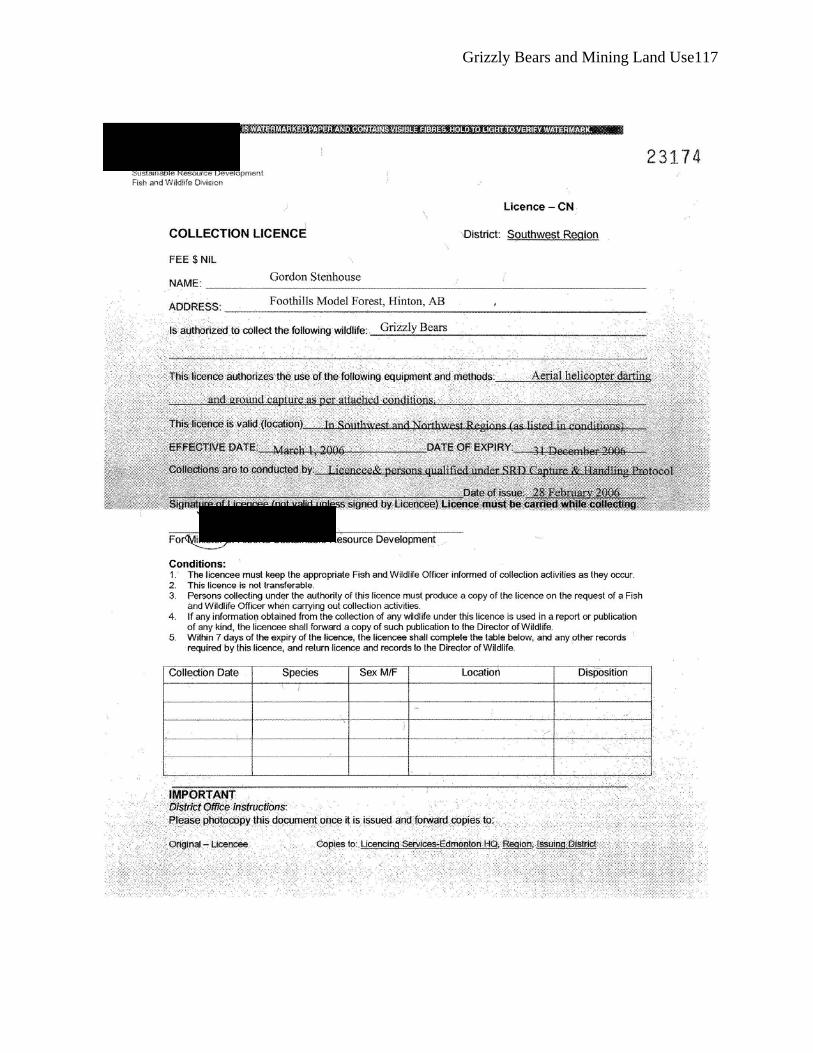
Grizzly Bears and Mining Land Use 117
Grizzly Bears and Mining Land Use 118
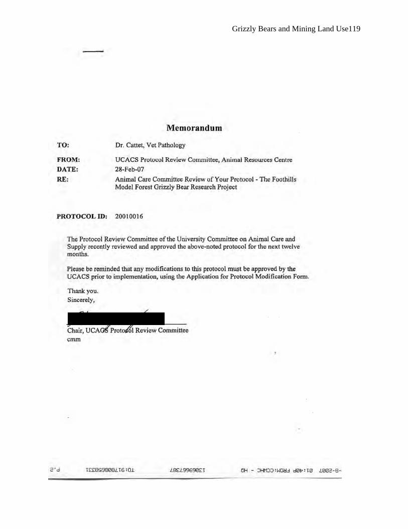
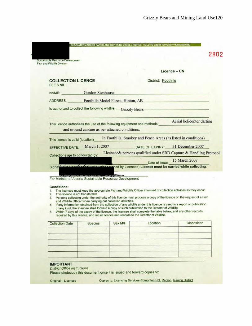
Appendix 2: Animal Welfare and Research Permits 2007