Second International Conference on Saltwater Intrusion and Coastal Aquifers— Monitoring, Modeling, and Management. Mérida, Yucatán, México, March 30–April 2, 2003 Geologic Controls on the Occurrence of Saltwater Intrusion in Heterogeneous and Fractured Island Aquifers, Southwestern British Columbia, Canada D.M. Allen 1 , E. Liteanu 1 , D.C. Mackie 1 1 Simon Fraser University, Canada EXTENDED ABSTRACT In coastal aquifers, heterogeneity introduces complexity to the configuration of the saltwater wedge and to chemical transport in the vicinity of the freshwater- saltwater interfaces. Therefore, predicting the impact of stresses to the aquifer, including freshwater withdrawals and climate change, is not straightforward. The Gulf Islands in southwestern British Columbia, Canada provide an excellent study site for investigating the hydrogeology of heterogeneous coastal / island aquifers. The islands consist of thick layered sandstone and mudstone formations that have been folded and extensively fractured. Geological investigations indicate that fracturing is pervasive in mudstone interbeds within sandstone-dominant formations, and therefore, the mudstone units act as the primary aquifers on the islands. In contrast, the sandstone units have low primary porosity, and unless fractured, are considered relatively impermeable. Numerous small- to large-scale fractures and fracture zones transect the lithologic units. A hydrostructural domain conceptual model is proposed for representing the complex hydrogeology of the islands. Hydraulic test data analyzed for numerous sites support the interpretation that large-scale vertical to sub-vertical fracture zones influence the well responses, and therefore, can be expected to play a major role in transmitting water at a variety of scales. These structures may be significant conduits for saltwater. Borehole flow meter experiments, examined in conjunction both with borehole video logs and the standard suite of borehole geophysical logs, indicate that fluid flow (both fresh and saline) is primarily through mudstone interbeds or through discrete narrow fractures in the sandstones. The observed occurrence of saltwater intrusion along the coast is variable owing to the local variability of the geology, largely brought about by the interbedded nature of the mudstones and by fracturing. INTRODUCTION In coastal aquifers, heterogeneity, and specifically fracturing, introduces complexity to the configuration of the saltwater wedge and to chemical transport in the vicinity of the freshwater-saltwater interfaces. Therefore, the occurrence of saltwater intrusion is complicated by the presence of preferential pathways for groundwater flow. The highest groundwater flux in a heterogeneous aquifer normally will occur within the more permeable units (assuming a uniform natural gradient toward the coast), and therefore, the freshwater-saltwater interface will occur further toward the ocean. This phenomenon is observed in confined coastal aquifers, which exhibit a layer-cake stratigraphy (Fig. 1a). Under pumping conditions, the interface shifts landward in response to a lower hydraulic gradient imposed by pumping (Fig. 1b). Aquifers with vertical or sub-vertical fracture zones may possibly be described in a similar fashion, but with the high zones of permeability extending vertically. Thus,
Transcript
Second International Conference on Saltwater Intrusion and Coastal Aquifers— Monitoring, Modeling, and Management. Mérida, Yucatán, México, March 30–April 2, 2003
Geologic Controls on the Occurrence of Saltwater Intrusion in Heterogeneous and Fractured Island Aquifers, Southwestern British Columbia, Canada
D.M. Allen 1, E. Liteanu 1, D.C. Mackie 1
1 Simon Fraser University, Canada
EXTENDED ABSTRACT
In coastal aquifers, heterogeneity introduces complexity to the configuration of the saltwater wedge and to chemical transport in the vicinity of the freshwater-saltwater interfaces. Therefore, predicting the impact of stresses to the aquifer, including freshwater withdrawals and climate change, is not straightforward. The Gulf Islands in southwestern British Columbia, Canada provide an excellent study site for investigating the hydrogeology of heterogeneous coastal / island aquifers. The islands consist of thick layered sandstone and mudstone formations that have been folded and extensively fractured. Geological investigations indicate that fracturing is pervasive in mudstone interbeds within sandstone-dominant formations, and therefore, the mudstone units act as the primary aquifers on the islands. In contrast, the sandstone units have low primary porosity, and unless fractured, are considered relatively impermeable. Numerous small- to large-scale fractures and fracture zones transect the lithologic units. A hydrostructural domain conceptual model is proposed for representing the complex hydrogeology of the islands. Hydraulic test data analyzed for numerous sites support the interpretation that large-scale vertical to sub-vertical fracture zones influence the well responses, and therefore, can be expected to play a major role in transmitting water at a variety of scales. These structures may be significant conduits for saltwater. Borehole flow meter experiments, examined in conjunction both with borehole video logs and the standard suite of borehole geophysical logs, indicate that fluid flow (both fresh and saline) is primarily through mudstone interbeds or through discrete narrow fractures in the sandstones. The observed occurrence of saltwater intrusion along the coast is variable owing to the local variability of the geology, largely brought about by the interbedded nature of the mudstones and by fracturing.
INTRODUCTION
In coastal aquifers, heterogeneity, and specifically fracturing, introduces complexity to the configuration of the saltwater wedge and to chemical transport in the vicinity of the freshwater-saltwater interfaces. Therefore, the occurrence of saltwater intrusion is complicated by the presence of preferential pathways for groundwater flow. The highest groundwater flux in a heterogeneous aquifer normally will occur within the more permeable units (assuming a uniform natural gradient toward the coast), and therefore, the freshwater-saltwater interface will occur further toward the ocean. This phenomenon is observed in confined coastal aquifers, which exhibit a layer-cake stratigraphy (Fig. 1a). Under pumping conditions, the interface shifts landward in response to a lower hydraulic gradient imposed by pumping (Fig. 1b). Aquifers with vertical or sub-vertical fracture zones may possibly be described in a similar fashion, but with the high zones of permeability extending vertically. Thus,
because of their inherent high permeability relative to the unfractured rock mass, densely fractured aquifer zones or discrete fractures can be anticipated to act as entry points for highly saline waters, or alternatively, exit points for fresh groundwater discharging along the coast, depending on the direction of the hydraulic gradient.
Fresh Groundwater
SalineGroundwater
Sea level
Water table
Sea-floor seepage
Spring
Low permeability layers
(a) static conditions
High permeability aquifer
Figure 1: Representations of the position of a saltwater wedge in (a) a confined homogeneous aquifer under static conditions, and (b) a confined homogeneous
aquifer under pumping conditions.
A series of detailed geologic, hydrogeologic, hydrochemical and geophysical studies have been conducted on the Gulf Islands in southwestern British Columbia, Canada, to investigate the geologic controls on the occurrence of, and possible pathways for, saltwater intrusion. The Gulf Islands are a group of 40+ islands situated within the Strait of Georgia, east of Vancouver Island (Fig. 2). Regional groundwater geochemical [Allen et al., 2001; Allen and Suchy, 2000] and isotopic data [Allen, provisionally accepted] identified a number of wells where salinization due to saltwater intrusion has occurred. However, due to aquifer heterogeneity associated with fracturing, the occurrence of saltwater intrusion is not uniform (i.e., some wells, equidistant from the shore, are contaminated and some adjacent wells are not). This suggests that the occurrence of saltwater intrusion is influenced by fracturing and/or that the natural freshwater flux is limited in some areas, which lead to local variability. This paper describes the geological interpretations and fracture characteristics that were subsequently used to develop a conceptual model that might be applicable to geologically complex settings. This model is supported by hydraulic test data, geophysical data, and hydrochemical data collected across the islands.
PHYSIOGRAPHY AND GEOLOGY The Gulf Islands range in area from ~1-75 km2 and are characterized by a
generally northwest–southeast trend and elongation defined by linear ridges and valleys. Elevations range from 100 to 200 m, reaching a maximum of about 350 m on Saltspring Island. Coastlines are typically rocky, with either long expanses of low relief bedrock sloping shallowly into the ocean or, alternatively, steep cliffs and narrow rocky beaches.
The Upper Cretaceous Nanaimo group comprises the majority of bedrock of the Gulf Islands, and consequently, the majority of the water-bearing units on the islands. Extensive regional geologic studies on the sedimentology and stratigraphy of the Nanaimo Group have been completed [e.g., Mustard, 1994].
2
Vancouver Island
Southern Gulf Islands
Northern Gulf Islands
Fraser R.
Figure 2: Location of the Gulf Islands in Southwestern British Columbia, Canada.
The Nanaimo Group is a dominantly deep marine sedimentary sequence up to 4 km thick. The sequence comprises 11 conformable and laterally intertonguing successions of sandstone and conglomerate formations separated by mudstone and siltstone formations, which are interpreted as dominantly submarine fan deposits. As such, the Nanaimo Group formations do not represent a true "layer cake" stratigraphy, but are composed of laterally thickening and thinning units with both conformable and sharp, erosive contacts. Fig. 3 is a bedrock map for the southern Gulf Islands and shows the variable surface exposure of the 11 formations.
Figure 3: Geology map of southern Gulf Islands [from Mackie, 2000 as modified
from Mustard, 1994].
The present distribution of Nanaimo Group formations is the result of multiple regional deformational events as described by Journeay and Morrison [1999]. The
3
overall regional structure of the islands is reflected as gentle folds with bedding that dips in the range of 5-15 degrees, and numerous large- and small-scale faults, fracture zones and discrete fractures that transect the formations (Fig. 3). The Gulf Islands also underwent glacio-isostatic deformation in response to multiple Quaternary glaciations [Clague, 1983], which have resulted in up to 100’s of feet of vertical isostatic rebound.
Mackie [2000] summarized the results of a detailed fracture mapping study on the southern Gulf Islands in which fracture data were collected from 157 stations, and spanning all of the 8 southern Gulf Islands. Over 8000 measurements of fractures were made. A linear scan-line technique was used (1-D), in which data are collected in trace form, that is, the intersection of the fracture surface with the outcrop surface. Generally, stations were chosen to minimize bias that may have resulted from orientation of coastline exposures, and when possible, different stations were located on mutually perpendicular coastline exposures.
Fracture Distributions
Both chain map and outcrop analyses indicate that the distribution of fractures, defined by spacing between fractures, is neither spatially nor lithologically homogenous. Fracture density, measured as number of fractures per metre chain length, varies both in relation to structural setting, especially with relation to large faults and in joint zones, and with changes in lithology. Variation of fracture density with proximity to faults is common [Caine et al., 1996], and on the Gulf Islands it was found that fracture density tends to increase by at least a factor of ten in the presence of a regional-scale fault. Lithology appears to affect density; zones of high fracture density are dominantly in sandstone, while fracture density does not increase so dramatically in faults that cut mudstone-dominated units.
Bedding perpendicular joints, found at all stations, vary in density both within a specific lithology/formation and between lithologies. Variation between lithologies is interpreted to be an effect of bedding thickness, a well documented process [Suppe, 1985]. Lithology in the Nanaimo Group varies in grain size both between and within formations. Sandstone-dominated formations (e.g. Gabriola – dominantly massive sandstone) are characteristically structureless and can attain thicknesses of 100s of meters with only minor fine grained interbeds. Silts and muds dominate mudstone formations (e.g., Spray Formation) with significantly lower bed thickness, on the scale of centimeters or millimeters. Higher joint densities were observed in mudstone-dominated units. HYDROGEOLOGY
The hydrogeology of the Gulf Islands, which encompasses the topographic driving forces, the presence of the saltwater interface along the shorelines, and the nature of the permeability and storage parameters for the rocks is controlled not only by the climate and physiography of the region, which control the driving forces for fluid flow, but also the lithology and geologic structure of the islands, which control the distribution of the hydraulic properties. Past investigations into the distribution of water resources [e.g., Hodge, 1985; Dakin et al., 1983] and drilling reports conclude that water is derived primarily from fractures as secondary permeability, reflecting the low primary porosity and permeability of the bedrock. All lithologies are highly
4
cemented, dominantly by calcite, with porosity in outcrop averaging about 5% [England, 1990].
Data and map analysis [Mackie, 2002] allows for distinction of at least three important structural features affecting groundwater flow: 1) lithologically controlled joint density, 2) discrete faults, and 3) fault/fracture zones.
Lithology and Joint Density
Based on the density of fractures (joints) measured in the different lithologies, mudstone- and sandstone-dominated formations can be separated into different hydrogeologic units. The higher density of joints in fine-grained thinly-bedded formations suggest that the mudstone-dominant units may have a higher permeability, and therefore, may act as aquifers. In contrast, the sandstone-dominated formations, with much lower fracture densities, may act more as impermeable blocks with significantly more widely spaced, discrete flow zones or pathways.
In this respect, intra-formation heterogeneity, in the form of fine grain interbeds within coarse grain formations, may create pockets of more highly fractured rock, which, if connected to a recharge zone, may form an “intra-formation” aquifer. Similarly, at the contacts between formations, where there is transitional bedding, there may be enhanced permeability. For example, a qualitative analysis of numerous well logs from the BC Water Well Database indicates a possible positive correlation between lithology and well yield, with fractured mudstone interbeds constituting a larger percentage of water bearing zones.
Joints hosted in all formations are anticipated to act as discrete flow paths, but if the density of jointing is sufficiently high, the medium may be considered as an equivalent porous medium (EPM) at some representative scale.
Discrete Faults
Many mesoscale faults were identified on the islands that may represent discrete flow paths or narrow (meter-scale) flow zones. These small structures have variable offset up to approximately 5 m and only minor changes in fracture density associated with them. The structures are not visible on 1:75,000 scale airphotos or on a DEM (digital elevation model). Flow along these structures, if they do not act as hydraulic barriers, is interpreted to be more like a discrete path or conduit, and may be of a relatively short length, perhaps up to 10’s of meters maximum. As well, these structures cross-cut all formations and are considered to represent a separate level in a hierarchy of structure-controlled flow. However, it is hypothesized that discrete faults, which tend to be older than lineament-scale fracture zones described below, may not have as significant an effect on groundwater flow at the island scale, but may be important at the local scale.
Deformation bands may be grouped with discrete faults and fractures, but as these structures tend to cause a decrease in formation porosity, and the bedrock is already a low porosity medium, there is not hypothesized to be a significant effect on water flow from these structures.
5
Fault / Fracture Zones
Structures visible at the 1:75,000 (regional scale) can be characterized on the ground as fracture zones up to 10’s of meters in width. Regional scale faults have related zones of fracturing that possibly extend 10’s of meters into the surrounding host rock. These structures are often identified by lineaments that are zones of high weathering or ridges.
From a hydrogeologic perspective fault and fracture zones can likely be represented at the regional scale as high permeability EPMs due to their high density and width of fracturing. These larger fracture zone structures are interpreted to have a significant effect on groundwater flow, particularly at the regional scale.
IMPLICATIONS OF HETEROGENEITY ON HYDROGEOLOGIC MODELS
In order to model groundwater flow in these islands aquifers, it is necessary to develop a reasonable conceptual model. The regional and local geology and structure suggest that the aquifers are complex, owing to the variations in fracture distribution and scale. Therefore, it will be necessary to represent the hydrogeology in a more simplistic way, particularly as EPM flow codes, such as SUTRA (USGS) will be used. The implications of having an aquifer system that is dominated by low primary porosity/permeability and that has a network of superimposed fractures that provides secondary permeability are four-fold:
1. to increase the complexity of the hydrogeologic model; 2. to require consideration of the scale of the investigation; 3. to suggest that, when present, the permeability of mudstone-interbeds may be
higher due to their higher joint density, and to perhaps observe some consistency in hydraulic properties between different lithologies; and
4. to question the validity of applying methods of interpretation and models that are meant to apply to porous media.
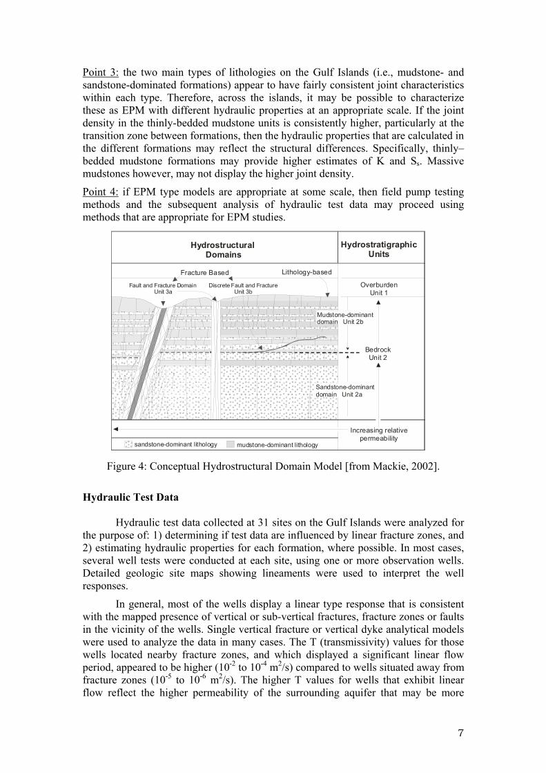
Point 1: a conceptual model based on the concept of hydrostratigraphy may not be valid because the hydrogeology is more controlled by structure than it is by its lithology and stratigraphy. In this respect, a hydrostructural domain model [Mackie, 2002] may be more appropriate, whereby permeability varies according to a structurally-controlled hierarchy as illustrated in Fig. 4. The model consists of two main lithologies that are variably fractured, and a hierarchy of fracturing associated with discrete fractures, fracture zones and faults. Representing hydrostructural domains in a numerical model will be a particular challenge, but may be possible if estimates of hydraulic properties for each hydrostructural domain can be estimated in a wide variety of settings (e.g., near fracture zones, away from fracture zones, and in different lithologies in each case).
Point 2: because fracturing occurs at a variety of scales, and there is a hierarchy of fracture types superimposed on the different lithologic units, the scale of investigation will be important to consider when interpreting hydrogeologic data. Fractures may themselves act as EPM or as discrete fractures depending on the scale of investigation. For a regional study, larger-scale features such as faults and fracture zones may dominate, and because of their large scale may be treated as EPM. The influence of local features, such as discrete fractures and bedding, may be important at smaller scales. Therefore, local-scale investigations should take into consideration the local geology as much as possible.
6
Point 3: the two main types of lithologies on the Gulf Islands (i.e., mudstone- and sandstone-dominated formations) appear to have fairly consistent joint characteristics within each type. Therefore, across the islands, it may be possible to characterize these as EPM with different hydraulic properties at an appropriate scale. If the joint density in the thinly-bedded mudstone units is consistently higher, particularly at the transition zone between formations, then the hydraulic properties that are calculated in the different formations may reflect the structural differences. Specifically, thinly–bedded mudstone formations may provide higher estimates of K and Ss. Massive mudstones however, may not display the higher joint density.
Point 4: if EPM type models are appropriate at some scale, then field pump testing methods and the subsequent analysis of hydraulic test data may proceed using methods that are appropriate for EPM studies.
Figure 4: Conceptual Hydrostructural Domain Model [from Mackie, 2002].
Hydraulic Test Data
Hydraulic test data collected at 31 sites on the Gulf Islands were analyzed for the purpose of: 1) determining if test data are influenced by linear fracture zones, and 2) estimating hydraulic properties for each formation, where possible. In most cases, several well tests were conducted at each site, using one or more observation wells. Detailed geologic site maps showing lineaments were used to interpret the well responses.
In general, most of the wells display a linear type response that is consistent with the mapped presence of vertical or sub-vertical fractures, fracture zones or faults in the vicinity of the wells. Single vertical fracture or vertical dyke analytical models were used to analyze the data in many cases. The T (transmissivity) values for those wells located nearby fracture zones, and which displayed a significant linear flow period, appeared to be higher (10-2 to 10-4 m2/s) compared to wells situated away from fracture zones (10-5 to 10-6 m2/s). The higher T values for wells that exhibit linear flow reflect the higher permeability of the surrounding aquifer that may be more
7
intensely fractured, not specifically the fracture itself. The fact that linear flow was observed in many wells is a strong indication that the conceptual model consisting of a hierarchy of fracturing is reasonable, and that vertical fracture zones probably do play a major role in controlling flow on the Gulf Islands.
Table 1 shows the values of T and S calculated for several formations. The Spray and Cedar District formations are mudstone dominant, while the Gabriola, Geoffrey, de Courcy and Protection formations are sandstone-dominant. The number of samples for the Gabriola, Geoffrey and Spray formations increases our confidence in the range of values. Low sampling in the de Courcy, Cedar District and Protection formations indicate a much lower level of confidence. Because the test data reflect the dominant presence of fracture zones, the average values are probably a poor reflection of representative values for the formations. Rather, we propose that the minimum values be used to represent the relatively unfractured aquifer, and the maximum values or averages used to represent the fractured aquifer near faults and fracture zones. It is important to note, however, that the fractures themselves will probably have at least one or two orders of magnitude higher T values than the fractured aquifer surrounding them.
Table 1: Average, maximum and minimum T and S values for the various formations Sandstone-Dominant Mudstone-Dominant Formation Gabriola Geoffrey De Courcy Protection Cedar District Spray
Transmissivity (m2/s) # of tests 73 16 1 1 2 8 Average 1.02E-5 2.40E-5 5.21E-5 1.08E-5 2.89E-5 8.56E-6 Max 5.42E-2 8.13E-4 7.50E-5 3.58E-5 5.95E-5 5.31E-5 Min 3.38E-7 1.22E-6 3.88E-5 2.80E-6 1.40E-5 7.55E-7
Storativity # of tests 9 5 3 2 0 0 Average 6.97E-4 1.45E-4 3.69E-4 1.82E-4 Max 3.67E-2 4.32E-4 5.58E-4 7.17E-4 Min 2.41E-7 4.44E-5 2.84E-4 4.62E-5
Hydraulic conductivity values, calculated by considering the open hole depth as the saturated thickness, b, gave fairly consistent results between formations. This result was somewhat unexpected. Based on our conceptual model, we expected to see lower values of T (or K) for wells completed in sandstone-dominant formations compared to mudstone-dominant formations. The consistency between the values may be a reflection of:
1. the presence of faults and fractures near most wells that were tested. This would bias the hydraulic properties, resulting in higher values for T. The presence of these structures would limit the ability to distinguish between lithologies.
2. the use of the entire open hole depth as saturated thickness may obscure the true results, particularly if permeability is derived from small intervals of intensely fractured mudstone (interbeds) or from discrete fractures as is suggested by borehole geophysical logs collected at several wells (Allen et al., 2002). In formations that contain a visually greater abundance of mudstone
8
interbeds, these beds appear highly fractured. Flow meter logging conducted during pump testing at one site showed that flow between wells was occurring within a single fractured mudstone interbed. In some wells (e.g., well EP-29 described below), flow was predominantly through discrete fractures. Thus, both discrete fractures (particularly in sandstone-dominant lithologies) and mudstone interbeds appear to control flow, and therefore, their discrete thickness should be used as b.
3. little to no difference in the hydraulic properties of the different lithologies. While a possible explanation, the style of fracturing observed on the islands does not support this conclusion.
ROLE OF HETEROGENEITY IN SALTWATER INTRUSION
In addition to the detailed geologic studies, borehole and surface geophysical methods have also been used to examine subsurface fracture distributions and the continuity of faults and fracture zones, and to infer their potential role in creating pathways for saltwater intrusion at the site scale [Allen et al., 2002]. Borehole flow meter experiments, examined in conjunction both with borehole video logs and the standard suite of borehole geophysical logs, indicate that fluid flow (both fresh and saline) is primarily through mudstone interbeds or through discrete narrow vertical fractures in the sandstones.
Flow (L/min)Flow (L/min)FRes (ohm-m)
EP-29
Tidal Ebb Tidal Flood
Gamma (CPS) Resistivity (ohm-m)
30
a) b)
a
b
c
Dep
th (m
)
FRAC
TUR
ES a
s AR
RO
WS
Figure 5: Fluid resistivity, flow meter, natural gamma and resistance logs for well EP-29 on Saturna Island. Water chemistry sampled at points A, B and C. Flow logs were acquired under (a) under tidal ebb and (b) under tidal flood conditions, both suggesting that fresh groundwater originates from various levels within the borehole, and saline groundwater enters at depth from a fracture below 52 m.
9
Figure 5 shows selected borehole logging results for an abandoned water well on Saturna Island (see Fig. 2). The well is located at the southernmost tip of a peninsula on the island, and is drilled into the Geoffrey Formation, which by contrast to other sandstone-dominant lithologies, consists of relatively clean sandstone (see gamma log). Discrete fractures and thin fracture zones were identified using a borehole camera as well as using the results from flow meter and resistivity logs.
Water samples were collected from three discrete depths using a bailer assembly. The water chemistry at C (58 m) is similar to the composition of saltwater and can be considered saline (EC > 2000 µS/cm). The groundwater composition at A and B (30 m and 50 m, respectively) is brackish (>800 µS/cm), and is representative of a transition or mixing zone between fresh water and saline groundwater. EC logging of this well during several aquifer tidal floods and ebbs confirmed that the freshwater-saltwater interface in the well does not shift its position considerably (approximately 1 m for a 3m tidal signal) as might be expected with the low flow rates.
When interpreted using the flow meter data, these results suggest that under both tidal states (ebb and flood), fresh groundwater originates from various levels within the borehole and saline groundwater enters at depth from a fracture below 52 m. When this well was pumped shortly after it was drilled, the composition of the groundwater was saline, suggesting that this fracture at depth is both highly transmissive and a primary water-bearing fracture. The composition of water in the vicinity of this fracture under static conditions further indicates a direct connection with seawater. Thus, at this location, salinization by saltwater intrusion has occurred directly as a result of intersecting a narrow fracture zone that has a connection to the ocean.
Using this well as an example, and considering the high variability in fracturing, it can be expected that not all wells will become contaminated by seawater. The Geoffrey Formation is a clean sandstone, and fracture spacing is expected to drop off significantly away from faults and fracture zones. Therefore, according to the conceptual model, only those wells that are situated very close to a fracture have a high potential to be contaminated by seawater.
At shallow depths these fractures may receive additional recharge and have the potential to transmit large quantities of fresh water toward the ocean, but if intersected at depth, they may contribute to salinization problems.
CONCLUSIONS Groundwater flow on the Gulf Islands, British Columbia, Canada is controlled to a large extent by the complex geology and structure of the aquifers, which can be represented conceptually as a hydrostructural domain model consisting of two main lithologies, and a hierarchy of fracturing associated with discrete fractures, fracture zones and faults.
Sandstone-dominant and mudstone-dominant formations were observed to be variably fractured, with higher joint spacing, and by inference, these units are expected to have a higher permeability. Well drilling logs support the conclusion that fractured mudstone units constitute the primary water-bearing aquifers on the islands.
10
Discrete faults (local scale), and faults and fracture zones (regional scale structures) transect the lithologic units. These features offer enhanced permeability as evidenced by the tendency for linear type flow during hydraulic testing in many wells. Fracturing associated with these structures extends into the rock mass, particularly in sandstones, and is expected to contribute to the high transmissivities measured for the aquifer. The fact that linear flow was observed in many wells is a strong indication that the conceptual model consisting of a hierarchy of fracturing is reasonable, and that vertical fracture zones probably do play a major role in controlling flow and saltwater intrusion on the Gulf Islands.
Borehole geophysical logs, including flow meter logs, support the general conclusion that fracturing, associated with both discrete fractures and highly fractured mudstone interbeds, controls the movement of water in the formations. Connection to the ocean was observed via a single discrete fracture, and variability in fracturing across the island, explains the variability of saltwater intrusion encountered. Where present, discrete fractures and faults can be expected to offer conduits for freshwater discharge; however, these same features may offer preferential pathways for saltwater into the aquifers.
References Allen, D.M.,” Determining the origin of groundwater using stable isotopes of 18O, 2H
and 34S, Gulf Islands, British Columbia,” Provisionally accepted by Ground Water, November 2002.
Allen, D.M., Abbey, D.G., Mackie, D.C., Luzitano, R., and Cleary, M., Investigation of potential saltwater intrusion pathways in a fractured aquifer using an integrated geophysical, geological and geochemical approach. Journal of Environmental and Engineering Geophysics, 7(1), 19-36, 2002.
Allen, D.M. and Suchy, M., “Geochemical evolution of groundwater on Saturna Island, British Columbia,” Canadian Journal of Earth Sciences, 38, 1059- 1080, 2001.
Allen, D.M., Matuso, G., Suchy, M. and Abbey, D.G., “A multidisciplinary approach to studying the nature and occurrence of saline groundwater in the Gulf Islands,
British Columbia, Canada,” In: Proceedings of the First International Conference on Saltwater Intrusion and Coastal Aquifers - Monitoring, Modeling, and Management, Essaouira, Morocco, April 23–25, 2001.
Caine, J.S., Evans, J.P., and Forster, C.B., “Fault zone architecture and permeability structure,” Geology, 24,1025-1028, 1996.
Clague, J.J., “Glacio-isostatic effects of the Cordilleran Ice Sheet, British Columbia,” In: Shorelines and Isostacy, eds. D.E. Smith and A.G. Dawson, pp. 321-343, Academic Press, London, 1983.
Dakin, R.A., Farvolden, J.A., Cherry, J.A., and Fritz, P., “Origin of dissolved solids in groundwater of Mayne Island, British Columbia, Canada,” Journal of Hydrology, 63, 233-270, 1983.
England, T. D. J., “Late Cretaceous to Paleogene Evolution of the Georgia Basin, Southwestern British Columbia,” Unpublished Ph.D. thesis, Memorial University, Newfoundland, Canada, 481 p., 1990.
11
Hodge, W.S., “A Preliminary Assessment of Groundwater Conditions on Saturna Island, British Columbia,” Unpublished report by British Columbia Ministry of Environment Water Management Branch, Victoria, BC, 1985.
Journeay, J.M. and Morrison, J., “Field investigations of Cenezoic structures in the northern Cascadia forearc, southwestern British Columbia,” In: Current Research, Geological Survey of Canada, Paper 1999-A, 239-250, 1999.
Mackie, D.C., “An Integrated Structural and Hydrogeologic Interpretation of the Fracture System in the Upper Cretaceous Nanaimo Group, Southern Gulf Islands, BC.,” Unpublished M.Sc. thesis, Department of Earth Sciences, Simon Fraser University, 2000.
Mustard, P.S., “The Upper Cretaceous Nanaimo Group, Georgia Basin,” In: Geology and Geological Hazards of the Vancouver Region, Southwestern British Columbia, ed. J.W.H. Monger, pp. 27-95, Geological Survey of Canada, Bulletin 481, 1994.
Suppe, J., “Principles of Structural Geology”, Prentice-Hall, Inc. New Jersey, 537 p., 1985.
Corresponding author: Diana M. Allen, Associate Professor, Department of Earth Sciences, Simon Fraser University, Burnaby, British Columbia, Canada, V5A 1S6. Email: [email protected]