30
Grandview Heights General Land Use Plan June 20, 2005
Grandview Heights
General Land Use Plan
June 20, 2005

Grandview Heights General Land Use Plan
- i -
Acknowledgements The City of Surrey would like to thank and acknowledge the contributions of the following individuals and organizations that participated in to the preparation of the General Land Use Plan for Grandview Heights. The Grandview Heights Citizen Advisory Committee Albert D. Svab Alfred Boldt Rita Krause B Gordon Cameron Norm Fleenor Vince Piccolo D Kuldip S. Jagpal James Bell Winston Leckie Jim McCutcheon Bernie Scholz Jamie Howard Eric W. Chen Dale Rezansoff
Denise Bouchard Bill Nichols Mark Devitt Jenny Tamas Rick Clough Justin Chorbajian Roy Langton Jim Wassall Joyce Gordon Janice Melody Brad Semke Alisa Wilson Ken Metherel David J. Marshall Harry Trommel
Giuseppe Fronteddu Richard Bryson Lynda Hruby Anna Luczynski Sheilen Raja Paul Gill Paul Kim David Sellars Gary Scott Fred Hubbick Mike Proskow Cindy Lightheart Ed Champion
Agencies and Organizations Consultants Umur Olcay, Surrey School District #36 West Grandview Heights Residents' Association Fergus Creek Pocket Taxpayers' Association Country Woods Residents' Association Redwood Park Neighbours' Association South Grandview Estates Association
Patti Shomm Moffat and Janice Keyes, Cario Communications Ian Whyte, ECL-Envirowest Donald Luxton, Donald Luxton & Associates
City of Surrey Staff Planning & Development Department
Engineering Department
Murray Dinwoodie, General Manager Judy McLeod, Manager, Long Range Planning & Policy Hernan Bello, Area Planning Stella Lee, Area Planning Joe Waskito, Long Range Planning & Policy Terry Hoff, Long Range Planning & Policy Tiina Mack, Parks Planning Greg Mitchell, Long Range Planning & Policy Lynn Guillbaut, Long Range Planning & Policy Wendy Whelen, Long Range Planning & Policy Fay Keng Wong, Long Range Planning & Policy Greg Zemrau, Long Range Planning & Policy
Paul Ham, General Manager Vincent LaLonde, Manager, Utilities & Transportation Rémi Dubé, Drainage Planning Carrie Baron, Drainage and Environment Jamie Boan, Transportation Planning Mirjana Petrovic, Transportation Planning

Grandview Heights General Land Use Plan
- ii -
Purpose of this Document This General Land Use Plan for the Grandview Heights area of Surrey is a culmination of a one and one-half year planning and community consultation process, coordinated by staff of the City of Surrey. This document reflects the ideas, suggestions and input received from the Grandview Heights community, with review and input from the Grandview Heights Citizen Advisory Committee (the "CAC"). It also reflects requirements and technical input by government agencies, the Surrey School District, environmental, heritage and engineering consultants, and other stakeholders. The purpose of this document is to provide an overall planning framework that will guide the servicing, development, and build-out of Grandview Heights as a comprehensively planned community. Grandview Heights will be a community that will provide existing and new residents with the opportunity to live, work and play in a high quality, healthy and livable community. This new community will consist of several cohesive and sustainable neighbourhoods, designed with respect for the natural environment and attributes of the Grandview Heights area. The land use concept and policies contained in this document will be used to guide the preparation of Neighbourhood Concept Plans ("NCPs") in Grandview Heights.

Grandview Heights General Land Use Plan
- iii -
Table of Contents Page
1.0 GRANDVIEW HEIGHTS GENERAL LAND USE PLAN AND POLICIES............ 1
1.1 INTRODUCTION ................................................................................................................ 1 1.2 OVERVIEW OF THE LAND USE CONCEPT .......................................................................... 1 1.3 LAND USE POLICIES – COMMUNITY STRUCTURE AND CHARACTER................................. 3 1.4 RESIDENTIAL LAND USE POLICIES................................................................................... 3 1.5 COMMERCIAL .................................................................................................................. 8 1.6 SCHOOLS, PARKS, GREENWAYS AND COMMUNITY AMENITIES ....................................... 8 1.7 ENVIRONMENT AND AGRICULTURE ................................................................................. 9 1.8 COMMUNITY HERITAGE................................................................................................. 12
2.0 LAND USE ESTIMATES AND DEVELOPMENT CAPACITIES FOR GRANDVIEW HEIGHTS ............................................................................................. 12
3.0 TRANSPORTATION AND SERVICING INFRASTRUCTURE ............................. 13 3.1 TRANSPORTATION.......................................................................................................... 13 3.2 SERVICING AND INFRASTRUCTURE ................................................................................ 14
4.0 GENERAL LAND USE PLAN – IMPLEMENTATION............................................ 20 4.1 NEIGHBOURHOOD CONCEPT PLANS ............................................................................... 20 4.2 FUNDING........................................................................................................................ 20 4.3 PHASING ........................................................................................................................ 20 4.4 SUSTAINABLE DEVELOPMENT PRACTICES ..................................................................... 20
5.0 GENERAL LAND USE PLAN – GUIDING PRINCIPALS ...................................... 21
Appendix "A" - General Land Use Plan - Guiding Principles.............................................. A1
List of Figures
Figure 1.1 - Grandview Heights Land Use Concept .................................................................. 2
Figure 1.2 - NCP Areas in Grandview Heights .......................................................................... 4
Figure 1.3: Examples of Cluster Form of Development – Conceptual Drawings.................. 6
Figure 1.4: Examples of Cluster Form of Development – Types of Cluster Development ... 7
Figure 1.5 - Wildlife Habitat Features and ESA Map............................................................. 11
Figure 3.1 - General Transportation Plan for Grandview Heights........................................ 16
Figure 3.2 - Conceptual Servicing – Sanitary Sewer ............................................................... 17
Figure 3.3 - Conceptual Servicing – Water .............................................................................. 18
Figure 3.4 - Conceptual Servicing - Drainage .......................................................................... 19
List of Tables
Table 1 - Land Use Estimates and Development Capacity ..................................................... 13

Grandview Heights General Land Use Plan
- 1 -
Grandview Heights General Land Use Plan 1.0 GRANDVIEW HEIGHTS GENERAL LAND USE PLAN AND POLICIES
1.1 Introduction
This report provides an overview of the General Land Use Plan (the "Plan") for Grandview Heights and includes general policies to support the land use concept. The policies describe the intent of the general land use designations, where parks, pathways, schools, roads and other community features will generally be located, and how the new Grandview Heights community will be structured, setting the basis for the preparation of more detailed neighbourhood concept plans.
1.2 Overview of the Land Use Concept
The land use concept illustrated in Figure 1.1, envisages Grandview Heights as a complete community with a mix of residential densities, small commercial nodes, community facilities, schools, parks, pathways, trees and protected areas. The pastoral ambiance of Grandview Heights will be maintained through the retention, wherever possible, of watercourses, trees, and vegetation of environmental significance, through respect for the adjacent Agricultural Land Reserve (the "ALR") by the implementation of significant buffers, through protection of key view corridors of the mountains and the ocean and through the retention of lower residential densities throughout the central area. A modified grid road system, combined with greenways, will enable residents to walk or cycle to all of the main schools, parks, services and facilities. The projected population at full build-out, subject to detailed planning and the preparation of Neighbourhood Concept Plans ("NCPS") under the proposed General Land Use Plan, is expected to be between 20,670 and 32,870.

Grandview Heights General Land Use Plan
- 2 -
Figure 1.1 - Grandview Heights Land Use Concept

Grandview Heights General Land Use Plan
- 3 -
1.3 Land Use Policies – Community Structure and Character
(a) Community identity and character in Grandview Heights will be maintained through the retention, wherever possible, of trees and vegetation of environmental significance, respect for the adjacent ALR, and protection of key view corridors of mountains and water; and
(b) Five neighbourhoods, as indicated in Figure 1.2, have been identified for
the establishment of more detailed NCPs. New development will not proceed until such plans have been completed through a further public consultation process, and have been approved by Council. Issues such as tree retention areas, the type and form of development, the location of schools and parks, the determination of setbacks, buffers and density adjacent to the ALR and the details of adequate transition areas between urban and permanent suburban and rural areas will be addressed in detail through the NCP processes.
1.4 Residential Land Use Policies
(a) There will be a variety of housing types in Grandview Heights, including suburban lots, single family lots, small lots, and multiple residential townhouses and apartments. It is anticipated that there will be in the range of 7,720 to 12,300 dwelling units of varying types, which will accommodate between 20,670 and 32,870 people at ultimate build-out;
(b) The highest residential densities will generally be located adjacent to the
Highway 99 Corridor, decreasing toward the central area of the Plan. The Plan provides for a small, mixed-used commercial/multi-family area near the north east corner of 176 Street and 24 Avenue, which will be surrounded by urban residential uses toward 184 Street. The commercial node is intended to provide local services to the neighbouring residents rather than be automobile-oriented. Appropriate buffer and transitional zoning in this area will be determined through the NCP process;
(c) The central area of Grandview Heights, between approximately 168 Street
and west of 176 Street, and between 28 Avenue and north of 20 Avenue, will retain its low-density character. New developments within this area will be subject to the application of design guidelines that will be prepared at the NCP stage; and
(d) Development in a clustered form will be considered in the area between
16 Avenue and 20 Avenue, generally east of about 170 Street, subject to the careful design of the transition areas around the existing one acre lots and the provision of adequate buffers adjacent to ALR lands. The design of this area will be subject to more detailed review during the NCP planning process.

Grandview Heights General Land Use Plan
- 4 -
Figure 1.2 - NCP Areas in Grandview Heights
(e) Transition densities adjacent to existing suburban density subdivisions will be defined through the NCP processes. "Transition" areas have been identified on the Land Use Concept between existing suburban areas and future urban areas. Residential densities within transitional areas will be to a maximum of four units per acre with the density, lot configuration and form of development defined through NCPs to provide compatibility between uses, using various approaches such as:
− Gradual changes in the size of lots from large to small; − Compatible frontage widths for lots facing each other along the street; − Building designs that are compatible in height and massing for
buildings facing each other along the street; − Landscaped buffers designed to provide for a compatible transition in
density; − Changes in lot sizes to occur at the rear of lots; and/or − Other means determined through the NCP process;
(f) A tree management, preservation and enhancement strategy will be
incorporated into each NCP. The existing "green" ambiance will be fostered through the retention and planting of trees, the provision of open

Grandview Heights General Land Use Plan
- 5 -
space in developments, the provision of parks and natural areas and the application of tree planting and management standards for individual properties;
(g) As noted, consideration will be given to clustered form of development in
certain areas of Grandview Heights as identified on the Land Use Concept. Some examples of how clustered development may occur are shown in Figures 1.3 – 1.4. This form of development is intended to occur as follows: − Tree surveys of significant stands will be undertaken by qualified
professionals in advance of the design of development proposals; − Dwelling units will be grouped in clusters in order to protect
significant stands of trees, protect areas of environmental sensitivity, to work with site topography and to provide for adequate buffer areas; and
− Mechanisms to address clustered forms of development will be established at the NCP stage; and
(h) Within NCP Area #2, certain density allocations may be subject to review
through the NCP process, particularly within the area in the vicinity of Edgewood Drive between 20 Avenue and 23 Avenue.

Grandview Heights General Land Use Plan
- 6 -
Figure 1.3: Examples of Cluster Form of Development – Conceptual Drawings

Grandview Heights General Land Use Plan
- 7 -
Figure 1.4: Examples of Cluster Form of Development – Types of Cluster Development

Grandview Heights General Land Use Plan
- 8 -
1.5 Commercial
(a) Small commercial areas may be established within NCP areas to serve the
convenience needs of local residents. These commercial nodes will be located so as to not impact existing established residential areas and at the intersections of arterial or collector roads. These commercial nodes are located:
− at the southwest corner of 168 Street and 24 Avenue; and. − east of 176 Street and north of 24 Avenue.
1.6 Schools, Parks, Greenways and Community Amenities
(a) Three elementary schools and one secondary school are planned for Grandview Heights. A fourth elementary school, near 160 Street, north of 28 Avenue, will serve the neighbourhood west of 164 Street between 24 Avenue and 28 Avenue. Elementary schools will be associated with neighbourhood parks. With the exception of the future elementary school on 26 Avenue and 172 Street, the precise location of the schools/parks, each of approximately 5.3 hectares (13 acres) in size, will be determined at the NCP stage;
(b) As set our in the policies of Surrey's Official Community Plan ("OCP"),
the provision of park space will be based on the following (per 1,000 estimated new residents):
− 5 acres for City parks; − 2 acres for community parks; − 1.5 acres for neighbourhood parks; and − 4 acres for nature preserves and linkages;
(c) Redwood Park and Darts Hill Park will be retained and enhanced and will
be connected with the community through linkages and open space corridors;
(d) A park area on and/or adjacent to the GVRD water reservoir site on
24 Avenue will be considered at the NCP stage;
(e) The general pedestrian/bicycle circulation and connections within Grandview Heights are shown on Figure 1.1. The location and design of additional pedestrian/bicycle links to parks, neighbourhood amenities, commercial nodes and other special features in the area will be defined at the NCP stage;
(f) Pedestrian/bicycle greenways will be located along 16 Avenue, 20 Avenue
and 24 Avenue, and around the edge of Grandview Heights on the historic

Grandview Heights General Land Use Plan
- 9 -
Great Northern Railway right-of-way. Pedestrian links from the main greenways to parks, neighbourhood commercial areas and other special features in the area will be defined at the NCP stage;
(g) The precise alignment of the greenway along the historic Great Northern
Railway right-of-way will be determined at the NCP stage. The location and design of this greenway will take into consideration the adjacent agricultural lands and ensure that agricultural lands and operations are not disturbed or impacted. This may involve buffers, berms, careful design of the location of the pathway within the corridor and, in some cases, alternative routes away from the ALR;
(h) Community scale park facilities, including playing fields and a community
centre, totally between 15 and 20 hectares (37 and 50 acres) will be established in Grandview Heights in a location or locations to be determined at the NCP stage, based on policies and criteria contained within this Plan. It is anticipated that such major facilities will be constructed as the population of the area warrants, likely in 10 to 15 years. In the interim, land acquisition may be undertaken in appropriate locations on a willing seller basis. Such lands may ultimately be used for park facilities, or may form a land bank in the area for sale or trade for other sites more suitably located for community scale park purposes. The location/size of community scale park facilities will be determined through the NCP processes. Other public open space will also be acquired or dedicated over time to accommodate civic amenities and facilities required to serve the larger Grandview Heights area;
(i) Where storm water detention ponds or wetlands are required, they will be
constructed as community amenities and features or as natural park areas; and
(j) The capital costs of constructing neighbourhood amenities and new police,
fire, and library facilities will be born by new development in accordance with the City’s NCP amenity contribution practices.
1.7 Environment and Agriculture
(a) An environmental overview study of the Grandview Heights area has revealed some significant forest blocks and watercourses that should be protected as development occurs in the area. These potentially sensitive areas will be further evaluated at the NCP stage and appropriate measures will be taken to preserve and enhance areas defined as environmentally significant;
(b) Figure 1.5 depicts the potential environmentally significant features and
wildlife habitat areas and reflects the main vegetation blocks in Grandview Heights;

Grandview Heights General Land Use Plan
- 10 -
(c) To achieve protection of the identified environmentally sensitive areas, while permitting some form of adjacent development, alternative development methods (e.g. gross density zoning, density bonusing, cluster zoning, alternative design standards, etc.) will be explored during the NCP process;
(d) Setbacks will be required from watercourses in the area in accordance
with the applicable provincial/federal policies or regulations in effect. These watercourse areas may also be enhanced with additional habitat that encompasses the specified setback, established woodland, young woodland and pasture grassland, to be determined through detailed studies through the NCP process;
(e) Through the NCP processes in the Grandview Heights Plan area, the
following additional environmental initiatives will be pursued:
− Development of habitat management plans to identify environmentally sensitive areas or features that should be protected, restored, replaced or enhanced, as appropriate to retain habitat diversity and compliment other planning objectives within the various NCP areas;
− Requirement of development strategies that are environmentally
sensitive, such as housing which clusters development on the least environmentally sensitive portion of a site or within an NCP area;
− Encourage the identification of linear park opportunities that also
preserve natural vegetation, provide secondary wildlife preservation areas, link other habitat features, and/or provide buffers to residential neighbourhoods;
− Incorporate the principles of sustainable development, including
innovative servicing, storm water management and road standards into NCPs and new developments; and
− Consideration of the creation of development permits areas to set
conditions and vary or supplement the City's bylaws for the protection of specific environmental features;
(f) The policies in Surrey's OCP, and other Council policies which promote
compatibility between the ALR and non-agricultural land uses, will be applied within Grandview Heights. Within the areas along the eastern and southern edge of the Plan area, Cluster Form development has been identified as a land use. It is the intent that such development will provide for a significant buffer between urban uses and the ALR, protecting the continuation of agricultural land uses in the ALR. Adjacent to the agricultural edge, the width of the buffer will increase proportionately to meet the normal suburban densities adjacent to the ALR, as set out in

Grandview Heights General Land Use Plan
- 11 -
other Council policies, including Council Policy O-23. This includes the use of buffers and land uses that are compatible with farm operations; consideration of significant grade changes, major roads and natural features such as watercourses, in determining measures to ensure an appropriate transition between non-agricultural and ALR uses. The Agricultural Advisory Committee will be consulted with regard to the effective implementation of buffers adjacent to the ALR as part of the NCP process;
(g) Development will be designed to ensure that the potential impacts of water
runoff from upland areas on agricultural lands will be mitigated. Integrated Storm Water Management Plans, in accordance with the GVRD Liquid Waste Management Plan may be undertaken for one or more of the NCP areas in Grandview Heights.
Figure 1.5 - Wildlife Habitat Features and ESA Map

Grandview Heights General Land Use Plan
- 12 -
1.8 Community Heritage
A study of the heritage features and characteristics of Grandview Heights was undertaken in association with this Plan. The history of the area is reflected in modest early buildings on large properties, often supplemented by out-buildings. The area has remained largely a rural estate community dominated by small agricultural pursuits. Additionally, logging was important in the early development of the area, and early transportation routes criss-crossed the area, for example the Great Northern Railway. The heritage study made three recommendations, as follows:
(a) Through the Heritage Conservation Program of the City of Surrey, the
existing Heritage Register site, Grandview Heights Elementary School Annex, should continue to be targeted for conservation;
(b) When future circumstances allow, the two potential heritage sites, Darts
Hill Garden Park and the Newcombe Barn, should be added to the Heritage Register. The situation of the Newcombe Barn should be monitored and heritage incentives offered, if appropriate, to assist in its preservation; and
(c) The history of the area can be interpreted within the context of ongoing
redevelopment. Historic people and events can be celebrated in a number of ways, which may include re-introduction of historic names, use of pioneer family names whenever possible, and panel displays of historic information and other interpretive techniques.
In addition, the natural heritage features and community history can be incorporated into the design and character of the five new neighbourhoods. Design and character guidelines will be prepared during the NCP processes to accomplish the preservation and retention of heritage and natural features.
2.0 LAND USE ESTIMATES AND DEVELOPMENT CAPACITIES FOR
GRANDVIEW HEIGHTS The projected population at full build out of Grandview Heights, subject to detailed planning and preparation of NCPs, is expected to be between 20,670 and 32,870. There could be approximately 7,720 to 12,300 dwelling units of varying types at full build-out over the next 15 to 20 years. Table 1 below contains the land use estimates and development capacities for Grandview Heights at full build-out.

Grandview Heights General Land Use Plan
- 13 -
Table 1 - Land Use Estimates and Development Capacity
Residential Land Use Density
Assumptions Dwelling Units Population
Acres Net Acres Low Med High Low Med High Low Med High
Multiple Residential 151 126 15 20 25 1,880 2,510 3,140 4,320 5,770 7,220
Suburban Residential 603 503 1 1.5 2 500 760 1,010 1,400 2,130 2,830
Transition Residential 160 144 2 3 4 290 430 580 810 1,200 1,620
Urban Residential 825 631 8 10 12 5,050 6,310 7,570 14,140 17,670 21,20TOTAL 1,739 1,404 7,720 10,010 12,300 20,670 26,770 32,870
Commercial 8 Parks 150 Schools 29 Institutional 53
TOTAL 240
GRAND TOTAL 1,979
3.0 TRANSPORTATION AND SERVICING INFRASTRUCTURE
3.1 Transportation
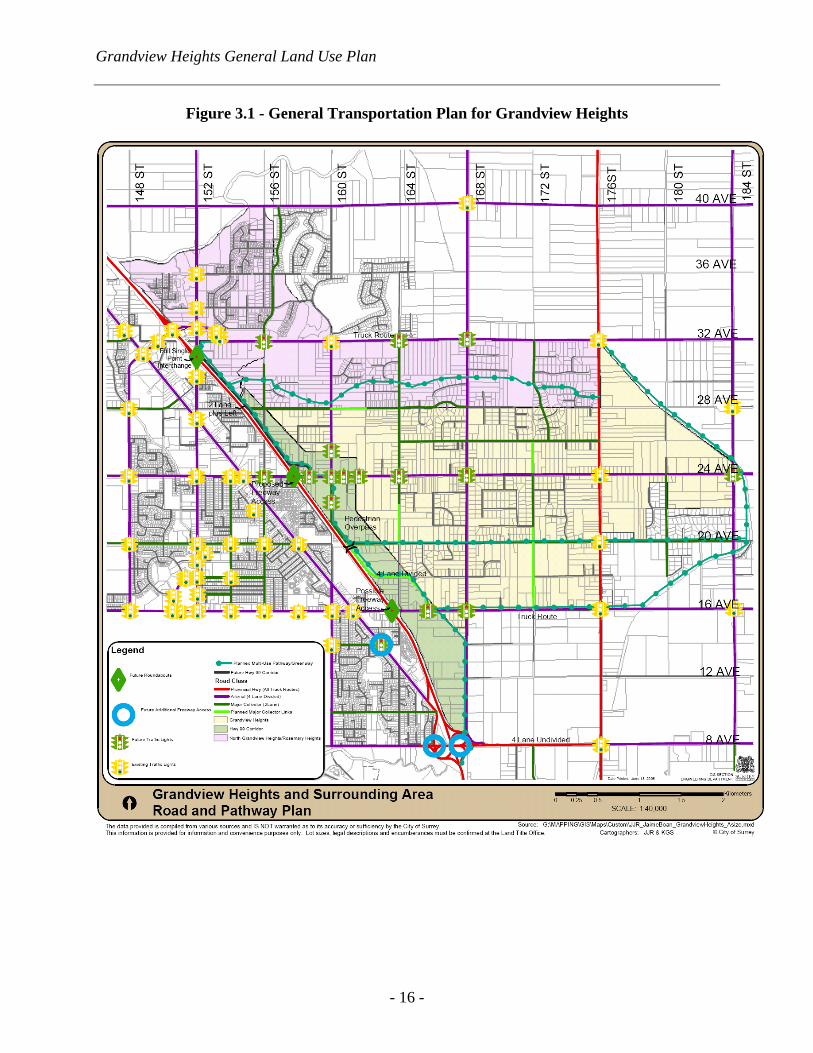
(a) A general transportation plan for Grandview Heights is shown in
Figure 3.1. The proposed changes in land use will lead to amendments in the City's Major Road network Plan (R91). These amendments include reclassification of 160 Street (24 Avenue to 32 Avenue) from major collector to arterial and 26 Avenue (164 Street to 168 Street) from local to major collector;
(b) Through the NCP processes, special road and pathway standards may be
developed in suburban and transitional density areas of Grandview Heights to retain the rural character;
(c) A modified grid road system in new development areas will be combined
with greenways, which will enable residents to walk or cycle to all of the main schools, parks, services and facilities;
(d) Transportation systems within NCP areas will be designed to encourage
walking, to slow down traffic on local roads and to minimize through traffic from using local residential roads;

Grandview Heights General Land Use Plan
- 14 -
(e) 24 Avenue is designated as an arterial road, which will ultimately have a four lane cross section, complete with sidewalks and paths. The treatment of this major transportation corridor has been highlighted as an area of concern within the community, since it has the potential of separating the neighbourhood. The importance of this arterial connection has been highlighted through the public process and a concept for the proposed freeway access at 24 Avenue and Highway 99 was presented and generally well received at recent open houses; and
(f) Traffic modeling for this General Land Use Plan was undertaken assuming
access would be provided at 24 Avenue and Highway 99. In the event that access to Highway 99 is not implemented at this location, redistribution of traffic would result and remodeling of the transportation network would be required.
3.2 Servicing and Infrastructure
(a) The water system in Grandview Heights will be designed to provide for:
− Watermain looping to ensure reliability and fire flow protection; − Utilization of some interim servicing options available with existing
infrastructure as long as supply can be ensured including fire flows; interim strategies will only be considered if they do not delay the ultimate plan;
− Supply to higher pressure zones from pump stations and supply to
lower pressure zones through gravity lines from reservoirs; and
− The Greater Vancouver Water District is responsible for regional water supply improvements only if South Surrey's water demand does not exceed that of an equivalent population of approximately 80,000 by 2011. Current South Surrey population is approximately 60,000. If South Surrey's water demand exceeds that of an equivalent population of 80,000 by 2011, the City (or associated developments) will be responsible for regional water supply upgrades in the area.
(b) Sanitary Sewer Servicing will be designed to ensure the lowest life cycle
costs, (i.e. maximizing areas to be serviced by gravity sewer and minimizing pumping costs). Local improvement projects may be required to service lands already developed, but currently serviced by septic systems. Interim servicing strategies will be considered at the owner's/developer's expense as long as ultimate servicing is not encumbered or delayed as a result. Lot layouts will be planned to avoid rear or side yard services and road layouts should be such that services can be provided by gravity flow. Staging will be planned so that no properties would be "land locked" from connecting to the City's services. In broad

Grandview Heights General Land Use Plan
- 15 -
terms, areas north of 24 Avenue will be serviced by the future North Grandview Interceptor, which runs just north of 28 Avenue. Areas south of 24 Avenue will be serviced by the future South Grandview pump station, likely to be constructed at 12 Avenue and 168 Street. The North Grandview Interceptor is currently in the City's 10 Year Capital Construction Plan, but the South Grandview pump station (and corresponding pressure main) are not in the Current 10 Year Plan;
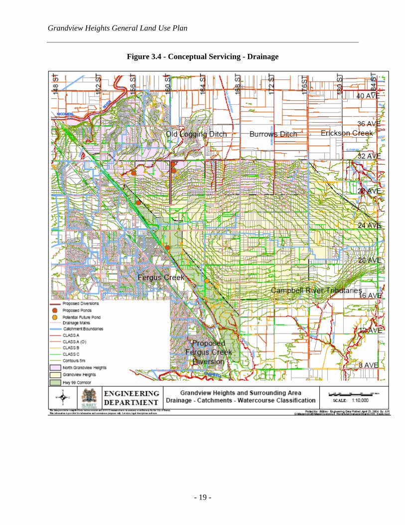
(c) Drainage plans will be developed to minimize impacts related to land use
changes (quality and quantity) and impact mitigation strategies will be developed to reflect the environmental sensitivity of the area and downstream watercourses. Existing soil conditions are to be considered in developing impact mitigation strategies. Specific drainage criteria will be developed to ensure appropriate level of service, while meeting environmental preservation objectives and site planning criteria will be developed at the NCP stage to encourage maintaining pre-development hydrology; and
(d) Conceptual plans showing the potential general servicing strategies for
sanitary sewer, water and storm water management/drainage are shown in Figures 3.2, 3.3 and 3.4, respectively.
Grandview Heights General Land Use Plan
- 16 -
Figure 3.1 - General Transportation Plan for Grandview Heights

Grandview Heights General Land Use Plan
- 17 -
Figure 3.2 - Conceptual Servicing – Sanitary Sewer

Grandview Heights General Land Use Plan
- 18 -
Figure 3.3 - Conceptual Servicing – Water
Grandview Heights General Land Use Plan
- 19 -
Figure 3.4 - Conceptual Servicing - Drainage

Grandview Heights General Land Use Plan
- 20 -
4.0 GENERAL LAND USE PLAN – IMPLEMENTATION
4.1 Neighbourhood Concept Plans (a) Grandview Heights will be comprised of distinct neighbourhoods for the
establishment of more detailed NCPs. The boundaries of these NCPs are identified in Figure 2 (Section 1.0 of this report);
(b) The new neighbourhoods in Grandview Heights are numbers as #1 to #5.
The numbering does not reflect the order of NCP preparation or development. Each NCP area will have a centrally located school/park site;
(c) The general content and process associated with the preparation of NCPs
is contained in Section 5 of Surrey's OCP. Before an NCP can proceed in Grandview Heights, terms of reference for the preparation and public consultation process must be approved by City Council; and
(d) Urban development will not proceed until NCPs have been completed
through further public consultation processes and have been approved by Council. At that time, issues such as the type and form of development and the details of adequate transition areas between the ALR, urban areas, and low density/ rural areas will be addressed in detail.
4.2 Funding
(a) The capital costs of constructing neighbourhood amenities and new police,
fire and library facilities will be borne by new development in accordance with the City's NCP amenity contribution practices. This will also include park, pathway development and the construction of any civic plazas and other amenities; and
(b) Grandview Heights will be planned and developed in accordance with the
City's "developer pay" principles, requiring that new development pay the costs for the infrastructure and amenities required to serve the new populations brought about by development.
4.3 Phasing
The first NCPs to be prepared will be in the area adjacent to the Highway 99 Corridor. Subsequent NCPs will be prepared and development will be managed in accordance with the feasibility of servicing, transportation management, and the ability of owners/developers to "front-end" the costs of development.
4.4 Sustainable Development Practices
(a) As Grandview Heights presents an ideal opportunity to implement principles of sustainability by introducing standards and development

Grandview Heights General Land Use Plan
- 21 -
practices consistent with global and regional sustainability objectives, detailed planning for the Grandview Heights area will incorporate principles of sustainable development, which are to be given attention in the development of the NCPs; and
(b) The detailed NCP process for the five NCP areas in Grandview Heights
will be expanded to explore innovative servicing, storm water management, road standard and neighbourhood planning ideas.
5.0 GENERAL LAND USE PLAN – GUIDING PRINCIPALS
Guiding principles for Grandview Heights were identified through workshops and discussions with the Grandview Heights CAC, through consultation with internal and external stakeholders and through consultation with the public. These guiding principles for Grandview Heights, which provided direction for preparing the Plan, should also be carried forward to NCPs and are contained in Appendix "A".

Grandview Heights General Land Use Plan
- A1 -
Appendix "A" - General Land Use Plan - Guiding Principles
At the outset of the planning process, several guiding principles were developed through the work of the CAC, to guide the development of the General Land Use Plan. They are as follows: Introduction The following policies are proposed to support the land use concept for Grandview Heights and will be used as a framework in preparing NCPs for the five NCP areas in Grandview Heights. Community Structure and Character 1. Community identity and character will be maintained through the retention, wherever
possible, of trees and vegetation of environmental significance, respect for the adjacent ALR and protection of key view corridors of mountains and water;
2. Five neighbourhoods have been identified for the establishment of more detailed NCPs. New development will not proceed until such plans have been completed through a further public consultation process and have been approved by Council. Issues such as tree retention areas, the type and form of development and the details of adequate transition areas between urban and permanent suburban and rural areas, will be addressed in detail through the NCP processes;
3. Buffering and transition densities adjacent to the ALR and the existing one-acre subdivisions will be defined through the NCP processes. Transitions in density will be defined at this stage though various approaches such as: − Gradual changes in the size of lots from large to small; − Compatible frontage widths for lots facing each other along the street; − Building designs that are compatible in height and massing for buildings facing each
other along the street; − Landscaped buffers designed to provide for a compatible transition in density; − Changes in lot sizes to occur at the rear of lots; and − Other means determined through the NCP process.
4. There will be a variety of housing types in Grandview Heights, including suburban lots,
single family lots, small lots and multiple residential townhouses and apartments. It is anticipated that, when completely built out, there will be in the range of 7,000 to 10,000 dwelling units of varying types which will accommodate roughly 20,000 additional people for a total of approximately 26,000, including the existing residents (i.e., those living on existing one-acre lots);
5. The highest residential densities will generally be located adjacent to the Highway 99 Corridor, decreasing toward 176 Street to the east. There will be a small, mixed-used commercial/multi-family area near the north east corner of 176 Street and 24 Avenue, which will be surrounded by urban residential uses toward 184 Street. This area will be

Grandview Heights General Land Use Plan
- A2 -
focussed upon the future neighbourhood residents and provide local services rather than auto-oriented commercial uses. Appropriate buffer and transitional zoning in this area will be determined through the NCP process. The central area of Grandview Heights will remain generally suburban in nature, with the exception that urban development in a clustered form will be considered in the area between 16 Avenue and 20 Avenue, generally east of about 170 Street, subject to the development of transition areas around the existing 1-acre lots;
6. A tree management, preservation and enhancement strategy will be incorporated into each NCP. The existing "green" ambiance will be fostered through the retention and planting of trees, the provision of open space in developments, the provision of park and natural areas and the application of tree planting and management standards for individual properties;
7. Consideration will be given to the transfer of densities and/or the clustering of development in order to protect significant stands of trees, protect areas of environmental sensitivity, to work with site topography, and to provide for adequate buffer areas. Tree surveys of significant stands will be undertaken by qualified professionals in advance of the design of development proposals. Zoning mechanisms to address clustered forms of development will be established at the NCP stage;
8. The central area of Grandview Heights, between approximately 168 Street and west of 176 Street, and between 28 Avenue and north of 20 Avenue, will retain its low-density character. New developments within this area will be subject to the application of design guidelines that will be prepared at the NCP stage; and
9. Within NCP #2, certain density allocations may be subject to review through the NCP process, particularly within the area in the vicinity of Edgewood Drive, between 20 Avenue and 23 Avenue.
Schools, Parks and Community Amenities 1. Three elementary schools and one secondary school are planned for the Grandview
Heights area. A fourth elementary school near 160 Street, north of 28 Avenue, will serve the neighbourhood west of 164 Street, between 24 Avenue and 28 Avenue. Elementary schools will generally be associated with neighbourhood parks. With the exception of the future elementary school on 26 Avenue and 172 Street, the precise location of the schools/parks, each of approximately 5.3 hectares (13 acres) in size, will be determined at the NCP stage;
2. As indicated in Surrey's OCP, the provision of park space will be based on the following (per 1,000 estimated new residents):
− 5 acres for City parks; − 2 acres for community parks; − 1.5 acres for neighbourhood parks; and − 4 acres for nature preserves and linkages;

Grandview Heights General Land Use Plan
- A3 -
3. Redwood Park and Darts Hill Park will be retained and enhanced and be connected with
the community through linkages and open space corridors;
4. A park area at the GVRD water reservoir site on 24 Avenue will be detailed at the NCP stage;
5. Green and pedestrian linkages and linear open spaces are identified on the Plan and are generally located along watercourses. Where possible, these may be associated with wildlife habitat and/or migrating routes. Additional local linkages will be established at the NCP stage;
6. Where storm water detention ponds or wetlands are required, they will be constructed as community amenities and features or as natural park areas;
7. Pedestrian/bicycle greenways will be located along 16 Avenue, 20 Avenue and 24 Avenue and around the edge of Grandview Heights on the historic Railway right-of-way. Pedestrian links from the main greenways to parks, neighbourhood commercial areas and other special features in the area will be defined at the NCP stage;
8. Land acquisition for a community-wide athletic and passive park to be established in approximately 10 to 15 years will be ongoing and the location/size of this park area will be determined through the various NCP processes. Other public open space will also be acquired or dedicated over time to accommodate civic amenities and facilities required to serve the larger Grandview Heights area; and
9. The capital costs of constructing neighbourhood amenities and new police, fire, and library facilities will be born by new development in accordance with the City's NCP amenity contribution practices.
Environment and Agriculture 1. Setbacks will be required from watercourses in the area in accordance with the applicable
provincial/federal policies or regulations in effect. These watercourse areas may also be enhanced with additional habitat that encompasses the specified setback, established woodland, young woodland and pasture grassland, to be determined through detailed studies through the NCP process;
2. Through the NCP processes in the Grandview Heights Plan area, the following additional environmental initiatives will be pursued:
− Develop a habitat management plan to identify environmentally sensitive areas or
features that should be protected, restored, replaced or enhanced, as appropriate, to retain habitat diversity and compliment other planning objectives within the various NCP areas;

Grandview Heights General Land Use Plan
- A4 -
− Require development strategies that are environmentally sensitive, such as housing which clusters development on the least environmentally sensitive portion of a site or within an NCP area;
− Encourage the identification of linear park opportunities that also preserve natural
vegetation, provide secondary wildlife preservation areas, link other habitat features, and/or provide buffers to residential neighbourhoods;
− Consider the creation of development permit areas to set conditions and vary or
supplement the City's by-laws for the protection of specific environmental features; and
− Incorporate the principles of sustainable development, including innovative servicing,
storm water management and road standards.
3. Development will be designed to ensure that the potential impacts of water runoff from upland areas on agricultural lands will be mitigated. Integrated Storm Water Management Plans, in accordance with the GVRD Liquid Waste Management Plan may be undertaken for one or more of the NCP areas in Grandview Heights; and
4. The policies in Surrey's OCP, which promote compatibility between the ALR non-agricultural land uses will be applied. This includes the use of buffers and land uses that are compatible with farm operations; considering significant grade changes, major roads, and natural features such as watercourses in determining measures to ensure an appropriate transition between non-agricultural and ALR uses; and having suburban lots adjacent to ALR land.
Phasing The first NCPs to be prepared will be in the area adjacent to the Highway 99 Corridor. Subsequent NCPs will be prepared and development will be managed in accordance with the feasibility of servicing, transportation management and the ability of owners/developers to "front-end" the costs of development. Commercial Small commercial areas may be established within NCP areas to serve the convenience needs of local residents. These commercial nodes will be located so as to not impact existing established residential areas and at the intersections of arterial or collector roads. Transportation 1. Through the NCP processes, special road and pathway standards may be developed in
suburban and transitional density areas of Grandview Heights to retain the rural character;

Grandview Heights General Land Use Plan
- A5 -
2. A modified grid road system in new development areas will be combined with greenways, which will enable residents to walk or cycle to all of the main schools, parks, services and facilities; and
3. Transportation systems within NCP areas will be designed to encourage walking, to slow down traffic and to minimize through-traffic from using local residential roads.
Servicing and Infrastructure 1. The water system in Grandview Heights will be designed to provide for:
− Watermain looping to ensure reliability and fire flow protection; − Utilization of some interim servicing options available with existing infrastructure as
long as supply can be ensured including fire flows; interim strategies will only be considered if they do not delay the ultimate plan; and
− Supply to higher pressure zones from pump stations and supply to lower pressure zones through gravity lines from reservoirs.
2. Sanitary sewer servicing will be designed to ensure the lowest life cycle costs, (i.e.
maximizing areas to be serviced by gravity sewer and minimizing pumping costs). Local improvement projects may be required to service lands already developed, but currently serviced by septic systems. Interim servicing strategies will be considered at the owners/developers expense as long as ultimate servicing is not encumbered or delayed as a result; and
3. Drainage plans will be developed to minimize impacts related to land use changes (quality and quantity) and impact mitigation strategies will be developed to reflect the environmental sensitivity of the area and downstream watercourses. Existing soil conditions are to be considered in developing impact mitigation strategies. Specific drainage criteria will be developed to ensure appropriate level of service while meeting environmental preservation objectives and site planning criteria will be developed at the NCP stage to encourage maintaining pre-development hydrology.
v:\wp-docs\admin & policy\05data\april-june\06161045.jmcl.doc SAW 6/22/05 3:06 PM


