14
HARDA DISTRICT MADHYA PRADESH Ministry of Water Resources Central Ground Water Board North Central Region BHOPAL 2013
| Date post: | 29-Jun-2018 |
| Category: |
Documents |
| Upload: | nguyenphuc |
| View: | 216 times |
| Download: | 0 times |

HARDA DISTRICT MADHYA PRADESH
Ministry of Water Resources
Central Ground Water Board
North Central Region BHOPAL
2013

HARDA DISTRICT AT A GLANCE
S.
No.
ITEMS STATISTICS
1. GENERAL INFORMATION
i) Geogeaphical area 3330 Sq.Km.
ii) Administrative Divisions (As on 2012)
Number of Tehsils
6
Number of Blocks 3 (Harda, Khirkia, Timarni)
Number of Panchayats 211 village Panchayats
Number of Villages 573
iii)Population (As per 2011 census) 570302
iv)Average Annual Rainfall (mm) 1374.5 mm
2. GEOMORPHOLOGY
i) Major Physiographic Units
1. Satpura range and extension
of Malwa Plateau in the south
2. Ridges (equivalent to Aravalli)
3. Alluvial plain in the north-east
and central part
ii) Major Drainage Narmada river and its tributaries,
namely Ganjal river, Ajnal river,
Sukni nadi, Midkul nadi, Dedra
nadi, Machak nadi, Syani nadi
and Kalimachak river.
3. LAND USE
i) Forest area: 780.92 Sq. Km.
ii) Net area sown: 1797.87 Sq. Km.
iii) Cultivable area: 1845.32 Sq. Km.
4. MAJOR SOIL TYPES
Black soils and ferruginous red
lateritic soils, Sandy clay loam,
sandy loam and clay loam. (
5. AREA UNDER PRINCIPAL CROPS
6. IRRIGATION BY DIFFERENT SOURCES
Number of
Structures
Area
(sq km)
Dugwells 8140 307
Tube wells/Bore wells 1894 142
Tanks/Ponds 1 1
Canals 1 795
Other Sources 169
Net Irrigated Area 1414
Gross Irrigated Area 1414
7. NUMBER OF GROUND WATER MONITORING WELLS OF CGWB (31.3.2013)
No. of Dug Wells
No. of Piezometers
9
3
8 PREDOMINANT GEOLOGICAL FORMATIONS
Archaean Granite; Porcellanite/
quartzite/ schist (equivalent to

Aravallies); Deccan Trap
basaltic lava flows and older
dolerite dykes/ sills and Recent
laterite and alluvium
9 HYDROGEOLOGY
Major Water Bearing Formation
Pre-monsoon
depth to water level during 2012
Post-monsoon
depth to water level during 2012
Long Term water level trend in 10 years
(2003-2012) in m/yr
Alluvium, Deccan Trap and
weathered granite.
3.81 to 16.27 m.bgl
0.30 to 17.8 m.bgl
0.04 to 0.73 m fall/annum
During Pre-monsoon
0.02 to 0.38 m rise/annum
(Post-monsoon)
10. GROUND WATER EXPLORATION BY CGWB (As on 31.3.2013)
No of wells drilled (EW,OW,PZ,SH, Total) 1 EW, 3 PZ
Depth Range (m) 32.61to 98.45 m.bgl
Discharge (litres per second) meagre to 10 lps.
-
-
11. GROUND WATER QUALITY
Presence of Chemical constituents more than
permissible limit (eg EC, F, As,Fe)
High Nitrate (> 45 mg/l)
recorded in 5 water samples
Type of Water Calcium Bicarbonate type
12 DYNAMIC GROUND WATER RESOURCES (2009) in MCM
Net Ground Water available 540.72
Gross Annual Ground Water Draft 134.34
Projected Demand for Domestic and Industrial
uses up to 2035
13.47
Stage of Ground Water Development 24%
13. AWARENESS AND TRAINING ACTIVITY
Mass Awareness Programmes Organised Nil
Water Management Training Programmes
Organised
Nil
14. EFFORTS OF ARTIFICIAL RECHARGE & RAINWATER HARVESTING
Projects completed by CGWB Nil
Projects under technical guidance of CGWB Nil
15. GROUND WATER CONTROL AND REGULATION
Number of OE Blocks Nil
Number of Critical Blocks Nil
Number of Blocks notified Nil
16. MAJOR GROUND WATER PROBLEMS AND ISSUES
Ground water level in declining
in Khirkiya block and parts of
Timarni block.
INTRODUCTION

Harda district has predominantly an agricultural based economy. It is situated
in the eastern part of Madhya Pradesh. Prior to 1998-99 District Harda was a part of
Hoshangabad District. Harda District was created in 6th
July 1998, when it was
divided from Hoshangabad District. After the division of the district, the area of
Harda district is 3330 Sq. Km. The district is bounded by Dewas and Sehore districts
in the North, Hoshangabad district in the east, Betul in the south and Khandwa district
in the west and south. Harda district lies between north latitudes 210 54’ and 22
0 36’
and east longitudes 760 46’ and 77
0 30’ in parts of Survey of India toposheet Nos, 55B
& F. Harda is the district headquarters and Khirkiya and Timarni are some of the
major towns. Harda lies on Delhi-Mumbai and Kolkata-Mumbai railway routes. State
Highway No. 15, linking Bhopal to Khandwa and National Highway No.59 A, linking
Indore to Betul, pass through the district. The villages in the district are approachable
by fair weather motorable tract.
The district is divided into three Tehsils and three development Blocks,
namely Harda Block, Timarni Block and Khirkiya Block. (Plate-I). As per 2001
census, the total population of the district is 474174 persons in 571 villages, as per
2001 census.
Drainage
The entire district is drained by Narmada River and its tributaries. Thus the
area falls in the Narmada Basin. The river Narmada flows along the northern
boundary of the district. The Ganjal river is the major tributary of the Narmada river
and flows from south to north along the eastern boundary of Harda district before
merging into the Narmada river. The other major tributary of the Narmada river
draining the district are Ajnal river, Sukni nadi, Midkul nadi, Dedra nadi, Machak
nadi, Syani nadi and Kalimachak river.
Irrigation
Table 1. : Irrigation
S.
No.
Sources of Irrigation
Number and Area Irrigated in Hectare
1
Dugwells
Number of
Structures
Area
(sq km)
8140 307
2 Tube wells/Bore
wells
Tanks/Ponds
1894 142
1 1
3 Canals
Other Sources
1 795
169
4 Net Irrigated
Area
Gross Irrigated
Area
1414
1414
Cropping Pattern
District is very rich in the field of agriculture due to good sources of irrigation
and fertile alluvial and black cotton soil. Wheat and gram are the main crops grown
during Rabi season. Cotton, Soyabean, Mustard, Til and Groundnut are the main
oilseeds produced here. The farmers have started the production of Sunflowers.
CGWB Activites
Preliminary hydrogeological studies in parts of Harda district were carried out
by the erstwhile ground water wing of geological survey of India in co-ordination
with the erstwhile exploratory tube wells organization from 1953 to 1963 (P.G.
Adyalkar, 1975). A comprehensive hydrogeological study of the alluvial area of the
district was carried out by Central Ground Water Board, during the Narmada Project
period from 1971 to 1978. During the above mentioned studies, besides
hydrogelogical, hydrological and hydrometeorological studies, exploratory drilling
was also carried out covering the entire Narmada upland alluvial valley. Systematic
hydrogeological survey has been carried out by Shri K. Srinivasan, Junior Geologist
of the GSI in 1969-90, by Shri A. K. Jain, Asstt. Hydrogeologist of Central Ground
Water Board in the southern part of the district in 1984-85 and by Shri S.N.Bangar,
Asstt. Hydrogeologist in 1987-88. Reappraisal Hydrogeological Survey was taken up
by Shri R. M. Verma, Asstt. Hydrogeologist during AAP 1991-92 to assess the
scenario of ground water regime.
Rainfall & Climate
The climate of Harda district is characterized by a hot summer and general
dryness except during the south west monsoon season. The year may be divided into
four seasons. The cold season, December to February is followed by the hot season
from March to about the middle of June. The period from the middle of June to
September is the southwest monsoon season. October and November form the post
monsoon period.
The normal rainfall of Harda district is 13.74.5 mm. It receives maximum
rainfall during southwest monsoon period. About 90.5% of the annual rainfall is
received during monsoon season and only 9.5 % of the annual rainfall takes place
during October to May period. The surplus water for groundwater recharge is
available only during the southwest monsoon period.
The normal maximum temperature occurs during the month of May i.e. 42.1oC
and minimum during the month of January i.e. 11.7oC. The normal annual mean
maximum and minimum temperature of Harda district is 32.8oC and 19.8
oC
respectively. During the southwest monsoon season the relative humidity generally
exceeds 91% (August month). Rest of the year is drier. The driest part of the year is
the summer season, when relative humidity is less than 33%. April is the driest month
of the year. The wind velocity is higher during the pre-monsoon period as compared
to post monsoon period. The maximum wind velocity 7.7 km/hr is observed during
the month of June and minimum 2.9 km/hr during the month of December. The
average normal annual wind velocity of Harda district is 5.0 km/hr.
Geomorphology & Soil Types
Physiographically, the district can be divided in three major divisions:-
1. Satpura range and extension of Malwa Plateau in the south,
2. Ridges (equivalent to Aravalli Hills) in the north-west,
3. Alluvial plain in the north-east and central part
The district is bounded by Satpura ranges in south and by Narmada river in the
north. The area slopes north west towards the Narmada river. The slope is generally
steep at the foothills of Satpura but moderate to gentle towards Narmada river. The
land surface attains a maximum altitude of 734 m above mean sea level at Kaoti (770
19’30”: 22003’00”), and minimum altitude of 240 m above mean sea level at
confluence of Machak river with the Narmada (76046’50”: 22
019’00”). A large
number of north westerly flowing tributaries originating from the Satpura join the
Narmada River along the left bank. The area is mainly drained by Narmada river and
its tributaries - namely Ganjal river, Ajnal river, Sukni nadi, Midkul nadi, Dedra nadi,
Machak nadi, Syani nadi and Kalimachak river.
Soils of the area are characterized by black grey, red and yellow colours, often
mixed with red and black alluvium and ferruginous red gravel or lateritic soils. These
soils are commonly known as black soils. About 15% of the area is covered by sandy
loam soils immediately on the banks of rivers. Remaining part is occupied by clay
loam with big pockets of sandy clay loam and sandy loam. The permeability of the
soil is low when the clay contains montmorillonite. They swell intensively when wet
and shrink with deep cracks when dry. Intake of water is very rapid till the cracks
disappear after complete wetting. The soils have been classified as
Ustocherpts/Ustorthents/ Haplustalfs/Haplusterts as per pedological taxonomy as per
pedological classification.

GROUND WATER SCENARIO
HYDROGEOLOGY
Aquifer System and Aquifer Parameters
The rocks occurring in the district range in age from Palaeoproterozoic to
Quaternary. About 40 % of the district, in the eastern, central and northern (adjoining
the Narmada river) part, is covered with alluvium. Ground water occurs under
phreatic as well as confined conditions. The water bearing properties of different
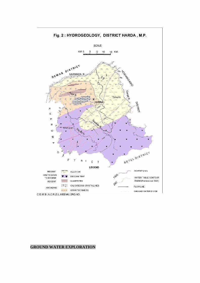
hydrogeological units occurring in Harda District are described below. Hydrogeology
of the district is shown in Plate-II.
Archaeans and Metamorphic rocks equivalent to Aravallis
The Archaean Group of rocks, comprising granite, phyllite, dolomite,
quartzite, chert breccia etc are exposed in the north-western part and are faulted near
the Narmada River. Weathered and fractured Granite forms a potential aquifer in the
area.
Deccan Trap
Deccan traps, which makes for about 50% of the entire district occur as lava
flows in the western and southern part of the district. The phreatic aquifer in
weathered/vesicular basalt are tapped by dugwells while the deeper confined aquifers
are tapped by drilling tubewells. The yield of dug wells ranges from 120 to 180 litres
per minute, but in the canal command area, due to substantial recharge from canal
seepage, sustains a good discharge.
Alluvium
The alluvial aquifer system in the district is highly potential. Two to three
granular zones and at places more number of potential granular zones comprising of
fine to medium to coarse grained sand, gravel and pebbles and laterite are encountered
in alluvium. The top phreatic aquifer range in thickness from 2 to 10m and is
encountered in the depth range of 4 to 20 mbgl.
It appears that all the alluvial aquifer zones constitute a single aquifer system -
the unconfined aquifer and a number of deeper aquifer zones separated by thick clay
zones. The deeper aquifers are of semi-confined to confined nature with varying
potentiometric heads. The yield of alluvial aquifers ranges from 180 to 900 litres per
minute.
GROUND WATER EXPLORATION

During Narmada Project period between 1971 to 1978 one exploratory well
was drilled in the District at Timarni site and 3 Peizometers were drilled during
Hydrology Project period between 1997 to 2000.
S.
No
Location Depth
Drilled/
Well
Completion
depth
Geological
Formations
Aquifer
Zones
Discharge Depth to
water
level
(In mbgl) (litres/sec) (mbgl)
1 Timarni
22°23'
77°14' 55
F/3
32.61 0-28.35
Alluvium
Basalt at 28.35
2
Handia(S)
22°29'02"
76°59'10"
36.86
0-14 Alluvium
Granite at 14.0
14.43-17.86
23.86-30.86
1.0 9.43
3
Harda(D)
22°20'29"
77°05'27"
57.50
10.46
4
Khirkiya(D)
22°09'45"
76°51'34"
98.45
0-0.6 Soil
Basalt at 0.6
8.5-12.19 4.58
Well Design
Exploratory wells were drilled by direct rotary method in the alluvial area of
the district. Since the area is highly potential, mostly 305 mm (12”) or 357 (14”)
housing has been used to the desired depth depending upon expected discharge and
draw-down vis-a-vis depth to water level. The water bearing zones were tapped by
placing slotted pipe of 1/8” or 1/16” opening against these zones and the annular
space was filled up by gravel of suitable size.
It has been observed that the State Govt. and the individual farmers in the
district are getting the bore holes drilled by DTH rigs which is most
unsuitable.Geophysical logging facilitates design the production wells properly.
In hard rocks DTH rig can be utilized. Bore hole can be left naked below the
surface casing. However, in the basaltic terrain suitable assembly can be lowered to
avoid collapsing of strata.
WATER LEVELS
Ground water level form a very important parameter of the ground water
system. The groundwater balance expresses itself in the change in water levels; hence
a continuous record is important and useful. CGWB has 10 Ground Water
Hydrograph Monitoring wells and 3 Peizometers in Harda district.
Pre Monsoon Depth to Water Level (May-2012 )
In general depth to water level in the area ranges from 3.81 to 16.27 m. below
ground level. Shallow water level of less than 6 m has been recorded at Chhidgaon

and Morgarhi. Depth to water level between 9 to 12 m. bgl. is occurring in major part
of the district and recorded at Magardha, Mandla, Handia, Harda, Timarni and
Mohanpur. Deep water level more than 12 m. bgl. is recorded at Chhipawad and
Temagaon.
Post Monsoon Depth to Water Level (November-2012)
In general, during post-monsoon period, depth of water levels in the district
ranges between 0.3 to 17.8 m. below ground level. Very shallow water level of less
than 3 m is recorded in an isolated monitoring well at Chhipawad. Depth to water
level between 3 to 6 m bgl. is occurring in major part of the district has been recorded
at Chhidgaon and Mandla. Depth to water level between 6 to 9 m bgl. is observed at
Morgarhi, Handia, Timarni, Mohanpur and Temagaon. Deepest water level of 11.5
was recorded at Harda.

CHANGE IN GROUND WATER LEVELS
Water Level Fluctuation between Pre and Post-Monsoon 2012
It is observed that there is 0.04 to 0.73 m fall/annum During Pre-monsoon and 0.02 to
0.38 m rise/annum (Post-monsoon) in the Harda district.
GROUND WATER RESOURCES
The groundwater resource of the District are under-developed and
under-utilised. 1894 number of tubewells and 8140 number of dugwells facilitate to irrigate an area of 439.94 Sq.Km. of agricultural land as against 1797.87 Sq.Km. of net sown area in the district.
Dynamic ground water resources of the district have been estimated for base year -2009 on block-wise basis. All blocks of the district are categorized as safe blocks, with highest stage of ground water development of 57 %. in Khirkiya block The net ground water availability in the district 54,072 ham and ground water draft for all uses is 13,034 ham, making Stage of Ground water development 24 % (28 % in 2003/04) as a whole for district. After making allocation for future domestic and industrial supply for next 25
years, balance available ground water for future irrigation would be 40,663 ham at 50 % stage of ground water development’s safe limits in the district.
There is ample scope for development of groundwater for irrigation, industrial and domestic purposes.
Table 6: Ground Water Resources of Harda district
S. No. Distric
t/ Assessment Unit
Sub-unit Command/
Non-Command/
Net Annual Ground water
Availability (ham)
Existing Gross
Ground water
Draft for Irrigation (ham)
Existing Gross
Ground water
Draft for Domestic
& Industrial
water Supply (ham)
Existing
Gross Ground water
Draft for All uses (ham)
Provision for
domestic, and
industrial requirement supply to next 25 year (2033)
(ham)
Net Ground water
Availability for future
irrigation d development
(ham)
Stage of Ground water
Development (%)
Category
Harda
1 Harda
Command 7324 664 101 764 120 6540 10 Safe
Non-Command
7439 3655 216 3871 257 3528 52 Safe
Block Total 14763 4318 317 4635 376 10068 31 Safe
2 Khirkiya
Command
Non-Command
8012 4235 326 4561 513 3264 57 Safe
Block Total 8012 4235 326 4561 513 3264 57 Safe
3 Timarni
Command 20520 384 93 477 165 19971 2 Safe Non-Command
10777 3126 235 3360 292 7359 31 Safe
Block Total 31297 3510 328 3838 457 27330 12 Safe
District Total
54072 12063 971 13034 1347 40663 24 Safe
GROUND WATER QUALITY
Ground Water quality of Harda district has been assessed by CGWB on the
basis of water samples collected from the six numbers of hydrograph (groundwater
monitoring) stations for the year 2011. The hydrogen ion concentration i.e. pH in
groundwater ranges from 7.08 to 7.92. The pH of ground water shows neutral to
marginal alkaline in nature. Ground water salinity is low to high as electric
conductivity values vary between 748 to 1865 µS/ cm at 25°C. As per BIS
recommendation the EC value in drinking water towards Total Dissolve Solids (TDS)
i.e. 750 µS/cm at 25°C is minimum desirable limit and 3000 µS/cm at 25°C is
maximum permissible limit for drinking purposes. If the EC value more than 3000
µS/cm at 25°C; the water is not suitable for drinking purposes. The EC of ground
water of Harda district does not exceeded maximum permissible limit. The highest
EC was recorded at Mandla village i.e. 1865 µS/cm at 25°C.
Constituents like Chloride, Sulphate and Calcium were within the safe limit for
drinking water as per BIS standards. Nitrate concentration in the ground water of
district varies from 30 to 213 mg/l. As per BIS recommendation nitrate more than
45mg/l was found in four villages namely Harda (58 mg/l), Chhipawad (60 mg/l),
Mohanpur (74 mg/l), Morgarhi (85 mg/l) and Mandla (213 mg/l). High nitrate in
ground water may be due to the excessive use of fertilizers etc. The fluoride
concentration in the ground water of Harda district recorded in the ranges 0.04 to 1.68
mg/l. The maximum concentration of fluoride i.e. 1.68 mg/l recorded in the ground
water of Handia village which is more than maximum permissible limit recommended
by BIS i.e. 1.50 mg/l. Total hardness of ground water have been recorded in the range
of 180 to 700 mg/l. The total hardness of 700 mg/l recorded at Mandla village which
is more than BIS recommendation i.e. 600 mg/l. The magnesium concentration was
recorded in the range of 6 to 46 mg/l. As per BIS recommendation the maximum
permissible limit of magnesium concentration in drinking water is 30 mg/l. The
villages namely: Mandla (38 mg/l), Chhidgaon (39 mg/l), Handia and Timarni (45
mg/l) and Mohanpur (46 mg/l) are recorded magnesium concentration more than BIS
recommendation.
Quality of water for Irrigation:-
High SAR is not good for irrigation as it lead to sodium hazards. Water samples falls
in C2S1 and C3S1 classes of US Salinity classification. The ground water in the district
is safe for irrigation purpose but proper drainage system is required where EC is high
i.e. more than 1500 µS/cm2.
GROUND WATER MANAGEMENT STRATEGY
Harda comes under safe category from ground water development point of
view. Due to easy availability of surface water for irrigation, after the construction of
major irrigation Tawa project (1975), the development of ground water for irrigation
has been negligible in the area falling under the Tawa Command Project. The ground
water development is confined only in non-command area in the district i.e. in
Khirkiya block and parts of Timarni block where ground water being the main source
of irrigation, ground water level is declining.
Scope of Conjunctive utilization of surface and ground water
Indira Sagar Project on Narmada river has the largest reservoir in India and
second largest in Asia has been completed and a number of villages on the bank of
Narmada river in Harda district will come under submergence as the water in the
reservoir attains its full reservoir level.
By 2008 monsoon, Donglighat-Jhalwa village in Harda district submerged.
The effect of the reservoir on groundwater levels will be seen in the coming decade
and the benefits/problems will be seen then. To deal with the situation, the
possibilities of conjunctive use of surface water and ground water should be
considered immediately.
RECOMMENDATIONS
Based on the hydrogeological studies the following recommendations are
made for proper development and utilization of the available groundwater resources
and management of ground water resources.
Once the Indira Sagar reservoir attains its full reservoir level, all existing
ground water structures should be put to their fullest use. All the tube wells

constructed in the area should be run to their fullest capacity. This will also cause
induced recharge from the reservoir to the ground water aquifers. Water from
tubewells/dugwells should be used for irrigation and excess water, if any, may be put
into distributaries and minors. More number of tube wells could be sunk in the
demarcated productive areas and individual command per tube well can be increased
for efficient and appropriate irrigation.


