80
Hubbard County Shoreland Management Ordinance No. 17 Amendment 16 June 25, 2014

Hubbard County
Shoreland Management Ordinance No. 17
Amendment 16
June 25, 2014

HUBBARD COUNTY SHORELAND MANAGEMENT ORDINANCE
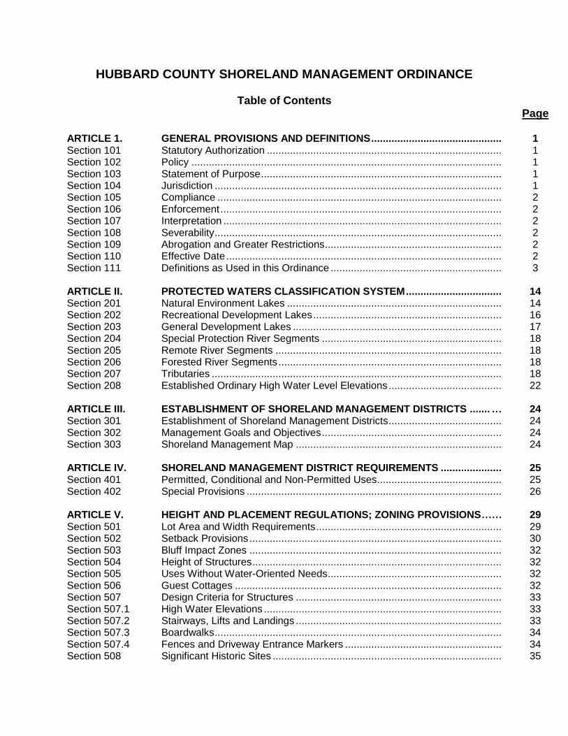
Table of Contents Page ARTICLE 1. GENERAL PROVISIONS AND DEFINITIONS ............................................. 1 Section 101 Statutory Authorization ................................................................................. 1 Section 102 Policy ........................................................................................................... 1 Section 103 Statement of Purpose ................................................................................... 1 Section 104 Jurisdiction ................................................................................................... 1 Section 105 Compliance .................................................................................................. 2 Section 106 Enforcement ................................................................................................. 2 Section 107 Interpretation ................................................................................................ 2 Section 108 Severability ................................................................................................... 2 Section 109 Abrogation and Greater Restrictions ............................................................. 2 Section 110 Effective Date ............................................................................................... 2 Section 111 Definitions as Used in this Ordinance ........................................................... 3 ARTICLE II. PROTECTED WATERS CLASSIFICATION SYSTEM ................................. 14 Section 201 Natural Environment Lakes .......................................................................... 14 Section 202 Recreational Development Lakes ................................................................. 16 Section 203 General Development Lakes ........................................................................ 17 Section 204 Special Protection River Segments .............................................................. 18 Section 205 Remote River Segments .............................................................................. 18 Section 206 Forested River Segments ............................................................................. 18 Section 207 Tributaries .................................................................................................... 18 Section 208 Established Ordinary High Water Level Elevations ....................................... 22 ARTICLE III. ESTABLISHMENT OF SHORELAND MANAGEMENT DISTRICTS ....... … 24 Section 301 Establishment of Shoreland Management Districts ....................................... 24 Section 302 Management Goals and Objectives .............................................................. 24 Section 303 Shoreland Management Map ....................................................................... 24 ARTICLE IV. SHORELAND MANAGEMENT DISTRICT REQUIREMENTS ..................... 25 Section 401 Permitted, Conditional and Non-Permitted Uses ........................................... 25 Section 402 Special Provisions ........................................................................................ 26 ARTICLE V. HEIGHT AND PLACEMENT REGULATIONS; ZONING PROVISIONS …… 29 Section 501 Lot Area and Width Requirements ................................................................ 29 Section 502 Setback Provisions ....................................................................................... 30 Section 503 Bluff Impact Zones ....................................................................................... 32 Section 504 Height of Structures ...................................................................................... 32 Section 505 Uses Without Water-Oriented Needs ............................................................ 32 Section 506 Guest Cottages ............................................................................................ 32 Section 507 Design Criteria for Structures ....................................................................... 33 Section 507.1 High Water Elevations .................................................................................. 33 Section 507.2 Stairways, Lifts and Landings ....................................................................... 33 Section 507.3 Boardwalks ................................................................................................... 34 Section 507.4 Fences and Driveway Entrance Markers ...................................................... 34 Section 508 Significant Historic Sites ............................................................................... 35

Section 509 Steep Slopes ................................................................................................ 35 Section 510 Building Repairs and Maintenance ............................................................... 35 Section 511 Temporary Structures ................................................................................... 36 Section 512 Recreational Vehicles .................................................................................. 36 Section 513 Geothermal Energy Systems ........................................................................ 36 ARTICLE VI. ACCESSORY USES AND STRUCTURES .................................................. 37 Section 601 Accessory Uses and Structures .................................................................... 37 ARTICLE VII. NONCONFORMITIES AND NONCONFORMING LOTS OF RECORD ........ 38 Section 701 Nonconforming Use of Land ......................................................................... 38 Section 702 Extension of Nonconforming Uses ................................................................ 38 Section 703 Change of a Nonconforming Use.................................................................. 38 Section 704 Nonconforming Structures ............................................................................ 38 Section 705 Damage to Nonconforming Structures .......................................................... 40 Section 706 Deck and Platform Additions ........................................................................ 40 Section 707 Nonconforming Lots of Record ..................................................................... 41 Section 707.1 Nonconforming Lots of Record recorded Prior to July 12, 1971 .................... 41 Section 707.2 Nonconforming Lots of Record recorded from July 12, 1971 to April 15, 1991 ........................................................................................... 42 Section 708 Nonconforming Sewage Treatment Systems ................................................ 42 ARTICLE VIII. SANITATION STANDARDS ........................................................................ 44 Section 801 Sewage Treatment Standards ...................................................................... 44 Section 802 Sewage Treatment Permit Requirements ..................................................... 45 Section 803 Water Supply Standards ............................................................................... 45 Section 804 Agricultural Waste Disposal .......................................................................... 45 ARTICLE IX. GENERAL SHORELAND REQUIREMENTS ............................................... 46 Section 901 Vegetative Alterations ................................................................................... 46 Section 902 Topographic Alterations/Grading and Filling ................................................. 47 Section 903 Placement and Design of Roads, Driveways, Recreation trails and ............. Parking Areas ............................................................................................... 49 Section 904 Stormwater Management Standards ............................................................ 50 Section 905 Special Provisions for Commercial, Industrial, Public & ............................... Semipublic Uses ........................................................................................... 50 Section 906 Special Provisions for Agricultural Uses ....................................................... 51 Section 907 Special Provisions for Forest Management .................................................. 52 Section 908 Special Provisions for Extractive Uses ......................................................... 52 Section 909 Special Provisions for Fish and Wildlife Habitat Improvements............................................................................................... 53 ARTICLE X. SUBDIVISIONS AND PLANNED UNIT DEVELOPMENTS .......................... 54 Section 1001 Applicability .................................................................................................. 54 Section 1002 Land Suitability ............................................................................................. 54 Section 1003 Consistency with Other Controls................................................................... 55 Section 1004 Dedications .................................................................................................. 56 Section 1005 Controlled Access on Recreational Lots ....................................................... 56 Section 1006 Lot Size ........................................................................................................ 57 Section 1007 Storm Drainage ............................................................................................ 57 Section 1008 Water Supply Facilities ................................................................................. 57

Section 1009 Sanitary Sewerage ....................................................................................... 57 Section 1010 Platting Requirements .................................................................................. 58 Section 1011 Planned Unit Development Review .............................................................. 58 Section 1012 PUD Site Suitability Evaluation ..................................................................... 59 Section 1013 Residential and Commercial PUD Density Evaluation .................................. 59 Section 1014 PUD Maintenance and Design Criteria ......................................................... 61 Section 1015 Conversions to PUDs ................................................................................... 63 ARTICLE XI. ADMINISTRATION ...................................................................................... 64 Section 1101 Environmental Services Officer .................................................................... 64 Section 1102 Planning Commission/Board of Adjustment .................................................. 65 Section 1103 Variances and Appeals ................................................................................. 68 Section 1104 Permits ......................................................................................................... 70 Section 1105 Conditional Use Permits ............................................................................... 70 Section 1106 Amendments ................................................................................................ 72 Section 1107 Public Notice and Hearing Requirements ..................................................... 73 Section 1108 Enforcement and Penalties........................................................................... 73 Section 1109 Fees ............................................................................................................. 74 Appendix A.1 Bluff drawing ............................................................................................. 75 Appendix A.2 Lot Width, Riparian drawing ..................................................................... 75

- 1 -
GENERAL PROVISIONS AND DEFINITIONS Section 101. Statutory Authorization Pursuant to the authority conferred by the State of Minnesota in Minnesota Statutes, Chapter 103, Minnesota Regulations, Parts 6120.2500 - 6120.3900, and the planning and zoning enabling legislation in Minnesota Statutes, Chapter 394 and for the purpose of; preserving and enhancing the quality of surface waters, preserving the economic and natural environmental values of shorelands, and providing for the wise utilization of waters and related land resources. Section 102. Policy The uncontrolled use of shorelands of Hubbard County, Minnesota affects the public health, safety and general welfare not only by contributing to pollution of public waters, but also by impairing the local tax base. It is, therefore, in the best interest of the public health, safety and welfare to provide for the wise subdivision, use and development of shorelands of public waters. The Minnesota State Legislature has delegated responsibility to local governments of the state to regulate the subdivision, use and development of the shorelands of public waters in order to preserve and enhance the quality of surface waters, conserve the economic and natural environmental values of shorelands, and to provide for the wise use of waters and related land resources. This responsibility is hereby recognized by Hubbard County, and will be accomplished through the enforcement of this Ordinance, which shall be known and cited as the Hubbard County Shoreland Management Ordinance. Section 103. Statement of Purpose The purpose of the Hubbard County Shoreland Management Ordinance is to achieve the aforementioned policies and to: -- Designate suitable management districts for each public water; -- Regulate the placement of sanitary and waste treatment facilities on lots; -- Regulate the area of lot and the length of water frontage suitable for a building site; -- Regulate alteration of the shorelands of public waters; -- Regulate alterations of the natural vegetation and the natural topography; and -- Regulate the subdivision of land in unincorporated areas.
-- Implement the above-mentioned items in accordance with the Hubbard County Land Use Plan.
The County Commissioners of Hubbard County, Minnesota do ordain as follows: Section 104. Jurisdiction The provision of this Ordinance shall apply to the shorelands of the public water bodies in the unincorporated areas of Hubbard County unless requested by those incorporated bodies, as classified in Article II of this Ordinance. Pursuant to Minnesota Regulations, Parts 6120.2500 - 6120.3900, no lake, pond, or flowage less than twenty-five (25) acres in size will be regulated by county shoreland management regulations. A body of water created by a private user where there was no previous shoreland is exempt from this Ordinance.
- 2 -
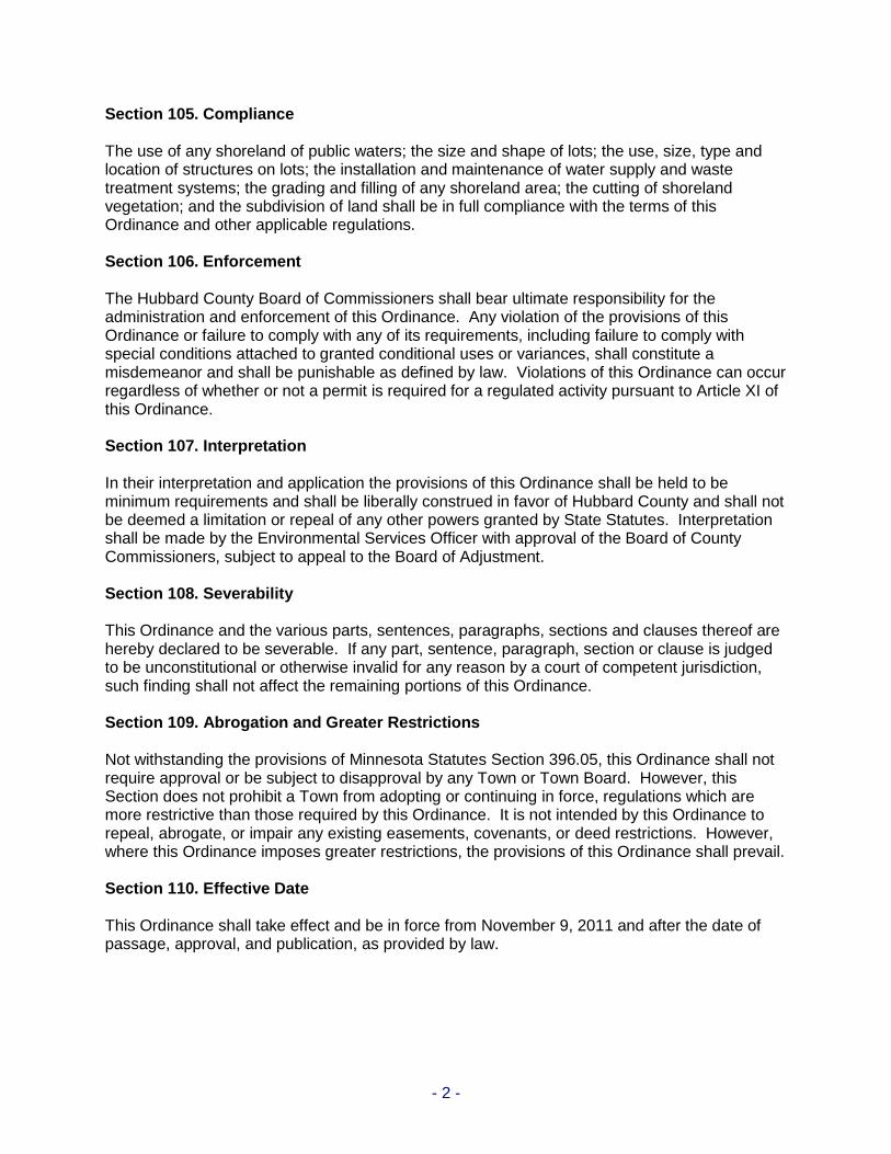
Section 105. Compliance The use of any shoreland of public waters; the size and shape of lots; the use, size, type and location of structures on lots; the installation and maintenance of water supply and waste treatment systems; the grading and filling of any shoreland area; the cutting of shoreland vegetation; and the subdivision of land shall be in full compliance with the terms of this Ordinance and other applicable regulations. Section 106. Enforcement The Hubbard County Board of Commissioners shall bear ultimate responsibility for the administration and enforcement of this Ordinance. Any violation of the provisions of this Ordinance or failure to comply with any of its requirements, including failure to comply with special conditions attached to granted conditional uses or variances, shall constitute a misdemeanor and shall be punishable as defined by law. Violations of this Ordinance can occur regardless of whether or not a permit is required for a regulated activity pursuant to Article XI of this Ordinance. Section 107. Interpretation In their interpretation and application the provisions of this Ordinance shall be held to be minimum requirements and shall be liberally construed in favor of Hubbard County and shall not be deemed a limitation or repeal of any other powers granted by State Statutes. Interpretation shall be made by the Environmental Services Officer with approval of the Board of County Commissioners, subject to appeal to the Board of Adjustment. Section 108. Severability This Ordinance and the various parts, sentences, paragraphs, sections and clauses thereof are hereby declared to be severable. If any part, sentence, paragraph, section or clause is judged to be unconstitutional or otherwise invalid for any reason by a court of competent jurisdiction, such finding shall not affect the remaining portions of this Ordinance. Section 109. Abrogation and Greater Restrictions Not withstanding the provisions of Minnesota Statutes Section 396.05, this Ordinance shall not require approval or be subject to disapproval by any Town or Town Board. However, this Section does not prohibit a Town from adopting or continuing in force, regulations which are more restrictive than those required by this Ordinance. It is not intended by this Ordinance to repeal, abrogate, or impair any existing easements, covenants, or deed restrictions. However, where this Ordinance imposes greater restrictions, the provisions of this Ordinance shall prevail. Section 110. Effective Date This Ordinance shall take effect and be in force from November 9, 2011 and after the date of passage, approval, and publication, as provided by law.

- 3 -
Section 111. Definitions as Used in this Ordinance Unless specifically defined below, words or phrases used in this Ordinance shall be interpreted so as to give them the same meaning as they have in common usage and so as to give the Ordinance its most reasonable application. For the purpose of this Ordinance, the words "must" and "shall" are mandatory; the word "may" is permissive. All distances, unless otherwise specified, shall be measured horizontally. Words used in the present tense shall include the future, and words used in the singular number shall include the plural number as well. ACCESSORY STRUCTURE OR FACILITY. Any structure, building, or facility incidental to another structure or facility on the same lot which, because of its nature, can reasonably be located at or greater than normal structure setback. Examples of such structures and facilities include but are not limited to: Swimming pools; tennis courts; saunas; solar collectors; wind generators; satellite dishes; detached garages; storage buildings; and recreational trailers and vehicles. ACCESSORY USE. Any use which is incidental to the principal use of a lot. AGRICULTURE. The use of land for agricultural purposes including: farming; dairying; pasturage; horticulture; floriculture; viticulture; animal and poultry husbandry and the necessary accessory uses for packing, treating and storing the produce, provided that the operation of any such accessory uses shall be secondary to that of the principal agricultural activities. AGRICULTURAL STRUCTURE. Any structure existing or erected and used principally for agricultural purposes, with the exception of dwelling units. BLUFF. A topographic feature such as a hill, cliff, or embankment having all of the following characteristics: (1) Part or all of the feature is located within a shoreland area; (2) The slope rises at least 25 feet above the ordinary high water level of the waterbody; (3) The grade of the slope from the toe of the bluff to a point 25 feet or more above the
ordinary high water level averages 30 percent or greater; (4) The slope drains toward the waterbody. An area with an average slope of less than 18 percent over a distance of 50 feet or more shall not be considered part of the bluff. (See Appendix A.1 for illustration). BLUFF IMPACT ZONE. A bluff and land located within 30 feet from the top of a bluff. BOARD OF ADJUSTMENT. The Hubbard County Board of Adjustment as appointed by the Hubbard County Board of Commissioners. BOARD OF COUNTY COMMISSIONERS. The Hubbard County Board of Commissioners. BOARDWALK. A permanent elevated structure used to provide access to a lake or river where a wetland is present and no other access point is available. BOATHOUSE. A structure used solely for the storage of boats or boating equipment.

- 4 -
BUILDING. Any structure, either temporary or permanent, having a roof or other covering, and designed for the shelter or enclosure of any person, animal or property of any kind, including tents, or recreational vehicles situated on private property and used for purposes ordinarily attributed to a building. BUILDING LINE. A line parallel to a lot line or the ordinary high water level at the required setback beyond which a structure may not extend. CHURCH. A building or structure, or groups of buildings or structures, that by design and construction are primarily intended for conducting organized religious services and associated accessory uses where persons regularly assemble for religious worship and are maintained and controlled by a religious body organized to sustain public worship. CLEAR CUTTING. The removal of an entire stand of trees. CLUSTERED. A development pattern and technique whereby structures or building sites are arranged in close proximity to one another in non-linear groups, adjacent to permanently preserved common open space so as to make the most efficient and visually aesthetic use of the natural features of the landscape and maximize visualization of the permanently preserved open space. COMMERCIAL USE. The principal use of land or buildings for the sale, lease, rental, or trade of products, goods or services. COMMISSIONER. The Commissioner of the Department of Natural Resources. CONDITIONAL USE. A land use or development as defined by Ordinance that would not be appropriate generally but may be allowed with appropriate restrictions as provided by official controls upon a finding that standards and criteria stated in the shoreland ordinance will be satisfied. The use is compatible with the existing neighborhood, and the use or development conforms to the comprehensive land use plan. CONTROLLED ACCESS OR RECREATIONAL LOT. A riparian lot which is intended to be used as a private access to public waters for non-riparian or riparian lots and/or dwelling units in any existing or proposed subdivision, outlot development or planned unit development. COOPERATIVE HOUSING. One or more residential units in a building or buildings owned or leased by a corporation, association, organization, or other legal entity, the shareholders or members of which are entitled, solely by reason of their ownership of stock or membership certificates in such entity to occupy said residential units.
COUNTY. The County of Hubbard, Minnesota. CRAWL SPACE. The space below the first story of a structure not more than 6 feet high and not intended for human habitation. CUL-DE-SAC. A street having one end open to traffic and being terminated by a vehicle turn-around. DECK. A horizontal unenclosed platform with or without attached railings, seats, trellises or other features, attached or functionally related to a principal use or site and at any point
- 5 -
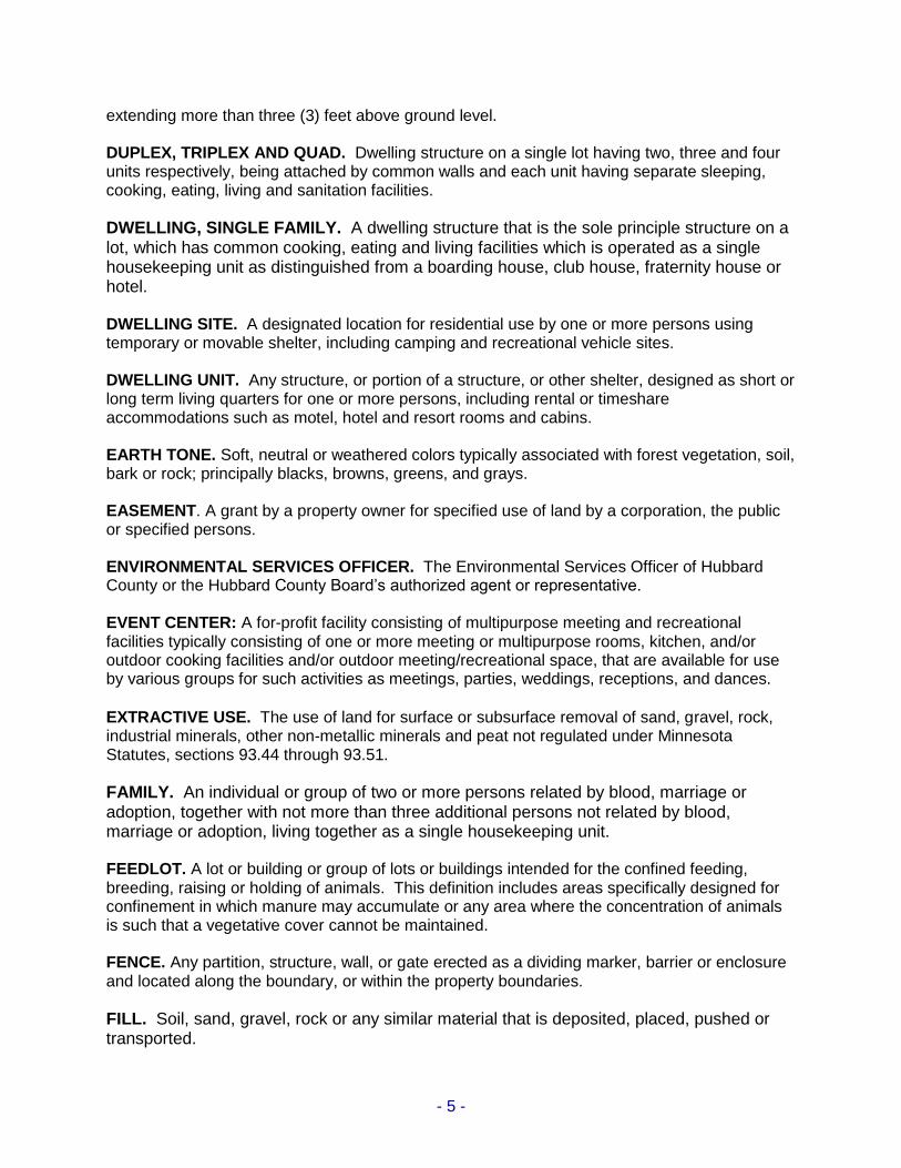
extending more than three (3) feet above ground level. DUPLEX, TRIPLEX AND QUAD. Dwelling structure on a single lot having two, three and four units respectively, being attached by common walls and each unit having separate sleeping, cooking, eating, living and sanitation facilities.
DWELLING, SINGLE FAMILY. A dwelling structure that is the sole principle structure on a lot, which has common cooking, eating and living facilities which is operated as a single housekeeping unit as distinguished from a boarding house, club house, fraternity house or hotel. DWELLING SITE. A designated location for residential use by one or more persons using temporary or movable shelter, including camping and recreational vehicle sites. DWELLING UNIT. Any structure, or portion of a structure, or other shelter, designed as short or long term living quarters for one or more persons, including rental or timeshare accommodations such as motel, hotel and resort rooms and cabins. EARTH TONE. Soft, neutral or weathered colors typically associated with forest vegetation, soil, bark or rock; principally blacks, browns, greens, and grays. EASEMENT. A grant by a property owner for specified use of land by a corporation, the public or specified persons. ENVIRONMENTAL SERVICES OFFICER. The Environmental Services Officer of Hubbard County or the Hubbard County Board’s authorized agent or representative. EVENT CENTER: A for-profit facility consisting of multipurpose meeting and recreational facilities typically consisting of one or more meeting or multipurpose rooms, kitchen, and/or outdoor cooking facilities and/or outdoor meeting/recreational space, that are available for use by various groups for such activities as meetings, parties, weddings, receptions, and dances.
EXTRACTIVE USE. The use of land for surface or subsurface removal of sand, gravel, rock, industrial minerals, other non-metallic minerals and peat not regulated under Minnesota Statutes, sections 93.44 through 93.51.
FAMILY. An individual or group of two or more persons related by blood, marriage or adoption, together with not more than three additional persons not related by blood, marriage or adoption, living together as a single housekeeping unit. FEEDLOT. A lot or building or group of lots or buildings intended for the confined feeding, breeding, raising or holding of animals. This definition includes areas specifically designed for confinement in which manure may accumulate or any area where the concentration of animals is such that a vegetative cover cannot be maintained. FENCE. Any partition, structure, wall, or gate erected as a dividing marker, barrier or enclosure and located along the boundary, or within the property boundaries.
FILL. Soil, sand, gravel, rock or any similar material that is deposited, placed, pushed or transported.

- 6 -
FOREST LAND CONVERSION. The clear cutting of forested lands to prepare for a new land use other than reestablishment of a subsequent forest stand. FRONT LOT LINE. For a riparian lot, be it platted or non-platted, the front lot line is that line indicating the ordinary high water level. For a nonriparian platted lot, a front lot line is a line dividing a lot from any public or private road, except a limited or controlled access road to which the lot has no access. For a nonriparian non-platted lot, the front lot line is a property boundary line that can either abut a public or private right of way or extend or wholly be located within an abutting public or private right of way. GARAGE. A fully enclosed building designed or used solely for the storage of motor vehicles not including buildings in which fuel is sold or in which repair or other services are performed. GEOTHERMAL ENERGY SYSTEM. A system that uses a heat pump to extract heat from the earth in heating mode and/or reject heat into the earth in cooling mode. It is also called a geothermal heat pump system, a ground-coupled heat pump system, an earth-source heat pump system, and a GeoExchange system. GROUP HOME. A residential facility licensed by the State of Minnesota or Hubbard County Social Services Department which serves from seven to sixteen mentally handicapped, physically handicapped, or socially maladjusted individuals. GUEST COTTAGE. A structure used as a dwelling unit that may contain sleeping spaces and kitchen and bathroom facilities in addition to those provided in the primary dwelling unit on a lot. HEIGHT OF STRUCTURE. The vertical distance between the highest adjoining ground level at the building or ten feet above the lowest ground level, whichever is lowest, and the highest point of the structure. HOLDING TANK. A watertight tank for storage of sewage until it can be transported to a point of approved treatment and disposal. HOME OCCUPATION. The operation of a business or profession in the home with the home as a base of operations provided that the operation of a home occupation is secondary to the use of the home, land, and accessory structures for residential purposes and conforms with the performance standards outlined in Section 402. HOUSEHOLD. An individual or group of two or more persons related by blood, marriage or adoption, together with not more than three additional persons not related by blood, marriage or adoption, living together as a single housekeeping unit. ICE RIDGE. A shoreline physical land feature caused by the pushing action of a lake’s ice sheet against the shore. The ice sheet scrapes, gouges, and pushes soil and rock into mounds called “ice ridges”. IMPERVIOUS SURFACE. A constructed hard surface that either prevents or retards the entry of water into the soil and causes water to run off the surface in greater quantities and at an increased rate of flow than prior to development. Examples include, but are not limited to: rooftops, sidewalks, decks, patios, storage areas, paver rock/stones, and concrete, asphalt, or packed gravel surfaces.

- 7 -
IMPROVED LOT. A lot that contains a single-family dwelling ready for immediate use as determined by Hubbard County, which is served by a sewage disposal system and water supply. INDIVIDUAL SEWAGE TREATMENT SYSTEM (ISTS). A sewage treatment system, other than a public or community system, which receives sewage from an individual establishment. Unless otherwise indicated the word "system", as it appears in this Ordinance, means an individual sewage treatment system. INDUSTRIAL USE. The use of land or buildings for the production, manufacture, warehousing, storage or transfer of goods, products, commodities or other wholesale items. INTENSIVE VEGETATIVE CLEARING. The substantial removal of trees or shrubs in a contiguous patch, strip, row or block. LANDING. A level area at the top, bottom, or a switchback point of a section of stairway, with or without a railing. LIFT. A mechanical device, motorized or otherwise that aids in the ascent or descent of steep slopes or bluffs. LOT. A parcel of land designated by plat, metes and bounds, registered land survey, auditors plot, or other accepted means, and separated from other parcels by its description; a numbered parcel in the lot and block description of platted property. LOT AREA. The area of land within the boundaries of a lot, excluding any part below the ordinary high water level. On lakes with Minnesota Department of Natural Resources or Hubbard County established ordinary high water levels, lot area is the area of land within the boundaries of a lot, excluding any part below the established ordinary high water level. LOT LINE, NON-PLATTED. A property boundary line of a non-platted lot. LOT LINE, PLATTED. A property boundary line of a platted lot, except any portion of the lot that extends into the abutting road or alley. LOT WIDTH, NON-RIPARIAN. The shortest distance between lot lines measured at the mid point of the building line. LOT WIDTH, RIPARIAN. The shortest distance between side lot lines measured at the building setback line. This shall also be the minimum width abutting the ordinary high water level of the adjacent lake or river (see Appendix A.2). MANUFACTURED HOUSING. Structures, transportable in one or more sections, which in the traveling mode, is eight body feet or more in length, or, when erected on site, is 320 or more square feet, and which is built on a permanent chassis and designed to be used as a dwelling with or without a permanent foundation when connected to the required utilities, and includes the plumbing, heating, air conditioning, and electrical systems contained therein; except that the term includes any structure which meets all the requirements and with respect to which the manufacturer voluntarily files a certification required by the secretary and complies with the standards established under M.S. 327.31. Manufactured housing includes mobile homes, modular homes, and/or prefabricated housing.

- 8 -
MARKER, DRIVEWAY ENTRANCE. Any non-dwelling unit structure erected adjacent to and/or over a property’s driveway at the point where the driveway bisects the property line and/or road right-of-way boundary and whose sole purpose is to mark and identify the property line and/or road right-of-way boundary. A driveway entrance marker is considered a special structure and is exempt from the setback and permit requirements of this Ordinance. MINING. The use of land for surface or subsurface removal of metallic minerals and peat as regulated under Minnesota Statutes, sections 93.44 through 93.51. MOBILE HOME. A structure designed or used for residential occupancy built upon or having a frame or chassis to which wheels may be attached by which it may be moved upon a highway, whether or not such structure actually has, at any given time, such wheels attached, or is jacked up or skirted. Mobile homes shall be treated as single household housing units. MOBILE HOME PARK. Any premises on which two or more mobile or manufactured homes, or any premises used or held out for the purpose of supplying to the public a parking space for two or more of such mobile or manufactured homes. Sales lots on which automobiles or unoccupied mobile or manufactured homes, new or used, are parked for purposes of inspection or sale are not included in this definition. For purposes of this Ordinance mobile home parks shall be considered a residential planned unit development. MULTIPLE DWELLING. A structure designed or used for residential occupancy by more than one household, with or without separate kitchen or dining facilities, including apartment houses, rooming houses, boarding hotels, hospitals or nursing homes. NONCONFORMITY. Any legal use, structure or parcel of land already in existence, recorded, or authorized before the adoption of official controls or amendments thereto that would not have been permitted to become established under the terms of the official controls as now written, if the official controls had been in effect prior to the date it was established, recorded or authorized. NON-RIPARIAN LOT. A lot that does not abut public waters of the State. OPEN SPACE. A portion of a development site that is permanently set aside for private use, is held in common ownership by all individual owners within a development, and will not be developed. Open space shall include wetlands, upland recreational areas, wildlife areas, historic sites, and areas unsuitable for development in their natural state. Open space is not the space between buildings of a cluster in a planned unit development and it does not include an area of 25 feet around each structure or any impervious surface. ORDINARY HIGH WATER LEVEL. The boundary of public waters and wetlands indicated by an elevation delineating the highest water level which has been maintained for a sufficient period of time to leave evidence upon the landscape, commonly that point where the natural vegetation changes from predominantly aquatic to predominantly terrestrial. For watercourses, the ordinary high water (OHW) level is the elevation of the top of the bank of the channel. For reservoirs and flowages, the ordinary high water level is the operating elevation of the normal summer pool. For lakes with established ordinary high water level elevations set by the Minnesota Department of Natural Resources or Hubbard County, the established OHW elevation shall be the legal ordinary high water level for purposes of this ordinance.
- 9 -
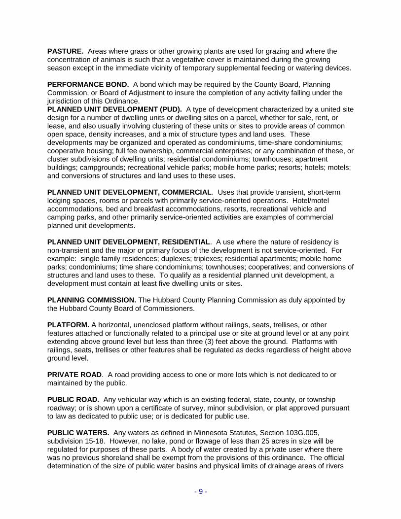
PASTURE. Areas where grass or other growing plants are used for grazing and where the concentration of animals is such that a vegetative cover is maintained during the growing season except in the immediate vicinity of temporary supplemental feeding or watering devices. PERFORMANCE BOND. A bond which may be required by the County Board, Planning Commission, or Board of Adjustment to insure the completion of any activity falling under the jurisdiction of this Ordinance. PLANNED UNIT DEVELOPMENT (PUD). A type of development characterized by a united site design for a number of dwelling units or dwelling sites on a parcel, whether for sale, rent, or lease, and also usually involving clustering of these units or sites to provide areas of common open space, density increases, and a mix of structure types and land uses. These developments may be organized and operated as condominiums, time-share condominiums; cooperative housing; full fee ownership, commercial enterprises; or any combination of these, or cluster subdivisions of dwelling units; residential condominiums; townhouses; apartment buildings; campgrounds; recreational vehicle parks; mobile home parks; resorts; hotels; motels; and conversions of structures and land uses to these uses. PLANNED UNIT DEVELOPMENT, COMMERCIAL. Uses that provide transient, short-term lodging spaces, rooms or parcels with primarily service-oriented operations. Hotel/motel accommodations, bed and breakfast accommodations, resorts, recreational vehicle and camping parks, and other primarily service-oriented activities are examples of commercial planned unit developments. PLANNED UNIT DEVELOPMENT, RESIDENTIAL. A use where the nature of residency is non-transient and the major or primary focus of the development is not service-oriented. For example: single family residences; duplexes; triplexes; residential apartments; mobile home parks; condominiums; time share condominiums; townhouses; cooperatives; and conversions of structures and land uses to these. To qualify as a residential planned unit development, a development must contain at least five dwelling units or sites. PLANNING COMMISSION. The Hubbard County Planning Commission as duly appointed by the Hubbard County Board of Commissioners. PLATFORM. A horizontal, unenclosed platform without railings, seats, trellises, or other features attached or functionally related to a principal use or site at ground level or at any point extending above ground level but less than three (3) feet above the ground. Platforms with railings, seats, trellises or other features shall be regulated as decks regardless of height above ground level. PRIVATE ROAD. A road providing access to one or more lots which is not dedicated to or maintained by the public. PUBLIC ROAD. Any vehicular way which is an existing federal, state, county, or township roadway; or is shown upon a certificate of survey, minor subdivision, or plat approved pursuant to law as dedicated to public use; or is dedicated for public use. PUBLIC WATERS. Any waters as defined in Minnesota Statutes, Section 103G.005, subdivision 15-18. However, no lake, pond or flowage of less than 25 acres in size will be regulated for purposes of these parts. A body of water created by a private user where there was no previous shoreland shall be exempt from the provisions of this ordinance. The official determination of the size of public water basins and physical limits of drainage areas of rivers

- 10 -
and streams shall be made by the Commissioner. REAR LOT LINE. The lot line opposite and most distant from the front lot line. RECREATIONAL CAMPING VEHICLE. Any of the following: 1. Travel trailer means a vehicular, portable structure built on a chassis, designed to be
used as a temporary dwelling for travel, recreational, and vacation uses. 2. Pick-up coach means a structure designed to be mounted on a truck chassis for use as a
temporary dwelling for travel, recreation, and vacation. 3. Motor home means a portable, temporary dwelling to be used for travel, recreation and
vacation, constructed as an integral part of a self-propelled vehicle. 4. Camping trailer means a folding structure, mounted on wheels and designed for travel,
recreation, and vacation use. RECREATION USE AREA. “Recreation use area” is the area allowed within the shore impact zone for residential lots, conservation subdivisions, planned unit developments, and new resorts. RECREATIONAL VEHICLE CAMPGROUND. Any area, whether privately or publicly owned, used on a daily, nightly, weekly or longer basis for the accommodation of five or more tents or recreational vehicles, either free of charge or for compensation. Recreational Vehicle Campgrounds are considered commercial planned unit developments. REPAIRS AND MAINTENANCE. An alteration of the interior or exterior portion of a structure that does not involve the replacement of the main structural frame, walls, or changes in the exterior dimensions of the structure. Repairs and maintenance of an existing structure shall be considered one or more of the following: (1) Work performed on the interior of the structure; (2) Work performed on the exterior of the structure to include the following: (a) Painting, replacement of siding, windows, doors, soffit, facia, re-roofing (to
include shingles and sheeting), roofing (if roofing replacement does not increase the height by more than two feet, or increase living space) and ornamentation. This also includes replacement of rotten or deteriorated material associated with the replacement of above items that is solely necessary for replacement of the item;
(b) Additional doors or windows if no more than 25 percent of the main structural framework is altered, reinforced, and/or replaced;
(c) Repairs to foundation provided the existing foundation type is not modified or changed (e.g. a pier foundation remains a pier foundation post-repair, a frost footing foundation remains a frost footing foundation post-repair, etc.) Up to 50 percent of a foundation may be repaired. Any amount over 50 percent constitutes replacement and is not allowed.
(d) Incidental repairs to decks and platforms (i.e. new floorboard and/or railings).
Under no conditions shall repairs and maintenance constitute replacement, reinforcement, or alteration (e.g. no sistering of studs/floor joists, etc.) of the main structural frame, walls, or more than 50 percent of the foundation; or changes in the exterior dimensions.
RESIDENTIAL LOT SUITABLE AREA. The minimum area on a residential lot or parcel of land that is the combination of:
- 11 -
1. the minimum contiguous area remaining on a lot or parcel of land after all setback requirements, bluffs, all easements and rights-of-way, historic sites, wetlands,
and land below the ordinary high water mark of public waters are subtracted for the purposes of placing structures; and
2. the area meeting or exceeding the site requirements of Minnesota Pollution Control Agency individual sewage treatment system rules, Chapter 7080, for the purpose of soil treatment or drainfield areas and future additional sites.
RESORT. A private commercial recreational development which includes multiple units intended for habitation on a temporary basis for relaxation or recreational purposes. RIPARIAN LOT. Any lot which is bounded on one or more sides by public waters frontage. SEMIPUBLIC USE. The use of land by a private nonprofit organization to provide a public service that is ordinarily open to some persons outside the regular constituency of the organization. SENSITIVE RESOURCE MANAGEMENT. The preservation and management of areas unsuitable for development in their natural state due to constraints such as shallow soils over groundwater or bedrock, highly erosive or expansive soils, steep slopes, susceptibility to flooding, or occurrence of flora or fauna in need of special protection. SEPTIC TANK. Any water tight, covered receptacle designed and constructed to receive the discharge of sewage from a building's sewer, to separate solids from liquids, digest organic matters, and store liquids for a period of detention, and allow the liquids to discharge to a soil treatment system. SETBACK. Effective July 13, 2006, the minimum horizontal distance between a structure, sewage treatment system, or other facility and an ordinary high water level, sewage treatment system, top of a bluff, road, highway, property line, or other facility. Decks must also meet the setback requirements of the ordinance and must be measured from the nearest point on the deck to the feature in question. SEWER SYSTEM. Pipelines, conduits, pumping stations, force main and all other construction, devices, appliances, or appurtenances used for conducting sewage or industrial or other wastes to a point of ultimate disposal. SHORE IMPACT ZONE. Land located between the ordinary high water level of a public water and a line parallel to it at a setback of 50 percent of the structure setback required by this ordinance. SHORELAND. Land located within the following distances from public waters: 1,000 feet from the ordinary high water level of a lake, pond or flowage; and 500 feet from a river or stream, or the landward extent of a floodplain designated by ordinance on a river or stream, whichever is greater. The limits of shorelands may be reduced whenever the waters involved are bounded by topographic divides which extend landward from the waters for lesser distances and where approved by the Commissioner. SIDE LOT LINE. Any lot line which meets the end of a front lot line and any other lot line within thirty degrees of being parallel to such a line, except a front lot line.

- 12 -
SIDEWALK. A hard surfaced pedestrian path. SIGNIFICANT HISTORIC SITE. Any archeological site, standing structure, or other property that meets the criteria for eligibility to the National Register of Historic Places or is listed in the State Register of Historic Sites, or is determined to be an unplatted cemetery that falls under the provisions of Minnesota Statutes, Section 307.08. A historic site meets these criteria if it is presently listed on either register or if it is determined to meet the qualifications for listing after review by the Minnesota State Archaeologist or the Director of the Minnesota Historical Society. All unplatted cemeteries are automatically considered to be significant historic sites.
SINGLE FAMILY RESIDENTIAL USE. The use of the land or buildings for a single family dwelling. SINGLE HOUSEHOLD DWELLING. A structure, designated or used for residential occupancy by one household. SOIL TREATMENT SYSTEM. A system where sewage tank effluent is treated and disposed of into the soil by percolation and filtration, and includes trenches, seepage beds, drainfields, at-grade systems, and mound systems". SPECIAL STRUCTURE. A special structure not subject to one or more setback requirements which have been prescribed by this Ordinance. STAIRWAY A series of steps or flights of steps for passing from one level to another. STEEP SLOPE. Land where agricultural activity or development is either not recommended or described as poorly suited due to slope steepness and the soil characteristics of the site, as mapped and described in available County soil surveys or other technical reports, unless appropriate design and construction techniques and farming practices are used in accordance with the provisions of this Ordinance. Where specific information is not available, steep slopes are lands having slopes over twelve percent, as measured over horizontal distances of fifty feet or more, that are not bluffs. STRUCTURE. That which is built or constructed, an edifice or building or appurtenance thereto, or any piece of work artificially built up, or composed of parts joined together in some definable manner, except aerial or underground utility lines such as: sewer, electric, telephone, telegraph, gas lines, towers, poles, and other supporting appurtenances. SUBDIVIDER. Any person who undertakes the subdivision of land as defined herein. The subdivider may be the owner or the authorized agent of the owner of the land to be subdivided.
SUBDIVISION. Land that is divided for the purpose of sale, rent or lease, including planned unit developments.
SURFACE WATER-ORIENTED COMMERCIAL USE. The use of land for commercial purposes, where access to and use of a surface water feature is an integral part of the normal conductance of business. Marinas, resorts, and restaurants with transient docking facilities are examples of such use.
TEMPORARY STRUCTURE. Any structure which has been erected or moved onto a lot in order to be utilized for any purpose for a limited period of time not to exceed 180 consecutive
- 13 -
days in a calendar year.
TOE OF THE BLUFF. The lower point of a 50-foot segment with an average slope exceeding 18 percent.
TOP OF THE BLUFF. The higher point of a 50-foot segment with an average slope exceeding 18 percent.
UNINCORPORATED AREA. The area outside of the incorporated area of a city. VARIANCE. Any modification or variation of official controls where it is deemed that, by reason of exceptional circumstances, the strict enforcement of the official controls would cause unnecessary hardship. A variance shall not be used to permit a use in a district where it is not allowed under the terms of the Ordinance.
WATER-ORIENTED ACCESSORY STRUCTURE OR FACILITY. A small, above ground building or other improvement, except stairways, fences, docks and retaining walls, which, because of the relationship of its use to a surface water feature would need to be located closer to public waters than the normal structure setback. Examples of such structures include boathouses, gazebos, screen houses, fish houses, pump houses, storage buildings, detached decks. These structures or facilities are not allowed in Hubbard County unless they meet the structure setback provisions of this Ordinance or comply with all provisions of Section 601 Paragraph #3.
WATER SUPPLY PURPOSE. Any use of water for domestic, commercial, industrial or agricultural purpose.
WETLAND. Any lands as defined in Minnesota Statutes, section 103G.005, subdivision 19. These lands are transitional between terrestrial and aquatic systems where the water table is usually at or near the surface or the land is covered by shallow water. Wetlands must have the following three attributes:
(1) have a predominance of hydric soils; (2) are inundated or saturated by surface or ground water at a frequency and duration
sufficient to support a prevalence of hydrophytic vegetation typically adapted for life in saturated soil conditions; and
(3) under normal circumstances support a prevalence of such vegetation.

- 14 -
ARTICLE II PUBLIC WATERS CLASSIFICATION SYSTEM
The public waters of Hubbard County have been classified below consistent with the criteria found in Minnesota Regulations, Part 6120.3300, and the Protected Waters Inventory Map for Hubbard County, Minnesota. The shoreland areas for the waterbodies listed in Sections 201 through 207 shall be as defined in Section 101 of this Ordinance for those waterbodies listed here and as shown on the Official Shoreland Management Map for Hubbard County. The public waters of Hubbard County have been classified as follows:
Section 201. Natural Environment Lake I.D. Number Lake Name Township 29-6 No Name Badoura 29-8 Mastny White Oak 29-10 Gauldin White Oak 29-11 No Name White Oak 29-13 Mary White Oak 29-21 No Name White Oak 29-24 No Name Akeley-White Oak 29-26 No Name Akeley 29-35 No Name Akeley 29-49 Lester Steamboat River 29-54 Spring Lakeport 29-55 No Name Lakeport 29-57 No Name Lakeport 29-63 Hart Hart Lake 29-64 No Name Hart Lake 29-76 Knutson Farden- Guthrie 29-79 No Name Crow Wing Lake 29-84 No Name Crow Wing Lake 29-94 Tamarack Nevis 29-95 Holland-Lucy Nevis 29-97 Clausens Mantrap- Nevis 29-102 No Name Mantrap
Lake I.D. Number Lake Name Township 29-104 No Name Mantrap 29-112 No Name Mantrap 29-120 No Name Thorpe 29-137 Dehart Guthrie 29-139 Kimball Guthrie 29-158 No Name Hubbard 29-159 No Name Hubbard 29-160 No Name Hubbard 29-181 No Name Lake Emma 29-182 Sixteen Lake Emma 29-183 Little Rice Lake Emma 29-189 Beaver Lake Emma 29-211 No Name Clay 29-213 No Name Clay 29-229 Rosie School- craft 29-233 Hubbard School- craft 29-257 Many Arms Arago 29-267 Lower Mud Arago- Clover 29-273 No Name Clover 29-280 Rose Clover 29-284 Upper Mud Clover 29-304 Bond Lake Hattie 29-308 No Name Fern 29-311 No Name Straight River

- 15 -
Lake I.D. Number Lake Name Township 29-1 Kettle Badoura 29-3 Nagel Badoura 29-4 Mud Badoura 29-7 Island White Oak 29-16 Hay White Oak 29-18 Little Ham White Oak 29-20 Loon White Oak 29-22 Steel Akeley - White Oak 29-23 Robinson Akeley-White Oak 29-29 Schroeder Akeley 29-33 Little Bass Akeley 29-34 Upper Bass Akeley 29-41 Cramer Akeley 29-43 Shingobee Akeley 29-44 Mud Akeley 29-58 Willow Lakeport 29-59 Horseshoe Lakeport 29-60 Oak Lakeport 29-65 Mud Farden 29-67 Little Midge Farden 29-68 Bowman Farden 29-73 Owl Akeley- Mantrap 29-74 Indian Akeley- Mantrap 29-78 4th Crow Wing Crow Wing Lake 29-80 Little Stony Crow Wing Lake 29-81 Wolf Crow Wing Lake 29-82 No Name Crow Wing Lake 29-83 Bladder Crow Wing Lake 29-87 Palmer Crow Wing Lake
Lake I.D. Number Lake Name Township 29-89 Shallow Nevis 29-96 Shinker Nevis 29-98 Waboose Mantrap 29-99 No Name Mantrap 29-101 Crooked Mantrap 29-105 No Name Mantrap 29-106 No Name Mantrap 29-108 Coon Mantrap 29-116 Crow Wing Mantrap 29-119 Mud Thorpe 29-126 Gillette Hendrickson 29-128 Island Hendrickson 29-130 Twenty-One Hendrickson 29-131 Nelson Hendrickson 29-134 Upper Thatcher Guthrie 29-135 Hatchers Guthrie 29-136 Horsehead Guthrie 29-144 Sunday Nevis- Henrietta 29-145 Round Nevis- Henrietta 29-147 Petit Lake Emma 29-154 Tepee Clay-Thorpe 29-155 Sheridan Lake George 29-157 Upper Twin Hubbard 29-163 Deer Henrietta- Lake Emma 29-164 Sweitzer Henrietta 29-165 Rockwell Henrietta 29-168 Mud Henrietta 29-169 Peysenski Henrietta 29-170 Ida Henrietta- Lake Emma 29-171 Ingram Henrietta- Lake Emma 29-172 Stocking Lake Emma 29-175 Stony Lake Emma 29-177 Rice Lake Emma 29-187 Dead Horse Lake Emma 29-195 Deep Clay 29-197 Pine Clay

- 16 -
Lake I.D. Number Lake Name Township 29-199 Birch Clay 29-202 Sawyer Clay 29-206 Buck Clay 29-212 Skunk Clay 29-215 Schoolcraft Clay-Lake George 29-217 Paine Lake George 29-218 Shanty Lake George 29-227 Evergreen Schoolcraft 29-230 Wolf Schoolcraft 29-231 Twenty Schoolcraft 29-234 Minnie Schoolcraft 29-235 Arrow Rockwood 29-237 Newman Rockwood 29-239 Spearhead Rockwood 29-240 Lilypad Rockwood 29-241 Frontenac Rockwood 29-245 Emma Lake Hattie- Schoolcraft 29-246 Hennepin Fern- Rockwood 29-247 Moran Straight River 29-248 Lord Straight River 29-251 Mud Todd 29-255 Bunness Arago 29-258 No Name Arago 29-265 Beden Arago 29-266 Sloan Arago 29-269 No Name Clover 29-272 Sibilant Clover-Lake Alice 29-275 Blacksmith Clover 29-276 Upper Camel Clover 29-277 Coon Clover 29-288 Brisbane Lake Alice 29-289 Mary Lake Alice 29-291 Spider Lake Alice 29-292 Beauty Lake Alice 29-297 Assawa Lake Hattie 29-301 Beauty Lake Hattie 29-303 Lost Lake Hattie 29-307 Diamond Fern 29-310 Brush Straight River 29-312 Cedar Clover
Lake I.D. Number Lake Name Township Boundary Lakes 11-503 Bess (with Cass Akeley
County) 80-19 Mud (with Wadena County) Crow Wing Lake Section 202. Recreational Development Lakes Lake I.D. Number Lake Name Township 29-2 Mow Badoura 29-5 Tripp Badoura 29-15 Williams White Oak 29-17 Ham White Oak 29-25 9th Crow Wing Akeley- White Oak 29-32 Big Bass Akeley 29-36 11th Crow Wing Akeley 29-45 10th Crow Wing Akeley 29-48 Benedict Steamboat River 29-61 Garfield Hart Lake- Lakeport 29-66 Midge Farden 29-71 Grace Farden 29-72 8th Crow Wing Nevis- White Oak 29-75 Kabekona Hendrick- son-Lakeport- Steamboat River 29-77 3rd Crow Wing Crow Wing Lake 29-85 2nd Crow Wing Crow Wing Lake 29-86 1st Crow Wing Crow Wing Lake 29-88 Island Crow Wing Lake 29-90 Deer Nevis 29-91 7th Crow Wing Nevis 29-92 5th Crow Wing Nevis

- 17 -
Lake I.D. Number Lake Name Township 29-93 6th Crow Wing Nevis 29-110 Dead Mantrap 29-117 Spider Mantrap 29-142 Duck Crow Wing Lake- Hubbard 29-143 Big Stony Crow Wing Lake- Hubbard 29-146 Belle Taine Henrietta- Nevis 29-148 Upper Bottle Lake Emma 29-149 Ojibway Lake Emma- Mantrap 29-150 Little Sand Lake Emma- Henrietta 29-151 Big Mantrap Mantrap-Clay- Thorpe-Lake Emma 29-156 Plantaganet Helga-Rockwood 29-161 Long Henrietta- Hubbard 29-162 Boulder Henrietta 29-178 Pickerel Lake Emma 29-180 Lower Bottle Lake Emma 29-184 Blue Lake Emma 29-185 Big Sand Lake Emma 29-186 Emma Lake Emma 29-188 Gilmore Lake Emma 29-190 Loon Lake Emma 29-208 Bad Axe Clay 29-216 Lake George Lake George 29-242 Fish Hook Henrietta-Todd 29-243 Potato Arago-Lake Emma
Lake I.D. Number Lake Name Township 29-249 Hinds Straight River 29-250 Portage Todd 29-254 Island Arago 29-256 Eagle Arago 29-286 Alice Lake Alice 29-300 Hattie Lake Hattie 29-309 LaSalle Fern 29-313 Little Mantrap Clover Lake I.D. Number Lake Name Township Boundary Lakes 11-502 Crystal (with Cass White Oak County 11-504 Steamboat (with Hart Lake Cass County) 11-505 Little Wolf (with Farden Cass County) 4-79 Wolf (with Beltrami Farden County, in Miss. Headwaters Board corridor and jurisdiction) 15-1 Big LaSalle (with Lake Hattie Clearwater County) Section 203. General Development Lakes Lake I.D. Number Lake Name Township 11-203 Leech (on the boundary with Cass County) Steamboat River

- 18 -
Section 204. Special Protection River Segments River From To Mississippi Border of Hubbard and North section line, Sec. 17, Clearwater Counties, in Miss. T145N, R35W Headwaters Board corridor and jurisdiction Mississippi South section line, Sec. 8, T145N, Border of Hubbard and Beltrami R35W, in Miss. Counties Headwaters Board corridor and jurisdiction Section 205. Remote River Segments River From To Schoolcraft South section line, Sec. 28, T144N, Inlet of Plantagenet Lake in R34W in Sec. 18, T145N, R33W Crow Wing Outlet of Second Crow Wing Lake Border of Hubbard and in Sec. 21, T139N, R33W Wadena Counties Section 206. Forested River Segments River From To Schoolcraft U.S. 71 bridge in Sec. 20, North section line, Sec. 33, T143N, R34W T144N, R34W Crow Wing Outlet of Fifth Crow Wing Lake Inlet of Fourth Crow Wing in Sec. 30, T140N, R33W in Sec. 4, T139N, R33W Shell Border of Becker and Hubbard Border of Hubbard and Wadena Counties Counties Shell Border of Hubbard and Wadena Inlet of Upper Twin Lake in Counties Sec. 31, T139N, R34W Shell Border of Hubbard and Wadena Confluence with Crow Wing River Counties in Sec. 32, T139N, R33W Fish Hook Confluence with Straight River in Confluence with Shell River in Sec. 7, T139N, R34W Sec. 30, T139N, R34W Straight Border of Becker and Hubbard Confluence with Fish Hook River Counties in Sec. 7, T139N, R34W Section 207. Tributaries Name From To LaSalle Sec. 7 (at Hwy. 200) T143N, R35W Sec. 19, T145N, R35W (confluence with Mississippi River) Hennepin Creek Sec. 28 (at Basin 29-564) T144N, Border of Hubbard and Beltrami R35W Counties
- 19 -
Section 207. Tributaries (Continued) Name From To Schoolcraft Sec. 32 (at Basin 29-215) T143N, Sec. 20 (at U.S. 71) T143N, R34W R34W Schoolcraft Creek Sec. 7 (at Basin 29-198) T142N, Sec. 5 (at Basin 29-215) T142N, R34W R34W Unnamed to Schoolcraft Sec. 17 (at Basin 29-527) T142N, Sec. 8 (at confluence with Creek Schoolcraft Creek) T142N, R34W Birch Creek Sec. 2 (at Basin 29-286) T143N, Sec. 4 (at confluence with R35W Schoolcraft River) T143N, R34W Lake Alice Creek Sec. 15, T143N, R35W Sec. 11 (at Basin 29-286) T143N, R35W Unnamed to Lake Alice Sec. 9 (at Basin 29-535) T143N, Sec. 2 (at Basin 29-286) T143N, R35W R35W Unnamed to Birch Creek Sec. 35 (at Basin 29-304) T144N, Sec. 36 (at confluence with R35W Birch Creek) T144N, R35W Alcohol Creek Sec. 15 (at Basin 29-216) T143N, Sec. 21 (at confluence with R34W Schoolcraft River) T144N, R34W Frontenac Creek Sec. 27 (at Basin 29-241) T145N, Sec. 3 (at confluence with R34W Schoolcraft River) T144N, R34W Rat Creek Sec. 8 (at Basin 29-227) T144N, Sec. 28 (at Basin 29-241) T145N, R34W R34W Skunk Creek Sec. 6, T144N, R34W Sec. 8 (at Basin 29-227) T144N, R34W Dead Creek Sec. 21 (at Co. Rd. 9) T145N, Sec. 28 (at Basin 29-241) R34W T145N, R34W Brokaw Creek Sec. 11 (at Basin 29-228) T144N, Sec. 2 (at confluence with R34W Schoolcraft River) T144N, R34W Cold Creek Sec. 19, T145N, R33W Sec. 19 (at Basin 29-156) T145N, R33W Revoir Creek Sec. 23 (at Basin 29-239) T145N, Sec. 13 (at Basin 29-156) T145N, R34W R34W Necktie River Sec. 1, T145N, R33W Sec. 26 (at Basin 11-504) T144N, R32W Bungashing Creek Sec. 4, T144N, R33W Sec. 28, T145N, R32W (at confluence with Necktie River) Unnamed to Sec. 26, T145N, R33W Sec. 26, T145N, R33W (at Bungashing Creek confluence with Bungashing Creek)

- 20 -
Section 207. Tributaries (Continued) Name From To Pokety Creek Sec. 24, T144N, R33W Sec. 29, T144N, R32W (at confluence with Necktie River) Unnamed to Sec. 29, T144N, R32W Sec. 29, T144N, R32W Pokety Creek (at confluence with Pokety Creek) Unnamed Tributary Sec. 1 (at Basin 29-54) Sec. 1, T143N, R32W T143N, R32W (Border of Hubbard and Cass Counties) Kabekona River Sec. 24, T144N, R34W Sec. 1 (Basin 11-203), T142N, R32W Unnamed to Sec. 36, T144N, R34W Sec. 25 (at confluence with Kabekona River Kabekona River) T144N, R34W Stall Creek Sec. 13, T143N, R33W Sec. 12, T143N, R33W (at confluence with Kabekona River) Gulch Creek Sec. 28 (at Basin 29-125) T143N, Sec. 24 (at Basin 29-75) T143N, R33W R33W Sucker Brook Sec. 6 (at Basin 29-49) T142N, Sec. 30 (at Basin 29-75) T143N, R32W R32W Unnamed to Oak Lake Sec. 16 (at Basin 29-57) T143N, Sec. 27 (at Basin 29-60) T143N, R32W R32W Grassy Creek Sec. 24, T143N, R32W Sec. 26, T143N, R32W (at confluence with Kabekona River) Unnamed to Leech Lake Sec. 1 (at Basin 29-48) T142N, Sec. 1 (at Basin 11-203) T142N, R32W R32W Shingobee River Sec. 35 (at Basin 29-22) T141N, Sec. 24, T141N, R32W (Border of R32W Hubbard and Cass Counties) Unnamed to Steel Lake Sec. 11 (at Basin 29-14) T140N, Sec. 2 (at Basin 29-22) T140N, R32W R32W Unnamed to Island Lake Sec. 11 (at Basin 29-12) T140N, Sec. 2 (at Basin 29-7) T140N, R32W R32W Unnamed to Big Sec 6 (at Basin 29-151) T141N, Sec. 23 (at Basin 29-185) T141N, Sand LakeR33W R34W Sand River Sec. 35 (at Basin 29-185) T141N, Sec. 5 (at Basin 29-89) T140N, R34W R33W Hellcamp Creek Sec. 24, T140N, R34W Sec. 19 (at Basin 29-92) T140N, R33W
- 21 -
Section 207. Tributaries (Continued) Name From To Wallingford Creek Sec. 25 (at Basin 29-94) T140N, Sec. 10 (at Basin 29-77) T139N, R33W R33W Mucky Creek Sec. 12 (at Basin 29-397) T139N, Sec. 11, T139N, R33W R33W Bender Creek Sec. 18 (at Basin 29-5) T139N, Sec. 27 (at Basin 29-86) T139N, R32W R33W Unnamed to Tripp Lake Sec. 8 (at Basin 29-2) T139N, Sec. 17 (at Basin 29-5) T139N, R32W R32W Unnamed to Bender Sec. 21 (at Basin 29-320) Sec. 19, T139N, R32W (at Creek T139N, R32W confluence with Bender Creek) Blueberry River Sec. 30, T139N, R35W (Border of Sec. 31, T139N, R35W (Border Hubbard and Becker Counties) of Hubbard and Becker Counties) Unnamed to Shell River Sec. 26 (at Basin 29-249) T139N, Sec. 36, T139N, R35W (at R35W confluence with Shell River) Fish Hook River Sec. 36 (at City limits of Park Sec. 30, T139N, R34W at Rapids) T140N, 35W confluence with Shell River) Unnamed to Island Lake Sec. 8 (at Basin 29-255) T141N, Sec. 5 (at Basin 29-254) T141N, R35W R35W Unnamed to Island Lake Sec. 33 (at Basin 29-280) T142N, Sec. 3 (at Basin 29-254) T141N, R35W R35W Unnamed to Upper Mud Sec. 36 (at 29-522) T142N, R35W Sec. 34 (at Basin 29-284) T142N, Lake R35W Hay Creek (Border of Sec. 18, T141N, R35W Sec. 22 (at Basin 29-243) T141N, Hubbard & Becker Co.) R35W Unnamed to Potato Lake Sec. 18 (at Basin 29-177) T141N, Sec. 19 (at Basin 29-243) T141N, R34W R34W Potato River Sec. 31 (at Basin 29-243) T141N, Sec. 2 (at Basin 29-242) T140N, R34W R35W Portage River Sec. 9 (at Basin 29-250) T140N, Sec. 10 (at Basin 29-242) T140N, R35W R35W Unnamed to Sec. 20 (at Basin 29-161) T139N, Sec. 19 (at confluence with Fish Fish Hook River R34W Hook River) T139N, R34W Crow Wing River Sec. 28 (at Basin 29-36) T141N, Sec. 20 (at Basin 29-92) T140N, R32W R33W Crow Wing River Sec. 9 (at Basin 29-78) T139N, Sec. 20 (at Basin 29-85) T139N, R33W R33W
- 22 -
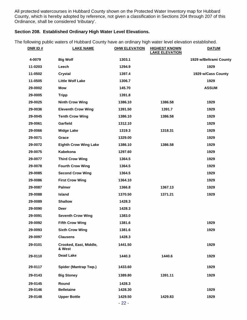
All protected watercourses in Hubbard County shown on the Protected Water Inventory map for Hubbard County, which is hereby adopted by reference, not given a classification in Sections 204 through 207 of this Ordinance, shall be considered 'tributary'. Section 208. Established Ordinary High Water Level Elevations. The following public waters of Hubbard County have an ordinary high water level elevation established.
DNR ID # LAKE NAME OHW ELEVATION HIGHEST KNOWN LAKE ELEVATION
DATUM
4-0079 Big Wolf 1303.1 1929 w/Beltrami County
11-0203 Leech 1294.9 1929
11-0502
11-0505
Crystal
Little Wolf Lake
1397.4
1306.7
1929 w/Cass County
1929
29-0002 Mow 145.70 ASSUM
29-0005 Tripp 1391.8
29-0025 Ninth Crow Wing 1386.10 1386.58 1929
29-0036 Eleventh Crow Wing 1391.50 1391.7 1929
29-0045 Tenth Crow Wing 1386.10 1386.58 1929
29-0061
29-0066
Garfield
Midge Lake
1312.10
1319.3
1318.31
1929
1929
29-0071 Grace 1329.00 1929
29-0072 Eighth Crow Wing Lake 1386.10 1386.58 1929
29-0075 Kabekona 1297.60 1929
29-0077 Third Crow Wing 1364.5 1929
29-0078 Fourth Crow Wing 1364.5 1929
29-0085 Second Crow Wing 1364.5 1929
29-0086
29-0087
First Crow Wing
Palmer
1364.10
1366.8
1367.13
1929
1929
29-0088
29-0089
29-0090
Island
Shallow
Deer
1370.50
1428.3
1428.3
1371.21
1929
29-0091 Seventh Crow Wing 1383.0
29-0092 Fifth Crow Wing 1381.6 1929
29-0093
29-0097
Sixth Crow Wing
Clausens
1381.6
1428.3
1929
29-0101
29-0110
Crooked, East, Middle, & West
Dead Lake
1441.50
1440.3
1440.6
1929
1929
29-0117
29-0143
29-0145
Spider (Mantrap Twp.) Big Stoney Round
1433.60
1389.80
1428.3
1391.11
1929
1929
29-0146 Belletaine 1428.30 1929
29-0148 Upper Bottle 1429.50 1429.83 1929

- 23 -
29-0149 Ojibway Lake 1440.3 1440.6 1929
29-0150 Little Sand 1428.30 1929
29-0151 Big Mantrap 1434.70 1929
29-0156 Plantaganet 1343.10 1929
29-0161 Long 1379.70 1929
29-0162 Boulder 1428.60 1429.3 1929
29-0169-01 Peysenski, west bay 1407.5
29-0169-02 Peysenski, east bay 1408.9
29-0170 Ida 1428.30 1929
29-0172 Stocking 1430.4
29-0178 Pickerel 1456.90 1929
29-0180 Lower Bottle 1429.50 1429.83 1929
29-0184 Blue 1443.70 1444.04 1929
29-0185 Big Sand 1428.30 1929
29-0186
29-0189
29-190
Emma
Beaver Lake
Loon Lake
1428.80
1429.30
1429.20
1429.7
1428.9
1429.7
1929
1929
1929
29-0208 Bad Axe 1439.50 1929
29-211 Unnamed 1483.0 1988
29-0212 Skunk 1483.0 1485.2 1988
29-213
29-216
Unnamed
Lake George
1483.0
1416.3
1417.3
1988
1929
29-0227 Evergreen 1381.60 1929
29-0241 Frontenac 1375.7 1375.53 1929
29-0242 Fish Hook 1426.30 1929
29-0243 Potato 1440.50 1929
29-0246
29-247
29-248
29-249
29-250
Hennepin
Moran
Lord
Hinds
Portage
1430.1
1405.0
1405.0
1370.2
1434.4
1405.30
1405.30
1371.12
1435.10
1929
1929
1929
1929
29-0251 Mud 1426.00 1929
29-0254 Island 1442.10 1929
29-0256 Eagle 1440.80 1929
29-0286 Alice 1419.8 1421.04 1929
29-0292 Beauty 97.7 ASSUM
29-0300 Hattie 148.50 ASSUM
29-0310 Brush 1445.8 1446.8 1929
29-0313 Little Mantrap 1519.80 1929
11-0203 Kabekona Bay of Leech Lake
1294.90 1929
- 24 -
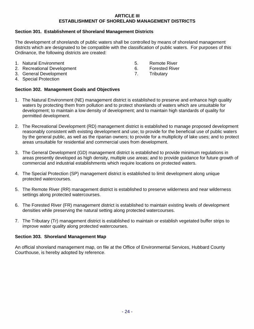
ARTICLE III ESTABLISHMENT OF SHORELAND MANAGEMENT DISTRICTS
Section 301. Establishment of Shoreland Management Districts The development of shorelands of public waters shall be controlled by means of shoreland management districts which are designated to be compatible with the classification of public waters. For purposes of this Ordinance, the following districts are created: 1. Natural Environment 5. Remote River 2. Recreational Development 6. Forested River 3. General Development 7. Tributary 4. Special Protection Section 302. Management Goals and Objectives 1. The Natural Environment (NE) management district is established to preserve and enhance high quality
waters by protecting them from pollution and to protect shorelands of waters which are unsuitable for development; to maintain a low density of development; and to maintain high standards of quality for permitted development.
2. The Recreational Development (RD) management district is established to manage proposed development
reasonably consistent with existing development and use; to provide for the beneficial use of public waters by the general public, as well as the riparian owners; to provide for a multiplicity of lake uses; and to protect areas unsuitable for residential and commercial uses from development.
3. The General Development (GD) management district is established to provide minimum regulations in
areas presently developed as high density, multiple use areas; and to provide guidance for future growth of commercial and industrial establishments which require locations on protected waters.
4. The Special Protection (SP) management district is established to limit development along unique
protected watercourses. 5. The Remote River (RR) management district is established to preserve wilderness and near wilderness
settings along protected watercourses. 6. The Forested River (FR) management district is established to maintain existing levels of development
densities while preserving the natural setting along protected watercourses. 7. The Tributary (Tr) management district is established to maintain or establish vegetated buffer strips to
improve water quality along protected watercourses. Section 303. Shoreland Management Map An official shoreland management map, on file at the Office of Environmental Services, Hubbard County Courthouse, is hereby adopted by reference.
- 25 -
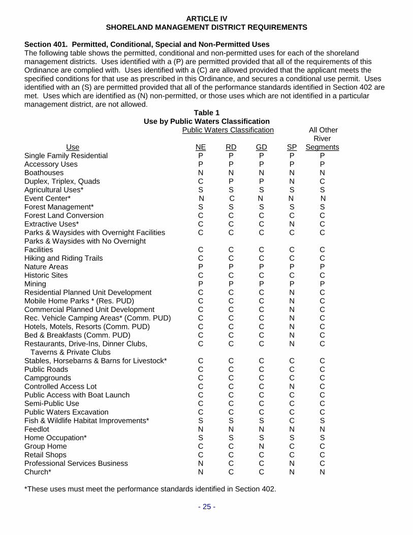
ARTICLE IV SHORELAND MANAGEMENT DISTRICT REQUIREMENTS Section 401. Permitted, Conditional, Special and Non-Permitted Uses The following table shows the permitted, conditional and non-permitted uses for each of the shoreland management districts. Uses identified with a (P) are permitted provided that all of the requirements of this Ordinance are complied with. Uses identified with a (C) are allowed provided that the applicant meets the specified conditions for that use as prescribed in this Ordinance, and secures a conditional use permit. Uses identified with an (S) are permitted provided that all of the performance standards identified in Section 402 are met. Uses which are identified as (N) non-permitted, or those uses which are not identified in a particular management district, are not allowed.
Table 1 Use by Public Waters Classification
Public Waters Classification All Other River Use NE RD GD SP Segments Single Family Residential P P P P P Accessory Uses P P P P P Boathouses N N N N N Duplex, Triplex, Quads C P P N C Agricultural Uses* S S S S S Event Center* N C N N N Forest Management* S S S S S Forest Land Conversion C C C C C Extractive Uses* C C C N C Parks & Waysides with Overnight Facilities C C C C C Parks & Waysides with No Overnight Facilities C C C C C Hiking and Riding Trails C C C C C Nature Areas P P P P P Historic Sites C C C C C Mining P P P P P Residential Planned Unit Development C C C N C Mobile Home Parks * (Res. PUD) C C C N C Commercial Planned Unit Development C C C N C Rec. Vehicle Camping Areas* (Comm. PUD) C C C N C Hotels, Motels, Resorts (Comm. PUD) C C C N C Bed & Breakfasts (Comm. PUD) C C C N C Restaurants, Drive-Ins, Dinner Clubs, C C C N C Taverns & Private Clubs Stables, Horsebarns & Barns for Livestock* C C C C C Public Roads C C C C C Campgrounds C C C C C Controlled Access Lot C C C N C Public Access with Boat Launch C C C C C Semi-Public Use C C C C C Public Waters Excavation C C C C C Fish & Wildlife Habitat Improvements* S S S C S Feedlot N N N N N Home Occupation* S S S S S Group Home C C N C C Retail Shops C C C C C Professional Services Business N C C N C Church* N C C N N *These uses must meet the performance standards identified in Section 402.
- 26 -
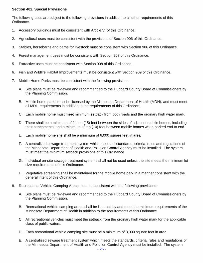
Section 402. Special Provisions The following uses are subject to the following provisions in addition to all other requirements of this Ordinance. 1. Accessory buildings must be consistent with Article VI of this Ordinance. 2. Agricultural uses must be consistent with the provisions of Section 906 of this Ordinance. 3. Stables, horsebarns and barns for livestock must be consistent with Section 906 of this Ordinance. 4. Forest management uses must be consistent with Section 907 of this Ordinance. 5. Extractive uses must be consistent with Section 908 of this Ordinance. 6. Fish and Wildlife Habitat Improvements must be consistent with Section 909 of this Ordinance. 7. Mobile Home Parks must be consistent with the following provisions: A. Site plans must be reviewed and recommended to the Hubbard County Board of Commissioners by the Planning Commission. B. Mobile home parks must be licensed by the Minnesota Department of Health (MDH), and must meet
all MDH requirements in addition to the requirements of this Ordinance. C. Each mobile home must meet minimum setback from both roads and the ordinary high water mark. D. There shall be a minimum of fifteen (15) feet between the sides of adjacent mobile homes, including
their attachments, and a minimum of ten (10) feet between mobile homes when parked end to end. E. Each mobile home site shall be a minimum of 6,000 square feet in area. F. A centralized sewage treatment system which meets all standards, criteria, rules and regulations of
the Minnesota Department of Health and Pollution Control Agency must be installed. The system must meet the minimum setback provisions of this Ordinance.
G. Individual on-site sewage treatment systems shall not be used unless the site meets the minimum lot
size requirements of this Ordinance. H. Vegetative screening shall be maintained for the mobile home park in a manner consistent with the
general intent of this Ordinance. 8. Recreational Vehicle Camping Areas must be consistent with the following provisions: A. Site plans must be reviewed and recommended to the Hubbard County Board of Commissioners by the Planning Commission. B. Recreational vehicle camping areas shall be licensed by and meet the minimum requirements of the
Minnesota Department of Health in addition to the requirements of this Ordinance. C. All recreational vehicles must meet the setback from the ordinary high water mark for the applicable
class of public waters. D. Each recreational vehicle camping site must be a minimum of 3,000 square feet in area. E. A centralized sewage treatment system which meets the standards, criteria, rules and regulations of
the Minnesota Department of Health and Pollution Control Agency must be installed. The system

- 27 -
must meet the minimum setback provisions of this Ordinance. F. Individual on-site sewage treatment systems shall not be used unless the site meets the minimum lot
size requirements of this Ordinance. G. Vegetative screening of the recreational vehicle camping area shall be maintained consistent with the
intent of this Ordinance. 9. Home occupations must be consistent with the following provisions: A. The home occupation shall be conducted principally by the members of the family occupying the
dwelling.
B. Conduct of the home occupation shall not change the residential character thereof. C. No more than one employee other than members of the family living on the premises may be
employed on or report to the premises. D. Signage shall consist of no more than 1 single or double-faced sign with a maximum area of two
square feet per side. E. No outdoor display of goods. F. Except for goods or articles produced on the premises, no stock in-trade shall be sold on the
premises. G. Additional need for parking generated by the home occupation shall be limited to three spaces and
shall meet all required setbacks. H. All home occupations shall conform to Section 401. I. Should the occupation be a professional service, clients shall not exceed 3 at any one time and related
supplies shall not be considered stock-in-trade. J. Should the home occupation be repair, the items repaired shall be of a size or nature that repair can
occur within the home. K. No outside storage is permitted.
L. The home occupation shall not generate sewage of a nature or type that cannot be treated by a permitted on-site sewage treatment system.
10. Church buildings and any accessory structure or facility, which for purposes of this paragraph shall include
all parking areas, must be consistent with the following provisions:
A. The Church building and any accessory structure or facility must be located within tier three (3) or four (4) from the ordinary high water mark of a lake, pond or flowage or the landward extent of a flood plain designated by ordinance, whichever is greater.
B. The lot or parcel on which a Church building and any accessory structure or facility is located must be a non-riparian lot or parcel that does not have access to a lake, pond, flowage, river or stream by a controlled access lot, easement or by any other means.
11. Event centers and related outdoor items must be consistent with the following provisions:
A. An event center use requires a conditional use permit.
- 28 -
B. An event center conditional use is only allowed on a non-riparian lot located in a Recreational Development (RD) classified management district.
C. The event center property shall be served by a minor collector or higher functional classification of roadway (per the classifications shown on the official map of Hubbard County Ordinance No. 34), except that the proposed use may be served by a lesser functional class of roadway if the responsible road authority grants written permission for such use at the proposed location. Written permission from the responsible road authority is required to be submitted as part of a conditional use permit application.
D. On-street vehicle parking is not allowed.
E. Off-street parking areas shall be improved with a durable and dustless surface. Such areas shall be so graded and drained as to dispose of all surface water accumulation within the parking area in accordance with an approved stormwater management plan. Durable and dustless surface may include crushed rock and similar treatment. Parking areas for six (6) or fewer vehicles shall be exempt from this provision.
F. Off-street parking areas shall be of sufficient size to provide parking for patrons, customers, suppliers, visitors and employees and shall provide one parking space for each three seats.
G. A parking space shall be at least nine (9) feet wide by twenty (20) feet long. In considering parking lots, a standard of three hundred (300) square feet per parking space shall be used to compute total requirements including maneuvering areas.
H. Where any commercial use is adjacent to property zoned or developed for residential use, that
commercial use shall provide screening along the boundary of the residential property. Screening shall also be provided where a commercial use is across the street from a residential zone or use, but not on that side of a commercial use considered to be the front as determined by the Environmental Services Officer. The screening required herein shall consist of fence, earth mounds/berms, trees, or shrubs. Plans for such screening shall be approved as part of the conditional use permit before the screening is erected.
- 29 -
ARTICLE V
HEIGHT AND PLACEMENT REGULATIONS; ZONING PROVISIONS
Except as otherwise specifically provided for in this Ordinance, no new lot shall be created, by plat or by metes and bounds description, which does not meet the following minimum dimensional requirements as specified in this Ordinance. No lot area shall be so reduced or diminished so that the yards or other open spaces are smaller than prescribed herein, nor shall the number of dwelling units be increased in any manner except in conformity with the area regulations in this Ordinance. Lots must not be occupied by any more dwelling units than indicated in Sections 501.1-501.6. Residential subdivisions with dwelling unit densities exceeding those in the tables in Sections 501.1-501.6 can only be allowed if designed and approved as residential planned unit developments per Article X of this Ordinance. The area of any lot shall not be reduced below the minimum standards specified herein. Section 501. Lot Area and Width Requirements
Following are the area minimum requirements, measured at both the building line on both riparian and non-riparian lots, and at the ordinary high water level on riparian lots and at the front lot line on non-riparian lots, for all lots created after the date of enactment of this Ordinance. Section 501.1. Natural Environment Lakes Riparian Lot Area (sq. ft.) – RLSA (sq. ft.) – Width Non-Riparian Lot Area (sq. ft.) – RLSA (sq. ft.) – Width
Single 80,000-40,000-200 Single 120,000-60,000-200 Duplex 120,000-60,000-300 Duplex 160,000-80,000-400 Triplex 160,000-80,000-400 Triplex 240,000-120,000-600 Quad 200,000-100,000-500 Quad 320,000-180,000-800
Section 501.2. Recreational Development Lakes - Unsewered Lots Riparian Lot Area (sq. ft.) – RLSA (sq. ft.) – Width Non-Riparian Lot Area (sq. ft.) – RLSA (sq. ft.) – Width
Single 40,000-20,000-150 Single 80,000-40,000-150 Duplex 80,000-40,000-225 Duplex 120,000-60,000-265 Triplex 120,000-60,000-300 Triplex 160,000-80,000-375 Quad 160,000-80,000-375 Quad 200,000-100,000-490
Section 501.3 Recreational Development Lakes - Sewered Lots
Sewered lot area dimensions can only be used if a publicly owned sewer system service is available on the property.
Riparian Lot Area (sq. ft.) – RLSA (sq. ft.) – Width Non-Riparian Lot Area (sq. ft.) – RLSA (sq. ft.)– Width
Single 30,000-15,000-100 Single 30,000-15,000-100 Duplex 60,000-30,000-150 Duplex 60,000-30,000-150 Triplex 90,000-45,000-200 Triplex 90,000-45,000-200 Quad 120,000-60,000-255 Quad 120,000-600,000-255
Section 501.4. General Development Lakes
Riparian Lot Area (sq. ft.) – RLSA (sq. ft.) – Width Non-Riparian Lot Area (sq. ft.) – RLSA (sq. ft.) – Width
Single 20,000-10,000-100 Single 40,000-20,000-150 Duplex 40,000-20,000-180 Duplex 80,000-40,000-265 Triplex 60,000-30,000-260 Triplex 120,000-60,000-375 Quad 80,000-40,000-340 Quad 160,000-80,000-490

- 30 -
Section 501.5. Special Protection River Segments The minimum lot size for both riparian and non-riparian lots in the special protection management district is ten (10) acres. Section 501.6. Minimum Width of River Segments and Tributaries Special Protection Remote Forested Tributaries Single 330 300 200 150 Duplex 450 450 300 225 Triplex 600 600 400 300 Quad 750 750 500 375 These minimum width requirements apply to both riparian and non-riparian lots. Section 501.7. Minimum Width at Rear Lot Line The minimum lot width at the rear lot line shall be no less than 50% of the minimum lot width standard, prescribed in Sections 501.1 through 502.4, at the building line, and the ordinary high water level on riparian lots and the front lot line on non-riparian lots. Section 501.8 Minimum Depth of River Lots The minimum depth on all special protection, remote, forested, and tributary river riparian and non-riparian lots created after the date of enactment of this Ordinance shall be 267 feet. Section 501.9 Minimum Residential Lot Suitable Area of River Lots The minimum residential lot suitable area (RLSA) on all remote, forested, and tributary river lots created after the date of enactment of this Ordinance shall be 20,000 square feet with 50 percent of the RLSA being contiguous. Section 502. Setback Provisions Structures constructed, or placed, after the date of enactment of this Ordinance shall meet the setbacks prescribed in this section. When more than one setback applies to a site, structures or facilities must be located to meet all setbacks. Section 502.1. Natural Environment Lakes Structure setback from ordinary high water level 150 Ft. Structure, sewage treatment system and driveway setback from side lot line 10 Ft. Structure and sewage treatment system setback from rear lot line 10 Ft. Structure setback from unplatted cemetery 50 Ft. Structure setback from Federal, State, or County Highway Right of Way 50 Ft. Structure setback from Right of Way of other public roads 20 Ft. Structure and ISTS setback from top of bluff 30 Ft. Sewage soil treatment system setback from ordinary high water level 150 Ft. Impervious surface coverage shall not exceed 25 percent of the lot area.

- 31 -
Section 502.2. Recreational Development Lakes Structure setback from ordinary high water level 100 Ft. Structure, sewage treatment system and driveway setback from side lot line 10 Ft. Structure and sewage treatment system setback from rear lot line 10 Ft. Structure setback from unplatted cemetery 50 Ft. Structure setback from Federal, State or County Highway Right of Way 50 Ft. Structure setback from Right of Way of other public roads 20 Ft. Structure and ISTS setback from top of bluff 30 Ft. Sewage soil treatment system setback from ordinary high water level* 150 Ft. Impervious surface coverage shall not exceed 25 percent of the lot area. Section 502.3. General Development Lakes Structure setback from ordinary high water level 75 Ft. Structure, sewage treatment system and driveway setback from side lot line 10 Ft. Structure and sewage treatment system setback from rear lot line 10 Ft. Structure setback from unplatted cemetery 50 Ft. Structure setback from Federal, State or County Highway Right of Way 50 Ft. Structure setback from Right of Way of other public roads 20 Ft. Structure and ISTS setback from top of bluff 30 Ft. Sewage soil treatment system setback from ordinary high water level* 150 Ft. Impervious surface coverage shall not exceed 25 percent of the lot area. Section 502.4. Special Protection River Segments Structure setback from ordinary high water level 200 Ft. Structure, sewage treatment system and driveway setback from side lot line 10 Ft. Structure and sewage treatment system setback from rear lot line 10 Ft. Structure setback from unplatted cemetery 50 Ft. Structure setback from Federal, State or County Highway Right of Way 50 Ft. Structure setback from Right of Way of other public roads 20 Ft. Structure and ISTS setback from top of bluff 30 Ft. Sewage soil treatment system setback from ordinary high water level 150 Ft. Impervious surface coverage shall not exceed 25 percent of the lot area. Section 502.5. Remote River Segments Structure setback from ordinary high water level 200 Ft. Structure, sewage treatment system and driveway setback from side lot line 10 Ft. Structure and sewage treatment system setback from rear lot line 10 Ft. Structure setback from unplatted cemetery 50 Ft. Structure setback from Federal, State or County Highway Right of Way 50 Ft. Structure setback from Right of Way of other public roads 20 Ft. Structure and ISTS setback from top of bluff 30 Ft. Sewage soil treatment system setback from ordinary high water level 150 Ft. Impervious surface coverage shall not exceed 25 percent of the lot area.
- 32 -
Section 502.6. Forested River Segments Structure setback from ordinary high water level 150 Ft. Structure, sewage treatment system and driveway setback from side lot line 10 Ft. Structure and sewage treatment system setback from rear lot line 10 Ft. Structure setback from unplatted cemetery 50 Ft. Structure setback from Federal, State or County Highway Right of Way 50 Ft. Structure setback from Right of Way of other public roads 20 Ft. Structure and ISTS setback from top of bluff 30 Ft. Sewage soil treatment system setback from ordinary high water level* 150 Ft. Impervious surface coverage shall not exceed 25 percent of the lot area. Section 502.7. Tributaries Structure setback from ordinary high water level 150 Ft. Structure, sewage treatment system and driveway setback from side lot line 10 Ft. Structure and sewage treatment system setback from rear lot line 10 Ft. Structure setback from unplatted cemetery 50 Ft. Structure setback from Federal, State or County Highway Right of Way 50 Ft. Structure setback from Right of Way of other public roads 20 Ft. Structure and ISTS setback from top of bluff 30 Ft. Sewage soil treatment system setback from ordinary high water level* 150 Ft. Impervious surface coverage shall not exceed 25 percent of the lot area. * See Section 801 Paragraph #3 for special circumstances Section 503. Bluff Impact Zones Structures or facilities, except stairways, sidewalks, lifts, and landings, must not be placed within bluff impact zones. Section 504. Height of Structures No structures, except churches and non-residential agricultural structures, shall exceed thirty-five (35) feet in height. Free standing guest cottages shall not exceed fifteen (15) feet in height. Guest cottages constructed above garages may not exceed 25 feet. Section 505. Uses Without Water-Oriented Needs Uses without water-oriented needs will be encouraged to locate on lots or parcels without public water frontage. If located on lots or parcels with public water frontage, such uses must either be set back double the normal ordinary high water level setback or be substantially screened from view from the water by vegetation or topography, assuming summer, leaf-on conditions. Section 506. Guest Cottages One guest cottage will be allowed on lots meeting or exceeding the duplex lot area and width dimension requirements prescribed in Section 501 of this Ordinance, provided the following minimum standards are met: 1. For lots exceeding the minimum lot dimensions of duplex lots, the guest cottage must be located within
the smallest duplex-sized lot that could be created including the principal unit. 2. A guest cottage must not cover more than 700 square feet of land surface and must not exceed 15 feet in
height unless such structure is constructed above a garage. In such cases the maximum height shall be 25 feet.
3. A guest cottage must be located or designed to reduce its visibility as viewed from public waters and

- 33 -
adjacent shorelands by vegetation, topography, increased setbacks or color, assuming summer, leaf-on conditions.
4. If sanitary facilities are to be provided with a guest cottage, such facilities shall utilize the same treatment
system as the principal structure, except in cases where topographic features would result in practical difficulties during installation as determined by the Environmental Services Officer.
Section 507. Design Criteria for Structures Structures must be placed, and lots developed, in accordance with the following design criteria: Section 507.1. High Water Elevations Structures must be placed in accordance with any floodplain regulations applicable to the site. Where such controls do not exist, the elevation to which the lowest floor, including basement floors (whether finished, unfinished, dirt, or other), is placed must be determined as follows: 1. for lakes, by placing the lowest floor at a level at least three feet above the highest known water level, or
three feet above the ordinary high water level, whichever is higher; 2. for rivers and streams, by placing the lowest floor at least three feet above the flood of record, if data are
available. If data are not available, by placing the lowest floor at least three feet above the ordinary high water level, or by conducting a technical evaluation to determine the effects of proposed construction upon flood stages and flood flows and to establish a flood protection elevation. Under all three approaches, technical evaluations must be done by a qualified engineer or hydrologist consistent with Statewide Floodplain Management Rules parts 6120.5000 to 6120.6200. If more than one approach is used, the highest flood protection elevation determined must be used for placing structures and other facilities.
Section 507.2. Stairways, Sidewalks, Lifts and Landings Stairways and lifts are the preferred alternative to major topographic alterations for achieving access up and down bluffs and steep slopes to shore areas. Stairways, sidewalks, lifts and landings must meet the following design requirements: 1. stairways, sidewalks and lifts must not exceed four feet in width on residential lots. Wider stairways, and
sidewalks may be used for commercial properties, public open-space recreational properties, and planned unit developments if specifically authorized in a conditional use permit;
2. landings for stairways and lifts on residential lots must not exceed 32 square feet in area. Landings
larger than 32 square feet may be allowed for commercial properties, public open-space recreational properties, and planned unit developments if specifically authorized in a conditional use permit;
3. canopies or roofs are not allowed on stairways, sidewalks, lifts, or landings; 4. stairways, sidewalks, lifts or landings may be either constructed above the ground on posts or pilings, or
placed into the ground provided they are designed and built in a manner that ensures control of soil erosion;
5. stairways, sidewalks, and accompanying landings can be placed into the ground on slopes of 18% or less
without need of a permit; 6. In-ground stairways, sidewalks, and accompanying landings on slopes over 18% require a plan prepared
by a licensed engineer and a grading and filling permit. The volume of earthen materials to be moved in the engineered plan that exceeds the maximum permitted quantities of earthen material movement stipulated by Section 902 of this Ordinance is exempt from the need for a variance for the quantity of material to be moved that is in excess of the maximum permitted amount;
- 34 -
7. all construction of stairways, sidewalks, lifts or landings must be done with environmentally friendly
materials; 8. lifts require a building permit and pre-permit site inspection by the Environmental Services Office. If erosion
is occurring on an existing access path, then the erosion problem on the path must be restored as a condition of the permit. An existing access path whose use will be discontinued upon installation of the lift must be fully revegetated and restored as a condition of the lift permit.
9. stairways, sidewalks, lifts or landings must be located in the most visually inconspicuous portions of lots,
as viewed from the surface of the public waters assuming summer, leaf-on conditions, whenever practical; and
10. facilities such as ramps, lifts, or mobility paths for physically handicapped persons are also allowed as a
permitted use for achieving access to shore areas, provided that the dimensional and performance standards of this section, and the requirements of the State Building Code, Minnesota Regulations 1341, are complied with.
Section 507.3 Boardwalks Boardwalks are the required method for achieving access to shore areas across delineated wetlands. Earthen fill strips must be authorized by a variance application to the Board of Adjustment and must comply with the Minnesota Wetland Conservation Act. Boardwalks must meet the following design requirements: 1. boardwalks must not exceed four feet in width on residential lots. Wider boardwalks may be used for
commercial properties, public open-space recreational properties, and planned unit developments if specifically authorized in a conditional use permit;
2. landings for boardwalks on residential lots must not exceed 32 square feet in area. Landings larger than
32 square feet may be allowed for commercial properties, public open-space recreational properties, and planned unit developments if specifically authorized in a conditional use permit;
3. canopies or roofs are not allowed on boardwalks or landings; 4. boardwalks may be either constructed above the ground on posts or pilings, or placed onto the ground; 5. boardwalks should be located in the most visually inconspicuous portions of lots, as viewed from the
surface of the public waters assuming summer, leaf-on conditions, whenever practical; and 6. Environmentally friendly and federal/state-approved building materials must be used in construction of
boardwalks across wetlands. Section 507.4. Fences Fences must meet the following design criteria:
1. All fences shall be entirely located upon the property of the party constructing or causing the
construction of such a fence. 2. Fences eight feet in height and lower do not require a permit and do not have to meet structure setback
requirements. They may be placed up to the more restrictive of either a property line or road right-of-way boundary.
3. Fences in the area between the ordinary high water mark and structure setback must be constructed in
a manner that maintains at least a 50% unobstructed view through the fence.
4. No fence shall be constructed so as to create a hazard for traffic on adjacent roads or obstruct the view

- 35 -
for drivers exiting a driveway.
5. Construction of fences shall conform to all other applicable local, state, and federal laws.
6. Exemption. Fences normally associated with agricultural operations such as barbed wire fencing and snow fencing, fences surrounding home gardens, and driveway entrance markers shall be exempt from the requirements of this Ordinance.
Section 508. Significant Historic Sites No structure may be placed on an identified significant historic site in a manner that affects the values of the site unless adequate information about the site has been removed and documented in a public repository. Section 509. Steep Slopes The Office of Environmental Services with the assistance of the Hubbard County Soil and Water Conservation District and the Natural Resources Conservation Service will evaluate to the extent possible soil erosion impacts and development visibility from public waters before issuing a permit for the construction of sewage treatment systems, shoreland alterations for roads and driveways, structures, or other improvements on steep slopes. When determined necessary, conditions must be attached to issued permits to prevent erosion and to preserve existing vegetation screening of structures, vehicles, and other facilities as viewed from the surface of public waters, assuming summer, leaf-on conditions. Section 510. Building Repairs and Maintenance The following definitions and provisions shall apply to repairs and maintenance of existing buildings: 1. Repairs and Maintenance shall be defined as: "An alteration of the interior or exterior portion of a structure
that does not involve the replacement of the main structural foundation, frame, walls, or changes in the exterior dimensions of the structure.” Repairs and maintenance of an existing structure shall be considered one or more of the following:
(A.) Work performed on the interior of the structure; (B.) Work performed on the exterior of the structure to include the following: (1.) Painting, replacement of siding, windows, doors, soffit, facia, re-roofing (to include
shingles and sheeting), roofing (if roofing replacement does not increase the height by more than two feet, or increase living space) and ornamentation. This also includes replacement of rotten or deteriorated material associated with the replacement of above items that is solely necessary for replacement of the item;
(2.) Additional doors or windows if no more than 25 percent of the main structural
framework is altered, reinforced, and/or replaced; (3.) Repairs to foundation provided the existing foundation type is not modified or
changed (e.g. a pier foundation remains a pier foundation post-repair, a frost footing foundation remains a frost footing foundation post-repair, etc.) Up to 50 percent of a foundation may be repaired. Any amount over 50 percent constitutes replacement and is not allowed.
(4.) Incidental repairs to decks and platforms (i.e. new floor boards and/or railings).
Under no conditions shall repairs and maintenance constitute replacement, reinforcement, or alteration (e.g. no sistering of studs/floor joists, etc.) of the main structural frame, walls, or more than 50 percent of the foundation; or changes in the exterior dimensions.

- 36 -
2. Normal repairs and maintenance, as defined by this ordinance, shall be allowed to buildings. No permit shall be required to perform such work.
Section 511. Temporary Structures 1. Temporary structures must meet all structure setback requirements of this Ordinance. 2. A temporary structure located on a lot for more than 180 consecutive days shall be considered a
permanent structure and must have a permit pursuant to Section 1105 of this Ordinance. Section 512. Recreational Vehicles. 1. Recreational vehicles must meet all structure setback requirements of this Ordinance or setbacks as
established by the Hubbard County Board of Adjustment. 2. A recreational vehicle when used as a dwelling unit and located on a lot for more than 180 consecutive
days shall be considered a dwelling unit and must have a permit pursuant to Section 1105 of this Ordinance.
3. Recreational vehicles must have self-contained sanitary facilities or comply with the sanitation standards
of this Ordinance. 4. Only one recreational vehicle when used as a dwelling unit shall be allowed per lot. This shall not prohibit
occasional and intermittent visitors. 5. The parking of uninhabited recreational vehicles for strictly storage purposes is allowed and in cases
where a property owner can demonstrate through legal description, or plat, or a certified survey that there is insufficient depth on a lot to accommodate placement of a recreational vehicle per section 502 of this ordinance the Environmental Services Officer may vary the setback administratively.
6. Items 2, 4, and 5 of this section do not apply to licensed recreational vehicle campgrounds. Section 513. Geothermal Energy Systems (effective Nov. 27, 2013) 1. Installation of geothermal energy systems shall be allowed per the following requirements. No additional
permitting shall be required if a current dwelling permit is in place and the following standards are met:
A. All parts of the system (except for a water discharge pipe on an open loop geothermal energy system) must be located behind the required structure setback from the ordinary high water mark.
B. and if a current dwelling permit is in place no additional permit shall be required. Parts of the system can be located in the area between the ordinary high water mark and structure setback if the following conditions are met: 1. The installation of the system parts complies with Section 902 of this Ordinance. 2. The structure serviced by the system is a legal nonconformity in terms of its ordinary high water
mark structure setback. C. Any geothermal system discharging into the shoreland area governed by this ordinance must only
use water supplied from sources approved by the Minnesota Department of Health for drinking water purposes.
D. No water or liquid from a geothermal energy system can be discharged in a manner that causes the water or liquid to run over the ground surface toward public waters.

- 37 -
ARTICLE VI ACCESSORY USES AND STRUCTURES
Section 601. Accessory Uses and Structures Where a lot is devoted to a permitted principal use, customary accessory uses and structures are authorized except as prohibited specifically or by necessary implication in this or any other ordinance. The following special rules are applicable: 1. All accessory buildings and structures, including carports and breezeways, attached to the
principal building on a lot shall be made structurally a part thereof and shall comply in all respects with the requirements of the Ordinance applicable to the principal building.
2. All detached accessory buildings or structures shall be located in compliance with all
setback requirements applicable to the principal building within the management district with the exception of storage structures as described in Paragraph #3.
3. Each residential lot may have one accessory storage structure located closer to public
waters than the structure setback if all of the following standards are met:
A. The property owner of record in the Office of the Hubbard County Recorder can demonstrate a permanent disability as evidenced by medical certification such as is currently required for disability parking certificates.
B. The storage structure must not exceed ten feet in height, as measured from the
foundation to the peak of the roof, and cannot occupy an area greater than 48 square feet.
C. The setback of the structure from the ordinary high water level must be at least ten
feet.
D. The storage structure must be earthtone in color and screened with vegetation to reduce visibility as viewed from public waters and adjacent shorelands.
E. The roof may not be used as a deck or storage area.
F. The structure must not be designed or used for human habitation and must not contain water supply or sewage treatment facilities.
G. Where grading or filling or excavation is necessary for construction a shoreland
alteration permit shall be required and there shall be no excavation waterward of the building line.
H. Upon sale or transfer of the lot, the structure must be removed from the lot or
moved to meet or exceed all structure setback standards unless the new owner can demonstrate a medical disability.
I. Any structure or facility not meeting the above criteria, or any additional accessory
structures or facilities must meet or exceed structure setback standards. 4. Piers and docks are allowed, but shall be controlled by applicable State and local
regulations.

- 38 -
ARTICLE VII NONCONFORMITIES AND NONCONFORMING LOTS OF RECORD
All legally established nonconformities existing as of the date of enactment of this Ordinance may continue provided that they are managed in accordance with applicable state statutes and the following standards. Section 701. Nonconforming Use of Land The nonconforming lawful use of land where no structure exists as of the effective date of this Ordinance may continue provided: 1. the nonconforming use of land shall in no way be expanded or extended either on the same
or adjoining property. 2. if the nonconforming use of land is changed or discontinued for a period of twelve
consecutive months, the new use of such land must be in conformity with the provisions of this Ordinance.
3. uses which are declared to be public nuisances shall not be allowed to continue as legal
nonconforming uses. Section 702. Extension of Nonconforming Uses A nonconforming use may be extended throughout a building or structure, provided no structural alterations or changes are made therein, except those required by statute or by ordinance or such as may be required for safety, or such as may be necessary to secure or insure the continued use of the building or structure for the duration of its natural life. Section 703. Change of a Nonconforming Use A nonconforming use may be changed to a conditional use, only upon approval of a conditional use permit. Whenever a nonconforming use has been changed to a conforming use, it shall not thereafter be changed to a nonconforming use. If a nonconforming use is discontinued for a period of twelve (12) consecutive months, any future use of the building, structure or land shall be in conformance with the terms of this Ordinance. Section 704. Nonconforming Structures 1. Buildings or structures which were legally constructed prior to the adoption of shoreland
controls, but that do not meet the provisions of this Ordinance may continue in use. Any addition or alteration to the outside dimensions of a nonconforming structure shall be allowed by building permit provided that:
A. conforming on-site sewage treatment systems and water supply facilities shall be
installed in buildings and structures where such systems and/or facilities already exist or are going to be added to the building and/or structure.
B. additions or alterations shall not exceed cumulatively, 50% of the exterior two-
dimensional square footage dimensions of the structure as it existed on April 15, 1991, as documented in records in the office of the Hubbard County Assessor (any part of the existing structure that will be removed and rebuilt with new construction

- 39 -
materials shall be included in the square footage calculations for both the pre-April 15, 1991 structure and in the 50% addition/alteration square footage allowed);
C. the lot size meets the standards of a minimum of 12,000 square feet, 75 feet in width
at the building line and, for riparian lots, 75 feet in width at the ordinary high water level;
D. additions or alterations shall not proceed waterward with the exception of decks and platforms as specified in Section 706 of this Ordinance; E. total cumulative additions or alterations allowed via this permit shall not proceed
toward more than two of the following lot lines: left side lot line, right side lot line, rear lot line – with left and right side lot lines identified by facing waterward.
F. additions or alterations may be single-story or multi-story. Multi-story additions shall
not cumulatively exceed the calculated 50% square footage allowed.
G. the height of the proposed addition, or completed structure, shall not exceed the height of the existing structure by more than four feet. This four foot height increase is allowed only for the purpose of tying in rooflines between the addition and existing structure and providing proper roof pitch for drainage. This means that the four foot height increase cannot be used if the addition will have an independent roof system that is not tied into the existing structure’s roof. This also means that the existing structure’s height cannot be increased up to the four foot maximum allowed height increase unless such is necessary in order to tie in the addition’s roof and provide proper roof pitch for drainage. Additional living space shall not be created.
H. the original nonconforming structure shall not be modified beyond what is solely necessary to tie in the addition or alteration to the structure.
I. the structure is located outside the shore or bluff impact zone. J. any addition or alteration to the outside dimensions of a nonconforming structure that
cannot meet these provisions must be authorized by a variance pursuant to Article XI of this Ordinance; and
K. all other provisions of this Ordinance are complied with. 2. The roof, if present, shall not be altered for use as a deck, storage area, or any other
purpose for which roofs are not normally intended. 3. No additions shall be allowed to nonconforming accessory structures. 4. Nonconforming structures are allowed to do repairs and maintenance as defined in
this ordinance. A permit is not required for repairs and maintenance as defined herein. Any grandfathered nonconforming structure that is altered, or partially replaced beyond what is allowed under repairs and maintenance shall no longer be considered grandfathered.
5. Additions to rental units within Commercial Planned Unit Developments shall not exceed

- 40 -
cumulatively, 50% of the square footage of the exterior two-dimensional square footage dimensions of the rental unit. Additions shall not be allowed if units are located in shore or bluff impact zones or if the development exceeds the density limitations as prescribed in Section 1013.
6. Principle residential dwellings which were legally constructed, without variance approval,
after the adoption of shoreland controls, but that do not meet the provisions of this Ordinance, may continue in use. Additions or alterations to such principal residential dwellings are allowed provided that all of the provisions of this Ordinance, except the structure setback from the ordinary high water level, are complied with. Additions or alterations shall not be constructed closer to the ordinary high water level than the existing principal residential dwelling.
7. Principal residential dwellings or planned unit development units which were legally constructed or altered or constructed additions by variance approval require a variance for any subsequent additions or alterations.
Section 705. Damage to Nonconforming Structures. Any nonconforming building or structure located outside of a shore or bluff impact
zone, which is damaged by fire, collapse, explosion or acts of God or public enemy, may be restored, reconstructed, or used as before provided that it is done within twelve (12) months of such occurrence. A nonconforming structure located within a shore or bluff impact zone, which is damaged to the extent of 50% of its market value, shall be reconstructed in compliance with the provisions of this Ordinance. Any deviation from these standards must be authorized by a variance pursuant to Article XI of this Ordinance.
Section 706. Deck and Platform Additions 1. Decks that do not meet setback requirements from public waters may be allowed without a
variance to be added to structures existing on the date the shoreland structure setbacks were established by ordinance, if all of the following criteria and standards are met:
A. a thorough evaluation of the property and structure reveals no reasonable location for a deck meeting or exceeding the existing ordinary high water level setback of the structure;
B. the deck encroachment toward the ordinary high water level does not exceed fifteen (15) percent of the existing setback of the principal residential dwelling from the ordinary high water level, or does not encroach closer than thirty (30) feet, whichever is more restrictive.
C. the platform encroachment toward the ordinary high water level does not encroach closer than thirty (30) feet and the platform encroachment does not exceed 400 square feet in size;
D. the deck is constructed of environmentally friendly materials, and the deck or platform is not roofed or screened;
2. Existing nonconforming decks or platforms shall not be reconstructed. 3. Existing deck or platform additions to nonconforming accessory structures shall not be
reconstructed.

- 41 -
Section 707. Nonconforming Lots of Record Section 707.1 Nonconforming Lots of Record recorded prior to July 12, 1971 1. This section applies to unimproved lots. An improved lot is defined in Section 111 of this
Ordinance and permits for improvements will be issued provided that they comply with all other provisions of this Ordinance.
2. Unimproved tracts of land that were lots of record in the office of the County Recorder on
the date of enactment of shoreland controls (July 12, 1971), that do not meet the minimum requirements of Section 501 of this Ordinance may be allowed as building sites without variances from the lot size requirements provided that they meet the following development standards:
A. the use is permitted in the shoreland district; B. the lot was created compliant with official controls in effect at that time; C. the structure and sewage treatment setback requirements of Section 502 this
Ordinance are met; D. the lot contains a minimum contiguous lawn area, that is free of limiting factors,
sufficient for the construction of two standard onsite sewage treatment systems; E. The lot contains an adequate supply of water for domestic purposes that meets or
exceeds standards of the Minnesota Department of Health. F. maximum impervious surface coverage shall be less than 25%; and G. the following lot width standards are met: 1. For Natural Environment Lakes a minimum of 150 feet in width at the building
line and, for riparian lots, 150 feet in width at the ordinary high water level. 2. For Recreational Development Lakes a minimum of 100 feet in width at the
building line and, for riparian lots, 100 feet in width at the ordinary high water level.
3. For General Development Lakes, River Segments and Tributaries a minimum of
75 feet in width at the building line and, for riparian lots, 75 feet in width at the ordinary high water level.
3. Development on lots which do not meet the development standards detailed above, must
be authorized by a variance pursuant to Article XI of this Ordinance. In evaluating the variance, the Board of Adjustment shall consider sewage treatment and water supply capabilities or constraints of the lot and shall deny the variance if adequate facilities cannot be provided.
4. If, in a group of two or more contiguous lots under the same ownership, any individual lot
cannot support development meeting the minimum performance standards outlined above, the lot shall not be considered as a separate parcel of land for the purposes of residential building site development. The lot must be combined with one or more contiguous lots

- 42 -
(either unimproved or improved) so that they equal one or more parcels of land, each capable of meeting the above outlined development standards and the Hubbard County Subdivision Ordinance requirements. If the resulting combined lot does not meet Hubbard County Subdivision Ordinance requirements, it must be authorized by a variance pursuant to Section 2, Subdivision B of the Subdivision Ordinance.
707.2 Nonconforming Lots of Record recorded from July 12, 1971 to April 16, 1991. 1. This section applies to unimproved lots. An improved lot is defined in Section 111 of this
Ordinance and permits for improvements will be issued provided they comply with all other provisions of this Ordinance.
2. Unimproved lots that were lots of record in the office of the County Recorder from July 12,
1971 to April 15, 1991, that do not meet the minimum requirements of Section 501 of this Ordinance may be allowed as building sites without variances from the lot size requirements provided that:
A. the use is permitted in the shoreland district; B. the lot was created compliant with official controls in effect at that time; and C. the sewage treatment and setback requirements of this Ordinance are met; 3. A variance from setback requirements must be obtained before any use, sewage
treatment system, or building permit is issued for a lot that does not meet setback requirements. In evaluating the variance, the Board of Adjustment shall consider sewage treatment and water supply capabilities or constraints of the lot and shall deny the variance if adequate facilities cannot be provided.
4. If, in a group of two or more contiguous lots under the same ownership, any individual lot
does not meet the minimum lot width and lot area requirements of Section 501 of this Ordinance, the lot shall not be considered as a separate parcel of land for the purposes of sale or development. The lot must be combined with one or more contiguous lots (either unimproved or improved) so that they equal one or more parcels of land, each meeting the lot area and lot width requirements of Section 501 of this Ordinance. Development on lots which, when combined, do not meet the minimum requirements of this Ordinance or the Hubbard County Subdivision Ordinance, must be authorized by a variance pursuant to Article XI of this Ordinance and Section 2, Subdivision B of the Subdivision Ordinance. Where each contiguous nonconforming lot is an improved lot, as defined herein, said lots are exempt from this provision.
Section 708. Failing Sewage Treatment Systems A sewage treatment system that does not meet the requirements specified in Article VIII of this Ordinance must be upgraded, at a minimum, at any time that a permit or variance of any type is required for any improvement on, or use of, the property. For the purposes of this provision, a sewage treatment system shall not be considered failing if the only deficiency is the setback of the sewage treatment system from the ordinary high water level. The Hubbard County Board of Commissioners has, by formal resolution, notified the Commissioner of its program to identify failing sewage treatment systems. Hubbard County will require upgrading or replacement of any failing system identified through this program within

- 43 -
one year of identification by the Office of Environmental Services. Commercial properties requiring large collector systems, multiple systems, or cluster systems shall have a period of three years from the date of notification to upgrade or replace any failing system providing a schematic and timetable is submitted to the Hubbard County Environmental Services Office within 30 days of notification of noncompliance. Sewage treatment systems installed according to all applicable local shoreland management standards adopted under MS 103 in effect at the time of installation may be considered as conforming unless they are determined to be failing, except that systems using cesspools, leaching pits, seepage pits, or other deep disposal methods, or systems with less soil treatment area separation above groundwater than required by the Minnesota Pollution Control Agency's Chapters 7080-7083 for design of on-site sewage treatment systems shall be considered failing. In addition, a system will be required to be upgraded to conform in entirety with all technical standards and criteria of Chapters 7080-7083 when additional bedrooms or water using appliances are added to a dwelling.

- 44 -
ARTICLE VIII SANITATION STANDARDS
Section 801. Sewage Treatment Standards Any premises used for human occupancy must be provided with an adequate method of sewage treatment, as follows: 1. Publicly-owned sewer systems must be used where available. 2. All private individual sewage treatment systems must meet or exceed all provisions of
the Hubbard County Individual Sewage Treatment System Standard Ordinance and the current edition of the Minnesota Rules, Chapters 7080-7083 in all respects, which is hereby adopted by reference and declared to be a part of this Ordinance. Copies of these documents are on file at the Office of Environmental Services, Hubbard County Courthouse. In all instances where the provisions of this Ordinance are stricter than Chapters 7080-7083, this Ordinance shall prevail.
3. Individual sewage treatment system's soil absorption area must be set back from the
ordinary high water level in accordance with the minimum standards specified in Section 502 of this Ordinance. In cases where a property owner can demonstrate through one or more of the following: legal description, plat, certified survey, or a wetland delineation report that there is insufficient depth or area on a lot to accommodate placement of a drainfield per Section 502 of this ordinance, the Environmental Services Officer may vary the setback administratively on recreational development and general development lakes, and forested and tributary rivers, but in no case shall the setback be less than 75 feet on Recreational Development lakes, 50 feet on General Development lakes, 100 feet on Forested Rivers, and 75 feet on Tributary Rivers.
4. Individual sewage treatment systems must be setback from the side lot line and rear lot
line in accordance with the minimum standards specified in Section 502 of this Ordinance. In cases where no feasible alternative exists and a written statement signed by all adjacent property owners attests to the location of the property line or a certified survey establishes the property line the Environmental Services Officer may allow a lesser setback administratively.
5. Failing sewage treatment systems shall be regulated and upgraded in accordance with
Section 708 of this Ordinance. 6. Privies are an approved method of sewage treatment provided that: Pit privies shall not
be installed where the bottom of the pit is less than four feet above the water table. A vault privy shall be used in areas of high ground water. The vault of a vault privy shall be constructed in the same manner as a septic tank as prescribed in Chapter 7080.1900 to 7080.2030. Privies shall be set back from the surface waters, property lines and water supply wells, the same distance as required for soil treatment areas. Where the structure setback exceeds the soil treatment system setback the structure setback shall prevail.
Pits or vaults shall be of sufficient capacity for the residence they serve, and shall have a
minimum of 50 cubic feet of capacity. The sides of the pits shall be curbed to prevent cave-in. The superstructure shall be constructed so as to be easily cleaned, and it shall be insect proof. The door and seat shall be self-closing. All openings, including vent
- 45 -
openings, shall be screened. Privies shall be adequately vented.
When the pit is filled to within one foot of the top, the solids shall be removed or a new pit shall be constructed. The abandoned pit shall be filled with clean earth and slightly mounded to allow for settling. Removed solids shall be disposed of by land application in accordance with MPCA guidelines for septage disposal, and consistent with local regulations. All liquids and solids removed from a vault privy shall be treated and disposed of by application in accordance with MPCA septage disposal guidelines.
7. Accessory structures are allowed to be connected to a septic system provided that: 1. the septic connection will comply with all pertinent regulations in this Ordinance, and 2. the system will comply with current sizing requirements, the Individual Sewage System Standards Ordinance, and Minnesota Rules, Chapters 7080-7083.
Section 802. Sewage Treatment Permit Requirements
1. No person, (except as described in paragraph 802 #2) firm or corporation shall install,
alter, repair or extend any individual sewage treatment system without first obtaining a license from the MPCA, and until a permit has been issued from the Hubbard County Office of Environmental Services for the specific installation, alteration, repair or extension to be performed.
2. An individual may install, alter, repair or extend an individual onsite sewage treatment
system on land that is solely owned or leased by the individual and functions solely as a dwelling or seasonal dwelling for that individual. The individual must first consult with a Designer I or II to submit the required site evaluation and design forms, and then obtain a sanitary permit.
Section 803. Water Supply Standards All public or private supplies of water for domestic purposes must meet or exceed the standards for water quality of the Minnesota Department of Health and the Minnesota Pollution Control Agency. All wells must be located, constructed, maintained and sealed in accordance with the Well Water Construction Code of the Minnesota Department of Health. Section 804. Agricultural Waste Disposal Any agricultural waste disposal operation in shoreland areas must conform to the standards, criteria, rules and regulations of the Minnesota Pollution Control Agency.

- 46 -
ARTICLE IX GENERAL SHORELAND REQUIREMENTS
Section 901. Vegetative Alterations Removal or alteration of vegetation, except for agricultural and forest management uses as regulated by Sections 906 and 907 of this Ordinance, is allowed subject to the following standards: 1. The Environmental Services Office is available to assist property owners who have
questions or concerns relating to vegetative alterations. Intensive vegetative clearing within the shore and bluff impact zones and on steep slopes is not allowed. except for access paths, stairways, sidewalks, lifts, landings, and shoreline recreation use areas as stated in this Section. Intensive vegetative clearing for forest land conversion to another use outside of these areas is a conditional use provided an erosion control and sedimentation plan is developed and approved by the Hubbard Soil and Water Conservation District in cooperation with the Natural Resources Conservation Service.
2. In shore and bluff impact zones and on steep slopes, limited pruning and trimming of
trees and shrubs is allowed to provide a view to the water from the principal dwelling site and intensive vegetative clearing is allowed to accommodate the placement of stairways, sidewalks, lifts and landings, access paths, and shoreline recreation use areas, provided that:
A. the screening of structures, vehicles, or other facilities as viewed from the water,
assuming summer, leaf-on conditions, is not substantially reduced so that the structures are at most 50 percent visible from public waters during summer, leaf-on conditions;
B. along rivers, existing shading of water surfaces is preserved; C. A ground layer of predominantly perennial vegetation, such as grass, flowers, forbs,
or native plants is preserved, maintained, or established in this area. Allowed exceptions from this requirement are stairways, sidewalks, lifts, and landings as specified in Section 507.2 of this Ordinance;
D. Access paths shall be no wider than six (6) feet and must be oriented generally
perpendicular to the shoreline except in cases where steep slopes or bluff impact zones require generally non-perpendicular to the shoreline designs per consultation with the Environmental Services Office; and
E. stairways, sidewalks, lifts, and landings must be located within the six (6) feet width
allowed in Item D above for access paths; and
F. the above provisions are not applicable to the removal of trees, limbs, or branches that are dead, diseased, or pose safety hazards.
G. Only one shoreline recreation use area shall be allowed on each residential lot and it shall not exceed the following dimensions:

- 47 -
Class or District Width Depth (the maximum distance in feet parallel to shore) (the maximum distance in feet perpendicular to shore)
Special Protection 10 15 Sensitive Area 10 15 Natural Environment 10 15 Recreational Development 20 15 General Development 30 15 Remote River segments 10 15 Forested and transition river segments 20 15 Agricultural, urban, and tributary river segments 30 15 3. Vegetative alterations necessary for the construction of structures and sewage treatment
systems and the construction of roads and parking areas regulated by Section 903 of this Ordinance are exempt from the vegetative alteration standards prescribed in this Section.
4. Use of fertilizer and pesticides in the shoreland management district shall be consistent
with best management practices for shorelands. Information relating to best management practices for shoreland lawns may be obtained from the Environmental Services Office.
Section 902. Topographic Alterations/Grading and Filling 1. With some specified exceptions, the following requirements govern when a grading and
filling permit will be required: On steep slopes or within shore and bluff impact zones:
A. up to five cubic yards of material may be moved per year without need of a permit;
B. five to ten cubic yards of material per 150’ of shoreline may be moved per project by permit;
C. movement of material exceeding these amounts must be authorized by a variance
pursuant to Article XI of this Ordinance. In the area between the shore impact zone and the structure setback line and outside of steep slopes or shore or bluff impact zones:
A. up to ten cubic yards of material may be moved per year without need of a permit;
B. ten to 50 cubic yards of material per 150’ of lot width may be moved per project by permit;
C. movement of material exceeding these amounts must be authorized by a variance
pursuant to Article XI of this Ordinance.

- 48 -
Landward of the structure setback line and outside of bluff impact zones:
A. any amount of material may be moved per project without need of a permit or variance so long as the Ordinance’s erosion control measures stated in Sections 901 and 902 are implemented and followed.
Note: In calculating total cubic yards, material is counted once regardless of how often it is
moved on the permitted parcel. For example, five cubic yards of material excavated from a side yard and deposited in the back yard is counted as five (5) total cubic yards. Five cubic yards of material excavated from the permitted parcel and removed completely off the permitted parcel is counted as five total cubic yards. Five cubic yards of material brought onto a permitted parcel from an off-parcel location is counted as five total cubic yards.
2. Grading and filling and excavations necessary for the construction of structures, sewage
treatment systems, and driveways under validly issued construction permits for these facilities do not require the issuance of a separate grading and filling permit providing that no excavation is to take place in front of the required setback distance save standard construction practices and providing fill is not required to bring the lowest floor three feet above the seasonal high water table. This Item also includes up to four (4) inches in depth of earthen material needed to reestablish vegetation within a twenty (20) foot perimeter of the permitted structure(s) and also over solely the immediate top of a permitted sewage treatment system. However, the grading and filling standards prescribed in paragraph 5 of this section must be incorporated into the issuance of permits for the construction of structures, sewage treatment systems, and driveways. Any further grading, filling, and excavations deemed necessary beyond that outlined in this Item must follow the regulations stated in Item 1 above.
3. Public roads and parking areas must meet the requirements prescribed in Section 903 of
this Ordinance. 4. Property owners may repair damage to a shoreline from a single season of ice damage
that occurred within the last twelve months when the ice ridge had been legally altered in prior years providing such work is reported to the Office of Environmental Services. Removal of an ice ridge in all other circumstances must be authorized by a variance pursuant to Article XI of this Ordinance. This means permanent ice ridges may not be removed.
5. The following considerations and conditions must be adhered to for the issuance of
construction permits, grading and filling permits, conditional use permits, variances and subdivision approvals:
A. grading and filling in any type 2, 3, 4, 5, 6, 7 or 8 wetland must be evaluated to
determine how extensively the proposed activity would affect the functional qualities of the wetland, including: sediment and pollutant trapping and retention; storage of surface runoff to prevent or reduce flood damage; fish and wildlife habitat; recreational use; shoreline or bank stabilization; and noteworthiness, including special qualities such as historic significance, and critical habitat for endangered plants and animals. This evaluation must also include a determination of whether the wetland alteration being proposed requires permits, reviews, or approvals by other local, state or federal agencies such as a watershed district, the Minnesota Department of Natural Resources, or the United States Army Corp of Engineers.
- 49 -
The applicant is responsible for contacting the local government official administering the Minnesota Wetland Conservation Act. The applicant will be so advised by the Office of Environmental Services;
B. alterations must be conducted in a manner that ensures that only the smallest
amount of bare ground is exposed for the shortest time possible, and shall in no case exceed one year from the date the permit is issued.
C. mulches or similar materials must be used, where necessary, for temporary bare soil
coverage, and a permanent vegetative cover must be established as soon as possible;
D. methods to minimize soil erosion and to trap sediments before they reach any
surface water feature must be used; E. altered areas must be stabilized to acceptable erosion control standards consistent
with the field office technical guides of the Natural Resources Conservation Service; F. fill or excavated material must not be placed in a manner that creates an unstable
slope;
G. plans to place fill or excavated material on steep slopes must be reviewed by qualified professionals for continued slope stability and must not create finished slopes of thirty (30) percent or greater;
H. fill or excavated material must not be placed in bluff impact zones; I. any alterations below the ordinary high water level of public waters must first be
authorized by the Commissioner of Natural Resources under Minnesota Statutes, Section 103G;
J. alterations of topography must only be allowed if they are accessory to permitted or
conditional uses and do not adversely affect adjacent or nearby properties; and K. placement of natural rock riprap, including associated grading of the shoreline and
placement of a filter blanket, may be allowed by permit if the finished slope does not exceed three feet horizontal to one foot vertical, the landward extent of the riprap is within ten feet of the ordinary high water level, the height of the riprap above the ordinary high water level does not exceed three feet, and the Environmental Services Office determines the shoreline has a legitimate erosion problem.
6. Excavating where the intended purpose is connection to a public water, such as boat
slips, canals, lagoons, and harbors, requires a conditional use permit from the Office of Environmental Services. Such conditional use permit shall only be granted after the Commissioner of Natural Resources has approved the proposed connection to public waters.
7. Whether federal, state or local regulation, the strictest provisions shall prevail. Section 903. Placement and Design of Roads, Driveways and Parking Areas 1. Public and private roads and parking areas must be designed to take advantage of

- 50 -
natural vegetation and topography to achieve maximum screening from view from public waters. Documentation must be provided by a qualified individual that all roads and parking areas are designed and constructed to minimize and control erosion to public waters consistent with the technical guides of the Natural Resources Conservation Service, or other technical materials.
2. Public watercraft access ramps, approach roads, and access-related parking areas may
be placed within shore impact zones provided that the vegetative screening and erosion control conditions of this Section are met and a conditional use permit is obtained per Section 401 of this Ordinance. Private watercraft approach roads and access ramps must be approved by a variance from the Board of Adjustment and must meet the vegetative screening and erosion control conditions of this section.
3. Roads, driveways, and parking areas must meet structure setbacks except for the 10 foot
rear lot line structure setback. In cases where preliminary plats are being processed and the local road authority, Planning Commission, or County Board recommends shared approaches and driveways or a recorded ingress and egress easement specifically describes the easement location and boundaries, the 10 foot side lot line setback may be waived.
Section 904. Stormwater Management Standards 1. When possible, existing natural drainageways, wetlands and vegetated soil surfaces
must be used to convey, store, filter, and retain stormwater runoff before discharge to public waters.
2. Development must be planned and conducted in a manner that will minimize the extent of
disturbed areas, runoff velocities, erosion potential, and reduce and delay runoff volumes. Disturbed areas must be stabilized and protected as soon as possible and facilities or methods used to retain sediment on the site.
3. When development density, topographic features, and soil and vegetation conditions are
not sufficient to adequately handle stormwater runoff using natural features and vegetation, various types of constructed facilities such as diversions, settling basins, skimming devices, dikes, waterways, and ponds may be used. Preference must be given to designs using surface drainage, vegetation, and infiltration rather than buried pipes and manmade materials and facilities.
4. When constructed facilities are used for stormwater management, documentation must
be provided by a qualified individual that they are designed and installed consistent with the field office technical guide of the Natural Resources Conservation Service.
5. Newly constructed stormwater outfalls to public waters must provide for filtering or settling
of suspended solids and skimming of surface debris before discharge. 6. Impervious surface coverage of lots must not exceed 25 percent of the lot area. Section 905. Special Provisions for Commercial, Industrial, Public and Semipublic Uses 1. Surface water-oriented commercial uses and industrial, public, or semipublic uses with
similar needs to have access to and use of public waters may be located on parcels or lots with frontage on public waters. Those uses with water-oriented needs must meet the

- 51 -
following standards: A. in addition to meeting impervious coverage limits, setbacks and other dimensional
provisions of this ordinance, the uses must be designed to incorporate topographic and vegetative screening of parking areas and structures;
B. uses that require short-term watercraft mooring for patrons must centralize these
facilities and design them to avoid obstructions of navigation and to be the minimum size necessary to meet the need; and,
C. uses that depend on patrons arriving by watercraft may use signs and lighting to
convey needed information to the public, subject to the following general standards: (1) no advertising signs or supporting facilities for signs may be placed in or upon
public waters. Signs conveying information or safety messages may be placed in or on public waters by a public authority or under a permit issued by the Hubbard County Sheriff;
(2) signs may be placed, when necessary, within the shore impact zone if they are
designed and sized to be the minimum necessary to convey the location and name of the establishment and the general type of goods or services available. The signs must not contain other detailed information such as product brands and prices, must not be located higher than ten feet above the ground, and must not exceed 32 square feet in size. If illuminated by artificial lighting, such lights shall be shielded or directed to prevent illumination out across public waters; and
(3) other outside lighting may be located within the shore impact zone or over
public waters if it is used primarily to illuminate potential safety hazards and is shielded or otherwise directed to prevent direct illumination out across public waters. This section does not preclude the use of navigational lighting.
2. Uses without water-oriented needs are encouraged to locate on lots or parcels without
public water frontage. If located on lots with public water frontage, such uses must either be set back double the normal setback from the ordinary high water level or be substantially screened from view from the water by vegetation or topography, assuming summer, leaf-on conditions.
Section 906. Special Provisions for Agricultural Uses 1. General cultivation farming, grazing, nurseries, horticulture, truck farming, sod farming,
and wild crop harvesting are permitted uses if steep slopes and shore and bluff impact zones are maintained in permanent vegetation or operated under a conservation plan approved by the Hubbard County Soil and Water Conservation District and consistent with the field office technical guides of the Natural Resources Conservation Service, as provided by a qualified agency individual. The shore impact zone for parcels with permitted agricultural land uses is equal to a line parallel to and 50 feet from the ordinary high water level, or half of the structure setback from the ordinary high water level within the particular management district, whichever is greater.
2. Conversion of land from a non-agricultural use to use as pasture or cropland is permitted
in all shoreland management districts surrounding lakes, provided that such conversions shall maintain a buffer of five hundred (500) feet from public waters. Land shall be

- 52 -
considered to be used for agricultural purposes if at any time during the ten years immediately preceding the date of enactment of this Ordinance the land was primarily used for agricultural purposes as defined by this Ordinance.
3. Horsebarns, stables and barns for livestock must be setback a minimum of five hundred
(500) feet from the ordinary high water mark of public waters. 4. New animal feedlots shall not be allowed within shoreland areas. 5. Agricultural practices and associated uses must be conducted consistent with the
provisions of Agriculture and Water Quality "Best Management Practices for Minnesota". 6. Land used as pasture must be a minimum size of five acres. Section 907. Special Provisions for Forest Management The harvesting of timber and associated reforestation must be conducted consistent with the
provisions of the Minnesota Nonpoint Source Pollution Assessment – Forestry, the provisions of Water Quality in Forest Management "Best Management Practices for Minnesota" and with the following standards:
1. Forest land conversion to another use requires issuance of a conditional use permit and
adherence to the following standards:
A. shore and bluff impact zones must not be intensively cleared of vegetation; and B. an erosion and sediment control plan is developed and approved by the local soil and water conservation district before issuance of a conditional use permit for the conversion.
2. Use of fertilizer, pesticides, or animal wastes within shorelands must be done in such a way as to minimize impact on the shore impact zone or public water by proper application or use of earth or vegetation.
Section 908. Special Provisions for Extractive Uses 1. An extractive use site development and restoration plan must be developed, approved,
and followed over the course of operation of the site. The plan must address dust, noise, possible pollutant discharges, hours and duration of operation, and anticipated vegetation and topographic alterations. The plan must also identify actions to be taken during operation to mitigate adverse environmental impacts, particularly erosion, and must clearly explain how the site will be rehabilitated after extractive activities end.
2. Processing machinery must be located consistent with setback standards for structures
from the ordinary high water level of public waters and from bluffs. 3. Mining of metallic minerals and peat, as defined in Minnesota Statutes, Section 93.44 to
93.51, shall be a permitted use provided the provisions of the specified Sections of Minnesota Statute are satisfied.

- 53 -
Section 909. Special Provisions for Fish and Wildlife Habitat Improvements Fish and wildlife habitat improvements shall be allowed provided that: 1. Such improvements shall be set back a minimum distance of 500 feet from the ordinary
high water level. 2. Wildlife ponds must be constructed in compliance with the standards established by the
NRCS, the DNR, and all other applicable laws, statutes, rules, ordinances, and regulations.

- 54 -
ARTICLE X SUBDIVISIONS AND PLANNED UNIT DEVELOPMENTS
Section 1001. Applicability All plats, replats or modifications thereof shall be submitted to the Hubbard County Planning Commission in the manner set forth in this Ordinance, and shall be in conformity therewith, and with such regulations as may be established by resolution of the Hubbard County Board of Commissioners and with the Hubbard County Subdivision Ordinance, which is hereby adopted by reference and declared to be a part of this Ordinance. Any plat hereafter made for each subdivision or each part thereof lying within the jurisdiction of this Ordinance shall be prepared, presented for approval, modified as required, and recorded as herein prescribed. The regulations contained herein, including the platting requirement, shall apply to the subdivision of a lot, tract or parcel of land into three or more lots, tracts or other division of land of less than five acres in size and to the subdivision of a lot, tract or parcel of land into six or more lots, tracts or other division of land of five acres or more in size. No more than five such lots in combination may be created without platting. Any division of a tract of land involving the sale or exchange of parcels between adjoining owners, where such sale or exchange does not create additional building sites or reduce the original tract below the requirements of this Ordinance may be submitted without a plat. The division of a lot, tract or parcel of land into two lots shall meet the minimum lot requirements of this Ordinance. Section 1002. Land Suitability 1. Each lot created through the subdivision process, including planned unit developments
authorized under the provisions of this Ordinance, must be suitable in its natural state for the proposed use with minimal alteration. Suitability analysis by Hubbard County will consider susceptibility to flooding, existence of wetlands, unique hydrological conditions soil and rock formations with severe limitations for development, severe erosion potential, steep topography, inadequate water supply or sewage treatment capabilities, near-shore aquatic conditions unsuitable for water-based recreation, important fish and wildlife habitat, presence of significant historic sites, or any other feature of the natural land likely to be harmful to the health, safety or welfare of future residents of the proposed subdivision or of Hubbard County.
2. Sufficient information must be submitted by the applicant to enable Hubbard County to make
a determination of land suitability. The information shall include at least the following: A. topographic contours at ten foot intervals from United States Geological Survey
(USGS) maps or more accurate sources, showing limiting site characteristics; B. the surface water features required by Minnesota Statutes, section 505.02,
subdivision 1, to be shown on plats, obtained from the United States Geological Survey quadrangle topographic maps or more accurate sources;
C. adequate soils information to determine suitability for building and on-site sewage
capabilities for every lot from the most current existing sources or from field investigations such as soil borings, percolation tests, or other methods;
D. information regarding location of domestic water supply; E. extent of vegetation and topographic alterations;
- 55 -
F. proposed methods for controlling stormwater runoff and erosion both during, and
after, construction activities; G. location of 100 year floodplain areas and floodway districts from existing adopted
maps or data; H. a line or contour representing the ordinary high water level, the toe and the top of
bluffs, the minimum building setback distances from the top of bluff, and from the public waters, and the minimum drainfield setbacks; and
I. near-shore aquatic conditions, including depths, types of bottom sediments, and
aquatic vegetation. 3. The Hubbard County Board of Commissioners or its designee (Environmental Services
Officer) shall make its decision, in writing, specifying the facts upon which the suitability determination is made. If a determination is made that the land is not suitable for development the applicant will be notified, in writing, regarding the particular facts leading to such determination. The applicant will be afforded the opportunity to appeal such determination in accordance with the procedure for appeal specified in Article XI of this Ordinance.
Section 1003. Consistency with other Controls 1. Subdivisions, and lots created within subdivisions, must conform to all of the official controls
prescribed in this Ordinance and the Hubbard County Subdivision Ordinance, which is hereby adopted by reference and declared to be a part of this Ordinance. A subdivision will not be approved where a variance from the official controls will later be needed in order to use a lot as a single family residential dwelling unit lot. A subdivision will not be approved unless domestic water supply is available and a sewage treatment system in full compliance with Section 801 of this Ordinance can be provided for every lot. Each lot in a subdivision shall meet the minimum lot size and dimensional requirements prescribed in Article V of this Ordinance. Each lot shall also include a minimum contiguous lawn area that is free of limiting factors, sufficient for the construction of two standard sewage treatment systems. Subdivisions which include lots that would require holding tanks shall not be approved.
2. Subdivisions of duplexes, triplexes and quads on Natural Environment Lakes must also
meet the following standards: A. each building must be set back at least 200 feet from the ordinary high water level; B. each building must have common sewage treatment and water systems in one
location and serve all dwelling units in the building; C. watercraft docking facilities for each lot must be centralized in a location and serve
all dwelling units in the building; and D. no more than twenty-five (25) percent of the shoreline of a lake shall be in duplex,
triplex or quad developments.

- 56 -
Section 1004. Dedications 1. The County Board of Commissioners may require that suitable sites within a subdivision be
dedicated or reserved for future public use such as: parks, public access or open space as needed by the particular subdivision.
2. The County Board of Commissioners may require that easements for drainage ways of
widths sufficient to accommodate anticipated storm water runoff be provided. 3. The County Board of Commissioners may require that easements for public utilities be
provided. Section 1005. Controlled Access or Recreational Lots A riparian lot which is intended to be used as a private access to public waters for non-riparian or riparian lots and/or dwelling units in any existing or proposed subdivision, outlot development or planned unit development shall require a conditional use permit, and shall comply with the following provisions: 1. The access lot shall have a minimum width of 200 feet at the water line, and shall extend a
minimum of 400 feet back from the ordinary high water level or to the back limits of the development. For each non-riparian lot in excess of six, the width of the lot must be increased by the percent of the minimum lot width requirement for riparian residential lots consistent with the following table. If docking, mooring, or over-water storage of watercraft is intended at a controlled access lot, then the width of the lot must be increased by the percent of the minimum lot width requirement for riparian residential lots for each watercraft provided for beyond six, consistent with the following table:
Ratio of Lake Size (acres) Required Increase to Shore Length (miles) in Frontage (%) Less than 100 25 100-200 20 201-300 15 301-400 10 More than 400 5 2. A minimum of twenty-five (25) foot sideyard area on both sides of the private access lot shall
be maintained with vegetative cover and screening abutting lots. 3. The ownership and the responsibility for the maintenance and upkeep of a private access lot
shall be vested in an incorporated association of the dwelling unit owners and their successors in interest who have access privileges over and upon such lots. The non-riparian dwelling units and lots shall be subjected to restrictive conditions and covenants for the equitable proration and assessment of the cost of maintenance and upkeep of the private access lot. Covenants must be developed which specify which lot owners have authority to utilize the access lot, and activities that are allowed on such lots. Further, the covenants shall limit the total number of vehicles parked and watercraft moored, docked, beached or otherwise situated to be visible to users of the public water to a maximum of one of each per lot served. Covenants must require centralization of all facilities and activities in the most suitable locations on the lot to minimize topographic and vegetative alterations. They must also require all buildings, parking areas and other facilities to be screened by

- 57 -
vegetation or topography as much as practical from view from the public water, assuming summer, leaf-on conditions. Covenants shall be filed with the Office of Environmental Services. Changes to covenants must be approved by the Planning Commission.
4. The construction of any facility including: docks, roadways, launching facilities, playground,
parking facility, or sports facility on any private access lot shall require the issuance of a Conditional Use Permit. The application for such permit shall be made by the corporation charged with the maintenance and upkeep of the lot. All facilities, with the exception of docks, must meet the setback provisions specified in Article V of this Ordinance.
5. No controlled access lot may provide access rights for more than twenty-five (25) non-
riparian lots. Section 1006. Lot Size 1. Newly created lots shall be of size and shape to satisfy all requirements of Article V of this
Ordinance. 2. The shape of individual lots may render parts unusable for the installation of private sewage
disposal systems or to provide adequate separation distance between them and watercourses or water wells. Therefore, any portion of a lot that is less than thirty (30) feet in width shall not be used in computing the minimum lot area.
Section 1007. Storm Drainage Storm drainage facilities, where required, shall be designed to permit the unimpeded flow of natural watercourses, insure the drainage of all points along the line of streets, and provide positive drainage away from on-site sewage disposal facilities. In designing storm drainage facilities, special consideration shall be given to protection against shoreland erosion and siltation of surface waters and the prevention of excess runoff onto adjacent property by Hubbard County officials. Section 1008. Water Supply Facilities Where there is an existing public water supply system on or near the proposed subdivision, the County Board, along with the local municipality, shall determine the feasibility of service and the requirements to be followed by the subdivider in connecting to the system. Where there is no public water supply system, individual water supply systems will be permitted in accordance with Minnesota Department of Health Standards for water quality. Such water supply systems must be located in accordance with Minnesota Department of Health Standards and the requirements of this Ordinance. Section 1009. Sanitary Sewerage 1. In areas having a public sanitary sewer system on or near the proposed subdivision, the
County Board, along with the local municipality, will determine the feasibility of service and the requirements to be followed by the subdivider in connecting to the system.
2. In areas not served by a public sewer system, on-site sewage treatment systems will be
allowed provided that all requirements of the Minnesota Pollution Control Agency "Subsurface Sewage Treatment System Standards", Chapters 7080-7083, and appendices, are complied with.

- 58 -
3. Sewage treatment systems shall be constructed to meet the requirements of the Minnesota
Pollution Control Agency, and shall meet the standards prescribed in Article V and Article VIII of this Ordinance.
Section 1010. Platting Requirement No land platted under the jurisdiction of this Ordinance may be recorded or sold until the subdivision process described in this Article and the Hubbard County Subdivision Ordinance is completed. Section 1011. Planned Unit Development Review Planned unit developments (PUDs) are allowed as conditional uses for new projects on undeveloped land, redevelopment of previously built sites, or conversions of existing buildings and land in those management districts where specifically identified in Article IV. Planned unit developments shall be processed as a conditional use, except that an expansion to an existing commercial PUD involving six or fewer new dwelling units or sites since the date of enactment of this Ordinance is allowed as a permitted use provided that the total project density does not exceed the allowable densities as prescribed in this Section. The Hubbard County Board of Commissioners may require special studies or environmental review reports (EAW/EIS) and the developer shall be responsible for the costs of preparing such with the Board of County Commissioners having the authority to charge back costs to the developer. Approval shall not occur until the environmental review process (EAW/EIS) has been completed, as required by Environmental Quality Board rules. An applicant for a PUD shall submit the following documents prior to final action being taken on the application request: 1. A site plan and/or plat for the project showing: the boundary of the proposed development;
surface water features and other natural and man made features; existing and proposed structures and other facilities, proposed land alterations; the location of existing and proposed sewage treatment and water supply systems; and topographic contours at a minimum of ten-foot intervals. A PUD that combines commercial and residential structures shall indicate and distinguish which buildings and portions of a project are commercial, residential or a combination of the two.
2. For residential planned unit developments a property owners association agreement with
mandatory membership, all in accordance with the maintenance and administrative requirements prescribed in Section 1015 of this Ordinance.
3. Deed restrictions, covenants, permanent easements or other instruments that: A. properly address future vegetative and topographic alterations; construction of additional
buildings; beaching of watercraft; and construction of commercial buildings in residential PUDs; and,
B. ensures the long-term preservation and maintenance of open space in accordance with
the criteria and analysis specified in the maintenance and administrative requirements of this Section.
4. For commercial planned unit developments, and for commercial structures within residential

- 59 -
planned unit developments; a master plan/drawing describing the proposed project and the floor plan for all commercial structures to be occupied.
5. Any additional documents as requested by the Hubbard County Planning Commission that
are necessary to explain how the PUD will be designed and will function. Section 1012. PUD Site Suitability Evaluation Proposed new, or expansions to existing, planned unit developments shall be evaluated using the following procedures and standards to determine the suitable area for the dwelling unit/dwelling site evaluation described in Section 1014. 1. The project parcel must be divided into tiers by locating one or more lines approximately
parallel to a line that identifies the ordinary high water level at the following intervals, proceeding landward:
A. General Development lakes - first tier 200 ft. B. General Development lakes - other tiers 267 ft. C. Recreational Development lakes 267 ft. D. Natural Environment lakes 400 ft. E. Rivers and Tributaries 300 ft. 2. The suitable area within each tier is next calculated by excluding from the tier area all
wetlands, bluffs, and land below the ordinary high water level of public waters. This suitable area and the proposed development are then subjected to either the residential or commercial planned unit development density evaluation steps to arrive at an allowable number of dwelling units or sites within each tier.
Section 1013. Residential and Commercial PUD Density Evaluation The procedures for determining the allowable density of residential and commercial planned unit developments are as follows. Allowable densities may be transferred from a tier to any other tier farther from the public water, but shall not be transferred to any tier closer to the public water. 1. To determine the allowable density for Residential Planned Unit Developments: A. the suitable area within each tier is divided by the single residential lot size standard for
the applicable management district. B. proposed locations and numbers of dwelling units or sites for the residential planned unit
developments are then compared with the tier, density, and suitability analyses herein and the maintenance and design criteria prescribed in Section 1015.
2. To determine the allowable density for Commercial Planned Unit Developments:
A. the average inside living area size of dwelling units or sites is computed. Computation of inside living area need not include decks, patios, stoops, steps, garages, porches or basements unless such areas are habitable space;
B. the appropriate floor area ratio is then selected from the following table based upon the
average unit floor area for the appropriate public water classification;

- 60 -
C. the suitable area within each tier is multiplied by the floor area ratio to yield the total floor
area in each tier allowed to be used for dwelling units or sites; D. the total floor area for each tier is divided by the average living area size to yield the
number of dwelling units or sites allowed for each tier;
E. proposed locations and numbers of dwelling units or sites for the commercial planned unit developments are then compared with the tier, density and suitability analyses herein and the maintenance and design criteria prescribed in Section 1014.
F. The density limitation shall be increased by 15% when rebuilding rental units if the unit to be rebuilt is at a conforming setback and the unit accommodates the same number of guests as previously.
Commercial Planned Unit Development* Floor Area Ratio by Public Waters Classification
Average Unit Floor Area
(sq. ft.)
GD Lakes (1st Tier)
Tributaries
GD Lakes (except 1st Tier), RD
Lakes, Forested River Segments
NE Lakes, Special Protection River Segments,
Remote River Segments
200 or less .040 .020 .010
300 .048 .024 .012
400 .056 .028 .014
500 .065 .032 .016
600 .072 .038 .019
700 .082 .042 .021
800 .091 .046 .023
900 .099 .050 .025
1,000 .108 .054 .027
1,100 .116 .058 .029
1,200 .125 .064 .032
1,300 .133 .068 .034
1,400 .142 .072 .036
1,500 or more .150 .075 .038
*For recreational camping areas, use the ratios listed for the average floor area of 400 square feet. Manufactured home sites in recreational camping areas shall use a ratio equal to the size of the manufactured home, or if unknown, shall use the ratio listed for the average floor area of 1,000 square feet.
- 61 -
Section 1014. PUD Maintenance and Design Criteria 1. Before final approval of a planned unit development may be granted, adequate provisions
must be developed for the preservation and maintenance of open spaces in perpetuity, and for the continued existence and functioning of the development.
2. Deed restrictions, covenants, permanent easements, public dedication and acceptance, or
other equally effective and permanent means shall be provided to ensure long-term preservation and maintenance of open space. The instruments must include all of the following protections:
A. commercial uses shall be prohibited in residential planned unit developments; B. vegetative and topographic alterations, except for routine maintenance, shall be
prohibited; C. construction of additional buildings or the storage of vehicles and/or other materials is
prohibited; D. uncontrolled beaching of watercraft shall be prohibited. 3. All residential planned unit developments must have a property owners association with the
following features: A. membership shall be mandatory for each dwelling unit or site owner; B. each member must pay a pro-rata share of the expenses of the association, and unpaid
assessments may become liens on units or sites; C. assessments must be adjustable to accommodate changing conditions; and D. the association shall be responsible for insurance, taxes, and maintenance of all
commonly owned property and facilities. 4. All planned unit developments must contain open space meeting all of the following criteria; A. at least 50 percent of the total project area must be preserved as open space; B. dwelling units or sites, road rights-of-way, land covered by road surfaces, parking areas,
and structures are developed areas and shall not be included in the computation of open space;
C. open space must include those areas with physical characteristics unsuitable for
development in their natural state, and areas containing significant historic sites or unplatted cemeteries;
D. open space may include outdoor recreational facilities for use by owners of dwelling
units or sites, by guests staying in commercial dwelling units or sites, and by the general public;
E. open space may include subsurface sewage treatment systems provided the use of the
space is restricted to avoid adverse impacts on such systems;

- 62 -
F. open space must not include commercial facilities or uses; G. the appearance of open space areas, including topography, vegetation, and allowable
uses, must be preserved by use of restrictive deed covenants, permanent easements, public dedication and acceptance, or other equally effective and permanent means; and
H. the shore impact zone, based upon normal structure setbacks, must be included as
open space. For residential planned unit developments, at least 50 percent of the shore impact zone of existing developments and at least 70 percent of the shore impact zone area of new developments must be preserved in its natural or existing state. For commercial planned unit developments, at least 50 percent of the shore impact zone must be preserved in its natural state.
5. Erosion control and stormwater management plans must be developed and the PUD must: A. be designed, and the construction managed, to minimize the likelihood of serious
erosion occurring either during or after construction. This must be accomplished by limiting the amount and length of time of bare ground exposure. Temporary ground covers, sediment entrapment facilities, vegetative buffer strips, or other appropriate techniques must be used to minimize erosion impacts on surface water features. Erosion control plans approved by the Hubbard Soil and Water Conservation District (assisted by the Natural Resources Conservation Service) may be required if warranted by project size and/or the physical characteristics of the site;
B. be designed and constructed to effectively manage reasonably expected quantities of
stormwater runoff. Impervious surface coverage within any tier must not exceed 25 percent of the tier area, except that for commercial planned unit developments 35 percent impervious surface coverage may be allowed in the first tier of general development lakes with an approved stormwater management plan consistent with Section 904 of this Ordinance.
6. Centralization and design of facilities and structures must be done according to the following
standards: A. planned unit developments must be connected to publicly owned water supply and
sewer systems, if available. On-site water supply and sewage treatment systems must be centralized and designed and installed to meet or exceed applicable standards or rules of the Minnesota Department of Health and Articles V and VIII of this Ordinance. On-site sewage treatment systems must be located on the most suitable areas of the development, and sufficient lawn area free of limiting factors must be provided for a replacement soil treatment system for each sewage system;
B. dwelling units or sites must be clustered into one or more groups and located on suitable
areas of the development. They must be designed and located to meet or exceed the following dimensional standards for the applicable shoreland classification: setback from the ordinary high water level; elevation above the surface water features; and maximum height;
C. shore recreation facilities, including but not limited to swimming areas, docks and
watercraft mooring areas and launching ramps must be centralized and located in suitable areas. Evaluation of suitability must include consideration of land slope, water depth, vegetation, soils, depth to groundwater and bedrock, or other relevant factors.

- 63 -
The number of spaces provided for continuous beaching, mooring, or docking of watercraft must not exceed one for each allowable dwelling unit or site in the first tier (not withstanding existing mooring sites in an existing commercially used harbor for commercial PUDs only). Launching ramp facilities, including a small dock for loading and unloading equipment, may be provided for use by occupants of dwelling units or sites located in other tiers;
D. structures, parking areas, and other facilities must be treated to reduce visibility as
viewed from public waters and adjacent shorelands by vegetation, topography, increased setbacks, color, or other means, assuming summer, leaf-on conditions. Vegetative and topographic screening must be preserved, if existing, or may be required to be provided;
E. accessory structures and facilities must meet the required principal structure setback,
and must be centralized. Section 1015. Conversions to PUDs Resorts or other land uses and/or facilities may be converted to residential planned unit developments provided all of the following standards are met: 1. Proposed conversions must be initially evaluated using the same procedures as for
residential planned unit developments involving all new construction. Inconsistencies between existing features of the development and the PUD standards shall be identified.
2. Deficiencies involving water supply and sewage treatment, structure color, impervious
surface coverage, open space and shore recreation facilities must be corrected as part of the conversion, or as specified in the Conditional Use Permit.
3. Shore and bluff impact zone deficiencies must be evaluated and reasonable improvements
made as part of the conversion. These improvements must include, where applicable, the following:
A. removal of extraneous buildings, docks, or other facilities that no longer need to be
located in shore or bluff impact zones; B. remedial measures to correct erosion sites and improve the vegetative cover and
screening of buildings and other facilities as viewed from the water; and C. if existing dwelling units are located in shore or bluff impact zones, conditions that
preclude exterior expansions in any dimension or substantial alteration are attached to approvals of all conversions. The conditions must also provide for future relocation of dwelling units, where feasible, to other locations meeting all setback and elevation requirements when they are rebuilt or replaced.
4. Existing dwelling unit or dwelling site densities that exceed standards prescribed in Section
1013 of this Ordinance may be allowed to continue but shall not be increased, either at the time of conversion or in the future. Efforts must be made during any such conversion to limit impacts of high densities by requiring seasonal use, improving vegetative screening, centralizing shore recreation facilities, installing new sewage treatment systems, or other means.

- 64 -
ARTICLE XI ADMINISTRATION
Section 1101. Environmental Services Officer The position of Environmental Services Officer is hereby established within the Office of Environmental Services. The Environmental Services Officer shall be appointed by the County Board of Commissioners. The Environmental Services Officer shall receive such compensation as the County Board may, from time to time, determine. The Environmental Services Officer shall: 1. Act as Inspector for the County; 2. Inspect all construction and development to ensure that the standards of this Ordinance are
complied with. All persons involved in land development activity shall allow free access to authorized representatives of the County at any reasonable time for the purposes of making such inspections as may be necessary to determine compliance with the Ordinance. Failure of such persons to allow an inspection shall be considered a violation of this Ordinance and the Environmental Services Officer shall have the authority and responsibility to take appropriate legal actions, or to suspend review of a permit, or to revoke a permit;
3. Enforce and administer the provisions of this Ordinance; 4. Issue permits for permitted uses and/or activities which comply with the provisions of this
Ordinance. Any permit issued on the basis of an application which is in error, whether the error is intentional or not, shall be null and void. No such permit may be construed as permission to build or begin a land use. It shall be the responsibility of the Environmental Services Officer to notify the property owner upon discovery of an erroneous application;
5. Receive applications for conditional use permits and forward, along with staff reports, to the
Planning Commission; 6. Receive applications for variance requests and forward, along with staff reports, to the
Board of Adjustment; 7. Receive applications for zoning amendments and forward, along with staff reports, to the
Planning Commission; 8. Maintain all records relating to the application for and deliberations relating to the issuance
or denial of permits; 9. Develop and maintain a public information bureau relating to shoreland management; 10. Maintain the County Shoreland Management Map as described in Article II.

- 65 -
Section 1102. Planning Commission/Board of Adjustment (effective Jan. 1, 2014) 1. Authority
The County Board of Commissioners hereby creates the Planning Commission/Board of Adjustment (PC/BOA) pursuant to Minnesota Statutes 394.21-394.37 and all acts amendatory thereof. 2. Duties
a. Acting in its capacity as the Planning Commission, the PC/BOA is hereby designated by
the County Board to: 1. assist the County Board in the formulation of goals, policies and programs for the
future development of Hubbard County;
2. assist the County Board in the preparation of development controls designed to promote development consistent with adopted goals and policies;
3. review applications for, conduct public hearings on in accordance with the provisions of this Ordinance, and make recommendations on conditional use permits and Ordinance amendments to the County Board;
4. review subdivision proposals for compliance with the provisions of this Ordinance, conduct public hearings on them, and make recommendations on such proposals (including preliminary and final plats) to the County Board of Commissioners;
5. perform any other such duties as required or requested by the County Board of Commissioners to further goals and policies in furtherance of the intent of this Ordinance and other County ordinances.
b. Acting in its capacity as the Board of Adjustment, the PC/BOA is hereby designated by
the County Board to: 1. grant variances from the strict enforcement of the standards and provisions
prescribed by this Ordinance and other County ordinances.
2. hear and decide any appeal from an order, requirement, decision, or determination made by the Environmental Services Officer;
3. interpret any management district boundary on the Official Shoreland Management Map;
c. The PC/BOA shall have other such duties and authorities as are prescribed by proper
ordinances of this County.
3. Membership
a. The PC/BOA shall consist of five voting members and one non-voting ex-officio member (who will only serve on the Planning Commission.) Said ex-officio member shall be a member of the County Board of Commissioners.

- 66 -
b. At least two voting members shall be residents of the portion of the County outside the corporate limits of municipalities.
c. No elected officer of the county or employee of the Hubbard County Board of Commissioners shall serve as a voting member of the PC/BOA.
d. No member of the PC/BOA shall have received, during the two years prior to
appointment, any substantial portion of income from business operations involving the development of land within the county for urban and urban related purposes.
4. Appointment/Terms a. The members of the PC/BOA shall be appointed by the County Board of Commissioners
consistent with Minnesota Statute, Chapter 394.
b. One (1) voting member shall reside in and be appointed from each county commissioner district. The county commissioner representing the district shall have the authority to recommend the member from said district to the County Board for consideration. A member appointment requires a majority vote of the County Board. The Hubbard County Board Chairperson shall appoint PC/BOA members on behalf of the County Board per the County Board’s vote on said members.
c. Each voting member of the PC/BOA shall be appointed for a term of four years except for the initial appointment terms as specified below. Appointments shall become effective at the first PC/BOA meeting in a calendar year. Commissioner District 1 - one (1) member with term ending December 31, 2015. Commissioner District 2 - one (1) member with term ending December 31, 2017. Commissioner District 3 - one (1) member with term ending December 31, 2015. Commissioner District 4 - one (1) member with term ending December 31, 2017. Commissioner District 5 - one (1) member with term ending December 31, 2015.
d. The one non-voting ex-officio Planning Commission member shall be annually appointed for a one year term.
e. Appointments shall be made by the County Board to fill any vacancy for the unexpired duration of the term. Vacancies in regular positions shall be declared by the County Board under any of the following conditions: 1. Death of a member. 2. Resignation of a member.
3. Removal of a member for cause as provided in this ordinance.
5. Removal
The following shall be deemed sufficient cause for the County Board of Commissioners to

- 67 -
remove any PC/BOA member. The County Board of Commissioners can remove any member upon the occurrence of any of the following conditions and can fill vacancies for any unexpired term. a. A member who fails to attend one-third (1/3) of the regularly scheduled PC/BOA
meetings in any 12 month period.
b. A member who fails to attend four consecutive regular PC/BOA meetings.
c. Attendance at several regular PC/BOA meetings for such a short length of time as to render the member's services of little value to the County.
d. Violation by the member of any land use control ordinance adopted by the County pursuant to Minnesota Statutes 394.27 to 394.37, and all acts amendatory thereof.
e. Any change in member residency status from unincorporated to incorporated, if the change causes the make-up of the PC/BOA to be inconsistent with this Section. Also any change in residency from the commissioner district the member was appointed to represent.
f. Inability to carry out the duties of the PC/BOA due to a conflict of interest.
g. A member who at a PC/BOA meeting engages in offensive, obscene, or abusive language or in boisterous and noisy conduct tending reasonably to arouse alarm, anger, or resentment in others.
h. Any other reason cited by the County Board of Commissioners. 6. Organization and Procedures
a. Officers
1. Officers of the PC/BOA shall be a Chairperson, Vice-Chairperson, Secretary, and other officers as needed.
2. Officers shall be elected by the PC/BOA at the first meeting held in a calendar year. 3. In the event of a resignation of an officer, the PC/BOA shall fill the vacancy. 4. The Chairperson shall preside at all meetings. 5. The Vice-Chairperson shall assume the responsibilities of the Chairperson when the
latter is not able to serve. 6. The Secretary shall assume the responsibilities of the Chairperson when the latter
and the Vice-Chairperson are not able to serve. 7. The PC/BOA authorizes the Environmental Services Officer to appoint a County
employee to perform the PC/BOA secretarial duties such as producing written meeting minutes.
b. Bylaws and Rules of Procedure

- 68 -
The PC/BOA shall develop bylaws for the transaction of its business, which shall not be inconsistent with or contrary to the statutes of the State of Minnesota or the ordinances of this County. The County Board of Commissioners must approve said bylaws.
c. Meetings
Meetings shall be scheduled and conducted according to the PC/BOA bylaws and at other such times as the Chairperson or Environmental Services Officer shall deem necessary and appropriate.
d. Voting
Each of the five voting members, including the chair, shall be entitled to vote on all questions, unless a particular issue involves a conflict of interest. A decision to abstain from voting shall also extend to discussion. Any question of whether a particular issue involves a conflict of interest sufficient to disqualify a member from voting thereon shall be decided by a majority vote of the attending members except the member who is being challenged.
e. Records
The PC/BOA shall keep a written public record filed in the Office of Land Records - Environmental Services of all its proceedings, findings, and determinations on all matters referred to it and shall cause a copy of any order issued by the BOA acting upon an appeal from an order, requirement, decision or determination by an administrative official, or a request for a variance to be recorded with the County Recorder by the Environmental Services Officer as necessary pursuant to Minnesota Statutes.
7. Compensation
The PC/BOA members may be compensated in an amount determined by the County Board and may be paid their necessary expenses in attending meetings and in the conduct of business of the PC/BOA.
Section 1103. Variances and Appeals 1. An application may be made, and a variance may be granted by the Hubbard County Board
of Adjustment pursuant to the provisions of Minnesota Statute Section 394.27, when the applicant/owner establishes the existence of all of the following criteria:
A. the condition causing the plight of the landowner is unique to the property and was not
caused by the actions of the landowner/applicant; B. the variance, if granted, will not alter the essential character of the locality; C. the granting of the variance will not be contrary to the public interest or damaging to the
rights of other persons or to the property values in the vicinity; D. the granting of the variance will be in harmony with the general purposes and intent of
the ordinance and consistent with the comprehensive plan;

- 69 -
E. the property owner or owners proposes to use the property in a reasonable manner in light of the essential character of the area and;
F. the granting of the variance is not based solely on economic considerations.; 2. No variance shall be granted simply because there are no objections; or because those who
do not object outnumber those who do, nor for any reason other than a proven practical difficulty.
3. No variance may be granted that would allow any use that is not allowed in the zoning
district in which the subject property is located.
4. A current compliance inspection report must be submitted to the Environmental Services Officer for each existing sewage treatment system(s) on the subject property for which a variance application is submitted. If an existing sewage treatment system on the subject property is found to be noncompliant, it must be upgraded to current standards before any permits on the subject property will be issued. The variance, if issued, must require reconstruction of a nonconforming sewage treatment system.
5. In granting any variance, the Board of Adjustment may impose conditions that it finds
necessary or desirable to effect the purposes of this ordinance and to protect the public interest.
6. A variance shall expire five (5) years from the date of issuance if the variance is not utilized.
7. An applicant or landowner cannot request the re-hearing of a variance request or
administrative decision appeal for a period of one (1) year from the date of the Board of Adjustment’s decision. An applicant or landowner may request the re-hearing of a request for a variance or an administrative decision appeal that has been denied when substantial new information is obtained that is relevant to the issue. The Board of Adjustment shall then re-hear the issue at another duly called public hearing.
8. If necessary, an extension of a variance shall be requested in writing and filed with the Environmental Services Officer at least thirty (30) days before the expiration date of the original variance. The request for extension shall state facts showing a good faith attempt to utilize the variance in the allowed five (5) years. Upon receipt of a request for a variance extension, the Environmental Services Officer shall review the request and make a decision to grant or deny the extension based on the information submitted. At staff’s discretion, the request may be referred to the Board of Adjustment. No extension shall be for more than one (1) year, after which if the variance is not utilized, the variance becomes void. In no case shall more than one (1) variance extension be approved for an individual variance request.
9. An applicant desiring a variance shall fill out and submit to the Hubbard County
Environmental Services Officer an Application for Variance form, copies of which are available from the Environmental Services Officer. The appropriate fee shall be paid in order for the application to receive consideration by the Board of Adjustment.
10. The Environmental Services Officer shall make a staff report, in writing, to the Board of
Adjustment who shall make the final decision after conducting a public hearing in accordance with M.S. 394.26 and the provisions of this Ordinance.

- 70 -
11. Permits are required for any item approved by variance. 12. An appeal of any administrative decision made in the enforcement of this Ordinance shall be
made within fifteen (15) days of the date of the administrative decision by filling out and submitting to the Environmental Services Officer an Administrative Decision Appeal Application form, which is available from the Environmental Services Officer. Such appeal shall be heard by the Board of Adjustment within sixty (60) days of the date that such application is submitted to the Environmental Services Officer.
Section 1104. Permits All property owners or designee having charge of the erection, alteration, moving, or change of the exterior of any building or structure shall apply for a building permit from the Hubbard County Environmental Services Officer before beginning or undertaking such work. Permits are also required for grading and filling, signs, variances and conditional uses. Repairs and maintenance as defined herein shall not require a permit. After the appropriate fee has been paid, and if the proposed work does not conflict with any portion of the Hubbard County Shoreland Management Ordinance and there are no outstanding violations on the parcel per Section 1109, the permit shall be granted. If the permit is not granted, the reasons for such denial will be provided, in writing, to the applicant. All building permit applications shall be examined and processed within thirty (30) days of receipt of such application unless the time limit for such processing is extended by the County Board of Commissioners. 1. Application for a building permit shall be made to the Environmental Services Officer on
blank forms to be provided by the County. Each application for a permit to construct, alter, move or change a building shall be accompanied by a plan, drawn to scale, showing: the dimensions of the lot to be built upon; and the size and location of the buildings and accessory building. Applications for building permits shall contain other such information as may be deemed necessary for the proper enforcement of this Ordinance.
2. Permits for the installation of water supply and sewage disposal systems, for excavations
intended for the connection to a public water, and for the erection of signs in shoreland areas must also be obtained from the Environmental Services Officer before such installation or erection has begun.
3. All building, grading and filling, and shoreland alteration and sanitary permits shall expire
one year from the date of approval unless a written extension is granted by the Environmental Services Officer prior to the date of expiration.
Section 1105. Conditional Use Permits Any use listed as a Conditional Use in this Ordinance shall be permitted only upon application to the Environmental Services Officer, review and recommendation of the Planning Commission, and approval and issuance of a Conditional Use Permit by the Hubbard County Board of Commissioners. The applicant for a conditional use permit shall fill out and submit to the Environmental Services Officer an Application for Conditional Use Permit. When such permit is submitted the appropriate fee shall be paid in order for the application to receive consideration by the Planning Commission.
- 71 -
1. In considering the granting of any conditional use permit the Planning Commission and County Board of Commissioners shall evaluate the effect of the proposed use upon:
A. the maintenance of the public health, safety and welfare; B. the prevention and control of water pollution, including sedimentation and nutrient
loading; C. existing topography and drainage features and vegetative cover on the site; D. the location of the site with respect to floodplains and floodways of rivers or tributaries; E. the erosion potential of the site based upon the degree and direction of slope, soil type
and existing vegetative cover; F. the location of the site with respect to existing and proposed access roads; G. its compatibility with adjacent land uses; H. the need for the proposed use for a shoreland location; I. the amount of liquid waste to be generated and the adequacy of the proposed sewage
disposal system; J. the visibility of structures and other facilities as viewed from public waters; K. adequacy of the site for water supply and on-site sewage treatment systems; L. assessment of the types, uses, and numbers of watercraft that the project will generate
in relation to the suitability of public waters to safely accommodate these watercraft. 2. Upon consideration of the factors listed above, the Planning Commission or Hubbard
County Board of Commissioners may attach such conditions, in addition to those required elsewhere in this Ordinance, that it deems necessary for the furtherance of the purposes set forth in this Ordinance. Such conditions attached to conditional use permits may include, but shall not be limited to:
A. type and extent of shore cover;
B. increased yards and setbacks; C. specified sewage treatment and water supply facilities; D. landscaping and vegetative screening; E. periods and/or hours of operation; F. operational control sureties; G. deed restrictions; H. location of piers, docks, parking, and signs;

- 72 -
I. type of construction; J. the Board of County Commissioners may require letters of credit to ensure all conditions
are adhered to; K. any other reasonable requirements necessary to fulfill the purposes and intent of this
Ordinance. 3. In order to secure information upon which to base the Planning Commission
recommendation, and County Board approval, the applicant may be required to furnish, in addition to the information required for the building or other permit, the following:
A. a plan of the proposed project area showing contours, soil types, ordinary high water
level, groundwater conditions, bedrock, slope, and vegetative cover; B. location of existing and proposed buildings, parking areas, traffic access, driveways,
walkways, piers, open spaces and vegetative cover; C. plans of buildings, sewage treatment facilities, water supply systems, and arrangements
of operations; D. specifications for areas of proposed grading, filling, lagooning, dredging, or other
topographic alterations; E. other pertinent information necessary to determine if the proposal meets the
requirements and intent of this Ordinance. 4. A conditional use permit operating permit must first be obtained in order to legally initiate
any conditional use approved by the County Board. Section 1106. Amendments The procedure for amendments to this Ordinance shall be as follows: 1. An amendment may be initiated by a property owner, the Planning Commission or the
County Board of Commissioners. Property owners wishing to initiate an amendment shall fill out an Application for Amendment form, available from the Environmental Services Officer. Such application shall be filled out and submitted to the Environmental Services Officer at least fifteen (15) days before the next regularly scheduled meeting of the Planning Commission together with the appropriate fee;
2. The applicant shall appear before the Planning Commission to answer any questions that
Commission members may have concerning the amendment request; 3. A public hearing on the amendment request shall be conducted by the Planning
Commission within sixty (60) days following such initial meeting. The Public hearing shall be conducted in accordance with M.S. 394.26;
4. The Planning Commission shall make a recommendation to the County Board of
Commissioners after the proceedings of this public hearing. The applicant shall be notified in writing of the recommendation that shall be forwarded to the County Board of Commissioners;
- 73 -
5. The County Board shall consider the recommendation of the Planning Commission
recommendation within thirty (30) days after the public hearing is conducted. Section 1107. Public Notice and Hearing Requirements 1. In addition to the procedures described in preceding sections of this Ordinance, all
conditional use permit requests, variance requests, requests for amendments, and final plat approval shall be reviewed at a public hearing conducted at least ten (10) days following official public notification including publication in the Official newspaper of Hubbard County and written notification by U.S. mail of all property owners within the following distances from the affected property when such notice is applicable: In the case of variances, 500 feet; In the case of Conditional Uses, one quarter mile or ten nearest properties, whichever provides notice to the most property owners; In the case of amendments to official controls which affect specific properties and preliminary plat review, one half mile.
2. The Commissioner of Natural Resources must also receive at least ten (10) days notification
of hearings to be conducted concerning applications for conditional use permits, variances, amendments or final plat approvals. Notice of hearings to consider subdivisions must include copies of the proposed final plat.
3. The Commissioner must also receive a copy of approved conditional use permits, variances,
zoning amendments and final plats postmarked within ten (10) days of final action. Section 1108. Enforcement and Penalties 1. Administrative. Whenever any construction or installation is being done contrary to the
provisions of this Ordinance, the work shall be stopped when written notice is served on any persons engaged in the doing or causing such work to be done or when notice is posted at the construction/installation site. The Environmental Services Officer may, in writing, suspend or revoke a permit issued in error or on the basis of incorrect information supplied, or for any violation of any other provisions of this Ordinance.
2. Investigations. The Environmental Services Officer shall investigate all violations of this
Ordinance, notify the owners of violations and direct the property owner to correct violations within a reasonable period of time, and if compliance is not obtained within a reasonable period of time, shall report such violations to the County Attorney, who shall take appropriate action on the matter.
3. Civil. In the event of violation or threatened violation of this Ordinance, the County Board of
Commissioners, in addition to other remedies, may institute appropriate actions or proceedings to prevent, restrain, correct or abate such violations or threatened violations, and it shall be the duty of the Hubbard County Attorney to institute such action.
4. Criminal. Any person, firm or corporation who shall violate any of the provisions herein, or
who shall fail to comply with any of the provisions herein, or who shall make any false statement in any document required to be submitted under such provisions, shall be guilty of a misdemeanor, and upon conviction thereof shall be punished by such penalties and fines provided by law.
5. Interference with County Access or Administration/Enforcement Prohibited.

- 74 -
All employees of the Hubbard County Environmental Service Department, members of the County Board of Commissioners, Planning Commission and Board of Adjustment, in the performance of their duties shall have free access to all land included within the jurisdiction of this Ordinance. Access to the land shall be during normal business hours unless an emergency exists. No person shall hinder or otherwise interfere with the Department's employees in the performance of their duties and responsibilities pursuant to this Ordinance. Refusal to allow reasonable access to the property by the Department shall be deemed a separate and distinct offense.
Section 1109. Fees In order to defray the administrative costs associated with the processing of applications for building and related permits, conditional use permits, variance requests, amendments and subdivision plat approval, a schedule of fees has been adopted by the Hubbard County Board of Commissioners. The schedule of fees shall be posted in the Office of Environmental Services, and may be altered or amended only by resolution of the County Board of Commissioners.
Amended July 7, 1993 Amended January 1, 1994
Amended April 5, 1995 Amended January 1, 1996 Amended January 1, 1999 Amended March 15, 1999
Amended November 15, 2004 Amended July 20, 2006 Amended May 1, 2008
Amended March 26, 2009 Amended February 4, 2010
Amended July 27, 2011 Amended September 28, 2011 Amended November 9, 2011 Amended November 5, 2013
Amended June 25, 2014

- 75 -
Appendix A.1
Appendix A.2


