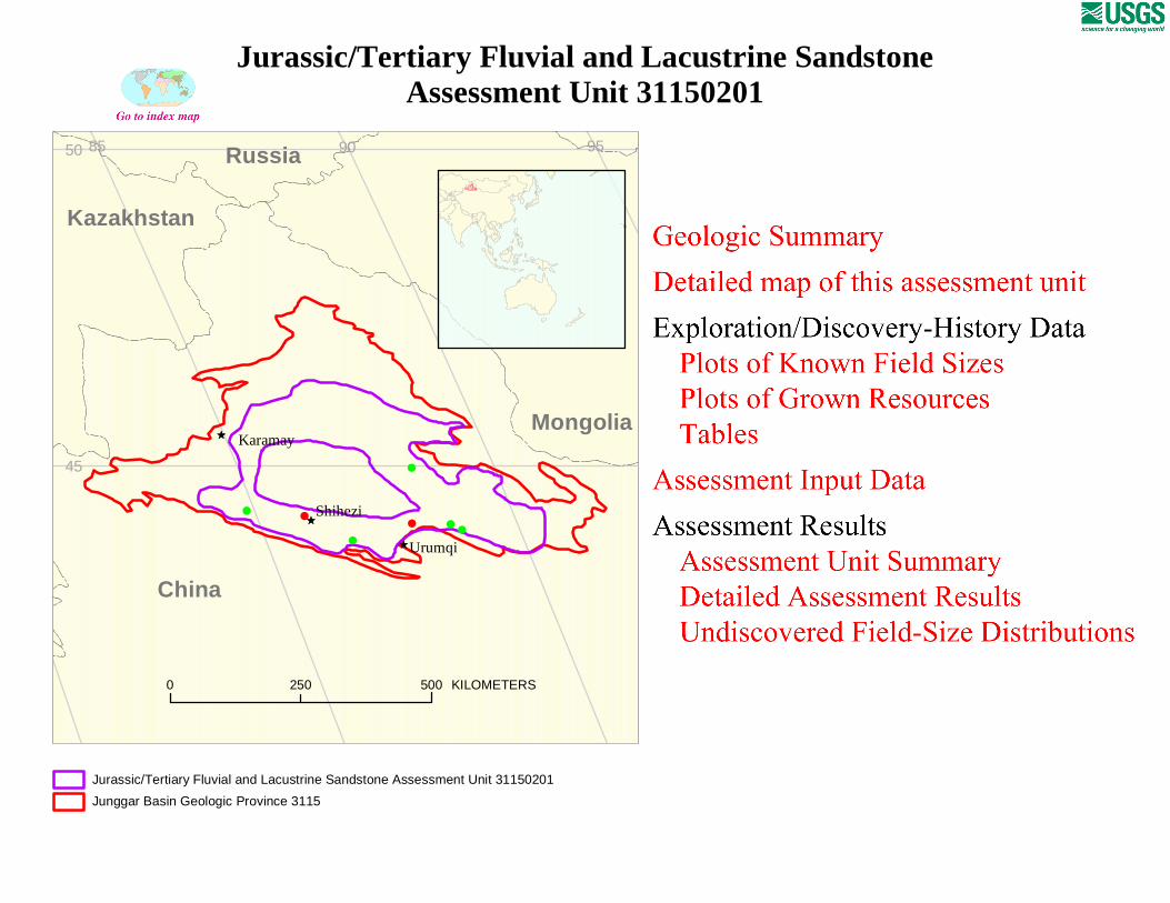
# # # # # # # Ê Ú Ê Ú Ê Ú Karamay Shihezi Urumqi 0 250 500 KILOMETERS Russia Kazakhstan Mongolia China 50 45 95 90 85 Jurassic/Tertiary Fluvial and Lacustrine Sandstone Assessment Unit 31150201 Junggar Basin Geologic Province 3115 Jurassic/Tertiary Fluvial and Lacustrine Sandstone Assessment Unit 31150201
Transcript
#
# ## # #
# ÊÚ
ÊÚ
ÊÚ Karamay
Shihezi
Urumqi
0 250 500 KILOMETERS
Russia
Kazakhstan
Mongolia
China
50
45
959085
Jurassic/Tertiary Fluvial and Lacustrine Sandstone Assessment Unit 31150201
Junggar Basin Geologic Province 3115
Jurassic/Tertiary Fluvial and Lacustrine SandstoneAssessment Unit 31150201
Page 1
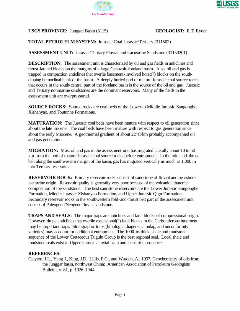
USGS PROVINCE: Junggar Basin (3115) GEOLOGIST: R.T. Ryder TOTAL PETROLEUM SYSTEM: Jurassic Coal-Jurassic/Tertiary (311502) ASSESSMENT UNIT: Jurassic/Tertiary Fluvial and Lacustrine Sandstone (31150201) DESCRIPTION: The assessment unit is characterized by oil and gas fields in anticlines and thrust-faulted blocks on the margins of a large Cenozoic foreland basin. Also, oil and gas is trapped in compaction anticlines that overlie basement-involved horst(?) blocks on the south-dipping homoclinal flank of the basin. A deeply buried pod of mature Jurassic coal source rocks that occurs in the south-central part of the foreland basin is the source of the oil and gas. Jurassic and Tertiary nonmarine sandstones are the dominant reservoirs. Many of the fields in the assessment unit are overpressured. SOURCE ROCKS: Source rocks are coal beds of the Lower to Middle Jurassic Sangonghe, Xishanyao, and Toutunhe Formations. MATURATION: The Jurassic coal beds have been mature with respect to oil generation since about the late Eocene. The coal beds have been mature with respect to gas generation since about the early Miocene. A geothermal gradient of about 22°C/km probably accompanied oil and gas generation. MIGRATION: Most oil and gas in the assessment unit has migrated laterally about 10 to 50 km from the pod of mature Jurassic coal source rocks before entrapment. In the fold-and-thrust belt along the southwestern margin of the basin, gas has migrated vertically as much as 1,000 m into Tertiary reservoirs. RESERVOIR ROCK: Primary reservoir rocks consist of sandstone of fluvial and nearshore lacustrine origin. Reservoir quality is generally very poor because of the volcanic litharenite composition of the sandstone. The best sandstone reservoirs are the Lower Jurassic Songonghe Formation, Middle Jurassic Xishanyao Formation, and Upper Jurassic Qigu Formation. Secondary reservoir rocks in the southwestern fold-and-thrust belt part of the assessment unit consist of Paleogene/Neogene fluvial sandstone. TRAPS AND SEALS: The major traps are anticlines and fault blocks of compressional origin. However, drape anticlines that overlie extensional(?) fault blocks in the Carboniferous basement may be important traps. Stratigraphic traps (lithologic, diagenetic, onlap, and unconformity varieties) may account for additional entrapment. The 1000-m-thick, shale and mudstone sequence of the Lower Cretaceous Tugulu Group is the best regional seal. Local shale and mudstone seals exist in Upper Jurassic alluvial plain and lacustrine sequences. REFERENCES: Clayton, J.L., Yang J., King, J.D., Lillis, P.G., and Warden, A., 1997, Geochemistry of oils from
the Junggar basin, northwest China: American Association of Petroleum Geologists Bulletin, v. 81, p. 1926-1944.
Page 2
Editorial Committee, 1989, Petroleum geology of the Junggar basin (in Chinese), in Petroleum Geology of China: Beijing, Petroleum Industry Press, v. 15A, 222 p.
Hendrix, M.S., Brassell, S.C., Carroll, A.R., and Graham, S.A., 1995, Sedimentology, organic geochemistry, and petroleum potential of Jurassic coal measures–Tarim, Junggar, and Turpan basins, northwest China: American Association of Petroleum Geologists Bulletin, v. 79, p. 929-959.
Peng X.L. and Zhang G.J., 1989, Tectonic features of the Junggar basin and their relationship with oil and gas distribution, in Zhu X., ed., Chinese sedimentary basins–Sedimentary basins of the world: Amsterdam, Elsevier, p. 17-31.
Zha M., Zhang W.H., and Qu J.X., 1999, Overpressure compartments in Junggar basin, northwest of China–Mechanism and hydrocarbon distribution (abs.): American Association of Petroleum Geologists Annual Convention Official Program, v. 8 [April 11-14, 1999, San Antonio, Texas], p. 158-159.
Zhao W., Zhang Y., Xu D., and Zhao C., 1997, Formation and distribution of coal measure-derived hydrocarbon accumulation in NW China, in Sun Z. C. and others, eds., Geology of fossil fuels−oil and gas: Proceedings 30th International Geological Congress, v. 18A, p. 87-101.
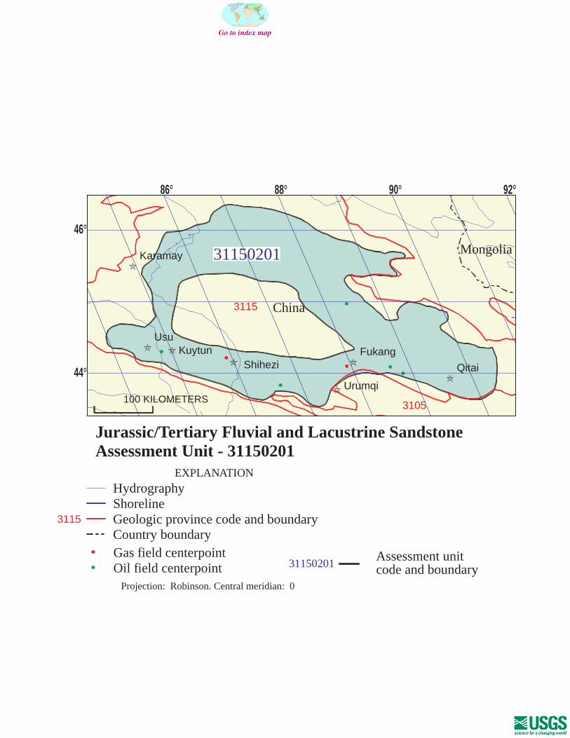
31150201
31150201Assessment unitcode and boundary
3105
3115
3115
Assessment Unit - 31150201Jurassic/Tertiary Fluvial and Lacustrine Sandstone
EXPLANATION
HydrographyShorelineGeologic province code and boundaryCountry boundaryGas field centerpointOil field centerpoint
Projection: Robinson. Central meridian: 0
100 KILOMETERS
86 88 90 92
44
46
Urumqi
Fukang
QitaiShiheziKuytun
Usu
Karamay
China
Mongolia
SEVENTH APPROXIMATIONNEW MILLENNIUM WORLD PETROLEUM ASSESSMENTDATA FORM FOR CONVENTIONAL ASSESSMENT UNITS
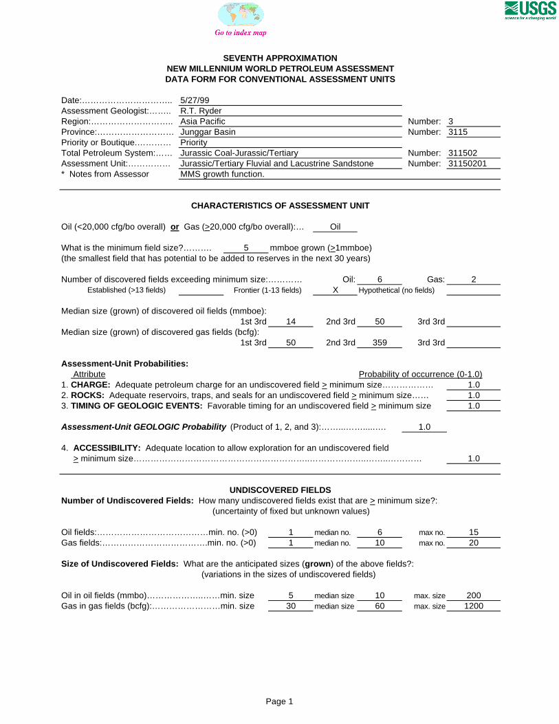
Date:………………………….. 5/27/99Assessment Geologist:…….. R.T. RyderRegion:……………………….. Asia Pacific Number: 3Province:……………………… Junggar Basin Number: 3115Priority or Boutique.………… PriorityTotal Petroleum System:…… Jurassic Coal-Jurassic/Tertiary Number: 311502Assessment Unit:…………… Jurassic/Tertiary Fluvial and Lacustrine Sandstone Number: 31150201* Notes from Assessor MMS growth function.
CHARACTERISTICS OF ASSESSMENT UNIT
Oil (<20,000 cfg/bo overall) or Gas (>20,000 cfg/bo overall):… Oil
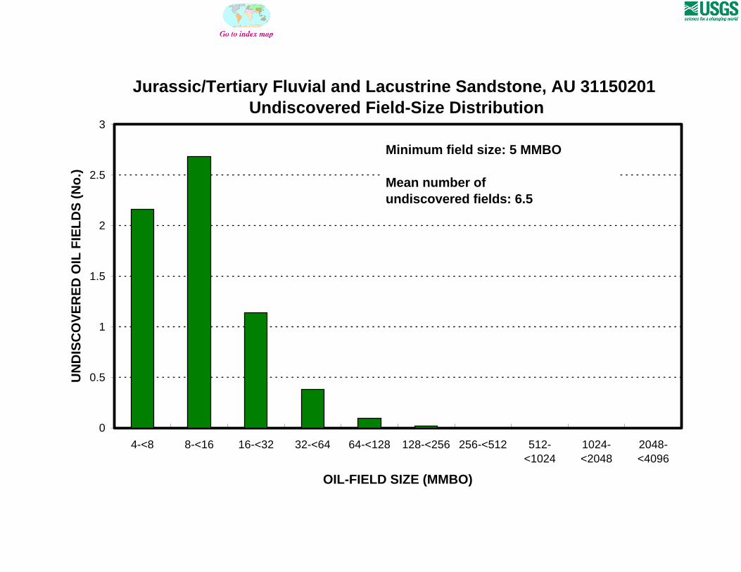
What is the minimum field size?………. 5 mmboe grown (>1mmboe)(the smallest field that has potential to be added to reserves in the next 30 years)
Number of discovered fields exceeding minimum size:………… Oil: 6 Gas: 2 Established (>13 fields) Frontier (1-13 fields) X Hypothetical (no fields)
Median size (grown) of discovered oil fields (mmboe):1st 3rd 14 2nd 3rd 50 3rd 3rd
Median size (grown) of discovered gas fields (bcfg):1st 3rd 50 2nd 3rd 359 3rd 3rd
Assessment-Unit Probabilities: Attribute Probability of occurrence (0-1.0)1. CHARGE: Adequate petroleum charge for an undiscovered field > minimum size……………… 1.02. ROCKS: Adequate reservoirs, traps, and seals for an undiscovered field > minimum size…… 1.03. TIMING OF GEOLOGIC EVENTS: Favorable timing for an undiscovered field > minimum size 1.0
Assessment-Unit GEOLOGIC Probability (Product of 1, 2, and 3):……...…….....…. 1.0
4. ACCESSIBILITY: Adequate location to allow exploration for an undiscovered field > minimum size……………………………………………………..………………..……..………… 1.0
UNDISCOVERED FIELDSNumber of Undiscovered Fields: How many undiscovered fields exist that are > minimum size?:
(uncertainty of fixed but unknown values)
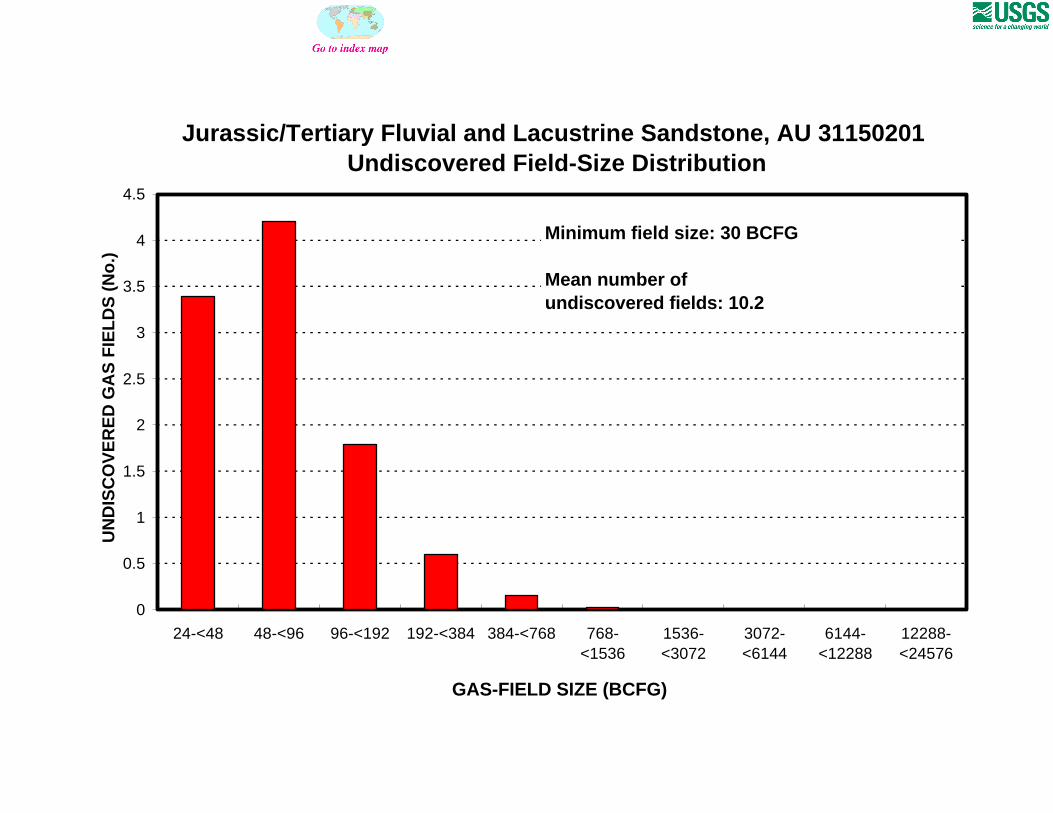
Oil fields:…………………………………min. no. (>0) 1 median no. 6 max no. 15Gas fields:……………………………….min. no. (>0) 1 median no. 10 max no. 20
Size of Undiscovered Fields: What are the anticipated sizes (grown) of the above fields?: (variations in the sizes of undiscovered fields)
Oil in oil fields (mmbo)………………..……min. size 5 median size 10 max. size 200Gas in gas fields (bcfg):……………………min. size 30 median size 60 max. size 1200
Page 1
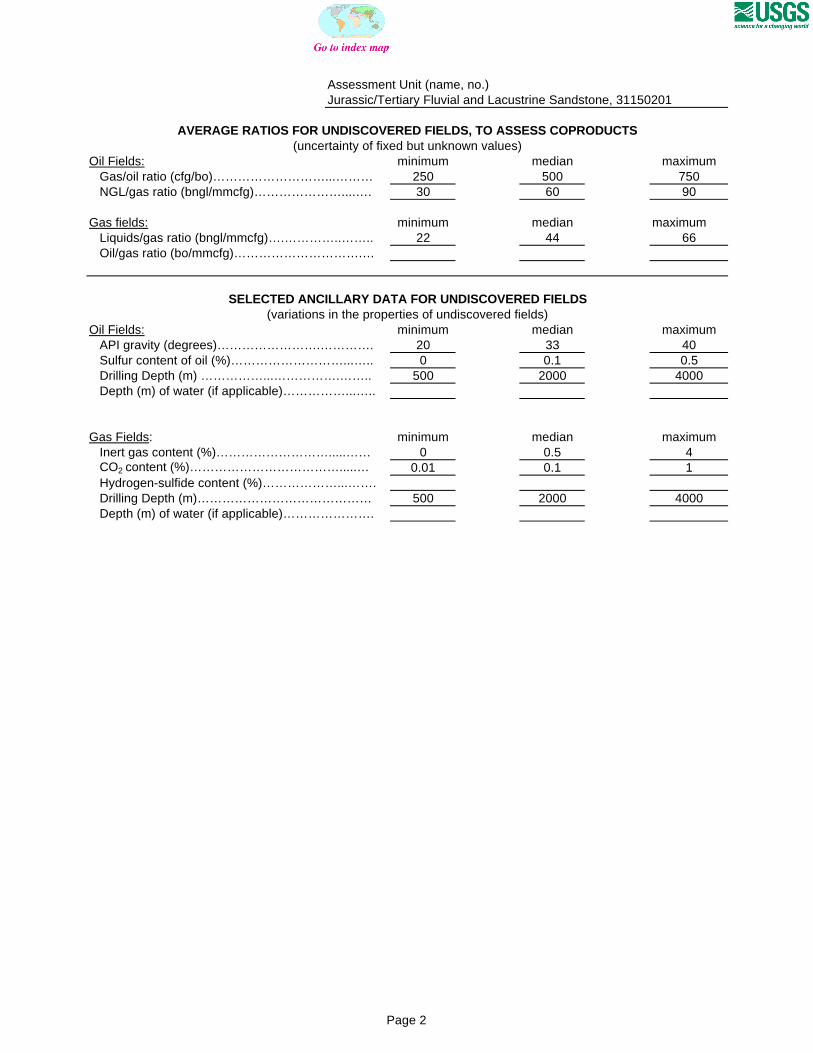
Assessment Unit (name, no.)Jurassic/Tertiary Fluvial and Lacustrine Sandstone, 31150201
AVERAGE RATIOS FOR UNDISCOVERED FIELDS, TO ASSESS COPRODUCTS(uncertainty of fixed but unknown values)
Oil Fields: minimum median maximum Gas/oil ratio (cfg/bo)………………………...……… 250 500 750 NGL/gas ratio (bngl/mmcfg)…………………....…. 30 60 90
Gas fields: minimum median maximum Liquids/gas ratio (bngl/mmcfg)….…………..…….. 22 44 66 Oil/gas ratio (bo/mmcfg)………………………….…
SELECTED ANCILLARY DATA FOR UNDISCOVERED FIELDS(variations in the properties of undiscovered fields)
Oil Fields: minimum median maximum API gravity (degrees)…………………….…………. 20 33 40 Sulfur content of oil (%)………………………...….. 0 0.1 0.5 Drilling Depth (m) ……………...…………….…….. 500 2000 4000 Depth (m) of water (if applicable)……………...…..
Gas Fields: minimum median maximum Inert gas content (%)……………………….....…… 0 0.5 4 CO2 content (%)……………………………….....… 0.01 0.1 1 Hydrogen-sulfide content (%)………………...……. Drilling Depth (m)…………………………………… 500 2000 4000 Depth (m) of water (if applicable)………………….
Page 2
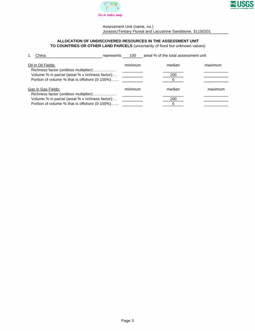
Assessment Unit (name, no.)Jurassic/Tertiary Fluvial and Lacustrine Sandstone, 31150201
ALLOCATION OF UNDISCOVERED RESOURCES IN THE ASSESSMENT UNITTO COUNTRIES OR OTHER LAND PARCELS (uncertainty of fixed but unknown values)
1. China represents 100 areal % of the total assessment unit
Oil in Oil Fields: minimum median maximum Richness factor (unitless multiplier):……….…..… Volume % in parcel (areal % x richness factor):… 100 Portion of volume % that is offshore (0-100%)…… 0
Gas in Gas Fields: minimum median maximum Richness factor (unitless multiplier):…………..…. Volume % in parcel (areal % x richness factor):… 100 Portion of volume % that is offshore (0-100%)…… 0