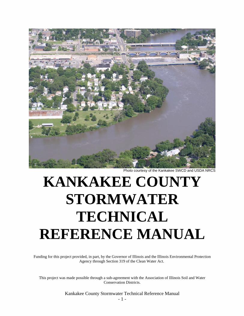
Kankakee County Stormwater Technical Reference Manual - 1 - Photo courtesy of the Kankakee SWCD and USDA NRCS KANKAKEE COUNTY STORMWATER TECHNICAL REFERENCE MANUAL Funding for this project provided, in part, by the Governor of Illinois and the Illinois Environmental Protection Agency through Section 319 of the Clean Water Act. This project was made possible through a sub-agreement with the Association of Illinois Soil and Water Conservation Districts.
Transcript
Kankakee County Stormwater Technical Reference Manual - 1 -
Photo courtesy of the Kankakee SWCD and USDA NRCS
KANKAKEE COUNTY STORMWATER
TECHNICAL REFERENCE MANUAL
Funding for this project provided, in part, by the Governor of Illinois and the Illinois Environmental Protection Agency through Section 319 of the Clean Water Act.
This project was made possible through a sub-agreement with the Association of Illinois Soil and Water Conservation Districts.
Kankakee County Stormwater Technical Reference Manual - 2 -
TABLE OF CONTENTS
SECTION 1 – PURPOSE, INTENT, & DEFINITIONS........................................................... 3 A. Purpose & Intent ................................................................................................................... 3 B. Definitions............................................................................................................................. 4
a. TR-55(WinTR55).......................................................................................................... 12 b. HEC-1/HEC-HMS Flood Hydrograph Package .......................................................... 16 c. TR-20(WinTR 20)......................................................................................................... 17 d. HSPF............................................................................................................................. 19 e. SWMM.......................................................................................................................... 20 f. ILLUDAS ...................................................................................................................... 20
B. Hydrologic Analysis............................................................................................................. 21 E. Emergency Overflow............................................................................................................ 24 H. Storm Sewer Design............................................................................................................. 27
Section 3 – Best Management Practices.................................................................................... 29 A. What Is A Best Management Practice (BMP) ..................................................................... 29 B. Best Management Practices Hierarchy ................................................................................ 29
1. Preserving (and Restoring) Regulatory Floodplains, Flood Prone and Wetland Areas .. 30 2. Minimizing Impervious Surfaces on the Property ............................................................ 31 3. Utilizing Stormwater Wetlands, Grassed Swales and Vegetated Filter Strips ................ 31 4. Infiltrating Runoff On-Site .............................................................................................. 32 5. Providing Stormwater Retention Facilities...................................................................... 33 6. Providing Wet Bottom or Wetland Detention Facilities.................................................. 33 7. Providing Dry Detention Facilities .................................................................................. 33 8. Constructing Storm Sewers.............................................................................................. 34 9. Protecting Water Quality Through Multiple Uses ........................................................... 35
C. Best Management Practices for Construction Site Runoff Control .................................... 35 D. Preparing An Effective Stormwater Pollution Prevention Plan (SWPPP) ......................... 43
SECTION 4 APPENDIX ............................................................................................................ 46 APPENDIX A - REFERENCE SECTION............................................................................... 46 APPENDIX B - GRADING AND DRAINAGE PERMIT ...................................................... 47 APPENDIX C - EROSION CONTROL FOR HOMEBUILDERS BROCHURE................... 49
Kankakee County Stormwater Technical Reference Manual - 3 -
SECTION 1 – PURPOSE, INTENT, & DEFINITIONS A. PURPOSE AND INTENT The Kankakee County Stormwater Technical Reference Manual (TRM) is a technical guide to provide developers and applicants assistance in complying with the Kankakee County Stormwater Ordinance, effective August 1, 2006 and hereafter referred to as the Stormwater Ordinance, and the technical requirements of a grading and drainage permit application. Goals of the TRM:
• To ensure uniform and consistent treatment for developments and to establish a minimum standard for minimizing environmental and water quality impacts to watersheds in Kankakee County.
• To provide the technical tools and guidelines to correctly apply the current requirements of the Stormwater Ordinance and to promote uniformity, consistency and efficiency throughout the permit and enforcement process.
The TRM is a document designed to facilitate implementation and provide guidance necessary to achieve the objectives and standards of the Stormwater Ordinance and is not intended to supersede the Stormwater Ordinance. It is important to use this document only as a technical reference and use the Ordinance as the regulatory document. The Stormwater Ordinance provides for the regulation of matters relative to the management of stormwater within the jurisdiction of Kankakee County and its extraterrestrial jurisdiction to provide no adverse impact on neighboring property owners. It’s provisions include, but are not limited to, regulating drainage installations and improvements, requiring preservation and enhancement of certain natural environmental features, requiring the installation of drainage improvements in developments, regulating uses, maintenance, and activities in floodplains and flood hazard areas, requirement permits, payment of fees and assurances of completion and providing for inspections and control of work. Urbanization without detention control can result in degradation of water quality and increased frequency and magnitude of overland flooding and stream destabilization which can result in damage both economic and environmental. A wide variety of individuals will find the TRM a useful tool and non-technical people will find worthwhile information in the Best Management Practices section. The following individuals would be expected to use this manual: County and Municipal Engineers/Planners Community Officials and Leaders Enforcement Officers Consulting Engineers Developers/Property Owners Watershed Planners Watershed Stakeholders Other Interested Parties
Kankakee County Stormwater Technical Reference Manual - 4 -
The TRM will have the following components: Provide technical background and reference information Provide direction to assist in uniform and comprehensive permit applications Provide design guidelines Provide information as a useful resource for planning purposes Provide interpretation for the Stormwater Ordinance The TRM is structured to provide clear direction for development projects in Kankakee County. It references numerous sources and websites to obtain additional information. These references are included in both Section 2 and Section 3 of the TRM. These sources and websites are to be used when more specialized information is needed. The Kankakee County Soil and Water Conservation District would like to thank the following organizations and people for their extensive help without which this document could not have been produced: The Illinois Environmental Protection Agency for the funding of the Protecting Water Quality in Urban Centers Grant, the Association of Illinois Soil and Water Conservation Districts for facilitating the IEPA grant, Kent Sims, NRCS Urban and Community Conservation Specialist for guidance and technical input, Robert Gotkowski, NRCS District Conservationist for review and support of the concept, the Kankakee County Regional Planning Department, Mike Van Mill, Director and Brian Billingsley, Senior Planner for staff time, reproduction and distribution of material and local match dollars, MG2A Engineering, Mike Gingerich and Jerry Leonard for the section on Best Management Practices and review of other sections, Tyson Engineering, Dave Tyson and James Brooks for the section on Hydrologic Analysis Methodologies and review of other sections, the Kankakee County Highway Department, Mark Rogers, Assistant County Engineer, for assistance with forms for the appendix and review , the Kankakee River Basin Commission for support and local match dollars and the Kankakee County Soil and Water Conservation District, Rich Howell Conservation District Manager for the Purpose and Intent Section. February 2006. Funding for this project provided, in part, by the Governor of Illinois and the Illinois Environmental Protection Agency through Section 319 of the Clean Water Act. This project was made possible through a sub-agreement with the Association of Illinois Soil and Water Conservation Districts. B. DEFINITIONS The following definitions are intended for use within the Technical Reference Manual and to supplement definitions in the Kankakee County Stormwater Ordinance. Where differences may occur, the Stormwater Ordinance Definitions shall take precedence.
adequate downstream stormwater capacity: A downstream channel or stormwater management system with the ability to store and convey the anticipated 100-year stormwater runoff without increasing flood height, flow, or damage to an adjacent or downstream building or structure.
Kankakee County Stormwater Technical Reference Manual - 5 -
basement: Any area of a building having its floor below grade (below grade level) on all sides.
buffer: An area of predominantly vegetated land located adjacent to channels, wetlands, lakes or ponds for the purpose of, but not limited to, reducing contaminants in stormwater that flows to such areas.
community: Any municipality (as defined at Ill. Rev. Stat., 1989, Ch. 24, 1-1-2 {1}) or the unincorporated county within Kankakee County acting as a unit of local government.
control structure: A structure designed to control the rate of flow that passes through a given point, given a specific upstream and downstream water surface elevation.
critical duration: The duration of a storm event that results in the greatest peak runoff.
damage: Reduction of value of a structure or a portion of a structure or property or a portion thereof from any cause.
depressional storage area: A non-riverine depression where stormwater collects.
design storm: A selected duration storm event, described in terms of the statistical probability of occurring once within a given number of years, for which stormwater or flood control improvements are designed and built.
drainage area: The land area above a given point that contributes runoff from rainfall and/or snowmelt.
freeboard: An increment of height added to a water surface elevation occurring as a result of a specified runoff event to provide a factor of safety for uncertainties in calculations, unknown local conditions, wave actions and unpredictable effects such as those caused by ice or debris jams.
hydrologic and hydraulic calculations: Engineering analysis which determines expected flood flows and flood elevations based on land characteristics and rainfall events.
hydrologically disturbed: An area where the land surface has been cleared, grubbed, compacted, or otherwise modified that changes runoff, volumes, rates, or direction.
inspect: To visit a site to observe or to check or to review a site and as-built plans for compliance with this Ordinance, permitted plans and permit conditions.
lake: A body of water encompassing an area of two or more acres which retains a normal water level throughout the year.
lowest floor: Lowest floor of the lowest enclosed area, including basement.
native vegetation: Generally, all warm season, deep rooted (4’ to 15’), grass and forb species believed to have grown naturally in the pre-settlement landscape
non-riverine: Areas not associated with a stream or river such as isolated depressional storage areas, ponds and lakes.
overland flow path: The route that stormwater will travel based on the topography of the land. Overland flow routes are typically viewed without consideration of infiltration, evaporation or underground drainage structures.
Kankakee County Stormwater Technical Reference Manual - 6 -
permanent erosion control: Permanent features of a development site designed to control soil erosion and sedimentation.
pond: A body of water of less than two acres which retains a normal water level year round.
redevelopment: The process of developing land previously developed.
riverine: Relating to, formed by, or resembling a stream (including creeks and rivers).
temporary erosion control: erosion control measures used to control soil erosion and sedimentation during the construction phase of a development.
transition section: Reaches of the stream where water flows from a narrow cross-section to a wide cross-section and vice-versa.
tributary area: All of the land surface that contributes runoff to a given point.
tributary stream: A stream that discharges to a larger stream at a point. A stream will typically have more than one tributary stream.
Kankakee County Stormwater Technical Reference Manual - 7 -
SECTION 2 – STORMWATER MANAGEMENT
The Stormwater Ordinance seeks to maintain existing flows and stages in Kankakee County in order to:
• Minimize future flooding; • Protect water quality and control erosion; and • Preserve the flood management capacity of constructed protection measures.
The additional impervious areas associated with development increases both the peak runoff rate and runoff volume. The objective of the runoff management approach is to control the timing or volume of runoff to preserve existing flows and stages at the downstream locations in the watershed. The simplest and most effective runoff management approach is to limit the outflow from any development to a rate that would not cause any increase in the flow or stage downstream. This approach, called a unit release rate approach, includes 2-year and 100-year rates that are applicable for all of Kankakee County.
The primary objective of this section is to discuss the procedures and guidelines for evaluating the existing and proposed runoff characteristics through the use of various hydrologic techniques. The materials presented here can be used to help choose the appropriate level and detail of the analysis. Any data available for the watershed, including data from regional sources such as the United States Geological Survey and Illinois State Water Survey, should be used in the calibration of the hydrologic model.
A. Runoff Calculations There are several methods for determining the appropriate storm runoff from a watershed. The Rational Method may be used as the primary tool for the determination of peak stormwater runoff rates from drainage areas of less than 10 acres. This method is also useful for the design of storm sewer systems. The Rational Method is an adequate design tool for small conveyance systems but is not appropriate for larger sites or for the design of detention basins. More sophisticated hydrograph methods are widely available and are relatively easy to apply using personal computers.
A runoff hydrograph method is required to determine peak runoff rates for major drainage systems with greater than 10 acres of drainage area. WinTR-55, WinTR-20, HEC-1/HEC-HMS or another Kankakee County approved hydrologic model is required for computing stormwater runoff under these conditions. These models may also be used if detention storage, depressional storage or another determination of stormwater runoff volume is anticipated or required. These models allow for the temporal variation of rainfall intensity and describe the shape of a hydrograph in a realistic manner, which would be required for the cases outlined above.
Other hydrograph producing models include HSPF, SWMM, and ILLUDAS. The other types of models may or may not be accepted by the Kankakee County Planning Department. Due to program limitations or reviewing limitations, most proprietary models are not allowed for use in the submittal for a Grading and Drainage Permit. However, each reviewing entity has access to all public models cited above and these are widely accepted. It is extremely important to check with the Kankakee County Planning Department to determine which hydrologic technique is appropriate and acceptable for the specific site.
Kankakee County Stormwater Technical Reference Manual - 8 -
1. Rational Method The rational method is an empirical runoff formula that has gained wide acceptance because of its simple intuitive treatment of peak storm runoff rates in areas less than 10 acres. The Rational Method is useful for the design of the following drainage facilities: storm sewers, inlets, swales and roadside ditches, culverts, erosion control features and overland flow paths. The Rational Method cannot be used in situations that require the computation of the storage of stormwater runoff volumes because it does not generate runoff volumes. In particular, it shall not be used to size detention, retention or depressional storage areas.
This rational method relates stormwater runoff to rainfall intensity, surface area and surface characteristics by the formula.
Q = C i A where:
Q = peak runoff rate, cfs; C = runoff coefficient, a dimensionless ratio of rainfall excess to total rainfall and it varies with topography, landuse, and type of surface of the drainage area; i = rainfall intensity, in inches per hour for a duration equal to the time of concentration A = drainage area tributary to the point under consideration, acres.
Runoff Coefficient, C - The runoff coefficient, C, is a variable of the Rational Method which is least susceptible to a precise determination and provides the engineer with an opportunity to exercise independent judgment.
Cw = A1 C1 + A2 C2+ A3 C3 A1 + A2 + A3
Where: Cw = Weighted runoff coefficient An = Sub-area “n” Cn = Runoff coefficient for sub-area “n”
This procedure can be applied to typical “sample” areas as a guide to the selection of usual values of the coefficient for the entire area. Runoff coefficients for the Rational Method are provided in the IDOT Drainage Manual.
Rainfall Intensity, I - Rainfall intensity, I, is the average rate of rainfall in inches per hour (in/hr). Intensity is selected on the basis of design frequency of occurrence, a statistical parameter established by design criteria, and rainfall duration. For the Rational Method, the critical rainfall intensity is the rainfall having a duration equal to the time of concentration of the drainage area/watershed. Rainfall intensities for various return periods and durations can be obtained from the Illinois State Water Survey’s Bulletin 70, Frequency Distributions and Hydroclimatic Characteristics of Heavy Rainstorms in Illinois (ISWS, 1989)
Time of Concentration, Tc - One of the basic assumptions underlying the Rational Method is that runoff is a function of the average rainfall rate during the time required for water to flow from the most hydraulically remote point of the drainage area/watershed to the point under consideration. Time of concentration, tc, is defined as the time it takes for runoff to travel from the hydraulically most distant part of the drainage area/watershed to the point of reference. The tc is usually computed by determining the travel time through the drainage area/watershed.
Kankakee County Stormwater Technical Reference Manual - 9 -
Several different methods currently exist for the computation of a time of concentration. Most of these methods compute the time of concentration by determining the total flow travel time considering the incremental travel times of overland (sheet) flow, shallow concentrated flow, and open channel flow. If the total tc computed is less than 5 minutes, a minimum tc of 5 minutes should be used.
Overland Sheet Flow The travel time can be obtained from the Manning’s Kinematic Solution expressed as (NRCS, 1986):
t = 0.007(nL)0.8 P2
0.5s0.4
where:
t = travel time, hrs L = overland flow, length, ft n = Manning roughness coefficient P2 = 2-yr, 24-hr storm event (Bulletin 70 rainfall data) s = average slope of flow path, ft/ft
Kankakee County Stormwater Technical Reference Manual - 10 -
OVERLAND FLOW MANNING’S “n” VALUES (For use with Kinematic Wave Equation)
All values are from Engman (1983), unless noted otherwise aWoolhiser (1975) bFallow has been idle for one year and is fairly smooth. cPalmer (1946). Weeping lovegrass, bluegrass, buffalo grass, blue gramma grass, native grass mix (OK), alfalfa, lespedeza.
Manning’s “n” values reported in the above table were determined specifically for overland sheet flow and are not appropriate for conventional open channel flow. The overland sheet flow travel distance should be limited to 100 feet or less.
Kankakee County Stormwater Technical Reference Manual - 11 -
Shallow Concentrated Flow Average velocities for a shallow concentrated flow in rills and gutters can be obtained by various standard methods. The WinTR-55 user manual has two equations for two types of surfaces, paved and unpaved. They are:
sV 1345.16= (Unpaved) sV 20.3282= (Paved)
Where: V = average velocity (ft/s), and s = slope of hydraulic grade line (watercourse slope, ft/ft)
These two equations are based on a solution of Manning’s Equation with different assumptions for n (Manning roughness coefficient) and r (hydraulic radius, ft). For unpaved areas, n is 0.05 and r is 0.4; for paved areas, n is 0.025 and r is 0.2.
Alternate procedures for evaluating gutter flow velocities involve the use of the modified Manning’s Equation as follows (from the IDOT Drainage Manual):
0.56 Sx1.67 S0.5 T2.67 V = n A
Where: V = flow velocity, fps n = Manning roughness coefficient Sx = cross slope, ft/ft S = longitudinal slope, ft/ft T = width of flow spread, ft A = area of flow, sq ft
The time of concentration for the shallow channel flow section can be computed by dividing the length of the shallow channel flow by the computed velocity. Main Open Channel Flow Average velocities for main open channel flow can be evaluated using the standard Manning’s Equation.
Where: V = flow velocity, fps n = Manning roughness coefficient R = hydraulic radius S = longitudinal slope, ft/ft
The time of concentration for the main channel flow section can then be computed by dividing the length of the main channel flow by the computed velocity. Manning n values for open channel flow may be obtained from Open Channel Hydraulics (Chow 1959).
1.486 R2/3 S1/2 V = n
Kankakee County Stormwater Technical Reference Manual - 12 -
2. Runoff Hydrograph Methods In hydrologic models, the transformation from rainfall excess to streamflow is accomplished either through unit hydrograph or kinematic wave routing procedures. These procedures allow hydrograph analysis concepts to be applied to watersheds through the development and application of generalized functions for estimating the amount of precipitation lost due to interception and infiltration, the unit hydrographs, and base flow.
The unit hydrograph is usually assumed to give a unique relationship between rainfall excess and surface runoff for a basin regardless of storm size, losses, or other factors. The unit hydrograph approach is currently used the most frequently. However, other methods of hydrograph generation are also becoming widely used, such as the kinematic wave approach to basin modeling. In addition to the software models, providing important hydrologic information, the results are frequently utilized in the hydraulic analysis.
A brief description of the different hydrologic models is provided below to assist in the selection process and obtain an understanding of their particular applications. Additional information is available by consulting the specific supporting documentation for each of the programs. Certain programs have inherent problems because the governing jurisdiction does not possess or is not familiar with the program. The Kankakee County Planning Department should be contacted first to verify acceptable methods for hydrologic modeling.
a. TR-55(WinTR55)
Historical Background Technical Release 55 (TR-55) Urban Hydrology for Small Watersheds was first issued in January 1975 as a simplified procedure to calculate the storm runoff volume, peak rate of discharge, hydrographs and storage volumes required for stormwater management structures (SCS, 1975). The first issue involved manual methods and assumed the NRCS Type II rainfall distribution for all calculations. In June 1986 major revisions were made in TR-55 by adding three rainfall distributions (Type I, IA and III) and programming the computations. Time of concentration was estimated by splitting the hydraulic flow path into separate flow phases (SCS, 1986). The computer program became a standard tool to analyze peak flow changes caused by urbanization in many locations. Its wide acceptance by public and private users has also indicated where improvements could be made in the procedures and the computer program. A WinTR-55 work group was formed in the spring of 1998 to modernize and revise the Technical Release and the computer software. The current changes include: upgrade the source code to Visual Basic, change the philosophy of data input, develop a Windows interface and output post-processor, enhance the hydrograph-generation capability of the software and flood route hydrographs through stream reaches and reservoirs. The availability and technical capabilities of the personal computer have significantly changed the philosophy of problem-solving for the engineer. Computer availability eliminated the need for TR-55 manual methods, thus the manual portions (graphs and tables) of the user document have been eliminated.
Kankakee County Stormwater Technical Reference Manual - 13 -
This user manual covers the procedures used in and the operation of the WinTR-55 computer program. Part 630 of the Natural Resources Conservation Service (NRCS) National Engineering Handbook provides detailed information on NRCS hydrology and is the technical reference for this document. Appendix A, which lists all the references, contains a list of the Part 630 chapters and their subjects. Users who are not familiar with NRCS hydrologic procedures should refer to the appropriate chapters for background information and the details of procedural techniques.
Program Description WinTR-55 is a single-event rainfall-runoff small watershed hydrologic model. The model generates hydrographs from both urban and agricultural areas and at selected points along the stream system. Hydrographs are routed downstream through channels and/or reservoirs. Multiple sub-areas can be modeled within the watershed. Model Overview A watershed is composed of sub-areas (land areas) and reaches (major flow paths in the watershed). Each sub-area has a hydrograph generated from the land area based on the land and climate characteristics provided. Reaches can be designated as either channel reaches where hydrographs are routed based on physical reach characteristics or as storage reaches where hydrographs are routed through a reservoir based on temporary storage and outlet characteristics. Hydrographs from sub-areas and reaches are combined as needed to accumulate flow as water moves from the upland areas down through the watershed reach network. The accumulation of all runoff from the watershed is represented at the watershed outlet. Up to ten sub-areas and ten reaches may be included in the watershed. WinTR-55 uses the TR-20 (NRCS, 2002) model for all of the hydrograph procedures: generation, channel routing, storage routing, and addition. Figure 1 is a diagram showing the WinTR-55 model, its relationship to TR-20, and the files associated with the model.
Kankakee County Stormwater Technical Reference Manual - 14 -
Figure 1. WinTR-55 System Schematic
TR-55 System
TR-20 Model
TR-20 Input File
Name
TR-20Input Data
PrintedPage
Data Displays and Plots
TR-55 Windows
Legend
Data Flow
Program Flow
StateRainfall Data
Error
Debug
HelpText
StandardLand use
Data
Land usePointer
File
CustomDimen. UnitHydrograph
CustomRainfall
Distribution
Hydrograph
TR-55Input Data
Kankakee County Stormwater Technical Reference Manual - 15 -
WinTR-55 hydrology has the capacity to analyze watersheds that meet these criteria: Table 1. WinTR-55 Capabilities & Limitations
Variable Limits Minimum area No absolute minimum is included in
the software. The user should carefully examine results from sub-areas less than 1 acre.
Maximum area 25 square miles (6,500 hectares) Number of Subwatersheds 1-10 Time of concentration for any sub-area 0.1 hour < Tc < 10 hour Number of reaches 0-10 Types of reaches Channel or Structure Reach Routing Muskingum-Cunge Structure Routing Storage-Indication Structure Types Pipe or Weir Structure Trial Sizes 1-3 Rainfall Depth Default or user-defined
0 – 50 inches (0-1,270 mm) Rainfall Distributions NRCS Type I, IA, II, III, NM60,
NM65, NM70, NM75, or user-defined Rainfall Duration 24-hour Dimensionless Unit Hydrograph Standard peak rate factor 484, , or
user-defined (e.g. Delmarva—see Example 3)
Antecedent Moisture Condition 2 (average)
Kankakee County Stormwater Technical Reference Manual - 16 -
b. HEC-1/HEC-HMS Flood Hydrograph Package HEC-1 was developed by the Hydrologic Engineering Center of the U.S. Army Corps of Engineers to simulate the surface runoff response of a watershed to rainfall events. Although it is a DOS-based program, it is still considered by many in the engineering and regulatory communities to be the leading model for major drainage system applications such as Flood Insurance Studies and watershed master planning. HEC-1 is accepted by the Federal Emergency Management Agency and therefore is the most widely used model for major drainage system analyses. In HEC-1, the watershed is represented in the model as an interconnected system of hydrologic (i.e., subbasins, reservoirs, ponds) and hydraulic (i.e., channels, closed conduits, pumps) components. The model computes a runoff hydrograph at each component, combining two or more hydrographs as it moves downstream in the watershed. The model has a variety of rainfall-runoff simulation methods, including the popular NRCS Curve Number methodology. The user can define rainfall events using gage or historical data, or HEC-1 can generate synthetic storms. Hydrograph generation is performed using the unit hydrograph technique. Clark, SCS Dimensionless and Snyder Unit Hydrographs are the available methodologies. Several common channel and storage routing techniques are available as well. HEC-1 is not considered a "design tool.” The program has limited hydraulic capabilities. It does not account for tailwater effects and cannot adequately simulate many urban hydraulic structures such as pipe networks, culverts and multi-stage detention pond outlet structures. However, there are other hydrologic applications developed within HEC-1 that have been utilized with much success. Multiplan-multiflood analyses allow the user to simulate a number of flood events for different watershed situations (or plans). The dam safety option enables the user to analyze the impact dam overtopping or structural failure on downstream areas. Flood damage analyses assess the economic impact of flood damage.
Because it is not a Windows-based program, HEC-1 does not have easy to use input and output report generation and graphical capabilities, and therefore is generally not considered a user-friendly program. Because of its wide acceptance, however, several software development companies have incorporated the source code into enhanced "shells" to provide a user-friendly interface and graphical input and output capabilities. Examples of these programs include Graphical HEC-1, developed by Haested Methods and WMS, developed by the Environmental Modeling Research Laboratory.
The Corps of Engineers has developed a user-friendly, Windows-based Hydrologic Modeling System (HEC-HMS) intended to replace the DOS-based HEC-1 model. The new program has all the components of HEC-1, with more user-friendly input and output processors and graphical capabilities. HEC-1 files can be imported into HEC-HMS. Version 2 of this model has been released. Information regarding these two programs can be obtained from the U.S Army Corps of Engineers at the following address:
Corps of Engineers Website: http://www.hec.usace.army.mil/ Hydrologic Engineering Center 609 Second Avenue Davis, California 95616 Tel: 530-756-1104
Kankakee County Stormwater Technical Reference Manual - 17 -
c. TR-20(WinTR 20)
Program Description The WinTR-20 model is a storm event surface water hydrologic model applied at a watershed scale. The model assists in the hydrologic evaluation of flood events for use in the analysis of water resource projects. It can be used to analyze current watershed conditions as well as assess the impact of proposed changes (alternatives) made within the drainage area/watershed. Multiple storms (or rainfall frequencies) can be analyzed within one model run. A summary table for all alternatives and storms within the run can be produced. Direct runoff is computed from watershed land areas resulting from synthetic or natural rain events. The runoff is routed through channels and/or impoundments to the drainage area/watershed outlet. Brief History Natural Resources Conservation Service (NRCS) hydrology techniques are based upon unit hydrograph theory and the runoff curve number method of calculating direct runoff from the rainfall occurring over specified areas (National Engineering Handbook, Part 630, Hydrology, NEH-630.10 and 630.16). The Soil Conservation Service (SCS) and the Agricultural Research Service (ARS) developed the background theory and verification studies for these in the 1940’s and 1950’s. In the beginning, all necessary computations were done by hand or by calculators and an analysis of a sizeable watershed typically took weeks or months. In the 1960's, the agencies cooperated to hire C-E-I-R, Inc. to write a computer program in FORTRAN for the IBM 360 mainframe computer system (1964). This reduced calculation time enormously and allowed analysis of complex subwatershed systems to proceed much more rapidly even though the engineer still had to collect the data, code it onto punch cards and get it to the mainframe location system for processing. In the early 1980's, the program code was updated to FORTRAN 77 for use on the personal computers that were becoming a standard office fixture. The document describing this program was released as an SCS technical release TR-20 “Computer Program for Project Formulation Hydrology” in 1982 (SCS, 1982). Engineers then were able to run the program (version 83(.9) dated 1986) at their own desk. Numerous minor modifications and additions were made to TR-20 for the next 12 years and several draft versions with improvements had a limited distribution. In late 1998, a WinTR-20 work group was organized to develop the next generation of the program, suitable for triumphant entry into the new millennium and utilizing the expanded capabilities of the latest new computer technologies (windows format). Model Overview The major components of the WinTR-20 System are shown in Figure 1. The program components (rectangular boxes) are 1) the Controller/Editor which allows the running of the other program components and the entry/editing of data for the WinTR-20 model, 2) the WinTR-20 model which is the heart of the system and performs the rainfall-runoff and watershed routing calculations, 3) the Data Converter which transforms old TR-20 input data to the new input format accepted by the WinTR-20 model, and 4) the HEC-RAS Reformatter which transforms HEC-RAS output profile data to WinTR-20 stream cross section data. The remaining rectangles (WinTR-20 GIS Input Generator and FLOOD ECONOMICS) represent programs for which direct links with the WinTR-20 system do not exist at this time and which are not covered in this manual.
Kankakee County Stormwater Technical Reference Manual - 18 -
Figure 1: WinTR-20 System Diagram
Capabilities and Limitations
WinTR-20 model is a storm event surface water hydrologic model applied at a watershed scale that meets these criteria:
WinTR-20 Capabilities and Limitations
Variable Limits Types of reaches Channel or Structure Channel Manning “n” .005 – 1.00 Reach Routing Muskingum-Cunge Sheet Flow Maximum Length 100 feet Sheet Flow Manning “n” .005 –1.00 Hydrograph Distribution Increment >= .01 cfs Runoff Curve Number 30-100 Weighted Curve Number 30-100
Kankakee County Stormwater Technical Reference Manual - 19 -
Features of old program that are no longer supported:
1. Capabilities associated with IPEAKS and PEAKS. IPEAKS was used in conjunction with the modified Att-Kin channel routing where reach lengths were made as long as possible – not available with the present WinTR-20 model. PEAKS was used to obtain peak discharge values at intermediate points between cross sections and/or structures. Reach length is less important with the Muskingum-Cunge reach routing used in the present model and thus the need to determine peak flow at points within a reach is no longer necessary.
2. The use of a rain table as a runoff table can be handled by changing affected sub-area Curve Number to 100, which converts all rainfall to runoff.
3. A separate Data Check program is no longer needed as data checking is done within the WinTR-20 Controller/Editor model.
d. HSPF
Hydrologic Simulation Program - FORTRAN (HSPF) The HSPF model was developed by the EPA for the continuous or single-event simulation of runoff quantity and quality from a watershed. The original model was developed from the Stanford Watershed Model, which simulated runoff quantity only. It was expanded to include quality components and has since become a popular model for continuous non-point source water quality simulations. Non-point source conventional and toxic organic pollutants from urban and agricultural land uses can be simulated, on pervious and impervious land surfaces and in streams and well-mixed impoundments. The various hydrologic processes are represented mathematically as flows and storages. The watershed is divided into land segments, channel reaches and reservoirs. Water, sediment and pollutants leaving a land segment move laterally to a downstream land segment, a stream or river reach or reservoir. Infiltration is considered for pervious land segments.
HSPF model output includes time series information for water quality and quantity, flow rates, sediment loads, and nutrient and pesticide concentrations. To manage the large amounts of data associated with the model, HSPF includes a database management system. To date, HSPF is still a DOS-based model and therefore does not have the useful graphical and editing options of a Windows-based program. Input data requirements for the model are extensive and the model takes some time to learn. However the EPA continues to expand and develop HSPF, and still recommends it for the continuous simulation of hydrology and water quality in watersheds.
At this time, this model can be used to develop runoff hydrographs and water quality loadings from watersheds, but currently cannot be used for BMP design.
The U.S. Geological Survey has become the point of contact for the operation, maintenance and distribution of this model. Information can be obtained at the following location:
U.S. Geological Survey Hydrological Analysis Software Support Program 437 National Center email: [email protected]
Kankakee County Stormwater Technical Reference Manual - 20 -
Reston, VA 20192 website: http://water.usgs.gov/software/
e. SWMM Stormwater Management Model - EPA SWMM (Huber and Dickinson, 1988) was developed by the EPA to analyze stormwater quantity and quality problems associated with runoff from urban areas. EPA SWMM has become the model of choice for simulation of minor drainage systems primarily composed of closed conduits. The model can simulate both single-event and continuous events, and has the capability to model both wet and dry weather flow. The basic output from SWMM consists of runoff hydrographs, pollutographs, storage volumes and flow stages and depths.
SWMM's hydraulic computations are link-node based and are performed in separate modules, called blocks. The EXTRAN computational block solves complete dynamic flow routing equations to simulate backwater, looped pipe connections, manhole surcharging and pressure flow. It is the most comprehensive model in its capabilities to simulate urban storm flow and many cities have used it successfully for stormwater, sanitary or combined sewer system modeling. Open channel flow can be simulated using the TRANSPORT block, which solves the kinematic wave equations for natural channel cross-sections.
SWMM has both hydrologic and water quality components. Hydrologic processes are simulated using the RUNOFF block, which computes the quantity and quality of runoff from drainage areas and routes the flow to major sewer system lines. Pollutant transport is simulated in tandem with hydrologic and hydraulic computations, and consists of calculation of pollutant buildup and washoff from land surfaces, and pollutant routing, scour and in-conduit suspension in flow conduits and channels.
EPA SWMM is a public domain model; version IV is currently available and a newer version V is to be released. For large watersheds with extensive pipe networks, input and output processing can be tedious and confusing. Because of the popularity of the model, commercial, third-party enhancements to SWMM have become more common, making the model a strong choice for minor system drainage modeling. Examples of commercially enhanced versions of EPA SWMM include MIKE SWMM, distributed by BOSS International, XPSWMM by XP-Software, and PCSWMM by Computational Hydraulics Inc. (CHI). CHI also developed PCSWMM GIS, which ties the SWMM model to a GIS platform.
f. ILLUDAS
The Illinois Urban Drainage Area Simulator - ILLUDAS stands for Illinois Urban Drainage Area Simulator. It has an option for sizing storm sewers given the basin runoff characteristics, design rainstorm and layout of the sewer network. If the sewer sizes are already known, such as in an existing system, the program will calculate the flows within the entire sewer network. This model was first developed during the 1960s at the Road Research Laboratory in England and was referred to as the RRL method. It was further developed and enhanced by the Illinois State Water Survey and, since it was in public domain, it was made available by the state of Illinois to anyone upon request. In recent years, this model was converted to a PC version by two individuals working for the Illinois State Water Survey and is being distributed as a proprietary model outside of Illinois.
Kankakee County Stormwater Technical Reference Manual - 21 -
ILLUDAS includes routines for estimating detention storage volumes. One of these routines is a simplification of the flood routing process occurring at a stormwater detention facility. This simplified routing option in ILLUDAS should only be considered for preliminary pre sizing of volumes before serious and more detailed studies are initiated. We refer to this preliminary routing procedure whenever ILLUDAS is discussed. For more information on the model and its capabilities, contact the Illinois State Water Survey, www.sws.uiuc.edu.
Detention design using ILLUDAS is performed using certain simplifying assumptions. Of these, the most significant is that the outflow from the detention facility is held constant during the entire detention process, namely, during filling and emptying. This simplification limits the use of ILLUDAS to preliminary systems planning. Figure A-6 illustrates a hypothetical installation that approximates the detention model used by ILLUDAS.
B. Hydrologic Analysis
The hydrologic conditions are analyzed for the existing and proposed conditions as an integral part of the stormwater management for the site. This section will provide guidelines for the steps involved in the analysis, direction for various issues that may be encountered and outline a format for the analysis. Hydrologic conditions are modeled to represent the land use of the drainage area/watershed on-site and offsite tributary areas for both the existing and proposed conditions.
Existing Conditions Model Information for existing conditions is typically obtained from a combination of topographic maps, aerial photographs, and field reconnaissance. Information for future land use conditions can be computed from municipal zoning maps, land use maps and the Kankakee County Comprehensive Land Use Plan.
If tributary areas are not developed, a reasonable fully developed land cover, based on local zoning, shall be used for the purposes of computing storage.
Kankakee County Stormwater Technical Reference Manual - 22 -
In determining site drainage patterns, the tributary system, time of concentration, runoff curve number, discharge elevation and the amount of discharge should be provided for each sub-drainage area/watershed. Information of existing detention facilities or depressional storage areas should also include normal, high and base flood elevations and the amount of discharge for the various storm events under consideration. Peak runoff rates shall be based on critical storm duration analysis for drainage systems with greater than 10 acres of drainage area. A general rule is that the critical storm duration should occur approximately the same time as the time of concentration for the site. For sites that anticipate having an area that would remain undisturbed, the existing model should be divided into and analyzed as subbasins. The undisturbed area should be included in a separate subbasin in order to analyze the flows under the proposed conditions.
Proposed Conditions Model The proposed condition should maintain the runoff onto and through the site without causing negative impacts for the range of storm frequencies. Therefore, the drainage analysis should provide a comparison of the existing and proposed flows.
In order to allow the runoff to pass through the proposed site, on-stream detention provisions of the Stormwater Ordinance must be addressed. In general, the runoff from the offsite flows needs to be evaluated to ensure that the additional runoff is properly conveyed through the site and that adequate downstream capacity exists at the outlet.
C. Release Rates and Discharges
Release Rates – In the absence of a detailed watershed-specific planning study, it is felt that the specified rates, in combination with the Stormwater Ordinance storage requirements, will be effective in 1) limiting 100-year flooding to existing conditions and 2) controlling flooding to existing conditions for events less than the 100-year event. These release rates are based in part on the results of a Northeastern Illinois Planning Commission (NIPC) study of detention effectiveness in a 30-square mile urbanized watershed in northeastern Illinois. The study results indicate that the recommended release rates likely will be effective for larger watersheds, but larger watersheds have not been explicitly evaluated.
The 100-year release rate of 0.15 cfs/acre is the same as that recommended in NIPC’s previous detention ordinance which was based on observed maximum recorded stream flows in northeastern Illinois.
The two-year release rate criteria is intended to control the magnitude, frequency, and duration of bankfull stream flows downstream of the property. Urbanization without detention control of the two-year event results in dramatic increases (200 percent) in the magnitude of the 2-year event and frequency of bankfull conditions resulting in stream destabilization. This leads to streambed and bank erosion and damages, both economic and environmental.
The two-year, 24-hour event release rate requirement also will provide additional settling time to remove suspended stormwater pollutants. About 80 percent of the long term runoff volume from a watershed results from events less than or equal to this two-year event. Small events (0.1 to 0.2 inches of runoff) will likely be detained for at least 5 to 10 hours and larger runoffs (1 inch or more) will receive detention times exceeding 24 hours.
Kankakee County Stormwater Technical Reference Manual - 23 -
Control of the two-year release rate to 0.04 cfs/acre likely will result in longer detention times and special design features should be considered to avoid maintenance and operational problems such as bank erosion, plant drownings, clogged or blocked restrictors or release pipes, continually saturated soil preventing mowing and silt build up.
These release rates have been widely used in the Chicago metro area collar counties since the 1980’s. The Stormwater Ordinance release rates will provide for discharges that will maintain flooding conditions at or below existing levels. Some counties are now considering even lower release rates to reduce flooding levels below existing conditions in watersheds where detailed hydrologic and hydraulic modeling has been completed.
Allowable Release Rates The flow draining from the site in the 100-year event is limited to a maximum rate of 0.15 cubic feet per second (cfs) per acre. In other words, the maximum outflow from the site in cubic feet per second is the total drainage area of the site multiplied by 0.15. Any flow above the maximum release must be stored on the site or the site must be designed with sufficient infiltration capacity such that the maximum allowable flow is never exceeded for up to and including the 100-year event. Similarly, the maximum allowable flow in the 2-year event is 0.04 cfs per acre. These release rates apply to the hydrologically disturbed areas of the ownership parcel. Undeveloped and undisturbed areas of the site that are not tributary to the Storm drainage system do not need to be included in the release rate or computations. The Kankakee County Planning Department shall review all areas that are to be preserved and their removal from the detention computations will be at their discretion.
The Stormwater Ordinance regulates the release rates for a site as the primary means to manage the stormwater. The use of detention facilities is typically the most effective measure used to control the release rate. However, when taking a holistic approach to manage the stormwater, other important aspects should be considered. One factor that influences the overall release rate is on-site flows that are not tributary to the detention facilities. These flows are considered unrestricted on-site flows. The proposed grading plans are useful for clearly indicating the direction of flow for the hydrologically disturbed areas. Any hydrologically disturbed areas discharging from the site undetained should be included in the proposed total release rate from the site. If there is no other alternative for detaining these flows, then the detention facilities may be oversized such that the cumulative flow from the site meets the allowable release rate, or a Developer may apply for a fee-in-lieu of detention for the undetained areas. Over-designing the detention facility typically is required to account for undetained flows from the site.
D. Inter-Basin Transfer
Inter-basin transfer refers to the diversion of water from one storm drainage system to another. It is best avoided by ensuring that existing drainage patterns are not altered. Inter-basin transfer of water will not be allowed unless no reasonable alternative exists as determined by the Kankakee County Planning Department. It may be considered in certain cases. For example, when localized flooding occurs adjacent to a proposed site, the development may be designed to provide relief to the existing drainage problem. If inter-basin transfer is proposed, it will be necessary to calculate flows and hydraulic grade lines on all affected waterways to demonstrate that there are no adverse impacts of the proposed modification.
Kankakee County Stormwater Technical Reference Manual - 24 -
E. Emergency Overflow
The Stormwater Ordinance requires that all stormwater detention facilities shall be provided with an overflow structure capable of safely passing flows in excess of a 100-year event at a stage not exceeding one foot above high water level. The overflow weir should be designed for a minimum depth of one foot or the depth required to pass the 100-year peak inflow plus one foot, whichever is greater. The 100-year inflow rate used to design the overflow structures should be based on the peak offsite and onsite flows that are tributary to the detention basin. When computing the 100-year peak inflow rates used to design the emergency overflow, the following guidelines should be followed:
• The hydrologic method and parameters used to compute the onsite and offsite flows tributary to the detention basin should be based on the performance standards in the Stormwater Ordinance.
• The inflow rates at each detention basin where an overflow spillway is being designed should be based on the outflow of any upstream direct inflow into the detention basin in which the emergency spillway is being designed.
• If additional storage is to be provided above the design 100-year elevation in a detention basin, the overflow structure can be sized by routing a second 100-year event through the pond. The routing will be based on the storage volumes above the 100-year elevation and should be performed for the critical duration storm event.
• Geologic and topographic features of the site influence the position, profile and length of the spillway. The cross section dimensions are governed by hydraulic elements and are determined by acceptable reservoir routing of the design storm. Most emergency spillways for detention basins may be designed as grass-lined open channels.
• Velocities through the spillway should be checked to assure that erosion will not occur. If the spillway velocities exceed the erosive velocity, additional protection should be provided. Outflow from the overflow spillway should be conveyed onsite without damages to property or structures. This can be conveyed in swales, storm sewers, streams and roadways. Outflow from an overflow spillway leaving the site should be directed to the main channel.
Protection of onsite properties and structures may be accomplished by implementing several possible erosion control measures including, but not limited to, riprap, rolled erosion control products and deep-rooted native vegetation.
F. Detention Requirement Examples
The TRM addresses three development situations with different approaches for meeting the stormwater detention requirements in the Stormwater Ordinance. Usually only one of the approaches will be applicable to a particular development. The three development examples are:
• Single Site Facility • Single Site with Offsite Drainage • Multi-Site Development
Kankakee County Stormwater Technical Reference Manual - 25 -
Single Site Facility A single site facility is a development or redevelopment in which all the drainage area/watershed is either contained on the site or there is offsite drainage area that the Developer has chosen to include and manage using the release rate approach. In such a typical development, a detention basin (or basins) would be designed to provide sufficient storage to meet the 0.04 and 0.15 cfs/acre release rates for the 2- and 100-year storm events, respectively. Regardless of whether the development is a new development or a redevelopment, the maximum outflow from the site would be limited to the unit release rate multiplied by the drainage area. For redevelopments, the drainage area for peak runoff management could, as approved by the Kankakee County Planning Department, include only the newly developed area or it could also include the previously developed area, but the entire tributary drainage area must be limited to the outflow established by the 2-year and 100-year release rates.
Single Site with Offsite Drainage A single site with offsite drainage is a development site with offsite tributary flow where the offsite drainage is typically owned and controlled by others. The magnitude of the offsite drainage area is usually large enough so that it is not practical to control it with the development site’s stormwater management facilities and still limit flows to the maximum allowable release rate outflow.
There are three options for meeting the Stormwater Ordinance when a development property has significant tributary inflow from upstream offsite properties. The preferred option is to bypass the offsite flows around or through the development by providing appropriate conveyance facilities that do not increase flows downstream. This may be accomplished in existing natural drainage or through man-made conveyance facilities that can pass offsite flows for events up to and including the 100-year event. With this approach, the development site drainage area is managed similar to the single site, using the established unit release rates.
A second option is to capture the offsite flow in a single detention basin and maintain the single site release rate as in the single site facility above. In this option, the detention basin is designed using the single site approach and the established unit release rates. When offsite drainage area is captured, the stormwater management plan must account for all offsite drainage and based on anticipated future land use condition. Sites using this approach should seek the Kankakee County Planning Department’s approval on site assumptions and technical procedures early on in the project. Basins designed in this manner must meet all requirements of on-line detention facilities.
Multi-Site Developments Multi-site developments may have runoff management facilities, typically detention basins or other flood management facilities, which provide runoff management for multiple developments or sites. These facilities have often been referred to as “regional” developments or sites. These facilities are sized to manage the runoff from the entire tributary area upstream and typically include multiple developments, many of which may have had site limitations for construction of single site facilities.
Kankakee County Stormwater Technical Reference Manual - 26 -
Multi-site facilities are more cost effective to construct and maintain compared to single, onsite facilities. They are often better able to take advantage of physical watershed characteristics and can often incorporate multi-use opportunities that would otherwise be impractical in single site facility.
For multi-site facilities to be effective and appropriate, tributary developments must convey their increased runoff flows and volume to the multi-site facility. Designs of the facility and the individual developments must ensure that runoff for up to and including the 100-year event can reach the multi-site facility without any adverse impacts. This often requires design and construction of overland flow paths, and may require upsizing of natural and man-made facilities between the developments and the multi-site detention basin.
Multi-site facilities require detailed analyses to incorporate ultimate development in the tributary watershed and must anticipate potential phasing of construction as development occurs.
G. Drainage into Wetlands
Management of water in wetlands has historically focused on drainage activities intended to de-water the wetland, allowing it to be converted to agricultural or urban purposes. However, the impacts of stormwater drainage into wetlands resulting from development within the watershed or wetlands also need to be addressed as part of the site development planning.
From an ecological standpoint, wetlands can suffer from “too much water” as well as from “not enough water”. Variability of water quantity in wetlands is associated with the presence of habitats of different depths. These habitats are characterized by specific plant and aquatic communities. There is also an obvious connection between water quantity and the spatial extent of wetland habitat.
Invasive plant species are frequently favored by alterations to water regimes, or by sedimentation resulting from adjacent upland activities. Management of wetlands degraded by historic drainage or sedimentation impacts may benefit by planned increases in specific quantities of stormwater runoff, properly pre-treated by appropriate Best Management Practices before entering the wetland.
Approaches to determining the environmental water requirements of wetlands can be divided into hydrology-driven and ecology-driven methods. Hydrology-driven approaches involve first the calculation of, and then the maintenance of the pre-development water regime of the wetland. It is assumed that the existing biota is adapted to the pre-development water regime and that the restoration of this regime will result in a healthy ecosystem. Ecology-driven approaches involve the determination of the optimal water regime requirements of the preferred biota, and the provision of that regime. Ecology-driven approaches may lead to more defensible analyses than those determined by hydrology-driven approaches.
The pre-development water regime of wetlands may be determined through the use of historical data where this is available, or through modeling. Significant elements of the pre-development water regime include the quantity, timing, duration and frequency of inundation. This information may be gained from historical hydrological data or from modeling. While hydrology-driven methodologies for the determination of environmental flows often focus on the
Kankakee County Stormwater Technical Reference Manual - 27 -
maintenance of minimum flows, the importance of maintaining natural variability is considered critical. Optimal management of wetland environmental water requirements may involve the replication of seasonal or ephemeral water regimes.
Any proposed stormwater discharge into a wetland should have a stage-duration analysis prepared which identifies the proposed hydrologic condition of the affected wetland(s). This analysis calculates how high the water will rise in the wetland during a given runoff event for how long a period. In general, a rise in the water surface of a wetland of two feet or more, for a period of longer than 24 hours during the 100-year storm event, can begin to adversely affect wetlands with any type of existing or proposed diverse plant community.
Any development activity that will result in discharge into an otherwise unmodified wetland will need to meet the water quality standards and release rates required by the Stormwater Ordinance. Efforts should be made to maintain the pre-disturbance watershed drainage patterns and watershed area of each affected wetland. Construction traffic should be avoided in or near a wetland.
H. Storm Sewer Design The design of a storm sewer is generally divided into the following operations:
1. Determine the location and spacing of all inlets.
2. Prepare a plan and layout of the storm sewer system that establishes the following design data:
• Location of storm sewers • Direction of flow • Location of manholes • Location of existing utilities such as water, gas, electric, or sanitary sewers
3. The design of the storm sewer is then accomplished by determining drainage areas, computing runoff by the rational method or other accepted hydrologic method, and computing the hydraulic capacity of the storm sewers.
In the absence of specific requirements for the design of storm sewers, recommended criteria in Kankakee County include:
• The 10-year critical duration storm shall be used as a minimum for the design of storm sewers, minor swales and appurtenances. Storm sewer design shall be based on full flow conditions.
• Storm sewers and swales shall not connect to sanitary sewers. • The minimum storm sewer size shall be 12 inches unless approved by the Kankakee
County Planning Department. • The minimum design velocity for a storm sewer shall be 2.0 feet per second. The
maximum design velocity for a storm sewer shall be 8.0 feet per second.
Kankakee County Stormwater Technical Reference Manual - 28 -
For Full Flow Condition
0.590 V = n D2/3 S1/2
Where: V = velocity, fps n = Manning roughness coefficient (typically 0.012) D = pipe diameter, ft S = slope, ft/ft
Kankakee County Stormwater Technical Reference Manual - 29 -
Section 3 – Best Management Practices A. WHAT IS A BEST MANAGEMENT PRACTICE (BMP) The concept of BMPs originates in federal laws that govern the control of nonpoint pollution sources. The concept directs attention to management of inputs rather than collection, concentration and treatment of the effects of inputs. BMPs are techniques to reduce stormwater runoff, soil erosion and sedimentation and minimize stormwater contamination as well as preventing surface runoff from carrying heavy sediment and nutrient loads into water bodies.
There are generally two reasons to implement BMPs from a water quality standpoint. The first is to protect the existing level of water quality from future degradation. The second is to correct existing water quality problems; commonly referred to as remedial practices. A different process is used for preventative vs. remedial practices.
BMPs may generally be categorized as (1) storage, (2) infiltration, (3) source controls, or (4) treatment practices. Storage practices detain stormwater on site temporarily and release it at a predetermined rate. Infiltration techniques provide for a reduction in the quantity of stormwater runoff by enhancing its rate of movement into the earth's surface. Source controls are intended to reduce contact between stormwater and pollutants. This includes the protection and stabilization of ground surfaces. The treatment of stormwater utilizes biological processes and chemical treatments to reduce the concentration of contaminants in stormwater. Some storage and infiltration practices also provide treatment benefits.
The Stormwater Ordinance specifies some specific BMPs and lists the BMP Hierarchy. This section of the TRM further explains the hierarchy and provides some additional BMP information.
B. BEST MANAGEMENT PRACTICES HIERARCHY Many site plans incorporate features that are meant to rapidly drain surface stormwater runoff from the site. This satisfies the objective of
• providing safe, dry egress • preventing damage from moisture and ice • maintaining a manicured, well managed appearance of the grounds
The BMPs and BMP Hierarchy described in this manual are meant to consider these same objectives while achieving Kankakee County’s water quality goals.
As part of the application, an applicant should include a narrative describing how the Runoff Volume Hierarchy was used in evaluating the existing conditions and developing the Stormwater Management Plan for the site. Justification for the use of different components of the hierarchy might include the need to comply with local ordinances or specific design constraints of the site. The report should state how each component was considered for reducing the runoff volume according to the priority explicit in the hierarchy described below.
Following is a listing of the Hierarchy from the Stormwater Ordinance with supplemental discussion and listing of BMPs.
Kankakee County Stormwater Technical Reference Manual - 30 -
1. Preserving (and Restoring) Regulatory Floodplains, Flood Prone and Wetland Areas The natural presence of buffer areas, streams, channels or other drainage ways has significant benefit to the overall ecology as well as the hydrology of the systems. Impervious cover of as little as 10 to 15 percent of a watershed can adversely influence channel conditions (Schueler 1996). In an effort to maintain a drainageway’s ability to persist within a range of conditions, disruption to these natural systems should be minimized to the greatest extent possible. The first priority in developing a site is to keep all activity outside the limits of these areas. Special provisions including project sequencing or special protective measures may be required.
Minimization measures include clearly delineating work zones on site plans and in the field, preserving and protecting existing woody plant canopy and natural groundcover, and implementing soil erosion and sedimentation control measures within and adjacent to the construction zone. Fencing can be used to effectively protect areas within a construction site that are to remain undisturbed. If possible, fencing should be in place before access roads are constructed. Both fencing and erosion and sediment controls must be in place during initial site preparation.
Disturbed portions of natural drainageways, channels, and associated buffer zones need prompt stabilization, preferably with deep-rooted native plants. The Native Plant Guide, NRCS et. al, 1997, should be used to develop the re-vegetation plan for disturbed channels.
In some cases construction adjacent to or within natural features may be used to enhance the condition of an existing stream, channel or other natural drainageway that has deteriorated. In these cases, enhancement activity may be desirable within the natural area, such as providing bank stabilization or restoring habitats. Existing drainageways to be modified or proposed drainageways should be established prior to mass grading the site. For more information on methods of stabilizing drainageways and channels using both hard and soft engineering (e.g., bioengineering) and other restoration activities refer to “Stream Corridor Restoration: Principles, Processes, and Practices” (Federal Interagency Stream Restoration Working Group 1998) or other appropriate references.
Specific BMPs a. Buffer Zones. An area along a shoreline, wetland, or stream where development is
restricted or prohibited. The primary function of aquatic buffers is to physically protect and separate a stream, lake, or wetland from future disturbance or encroachment. The three types of buffers are water pollution hazard setbacks, vegetated buffers, and engineered buffers.
b. Conservation Easements. Voluntary agreements that allow an individual or group to set aside private property to limit the type or amount of development on their property. The conservation easement can cover all or a portion of a property and can either be permanent or last for a specified time. The easement is typically described in terms of the resource it is designed to protect (e.g., agricultural, forest, historic, or open space easements) and explains and mandates the restrictions on the uses of the particular property.
Kankakee County Stormwater Technical Reference Manual - 31 -
c. Restoration (Enhancement). An area in or adjacent to a shoreline, wetland, or stream where existing conditions are improved and more natural, maintainable conditions are established.
2. Minimizing Impervious Surfaces on the Property
The second priority in developing a site is to minimize impervious surfaces on the property. It is also important to effectively utilize pervious surfaces to increase infiltration of rain water. The increase of impervious surface area of a site directly increases the volume of stormwater runoff.
a. Open Space Design, Conservation Development. A site design technique that concentrates dwelling units in a compact area in one portion of the development site in exchange for providing open space and natural areas elsewhere on the site. The minimum lot sizes, setbacks and frontage distances for the residential zone are relaxed in order to create the open space. This is usually achieved through the jurisdictions Planned Unit Development zoning procedures.
b. Narrower Streets. In many residential settings, streets can be as narrow as twenty-six (26) feet wide without sacrificing emergency access, on-street parking or vehicular and pedestrian safety. Even narrower access streets or shared driveways can be used when only a handful of homes need to be served. Use of narrower streets will only be allowed on public streets by requesting a variance from the jurisdiction’s subdivision ordinance.
c. Eliminating Curbs and Gutters. Elimination of curbs and gutters involves the use of grass swales and ditches as an alternative to convey stormwater runoff, thereby providing natural stormwater filtration and pollution reduction. Eliminating curbs and gutters from public streets may only be considered within open space design, conservation developments.
d. Alternative Pavers (Permeable Pavement). Alternative pavers are permeable surfaces that can replace asphalt and concrete and can be used for driveways, parking lots, and walkways. Commercially available pavers are used which contain void spaces for grass or clean, washed stone or gravel. Gravel, cobble, or mulch parking lots are discouraged.
3. Utilizing Stormwater Wetlands, Grassed Swales and Vegetated Filter Strips
"End-of-the-pipe" stormwater solutions use elaborate storm sewer networks to quickly drain runoff. Detention basins capture this runoff and slow the release to neighboring property. Priority should be given to a distributed stormwater management approach that utilizes the entire landscape to mimic natural hydrologic processes and manage stormwater closer to where it falls by absorbing, slowing, and filtering runoff.
Specific BMPs a. Stormwater Wetlands. Stormwater wetlands (a.k.a. constructed wetlands) are structural
practices similar to wet detention ponds that incorporate wetland plants into the design. Stormwater wetlands are designed specifically for the purpose of treating stormwater runoff and providing enhanced aquatic habitat. A distinction should be made between
Kankakee County Stormwater Technical Reference Manual - 32 -
using a constructed wetland for stormwater management and diverting stormwater into a natural (existing) wetland. The latter practice is not recommended because altering the hydrology of the existing wetland with additional stormwater can degrade the resource and result in plant die-off and the destruction of wildlife habitat. Furthermore, the latter practice may be prohibited by state (IDNR) or federal (USACE) regulations.
b. Grassed Swales. The term swale (a.k.a. grassed channel, dry swale, wet swale, bio-filter) refers to a series of vegetated, open channel management practices designed specifically to treat and attenuate stormwater runoff for a specified water quality volume. As stormwater runoff flows through these channels, it is treated through filtering by the vegetation in the channel, filtering through a subsoil matrix, and/or infiltration into the underlying soils. Use of deep rooted native vegetation should be encouraged when site conditions permit.
c. Vegetated Filter Strips. Vegetated surfaces that are designed to treat sheet flow from adjacent surfaces. They function by slowing runoff velocities and filtering out sediment and other pollutants. Use of deep rooted native vegetation should be encouraged when site conditions permit.
4. Infiltrating Runoff On-Site Increasing the infiltrating rate of runoff on site will assist accomplishing the second priority of minimizing impervious surfaces. It is important to maximize the benefit of pervious surfaces on the site. Infiltration BMPs can be active (Bioretention) or passive (discharge of down spouts to lawns instead of pavement).
Each infiltration application must be carefully analyzed before implementation. Soil suitability and the potential for groundwater contamination must be carefully assessed. Practices that are in danger of clogging by sediment must be investigated, and if constructed maintained. For example, presedimentation basins may be required to remove the bulk of any sediment load prior to entry into the retention facility.
Specific BMPS a. Sand and Organic Filters. Sand filters are usually two-chambered stormwater devices;
the first is a settling chamber, and the second is a filter bed filled with sand or another filtering media. As stormwater flows into the first chamber, large particles settle out, and then finer particles and other pollutants are removed as stormwater flows through the filtering medium. There are several modifications of the basic sand filter design, including the surface sand filter, underground sand filter, perimeter sand filter, organic media filter, and Multi-Chamber Treatment Train.
b. Infiltration Trenches. An infiltration trench is a rock-filled trench with no outlet that receives stormwater runoff. Stormwater runoff passes through some combination of pretreatment measures, such as a swale and detention basin, and into the trench. There, runoff is stored in the void space between the stones and infiltrates through the bottom and into the soil matrix.
c. Infiltration Basins. An infiltration basin is a shallow impoundment that is designed to infiltrate stormwater into the ground water. Infiltration Basins should only be used on small drainage areas (less than ten (10) acres), and where soils are highly permeable.
Kankakee County Stormwater Technical Reference Manual - 33 -
d. Porous Pavements. Porous pavement is a permeable pavement surface with an underlying stone reservoir to temporarily store runoff before it infiltrates into the subsoil. This porous surface replaces traditional pavement, allowing parking lot stormwater to infiltrate directly and receive water quality treatment. There are a few porous pavement options, including porous asphalt, pervious concrete, and grass pavers. Regular maintenance will be required to avoid and prevent clogging.
e. Bioretention. Bioretention areas are landscaping features adapted to provide on-site treatment of stormwater runoff. They are commonly located in parking lot islands or within small pockets of residential land uses. Surface runoff is directed into shallow, landscaped depressions. These depressions are designed to incorporate many of the pollutant removal mechanisms that operate in forested ecosystems. Landscape materials are selected to maximize infiltration in planting garden and yard areas. During storms, runoff ponds above the mulch and soil in the system. Runoff from larger storms is generally diverted past the bioretention facility to the storm drainage system. The remaining runoff filters through the mulch and prepared soil mix. Typically, the filtered runoff is collected in a perforated underdrain and returned to the storm drainage system.
5. Providing Stormwater Retention Facilities a. On-Lot Treatment. A series of practices that are designed to collect runoff from
individual residential or small commercial lots. The primary purpose of most on-lot practices is to manage rooftop runoff and, to a lesser extent, driveway and sidewalk runoff. Although there are a wide variety of on-lot treatment options, they can all be classified into one of three categories: 1) practices that collect and infiltrate rooftop runoff; 2) practices that divert runoff or soil moisture to a pervious area; and 3) practices that store runoff for later use, e.g. rain barrels.
b. Retention Basins. Retention basins are designed to collect and hold stormwater runoff, with no outlet pipes or structures. They are not necessarily infiltration basins, and are best designed to rely mostly on evaporation and groundwater infiltration. Retention basins are only feasible when special circumstances of land and soil type are available.
6. Providing Wet Bottom or Wetland Detention Facilities Wet Bottom detention facilities are designed with a permanent pool of water over the bottom of the basin that is typically four to 10 feet deep. Wetland detention facilities are designed with all or a portion of the bottom of the basin as a wetland. These are defined and controlled in the Stormwater Ordinance under Section Three, Article III (Design Standards), Sections A – H.
7. Providing Dry Detention Facilities
Dry detention facilities are basins designed to drain completely after temporary storage of stormwater flows and to normally have dry bottoms between runoff events. These are defined and controlled in the Stormwater Ordinance under Section Three, Article III (Design Standards), Sections A – F and Section I
Kankakee County Stormwater Technical Reference Manual - 34 -
8. Constructing Storm Sewers A storm sewer system is a system of inlets, pipes, manholes, junctions, outlets and other structures designed to convey stormwater runoff to a discharge point. The stormwater storage and water quality benefits from storm sewers are minimal. Use of vegetated swales should be incorporated into the site design whenever possible. Open vegetated swales can be used to reduce the peak volume of runoff and improve the water quality from a site. In general, the advantages of swales over conventional storm sewer systems include the following:
• the slowing of stormwater runoff velocities thereby lengthening time of concentration and reducing peak discharges;
• potential to increase infiltration, especially for dry swales;
• increased stormwater storage;
• removal of suspended pollutants;
• vegetation provides pretreatment by trapping, filtering, and infiltrating particulate and associated pollutants;
• accents natural landscape and are generally easy to maintain;
• swales are easily located and constructed;
• provide a reduction in cost from constructing storm sewers and is generally less expensive than curb and gutter systems.
Disadvantages to the use of swales include:
• potential increased maintenance costs;
• limited ability to control peak flows or reduce stormwater volumes;
• roadside swales are subject to damage from off-street parking and snow removal;
• potential for freezing and overflow during winter conditions.
There are a number of commercially available systems that will improve water quality within a storm sewer system.
a. Manufactured products for stormwater inlets. A variety of products for stormwater inlets known as swirl separators, or hydrodynamic structures. Swirl separators are modifications of the traditional oil-grit separator and include an internal component that creates a swirling motion as stormwater flows through a cylindrical chamber. The concept behind these designs is that sediments settle out as stormwater moves in this swirling path. Additional compartments or chambers are sometimes present to trap oil and other floatables. There are several different types of proprietary separators, each of which incorporates slightly different design variations, such as off-line applications.
b. Catch basin inserts. Catch basin efficiency can be improved using commercially available inserts, which can be designed to remove oil and grease, trash, debris, and sediment. Some inserts are designed to drop directly into existing catch basins, while others may require being installed as part of the construction of the basin.
Kankakee County Stormwater Technical Reference Manual - 35 -
c. In-line storage structures. In-line storage refers to a number of practices designed to use the storage within the storm drainage system to detain flows. Storage is achieved by placing large-volume devices in the storm drainage system to restrict the rate of flow. Devices can slow the rate of flow by storing runoff volume, as in the case of a dam or weir, or through the use of vortex valves, devices that reduce flow rates by creating a helical flow path in the structure.
9. Protecting Water Quality Through Multiple Uses The storm drainage system generally exists to protect the health and welfare of the public. Protecting water quality serves this same interest. The storm drainage system should incorporate multiple uses where practical; balancing function, maintenance cost, aesthetics, recreation; and ecological benefits.
Potential BMPS Gardens
Prairie & Woodland Open Space
Playing fields
Wildlife Habitat
Trails
Fishing
C. Best Management Practices for Construction Site Runoff Control This section provides guidance to assist an applicant in the selection of BMPs to meet the intent of the Stormwater Ordinance’s requirements and objectives for Construction Site Runoff control (Section Two), Post Construction Runoff Control (Section Three), and for preparation of an effective Stormwater Pollution Prevention Plan (SWPPP) (Section Four).
General Provisions – There are a number of general site requirements that are typically incorporated into the soil erosion and sediment control plan as notes. Consult with the Kankakee County Planning Department for the recommended notes list to be included on every plan set. Some of these provisions are as follows:
• Properties, channels, and waterways adjacent to or downstream from development sites shall be protected from erosion due to increases in volume, velocity, and peak flow rate of stormwater runoff.
• Sediment barriers, sediment basins, diversions, and other appropriately planned and designed measures intended to trap sediment on site shall be constructed as the first step before clearing and grading. They shall be functioning before any upslope land hydrologic disturbance takes place. Earthen structures such as dams, dikes, and diversions shall be seeded and mulched or stabilized immediately after installation.
• All temporary and permanent erosion and sediment control measures must be maintained and repaired as needed to assure the continued performance of their intended function.
Stockpile - Any mound of soil greater than 100-yd3 that will remain for greater than 7-days. The location and size of the stockpiles shall be indicated on the site plans along with the appropriate soil erosion and sedimentation control measures. Stockpiles shall not be placed within any flood-prone area, designated buffer area, wetlands, Waters of the United States or Waters of the State. Appropriate measures include temporary seeding, silt fence or a small
Kankakee County Stormwater Technical Reference Manual - 36 -
earthen berm surrounding the stockpile. A stockpile shall not be located within a buffer or flood prone area.
Construction Dewatering -- If dewatering services are used, adjacent properties and discharge locations shall be protected from erosion. Discharges shall enter an appropriately planned and designed sediment and erosion control measure such as a sediment trap or filter bag. Dewatering discharge may not be directly discharged into wetlands onsite or offsite.
Vegetative Cover - Soil disturbance schedules shall provide minimal, practicable exposure of soils to erosion. Sound soil stabilization measures shall consider the time of year, specific site conditions, the estimated duration of soil use and sediment control measures. Permanent or temporary soil stabilization shall be stabilized in disturbed areas within 14 calendar days of the end of the active disturbance of the soil. It is important to note that the end of active hydrologic disturbance is not necessarily associated with final grading. If an area will not be actively "worked" for a period of 14 days or more, then it is assumed the active disturbance has ended whether for a temporary or permanent time frame. Snow cover may, however, preclude the 14-day stabilization requirement.
Erosion Control Blanket – this protective measure is an integral part in establishing the vegetative cover. Blanket manufacturers and distributors have software programs and other products that can be used to determine the appropriate blanket to install in each situation. Concentrated flow areas and overflow structures are locations where semi-permanent or permanent blankets are recommended. (The use of non-biodegradable excelsior blanket is not typically recommended as it has been observed in the field to not bind with the soil and vegetation. In addition a non-biodegradable blanket can create future maintenance concerns for areas that will be mowed or otherwise maintained.) [Practice Code 830 of the Illinois Urban Manual]
Permanent Stabilization - A site is considered stabilized when the following criteria are met:
• The appropriate measures for stabilization have been installed. These measures include seeding, mulching, sodding, and/or non vegetative treatments.
• Areas having a slope greater than 3H:1V are stabilized with sod, mat or blanket staked in place. Erosion control blanket is the recommended practice. All interior detention basin side slopes are treated with an erosion control blanket between normal and high water level.
• Sufficient ground cover is achieved which is mature enough to control erosion. Any site areas that are found to be eroding excessively shall be provided with additional stabilization measures until the problem(s) is corrected.
Sediment Control - The size of the hydrologically disturbed drainage area determines the extent of sediment control measures required by the Ordinance.
(1) Stormwater runoff from a hydrologic disturbance draining greater than 5000-s.f. and less than 1-ac shall provide a filter barrier at a minimum for protection of flows running offsite or into natural resource areas. The filter barrier typically consists of silt fencing, or equivalent measures. The use of straw bales as a filter barrier is no longer considered
Kankakee County Stormwater Technical Reference Manual - 37 -
a BMP. Straw bales have significant maintenance requirements and frequently fail in the field. The best use of straw is as a mulch and not as a filter barrier.
Silt Fence – Properly specified, installed and maintained silt fencing is critical to providing an effective means of sedimentation control. Refer to Drawing Number IL-620(two sheets) in the Illinois Urban Manual for a typical silt fence detail. The proper geotechnical fabric can easily be tested by checking for porosity. Some geotechnical fabrics do not allow water to flow through the material. Consequently, premature failure of the fence could occur by effectively damming the runoff. Additionally, the fence needs to be toed into the soil upstream of the support posts. This practice ensures stability for the fence and doesn’t allow washout to occur under the fence.
Wire mesh backing is specified for the silt fence when the support posts are greater than 5 feet apart. It is also recommended adjacent to sensitive areas. Sensitive sediment loading areas need to be monitored on a frequent basis and an aggressive program to replace failed fencing is required to be found effective.
(2) Stormwater runoff from a hydrologic disturbance draining an area greater than 1-ac but less than 5-as shall protect flow offsite or to natural resource areas by providing a temporary sediment trap at the down slope point. The trap shall be sized according to the size of the disturbance within the drainage area. In order to ensure the effectiveness of the sediment trap(Illinois Urban Manual Drawing Number IL-660, temporary diversions may be required to direct the runoff of the hydrologically disturbed areas into the trap. The sediment load volume required can be estimated by using the 2- year, 24-hour storm event over the hydrologically disturbed tributary drainage area or 134 cubic yards/acre based on the area draining into the basin. Half of the detention storage shall be below the permeable fill.
(3) Stormwater runoff from drainage areas with 5-ac or greater disturbed area must pass through an appropriately planned and designed sediment basin or other suitable sediment trapping facility with equivalent or greater storage capacity. Outflow from the sediment basin must occur through a temporary perforated-riser-pipe. Typically the detention basin is overexcavated to account for sediment accumulation. In this situation the perforated-riser-pipe is installed in place of the Flared End Section at the outlet control structure. It is important to note that the final grade of the detention facility needs to match the permitted plans. If more sediment volume is accumulated than anticipated the detention facility will need to be re-excavated. The sediment load volume required can be estimated by using the 2-year, 24-hour storm event over the hydrologically disturbed tributary drainage area.
Sediment Basins - Sediment basins were the original design intent for meeting the water quality treatment provision. Sediment basins are generally used with larger developments of 5-ac. or more. On-site sediment basins shall be constructed and functional prior to initiating clearing, grading, stripping, excavating or fill activities on the site. The sediment basin shall always be constructed on the downslope point of the disturbed area. Sediment basins are typically dewatered by either a perforated underdrain or a sediment basin dewatering device. The live sediment storage volume can be credited toward the total detention volume required for the development. Additionally, a sediment basin design can be composed of a permanent pool volume and a live storage volume. If a permanent pool volume is proposed it must be at least 3-ft deep, and at least one-half of the total depth of the basin, to prevent the re-suspension of solids and should be equal to the runoff volume from the 2-yr, 24-hr event
Kankakee County Stormwater Technical Reference Manual - 38 -
from the tributary drainage area. The release rate should be designed to achieve a minimum retention time of 10-hrs.
Guidelines for Sediment Basins Volume Runoff from a 2-year 24-hour storm event up to 3630 ft3/acre of
upstream disturbed land. Where possible, flows from upstream undisturbed land can be diverted away from the basin to minimize its size.
Inlet/Outlet Orientation Opposite ends of the basin.
Basin Shape Elliptical, rectangular, or triangular with inlet and outlet at opposite longitudinal ends.
Length to Width Ratio 3:1 or greater.
Velocity Dissipation Baffles and/or vegetation between the inlet and outlet.
Outlets Surface withdrawal controlled by pipe system (either under-drain or sediment basin dewatering device) with an emergency overflow for more extreme events. The perforations and/or standpipe with orifice sized to release volume over 24-hr duration. This can be accomplished by sizing the perforations in the standpipe to be double the surface area of the outlet pipe with a minimum size of 2-in or by installing 15, 2-in diameter holes per foot of riser, whichever is less restrictive.
Depth The basin should be deep enough to prevent re-suspension of sediments. Typically this should be approximately 3- to 4-ft. Additional depth should be provided near inflow areas. This allows heavier particles to be immediately trapped to allow more deposition space for design size particles within uniform flow areas. Half of the total depth should be below the lowest opening in the controlled outlet device.
Shorelines Should be stabilized with vegetation, side slopes should be 4:1 or flatter.
Maintenance The basins should be accessible by equipment.
Kankakee County Stormwater Technical Reference Manual - 39 -
Construction Entrance - A minimum of one stabilized construction entrance shall be provided onto the site. The construction entrance shall consist of a stabilized mat of aggregate placed on a geotechnical filter fabric. The aggregate should consist of coarse aggregate having a gradation of CA-1, CA-2 or CA-3 with a minimum thickness of six inches. The length will vary based upon the site. Whenever construction vehicle access routes intersect paved public roads, provisions shall be made to minimize the depositing of sediment and mud onto public roads. However, in the event tracking occurs onto the roadway, sediment and mud deposits shall be removed from the public road right-of-way at the end of each work day by shoveling or sweeping/street cleaning, and transported to a controlled sediment disposal area. Until sediment and mud is removed in this manner, flushing is not allowed. Refer to Practice Code 930 of the Illinois Urban Manual for detailed specifications and guidelines. It may also be necessary to include a location for vehicle washdown. Refer to Standard drawing 630 (two sheets) in the Illinois Urban Manual
Concentrated Flow Paths for conveyance of offsite or onsite flows – The design of swales including ditches, channels, overland flow paths, diversions and outlet structures shall provide for the base flood without erosion. The use of erosion control blanket is one of the most effective methods for stabilizing these locations and is effective for achieving both temporary and permanent stabilization. The use of check dams (to slow velocities) in combination with silt fence or Triangular Silt Dykes™ (to trap sediment) can also be very effective. The designer may chose to use check dams and filter fabric during construction and then stabilize with blanket and permanent seeding after final grading is achieved. Permanent stabilization also includes velocity reduction at the outlet point. Concentrated flow leaving a site shall have energy dissipation measures in place to ensure non-erosive flow to the watercourse. This is typically accomplished by the use of level spreaders, lined (riprap) aprons or drop inlet pipe spillways are preferred. The size of the riprap apron area is determined by referring to Practice Code 910 of the Illinois Urban Manual. The bedding depth, median size and the apron area length and width are specified based upon the outlet pipe size and velocity. Refer to Standard Drawing 610 or 611 in the Illinois Urban Manual.
Inlet Protection - All storm sewer inlets that are or will be functioning during construction shall be protected so that sediment-laden water will not enter the conveyance system without first being filtered or otherwise treated to remove sediment. Several options are available to the applicant. Refer to Practice Code No. 850, 855 and 860 of the Illinois Urban Manual for detailed information. Inlet Protection is designed for drainage areas less than 1- acre.
Block and Gravel – This technique requires the placement of masonry block around the perimeter of the inlet and the placement of porous gravel sloped to grade. The height of the barrier may vary from 12 to 24-inches. This technique is recommended for drainage areas less than 1-acre. Refer to Standard Drawing 550 in the Illinois Urban Manual.
Excavated Drain – This technique requires the excavation of the area around the inlet to prevent sediment from entering. The excavation depth varies from 12 to 24-inches. Porous gravel may be placed around the inlet if weep holes are provided in the inlets. Refer to Standard Drawing 555 of the Illinois Urban Manual.
Fabric Drop – This technique requires the placement of a fabric barrier around the inlet. The fabric is supported with wood stakes. The fabric is securely toed into the soil to prevent failure. Refer to Drawing 560 of the Illinois Urban Manual.
Kankakee County Stormwater Technical Reference Manual - 40 -
Temporary Stream Crossings – Construction vehicles shall cross streams by the means of existing bridges or culverts if at all practicable. When an existing crossing is not available the temporary crossing shall be constructed with non-erosive material. The access road and temporary crossing must be removed within one year after installation unless an extension is granted by the Enforcement Officer. A swale or other water diversion shall be constructed (across the roadway) on both approaches to prevent direct runoff to the stream.
Stream / Channel Activities - The time and area of disturbance of the stream, bed and banks must be kept to a minimum and re-stabilized within 48-hours after channel disturbance is complete or interrupted. If a channel is to be modified a means to reduce sedimentation and degradation of downstream water quality must be installed before excavation begins and must be maintained throughout the construction process. New or relocated channels shall be built in the dry and all items of construction (including vegetation) shall be completed prior to diversion of water into the new channel. The new or modified channel stabilization shall withstand all events up to the base flood without increased erosion. The use of armoring of banks using bulkheads, riprap and other materials shall be avoided. Stabilization of the banks should be accomplished by the use of vegetation and gradual slopes, armoring shall only be used when these methods will not prevent erosion. Such armoring shall have minimal impact on other properties and the existing land configuration.
Removal of Control Measures - All temporary erosion and sediment control measures shall be removed of within 30 days after final site stabilization or after the temporary measures are no longer needed. Trapped sediment and other disturbed soil areas resulting from the disposition of temporary measures should be permanently stabilized to prevent further erosion and sedimentation.
Additional BMPs for Water Quality Protection - There are a number of structural and non-structural BMPs that can be used for soil erosion and sediment control during construction or for post-construction water quality protection. Detailed (but not exhaustive) listings of BMPs are included below.
Ordinance Section Four, Item E lists Referenced Standards for design of soil erosion and sediment control BMPs, preparation of SWPPP and technical guidance for meeting the intent of the Ordinance. The following source information will assist the applicant in obtaining the most current provisions of these references.
USEPA – NPDES Stormwater Program Overview – and – Menu of BMPs (standards) http://cfpub.epa.gov/npdes/home.cfm?program_id=6
IEPA - Illinois NPDES Phase II Stormwater Permit Requirements http://www.epa.state.il.us/water/permits/storm-water/index.html
Illinois Urban Manual – BMP Standards, Specifications and Drawings http://www.il.nrcs.usda.gov/technical/engineer/urban/index.html
Procedures and Standards for Urban Soil Erosion and Sediment Control in Illinois (commonly referred to as the “Greenbook”) – Not currently available on the Web, but can be
Kankakee County Stormwater Technical Reference Manual - 41 -
purchased at the Kankakee County Soil and Water Conservation District Office – 685 Larry Power Road, Bourbonnais, IL 60914. 815-937-8940, ext. 3.
Construction Site Runoff Control BMPs (from US-EPA BMP List)
Runoff Control Minimize Clearing
Land Grading
Permanent Diversions
Preserving Natural Vegetation
Construction Entrances
Stabilize Drainage Ways
Check Dams
Filter Berms
Grass-lined Channels
Riprap
Erosion Control Stabilize Exposed Soils
Chemical Stabilization
Mulching
Permanent Seeding
Sodding
Soil Roughening
Protect Steep Slopes Geotextiles
Gradient Terraces
Soil Retention
Temporary Slope Drain
Protect Waterways
Temporary Stream Crossings
Vegetated Buffer
Phase Construction
Construction Sequencing
Dust Control
Sediment Control Install Perimeter Controls Temporary diversion dikes
Wind Fences and Sand Fences
Brush Barrier
Silt Fence
Install Sediment Trapping Devices Sediment Basins and Rock Dams
Sediment Filters and Sediment Chambers
Sediment Trap
Inlet protection Storm Drain Inlet Protection
Good Housekeeping Other Wastes
General Construction Site Waste management
Spill Prevention and Control Plan
Vehicle Maintenance and Washing Areas
Education and Awareness
Contractor Certification and Inspector Training
Construction Reviewer
BMP Inspection and Maintenance
Model Ordinances
Additional Fact Sheets (Available on US-EPA Web Site)
Turf Reinforcement Mats
Vegetative Covers
Dust Control
Kankakee County Stormwater Technical Reference Manual - 42 -
Additional Fact Sheets (Available on USA-EPA Web Site)
Bioretention
Hydrodynamic Separators
Infiltration Drainfields
Infiltration Trench
Modular Treatment System
Porous Pavement
Sand Filters
Stormwater Wetlands
Turf Reinforcement Mats
Vegetative Swales
Water Quality Inlets
Wet Detention Ponds
Kankakee County Stormwater Technical Reference Manual - 43 -
D. Preparing An Effective Stormwater Pollution Prevention Plan (SWPPP) A great deal of information must be assimilated to develop an efficient plan minimizing erosion and controlling sedimentation at a construction site. An erosion and sediment control (ESC) plan is an important component of a SWPPP. A ESC plan shows the site's existing topography, and how and when it will be altered. It also shows the soil erosion and sediment control measures that will be used to minimize the risk of sediment pollution, and how and when they will be implemented and maintained. The coordination of soil erosion and sediment control practices with construction activities is explained on the plan by a phasing schedule.
The Kankakee County Regional Planning Department is responsible for approving erosion and sediment control plans may require or waive items for inclusion as deemed necessary by specific site conditions. Standard symbols and methodologies facilitate the understanding and review of plans. The scales for erosion and sediment control plans should be the same as used for the drainage plan. Consult the Appropriate Authority prior to plan preparation as requirements may vary for various reviewing agencies. The following procedure is recommended to develop a plan that will efficiently control erosion and sedimentation throughout the site development process.
After you have collected the site information and made measurements, the next phase is to design a plan to prevent and control pollution of stormwater runoff from your construction site. To complete the SWPPP, (1) review and incorporate State and local requirements, (2) select erosion and sediment controls. (3) select other controls, (4) select stormwater management controls, (5) indicate the location of controls in the site map, (6) prepare an inspection and maintenance plan, (7) prepare a description of controls and (8) prepare a sequence of major activities. The following subsections explain how the controls you select should be described in the SWPPP.
(1) Review and Incorporate State and Local Requirements
The SWPPP prepared for compliance with EPA’s NPDES General Permit must also comply with the state and the provisions of the Kankakee County Stormwater Ordinance requirements. Therefore, prior to designing the SWPPP, you must first determine what requirements, if any, exist for sediment and erosion site plans, site permits or stormwater management site plans, or site permits. Where these requirements do exist, then they must be carefully reviewed and incorporated into the plan design. Consideration of state and local requirements in the plan design phase is necessary because the permit requires that the permitter provide a certification that the pollution prevention plan reflects the requirements applicable to protecting surface water resources in sediment and erosion site plans or permits, or stormwater management site plans or site permits approved by state or local officials.
(2) Select Erosion and Sediment Controls
The SWPPP must include a description of the measures to be used for erosion and sediment controls throughout the construction project. These controls include stabilization measures for disturbed areas and structural controls to divert runoff and remove sediment. Erosion and sediment controls are implemented during the construction period to prevent and/or control the loss of soil from the construction site into the receiving waters. Your selection of
Kankakee County Stormwater Technical Reference Manual - 44 -
the most appropriate erosion and sediment controls depends on a number of factors, but is most dependent on site conditions. The information collected in the site evaluation, design and assessment phases is used to select controls. The Illinois Urban Manual provides minimum requirements and a more complete list of BMP’s.
• Vegetative control measures - Stabilization-Under the EPA’s General Permit disturbed areas of the construction site that will not be redisturbed for 21 days or more must be stabilized by the 14th day after the last disturbance. Stabilization measures include the following:
- Temporary Seeding-Temporary seeding is the planting of fast-growing grasses to hold down the soils in disturbed areas so that they are less apt to be carried offsite by stormwater runoff or wind.
- Permanent seeding-Permanent seeding is the use of permanent vegetation (grass, trees, or shrubs) to stabilize the soil by holding soil particles in place.
- Mulching-Mulching is the placement of material such as hay, grass, woodchips, straw. or gravel on the soil surface to cover and hold in place disturbed soils. Mulching also accompanies seeding to stabilize the soil until the seeding becomes established.
• Structural control measures The EPA General Permit requires that the SWPPP includes structural practices to divert flows away from disturbed areas, to store flows, or to limit the discharge of pollutants from the site. The following are some of the practices which may be used.
- Earth Diversion Dikes may be used to either divert uncontaminated runoff away from disturbed areas or to divert contaminated runoff into a sediment basin or sediment trap. Dikes along with Silt Fence, Sediment Basins/Traps and other BMPs should be used as necessary to control stormwater runoff to minimize the risk of sediment pollution.
(3) Select Other Controls
In addition to erosion and sediment controls, the Pollution Prevention Plan for your project must address the other potential pollutant sources that may exist on a construction site. These controls include proper disposal of construction site, waste disposal, compliance with applicable State or local waste disposal, sanitary sewer or septic system regulations, control of offsite vehicle tracking, and control of allowable non-stormwater discharges, as explained in the following bullets:
• Ensure proper disposal of construction site waste materials.
• Treat or dispose of sanitary wastes that are generated onsite in accordance with state or local requirements. Contact the Kankakee County Regional Planning Department or state regulatory agency.
• Prevent offsite tracking of sediments and generation of dust. Stabilized construction entrances or vehicle washing racks should be installed at locations where vehicles leave the site. Where dust may be a problem, implement dust control measures such as irrigation.
Kankakee County Stormwater Technical Reference Manual - 45 -
• Identify and prevent contamination of non-stormwater discharges. Where non-stormwater discharges allowed by the General Permit exist, they must be identified and steps must be taken to prevent contamination of these discharges.
(4) Select Stormwater Management Controls
Stormwater management controls are constructed to prevent and control pollution of stormwater after the construction is completed. The General Permit requires that the pollution prevention plan include a description of the measures that will be installed to control pollutants in stormwater after construction is complete. For sites in which the development results in runoff flows that are higher than pre-construction levels, the pollution prevention plan must include a technical explanation of why a particular stormwater management measure was selected. These controls include, but are not limited to, one or more of the following:
• Retention pond - A pond that holds runoff in a reservoir without release except by means of evaporation, infiltration, or emergency bypass.
• Detention pond - A pond that holds or detains runoff in a basin for a limited time releasing it slowly to allow most of the sediments to drop out.
• Infiltration measures - Measures that allow the percolation of water though the ground surface into subsurface soil. Specific measures include infiltration trenches, basins, and dry wells.
• Vegetated swales and natural depressions-Grass-lined ditches or depressions that transport runoff, filter sediments from the runoff, and enhance infiltration of the runoff. Selection of the most appropriate stormwater management measures depends upon a number of factors associated with site conditions. EPA expects that most sites can employ measures to remove 80 percent of the total suspended solids from post-construction runoff. When you select stormwater management measures for a development project, consider the impacts of these measures on other environmental media (e.g., land, air, and ground water).
In addition to pollutant removal, the stormwater management portion of the plan must address velocity dissipation at discharge locations. Development usually means an increase in speed with which the site will drain because of the addition of paved areas, storm sewers, curbs, gutters, etc. The General Permit requires that velocity dissipation devices be placed along the length of any outfall where the discharge from the developed area may erode the channel. The potential for erosion is primarily dependent upon the velocity of the stormwater discharge and the type of material that lines the channel. One velocity dissipation device is riprap outlet protection, which is stone or riprap placed at the discharge point to reduce the speed of concentrated stormwater flows.
(5) Indicate the Location of Controls on the Site Map
Pollution prevention measures must be shown on the pollution prevention site map, including the location of each measure used for erosion and sediment control, stormwater management, and other controls. When this has been done, the site map is ready to be included in the Pollution Prevention Plan. Note: It may not be feasible to indicate some controls on the site map, e.g., waste control measures.
Kankakee County Stormwater Technical Reference Manual - 46 -
SECTION 4 APPENDIX APPENDIX A - REFERENCE SECTION Federal Interagency Stream Restoration Working Group (FISRWG), 1998. Stream Corridor Restoration: Principles, Processes, and Practices. http://www.nrcs.usda.gov/technical/stream_restoration/newtofc.htm. Huff, F. A., and J. R. Angel, 1989. Rainfall Distributions and Hydroclimatic Characteristics of Heavy Rainstorms in Illinois (Bulletin 70), Illinois State Water Survey. http://www.sws.uiuc.edu/atmos/statecli/RF/download.htm. Illinois Department of Transportation, Bureau of Bridges & Structures, 2004. Drainage Manual. http://www.dot.state.il.us/bridges/brmanuals.html. Illinois Urban Manual, 2002. Developed by NRCS & IEPA. http://www.il.nrcs.usda.gov/technical/engineer/urban/contents.html. National Engineering Handbook, 1997. http://www.info.usda.gov/CED/ftp/CED/NEM.html. Ven te Chow, 1989. Open Channel Hydraulics. McGraw Hill
Kankakee County Stormwater Technical Reference Manual - 47 -
APPENDIX B - GRADING AND DRAINAGE PERMIT
Kankakee County Stormwater Technical Reference Manual - 48 -
NO Grading and Drainage Permit is NOT Required.
NO
DRAINAGE AND GRADING PERMIT REQUIREMENT DETERMINATION
YES
Start Here
Is Development Single-Family
Residential or Duplex?
YES
Is one or more Single-Family dwellings or Duplexes, to be
constructed, part of a Subdivision Development or an individual
parcel without a Neighborhood Drainage Plan or Stormwater Pollution Prevention Plan?
Will the impervious surface, including the addition of impervious surface, be greater than
10,000 square feet?
Will the impervious surface, including the addition of impervious surface, be
greater than 500 square feet?
NO
YES YES
Will the land disturbing activity affect an area greater than one acre (43,560 square feet)?
Is any land disturbing activity
on the sloping side of the slope disturbance line?
YES YES N
O
NO
Will the land disturbing activity affect an area greater than 5000 square feet?
Does the activity solely consist of: a. The installation, renovation or replacement
of a septic system, potable water service line or other utility serving an existing structure
b. The excavation or removal of vegetation in right-of-way or public utility easements for the purpose of installing or maintaining utilities
c. The maintenance, repair or at grade replacement of existing lawn areas not otherwise requiring a stormwater permit under this ordinance
d. The maintenance of an existing stormwater facility, not requiring other state or federal permits or approvals.
NO
NO
YES
Will the land disturbing activity affect an area greater than 500
square feet?
Is the land disturbing activity within 25 feet of a lake, pond, stream,
or wetland?
YES
YES
NO
YES
Will excavation, fill, or any combination thereof exceed 100 cubic yards?
NO
NO
YES
Grading and Drainage Permit is NOT Required
NO
APPENDIX C - EROSION CONTROL FOR HOMEBUILDERS BROCHURE
Increased Flooding—Sediment build-up lowers the flow capacity of channels causing more frequent flooding in areas that rarely of never flooded in the past.
Water Quality Impairment - Sediment-laden runoff transfers nutrients and other pollutants to downstream lakes and rivers degrading aquatic habitats and increasing costs for water treatment.
Financial burden to taxpayers - Sediment that finds its way into streets, storm sewers, and ditches results in additional maintenance costs for local, state, and federal governments.
Controlling Erosion is Easy...But Important Because…..
Simple ... but Effective Controls Include …….Preserving existing trees and grass where possible;
Silt fence to trap sediment on the down slope sides of the lot and soil piles;
Soil piles located away from any roads or waterways;
Gravel drive used by all vehicles to limit tracking of mud onto streets;
Cleanup of sediment carried offsite by vehicles or storms;
Downspout extenders to prevent erosion from roof runoff; and
Re-vegetating the site as soon as possible.
EROSION CONTROL FOR HOMEBUILDERS
February 2006
Eroding construction sites are a leading cause of water quality problems in Illinois. For every acre under construction, about a dump truck and a half of soil washes into nearby lakes or streams.
Erosion control is important even for home sites of an acre or less. The materials needed are easy to find and relatively inexpensive - straw, silt fence, stakes, gravel, plastic tubes, and grass seed. Putting these materials to use is a straightforward process. Only a few controls are needed on most sites:
Problems caused by this sediment include:
Photo: Courtesy of USDA-NRCS—Plainfield
Kankakee County 189 E Court Street Kankakee, IL 60901 Building Department Phone 815-937-2940 Fax 815-937-2952
If you need help developing an erosion control plan, assistance is available from your local Soil and Water Conservation District office and the U.S.D.A. Natural Resources Conservation Service staff.
Kankakee County SWCD 815-937-8940 x 3
Existing Vegetation (Adjacent Lot)
Property Do Not Disturb Corner
Sod Swale (Drainage Easement) Silt Fence Silt Fence Protect and Preserve Existing Tree Topsoil Fertilize, Seed and Mulch And/or Sod Stockpile House Garage N Subsoil Stabilized Construction Entrance Sample Silt Fence Street Until Sod is Established
Portions of this document were obtained from a publication by the Henry County Soil and Water Conservation District
Is within 300 feet of a stream or wetland Is within 1000 feet of a lake Has a waterway or ditch
Is steep (slopes of 12% or more) Received runoff from 10,000 sq. ft. or more of adjacent land Has more than an acre of disturbed ground
WARNING- Extra measures may be needed if your site:
This fact sheet includes the diagrams and step-by-step instructions needed by builders on most home sites. Additional controls may be needed for sites that have steep slopes are adjacent to lakes and streams, receive a lot of runoff from adjacent land, or are larger than an acre.
SILT FENCES Put up before any other work is done. Install on down slope enough to allow water to pond behind fence. Excavate a 6 inches wide by 6 inches deep trench along the contour of the slope. An additional 6 inches of fabric should extend along the bottom of the trench in the upslope direction. Inspect and repair once a week and after every ½ inch rain. Remove sediment if deposits reach one third the fence height. Maintain until a lawn is established, then remove.
SOIL PILES Locate away from any down slope street, driveway, stream, lake, wetland, ditch or drainage way. Place a silt fence around all stockpiles. Temporary seeding such as annual rye or winter wheat, is recommend for piles during fall construction season.
STABILIZED CONSTRUCTION ENTRANCE Install a single access “gravel drive” using 2-3 inch aggregate. Lay stone 6 inches deep, at least as wide as the ingress and egress (14 ft. minimum, and extend from the foundation to the street (30 ft. minimum). Use to prevent tracking mud onto the road by all vehicles. Maintain throughout construction.
SEDIMENT CLEANUP By the end of each work day, sweep or scrape up soil tracked onto the road. By the end of the next work day after a storm clean up the soil washed off-site.
DOWNSPOUT EXTENDERS Not required, but highly recommended. Install as soon as gutters and downspouts are complete to prevent erosion from roof runoff. Use plastic drainage pipe to route water to a grassed or paved area. Maintain until a lawn is established.
STORM SEWER INLET PROTECTION Protect on-site storm sewer inlets with silt fences or equivalent measures. Inspect, repair and remove sediment deposits after every storm.
PRESERVE EXISTING VEGETATION Wherever possible, preserve existing trees, shrubs and other vegetation. To prevent root damage, do not grade, place soil piles, or park vehicles near trees marked for preservation. Place plastic mesh or snow fence barriers around trees to protect the area below their branches.
SEEDING AND MULCHING Spread 4-6 inches of topsoil. Fertilize and lime if needed according to soil test, or apply 25 lbs per 1000 square feet of 12-12-12- fertilizer. Seed with an appropriate mix for the site (see table on back page). Rake lightly to cover seed with ¼ inch of soil - roll lightly. Mulch with straw (90 lbs per 1000 sq. ft.)
Anchor mulch by punching into the soil, watering or by using netting or other measures on steep slopes. Water gently every day or two to keep soil moist. Less watering is needed once grass is 2 inches tall. Add maintenance fertilizer annually in split application as needed for seeding.
SODDING Spread 4 to 6 inches of topsoil. Fertilize and lime if needed according to soil test (or apply 10 lb./1000 sq. ft. of 10-10-10- fertilizer). Lightly water the soil. Lay sod. Tamp or roll lightly. On slopes, lay sod starting at the bottom and work toward the top, laying in a brickwork pattern. Peg each piece down in several places. Initial watering should wet soil 4 inches deep below sod (or until water stands 1 inch deep in a straight-sided container). Then water lightly every day or two to keep soil moist but not saturated for 2 weeks. Generally, the best times to sod or seed are early spring ( April 1-May 15) or fall (Aug. 1-Sept. 15). Add maintenance fertilizer annually in split application as needed for sod.
If construction is completed after September 15, final seeding should be delayed. Sod may be laid until November 15. Temporary seed (such as rye or winter wheat) may be planted until October 15. Mulch or matting may be applied after October 15, if weather permits. Silt fences must be maintained until final seeding or sodding is completed in spring. (by June 1)
Species Rate/1000 sq ft. Species Rate/1000 sq. ft.
Cereal (annual ryegrass)
2 lbs (90 lbs/acre)
Kentucky Blue Grass
Blend Min. 3 varieties
2-3 lbs
Oats 2 lbs. (90 lbs./acre)
Kentucky Blue Grass Perennial Ryegrass
mix 2:1
3-4 lbs
Wheat 2 lbs. (90 lbs/acre) Kentucky Bluegrass
Fine Fescue mix 2.5:1 Shade
3-5 lbs
Perennial Ryegrass
0.6 lbs (25 lbs/acre) Tall Fescue Blend
High Traffic Areas or Hot Dry sites
5-6 lbs.
MULCHING ——- Used to provide temporary erosion protection
Shape and grade as required, while removing all rocks, clods and debris. Spread mulch uniformly at a rate of 90 lbs. per 1000 square feet of bare ground. No more than 25% of ground should be visible.
Anchor mulch immediately, using one of the following ways: Staple degradable plastic, polyester or paper netting over mulch, with a 4-6 inch overlap at edges, installed
according to manufacturer’s recommendations;
Crimp or punch mulch into soil 2-4 inches by using either a mulch anchoring tool or farm disk operating on the contour of the slope OR by cleating with dozer tracks operating up and down slopes (to prevent tracks forming gullies);
Apply synthetic tackifier, binder or soil stabilizer according to manufacturer’s recommendations.
Maintain adequate coverage by checking after rain events and reapplying when needed. Continue inspections and maintenance until permanent vegetation is established.
COMMONLY USED EROSION CONTROLS TEMPORARY AND PERMANENT SEEDING
The following chart is intended to provide general information on establishing temporary vegetative cover and permanent lawns