KIMBERLITES AND LAMPROITES OF COLORADO AND WYOMING, USA H. G. Coopersmith 1 , R. H. Mitchell 2 , and W. D. Hausel 3 1. Coopersmith & Associates, Fort Collins, Colorado, USA 2. Department of Geology, Lakehead University, Thunder Bay, Ontario, Canada 3. Wyoming State Geological Survey, Laramie, Wyoming, USA Guidebook Prepared for the VIIIth International Kimberlite Conference, Colorado and Wyoming Field Trip 16 - 21 June 2003 Editor: B. A. Kjarsgaard Geological Survey of Canada Additonal copies of this guidebook may be obtained from: Geological Survey of Canada Bookstore Natural Resources Canada 601 Booth St. Ottawa, Ontario K1A 0E8 E-mail: [email protected]Telephone: 1 - 613 - 995-4342 1 - 888 - 252-4301 (toll-free) FAX: 1 - 613 - 943-0646 Publication Date: June 2003
Transcript
KIMBERLITES AND LAMPROITES OF COLORADO AND WYOMING, USA
H. G. Coopersmith1, R. H. Mitchell2, and W. D. Hausel3
1. Coopersmith & Associates, Fort Collins, Colorado, USA2. Department of Geology, Lakehead University, Thunder Bay, Ontario, Canada3. Wyoming State Geological Survey, Laramie, Wyoming, USA
Guidebook Prepared for the VIIIth International Kimberlite Conference, Colorado and Wyoming Field Trip 16 - 21 June 2003
Editor: B. A. Kjarsgaard Geological Survey of Canada
Additonal copies of this guidebook may be obtained from:
Geological Survey of Canada BookstoreNatural Resources Canada
Day 1. Monday June 16th, 2003Overnight at airport hotel - included with the tour is dinner and breakfast. (or participants can make their own arrangementsto be at hotel in AM on 17th.).
Day 2. Tuesday June 17th, 2003Leave hotel at 8 am. 3.5 hour drive to State Line Kimberlites. Box lunch. 5pm - depart for 1 hour drive to Laramie, Wyoming.Overnight Laramie - hotel and dinner.
Day 3. Wednesday June 18th, 2003Leave hotel 8am. 1.5 hour drive to Iron Mountain Kimberlite District. Tour all day, box lunch, hiking, and rattlesnakes pro-vided. Drive back to Laramie. Overnight Laramie – hotel and dinner.
Day 4. Thursday June 19th, 2003Leave hotel early 7am. 3.5 hour drive to Leucite Hills’ lamproites. Tour all day, with box lunch, hiking. Overnight at RockSprings, Wyoming - hotel and dinner.
Day 5. Friday June 20th, 2003Leave hotel 8am. Tour Leucite Hills lamproites all day, with box lunch, hiking. Overnight at Rock Springs, Wyoming - hoteland dinner.
Day 6. Saturday June 21st, 2003Leave early morning for flight from Salt Lake City to Victoria, Canada. Shuttle available to conference hotels.
Other comments: Participants should be prepared for significant hiking and climbing at 8000 foot elevations, rat-tlesnakes, strong sun, dehydration, and possibly severe afternoon thunderstorms. Foreign participants may require additionalvisas for entering the USA as well as Canada. Participants must arrange their own travel insurance for all parts of the tour.
v
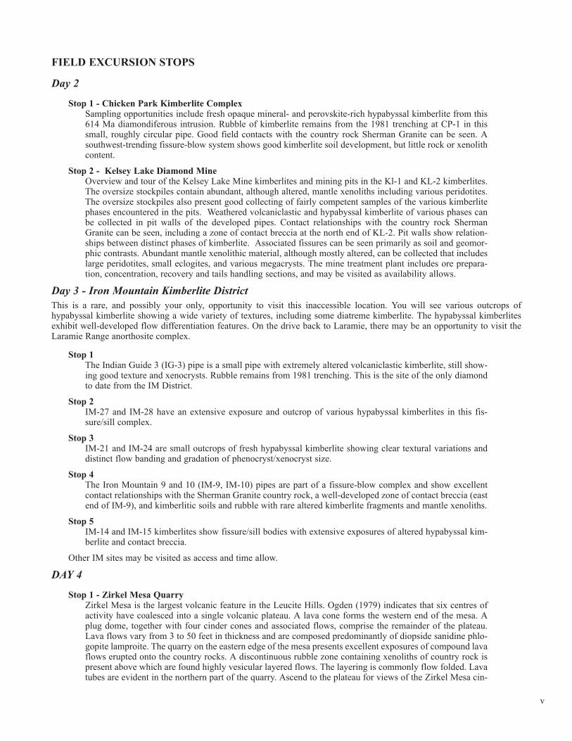
FIELD EXCURSION STOPS
Day 2
Stop 1 - Chicken Park Kimberlite ComplexSampling opportunities include fresh opaque mineral- and perovskite-rich hypabyssal kimberlite from this614 Ma diamondiferous intrusion. Rubble of kimberlite remains from the 1981 trenching at CP-1 in thissmall, roughly circular pipe. Good field contacts with the country rock Sherman Granite can be seen. Asouthwest-trending fissure-blow system shows good kimberlite soil development, but little rock or xenolithcontent.
Stop 2 - Kelsey Lake Diamond MineOverview and tour of the Kelsey Lake Mine kimberlites and mining pits in the Kl-1 and KL-2 kimberlites.The oversize stockpiles contain abundant, although altered, mantle xenoliths including various peridotites.The oversize stockpiles also present good collecting of fairly competent samples of the various kimberlitephases encountered in the pits. Weathered volcaniclastic and hypabyssal kimberlite of various phases canbe collected in pit walls of the developed pipes. Contact relationships with the country rock ShermanGranite can be seen, including a zone of contact breccia at the north end of KL-2. Pit walls show relation-ships between distinct phases of kimberlite. Associated fissures can be seen primarily as soil and geomor-phic contrasts. Abundant mantle xenolithic material, although mostly altered, can be collected that includeslarge peridotites, small eclogites, and various megacrysts. The mine treatment plant includes ore prepara-tion, concentration, recovery and tails handling sections, and may be visited as availability allows.
Day 3 - Iron Mountain Kimberlite DistrictThis is a rare, and possibly your only, opportunity to visit this inaccessible location. You will see various outcrops ofhypabyssal kimberlite showing a wide variety of textures, including some diatreme kimberlite. The hypabyssal kimberlitesexhibit well-developed flow differentiation features. On the drive back to Laramie, there may be an opportunity to visit theLaramie Range anorthosite complex.
Stop 1 The Indian Guide 3 (IG-3) pipe is a small pipe with extremely altered volcaniclastic kimberlite, still show-ing good texture and xenocrysts. Rubble remains from 1981 trenching. This is the site of the only diamondto date from the IM District.
Stop 2IM-27 and IM-28 have an extensive exposure and outcrop of various hypabyssal kimberlites in this fis-sure/sill complex.
Stop 3IM-21 and IM-24 are small outcrops of fresh hypabyssal kimberlite showing clear textural variations anddistinct flow banding and gradation of phenocryst/xenocryst size.
Stop 4The Iron Mountain 9 and 10 (IM-9, IM-10) pipes are part of a fissure-blow complex and show excellentcontact relationships with the Sherman Granite country rock, a well-developed zone of contact breccia (eastend of IM-9), and kimberlitic soils and rubble with rare altered kimberlite fragments and mantle xenoliths.
Stop 5IM-14 and IM-15 kimberlites show fissure/sill bodies with extensive exposures of altered hypabyssal kim-berlite and contact breccia.
Other IM sites may be visited as access and time allow.
DAY 4
Stop 1 - Zirkel Mesa QuarryZirkel Mesa is the largest volcanic feature in the Leucite Hills. Ogden (1979) indicates that six centres ofactivity have coalesced into a single volcanic plateau. A lava cone forms the western end of the mesa. Aplug dome, together with four cinder cones and associated flows, comprise the remainder of the plateau.Lava flows vary from 3 to 50 feet in thickness and are composed predominantly of diopside sanidine phlo-gopite lamproite. The quarry on the eastern edge of the mesa presents excellent exposures of compound lavaflows erupted onto the country rocks. A discontinuous rubble zone containing xenoliths of country rock ispresent above which are found highly vesicular layered flows. The layering is commonly flow folded. Lavatubes are evident in the northern part of the quarry. Ascend to the plateau for views of the Zirkel Mesa cin-
vi
der cones, Spring Butte, and Black Rock.
Stop 2- Black RockBlack Rock is the eastern-most, and least understood, vent in the Leucite Hills. Essentially, it consists of dis-continuous thin lava flows overlying a pyroclastic unit. The north side of the mesa consists of about 15m ofpoorly lithified vesicular lamproite overlain by 25m of alternating vesicular and non-vesicular lavas. Theseunits exhibit well-defined pseudo-columnar jointing formed by vertical jointing. The vertical south and eastfaces of the mesa are bedded and the lavas dip ~30o to the north. They consist of pseudo-columnar jointeddiscontinuous layers of vesicular and non-vesicular lava. The west face consists of a poorly-exposed olivinesanidine lamproite overlain by friable rubbly lamproite capped by a wedge of interbedded fissile and vesic-ular lavas, which are in turn covered by vertically-jointed, northerly-dipping interbedded vesicular and mas-sive leucite phlogopite lamproite and sanidine phlogopite lamproite lavas. The top of the mesa is depressedgiving the impression that the lavas dip towards the centre of a vent. However, there is no geophysical/geo-logical evidence for the presence of a crater/magma chamber underlying the mesa, and Ogden (1979) sug-gests that the depression on the top of the mesa was formed by post-extrusional compaction. Ogden (1979)further states that the presence of the pseudo-columnar jointing indicates that the entire section of lavascooled as a single unit. Cinder cones are not present. Dunite megacrysts or xenoliths have been identified atBlack Rock and single crystals of olivine are present in the anthills at the base of the western face (Hausel,1998).
Stop 3 - Spring Butte (Formerly Orenda Mesa)This butte is the type locality for orendite (now known as diopside sanidine phlogopite lamproite). Thebutte is a compound volcanic centre consisting of six cinder cones and at least six lava flows together withthree minor northwest trending feeder dykes associated with the oldest flow. Flow thicknesses range from3 - 25m. The cones consist of welded clastic flows with ribbon and bread-crust bombs. Xenoliths of coun-try rock and basement are rarely found. Both leucite and sanidine lamproite are present. Lavas forming thesecond and third oldest flows of the mesa will be examined at the eastern margin of the butte.
DAY 5
Stop 1 - Steamboat MountainSteamboat Mountain forms a prominent plateau at the northern margin of the Leucite Hills field. Unlikeother mesas in the area, the plateau is forested and, because of this and the soil cover, exposures of the lavaflows are not as extensive as elsewhere. The mesa consists of numerous small flows and four lava cones.The southeast face of the plateau exposes an excellent cross-section of numerous lavas lying upon theBridger and Green River Formations. Ogden (1979) has noted that lava tubes are extremely common onSteam Boat Mountain. These may have scoriaceous or massive cores. Tubes in some instances have brokenthrough thin lava flows and produced dome-like protrusions. Many of the diopside leucite phlogopite lavasare amygdaloidal. Lava cones are composed of thin flows of hyalo-phlogopite lamproite interbedded withminor amounts of tephra. Pumice-like material is common.
Stop 2 - Middle Table Mountain - North Table MountainMiddle Table Mountain is a small mesa, located 200 m south of North Table Mountain, and is the type local-ity for transitional diopside leucite maduptic lamproite. This occurrence consists principally of green-coloured madupitic lamproite with lesser amounts of massive-to-weakly vesicular grey leucite diopside phl-ogopite lamproite. The madupitic rocks are fissile and columnar-jointed. Ogden (1979) has described theoccurrence as a plug-dome, on the basis of the presence of concentric vertical joints and phlogopite flow-aligned phenocrysts. However, it is also possible that the madupitic portion might represent a subvolcaniclava lake analogous to the lake found at Mt. North in the Ellendale lamproite field. In addition to theirunusual petrographic character, they contain an unusual suite of accessory minerals including Sr-REE-per-ovskite, K2TiSi3O9 (the titanium analog of wadeite), and Ba-Sr-apatite (Mitchell and Steele, 1992). Themaduptic rocks are overlain by yellow scoriaceous phlogopite lamproite and a thin lava flow with squeeze-up spines and horizontal flow layering. North Table Mountain is a mesa capped by a single lava flow. Flowlayering is exceptionally well developed in this lamproite. The layers consist of isochemical dark greyleucite phlogopite lamproite and light grey sanidine phlogopite lamproite. Squeeze-up spines and parasiticflows are common.
Stop 3 - Boar’s Tusk The Boar’s Tusk is a prominent erosional remnant of a volcanic neck. The top of the neck is 110m abovethe surrounding surface. The lower 65m consists of Laramie age country rock covered by talus. The actualneck is a pair of spires that are separated from each other by a fault and an eroded feeder dyke. The neckconsists of leucite phlogopite lamproite agglomerate and tuff. Clasts are of vesicular and massive lamproiteand local country rock, including the now-eroded Green River shale. Samples that are representative of a
vii
wide range of textural types of phlogopite lamproite are best collected from the talus slope rather than thespire itself.
Stop 4 - Badger’s Teeth (Twin Rocks)This small exposure is an elongated volcanic neck and associated feeder dyke emplaced in Laramie sand-stone. It consists of five projecting teeth-like masses arranged along and east-west strike. The agglomerateis formed from clasts of highly vesicular amygdaloidal leucite phlogopite lamproite and angular countryrock xenoliths.
Stop 5 - Pilot ButtePilot Butte is a mesa consisting entirely of diopside madupitic lamproite (type locality of the formermadupite) and is isolated from the main volcanic centres of the Leucite Hills field. It now consists primari-ly of a 20 m thick lava flow of madupitic lamproite that issued from a volcanic neck located at the westernend of the mesa. Vertical flow layering in the neck becomes horizontal and like that of the main easterly-flowing lava about 10m above the neck. Jointing in the lava is parallel to the surface over which it flowed.Whilst partially solidified, the flow front was breached by material from the still fluid interior. Removal ofthis magma resulted in collapse of the lava surface. The lavas contain abundant xenoliths of Green RiverFormation that have been abraded and assimilated by the magma. A dyke exposed on the southern flankscontains globular segregation-textured lamproite.
viii
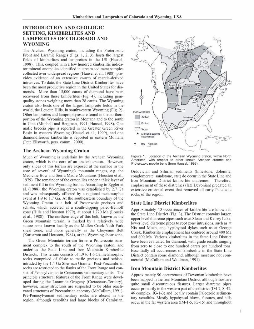
INTRODUCTION AND GEOLOGICSETTING, KIMBERLITES ANDLAMPROITES OF COLORADO ANDWYOMINGThe Archean Wyoming craton, including the ProterozoicFront and Laramie Ranges (Figs. 1, 2, 3), hosts the largestfields of kimberlites and lamproites in the US (Hausel,1998). This, coupled with a few hundred kimberlitic indica-tor mineral anomalies identified in stream sediment samplescollected over widespread regions (Hausel et al., 1988), pro-vides evidence of an extensive swarm of mantle-derivedintrusives. To date, the State Line District Kimberlites havebeen the most productive region in the United States for dia-monds. More than 15,000 carats of diamond have beenrecovered from these kimberlites (Fig. 4), including gem-quality stones weighing more than 28 carats. The Wyomingcraton also hosts one of the largest lamproite fields in theworld, the Leucite Hills, in southwestern Wyoming (Fig. 2).Other lamproites and lamprophyres are found in the northernportion of the Wyoming craton in Montana and to the southin Utah (Mitchell and Bergman, 1991; Hausel, 1998). Onemafic breccia pipe is reported in the Greater Green RiverBasin in western Wyoming (Hausel et al., 1999), and onediamondiferous kimberlite is reported in eastern Montana(Pete Ellsworth, pers. comm., 2000).
The Archean Wyoming CratonMuch of Wyoming is underlain by the Archean Wyomingcraton, which is the core of an ancient craton. However,only slices of this terrain are exposed at the surface in thecore of several of Wyoming’s mountain ranges, e.g. theMedicine Bow and Sierra Madre Mountains (Houston et al.,1979). The remainder of the craton lies under a thick layer ofsediment fill in the Wyoming basins. According to Eggler etal. (1988), the Wyoming craton was established by 2.7 Gaand was subsequently affected by a regional metamorphicevent at 1.9 to 1.7 Ga. At the southeastern boundary of theWyoming Craton is a belt of Proterozoic gneisses andschists, which accreted at a south-dipping paleo-Benioffzone (Hills and Houston 1979), at about 1,770 Ma (Louckset al., 1988). The northern edge of this belt, known as theGreen Mountain terrain, is marked by a relatively widesuture zone known locally as the Mullen Creek-Nash Forkshear zone, and more generally as the Cheyenne Belt(Karlstrom and Houston, 1984), or the Wyoming shear zone.
The Green Mountain terrain forms a Proterozoic base-ment complex to the south of the Wyoming craton, andunderlies the State Line and Iron Mountain KimberliteDistricts. This terrain consists of 1.9 to 1.6 Ga metamorphicrocks comprised of felsic to mafic gneisses and schists,intruded by the 1.4 Ga Sherman Granite. Post-Precambrianrocks are restricted to the flanks of the Front Range and con-sist of Pennsylvanian to Cretaceous sedimentary units. Theprinciple structural features of the Front Range were devel-oped during the Laramide Orogeny (Cretaceous-Tertiary),however, many structures are suspected to be older reacti-vated structures of Precambrian ancestry (McCallum, 1991).Pre-Pennsylvanian sedimentary rocks are absent in theregion, although xenoliths and large blocks of Cambrian,
Ordovician and Silurian sediments (limestone, dolomite,conglomerate, sandstone, etc.) do occur in the State Line andIron Mountain District kimberlite diatremes. Therefore,emplacement of these diatremes (late Devonian) predated anextensive erosional event that removed all early Paleozoicrocks of the region.
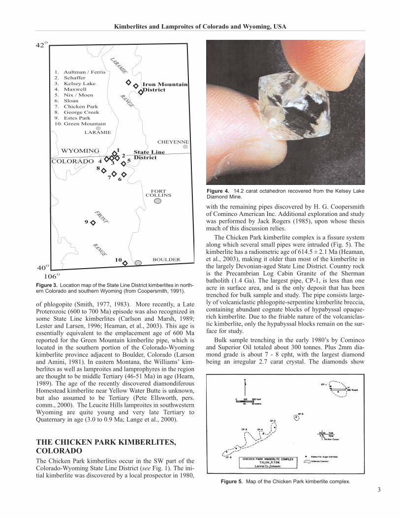
State Line District KimberlitesApproximately 40 occurrences of kimberlite are known inthe State Line District (Fig. 3). The District contains larger,upper level diatreme pipes such as at Sloan and Kelsey Lake,lower level diatreme pipes to root zone intrusions, such as atNix and Moen, and hypabyssal dykes such as at GeorgeCreek. Kimberlite emplacement has centered around 400 Maand 600 Ma. Various kimberlites in the State Line Districthave been evaluated for diamond, with grade results rangingfrom zero to close to one hundred carats per hundred tons.Essentially all occurrences of kimberlite in the State LineDistrict contain some diamond, although most are not com-mercial (McCallum and Waldman, 1991).
Iron Mountain District KimberlitesApproximately 90 occurrences of Devonian kimberlite havebeen mapped in the Iron Mountain District, although most arequite small discontinuous fissures. Larger diatreme pipesoccur primarily in the western part of the district (IM-7, 8, 42,46 complex, IG-1-3) and locally contain Paleozoic sedimen-tary xenoliths. Mostly hypabyssal blows, fissures, and sillsoccur in the far western area (IM-1-5, IG-15) and throughout
Kimberlites and Lamproites of Colorado and Wyoming, USA
1
Figure 1. Location of the Archean Wyoming craton, within NorthAmerican, with respect to other known Archean cratons andProterozoic mobile belts (from Hausel, 1998).
the remainder of the district. Limited bulk sampling to datehas produced only one diamond from Iron Mountain.
Age of Kimberlites and Lamproites in theWyoming CratonKimberlites and lamproites in this region were emplacedduring more than one episode. A group of kimberlitic, lam-
proitic, and lamprophyric intrusive events have been recog-nized including Late Precambrian, Early Devonian, Tertiary,and Quaternary. Ages of kimberlite in the State Line and IronMountain Districts are Early Devonian based on the pres-ence of Paleozoic xenoliths (McCallum and Mabarak, 1976),fission track dating of titanite (Larson and Amini, 1981) andzircon (Naesser and McCallum, 1977), and on Rb-Sr dating
H. G. Coopersmith, R. H. Mitchell, and W. D. Hausel
2
Figure 2. Generalized map of the Archean Wyoming craton (outlined by heavy dashed line) showing the locations of known kimberlites, lam-proites, related rocks, and kimberlite indicator mineral anomalies (from Hausel, 1998).
of phlogopite (Smith, 1977, 1983). More recently, a LateProterozoic (600 to 700 Ma) episode was also recognized insome State Line kimberlites (Carlson and Marsh, 1989;Lester and Larsen, 1996; Heaman, et al., 2003). This age isessentially equivalent to the emplacement age of 600 Mareported for the Green Mountain kimberlite pipe, which islocated in the southern portion of the Colorado-Wyomingkimberlite province adjacent to Boulder, Colorado (Larsonand Amini, 1981). In eastern Montana, the Williams’ kim-berlites as well as lamproites and lamprophyres in the regionare thought to be middle Tertiary (46-51 Ma) in age (Hearn,1989). The age of the recently discovered diamondiferousHomestead kimberlite near Yellow Water Butte is unknown,but also assumed to be Tertiary (Pete Ellsworth, pers.comm., 2000). The Leucite Hills lamproites in southwesternWyoming are quite young and very late Tertiary toQuaternary in age (3.0 to 0.9 Ma; Lange et al., 2000).
THE CHICKEN PARK KIMBERLITES,COLORADOThe Chicken Park kimberlites occur in the SW part of theColorado-Wyoming State Line District (see Fig. 1). The ini-tial kimberlite was discovered by a local prospector in 1980,
with the remaining pipes discovered by H. G. Coopersmithof Cominco American Inc. Additional exploration and studywas performed by Jack Rogers (1985), upon whose thesismuch of this discussion relies.
The Chicken Park kimberlite complex is a fissure systemalong which several small pipes were intruded (Fig. 5). Thekimberlite has a radiometric age of 614.5 ± 2.1 Ma (Heaman,et al., 2003), making it older than most of the kimberlite inthe largely Devonian-aged State Line District. Country rockis the Precambrian Log Cabin Granite of the Shermanbatholith (1.4 Ga). The largest pipe, CP-1, is less than oneacre in surface area, and is the only deposit that has beentrenched for bulk sample and study. The pipe consists large-ly of volcaniclastic phlogopite-serpentine kimberlite breccia,containing abundant cognate blocks of hypabyssal opaque-rich kimberlite. Due to the friable nature of the volcaniclas-tic kimberlite, only the hypabyssal blocks remain on the sur-face for study.
Bulk sample trenching in the early 1980’s by Comincoand Superior Oil totaled about 300 tonnes. Plus 2mm dia-mond grade is about 7 - 8 cpht, with the largest diamondbeing an irregular 2.7 carat crystal. The diamonds show
Kimberlites and Lamproites of Colorado and Wyoming, USA
3
12
4
Iron MountainDistrict
3 5
7 6
9
8
FORTCOLLINS
10
State LineDistrict
WYOMING
COLORADO
BOULDER
CHEYENNE
LARAMIE
LARAMIE
FRONT
RANGE
RANGE
1. Aultman / Ferris 2. Schaffer3. Kelsey Lake4. Maxwell5. Nix / Moen6. Sloan7. Chicken Park8. George Creek 9. Estes Park10. Green Mountain
40O
106O
O42
Figure 3. Location map of the State Line District kimberlites in north-ern Colorado and southern Wyoming (from Coopersmith, 1991).
Figure 4. 14.2 carat octahedron recovered from the Kelsey LakeDiamond Mine.
Figure 5. Map of the Chicken Park kimberlite complex.
mostly single crystal forms and most contain deformationfeatures. Extreme stone resorption is noted, as is extreme latestage surface etching (Falk, 1992).
These kimberlites are rich in perovskite, phlogopite,macrocrystal ilmenite, and olivine (altered). Pyroxene andgarnet are extremely rare. The xenolith content in the kim-berlite is low, with only a few lower crustal rocks and high-ly altered upper mantle xenoliths present. Granitic xenolithsare most common near the contacts. No Paleozoic sedimen-tary xenoliths have been found, which is consistent with theEocambrian age of emplacement.
The kimberlite at Chicken Park is highly autolithic. Theseautoliths, or cognate inclusions of kimberlite, occur asblocks a few centimeters to 1 meter in size. Two distincttypes of kimberlite autoliths/cognate inclusions areobserved. One type is generally smaller and always roundedto sub-rounded, implying that they have spent some timeincorporated in a possibly fluidized diatreme matrix. Thistype of kimberlite is a phlogopite- perovskite-, and/oropaque mineral-rich variety of serpentine-phlogopite macro-crystic kimberlite. The second type is a serpentine kimber-lite, and the blocks are larger, angular, and exhibit a brec-ciated texture. This type often has a reddish appearance dueto hematite in the serpentine, and secondary titanium-richminerals (‘leucoxene’) after ilmenite and perovskite can alsobe quite common. Less common aphanitic calcite kimberliteis nearly devoid of macrocrysts, and has a uniform ground-mass of calcite and euhedral olivine microphenocrysts.
Rogers (1985) provides the following limited analyses.Olivine macrocrysts have Mg/(Mg+Fe) ratios (Mg#) of 0.875to 0.919. Olivine microphenocrysts have Mg/(Mg+Fe) ratiosof 0.877. Ilmenite macrocrysts and xenocrysts have lowCr2O3 (0.00 to 0.45 wt%) and moderate to high MgO (8.66 to15.34 wt%). Garnet xenocrysts (peridotitic) range from 4.5to 11.5 wt% Cr2O3, some being low CaO (from 3.5 wt%).Phlogopite has low Cr2O3 (to 0.07 wt%), low Al2O3 (to 14.34wt%), high FeO (from 4.86 wt%) and K2O from 9-10 wt%.Perovskite has consistently low Cr2O3, TiO2 generally 40 to54 wt%, and FeO generally 1-1.5 wt%. Groundmass spinelsare generally chrome-rich magnesian titanomagnetite,although high-Cr chromite does occur.
McCallum (1989) further studied the oxide minerals atChicken Park. He notes that the oxide minerals reflect asomewhat atypical Mn-rich assemblage, and that two inter-vals of crystallization are recognized: an early assemblagecrystallized at deep levels, and a later assemblage formed ina near surface environment. This conclusion is consistentwith the observed late stage diamond-etching event.
Table 1 presents major element whole rock analyses ofChicken Park kimberlite, along with representative analysesfrom elsewhere.
GEOLOGY AND DEVELOPMENT OF THEKELSEY LAKE DIAMOND MINE, COLORADO
IntroductionThe Kelsey Lake kimberlites, a cluster of nine diamondifer-ous pipes, occur in the northern State Line Kimberlite District
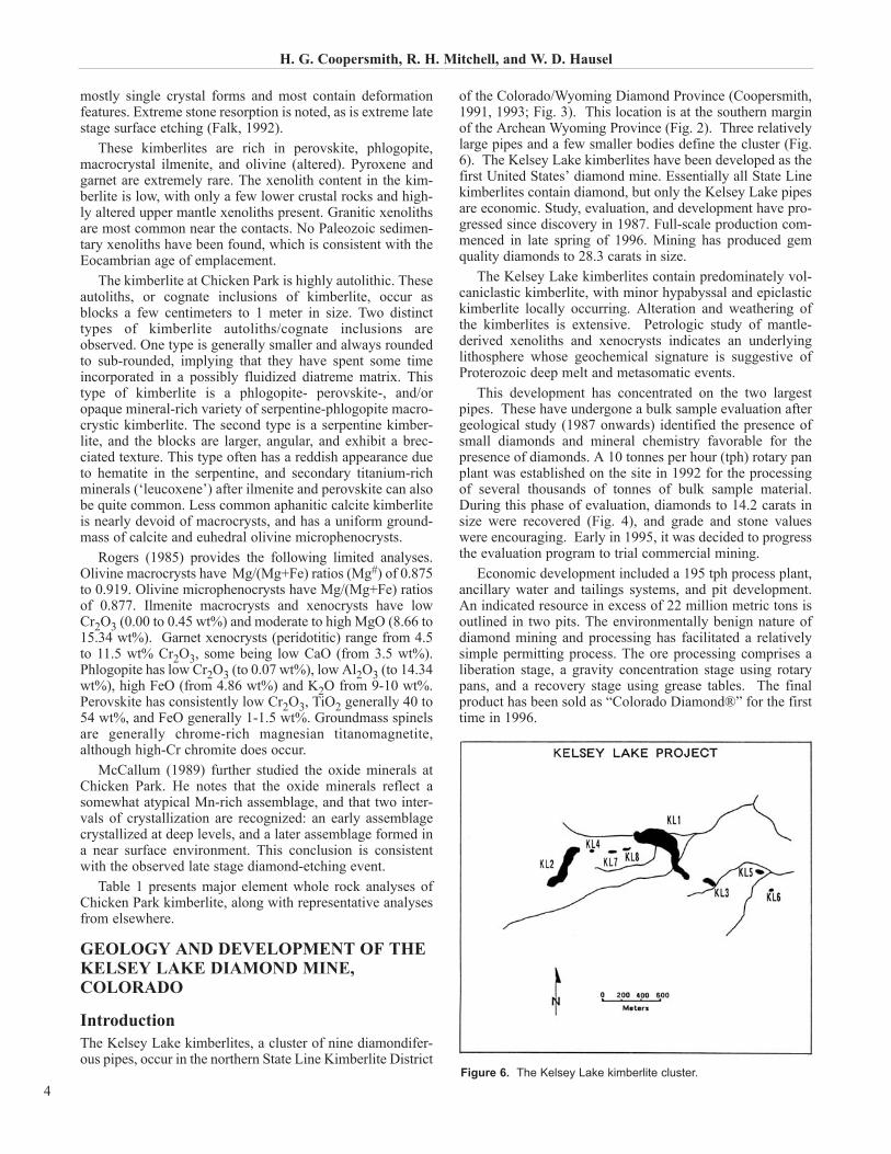
of the Colorado/Wyoming Diamond Province (Coopersmith,1991, 1993; Fig. 3). This location is at the southern marginof the Archean Wyoming Province (Fig. 2). Three relativelylarge pipes and a few smaller bodies define the cluster (Fig.6). The Kelsey Lake kimberlites have been developed as thefirst United States’ diamond mine. Essentially all State Linekimberlites contain diamond, but only the Kelsey Lake pipesare economic. Study, evaluation, and development have pro-gressed since discovery in 1987. Full-scale production com-menced in late spring of 1996. Mining has produced gemquality diamonds to 28.3 carats in size.
The Kelsey Lake kimberlites contain predominately vol-caniclastic kimberlite, with minor hypabyssal and epiclastickimberlite locally occurring. Alteration and weathering ofthe kimberlites is extensive. Petrologic study of mantle-derived xenoliths and xenocrysts indicates an underlyinglithosphere whose geochemical signature is suggestive ofProterozoic deep melt and metasomatic events.
This development has concentrated on the two largestpipes. These have undergone a bulk sample evaluation aftergeological study (1987 onwards) identified the presence ofsmall diamonds and mineral chemistry favorable for thepresence of diamonds. A 10 tonnes per hour (tph) rotary panplant was established on the site in 1992 for the processingof several thousands of tonnes of bulk sample material.During this phase of evaluation, diamonds to 14.2 carats insize were recovered (Fig. 4), and grade and stone valueswere encouraging. Early in 1995, it was decided to progressthe evaluation program to trial commercial mining.
Economic development included a 195 tph process plant,ancillary water and tailings systems, and pit development.An indicated resource in excess of 22 million metric tons isoutlined in two pits. The environmentally benign nature ofdiamond mining and processing has facilitated a relativelysimple permitting process. The ore processing comprises aliberation stage, a gravity concentration stage using rotarypans, and a recovery stage using grease tables. The finalproduct has been sold as “Colorado Diamond®” for the firsttime in 1996.
H. G. Coopersmith, R. H. Mitchell, and W. D. Hausel
4Figure 6. The Kelsey Lake kimberlite cluster.
GeologyThe Kelsey Lake kimberlites form a small group of irregularshaped pipes and fissures (Fig. 6). The pipes consist largelyof multiphase blows of volcaniclastic kimberlite with exten-sions of hypabyssal kimberlite. The kimberlite is altered anddeeply weathered. The Kelsey Lake 1 pipe is approximately12 acres in surface area, while the Kelsey Lake 2 pipe isapproximately 10 acres. The two main pipes combined areover 20 acres in surface area, ranking them among the largestin the district. The kimberlites intrude 1.4 Ga Proterozoicgranitic rocks of the Sherman batholith. A simplified geolog-ical map is presented in Figure 7. Shape is largely controlledby jointing in the country rock. The kimberlite contains sed-imentary xenoliths of Cambrian to Silurian age. An apparentDevonian age of the Kelsey Lake kimberlite occurrences isin good agreement with Early Devonian (390 Ma) isotopicages of other kimberlites in the District (Smith, 1983).
The KL-1 pipe consists of multiple phases of volcaniclas-tic units of diatreme kimberlite and subordinate epiclastic orpyroclastic kimberlite. Pellet-rich volcaniclastic serpentinekimberlite breccia occupies the southern fissure appendageof the main pipe. This is extremely rich in mantle xenocrysts,megacrysts, and xenoliths. The southern portion of the pipecontains pellet- and autolith-rich layered pyroclastic kimber-lite, which is termed a ‘sandy’ tuff. The quantity of roundedquartz grains and sedimentary xenolith material variesbetween and within layers. Large (up to 3 meters) sedimen-tary blocks are present. This zone has a moderate amount ofmantle xenocrystal and xenolithic material. The main pipe,which comprises the northern part of the body, contains vol-caniclastic serpentine kimberlite breccia, with a moderate
amount of mantle component, and locally abundant largecrustal xenolithic blocks.
The KL-2 pipe is a multiphase kimberlite complex with atleast four major distinct phases of volcaniclastic serpentinekimberlite breccia. These are locally rich in mantle xenolithsand xenocrysts. Sedimentary xenolith content, size, and
Kimberlites and Lamproites of Colorado and Wyoming, USA
5
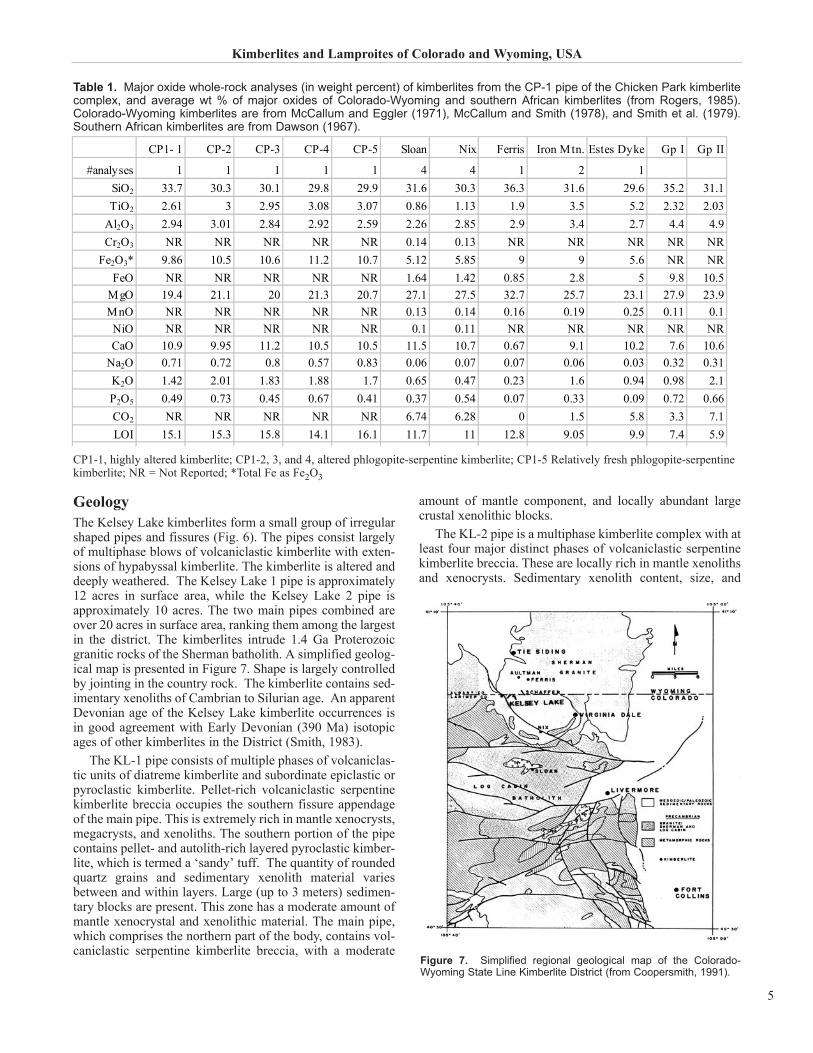
CP1- 1 CP-2 CP-3 CP-4 CP-5 Sloan Nix Ferris Iron Mtn. Estes Dyke Gp I Gp II
Al2O3 2.94 3.01 2.84 2.92 2.59 2.26 2.85 2.9 3.4 2.7 4.4 4.9Cr2O3 NR NR NR NR NR 0.14 0.13 NR NR NR NR NR
Fe2O3* 9.86 10.5 10.6 11.2 10.7 5.12 5.85 9 9 5.6 NR NRFeO NR NR NR NR NR 1.64 1.42 0.85 2.8 5 9.8 10.5
MgO 19.4 21.1 20 21.3 20.7 27.1 27.5 32.7 25.7 23.1 27.9 23.9MnO NR NR NR NR NR 0.13 0.14 0.16 0.19 0.25 0.11 0.1NiO NR NR NR NR NR 0.1 0.11 NR NR NR NR NRCaO 10.9 9.95 11.2 10.5 10.5 11.5 10.7 0.67 9.1 10.2 7.6 10.6
Table 1. Major oxide whole-rock analyses (in weight percent) of kimberlites from the CP-1 pipe of the Chicken Park kimberlitecomplex, and average wt % of major oxides of Colorado-Wyoming and southern African kimberlites (from Rogers, 1985).Colorado-Wyoming kimberlites are from McCallum and Eggler (1971), McCallum and Smith (1978), and Smith et al. (1979).Southern African kimberlites are from Dawson (1967).
CP1-1, highly altered kimberlite; CP1-2, 3, and 4, altered phlogopite-serpentine kimberlite; CP1-5 Relatively fresh phlogopite-serpentinekimberlite; NR = Not Reported; *Total Fe as Fe2O3
Figure 7. Simplified regional geological map of the Colorado-Wyoming State Line Kimberlite District (from Coopersmith, 1991).
preservation varies considerably between phases. Alterationand carbonatization is also variable. Locally abundantcrustal xenoliths exceed one meter in size. Occurrence of acontact breccia is observed.
Late stage alteration and surface weathering hasdestroyed much of the primary mineral assemblage of bothbodies of kimberlite. Ubiquitous pheonocrystal and macro-crystal olivine is totally replaced by serpophitic or lizarditeserpentine, and commonly is carbonatized. Groundmass per-ovskite, apatite, opaque minerals, and diopside generally arepreserved. Groundmass serpentine and calcite may be eitherprimary or secondary. Macrocrysts and xenocrysts of Mg-ilmenite, pyrope garnet, spinels, phlogopite, and chromiandiopside are generally preserved, as are megacrysts of Mg-ilmenite, Cr-poor titanian pyrope, and subcalcic diopside.The groundmass of the autoliths and pellets is relativelyfresh, and generally is phlogopite-rich. Petrographically,these rocks are Group 1 kimberlites as defined by Smith(1983). Whole-rock and trace element chemical analysis ofthe kimberlite is presented in Table 2. These analyses showthe extensively altered nature of the kimberlite. Xenolithicmaterial in the pipes includes upper mantle peridotite andeclogite, lower crustal granulite, and crustal granitic, meta-morphic and sedimentary rocks. Content and size ranges ofxenolithic and megacrystal material varies widely withinphases of the pipes.
Mantle Xenocrysts and XenolithsMantle-derived material in the Kelsey Lake kimberlitesincludes diamonds, xenoliths of lherzolite, harzburgite, andeclogite, members of the Cr-poor megacryst suite, and vari-ous single crystal xenocrysts.
DiamondsNo diamond-bearing xenoliths have been recovered,although a diamond-bearing harzburgite has been found inthe nearby Schaffer kimberlite. At Kelsey Lake, two dia-mondiferous garnet xenocrysts have been analyzed. Theseare harzburgitic garnets with 10.8 wt% Cr2O3, 5.0 wt% CaO,and 7.8 wt% Cr2O3, 5.0 wt% CaO (Pizzolato and Schulze,1998). Aside from sulphide rosettes, syngenetic inclusionsrecognized include olivine, Cr-pyrope (10.5 wt% Cr2O3, 3.3 wt% CaO; L.A. Pizzolato, pers. comm., 2002), andeclogitic pyrope (D. J. Schulze, pers. comm., 2003), linkingat least a portion of the diamond population to a harzburgiteparagenesis.
The diamonds are predominately of octahedral form,showing only moderate resorption (Falk, 1992).Preservation varies from sharp octahedra (10 % of the popu-lation; notably this percentage of sharp octahedra is higher inthe larger stone size classes), through transition stones totetrahexahedroid (rounded dodecahedron). Macles are com-mon, interpenetrant twins are rare. Broken crystals are com-mon (old breaks). Aggregates are uncommon. The diamondswere subject to major deformation while within their hostxenoliths (Falk, 1992). No late-stage etching event is indi-cated. Approximately one-half of the production is cuttablewith very little boart. Most stones are white, colorless, withcolors trending towards honey brown. Large canary yellowstones have been found, but the rare pinks and blues are very
small to date. More than 25% by weight are diamondsgreater than sieve size 21 (approx. 5mm round; 1ct.), whilestones less than sieve size 9 (approx. 2mm round; approx.0.05 ct.) are only a small percentage.
Peridotite xenolithsPeridotite xenoliths are relatively abundant in the kimberlitein the mine, occurring as extensively altered rounded frag-ments to 30 cm in diameter. They are recognized on brokensurfaces by their yellow-green color and, in many samples,the presence of purple garnet, green Cr-diopside, and/orblack spinel. Olivine and orthopyroxene are not preserved,but replaced by serpentine and calcite. Some peridotites arethoroughly silicified, as are the altered peridotites at the near-by Schaffer kimberlites. Primary rock types include lherzo-lite and harzburgite, with or without garnet and/or spinel.
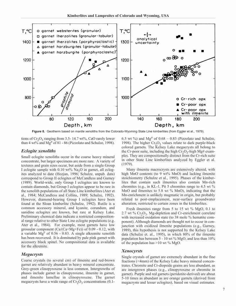
The peridotite xenoliths are classified as infertile (deplet-ed) based on molar ratio Cr/(Cr+Al) and Mg/(Mg+Fe) of theCr-pyropes and Cr-diopsides (Eggler et al., 1987). Egglerdetermined that infertile peridotites extended to depths of 200km (Fig. 8) as residua from a Precambrian melting eventinvolving the entire lithosphere, subsequently metasomatical-ly enriched at shallower depths. Garnets in both lherzolite andharzburgite xenoliths are mostly lherzolitic with concentra-
H. G. Coopersmith, R. H. Mitchell, and W. D. Hausel
Table 2. Whole rock geochemistry of the Kelsey Lake kim-berlites (from Coopersmith, 1991).
tions of Cr2O3 ranging from 3.5- 14.7 wt%, CaO rarely lowerthan 4 wt% and Mg# of 81 - 86 (Pizzolato and Schulze, 1998).
Eclogite xenolithsSmall eclogite xenoliths occur in the coarse heavy mineralconcentrate, but larger specimens are more rare. A variety oftextures and grain sizes occur, but aside from a single GroupI eclogite sample with 0.10 wt% Na2O in garnet, all eclog-ites analyzed to date (Hozjan, 1996; Schulze, unpub. data)correspond to Group II eclogites of McCandless and Gurney(1989). World-wide, only Group I eclogites are known tocontain diamonds, but Group I eclogites appear to be rare inthe xenolith populations of all State Line kimberlites (Ater etal., 1984; McCandless and Collins, 1989; Schulze, 1992).However, diamond-bearing Group I eclogites have beenfound at the Sloan kimberlite (Schulze, 1992). Rutile is acommon accessory mineral, and kyanite, corundum, andsanidine eclogites are known, but rare at Kelsey Lake.Preliminary chemical data indicate a restricted composition-al range relative to other State Line eclogite populations (e.g.Ater et al., 1984). For example, most garnets have lowgrossular component (Ca/(Ca+Mg+Fe)) of 0.09 - 0.12, witha variable Mg# of 0.56 - 0.83. A single alkremite xenolithhas been recovered. It is dominated by pale pink garnet withaccessory black spinel. No compositional data is availablefor the alkremite.
MegacrystsCoarse crystals (to several cm) of ilmenite and red-browngarnet are relatively abundant in heavy mineral concentrate.Grey-green clinopyroxene is less common. Intergrowths ofphases include garnet in clinopyroxene, ilmenite in garnet,and ilmenite lamellae in clinopyroxene. The garnetmegacrysts have a wide range of Cr2O3 concentrations (0.1-
6.5 wt %) and Mg# of 0.68 – 0.83 (Pizzolato and Schulze,1998). The higher Cr2O3 values relate to dark purple-blackcolored garnets. The Kelsey Lake megacrysts all belong tothe Cr-poor suite, including the high Cr2O3-high Mg# exam-ples. They are compositionally distinct from the Cr-rich suitein other State Line kimberlites analyzed by Eggler et al.(1979).
Many ilmenite macrocrysts are extensively altered, withhigh MnO contents (to 9 wt% MnO) and lacking ilmenitestoichiometry (Schulze et al., 1995). Phases of the kimber-lites that contain such ilmenites also contain Mn-richchromites (e.g., in KL-1, Pit 5 chromites range to 4.5 wt %MnO and ilmenites to 5.8 wt % MnO), indicating that theMn-enrichment is unlikely magmatic in origin, but probablyrelated to post-emplacement, near-surface groundwateralteration, restricted to certain zones in the kimberlites.
Fresh ilmenites range from 5 to 15 wt % MgO, 0.1 to 2.7 wt % Cr2O3. Mg-depletion and Cr-enrichment correlatewith increased oxidation state (to 38 mole % hematite com-ponent). Although diamonds are thought not to occur in con-junction with oxidized ilmenite populations (e.g., Gurney,1989), this hypothesis is not supported by the Kelsey Lakedata (Schulze et. al., 1995), in which 80% of the ilmenitepopulation has between 5 - 10 wt % MgO, and less than 10%of the population has >10 wt % MgO.
XenocyrstsSingle crystals of garnet are extremely abundant in the finefractions (<4mm) of the Kelsey Lake heavy mineral concen-trates. Chromite and Cr-diopside grains are less abundant, asare intergrown phases (e.g., clinopyroxene or chromite ingarnet). Purple and red garnets (peridotite-derived) are about5-10 times as abundant as are orange garnets (derived frommegacrysts and lesser eclogites), based on visual estimates.
Kimberlites and Lamproites of Colorado and Wyoming, USA
7
Figure 8. Geotherm based on mantle xenoliths from the Colorado-Wyoming State Line kimberlites (from Eggler et al., 1979).
Chemical compositions indicate that most purple garnets arederived from Iherzolite xenoliths (“G9” garnets of Gurney,1984). Low-Ca Cr-pyropes (“G10” garnets) also occur (con-sistent with the presence of diamonds), with CaO contents aslow as 2.4 wt %. Similarly, high-Cr chromites (Cr2O3 to 67 wt %), which correspond chemically to chromite inclu-sions in diamonds (e.g., Sobolev, 1984), are also present inthe Kelsey Lake kimberlites.
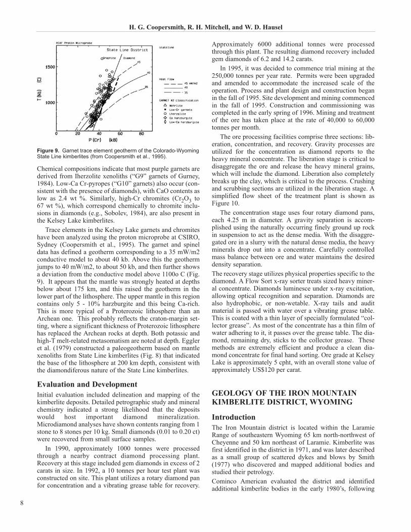
Trace elements in the Kelsey Lake garnets and chromiteshave been analyzed using the proton microprobe at CSIRO,Sydney (Coopersmith et al., 1995). The garnet and spineldata has defined a geotherm corresponding to a 35 mW/m2conductive model to about 40 kb. Above this the geothermjumps to 40 mW/m2, to about 50 kb, and then further showsa deviation from the conductive model above 1100o C (Fig.9). It appears that the mantle was strongly heated at depthsbelow about 175 km, and this raised the geotherm in thelower part of the lithosphere. The upper mantle in this regioncontains only 5 - 10% harzburgite and this being Ca-rich.This is more typical of a Proterozoic lithosphere than anArchean one. This probably reflects the craton-margin set-ting, where a significant thickness of Proterozoic lithospherehas replaced the Archean rocks at depth. Both potassic andhigh-T melt-related metasomatism are noted at depth. Eggleret al. (1979) constructed a paleogeotherm based on mantlexenoliths from State Line kimberlites (Fig. 8) that indicatedthe base of the lithosphere at 200 km depth, consistent withthe diamondiferous nature of the State Line kimberlites.
Evaluation and DevelopmentInitial evaluation included delineation and mapping of thekimberlite deposits. Detailed petrographic study and mineralchemistry indicated a strong likelihood that the depositswould host important diamond mineralization.Microdiamond analyses have shown contents ranging from 1stone to 8 stones per 10 kg. Small diamonds (0.01 to 0.20 ct)were recovered from small surface samples.
In 1990, approximately 1000 tonnes were processedthrough a nearby contract diamond processing plant.Recovery at this stage included gem diamonds in excess of 2carats in size. In 1992, a 10 tonnes per hour test plant wasconstructed on site. This plant utilizes a rotary diamond panfor concentration and a vibrating grease table for recovery.
Approximately 6000 additional tonnes were processedthrough this plant. The resulting diamond recovery includedgem diamonds of 6.2 and 14.2 carats.
In 1995, it was decided to commence trial mining at the250,000 tonnes per year rate. Permits were been upgradedand amended to accommodate the increased scale of theoperation. Process and plant design and construction beganin the fall of 1995. Site development and mining commencedin the fall of 1995. Construction and commissioning wascompleted in the early spring of 1996. Mining and treatmentof the ore has taken place at the rate of 40,000 to 60,000tonnes per month.
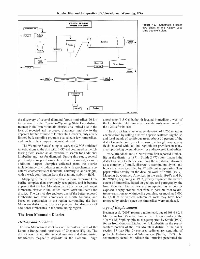
The ore processing facilities comprise three sections: lib-eration, concentration, and recovery. Gravity processes areutilized for the concentration as diamond reports to theheavy mineral concentrate. The liberation stage is critical todisaggregate the ore and release the heavy mineral grains,which will include the diamond. Liberation also completelybreaks up the clay, which is critical to the process. Crushingand scrubbing sections are utilized in the liberation stage. Asimplified flow sheet of the treatment plant is shown asFigure 10.
The concentration stage uses four rotary diamond pans,each 4.25 m in diameter. A gravity separation is accom-plished using the naturally occurring finely ground up rockin suspension to act as the dense media. With the disaggre-gated ore in a slurry with the natural dense media, the heavyminerals drop out into a concentrate. Carefully controlledmass balance between ore and water maintains the desireddensity separation.The recovery stage utilizes physical properties specific to thediamond. A Flow Sort x-ray sorter treats sized heavy miner-al concentrate. Diamonds luminesce under x-ray excitation,allowing optical recognition and separation. Diamonds arealso hydrophobic, or non-wetable. X-ray tails and auditmaterial is passed with water over a vibrating grease table.This is coated with a thin layer of specially formulated “col-lector grease”. As most of the concentrate has a thin film ofwater adhering to it, it passes over the grease table. The dia-mond, remaining dry, sticks to the collector grease. Thesemethods are extremely efficient and produce a clean dia-mond concentrate for final hand sorting. Ore grade at KelseyLake is approximately 5 cpht, with an overall stone value ofapproximately US$120 per carat.
GEOLOGY OF THE IRON MOUNTAINKIMBERLITE DISTRICT, WYOMING
IntroductionThe Iron Mountain district is located within the LaramieRange of southeastern Wyoming 65 km north-northwest ofCheyenne and 50 km northeast of Laramie. Kimberlite wasfirst identified in the district in 1971, and was later describedas a small group of scattered dykes and blows by Smith(1977) who discovered and mapped additional bodies andstudied their petrology.Cominco American evaluated the district and identifiedadditional kimberlite bodies in the early 1980’s, following
H. G. Coopersmith, R. H. Mitchell, and W. D. Hausel
8
Figure 9. Garnet trace element geotherm of the Colorado-WyomingState Line kimberlites (from Coopersmith et al., 1995).
the discovery of several diamondiferous kimberlites 70 kmto the south in the Colorado-Wyoming State Line district.Interest in the Iron Mountain district was limited due to thelack of reported and recovered diamonds, and due to theapparent limited volume of kimberlite. However, only a verylimited bulk-sampling program evaluated a few kimberlites,and much of the complex remains untested.
The Wyoming State Geological Survey (WSGS) initiatedinvestigations in the district in 1997 and continued in the fol-lowing field season as an exercise to search for additionalkimberlite and test for diamond. During this study, severalpreviously unmapped kimberlites were discovered, as wereadditional targets. Samples collected from the districtinclude kimberlitic indicator minerals with geochemical sig-natures characteristic of lherzolite, harzburgite, and eclogite,with a weak contribution from the diamond-stability field.
Mapping of the district identified a more extensive kim-berlite complex than previously recognized, and it becameapparent that the Iron Mountain district is the second largestkimberlite district in the United States, after the State Linedistrict. The district also encloses one of the better-exposedkimberlitic root zone complexes in North America, andbased on exploration in the region surrounding the IronMountain district, there is also potential for discovery ofadditional kimberlites in the surrounding region.
The Iron Mountain District
History and LocationThe Iron Mountain district lies on the eastern flank of theLaramie Range north-northwest of Cheyenne (Fig. 2). Thedistrict was named after several massive and disseminatedtitaniferous magnetite deposits in the Laramie Range
anorthosite (1.5 Ga) batholith located immediately west ofthe kimberlite field. Some of these deposits were mined inthe 1950’s for ballast.
The district lies at an average elevation of 2,200 m and ischaracterized by rolling hills with sparse scattered sagebrushand local stands of coniferous trees. About 50 percent of thedistrict is underlain by rock exposure, although large grassyfields covered with soil and regolith are prevalent in manyareas, providing potential cover for undiscovered kimberlites.
W.A. Braddock and D. Nordstrom first reported kimber-lite in the district in 1971. Smith (1977) later mapped thedistrict as part of a thesis describing the ultrabasic intrusivesas a complex of small, discrete, discontinuous dykes andblows that were identified by 57 different sample sites. Thispaper relies heavily on the detailed work of Smith (1977).Mapping by Cominco American in the early 1980’s and bythe WSGS, beginning in 1997, greatly expanded the knownextent of kimberlite. Based on geology and petrography, theIron Mountain kimberlites are interpreted as a poorly-exposed, deeply-eroded, root zone to possible root to dia-treme transition zone kimberlite complex. As much as 1,000to 1,600 m of vertical column of rock may have beenremoved by erosion since the kimberlites were emplaced.
Age of EmplacementHeaman et al. (2003) reports a radiometric age of 408.4 ± 2.6Ma for an Iron Mountain kimberlite. This is similar to the400 Ma Rb-Sr phlogopite mica age reported by Smith (1979)for an Iron Mountain kimberlite. A kimberlite in the south-western portion of the Iron Mountain district in the SW/4section 17 (see Fig. 2) encloses sedimentary xenoliths ofprobable Ordovician and Silurian age (Smith, 1977). Thesedimentary xenoliths indicate the intrusive penetrated the
Kimberlites and Lamproites of Colorado and Wyoming, USA
9
Figure 10. Schematic processflow sheet of the Kelsey LakeMine treatment plant.
former Silurian-Devonian surface and assimilated fragmentsof the sedimentary cover. The xenoliths establish the oldestpossible age for the primary episode of eruption, and fitswell with the reported age determinations.
Upper crustal xenoliths found in some of the kimberlitesinclude quartz monzonite, anorthosite, syenite, hypersthenesyenite, amphibolite, biotite schist, and fragments of maficigneous rock. Lower crustal xenoliths include pyroxeniteand garnet granulite. Mantle xenoliths include garnet andspinel peridotite, websterite, eclogite, and diopside-ilmeniteintergrowths. Megacrysts include clinopyroxene, orthopy-roxene, garnet, ilmenite, and rare olivine (Smith, 1977).
Geology and StructureThe Iron Mountain district lies along the eastern flank of theLaramie Range. The range was uplifted and thrust easterlyduring the Laramide orogeny and the district is currently sur-rounded on the east, south, and west by Phanerozoic sedi-mentary rocks, which were deformed by crustal shortening.Several broad folds, anticlines, domes, synclines, low anglethrusts, and associated tear faults are present in the adjacentPhanerozoic terrain. Precambrian deformation at IronMountain includes joint sets and a northeast-trending zone ofcataclasis in the northwestern part of the district.
Kimberlites at Iron Mountain and in the State Line liewithin the Proterozoic basement south of the Cheyenne Belt.The Iron Mountain kimberlites parallel the trend of theCheyenne Belt, suggesting that kimberlite emplacement mayhave been influenced by this structure. The Cheyenne Belt isalso exposed in the Sierra Madre and Medicine BowMountains to the west, where additional indicator mineralsand a few diamonds have been found.
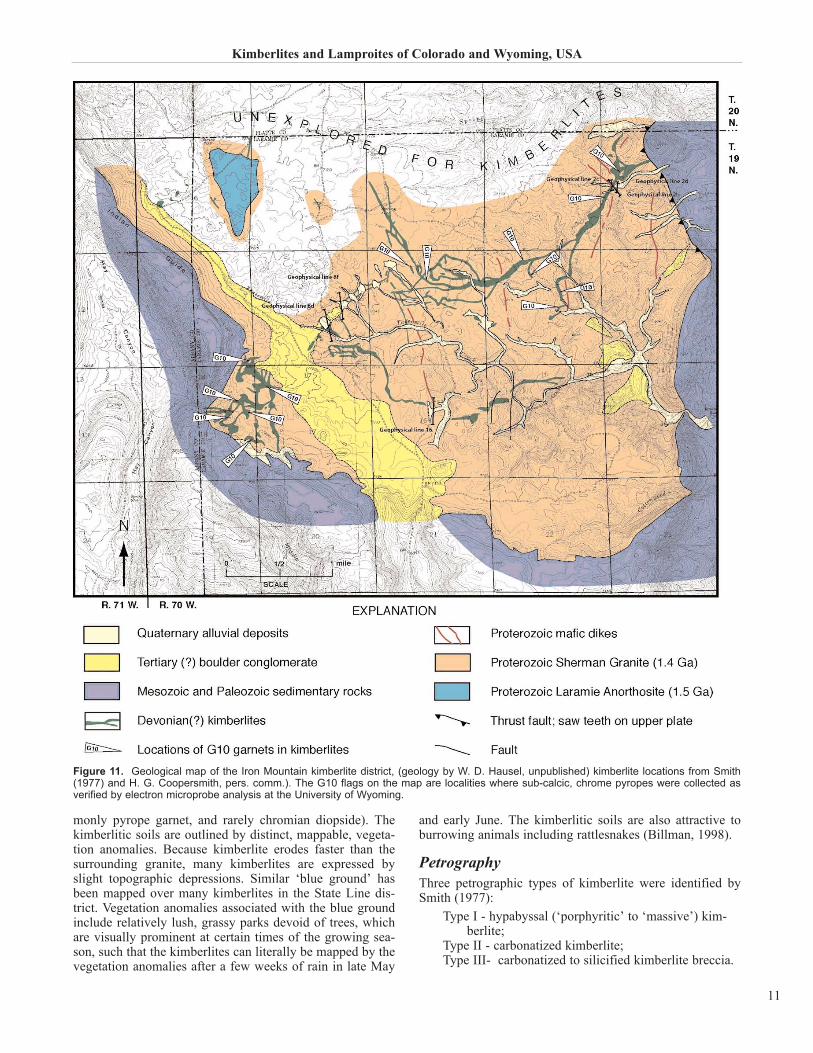
The Iron Mountain kimberlites (Fig. 11) form a deeplydissected feeder dyke complex with periodic blows and sillsintruding Sherman Granite. The granite and kimberlites areexposed in the core of an eroded, south-plunging, anticlino-rium. It is possible that the kimberlite complex continues tothe east and west under the Phanerozoic cover, and the pos-sibility of kimberlites further north and west is consideredlikely.
Mississippian and younger sedimentary rocks uncon-formably overlie the Sherman Granite and kimberlite, anddip off the core of the Iron Mountain anticlinorium to theeast, south, and west. Immediately west of the district, sed-imentary rocks are exposed in the asymmetrical, southerly-plunging Hay Canyon syncline. Precambrian rocks of theLaramie anorthosite-syenite batholith and titaniferous mag-netite deposits crop out west of the syncline.
The oldest in situ sedimentary rocks in the area consist ofthin, calcareous, arkosic sandstone with underlyingdolomitic limestone. These are thought to be a southernextension of the Mississippian Madison Formation and sit onthe Precambrian surface. The Madison is overlain by theCasper (Mississippian – Pennsylvanian), the PermianMinnekahta and Opeche Formations, and the TriassicChugwater Formation.
A Tertiary conglomerate (paleoplacer) lies directly on theSherman erosional surface in the western portion of the dis-trict. The conglomerate is unsorted, poorly consolidated,
with rounded to angular boulders, pebbles, and cobbles ofPrecambrian igneous and metamorphic rock interspersedwith Paleozoic and Mesozoic fragments and occasional kim-berlitic indicator minerals. Kimberlite was traced into theconglomerate from both the east and west, and locally con-tinues under the unit. The extent of hidden kimberlitebeneath the conglomerate is unknown and considerable clayin the conglomerate masks electrical responses from anypotentially buried kimberlite.
Precambrian anorthosite is found in the northwestern por-tion of the district, as fragments in Tertiary conglomerate,and xenoliths in some kimberlites (Smith, 1977). Theanorthosite was intruded by the Sherman Granite (Petermanet al., 1968). Two varieties of granitic rocks in the area aredistinguished by grain size. One is fine-grained granite inthe northeast, northwest, west-central, and southeast. Acoarse-grained porphyritic quartz monzonite to granite isfound elsewhere. Discontinuous simple pegmatite and aplitedykes are scattered throughout the district. North- to north-west-trending Precambrian mafic dykes intrude the ShermanGranite. These are 2 to 3 m wide, nearly vertical, and formsharp contacts with the granite. Locally, some of these dykeshave been cut by kimberlite.
KimberliteSmith (1977) conducted detailed sampling and study of theIron Mountain kimberlites, and much of this discussion isbased on his work. Kimberlites at Iron Mountain form anextensive, locally continuous, fissure complex. The complexwas traced over a strike-length of 8 km within 30 km2 andcontains several enlargements, some of which are interpret-ed as ‘blows’, or the eroded remnants of former pipes. A fewpossible pipes were recognized in the western and north-western portion of the district. The central portion of thecomplex contains a network of branching dykes and sills.The dykes range from 1 to 125 m wide and dip vertically tosteeply, while the sills are shallow dipping.
A few blows were mapped where dyke enlargementscoexist with kimberlite breccia, which is extensively carbon-atized. Elsewhere, dyke swells contain macrocrystichypabyssal kimberlite (i.e., SE section 3 near geophysicallines 18, 20, and 21, and in the NW section 2; Fig. 11). Pipeswere also mapped in sections 6, 17 and 18, along the west-ern margin of the district and are interpreted as diatremesthat contain crustal sedimentary xenoliths and also mantlexenoliths.
A group of carbonatized breccia pipes were also mappedin sections 15 and 16. These contain abundant fragmentedSherman Granite breccia clasts with hypabyssal kimberlitexenoliths (Smith, 1977). The absence of Paleozoic xenolithssuggests these breccias may represent a degassing event ofthe kimberlitic magma, and are interpreted as root zones ofblind diatremes.
In general, the dykes are mapped as scattered serpen-tinized kimberlite outcrops connected by grus-covered kim-berlitic soil. In places, the kimberlitic soils are distinct, par-ticularly where the grus is thin. These soils contain inter-mixed rock fragments of kimberlite and granite in blueground (carbonated montmorillonite clay) with variableamounts of indicator minerals (notably ilmenite, less com-
H. G. Coopersmith, R. H. Mitchell, and W. D. Hausel
10
monly pyrope garnet, and rarely chromian diopside). Thekimberlitic soils are outlined by distinct, mappable, vegeta-tion anomalies. Because kimberlite erodes faster than thesurrounding granite, many kimberlites are expressed byslight topographic depressions. Similar ‘blue ground’ hasbeen mapped over many kimberlites in the State Line dis-trict. Vegetation anomalies associated with the blue groundinclude relatively lush, grassy parks devoid of trees, whichare visually prominent at certain times of the growing sea-son, such that the kimberlites can literally be mapped by thevegetation anomalies after a few weeks of rain in late May
and early June. The kimberlitic soils are also attractive toburrowing animals including rattlesnakes (Billman, 1998).
PetrographyThree petrographic types of kimberlite were identified bySmith (1977):
Type I - hypabyssal (‘porphyritic’ to ‘massive’) kim-berlite;
Type II - carbonatized kimberlite;Type III- carbonatized to silicified kimberlite breccia.
Kimberlites and Lamproites of Colorado and Wyoming, USA
11
Figure 11. Geological map of the Iron Mountain kimberlite district, (geology by W. D. Hausel, unpublished) kimberlite locations from Smith(1977) and H. G. Coopersmith, pers. comm.). The G10 flags on the map are localities where sub-calcic, chrome pyropes were collected asverified by electron microprobe analysis at the University of Wyoming.
All stages of gradation from one kimberlite type to anotherhave been recognized in the district.
The hypabyssal kimberlite is a distinct green, highly ser-pentinized, magmatic kimberlite that is restricted to dykesand sills. This rock contains large, sub-rounded, <1 to 3 cmolivine macrocrysts, pervasively replaced by grey-blackmagnetite, reddish hematite, and light-green serpentine in aserpentinized groundmass. The groundmass consists ofabundant, small, rounded, serpentinized olivines in a meshof serpentine with minor interstitial to poikilitic carbonate,minor perovskite and phlogopite, and trace apatite. Locally,the kimberlite exhibits an irregular, flow texture with a roughalignment of the long axes of the macrocrysts, megacrysts,and xenocrysts. Only minor amounts of xenocrysts andxenoliths are found in this type of kimberlite. Uncommon,mantle-derived xenocrysts include pyrope garnet, chromiandiopside, chromian enstatite, and enstatite. Ilmenitemegacrysts are present in relatively large amounts and mayform as much as 2 to 3 percent of the rock, locally. The mostcommon xenolith is granite; eclogite and peridotite are rare.The hypabyssal kimberlite represents a magmatic dykefacies, and is the least differentiated kimberlite in the district.
The carbonatized kimberlite is dark grey to greyish-greenrock with porphyritic to massive texture similar to thehypabyssal kimberlite. This kimberlite is spatially associat-ed with blows, and is weakly to strongly carbonatized. Therock is primarily hypabyssal facies with local volcaniclastickimberlite units. This kimberlite may contain minor to 80percent carbonate as replacements of olivine macrocrysts ina serpentine-carbonate groundmass. Hematite mantles somemacrocrysts and the groundmass includes hematite, mag-netite, minor Cr-spinel, and a variety of Fe-Ti oxides.Serpentine is usually present in small amounts dispersedthroughout the matrix and is intimately intermixed with car-bonate. Small amounts of secondary phlogopite may also bepresent. The heterogeneous nature of this rock is accented bya varied group of xenoliths. In general, a greater quantity ofmantle xenoliths and xenocrysts are found in this kimberlitecompared to other varieties of Iron Mountain kimberlite. Inthe southwestern portion of the district, this kimberlite con-tains angular, elongate, granitic fragments that locally exhib-it flow alignment.
Carbonatized to silicified kimberlitic breccia is exposedin a group of blows interpreted to represent the eroded rootzones of blind diatremes. This rock is gradational to the car-bonatized kimberlite. Whole rock chemistry of this contam-inated rock is difficult to assess due to the abundant graniticxenoliths. These breccias are serpentine deficient relative tonormal intrusive kimberlite breccia. In hand specimen, therock is grey to black and may contain as much as 70 percentgranitic fragments in a carbonate-rich matrix. The brecciaexhibits varying degrees of silicification. Exposures may beexpressed as saddles between silicified granitic wall rock. Inthin section, granitic rock fragments are set in a finely crys-talline matrix of carbonate, pulverized granitic material,cryptocrystalline to microcrystalline quartz, hematite, mag-netite, and rounded carbonatized grains. Hematite common-ly rims altered xenocrysts, most of which were probablyolivine. Smith (1977) found rare, altered, serpentine-richkimberlite xenoliths in this breccia.
Whole Rock GeochemistryThe mineralogy and whole rock geochemistry show the IronMountain kimberlites range from serpentine dominant tocarbonate dominant. The Iron Mountain kimberlites bare lit-tle resemblance to their initial mantle melt due to fractiona-tion, differentiation, and incorporation of abundant xenolith-ic material. Representative whole rock analyses of theserocks are difficult to assess, as the kimberlites are contami-nated with appreciable foreign material incorporated in themagma as it rose from the mantle through the earth’s crust.Samples of Iron Mountain Type I and II kimberlite wereselected for analysis because of the lower amount of visiblecontaminates. All samples of the Type III kimberlite werepervasively contaminated by granitic xenoliths. Major oxide,minor and trace element concentrations of many IronMountain kimberlites are compatible with worldwide kim-berlite averages, and to those of the State Line diamondifer-ous kimberlites (Table 1).
The Type I kimberlite is characteristic of a typical kim-berlite containing considerable groundmass and macrocrys-tal olivine with minor pyroxene and ilmenite and some con-taminates. The olivine throughout the samples is pervasive-ly serpentinized, with little preserved primary olivine.Where preserved, the olivine is found in the cores of somemegacrysts and groundmass grains that are enclosed in areaction rim of serpentine. But for the most part, the grainsoccur as serpentine pseudomorphs after olivine. The miner-alogy emphasizes a magnesium-rich chemistry.
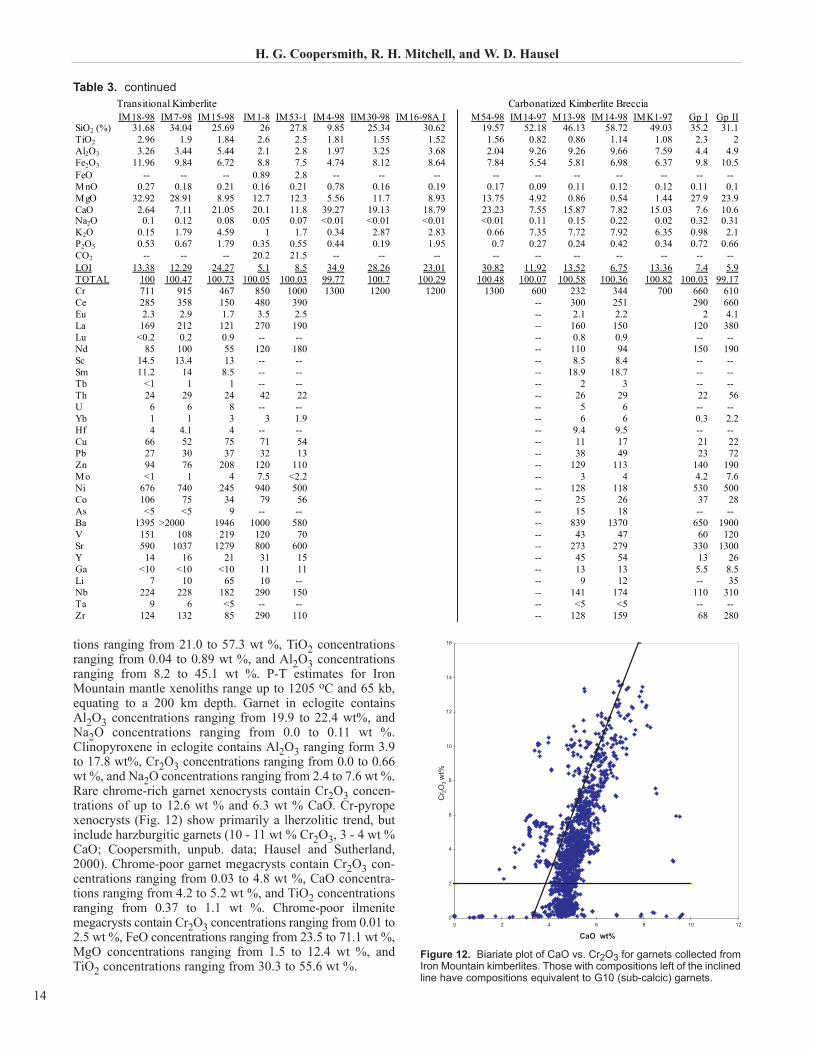
The average chemistry of the Type I kimberlite is compara-ble with average Gp 1 kimberlite (Table 3). Type I kimberliteshave higher average magnesium (28.6 % MgO) and loweraverage potassium (1.04 % K2O) than the average Gp 1 kim-berlite (27.9 % MgO; 0.98% K2O). Magnesium content ishigher and potassium content lower than the average Gp 2kimberlite/orangeite (23.9 % MgO; 2.1 % K2O; Table 3).Samples of the Iron Mountain Type I hypabyssal kimberliterange from 23.1 - 33.31 % MgO, and 0.18 - 1.8 % K2O.
Carbonatized kimberlites (Type II) show a wide range inmajor oxide chemistry, in part due to contamination and dif-ferentiation. Carbonatization appears to have had the great-est influence on the chemistry variance. These kimberlitesshow a wide range of carbonatization from weakly carbonat-ed rock where the serpentinized olivine megacrysts containreaction rims of carbonate with some interstitial carbonategroundmass, to extreme carbonatization showing pervasivealteration of the rock. In the pervasively altered rocks, themegacrysts and groundmass appear to be completelyreplaced by carbonate. Samples IM7-98 and IM18-98(Table 3) are weakly carbonatized. Whole rock chemistryshows 28.91 and 32.92 % MgO with 7.11 and 2.64 % CaO,respectively. LOI totals 12.29 and 13.38 %, much of whichprobably occurs as H2O with some CO2. Other Type II sam-ples listed in Table 3 are pervasively carbonatized. In partic-ular, sample IM4-98 contains 5.56 percent MgO, 39.27 %CaO, and 34.9 % LOI, and is dramatically depleted in silica(9.85 % SiO2) and potassium (0.34 % K2O). Based on thechemistry this sample represents extreme carbonatizationwith depletion of MgO. Other samples of this type also showintense carbonatization. Samples IM15-98 and IM30-98contain serpentinized olivine megacrysts with a groundmass
H. G. Coopersmith, R. H. Mitchell, and W. D. Hausel
12
pervasively replaced by carbonate. These yielded 8.95 and11.7 % MgO with 21.05 and 19.13 % CaO.
Carbonatized breccias (Type III) have been contaminatedby abundant granite breccia clasts. These rocks look morelike a fault breccia than kimberlite. Samples with the leastamount of granitic xenoliths were selected for whole rockanalysis, and show enrichment in SiO2, Al2O3, K2O as wellas extreme depletion of MgO (Table 3). Only sample IM14-97 contained appreciable magnesium (4.92 % MgO). Threeother samples contained 0.54 to 1.44 % MgO. These sam-ples also show enrichment of calcium (7.55 - 18.87 % CaO)in the form of calcite. No magnesium-silicate minerals wereidentified during petrographic analysis of these samples, andit is possible that the rocks represent a degassing phase of ablind diatreme, where CO2 gas exsolved from the kimberlitemagma as the lithostatic pressure decreased near the surface.
Rare earth contents of the kimberlites show chondritenormalized distribution patterns that are highly fractionatedtoward light rare earths. La/Yb ratios range from 75 to 173,and the kimberlites from Iron Mountain (as well as the StateLine district) display negative Eu anomalies. Similar pat-terns have been recognized in some South African andSiberian diamondiferous kimberlites (Smith, 1977).
Mantle Petrology Smith (1977) studied the mantle petrology at Iron Mountainthrough examination of xenoliths. Mantle xenoliths includegarnet peridotite, spinel peridotite, websterite and eclogite,as well as discrete megacrysts of garnet, diopside, ilmenite,and diopside-ilmenite intergrowths. The majority of thesemantle xenoliths are intensely altered, with relict primarymineralogy including chrome diopside, garnet, and chromespinel. Smith (1977) identified three general types of materi-al: depleted spinel and garnet peridotite from which partialmelt has been extracted; eclogite and websterite, whichformed as cumulates of rising basaltic melts; and themegacryst assemblage, which crystallized from a fractionat-ing liquid that may have been parental to kimberlite.
Smith (1977) reported the following mineral chemistry.Chrome pyrope in garnet peridotite contains Cr2O3 concen-trations ranging from 5.8 to 10.5 wt %, CaO concentrationsranging from 5.5 to 7.5 wt %, and TiO2 concentrations rang-ing from 0.03 to 1.0 wt %. Clinopyroxene in garnet peri-dotite contains 1.3 - 2.9 wt % Cr2O3, Na2O concentrationsranging from 1.1 to 2.7 wt %, and Al2O3 concentrationsranging from 0.15 to 4.6 wt %. Spinel in spinel peridotite andspinel-bearing garnet peridotite contains Cr2O3 concentra-
Kimberlites and Lamproites of Colorado and Wyoming, USA
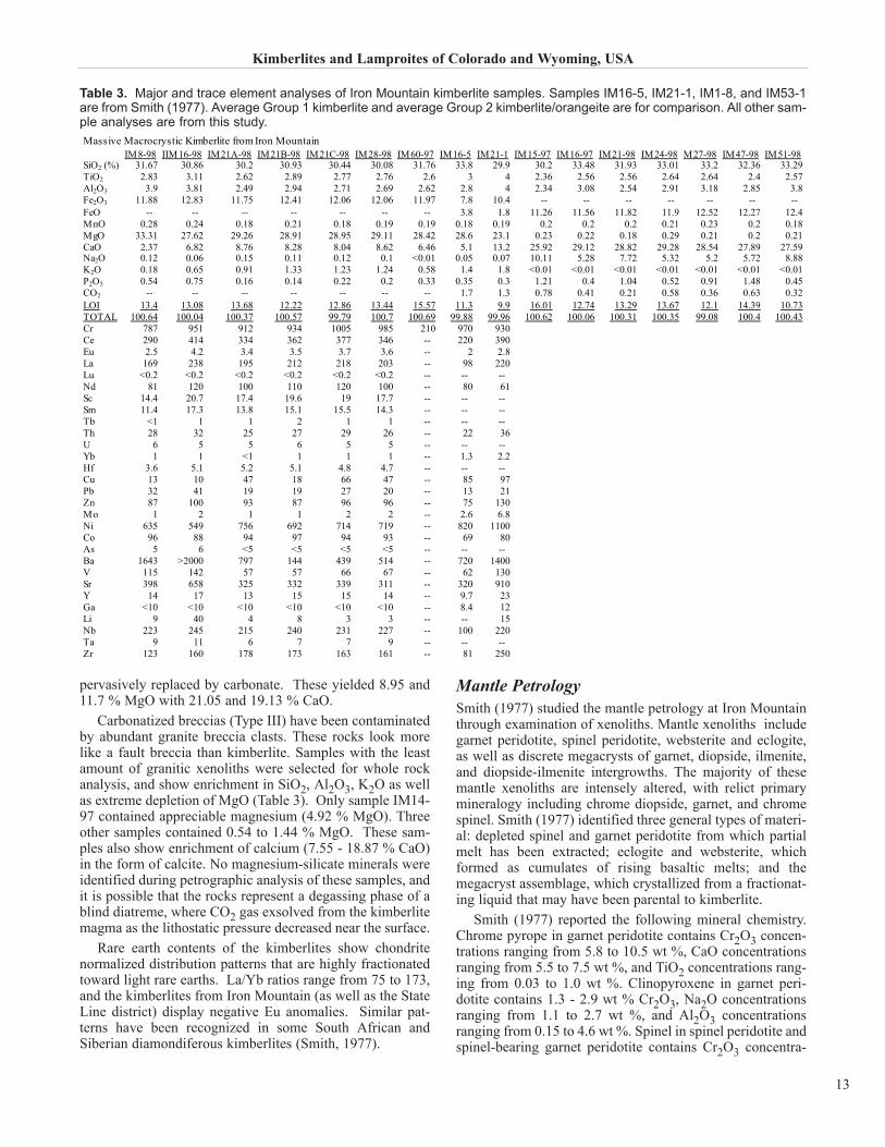
Table 3. Major and trace element analyses of Iron Mountain kimberlite samples. Samples IM16-5, IM21-1, IM1-8, and IM53-1are from Smith (1977). Average Group 1 kimberlite and average Group 2 kimberlite/orangeite are for comparison. All other sam-ple analyses are from this study.
tions ranging from 21.0 to 57.3 wt %, TiO2 concentrationsranging from 0.04 to 0.89 wt %, and Al2O3 concentrationsranging from 8.2 to 45.1 wt %. P-T estimates for IronMountain mantle xenoliths range up to 1205 oC and 65 kb,equating to a 200 km depth. Garnet in eclogite containsAl2O3 concentrations ranging from 19.9 to 22.4 wt%, andNa2O concentrations ranging from 0.0 to 0.11 wt %.Clinopyroxene in eclogite contains Al2O3 ranging form 3.9to 17.8 wt%, Cr2O3 concentrations ranging from 0.0 to 0.66wt %, and Na2O concentrations ranging from 2.4 to 7.6 wt %.Rare chrome-rich garnet xenocrysts contain Cr2O3 concen-trations of up to 12.6 wt % and 6.3 wt % CaO. Cr-pyropexenocrysts (Fig. 12) show primarily a lherzolitic trend, butinclude harzburgitic garnets (10 - 11 wt % Cr2O3, 3 - 4 wt %CaO; Coopersmith, unpub. data; Hausel and Sutherland,2000). Chrome-poor garnet megacrysts contain Cr2O3 con-centrations ranging from 0.03 to 4.8 wt %, CaO concentra-tions ranging from 4.2 to 5.2 wt %, and TiO2 concentrationsranging from 0.37 to 1.1 wt %. Chrome-poor ilmenitemegacrysts contain Cr2O3 concentrations ranging from 0.01 to2.5 wt %, FeO concentrations ranging from 23.5 to 71.1 wt %,MgO concentrations ranging from 1.5 to 12.4 wt %, andTiO2 concentrations ranging from 30.3 to 55.6 wt %.
H. G. Coopersmith, R. H. Mitchell, and W. D. Hausel
14
Transitional Kimberlite Carbonatized Kimberlite BrecciaIM18-98 IM7-98 IM15-98 IM1-8 IM53-1 IM4-98 IIM30-98 IM16-98A I M54-98 IM14-97 M13-98 IM14-98 IMK1-97 Gp I Gp II
Figure 12. Biariate plot of CaO vs. Cr2O3 for garnets collected fromIron Mountain kimberlites. Those with compositions left of the inclinedline have compositions equivalent to G10 (sub-calcic) garnets.
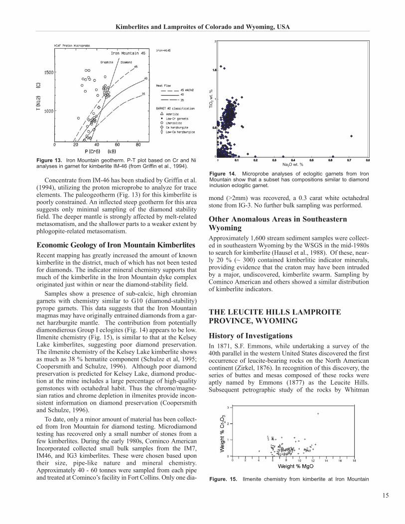
Concentrate from IM-46 has been studied by Griffin et al.(1994), utilizing the proton microprobe to analyze for traceelements. The paleogeotherm (Fig. 13) for this kimberlite ispoorly constrained. An inflected steep geotherm for this areasuggests only minimal sampling of the diamond stabilityfield. The deeper mantle is strongly affected by melt-relatedmetasomatism, and the shallower parts to a weaker extent byphlogopite-related metasomatism.
Economic Geology of Iron Mountain KimberlitesRecent mapping has greatly increased the amount of knownkimberlite in the district, much of which has not been testedfor diamonds. The indicator mineral chemistry supports thatmuch of the kimberlite in the Iron Mountain dyke complexoriginated just within or near the diamond-stability field.
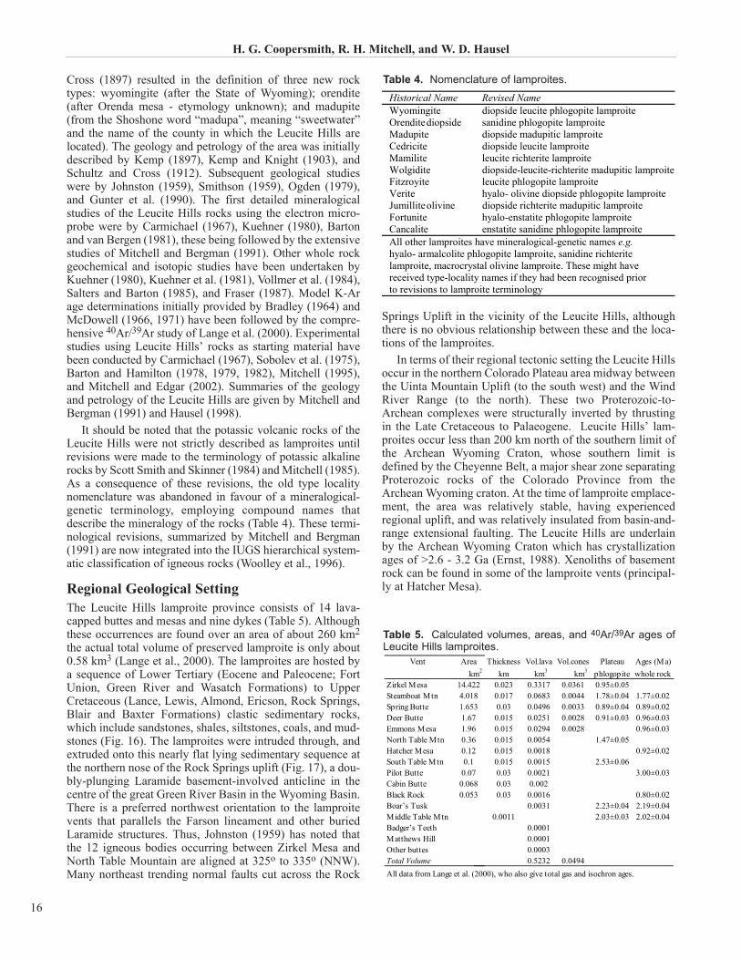
Samples show a presence of sub-calcic, high chromiangarnets with chemistry similar to G10 (diamond-stability)pyrope garnets. This data suggests that the Iron Mountainmagmas may have originally entrained diamonds from a gar-net harzburgite mantle. The contribution from potentiallydiamondierous Group I eclogites (Fig. 14) appears to be low.Ilmenite chemistry (Fig. 15), is similar to that at the KelseyLake kimberlites, suggesting poor diamond preservation.The ilmenite chemistry of the Kelsey Lake kimberlite showsas much as 38 % hematite component (Schulze et al, 1995;Coopersmith and Schulze, 1996). Although poor diamondpreservation is predicted for Kelsey Lake, diamond produc-tion at the mine includes a large percentage of high-qualitygemstones with octahedral habit. Thus the chrome/magne-sian ratios and chrome depletion in ilmenites provide incon-sistent information on diamond preservation (Coopersmithand Schulze, 1996).
To date, only a minor amount of material has been collect-ed from Iron Mountain for diamond testing. Microdiamondtesting has recovered only a small number of stones from afew kimberlites. During the early 1980s, Cominco AmericanIncorporated collected small bulk samples from the IM7,IM46, and IG3 kimberlites. These were chosen based upontheir size, pipe-like nature and mineral chemistry.Approximately 40 - 60 tonnes were sampled from each pipeand treated at Cominco’s facility in Fort Collins. Only one dia-
mond (>2mm) was recovered, a 0.3 carat white octahedralstone from IG-3. No further bulk sampling was performed.
Other Anomalous Areas in SoutheasternWyomingApproximately 1,600 stream sediment samples were collect-ed in southeastern Wyoming by the WSGS in the mid-1980sto search for kimberlite (Hausel et al., 1988). Of these, near-ly 20 % (~ 300) contained kimberlitic indicator minerals,providing evidence that the craton may have been intrudedby a major, undiscovered, kimberlite swarm. Sampling byCominco American and others showed a similar distributionof kimberlite indicators.
THE LEUCITE HILLS LAMPROITEPROVINCE, WYOMING
History of InvestigationsIn 1871, S.F. Emmons, while undertaking a survey of the40th parallel in the western United States discovered the firstoccurrence of leucite-bearing rocks on the North Americancontinent (Zirkel, 1876). In recognition of this discovery, theseries of buttes and mesas composed of these rocks wereaptly named by Emmons (1877) as the Leucite Hills.Subsequent petrographic study of the rocks by Whitman
Kimberlites and Lamproites of Colorado and Wyoming, USA
15
Figure 13. Iron Mountain geotherm. P-T plot based on Cr and Nianalyses in garnet for kimberlite IM-46 (from Griffin et al., 1994).
Figure 14. Microprobe analyses of eclogitic garnets from IronMountain show that a subset has compositions similar to diamondinclusion eclogitic garnet.
Figure. 15. Ilmenite chemistry from kimberlite at Iron Mountain
Cross (1897) resulted in the definition of three new rocktypes: wyomingite (after the State of Wyoming); orendite(after Orenda mesa - etymology unknown); and madupite(from the Shoshone word “madupa”, meaning “sweetwater”and the name of the county in which the Leucite Hills arelocated). The geology and petrology of the area was initiallydescribed by Kemp (1897), Kemp and Knight (1903), andSchultz and Cross (1912). Subsequent geological studieswere by Johnston (1959), Smithson (1959), Ogden (1979),and Gunter et al. (1990). The first detailed mineralogicalstudies of the Leucite Hills rocks using the electron micro-probe were by Carmichael (1967), Kuehner (1980), Bartonand van Bergen (1981), these being followed by the extensivestudies of Mitchell and Bergman (1991). Other whole rockgeochemical and isotopic studies have been undertaken byKuehner (1980), Kuehner et al. (1981), Vollmer et al. (1984),Salters and Barton (1985), and Fraser (1987). Model K-Arage determinations initially provided by Bradley (1964) andMcDowell (1966, 1971) have been followed by the compre-hensive 40Ar/39Ar study of Lange et al. (2000). Experimentalstudies using Leucite Hills’ rocks as starting material havebeen conducted by Carmichael (1967), Sobolev et al. (1975),Barton and Hamilton (1978, 1979, 1982), Mitchell (1995),and Mitchell and Edgar (2002). Summaries of the geologyand petrology of the Leucite Hills are given by Mitchell andBergman (1991) and Hausel (1998).
It should be noted that the potassic volcanic rocks of theLeucite Hills were not strictly described as lamproites untilrevisions were made to the terminology of potassic alkalinerocks by Scott Smith and Skinner (1984) and Mitchell (1985).As a consequence of these revisions, the old type localitynomenclature was abandoned in favour of a mineralogical-genetic terminology, employing compound names thatdescribe the mineralogy of the rocks (Table 4). These termi-nological revisions, summarized by Mitchell and Bergman(1991) are now integrated into the IUGS hierarchical system-atic classification of igneous rocks (Woolley et al., 1996).
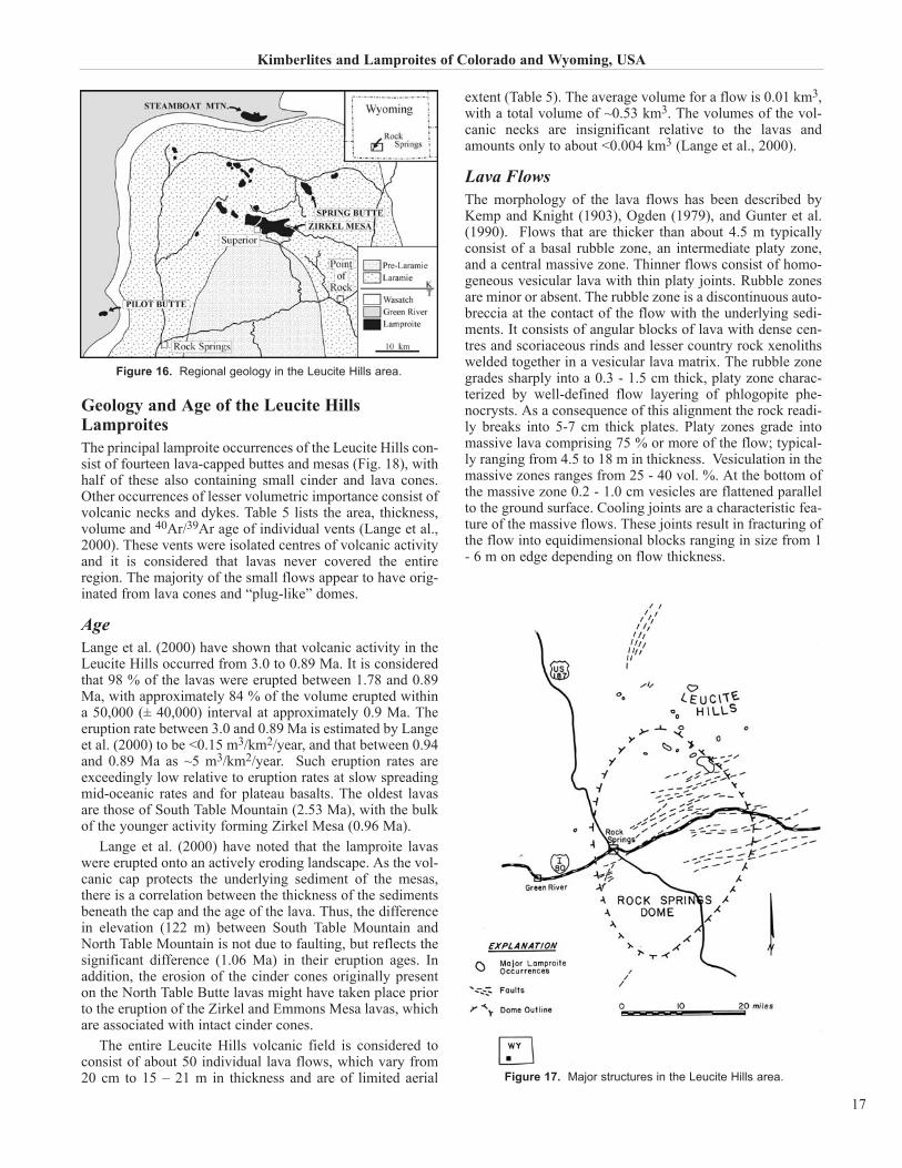
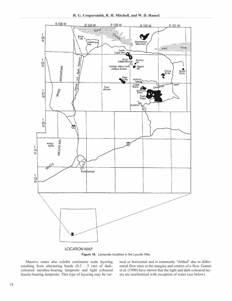
Regional Geological Setting The Leucite Hills lamproite province consists of 14 lava-capped buttes and mesas and nine dykes (Table 5). Althoughthese occurrences are found over an area of about 260 km2
the actual total volume of preserved lamproite is only about0.58 km3 (Lange et al., 2000). The lamproites are hosted bya sequence of Lower Tertiary (Eocene and Paleocene; FortUnion, Green River and Wasatch Formations) to UpperCretaceous (Lance, Lewis, Almond, Ericson, Rock Springs,Blair and Baxter Formations) clastic sedimentary rocks,which include sandstones, shales, siltstones, coals, and mud-stones (Fig. 16). The lamproites were intruded through, andextruded onto this nearly flat lying sedimentary sequence atthe northern nose of the Rock Springs uplift (Fig. 17), a dou-bly-plunging Laramide basement-involved anticline in thecentre of the great Green River Basin in the Wyoming Basin.There is a preferred northwest orientation to the lamproitevents that parallels the Farson lineament and other buriedLaramide structures. Thus, Johnston (1959) has noted thatthe 12 igneous bodies occurring between Zirkel Mesa andNorth Table Mountain are aligned at 325o to 335o (NNW).Many northeast trending normal faults cut across the Rock
Springs Uplift in the vicinity of the Leucite Hills, althoughthere is no obvious relationship between these and the loca-tions of the lamproites.
In terms of their regional tectonic setting the Leucite Hillsoccur in the northern Colorado Plateau area midway betweenthe Uinta Mountain Uplift (to the south west) and the WindRiver Range (to the north). These two Proterozoic-to-Archean complexes were structurally inverted by thrustingin the Late Cretaceous to Palaeogene. Leucite Hills’ lam-proites occur less than 200 km north of the southern limit ofthe Archean Wyoming Craton, whose southern limit isdefined by the Cheyenne Belt, a major shear zone separatingProterozoic rocks of the Colorado Province from theArchean Wyoming craton. At the time of lamproite emplace-ment, the area was relatively stable, having experiencedregional uplift, and was relatively insulated from basin-and-range extensional faulting. The Leucite Hills are underlainby the Archean Wyoming Craton which has crystallizationages of >2.6 - 3.2 Ga (Ernst, 1988). Xenoliths of basementrock can be found in some of the lamproite vents (principal-ly at Hatcher Mesa).
H. G. Coopersmith, R. H. Mitchell, and W. D. Hausel
16
Historical Name Revised Name Wyomingite diopside leucite phlogopite lamproite Orendite diopside sanidine phlogopite lamproite Madupite diopside madupitic lamproite Cedricite diopside leucite lamproite Mamilite leucite richterite lamproite Wolgidite diopside-leucite-richterite madupitic lamproite Fitzroyite leucite phlogopite lamproite Verite hyalo- olivine diopside phlogopite lamproite Jumillite olivine diopside richterite madupitic lamproite Fortunite hyalo-enstatite phlogopite lamproite Cancalite enstatite sanidine phlogopite lamproite All other lamproites have mineralogical-genetic names e.g. hyalo- armalcolite phlogopite lamproite, sanidine richterite lamproite, macrocrystal olivine lamproite. These might have received type-locality names if they had been recognised prior to revisions to lamproite terminology
Table 4. Nomenclature of lamproites.
Vent Area Thickness Vol.lava Vol.cones Plateau Ages (Ma) km2 km km3 km3 phlogopite whole rock
Zirkel Mesa 14.422 0.023 0.3317 0.0361 0.95±0.05Steamboat Mtn 4.018 0.017 0.0683 0.0044 1.78±0.04 1.77±0.02Spring Butte 1.653 0.03 0.0496 0.0033 0.89±0.04 0.89±0.02Deer Butte 1.67 0.015 0.0251 0.0028 0.91±0.03 0.96±0.03Emmons Mesa 1.96 0.015 0.0294 0.0028 0.96±0.03North Table Mtn 0.36 0.015 0.0054 1.47±0.05Hatcher Mesa 0.12 0.015 0.0018 0.92±0.02South Table Mtn 0.1 0.015 0.0015 2.53±0.06Pilot Butte 0.07 0.03 0.0021 3.00±0.03Cabin Butte 0.068 0.03 0.002Black Rock 0.053 0.03 0.0016 0.80±0.02Boar’s Tusk 0.0031 2.23±0.04 2.19±0.04Middle Table Mtn 0.0011 2.03±0.03 2.02±0.04Badger’s Teeth 0.0001Matthews Hill 0.0001Other buttes 0.0003Total Volume 0.5232 0.0494All data from Lange et al. (2000), who also give total gas and isochron ages.
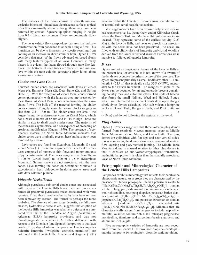
Geology and Age of the Leucite HillsLamproitesThe principal lamproite occurrences of the Leucite Hills con-sist of fourteen lava-capped buttes and mesas (Fig. 18), withhalf of these also containing small cinder and lava cones.Other occurrences of lesser volumetric importance consist ofvolcanic necks and dykes. Table 5 lists the area, thickness,volume and 40Ar/39Ar age of individual vents (Lange et al.,2000). These vents were isolated centres of volcanic activityand it is considered that lavas never covered the entireregion. The majority of the small flows appear to have orig-inated from lava cones and “plug-like” domes.
AgeLange et al. (2000) have shown that volcanic activity in theLeucite Hills occurred from 3.0 to 0.89 Ma. It is consideredthat 98 % of the lavas were erupted between 1.78 and 0.89Ma, with approximately 84 % of the volume erupted withina 50,000 (± 40,000) interval at approximately 0.9 Ma. Theeruption rate between 3.0 and 0.89 Ma is estimated by Langeet al. (2000) to be <0.15 m3/km2/year, and that between 0.94and 0.89 Ma as ~5 m3/km2/year. Such eruption rates areexceedingly low relative to eruption rates at slow spreadingmid-oceanic rates and for plateau basalts. The oldest lavasare those of South Table Mountain (2.53 Ma), with the bulkof the younger activity forming Zirkel Mesa (0.96 Ma).
Lange et al. (2000) have noted that the lamproite lavaswere erupted onto an actively eroding landscape. As the vol-canic cap protects the underlying sediment of the mesas,there is a correlation between the thickness of the sedimentsbeneath the cap and the age of the lava. Thus, the differencein elevation (122 m) between South Table Mountain andNorth Table Mountain is not due to faulting, but reflects thesignificant difference (1.06 Ma) in their eruption ages. Inaddition, the erosion of the cinder cones originally presenton the North Table Butte lavas might have taken place priorto the eruption of the Zirkel and Emmons Mesa lavas, whichare associated with intact cinder cones.
The entire Leucite Hills volcanic field is considered toconsist of about 50 individual lava flows, which vary from20 cm to 15 – 21 m in thickness and are of limited aerial
extent (Table 5). The average volume for a flow is 0.01 km3,with a total volume of ~0.53 km3. The volumes of the vol-canic necks are insignificant relative to the lavas andamounts only to about <0.004 km3 (Lange et al., 2000).
Lava FlowsThe morphology of the lava flows has been described byKemp and Knight (1903), Ogden (1979), and Gunter et al.(1990). Flows that are thicker than about 4.5 m typicallyconsist of a basal rubble zone, an intermediate platy zone,and a central massive zone. Thinner flows consist of homo-geneous vesicular lava with thin platy joints. Rubble zonesare minor or absent. The rubble zone is a discontinuous auto-breccia at the contact of the flow with the underlying sedi-ments. It consists of angular blocks of lava with dense cen-tres and scoriaceous rinds and lesser country rock xenolithswelded together in a vesicular lava matrix. The rubble zonegrades sharply into a 0.3 - 1.5 cm thick, platy zone charac-terized by well-defined flow layering of phlogopite phe-nocrysts. As a consequence of this alignment the rock readi-ly breaks into 5-7 cm thick plates. Platy zones grade intomassive lava comprising 75 % or more of the flow; typical-ly ranging from 4.5 to 18 m in thickness. Vesiculation in themassive zones ranges from 25 - 40 vol. %. At the bottom ofthe massive zone 0.2 - 1.0 cm vesicles are flattened parallelto the ground surface. Cooling joints are a characteristic fea-ture of the massive flows. These joints result in fracturing ofthe flow into equidimensional blocks ranging in size from 1- 6 m on edge depending on flow thickness.
Kimberlites and Lamproites of Colorado and Wyoming, USA
17
Figure 16. Regional geology in the Leucite Hills area.
Figure 17. Major structures in the Leucite Hills area.
Massive zones also exhibit centimetre scale layeringresulting from alternating bands (0.2 - 5 cm) of dark-coloured sanidine-bearing lamproite and light colouredleucite-bearing lamproite. This type of layering may be ver-
tical or horizontal and is commonly “folded” due to differ-ential flow rates at the margins and centres of a flow. Gunteret al. (1990) have shown that the light and dark coloured lay-ers are isochemical with exception of water (see below).
H. G. Coopersmith, R. H. Mitchell, and W. D. Hausel
18
Figure 18. Lamproite localities in the Leucite Hills.
The surfaces of the flows consist of smooth massivevesicular blocks of jointed lava. Scoriaceous surfaces typicalof aa flows are usually absent, although these may have beenremoved by erosion. Squeeze-up spines ranging in heightfrom 0.3 - 0.6 m are common. These are commonly flow-aligned.
The lavas exhibit flow morphology features that indicatetransformation from pahoehoe to aa with a single flow. Thistransition can be due to increases in viscosity resulting fromcooling or an increase in shear strain or both. Ogden (1979)considers that most of the flows advanced on broad frontswith many features typical of aa lavas. However, in manyplaces it is evident that lavas flowed through tube-like fea-tures. The bottoms of such tubes are flattened and massivelava within the tube exhibits concentric platy joints aboutscoriaceous centres.
Cinder and Lava ConesFourteen cinder cones are associated with lavas at ZirkelMesa (4), Emmons Mesa (2), Deer Butte (2), and SpringButte (6). With the exception of Zirkel Mesa, cones formedcontemporaneously with the lavas as they are breached bythese flows. At Zirkel Mesa, cones were formed on the asso-ciated flows. The bulk off the material forming the cindercones consists of highly vesicular scoria blocks ranging insize from 2.5 - 13.0 m. The cinder cones are small; thelargest being the eastern-most cone on Zirkel Mesa, whichhas a basal diameter of 85 0m and is 115 m high These aresimilar in size to alkali basalt cinder cones. The majority ofthe cones are asymmetrical as a consequence of breaching orerosional modification (Ogden, 1979). The presence of sco-riaceous material on North Table Mountain indicates thatcinder cones were originally present here but have now beenremoved by erosion.
Lava cones are found on Steamboat Mountain (3) andZirkel Mesa (1). These are asymmetrical shield-like struc-tures composed of numerous thin flows and minor amountsof pyroclastic material. The cones range in size from 760 mx 100 m (Zirkel Mesa) to 1600 m x 75 m (SteamboatMountain). Summit craters are not associated with the lavacones. Lava forming the cones on Steamboat Mountain isexceptionally fresh phlogopite hyalo-lamproite associatedwith dark coloured pumice.
Volcanic Necks/VentsAlthough pyroclastic sub-aerial cinder cones are associatedwith many of the Leucite Hills lavas, there are few occur-rences of preserved pyroclastic rocks associated with ventopening. Either these have been buried by later lavas or havebeen removed by erosion. The former is perhaps the moreprobable. The absence of base surge deposits, air-fall pyro-clastics, hydroclastic breccias etc., suggests that eruption ofthe Leucite Hills lamproites was relatively quiescent as com-pared with that of the Ellendale or Argyle (Australia) orArkansas (USA) lamproite provinces, and was notphreatomagmatic in character. A further difference withrespect to the Ellendale (and Spanish) lamproites is that lavaponds of hypabyssal olivine lamproite or leucite-diopside-richterite lamproite (“wolgidite, cedricite, mamillite”) arenot found in the Leucite Hills. Mitchell and Bergman (1991)
have noted that the Leucite Hills volcanism is similar to thatof normal sub-aerial basaltic volcanism.
Vent agglomerates have been exposed only where erosionhas been extensive, i.e. the northern end of Killpecker Creek,where the Boar’s Tusk and Matthew Hill volcanic necks arelocated. They represent some of the earliest activity (2.23Ma) in the Leucite Hills, and lavas or pyroclastics associat-ed with the necks have not been preserved. The necks arefilled with autolithic clasts of lamproite and crustal xenolithsderived from the Green River and Wasatch Formations set inmassive-to-foliated phlogopite lamproite.
DykesDykes are not a conspicuous feature of the Leucite Hills atthe present level of erosion. It is not known if a swarm offeeder dykes occupies the infrastructure of the province. Thedykes are present primarily as small bodies (width 0.3 - 15m;length 8 - 215 m) that typically strike 320o (NNW), subpar-allel to the Farson lineament. The margins of some of thedykes can be occupied by an agglomeratic breccia contain-ing country rock and autolithic clasts. This style of brecciaalso forms the small Iddings, Weed and Hallock Buttes,which are interpreted as incipient vents developed along asingle dyke. Dykes associated with sub-volcanic lamproitenecks at Boars’ Tusk, Badger’s Teeth, and Pilot Butte aret h i n(<10 m) and do not following the regional strike trend.
Plug DomesOgden (1979) has suggested that three volcanic plug domesformed from relatively viscous magmas occur at MiddleTable Mountain, Zirkel Mesa, and Cabin Butte. The plugdomes are cylindrical with flat tops and near-vertical sides.Lavas comprising the domes show very pronounced verticalflow layering and platy vertical jointing. The Middle TableMountain dome is unusual relative to other plug domes inthat it consists of sub-volcanic/hypabyssal transitionalmadupitic lamproite. It is older than the spatially associatedlavas of North Table Mountain.
Petrographic and Mineralogical Character ofthe Leucite Hills LamproitesLamproites exhibit a mineralogy that reflects their peralkalineultrapotassic nature. As a group they are characterized by thepresence of titanian phlogopite, titanian potassium richterite[(Na,K)(Na,Ca)(Mg,Fe,Ti)5(Si,Ti,Al)8O22(OH)2], titaniantetraferriphlogopite, sodium- and aluminium-deficient leucite,iron-rich sanidine, poor-poor diopside, potassian barian titan-ites [priderite (K,Ba)1-2(Fe3+, Mg, Cr, V,)1-2(Ti)6-7O16) orjeppeite (K,Ba)2Ti6O13)], and potassian zirconian or titaniansilicates [wadeite (K2ZrSi3O9), shcherbakovite[(Ba,K)(K,Na)Na(Ti,Nb,Zr,Fe)2Si4O14)]. Minerals that arecharacteristically absent from lamproites include: nepheline;melilite; kalsilite; sodium-rich alkali feldspar; plagioclase,monticellite, titanium- and zirconium-bearing garnets, andaluminium-rich augite.
Five petrographic varieties of lamproite are now recog-nized from the Leucite Hills Province: diopside-leucite-phl-ogopite lamproite (wyomingite); diopside-sanidine-phlogo-
Kimberlites and Lamproites of Colorado and Wyoming, USA
19
pite lamproite (orendite); olivine-bearing diopside-sanidine-phlogopite lamproite (olivine orendite); diopside madupiticlamproite (madupite); transitional madupitic lamproite. Theterminology used to describe the rocks follows the miner-alogical-genetic system of nomenclature recommended forlamproites by Mitchell and Bergman (1991), and adopted bythe IUGS (Woolley et al., 1996). The older, now otiose, ter-minology is given above in parentheses.
Diopside-leucite-phlogopite lamproiteThese vesicular rocks are characterized by the presence ofphenocrysts of phlogopite set in a groundmass containingmicrophenocrysts of leucite and diopside. All of these min-erals can be set in a glassy mesostasis with or without potass-ian titanian richterite. Accessory microphenocrystal phasesinclude apatite, priderite, and wadeite. Wide variations inmode can occur and pumice consisting of phlogopite set inglass can be found.
Diopside-sanidine-phlogopite lamproiteThese vesicular rocks are also characterized by the presenceof phenocrysts of phlogopite. They differ from the aboveleucite-bearing lamproites in that sanidine is a characteristicmineral of the groundmass and that they exhibit greatermodal diversity. Sanidine can coexist with leucite, diopside,and potassian titanian richterite. In contrast to the above lam-proites, glass is not typically present. Accessory phasesinclude apatite, priderite and wadeite.
Typically, leucite is enclosed by sanidine. The propor-tions of leucite to sanidine may vary on a centimetre scalewithin the same flow. Gunter et al. (1990) have demonstrat-ed that such modally different lamproites are isochemical,with the exception that the water content of the sanidine-bearing varieties is higher than that of the sanidine-free types(Table 3).
Olivine-bearing diopside-sanidine-phlogopitelamproitesThese rocks are petrographically identical to diopside-sani-dine-phlogopite lamproite with the exception that olivine ispresent as either anhedral crystals mantled by phlogopitelaths or microphenocrystal euhedral olivines. Mantledolivines are magnesian (Mg# = 0.93 - 0.92; 0.30 - 0.40 wt. %NiO) relative to microphenocrystal olivines (Mg# = 0.93 -0.87; 0.25 - 0.17 wt. % NiO). The mantling micas are iden-tical in composition to mica forming phenocrysts and haveevidently formed by reaction with the magma in which theyare enclosed. These olivines are considered to be mantle-derived xenocrysts. The euhedral olivines appear to be bonafide primary liquidus phases. Their presence might reflectenhanced Mg-contents resulting from dissolution of mantlexenocrysts or they might be high-pressure phenocrysts.Microphenocrystal olivine can also form as reaction rimsaround phlogopite phenocrysts and represent the breakdownproducts of primary phlogopite. Olivine bearing lamproitesin the Leucite Hills are known only from North and SouthTable Mountain, Black Rock, and Endlich Hill. Olivine lam-proites of the type found in the West Kimberley lamproiteprovince of Australia are not present in the Leucite Hills.
Diopside madupitic lamproiteThe term madupitic indicates that a lamproite containspoikilitic groundmass phlogopite as opposed to phlogopitelamproite in which the mica occurs as phenocrysts.Madupitic is preferred to the textural term “oikocrystal”, asthe latter is used primarily for large late-forming poikiliticcrystals in a wide variety of plutonic rocks. However, it isrecognized, that the formation of a madupitic texture mightinvolve similar crystallization processes as lead to oikocrystformation. Madupitic-textured lamproites are sub-volcanic-to-hypabyssal rocks.
Diopside madupitic lamproite (formerly madupite) con-sists of flow-aligned microphenocrysts of diopside set inglassy (commonly altered) matrix containing groundmassdiopside, spinel, wadeite, perovskite, and apatite. The char-acteristic petrographic feature is the presence of large (up to1 cm) optically continuous, poikilitic plates of Al-poor, Ti-rich phlogopite. These micas are considered on the basis oftheir compositions to be more evolved than the Al-rich, Ti-poor micas occurring as phenocrysts in phlogopite lam-proites. Olivine, richterite, sanidine, and priderite are notfound in these rocks and leucite is only very rarely present.
Transitional diopside madupitic lamproiteThese rocks share some of the petrographic character of bothphlogopite lamproites and madupitic lamproites as they con-tain phlogopite phenocrysts that are mantled by poikiliticmicas, which are petrographically- and compositionally-identical to associated large groundmass plates. In additionto diopside, leucite is a characteristic microphenocrystalphase. Also present are poikilitic purple groundmass Sr-REE-rich perovskite, wadeite, and Sr-rich apatite.
Compositions of Leucite Hills LamproitesAll of the Leucite Hills lamproites are peralkaline with veryhigh K2O/ Na2O ratios (>8). Lamproites from SteamboatMountain represent the most potassic (12 wt.% K2O) vol-canic rocks ever described. Unlike, the Ellendale lamproiteprovince, the Leucite Hills rocks do not exhibit a wide rangein composition. Two broad groups in terms of their SiO2content are evident: madupitic low silica rocks and silica-rich phlogopite lamproites (Table 6). Phlogopite lamproiteswithin and between individual vents exhibit only a limitedrange in composition, reflecting primarily the proportions ofcrystals to glass. Sanidine phlogopite lamproite and leucitephlogopite lamproite within a given flow are identical incomposition (Table 3, analyses 7, 8), clearly demonstratingthat they are heteromorphs. The compositions of phlogopitelamproites can be considered a representative of theirparental magmas, unlike those of madupitic lamproiteswhose compositions appear to have been determined, in part,by crystal accumulation. Madupitic lamproites are not less-evolved variants of the magmas that formed the phlogopitelamproites. The relationship between the two types is not yetresolved, although it is clear that processes other than crys-tal fractionation must have played a role in their genesis asthey exhibit different Sr and Nd isotopic compositions.
H. G. Coopersmith, R. H. Mitchell, and W. D. Hausel
20
ACKNOWLEDGEMENTS The Kelsey Lake project would not have come to fruitionwithout the early support of A. J. A. Janse, R. Baxter-Brown,and C E. E. Devenish. The exploration and development ofthe Kelsey Lake project was greatly facilitated by the localstaff, including M. L. Hobbs and C. F. Brink. Also, deepappreciation goes to M. E. McCallum for his pioneeringwork in the district. Significant analytical support and dis-cussion has been provided by D. J. Schulze, L-A. Pizzolato,and W. L. Griffin. Finally, thanks to all who buy ColoradoDiamonds®.
In the Iron Mountain District, Craig Smith performed thepioneering work. Cominco American continued the evalua-tion of the diamond potential of the Iron Mountain District.The Wyoming State Geological Survey received supplemen-tal funding from the Wyoming State Legislature to studykimberlite in the Iron Mountain district. Robert Gregory,Woody Motten, and Wayne Sutherland contributed greatly tothat project. We would like to acknowledge Max Evans andTom Evans with the American Diamond Company, and PaulGraff, Gordon Marlatt, and Vic Norris for unrestricted accessto their mining claims and leased properties at IronMountain. We are also grateful for access provided by thefollowing ranch owners and managers: John Dilts, VirginiaJohnson, Jim McGuire, Mark Mills, Diemer True, RandallPerry, Bonnie Reider, Genevieve Wagner, and Duer Wagner.
REFERENCES Ater, P. C., Eggler, D. H., and McCallum, M. E.1984: Petrology and Geochemistry of Mantle Eclogite Xenoliths
from Colorado-Wyoming Kimberlites: Recycled OceanicCrust?; in Kimberlites II: The Mantle and Crust - MantleRelationships, J. Kornprobst, (ed.), Elsevier, New York, p. 309-318.
Barton, M. and van Bergen, M. J.1981: Green Clinopyroxenes and Associated Phases in a
Potassium-rich Lava from the Leucite Hills, Wyoming;Contributions to Mineralogy and Petrology, v. 77, p. 101-114.
Barton, M. and Hamilton, D. L.1978: Water-saturated Melting Relations to 5 kilobars of Three
Leucite Hills Lavas; Contributions to Mineralogy andPetrology, v. 66, p. 41-49.
1979: The Melting Relations of a Madupite from the LeuciteHills, Wyoming to 30 kb; Contributions to Mineralogy andPetrology, v. 69, p. 133-142.
1982: Water-saturated melting experiments bearing upon the ori-gin of potassium-rich magmas; Mineralogical Magazine, v. 45, p. 267-278.
Billman, J.1998: Tiffany’s? Hardly. We picked ours up in Laramie; Outside
Magazine, v. 23, no. 10, p. 41-50.Bradley, W. H.1964: Geology of the Green River Formation and Associated
Eocene Rocks in Southwest Wyoming and Adjacent Partsof Colorado and Utah; U.S. Geological Survey,Professional Paper 496-A, p. A1-A86.
Carmichael, I. S. E.1967: The Mineralogy and Petrology of the Volcanic Rocks from
the Leucite Hills, Wyoming; Contributions to Mineralogyand Petrology, v. 15, p. 24-66.
Carlson, J. A. and Marsh, S. W.1989: Discovery of the George Creek Kimberlite Dikes,
Colorado: in Proceedings of the Fourth InternationalKimberlite Conference Kimberlites and Related rocks, J.Ross (ed.); Geological Society of Australia SpecialPublication 14, v. 2, p. 1169-1178.
Coopersmith, H. G.1991: Geology and Exploration of the Kelsey Lake
Diamondiferous Kimberlites, Colorado; Society of MiningEngineers, Preprint no. 91-174, 18 p.
1993: Diamondiferous Kimberlite at Kelsey Lake, SouthernWyoming Archean Province; in Mid-Continent Diamonds,K. P. E. Dunne and B. Grant (ed.); Geological Associationof Canada, Mineral Deposits Division, p. 85-88.
Coopersmith, H. G. and Schulze, D. J.1996: Development and Geology of the Kelsey Lake Diamond
Mine, Colorado; in Diamonds to Gold, T. B. Thompson(ed.); Society of Economic Geologists, Guidebook Series,v. 26, p. 5-19.
Coopersmith, H. G., Griffin, W. L., Ryan, C.G., Win, T. T.,and McCallum, M. E.1995: Trace Elements in Garnets and Chromites from Colorado-
Wyoming Kimberlites as a Guide to Exploration; SixthInternational Kimberlite Conference, Extended Abstracts,Novosibirsk, Russia, p.118-120.
Cross, C. W.1897: The Igneous Rocks of the Leucite Hills and Pilot Butte;
American Journal of Science, v. 4, p. 115 - 141.Dawson, J. B.1967: Geochemistry and Origin of Kimberlite; in Ultramafic and
Related Rocks, P. J. Wyllie (ed.), John Wiley and Sons, p. 269-278.
Eggler, D. H., McCallum, M. E., and Smith, C. B.1979: Megacryst Assemblages in Kimberlites from Northern
Colorado and Southern Wyoming: Petrology,Geothermometry-Barometry, and Areal Distribution; inThe Mantle Sample: Inclusions in Kimberlites and OtherVolcanics, F. R. Boyd and H. O. A. Meyer, (ed.); AmericanGeophysical Union, Washington, D.C., p. 213-226.
Kimberlites and Lamproites of Colorado and Wyoming, USA
+ 1.72 2.91 2.07 2.71 1.23 -- 3.40 3.00 2SO3 0.74 1.00 0.46 0.29 0.40 1.15 -- -- 0Cl 0.03 0.02 -- 0.04 -- 0.03 -- -- F 0.50 0.69 -- 0.49 -- 0.66 -- -- 1 3 di id l it hl it l it ( i it ) C (189
Table 6. Whole rock compositions of Leucite Hills lamproites.
Eggler, D. H., McCallum, M. E., and Kirkley, M. B.1987: Kimberlite-transported Nodules from Colorado-Wyoming;
A Record of Enrichment of Shallow Portions of an InfertileLithosphere; Geological Society of America, Special Paper 215, p. 77-90.
Eggler, D. H., Meen, J. K., Welt, F., Dudas, F. O., Furlong, K. P.,McCallum, M. E., and Carlson, R. W.1988: Tectonomagmatism of the Wyoming Province; Colorado
School of Mines Quarterly, v. 83, no. 2, p. 25-40.Emmons, S. F.1877: Descriptive Geology; in Report of the Geological
Exploration of the 40th Parallel, C. King (ed.); U.S. ArmyEngineer Department; Professional Papers, v. 2, p. 236-238.
Ernst, W. G.1988: Metamorphic Terrains, Isotopic Provinces, and Implications
for Crustal Growth of the Western United States; Journal ofGeophysical Research, v. 93, p. 7634-7642.
Falk, R. W.1992: Physical Characteristics of Diamonds from the George
Creek, Kelsey Lake, and Chicken Park Kimberlites, M.Sc.thesis, Colorado State University, 236 p.
Fraser, K. J.1987: Petrogenesis of Kimberlites from South Africa and
Lamproites from Western Australia and North America,Ph.D. Thesis, The Open University, Milton Keynes, UK.
Griffin, W. L., Win, T. T. and Ryan, C. G.1994: Trace Elements in Garnets from the Colorado-Wyoming
Kimberlites: Evaluation of Diamond Grade; Explorationand Mining Report 35R, unpublished CSIRO Report prepared for Diamond Company N.L., 152p.
Gunter, W.D., Hoinkes, G., Ogden, P. R., and Pajari, G. E.1990: Origin of Leucite-rich and Sanidine-rich Flow Layers in the
Leucite Hills Volcanic Field, Wyoming; Journal ofGeophysical Research, v. 95B, p. 15911-15928.
Gurney, J. J.1984: A Correlation between Garnets and Diamonds: in
Kimberlite Occurrence and Origin: A Basis for ConceptualModels in Exploration, J. E. Glover and P. G. Harris (ed.),University of Western Australia, Special Publication No. 8,p. 143-166.
1989: Diamonds; in Proceedings of the Fourth InternationalKimberlite Conference Kimberlites and Related rocks, J.Ross (ed.), Geological Society of Australia, SpecialPublication 14, v. 2, p. 935-965.
Hausel, W. D.1998: Diamonds and Mantle Source Rocks in the Wyoming
Craton, with a Discussion of Other US Occurrences;Wyoming State Geological Survey, Report ofInvestigations 53, 93 p.
Hausel, W. D., Sutherland, W. M., and Gregory, E. B.1988: Stream-Sediment Sample results in Search of Kimberlite
Intrusives in Southeastern Wyoming; Geological Survey ofWyoming, Open-File Report 88-11, 11 p.
Hausel, W. D., Kucera, R. E., McCandless, T. E., and Gregory, R.W.1999: Mantle-derived Breccia Pipes in the Southern Green River
Basin of Wyoming (USA); in Proceedings of the VIIthInternational Kimberlite Conference, J. J. Gurney, J. L.Gurney, M. D. Pascoe, and S. H. Richardson (ed.); v. 1, RedRoof Design, Cape Town, p.348 - 352
Hausel, W. D. and Sutherland, W. M.2000: Gemstones and Other Unique Minerals and Rocks of
Wyoming: A Field Guide for Collectors; Geological Surveyof Wyoming, Bulletin, 267 p.
Heaman, L. M., Kjarsgaard, B. A., and Creaser, R. A.2003: TheTiming of Kimberlite Magmatism and Implications for
Diamond Exploration: a Global Perspective; Lithos (in press).Hearn, B. C., Jr.1989: Alkalic Ultramafic Magmas in North-Central Montana,
USA: Genetic Relations of Alnöite, Kimberlite, andCarbonatite; in Proceedings of the Fourth InternationalKimberlite Conference, Kimberlites and Related Rocks, J.Ross (ed.); Geological Society of Australia, SpecialPublication 14, v. 1; p. 109-119.
Hills, F.A. and Houston, R.S.1979: Early Proterozoic Tectonics of the Central Rocky
Mountains, North America; in Contributions to WyomingGeology, D. W. Boyd and J. A. Lillegraven (eds.);University of Wyoming, Laramie, p. 89-109.
Houston, R. S., Karlstrom, K. E., Hills, F. A., and Smithson, S. B.1979: The Cheyenne Belt: The major Precambrian Crustal
Boundary in the Western United States; Geological Societyof America, Abstracts with Programs, v. 11, p. 446.
Hozjan, D. J.1996: Characteristics of Ecologite Xenoliths from Kelsey Lake,
Colorado; B.Sc. thesis, University of Toronto, Toronto,Ontario, Canada, 41p.
Johnston, R. H.1959: Geology of the Northern Leucite Hills, Sweetwater County,
Wyoming; M.Sc. Thesis, University of Wyoming, Laramie.Karlstrom K. E. and Houston, R. S.1984: The Cheyenne Belt: Analysis of a Proterozoic Suture in
Southern Wyoming; Precambrian Research, v. 25, p. 415-446.Kemp, J. F.1897: The Leucite Hills of Wyoming; Geological Society of
America Bulletin, v. 8, p. 169-182.Kemp, J. F. and Knight, W. C.1903: Leucite Hills of Wyoming; Geological Society of America
Bulletin, v. 14, p. 305-336.Kuehner, S. M.1980: Petrogenesis of Ultrapotassic Rocks, Leucite Hills,
Wyoming; M.Sc. thesis, University of Western Ontario,London, Ontario, Canada.
Kuehner, S. M., Edgar, A. D., and Arima, M.1981: Petrogenesis of Ultrapotassic Rocks from the Leucite Hills,
Wyoming; American Mineralogist, v. 66, p. 663-677.Lange, R. L., Carmichael, I. S. E., and Hall, C. M.2000: 40Ar/39Ar Chronology of the Leucite Hills, Wyoming:
Eruption Rates, Erosion Rates, and an EvolvingTemperature Structure of the Underlying Mantle; Earth andPlanetary Science Letters, v. 174, p. 329-340.
Larson, E. E. and Amini, M. H.1981: Fission-track Dating of the Green Mountain Kimberlite
Diatreme near Boulder, Colorado; The Mountain Geologist,v. 18, no. 1, p. 18-22.
Loucks, R. R., Premo, W. R., and Snyder, G. L.1988: Petrology, Structure, and Age of the Mullen Creek Layered
Mafic Complex and Age of Arc Accretion, Medicine BowMountains, Wyoming; Geological Society of America,Abstracts with Programs, v. 20, p. A73.
Lester, A. P. and Larson, E. E.1996: New Geochronologic Evidence for Late Proterozoic
Emplacement in the Colorado-Wyoming Kimberlite Belt;American Geophysical Union, EOS Transactions, v. 77, no. 46, p. F821.
McCallum, M. E.1989: Oxide Minerals in the Chicken Park Kimberlite, Northern
Colorado; in Proceedings of the Fourth InternationalKimberlite Conference, Kimberlites and Related Rocks, J.
H. G. Coopersmith, R. H. Mitchell, and W. D. Hausel
22
Ross (ed.); Geological Society of Australia, SpecialPublication 14, v. 1, p. 241-263.
1991: The Sloan 1 and 2 Kimberlite Complex near the SouthernBoundary of the Colorado-Wyoming Kimberlite Province;in Mineral Resources of Wyoming, B. R. Frost, and S.Roberts (ed.); Wyoming Geological Association, 42nd FieldConference Guidebook, p. 229-250.
McCallum, M. E. and Eggler, D. H.1971: Mineralogy of the Sloan Diatreme, a Kimberlite Pipe in
Northern Larimer County, Colorado; AmericanMineralogist, v.56, p. 1735-1749.
McCallum, M. E. and Mabarak, C D.1976: Diamond in State Line kimberlite diatremes, Albany
County, Wyoming, and Larimer County, Colorado;Geological Survey of Wyoming, Report of InvestigationsNo. 12, 36 p.
McCallum, M. E. and Smith, C. B.1978: Minor and Trace Element Contents of Kimberlites of the
Front Range, Colorado and Wyoming; U.S. GeologicalSurvey, Open File Report 78-1011, 20 p.
McCallum, M. E. and Waldman, M. A.1991: The Diamond Resources of the Colorado-Wyoming State
Line District: Kimberlite Indication Mineral Chemistry as aGuide to Economic Potential; in Mineral Resources ofWyoming, B. R. Frost and S. Roberts (ed.); WyomingGeological Association, 42nd Field Conference Guidebook,p. 77-90.
McCandless, T. E. and Collins, D. S.1989: A Diamond-Graphite Eclogite from the Sloan 2 Kimberlite,
Colorado, U.S.A.; in Proceedings of the FourthInternational Kimberlite Conference Kimberlites andRelated rocks, J. Ross, J.; Geological Society of Australia,Special Publication 14, v. 2, p. 1063-1069.
McCandless, T. E. and Gurney, J. J.1989: Sodium in Garnet and Potassium in Clinopyroxene: Criteria
for Classifying Mantle Eclogites; in Proceedings of theFourth International Kimberlite Conference Kimberlitesand Related rocks, J. Ross (ed.), Geological Society ofAustralia, Special Publication 14, v. 2, p. 827-832.
McDowell, F. W.1966: Potassium-Argon Dating of Cordilleran Intrusives; Ph.D.
thesis, Columbia University, New York.1971: K-Ar Ages of Igneous Rocks from the Western United
States; Isochron West, v. 2, p. 1-16.Mitchell, R. H.1985: A Review of the Mineralogy of Lamproites; Transactions of
the Geological Society of South Africa, v. 88, p. 411-437.1995: Melting Experiments on a Sanidine Phlogopite Lamproite
at 4-7 GPa and their Bearing on the Sources of LamproiticMagmas; Journal of Petrology, v. 36, p. 1455-1474.
Mitchell, R. H. and Bergman, S. C.1991: Petrology of Lamproites; Plenum Press, New York, 447 p.Mitchell, R. H. and Edgar, A. D.2002: Melting Experiments on SiO2-rich Lamproites to 6.4 GPa
and their Gearing on the Sources of Lamproite Magmas;Mineralogy and Petrology, v. 74, p. 115-128.
Mitchell, R. H. and Steele, I.1992: Potassian Zirconium and Titanium Silicates and Strontian
Cerian Perovskite in Lamproites from the Leucite Hills,Wyoming; Canadian Mineralogist, v. 30, p. 1153-1159.
Naesser, C. W. and McCallum, M. E.1977: Fission-track Dating of Kimberlitic Zircons; Second
International Kimberlite Conference, Extended Abstracts,Santa Fe, New Mexico, p. 242-243.
Ogden, P. R., Jr.1979: The Geology, Major Element Geochemistry, and
Petrogenesis of the Leucite Hills Volcanic Rocks, Wyoming;PhD thesis, University of Wyoming, Laramie, 137 p.
Peterman, Z. E., Hedge, C. E., and Braddock, W.A.1968: Age of Precambrian Events in the Northeast Front Range,
Colorado; Journal of Geophysical Research, v. 73, p. 2277-2296.
Pizzolato, L.A. and Schulze, D. J.1998: Preliminary Investigations of Megacrysts and Peridotite
Xenoliths from the Kelsey Lake Kimberlite, Colorado-Wyoming, USA; 7th International Kimberlite Conference,Extended Abstracts, Cape Town, p. 693-695.
Rogers, J. A.1985: Kimberlite Exploration, Red Feather Area, and Petrology
of the Chicken Park Diatreme, Northern Colorado; M.Sc.thesis, Colorado State University, 228 p.
Salters, V. J. M. and Barton, M.J. 1985: The Geochemistry of Ultrapotassic Lavas from the Leucite
Hills, Wyoming; EOS, v. 66, p. 1109.Schulze, D. J.1992: Diamond Eclogite from Sloan Ranch, Colorado and its
Bearing on the Diamond Grade of the Sloan Kimberlite;Economic Geology, v. 87, p. 2175-2179.
Schulze, D. J., Anderson, P. F. N., Hearn, B. C., Jr., andHetman, C. M.1995: Origin and Significance of Ilmenite Megacrysts and
Macrocrysts from Kimberlite; International GeologyReview, v. 37, p. 780-812.
Schultz, A. R. and Cross, W. C.1912: Potash-bearing Rocks of the Leucite Hills, Sweetwater County,
Wyoming; U.S. Geological Survey, Bulletin 512, p. 1-39.Scott Smith, B. H. and Skinner, E. M. W.1984: Diamondiferous Lamproites; Journal of Geology, v. 92,
p. 433-438.Smith, C. B.1977: Kimberlite and Mantle Derived Xenoliths at Iron Mountain,
Wyoming; M.Sc. thesis, Colorado State University, 218 p.1983: Rubidium-Strontium, Uranium-Lead and other Samarium-
Neodymium Isotopic Studies of Kimberlite and SelectedMantle-derived Xenoliths; Ph.D. thesis, University of theWitwatersrand, Johannesburg, South Africa, 436 p.
Smith, C. B., McCallum, M. E., Coopersmith, H. G., andEggler, D. H.1979: Petrochemistry and Structure of Kimberlite in the Front
Range and Laramie Range, Colorado-Wyoming; inKimberlites, Diatremes and Diamonds: Their Geology,Petrology and Geochemistry, F. R. Boyd and H. O A.Meyer (ed.); American Geophysical Union, Washington,D.C., p. 178-189.
Smithson, S. B.1959: Geology of the Southeastern Leucite Hills, Sweetwater
County, Wyoming; M.Sc. Thesis, University of Wyoming,Laramie.
Sobolev, N. V.1984: Kimberlites of the Siberian Platform: Their Geological and
Mineralogical Features; in Kimberlite Occurrence andOrigin: A Basis for Conceptual Models in Exploration, J. E.Glover and P. G. Harris (ed.), University of WesternAustralia, Special Publication No. 8, p. 275-287.
Sobolev, V. S., Bazarova, T. Y. and Yagi, K.1975: Crystallization Temperature of Wyomingite from Leucite
Hills; Contributions to Mineralogy and Petrology, v. 49, p. 301-308.
Kimberlites and Lamproites of Colorado and Wyoming, USA
23
Vollmer, R. Ogden, P. R., Schilling, J. G., Kingsley, R. H., andWaggoner, D. R.1984: Nd and Sr Iotopes in Utrapotassic Rocks Volcanic Rocks
from the Leucite Hills, Wyoming; Contributions toMineralogy and Petrology, v. 87, p. 358-368.
Woolley, A. R., Bergman, S. C., Edgar, A. D., Le Bas, M. J.,Mitchell, R.H., Rock, N. M. S., and Scott Smith, B. H.1996: Classification of Lamprophyres, Lamproites, Kimberlites,
and the Kalsilitic, Melilitic and Leucitic rocks; CanadianMineralogist, v. 34, p. 175-186.
Zirkel, F.1876: Microscopical Petrography; U.S. Geol. Expl. 40th Parallel,
Report 6, p. 259-261.
H. G. Coopersmith, R. H. Mitchell, and W. D. Hausel