1 Work Package 4 IMPACT Report Appendix 10(a) Launch urgent and comprehensive peatland condition surveys and remediation programmes 1. EXECUTIVE SUMMARY 1.1. The Island’s largest peat reserves, and therefore the Island’s largest carbon store, are located in the uplands. Largely uncultivated, the Manx hills are dominated by semi-natural habitats. Significant, yet unquantified peat reserves are also found in areas like Ballaugh Curragh and the Central Valley. 1.2. As the majority of the upland peat reserve is found on the Government land estate, it provides us with a unique opportunity to shape future land management through appropriate restoration guided by Landscape-scale management plans. 1.3. A comprehensive survey of the depth and extent of the Island’s upland peat, the Manx Mires Partnership (MMP), is currently being undertaken by Manx Wildlife Trust (MWT), in partnership with The Department of Environment, Food and Agriculture (DEFA) and Manx National Heritage (MNH). This survey will focus on mapping the Island’s peat extent and provide a finalised evidence base. This survey has focussed on the Sulby catchment to date, but it will extend to cover the remaining upland areas. It is estimated that there may be up to 20 Mt CO 2 equivalent stored in the upland peat, although this estimate will be revised upon completion of the survey. However, using this estimated figure, the value of the carbon currently stored in the uplands is £158.2 million (based on £27/tonne of CO 2 equivalent). 1.4. Research carried out in 2017 on behalf of DEFA focused on four differing upland sites and estimated that the Manx upland peat soils could be sequestering as much as 18,000 tonnes of CO 2 annually. One of the studied sites contained historic peat workings with their associated erosion and exposed peat and all of the sites included historic drainage. Despite this, the combined results still favoured the uplands to be a sink of carbon rather than a source. Functioning peatlands continue to sequester CO 2 over very long periods, hence the significant storage figure above. However, degraded peatlands can be a significant source of greenhouse gases. 1.5. Peatland sequestration at 18,000 tonnes of CO 2 a year would offset 2.25 % of anthropogenic CO 2 emissions at current rates and carbon storage on the uplands has the potential to store over 9 % of the total anthropogenic emissions. 1.6. Restoring habitats to functioning blanket bog and fen, where appropriate, will increase the annual sequestration figure and have a positive impact on biodiversity. To inform extensive restoration, further research is required to establish peat depth and condition. To survey the remaining upland peat (South of Central Valley) and lowland peat sites for peat depth and extent may cost in the region of £22,500. However, to inform future restoration plans, more detailed survey work is required to assess habitat and peat condition. These additional survey costs are broken down in more detail within the document.
Transcript
1 Work Package 4 IMPACT Report Appendix 10(a)
Launch urgent and comprehensive peatland condition surveys and remediation programmes
1. EXECUTIVE SUMMARY
1.1. The Island’s largest peat reserves, and therefore the Island’s largest carbon store, are located in the uplands. Largely uncultivated, the Manx hills are dominated by semi-natural habitats. Significant, yet unquantified peat reserves are also found in areas like Ballaugh Curragh and the Central Valley.
1.2. As the majority of the upland peat reserve is found on the Government land estate, it provides us with a unique opportunity to shape future land management through appropriate restoration guided by Landscape-scale management plans.
1.3. A comprehensive survey of the depth and extent of the Island’s upland peat, the Manx Mires Partnership (MMP), is currently being undertaken by Manx Wildlife Trust (MWT), in partnership with The Department of Environment, Food and Agriculture (DEFA) and Manx National Heritage (MNH). This survey will focus on mapping the Island’s peat extent and provide a finalised evidence base. This survey has focussed on the Sulby catchment to date, but it will extend to cover the remaining upland areas. It is estimated that there may be up to 20 Mt CO2 equivalent stored in the upland peat, although this estimate will be revised upon completion of the survey. However, using this estimated figure, the value of the carbon currently stored in the uplands is £158.2 million (based on £27/tonne of CO2 equivalent).
1.4. Research carried out in 2017 on behalf of DEFA focused on four differing upland sites and estimated that the Manx upland peat soils could be sequestering as much as 18,000 tonnes of CO2 annually. One of the studied sites contained historic peat workings with their associated erosion and exposed peat and all of the sites included historic drainage. Despite this, the combined results still favoured the uplands to be a sink of carbon rather than a source. Functioning peatlands continue to sequester CO2 over very long periods, hence the significant storage figure above. However, degraded peatlands can be a significant source of greenhouse gases.
1.5. Peatland sequestration at 18,000 tonnes of CO2 a year would offset 2.25 % of anthropogenic CO2 emissions at current rates and carbon storage on the uplands has the potential to store over 9 % of the total anthropogenic emissions.
1.6. Restoring habitats to functioning blanket bog and fen, where appropriate, will increase the annual sequestration figure and have a positive impact on biodiversity. To inform extensive restoration, further research is required to establish peat depth and condition. To survey the remaining upland peat (South of Central Valley) and lowland peat sites for peat depth and extent may cost in the region of £22,500. However, to inform future restoration plans, more detailed survey work is required to assess habitat and peat condition. These additional survey costs are broken down in more detail within the document.
2 Work Package 4 IMPACT Report Appendix 10(a)
1.7. In simplistic terms, peatland restoration means intervening where previous land management actions have changed site hydrology and vegetation or have led to erosion. This could mean 'rewetting' habitats by partially blocking man-made drains, re-profiling old peat workings and other areas of erosion. Appropriate use of the Governments Light Detecting and Ranging (LIDAR) dataset in conjunction with Geographic Information System (GIS) mapping will help to locate partially hidden drainage systems and model natural drainage, thus informing potential restoration works.
1.8. As previous local peatland habitat restoration and enhancement works have been carried out in an experimental and ad-hoc manner, it is not possible to give accurate costings based on local experience. However, it has been estimated that the average cost of restoring peatland is £830/ha with ongoing expenses of between £25 and £400/ha/year, although the actual cost will depend on an assessment of the restoration needs. These estimated costs should be viewed in the context of the estimated value of carbon stored in the uplands as £158.2 million and an estimated annual ecosystem services value for wetland and mire of £9598/ha/year.
1.9. Of the estimated upland peat area of 10,273ha, only 639ha has been classified as wetland and mire. This area may change with future surveys and if restoration work succeeds in re-wetting habitats. An expansion of bog habitats could potentially increase the overall value of the ecosystem services provided as well as preserve and increase the value of the carbon stored.
1.10. Peatland restoration combined with additional habitat connectivity in terms of well-planned woodland establishment will not only sequester and store CO2 but will also have a positive effect on biodiversity, flood alleviation and water supply. Positive upland management, especially in terms of re-wetting peatlands through intervention and restoration will provide essential natural flood risk management (NFRM) objectives at the source. This document has not fully explored the value of such works in terms of direct NFRM, but further research is recommended to facilitate multiple potential benefits from such intervention.
1.11. As well as carbon stored in peat, active bogs can hold a valuable store of carbon in their above-ground biomass. It has been estimated that a 15cm sphagnum layer can have a carbon content of up to 50 tonnes of carbon per hectare (tC/ha) and this is comparable to the total above and below-ground biomass of some 50-year-old conifer plantations.
1.12. Upland heathlands are dominated by native dwarf shrub species which flourish on the shallower and drier upland peat soils. Heaths are habitats of global importance and are protected locally by the Heath Burning Act 2003. The Act allows for appropriate vegetation management, including rotational burning. Heather management can provide multiple benefits when carried out correctly, and it can significantly reduce the risks associated with unplanned wildfire, thus protecting carbon stored in peat. One study looked at carbon accumulation rates on peat heathland that were managed with fire. They found that while fire does slow down
3 Work Package 4 IMPACT Report Appendix 10(a)
the accumulation rate of peat, which is more significant with a greater burning frequency, it does not stop the growth of peat. They concluded that this type of management can mitigate wildfire risk as well as providing a habitat for a variety of species.
1.13. Wildfire is considered to be the most significant risk to stored carbon in a peatland context. A deep-seated fire could consume vast amounts of peat releasing carbon that has accumulated over thousands of years in a matter of days or weeks. It is therefore essential to reduce this risk through appropriate land management, partnership working and education.
1.14. Current land management practices will likely require modification to maximise carbon sequestration and this may involve assessing upland stocking levels. However, and upon consideration of this report, it is not felt appropriate to remove all livestock from the uplands. Positive land management is required to help protect the vast stores of peatland carbon, and upland managers are best placed to deliver this service.
1.15. Upland sites will likely be considered for on-shore wind energy generation in the future. This once again highlights the importance of accurately surveying upland peat extent and depth to help inform planners and renewable energy developers.
1.16. The Isle of Man has the highest density of breeding and wintering hen harriers Circus cyaneus in the British Isles. Prime habitat is typically managed heathland, with a variety of age structures and low intensity sheep grazing; in these locations territories can be at a density of 1 per 800 m2.
1.17. The majority of future sequestration and off-setting projects will rely on the co-operation of the Agriculture sector. It is therefore essential to maintain clear, and positive, lines of communication to ensure that crucial joint working initiatives are embraced and not compromised.
1.18. Should the appropriate funding become available, peatland restoration can be commenced on known degraded sites on the Government upland estate following the appropriate ecological assessments and planning approval.
Work Package 4 IMPACT Report Appendix 10(a)
4
2. THE CHALLENGE - ISLE OF MAN CONTEXT
2.1. Climate change and biodiversity are heavily interconnected. Biodiversity, in the form of vegetated habitats such as native woodland, grassland and peatlands, have significant potential to mitigate climate change, while the maintenance of biodiversity itself is highly dependent on the extent and nature of local and global climate change effects.
2.2. Whilst the catalyst for this report has been the Isle of Man Government’s commitment for the Island to reach net zero carbon emissions by 2050, it is essential that it is not achieved at the detriment of local biodiversity, which should be conserved in its own right, for ecosystem function, but also because of its potential role in achieving the net zero emissions targets.
What is peat and what are peatlands?
2.3. Peat forms where anaerobic conditions, from a water table which is just below or just above the ground surface, inhibit the decomposition of vegetation. Decomposition is also inhibited by the decay-resistance of the dead plant material and this results in peat containing a high percentage of organic matter, usually at least 80% but higher in ombrotrophic bogs (those fed by rain/cloud water rather than ground water). Peat formation is heavily dependent on climatic conditions making the Isle of Man ideal, much like surrounding islands in the north eastern Atlantic. In cool wet areas mosses are the dominant peat formers. Sphagnum moss species are adapted to conditions found in bogs and create such conditions themselves. They can store 15 to 20 times their dry mass of water between their leaves (Weissert and Disney, 2013), creating the wet, anoxic environment needed for peat formation. As they play such an essential role in peat formation, extensive sphagnum cover is an indicator for an active bog. Smaller accumulations of sphagnum need to be assessed in detail as they can either indicate new peat formation of or a reduction in accumulation.
2.4. Peat-forming habitats include blanket bog, valley mire, lowland raised bog and fens. This report focuses on blanket bog and associated upland peat, however, the other types of habitat are present in the Isle of Man and should be considered in the future. Due to their extreme conditions, blanket bogs do not contain a high diversity of species. However, the species they do contain are important due to their rarity or threatened state. Many typical bog species occur throughout the blanket bog habitat in the UK, although some species are more restricted in their range. Criteria for the assessment of habitat condition based on species assemblage and relative abundance is considered in more detail in work package 5. Work is ongoing in this area by Manx Wildlife Trust and DEFA via the MMP which aims to fill this knowledge gap.
Work Package 4 IMPACT Report Appendix 10(a)
5
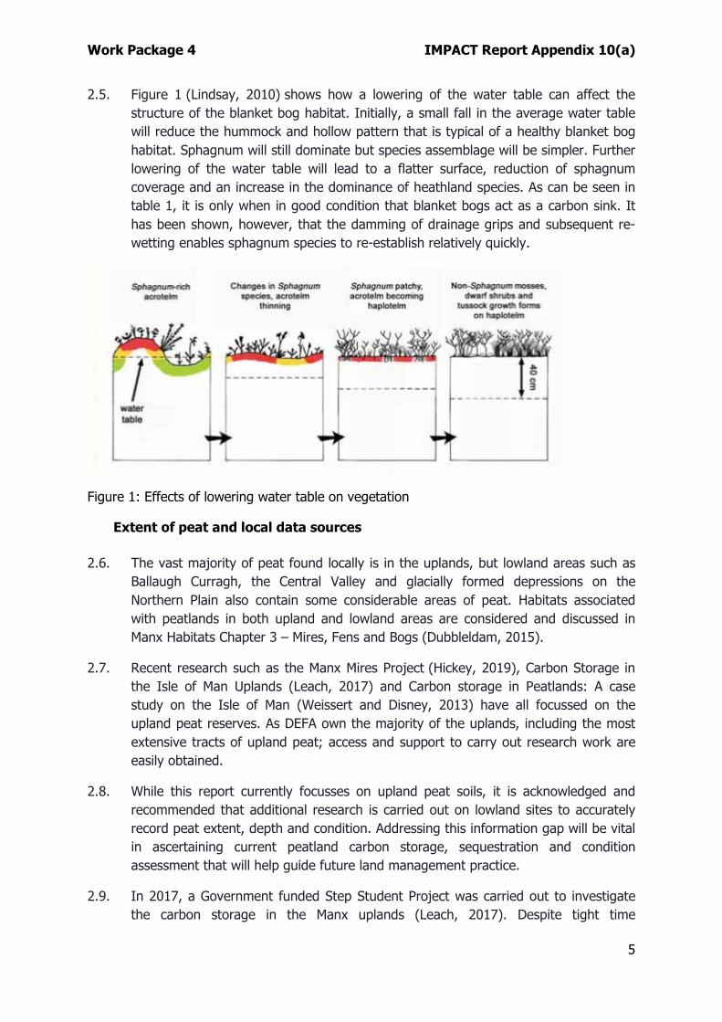
2.5. Figure 1 (Lindsay, 2010) shows how a lowering of the water table can affect the structure of the blanket bog habitat. Initially, a small fall in the average water table will reduce the hummock and hollow pattern that is typical of a healthy blanket bog habitat. Sphagnum will still dominate but species assemblage will be simpler. Further lowering of the water table will lead to a flatter surface, reduction of sphagnum coverage and an increase in the dominance of heathland species. As can be seen in table 1, it is only when in good condition that blanket bogs act as a carbon sink. It has been shown, however, that the damming of drainage grips and subsequent re-wetting enables sphagnum species to re-establish relatively quickly.
Figure 1: Effects of lowering water table on vegetation
Extent of peat and local data sources
2.6. The vast majority of peat found locally is in the uplands, but lowland areas such as Ballaugh Curragh, the Central Valley and glacially formed depressions on the Northern Plain also contain some considerable areas of peat. Habitats associated with peatlands in both upland and lowland areas are considered and discussed in Manx Habitats Chapter 3 – Mires, Fens and Bogs (Dubbleldam, 2015).
2.7. Recent research such as the Manx Mires Project (Hickey, 2019), Carbon Storage in the Isle of Man Uplands (Leach, 2017) and Carbon storage in Peatlands: A case study on the Isle of Man (Weissert and Disney, 2013) have all focussed on the upland peat reserves. As DEFA own the majority of the uplands, including the most extensive tracts of upland peat; access and support to carry out research work are easily obtained.
2.8. While this report currently focusses on upland peat soils, it is acknowledged and recommended that additional research is carried out on lowland sites to accurately record peat extent, depth and condition. Addressing this information gap will be vital in ascertaining current peatland carbon storage, sequestration and condition assessment that will help guide future land management practice.
2.9. In 2017, a Government funded Step Student Project was carried out to investigate the carbon storage in the Manx uplands (Leach, 2017). Despite tight time
Work Package 4 IMPACT Report Appendix 10(a)
6
constraints, the student who carried out the project worked closely with the DEFA Uplands Manager in an attempt to accurately assess several differing upland peat sites both south and north of the Central Valley. While only a small percentage of the total upland area was studied the site selection, small grid spacing’s for depths, and core samples along with laboratory work helped to deliver a useful report.
2.10. It is quite probable that where more accurate and detailed peatland assessment work is required the survey techniques and methods from the Step Student Project could be used as a blueprint. Further reference will be made to the methodology, results and recommendations throughout this project.
2.11. The MMP is currently underway and the MWT is assisting with additional consultancy work in terms of current and future storage and sequestration data for this report and as such their input is key to this particular document.
2.12. The Phase 1 Habitat Survey of the Isle of Man (Sayle et al., 1995) indicated that the uplands were dominated by acid grassland and heath. There was only a small amount of blanket bog vegetation identified, although other types of peat-forming habitats, such as mires and fens are found. However, (Dubbeldam, 2015) noted the Phase 1 survey is at its weakest on this suite of habitats. This assumption was likely made due to scale of the habitat concerned and the difficulties of mapping pre GPS and GIS. What is known indicates that much of the current upland habitat has been modified by drainage for agriculture, irrigation for water-driven machinery for agriculture and mining, turbary, historic fires, afforestation and grazing. It is therefore likely that peat accumulation will have been suppressed by these, mostly historic, actions. However, it is acknowledged that positive land management and a greater awareness of environmental issues, particularly over the last two decades, will be having a positive effect on our upland sites. Unfortunately, and as is often the case, positive gains in terms of positive actions can be counteracted by harmful intervention such as inappropriate land management in the uplands and marginal areas not in DEFA ownership.
2.13. The lack of certainty regarding the extent and condition of our peatlands is a primary motivation behind the current survey work and set up of the MMP.
2.14. Much of the peat that formed over the last 5000-6000 years in the Manx uplands is still present, representing a valuable store of carbon. When supporting healthy blanket bog vegetation this peatland can be a valuable carbon sink, however, when and where degraded it is more likely to be a source of carbon (Yorkshire Peat Partnership). The condition of the peat in the Isle of Man has yet to be fully assessed, although some studies have looked at several small areas (Weissert and Disney, 2013) and (Leach, 2017). However, it is likely that some areas of peatland are currently a net source of carbon emissions (Weissert and Disney, 2013).
2.15. Due to their capacity to sequester carbon and store it for a very long time, peatlands have the potential to contribute to the Isle of Man’s Climate Change Emergency Mitigation Strategy. In a degraded condition, peat can release carbon back into the
Work Package 4 IMPACT Report Appendix 10(a)
7
atmosphere as CO2, contributing to the Island’s greenhouse gas (GHG) emissions. When in good condition and actively growing the sequestration of carbon into the peat may help offset CO2 emissions. Natural and restored blanket bog habitat may, therefore, help in achieving emissions targets, whether by resulting in net sequestration of carbon or by reducing avoidable losses.
Relevant Isle of Man Legislation, Policy and Strategy
Isle of Man Wildlife Act 1990
2.16. The Wildlife Act 1990 is the means through which habitats and species receive protection in the Isle of Man. In particular, Part II – Nature Conservation, makes provision for the designation of Areas of Special Scientific Interest and National Nature Reserves, and the means to pay landowners or tenants for the conservation and positive management of areas of high conservation interest.
The Agricultural Development Scheme (ADS)
2.17. The Agricultural Development Scheme (formerly the Countryside Care Scheme) forms one of the components of the Policy for Manx Agriculture, which was approved by Tynwald in April 2008. The Scheme was approved by Tynwald in December 2008 and implemented from 1 April 2009.
Agricultural Holdings Act 1969
2.18. The Agricultural Holdings Act 1969 which replaced the Agricultural Holdings Act 1936 was introduced to give additional security to farm tenants.
Agricultural Tenancies Act 2008
2.19. An unintended consequence of the 1969 Act was that the availability of new land to let for more than one year effectively dried up and landlords reluctant to lose control of their asset started taking land back ‘in hand’. To address this perceived shortcoming in the Agricultural Holdings Act 1969, the Agricultural Tenancies Act 2008 was introduced.
The Bern Convention on Conservation of European Wildlife & Natural Habitats
2.20. The Isle of Man is a signatory to the Bern Convention and has obligations for the management and protection of our natural habitats and endangered species.
The Convention on the Conservation of Migratory Species of Wild Animals (Bonn)
2.21. The Isle of Man is a signatory of the Bonn Convention
The Isle of Man Biodiversity Strategy 2015
Work Package 4 IMPACT Report Appendix 10(a)
8
2.22. The Isle of Man Biodiversity Strategy was introduced in 2015 as the Isle of Man’s way of integrating targets from the Convention on Biological Diversity 2011 Strategy Plan for Biodiversity, including Aichi Biodiversity Targets.
The Isle of Man Forestry Act 1984
2.23. This act and its associated bye-laws provide a mechanism to protect the Forestry, Amenity and Lands Directorates estate from damaging activities. It also covers elements pertinent to this work package such as Public Turbaries and Access to Mountains.
The Heath Burning Act 2003
2.24. Under the Heath Burning Act 2003, the Department of Environment, Food and Agriculture can register heathland and control burning or destruction of registered heathland by licence. Registration of heath is undertaken in liaison with owners/occupiers and other identified interested parties.
Our Landscape, our Legacy - A Strategy for the Landscape and Amenity of the Isle of Man to 2050. Sustaining and Maximising our Natural Wealth
2.25. Our living, working landscape provides food, sustainable local fuel, pollination, climate regulation, improved air and water quality and reduced flood risk. Our lives and our health have a fundamental reliance on these services, whether we are aware of them or not, and in the Isle of Man we offer an unrivalled open space that also supports businesses in attracting employees from a worldwide market. The strategy will establish a vision for progressive and diverse management that will secure a profitable and functioning landscape that can naturally provide for current and future generations. By recognising the impact upon and benefits to the environment, the economy and the community it will co-ordinate, support and help shape existing and future policies across all of Government to allow the regulation or mitigation of flooding, climate challenges and other pressures. Through careful management to balance all of these elements we will start to maximise the benefit of the free services available without jeopardising their future sustainability.
Isle of Man Coastal Erosion and Flood Risk Management Strategy
2.26. Strategy Deliver Key Action 5 is; Low cost solutions working with nature through natural flood management measures should be adopted wherever possible as these have the potential to reduce flood risk elsewhere and can achieve biodiversity and carbon benefits as well as helping to adapt to climate change.
2.27. Contracts for Natural Flood Risk Management (NFRM) studies for the Neb, Douglas and Laxey river catchments are currently being developed. Correctly planned and implemented measures could achieve positive biodiversity and carbon storage benefits through the reinstatement or creation of natural habitat features - wetlands, woodlands, reinstatement of river features etc. which in turn act as carbon sinks.
Work Package 4 IMPACT Report Appendix 10(a)
9
The Isle of Man Strategic Plan 2016
2.28. The Isle of Man Strategic Plan contains the strategic and general policies and the planning framework for development and other land-use on the Island. Operating underneath this are various planning policy statements and a set of area plans which contain the local, specific plans for development.
The Town and Country Planning Act 1999
Key Stakeholders
2.29. Land owners and land managers
• Department of Environment , Food and Agriculture
• Manx Utilities Authority
• Manx National Heritage
• Department of Infrastructure
• Isle of Man Flockmasters Association
• Manx National Farmers Union
• Upland Sporting Tenants
• Private land owners
• Isle of Man Fire and Rescue Service (IOMFRS).
2.30. NGO’s
• Manx Birdlife
• Manx Wildlife Trust & Wildflowers of Mann
• Manx Woodland Trust
• Manx Upland Management Forum
• Manx Nature Conservation Forum
• The Manx Public.
Biodiversity
2.31. Whilst biodiversity is covered extensively within work package 5, it must be noted that both the upland and lowland peatlands on the Island provide extensive tracts of habitats for a number of notable species.
2.32. Of note and worthy of specific mention within this report is the hen harrier.
Work Package 4 IMPACT Report Appendix 10(a)
10
2.33. The Isle of Man has the highest density of breeding and wintering hen harriers Circus cyaneus in the British Isles; and is therefore the most significant location for these birds. As signatories to the Convention on the Conservation of Migratory Species of Wild Animals (Bonn) and the Convention on the Conservation of European Wildlife and Natural Habitats (Berne) the Isle of Man has an International responsibility to maintain and enhance the hen harrier population and the upland habitat required by these birds. Hen harriers are red listed on the Birds of Conservation Concern 4 (BOCC 4) because of a historical decline in the population due to persecution in other jurisdictions (Eaton et al., 2015).
Table 1: Compiled by DEFA with data from various sources (Wotton, et al., 2018), (Hayhow, et al., 2013), (Sim, et al., 2007) and (Sim et al., 2001).
Census Year 2016 2010 2004 1998 1988 Territorial pairs 30 29 57 49 44
2.34. In the Isle of Man hen harriers typically breed in heather/western gorse moorland and occasionally patches of European gorse (Sim, et al., 2007). Prime habitat is typically managed moorland, with a variety of age structures and low intensity sheep grazing; in these locations territories can be at a density of 1 per 800m2. In the Isle of Man, rats, young rabbits and hares form a significant proportion of the diet; in addition to a wide variety of bird species. The southern, central and northern hills all meet the Joint Nature Conservation Committee (JNCC) criteria for Special Protection Area designation for breeding hen harrier.
2.35. Hen harriers also utilise areas of mature heather for roosting over the winter. The peak co-ordinated count for 5 roosts in the Isle of Man in 2018/2019 was 50 and mean peak for 2013 to 2019 was 41.6 (Samson 2019, pers. comm). Five regularly used roosts meet the JNCC criteria for Special Protection Areas designation.
3. THE OPPORTUNITY Carbon Storage in Peat
3.1. Recent research in the UK has considered the value of peatlands in terms of carbon storage and sequestration. Unlike other vegetative stores of carbon, such as trees, peat can continue to accumulate over a very long timescale. Various studies have estimated the amount of carbon stored within peatlands, but accuracy has been a problem due to a lack of data on peat depth and therefore volume. It is estimated (Worrall et al., 2011) that UK peatlands store over 3200 million tonnes of carbon, which is around 20 times more than that stored in UK forests. Although it is variable, it is the richness of carbon atoms within the organic fraction of the solid matter in peat that makes it such an essential factor in terms of climate change, as the average percentage is between 50% and 53% of solid matter.
Work Package 4 IMPACT Report Appendix 10(a)
11
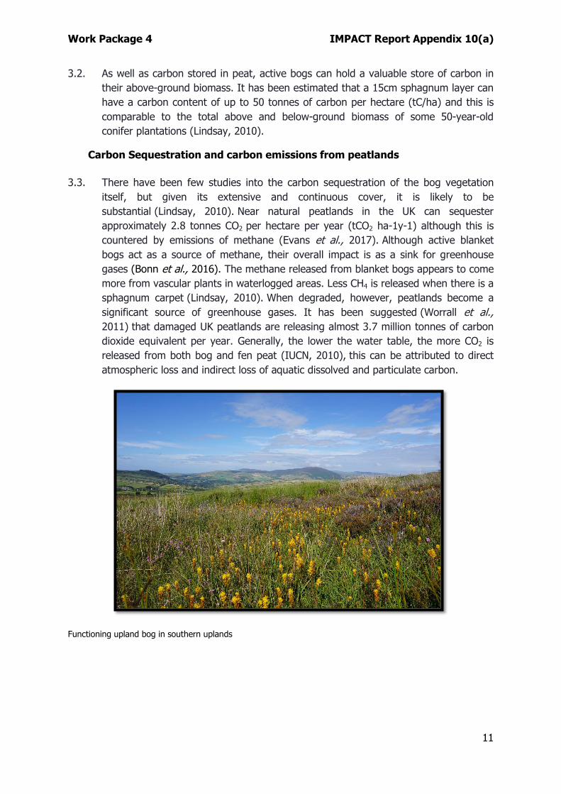
3.2. As well as carbon stored in peat, active bogs can hold a valuable store of carbon in their above-ground biomass. It has been estimated that a 15cm sphagnum layer can have a carbon content of up to 50 tonnes of carbon per hectare (tC/ha) and this is comparable to the total above and below-ground biomass of some 50-year-old conifer plantations (Lindsay, 2010).
Carbon Sequestration and carbon emissions from peatlands
3.3. There have been few studies into the carbon sequestration of the bog vegetation itself, but given its extensive and continuous cover, it is likely to be substantial (Lindsay, 2010). Near natural peatlands in the UK can sequester approximately 2.8 tonnes CO2 per hectare per year (tCO2 ha-1y-1) although this is countered by emissions of methane (Evans et al., 2017). Although active blanket bogs act as a source of methane, their overall impact is as a sink for greenhouse gases (Bonn et al., 2016). The methane released from blanket bogs appears to come more from vascular plants in waterlogged areas. Less CH4 is released when there is a sphagnum carpet (Lindsay, 2010). When degraded, however, peatlands become a significant source of greenhouse gases. It has been suggested (Worrall et al., 2011) that damaged UK peatlands are releasing almost 3.7 million tonnes of carbon dioxide equivalent per year. Generally, the lower the water table, the more CO2 is released from both bog and fen peat (IUCN, 2010), this can be attributed to direct atmospheric loss and indirect loss of aquatic dissolved and particulate carbon.
Functioning upland bog in southern uplands
Work Package 4 IMPACT Report Appendix 10(a)
12
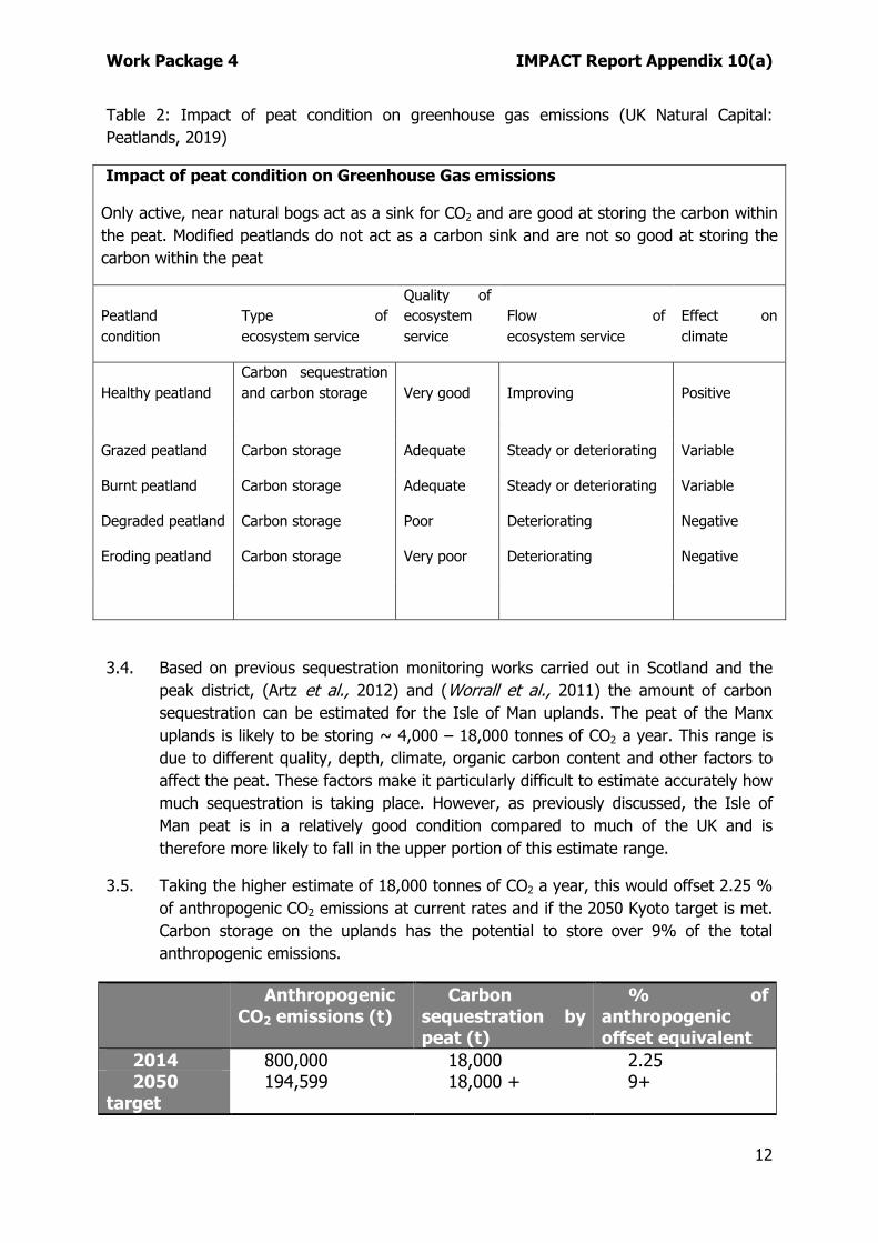
Table 2: Impact of peat condition on greenhouse gas emissions (UK Natural Capital: Peatlands, 2019)
Impact of peat condition on Greenhouse Gas emissions
Only active, near natural bogs act as a sink for CO2 and are good at storing the carbon within the peat. Modified peatlands do not act as a carbon sink and are not so good at storing the carbon within the peat
Peatland condition
Type of ecosystem service
Quality of ecosystem service
Flow of ecosystem service
Effect on climate
Healthy peatland Carbon sequestration and carbon storage Very good Improving Positive
Grazed peatland Carbon storage Adequate Steady or deteriorating Variable
Burnt peatland Carbon storage Adequate Steady or deteriorating Variable
Eroding peatland Carbon storage Very poor Deteriorating Negative
3.4. Based on previous sequestration monitoring works carried out in Scotland and the peak district, (Artz et al., 2012) and (Worrall et al., 2011) the amount of carbon sequestration can be estimated for the Isle of Man uplands. The peat of the Manx uplands is likely to be storing ~ 4,000 – 18,000 tonnes of CO2 a year. This range is due to different quality, depth, climate, organic carbon content and other factors to affect the peat. These factors make it particularly difficult to estimate accurately how much sequestration is taking place. However, as previously discussed, the Isle of Man peat is in a relatively good condition compared to much of the UK and is therefore more likely to fall in the upper portion of this estimate range.
3.5. Taking the higher estimate of 18,000 tonnes of CO2 a year, this would offset 2.25 % of anthropogenic CO2 emissions at current rates and if the 2050 Kyoto target is met. Carbon storage on the uplands has the potential to store over 9% of the total anthropogenic emissions.
Anthropogenic CO2 emissions (t)
Carbon sequestration by peat (t)
% of anthropogenic offset equivalent
2014 800,000 18,000 2.25 2050
target 194,599 18,000 + 9+
Work Package 4 IMPACT Report Appendix 10(a)
13
Table 3: Potential sequestration of peat on the Isle of Man and its impact on offsetting anthropogenic CO2 release (Leach, 2017)
3.6. These sequestration estimates for the Manx peatlands are not an accurate measure due to the difficulties and variability in peat. Further detailed research on the topic would be required to calculate a more precise value but Table 2 still illustrates that the uplands have the potential to have a significant impact on the carbon balance, particularly if further restoration and improvements are made in the future.
4. CURRENT AND ONGOING SURVEY WORK Manx Mires Partnership
4.1. A grant from Manx National Heritage has enabled an initial pilot and determination of condition assessment methodology, build evidence on the typology of Manx mire habitats and allow some knowledge exchange with other upland peat restoration projects. Additional funding will be required to survey outlying areas of peat such as the lowland sites previously mentioned. The information contained within this section of the document was provided by the MMP. The author of this document has added additional notes where appropriate.
Survey Method
4.2. Peat depth has been measured throughout upland areas using a 0.01 m diameter earth rod to the depth of contact with the mineral surface. To reduce inaccuracies from solid objects within the peat layer, 3 depth measurements were taken approximately 1 m apart at each sample location. The mean average of these is then used (Lindsay, 2010).
4.3. A grid pattern of depth measurements are taken at distances of approximately 150 m. Distances may vary depending on the accessibility of the ground and whether there is a noticeable change in the topography or vegetation. In the latter case, depth measurements may be closer together than 150 m. Up to September 2019, a total of 700 depth measurements have been recorded. While this survey pattern will give a general picture of peat coverage and depth, a higher resolution survey will be needed for key areas that could be suitable for restoration work.
Limitations
4.4. This methodology has limitations for accurately estimating the depth of peat cover, as depth can vary considerably over short distances. It is, however, the most widely used method, due to the current lack of other viable methods.
Work Package 4 IMPACT Report Appendix 10(a)
14
Alternative methods
4.5. Ground-penetrating radar can be used but is costly and challenging to use on some peatland terrain. Assessments of peat depth based on habitat type are also likely to prove inaccurate. Some current habitats have been modified through historical drainage for agriculture and past fire events, and therefore do not indicate the original peat-forming habitats. Also, peat extracted for fuel has resulted in areas where the peat is shallow, despite supporting a peat-forming habitat. It is believed that even shallow peat deposits were exploited in the past not just for fuel, but also for roofing material and animal bedding.
4.6. The Isle of Man Government possesses all Island LIDAR data captured in recent years. LIDAR, which stands for Light Detection and Ranging, is a remote sensing method that uses light in the form of a pulsed laser to measure ranges (variable distances) to the Earth. LIDAR data is used in conjunction with GIS mapping software and can be useful in highlighting otherwise hard to detect ground features such as upland drains. However, the LIDAR data owned by the Government proved hard to package for network use by employees. It can also be complicated to extract the relevant detail by inexperienced users.
4.7. As yet, LIDAR data has not been utilised fully to assess upland features and expert external assistance will likely be required to fully exploit the available information.
Work Package 4 IMPACT Report Appendix 10(a)
15
Results
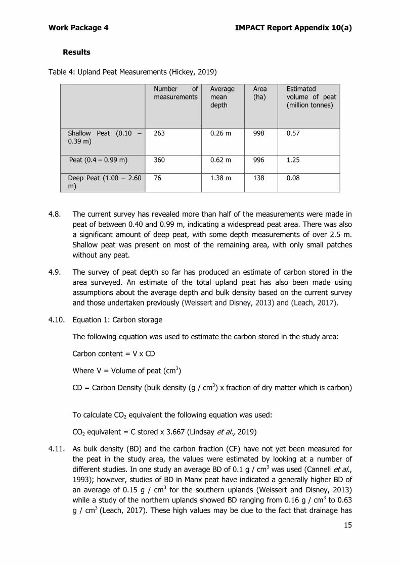
Table 4: Upland Peat Measurements (Hickey, 2019)
Number of measurements
Average mean depth
Area (ha)
Estimated volume of peat (million tonnes)
Shallow Peat (0.10 – 0.39 m)
263 0.26 m 998 0.57
Peat (0.4 – 0.99 m) 360 0.62 m 996 1.25
Deep Peat (1.00 – 2.60 m)
76 1.38 m 138 0.08
4.8. The current survey has revealed more than half of the measurements were made in peat of between 0.40 and 0.99 m, indicating a widespread peat area. There was also a significant amount of deep peat, with some depth measurements of over 2.5 m. Shallow peat was present on most of the remaining area, with only small patches without any peat.
4.9. The survey of peat depth so far has produced an estimate of carbon stored in the area surveyed. An estimate of the total upland peat has also been made using assumptions about the average depth and bulk density based on the current survey and those undertaken previously (Weissert and Disney, 2013) and (Leach, 2017).
4.10. Equation 1: Carbon storage
The following equation was used to estimate the carbon stored in the study area:
Carbon content = V x CD
Where V = Volume of peat (cm3)
CD = Carbon Density (bulk density (g / cm3) x fraction of dry matter which is carbon)
To calculate CO2 equivalent the following equation was used:
CO2 equivalent = C stored x 3.667 (Lindsay et al., 2019)
4.11. As bulk density (BD) and the carbon fraction (CF) have not yet been measured for the peat in the study area, the values were estimated by looking at a number of different studies. In one study an average BD of 0.1 g / cm3 was used (Cannell et al., 1993); however, studies of BD in Manx peat have indicated a generally higher BD of an average of 0.15 g / cm3 for the southern uplands (Weissert and Disney, 2013) while a study of the northern uplands showed BD ranging from 0.16 g / cm3 to 0.63 g / cm3 (Leach, 2017). These high values may be due to the fact that drainage has
Work Package 4 IMPACT Report Appendix 10(a)
16
resulted in the peat being drier than it would be in a natural state. For this study a BD of 0.2 g / cm3 was assumed, as it is close to the average of 0.15g / cm3 for the southern uplands but takes into account the higher densities found in the northern uplands. A more accurate estimate can be made once bulk density has been measured for a larger number of sites throughout the uplands.
The differences in t C/ha shown in Table 5 can be accounted for by the different average depth of peat in different study areas and differences in bulk density.
Table 5: Comparison of tonnes of carbon per hectare estimated from different studies
Study Hickey, 2018 Leach, 2017 Weissert & Disney, 2011
Hickey, 2019
t C/ha 660 580 136 570
Table 6: Carbon stored in area studied to date (Sept 2019)
Area (ha) Mean Average Depth (m)
Tonnes of Carbon per hectare
Carbon Stored (million tonnes)
CO2 Equivalent (million tonnes)
2132 0.57 570 1.22 4.45
Table 7: Potential carbon stored in the area still to be measured
Area (ha) Mean Average Depth (m)
Tonnes of Carbon per hectare
Carbon Stored (million tonnes)
CO2 Equivalent (million tonnes)
8142 0.57 570 4.64 17.02
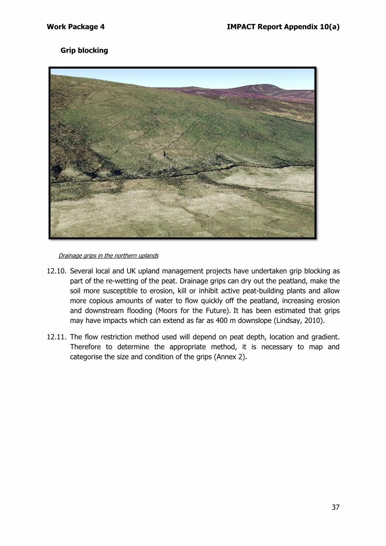
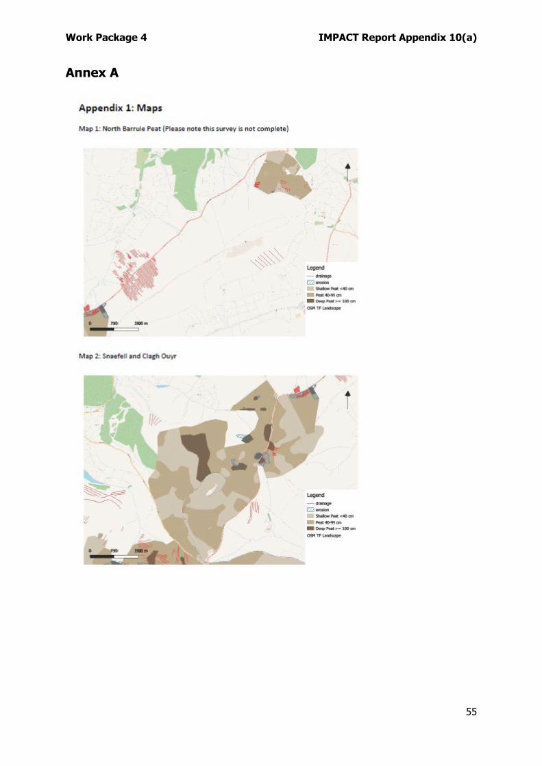
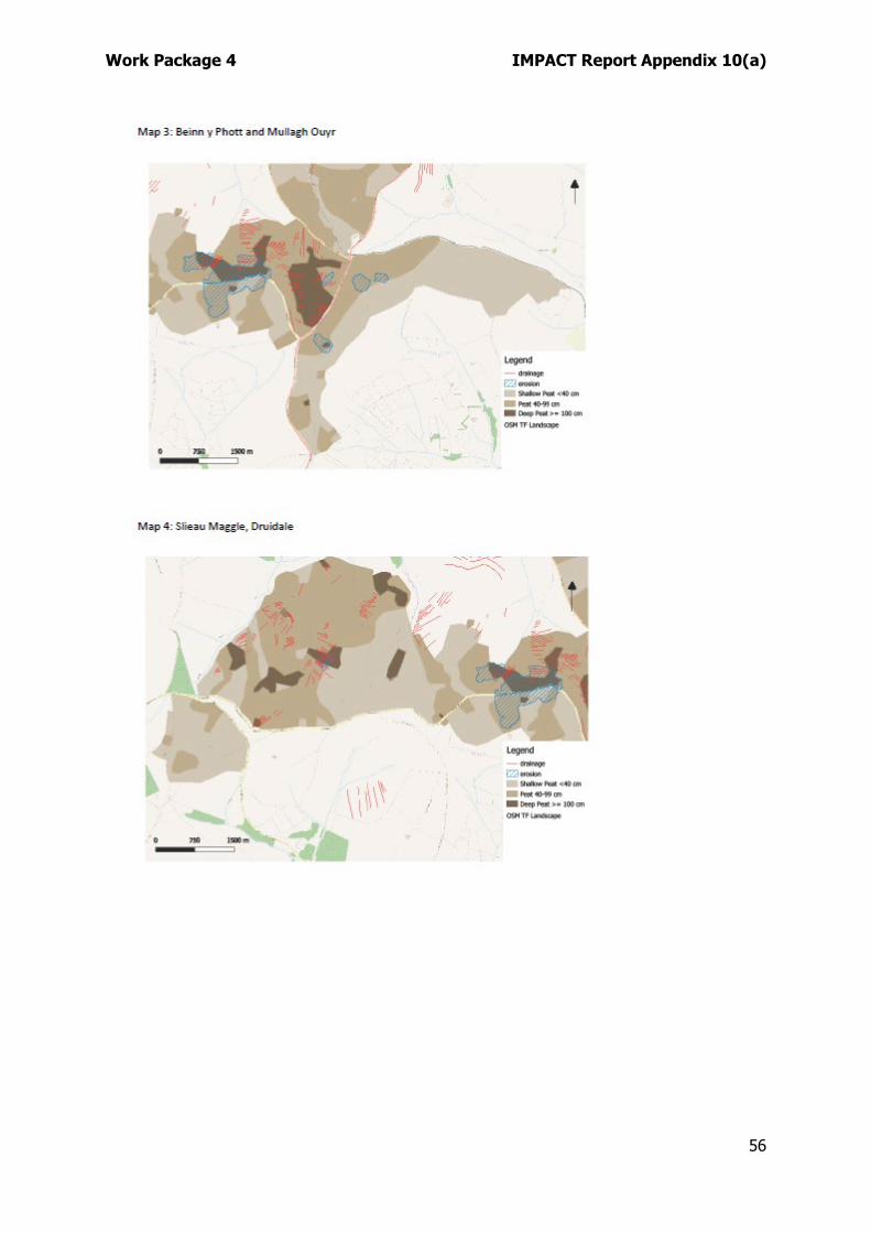
Maps showing the surveyed areas of peat according to depth category can be found in the Annex. These also indicate known areas of erosion and grips.
Peat depth
4.12. Peat depth sampling over the study area showed that the area was covered in a layer of peat, as defined in the table above, and can therefore, be described as a peatland. Occasional small areas had peat less than 10 cm, and these were associated with rocky outcrops or localised erosion. Studies across the UK use different parameters for designating peatland by the depth of peat. In England and Wales, a depth of 40 cm is deemed to be peatland, although when considering carbon storage in the Isle of Man, a depth of between 10 to 40 cm will be taken into account and described as shallow peat. According to (Lindsay et al., 2019) a peat soil
Work Package 4 IMPACT Report Appendix 10(a)
17
only 30 cm deep almost certainly contains more carbon than the combined biomass and soil carbon contained within an equivalent area of tropical rainforest. Anything deeper than 100 cm is considered deep peat.
4.13. The depth of peat already studied locally is highly variable, with pockets of deep peat
close to shallow peat. This may be due to the underlying topography as well as peat degradation from various land-use practices.
Condition
4.14. A detailed condition survey has not yet been undertaken as part of the MMP. Both (Leach, 2017) and (Weissert and Disney, 2013) incorporated some vegetation analysis into their investigations but these were restricted in area. The ecosystem could be assessed for health via its vegetation (e.g. sphagnum as mentioned above) assemblage, and other elements such as invertebrates and bird assemblages. The focus initially would be based on physical parameters such as hydrology (water levels and drainage) together with observed degradation such as erosion. This can be matched with a vegetation survey for plants and mosses to help indicate the state of the ecosystem.
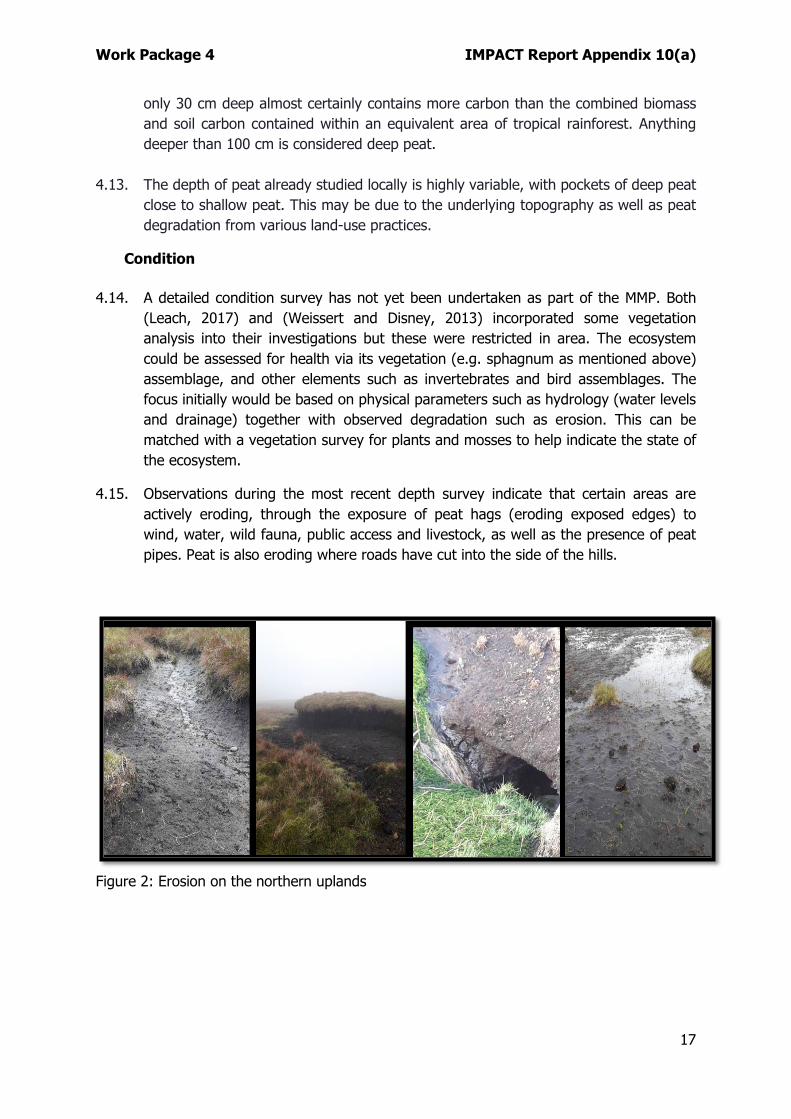
4.15. Observations during the most recent depth survey indicate that certain areas are actively eroding, through the exposure of peat hags (eroding exposed edges) to wind, water, wild fauna, public access and livestock, as well as the presence of peat pipes. Peat is also eroding where roads have cut into the side of the hills.
Figure 2: Erosion on the northern uplands
Work Package 4 IMPACT Report Appendix 10(a)
18
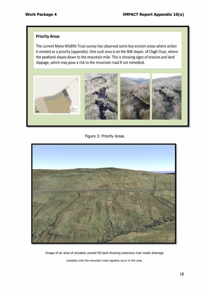
Figure 3: Priority Areas
Image of an area of privately owned hill land showing extensive man made drainage
Landslips onto the mountain road regularly occur in this area.
Work Package 4 IMPACT Report Appendix 10(a)
19
Habitat
4.16. A habitat survey of the Isle of Man was completed in 1995 (Sayle et al., 1995), but a more detailed and up to date survey is required to highlight areas of habitat which are likely to be currently forming peat. A brief study of an area in the Sulby catchment showed an area of blanket bog that was not indicated by the Phase 1 survey. Conversely, some areas classed as blanket bog in 1995 no longer appear to support that habitat. In order to guide and drive any restoration projects it will be necessary to establish what constitutes good blanket bog habitat in the Isle of Man and use this information to survey key areas in detail.
4.17. It is clear that there is considerable potential for mires and blanket bog in the Manx uplands. The best option is to confirm via survey and examine condition to inform management and policy better. Habitats and their connectivity are explored in more detail in work package 5.
Uncertainties
4.18. The bulk density and carbon content of peat in the area surveyed by the MMP have not yet been measured so an estimate was made based on other studies (Weissert and Disney, 2013) and (Leach, 2017). Previous studies have only looked at a few small areas, so to give a more accurate picture of the carbon stored within the peat, these factors would need to be measured at a number of locations.
4.19. Depth sampling was in general done at approximately 150 m intervals, which is not as frequent as other studies in the Isle of Man (Weissert and Disney, 2013), which used 50 m intervals, while 100 m intervals are commonly used in UK surveys. The intervals used in this study were decided upon due to time constraints and further higher resolution depth sampling of key areas can be done at a later date. The current survey has found that peat depth can vary greatly over distances of less than 10 m, so while the current survey will give a general picture of the peat cover, more detailed sampling will be needed to assess the condition of the peat in areas to be restored.
4.20. Mean peat depth was 0.57 m but depth sampling showed a wide range of depths over a relatively short distance. Pockets of deep peat lay between shallower peat with an overall range of depths between 0.05 m and 2.60 m. While there will always been some uncertainty as to the volume of peat cover, further depth measurements should help to reduce this uncertainty.
4.21. This means a peat depth of 0.57 m was used to estimate the peat coverage in the areas not yet studied. It is likely, however, that the average depth of the uplands as a whole will be less than this and therefore carbon volume will be lower. The southern hills, for example, have been found to generally be covered in shallow peat (Weissert and Disney, 2013).
4.22. Previous studies in the Isle of Man (Weissert and Disney, 2013) and (Leach, 2017) have used quadrats and photographs to assess percentage cover of sphagnum and
Work Package 4 IMPACT Report Appendix 10(a)
20
noted a positive correlation with peat depth in the southern hills, however, no correlation was found (Leach, 2017) in a study of 4 of sites in the northern uplands. Yet, sphagnum cover could be associated with peat firming habitat irrespective of depth.
4.23. Current survey work, including a citizen science aspect, could be made more accurate and efficient if a bespoke mobile ‘app’ was developed.
5. CONSIDERATION OF ONSHORE RENEWABLE ENERGY GENERATION
5.1. In order to reach the ambitious 2050 net-zero target, renewable energy generation will be an essential element of the Island’s future. However, the benefits of wind farms and solar arrays need to be well planned to avoid any unnecessary loss of stored carbon during construction. Any such developments will need to take into account the impact on the peat and wildlife (Wang, Impacts of wind energy on environment) at a local scale, as well as considering the overall effect globally (Smith, 2016) and (Schuster et al., 2015).
5.2. Excavated roads to service wind farms can have a significant impact on peat, potentially affecting the hydrology of the site, thereby modifying peat, and or the ecological processes within the wetland complex. Locally they can also impact water quality and wetland conditions due to the material used for the construction of foundations, roads and other infrastructure (Lindsay, 2010).
5.3. The risk of peat landslides must also be taken into consideration when choosing suitable sites (Lindsay and Bragg, 2005).
5.4. The carbon cost of developing wind farms on peat can be estimated (Nayak et al., 2008). It has been suggested that careful consideration be given before developing wind farms on peat due to the resulting CO2 emissions and that development should not occur on non-degraded peat (Smith et al., 2012).
5.5. As well as having an impact on emissions, future wind farm developments may affect bird populations either through disturbance or displacement during construction and operation and the possibility of direct turbine strikes. All such, considerations will be analysed during the planning process of individual developments.
5.6. The Manx uplands are home to several bird species of conservation concern including IUCN red-listed species such as curlew, hen harrier, merlin, skylark and grasshopper warbler. Other upland breeding species of note include peregrine falcon, red grouse, short-eared owl and kestrel. The Island was naturally colonised by the common buzzard during the last decade and are now a relatively common sight.
5.7. At a local level, the Manx Electricity Authority explored onshore renewable options back in the early 2000s. A site in the Southern Upland’s known as Snuff the Wind (Cross Vein) was investigated as the upland site of best potential. However, it appears that the project faltered and was ultimately abandoned. Amongst other
Work Package 4 IMPACT Report Appendix 10(a)
21
factors, the presence of breeding hen harriers was considered as significant constraint to siting an array in this area.
5.8. Onshore renewable energy generation is covered in detail within work package 32.
6. WOODLAND ESTABLISHMENT AND HABITAT CONNECTIVITY
6.1. The establishment of native woodland in suitable upland sites provides an additional opportunity to increase CO2 sequestration. Planting on deep peat should be avoided as it is unlikely to be successful and will inhibit functioning bog habitats.
6.2. To maximise opportunities and to deliver multiple benefits, new woodland site selection will be crucial and guided by the ongoing opportunity and constraints mapping exercise referred to in work package 5. In an upland context, planting should focus on extending habitat connectivity between lowland and upland riparian zones and sheltered gullies. There are significant opportunities to create such habitat corridors but they will require careful planning and livestock exclusion via fencing. Well planned and executed woodland establishment will also help in terms of natural flood risk management.
6.3. DEFA upland leases allow for tree planting via clauses originally intended for upland afforestation. However, an agreement between landlord and tenant is required to reduce stocking densities as required. This subject is covered in more detail within work package 5.
7. CURRENT LAND USE, MANAGEMENT AND SERVICES Agriculture
7.1. The uplands we see today, whilst wild in appearance, have been shaped by the actions of man over thousands of years. This ‘cultural landscape’ consists of an intricate mix of terrestrial habitats including heath, blanket bog, woodland, acid grasslands and watercourses.
7.2. People continue to raise livestock in the uplands, and in so doing, have created the modern upland landscape. Hill farming has evolved over the last several hundred years with increases in stock, typically characterised by more sheep and fewer cattle the trend until recent years. Changes to farming practices have primarily been driven by post-war support to produce food, but more recently the Agricultural Development Scheme (ADS), which allows farmers to diversify from production, has resulted in a reduction in sheep numbers.
7.3. The hill flock performs an important role in producing replacements cross-bred lambs for lowland flocks. However, the majority of lamb carcasses produced from the hill are small (i.e. light lambs) for which there is a limited local market. These animals could be viewed as a by-product of good upland management. The current economic climate makes these lambs suited to export markets or for live export to UK abattoirs. Our farmers, as elsewhere, are constrained by policy and market forces.
Work Package 4 IMPACT Report Appendix 10(a)
22
However, the Island has in recent decades had a lower grazing density than our UK counterparts and this is borne out by our hills favourable condition (Manx Uplands Steering Group, 2013) and ability to support bird species of high conservation value.
7.4. Upland farming is not profitable without subsidy. The move from headage payments to single farm payment under the Agricultural Development Scheme (formerly known as the Countryside Care Scheme) in 2008 led to a period of uncertainty for all farmers. However, the move to a flat rate area payment has led to a period of relative stability where farm incomes are stable, as incomes, independent of the market, are assured. Any kind of hard, or no-deal Brexit that restricts trade will have a disproportionate impact on sheep farmers and may influence future stocking and management of hill land.
7.5. There are distinct areas of localised peatland erosion that have either occurred naturally or through human intervention such as peat extraction or vehicle damage. Such areas can be further eroded and degraded by stock-poaching.
7.6. Additionally, a study (Worrall and Clay, 2012) has shown that reduced vegetation on sheep tracks leads to an increase in runoff and transport of DOC. Grazing can increase the amount of carbon released into the atmosphere as plant matter is transformed into dung and urine which are readily decomposed, rather than being incorporated into the peat. However, it is accepted that livestock dung can help to increase insect abundance, which in turn helps to support birdlife.
7.7. The effects of sheep trampling has been considered in terms of CO2 flux (Clay and Worrall, 2013). It has been found that trampling does significantly affect CO2 exchange in peat, but that cessation of trampling allows recovery in a relatively short space of time. The difference between the presence and absence of trampling was more significant in terms of CO2 flux than the intensity of the trampling, although this did have some impact.
7.8. A confidential draft Agricultural Strategy 2019-29 Isle of Man High level principles will shortly be presented to Tynwald (Agricultural Strategy 2019-2029).
7.9. Key Objectives: which are all of significant importance:
• The Environment – Providing support for targeted initiatives that produce conserved and cherished landscapes, enhance biodiversity, sequester carbon and, and improve water quality, reduce flood risk and address the land management components of the imminent Climate Change Action Plan.
• Supporting Active Farmers – Ensuring that financial support is targeted at businesses producing food, protecting the environment and catchment and landscape management.
• Productivity – supporting marketing, efficiency, knowledge, benchmarking and advice to sustainably improve farm profitability and secure the long-term viability of the industry, post BREXIT.
Work Package 4 IMPACT Report Appendix 10(a)
23
• Investment – increasing investment through capital grants, business confidence and profitability.
7.10. The draft strategy also states: ‘In addition to this strategy, delivering productive agriculture there is a strong commitment on delivering biodiversity, climate change mitigation, catchment management and Biosphere objectives, which are core objectives of the wider Department and Government’
7.11. The strategy builds on existing agricultural and environmental policies such as:
• GD 2014/0042 Isle of Man Food Security Strategy
• GD 2014/0076 Food Matters – A Food Business Development Strategy, 2015-2025
• GD_2016/0027 Our Landscape Our Legacy
• GD_2015/0049 Managing our Natural Wealth, The Isle of Man’s First Biodiversity Strategy
7.12. The strategy brings the wider environment and climate change mitigation to the forefront in terms of support levels and in an upland context, stewardship payments will be associated with positive and appropriate habitat management. It should be remembered that certain peatland restoration works require specialist knowledge and experience and will likely require additional funding outside of the Agriculture Strategy. However, the draft strategy is positive, particularly in recognising the importance of carbon sequestration and storage.
Agricultural Holdings Act 1969
7.13. The Agricultural Holdings Act 1969 which replaced the Agricultural Holdings Act 1936 was introduced to give additional security to farm tenants. Legislation similar to the 1969 Act also exists in England, however it had two subtle differences:
• Manx legislation allowed the Tenancy to be passed on limitless times, whereas in England the right to succeed was limited to three generations (existing tenant plus two successions)
• Manx legislation allowed the Tenancy to be passed on to spouse, children and grandchildren in England succession was limited to direct descendants (spouse or children).
7.14. An unintended consequence of the 1969 Act was that the availability of new land to let for more than one year effectively dried up and landlords reluctant to lose control of their asset started taking land back ‘in hand’. To address this perceived shortcoming in the Agricultural Holdings Act 1969, the Agricultural Tenancies Act 2008 was introduced. This allowed the creation of short term tenancies and whilst it mirrored changes in other jurisdictions was seen as quite radical by some sections of the farming community. Time has proved that the Act was an appropriate change
and land previously managed on behalf of land owners has become available to new Tenants. However the 2008 Tenancies Act had no effect on agreements made under the 1969 legislation; therefore the rights of tenancy succession for perpetuity still exists for tenancies made the 1969 Act and will continue to do so without changes being made to that legislation.
7.15. The Department carried out a consultation process in 2018 (44) to gauge interest in regards of introducing a sunset clause to the 1969 Act. However, the majority of respondents were active tenants and they were largely opposed to change.
Shooting leases (applicable to DEFA upland holdings)
7.16. Whilst not a significant economic influence on the uplands, land management associated with non-commercial upland game shooting has had a role in shaping the ecology and landscape of the hills. Since the mid-1980’s a small number of shooting tenants has attempted to preserve a sustainable population of red grouse through improved heather management and limited corvid control. Heather management (discussed in more detail below) when carried out correctly and in a prescribed manner, can enhance the quality and variety of habitats by rejuvenating old heather stands and creating a mosaic of different age classes. However, it should be noted that future land management techniques will require modification should woodland establishment, on or near to, be made possible by the removal or exclusion of livestock.
7.17. In 1994 those with an interest in red grouse as a quarry species instigated a self-imposed moratorium on taking red grouse due to a continued population decline and this remains the case today. However, a small number of tenants remain dedicated to enhancing upland habitats, but the current situation with the shooting tenancies is unsustainable as grouse numbers are currently deficient and few people are prepared to embark on the labour intensive work required.
7.18. Despite the moderate levels of positive hill management and lack of commercial activity for grouse, there is some opposition to these practices in the Isle of Man, where inaccurate comparisons to UK commercial grouse estates and raptor persecution are made.
Access and Recreation
7.19. Much of the 11,500 ha DEFA estate is open to public ramblage (approx. 8,100Ha), and over 90km of footpaths and rights of way (25% of all Manx footpaths) occur in the 'uplands' above 200 m. No firm figures currently exist for the usage of the uplands for recreation activities, but conservative estimates of visitors to the DEFA estate are well over 0.5million per annum. Some upland public access via Public Rights of Way also exists in areas not managed by DEFA. Two recent STEP student projects have focussed on public access, use and expectations of visitors to the National Glens (2018) and Forest & Plantations (2019). It is hoped that a similar exercise can be carried out in 2020 covering the upland estate.
Work Package 4 IMPACT Report Appendix 10(a)
25
7.20. The uplands also contain a number of historic highways known locally as Green Lanes which include a number of Unclassified Roads, Byeways and Greenway Roads. A Green Lane is defined as an unsurfaced road through the countryside for pedestrians, 4x4 vehicles, motorcycles, mountain bikes and horses. Some Green Lanes are classified in law as 'Greenway Roads' which have weight restrictions of 500 kg. Permits may be obtained to take heavier vehicles such as 4x4's onto these roads.
7.21. Localised erosion of upland peat soils is often associated with recreational access and is not just restricted to vehicle use. The summit path on Snaefell shows signs of significant localised erosion in deep peat areas. This erosion is mostly down to a combination of regular pedestrian use, lack of appropriate maintenance and water ingress. There are other well-used pedestrian routes where erosion is an issue, but not to the extent of Snaefell. Boardwalks are used in some areas to traverse bogs, but some of these are now in need of repair.
7.22. A report titled ‘Extent of Ecological Impact from Use of Paths in the Unenclosed Uplands of the Isle of Man’ (Dubbeldam, 2015) was prepared by the Wildflowers of Mann Project on behalf of the Department of Infrastructure (DOI) which has statutory responsibility for the maintenance and management of highways.
7.23. 114.5 km of public footpath, greenway, byway and established trails were surveyed in the unenclosed upland moorlands of the Isle of Man in the summer and autumn of 2014. Ninety-two random point samples were also taken along this network.
7.24. The survey revealed that the path and track network directly impacts upon 60 ha of moorland habitat, of which two-thirds have 'unnecessary damage' caused by path widening and misuse, leading to a loss of approximately 60,000 m3 of peat (including historical loss from the original path construction and use). Half of this area is now in a state of recovery and half continues to degrade.
7.25. Much of the ongoing degradation is on regularly used non-statutory trails used by motorised recreational vehicles. The charts below focus on the three main path track types and indicate condition during the 2015 survey period.
Fig 4: (Dubbeldam, 2015)
7.26. The Wildflowers of Mann report concluded with the following, with some of the recommendations already actioned successfully: ‘People visiting the uplands, especially on foot, are often shocked at the condition of the paths and damage caused by the various recreation uses. While the visual condition may be classed in parts as ‘eyesore’ and as a walking surface it is so poor that horse users no longer
Work Package 4 IMPACT Report Appendix 10(a)
26
regularly use the greenways, the ecological condition is not as bleak as many would intuitively think.
Three-quarters of the Island’s paths are in a good or recovering condition, though the recovering paths may well take many decades for the moorland vegetation to recover fully. Much of the recovery has happened in the past ten years following several decades of rapidly worsening conditions’.
‘The remaining poor condition paths will be more difficult to bring into a recovering condition because the poor condition footpaths would need an additional effort of wardening and signage to prevent inappropriate use and the illicit motocross trails are often on private land, and some use may well be perfectly legal. There are however still areas of Government land where the intelligent placement of timber rails and respectful signage (as has occurred on the Michael Hills) will help prevent much of the antisocial behaviour. Timber rails alongside greenways on private land would also help stop access to illicit trails and off-piste riding, though repeated vandalism is likely to make this a particularly difficult task’.
‘The levels of damage and erosion are not a serious ecological problem when put into the context of the whole of the uplands, though they are still mostly avoidable through good management’.
7.27. Significant localised peat erosion in the uplands is associated with vehicular access. Whilst some of the Green Lanes are armoured with locally sourced stone some are not and erosion is common and dispersed over a wide area. In some cases, erosion occurs parallel to the actual highway and is referred to as double-tracking. This can happen when the legal highway becomes hard to traverse due to a lack of maintenance as riders and drivers are forced onto the surrounding hill land. This was actually more common in the past as targeted repairs are now recommended regularly by a stakeholder group called the Green Lane User Group (GLUG).
7.28. Most Green Lane repairs are carried out by the Department of Infrastructure’s Highways Division (DOI); however, several successful joint projects between DOI, DEFA and GLUG members have also taken place. The most notable and beneficial recent project was the restoration of the original legal route on Slieau Managh where divergence had led to significant erosion.
7.29. Sometimes double-tracking occurs in areas where the riders deem the legal route to be ‘too easy’, and they choose to ride on the open hill land instead. Such use is illegal and contravenes Highways and Forestry Legislation. This activity has reduced in recent years partly due to better education facilitated by GLUG, but also due to the successful prosecution of offenders. DEFA employ one fulltime Countryside Ranger to help enforce bye-laws on the estate, and additional support is provided as required by the Uplands Ranger.
Work Package 4 IMPACT Report Appendix 10(a)
27
One of the many advisory signs erected by DEFA staff on the upland estate
7.30. Prior to DEFA employing bye-law enforcement staff, off-piste motorcycling was widespread, and many upland areas were damaged by such activity. This is now far less common, but it does still occur, and it is a particular problem during TT fortnight.
7.31. Under the Forestry Act 1984 cycling and horse riding are not permitted in the uplands other than on Green Lanes. There are exceptions to this where areas are explicitly laid out for the purpose such as the cycle path on the flanks of Cronk Ny Arrey Laa and the Cronk Breck Bridle-Path. Mountain biking across open heathland is known to take place causing some localised erosion, although to date no one has been prosecuted. The suggestion of adopting an open access policy for cycling similar to that in Scotland may be the subject of a future debate.
Turbary
7.32. Turbary-cutting peat for fuel was a common practice historically. The Forestry Act 1984 allows for the provision of a public turbary (an area where peat can be cut by hand and removed for domestic fuel). The Department still maintains and licences
Work Package 4 IMPACT Report Appendix 10(a)
28
one small turbary but has significantly increased the licence fee in recent years in recognition of the value of the peatland resource. Rather than removing access to a public turbary altogether it was decided to increase the annual licence fee from £15 to £150. This reduced the number of applications dramatically, and indeed no licences were applied for or granted in 2019.
7.33. Earlier this year the Chief Minister announced a Climate Change Bill and amongst the action points in his announcement was a pledge to ban peat cutting within months. Legal advice has been sought to progress this action.
The Beinn-y-Phott Turbary showing degradation and erosion
8. HEATHER MANAGEMENT Burning
8.1. Land managers practise heather management for numerous reasons. Judicious and appropriate burning within a long-term programme can benefit accessibility and improve food value for grazing animals. It can offer a more diverse and sustaining habitat for grouse and other wildlife. It increases the frequency of the natural cycle of heath regeneration, creating variation in an otherwise uniform habitat.
8.2. Also, burning removes the build-up of combustible material and can provide firebreaks, thus providing a degree of protection against widespread damage through wildfire. Burning helps maintain the fabric and landscape heritage of our uplands when carried out in accordance with the Heath Burning Code.
8.3. Burning is not without risk as ill-considered burning can be counter-productive, destroying valuable grazing, plants, animals and birds. It can alter the physical structure, the chemical composition and even the hydrology of the soil and mar the appearance of the landscape. Very hot and deep-seated fires can enter the peat layer, thus releasing vast amounts of stored carbon. Such fires can also continue to
Work Package 4 IMPACT Report Appendix 10(a)
29
burn uncontrollably for a very long time as peat is consumed subsurface, resulting in irreversible damage to the habitat/ecosystem. Fires can be dangerous to those carrying out the burn, to adjacent property and others, if not managed correctly and responsibly.
8.4. Historically shepherds would choose to light large fires that would clear significant areas of heather in one long-lasting burn. Whereas those whose intention it was to burn to improve habitat for wildlife would choose to burn small patches rarely wider than 30 m, but they would burn multiple strips spread across a wider area over a sustained period. The latter method is the preferred method endorsed by land managers and conservationists from on and off-Island.
8.5. The Heath Burning Act 2003 was intended to provide a mechanism to register and protect areas of heathland. Whilst there was consternation in respects to increased bureaucracy, the Act has transformed burning activities. To burn registered heath, the land manager must apply for and attain a licence to do so from the Agriculture and Lands Directorate (ALD) formerly the Forestry, Amenity and Lands Directorate (FALD).
8.6. Licence holders must adhere to standard conditions contained within the licences as well as any special conditions imposed, and this may include site-specific detail such as no burning zones. All activities are to be carried out by following the Heath Burning Code, and this code gives clear and practical guidance to those carrying out burning.
8.7. It must be noted that the majority of burning is carried out on dry heath where deep peat is rarely present. The Code states that burning should not be carried out on blanket bog. The ALD have long supported appropriate and well-planned burning of Registered Heath as experience has shown it to be widely beneficial in terms of delivering multiple benefits. Appropriate burning means, burning in a manner where
Work Package 4 IMPACT Report Appendix 10(a)
30
the mosses and the litter layer remain (albeit charred) after burning and this technique is referred to as a cool burn. Such burns recover quickly, but they significantly reduce the above-ground fuel load of the area. The adoption of smaller multiple burns spread across the area also provides numerous firebreaks that can be utilised during prescribed burning, but they also help greatly in the event of unplanned fires.
8.8. Prescribed burning on the Island is not carried out to the same or even similar extent or frequency as on driven grouse moors in the UK. Whilst no specific local research has been carried out; it is highly unlikely that any significant area of heathland on the Island has been intentionally managed on anything less than a 20-year re-burn cycle.
8.9. Whilst heather burning is unpopular in some quarters (not least with those opposed to driven grouse shooting in the UK) practical land managers with intimate local knowledge, access to low ground pressure vehicles and experience of controlling fires are often relied upon to assist emergency services during unplanned and wildfire incidents.
8.10. The survey work being carried out by the MMP will be utilised to incorporate additional no-burn zones where heath is present on deep peat.
8.11. Current research as to the impact of burning is inconclusive. One study (Marrs et al., 2019) looked at carbon accumulation rates on peat moorland that were managed with fire. They found that while fire does slow down the accumulation rate of peat, which is more significant with a greater burning frequency, it does not stop the growth of peat. They concluded that this type of management can mitigate wildfire risk as well as providing a habitat for a variety of species.
8.12. The IUCN Peatland Programme states that while there is uncertainty about the impacts of burning on blanket bog, it should be avoided. Ideally, peatlands should be returned to peat-forming habitats which do not need burning, by removing factors that cause degradation
8.13. Shortly before the Heath Burning Act came into force on the Island a large, unplanned, fire consumed an extensive area of unmanaged heathland at Bradda Head. The fire, believed to have been started by a stray spark from a garden bonfire, consumed virtually all of the heathland vegetation and a significant percentage of the peat layer. It proved to be a considerable resource burden for the Isle of Man Fire and Rescue Service (IOMFRS) as numerous crews were on site for several days.
8.14. A report on the fire compiled on behalf of the Government (Davies, 2004) made multiple recommendations. It associated the size and complexity of managing the incident to the abandonment of any meaningful land management for at least 50 years prior to the fire. In his closing statement, the author concludes ‘Policymakers, land-owners, local authorities and the general public need to understand that the
Work Package 4 IMPACT Report Appendix 10(a)
31
lack of any management on sites such as Bradda means that another wildfire is waiting to happen’.
8.15. More recently a report on the 2018 Llantysilio Mountain wildfire in Wales also highlights the lack of appropriate land management as one of the reasons the fire caused extensive damage and burned for an extremely prolonged period directly impacting on biodiversity and stored carbon.
8.16. As a result of the Bradda Head fire, lines of communication between land managers and the Isle of Man Fire & Rescue Service (IOMFRS) started to improve significantly and the FALD played a vital role of bringing together the two groups. The ALD and IOMFRS now have an excellent and ever-improving working relationship and pool resources as and when required. A member of ALD staff is an early point of contact for all wildfire incidents on the Island, and this brings local knowledge and an understanding of vegetation fires to the fire front. Regular meetings take place, including desk-based and field exercises involving the emergency services and ALD staff. The adoption of a wildfire risk index as used in other jurisdictions is currently being considered to improve public awareness.
Heather Cutting
8.17. Heather cutting can be carried out as an alternative to burning or in addition to burning. Cutting can be carried out using heavy-duty mowers or flails mounted to either a 4WD tractor or low ground pressure vehicles such as an ATV’s.
8.18. The main advantage of cutting when compared to burning is that it is far less likely to be hampered by the weather and the risk of fire damage to neighbouring property is minimised. Accurate management plans can be adhered to as the size and shape of each cut can be easily controlled. Following the recommendations made in the report following the Bradda Head fire the FALD embarked on an annual heather cutting programme. The main emphasis of this work was to reduce heathland fuel loads to help reduce the risk of wildfire. This activity peaked around 2007, but an annual cutting programme is still in place, but restricted resources have significantly reduced this work in recent years, particularly in an upland context. Cutting is limited by terrain and a cut firebreak is not as efficient as a burn due to the remaining mulch layer drying out and becoming combustible. However, heath regeneration is similar to that of a burn.
8.19. More recently the ALD has employed the services of a contractor to bale cut heather. These bales are utilised for various soft engineering and filtration tasks such as grip blocking, by-way repairs, heath restoration and sediment traps. Heather bales may be further employed in regards to peatland restoration.
Work Package 4 IMPACT Report Appendix 10(a)
32
Cut heather being baled for use in remediation projects
9. COMMERCIAL FORESTRY ON PEAT
9.1. The majority of Manx plantations are located in upland areas where peat is ever-present. As the value of peatlands as a carbon store has been recognised, it is now clear that this may not be the best approach as new forestry sites tend to need draining and therefore the release of CO2. It is estimated (Lindsay, 2010) that the above-ground carbon density of a conifer plantation to be 10.3 tC/ha. This is equivalent to the carbon density of a layer of sphagnum only 6.4 cm thick. This suggests that restored blanket bog vegetation could store as much carbon as conifer plantations, with the added ability to store the carbon in peat over extended timescales. An increase of CH4 emissions from re-wetted bogs and the CO2 emissions from decaying woody material after plantation removal must also be taken into account.
9.2. However, forestry practices have changed significantly since the last round of local afforestation during the 1980s and 90s. Far more emphasis is now placed on ecological factors, and ground preparation has moved away from ploughing and sites that require drainage should not be selected for planting. There are management techniques whereby productive woodland can be planted on flushed and shallow peats where this will not harm the hydrology or ecology of core peatland areas. This requires detailed management zones which aim to consolidate productive woodland (where a net carbon saving can be made by restocking) and peatland and marginal land of low productivity. The assessment on which is best is influenced by current land management and the potential General Yield Class expected.
Work Package 4 IMPACT Report Appendix 10(a)
33
9.3. Should additional timber resources be required for either sawn timber products or woodchip biomass, then additional commercial planting may be necessary. However, site selection will be crucial, and a change in legislation may be required due to the Tynwald approved abandonment of the previous afforestation programme. Commercial forestry is considered in more detail in work package 5.
10. WATER 10.1. Water is a central element in all upland ecosystem processes - it is both an essential
input and a critical output.
10.2. Upland management can have a significant effect on raw water quality and catchment drainage patterns (flooding). This can add to the cost of water provision and flood defence. Consistently good raw water quality should be recognised as a product of appropriate upland management. High annual precipitation is characteristic of upland ecosystems and is fundamental to maintaining the natural processes and distinctive biodiversity of moorlands. Peatlands, in particular, rely on water. When damaged by artificial drainage, peat extraction or building works, peatland ecosystems dry out, cease to function effectively and become more vulnerable to fire, overgrazing, climate change and atmospheric pollutants. Dry peat wastes away, releasing carbon into the atmosphere and the surface water.
10.3. As 70% of UK drinking water originates from (often peat dominated) uplands, and without complicated and expensive treatment systems, the condition of peatlands can have a direct impact on the public water supply. The lack of sufficient or poorly implemented historic upland land management can affect raw water quality (chiefly colour) and possibly downstream flooding, adding to the costs of water provision and flood defence.
10.4. Each year the Manx Utilities Authority (MUA) collects, treats, stores, and distributes over 9,500 million litres of water. Over 60,000 tests are carried out on around 15,000 water samples annually.
10.5. Over 99% of drinking water in the Isle of Man comes from surface water, the majority gathered in the uplands and being stored in the Sulby and Baldwin reservoirs.
10.6. Raw water quality in the Isle of Man is considered to be consistent, in part due to the current management practices in the upland catchment. However, management of the entire watershed is not within the powers of the MUA, and reliance on neighbouring landowners, farming tenants and other upland users is required to maintain this situation.
10.7. Natural Flood Risk Management (NFRM) can be successfully achieved by combining multiple positive land management practices across an entire catchment. The additional levels of peatland protection, enhancement and restoration as well as woodland establishment and habitat connectivity covered by this report and work package 5 will significantly help to improve resilience in terms of flood risk. NFRM is not a silver bullet, and land management alone will not prevent all future flooding,
Work Package 4 IMPACT Report Appendix 10(a)
34
but the benefits of NRFM extend beyond flooding in its simplistic terms. The protection and enhancement of riparian habitats will also help to prevent erosion, which in turn will reduce the mobilisation of peat and other soils into the river systems. Such actions will improve in-stream diversity, improve riparian habitats and reduce silt build up in the Island’s two ‘flap gate’ marinas.
11. HERITAGE
11.1. Upland landscapes can better preserve evidence for past human activities because they are often put to less intensive and damaging uses in the modern era. There is a tendency for less development and less agricultural activity, though afforestation can pose a significant threat.
• The Manx uplands are no exception to this observation
• upland common land historically accounted for 30% of the Island’s land surface
• uplands contain around 5% of recorded archaeological features but many more have been observed and require survey and characterisation
• upland archaeological remains in the Isle of Man range in date from about 5,000 years ago to the present day. Palaeo-environmental evidence, which is preferentially preserved in peat, dates back even further, potentially extending where undisturbed to the end of the Ice Age
• upland archaeology includes a range of features: buried remains and artefacts (organic remains are often preferentially preserved by the waterlogged anaerobic environment associated with peat); upstanding earthworks and structures; prehistoric and medieval burials; permanent and seasonal settlements and dwellings of prehistoric, medieval and more recent date
• cultural remains in the uplands also include features not usually regarded as archaeology: peat deposits (for ancient environmental and botanical evidence); field systems; abandoned farmsteads (tholtans)
• conservation of the upland archaeological record goes hand-in-hand with the safeguarding of peatlands. Activities extending across the full spectrum of leisure, development and land management which result in the break-up of vegetation cover, de-watering, drainage, erosion or land-slip can all potentially affect the safety of upland archaeological remains unless managed appropriately. The archaeological resource is finite and non-renewable.
Work Package 4 IMPACT Report Appendix 10(a)
35
12. RESTORATION AND FUTURE SURVEY REQUIREMENTS Considerations
12.1. The Manx uplands are iconic in landscape terms and offer considerable opportunity to deliver nature conservation and climate change objectives as well as international obligations. Taking a Natural Climate Solutions/Nature Based Solutions approach (Glenk et al., 2018) would enable ecosystem restoration for multiple benefits, taking into account the fact that two habitats in the ecosystem are globally important – heath and peatland. In order to facilitate the restoration of the upland peatland, the following land management considerations need to be taken:
• improving habitats for biodiversity
• reconnect upland and lowland habitats, this should include extensive native woodland establishment at lower to mid elevations initially focussing on, but not exclusively, riparian habitats and upland gullies (this is covered in more detail with work package 5)
• implementation of new management plans for individual upland agricultural holdings to enable improved ecosystem services and carbon capture
• re-wetting habitats to improve carbon sequestration, natural flood risk management and increase fire resilience
• implementing specific techniques for on-ground peatland restoration
• location of any proposed on-shore wind farms
• management and designation of upland paths, tracks and by-ways
• impacts of climate change on ecosystems.
Survey Requirements
12.2. As previously mentioned, limited research has been carried out regarding peat depth, extent and condition on the Island, and as such this knowledge gap will need addressing to influence future peatland management and restoration.
Completion of upland peat mapping
12.3. The current survey being undertaken by Manx Wildlife Trust has funding until 31st August 2020. By this date, it is hoped that the mapping of peat in the northern uplands will be complete. Further work to map the southern uplands will need additional funding.
12.4. Some measurements of bulk density (BD) and loss on ignition (LOI) have been taken at a few locations (Weissert and Disney, 2013) and (Leach, 2017). These showed a wide range of values, particularly between the northern and southern uplands.
Work Package 4 IMPACT Report Appendix 10(a)
36
Further and more targeted measurements at more frequent intervals measurements will be needed to provide a more accurate estimate of carbon storage.
Lowland peat survey
12.5. It is known that there are significant peat reserves in the lowlands of the Isle of Man, in places such as the Ballaugh Curraghs and the Central Valley. A depth and condition survey of these locations would provide a more accurate estimate of the amount of carbon stored in the Isle of Man. It will also provide a better picture of what management practices can be applied to improve the amount of carbon that can be stored. Surveying these heavily wooded wetlands will be significantly more time consuming hectare for hectare compared to open upland sites. Permission to access land in multiple ownership may also be time consuming.
Condition survey
12.6. A survey of the condition of the peat and habitats is needed to inform restoration / remediation methods. Key areas could be selected based on the following factors:
• degree of erosion
• potential for erosion
• potential for habitat restoration
• practical considerations of restoration work.
12.7. Areas which could be considered for restoration can be identified from the initial depth survey, local knowledge and a study of aerial images.
12.8. It is recommended that future upland habitat condition assessments follow the methodology as set out and used by (Samson, 2014) within the report Lanagore Condition Assessment 2014.
12.9. Conditions surveys of known degraded sites will be a priority and costing for such works are provided in section 7.
Work Package 4 IMPACT Report Appendix 10(a)
37
Grip blocking
Drainage grips in the northern uplands
12.10. Several local and UK upland management projects have undertaken grip blocking as part of the re-wetting of the peat. Drainage grips can dry out the peatland, make the soil more susceptible to erosion, kill or inhibit active peat-building plants and allow more copious amounts of water to flow quickly off the peatland, increasing erosion and downstream flooding (Moors for the Future). It has been estimated that grips may have impacts which can extend as far as 400 m downslope (Lindsay, 2010).
12.11. The flow restriction method used will depend on peat depth, location and gradient. Therefore to determine the appropriate method, it is necessary to map and categorise the size and condition of the grips (Annex 2).
Work Package 4 IMPACT Report Appendix 10(a)
38
Mechanised grip blocking in the southern uplands 2011
(Favourable=green, less favourable=red)
Table 8: Strengths and weaknesses of different types of dam (Moors for the Future)
12.12. The ALD has utilised a combination of the techniques above and experience suggests that the method employed is often dictated by the particular site and reason for intervention. The primary focus of this document is climate change. Still, it must be remembered that rewetting projects are often multi-benefit exercises, and as such drainage modifications may be carried out to improve habitats or as part of a Natural Flood Risk Management project.
12.13. Locally peat dams have proved to be reliable, but not every site has the depth of peat required to ‘plug’ eroded drains. Where this has been the case the bulk of the dam has been created with excavated subsoil/mineral layer topped with peat and a viable turf. Dam’s without a turfed top surface tend to fail due to erosion. However, the availability of peat for dam creation should not be a problem where restoration and drain blocking works are required within the Sulby catchment.
Work Package 4 IMPACT Report Appendix 10(a)
39
12.14. Heather bales appear to work well in certain circumstances, especially in eroded drains and ruts. Their ability to capture sediment is quite useful in certain situations. Where they do trap sediment, this then helps to build a stronger barrier, but some under and side cutting erosion has been witnessed. This is possibly due to inadequate dam preparation, as all bales have been installed by hand. An excavated slot, as used during mechanised peat dam creation, may help to alleviate this problem. It is also worth noting that heather bale longevity beyond four years is unknown in a local context.
Sphagnum and cotton grass established quickly in the vicinity of blocked drains at Glen Rushen
12.15. The importation of stone to remote sites is problematic, but should a local source of suitable stone be available then stone dams may be utilised within restoration schemes.
12.16. Quick results have been achieved using timber dams. However, and where possible, preference should be given to other techniques that will naturalise and become vegetated and stronger such as peat dams, heather bales and stone dams.
12.17. The author is unaware of any local lowland drain-blocking experiments but believes that a combination of physical drain blocking and utilisation of ‘leaky’ dams may provide multiple benefits in the Central Valley. The Central Valley, its habitats and potential to provide improved ecosystem services are considered in more detail in work package 5.
Work Package 4 IMPACT Report Appendix 10(a)
40
Surface smoothing
12.18. Surface smoothing is a technique that essentially crushes plough lines from peatland modification such as commercial forestry. This technique has already been utilised successfully on the Island at Dreem Beary. The ALD have cleared a 40 ha block of failed and poorly situated commercial forestry adjacent to the Central Hills Area of Special Scientific Interest utilising a heavy-duty tractor mounted flail. The standing timber was mulched on-site into small chips. The action of the flail levelled out the plough lines, which in turn has helped to re-wet areas of the site. The site is now a mix of un-grazed heath with numerous small sphagnum pools.
Mulching inappropriately sited commercial conifers at Dreem Beary
Reprofiling
12.19. Peat hags are susceptible to erosion from wind, water, wildlife and livestock. It is difficult for plants to colonise actively eroding hags, so they need to be stabilised before re-colonisation can occur. The slope of the hag needs to be re-profiled so that it is a stable slope of no more than 35 degrees, although hags may be re-profiled to 45 degrees if there is insufficient material for a shallower angle. If the angle of the slope is 45 degrees, Geo-jute can be used to stabilise the area. The best time of year for re-profiling is late summer and autumn, to avoid bird breeding season (Yorkshire Peat Partnership).
Bare peat stabilization
12.20. Bryophyte-rich heather brash can be used to stabilize bare peat surfaces. Ideally, this should be cut from the local area. This should be spread at a depth of about 5 cm (Yorkshire Peat Partnership). If it is spread too thickly, it will inhibit the establishment of vegetation (Parry et al., 2014). The Yorkshire Peat Partnership uses lime on the peat surface to enable the establishment of annual grasses to bind
Work Package 4 IMPACT Report Appendix 10(a)
41
the peat surface in the first year which then gives way to slower establishing natural vegetation.
12.21. ALD staff have experimented with bare ground re-vegetation in a number of locations using various methods. A recent experiment has been carried out on an exposed hilltop where the peat layer was destroyed, and ultimately lost, many decades ago. Heather brash has been utilised in conjunction with coir netting and livestock have been excluded from the area. It is envisaged that it will take several years for the brash to break down to form a humus layer upon which vegetation can establish.
Heather brash under coir netting at Sartfell
Peat pipes
12.22. Some peat pipe blocking is currently being undertaken in the Yorkshire Dales and research is being undertaken to assess the impacts of this. (Holden et al., 2014) suggests that any benefits of peat pipe blocking may be outweighed by the costs, except in highly degraded area.
Wet scrapes
12.23. The creation of shallow scrapes in areas of wet heath and blanket bog to create areas of shallow water can be beneficial for biodiversity. Each scrape scenario is different, but local work would suggest that breaking up the dwarf shrub layer to create wet scrapes can lead to colonisation of sphagnum mosses. Wet scrapes can easily be incorporated during other peat restoration techniques such as mechanical grip blocking.
Work Package 4 IMPACT Report Appendix 10(a)
42
13. RESTORATION PRIORITIES BASED ON LOCAL KNOWLEDGE
13.1. There are numerous hand dug drains/grips in the Manx uplands and many more within lowland peat sites. The extensive network of drains in the northern uplands are believed to have been dug by Scottish shepherds who farmed the areas following enclosure in the late 1800’s. Many of these drains were created on steep sites such as Park Llewellyn which is now privately owned. It would be remiss to attempt to block such drains without a full site survey carried out by off-Island specialists as intervention may lead to landslides over the Mountain Road.
Extensive historic drainage at the Rheast
13.2. However, there are numerous sites on the DEFA estate where rewetting following drain modifications could be carried should resources permit. Likewise, there are areas of degraded peat around former turbary sites where intervention through re-profiling and re-vegetating could commence forthwith following ecological appraisal and the appropriate planning permission being received.
13.3. Specific remediation sites are not identified within this document, but ALD staff have sufficient local knowledge to target remediation works as soon as resources permit.
Work Package 4 IMPACT Report Appendix 10(a)
43
13.4. A survey of aerial photographs shows that there are a large number of grips on the upland peat (Annex A). There will be many more that are not visible on the aerial photographs and some old drains may appear to be blocked, but they have in fact eroded and are now peat pipes. Those identified, so far, have a combined length of 62.7 km.
13.5. In order to establish a full and comprehensive plan for gully blocking, it would first be necessary to map the condition of grips in areas suitable for restoration. Likewise, a survey of hags and peat-pans suitable for re-profiling should be undertaken.
13.6. There are several factors limiting the restoration work:
• the gradient of the slopes on which many of the grips were dug will be difficult to access and may be unsafe to block (landslips/washouts)
• there are numerous specialist consultants and contractors in the UK who specialise in peatland projects; however, due to the limited past opportunities few local contractors have direct experience of such works
• materials for drain blocking in the UK are often brought to the site by helicopter, so cost may be a limiting factor should this be a desirable method to employ locally
• the modifications required to make heavy plant suitable for working on peatlands are expensive.
14. BARRIERS AND RISKS Topography and landscape features
14.1. Future survey work and indeed, peatland restoration and management works may not be possible in all locations. Physical features such as steep-sided ravines, drains, open sphagnum pools and dense scrub will prevent safe access for those carrying out the work.
14.2. Additionally, some of the historic uplands grips which were originally hand dug are on particularly steep slopes where mechanical intervention may not be possible. It is also unknown if such grips can be successfully blocked due to potential high erosion levels associated with steep watercourses. All survey and remediation work will require site specific risk and environmental assessments.
Implementation, adoption and maintenance
14.3. Whilst it is envisaged that ADS recipients will deliver some elements of peatland management and enhancement, it must be recognised that additional funding will be required to carry out specific specialist restoration works. It is currently proposed within the draft agricultural policy that each upland holding will be required to submit a management plan to be agreed with ALD staff. However, extensive restoration projects will need additional funding.
Work Package 4 IMPACT Report Appendix 10(a)
44
Public feedback
14.4. Members of the public and industry stakeholders have had the opportunity to suggest topics for consideration at several public meetings and via the online dialogue portal.
Abandonment
14.5. Some comments were received that suggested removing all livestock from the uplands and letting nature take its course. This would likely lead to an increase of CO2 sequestration in the short to medium term as a scrub layer would slowly extend uphill. However, as mentioned elsewhere in this document experienced land managers and fire service professionals from the UK and further afield understand that appropriate vegetation management is required to protect habitats and ultimately reduce the risk of damaging wildfires which are becoming more common. It should also be noted that scrub encroachment and natural woodland expansion is a very slow process on the Island. There are many areas of failed or unplanted forestry that have not been grazed for decades and very little in the way of succession is evident apart from in sheltered gullies. However, it is appreciated that such areas do provide additional biodiversity and are occasionally used as nesting and roosting sites by species such as hen harrier and short-eared owl.
14.6. However, should future research show that current grazing regimes are incompatible with peatland sequestration and restoration, then this will have to be addressed.
Wind turbine arrays
14.7. Numerous comments were received for and against upland wind turbine arrays. However, as our targets are ambitious, such developments will likely be explored further. The pros and cons of upland arrays are now well understood, and if sites are appropriately assessed, then localised environmental impact should be minimised.
1969 Agricultural Tenancies Act
14.8. As the 1969 Act affords tenants long term, secure leases, all communications regarding alternative agricultural practice must be conducted in an appropriate manner. The majority of future sequestration and off-setting projects will rely on the co-operation of the agriculture sector, so it is critical to ensure joint working initiatives are embraced and not compromised.
Work Package 4 IMPACT Report Appendix 10(a)
45
Inappropriate land use and management
Fire
14.9. The most significant risk to the large peatland carbon stores is unplanned wildfire. Upland land management must continue to have a robust vegetation management plan to help minimise the threat posed by such an event. Close liaison and joint working plans between the IOMFRS and DEFA will need to be maintained and a wildfire risk index developed for the Island.
Recreation
14.10. As previously mentioned inappropriate recreational use of open peatland areas can increase localised erosion.
Overgrazing
14.11. Overgrazing can alter the natural vegetative structure, suppress woodland establishment (where livestock is not physically excluded) and erode banks and gullies.
Cultivation
14.12. Every effort should be made to prevent any further drainage and cultivation of peatland habitats going forward. Such work is highly unlikely to occur on the DEFA estate, but such actions have been witnessed in peatland areas not managed by DEFA in recent years. Specific site reference has not been made concerning recent cases for appropriate legal reasons.
Highway network and drainage
14.13. Many upland drains are strategic highways assets. However, no consultation takes place between the Highways Division and landowners before carrying out works on these assets. Some roadside drainage is poorly implemented and bare peat is left to dry and erode due to poor planning. This peat could be used as part of restoration projects as part mitigation where highway drainage is unavoidable.
Landslips
14.14. Upland landslips are not uncommon and in many cases they occur in areas with historic drains. Specialist advice will be required should remediation of drains in areas prone to slipping be planned.
Town and Country Planning Act 1999
14.15. All peatland remediation work that will require the use of mechanical excavators will require appropriate planning permission. Therefore, there may need to be a review of the current planning control regulatory frameworks to ensure that all the
Work Package 4 IMPACT Report Appendix 10(a)
46
proposals align and maximise the benefit of the peatland restoration and develop new policy principles where needed or expand on those already in existence.
Ecological assessments
14.16. Appropriate ecological assessments should be carried out prior to any significant restoration works.
15. COST AND RETURN Value of Upland Carbon
15.1. The value of the carbon stored in upland peat can be measured using current carbon prices. An estimate has been made of the total value of carbon in the uplands of the Isle of Man based on a variety of estimates of carbon value (Artz et al., 2012). The higher figures take into account future implications of carbon lost from the peatlands.
15.2. These estimates are based on the assumption that the remaining area of peat to be surveyed is of a similar depth to those already measured. It is very likely, however, that average peat depth in remaining areas will be shallower (Weissert and Disney, 2013) and therefore the total value of the stored carbon would be lower.
Table 9: An estimate of the value of the carbon stored in the uplands (Artz et al., 2012)
Carbon prices (£) Total Carbon value for upland peat on the Isle of Man (estimated) 5.86 Mt C
Lowest Market 4.95 29 million Social / IPCC 27 158.2 million Revised Stern 129 755.9 million
Value of Ecosystem Services
15.3. Ecosystem services have been valued for wetland and mires (Annex 2), using the categories of water supply, flood control, water quality and aesthetic enjoyment, as approximately £9598/ha/year. While heath was measured as a valuable habitat for aesthetic enjoyment, it was not valued for the other categories due to data limitations (Brander and McEvoy, 2012), but is unlikely to be as valuable for services such as water supply and quality as it is generally a drier habitat than wetland and mires. If restoration works succeed in re-wetting habitats that have been modified by various land-use practices, the ecosystem services of water supply, water quality and flood control will increase in value.
Table 10: Costs of peatland restoration compared to value (IPCC)
Cost of restoration Cost/ha
Value of Ecosystem Services Value/ha/year
Total value of upland carbon (estimate, IPCC)
£830 £9598 £158.2 million
Work Package 4 IMPACT Report Appendix 10(a)
47
15.4. The total value of upland peat in the Isle of Man has been estimated using the Social / IPCC estimate of carbon price and multiplying it with the estimated carbon stocks in the peat in the uplands of the Isle of Man (5.68 Mt).
15.5. It has been estimated by (Glenk et al., 2018) that the cost per hectare was approximately £830 per hectare for restoration. Annual on-going costs varied between £25/ha and £400/ha. The lower cost does not take into account management and opportunity costs and reflects only minimal monitoring. The higher cost is associated with high opportunity costs and/or high costs of management and monitoring.
Estimated Costs of Survey and Restoration
Restoration works
Table 11: Restoration cost summary from published literature (Glenk et al., 2018)
15.6. Costs for possible restoration scenarios have been estimated by MWT below. These assume that restored areas will have an emission factor of near natural bogs. These restoration scenarios are not a suggestion of which areas should be restored, as this will need to be decided based on future surveys. They aim to give an estimate of the different emissions outcomes based on different levels of restoration requirement.
Work Package 4 IMPACT Report Appendix 10(a)
48
15.7. It has been assumed that only near-natural fens act as a sink for GHG’s. Near natural bog is ‘climate neutral’ in the short term (100 years), but is likely to have a net cooling impact over longer periods, due to the shorter atmospheric lifetime of CH4 compared to CO2 (Evans et al., 2014).
15.8. Three restoration scenarios have been considered to show how emissions may differ after different levels of restoration. Restoring the majority of the upland peat (restoration 3) could reduce the annual emissions to 1277 tonnes CO2e. A more moderate level of restoration (Lindsay, 2010) could still considerably reduce emissions to 45846 tonnes CO2e, while a limited restoration of a few key areas (restoration 2) could cut emissions to 65607 tonnes CO2e.
15.9. Complete restoration of lowland peat could result in a change from 5339 tonnes CO2e to -1.6 tonnes CO2e, enabling them to have a net cooling effect on the climate. This does not take into account the Curragh habitat, for which there is not an emissions factor, so further work is needed to establish the impact this habitat has on emissions.
Survey Costs
15.10. Costs have been calculated for peat depth surveys in the southern uplands and the lowland peat. Costs have also been estimated for surveying the peat and habitat condition in the three restoration scenarios. Costs include time for planning, contingency and expenses, as well as the extra time needed for complicated sites.
Table 12: Estimated survey costs (Hickey, 2019)
Survey Ha Estimated Time (Hours) Estimated Cost
Southern Uplands Peat Depth 1555 100 £7500
Lowlands Peat Depth 2697 400 £15000
Uplands Peat and Habitat Condition (Restoration 1)
2328 2265 £58000
Uplands Peat and Habitat Condition (Restoration 2)
304 273 £7000
Uplands Peat and Habitat Condition (Restoration 3)
10530 26678 £690000
Lowlands Peat and Habitat Condition 2697 428 £55000
16. KNOWLEDGE GAPS
16.1. It needs to be acknowledged that numerous knowledge gaps in this and other land based work packages are a consequence of several factors. DEFA employs numerous professionals that are able to assist with these knowledge gaps; however, this project could not be fully supported in the tight time frames by DEFA staff that possess the relevant expertise due to stretched resources.
Work Package 4 IMPACT Report Appendix 10(a)
49
16.2. Specialist knowledge that is available within the DEFA team that would greatly assist with future peatland projects include that of the Head of Forestry, The Head of Agriculture and the Senior Conservation officer.
17. OPTIONS Agriculture options
17.1. Continue to liaise with the industry and policymakers to ensure agriculture remains a viable and sustainable activity whilst maximising opportunities to enhance and protect peatland habitats for:
• carbon storage
• increased sequestration
• improved fire resilience
• biodiversity
• freshwater supply
• Natural flood risk management
• public access and sustainable recreation
• public health and wellbeing
• increased value in terms of ecosystem services.
17.2. Much of the above can be delivered via habitat enhancement and improved connectivity with other habitats to include:
• positive and well-planned vegetation management where required
• native woodland expansion and establishment which will be guided by appropriate ecological assessment in conjunction with work package 5
• rewetting and wetland creation/expansion
• softening the transition between ‘Above the Mountain Line’ and ‘Below the Mountain Line’ land classifications.
Peatland protection
• ensure current legislation adequately protects peatland habitats and ensure adequate enforcement
• continue close partnership working with land managers and the Isle of Man Fire and Rescue Service
• establish Wildfire Risk Index to improve on current public awareness of wildfire risks.
Work Package 4 IMPACT Report Appendix 10(a)
50
Survey options
17.3. Support the planned continuation of the Manx Mires Partnership peatland survey as per this report whilst considering the following:
• focus next steps of research on the deep peat areas of the Sulby, Laxey and Glass river catchments
• to better inform peatland restoration and natural flood risk management objectives survey grid spacing should be reduced to 50 m
• surveys to include peat depth and condition, habitat and grip/drain assessment. Accurate peat and habitat assessment in these areas will also provide vital information in terms of site suitability for woodland creation for NFRM and habitat connectivity
• secure funding to thoroughly survey key lowland peatland sites at Ballaugh Curragh and Central Valley. These areas are likely to contain significant quantities of stored carbon, and as a result of historical drainage and land, improvement programmes will probably provide opportunities to implement restoration works
• positive intervention within the Central Valley may provide significant natural flood risk management opportunities within both the Dhoo and Neb river catchments.
Renewable energy generation considerations
17.4. Site surveys for any onshore renewable energy generation on or close to peatland should include full ecological/environmental impact assessments including:
• habitat condition surveys in the immediate and surrounding area of the proposed development site
• extensive hydrology modelling to understand the potential impact on peatlands and downstream habitats
• full ecological surveys.
17.5. Such work would complement extensive surveys already recommended within this report, particularly if there are any issues resourcing suggested survey.
17.6. Onshore wind developments could potentially provide funding for peatland restoration or woodland establishment as part of a mitigation agreement. Regardless of how well planned and assessed upland renewable developments are they will have an impact on habitats and biodiversity and as such, the inclusion of mitigation schemes should be included within any proposed development.
Work Package 4 IMPACT Report Appendix 10(a)
51
Restoration options
17.7. Embark on restoration project at the former public turbary at Beinn-y-Phott and the wider Sulby catchment.
17.8. Select UK based consultant contractor to visit the Island to:
• devise restoration plan for former turbary sites at Beinn-y-Phott, Mullagh Ouyr and Snaefell
• organise demonstration of restoration techniques to provide training for interested local contractors.
17.9. Address poorly implemented land management where peatland has been extensively drained within the last decade on land not in DEFA ownership.
17.10. Restoration opportunities should be carried out and delivered in Partnership with Manx Utilities Authority to ensure multiple benefits in terms of NFRM.
17.11. All peatland remediation work that will require the use of mechanical excavators will require appropriate planning permission. Therefore, a review of the current planning control regulatory framework should be further explored to ensure that we can maximise the benefit of the peatland restoration and develop new policy principles where needed or expand on those already in existence.
17.12. Ensure Government agencies adequately manage their own assets to maximise peatland protection via:
• well-resourced maintenance of upland rights of way to prevent erosion
• fund restoration works where lack of preventative maintenance of upland public rights of way has led to track widening and extensive erosion
• other Government Departments to assist DEFA in the Policing of illegal off-piste motorcycling.
Work Package 4 IMPACT Report Appendix 10(a)
52
18. REFERENCES Agricultural Strategy 2019-29 Isle of Man High level principles
Amendment to the Agricultural Holdings Act 1969 https://consult.gov.im/environment-food-and-agriculture/amendment-to-the-agricultural-holdings-act-1969/
Artz, R. Chapman, S. Donnelly, D. and Mathews R. (2012). Potential Abatement from Peatland Restoration. Research Summary. Climate Exchange.
Artz, R., et al., (2012) Restoration of lowland raised bogs in Scotland: Emissions savings and the implications of a changing climate on lowland raised bog condition, Scottish Wildlife Trust
Bonn, A., Allot, T., Evans, M., Joosten, H., Stoneman, R., (2016) Peatland Restoration and Ecosystem Services.
Brander, L., and McEvoy, P., (2012) The economic value of ecosystem services from the terrestrial habitats of the Isle of Man, DEFA report
Cannell, M.G.R., Dewar, R.C. and Pyatt, D.G., (1993). Conifer Plantations on Drained Peatlands in Britain: a Net Gain or Loss of Carbon? Forestry, 66 (4), 353-369.
Clay and Worrall; (2013) The response of CO2 fluxes from a peat soil to variation in simulated sheep trampling; Geoderma 197-198 59-66
Daniel B. Hayhow, Mark A. Eaton, Stephen Bladwell, Brian Etheridge, Steven R. Ewing, Marc Ruddock, Richard Saunders, Chris Sharpe, Innes M.W. Sim & Andrew Stevenson (2013) The status of the Hen Harrier, Circus cyaneus, in the UK and Isle of Man in 2010, Bird Study, 60:4, 446-458, DOI: 10.1080/00063657.2013.839621
Dubbeldam, A. (2015) Extent of Ecological Impact from Use of Paths in the Unenclosed Uplands of the Isle of Man - a report for the Department of Infrastructure
Dubbeldam, A. (2015) Manx Habitats Chapter 3 - Mires, Fens and Bogs
Eaton, M.A., Aebischer, N.J., Brown, A., Hearn, R.D., Lock, L., Musgrove, A.J., Noble, D.G., Stroud, D.A., & Gregory, R.D. (2015). Birds of Conservation Concern 4: the population status of birds in the UK, Channel Islands and Isle of Man. British Birds, 108: 708-746
Evans, C., et al., (2017) Implementation of an Emissions Inventory for UK Peatlands, Centre for Ecology and Hydrology
Glenk, K., Novo, P., Roberts, M., Martin-Ortega, J., (2018). The costs of peatland restoration in Scotland- considerations for data collection and systematic analysis. Joint report by: SEFARI, SRUC, James Hutton Institute, University of Leeds and BioSS.
Gwilym Matthew Davies (2004) BRADDA HEAD FIRE 17-19th October 2003 A report to the Isle of Man Government Department of Agriculture, Fisheries and Forestry
Work Package 4 IMPACT Report Appendix 10(a)
53
Harper, A., Doerr, S., Santina, C., Froyd, C., Sinnadurai, P., (2018) Prescribed fire and its impacts on ecosystem services in the UK; Science of the Total Environment 624 691-703
Hickey, S. (2019) Estimated GHG Emissions from the Manx Peatlands and Costs of Survey and Restoration
Hickey, S. (2019) Manx Mires Partnership
Holden, J., Baird, A., Parry, L., Chapman, P., Palmer, S., Wallage, Z., and Wynne, H., (2014) The impact of blocking natural peat pipes on dissolved organic carbon; Geophysical Research Abstracts Vol. 16, EGU2014-6393, 2014 EGU General Assembly
I.M.W. Sim , D.W. Gibbons , I.P. Bainbridge & W.A. Mattingley (2001) Status of the Hen Harrier Circus cyaneus in the UK and the Isle of Man in 1998, Bird Study, 48:3, 341-353, DOI: 10.1080/00063650109461233
Innes M.W. Sim , Ian A. Dillon , Mark A. Eaton , Brian Etheridge , Patrick Lindley , Helen Riley , Richard Saunders , Chris Sharpe & Matthew Tickner (2007) Status of the Hen Harrier Circus cyaneus in the UK and Isle of Man in 2004, and a comparison with the 1988/89 and 1998 surveys, Bird Study, 54:2, 256-267, DOI: 10.1080/00063650709461482
IUCN Peatland Programme Commission of Enquiry on Peatlands (2011)
IUCN Position Statement: Burning and Peatlands (2018)
Joosten, H., Tanneberget, F. & Moen, A., (2017) Mires and Peatlands of Europe.
Leach, A., (2017) Carbon Storage of the Isle of Man Uplands, DEFA STEPS Project.
Lindsay, R., (2010) Peatbogs and Carbon; A critical synthesis. RSPB Scotland.
Lindsay, R., Bragg, O., (2005) Wind farms and blanket peat, a report on the Derrybrien bog slide
Lindsay, R., Ifo, A., Cole, L., Montanarella, L., (in press) Peatlands: the challenge of mapping the world's invisible stores of carbon
Lindsay, R., Montaarella, L., Nuutinen, M., (2019) Shallow peat - overlooked and undervalued (in press)
Llantysilio Mountain Fire Summer 2018 Final Report
Manx Uplands Steering Group (2013) Issues and Opportunities
Marrs et al., (2019) Experimental evidence for sustained carbon sequestration in fire-managed, peat moorlands; Nature Geoscience volume 12, pages108-112 (2019)
Moors for the Future: Grip and Gully Blocking Factsheet
Nayak, D., et al., (2008) Calculating carbon savings from wind farms on Scottish peat lands - a new approach
Work Package 4 IMPACT Report Appendix 10(a)
54
Office for National Statistics, UK Natural Capital: Peatlands (2019)
Parry, L., Holden, J., Chapman, P., (2014) Restoration of blanket peatlands; Journal of Environmental Management 133 193e205
Samson. L, Lanagore Condition Assessment (2014)
Sayle, T., Lamb, J., Colvin, A., Harris, B., Isle of Man Ecological Habitat Survey 1991-1994 (Published 1995). Isle of Man Government.
Schuster, E., Bulling, L., Koppel, J., (2015) Consolidating the state of knowledge: A synoptical review of wind energy's wildlife effects; Environmental Management 56, pp300 - 331
Simon R. Wotton, Stephen Bladwell, Wendy Mattingley, Neil G. Morris, David Raw, Marc Ruddock, Andrew Stevenson & Mark A. Eaton (2018) Status of the Hen Harrier Circus cyaneus in the UK and Isle of Man in 2016, Bird Study, 65:2, 145-160, DOI:10.1080/00063657.2018.1476462
Smith, B., (2016) Assessment of carbon and nutrient export from a peatland windfarm construction site; Thesis, University of Glasgow,