+ All Categories
Home > Documents > MANDURAH ISLAND Welcome to the Dolphin Trail KAYAK GUIDE

MANDURAH ISLAND Welcome to the Dolphin Trail KAYAK GUIDE

Date post: 18-Dec-2021
Category:
Upload: others
View: 2 times
Download: 0 times
Share this document with a friend
2
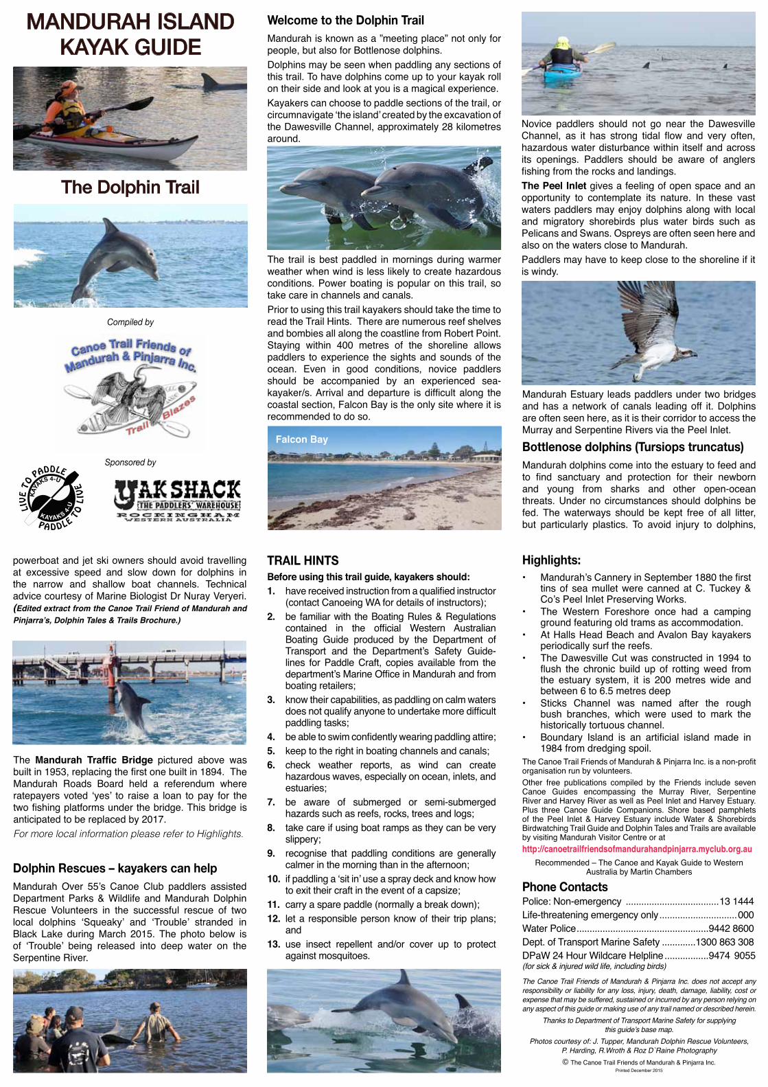
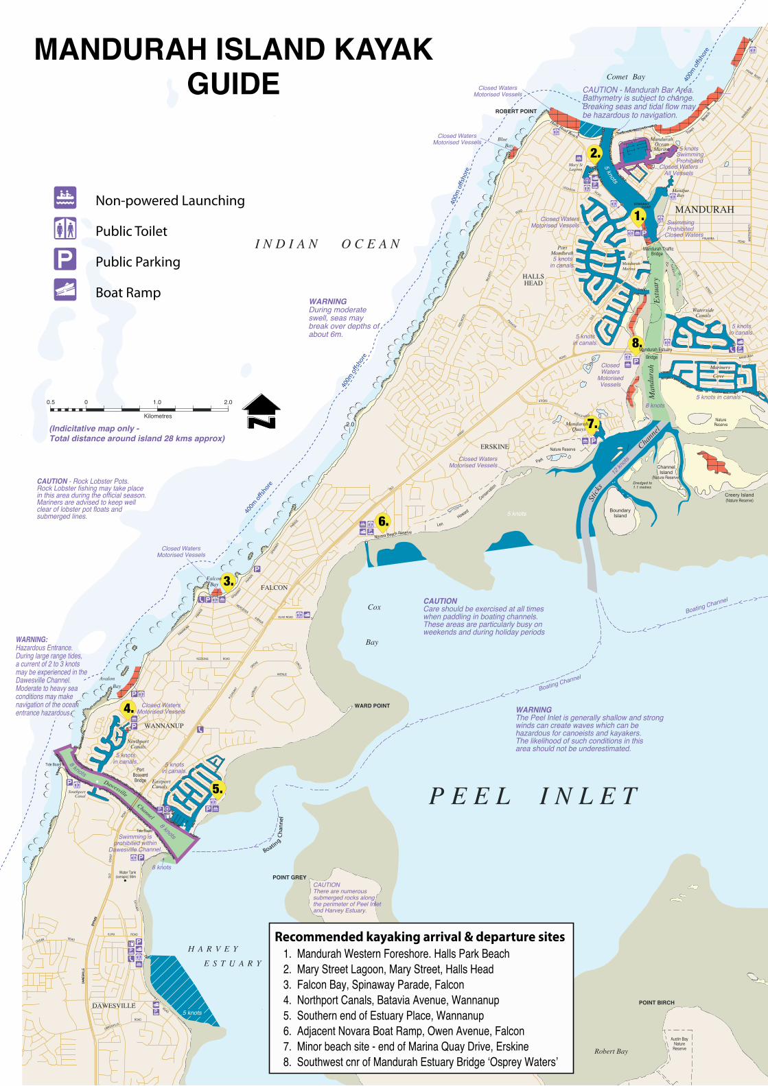
Welcome to the Dolphin Trail Mandurah is known as a ”meeting place” not only for people, but also for Bottlenose dolphins. Dolphins may be seen when paddling any sections of this trail. To have dolphins come up to your kayak roll on their side and look at you is a magical experience. Kayakers can choose to paddle sections of the trail, or circumnavigate ‘the island’ created by the excavation of the Dawesville Channel, approximately 28 kilometres around. Falcon Bay Dolphin Rescues – kayakers can help Mandurah Over 55’s Canoe Club paddlers assisted Department Parks & Wildlife and Mandurah Dolphin Rescue Volunteers in the successful rescue of two local dolphins ‘Squeaky’ and ‘Trouble’ stranded in Black Lake during March 2015. The photo below is of ‘Trouble’ being released into deep water on the Serpentine River. powerboat and jet ski owners should avoid travelling at excessive speed and slow down for dolphins in the narrow and shallow boat channels. Technical advice courtesy of Marine Biologist Dr Nuray Veryeri. (Edited extract from the Canoe Trail Friend of Mandurah and Pinjarra’s, Dolphin Tales & Trails Brochure.) The Mandurah Traffic Bridge pictured above was built in 1953, replacing the first one built in 1894. The Mandurah Roads Board held a referendum where ratepayers voted ‘yes’ to raise a loan to pay for the two fishing platforms under the bridge. This bridge is anticipated to be replaced by 2017. For more local information please refer to Highlights. The trail is best paddled in mornings during warmer weather when wind is less likely to create hazardous conditions. Power boating is popular on this trail, so take care in channels and canals. Prior to using this trail kayakers should take the time to read the Trail Hints. There are numerous reef shelves and bombies all along the coastline from Robert Point. Staying within 400 metres of the shoreline allows paddlers to experience the sights and sounds of the ocean. Even in good conditions, novice paddlers should be accompanied by an experienced sea- kayaker/s. Arrival and departure is difficult along the coastal section, Falcon Bay is the only site where it is recommended to do so. Osprey Novice paddlers should not go near the Dawesville Channel, as it has strong tidal flow and very often, hazardous water disturbance within itself and across its openings. Paddlers should be aware of anglers fishing from the rocks and landings. The Peel Inlet gives a feeling of open space and an opportunity to contemplate its nature. In these vast waters paddlers may enjoy dolphins along with local and migratory shorebirds plus water birds such as Pelicans and Swans. Ospreys are often seen here and also on the waters close to Mandurah. Paddlers may have to keep close to the shoreline if it is windy. Mandurah Estuary leads paddlers under two bridges and has a network of canals leading off it. Dolphins are often seen here, as it is their corridor to access the Murray and Serpentine Rivers via the Peel Inlet. Bottlenose dolphins (Tursiops truncatus) Mandurah dolphins come into the estuary to feed and to find sanctuary and protection for their newborn and young from sharks and other open-ocean threats. Under no circumstances should dolphins be fed. The waterways should be kept free of all litter, but particularly plastics. To avoid injury to dolphins, TRAIL HINTS Before using this trail guide, kayakers should: 1. have received instruction from a qualified instructor (contact Canoeing WA for details of instructors); 2. be familiar with the Boating Rules & Regulations contained in the official Western Australian Boating Guide produced by the Department of Transport and the Department’s Safety Guide- lines for Paddle Craft, copies available from the department’s Marine Office in Mandurah and from boating retailers; 3. know their capabilities, as paddling on calm waters does not qualify anyone to undertake more difficult paddling tasks; 4. be able to swim confidently wearing paddling attire; 5. keep to the right in boating channels and canals; 6. check weather reports, as wind can create hazardous waves, especially on ocean, inlets, and estuaries; 7. be aware of submerged or semi-submerged hazards such as reefs, rocks, trees and logs; 8. take care if using boat ramps as they can be very slippery; 9. recognise that paddling conditions are generally calmer in the morning than in the afternoon; 10. if paddling a ‘sit in’ use a spray deck and know how to exit their craft in the event of a capsize; 11. carry a spare paddle (normally a break down); 12. let a responsible person know of their trip plans; and 13. use insect repellent and/or cover up to protect against mosquitoes. The Canoe Trail Friends of Mandurah & Pinjarra Inc. does not accept any responsibility or liability for any loss, injury, death, damage, liability, cost or expense that may be suffered, sustained or incurred by any person relying on any aspect of this guide or making use of any trail named or described herein. Thanks to Department of Transport Marine Safety for supplying this guide’s base map. Photos courtesy of: J. Tupper, Mandurah Dolphin Rescue Volunteers, P. Harding, R.Wroth & Roz D`Raine Photography Phone Contacts Police: Non-emergency .................................... 13 1444 Life-threatening emergency only .............................. 000 Water Police ...................................................9442 8600 Dept. of Transport Marine Safety .............1300 863 308 DPaW 24 Hour Wildcare Helpline .................9474 9055 (for sick & injured wild life, including birds) Recommended – The Canoe and Kayak Guide to Western Australia by Martin Chambers The Canoe Trail Friends of Mandurah & Pinjarra Inc. is a non-profit organisation run by volunteers. Other free publications compiled by the Friends include seven Canoe Guides encompassing the Murray River, Serpentine River and Harvey River as well as Peel Inlet and Harvey Estuary. Plus three Canoe Guide Companions. Shore based pamphlets of the Peel Inlet & Harvey Estuary include Water & Shorebirds Birdwatching Trail Guide and Dolphin Tales and Trails are available by visiting Mandurah Visitor Centre or at http://canoetrailfriendsofmandurahandpinjarra.myclub.org.au Highlights: Mandurah’s Cannery in September 1880 the first tins of sea mullet were canned at C. Tuckey & Co’s Peel Inlet Preserving Works. The Western Foreshore once had a camping ground featuring old trams as accommodation. At Halls Head Beach and Avalon Bay kayakers periodically surf the reefs. The Dawesville Cut was constructed in 1994 to flush the chronic build up of rotting weed from the estuary system, it is 200 metres wide and between 6 to 6.5 metres deep Sticks Channel was named after the rough bush branches, which were used to mark the historically tortuous channel. Boundary Island is an artificial island made in 1984 from dredging spoil. © The Canoe Trail Friends of Mandurah & Pinjarra Inc. Printed December 2015 MANDURAH ISLAND KAYAK GUIDE Sponsored by Compiled by The Dolphin Trail
Transcript

Welcome to the Dolphin TrailMandurah is known as a ”meeting place” not only for people, but also for Bottlenose dolphins. Dolphins may be seen when paddling any sections of this trail. To have dolphins come up to your kayak roll on their side and look at you is a magical experience. Kayakers can choose to paddle sections of the trail, or circumnavigate ‘the island’ created by the excavation of the Dawesville Channel, approximately 28 kilometres around.

Falcon Bay

Dolphin Rescues – kayakers can help

Mandurah Over 55’s Canoe Club paddlers assisted Department Parks & Wildlife and Mandurah Dolphin Rescue Volunteers in the successful rescue of two local dolphins ‘Squeaky’ and ‘Trouble’ stranded in Black Lake during March 2015. The photo below is of ‘Trouble’ being released into deep water on the Serpentine River.

powerboat and jet ski owners should avoid travelling at excessive speed and slow down for dolphins in the narrow and shallow boat channels. Technical advice courtesy of Marine Biologist Dr Nuray Veryeri. (Edited extract from the Canoe Trail Friend of Mandurah and Pinjarra’s, Dolphin Tales & Trails Brochure.)

The Mandurah Traffic Bridge pictured above was built in 1953, replacing the first one built in 1894. The Mandurah Roads Board held a referendum where ratepayers voted ‘yes’ to raise a loan to pay for the two fishing platforms under the bridge. This bridge is anticipated to be replaced by 2017. For more local information please refer to Highlights.

The trail is best paddled in mornings during warmer weather when wind is less likely to create hazardous conditions. Power boating is popular on this trail, so take care in channels and canals.Prior to using this trail kayakers should take the time to read the Trail Hints. There are numerous reef shelves and bombies all along the coastline from Robert Point. Staying within 400 metres of the shoreline allows paddlers to experience the sights and sounds of the ocean. Even in good conditions, novice paddlers should be accompanied by an experienced sea-kayaker/s. Arrival and departure is difficult along the coastal section, Falcon Bay is the only site where it is recommended to do so.

Osprey

Novice paddlers should not go near the Dawesville Channel, as it has strong tidal flow and very often, hazardous water disturbance within itself and across its openings. Paddlers should be aware of anglers fishing from the rocks and landings.The Peel Inlet gives a feeling of open space and an opportunity to contemplate its nature. In these vast waters paddlers may enjoy dolphins along with local and migratory shorebirds plus water birds such as Pelicans and Swans. Ospreys are often seen here and also on the waters close to Mandurah. Paddlers may have to keep close to the shoreline if it is windy.

Mandurah Estuary leads paddlers under two bridges and has a network of canals leading off it. Dolphins are often seen here, as it is their corridor to access the Murray and Serpentine Rivers via the Peel Inlet.Bottlenose dolphins (Tursiops truncatus) Mandurah dolphins come into the estuary to feed and to find sanctuary and protection for their newborn and young from sharks and other open-ocean threats. Under no circumstances should dolphins be fed. The waterways should be kept free of all litter, but particularly plastics. To avoid injury to dolphins,

TRAIL HINTSBefore using this trail guide, kayakers should:1. have received instruction from a qualified instructor

(contact Canoeing WA for details of instructors);2. be familiar with the Boating Rules & Regulations

contained in the official Western Australian Boating Guide produced by the Department of Transport and the Department’s Safety Guide-lines for Paddle Craft, copies available from the department’s Marine Office in Mandurah and from boating retailers;

3. know their capabilities, as paddling on calm waters does not qualify anyone to undertake more difficult paddling tasks;

4. be able to swim confidently wearing paddling attire;5. keep to the right in boating channels and canals;6. check weather reports, as wind can create

hazardous waves, especially on ocean, inlets, and estuaries;

7. be aware of submerged or semi-submerged hazards such as reefs, rocks, trees and logs;

8. take care if using boat ramps as they can be very slippery;

9. recognise that paddling conditions are generally calmer in the morning than in the afternoon;

10. if paddling a ‘sit in’ use a spray deck and know how to exit their craft in the event of a capsize;

11. carry a spare paddle (normally a break down);12. let a responsible person know of their trip plans;

and13. use insect repellent and/or cover up to protect

against mosquitoes.

The Canoe Trail Friends of Mandurah & Pinjarra Inc. does not accept any responsibility or liability for any loss, injury, death, damage, liability, cost or expense that may be suffered, sustained or incurred by any person relying on any aspect of this guide or making use of any trail named or described herein.

Thanks to Department of Transport Marine Safety for supplying this guide’s base map.

Photos courtesy of: J. Tupper, Mandurah Dolphin Rescue Volunteers, P. Harding, R.Wroth & Roz D`Raine Photography

Phone ContactsPolice: Non-emergency ....................................13 1444 Life-threatening emergency only ..............................000 Water Police ...................................................9442 8600 Dept. of Transport Marine Safety .............1300 863 308DPaW 24 Hour Wildcare Helpline .................9474 9055 (for sick & injured wild life, including birds)

Recommended – The Canoe and Kayak Guide to Western Australia by Martin Chambers

The Canoe Trail Friends of Mandurah & Pinjarra Inc. is a non-profit organisation run by volunteers. Other free publications compiled by the Friends include seven Canoe Guides encompassing the Murray River, Serpentine River and Harvey River as well as Peel Inlet and Harvey Estuary. Plus three Canoe Guide Companions. Shore based pamphlets of the Peel Inlet & Harvey Estuary include Water & Shorebirds Birdwatching Trail Guide and Dolphin Tales and Trails are available by visiting Mandurah Visitor Centre or athttp://canoetrailfriendsofmandurahandpinjarra.myclub.org.au

Highlights: • Mandurah’s Cannery in September 1880 the first

tins of sea mullet were canned at C. Tuckey & Co’s Peel Inlet Preserving Works.

• The Western Foreshore once had a camping ground featuring old trams as accommodation.

• At Halls Head Beach and Avalon Bay kayakers periodically surf the reefs.

• The Dawesville Cut was constructed in 1994 to flush the chronic build up of rotting weed from the estuary system, it is 200 metres wide and between 6 to 6.5 metres deep

• Sticks Channel was named after the rough bush branches, which were used to mark the historically tortuous channel.

• Boundary Island is an artificial island made in 1984 from dredging spoil.

© The Canoe Trail Friends of Mandurah & Pinjarra Inc. Printed December 2015

MANDURAH ISLAND KAYAK GUIDE

Sponsored by

Compiled by

The Dolphin Trail

MANDURAH ISLAND KAYAK GUIDE

5.

4.

3.

6.

7.

2.

1.

8.

0 1.0

Kilometres

0.5 2.0

2.0(Indicitative map only -Total distance around island 28 kms approx)

400m

o�sh

ore

400m

o�sh

ore

400m

o�s

hore

DAW

ESV I

L LE

BYPA

SS

Man

dura

hEs

tuar

y

STICKS

BOULE VA R D

PEEL

WO

OD

PARADE

McL

ARTY

ROAD

LEIGHTON ROAD

PLEA

SANT

GROVE CIRCLE

NUT

BUSH

AVENUE

SPIN

AWAY

PARADE

PANAMUNA

PARA

DE

SPIN

AWAY

PARADE

ILUKA ROAD

OLD

COAST

ROAD

OLD

COAST

ROAD

Stick

s

Chann

el

YEEDONG ROAD

ANST

RU

THE

RR

OAD

LESLIE

STREET

MANDURAH

TERR

AC

5 knots

8 knots

Austin BayNature

ReserveSTONY POINT

POINT BIRCH

Robert Bay

POINT GREY

Austin BayNature

Reserve

CARRABUNGUP

SwimmingProhibited

Closed WatersMotorised Vessels

Closed WatersMotorised Vessels

Len

Howard

Conser

vation

Park

ClosedWaters

MotorisedVessels

DAWESVILLE

Boating Channel

CAUTION - Rock Lobster Pots.Rock Lobster fishing may take placein this area during the official season.Mariners are advised to keep wellclear of lobster pot floats andsubmerged lines.

CAUTION - Mandurah Bar Area.Bathymetry is subject to change.Breaking seas and tidal flow maybe hazardous to navigation.

WARNING: Hazardous Entrance.During large range tides,a current of 2 to 3 knotsmay be experienced in theDawesville Channel.Moderate to heavy seaconditions may makenavigation of the oceanentrance hazardous.

CAUTIONThere are numeroussubmerged rocks alongthe perimeter of Peel Inletand Harvey Estuary.

Cox

Bay

SoldiersC

ove

5knots

8 knots

MANDURAH

DAW

ESV I

L LE

BYPA

SS

DAWESVILLE

Novara Beach Reserve

Dawesville

Channel

Town

Beach

P E E L I N L E T

Falcon

MandurahQuays

BoundaryIsland

WatersideCanals

PortMandurah

Mary StLagoon

STINGRAYPOINT

Comet Bay

O C E A NI N D I A N

AvalonBay

BlueBay

MarinersCove

Creery Island

NorthportCanals

MandjarBay

MandurahMarina

MandurahOceanMarina

EastportCanals

SouthportCanal

5 knots

8 knots

Closed WatersAll Vessels

5 knotsin canals.

5 knotsin canals.

8 knots

5 knots

5 knotsin canals.

5 knotsin canals.

Closed WatersMotorised Vessels

5 knotsin canals.

Swimming isprohibited within

Dawesville Channel.

ROADPINJARRA

PRIAM ROAD

MERCEDES

AVENUE

OLIVE ROAD

ROADOCEAN

ROAD

ROAD

OLD

CO

AST

ESTUARY

ROAD

Nature Reserve

Tide Board

Tide Board

Water Tank(conspic) 56m

(Nature Reserve)

(Nature Reserve)Dredged to1.1 metres

ChannelIsland

PortBouvardBridge

Mandurah TrafficBridge

Mandurah Estuary

Bridge

WARD POINT

ROBERT POINT

ERSKINE

HALLSHEAD

MANDURAH

FALCON

WANNANUP

5 knots in canals.

NatureReserve

Closed WatersMotorised Vessels

Closed WatersMotorised Vessels

Closed WatersMotorised Vessels

H A R V E Y

E S T U A R Y

12 kn

ots

Bay

WARNINGThe Peel Inlet is generally shallow and strong winds can create waves which can be hazardous for canoeists and kayakers. The likelihood of such conditions in this area should not be underestimated.

SwimmingProhibited

Closed Waters

Boatin

g Cha

nnel

Boating Channel

Non-powered Launching

Boat Ramp

Public Toilet

Public Parking400m

o�shore

Halls Head Beach

CAUTIONCare should be exercised at all times when paddling in boating channels. These areas are particularly busy on weekends and during holiday periods

WARNINGDuring moderate swell, seas may break over depths of about 6m.

Recommended kayaking arrival & departure sites1. Mandurah Western Foreshore. Halls Park Beach2. Mary Street Lagoon, Mary Street, Halls Head3. Falcon Bay, Spinaway Parade, Falcon4. Northport Canals, Batavia Avenue, Wannanup5. Southern end of Estuary Place, Wannanup6. Adjacent Novara Boat Ramp, Owen Avenue, Falcon7. Minor beach site - end of Marina Quay Drive, Erskine8. Southwest cnr of Mandurah Estuary Bridge ‘Osprey Waters’


Recommended