Meteorological environment of a tornado outbreakin Southern Romania
I. C. Oprea and A. Bell
National Meteorological Administration, 97, Bucuresti-Ploiesti, Bucharest, Romania
Received: 4 November 2008 – Revised: 14 April 2009 – Accepted: 14 April 2009 – Published: 23 April 2009
Abstract. On 7 May 2005, a squall line with an embed-ded bow echo formed over Southern Romania causing severewind damage. The length of the wind damage was around150 km. Three tornadoes have been reported, two of them be-ing recorded by video camera. One of the tornadoes occurredin Buftea (near Bucharest), the second in Ciobanu village(near Medgidia radar site) and the third in Movilita village,40 km to the northeast of Bucharest. The site surveys con-firmed wind damage associated with these tornadoes. Basedon damage, the Movilita village tornado was classified as anF1 type on the Fujita scale, and the Buftea and Ciobanu vil-lage tornadoes were classified as F0. Large scale forcingwas provided by a vigorous upper level trough. The squallline developed in the warm sector of a low, ahead of thecold front. The Bucharest EEC-DWSR-2500C Doppler ve-locity depicted cyclonically rotational structures associatedwith the left end of the bow echo. In two hours this squallline traversed the southern part of the country. The northernend of the line preserved the bowed structures and high re-flectivity gradient in front of them. The dry air associatedwith the descending rear inflow jet was evident as rear in-flow notches in the reflectivity field of the Bucharest C-bandradar and the Medgidia S-band WSR-98 D radar. The synop-tic and mesoscale environment associated with 7 May 2005bow echo had many similarities to the “dynamic” pattern de-scribed by John and Hirt (1987). Herein are analyzed thecombined effects of synoptic and mesoscale circulations, to-gether with the data provided by C-band EEC-DWSR-2500Cand S-band WSR-98D radars, and the ECMWF and AL-ADIN model output data. Some operational aspects of thewarning process are also discussed.
Bow echoes are a unique form of convective organization thatoften produces severe weather, especially damaging straight-line winds and tornadoes. Fujita (1978) realized the firstwell-known conceptual model with his schematic (Fig. 1a)that shows how an initial straight echo transforms into abow-shaped line of convective cells with the strongest windsoccurring at the apex of the bow. During its most intensephase (Fig. 1a, C), the center of the bow may form a spear-head echo (Fujita and Byers, 1977). During the decliningstage, the system often evolves into a comma-shaped echowith cyclonic and anticyclonic rotation at the end of the bow(Fig. 1a, D). Fujita’s first observational studies confirmed theexistence of tornadic damage generally collocated with theapex of the bow (Fujita, 1978, 1981). Subsequent observa-tional studies documented tornadoes occurring with the apexof the bow (Forbes and Wakimoto, 1983; Wakimoto, 1983;Przybylinski, 1995; Funk et al., 1999; Atkins et al., 2004)or associated with the cyclonically rotating “comma headecho” (Weisman, 1993; Pfost and Gerard, 1997). The studiesabout the mesovortices associated with the apex of the bowor the bookend vortices (Weisman, 1990) associated with thenorthern end bow echo were progressed upon the installa-tion of WSR-88D radar in the early 1990s, when the Dopplerwinds offered the opportunity to identify cyclonic and anti-cyclonic rotational features (Burgess and Smull, 1990; Weis-man, 1993; Jorgensen and Smull, 1993; Przybylinski et al.,2000; Arnett and Atkins, 2002; Atkins et al., 2004).
Convectively generated windstorms occur over a wide ar-ray of temporal and spatial scales (Fujita, 1978; Fujita andWakimoto, 1981); however, the more widespread and longerlived of these windstorms are termed “derechos” (Hinrichs,1888; Johns and Hirt, 1987). By analyzing the radar sum-mary charts associated with 70 warm-season cases of con-vectively induced straight-line windstorm, Johns and Hirt(1987) identified two basic echo patterns. The first pattern,
Published by Copernicus Publications on behalf of the European Geosciences Union.
Fig. 1. (a) Fujita’s (1978) conceptual model of a bow echo witha rotating comma head.(b) Schematic representation of featuresassociated with a “dynamic” synoptic pattern. Total area affectedby widespread wind damage indicated by hatching. Frontal andsquall line symbols are conventional (Johns and Hirt, 1987).
termed “progressive”, consists of a single bowed segmentthat moves parallel to a quasi-stationary front. The secondpattern, named “serial”, consists of a series of bows thatpropagate along a large-scale squall line. The “progressive”derechoes are mostly associated with the warm-season atmo-spheric conditions, when amounts of convective instabilityand low level moisture are very high (Johns, 1993). Thebow-echoes move along a quasi-stationary low-level thermalboundary orientated nearly parallel to the mean flow that isoften westerly to north-westerly (John and Hirt, 1987). The“serial” derecho was associated by Johns (1993) with a “dy-namic” pattern (Fig. 1b) that consists of a strong, migrat-ing low pressure system associated in general with severeweather systems (Johns and Doswell, 1992).
Evans and Doswell (2001) extend the work on dere-cho producing convective storm environments by examin-ing proximity soundings from 67 derechoes cases from alltimes of the year. The authors observed that derechoes oc-cur under a wide range of atmospheric conditions, and in-cluded an additional pattern, named “hybrids” derechoes,that display features of both the warm-season and dynamicpatterns. Conoglio et al. (2004) documented the spectrumof large scale environment flow patterns from a set of 225analyses of 500-hPa geopotential heights associated with
Fig. 2. The Romanian National Radar Network integrates:five WSR-98 D S-band, two EEC-DWSR-2500 C-band and oneGematronik-METEOR 500 C-band. The white rectangle number1 represents the extent of the region in Fig. 3. The rectangles num-ber 2 and 3 represent the area in radar images that will be used laterin the text.
the development and early evolution of derecho producingconvective systems. The majority of the events (72%) fellinto three main patterns that include a well-defined upstreamtrough (40%), a ridge (20%), and a zonal, low-amplitudeflow (12%). The remaining 28% of the cases form large-scale hybrid patterns that contain various characteristics ofthe three main patterns. In addition Conoglio et al. (2004)found that low level shear (instability) is significantly higher(lower) for the more strongly forced events, while the lowlevel storm-relative inflow tends to be much deeper for themore weakly forced events.
Almost all the derecho producing convective storms stud-ies in the last decades refer to cases that have affected theUnited States. Although it is likely that derecho producingconvective storms occur in other parts of the world, only fewcases have been described in the literature. A severe bow-echo storm passed over Northern Switzerland and SouthernGermany on 22 July 1995 and wind damage was reportedin both countries (Schmid et al., 2000). On 5 July 2002 arapidly propagating bow echo formed over Eastern Finlandcausing severe wind damage in an exceptionally large area(Punkka et al., 2006), and on 10 July 2002, a bow echo pro-ducing a derecho affected the capital of Germany (Gatzen,2004). In August 2003 a mesoscale convective storm causedsevere wind damage in Northeastern Spain and SouthernFrance (Lopez and Arus, 2004).
On 7 May 2005, a squall line with an embedded bow echoformed over Southern Romania causing severe wind dam-age. Three tornadoes have been reported, two of them beingrecorded by video camera. The site survey confirmed winddamage associated with these tornadoes, two of them wereF0 and the third was more intense being classified as F1 onthe Fujita scale.
A major responsibility of the Romanian National WeatherForecast Centre is to issue warnings of severe weather (se-vere thunderstorms, flash flood, tornadoes). The RomanianNational Weather Service began the operational use of thefive WSR-98 D (Weather Surveillance Radar-1998D) in 2002that together with two EEC-DWSR-2500C Doppler radarsand one Gematronik-METEOR 500C type installed in 2001form nationwide coverage radar Doppler network (Fig. 2).This radar network system contains numerous algorithmsthat use Doppler radar base data – reflectivity (dBZ) and ve-locity (m s−1) – as input to produce meteorological analy-ses. Romanian forecasters have required time to adjust theirinterpretation of radar algorithm output and severe weatherwarning thresholds. Based on past experience in analog radarobservations (since the 1970s) three thresholds with differentintensity intervals for severe weather, warnings have been in-troduced. These thresholds include weak, moderate and highintensities for convective events. Forecasting and monitor-ing potentially severe thunderstorms with high intensities forwind speed, high rainfall rate and hail in the context of thevariety of Romanian relief constitutes a significant challenge,because in most cases, various kinds of severe weather occursimultaneously. This was the situation on 7 May 2005, inSouthern Romania, when tornadoes, high winds and hail af-fected the plain region from the south of the country, andtorrential rain in the hilly part that produced, in the intervalimmediately following, a major flash flood. This case is notonly interesting meteorologically, but also because it showshow the simultaneous occurrence of severe whether eventscan decrease the efficiency of the operational weather shortterm forecasting system.
The environment in Southern Romania tends to be moreconducive to severe convection than in other parts of thecountry (Stan-Sion and Antonescu, 2006). Interactions ofthe synoptic flows with the curved shape of the CarpathianMountains results in convergence zones in this part of thecountry (Bell, 2008). If necessary ingredients (lift, instabil-ity and moisture) exist (Doswell et al., 1996), then severeconvection is initiated near this convergence zone (Stan-Sionet al., 2006, 2007). The first tornado observed in SouthernRomania using Doppler radar was at Facaeni (Lemon et al.,2003), after which the tornado threat in Romania became rec-ognized. That this storm formed in Romania from a supercellmeant that supercell storms become “targets” for nowcastingsevere weather. Romanian forecasters were challenged torecognize environmental factors that favor supercell devel-opment, while the environment that is particularly favorablefor bow echo formation had not been reviewed at the timeof this event. Further, tornadoes associated with bow echoeswere a concept totally unknown to our forecasters.
Early on 7 May 2005, the convective event began as anelongated area of thunderstorms over hilly region in South-ern Romania between 06:00 UTC and 09:00, while a smallcluster of convective cells passed from Bulgaria into South-ern Romania and moved north-east. The convective system
Fig. 3. The location and wind damage reports of the 7 May 2008event area.(a) The geography of the south-eastern part of Romaniaand radar locations are indicated. The area depicted is a zoom rep-resented by the white rectangle number 1 from Fig. 2. The squallline locations every half hour between 10:30 UTC and 13:30 UTCare depicted with round dot lines. With red triangles are indicatedthe tornado reports from Buftea, Movilita and Ciobanu villages andwith blue circles are indicated the 10 m wind gust reports greaterthan 16 m s−1. The length of the damage is around 150 km.(b)The location of the wind damage report in Movilita village and areaaround this village. The red line from the left corner shows thedirection of the scattered narrow damage path area observed north-east for about 10 km toward Moldoveni village.
evolved into a squall line with bow echo near Bucharest, andbrought damaging wind and three small tornadoes, two ofwhich were recorded by video camera. One of the tornadoesoccurred in Buftea (near Bucharest), the second in Ciobanuvillage (56 km from the Medgidia radar site) and the thirdin Movilita village, 40 km from Bucharest, in the north-eastdirection (Fig. 3), which caused the greatest wind damage.
Our goals in this study are, firstly, to identify charac-teristics of the synoptic and mesoscale environment thatwere favorable for producing and sustaining the squall linewith bow echo in 7 May 2005 and, secondly, to findmesoscale and convective scale factors that determine theevolution and location of the convective event. Analysisof weather phenomenon associated with deep moist con-vection is made through the evaluation of basic ingredientsand their possible contribution and interactions (Doswell,1996). Thus, deep moist convection is initiated if latentinstability, moisture and sufficient lift are present. Synop-tic scale and mesoscale processes are evaluated using nu-merical model outputs from ECMWF (The European Centrefor Medium Range Weather Forecasters,http://www.ecmwf.int/research/ifs/) and ALADIN (Aire Limitee AdaptationDynamique Developpement InterNational,http://www.cnrm.meteo.fr/aladin/) data, Doppler radar products, conventionalweather station data, Meteosat Second Generation (MSG-2)visible, and water vapor images. Further, we will comparesynoptic and mesoscale features associated with the forma-tion and evolution of the 7 May 2005 bow echo with condi-tions that favor bow echo development in USA observed byJohns and Hirt (Johns and Hirt, 1987; Jonhs, 1993).
2 Damage survey analysis
The squall line location every half hours between 10:30 UTCand 13:30 UTC and wind damage reports are depicted inFig. 3a. The Movilita village damage (Fig. 3a) was reportedaround 11:00 UTC and was associated with the northern endbow echo. Buftea and Ciobanu village tornadoes (Fig. 3a)were associated with gust front mesovortices. In Afumati,Buzau, Grivita, Slobozia and Braila towns the 10 m wind gustreports were greater than 16 m s−1 (Fig. 3a). The horizontallength of the damage was around 150 km.
An in situ damage survey in Movilita village was car-ried out, two days after the event by an expert team of theNational Meteorological Administration formed by CornelSoci, Bogdan Antonescu si Ruxandra Banica, and an inter-nal report has been elaborated. The damage track begansouth of the Movilita village (red triangle marked with num-ber 1 in Fig. 3b), extended about 0.5 km north-east (red circlemarked with number 2 in Fig. 3b), then deviated toward thenorth-west (red circle marked with number 3 in Fig. 3b), andfinally, the tornado tracked north-east for about 1 km (red cir-cle marked with number 4 in Fig. 3b). A more narrow dam-age path was observed north-east for about 10 km, towardMoldoveni village (Fig. 3b), where a path of about 10 m in acorn field was flattened. In Movilita village the roofs of 24houses were damaged or torn out and a house clay brick wallwas completely demolished (Fig. 4a). The village church hadhalf of its roof plate fully detached, while the other half wasintact. A ten meters length from the fence surrounding thechurch was destroyed (Fig. 4b). Some trees were torn, oth-ers uprooted, while some electrification poles were torn andfelled (Fig. 4c), and pieces of iron plate hang in the trees.
The eye witness report mentioned that “. . . a howl rushedat us. The storm took the house roof, turned out in the airand drove it away far from the house. The wind broke thewindows and the doors. Pieces from the wall spread aroundand five trees were uprooted. At the gate, one electrificationpole was torn and felled. All this lasted a few minutes.”
Other eye witness report mentioned that “The tornadowent out from the corn field as a funnel. The whirl took theroof plate from the church and throws him a few tens of me-ters away. From the church, the stream wind went to the roadas a snake. He took the big doors from the warehouse andraised them ten meters in the air. Before the tornado, smallhail, like wheat seed dimensions fell down, lasting about tenminutes.”
The image shot by an amateur during the storm is an un-questionable proof and was afterwards shown on television.In that image could be seen the rotational cloud structure, thewhirl moving down to the Earth, but it is not clear whetheror not it touched the ground surface (Fig. 4d). Based on theground effects, this tornado can be classified as F1 type onthe Fujita scale. A weaker tornado (F0) was recorded by anamateur near Buftea village (10 km north of Bucharest) in anunpopulated area (Fig. 3a). This tornado uprooted some treesand damaged a corn field. The witness mentioned that inCiobanu village the wind damaged the roofs from two housesand uprooted some trees.
3 Analysis of the meteorological environment of thetornado outbreak
Synoptic scale and mesoscale processes are evaluated usingnumerical model fields from ECMWF and ALADIN numer-ical models, Doppler radar products, high resolution visible
satellite imagery and conventional weather station data. Sur-face data from the meteorological stations from RomanianNational Meteorological Administration were used for sur-face analyses. The surface data consisted of hourly observa-tions of 2 m temperature, 2 m dewpoint, mean sea level pres-sure, 10 m wind speed and direction.
3.1 Analysis of synoptic scale conditions
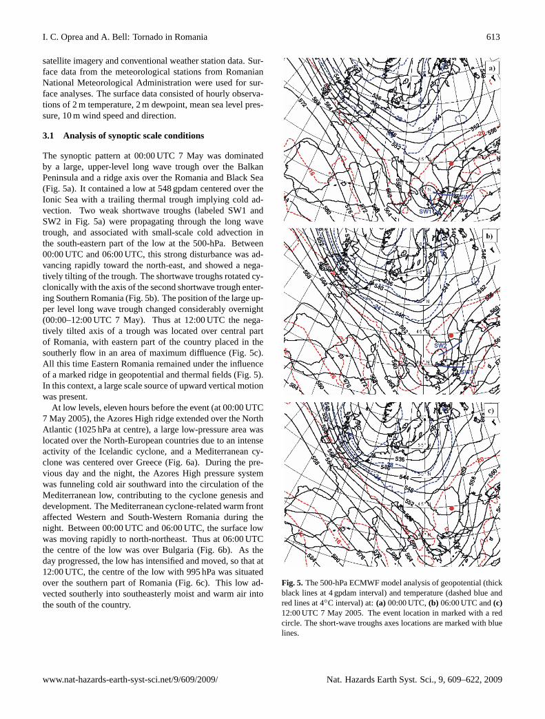
The synoptic pattern at 00:00 UTC 7 May was dominatedby a large, upper-level long wave trough over the BalkanPeninsula and a ridge axis over the Romania and Black Sea(Fig. 5a). It contained a low at 548 gpdam centered over theIonic Sea with a trailing thermal trough implying cold ad-vection. Two weak shortwave troughs (labeled SW1 andSW2 in Fig. 5a) were propagating through the long wavetrough, and associated with small-scale cold advection inthe south-eastern part of the low at the 500-hPa. Between00:00 UTC and 06:00 UTC, this strong disturbance was ad-vancing rapidly toward the north-east, and showed a nega-tively tilting of the trough. The shortwave troughs rotated cy-clonically with the axis of the second shortwave trough enter-ing Southern Romania (Fig. 5b). The position of the large up-per level long wave trough changed considerably overnight(00:00–12:00 UTC 7 May). Thus at 12:00 UTC the nega-tively tilted axis of a trough was located over central partof Romania, with eastern part of the country placed in thesoutherly flow in an area of maximum diffluence (Fig. 5c).All this time Eastern Romania remained under the influenceof a marked ridge in geopotential and thermal fields (Fig. 5).In this context, a large scale source of upward vertical motionwas present.
At low levels, eleven hours before the event (at 00:00 UTC7 May 2005), the Azores High ridge extended over the NorthAtlantic (1025 hPa at centre), a large low-pressure area waslocated over the North-European countries due to an intenseactivity of the Icelandic cyclone, and a Mediterranean cy-clone was centered over Greece (Fig. 6a). During the pre-vious day and the night, the Azores High pressure systemwas funneling cold air southward into the circulation of theMediterranean low, contributing to the cyclone genesis anddevelopment. The Mediterranean cyclone-related warm frontaffected Western and South-Western Romania during thenight. Between 00:00 UTC and 06:00 UTC, the surface lowwas moving rapidly to north-northeast. Thus at 06:00 UTCthe centre of the low was over Bulgaria (Fig. 6b). As theday progressed, the low has intensified and moved, so that at12:00 UTC, the centre of the low with 995 hPa was situatedover the southern part of Romania (Fig. 6c). This low ad-vected southerly into southeasterly moist and warm air intothe south of the country.
Fig. 5. The 500-hPa ECMWF model analysis of geopotential (thickblack lines at 4 gpdam interval) and temperature (dashed blue andred lines at 4◦C interval) at:(a) 00:00 UTC,(b) 06:00 UTC and(c)12:00 UTC 7 May 2005. The event location in marked with a redcircle. The short-wave troughs axes locations are marked with bluelines.
Fig. 6. The low level ECMWF model analysis of mean sealevel pressure (solid green and orange lines at 5 hPa intervals) and850-hPa temperature (dashed red lines at 4◦C intervals) at: (a)00:00 UTC,(b) 06:00 UTC and(c) 12:00 UTC 7 May 2005. TheAzores High is depicted with “H” and Icelandic and MediterraneanLows are depicted with “L”. The solid red and blue lines are, re-spectively, warm and cold fronts associated with the MediterraneanLow.
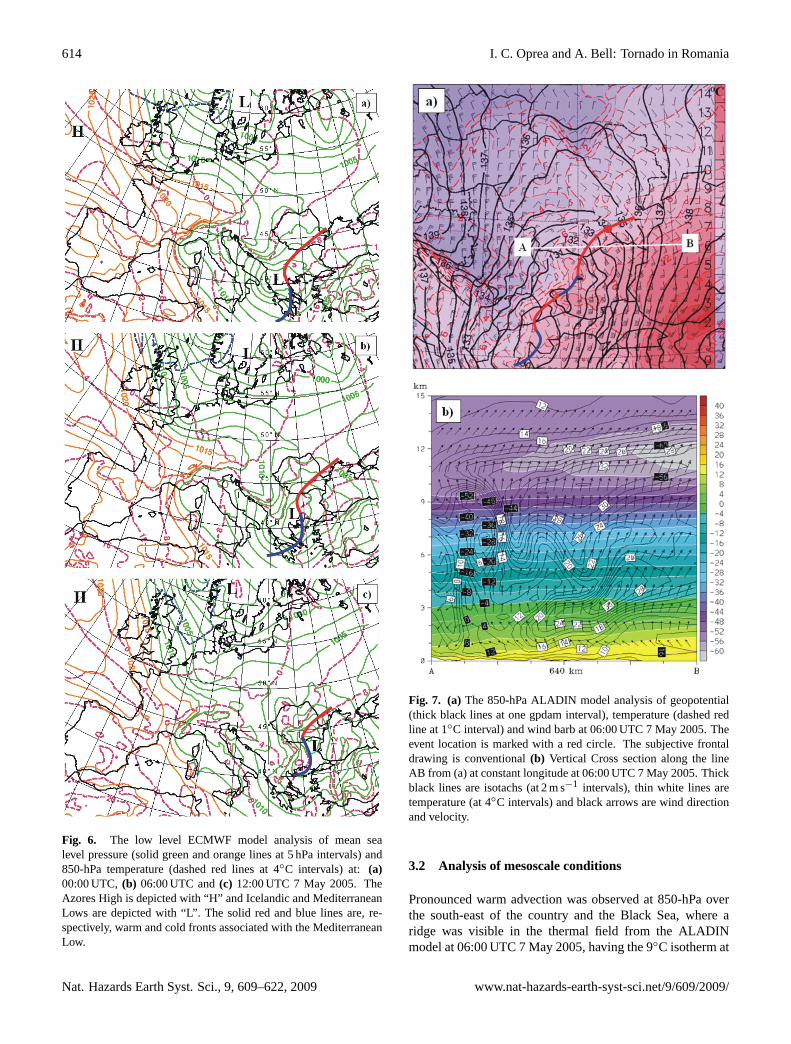
Fig. 7. (a) The 850-hPa ALADIN model analysis of geopotential(thick black lines at one gpdam interval), temperature (dashed redline at 1◦C interval) and wind barb at 06:00 UTC 7 May 2005. Theevent location is marked with a red circle. The subjective frontaldrawing is conventional(b) Vertical Cross section along the lineAB from (a) at constant longitude at 06:00 UTC 7 May 2005. Thickblack lines are isotachs (at 2 m s−1 intervals), thin white lines aretemperature (at 4◦C intervals) and black arrows are wind directionand velocity.
3.2 Analysis of mesoscale conditions
Pronounced warm advection was observed at 850-hPa overthe south-east of the country and the Black Sea, where aridge was visible in the thermal field from the ALADINmodel at 06:00 UTC 7 May 2005, having the 9◦C isotherm at
the south of Romania associated with strong south-easterlywinds (16 m s−1) (Fig. 7a). A vertical cross-section alongthe line AB in Fig. 7a at 06:00 UTC shows high velocitywind over the whole troposphere, with 14 m s−1 at 1000 m(Fig. 7b). Also, the wind direction was south-easterly atlow-level and then turned within the first 2000 m and becamesoutherly and nearly unidirectional above (Fig. 7b).
The strong moist and warm advection from south-eastwas identified also at 12:00 UTC as a tongue shape follow-ing the wet-bulb equivalent potential temperature contours at925 hPa level (Fig. 8a). Also, the 994-hPa low was centeredover the south of the country and a strong gradient in thewet-bulb equivalent potential temperature contours and windflows associated with the warm and cold front along South-ern Romania could be observed (Fig. 8a). A vertical crosssection along the line AB in Fig. 8a at 12:00 UTC was madethrough the centre of the surface low. The location of thesquall line at 12:00 UTC relative to line AB is depicted witha black cross in Fig. 8b. One relative maxima of the windis located at 1500 m to the rear of the squall line with val-ues of 16 m s−1 and a south-south-west orientation (Fig. 8b).The vertical cross section of the wind shows the presenceof a Low Level Jet at about 1500 m that is a common fea-ture of cold fronts (Browning and Pardoe, 1973; Kotroni andLagouvardos, 1993). Behind the relative squall line, at a dis-tance about 200 km, the vertical cross-section showed thepresence of areas with high gradients in wind velocity anddirection and with potential temperature discontinuities as-sociated with the approaching cold front.
The vertical cross section depicts also the existence of astrong wind velocity gradient with one relative maxim of thewind down to 4000 m and reaching 30 m s−1, at 06:00 UTC(Fig. 7b) and 26 m s−1 at 12:00 UTC (Fig. 8b).
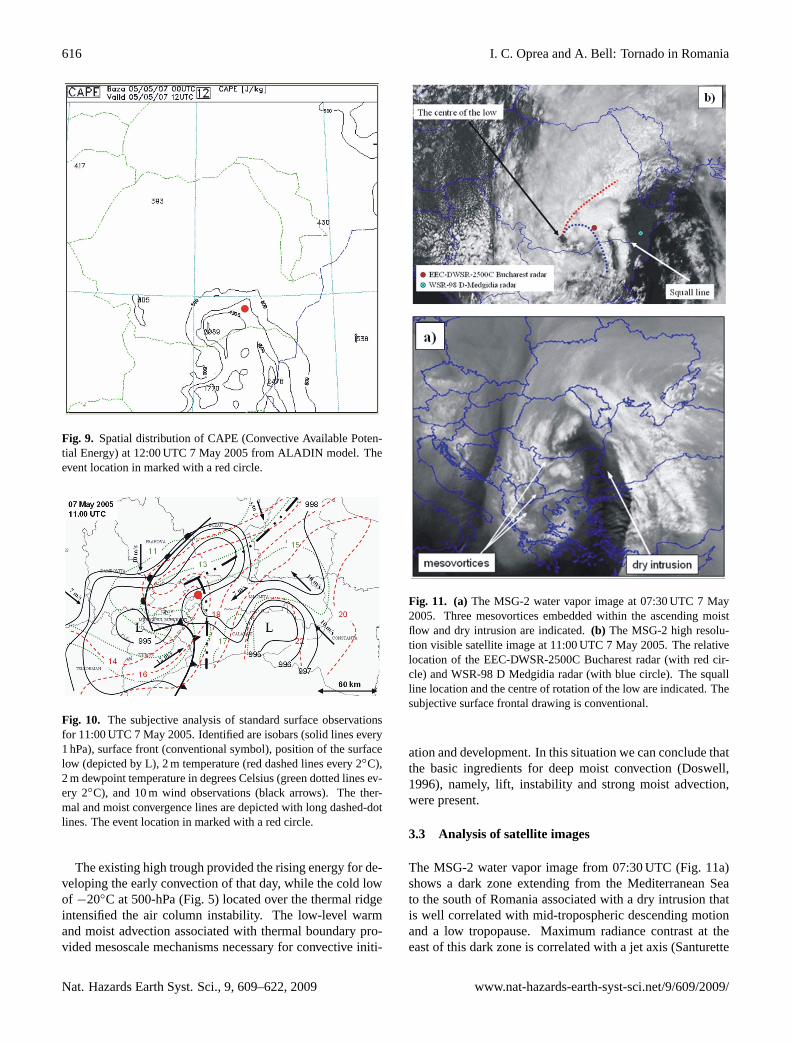
The spatial distribution of CAPE (Convective AvailablePotential Energy), according to ALADIN model data, at12:00 UTC, shows that the greatest values appear over thesouth of Romania, where CAPE was around 2500 J Kg−1
(Fig. 9). The ALADIN model uses the most unstable par-cel of air found within the lowest 300 hPa of the atmosphereto calculate CAPE, that is called MUCAPE (Most UnstableConvective Available Potential Energy). The analysis of thereal vertical profile of the atmosphere could not be made be-cause the squall line development did not allow the verticalsounding at Bucharest.
The subjective analysis of standard surface observations at11:00 UTC depicted two thermal boundaries situated in thewarm sector of the surface low. An area with high surfacetemperature gradients and surface wind convergence was an-alyzed in the North-East Muntenia region (Fig. 10). An-other area with high surface temperature gradients and sur-face wet bulb temperature was located in Southeast Munte-nia, in front of the approaching cold front. The surface tem-perature gradient was enhanced by diurnal heating (22◦Cat 11:00 UTC in the south-east of the country). The differ-ent orientation of the 10 m wind associated with these ther-
Fig. 8. (a)The mean sea level pressure (thick black lines at 2 hPa in-tervals), wind at 10 m (with arrows) and wet bulb potential temper-ature at 925 hPa (dashed red lines at 2◦C intervals) from ALADINmodel at 12:00 UTC 7 May 2005. The event location in markedwith a red circle. The arrows indicate the warm and cold flows as-sociated with the surface low.(b) Vertical cross-section along theline AB from (b) at constant longitude at 12:00 UTC. Thick blacklines are isotachs (at 2 m s−1 intervals), thin white lines are potentialtemperature (at 6 K intervals) and black arrows are wind directionand velocity. The relative location of the squall line is depicted witha black cross.
mal boundaries is shown in Fig. 10. Convection becamelinearly organized by 09:00 UTC along the thermal bound-ary ahead of the cold front and showed bow echo featuresstarting from 10:30 UTC. The bow echo propagated alongthe thermal boundary in the north-eastern part of Muntenia(Fig. 10).
Fig. 9. Spatial distribution of CAPE (Convective Available Poten-tial Energy) at 12:00 UTC 7 May 2005 from ALADIN model. Theevent location in marked with a red circle.
Fig. 10. The subjective analysis of standard surface observationsfor 11:00 UTC 7 May 2005. Identified are isobars (solid lines every1 hPa), surface front (conventional symbol), position of the surfacelow (depicted by L), 2 m temperature (red dashed lines every 2◦C),2 m dewpoint temperature in degrees Celsius (green dotted lines ev-ery 2◦C), and 10 m wind observations (black arrows). The ther-mal and moist convergence lines are depicted with long dashed-dotlines. The event location in marked with a red circle.
The existing high trough provided the rising energy for de-veloping the early convection of that day, while the cold lowof −20◦C at 500-hPa (Fig. 5) located over the thermal ridgeintensified the air column instability. The low-level warmand moist advection associated with thermal boundary pro-vided mesoscale mechanisms necessary for convective initi-
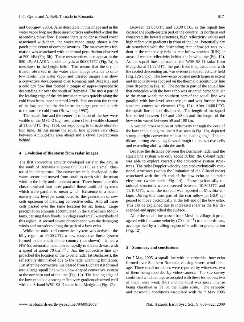
Fig. 11. (a)The MSG-2 water vapor image at 07:30 UTC 7 May2005. Three mesovortices embedded within the ascending moistflow and dry intrusion are indicated.(b) The MSG-2 high resolu-tion visible satellite image at 11:00 UTC 7 May 2005. The relativelocation of the EEC-DWSR-2500C Bucharest radar (with red cir-cle) and WSR-98 D Medgidia radar (with blue circle). The squallline location and the centre of rotation of the low are indicated. Thesubjective surface frontal drawing is conventional.
ation and development. In this situation we can conclude thatthe basic ingredients for deep moist convection (Doswell,1996), namely, lift, instability and strong moist advection,were present.
3.3 Analysis of satellite images
The MSG-2 water vapor image from 07:30 UTC (Fig. 11a)shows a dark zone extending from the Mediterranean Seato the south of Romania associated with a dry intrusion thatis well correlated with mid-tropospheric descending motionand a low tropopause. Maximum radiance contrast at theeast of this dark zone is correlated with a jet axis (Santurette
and Georgiev, 2005). Also detectable in this image and in thewater vapor loop are three mesovortices embedded within theascending moist flow. Because there is no dense cloud coverassociated with them, the water vapor image shows a drypatch at the center of each mesovortex. The mesovortices for-mation was associated with a thermal perturbation observedat 500-hPa (Fig. 5b). These mesovortices also appear in the850-hPa ALADIN model analysis at 06:00 UTC (Fig. 7a) asmesolows in the height field. This means that the dry in-trusion observed in the water vapor image extends to mid-low levels. The water vapor and infrared images also showa convective development over Romania and Bulgaria, anda cold dry flow that formed a tongue of upper-troposphericdescending air over the south of Romania. The moist part ofthe leading edge of the dry intrusion moves quickly along thecold front from upper and mid-levels, fans out near the centreof the low, and then the dry intrusion surges perpendicularlyto the surface cold front (Browning, 1997).
The squall line and the center of rotation of the low werevisible in the MSG-2 high resolution (1 km) visible channelat 11:00 UTC (Fig. 11b), corresponding to tornado observa-tion time. In this image the squall line appears very clear,between a cloud-free area ahead and a cloud covered areabehind.
4 Evolution of the storm from radar images
The first convective activity developed early in the day, inthe south of Romania at about 05:00 UTC, as a small clus-ter of thunderstorms. The convective cells developed in thewarm sector and moved from south to north with the meanwind in the hilly and mountain area. Three hours later thiscluster evolved into three parallel linear multi-cell systemswhich were parallel to mean wind. Existence of a south-easterly low level jet contributed to the generation of newcells upstream of maturing convective cells. And all thesecells passed over the same location for six hours. Largeprecipitation amounts accumulated in the Carpathian Moun-tains, causing flash floods in villages and small watersheds ofthis region. A second severe phenomenon was the damagingwinds and tornadoes along the path of a bow echo.
While the multi-cell convective system was active in thehilly region at 09:00 UTC, a new convective linear systemformed in the south of the country (not shown). It had aNW-SE orientation and moved rapidly to the north-east witha speed of about 70 km h−1. As, the convective line ap-proached the location of the C-band radar (at Bucharest), thereflectivity diminished due to the radar scanning limitation.Just after the convective line passed from Bucharest it formedinto a large squall line with a bow-shaped convective systemat the northern end of the line (Fig. 12). The leading edge ofthe bow echo had a strong reflectivity gradient observed wellwith the S-band WSR-98 D radar from Medgidia (Fig. 12).
Between 11:00 UTC and 13:30 UTC, as this squall linecrossed the south-eastern part of the country, its northern endconserved the bowed structures, high reflectivity values andhigh reflectivity gradients in front of the line. Potentially dryair associated with the descending rear inflow jet was evi-dent in the reflectivity field as rear inflow notches (RIN) orareas of weaker reflectivity behind the bowing line (Fig. 12).As the squall line approached the WSR-98 D radar fromMedgidia at 11:52 UTC, the gust front line, associated withthe cooled descending air, was evident in the reflectivity field(Fig. 12b and c). The bow-echo became much larger in extentand its activity was focused on the thermal discontinuity linezone depicted in Fig. 10. The northern part of the squall linethat coincides with the bow echo was oriented perpendicularto the mean wind; the southern part of the squall line wasparallel with low-level southerly jet and was formed fromscattered convective elements (Fig. 12). After 14:00 UTC,the squall line almost dissipated. The length of the squallline varied between 150 and 250 km and the length of thebow-echo varied between 50 and 100 km.
A vertical cross section of reflectivity through the core ofthe bow echo, along the line AB as seen in Fig. 13a, depictedstrong, upright convective cells at the leading edge. This in-dicates strong ascending flows through the convective cellsand extending aloft within the anvil.
Because the distance between the Bucharest radar and thesquall line system was only about 30 km, the C-band radarwas able to explore correctly the convective system struc-tures. The radar Doppler velocity depicted cyclonically rota-tional structures (within the limitation of the C-band radar)associated with the left end of the bow echo at all radarelevations (white circle, Fig. 14). These cyclonically ro-tational structures were observed between 10:30 UTC and11:10 UTC, when the tornado was reported in Movilita vil-lage. During this time, part of the rear inflow jet (RIJ) ap-peared to move cyclonically at the left end of the bow echo.This can be explained due to increased shear as the RIJ de-scended and approached the surface.
After the squall line passed from Movilita village, it prop-agated with the same velocity (70 km h−1) to the north-east,accompanied by a trailing region of stratiform precipitation(Fig. 12).
5 Summary and conclusions
On 7 May 2005, a squall line with an embedded bow echoformed over Southern Romania causing severe wind dam-age. Three small tornadoes were reported by witnesses, twoof them being recorded by video camera. The site surveyconfirmed wind damage associated with these tornadoes, twoof them were weak (F0) and the third was more intensebeing classified as F1 on the Fujita scale. The synopticand mesoscale conditions associated with the 7 May 2005
Fig. 12. Sequence of base reflectivity from the WSR-98 D Medgidia radar (depicted with R) at 0.5◦C tilt at: (a) 10:57 UTC,(b) 11:58 UTCand(c) 12:52 UTC. Identified are the squall line, bow echo and rear inflow notch, trailing region of stratiform precipitation, gust front andcold front. The distance from the radar to the second circle is 100 km. The area depicted is a zoom represented by the white rectanglenumber 2 from Fig. 2.
Southern Romania squall line with bow-echo is summarizedby the composite chart valid for 11:00 UTC (Fig. 15).
– The squall line with an embedded bow echo formedalong a surface thermal and moisture boundary lineahead of the surface cold front associated with a stronglow pressure system.
– The squall line formed within the 925-hPa wet bulb po-
tential temperature ridge as a southerly low level jet of16 m s−1 at 850-hPa was advecting a warm and moistair mass into Southern Romania.
– Ahead of the bow echo, the vertical profile of the windshowed a veering of the wind at low levels with gener-ally constant wind direction at mid and upper levels.
– Behind the bow echo, the vertical profile of the wind
Fig. 13. (a)Vertical cross section through the middle of the echo(line AB) from (b) EEC-DWSR-2500C Bucharest radar reflectivityat 0.5◦ tilt at 10:50 UTC 7 May 2005. The white rectangle repre-sents the area depicted in Fig. 14.
indicates unidirectional (near south-westerly wind at alllevels). The winds are stronger than those ahead of thebow echo, and the rear inflow jet of 16–18 m s−1 at 850-hPa was present.
– The upper levels winds were parallel with the low levelwind both sides of the bow echo as the vertical profileindicated.
– The squall line traveled along a low-level thermalboundary oriented nearly parallel with the mean wind.
The vertical profiles of the wind obtained from the ALADINmodel at 12:00 UTC, behind and ahead of the event (points Aand B from Fig. 15) depicts strong vertical wind shear at lowlevels with unidirectional shear at medium and upper levelsahead of the event and unidirectional shear to the rear of theevent.
Fig. 14. The EEC-DWSR-2500C data from Bucharest radar.Doppler velocity data at(a)2.4◦ tilt with radar beam at 1500 m high,(b) 1.5◦ tilt with radar beam at 900 m high,(c) 0.5◦ tilt with radarbeam at 400 m high and(d) reflectivity at 0.5◦ tilt at 11:00 UTC7 May 2005. Rear inflow jet (RIJ) and rear inflow notch (RIN) isindicated. The area depicted is a zoom represented by the whiterectangle in Fig. 13b and also by the white rectangle number 3 fromFig. 2.
The synoptic and mesoscale conditions associated with the7 May 2005 Southern Romania squall line with bow-echoappear to have similarities with those described by studiesof “dynamic” derechoes (Johns and Hirt, 1987) (Fig. 1b).These similarities include: initiation of the squall line in thewarm sector of a strong surface low associated with an upperlevel trough; development of the squall line ahead of a coldfront and development of the tornado structures associatedwith a portion of the bow-echo (Johns et al., 1993). Othersimilarities with the “dynamic” pattern are the existence ofstronger midlevel winds in the 7 May 2005 event and thepresence of dry, potentially cold intrusions in the downdraftentrainment region. The differences includes the amount ofpotential instability over the genesis area, orientation of thelimited bowing segment normal to the mean wind and themoving of the bow echo along the surface thermal boundarythat are typically associated with “warm-season” derechoes(Johns and Hirt, 1987). Due to the Romanian topographywith the Carpathian Mountains situated in the middle of thecountry, severe wind damage reports caused by convectivestorms cannot affect an area more than 400 km in length asthe Johns and Hirt (1987) derecho definition requires. Thesquall lines observed in Romania have a major axis lengthbetween 100 km and 300 km (Stan-Sion, 2007).
The most classic synoptic pattern in North Americainvolves north-westerly flow aloft, whereas in Romania,southerly upper flow is often associated with severe events.
The EEC-DWSR-2500C Bucharest radar and the WSR-98 D Medgidia radar were important tools in the detection
Fig. 15. Composite chart for 11:00 UTC 7 May 2005. Identified are 500-hPa heights in decameters (solid lines), surface front (conventionalsymbol), position of the surface low (depicted by L), 850-hPa temperature in degrees Celsius (thin line), 925 hPa wet bulb potential tem-perature (dashed line with 14◦), surface dewpoint temperature in degrees Celsius (squared dot lines), low level jet in front of the squall line(arrow with 16 m/s and rear inflow jet (arrow with 18 m/s and arrow with squared dots) that impinges in the rear part of the bow echo and10 m wind from real observations (black arrows). The thermal and moist convergence lines are depicted with long dashed-dot lines. Thevertical profiles of the wind from ALADIN model are depicted 30 km to the rear (A) and 30 km in front (B) of the bow echo. The bow echolocation is depicted with a thick grey line.
of the radar signature associated with the 7 May 2005 bowecho. The identified bow echo patterns are summarized:
– A rear inflow notch was evident in the radar reflectivityimage.
– A high reflectivity gradient was observed in front of theline.
– The rear inflow jet was evident in the Doppler radialvelocity image at about 1500 m from the ground.
– The vertical cross-section of reflectivity through thecore of the bow echo depicted strong, upright convec-tive cells at the leading edge.
– The radar Doppler velocity depicted cyclonically ro-tational structures associated with the left end of thebowed echo.
The 7 May squall line had some features in common with thetype 1 radar echo pattern introduced by Przybylinski (1995).It was characterized by a bow echo 100 km in length with anassociated mesocirculation near the northern end. A stronglow-level reflectivity gradient was observed along the leadingedge of the bow and a rear inflow notch was present behindthe leading line.
The cyclonically rotational structures were observed be-tween 10:30 and 11:10 UTC, when a tornado was reported inMovilita village. Thus, the wind damage reported in Mo-vilita village was due to the intensification of the rear in-flow jet and due to tornado event. It was not possible toidentify the radar structures which generated the Buftea andCiobanu tornadoes, but it is likely that they were associatedwith mesovortices along the gust front.
At the time of this event, Romanian forecasters had a lotof experience in accurately forecasting the weather associ-ated with Mediterranean Cyclones and in issuing warningsfor the location of heavy rain. Upon the installation of theDoppler radar network, the Romanian forecaster was chal-lenged to recognize environmental factors that favor super-cell development. However, the environment that is partic-ularly favorable for bow echo formation and its associatedtornadoes were concepts totally unknown to our forecastersat the time of this event.
The Johns and Hirt (1987, 1993) studies offer a usefulmodel for the recognition of an environment favoring bowechoes and consequently better short term forecasting. Theidentification of the bow echo pattern on the radar can con-tribute to improvements of the warnings decisions. TheRomanian bow echo cases have many similarities with the
cases observed in United States and Europe, although themesoscale flows induced by the Carpathian Mountains andthe Black Sea, create several differences. This study is thefirst step in creating an appropriate conceptual model forsquall line and bow echo formation in Romania.
Acknowledgements.The authors are especially grateful to ac-knowledge D. Banciu and S. Tascu for their preparation ofmodel data products and S. Stefan for her encouragement in thecompletion of this work. The authors also acknowledge the expertsteam that performed the damage survey. The authors would liketo acknowledge the comments and suggestions of the anonymousreviewers that greatly improved the paper.
Edited by: A. LoukasReviewed by: three anonymous referees
References
Atkins, N. T., Arnott, J. M., Przybylinski, R. W., Wolf, R. A.,and Ketcham, B. D.: Vortex structure and evolution within bowechoes. Part I: Single-Doppler and damage analysis of the 29June 1998 derecho, Mon. Weather Rev., 132, 2224–2242, 2004.
Arnott, J. M. and Atkins, N. T.: Tornadogenesis within quasilinearconvective systems. Part I: Radar and storm damage analysis ofthe 29 June 1998 derecho, Preprints, 21st Conf. on Severe LocalStorms, San Antonio, TX, Amer. Meteor. Soc., 494–497, 2002.
Bell, A.: Radar Characteristics of Tropical-like Severe Storms inRomania, Conference on Radar in Meteorology and Hydrol-ogy (ERAD2008), Helsinki, Finland, ISSN: 978-951-697-676-4,2008.
Browning, K. A., and Pardoe, C. W.: Structure of low-level jetstreams ahead of mid-latitude cold fronts, Q. J. Roy. Meteor.Soc., 99, 619–638, 1973.
Browning, K. A., Ballard, S. P., and Davitt, C. S. A.: High-Resolution Analysis of Frontal Fracture, Mon. Weather Rev.,125, 1212–1230, 1997.
Doswell III, C. A., Brooks, H. E., and Maddox, R. A.: Flash floodforecasting: An ingredients-based methodology, Weather Fore-cast., 11, 560–581, 1996.
Burgess, D. W. and Smull, B. F.: Doppler radar observationsof a bow echo associated with a long-track severe windstorm,Preprints, 16th Conf. on Severe Local Storms, Kananaskis Park,AB, Canada, Amer. Meteor. Soc., 203–208, 1990.
Coniglio, M. C., Stensrud, D. J., and Richman, M. B.: An Ob-servational Study of Derecho-Producing Convective Systems,Weather Forecast., 19, 320–337, 2004.
Evans, J. S. and Doswell III, C. A.: Examination of derecho en-vironments using proximity soundings, Weather Forecast., 16,329–342, 2001.
Forbes, G. S. and Wakimoto, R. M.: A concentrated outbreak of tor-nadoes, downbursts and microbursts, and implications regardingvortex classification, Mon. Weather Rev., 111, 220–236, 1983.
Fujita, T. T. and Byers, H. R.: Spearhead echo and downburst in thecrash of an airliner, Mon. Weather Rev., 105, 129–146, 1977.
Fujita, T. T.: Manual of downburst identification for project Nim-rod, Satellite and Mesometeorology Research Paper 156, Dept.of Geophysical Sciences, University of Chicago, [NTIS PB-286048], 104 pp., 1978.
Fujita, T. T.: Tornadoes and downbursts in the context of general-ized planetary scales, J. Atmos. Sci., 38, 1511–1534, 1981.
Fujita, T. T. and Wakimoto, R. M.: Five scales of airflow associatedwith a series of downbursts of 16 July 1980, Mon. Weather Rev.,109, 1438–1456, 1981.
Funk, T. W., Darmofal, K. E., Kirkpatrick, J. D., DeWald, V. L.,Przybylinski, R. W., Schmocker, G. K., and Lin, Y.-J.: Storm re-flectivity and mesocyclone evolution associated with the 15 April1994 squall line over Kentucky and southern Indiana, WeatherForecast., 14, 976–993, 1999.
Gatzen, C.: A Derecho in Europe: Berlin, 10 July 2002, WeatherForecast., 19, 639–645, 2004.
Jorgensen, D. P. and Smull, B. F.: Mesovortex circulations seen byairborne Doppler radar within a bow-echo mesoscale convectivesystem, B. Am. Meteorol. Soc., 74, 2146–2157, 1993.
Johns, R. H. and Hirt, W. D.: Derechos: Widespread ConvectivelyInduced Windstorms, Weather Forecast., 2, 32–49, 1987.
Johns, R. H. and Doswell III, C. A.: Severe local storms forecasting,Weather Forecast., 7, 588–612, 1992.
Johns, R. H.: Meteorological Conditions Associated with BowEcho Development in Convective Storms, Weather Forecast., 8,294–299, 1993.
Keyser, D. and Shapiro, M.: A Review of the Structure and Dy-namics of Upper-Level Frontal Zones, Mon. Weather Rev., 114,452–499, 1986.
Kotroni, V. and Lagouvardos, K.: Low-level jet streams associ-ated with atmospheric cold fronts – seven case studies from theFRONTS 87 experiment, Geophys. Res. Lett., 20(13), 1371–1374, 1993.
Lemon, L. R., Stan-Sion, A., Soci, C., and Cordoneanu, E.: Astrong, long-track, Romanian tornado, Atmos. Res., 67–68, 391–416, 2003.
Lopez, J. M. and Arus, J.: A Mediterranean derecho: Catalonia(Spain), 17th August 2003, Preprints, Third European Conf. onSevere Storms, Leon, Spain, CD-ROM, P53, 2004.
Pfost, R. L. and Gerard, A. E.: “Bookend vortex” – induced torna-does along the Natchez Trace, Weather Forecast., 12, 572–580,1997.
Przybylinski, R. W.: The Bow Echo: Observations, Numerical Sim-ulations, and Severe Weather Detection Methods, Weather Fore-cast., 10, 203–218, 1995.
Przybylinski, R. W., Schmocker, G. K. and Lin, Y.-J.: A study ofstorm and vortex morphology during the intensifying stage ofsevere wind mesoscale convective systems, Preprints, 20th Conf.on Severe Local Storms, Orlando, FL, Amer. Meteor. Soc., 173–176, 2000.
Punkka, A. J., Teittinen, J., and Johns, R. H.: Synoptic andMesoscale Analysis of a High-Latitude Derecho-Severe Thun-derstorm Outbreak in Finland on 5 July 2002, Weather Forecast.,21, 752–763, 2006.
Santurette, P. and Georgiev, C. G.: Weather Analysis and Forecast-ing Applying Satellite Water Vapor Imagery and Potential Vor-ticity Analysis, Ed. Elsevier Academic Press, 180 pp., 2005.
Schmid, W., Schiesser, H. H., Furger, M., and Jenni, M.: The Originof Severe Winds in a Tornadic Bow-Echo Storm over NorthernSwitzerland, Mon. Weather Rev., 128, 192–207, 2000.
Stan-Sion, A. and Antonescu, B.: Mesocyclones in Romania – char-acteristics and environments, 23rd Conf. on Severe Local Storms,San Louis (MO), USA, 5–10 November, 2006.
Stan-Sion, A., Stumpf, G., and Antonescu, B.: An exceptional tor-nado outbreak during 2005 in southeastern Romania, EuropeanGeosciences Union (EGU 2006) Vienna, Austria, 2–7 April,(ISSN: 1029-7006), 2006.
Stan-Sion, A., Oprea, C. I., and Antonescu, B.: Bow echo char-acteristics in Romania, 33rd Conference on Radar Meteorology,Cairns, Australia, 6–10 August, 2007.
Stan-Sion, A. and Antonescu, B.: Mesocyclones characteristics inRomania, 33rd Conference on Radar Meteorology, 6–10 August,Cairns, Queensland, Australia, 2007.
Wakimoto, R. M.: The West Bend, Wisconsin storm of 4 April1981: A problem in operational meteorology, J. Appl. Meteorol.,22, 181–189, 1983.
Weisman, M. L.: The genesis of bow echoes: A rear-inflow inducedmeso-convective structure, NCAR cooperative thesis No. 125,148 pp. (Available from the National Center for Atmospheric Re-search, P.O. Box 3000, Boulder, Colorado, 80307), 1990.
The European Centre for Medium Range Weather Forecasters(ECMWF):http://www.ecmwf.int/research/ifs/, access: 23 April2009.