Moving on: an archaeological record of mobility in the Esperance area of South-Western Australia Moya Smith Department of Anthropology, Western Australian Museum, Locked Bag 49, Welshpool DC, Western Australia, 6986, Australia. ABSTRACT – High residential mobility characterises the lifestyle of Aboriginal people of the Esperance area over the last 13,000 years. Despite environmental conditions and a resource structure in the coastal zone that would have sustained a less mobile lifestyle, the archaeological record in both coast and interior reflects a long-term commitment to moving on. KEYWORDS: archaeology, prehistory, sites, resource structures 016–029 (2011) 79 INTRODUCTION Towards the end of the 1980s Sylvia Hallam was fond of telling those who asked about her profession, that she was a ‘prehistoric archaeologist’, enjoying the laughter that this elicited. However, pun aside, this does position Sylvia as an archaeologist whose vision was largely inspired by history, by the need to tell a story. While using the information that science could provide, at the same time she reflected the differences between an archaeology founded in history and an archaeology struggling either to define itself as science or to promote archaeological research as a scientific process (with an hypothesis, test, analysis and result). As one of the two pioneer archaeologists working in Western Australia from the early 1970s (the other being Charles Dortch), Sylvia Hallam encouraged generations of Western Australian students to embark on regional studies of pre-European Aboriginal societies and to tell the story of the human past in Western Australia. Explicitly or otherwise, Sylvia presented models that shaped the frameworks of decades of research. Her work continued to focus on a story, a sense of problem, rather than on the process of discovery. Sylvia encouraged researchers to examine all available information that might inform the story of Aboriginal people’s lives in pre-European Western Australia. Her students learnt to recognize the importance of re-examining primary excavation reports rather than relying only on latest reviews, to acknowledge the significance of landscape and resources and to extend their focus beyond individual sites. They also learnt to seek local cultural and environmental contexts, to value and use scientific evidence, to realise and exploit the potential value of historical and ethnographic records (Hallam 1975), and to understand the difference between the past and the histories that can be written about that past (Hexter 1971). Sylvia’s own regional prehistory of the Swan River area (e.g. Hallam 1983, 1986a) examined artefact distribution and promulgated models about the antiquity of occupation, definable phases of occupation history and population density. She drew the social framework for understanding the sites identified in the Swan Coastal Plain from analysis of ethnohistoric sources. From these she detailed subsistence patterns and social organisation, focusing on groupings, movements, aggregation, dispersal, and resource scheduling, recurrent or ephemeral occupation of different locations and movement between them. Thus people themselves were the primary players in these histories, whatever the impact on their lives of changing climate and resources. However, she never assumed that specific ethnohistoric or ethnographic data could be used to interpret archaeological data from any hunter-gatherer society in any geographic location. She constantly queried the apparent enthusiasm with which archaeologists applied such models across space and time. She insisted that at the very least it was important to consider the relevance of ethnohistoric data at a local level, before contemplating wider geographic or temporal application. Contemporary users of ethnohistoric data perhaps detail the limitations of its use more explicitly: ‘The regional ethnohistoric record RECORDS OF THE WESTERN AUSTRALIAN MUSEUM SUPPLEMENT
Transcript
Moving on: an archaeological record
of mobility in the Esperance area of
South-Western Australia
Moya Smith
Department of Anthropology, Western Australian Museum, Locked Bag 49, Welshpool DC, Western Australia, 6986, Australia.
ABSTRACT – High residential mobility characterises the lifestyle of Aboriginal people of the Esperance area over the last 13,000 years. Despite environmental conditions and a resource structure in the coastal zone that would have sustained a less mobile lifestyle, the archaeological record in both coast and interior refl ects a long-term commitment to moving on.
fond of telling those who asked about her profession,
that she was a ‘prehistoric archaeologist’, enjoying
the laughter that this elicited. However, pun aside,
this does position Sylvia as an archaeologist whose
vision was largely inspired by history, by the need
to tell a story. While using the information that
science could provide, at the same time she refl ected
the differences between an archaeology founded
in history and an archaeology struggling either to
defi ne itself as science or to promote archaeological
research as a scientifi c process (with an hypothesis,
test, analysis and result). As one of the two pioneer
archaeologists working in Western Australia from
the early 1970s (the other being Charles Dortch),
Sylvia Hallam encouraged generations of Western
Australian students to embark on regional studies
of pre-European Aboriginal societies and to tell
the story of the human past in Western Australia.
Explicitly or otherwise, Sylvia presented models
that shaped the frameworks of decades of research.
Her work continued to focus on a story, a sense of
problem, rather than on the process of discovery.
Sylvia encouraged researchers to examine all
available information that might inform the story of
Aboriginal people’s lives in pre-European Western
Australia. Her students learnt to recognize the
importance of re-examining primary excavation
reports rather than relying only on latest reviews,
to acknowledge the significance of landscape
and resources and to extend their focus beyond
individual sites. They also learnt to seek local
cultural and environmental contexts, to value and use scientifi c evidence, to realise and exploit the potential value of historical and ethnographic records (Hallam 1975), and to understand the difference between the past and the histories that can be written about that past (Hexter 1971).
Sylvia’s own regional prehistory of the Swan River area (e.g. Hallam 1983, 1986a) examined artefact distribution and promulgated models about the antiquity of occupation, definable phases of occupation history and population density. She drew the social framework for understanding the sites identifi ed in the Swan Coastal Plain from analysis of ethnohistoric sources. From these she detailed subsistence patterns and social organisation, focusing on groupings, movements, aggregation, dispersal, and resource scheduling, recurrent or ephemeral occupation of different locations and movement between them. Thus people themselves were the primary players in these histories, whatever the impact on their lives of changing climate and resources. However, she never assumed that specifi c ethnohistoric or ethnographic data could be used to interpret archaeological data from any hunter-gatherer society in any geographic location. She constantly queried the apparent enthusiasm with which archaeologists applied such models across space and time. She insisted that at the very least it was important to consider the relevance of ethnohistoric data at a local level, before contemplating wider geographic or temporal application. Contemporary users of ethnohistoric data perhaps detail the limitations of its use more explicitly: ‘The regional ethnohistoric record
RECORDS OF THE WESTERN AUSTRALIAN MUSEUM
SUPPLEMENT
MOVING ON: MOBILITY IN THE ESPERANCE AREA 17
serves then as a source of territorial and economic modelling, rather than as an indicator of prehistoric behavioural patterns’ (Dortch 2000: 17).
In 1986 Hallam could say that juxtaposing ethnohistoric data and archaeological materials was a rare phenomenon (Hallam 1986b). Perhaps inspired largely by the success of Hallam’s own work, Western Australian students and heritage consultants have gone on to make this the standard in any fi eld survey and analysis of archaeological materials. Indeed, her analysis of Aboriginal settlement patterns in the Swan Coastal Plain was a signifi cant model for the work of several post-graduate archaeology students (Bird 1985; Ferguson 1985; Schwede 1990), including my own survey and analysis of archaeological sites in the Esperance area (Smith 1993). This followed Sylvia’s example of detailing a story of a particular location, albeit a story with relevance for general questions in Australian archaeology.
MAKING SENSE OF SITES IN THE ESPERANCE AREA
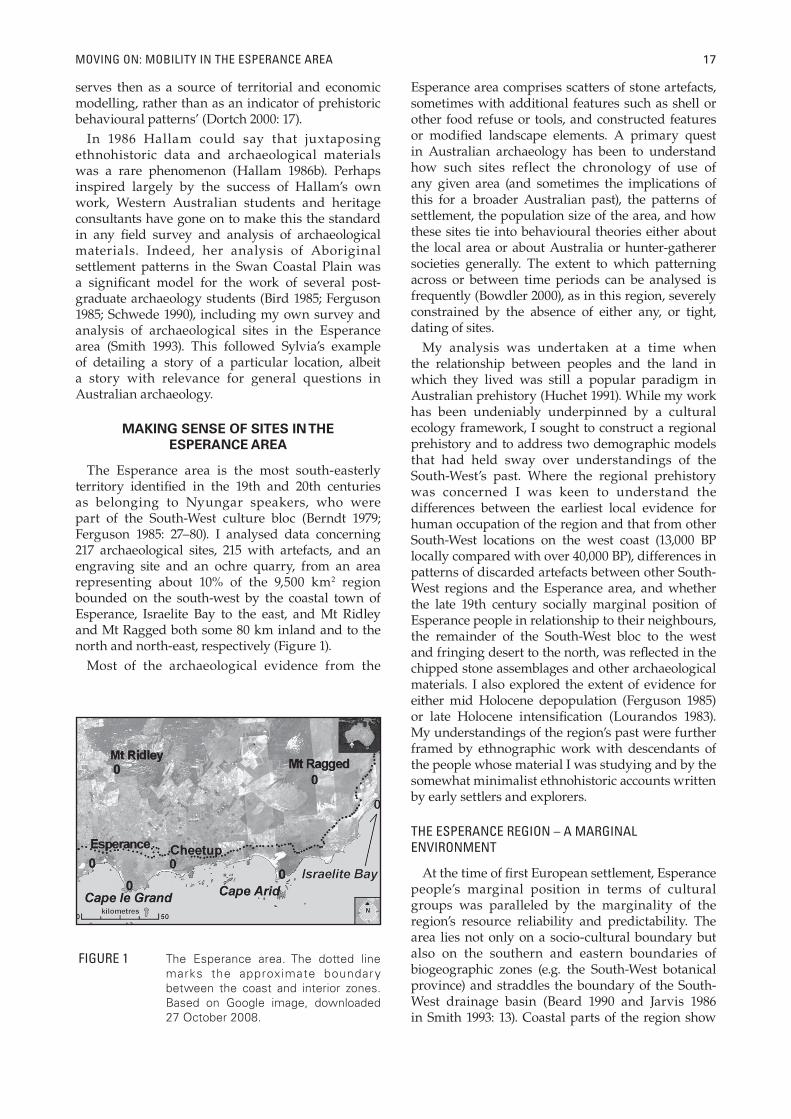
The Esperance area is the most south-easterly territory identifi ed in the 19th and 20th centuries as belonging to Nyungar speakers, who were part of the South-West culture bloc (Berndt 1979; Ferguson 1985: 27–80). I analysed data concerning 217 archaeological sites, 215 with artefacts, and an engraving site and an ochre quarry, from an area representing about 10% of the 9,500 km2 region bounded on the south-west by the coastal town of Esperance, Israelite Bay to the east, and Mt Ridley and Mt Ragged both some 80 km inland and to the north and north-east, respectively (Figure 1).
Most of the archaeological evidence from the
Esperance area comprises scatters of stone artefacts, sometimes with additional features such as shell or other food refuse or tools, and constructed features or modifi ed landscape elements. A primary quest in Australian archaeology has been to understand how such sites reflect the chronology of use of any given area (and sometimes the implications of this for a broader Australian past), the patterns of settlement, the population size of the area, and how these sites tie into behavioural theories either about the local area or about Australia or hunter-gatherer societies generally. The extent to which patterning across or between time periods can be analysed is frequently (Bowdler 2000), as in this region, severely constrained by the absence of either any, or tight, dating of sites.
My analysis was undertaken at a time when the relationship between peoples and the land in which they lived was still a popular paradigm in Australian prehistory (Huchet 1991). While my work has been undeniably underpinned by a cultural ecology framework, I sought to construct a regional prehistory and to address two demographic models that had held sway over understandings of the South-West’s past. Where the regional prehistory was concerned I was keen to understand the differences between the earliest local evidence for human occupation of the region and that from other South-West locations on the west coast (13,000 BP locally compared with over 40,000 BP), differences in patterns of discarded artefacts between other South-West regions and the Esperance area, and whether the late 19th century socially marginal position of Esperance people in relationship to their neighbours, the remainder of the South-West bloc to the west and fringing desert to the north, was refl ected in the chipped stone assemblages and other archaeological materials. I also explored the extent of evidence for either mid Holocene depopulation (Ferguson 1985) or late Holocene intensifi cation (Lourandos 1983). My understandings of the region’s past were further framed by ethnographic work with descendants of the people whose material I was studying and by the somewhat minimalist ethnohistoric accounts written by early settlers and explorers.
THE ESPERANCE REGION – A MARGINAL ENVIRONMENT
At the time of fi rst European settlement, Esperance people’s marginal position in terms of cultural groups was paralleled by the marginality of the region’s resource reliability and predictability. The area lies not only on a socio-cultural boundary but also on the southern and eastern boundaries of biogeographic zones (e.g. the South-West botanical province) and straddles the boundary of the South-West drainage basin (Beard 1990 and Jarvis 1986 in Smith 1993: 13). Coastal parts of the region show
FIGURE 1 The Esperance area. The dotted line marks the approximate boundary between the coast and interior zones. Based on Google image, downloaded 27 October 2008.
18 MOYA SMITH
remarkable predictability in rainfall, evaporation, temperature and prevailing wind direction, while the inland, sometimes a mere 10 km from the coast, has unpredictable characteristics similar to those of the neighbouring Nullarbor and arid zone to the east and north.
On the fringes of a classic Dry Mediterranean climate – with seasonal rainfall patterns, wet winters and predominantly dry summers – the annual rainfall along the coast averages 600–700 mm with an evaporation rate of 1,400–1,600 mm. Inland the seasonal nature of rainfall is less marked, with sporadic summer thunderstorms providing most of the annual rainfall of 350–400 mm. Here the annual evaporation rate is 2,000 mm. Temperatures range from -4°C to 47°C. On the coast the average maximum temperature in the hottest months January and February is 26°C, and average winter minimum between June and August is 8.5°C. Inland the average summer maximum is 30°C, and winter minimum 4.5°C.
A proposed period of aridity and extensive dune building between 20,000 and 13,000 BP (Bowler 1976; Wyrwoll 1979) ends at the time of earliest known occupation of the Esperance area. At this stage, the coastline was about 80 km distant, 20 km closer than during the last glacial maximum. The exact nature of wind circulation and temperature variation is unclear but Beard (1973) may be correct in suggesting that rainfall curves probably paralleled the coast as they do now, and Recherche Archipelago Islands are the remnants of occupied wetter areas. Much of the current coast zone would have received reduced or less effective rainfall. By 9,000 years ago the coastline came within 5–10 km of its existing position. It is probable that the current coast and interior zones of the study area experienced aridity similar to the Eucla area and that, if not abandoned during the glacial maximum, the area was not densely occupied (Smith 1993: 37–38).
Locals would tell you that cool breezes – or howling gales – and cloudy weather are a consistent feature of the Esperance region. If similarly strong winds prevailed since fi rst human occupation they must also have impacted on selection of camp site. During summer, breezes commonly come from the north-east in the morning, swinging round to south-east in the afternoon, and sometimes reaching speeds of up to 20 km/h. Throughout winter strong winds and gales come from an arc between north-west and south-west. By August and September the winds are re-established in the summer pattern, with morning westerlies and afternoon south-westerlies decreasing from the ferocity of the winter winds.
The landforms and underlying geological structures of the area constrain the time frame of the archaeological residue of settlement patterns. Short drainage channels dissect a narrow coastal
plain about 10 km wide, exposing chert bearing Tertiary siltstones. The sandplain, inland from the coastal strip, is some 50 m higher than sea level and broken by small lakes and swamps in depressions. Low lying late Pleistocene and early Holocene long parallel sand dunes oriented west north-west cover much of the area, and clearly surface sites on the sandplain will date no earlier than this restricted period. More recent Holocene dunes are aligned south-west to north-east. These refl ect dune mobilising winds from the south-west to the south-east. Current coastal drift dunes are produced by prevailing strong south-westerly winds. These dunes overly shallow clay beds, Eocene marine sediments comprising siltstone and patches of limestone, Proterozoic granite and gneissic migmatite headlands and domes, and bedded quartzites. The Eocene sediments, granites and quartzites also have surface exposures, the exposed Eocene sediments containing the chert that dominates local artefact assemblages. The most dramatic features of the landscape are the granites which feature as isolated hills or domes across the sandplain, few of these are higher than 100 m.
DATING SITES
In the Esperance region, apart from three sites with any stratigraphy and dateable organic material, determination of antiquity of discarded materials and site occupancy, and the basis of discussion of variation in settlement patterning through time, was based on lithic materials and artefact types, as well as geological context of the discarded artefacts. There is a reasonably well established chronology for the appearance and disappearance of a specifi c lithic type in South-West assemblages. The sources of chert with inclusions of bryozoan fossils are considered to become inaccessible once sea levels reached their current height, around 6,000 years ago (Glover 1975a, 1975b; Ferguson 1980; Schwede 1990; Smith 1993; Dortch 2002), and even though people may have re-worked stone from earlier sites, large fl akes of bryozoan chert can be considered earlier than middle Holocene (yes Sylvia, big is indeed older!). The presence (rather than absence) of elements of the Australian Small Tool Tradition (backed blades or backed fl akes and adze slugs) reflect a discard or occupancy predominantly later than 6,000 years ago. Backed artefacts and adzes appear to become well established across Australia by around the mid Holocene (Bowdler and O’Connor 1991; Hiscock and Attenbrow 1998; Bowdler 2000), although the presence of backed artefacts is now attested as early as 8,380±20 BP near Sydney (Hiscock and Attenbrow 1998) – these early dates bolstering the validity of a temporal link between a microlith from Northcliffe and material dated at 6,780±120 BP (SUA 379) (Dortch 1975).
MOVING ON: MOBILITY IN THE ESPERANCE AREA 19
Artefact scatters are located across the landscape, on or adjacent to granite domes or ‘pavements’, frequently with little to indicate precise chronology and frequently redeposited; in lunettes or fringing dunes around freshwater swamps or lakes; on dune crests; in blowouts or defl ations in dunes; along creekbanks; in rockshelters and at stone sources. Vegetation patterns, underlying sediments and marked rainfall zones indicated a clear distinction between coast zone and interior or inland (Figure 1). The coast characteristically has scrub heath, coastal dune scrub, and mallee heath dominated by tallerack, a eucalypt (E. tetragona) that local people cited as the indicator of being in ‘coast
country’ (Veth and Moore 1989; Mr T. Bullen pers. comm. 1991); with thickets of Melaleuca, Acacia or Banksia near swamps (Figure 2). Mallee, Allocasuarina thickets, and eucalypt woodlands dominate the inland, or interior, landscape (Figure 3).
ASPECTS OF SPATIAL PATTERNING
Dortch and Morse (1984) located 10 sites or clusters of stone artefacts on the granite islands of the Recherche Archipelago. Most of the material is thought to date from the period when the islands were hills in the extended coastal plain (i.e. before
FIGURE 2 Coastal landscape near Cape le Grand.
FIGURE 3 Inland eucalypts and quandong, with Mount Ridley in the background.
20 MOYA SMITH
10,000 years ago), although it is possible that some artefacts were discarded by Aboriginal people working with sailors or whalers during the 1800s. Coastal sites are thought to demonstrate occupation after about 13,000 BP (the end of the Pleistocene dune building phase) though mostly between the mid Holocene and the historic period, and on the basis of landform and artefact typology interior sites do not appear to be earlier than mid Holocene.
There was clear variation in the distribution of sites in each of three zones – Recherche Archipelago Islands, the coastline and coastal plain and the less well watered interior. Analysis of environmental and internal site features, including site density, focus on specifi c topographic features, proximity to resources and aspect refl ected further details of spatial patterning (Smith 1993: 283). From these data I constructed a model of resource structures and settlement pattern.
SITE DENSITY
In the Esperance region the average site density, or number of km2 per site, is one site per 4.4 km2 (including all sites) or one artefact scatter per 5 km2. This varies considerably from zone to zone, and according to topographic features on which sites are located, with the exception that site density on granites is fairly consistent irrespective of zone, and, apparently irrespective, of time of artefact discard. Site density on granites ranges from one site per 1.7 km2 on the islands, to one site per 2.1 km2 on the mainland. Esperance area sites exhibit the lowest site densities and smallest artefact assemblages so far known from the South-West region. Comparative site densities from the Fitzgerald River and King George Sound areas further west are shown in Table 1.
SITE SIZE
The majority (167 or 86%) of the 193 artefact scatters recorded in the Esperance region have fewer than 351 artefacts including both debitage and formal tools (Table 2). Based on survey results, estimated fl aked stone artefact populations for the entire 9,500 km2 region amount to approximately 360,000 and estimated numbers of sites to approximately 1,700. The overall pattern of site location identifi ed so far suggests that more than one third of these would be in the coastal zone, which occupies approximately one quarter of the area.
These artefact numbers appear signifi cantly lower than in either the southern west coast or the arid zone. Surface scatters at Ellenbrook, Quininup, and in the Perth metropolitan region have several thousand artefacts. In one 14 km2 area of the Swan Coastal Plain, Hallam (1983) has recorded 50,000 artefacts per square kilometre. In one part of the Arid Zone ‘the majority of sites contain 5000 pieces
or less … [though] three sites contain over 100,000
pieces’ (Veth 1989: 81).
SPECIFIC TOPOGRAPHIC FEATURES
The distribution of the small artefact scatters
across the landscape is not random but tied to
resource availability in the coastal and interior
zones. Granite domes and granite flats are the
focus of sites in all three zones. All island sites, and
approximately 58% of both coastal and interior sites
are on granites, while in terms of artefact numbers
67.9% of coastal artefacts and 75% of interior artefacts
were discarded on these features. Remaining sites
focus on different features in the mainland zones.
In the coastal zone, swamps, rivers, lakes (21%) and
dunes (20.3%) are the other foci of sites, while, in
the interior, other sites focus on salt lakes (26%) and
areas of the sandplain (14%). Probable reasons for the
favoured status of granites include: the diversity of
associated vegetation including documented food
sources; ease of access to shelter from wind, rain
and sun; convenience as look-out posts to monitor
resources or other people; proximity to other
resource zones; and the water catchment properties
of granites
PROXIMITY TO RESOURCES
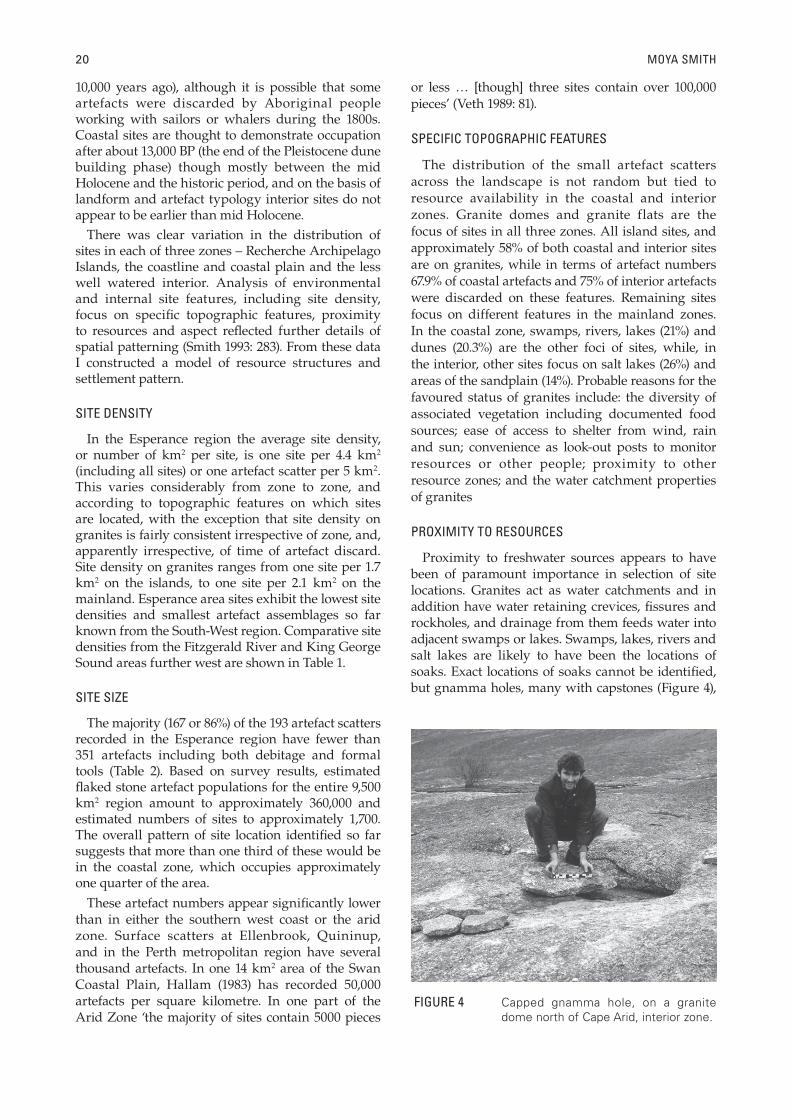
Proximity to freshwater sources appears to have been of paramount importance in selection of site locations. Granites act as water catchments and in addition have water retaining crevices, fi ssures and rockholes, and drainage from them feeds water into adjacent swamps or lakes. Swamps, lakes, rivers and salt lakes are likely to have been the locations of soaks. Exact locations of soaks cannot be identifi ed, but gnamma holes, many with capstones (Figure 4),
FIGURE 4 Capped gnamma hole, on a granite dome north of Cape Arid, interior zone.
MOVING ON: MOBILITY IN THE ESPERANCE AREA 21
TAB
LE 1
C
ompa
rativ
e si
te d
ensi
ties
expr
esse
d as
km
2 pe
r si
te:
Esp
eran
ce,
Gai
rdne
r R
iver
and
Kin
g G
eorg
e S
ound
are
as (
afte
r ta
ble
6.28
of
Sm
ith 1
993:
284
, w
ith
data
fro
m B
ird 1
985;
Fer
guso
n 19
85).
Key:
‘in
land
’ –
inla
nd s
alt
lake
; ‘a
ll si
tes’
– i
nclu
des
depo
sits
, ar
tefa
cts
scat
ters
, oc
hre
sour
ces,
eng
ravi
ng,
ston
e ar
rang
emen
ts, b
uria
ls, s
hell
scat
ters
, qua
rrie
s; ‘a
rtef
acts
onl
y’ –
incl
udes
sca
tter
s bu
t ex
clud
es q
uarr
ies
and
isol
ated
art
ifact
s.
Isla
ndCo
ast
Inte
rior
All
Coas
t Sa
ndpl
ain
Inte
rmed
iate
Inla
nd
All
den
sity
all
sit
es2.0
3.94
6.25
4.4
0.2
1.4
0.6
1.5
0.9
1.13
n =
1015
552
217
3732
5853
180
den
sity
art
efac
ts o
nly
2.0
4.6
6.5
4.9
0.2
1.9
1.4
1.7
1.3
n =
1013
350
193
2924
2745
123
art
efac
ts o
nly
/gra
nit
e1.
72.0
12.0
72.0
5
n =
1078
2911
7 TA
BLE
2
Num
bers
of
site
s –
of v
aryi
ng n
umbe
rs o
f ar
tefa
cts
– in
diff
eren
t zo
nes
(aft
er t
able
s 6.
7, 6
.22
and
7.1
in S
mith
199
3). K
ey: F
C –
bry
ozoa
n ch
ert;
A –
adz
e; B
B –
ba
cked
art
efac
ts; E
– a
rtef
acts
in E
urop
ean
mat
eria
ls (s
ee a
lso
Dor
tch
and
Mor
se 1
984:
36;
tab
le 1
).
NU
MB
ER
OF
ART
EFA
CTS
NUM
BER
OF IS
LAN
D SI
TES
FCA or BB
E%
OF
SITE
SIN
ZO
NE
NUM
BER
OF C
OAST
SI
TES
FCA or
B
B
E%
OF
SITE
S IN
ZON
E
NU
MB
ER
OF
INLA
ND
SITE
S
FCA or
BB
E%
OF
SITE
S IN
ZO
NE
TOTA
L SI
TE
NU
MB
ER
0–
30
55
150
42
51
31.6
132
226
.060
31–
99
55
250
322
91
24.1
82
116
.045
100
–350
392
154
29.3
23
152
46.
062
351
–50
09
52
6.8
41
8.0
13
501
–10
00
73
5.3
22
24.
09
>10
00
41
42
3.0
4
TOTA
L10
133
541
1050
22
7
ESPE
RAN
CE
GA
IRD
NER
RIV
ER
KIN
G GE
ORGE
SOU
ND
22 MOYA SMITH
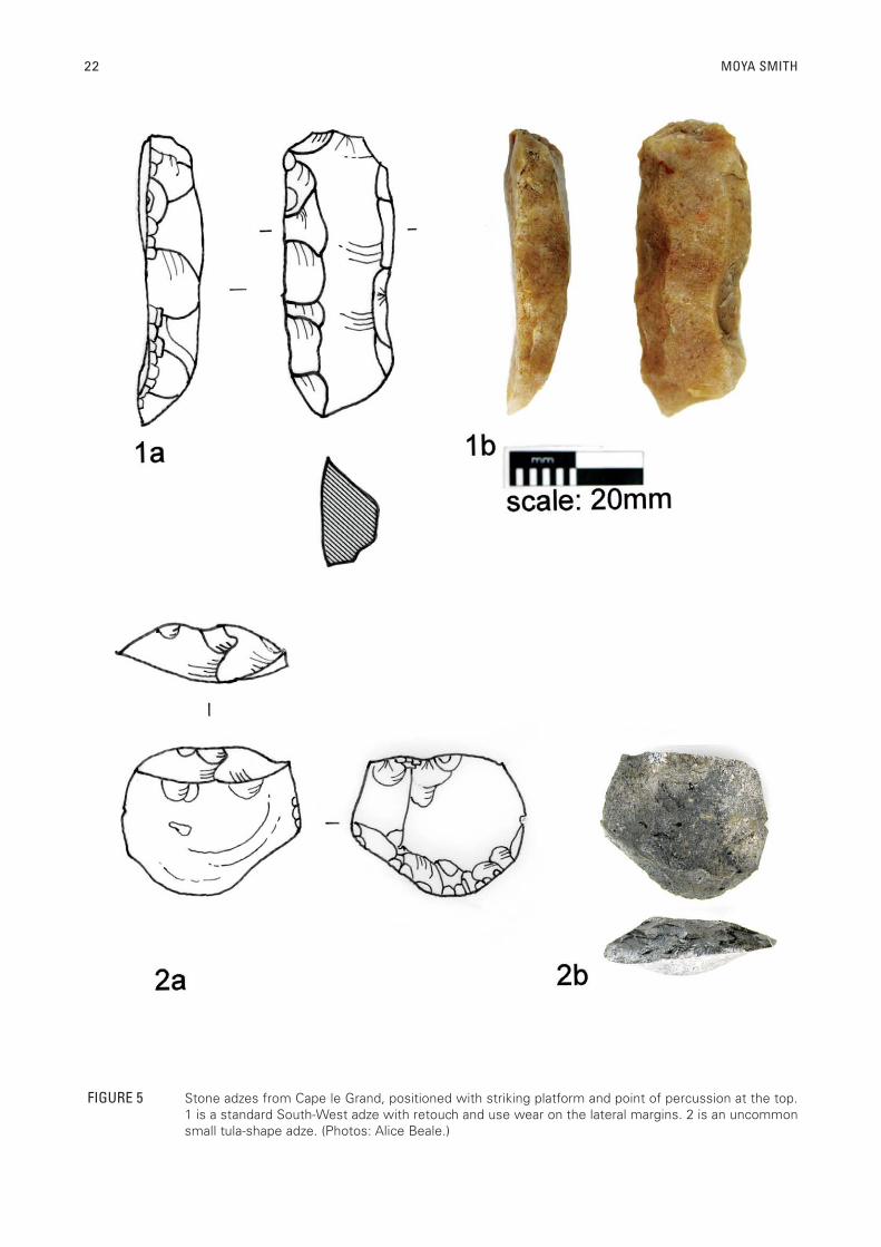
FIGURE 5 Stone adzes from Cape le Grand, positioned with striking platform and point of percussion at the top.1 is a standard South-West adze with retouch and use wear on the lateral margins. 2 is an uncommon small tula-shape adze. (Photos: Alice Beale.)
MOVING ON: MOBILITY IN THE ESPERANCE AREA 23
have been located on 24 sites, and artefact scatters are usually within 100 m of these. These favoured site locations not only offer fresh water, they also have vegetation communities which include exploited edible plant species. The predictability of the availability of these plants is tied directly to the reliability of the water.
Proximity to other resource zones is not an obvious factor in selection of camp site locations, although this must have affected population and residential mobility (especially given site size). Maximum optimal foraging range appears to lie within 5–10 km (Smith 1993: fi gure 6.10). At this distance, the majority of coastal sites have access to seven different resource zones, while most interior sites have access to four or fi ve different zones. It is apparent that while increased foraging range in the interior gave access to more resource zone variation, people chose to move residence closer to these resources rather than foraging more widely from a base camp (logistical mobility) (cf. Kelly 1983, 1995).
Current studies of the role of technological organisation in lithic assemblages consider the links between ‘how technological strategies are responsive to environmental factors and social/economic strategies. Proximity to the location of the knappable raw material sources is determined by the group‘s settlement pattern (Nelson 1991).’ In the Esperance region, fl akeable stone is perhaps one of the least diffi cult resources for people to have accessed at any stage during the human past. Reasonable quality chert is available almost the entire length of the coastline, in exposed surfaces of Tertiary sediments, while vein quartz, the other dominant lithic type, occurs in seams in the granites. Spicular coastal chert is clearly the preferred material, its widespread occurrence, the ease with which it can be extracted and its fracturing and cutting properties perhaps all contributed to its being the material of choice rather than other available materials such as quartz, silcrete and quartzite. There is, however, no simple linear relationship between dominant lithic material and source proximity. Where a material other than chert dominates an assemblage the choice of quartz appears in one instance to reflect a preferential use of quartz, perhaps for skin working, and in another, use of quartz after poor knapping led to the abandonment of a large chert core (Smith 1993: 318). Unlike the Jerramungup region to the west where chert was clearly of suffi cient value for local people to practice a range of conservation strategies (Bird 1985: 281) such strategies are absent in the Esperance area. Not even ‘exotic’ raw materials derived from outside the region are curated.
ASPECT AND OUTLOOK
Resource proximity is not the only physical factor affecting site location. Within specifi c topographic
features, there is marked patterning in relationship to aspect and outlook. In the coast zone, 78% of sites are positioned to maximise shelter from the south-west. All but one site of the remaining 22% have almost 360º views. In the interior, 52% of sites are positioned to maximise shelter from the south-west, while 46% have 360º views. The coastal emphasis on facing away from the south-west is echoed c. 275 km west in the Gairdner River region (Bird 1985: 156), which is also subject to the adverse climatic conditions which affect the Esperance coastline. The sweeping 360º views are not paralleled west of the Esperance area and it is noteworthy that these are more common in the interior. In both zones approximately 50% of sites with 360º views are on granites.
One important reason for this pattern is resource monitoring, not only of the immediate vicinity, but also noting rainfall distribution over the landscape, which has widespread implications for resource scheduling decisions. One of the key characteristics of the interior is the unpredictability of its rainfall, and thus of plant and animal foods. From the vantage point of the tops of granites, rainfall distribution and the consequent distribution of plant and animal foods as well as water sources, can be pinpointed with a reasonable degree of accuracy over large areas of land from the coast to well into the interior (and vice versa) (cf. Stafford et al. 1990). Since neither zone in isolation contains the resources necessary to sustain a viable economy, it is essential to monitor the entire landscape. The view from the granites gives knowledge of the macrocosm.
CULTURAL AFFINITIES
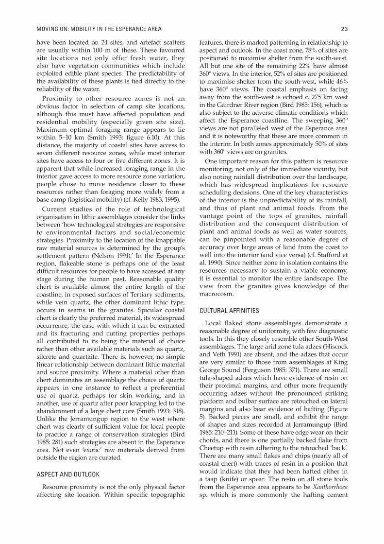
Local flaked stone assemblages demonstrate a reasonable degree of uniformity, with few diagnostic tools. In this they closely resemble other South-West assemblages. The large arid zone tula adzes (Hiscock and Veth 1991) are absent, and the adzes that occur are very similar to those from assemblages at King George Sound (Ferguson 1985: 371). There are small tula-shaped adzes which have evidence of resin on their proximal margins, and other more frequently occurring adzes without the pronounced striking platform and bulbar surface are retouched on lateral margins and also bear evidence of hafting (Figure 5). Backed pieces are small, and exhibit the range of shapes and sizes recorded at Jerramungup (Bird 1985: 210–211). Some of these have edge wear on their chords, and there is one partially backed fl ake from Cheetup with resin adhering to the retouched ‘back’. There are many small fl akes and chips (nearly all of coastal chert) with traces of resin in a position that would indicate that they had been hafted either in a taap (knife) or spear. The resin on all stone tools from the Esperance area appears to be Xanthorrhoea sp. which is more commonly the hafting cement
24 MOYA SMITH
FIGURE 6 A South-West club, A00362, Anthropology Department collection, WA Museum. The stone adze, hafted with Xanthorrhoea resin, has retouch on the lateral margins. (Photos: Douglas Elford.)
MOVING ON: MOBILITY IN THE ESPERANCE AREA 25
used in the South-West (Figure 6), rather than Triodia sp. resins or beeswax which are used elsewhere in the state. Grindstones are typically South-West and are small and dimpled.
SUMMARY
The location of sites in the Esperance region refl ects a landscape used by small groups of foragers with high residential mobility. The majority of sites contain few artefacts and are small nodes of human presence mostly focused on granites or features where freshwater can be obtained and where biological diversity is greater. People favoured camp sites that afforded either protection from the south-west winds or commanding views over the surrounding landscape and were within 500–800 m of fresh water. There are only four sites with more than 1,000 artefacts, possibly locations of intra- or inter-group gatherings.
In the absence of a suite of dated sites it is not possible to examine changes in settlement patterns. In Cheetup, the one site that spans 13,000 years until the historic period, changes in discard rate clearly refl ect alteration in human activities in the cave. The earliest occupation unit consists mainly of cooking hearths, while the more recent unit refl ects a focus on resin preparation and hafting. The rate of establishment of new sites cannot be determined with any degree of accuracy. While Cheetup appears to mark the beginning of the human occupation of the current coastal regions by 13,000 BP, the absence of any indication of occupation prior to the late Holocene in the interior zone may refl ect comparatively recent amelioration of local environmental conditions and attendant later occupation of this zone.
MOBILITY AND RESOURCE STRUCTURES
Just what then do these Esperance area artefact scatters represent? Ethnographic observations about radius of stone debitage from individual stone tool knappers, the areal extent of occupation sites and activity areas in relationship to group size and duration of site occupation, provide a framework for possible explanations about the nature of these local artefact scatters. Some 1,200 km north-east of the Esperance area, Hayden (1979: 165–166) recorded a 6 m radius of stone artefact debris around hearth and activity areas for individuals on two sites in the Gibson Desert. Ngarulurutja and Walukaritji were occupied respectively for one and three weeks, with total numbers of discarded stone being 114 and 94 pieces over areas of 79–113 m2. Over one to three week periods of occupation, family groups of between 6 to 12 people discarded from between 6 to 28 pieces of stone per person per week.
The hazards of basing estimates of population size
on artefact numbers and numbers of sites have been discussed at great length in Australia (e.g. Dortch and Smith 2001). However, the consistency in size and distribution of artefact scatters in the region, in combination with ethnographic analogies, strongly suggests that those Esperance area sites with few artefacts, whether the latter are contemporaneous or not, are unlikely to represent major habitation sites and probably refl ect occupation periods of short duration. Small numbers of artefacts spread over areas less than 20 m2 cannot represent the presence of large numbers of people. Major habitation sites or base camps either occupied by large groups for several weeks, or revisited over long periods of time, could be expected to have considerable numbers of discarded artefacts. Major habitation sites could also be expected to be reasonably extensive if occupied by more than a nuclear family at any one time, or to have reasonable artefact density if reoccupied.
The archaeological residue of small groups of people, staying for short terms at locations before moving on, and leaving a low artefact discard signal at habitation sites (O‘Connor et al. 1993) is consistent with the low level, low extent and low density pattern of artefact discard in the Esperance region. These small archaeological sites are best explained as the refl ection of small groups of people with high residential mobility (frequent relocation of the group’s camp or residence). Kelly (1995: 118) explains the Binford proposition that residential mobility is typical of foragers, moving to their food resources, or mapping onto regional resources, obtaining immediate return. There are only four sites with more than 1,000 artefacts, all in the coastal zone. Compared to other sites, these have greater artefact frequencies, a wider range of lithic types (including some exotics), greater areal extent, and indications of use over longer periods. They are interpreted as foci of group, and perhaps inter-group, gatherings. Depending on the nature of the ‘gathering’, occupants need not necessarily focus on stone tool production, but one would expect these locations to have relative resource abundance to sustain larger groups, and to have other archaeological features (e.g. rock art, stone arrangements).
The trend towards increased sedentism and decreased mobility that has been identified elsewhere in Australia (Lourandos 1997) seems to be absent in the Esperance region, where people remain highly mobile foragers. Lourandos suggested that the move towards decreased mobility sometimes ran counter to environmental resource structures (1997: 305). In the Esperance region, by contrast, it seems that a continuing pattern of high residential mobility was maintained even in areas where resource structures could have supported decreased mobility. The answer to unlikely responses to environmental conditions might be found in socio-
26 MOYA SMITH
TAB
LE 3
R
esou
rce
stru
ctur
e, b
ehav
iour
and
arc
haeo
logi
cal c
orre
late
s (a
fter
Am
bros
e an
d Lo
renz
199
0: 1
0).
A. P
REDI
CTA
BLE
& S
CARC
EB.
PRE
DICT
ABL
E &
DEN
SEC.
UN
PRED
ICTA
BLE
& D
ENSE
D. U
NPR
EDIC
TAB
LE &
SCA
RCE
BEH
AVIO
URA
L CO
RREL
ATES
Ter
rito
ria
l st
rate
gy
terr
ito
ria
l d
efen
ceh
om
e ra
ng
e, s
emi-
per
mea
ble
un
def
end
ed v
ery
per
mea
ble
un
def
end
ed v
ery
per
mea
ble
Info
rmat
ion
exch
an
ge
low
med
ium
ver
y h
igh
hig
h
Res
iden
tia
l m
ob
ilit
ylo
w,
sch
edu
led
med
ium
, sc
hed
ule
dh
igh
, o
pp
ort
un
isti
cv
ery
hig
h,
op
po
rtu
nis
tic
Gro
up
siz
esm
all
sma
llla
rge
ver
y s
ma
ll
Po
pu
lati
on
den
sity
hig
hm
ediu
mm
ediu
mv
ery
lo
w
Die
t b
read
thm
od
erat
eh
igh
ver
y l
ow
ver
y h
igh
ARC
HA
EOLO
GICA
L CO
RREL
ATES
Mac
ro-r
egio
na
l a
ssem
bla
ge
va
riab
ilit
yh
igh
sty
list
ic v
ari
ab
ilit
ylo
w s
tyli
stic
va
ria
bil
ity
hig
h s
tyli
stic
un
ifo
rmit
yh
igh
sty
list
ic u
nif
orm
ity
Raw
mat
eria
l so
urc
esa
ll l
oca
l, e
mb
edd
edm
ost
ly l
oca
ld
iver
se,
ma
ny
dis
tan
t ex
oti
cslo
cal,
an
d d
ista
nt
exo
tics
Occ
up
atio
n s
ite
inte
nsi
tyh
igh
at
ho
me
ba
sem
od
erat
e at
ho
me
ba
sev
ery
lo
w a
t h
om
e b
ase
ver
y l
ow
at
ho
me
ba
se
Intr
a-s
ite
spat
ial
org
an
isat
ion
ver
y s
tru
ctu
red
act
ivit
y &
d
isca
rd l
oca
tio
ns
mo
der
atel
y s
tru
ctu
red
po
orl
y s
tru
ctu
red
po
orl
y s
tru
ctu
red
Fau
na
l &
fl o
ral
div
ersi
tym
od
erat
ely
hig
hh
igh
ver
y l
ow
, la
rge
ga
me
ver
y h
igh
, m
ost
ly p
lan
t
MOVING ON: MOBILITY IN THE ESPERANCE AREA 27
demographic environments, but people also appear to make cultural choices based on local resource structure – the spatial and temporal abundance and predictability of resources.
Ambrose and Lorenz (1990) have developed a useful model for considering resource structures (Table 3), based on earlier models of Winterhalder (1981). They identify four poles in a continuum of resource structure according to predictability and abundance of resources. I have considered the nature of the Esperance area local resource structure and expected behavioural correlates; the extent of overlap between expected and observed behaviour and the archaeological correlates these should have; and the degree of fi t between local archaeological record and behaviour and resource structure. This information is drawn largely from my doctoral thesis (Smith 1993: 353–358) and summarised here.
LOCAL RESOURCE STRUCTURE AND BEHAVIOURAL CORRELATES
Water is abundant in the coastal zone, scarce in the interior, but predictable in both zones if rainfall patterns are monitored. Plants have predictable locations (both general and specific) but their abundance varies according to rainfall. Knowledge of their distribution again depends on monitoring rainfall patterns. Coastal species (including those found in estuaries) are moderately abundant and some are predictable, for example seal colonies, fi sh migratory patterns, fi sh in estuaries, shellfi sh, and nesting sea birds. Small mammals and reptiles are not overly abundant, but habitat preference is constant, and their general location is predictable. Some large mammals, for example the Western Grey Kangaroo (Macropus fuliginosus), are territorial, and have predictable morning and evening feeding patterns; other wallabies have a predictable range. Water birds are usually located in the coastal swamps, and emus can be targeted by monitoring the progress of one of their target foods Santalum acuminatum, or quandong. While emus occur in both zones, they are frequently targeted in the interior near quandong stands, for example, near Mt Ridley (Arthur Dimer, pers. comm.).
The apparent initial occupation of the region at 13,000 BP coincided with the end of a drier and colder period during which sand dunes were mobilised. At this stage shoreline advance and territorial contraction was fairly rapid. For example, Cheetup, which was about 80 km inland at 13,000 BP, was only about 11 km from the shore by 10,000 BP. By 10,000 BP the current coastal zone should have already been subject to the predictable rainfall patterns of the Mediterranean regime and the interior subject to the unpredictable conditions which currently prevail (Beard 1990). By 7,000 BP, the granite peaks, which had formed part of the earlier
extended coastal plain, had become islands, and the shoreline was about 8 km from Cheetup. Climatic conditions appear to have remained relatively stable over the last 5,000 or 6,000 years
The Esperance region today appears to have two different resource structures – predictable and scarce in the coastal zone, and unpredictable and scarce in the interior. One could expect behavioural correlates for the coastal zone to include territorial defence, low information exchange, low and scheduled residential mobility, small group size, high population density and moderate diet breadth. For the interior, behavioural correlates should be undefended and permeable territorial strategies, high information exchange, very high and opportunistic residential mobility, very small group size, very low population density and very high diet breadth. For the early period (i.e. the end of the Pleistocene) it is diffi cult to identify all the expected behavioural correlates of these resource structures. In both coastal and interior zones, however, residential mobility seems to have been high to very high, group size and population density both appear to have been low and diet breadth was apparently very high. Despite the distinct variation in resource structure between coast and interior, these are all behavioural correlates commensurate with an unpredictable and scarce resource structure.
The regional archaeological record also refl ects what Ambrose and Lorenz‘s (1990) model posits as linked with an unpredictable and scarce resource
structure, that is, with the conditions of the interior.
1. Macro-assemblage variability exhibits
both high stylistic uniformity (D) and low
stylistic variability (B).
2. Raw mater ia l (stone) sou rces are
predominantly local with some exotics from
outside the study area (D).
3. Occupation site intensity as identifi ed by
artefact numbers and areal extent of sites is
very low at home base, in fact few ‘home
bases’ can be identifi ed (D).
4. Intra-site spatial organisation is poorly
structured (D).
5. Faunal and fl oral diversity is high, and
ethnographic evidence suggests this is
particularly so of plants.
The inclusion of both marine and estuarine
resources in the same subsistence base, despite
the ‘confl icting’ values these have as companion
foods with hinterland resources (cf. Dwyer 1988;
O’Connor 1990), is accounted for by a link between
unpredictable and scarce resource structure and
high diet breadth.
28 MOYA SMITH
CONCLUSION
Since the resource structures are not uniform, why is there evident uniformity of ethnographically observed behaviours, and an archaeological record reflecting continuity of behaviour over several thousand years? It may be that, despite apparent relative predictability of the coastal zone, local occupants perceived it differently as unpredictable. It may on the other hand be that any difference in strategy is not represented archaeologically, or is represented very subtly. It could be, for example, that the absence of sites with more than 1,000 stone artefacts in the interior, compared with the coastal zone where several occur, is an index of a slight tendency towards decreased residential mobility in the coastal zone. There are indications of Late Holocene attempts to increase local resource predictability or ‘extend their economic utility’ (Bettinger 1987: 125), for example by capping gnamma holes (Figure 4), and constructing lizard habitats (Smith 1993: 246–252). The storage of Macrozamia kernels during the late Pleistocene is also evidence of attempts to increase resource predictability (cf. Kelly 1983: 292).
In summary, the dominant features of the region, apparently through the last 10,000 years at least, are small sites with few artefacts and confined horizontal distribution. Artefact assemblages are remarkably uniform and tools are made predominantly of local stone materials although some exotics also occur. These are a characteristic response to temporal and spatial unpredictability and shortage of resources. The maintenance of a behavioural system geared towards such environmental conditions, regardless of the apparent variation in actual resource structure, may refl ect a specialised local cultural adaptation with an emphasis on risk minimisation (cf. Yellen 1986). There appears to be a highly mobile society in a semi-arid and marginal environment making some slight effort to expand or control the resource base but not responding to ameliorating conditions or a broadened resource base by decreasing their residential mobility. Whether this type of response is true of other people living in semi-arid marginal environments and with what is essentially a resource poor coastline as well, or whether this is an entirely local response has not been tested at this stage. Diversifi ed economic activities in different microenvironments are a normal response to climatic unpredictability (Kelly et al. 2005). Mobility may be a well-entrenched pattern constrained by social relations that would survive whatever the environmental regime. In his research in the King George Sound region about 400 km west of Esperance, Ferguson (1985: 53) identifi ed ‘casual but constant mobility’ despite a relatively resource rich environment as a characteristic of local and west coast Nyungar society. The adoption of a similar highly
mobile, extreme forager lifestyle in the Esperance area on the margins of the South-West culture bloc is suggestive of a particular South-West cultural phenomenon, one that is not obviously tightly tied to local resource structures. Whatever the initial impetus for a lifestyle that embraced high residential mobility, and despite conditions that didn’t always make this a survival imperative, moving on seems to have been the preferred local lifestyle.
ACKNOWLEDGEMENTS
I should like to acknowledge the Aboriginal people of the Esperance region, many of whom have shared their knowledge with me over the years. Caroline Bird and an anonymous referee provided helpful comments on a draft of this paper.
REFERENCES
Ambrose, S.H. and Lorenz, K.G. (1990). Social and eological models of the Middle Stone Age in southern Africa (pp. 3–33). In: Mellars, P. (ed.), The emergence of modern humans. Edinburgh University Press: Edinburgh.
Beard, J.S. (1973). The vegetation of the Esperance and Malcolm areas, Western Australia 1: 250,000 Series. Vegmap Publications: Perth.
Beard, J.S. (1990). Plant life of Western Australia. Kangaroo Press: Kenshurst.
Berndt, R.M. (1979). Aborigines of the South-west (pp. 81–89). In: Berndt, R.M. and C.H. (eds), Aborigines of the west, their past and present. University of Western Australia Press: Nedlands.
Bettinger, R.L. (1987). Archaeological approaches to hunter-gatherers. Annual Review of Anthropology 16: 121–142.
Bird, C.F.M. (1985). Prehistoric lithic resource utilisation: a case study from the southwest of Western Australia. PhD thesis, University of Western Australia: Nedlands.
Bowdler, S. (2000). Australian hunter-gatherer settlement systems: can we identify directional change over time? Paper presented at 65th Annual Meeting of the Society for American Archaeology, Philadelphia, USA, March 2000. Accessed July 22, 2005 from: http: //www.archaeology.arts.uwa.edu.au/staff/bowdler__research_interests/saa_2000_paper_australian_huntergatherer_settelment_systems_can_we_identify_direcitonal_change_over_time/
Bowdler, S. and O’Connor, S. (1991). The dating of the Australian Small Tool Tradition, with new evidence from the Kimberley, WA. Australian Aboriginal Studies 1991/1: 53–62.
Bowler, J.M. (1976). Aridity in Australia: age, origin and expression in aeolian landforms and sediments. Earth Science Review 12: 279–310.
Dortch, C.E. (1975). Geometric microliths from a dated archaeological deposit near Northcliffe, Western Australia. Journal of the Royal Society of Western Australia 58: 59–63.
Dortch, C.E. (2000). Past Aboriginal hunter-gatherer economy and territorial organization in coastal districts of Western Australia’s lower South-west. PhD thesis, University of Western Australia: Nedlands.
MOVING ON: MOBILITY IN THE ESPERANCE AREA 29
Dortch, C.E. (2002). Modelling past Aboriginal hunter-gatherer socio-economic and territorial organisation in Western Australia’s lower South-west. Archaeology in Oceania 37: 1–21.
Dortch, C.E. and Morse, K. (1984). Prehistoric stone artefacts on some offshore islands in Western Australia. Australian Archaeology 19: 31–47.
Dortch, C.E. and Smith, M.V. (2001). Grand hypotheses: palaeodemographic modelling in Western Australia’s South-west. Archaeology in Oceania 36: 34–45.
Dwyer, P.D. (1988). Companion foods, schedules and archaeology (pp. 148–155). In: Meehan, B. and Jones, R. (eds), Archaeology with ethnography: an Australian perspective. Department of Prehistory, Research School of Pacifi c Studies, Australian National University: Canberra.
Ferguson, W.C. (1980). Fossiliferous chert in southwestern Australia after the Holocene Transgression: a behavioural hypothesis. The Artefact 5: 155–169.
Ferguson, W.C. (1985). A mid Holocene depopulation of the Australian southwest. PhD thesis, Australian National University: Canberra.
Glover, J.E. (1975a). The petrology and probable stratigraphic signature of aboriginal artefacts from part of south-western Australia. Journal of the Royal Society of Western Australia 58: 75–85.
Glover, J.E. (1975b). Aboriginal chert artefacts, probably from quarries on the continental shelf, W.A. Search 6: 392–394.
Hallam, S.J. (1975). Fire and hearth: a study of Aboriginal usage and European usurpation in south-western Australia. Australian Institute of Aboriginal Studies: Canberra.
Hallam, S.J. (1983). Sorts of sites: mobility, group fl uctuation and the genesis of artefact scatters. Paper presented at ANZAAS conference, Perth.
Hallam, S.J. (1986a). Prehistoric aboriginal populations on the Swan Coastal Plain, Western Australia. Unpublished Report to the Australian Research Grants Scheme.
Hallam, S.J. (1986b). Yams, alluvium and ‘villages’ on the west coastal plain (pp. 116–132). In: Ward, G. (ed.), Archaeology at ANZAAS, Canberra: papers delivered to the 54th ANZAAS Congress, 1984. Canberra Archaeological Society: Canberra.
Hayden, B. (1979). Palaeolithic refl ections. lithic technology and ethnographic excavations among Australian Aborigines. Australian Institute of Aboriginal Studies: Canberra.
Hexter, J.H. (1971). The history primer. Basic Books: New York.
Hiscock, P. and Attenbrow, V. (1998). Early Holocene backed artefacts from Australia. Archaeology in Oceania 33: 49–62.
Hiscock, P. and Veth, P.M. (1991). Change in the Australian desert culture: a reanalysis of tulas from Puntutjarpa Rockshelter. World Archaeology 22: 332–345.
Huchet, B.M.J. (1991). Theories and Australian prehistory: the last three decades. Australian Archaeology 33: 44–51.
Jarvis, N. (ed.) (1986). Western Australia: an atlas of human endeavour. Department of Lands and Survey and Western Australian Education Department: Perth.
Kelly, R.L. (1983). Hunter-gatherer mobility strategies. Journal of Anthropological Research 39: 277-306.
Kelly, R.L. (1995). The foraging spectrum; diversity in hunter-gatherer lifeways. Smithsonian Institution Press: Washington, D.C.
Kelly, R.L., Poyer, L. and Tucker, B. (2005). An ethnoarchaeological study of mobility, architectural investment, and food sharing among Madagascar’s Mikea. American Anthropology 107: 403–416.
Lourandos, H. (1983). Intensifi cation: a late Pleistocene-Holocene archaeological sequence from south-western Victoria. Archaeology in Oceania 18: 81–94.
Lourandos, H. (1997). Continent of hunter-gatherers: new perspectives in Australian prehistory. Cambridge University Press: Melbourne.
Nelson, M.C. (1991). The study of technological organization. Archaeological Method and Theory 3: 57–100.
O‘Connor, S. (1990). 30,000 years in the Kimberley: a prehistory of the islands of the Buccaneer Archipelago and adjacent mainland, West Kimberley, Western Australia. PhD thesis, University of Western Australia: Perth.
O’Connor, S., Veth, P. and Hubbard, N.N. (1993). Changing interpretations of postglacial human subsistence and demography in Sahul (pp. 95–105). In: Smith, M.A., Spriggs, M. and Fankhauser, B. (eds), Sahul in review: Pleistocene archaeology in Australia, New Guinea and Island Melanesia. Occasional Papers in Prehistory 24. Department of Prehistory, Research School of Pacific Studies, Australian National University: Canberra.
Schwede, M. (1990). Quartz, the multifaceted stone: a regional prehistory of the Helena River Valley on the Swan Coastal Plain of southwestern Australia. PhD thesis, University of Western Australia: Nedlands.
Smith, M.V. (1993). Recherche a l‘Esperance: a prehistory of the Esperance region of south-western Australia. PhD thesis, University of Western Australia: Nedlands.
Stafford Smith, D.M. and Morton, S.R. (1990). A framework for the ecology of arid Australia. Journal of Arid Environments 18: 255–278.
Veth, P.M. (1989). The prehistory of the Sandy Deserts: spatial and temporal variation in settlement and subsistence behaviour within the arid zone of Australia. PhD thesis, University of Western Australia: Nedlands.
Veth, P. and Moore, P. (1989). Report of an archaeological and ethnographic survey in the South Coast Highway, Stokes Inlet Road to Young River Bridge, West of Esperance, WA. Unpublished report for the Main Roads Department, Western Australia.
Winterhalder, B. (1981). Optimal foraging strategies and hunter-gatherer research: theories and models (pp. 13–35). In: Winterhalder, B. and Smith, E.A. (eds), hunter-gatherer foraging strategies: ethnographic and archaeological analysis. University of Chicago Press: Chicago.
Wyrwoll, K.H. (1979). Late quaternary climates of Western Australia. Journal of the Royal Society of Western Australia 62: 129–142.
Yellen, J.E. (1986). Optimization and risk in human foraging strategies. Journal of Human Evolution 15: 733–750.
MANUSCRIPT RECEIVED DECEMBER 2005; ACCEPTED NOVEMBER 2008.