NPDES Storm Water Ma11ageme111 Pla11 Allllllal Report - Permit Year 12 Municipality/Organization: MassDOT - Highway Division EPA NPDES Permit Number: MA043025 MaDEP Transmittal Number: Annual Report Number & Reporting Period: No. 11: April2014-March 2015 NPDES Phase II Small MS4 General Permit Annual Report Part I. General Information Contact Person: Mr. Henry Barbaro Title: Supervisor of Stormwater Unit Telephone #: (857) 368-8788 Email: [email protected]Certification: I certify under penalty of law that this document and all attachments were prepared under my direction or supervision in accordance with a system designed to assure that qualified personnel properly gather and evaluate the information submitted. Based on my inquiry of the person or persons who manage the system, or those persons directly responsible for gathering the information, the information submitted is, to the best of my knowledge and belief, true, accurate, and complete. I am aware that there are significant penalties for submitting false information, including the possibility of fine and imprisonment for · v"olations. - Signature: 1 6 C..::..L Printed Name: Thomas Tinlin Title: Acting Highway Administrator- MassDOT. Highway Division Date: 05/01/2015
Transcript
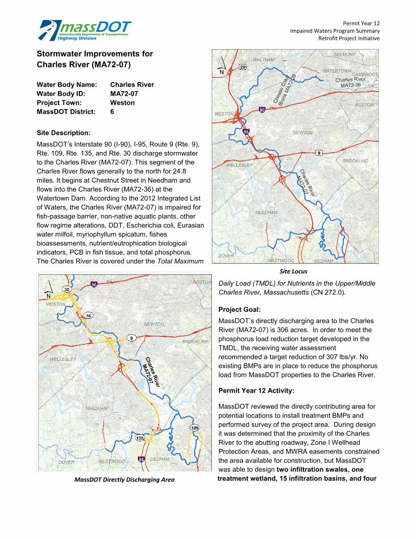
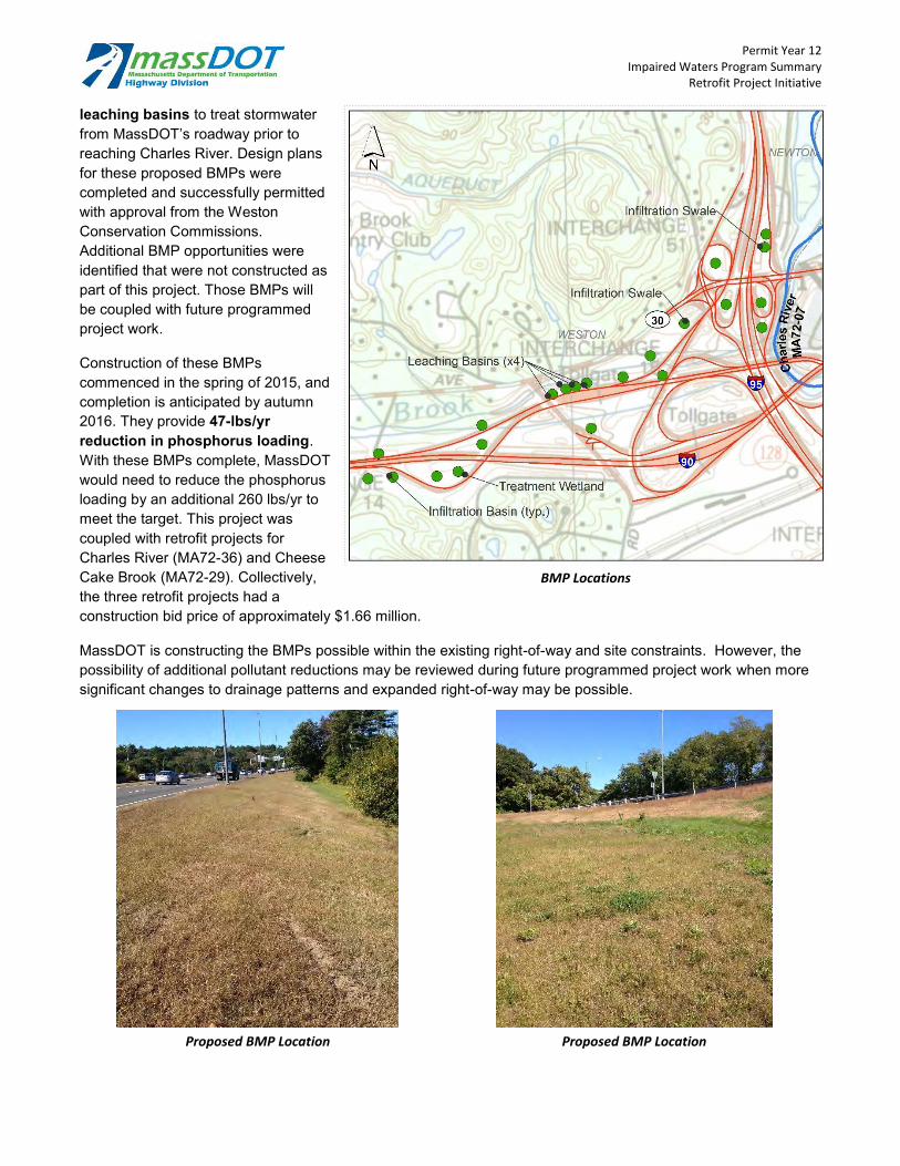
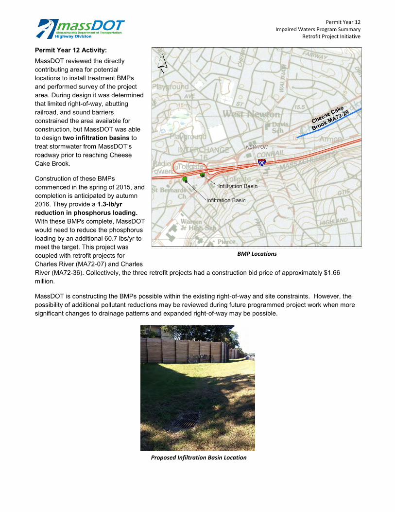
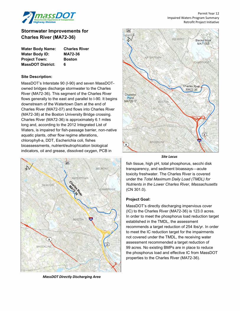
NPDES Storm Water Ma11ageme111 Pla11 Allllllal Report - Permit Year 12
I certify under penalty of law that this document and all attachments were prepared under my direction or supervision in accordance with a system designed to assure that qualified personnel properly gather and evaluate the information submitted. Based on my inquiry of the person or persons who manage the system, or those persons directly responsible for gathering the information, the information submitted is, to the best of my knowledge and belief, true, accurate, and complete. I am aware that there are significant penalties for submitting false information, including the possibility of fine and imprisonment for knowing ~·v"olations.
NPDES Storm Water Management Plan Annual Report – Permit Year 12
Part II. Self-Assessment
MassDOT – Highway Division has completed the required self-assessment and determines that the Municipal Separate Storm Sewer Systems (MS4) continues to be in full compliance with the permit conditions. MassDOT has spent significant time, effort and funds focusing on the potential impacts of stormwater from its roads and properties this year. MassDOT has advanced its stormwater program in Permit Year 12 through implementing the Impaired Waters Program, educating its staff and presenting at numerous seminars, and identifying and removing illicit connections.
The MassDOT Environmental Services Stormwater Unit recently hired an additional staff member to increase overall work capacity. Subsequently, MassDOT now has more time and expertise to focus on identifying programmed projects that would benefit from structural stormwater BMPs and ensuring proposed BMPs are feasible, effective, and maintainable. The Stormwater Unit is now responsible for reviewing the drainage/stormwater management system for all programmed projects. Additionally, the added work capacity has allowed the stormwater unit to begin enhancing BMP and drainage inventory, inspection, and maintenance practices.
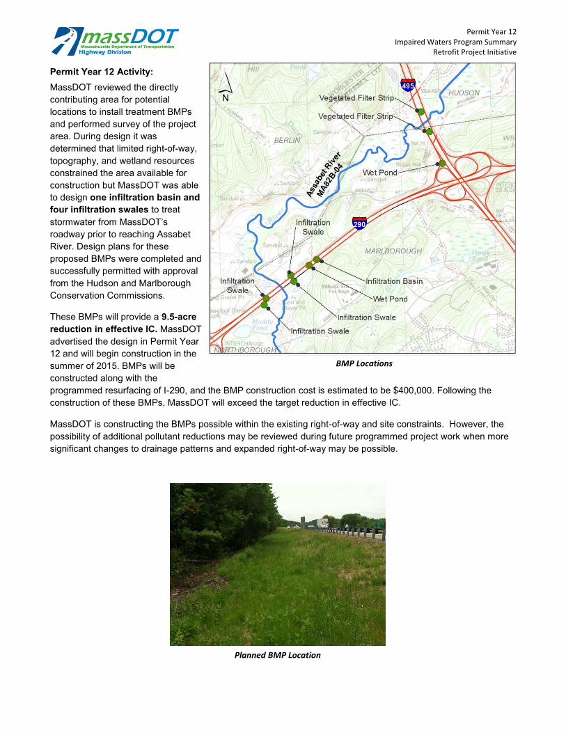
MassDOT, with our consultants support, has continued to implement the “Impaired Waters Program” (IWP) to address discharges to impaired waters from the highway stormwater system as part of compliance with the MS4 general permit, and has completed a significant number of specific water quality treatment projects. MassDOT expended a significant amount of external and internal resources to implement this aggressive program. MassDOT’s program includes two components: the Retrofit Initiative and the Programmed Projects Initiative. Through the Retrofit Initiative MassDOT identifies locations which warrant adding stormwater Best Management Practices (BMPs) along existing roadways, and through the Programmed Projects Initiative MassDOT incorporates stormwater BMPs in to programmed (planned) roadway construction projects.
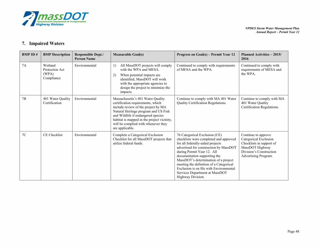
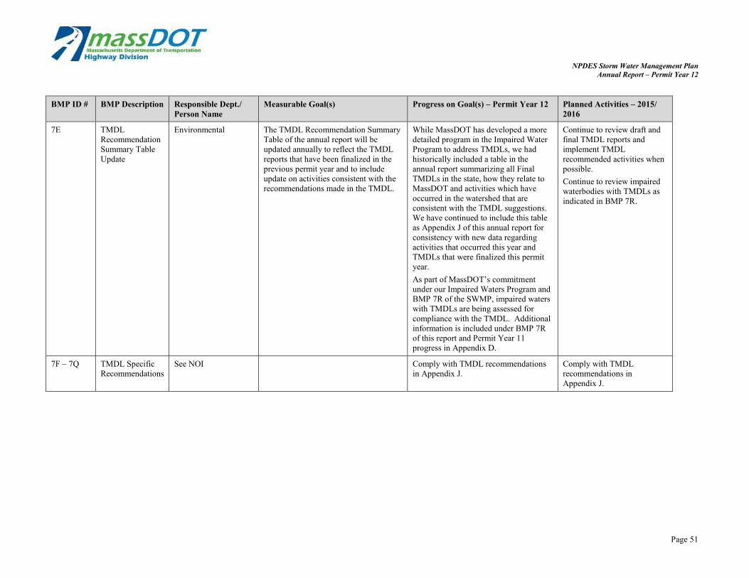
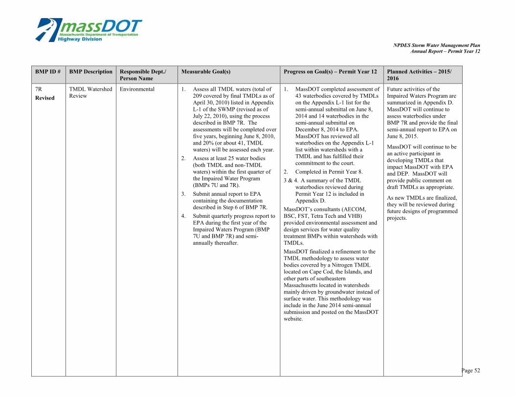
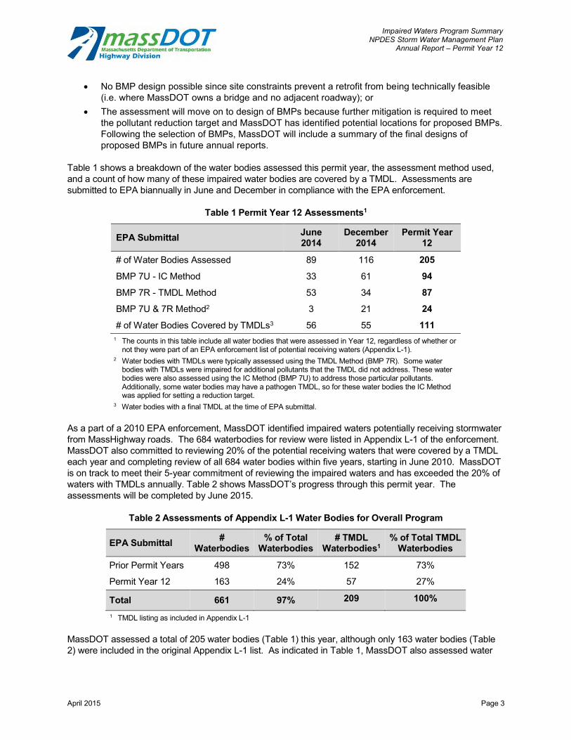
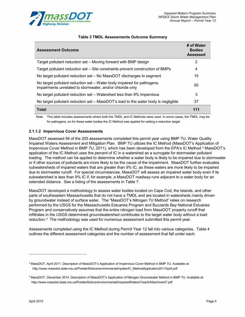
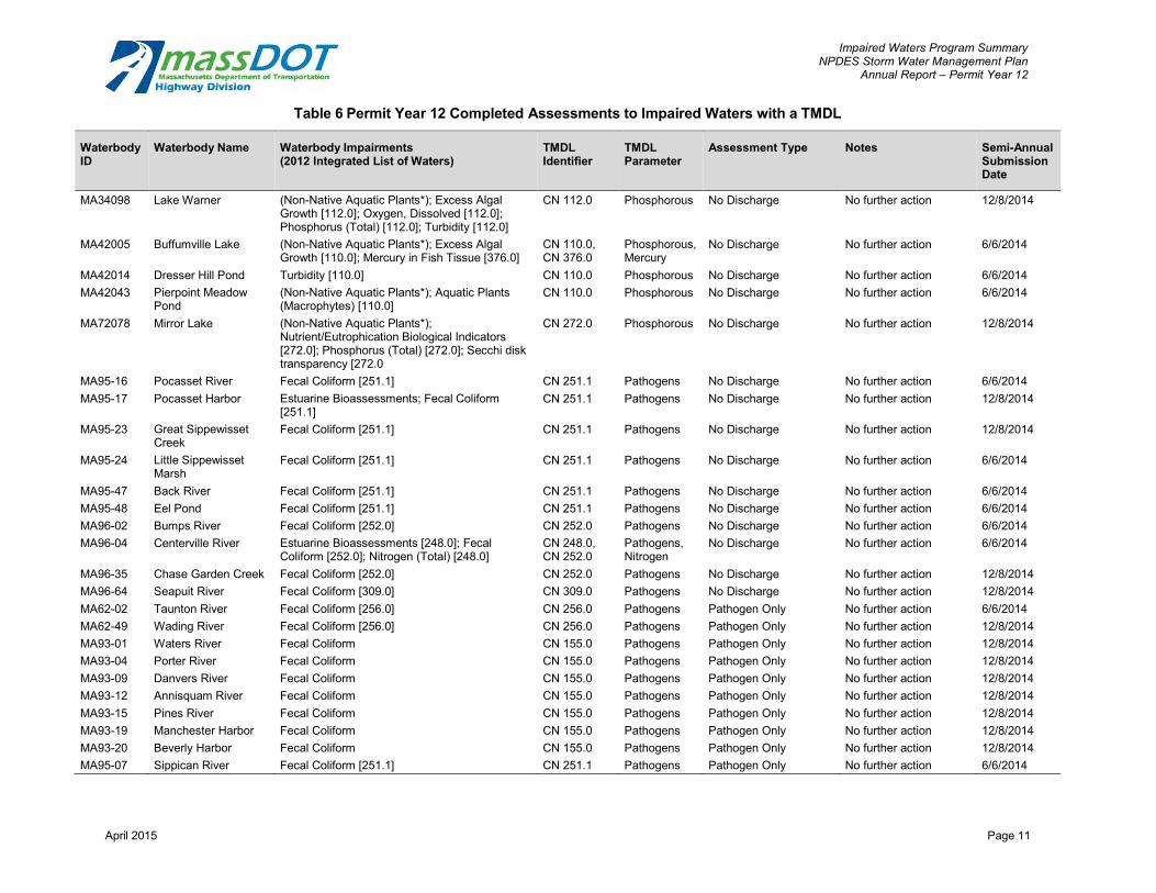
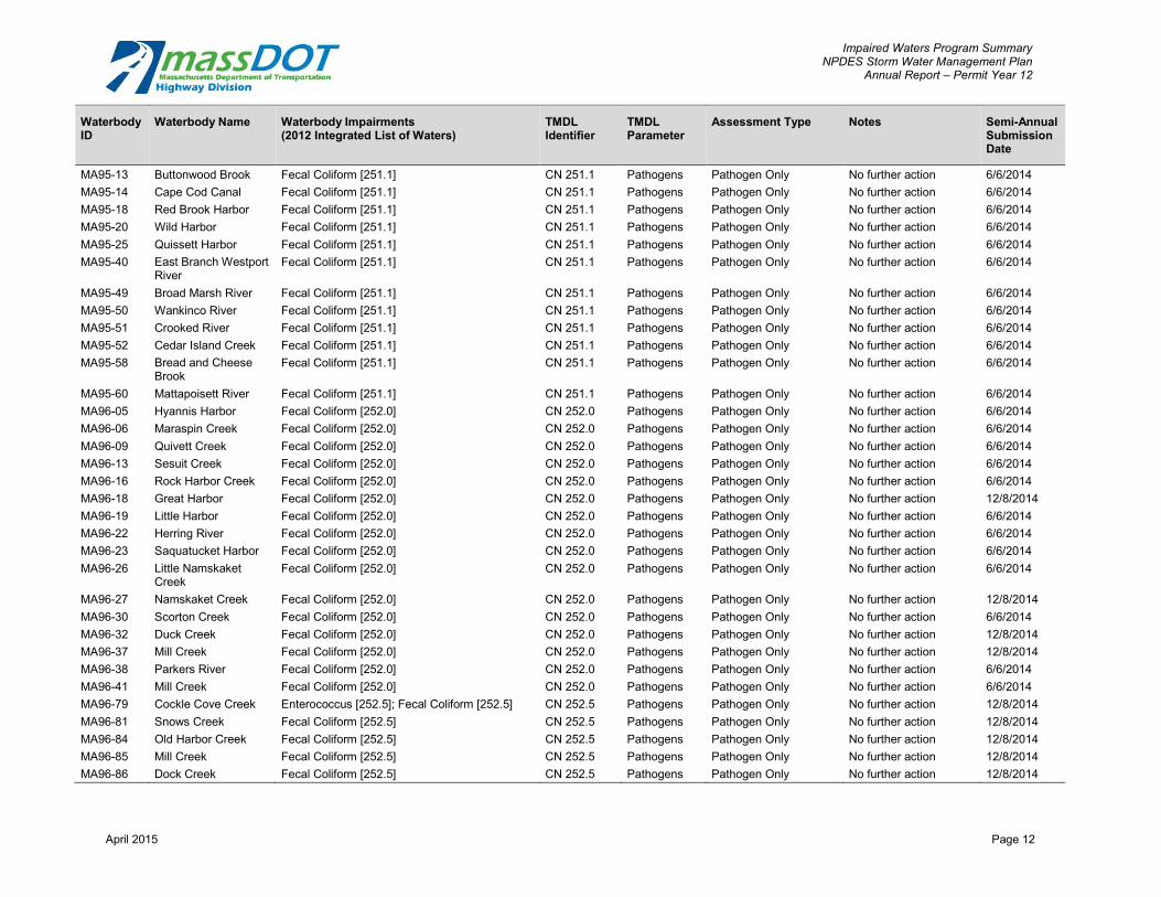
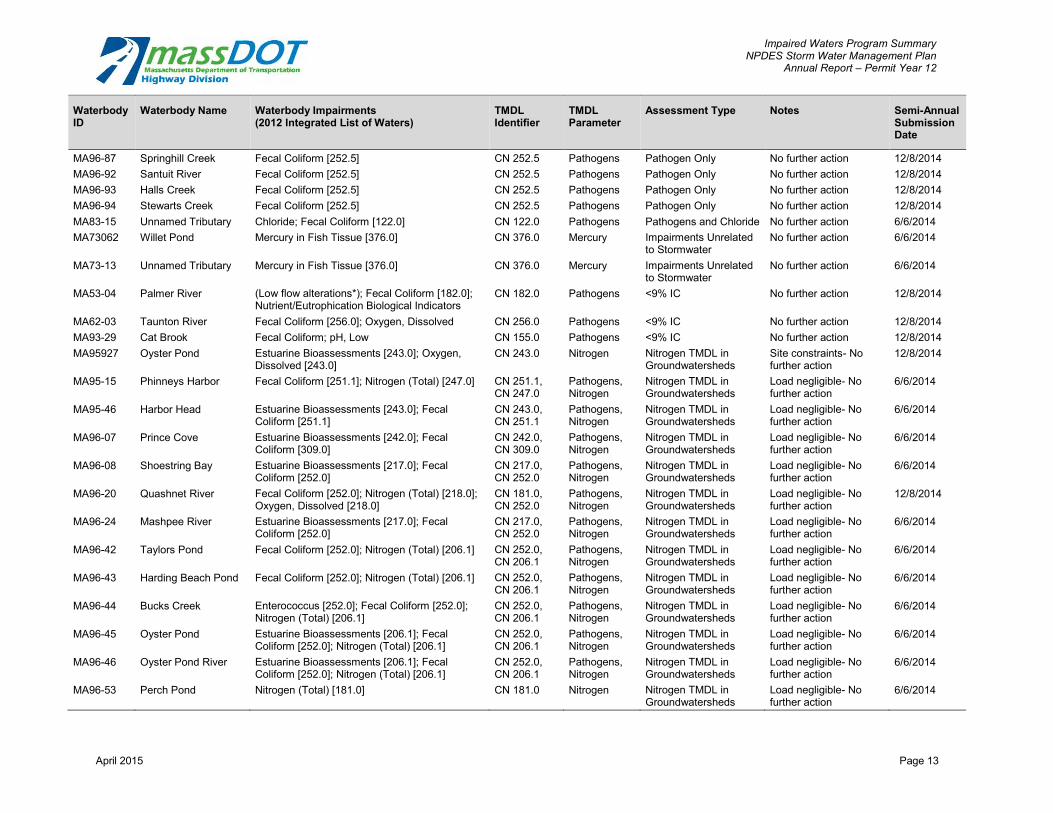
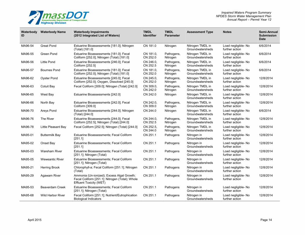
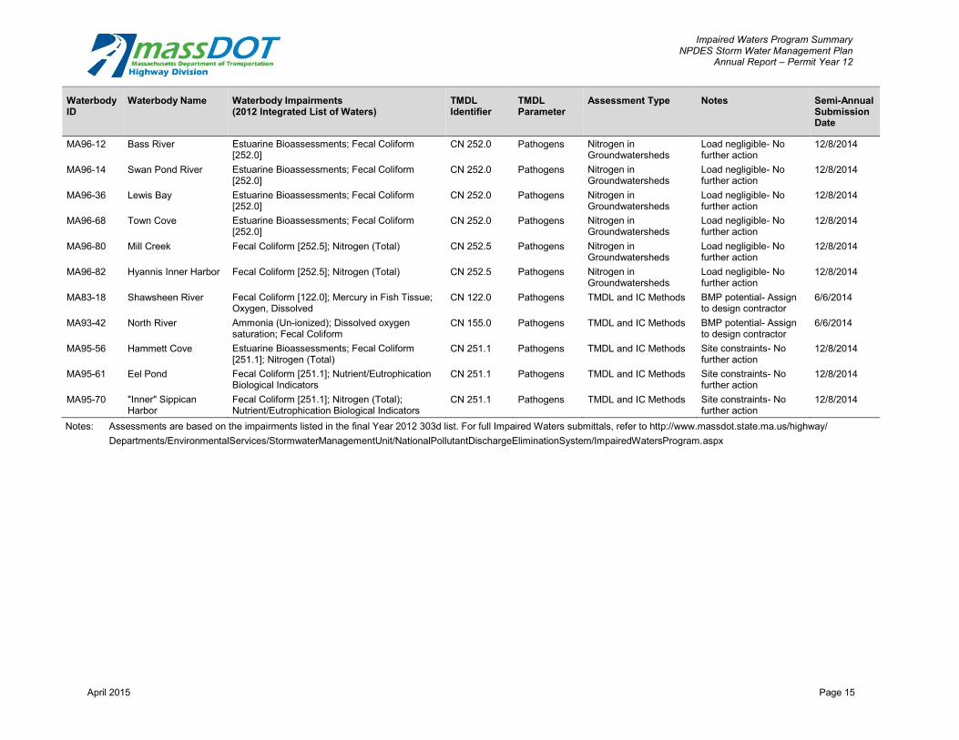
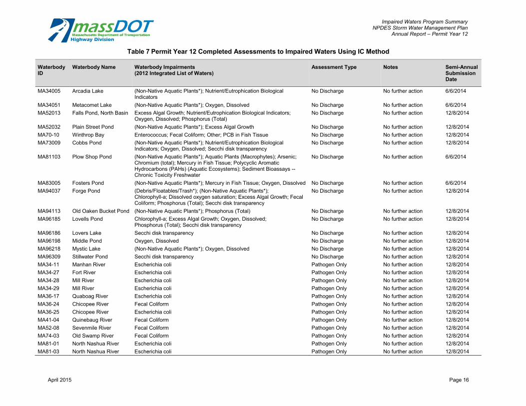
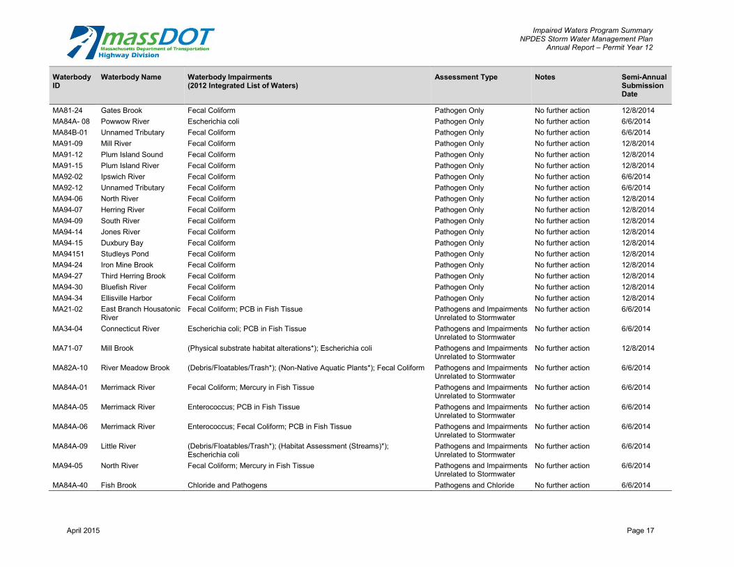
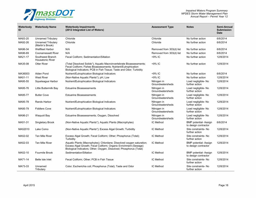
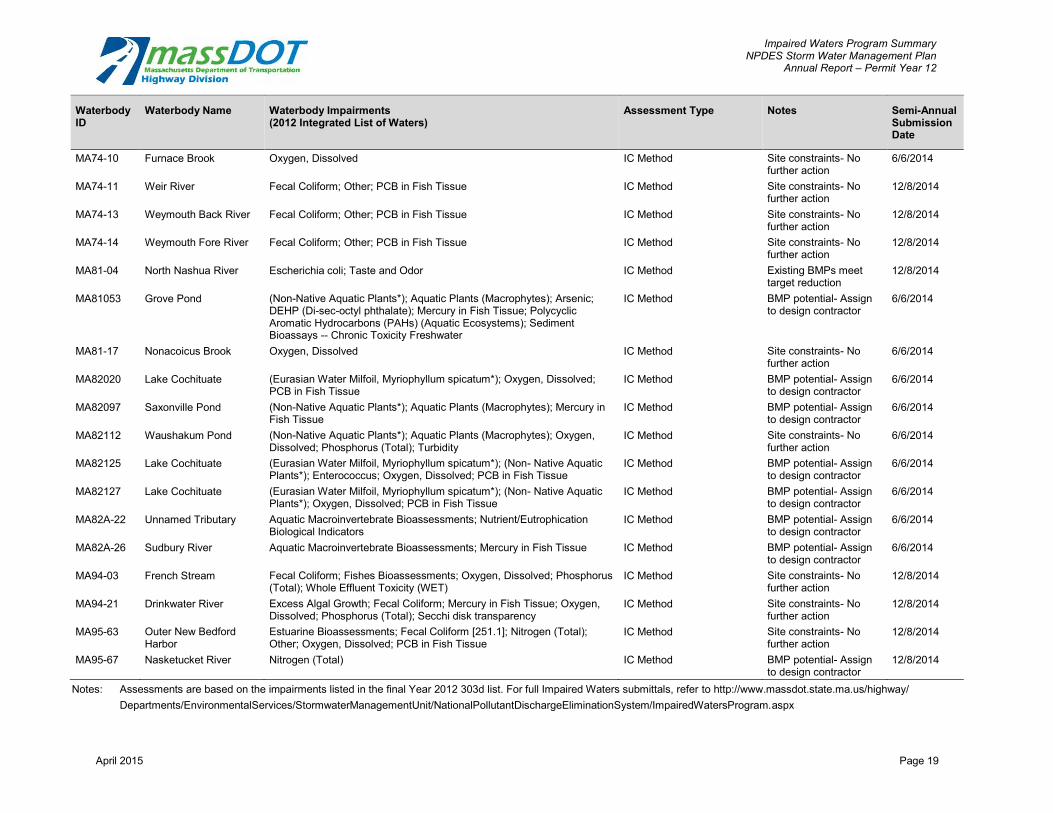
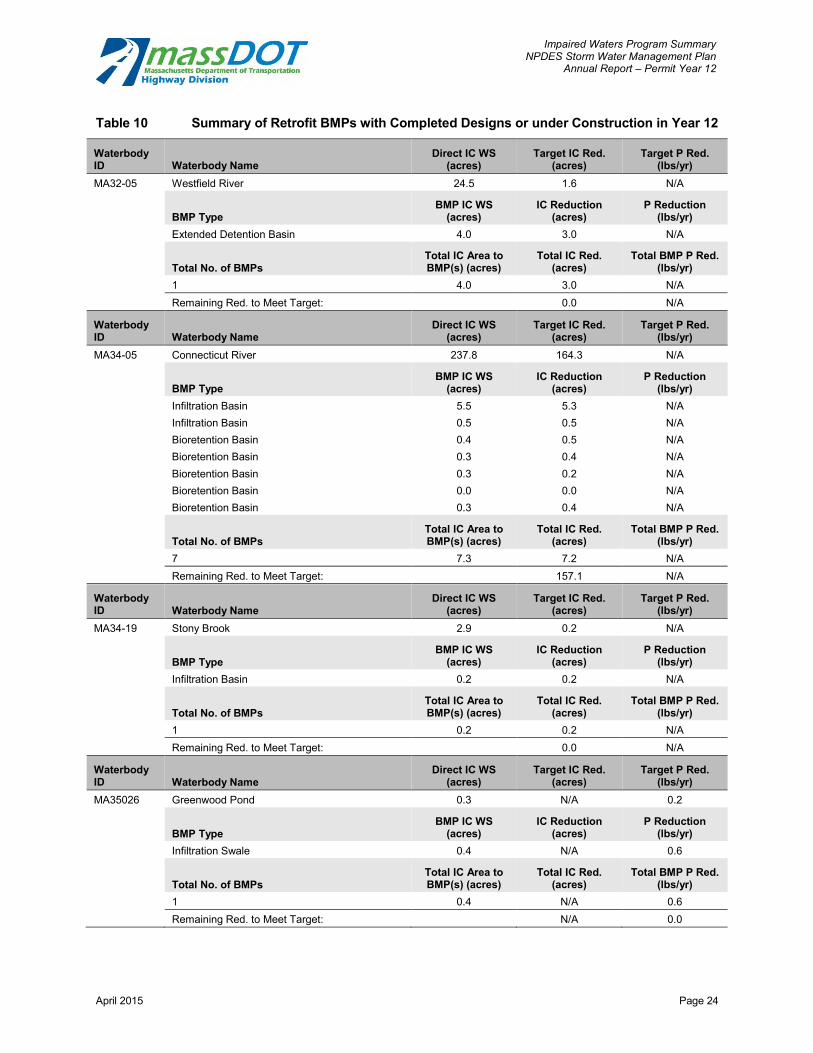
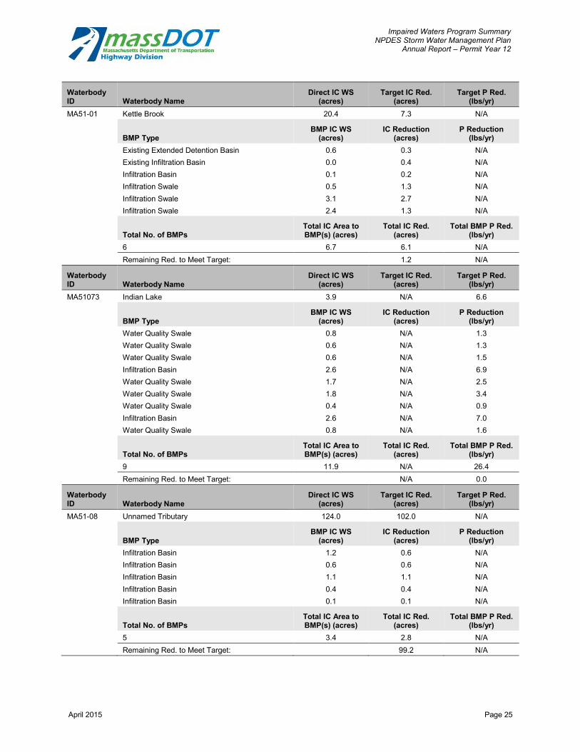
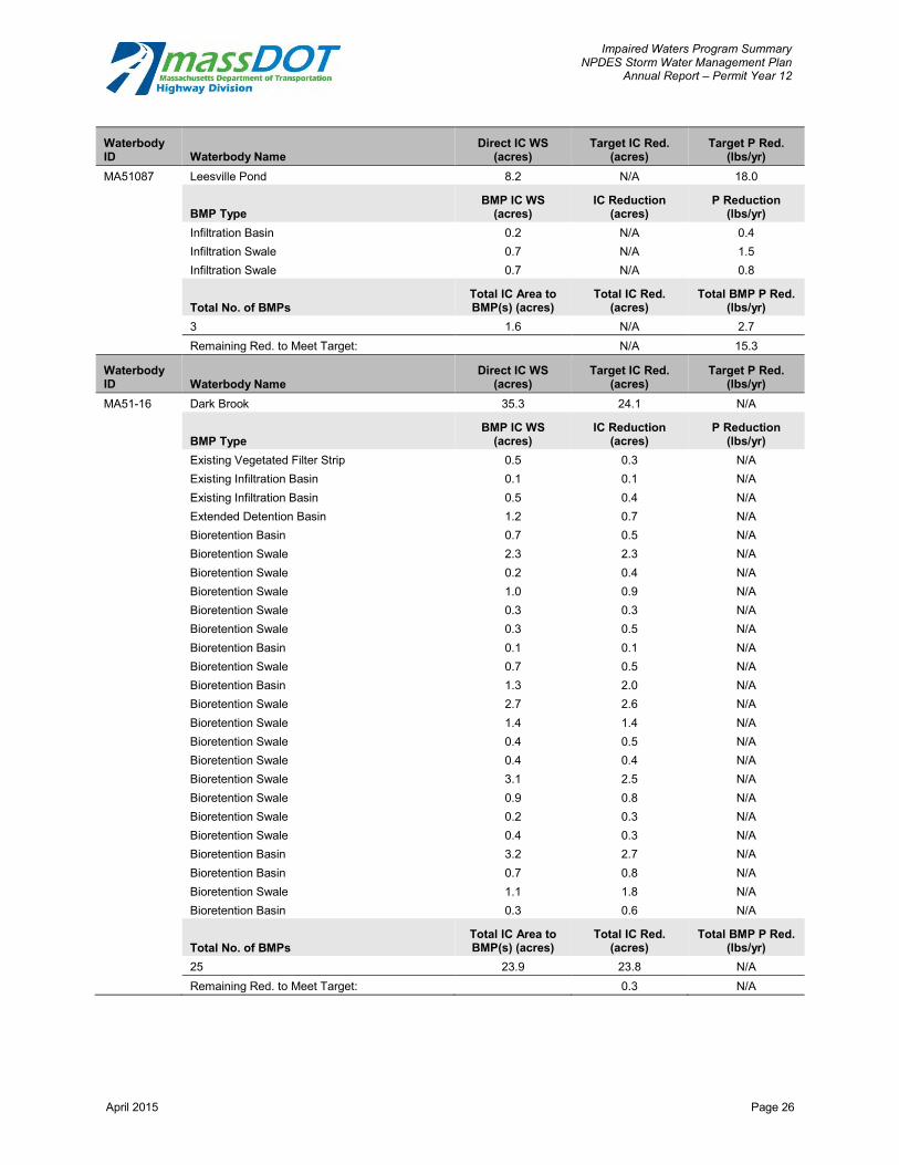
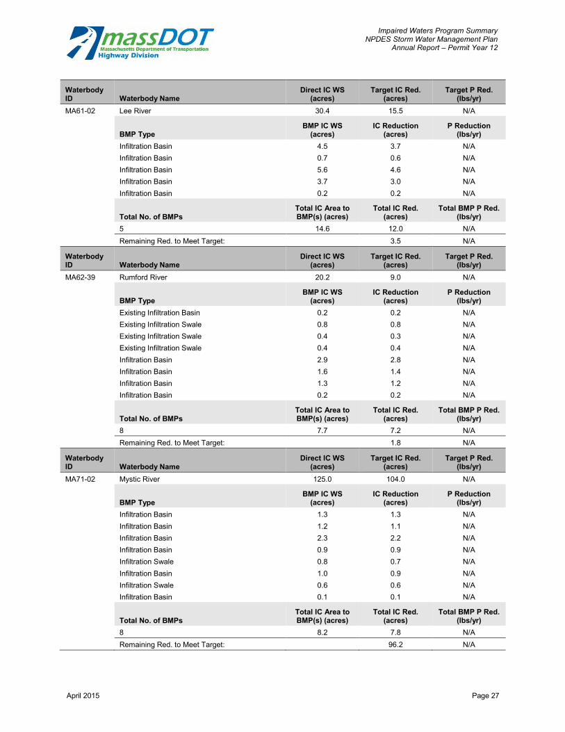
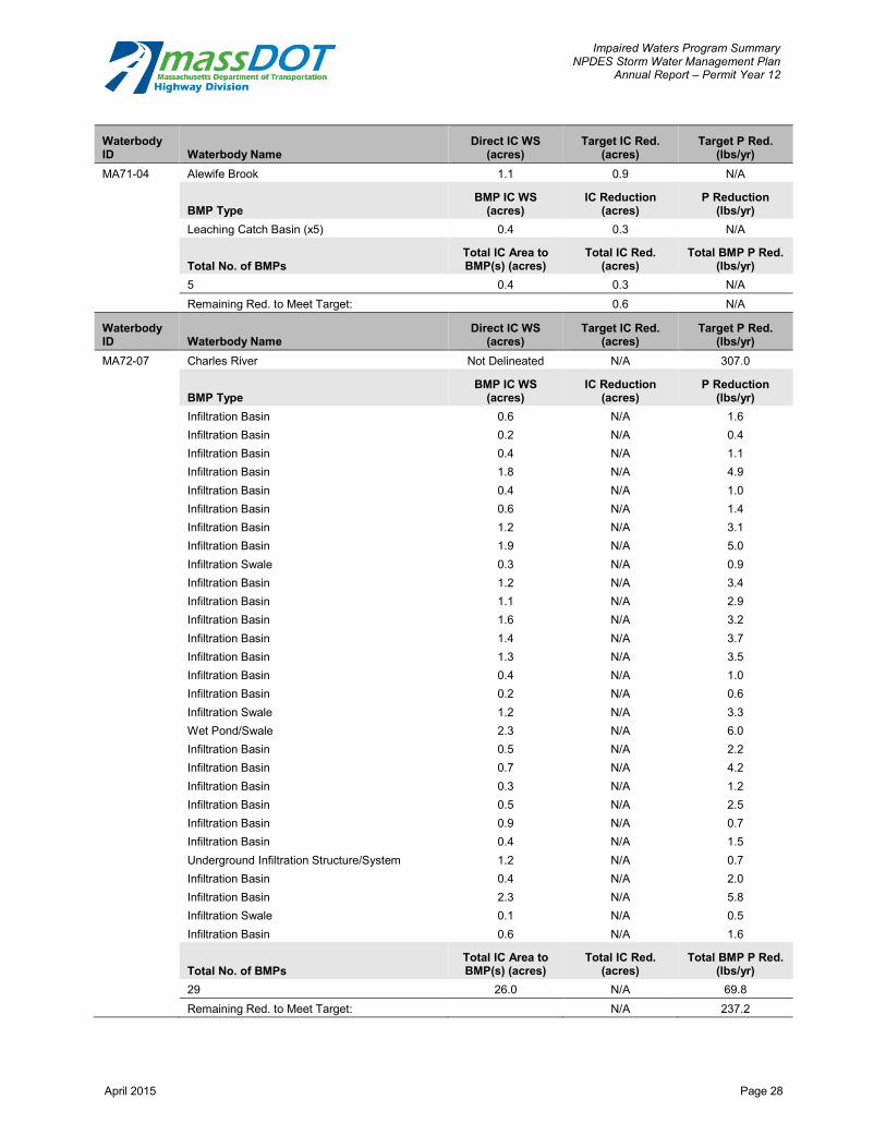
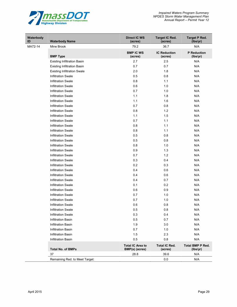
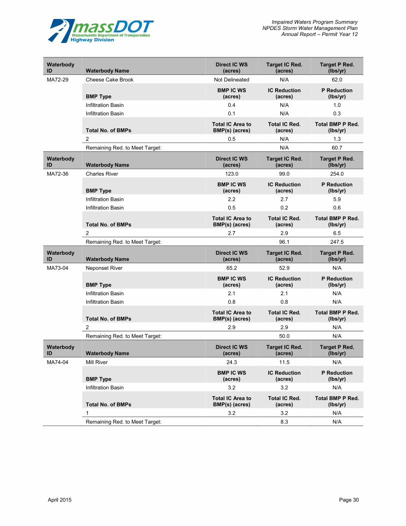
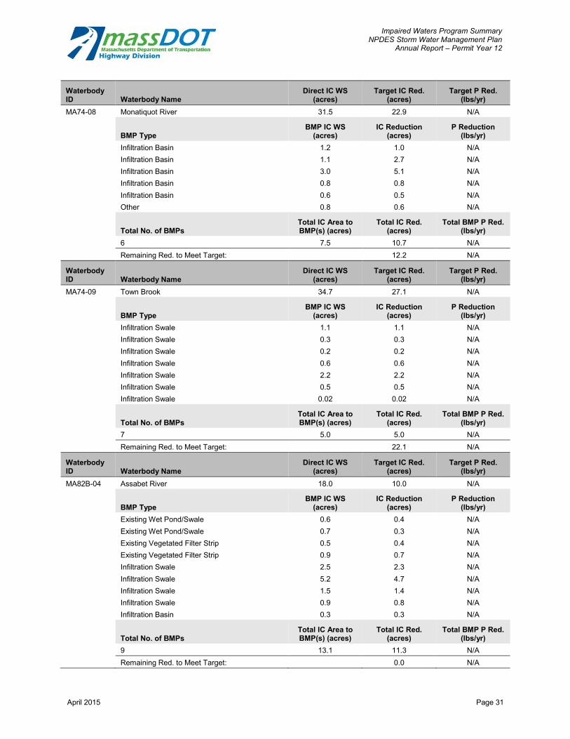
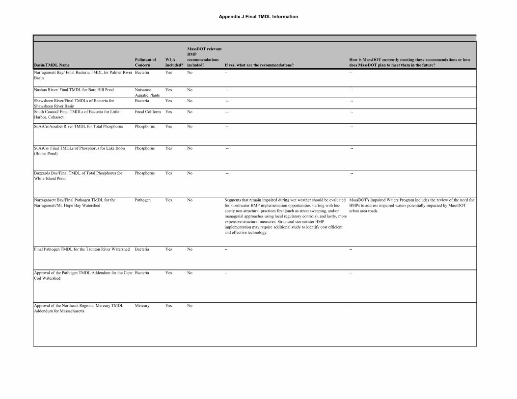
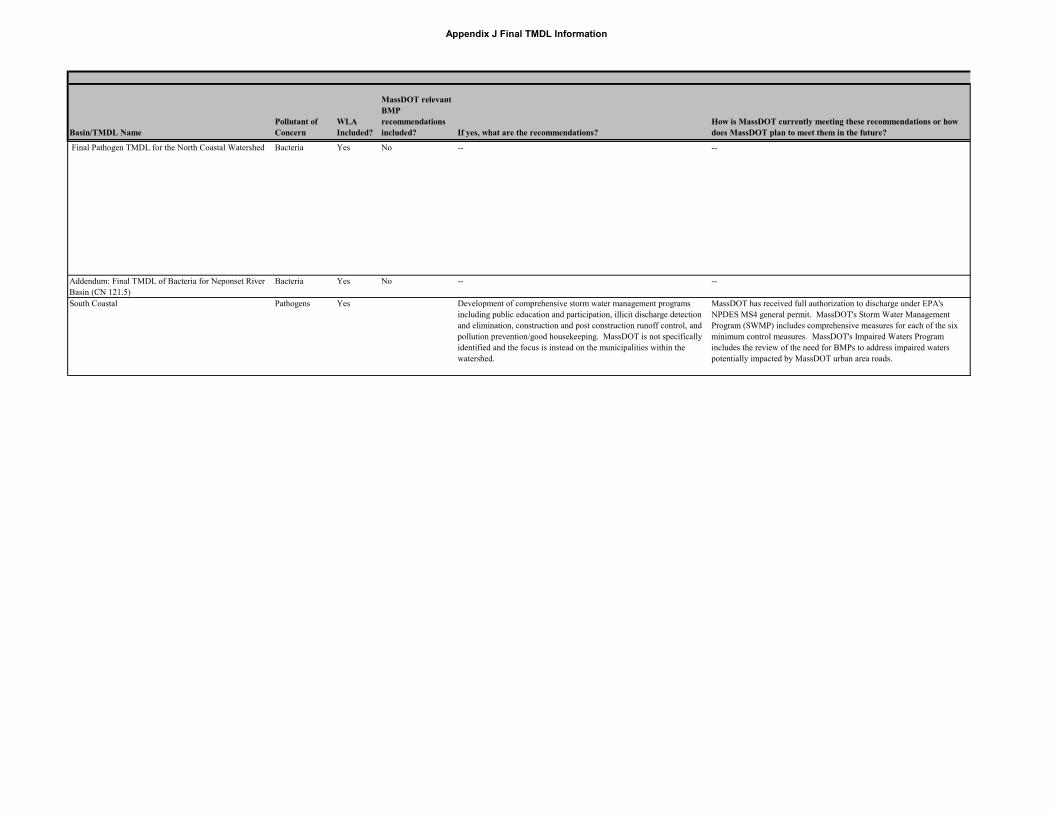
During Permit Year 12, MassDOT completed IWP assessments of 205 water bodies. MassDOT included 76 impaired water bodies in its semi-annual submittal on June 6, 2014 to EPA and another 87 water bodies in its semi-annual submittal on December 8, 2014, all of which count toward the water bodies included on the list of impaired waters potentially receiving MassHighway stormwater runoff which were listed in MassHighway’s 2010 commitment to the court and EPA’s enforcement as Appendix L-1. Since 2010, MassDOT assessed 100% of Appendix L-1 water bodies with TMDLs thereby completing our commitment to review approximately 20% of impaired waters in watersheds with TMDLs each year. Also, MassDOT has completed assessment of 97% of Appendix L-1 water bodies without TMDLs. MassDOT plans to submit our final semi-annual submittal to EPA on June 8, 2015 which will include assessments for the remaining Appendix L-1 water bodies. MassDOT also assessed 42 water bodies that were not required for the court/ EPA enforcement order but that MassDOT assessed based on the IWP goals including use of updated urban area delineations, 303(d) lists, and TMDLs. These additional assessments illustrate MassDOT’s commitment to improving stormwater runoff quality from its highways.
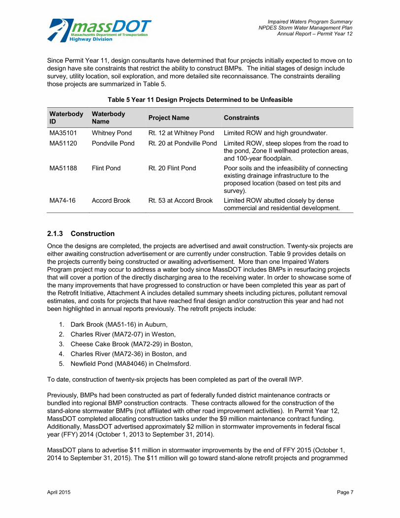
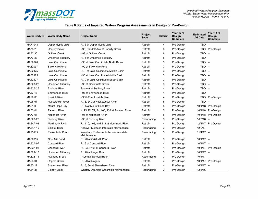
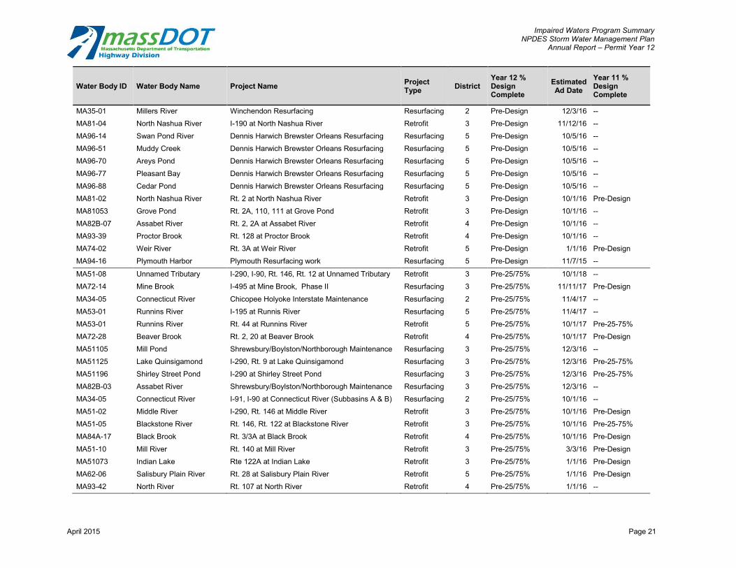
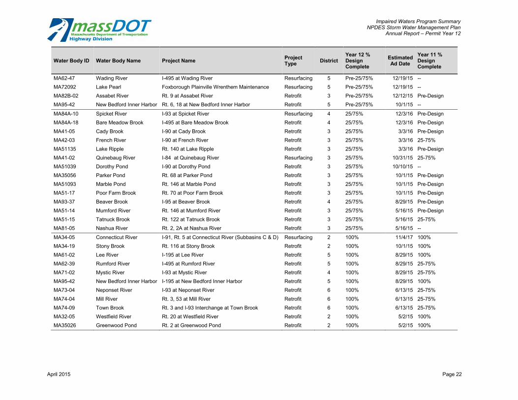
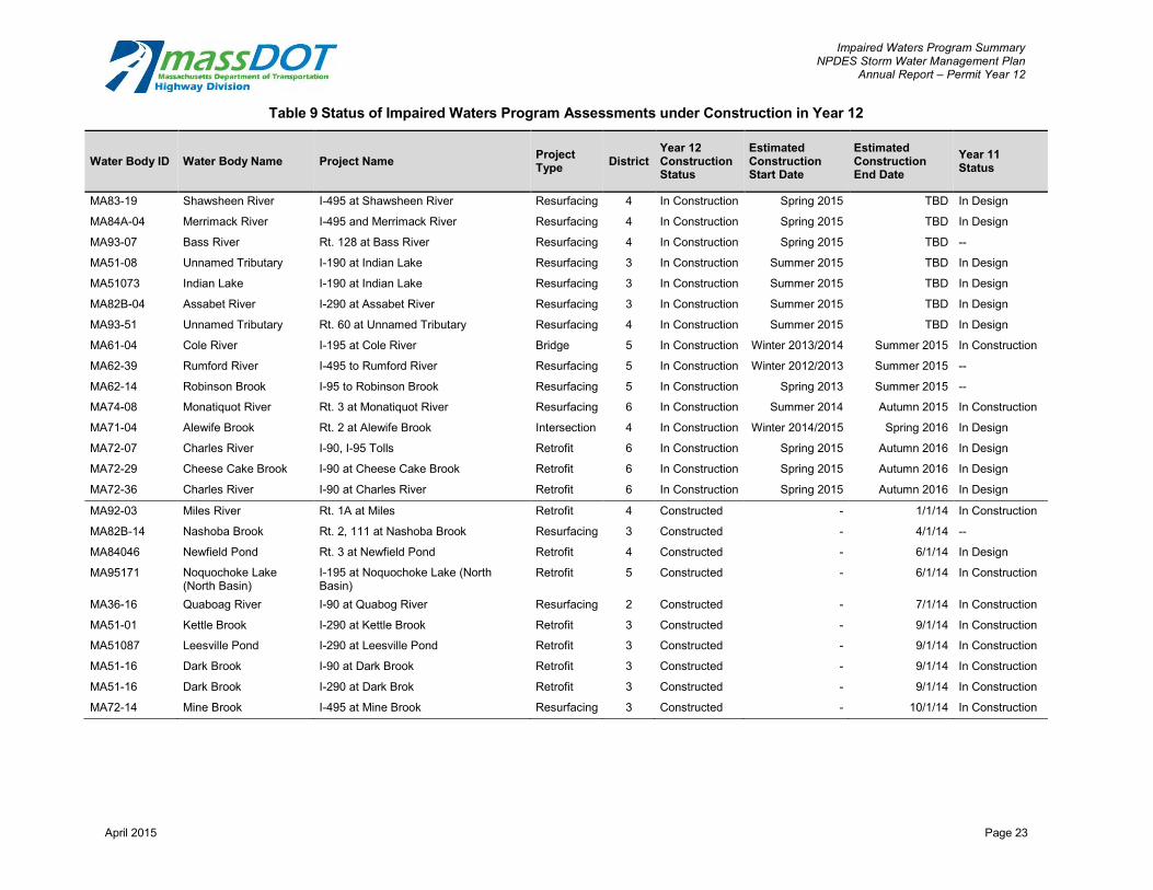
MassDOT worked diligently this year to move forward with the many assessments where design of BMPs are warranted through design contracts with five design consultants. There are currently 78 projects in various stages of the design process to construct stormwater BMPs. These projects, in addition to on-going projects from Permit Years 8 through 10, currently include the design of a broad
Page 2
NPDES Storm Water Management Plan Annual Report – Permit Year 12
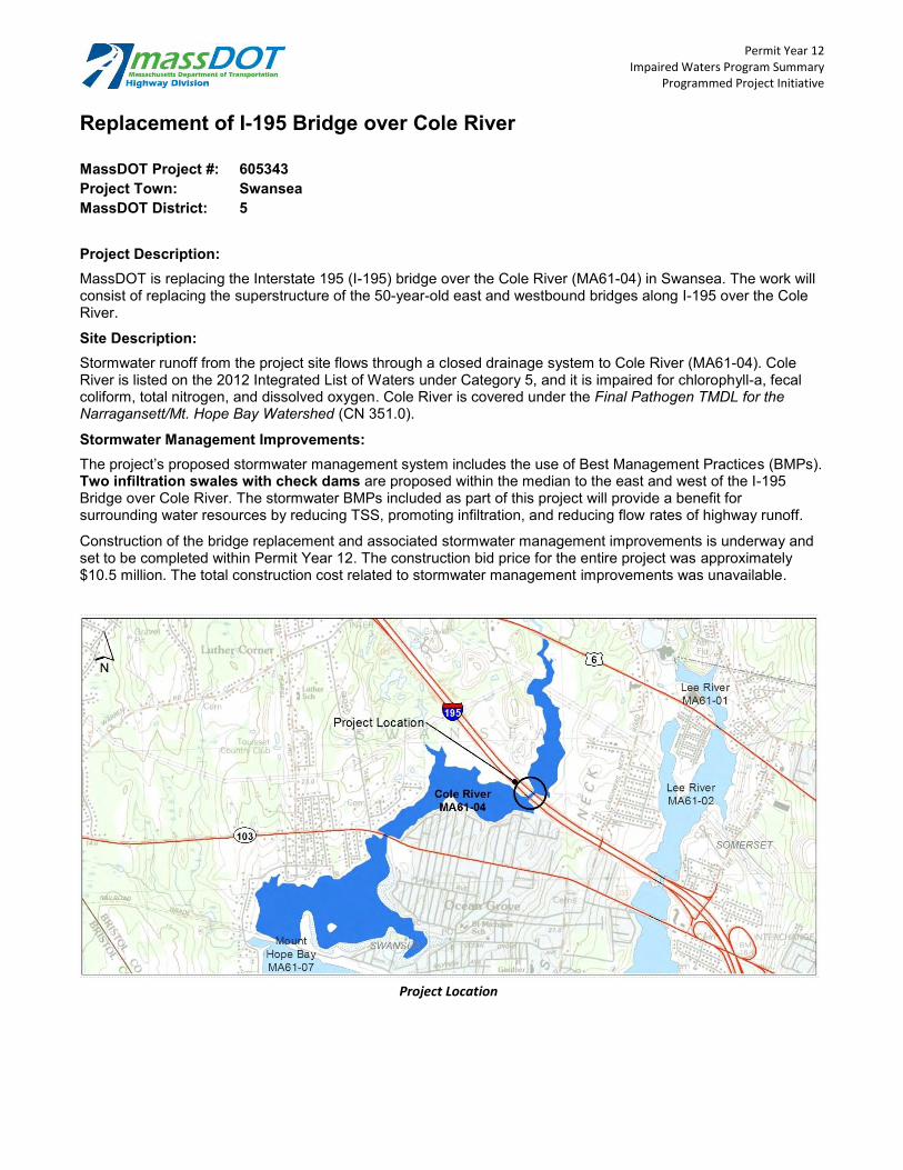
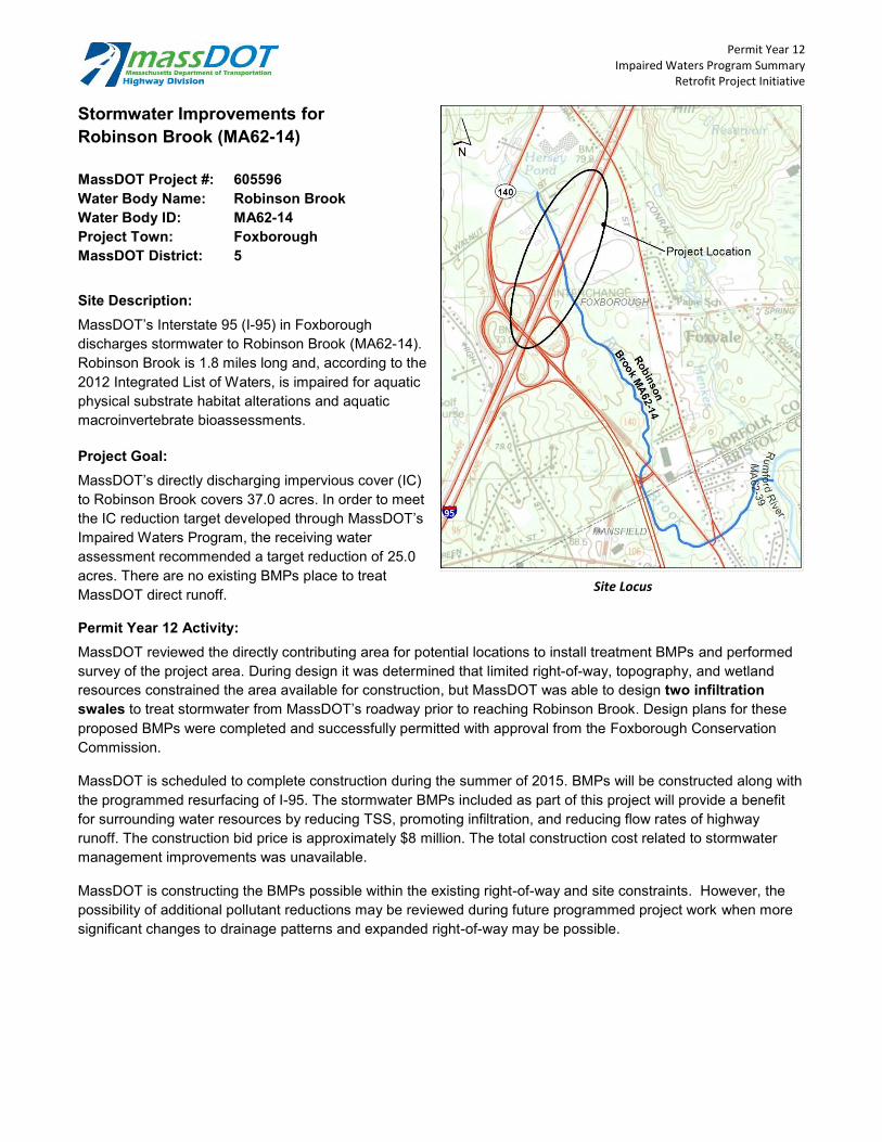
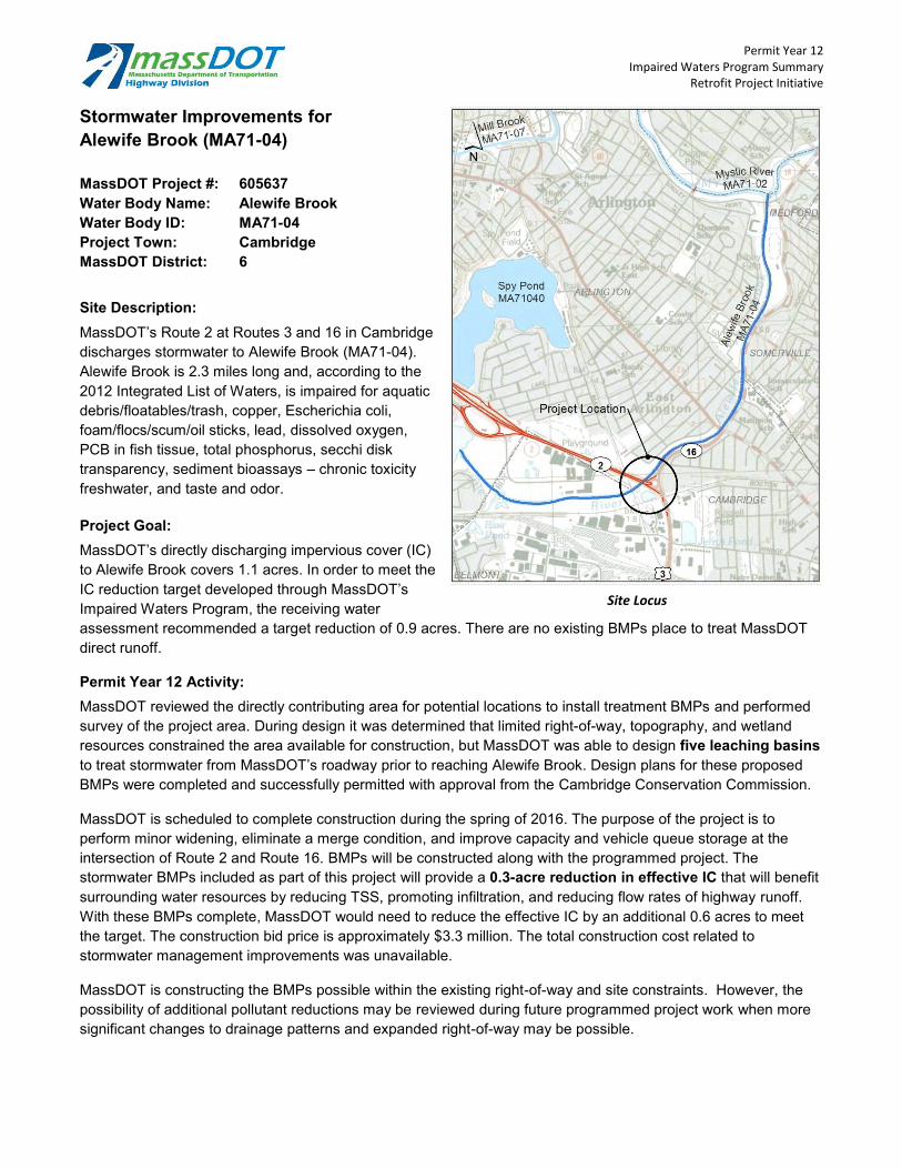
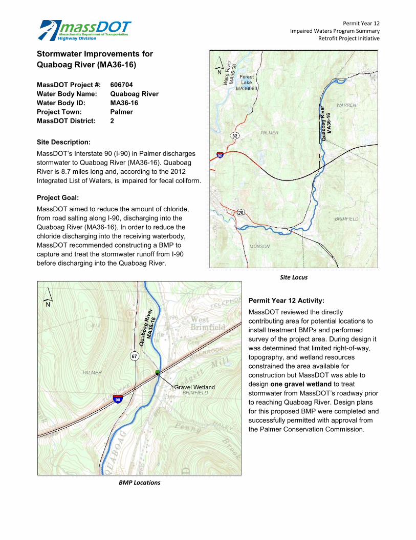
range of vegetated and subsurface stormwater infiltration BMPs. BMPs included in final design in Permit Year 12 are estimated to remove 159 acres of effective impervious cover (IC) and 107 lbs/yr of phosphorus. Eleven projects have reached 100% Design and are awaiting construction advertisement. Fifteen projects are currently under construction and 26 have been completed since the program began. A summary of the Impaired Waters Program is included in BMPs 7R and 7U, along with Appendix D of this report.
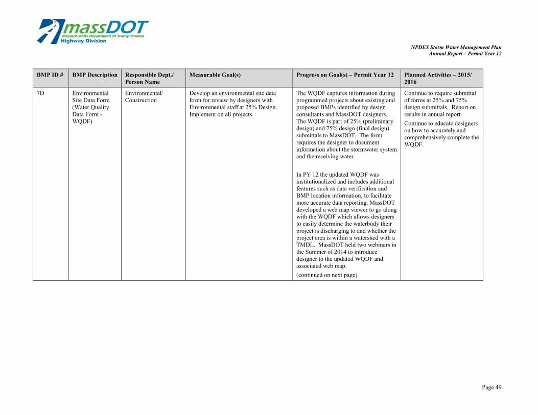
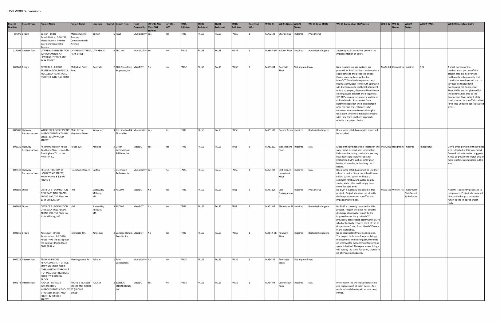
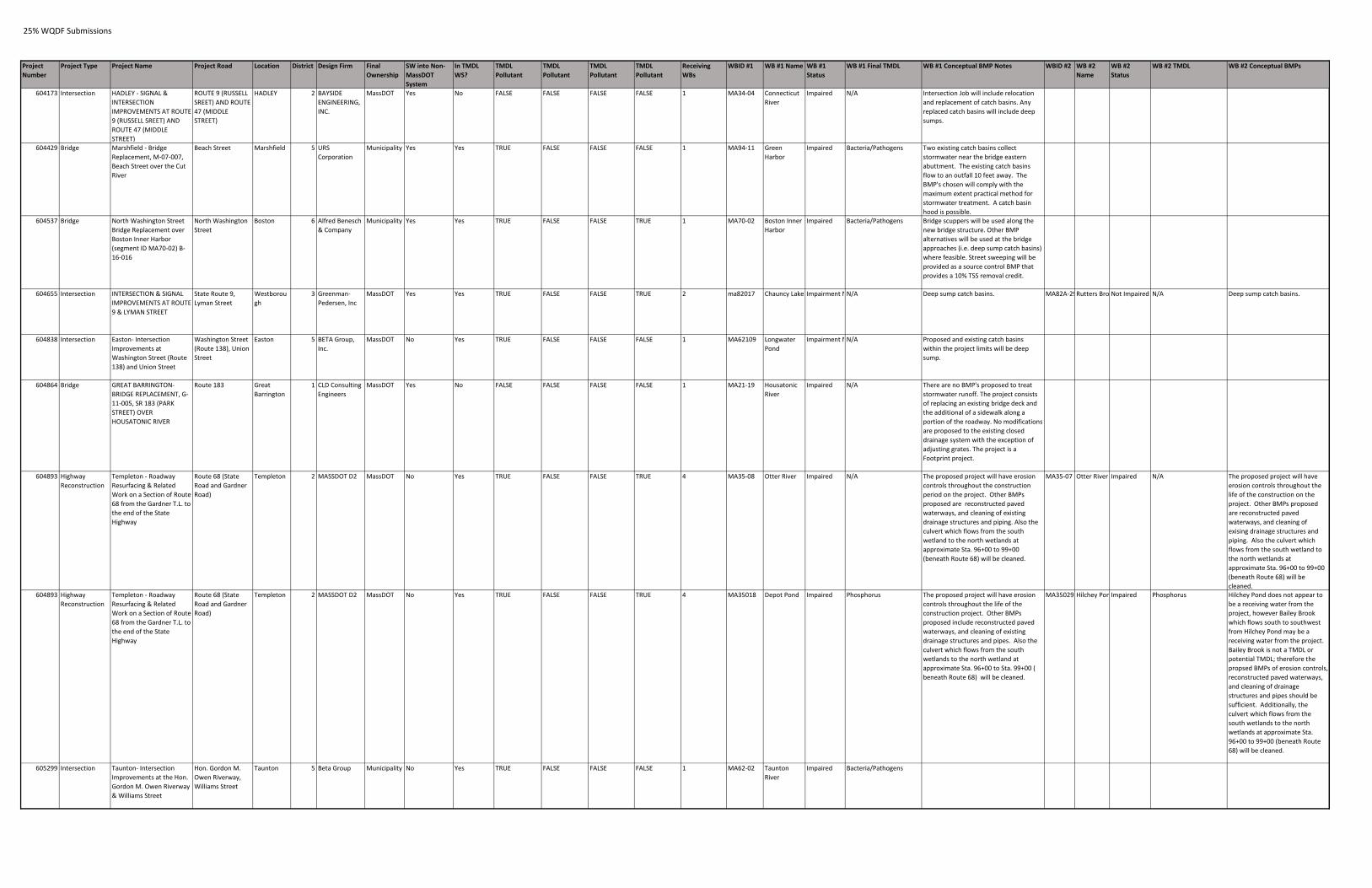
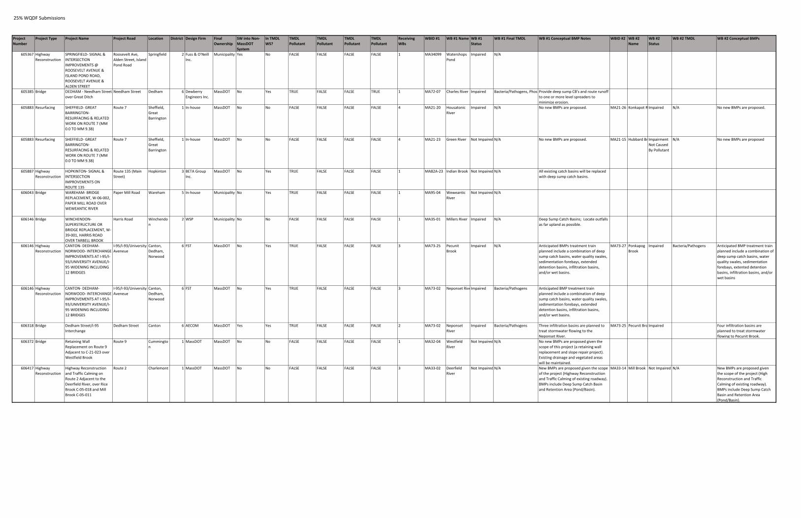
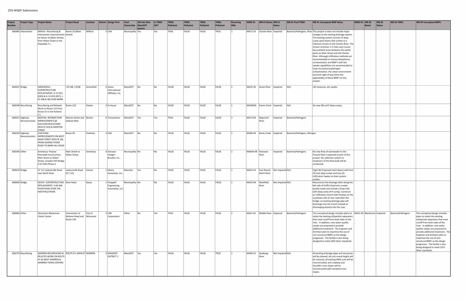
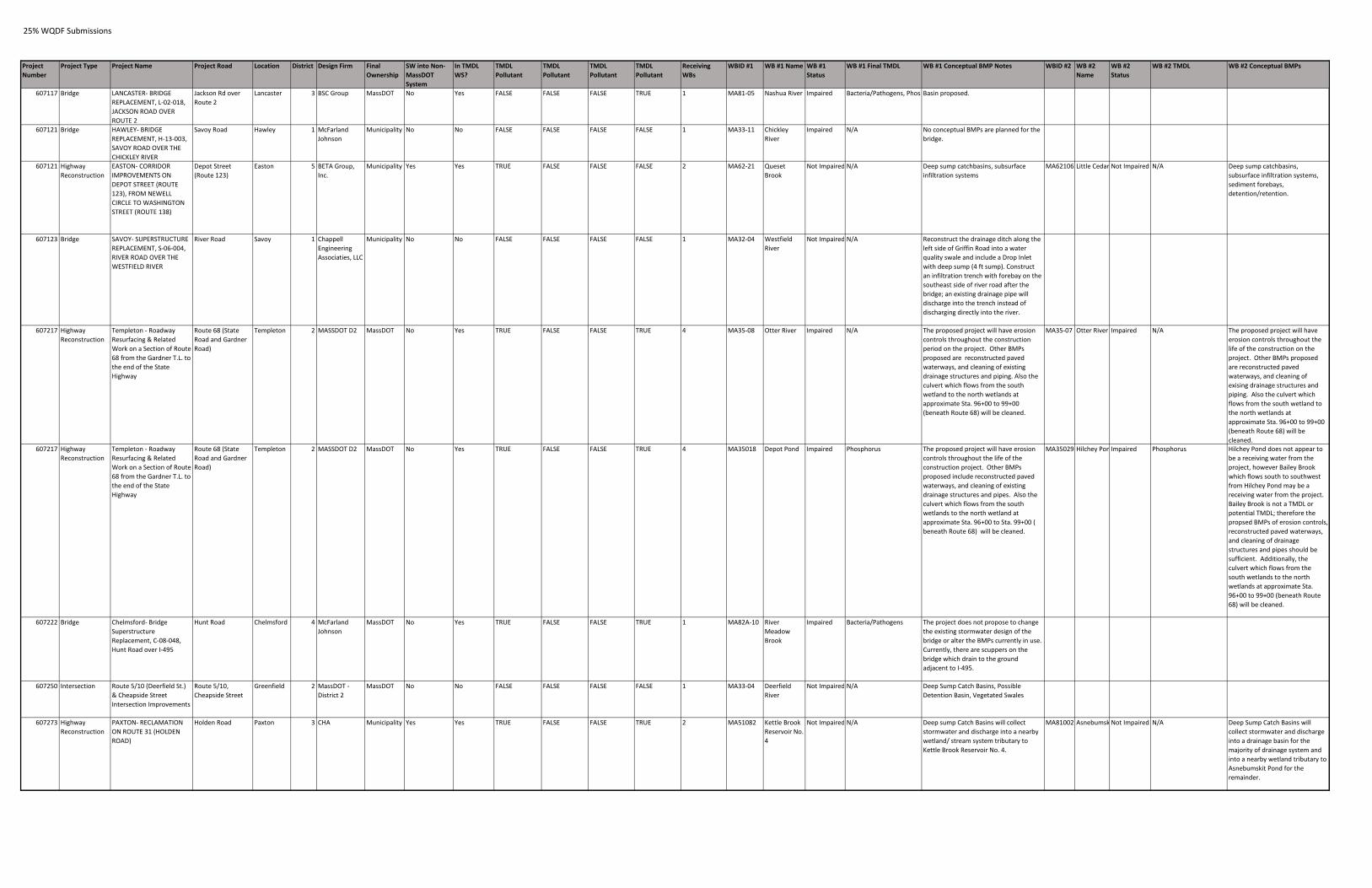
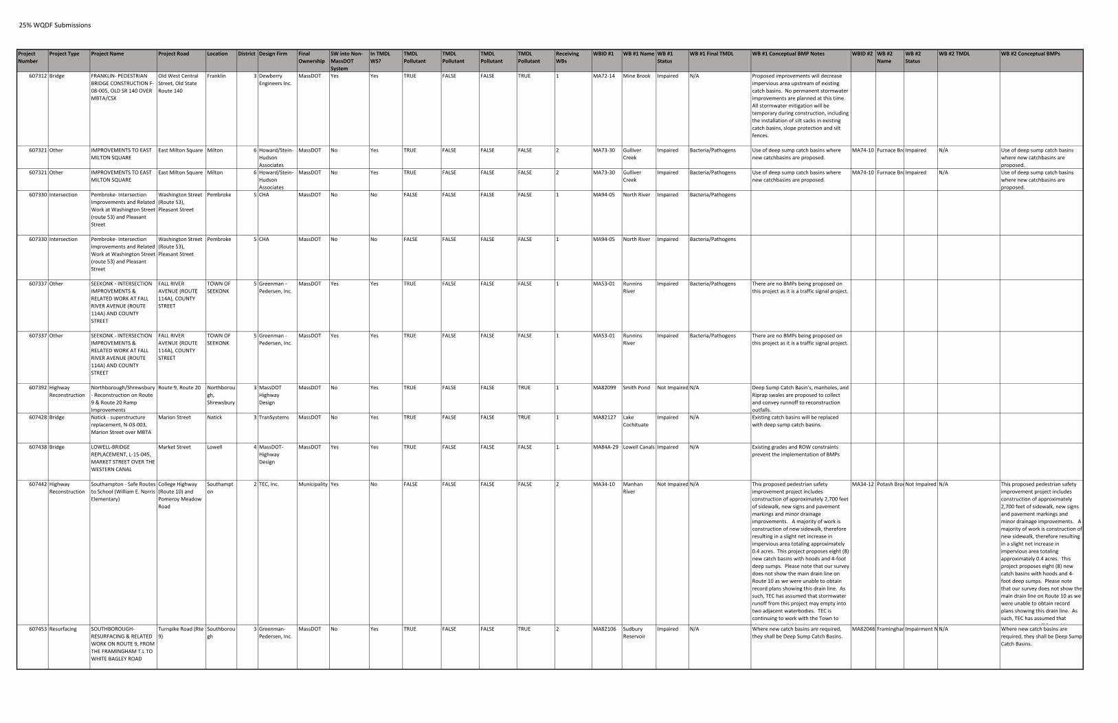
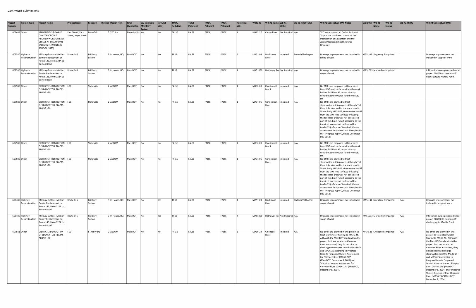
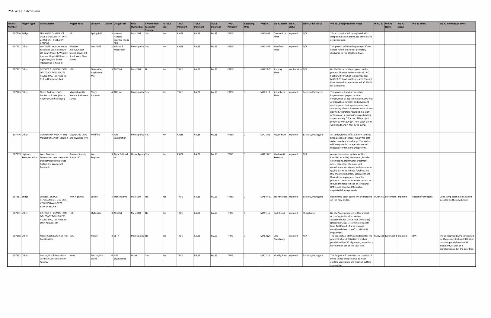
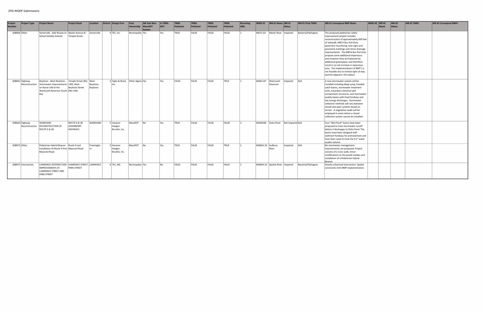
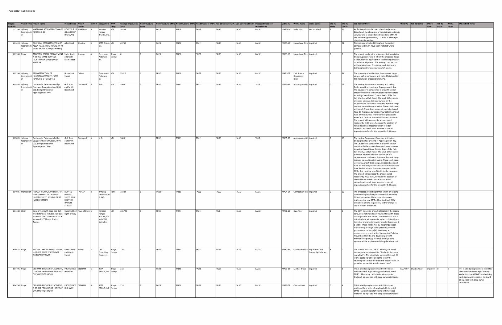
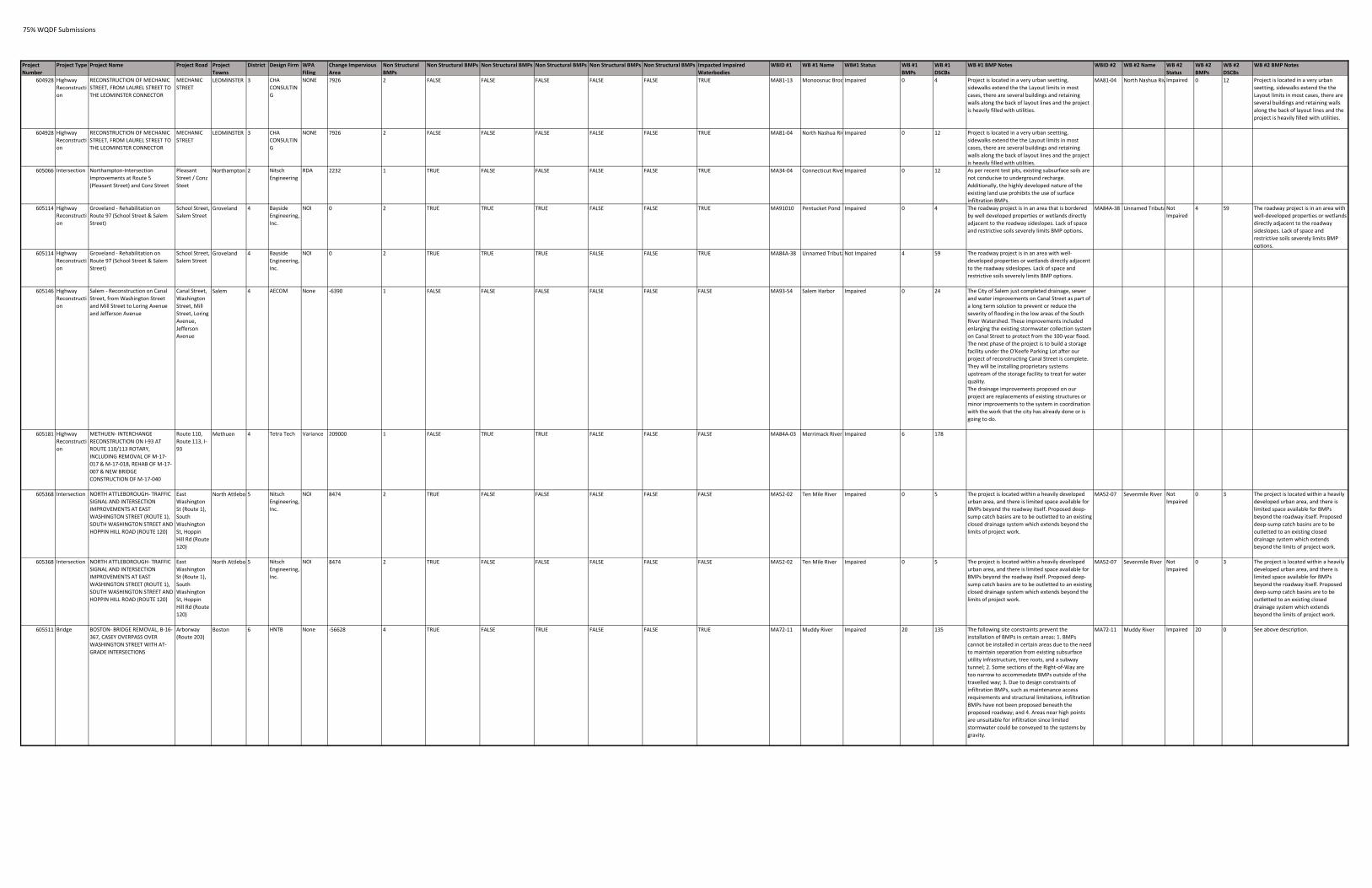
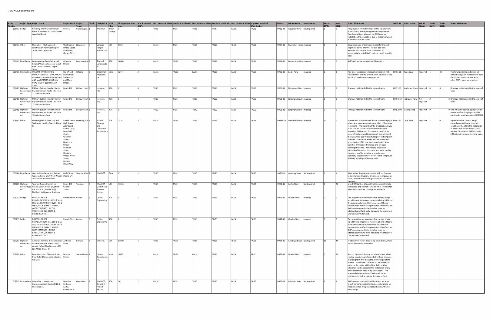
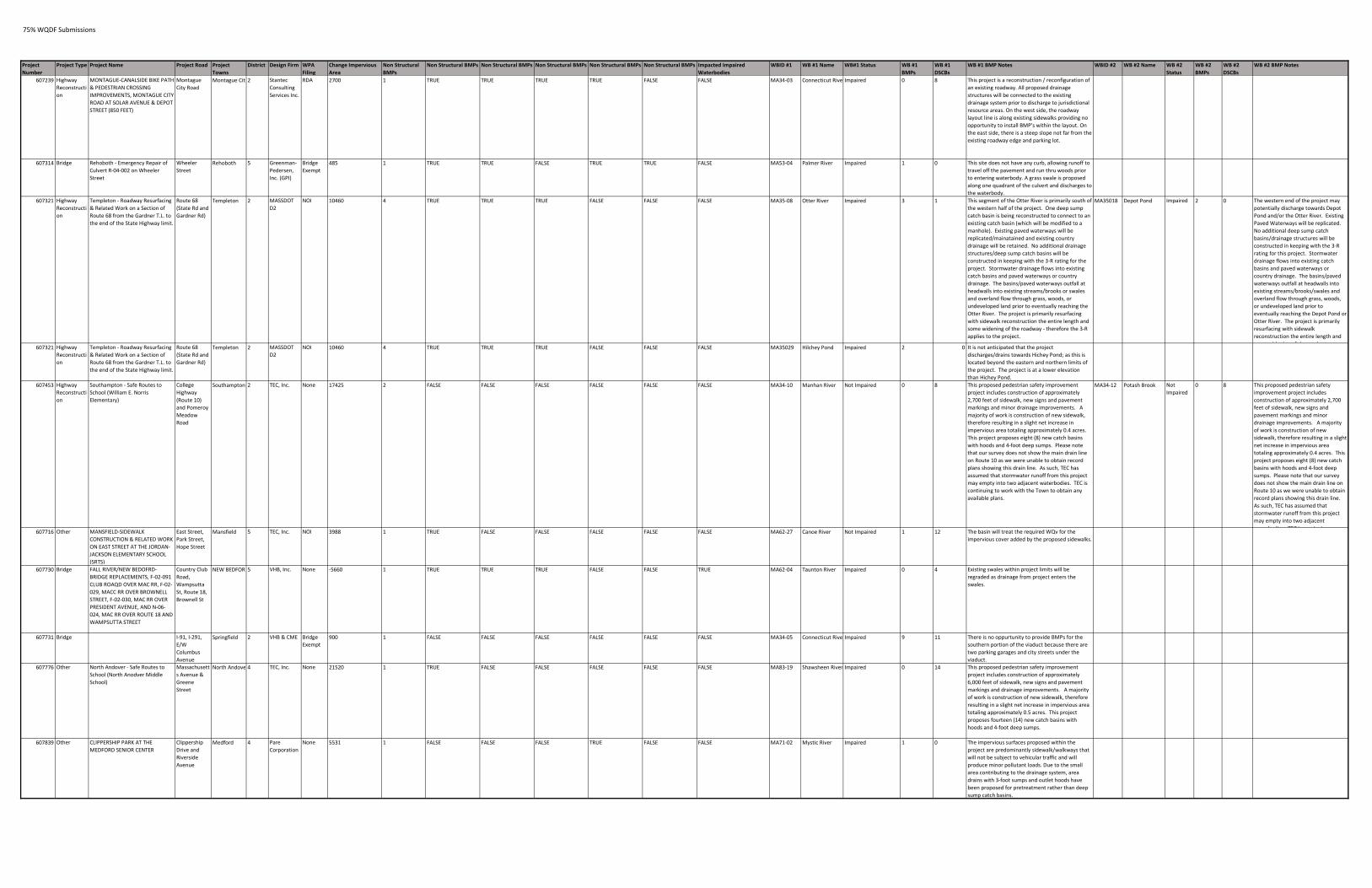
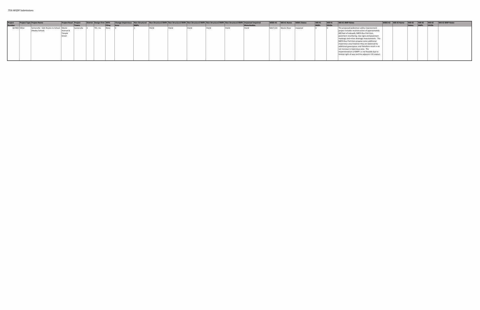
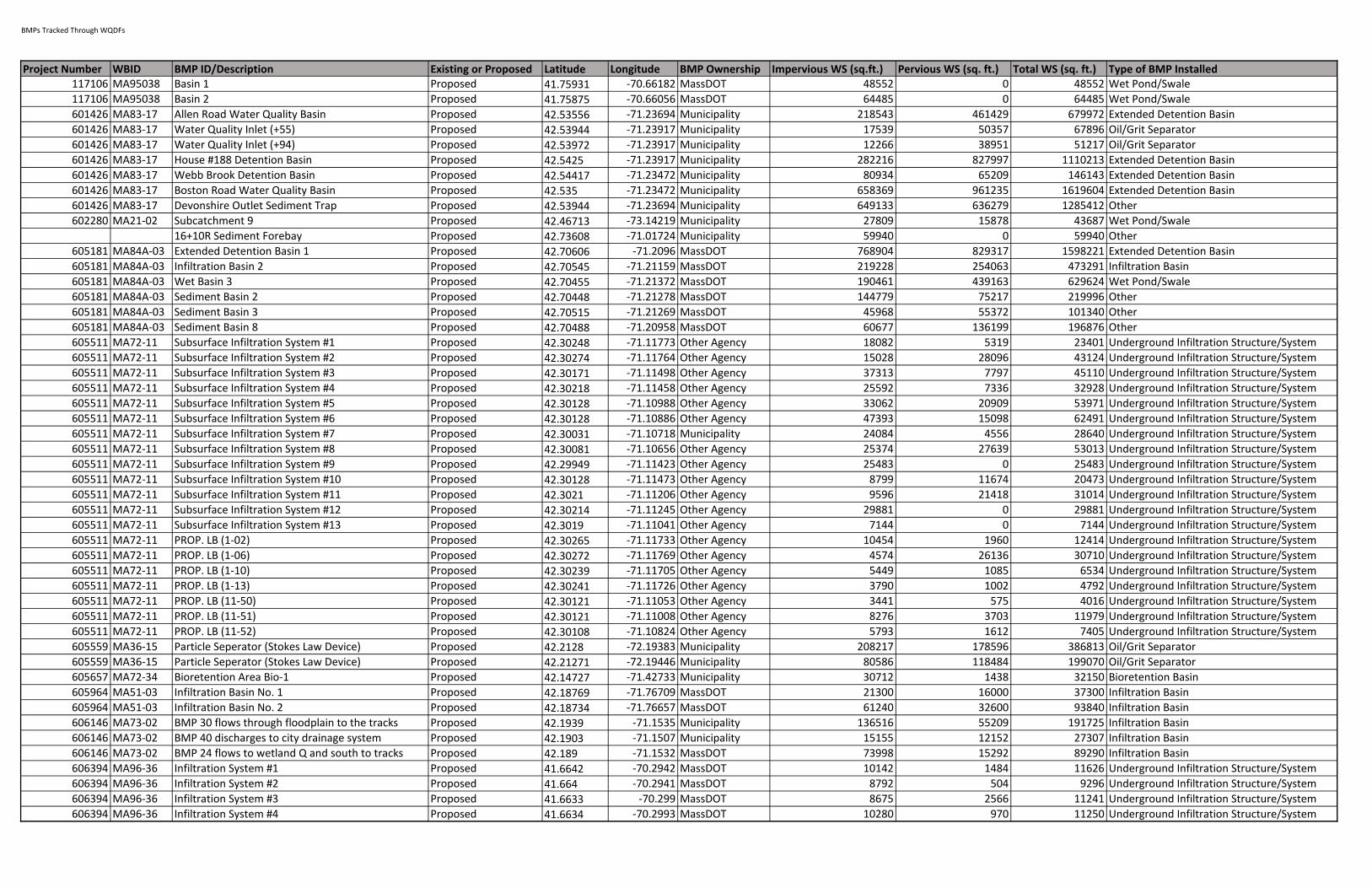
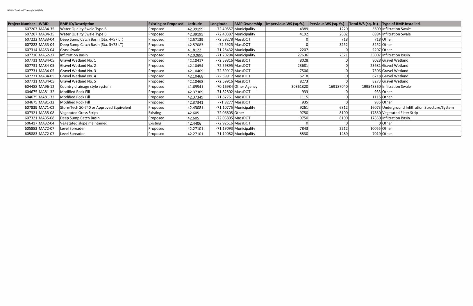
In order to alert designers working on projects that potentially impact impaired waters, and to capture information regarding stormwater improvements incorporated into designs to address MassDOT stormwater, MassDOT developed a water quality data form (WQDF) which is submitted by design consultants at the 25% and 75% design stage. This past year, the updated WQDF was used by designers to document BMPs implemented in impaired waters contributing areas, leading to more comprehensive and accurate data collection regarding stormwater BMPs. MassDOT conducted two webinars for designers during Permit Year 12 on how to fill out the new WQDF and use the interactive web-map developed to assist designers in identifying water resources associated with their projects.
This year, MassDOT has received 128 water quality data forms; 79 at the 25% design phase and 49 forms at the 75% design phase. Of the 25% forms, 164 receiving waterbodies were identified, 64 affected an impaired water body without a TMDL, 100 were in a watershed covered by a TMDL, and 76 receiving waterbodies with a TMDL were identified. The 75% forms documented a total of 99 stormwater BMPs (existing and proposed) and at least 1,148 proposed deep sump catch basins. Additionally, non-structural BMPs implemented for these projects were documented and included measures such as street sweeping, protecting sensitive areas, inspection and cleaning of stormwater structures, catch basin cleaning, snow removal and deicing controls, and use of sediment and erosion controls during construction. Information collected in WQDFs during Permit Year 12 are included in Appendix E.
MassDOT has developed the IWP geospatial database to track the many structural BMPs being designed and constructed by its design consultants and the status of water body assessments. This IWP geospatial database is a powerful tool in the analysis of MassDOT’s program and future planning/ water quality analysis. The updated WQDF also allows MassDOT to compile the information provided by designers of programmed projects on proposed stormwater BMPs into the IWP geospatial database. Compiling stormwater BMP information in the IWP database will allow for streamlined tracking and maintenance of BMPs moving forward.
MassDOT conducted a robust training and outreach effort in Permit Year 12 including presentations on MassDOTs stormwater program at various conferences, participation in national research studies and workshops, and internal staff training. MassDOT’s stormwater program continues to be at the cutting edge of stormwater management for regional state DOTs and presentations from MassDOT are sought out by conference organizers in the area.
MassDOT continues to follow up on potential illicit connections identified in its drainage systems while working on a more targeted and efficient Illicit Discharge Detection and Elimination (IDDE) program as the linear, controlled nature of MassDOT’s roadway network results in few illicit connections. The program is in draft stages and considers IDDE required program elements in the draft NPDES Massachusetts Small MS4 General permit.
Page 3
NPDES Storm Water Management Plan Annual Report – Permit Year 12
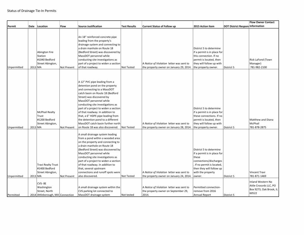
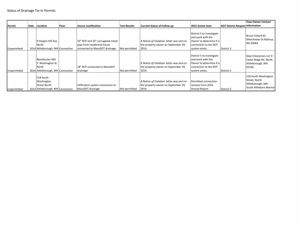
MassDOT continued the review of Appendix A (IDDE Status Permit) and Appendix B (Status of Drainage Tie-In Permits) tables that have been submitted in previous Annual Reports. This included revising the tables and including more specific information on the Property Owner and Action Items. Additionally, this critical review included contacting each District to determine if any of the Illicit Discharges were permitted; and therefore removed from the IDDE Tables.
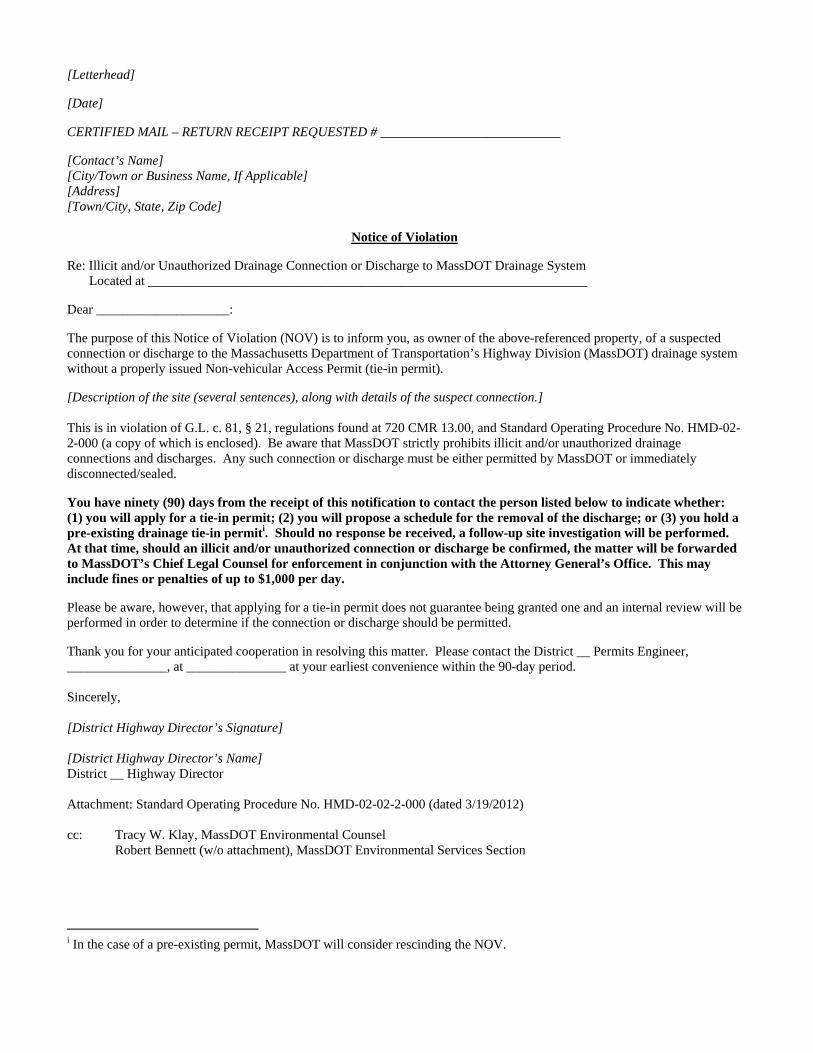
During this Permit Year, MassDOT continued to identify and confirm stormwater flows into the MassDOT system that are not currently permitted and to contact property owners. Notice of Violation (NOV) letters were sent to various property owners in Permit Year 12 to notify them of the tie-in requirements in place and initiate the tie-in permit process. A generic NOV letter is included in Appendix C.
The Drainage Tie-In Standard Operating Procedure (SOP), issued in 2012, has been utilized this past year to confirm that property owners with stormwater discharges that want to tie into the system are in compliance with the NPDES general permit and that non-stormwater discharges are not allowed. Additionally, when existing connections to the drainage system are identified, the Drainage Tie-In SOP is later referenced in letters to property owners so that property owners can either permit their stormwater connections to the drainage system or remove the connection. This process helps implement the IDDE program and is a way to remove illicit connections that have intermittent flow that would not necessarily be identified in the field.
Page 4
NPDES Storm Water Management Plan Annual Report – Permit Year 12
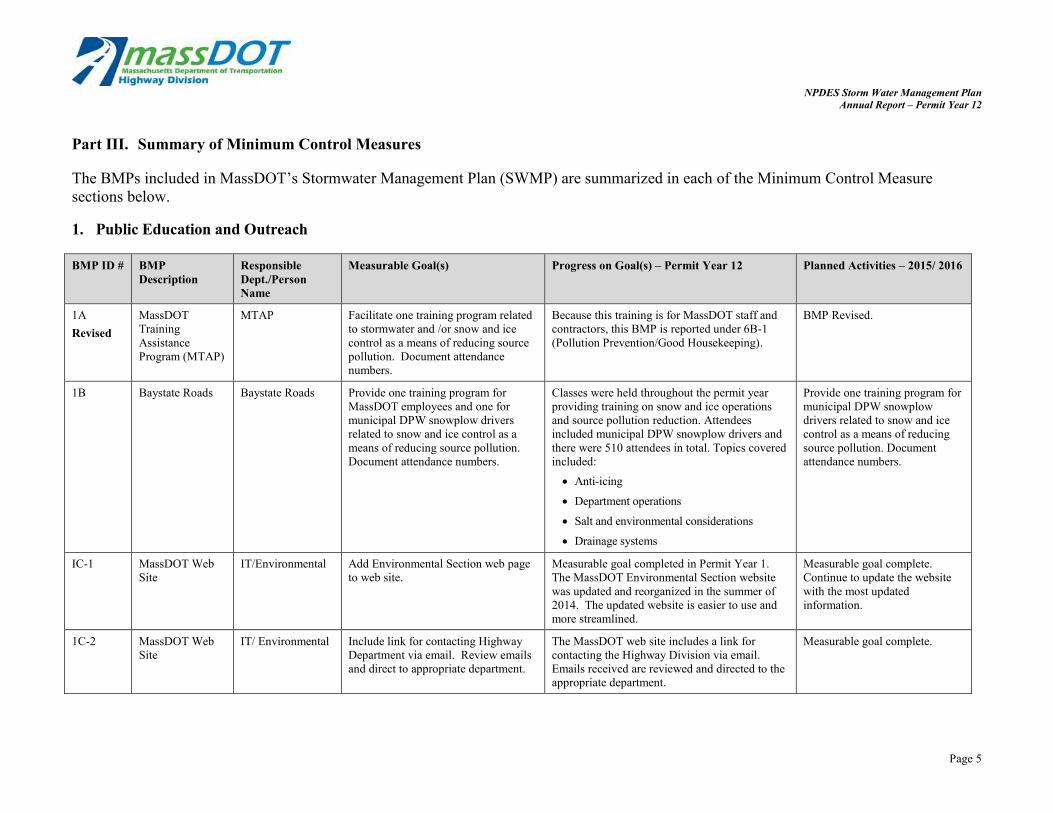
Part III. Summary of Minimum Control Measures
The BMPs included in MassDOT’s Stormwater Management Plan (SWMP) are summarized in each of the Minimum Control Measure sections below.
1. Public Education and Outreach
BMP ID # BMP Description
Responsible Dept./Person Name
Measurable Goal(s) Progress on Goal(s) – Permit Year 12 Planned Activities – 2015/ 2016
1A Revised
MassDOT Training Assistance Program (MTAP)
MTAP Facilitate one training program related to stormwater and /or snow and ice control as a means of reducing source pollution. Document attendance numbers.
Because this training is for MassDOT staff and contractors, this BMP is reported under 6B-1 (Pollution Prevention/Good Housekeeping).
BMP Revised.
1B Baystate Roads Baystate Roads Provide one training program for MassDOT employees and one for municipal DPW snowplow drivers related to snow and ice control as a means of reducing source pollution. Document attendance numbers.
Classes were held throughout the permit year providing training on snow and ice operations and source pollution reduction. Attendees included municipal DPW snowplow drivers and there were 510 attendees in total. Topics covered included: Anti-icing
Department operations
Salt and environmental considerations
Drainage systems
Provide one training program for municipal DPW snowplow drivers related to snow and ice control as a means of reducing source pollution. Document attendance numbers.
IC-1 MassDOT Web Site
IT/Environmental Add Environmental Section web page to web site.
Measurable goal completed in Permit Year 1. The MassDOT Environmental Section website was updated and reorganized in the summer of 2014. The updated website is easier to use and more streamlined.
Measurable goal complete. Continue to update the website with the most updated information.
1C-2 MassDOT Web Site
IT/ Environmental Include link for contacting Highway Department via email. Review emails and direct to appropriate department.
The MassDOT web site includes a link for contacting the Highway Division via email. Emails received are reviewed and directed to the appropriate department.
Measurable goal complete.
Page 5
NPDES Storm Water Management Plan Annual Report – Permit Year 12
BMP ID # BMP Description
Responsible Dept./Person Name
Measurable Goal(s) Progress on Goal(s) – Permit Year 12 Planned Activities – 2015/ 2016
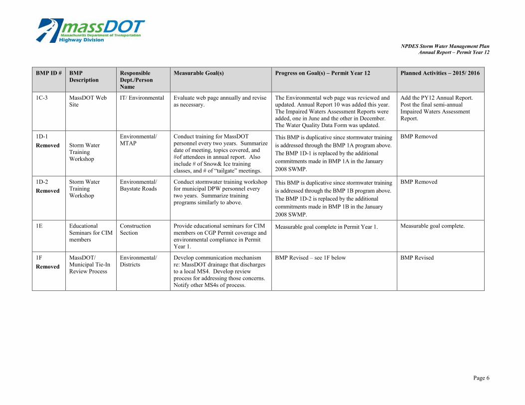
1C-3 MassDOT Web Site
IT/ Environmental Evaluate web page annually and revise as necessary.
The Environmental web page was reviewed and updated. Annual Report 10 was added this year. The Impaired Waters Assessment Reports were added, one in June and the other in December. The Water Quality Data Form was updated.
Add the PY12 Annual Report. Post the final semi-annual Impaired Waters Assessment Report.
1D-1 Removed Storm Water
Training Workshop
Environmental/ MTAP
Conduct training for MassDOT personnel every two years. Summarize date of meeting, topics covered, and #of attendees in annual report. Also include # of Snow& Ice training classes, and # of “tailgate” meetings.
This BMP is duplicative since stormwater training is addressed through the BMP 1A program above. The BMP 1D-1 is replaced by the additional commitments made in BMP 1A in the January 2008 SWMP.
BMP Removed
1D-2 Removed
Storm Water Training Workshop
Environmental/ Baystate Roads
Conduct stormwater training workshop for municipal DPW personnel every two years. Summarize training programs similarly to above.
This BMP is duplicative since stormwater training is addressed through the BMP 1B program above. The BMP 1D-2 is replaced by the additional commitments made in BMP 1B in the January 2008 SWMP.
BMP Removed
1E Educational Seminars for CIM members
Construction Section
Provide educational seminars for CIM members on CGP Permit coverage and environmental compliance in Permit Year 1.
Measurable goal complete in Permit Year 1. Measurable goal complete.
1F Removed
MassDOT/ Municipal Tie-In Review Process
Environmental/ Districts
Develop communication mechanism re: MassDOT drainage that discharges to a local MS4. Develop review process for addressing those concerns. Notify other MS4s of process.
BMP Revised – see 1F below BMP Revised
Page 6
NPDES Storm Water Management Plan Annual Report – Permit Year 12
BMP ID # BMP Description
Responsible Dept./Person Name
Measurable Goal(s) Progress on Goal(s) – Permit Year 12 Planned Activities – 2015/ 2016
1F Post Contact Environmental/ 1) Distribute a flyer with contact 1) Completed in Year 5. 1) Completed in Year 5. Revised Names for
Municipal Drainage Concerns on MassDOT Web Site
Districts/ GIS names to municipalities during May 2007 Baystate Roads NPDES Phase II General Permit seminar. 2) Post DHD contact name for each district on website for municipalities to contact and maintain link.
2) DHD contact names continue to be updated on the web site. Go to http://www.massdot.state.ma.us/highway/ AbouttheDistricts.aspx
3) MassDOT has posted the drainage outfall inventory on the web site at this location:
2) Continue to maintain contact names.
3) Share drainage inventory information as requested.
3) GIS group will develop a program to provide easy to use access and allow the public to identify a selected area and review the MassDOT owned roads and outfalls. MassDOT will then review alternatives for alerting towns and the public to the availability of this information.
Traffic Operations Maintain signs identifying rivers and streams crossed by MassDOT roads, until crossing of all named rivers and streams are signposted.
MassDOT installed 2 signs identifying river and stream crossings. The locations were identified by the MassRiverways Program and installed by MassDOT personnel. The two signs were installed to identify Monatiquot River in Braintree.
MassDOT will continue to install signs in areas identified by MassRiverways Program.
1H Anti-litter/ Operations Maintain anti-litter message in the Messages on permanent Variable Message No further action. Removed Dumping
Messages on Variable Message Boards
message mix on permanent Variable Message Boards (VMBs).
Boards are restricted to traffic and safety issues.
1I Anti-litter/ Operations Work with EOEEA’s Think Blue It was determined in Permit Year 7, that the BMP Revised. Removed Dumping
Literature at Campaign to identify appropriate brochures for use in Visitor’s Centers.
Think Blue Campaign was not the right program for providing stormwater literature to the public.
Visitors Centers Distribute literature to appropriate The BMP was revised – see 1I below. visitor centers and track number of brochures distributed annually.
NPDES Storm Water Management Plan Annual Report – Permit Year 12
BMP ID # BMP Description
Responsible Dept./Person Name
Measurable Goal(s) Progress on Goal(s) – Permit Year 12 Planned Activities – 2015/ 2016
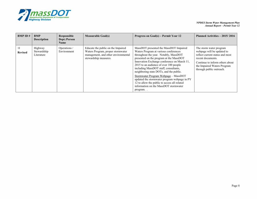
1I Highway Operations / Educate the public on the Impaired MassDOT presented the MassDOT Impaired The storm water program Revised Stewardship
Literature Environment Waters Program, proper stormwater
management, and other environmental stewardship measures.
Waters Program at various conferences throughout the year. Notably, MassDOT presented on the program at the MassDOT Innovation Exchange conference on March 11, 2015 to an audience of over 100 people including MassDOT staff, consultants, neighboring state DOTs, and the public. Stormwater Program Webpage – MassDOT updated the stormwater program webpage in PY 12 to allow the public to access all related information on the MassDOT stormwater program. .
webpage will be updated to reflect current status and most recent documents. Continue to inform others about the Impaired Waters Program through public outreach.
Page 8
NPDES Storm Water Management Plan Annual Report – Permit Year 12
Page 9
BMP ID # BMP Description
Responsible Dept./Person Name
Measurable Goal(s) Progress on Goal(s) – Permit Year 12 Planned Activities – 2015/ 2016
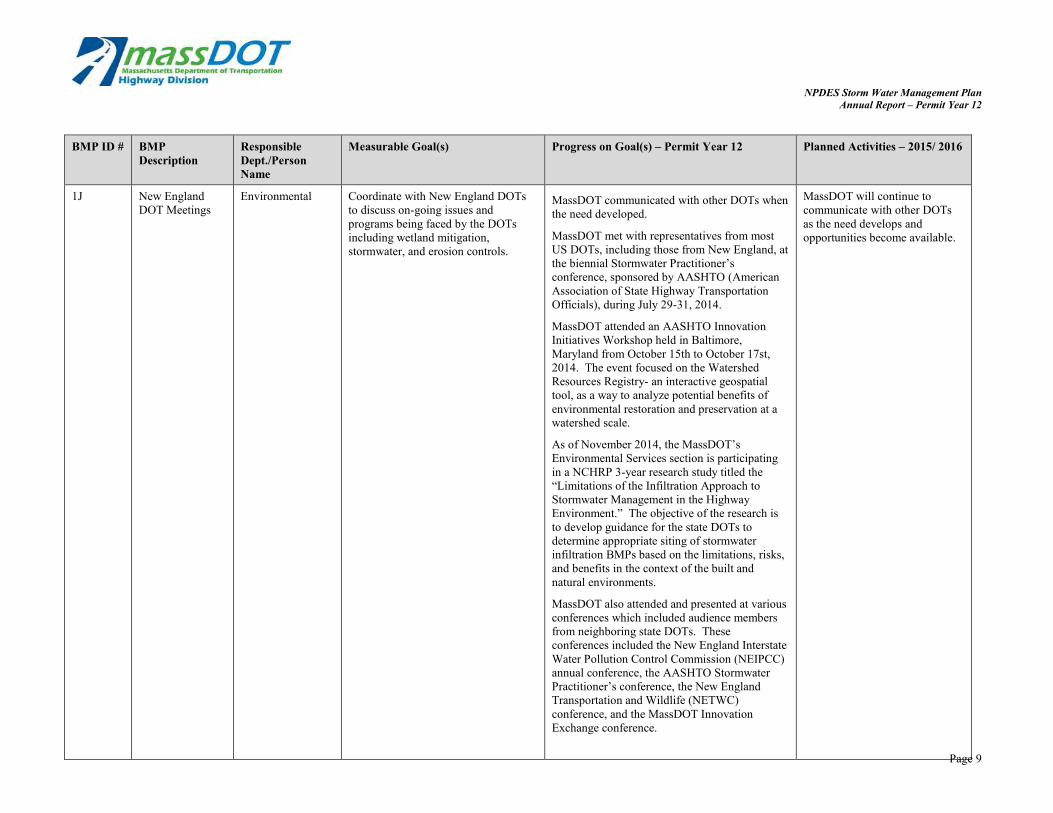
1J New England DOT Meetings
Environmental Coordinate with New England DOTs to discuss on-going issues and programs being faced by the DOTs including wetland mitigation, stormwater, and erosion controls.
MassDOT communicated with other DOTs when the need developed.
MassDOT met with representatives from most US DOTs, including those from New England, at the biennial Stormwater Practitioner’s conference, sponsored by AASHTO (American Association of State Highway Transportation Officials), during July 29-31, 2014.
MassDOT attended an AASHTO Innovation Initiatives Workshop held in Baltimore, Maryland from October 15th to October 17st, 2014. The event focused on the Watershed Resources Registry- an interactive geospatial tool, as a way to analyze potential benefits of environmental restoration and preservation at a watershed scale.
As of November 2014, the MassDOT’s Environmental Services section is participating in a NCHRP 3-year research study titled the “Limitations of the Infiltration Approach to Stormwater Management in the Highway Environment.” The objective of the research is to develop guidance for the state DOTs to determine appropriate siting of stormwater infiltration BMPs based on the limitations, risks, and benefits in the context of the built and natural environments.
MassDOT also attended and presented at various conferences which included audience members from neighboring state DOTs. These conferences included the New England Interstate Water Pollution Control Commission (NEIPCC) annual conference, the AASHTO Stormwater Practitioner’s conference, the New England Transportation and Wildlife (NETWC) conference, and the MassDOT Innovation Exchange conference.
MassDOT will continue to communicate with other DOTs as the need develops and opportunities become available.
NPDES Storm Water Management Plan Annual Report – Permit Year 12
BMP ID # BMP Description
Responsible Dept./Person Name
Measurable Goal(s) Progress on Goal(s) – Permit Year 12 Planned Activities – 2015/ 2016
1K Storm Water Coordinator
Environmental Fund a full-time stormwater coordinator position each year.
The Environmental Section stormwater staff continues to coordinate compliance within the NPDES stormwater program. They have completed many tasks under these roles throughout the year. Stormwater staff members also continue to coordinate the Impaired Waters Program implementation. They work with consultants to perform assessments, select appropriate stormwater BMPS as part of the Retrofit Initiative and Programmed Project Initiative, and is responsible for maintenance contracts in each of the districts to construct the BMPs once designed.
Continue to fund a stormwater analyst and an Impaired Waters Program coordinator. Hire a summer intern for the summer of 2015 to provide stormwater related assistance.
During Permit Year 12, MassDOT hired a third staff member to join the Stormwater Unit. This entry level position has allowed MassDOT to expand its stormwater review of all MassDOT programmed projects and develop more stormwater retrofit projects.
Page 10
NPDES Storm Water Management Plan Annual Report – Permit Year 12
BMP ID # BMP Description
Responsible Dept./Person Name
Measurable Goal(s) Progress on Goal(s) – Permit Year 12 Planned Activities – 2015/ 2016
Addn. Environmental Site Data Form
Environmental Develop an environmental site data form for review by designers with Environmental staff at 25% Design. Implement on all projects.
The Water Quality Data Form (WQDF) is being used for submittal at 25% Design and 75% Design stage to MassDOT by internal designers and consultants. In PY 11 an updated WQDF was launched, which includes additional features such as data verification, to facilitate more accurate data reporting. MassDOT conducted two webinars for designers during Permit Year 12 on how to fill out the new WQDF and use the interactive web-map developed to assist designers in identifying water resources associated with their projects.
Internal designers and consultants will continue to submit the forms at 25% and 75% Design Submittals. Complete efforts to convert the modified form into an online form, and continue to update MassDOT database to accurately track assessment and BMP design data. Continue to educate designers on how to accurately and
In the past year MassDOT also launched an in-house database and uploaded historic assessment and project data into the database in order to more accurately track impaired waters assessment and BMP design data. MassDOT has received more than 128 water quality data forms; 79 at the 25% design phase and 49 forms at the 75% design phase. Of the 25% forms, 164 receiving waterbodies were identified, 64 affected an impaired water body without a TMDL, 100 were in a watershed covered by a TMDL, and 76 receiving waterbodies with a TMDL were identified. The 75% forms documented a total of 99 stormwater BMPs (existing and proposed) and at least 1,148 proposed deep sump catch basins. Additionally, non-structural BMPs for these projects were documented. Appendix X provides more information on data collected through the WQDFs in Permit Year 12.
comprehensively complete the WQDF.
Page 11
NPDES Storm Water Management Plan Annual Report – Permit Year 12
BMP ID # BMP Description
Responsible Dept./Person Name
Measurable Goal(s) Progress on Goal(s) – Permit Year 12 Planned Activities – 2015/ 2016
Addn Stormwater Related Presentations
Environmental MassDOT stormwater staff delivers educational stormwater presentations to interested groups throughout the year.
MassDOT met with representatives from most US DOTs, including those from New England, at the biennial Stormwater Practitioner’s conference, sponsored by AASHTO (American Association of State Highway Transportation
Continue to present relevant topics at conferences. A MassDOT stormwater staff member will present at the April 2015 NEIWPCC conference on the MassDOT IWP geospatial database and its use for watershed planning.
Officials), during July 29-31, 2014. MassDOT presented at this conference on design of BMPs for easy inspection and maintenance.
MassDOT presented at the New England Interstate Water Pollution Control Commission (NEIPCC) annual conference on April 29, 2015 and at New England Transportation and Wildlife (NETWC) conference on September 22, 2015, the on the benefit of trees for stormwater management. MassDOT presented on the program at the MassDOT Innovation Exchange conference on March 11, 2015 to an audience of over 100 people including MassDOT staff, consultants, neighboring state DOTs, and the public.
Additionally, MassDOT presented to a graduate seminar at UMass Amherts on March 13, 2015 on planning for, designing, and maintaining stormwater BMPs.
Page 12
NPDES Storm Water Management Plan Annual Report – Permit Year 12
BMP ID # BMP Description
Responsible Dept./Person Name
Measurable Goal(s) Progress on Goal(s) – Permit Year 12 Planned Activities – 2015/ 2016
Addn TRB NCHRP Committee(s)
Environmental As of November 2014, the MassDOT’s Environmental Services section is participating in a NCHRP 3-year research study titled the “Limitations of the Infiltration Approach to Stormwater Management in the Highway Environment.” The objective of the research is to develop guidance for the state DOTs to determine appropriate siting of stormwater infiltration BMPs based on the limitations, risks, and benefits in the context of the built and natural environments. In January 2015, water quality sampling, for a bridge runoff study, started at three different bridge locations. The objective of this study, being performed by the USGS, is to assess the concentrations of phosphorous present in stormwater runoff coming from roadway bridges in the Lower Charles River Basin located between the cities of Boston and Cambridge Massachusetts.
Continue participation in study panels. Continue USGS phosphorus loading study.
Addn AASHTO Stormwater Mitigation Survey
Environmental MassDOT staff participated in a survey about watershed-based stormwater management programs conducted by AASHTO on behalf of EPA in December 2014.
No further action anticipated.
Page 13
NPDES Storm Water Management Plan Annual Report – Permit Year 12
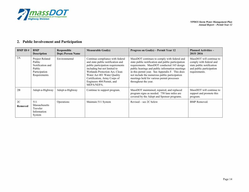
2. Public Involvement and Participation
BMP ID # BMP Description
Responsible Dept./Person Name
Measurable Goal(s) Progress on Goal(s) – Permit Year 12 Planned Activities – 2015/ 2016
2A Project Related Public Notification and Public Participation Requirements
Environmental Continue compliance with federal and state public notification and public participation requirements including but not limited to Wetlands Protection Act, Clean Water Act 401 Water Quality Certification, Army Corps of Engineers 404 Permit, and MEPA/NEPA.
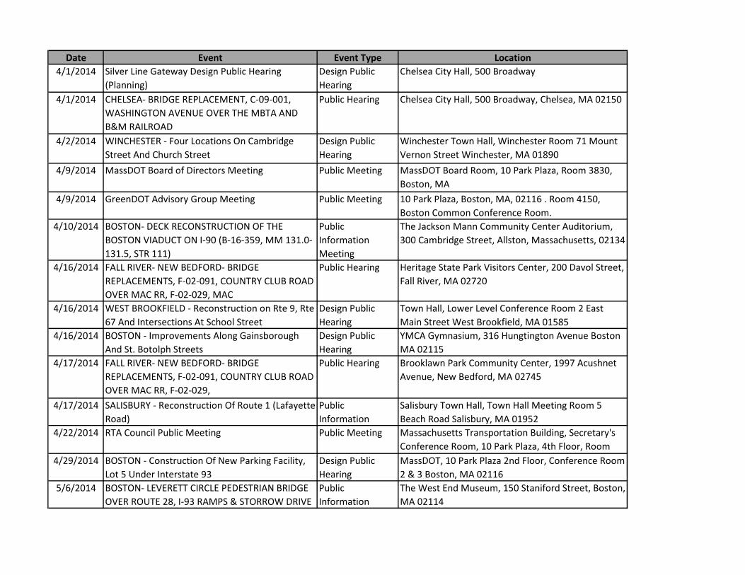
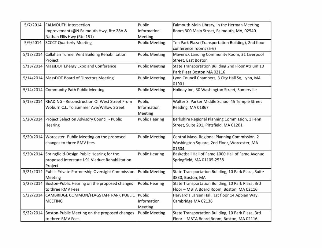
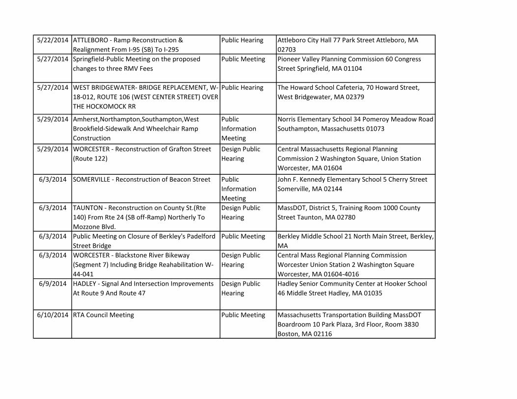
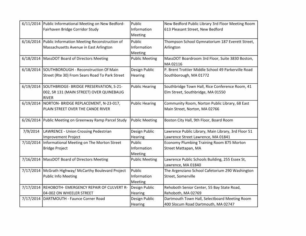
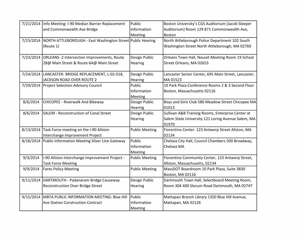
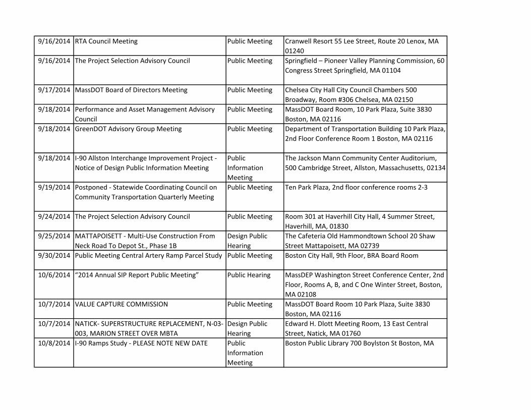
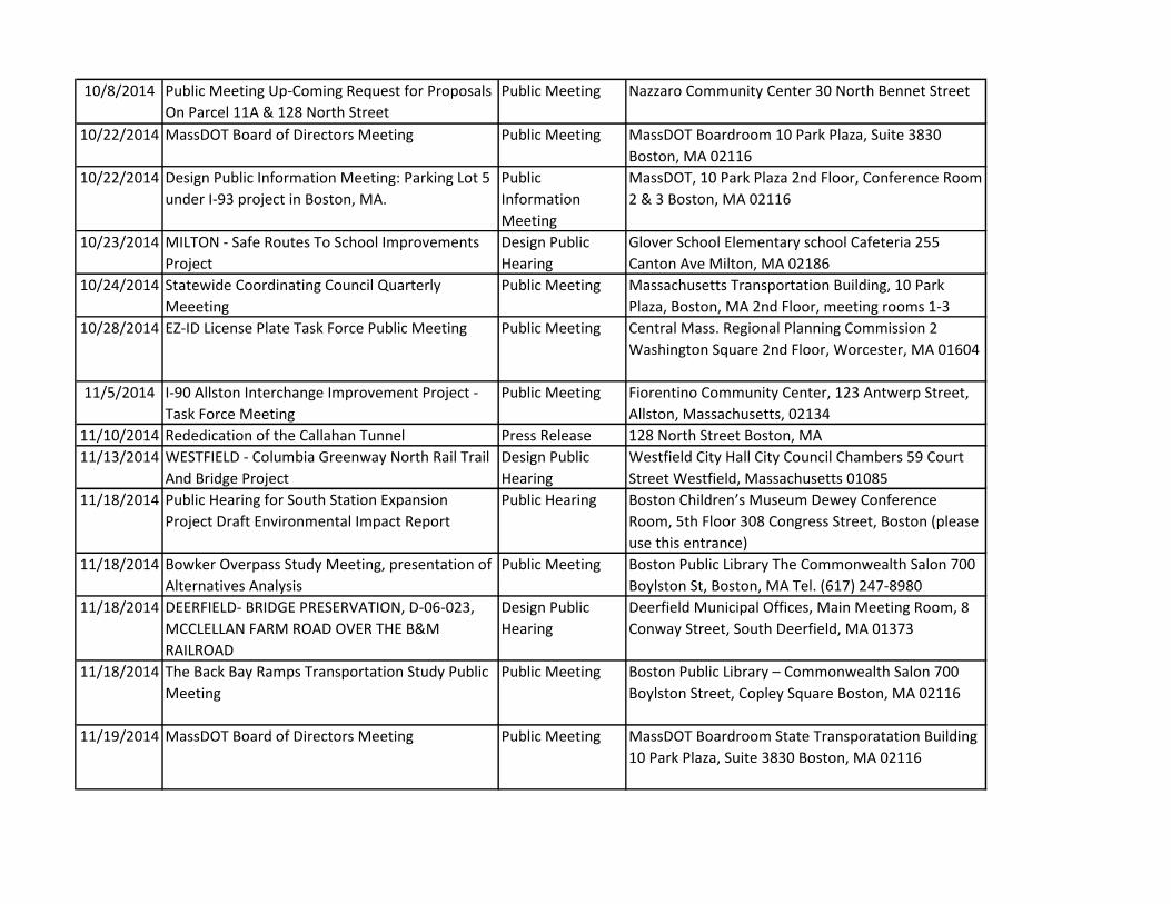
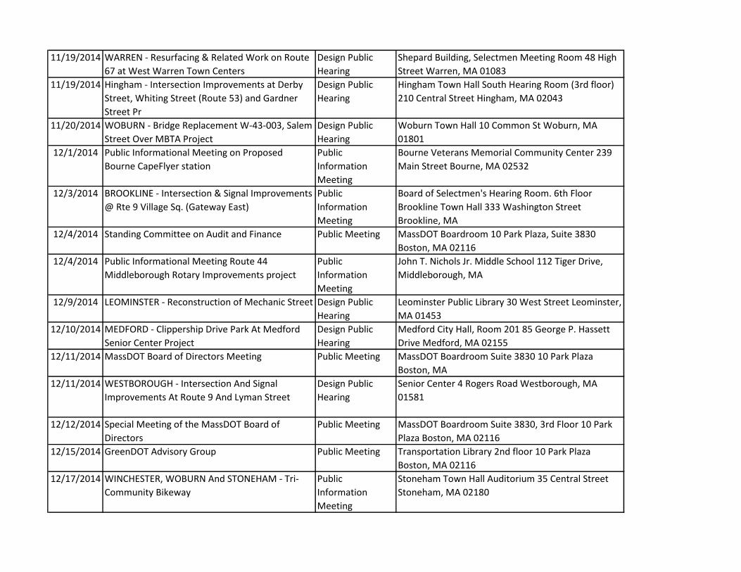
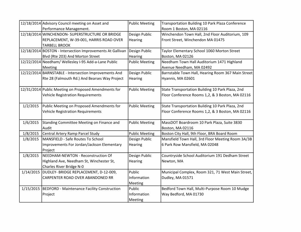
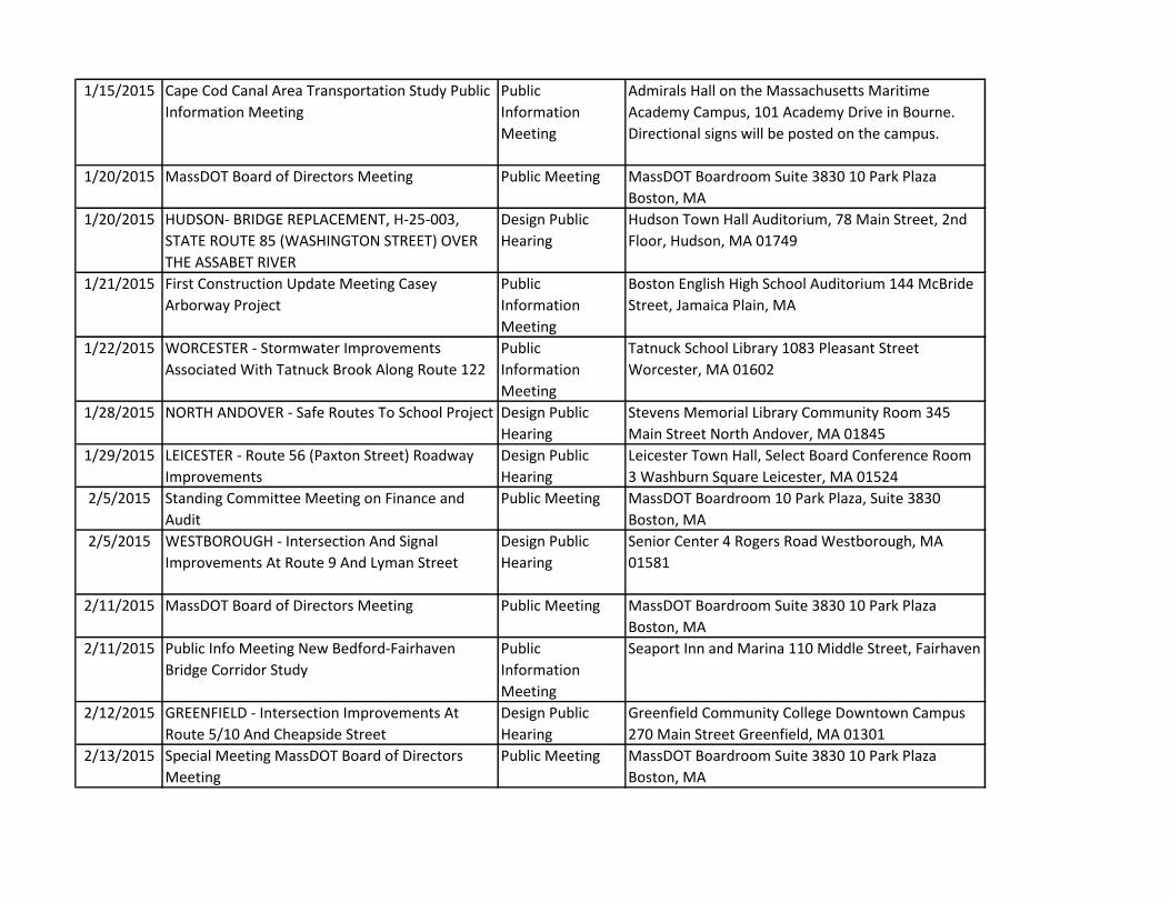
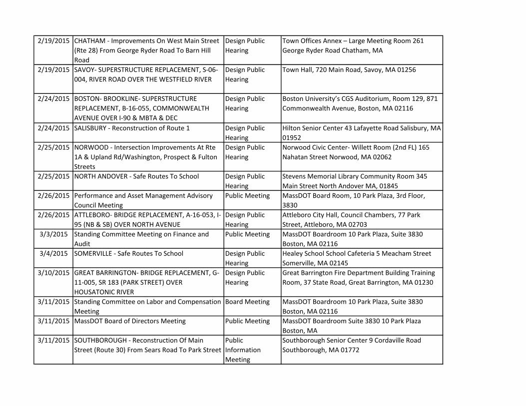
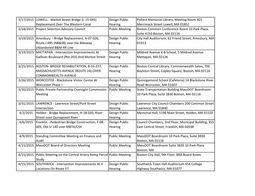
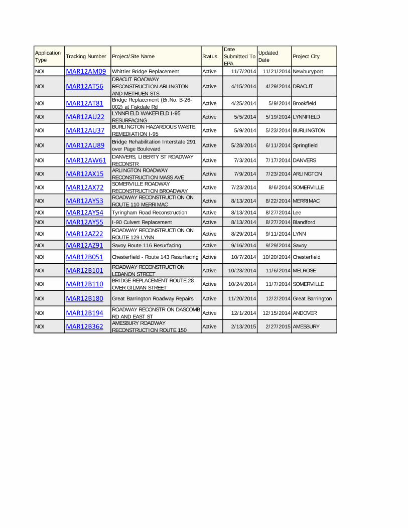
MassDOT continues to comply with federal and state public notification and public participation requirements. MassDOT conducted 165 design public hearings and public information meetings in this permit year. See Appendix F. This does not include the numerous public participation meetings held for various permit processes throughout the year.
MassDOT will continue to comply with federal and state public notification and public participation requirements.
2B Adopt-a-Highway Adopt-a-Highway Continue to support program. MassDOT maintained, repaired, and replaced program signs as needed. 750 lane miles are covered by the Adopt and Sponsor programs.
MassDOT will continue to support and promote this program.
2C Removed
511 Massachusetts Traveler Information System
Operations Maintain 511 System Revised – see 2C below BMP Removed.
Page 14
NPDES Storm Water Management Plan Annual Report – Permit Year 12
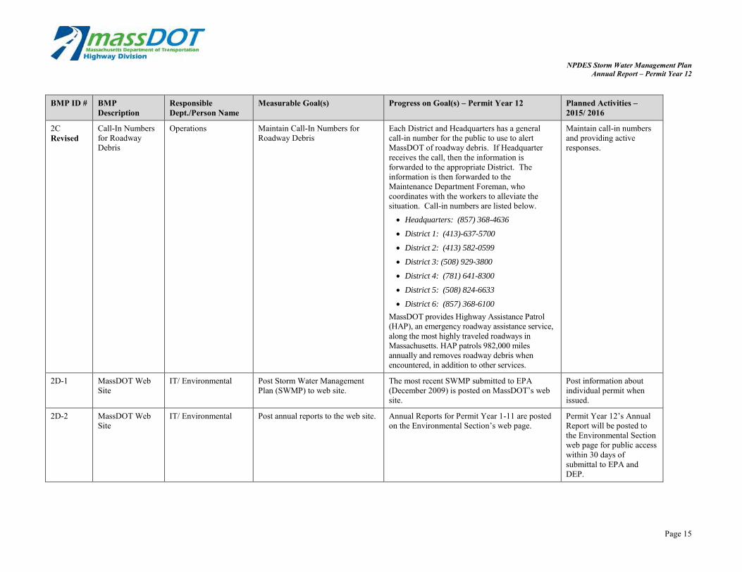
BMP ID # BMP Responsible Measurable Goal(s) Progress on Goal(s) – Permit Year 12 Planned Activities – Description Dept./Person Name 2015/ 2016
2C Call-In Numbers Operations Maintain Call-In Numbers for Each District and Headquarters has a general Maintain call-in numbers Revised for Roadway
Debris Roadway Debris call-in number for the public to use to alert
MassDOT of roadway debris. If Headquarter receives the call, then the information is forwarded to the appropriate District. The information is then forwarded to the Maintenance Department Foreman, who coordinates with the workers to alleviate the situation. Call-in numbers are listed below.
and providing active responses.
Headquarters: (857) 368-4636
District 1: (413)-637-5700
District 2: (413) 582-0599
District 3: (508) 929-3800
District 4: (781) 641-8300
District 5: (508) 824-6633
District 6: (857) 368-6100
MassDOT provides Highway Assistance Patrol (HAP), an emergency roadway assistance service, along the most highly traveled roadways in Massachusetts. HAP patrols 982,000 miles annually and removes roadway debris when encountered, in addition to other services.
2D-1 MassDOT Web IT/ Environmental Post Storm Water Management The most recent SWMP submitted to EPA Post information about Site Plan (SWMP) to web site. (December 2009) is posted on MassDOT’s web individual permit when
site. issued.
2D-2 MassDOT Web Site
IT/ Environmental Post annual reports to the web site. Annual Reports for Permit Year 1-11 are posted on the Environmental Section’s web page.
Permit Year 12’s Annual Report will be posted to the Environmental Section web page for public access within 30 days of submittal to EPA and DEP.
Page 15
NPDES Storm Water Management Plan Annual Report – Permit Year 12
BMP ID # BMP Description
Responsible Dept./Person Name
Measurable Goal(s) Progress on Goal(s) – Permit Year 12 Planned Activities – 2015/ 2016
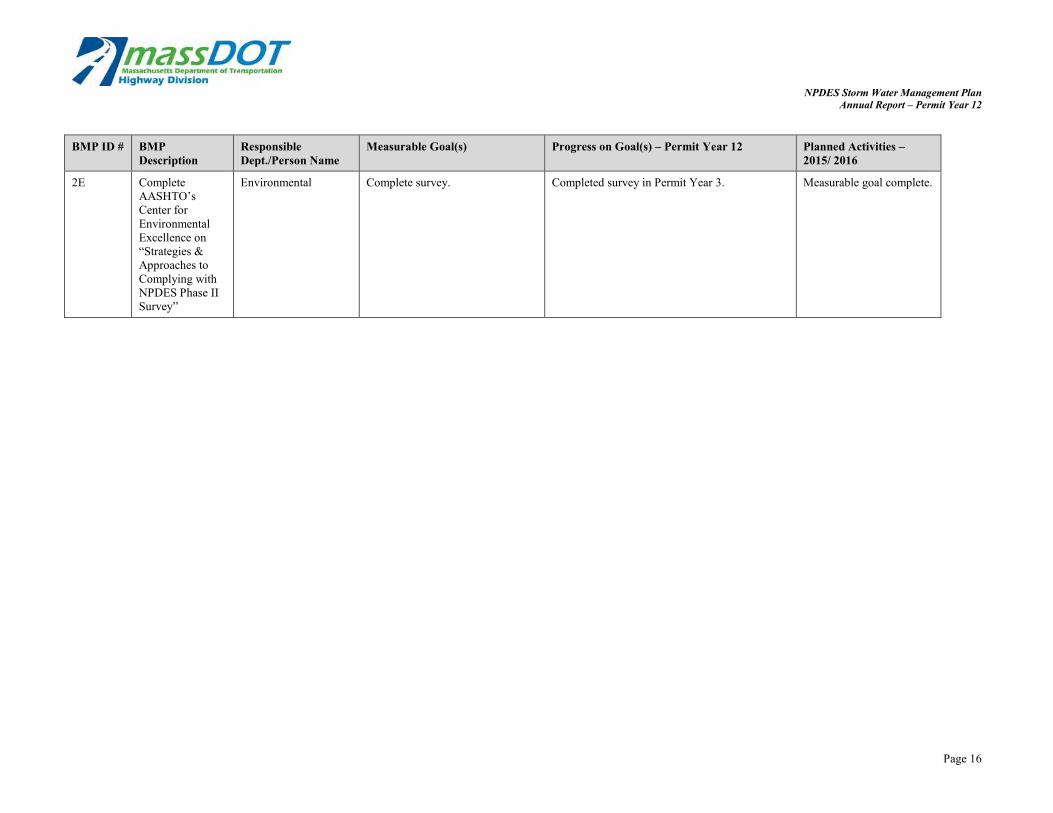
2E Complete AASHTO’s Center for Environmental Excellence on “Strategies & Approaches to Complying with NPDES Phase II Survey”
Environmental Complete survey. Completed survey in Permit Year 3. Measurable goal complete.
Page 16
NPDES Storm Water Management Plan Annual Report – Permit Year 12
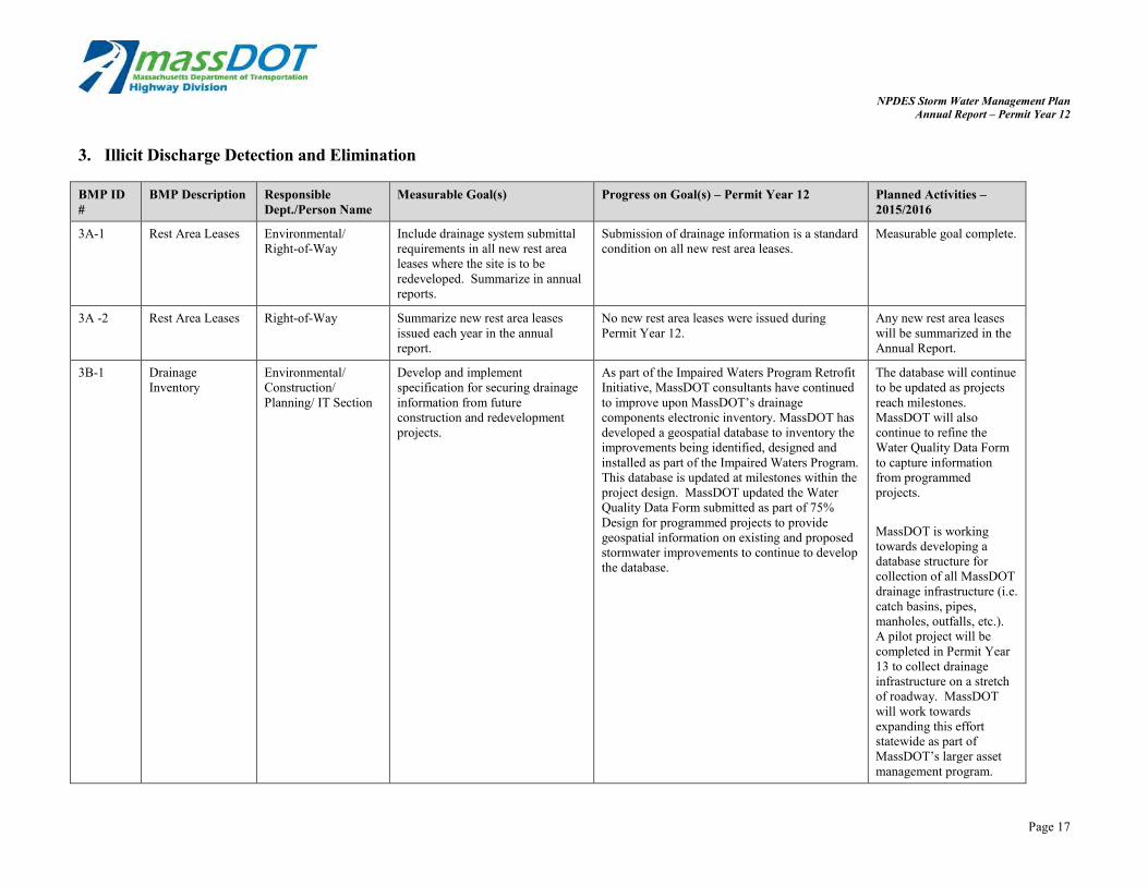
3. Illicit Discharge Detection and Elimination
BMP ID #
BMP Description Responsible Dept./Person Name
Measurable Goal(s) Progress on Goal(s) – Permit Year 12 Planned Activities – 2015/2016
3A-1 Rest Area Leases Environmental/ Right-of-Way
Include drainage system submittal requirements in all new rest area leases where the site is to be redeveloped. Summarize in annual reports.
Submission of drainage information is a standard condition on all new rest area leases.
Measurable goal complete.
3A -2 Rest Area Leases Right-of-Way Summarize new rest area leases issued each year in the annual report.
No new rest area leases were issued during Permit Year 12.
Any new rest area leases will be summarized in the Annual Report.
3B-1 Drainage Inventory
Environmental/ Construction/ Planning/ IT Section
Develop and implement specification for securing drainage information from future construction and redevelopment projects.
As part of the Impaired Waters Program Retrofit Initiative, MassDOT consultants have continued to improve upon MassDOT’s drainage components electronic inventory. MassDOT has developed a geospatial database to inventory the improvements being identified, designed and installed as part of the Impaired Waters Program. This database is updated at milestones within the project design. MassDOT updated the Water Quality Data Form submitted as part of 75% Design for programmed projects to provide geospatial information on existing and proposed stormwater improvements to continue to develop the database.
The database will continue to be updated as projects reach milestones. MassDOT will also continue to refine the Water Quality Data Form to capture information from programmed projects.
MassDOT is working towards developing a database structure for collection of all MassDOT drainage infrastructure (i.e. catch basins, pipes, manholes, outfalls, etc.). A pilot project will be completed in Permit Year 13 to collect drainage infrastructure on a stretch of roadway. MassDOT will work towards expanding this effort statewide as part of MassDOT’s larger asset management program.
Page 17
NPDES Storm Water Management Plan Annual Report – Permit Year 12
BMP ID #
BMP Description Responsible Dept./Person Name
Measurable Goal(s) Progress on Goal(s) – Permit Year 12 Planned Activities – 2015/2016
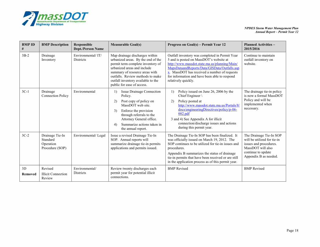
3B-2 Drainage Inventory
Environmental/ IT/ Districts
Map drainage discharges within urbanized areas. By the end of the permit term complete inventory of urbanized areas and include summary of resource areas with outfalls. Review methods to make outfall inventory available to the public for ease of access.
Outfall inventory was completed in Permit Year 5 and is posted on MassDOT’s website at http://www.massdot.state.ma.us/planning/Main/ MapsDataandReports/Data/GISData/Outfalls.asp x. MassDOT has received a number of requests for information and have been able to respond relatively quickly.
Continue to maintain outfall inventory on website.
3) Enforce the provision through referrals to the Attorney General office.
4) Summarize actions taken in the annual report.
1) Policy issued on June 26, 2006 by the Chief Engineer \
2) Policy posted at http://www.massdot.state.ma.us/Portals/8/ docs/engineeringDirectives/policy/p-06-002.pdf
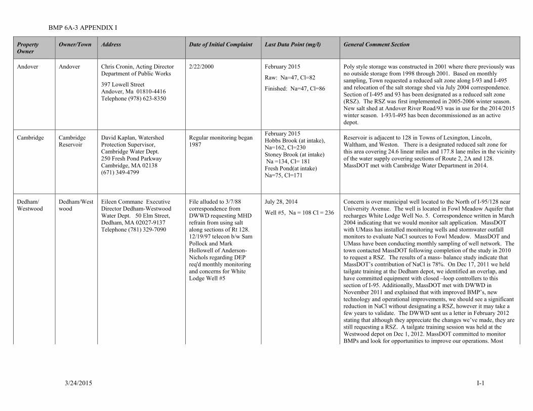
3 and 4) See Appendix A for illicit connection/discharge issues and actions during this permit year.
The drainage tie-in policy is now a formal MassDOT Policy and will be implemented when necessary.
3C-2 Drainage Tie-In Standard Operation Procedure (SOP)
Environmental/ Legal Issue a revised Drainage Tie-In SOP. Annual reports will summarize drainage tie-in permits applications and permits issued.
The Drainage Tie-In SOP has been finalized. It was officially issued on March 19, 2012. The SOP continues to be utilized for tie-in issues and procedures. Appendix B summarizes the status of drainage tie-in permits that have been received or are still in the application process as of this permit year.
The Drainage Tie-In SOP will be utilized for tie-in issues and procedures. MassDOT will also continue to update Appendix B as needed.
3D Removed
Revised Illicit Connection Review
Environmental/ Districts
Review twenty discharges each permit year for potential illicit connections.
NPDES Storm Water Management Plan Annual Report – Permit Year 12
BMP ID #
BMP Description Responsible Dept./Person Name
Measurable Goal(s) Progress on Goal(s) – Permit Year 12 Planned Activities – 2015/2016
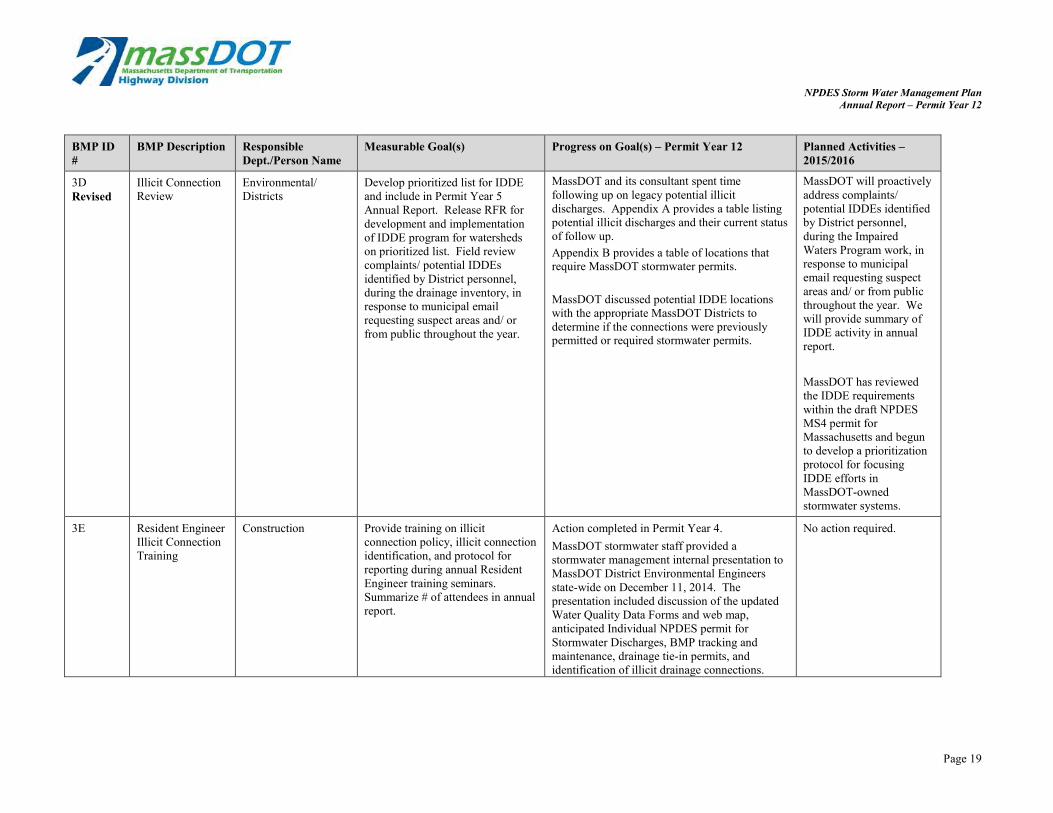
3D Illicit Connection Environmental/ Develop prioritized list for IDDE MassDOT and its consultant spent time MassDOT will proactively Revised Review Districts and include in Permit Year 5 following up on legacy potential illicit address complaints/
Annual Report. Release RFR for discharges. Appendix A provides a table listing potential IDDEs identified development and implementation potential illicit discharges and their current status by District personnel, of IDDE program for watersheds of follow up. during the Impaired on prioritized list. Field review Appendix B provides a table of locations that Waters Program work, in complaints/ potential IDDEs require MassDOT stormwater permits. response to municipal identified by District personnel, email requesting suspect during the drainage inventory, in response to municipal email requesting suspect areas and/ or from public throughout the year.
MassDOT discussed potential IDDE locations with the appropriate MassDOT Districts to determine if the connections were previously permitted or required stormwater permits.
areas and/ or from public throughout the year. We will provide summary of IDDE activity in annual report.
MassDOT has reviewed the IDDE requirements within the draft NPDES MS4 permit for Massachusetts and begun to develop a prioritization protocol for focusing IDDE efforts in MassDOT-owned stormwater systems.
3E Resident Engineer Illicit Connection Training
Construction Provide training on illicit connection policy, illicit connection identification, and protocol for reporting during annual Resident Engineer training seminars. Summarize # of attendees in annual report.
Action completed in Permit Year 4. MassDOT stormwater staff provided a stormwater management internal presentation to MassDOT District Environmental Engineers state-wide on December 11, 2014. The presentation included discussion of the updated Water Quality Data Forms and web map, anticipated Individual NPDES permit for Stormwater Discharges, BMP tracking and maintenance, drainage tie-in permits, and identification of illicit drainage connections.
No action required.
Page 19
NPDES Storm Water Management Plan Annual Report – Permit Year 12
BMP ID #
BMP Description Responsible Dept./Person Name
Measurable Goal(s) Progress on Goal(s) – Permit Year 12 Planned Activities – 2015/2016
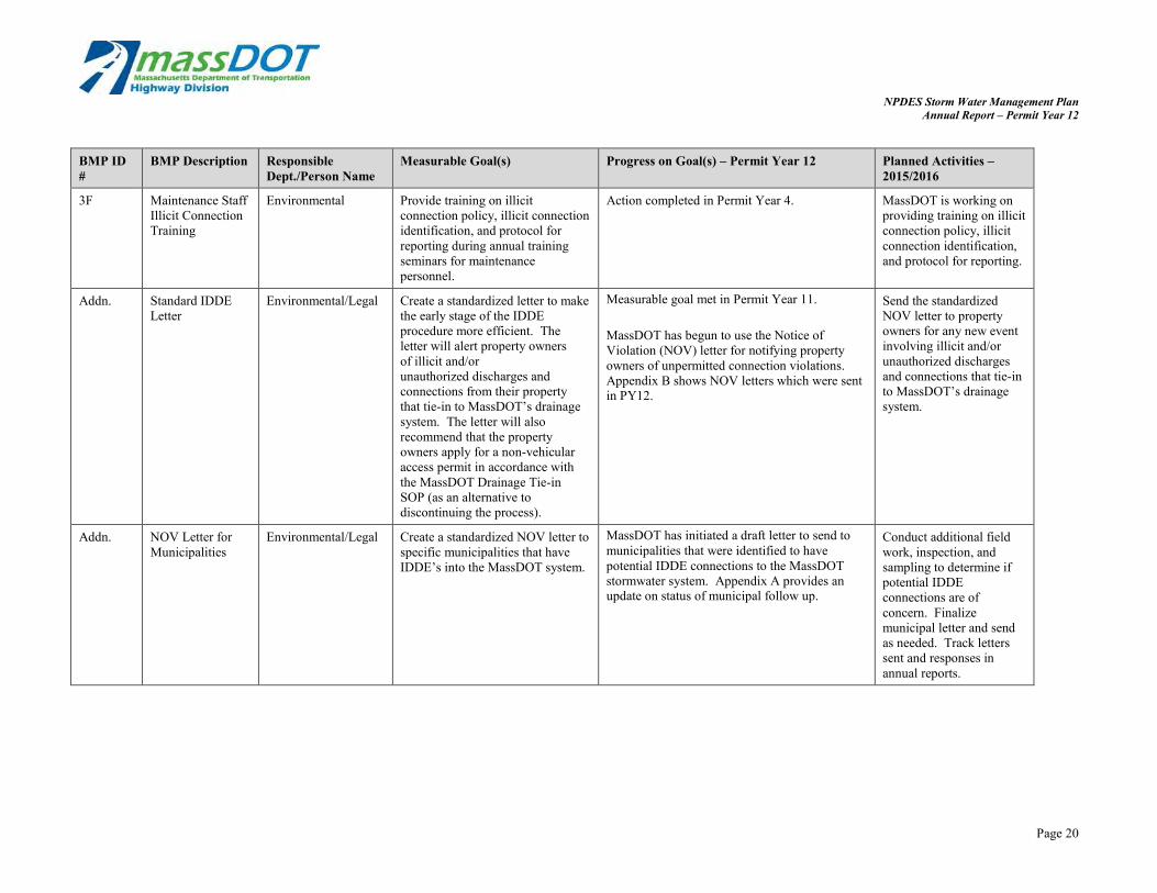
3F Maintenance Staff Illicit Connection Training
Environmental Provide training on illicit connection policy, illicit connection identification, and protocol for reporting during annual training seminars for maintenance personnel.
Action completed in Permit Year 4. MassDOT is working on providing training on illicit connection policy, illicit connection identification, and protocol for reporting.
Addn. Standard IDDE Letter
Environmental/Legal Create a standardized letter to make the early stage of the IDDE procedure more efficient. The letter will alert property owners of illicit and/or unauthorized discharges and connections from their property that tie-in to MassDOT’s drainage system. The letter will also recommend that the property owners apply for a non-vehicular access permit in accordance with the MassDOT Drainage Tie-in SOP (as an alternative to discontinuing the process).
Measurable goal met in Permit Year 11.
MassDOT has begun to use the Notice of Violation (NOV) letter for notifying property owners of unpermitted connection violations. Appendix B shows NOV letters which were sent in PY12.
Send the standardized NOV letter to property owners for any new event involving illicit and/or unauthorized discharges and connections that tie-in to MassDOT’s drainage system.
Addn. NOV Letter for Municipalities
Environmental/Legal Create a standardized NOV letter to specific municipalities that have IDDE’s into the MassDOT system.
MassDOT has initiated a draft letter to send to municipalities that were identified to have potential IDDE connections to the MassDOT stormwater system. Appendix A provides an update on status of municipal follow up.
Conduct additional field work, inspection, and sampling to determine if potential IDDE connections are of concern. Finalize municipal letter and send as needed. Track letters sent and responses in annual reports.
Page 20
NPDES Storm Water Management Plan Annual Report – Permit Year 12
4. Construction Site Stormwater Runoff Control
BMP ID # BMP Description
Responsible Dept./Person Name
Measurable Goal(s) Progress on Goal(s) – Permit Year 12 Planned Activities – 2015/ 2016
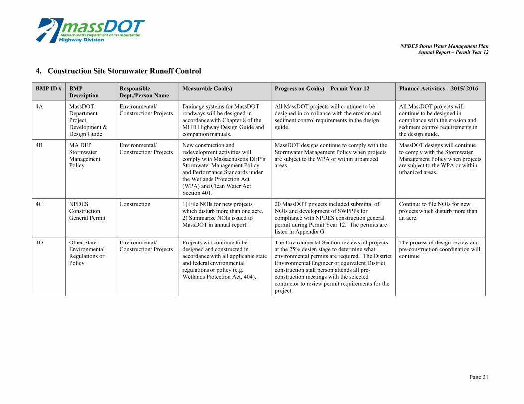
4A MassDOT Department Project Development & Design Guide
Environmental/ Construction/ Projects
Drainage systems for MassDOT roadways will be designed in accordance with Chapter 8 of the MHD Highway Design Guide and companion manuals.
All MassDOT projects will continue to be designed in compliance with the erosion and sediment control requirements in the design guide.
All MassDOT projects will continue to be designed in compliance with the erosion and sediment control requirements in the design guide.
4B MA DEP Stormwater Management Policy
Environmental/ Construction/ Projects
New construction and redevelopment activities will comply with Massachusetts DEP’s Stormwater Management Policy and Performance Standards under the Wetlands Protection Act (WPA) and Clean Water Act Section 401.
MassDOT designs continue to comply with the Stormwater Management Policy when projects are subject to the WPA or within urbanized areas.
MassDOT designs will continue to comply with the Stormwater Management Policy when projects are subject to the WPA or within urbanized areas.
4C NPDES Construction General Permit
Construction 1) File NOIs for new projects which disturb more than one acre. 2) Summarize NOIs issued to MassDOT in annual report.
20 MassDOT projects included submittal of NOIs and development of SWPPPs for compliance with NPDES construction general permit during Permit Year 12. The permits are listed in Appendix G.
Continue to file NOIs for new projects which disturb more than an acre.
4D Other State Environmental Regulations or Policy
Environmental/ Construction/ Projects
Projects will continue to be designed and constructed in accordance with all applicable state and federal environmental regulations or policy (e.g. Wetlands Protection Act, 404).
The Environmental Section reviews all projects at the 25% design stage to determine what environmental permits are required. The District Environmental Engineer or equivalent District construction staff person attends all pre-construction meetings with the selected contractor to review permit requirements for the project.
The process of design review and pre-construction coordination will continue.
Page 21
NPDES Storm Water Management Plan Annual Report – Permit Year 12
BMP ID # BMP Description
Responsible Dept./Person Name
Measurable Goal(s) Progress on Goal(s) – Permit Year 12 Planned Activities – 2015/ 2016
4E MassDOT Stormwater Handbook
Environmental/ Construction/ Projects
Design projects in urbanized areas in compliance with Handbook
MassDOT requires that all new construction and redevelopment activities undertaken by MassDOT, or by others that are funded in whole or in part by MassDOT, comply with the Handbook. MassDOT made major progress in drafting a complete rewrite of Chapters 1-6 of the MassDOT Stormwater Handbook. Chapters 1-3 have been provided to MassDEP for review. Revision to address policy changes, TMDL requirements, and requirements of the forthcoming TS4 Permit is underway, and MassDOT is working with MassDEP on a timeline for ratification of the revised chapters.
MassDOT will continue to require compliance with the Handbook and will continue the process of revising the Handbook and working with MassDEP on a timeline for ratification of the revised Stormwater Handbook.
4F Standard Specification for Highways and Bridges
Environmental/ Construction/ Projects
Continue to include erosion and pollution prevention controls in construction contracts
Inclusion of such controls is standard practice for construction contracts issued by MassDOT. A revised contract item/ specification is now included in each contract which requires a detailed Storm Water Pollution Prevention Plan (SWPPP)/ Erosion Control Plan (ECP) for all projects (except minor - such as signage, grass mowing, etc.). Having the contractor develop the SWPPP and ECP (rather than the designer) has been accepted by the Conservation Commissions and DEP on a project by project basis. In addition, the Stormwater Unit ensures that all construction contracts include items for sediment removal and disposal from pipes and drainage structures within the project area.
Such controls will continue to be included in construction contracts issued by MassDOT.
4G Revised
MassDOT Research Needs Program
Environmental/ Construction
Continue funding the MassDOT Research Needs Program
Moved to MCM 6 since the focus of the research program is no longer construction controls.
Page 22
NPDES Storm Water Management Plan Annual Report – Permit Year 12
BMP ID # BMP Description
Responsible Dept./Person Name
Measurable Goal(s) Progress on Goal(s) – Permit Year 12 Planned Activities – 2015/ 2016
4H Pre-Construction Meeting Review of NPDES Construction GP requirements
District Environmental Staff/ Construction
District Environmental Staff Review NPDES requirements at the applicable pre-construction meetings. These meetings include outlining the requirements of the Construction General Permit and identify the roles and responsibilities of MassDOT and the Contractor.
MassDOT reviews the NPDES Construction GP requirements (i.e. SWPPP) with Contractors at the pre-construction meeting. MassDOT Environmental Engineers attend all pre-construction meetings which involve environmental permits, not limited to NPDES. Therefore, erosion control is discussed at all pre-con meetings.
MassDOT will continue to review the NPDES Construction GP requirements with Contractors at the pre-construction meeting.
4I Contract Bid Item and Special Provision for Storm Water Pollution Prevention Plans (SWPPPs)
Construction Section/ Contracts
Prepare a Contract Bid Item and Special Provision for inclusion in construction contracts to be advertised for bids which exceed the one-acre disturbance threshold.
4J Field Guide on Erosion Prevention and Sediment Control
Construction Section/ Chief Engineer
Prepare field guide and issue to Resident Engineers
The guide was issued to resident engineers at winter training and was posted online at the Field Operations page in December 2013 found here: http://www.mhd.state.ma.us/fieldops/downloads/ ErosionSedimentFieldGuide2013.pdf Printed Field Guides were handed out at 2014/2015 Winter Seminars.
Measurable goal is now complete.
4K Storm Water Pollution Prevention Plan (SWPPP) Guidance Manual for Contractors
Construction Section/ Districts
Prepare a SWPPP Guidance for Contractors document on MassDOT construction projects. Implement use of the document on all appropriate MassDOT projects. Once contractors begin to use the document, it may be revised if necessary to address input received internally and from agencies. Ultimately the document will be converted into a computer program.
Measurable goal complete in Permit Year 4. SWPPP bid item which includes an Erosion Control Plan is now included in all contracts.
NPDES Storm Water Management Plan Annual Report – Permit Year 12
BMP ID # BMP Description
Responsible Dept./Person Name
Measurable Goal(s) Progress on Goal(s) – Permit Year 12 Planned Activities – 2015/ 2016
4L-1 Training Construction Section Conduct annual Erosion Prevention and Sediment Control Training for MassDOT Construction Personnel. Summarize # of attendees and topics covered.
Winter seminars were performed and topics covered NPDES permitting, erosion and sediment control, dust, noise, landscape, HazMat and Diesel Retrofit Program. District 1 – March 5, 2015 with approximately 48 attendees. District 2 – March 26, 2015 with approximately 52 attendees. District 3 - To be scheduled this Spring. District 4 – March 23, 2015 with approximately 60 attendees. District 5 – To be scheduled this Spring. District 6 – To be held on April 7, 2015.
MassDOT will continue training on topics similar to those discussed in the past. Upcoming trainings include: District 3 – Spring 2015 District 5 – Spring 2015 District 6 – Spring 2015
Additionally, staff from MassDOT’s Environmental Section, Construction Environmental Section, and Landscape Design Section completed the Forester University Sediment and Erosion Control for Construction Sites Master Class Webinar Series in December 2014.
4L-2 Non-Traditional Erosion Control Specifications
Landscaping Section Develop specifications for non-traditional erosion controls and evaluate research being conducted by other state DOTs that can be accepted by MassDOT Research and Materials Section. As new technologies are developed, review and develop specifications for additional erosion controls.
MassDOT continues to use compost amended topsoil and compost filler tubes for many of its projects. There is variability in the reliability of the material available. MassDOT continues to expand its use of compost topsoil in lieu of conventional loam placement, as well as compost filter tubes in lieu of hay bales.
MassDOT intends to fund research for field testing of compost benefits in 2015.
4M Erosion and Construction Section/ Perform field tests of new erosion MassDOT does not perform its own field tests BMP Removed. Removed Sediment Control
Field Tests Districts/ Landscaping and sediment control materials on
MassDOT projects. Prepare and circulate an internal memo on the effectiveness of the new measure.
any longer but instead relies upon guidance developed by others.
Page 24
NPDES Storm Water Management Plan Annual Report – Permit Year 12
BMP ID # BMP Description
Responsible Dept./Person Name
Measurable Goal(s) Progress on Goal(s) – Permit Year 12 Planned Activities – 2015/ 2016
4N Construction Bulletins
Construction Section Issue annual construction bulletins to each District regarding stormwater issues.
Issued annual construction bulletins to all Districts in the Spring of 2014 and Fall of 2014 regarding erosion control, dust, cofferdams, and stabilization.
Issue bulletin in the Fall of 2015 regarding stormwater issues.
4O Solicit Construction Activity Feedback from Public
Construction Section/ IT
Maintain MassDOT web site to include contact information for ongoing construction activities. Respond to concerns submitted in a timely manner.
MassDOT maintained their website to include contact information for ongoing construction activities. MassDOT responded to concerns submitted in a timely manner.
MassDOT will continue to maintain their website to include contact information for ongoing construction activities. MassDOT will respond to concerns submitted in a timely manner.
4P Construction Runoff Control Enforcement
Construction Section/ Districts
Non-compliance with the CGP and SWPPP as well as non-compliance with any applicable environmental permits will be addressed through the District Construction personnel and District Highway Director and can include monetary penalties, where included in contracts, and deductions or delays in payment, when warranted.
The District Construction Office and District Highway Director addressed noncompliance with Environmental Permits on the Whittier Bridge and Crosby Corner. Both Contractors were required to fix erosion/sedimentation projects / permit issues immediately. Fall River Rt. 79 had erosions controls that needed to be maintained and were fixed. MassDOT field staff and Consultant Environmental Monitors are assigned to these projects for environmental protection.
MassDOT will continue to address non-compliance through monetary penalties or deductions or delays in payment, when warranted.
4Q Standard Practices Memo
Construction Section MassDOT will prepare and issue a Standard Practices memo to Construction Engineers on the protocol for Illicit Discharge Detection and Elimination during construction projects.
A separate SOP for construction was not developed. During Permit Year 4, the District Construction offices were provided with the procedures to follow on discovery of any illicit discharges during construction and provided training to the Residential Engineers (REs). MassDOT determined a separate SOP was not warranted.
No further action warranted.
Page 25
NPDES Storm Water Management Plan Annual Report – Permit Year 12
BMP ID # BMP Description
Responsible Dept./Person Name
Measurable Goal(s) Progress on Goal(s) – Permit Year 12 Planned Activities – 2015/ 2016
4R Contractor Inspector Training
Construction Section Modify NPDES SWPPP item to include half day training requirement. Provide training programs.
The new SWPPP Item 756 has been revised by the working group and added online training, and will be in new contracts with SWPPP Item. The training will be done online with a certification sent to MassDOT. Details will be worked out through the established working group. Finding appropriate online training, hopefully endorsed by or provided by EPA, will be more useful than establishing a separate training.
MassDOT will continue to add this item to contracts.
Addn. Drainage Structure Sediment Removal
Environmental/Design Include removal of sediments from drainage structures as a standard item on all construction projects
MassDOT bid items 227.3 (removal of drainage structure sediments) and 227.31 (removal of drainage pipe sediments) have been included in all MassDOT bid estimates so as to ensure drainage structures within the project limits are cleaned if necessary.
Continue to include drainage structure sediment removal bid items in all construction projects.
Page 26
NPDES Storm Water Management Plan Annual Report – Permit Year 12
5. Post-Construction Stormwater Management in New Development and Redevelopment
BMP ID # BMP Description
Responsible Dept./Person Name
Measurable Goal(s) Progress on Goal(s) – Permit Year 12 Planned Activities – 2015/ 2016
5A-1 MassDOT Stormwater Handbook
Environmental Secure DEP ratification for MassDOT Stormwater Handbook.
Measurable goal complete for original Handbook. MassDOT is currently revising the Stormwater Handbook to address policy changes,TMDL requirements, and the requirements of the forthcoming TS4 permit and is working with MassDEP on a timeline for ratification of the revised chapters. MassDOT Completed draft revisions of Chapters 1-6 in PY12 and is working towards finalizing all chapters by Fall/Winter 2015.
MassDOT will confirm a timeline with MassDEP for review and ratification of the revised Stormwater Handbook. MassDOT has secured a MassDEP liaison to coordinate MassDEP’s review of revisions.
5A-2 Revise Ch. 4 of the MassDOT Storm Water Handbook
Environmental Revise Chapter 4 (selection methodologies) within 9 months of DEP’s SW Policy Handbook update being released. Reissue MassDOT Handbook to Designers within 1 year of DEP’s document being released.
MassDOT is revising the Stormwater Handbook. MassDOT determined that a rewrite of the entire Handbook was more appropriate to address the changes in the DEP Policy, the MassDOT experience gained in implementing the guidelines, and the requirements of the forthcoming TS4 permit. Therefore, the update has been more extensive and the schedule extended.
MassDOT will confirm a timeline with MassDEP for review and ratification of the revised Stormwater Handbook.
5A-3 Revise Ch. 5 of the MassDOT Storm Water Handbook
Environmental Revise Chapter 5 (BMP toolbox) within 9 months of DEP’s SW Policy Handbook update being released. Reissue MassDOT Handbook to Designers within 1 year of DEP’s document being released.
MassDOT is revising the Storm Water Handbook. MassDOT determined that a rewrite of the entire Handbook was more appropriate to address the changes in the DEP Policy and the MassDOT experience gained in implementing the guidelines. Therefore, the update has been more extensive and the schedule extended.
MassDOT will confirm a timeline with MassDEP for review and ratification of the revised Stormwater Handbook.
5B MassDOT Roadway Maintenance Program
Maintenance Continue to implement MassDOT maintenance program as outlined in the maintenance schedule and in accordance with TMDL watersheds specific agreements.
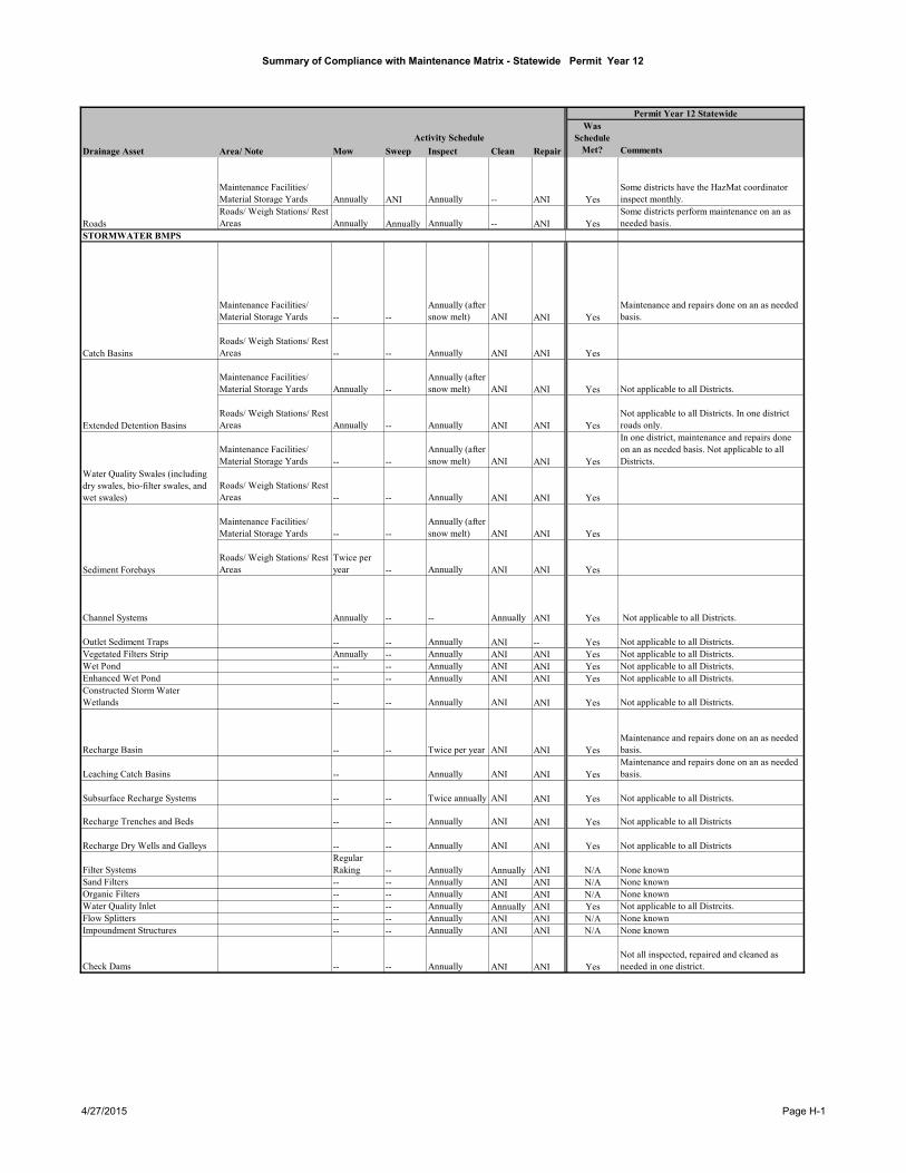
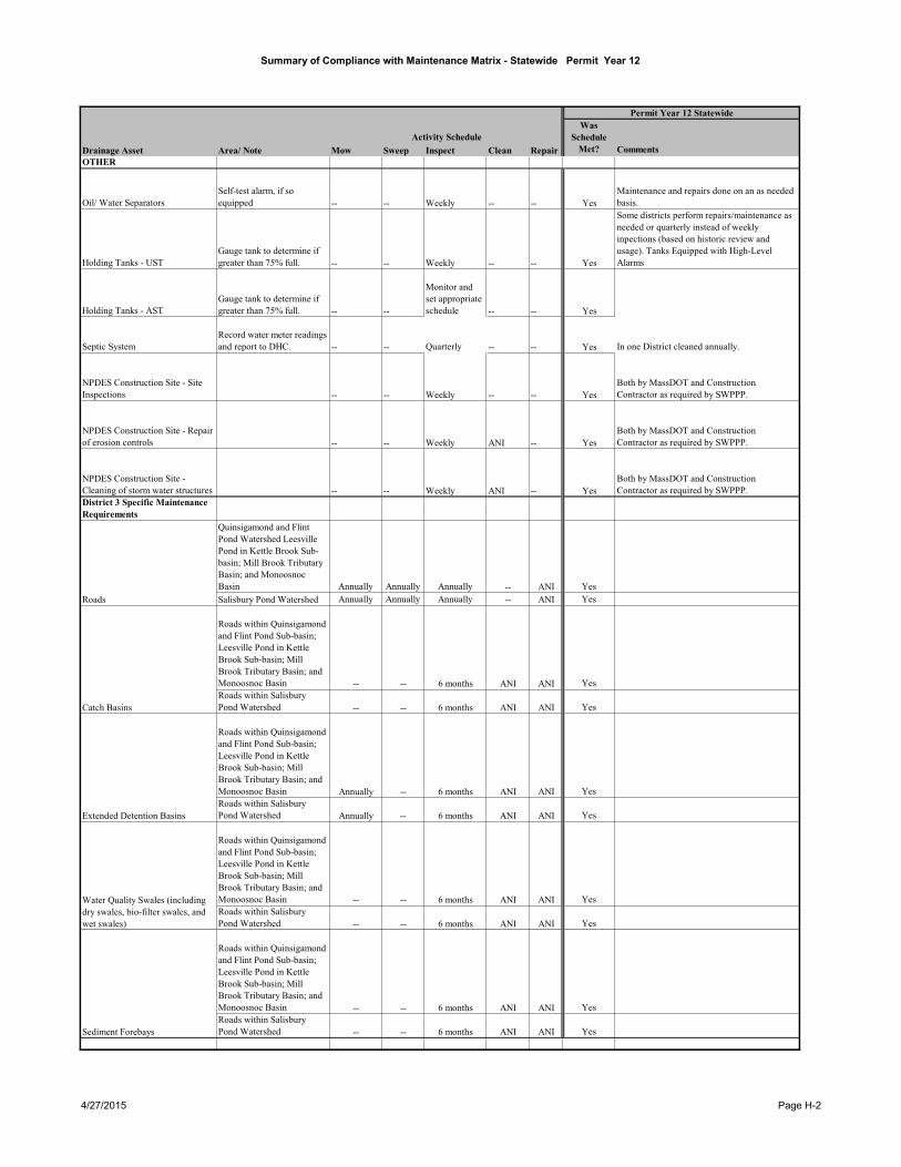
MassDOT maintained their roads in compliance with the maintenance schedule included in the SWMP and TMDL watershed specific agreements. A summary of this year’s maintenance for each district is included in Appendix H.
MassDOT will continue to conduct maintenance on its roadways as outlined in the maintenance schedule and in accordance with TMDL watersheds specific agreements.
Page 27
NPDES Storm Water Management Plan Annual Report – Permit Year 12
BMP ID # BMP Description
Responsible Dept./Person Name
Measurable Goal(s) Progress on Goal(s) – Permit Year 12 Planned Activities – 2015/ 2016
5C Removed
Technology Acceptance and Reciprocity Partnership (TARP)
TARP Continue to work with DEP to develop review protocol for innovative stormwater BMPs. Summarize meeting(s) attended and agenda in annual report.
BMP Revised – see 5C Revised below. BMP Revised.
5C Revised
Identify Innovative Stormwater BMPs Appropriate for MassDOT Projects
Environmental Introduce innovative stormwater BMPs for MassDOT highway projects
MassDOT has been drafting Chapters 5&6 of the MassDOT Stormwater Handbook. These chapters identify highway-specific BMPs that are designed and implemented on a site specific basis. New and innovative BMPs are being evaluated for inclusion in these chapters.
Ratify & publish the MassDOT Stormwater Handbook.
5D Southeast Expressway BMP Effectiveness Project
Environmental Conduct a study of the effectiveness of water quality inlets (WQIs) and catch basins at removing suspended sediments from highway runoff.
Study completed previously. The 14-month sediment removal efficiency was 35% for one WQI and 28% for the second WQI. The efficiency for individual storms for deep sump hooded catch basins was 39%.
No further action planned.
5E Highway Runoff Contaminant Model
Env. Div. Consultant Develop and calibrate contaminant loading model.
MassDOT continues to use its long-term continuous simulation model for loading and BMP performances for pollutant accounting for portions of its program. USGS published the BMP treatment report: http://pubs.usgs.gov/sir/2014/5037/ MassDOT continues to work with USGS in the development and use of SELDM.
MassDOT plans on developing look-up values for pollutant loading and BMP performances which will be developed using published data from EPA, and results from SELDM and MassDOT’s long-term continuous simulation model. MassDOT will use the values to estimate loading and pollutant treatment for all of its inventoried BMPs where data is available.
5F Removed
BMP Maintenance Manual
Environmental/ Maintenance
Develop BMP Maintenance Manual to be used as a field guide by maintenance personnel Provide training on the BMP Maintenance Manual.
Changes to BMP 5B narrative now include the manual used as guidance by maintenance staff while performing drainage system maintenance.
NPDES Storm Water Management Plan Annual Report – Permit Year 12
BMP ID # BMP Description
Responsible Dept./Person Name
Measurable Goal(s) Progress on Goal(s) – Permit Year 12 Planned Activities – 2015/ 2016
5G Right of Way Parcel Evaluation
Environmental Develop and implement a program of evaluating parcels which are candidates for disposal by MassDOT for their potential in siting stormwater BMPs.
Environmental reviewed 23 right of way canvasses. All sales, transfers, and leases of MassDOT properties were approved. Conditions were developed for parcels that were determined to potentially impact existing stormwater facilities or wetlands. These conditions were made standard for all future right-of-way canvass agreements.
The Environmental Section will continue to review canvasses as they are presented. The emphasis will remain on keeping parcels of land that are highly suitable for stormwater treatment (as well as wetland replication).
5H-1 Post Construction Runoff Enforcement-Illicit Discharge Prohibition Policy
Commissioner/ Legal/ Environmental
1) Develop policy for addressing unauthorized connections to the MassDOT’s drainage system. 2) Enforce the provisions through referrals to the Attorney General. 3) Summarize actions taken in annual report.
Illicit Discharge Policy was issued in June 2006. Failure to comply with the Dept. request will necessitate further action by the Department either through the State Attorney General’s office or the District.
MassDOT’s Environmental Services Section will continue to communicate (where possible) with the property owners and move toward resolution of the issues.
There were no referrals to the Attorney General’s office during Permit Year 12.
The standard Notice of Violation (NOV) Letter has been revised.
The IDDE Table in Appendix A has been updated to reflect the current status for each case.
The improved Notice of Violation (NOV) Letter will now be used any new event involving illicit and/or unauthorized discharges and connections that tie-in to MassDOT’s drainage system.
5H-2 Post Construction Runoff Enforcement-Drainage Tie-In Policy
Commissioner/ Legal/ Environmental/ Districts
Develop permitting process for adjacent properties which would like to tie into MassDOT drainage system. Implement program and summarize actions taken under program in annual report.
The Drainage Tie-In SOP is being implemented when necessary. Appendix B summarizes the status of drainage tie-in permits that have been received or are still in the application process as of this permit year.
The Drainage Tie-In SOP will continue to be implemented for tie-in issues and procedures. MassDOT will also continue to update Appendix B as needed.
5H-3 Post Construction Runoff Enforcement-Offsite Pollution to MassDOT Drainage System
Commissioner/ Legal/ Environmental
Runoff not meeting the NPDES MS4 requirements which is reaching the MassDOT MS4 and is not covered under 5H-1 or 5H-2 may be considered trespassing and referred to the AG’s office by MassDOT counsel at the DHD’s discretion.
No enforcement action was needed in any of the districts.
MassDOT will continue to take action when these requirements are not met.
Page 29
NPDES Storm Water Management Plan Annual Report – Permit Year 12
BMP ID # BMP Description
Responsible Dept./Person Name
Measurable Goal(s) Progress on Goal(s) – Permit Year 12 Planned Activities – 2015/ 2016
5I Rest Area Redevelopment to Meet Stormwater Management Handbook Standards
Environmental/ Right of Way
Add language to new lease agreements requiring lessees, who redevelop or build new buildings on rest area property leased from MassDOT, to meet the standards within the Storm Water Management Handbook and the SWMP requirements.
Measurable goal complete. No action required.
5J Transportation Planning/ MPOs Continue to include environmental MPOs continued to include the Continue to include Evaluation considerations in the funding environmental component in their environmental component in Criteria prioritization evaluation. evaluation procedures. evaluation procedure.
5K Federal Enhancement Funding
Planning Explore opportunities for using Federal enhancement funding for environmental restoration and pollution abatement projects. Participate in quarterly committee meetings.
MassDOT no longer utilizes TAP funding for the Impaired Waters Program. Instead, funding for structural stormwater improvements is received now through the FHWA Surface Transportation Program (STP) under Transportation Enhancements.
Continue to utilize funding from the STP for the Impaired Waters Program.
Under Federal Fiscal Year 2015 (October 2014-September 2015), MassDOT will advertise
MassDOT has continued to secure funding for the Impaired Waters Program. MassDOT constructed stormwater improvements in PY12 through the existing SEP-14 funding through FHWA and additionally advertised over $2 million in stormwater retrofit projects.
approximately $11 million in stormwater improvements projects.
Page 30
NPDES Storm Water Management Plan Annual Report – Permit Year 12
6. Pollution Prevention and Good Housekeeping in Municipal Operations
BMP ID # BMP Description
Responsible Dept./Person Name
Measurable Goal(s) Progress on Goal(s) – Permit Year 12 Planned Activities – 2015/2016
6A-1 Project Clean/ Maintain the existing 511 System. Revised – see 6A-1 below. BMP removed. Removed Source Control -
511 Massachusetts Traveler Information System
Operations
6A-1 Source Control - Operations Maintain Call-In Numbers for Roadway Each District and Headquarters has a The call-in numbers will continue Revised Call-In Numbers
for Roadway Debris
Debris general call-in number for the public to use to alert MassDOT of roadway debris. If Headquarter receives the call, then the information is forwarded to the appropriate District. The information is then forwarded to the Maintenance Department Foreman, who coordinates with the workers to alleviate the situation. Call-in numbers are listed below. Headquarters: (857) 368-4636
District 1: (413)-637-5700
District 2: (413) 582-0599
District 3: (508) 929-3800
District 4: (781) 641-8300
District 5: (508) 824-6633
District 6: (857) 368-6100
MassDOT provides Highway Assistance Patrol (HAP), an emergency roadway assistance service, along the most highly traveled roadways in Massachusetts. HAP patrols 982,000 miles annually and removes roadway debris when encountered, in addition to other services.
to be utilized for the public to call in about roadway debris.
Page 31
NPDES Storm Water Management Plan Annual Report – Permit Year 12
BMP ID # BMP Description
Responsible Dept./Person Name
Measurable Goal(s) Progress on Goal(s) – Permit Year 12 Planned Activities – 2015/2016
6A-2 Source Control – Adopt-a-Highway
Adopt-a-Highway/ Operations
Continue to support this program by maintaining signs in areas where the program is active. Summarize number of road miles cleaned.
MassDOT continues to support this program. Approximately 566 miles were cleaned for litter pick-up by Sponsor-A-Highway. MassDOT continues to maintain, repair, and replace program signs as needed.
MassDOT will maintain or increase the current level of sponsors and increase volunteer participation.
6A-3 Source Control -Deicing Programs and Reduced Salt Areas
Environmental/ Districts
Continue to support De-icing and Reduced Salt Areas Programs.
MassDOT continues to support the De-icing and Reduced Salt Areas Programs.
The Salt Material Usage Committee was reconvened on July 24, 2014 and March 26, 2015. The committee discussed the ESPR Annual Report, the training program trial Reduced Salt Zones (RSZ) study for using 3:1 ratio of salt brine facility to sand. The Committee also reviewed the Snow and Ice Control Program Annual Report, data collection, new areas of concern, salt storage management and technological advances and salt storage upgrades.
The next meeting will be held in the summer/spring of 2015. The committee will review results from RSZ study, new areas of concern, and the Snow and Ice Control Program Annual update.
6A-4 Source Control – Motorist Assistance Program (formerly HELP)
MAP Program/ Operations
Continue to provide 22 Highway Emergency Locator Program (HELP) vans and/or tow trucks.
MassDOT provided 35 Highway Assistance Program (HAP) vans and/or tow trucks. The HAP vehicles cover 25 patrol routes on Massachusetts’ most highly traveled roads and patrols approximately 982,000 miles annually.
MassDOT will continue to maintain this program.
Page 32
NPDES Storm Water Management Plan Annual Report – Permit Year 12
BMP ID # BMP Description
Responsible Dept./Person Name
Measurable Goal(s) Progress on Goal(s) – Permit Year 12 Planned Activities – 2015/2016
6A-5 Source Control -VMP
Environmental 1) Develop a generic Vegetation Management Plan (VMP) which outlines methods of minimizing the discharge of pollutants related to the storage and application of pesticides, herbicides, and fertilizers.
2) Prepare a Yearly Operational Plan (YOP) by April of each year.
A VMP was not issued for Districts 2-5 this year, therefore no herbicide spraying occurred this year in those districts.
District 1 still has an active VMP, which only allows herbicide spraying beneath the guardrail along I-90. The 2014-2018 VMP is posted on MassDOT’s website along with the 2015 YOP for District 1 at http://www.massdot.state.ma.us/highway/ DoingBusinessWithUs/
MassDOT anticipates very limited spraying statewide- mostly for treatment of invasive plants.
3) Post YOP on web site within 30 days.
4) Summarize actions taken in previous year in annual report.
ManualsPublicationsForms.aspx
6A-6 Source Control -HOV
Planning Continue participation in ridesharing activities through the duration of the permit term.
MassDOT continues to support this program.
MassDOT will continue to support this program.
6A-7 Source Control -Alternative Transportation
Planning Provide technical assistance and funding for bicycling and walking, including on-road and off-road improvements, at the local level.
MassDOT continues to utilize Transportation Enhancement funding to fund bicycle and walking infrastructure improvements as part of the Safe Route to School Program and other transportation improvement projects.
MassDOT will continue to fund pedestrian and cyclist transportation projects including Safe Routes to Schools projects and mutli-use path projects.
6A-8 Source Control-Highway Safety
Highway Design 1) Incorporate safety measures into all new highway designs. 2) Provide signage to warn of vehicle hazards including tipping hazards and steep grades. 3) Install variable message boards (VMBs) on selected roadways to improve driver awareness. 4) Include evolving safety technologies as part of future highway design projects as they are developed.
Safety measures are included in all new highway designs including appropriate signage and evolving technologies. MassDOT installs and maintains VMBs on select roads to improve driver awareness to potential safety hazards.
MassDOT will continue to support this program.
Page 33
NPDES Storm Water Management Plan Annual Report – Permit Year 12
BMP ID # BMP Description
Responsible Dept./Person Name
Measurable Goal(s) Progress on Goal(s) – Permit Year 12 Planned Activities – 2015/2016
6A-9 Source Control - Environmental 1) Maintain an active Pollution The Department’s TUR/P2 Program has MassDOT will continue to Revised GreenDOT Prevention Task Force (PPTF)
throughout the permit term. 2) Provide summary of actions taken on each pollution prevention initiative included in the SWMP in the annual report.
been superseded by the department’s GreenDOT and Climate Control Initiatives.
MassDOT continued use of water-based, lead-free and chrome-free traffic marking paints; indoor storage of raw materials (oils, chemicals, salt). HPLV (2-4 gpm) pressure washers used for vehicle cleaning and degreasing vs. standard hose (20-25 gpm). MassDOT continued enforcement of the indoor-only vehicle washing policy.
support the principles of the previous TUR/P2 Program, which has now been superseded by GreenDOT. MassDOT will continue monitoring for proper handling and management of stormwater polluting materials, solid wastes, and industrial waste water.
6B-1 Employee Training
MTAP/ Baystate Roads
Facilitate one training program related to stormwater and /or snow and ice control as a means of reducing source pollution. Document attendance numbers.
Twelve snow and ice control classes were conducted in 2014 with a total of 421 attendees. Trainings dates were October through November 2014. Topics covered included:
Anti-icing
Department operations
Salt and environmental considerations
Provide one training program for MassDOT employees (provided by MTAP) and one for municipal DPW snowplow drivers (provided by MTAP/Baystate Roads) related to snow and ice control as a means of reducing source pollution. Document attendance numbers.
Page 34
NPDES Storm Water Management Plan Annual Report – Permit Year 12
BMP ID # BMP Description
Responsible Dept./Person Name
Measurable Goal(s) Progress on Goal(s) – Permit Year 12 Planned Activities – 2015/2016
6B-2 Employee Training
Environmental Provide annual training to at least 300 maintenance facility personnel regarding good housekeeping/ spill prevention.
Trainings were provided during the winter of 2013/2014 for 440 maintenance facility personnel. Training included discussion of the following topics:
Environmental Awareness Training Multi-media compliance Waste and raw materials management
relative to stormwater pollution prevention
Reporting of oil/hazmat to stormwater systems
Asbestos containing materials Solid waste Roadside issues Storage tanks Wetlands protection and compliance Recordkeeping Inspections Water quality (including stormwater
issues) Natural resources Spill management Hazardous materials management Hazardous waste management Universal waste management Stage II vapor recovery system
inspection
MassDOT will again provide annual training to maintenance facility personnel regarding good housekeeping practices and spill prevention.
Page 35
NPDES Storm Water Management Plan Annual Report – Permit Year 12
BMP ID # BMP Description
Responsible Dept./Person Name
Measurable Goal(s) Progress on Goal(s) – Permit Year 12 Planned Activities – 2015/2016
6B-2 (cont’d)
District 1: On May 13th , 14th , 15th , and 16th , 2014, training sessions were provided for 7 district maintenance personnel. District 2: On January 14th, 15th, and 21st , training sessions were provided for 90 district maintenance personnel. District 3: On November 4th, 14th, 18th , and 25th, 2014, training sessions were provided for 105 district maintenance personnel. District 4: On December 3rd, 4th, 9th, 10th , and 11th, 2014, trainings sessions were provided for 89 district maintenance personnel. District 5: On November 5th and 6th , 2014, training sessions were provided for 69 maintenance personnel. District 6: On November 5th, 2014 and March 12th, 2015, training sessions were provided for 13 district maintenance personnel.
6B-3 Employee Training
Highway Operations Provide annual training to at least 200 supervisors and drivers annually on the latest on snow and ice removal.
25 Snow and Ice Trainings were held from October 1st through December 20th , 2014 for approximately 900 state personnel and over 500 vendors attended. Topics covered included: anti-icing versus de-icing, Department Operations and Salt Environmental considerations.
MassDOT will continue to provide training and focus on operational efficiency and effectiveness. Topics to discuss will include results of pilot studies conducted as well as material usage, technology, and cause and effect.
Page 36
NPDES Storm Water Management Plan Annual Report – Permit Year 12
BMP ID # BMP Description
Responsible Dept./Person Name
Measurable Goal(s) Progress on Goal(s) – Permit Year 12 Planned Activities – 2015/2016
6B-4 Employee Training
Highway Operations Ensure all equipment and vehicle operators have received training on the proper operation of the equipment and vehicles they operate.
Training was provided for the following equipment in PY12:
Tractor Trailer Training Eager Beaver Transport Trailer D#-1, 2, & 3. Sept. 23rd 2014
MassDOT will provide operational, safety, and maintenance training on sweeper training, mower training, and snow and ice equipment training. Training is based on the District’s
Ray-co Wood Chipper Training D#-5 April 8th 2014
Caterpillar Front End Loader 930K Training—April 2014 D#-1,2,4,6 & HOV Lane
John Deere Tractor Mower/w side & rear Flails, 10' and 15' Bat Wings, and Over the Guard Rail Mowers-May 2015 D#-5.
Terex LT-38' Aerial Bucket Lift-Training, April 9th 2014 D#-2
needs and requests. Plans for PY12 include sweeper training, mower training, S & I equipment training, includes the New TP-26 tow plows. All trainings consist of operational, safety, and maintenance.
6C-1 Maintenance Districts Continue to implement maintenance schedule outlined in Appendix E of the SWMP.
MassDOT continued to maintain the highway system through catch basin cleaning contracts and performed street sweeping and regular drainage system maintenance. See Appendix H of the annual report for a summary of compliance.
MassDOT will continue to maintain the highway system through catch basin cleaning contracts, street sweeping, and regular drainage system maintenance in compliance with Appendix E of the SWMP.
6C-2 Maintenance Districts 1) MassDOT reviewed each of the maintenance and material storage yards and creates a site specific facility handbook that provides information on necessary steps to environmental compliance. 2) Post EMS Manual on MassDOT website for public information. 3) Post generic Facility Handbook on website for public information.
Site specific facility handbooks were created in 1995. This year no updates were necessary for the EMS Manual.The manual is posted on the internal MassDOT web site. The public website is currently being updated.
Planned routine updates are scheduled for Permit Year 13 MassDOT will continue to post updated materials to the public website. EMS materials including the Manual and the Handbook will be uploaded once the website has been updated.
Page 37
NPDES Storm Water Management Plan Annual Report – Permit Year 12
BMP ID # BMP Description
Responsible Dept./Person Name
Measurable Goal(s) Progress on Goal(s) – Permit Year 12 Planned Activities – 2015/2016
6C-3 Maintenance Record and Data Management Work Management
Environmental 1) Develop work management system.
2) Populate program with infrastructure information as available.
The Maximo Asset and Maintenance Management System is being used in each of MassDOT’s Districts as a maintenance work order program. Drainage-related work orders are tracked
Continue to optimize the data collection in the Maximo Asset and Maintenance Management System through the Asset Management initiative.
System 3) Implement system and begin to
record maintenance activities in these watersheds.
in the system. Most of the work involves ongoing catch basin cleaning, unplugging and repair. Other documented activities include waterway digging and clearing, drainage structure maintenance, drop inlet cleaning, and culvert cleaning.
Begin developing drainage infrastructure data collection system and collect data.
Pilot stormwater BMP inspection program by developing inspection and maintenance logs and
The system is still in its early stages and is not yet at a point where information can be easily pulled from for reporting purposes. MassDOT is actively developing an Asset Management System to optimize the information collected.
schedules. Begin to collect BMP inspection data.
Page 38
NPDES Storm Water Management Plan Annual Report – Permit Year 12
BMP ID # BMP Description
Responsible Dept./Person Name
Measurable Goal(s) Progress on Goal(s) – Permit Year 12 Planned Activities – 2015/2016
6D Waste Disposal Districts 1) Street sweeping waste will be reused in appropriate slope stabilization and road work projects in compliance with SOP, when appropriate.
2) Street Sweeping material which cannot be reused will be disposed of at landfills as daily cover.
3) Waste material from drainage structures and stormwater BMPs removed during maintenance will be disposed of according to “Reuse and Disposal of Contaminated Soil at
MassDOT and its contractors continue to properly dispose of waste. MassDOT did not have an appropriate opportunity to reuse street sweeping waste. MassDOT removed an estimated 13,817 C.Y. of sweeping material and 38,328 C.Y. of drainage structure material this year. Material removed is summarized in the table below. District 1 had 2,924 C.Y. of sweeping
materials removed and 81 C.Y. of drainage structure waste removed.
District 2 had 3,200 C.Y. of sweeping materials removed and 72 C.Y. of
MassDOT and its contractors will continue to properly dispose of waste and ensure disposal of street sweepings and catch basin cleanings are in accordance with DEP policy.
Massachusetts Landfills” DEP Policy #COMM-97-001.
drainage structure waste removed. District 3 had 794 C.Y. of sweeping
materials removed and 100 C.Y. of drainage structure waste removed. (note: additional work completed under a contract that only reported hours worked with a vacuum truck. 344 hours cleaning catch basins and pipes were reported in addition to the quantities).
District 4 had 4,268 C.Y. of sweeping materials removed and 136 C.Y, of drainage structure waste removed.
District 5 had 1,857 C.Y. of sweeping materials removed and 32,300 C.Y. of drainage structure waste removed.
District 6 had 2,883 C.Y. of sweeping materials removed and 427 C.Y. of drainage structure waste removed.
Page 39
NPDES Storm Water Management Plan Annual Report – Permit Year 12
BMP ID # BMP Description
Responsible Dept./Person Name
Measurable Goal(s) Progress on Goal(s) – Permit Year 12 Planned Activities – 2015/2016
6E – Good Environmental Evaluate existing Maintenance BMP 6E Good Housekeeping/ Pollution No further action recommended. Removed Housekeeping/
Pollution Prevention Program Evaluation
Programs to determine additional or revised activities, which would increase effectiveness and usefulness of the programs.
Prevention Program Evaluation has been removed (and the subsequent BMPs renumbered) since the addition of BMP 6F through 6O provide a better use of resources with an increased impact on meeting the good housekeeping and pollution prevention minimum control measure.
6E Catch Basin Environmental/ 1) Provide annual report on Measurable goal is complete. The MassDOT plans to conduct a Revised Accumulation
Project Maintenance/ Districts progress each December and
include summary in annual findings of the Catch Basin Accumulation Project do not support the need for
catch basin study along I-95 in Needham and Wellesley
report. revising the existing cleaning schedule following the completion of the 2) Complete a study of debris and SOP for catch basin cleaning. Add-a-Lane project. The study
accumulation in catch basins. will involve inspecting a
3) Based on the results of the study, revise the existing cleaning schedule and SOP for catch basin cleaning.
representative set of catch basins four times per year for one year. This will inform MassDOT and MassDEP on the appropriate, effective, and efficient cleaning schedule required for catch basins along this corridor and potentially inform programs statewide.
Page 40
NPDES Storm Water Management Plan Annual Report – Permit Year 12
BMP ID # BMP Description
Responsible Dept./Person Name
Measurable Goal(s) Progress on Goal(s) – Permit Year 12 Planned Activities – 2015/2016
6F Policy and Program Review
Environmental MassDOT will continue to at least biannually evaluate its snow and ice control policies and operational programs in order to make adjustments based on data and experience, and to respond to changing conditions.
The program is evaluated each year and took place during the winter season of 2014-2015. MassDOT established a program so that all material spreaders will have Closed Loop Ground Speed Controller Systems by the beginning Snow & Ice season of 2015-2016, which was met this year A truck operator with an automatic controller based on ground speed is able to maintain a constant application rate of material on the road without having to adjust the valve opening to conform to the changing speed of the truck. The closed-loop system monitors both truck speed and belt or auger speed and adjusts the control valve until a predetermined ratio value of belt or auger speed and truck speed is obtained. This provides a more efficient application of material.
The program will be evaluated spring 2015.
6G Salt Remediation Program
Environmental. Maintenance/ Districts
Continue to provide the Salt Remediation Program with a funding level appropriate to quickly address salt related complaints.
Funding provided through Interdepartmental Service Agreement (ISA) -$4.07 million, from July 2012 through June 2015.An updated version of the Public Well Supply Matrix is included as Appendix I of this annual report to summarize the current status of each public well included in the salt remediation program.
Continue Salt Remediation Program. New ISA in the amount of $4,501,095 anticipated for July 2015-June 30, 2018.
Page 41
NPDES Storm Water Management Plan Annual Report – Permit Year 12
BMP ID # BMP Description
Responsible Dept./Person Name
Measurable Goal(s) Progress on Goal(s) – Permit Year 12 Planned Activities – 2015/2016
6H Clean Well Initiative
Environmental Provide a continued level of funding that will allow MassDOT to complete up to 20 replacement wells per year.
MassDOT remediated nine (9) wells including: Sandoval in Palmer
Flebotte in Palmer
Scarpati in Pepperell
Toomey in Rutland
Skolnick in Ashby
J. Neri in Barre
M. Nerri in Barre
Cooke in Russell
Carven in Uxbridge An updated version of the Public Well Supply Matrix is included as Appendix I of this annual report to summarize the current status of each public well included in the Clean Well Initiative Program.
Continue sampling and analysis of private water supply wells and where applicable well rehabilitation, replacement well, water treatment activities and drainage modifications.
Page 42
NPDES Storm Water Management Plan Annual Report – Permit Year 12
BMP ID # BMP Description
Responsible Dept./Person Name
Measurable Goal(s) Progress on Goal(s) – Permit Year 12 Planned Activities – 2015/2016
6I Salt/Sand Management and Storage
Operations MassDOT will continue to replace or repair inadequate salt storage sheds, as well as cover sand piles and/or move them out of wetland buffer zones. Review sheds: Increased capacity of some sheds may be justified because salt storage needs have grown over time and/or because the shed is in a sensitive area and the salt loading operations call for better containment. In sensitive areas, consideration should be given to the use of Gambrel style sheds that
MassDOT replaced the Andover salt shed, moving it out of Haggett’s Pond watershed and the Braintree salt shed was moved to a location outside the wetland buffer zone.
MassDOT continues to staff the position of Director of Snow and Ice Operations. In PY12, the standing Director retired after many years of service and a new Director was instated. The new Director of Snow and Ice Operations is a long
Continue to train our personnel to be aware of wetlands in and around our facilities.
MassDOT will repair or replace many damaged sheds. Locations include: Hopkinton, Manchester, Stoughton, Sturbridge and Charlton. Increase capacity needs in Braintree and Yarmouth. Construction design considered in environmental sensitive areas.
provide for the entire operation to be conducted under cover to minimize salt spillage outside of the shed. MassDOT
standing MassDOT employee who formerly served in the maintenance division of District 4 and brings with him
Work with area supervisors to manage sand supply in all areas.
will continue to prioritize the identification and selection of parcels being considered for new salt storage facilities, considering operational needs and the environmental setting. Review Sand Piles: MassDOT will strive to locate sand piles outside wetland buffer zones whenever space allows. However, when this is not possible the department will work towards storing sand piles under cover, especially during the non-winter months. This could be accomplished by storing sand within sheds or, more likely, using a heavy-gauge polyethylene tarp. (Continued on next page)
a great understanding of MassDOT highway maintenance and operations.
Page 43
NPDES Storm Water Management Plan Annual Report – Permit Year 12
BMP ID # BMP Description
Responsible Dept./Person Name
Measurable Goal(s) Progress on Goal(s) – Permit Year 12 Planned Activities – 2015/2016
6I (cont’d) The tarp could be peeled back once, before winter operations, and then covered again at the end of the season. Personnel: In October 2006, MassDOT hired a Director of Snow & Ice Operations, with over 20 years of experience in winter operations, to improve salt management and supervision of deicing operations.
6J Salt Storage Best Management Practices/ Pollution Prevention
Environmental Continue to implement salt storage in compliance with DEP Guidelines on Deicing Chemical Storage. Continue to follow MassDOT SOP for the Management of Sand and Deicing Chemicals at MassDOT Facilities. Continue to follow Facility Environmental Handbook guidelines at maintenance facilities.
MassDOT continued to include environmental stewardship in our winter operations classes. We emphasized the needs to follow the current SOP’s on salt management and proper material handling.
Continue to inform personnel of the cause and effects of winter operations on the environment.
6K Equipment Improvements
Environmental MassDOT will continue to expand the use of anti-icing as a standard tool for snow and ice control.
The anti-icing program expanded with the opening of a salt brine production facility in Sagamore in December 2012. The use of anti-icing has increased. MassDOT increased the number of anti-icing equipment and the hours the equipment is utilized. Most of the depots across the Commonwealth have access to direct liquid truck. Interstates are the primary roads targeted followed by all others.
MassDOT will work on method of quantifying anti-icing activities versus pre-wetting activities. Each District will acquire additional liquid tank trucks to increase roadway pretreatment prior to winter storm events.
6L Enhanced Weather Forecasting Information
Environmental Continue to provide sufficient funding to use weather forecasting contractor to provide up-to-date and local weather information during snow and ice season.
MassDOT-Highway Division is in the fourth year of a multi-year agreement with Telvent, our weather provider approximately 50k (5-Year Contract Signed). MassDOT worked with the National Weather Services and NOAA to improve our Snow and Ice Operations.
MassDOT will continue to investigate pavement temperature forecasting. Additionally, MassDOT will install 16 non-invasive pavement-temperature and friction monitors statewide.
Page 44
NPDES Storm Water Management Plan Annual Report – Permit Year 12
BMP ID # BMP Description
Responsible Dept./Person Name
Measurable Goal(s) Progress on Goal(s) – Permit Year 12 Planned Activities – 2015/2016
6M Road Weather Information System (RWIS)
Environmental MassDOT will ensure that these stations will be maintained so as to remain fully functional.
MassDOT has developed an agreement with NH, ME, VT, RI and CT to expand the data sharing of RWIS station data, significantly expanding the RWIS network.
MassDOT will work to expand the use of RWIS data across the Commonwealth.
6N Alternative Technologies
Environmental MassDOT will continue to maximize the use of Premix and liquid calcium chloride, as alternative deicers, to reduce the quantity of granular sodium chloride, and should closely monitor reduced salt zones during storms to ensure the proper timing of salt applications and to minimize the potential for overuse of deicing chemicals.
MassDOT – Highway Division has increased the use of liquid anti-icers in an attempt to reduce the amounts of granular sodium chloride. Research is proving that by better timing and proper application rates, MassDOT could reduce the overall chlorides dispensed in the ‘reduce salt zone.’ The uses of anti-icing techniques have significantly reduced the amount of deicer required to keep the roads reasonably
MassDOT will continue to maximize the use of Premix and liquid magnesium chloride as alternative deicers, reduce the quantity of granular sodium chloride, and closely monitor reduced salt zones during storms to ensure the proper timing of salt applications and to minimize the potential for overuse of deicing chemicals.
safe. Additionally, all MassDOT salt spreader trucks now operate with a closed loop controller system. Furthermore, all MassDOT contractors are required to operate their spreaders using closed loop controllers as well.
Page 45
NPDES Storm Water Management Plan Annual Report – Permit Year 12
BMP ID # BMP Description
Responsible Dept./Person Name
Measurable Goal(s) Progress on Goal(s) – Permit Year 12 Planned Activities – 2015/2016
6O Research Operations MassDOT has joined Clear Roads program and will continue to explore moving forward on other projects. Summarize research performed.
Massachusetts has continued to commit resources towards Clear Roads and MassDOT continues to be an active member in the Clear Roads program. Clear Roads activities are documented on their web-site Clearroads.org. Research continues to assist MassDOT by bringing the most current practices to Operations. New research projects being conducted include: Snowplow operator and supervisor
training
Snow and ice control-environmental management practices
Winter maintenance interchange best practices.
MassDOT will continue to support, participate, and use the research and benefits of collaboration with Clear Roads.
Addn. MassDOT Research Needs Program (Previously indicated as BMP 4G but focus of research program is now for source control instead of construction)
Environmental/ Construction
Continue funding the MassDOT Research Needs Program.
Continued funding the MassDOT Research Needs Program. Participated in NCHRP studies concerning limitations of the infiltration approach to stormwater management in the highway setting. Ratified an agreement with USGS to study phosphorous loading off bridges.
MassDOT will continue to participate in NCHRP studies as well as work with USGS to consult as needed on water quality issues and on the phosphorus loading off bridges.
Page 46
NPDES Storm Water Management Plan Annual Report – Permit Year 12
BMP ID # BMP Description
Responsible Dept./Person Name
Measurable Goal(s) Progress on Goal(s) – Permit Year 12 Planned Activities – 2015/2016
Addn. Open Graded Friction Course
Environmental Complete Study on Open Graded Friction Course benefits on stormwater treatment
MassDOT, along with USGS, is initiating a study on the use and benefits of Open Graded Friction Course (OGFC). The reason for this study is toobtain stormwater treatment credit from MassDEP for use of this technology along a section of I-95 in Needham and Wellesley. Open-graded-friction-course has stormwater quality benefits, as it reduces “splash” and runoff volumes, and contributes fewer pollutants to runoff than traditional pavement. In the past year, USGS has prepared a draft scope of the study and funding for USGS to complete the work has been evaluated. The study will begin following completion of construction along I-95 which is anticipated to be April 2019.
Continue discussions with MassDEP regarding obtaining stormwater treatment credit for OGFC use. Make preparations for the study to confirm water quality benefits associated with use of this BMP in consultation with MassDEP.
Page 47
NPDES Storm Water Management Plan Annual Report – Permit Year 12
7. Impaired Waters
BMP ID # BMP Description Responsible Dept./ Person Name
Measurable Goal(s) Progress on Goal(s) – Permit Year 12 Planned Activities – 2015/ 2016
7A Wetland Protection Act (WPA) Compliance
Environmental 1) All MassDOT projects will comply with the WPA and MESA.
2) When potential impacts are identified, MassDOT will work with the appropriate agencies to design the project to minimize the impacts.
Continued to comply with requirements of MESA and the WPA.
Continued to comply with requirements of MESA and the WPA.
7B 401 Water Quality Certification
Environmental Massachusetts’s 401 Water Quality certification requirements, which include review of the project by MA Natural Heritage program and US Fish and Wildlife if endangered species habitat is mapped in the project vicinity, will be complied with whenever they are applicable.
Continue to comply with MA 401 Water Quality Certification Regulations.
Continue to comply with MA 401 Water Quality Certification Regulations.
7C CE Checklist Environmental Complete a Categorical Exclusion Checklist for all MassDOT projects that utilize federal funds.
76 Categorical Exclusion (CE) checklists were completed and approved for all federally-aided projects advertised for construction by MassDOT during Permit Year 12. All documentation supporting the MassDOT’s determination of a project meeting the definition of a Categorical Exclusion is on file with Environmental Services Department at MassDOT Highway Division.
Continue to approve Categorical Exclusion Checklists in support of MassDOT Highway Division’s Construction Advertising Program.
Page 48
NPDES Storm Water Management Plan Annual Report – Permit Year 12
BMP ID # BMP Description Responsible Dept./ Person Name
Measurable Goal(s) Progress on Goal(s) – Permit Year 12 Planned Activities – 2015/ 2016
7D Environmental Site Data Form (Water Quality Data Form -WQDF)
Environmental/ Construction
Develop an environmental site data form for review by designers with Environmental staff at 25% Design. Implement on all projects.
The WQDF captures information during programmed projects about existing and proposed BMPs identified by design consultants and MassDOT designers. The WQDF is part of 25% (preliminary design) and 75% design (final design) submittals to MassDOT. The form requires the designer to document information about the stormwater system and the receiving water.
Continue to require submittal of forms at 25% and 75% design submittals. Report on results in annual report. Continue to educate designers on how to accurately and comprehensively complete the WQDF.
In PY 12 the updated WQDF was institutionalized and includes additional features such as data verification and BMP location information, to facilitate more accurate data reporting. MassDOT developed a web map viewer to go along with the WQDF which allows designers to easily determine the waterbody their project is discharging to and whether the project area is within a watershed with a TMDL. MassDOT held two webinars in the Summer of 2014 to introduce designer to the updated WQDF and associated web map. (continued on next page)
Page 49
NPDES Storm Water Management Plan Annual Report – Permit Year 12
BMP ID # BMP Description Responsible Dept./ Person Name
Measurable Goal(s) Progress on Goal(s) – Permit Year 12 Planned Activities – 2015/ 2016
7D (cont.) MassDOT has received more than 128 water quality data forms; 79 at the 25% design phase and 49 forms at the 75% design phase. Of the 25% forms, 164 receiving waterbodies were identified, 64 affected an impaired water body without a TMDL, and 100 were in a watershed covered by a TMDL and 76 receiving waterbodies with a TMDL were identified.. The 75% forms documented a total of 99 stormwater BMPs (existing and proposed) and at least 1148 deep sump catch basins. Additionally, non-structural BMPs implemented for these projects were documented and included measures such as street sweeping, protecting sensitive areas, inspection and cleaning of stormwater structures, catch basin cleaning, snow removal and deicing controls, and use of sediment and erosion controls during construction. For more information on the data collected through the WQDF, please see Appendix E.
Page 50
NPDES Storm Water Management Plan Annual Report – Permit Year 12
BMP ID # BMP Description Responsible Dept./ Person Name
Measurable Goal(s) Progress on Goal(s) – Permit Year 12 Planned Activities – 2015/ 2016
7E TMDL Recommendation Summary Table Update
Environmental The TMDL Recommendation Summary Table of the annual report will be updated annually to reflect the TMDL reports that have been finalized in the previous permit year and to include update on activities consistent with the recommendations made in the TMDL.
While MassDOT has developed a more detailed program in the Impaired Water Program to address TMDLs, we had historically included a table in the annual report summarizing all Final TMDLs in the state, how they relate to MassDOT and activities which have occurred in the watershed that are consistent with the TMDL suggestions. We have continued to include this table as Appendix J of this annual report for consistency with new data regarding activities that occurred this year and TMDLs that were finalized this permit year. As part of MassDOT’s commitment under our Impaired Waters Program and BMP 7R of the SWMP, impaired waters with TMDLs are being assessed for compliance with the TMDL. Additional information is included under BMP 7R of this report and Permit Year 11 progress in Appendix D.
Continue to review draft and final TMDL reports and implement TMDL recommended activities when possible. Continue to review impaired waterbodies with TMDLs as indicated in BMP 7R.
7F – 7Q TMDL Specific Recommendations
See NOI Comply with TMDL recommendations in Appendix J.
Comply with TMDL recommendations in Appendix J.
Page 51
NPDES Storm Water Management Plan Annual Report – Permit Year 12
BMP ID # BMP Description Responsible Dept./ Person Name
Measurable Goal(s) Progress on Goal(s) – Permit Year 12 Planned Activities – 2015/ 2016
7R TMDL Watershed Environmental 1. Assess all TMDL waters (total of 1. MassDOT completed assessment of Future activities of the Revised Review 209 covered by final TMDLs as of
April 30, 2010) listed in Appendix L-1 of the SWMP (revised as of July 22, 2010), using the process described in BMP 7R. The assessments will be completed over five years, beginning June 8, 2010, and 20% (or about 41, TMDL waters) will be assessed each year.
2. Assess at least 25 water bodies (both TMDL and non-TMDL
43 waterbodies covered by TMDLs on the Appendix L-1 list for the semi-annual submittal on June 8, 2014 and 14 waterbodies in the semi-annual submittal on December 8, 2014 to EPA. MassDOT has reviewed all waterbodies on the Appendix L-1 list within watersheds with a TMDL and has fulfilled their commitment to the court.
Impaired Waters Program are summarized in Appendix D. MassDOT will continue to assess waterbodies under BMP 7R and provide the final semi-annual report to EPA on June 8, 2015.
MassDOT will continue to be an active participant in developing TMDLs that impact MassDOT with EPA
waters) within the first quarter of the Impaired Water Program (BMPs 7U and 7R).
3. Submit annual report to EPA containing the documentation described in Step 6 of BMP 7R.
2. Completed in Permit Year 8. 3 & 4. A summary of the TMDL
waterbodies reviewed during Permit Year 12 is included in Appendix D.
MassDOT’s consultants (AECOM,
and DEP. MassDOT will provide public comment on draft TMDLs as appropriate.
As new TMDLs are finalized, they will be reviewed during future designs of programmed
4. Submit quarterly progress report to EPA during the first year of the Impaired Waters Program (BMP 7U and BMP 7R) and semi-annually thereafter.
BSC, FST, Tetra Tech and VHB) provided environmental assessment and design services for water quality treatment BMPs within watersheds with TMDLs. MassDOT finalized a refinement to the TMDL methodology to assess water bodies covered by a Nitrogen TMDL located on Cape Cod, the Islands, and other parts of southeastern Massachusetts located in watersheds mainly driven by groundwater instead of surface water. This methodology was include in the June 2014 semi-annual submission and posted on the MassDOT website.
projects.
Page 52
NPDES Storm Water Management Plan Annual Report – Permit Year 12
BMP ID # BMP Description Responsible Dept./ Person Name
Measurable Goal(s) Progress on Goal(s) – Permit Year 12 Planned Activities – 2015/ 2016
7R TMDL Watershed MassDOT continues to be an active Revised (cont’d)
Review participant in developing TMDLs with EPA and DEP. Appendix J includes a review of final TMDLs and the implementation requirements which are relevant to MassDOT.
Similarly, MassDOT worked with the Cape Cod Commission this year to assist them in preparing the Cape Cod Section 208 report.
7S Salt Remediation Environmental Continue to provide the Salt Overall ISA 56565 Salt Remediation Continue to address new and Program Remediation Program with a funding Program budget is $4.07 million through existing salt complaints.
level appropriate to quickly address salt related complaints.
ISA from July 2012 through June 2015.
7T Review of Environmental 1. Analyze each of the three sites 1. Task completed in Permit Year 8. All required actions have been Added Specific Sites for
Water Quality Exceedances in
identified in the CLF lawsuit (Charles River crossings in Bellingham and Milford; and North
2. Task completed in Permit Year 8. 3 Task completed in Permit Year 8.
completed.
Response to Conservation Law Foundation (CLF) et al. Lawsuit
Nashua River crossing in Lancaster). Develop summary report with modeling methodology and summary of results.
2. For the sites which are determined to contribute to the exceedance of water quality at the stream crossing, construct BMPs to address MassDOT related exceedances.
3. Submit a remedial plan to the court.
Page 53
NPDES Storm Water Management Plan Annual Report – Permit Year 12
BMP ID # BMP Description Responsible Dept./ Person Name
Measurable Goal(s) Progress on Goal(s) – Permit Year 12 Planned Activities – 2015/ 2016
7U Water Quality Environmental 1) Assess all water listed in Appendix 1) MassDOT has submitted 661 Future activities of the Revised Impaired Waters
Assessment and Mitigation Plan
L-1 of the SWMP (revised as of July 22, 2010) using the process described in this BMP.
2) Assess at least 25 water bodies (both TMDL and non-TMDL waters) within the first quarter of the Impaired Water Program (BMPs 7U and 7R).
3) Submit quarterly progress reports to EPA during the first year of the Impaired Waters Program and semi-annually thereafter.
4) Provide documentation described in step 6 of BMP 7U in annual reports to the EPA.
assessments to EPA as part of its semi-annual submittals. MassDOT is on track to complete assessment of all water bodies in Appendix L-1 by June 2015.
2) Completed in Permit Year 8. 3) MassDOT submitted its semi-
annual reports on June 8, 2014 and December 8, 2014.
4) A summary of the water bodies reviewed during Permit Year 12 is included in Appendix D.
MassDOT’s consultants (AECOM, BSC, FST, TetraTech and VHB) provided environmental assessment and design services for retrofit water quality treatment BMPs within watersheds both with and without TMDLs. In PY12, MassDOT finalized a refinement to the TMDL methodology to assess water bodies on Cape Cod, the Islands, and other parts of southeastern Massachusetts located in watersheds mainly driven by groundwater instead of surface water that are not covered by a Nitrogen TMDL. This methodology was include in the December 2014 semi-annual submission.
Impaired Waters Program are summarized in Appendix D. MassDOT will continue to assess waterbodies under BMP 7U and provide the final semi-annual report to EPA on June 8, 2015.
Page 54
NPDES Storm Water Management Plan Annual Report – Permit Year 12
BMP ID # BMP Description Responsible Dept./ Person Name
Measurable Goal(s) Progress on Goal(s) – Permit Year 12 Planned Activities – 2015/ 2016
8A Cultural Resources Review
Cultural Resources Department
Review all projects for impacts to historic properties at the 25% design phase. If a potential impact is found, the Department works with the designer (MassDOT or consultant) and Massachusetts Historical Commission to alter the design to mitigate or prevent adverse effects.
All projects listed in the Construction Advertisement Program for the reporting year were reviewed for impacts to historic properties or archaeological resources. None of the projects reviewed had stormwater impacts to significant archaeological or historic resources. Thus, none of these projects required any stormwater BMP design alterations based on cultural resources concerns.
The Cultural Resources Unit will continue to review projects for any stormwater impacts to historic resources at the 25% design stage.
Addn. V-Pass Pollutant Assessment Simulation for SWMM
Environmental/ Consultant
MassDOT used the supplemental approach on multiple Retrofit Initiative designs in PY 12. MassDOT, their consultant and EPA have met multiple times to discuss the calibration of the model to loading values in draft NPDES permits.
MassDOT will continue to use the supplemental approach on select Retrofit Initiative designs and explore expanding its use to additional designs and ongoing discussions with calibration efforts with EPA.
Addn. Programmed Projects Initiative
Environmental/ Consultant
MassDOT continues to implement stormwater BMPs in programmed projects that drain to an impaired water body. The WQDF documented more than 99 existing and proposed stormwater BMPs this permit year. Refer to Appendix D for more detail on the Programmed Project Initiative and Appendix E for data collected in WQDFs submitted in PY 12.
MassDOT will continue the Programmed Projects Initiative.
Page 55
NPDES Storm Water Management Plan Annual Report – Permit Year 12
Part IV. Summary of Information Collected and Analyzed
All information collected and analyzed this year is summarized in the proceeding tables and narrative.
Part V. Program Outputs & Accomplishments (OPTIONAL)
MassDOT’s accomplishments during the twelfth permit year are summarized in Part 1- 4 of this annual report. Additional BMPs that have been added this year have been added to the matrix above with new “Additional” row, rather than summarized below. Additional accomplishments are described below.
The MassDOT Environmental Services Stormwater Management Section recently hired an additional staff member to increase overall work capacity. Subsequently, MassDOT now has more time and expertise to focus on identifying programmed projects that would benefit from structural stormwater BMP implementation, as well as ensuring effective BMPs are proposed.
The Stormwater Unit is now responsible for reviewing the drainage/stormwater management system for all programmed projects. This is systematically completed through the water quality data form and communication directly with designers. This added capacity has resulted in more projects being identified as needing stormwater BMPs. It has also allowed MassDOT to ensure that all proposed BMPs are feasible to install, inspect, and maintain.
Additionally, the added work capacity has allowed the stormwater unit to begin enhancing BMP and drainage inventory, inspection, and maintenance practices. During Permit Year 12, MassDOT made great strides towards being able to collect drainage infrastructure data. MassDOT purchased an iPad and launched its ArcGIS Online program, both will make mobile data collection feasible and efficient.
MassDOT’s Stormwater Unit will focus in Permit Year 13 on developing a database format to inventory drainage infrastructure. This drainage infrastructure inventory, once populated, will allow MassDOT to better understand its system, where maintenance efforts should be focused, and where the system is working effectively.
In the summer of 2015, MassDOT plans to hire a summer stormwater intern. The intern will focus on developing a BMP inspection and maintenance data collection system using ArcGIS online. The intern will also work with MassDOT staff to inspect constructed BMPs and compile data using a mobile data collection device.
Page 56
NPDES Storm Water Management Plan Annual Report – Permit Year 12
List of Appendices
Appendix A: IDDE Status Table Appendix B: Status of Drainage Tie-in Permits Appendix C: Notice of Violation (NOV) Letter Appendix D: Impaired Waters Program – Summary of NPDES Permit Year 12 Appendix E: Water Quality Data Forms Submitted in Permit Year 12 Appendix F: Design Public Hearings Table Appendix G: Active MassDOT Construction NOIs in Permit Year 12 Appendix H: Maintenance Schedule Summary Appendix I: Public Well Supply Matrix and Salt Remediation Program Appendix J: TMDL Review Table
NPDES Storm Water Management PlanAnnual Report – Permit Year 12
Appendix A: IDDE Status Table
IDDE Status Table
Date Location Flow Source Justification Test Results Current Status of Follow up Action Item DOT District Responsibility
Flow Owner
Contact
Information
2012
626 Bedford
Street (Route 18)
East Bridgewater Not Present Illicit Discharge Survey Not Tested
A survey was conducted in 2012 on two catch
basins and two manholes with suspicious pipes
located within them. No dry weather flow was
observed. DOT confirmed no knowledge of tie-in.
Flow is unpermitted, therefore a NOV
letter will be sent to the property
owner District 5
Joppa Market
(508) 378-1313
2012
257 Mansfield
Avenue (Route
140)
Norton, MA Not Present Illicit Discharge Survey Not Tested
MassDOT conducted two site visits at this location
in 2012 and determined the source of this
connection is located off of MassDOT property.
Property owner was contacted by Mr. George
Ayoub in 2012 and was asked to apply for a
permit. No record of the permit is known at MA
DOT.
Notify the town of Norton of the
connection District 5
Norton Estates
(508) 285-2901
2007
209 Main Street
(Route 1A)
Rowley, MA Not Present
1" black rubber hose noted from
residence to MassDOT catch basin Not Tested
A letter was sent to the residence of 209 Main
Street, Rowley, MA on 10/7/2011. The property
owner was given 60 days to respond. A response
was not received during this time period.
MassDOT Environmental contacted the property
owner via telephone and left a detailed message
regarding the unpermitted flow. A return phone
call was received from the property owner.
MassDOT is currently working with the property
owner to resolve the issue.
District 4 will follow up with property
owner to determine if this is a
permitted connection. District 4
Robert and
Kathryn Casaletto
(978) 948-2911
2010
Rent-A-Tool
777 North Shore
Road (1A),
Revere, MA Trickle
District 4 staff identified flow
discharging to a MassDOT catch
basin/Follow up Illicit Discharge survey Not Tested
A permit application was submitted to MassDOT
in 2010. Additional information was requested by
MassDOT but was not received. In 2013 MassDOT
environmental contacted the business owner via
telephone and left a detailed message, a return
phone call has not been received.
District 4 will follow up with property
owner and then send an NOV letter, if
necessary. District 4
Rent-A-Tool (Steve
Williams) (781) 829-
3900
2011
Dunkin Donuts
888 Main Street
Woburn, MA Not Present
District 4 staff identified a 4" pipe
connected to a MassDOT catch basin Not Tested
In 2011 a letter was sent to the property owner
and a phone call was placed in 2013. MassDOT
has not received a response from the letter or
phone communication.
District 4 will follow up with property
owner to determine if this is a
permitted connection. District 4
Dunkin Donuts
(781) 932-0548
2011
454 Patriots Road
(Route 2A)
Templeton, MA Not Present
District 2 observed a small pipe exiting
this property during a maintenance call Not Tested
In 2012 a letter was sent to the property owner
and a phone call was placed in 2013. MassDOT
has not received responses to either form of
communication. District staff do not think the
flow direcly ties into the DOT system.
A follow up visit should be conducted
to determine the source of this flow,
and follow up with the town should be
conducted if this is not connected to
MA DOT property District 2
Charlie Perkins
(978) 939-1063
(978) 939-8980
2007
Dorrance, Inc.
283 West Main
Street (Route
123)
Norton, MA Not Present
Tie-in identified by MassDOT at private
residence Not Tested
A letter and permit application was sent to the
homeowner in September of 2011. In March of
2013 MassDOT Environmental left a detailed
message with the homeowner regarding the
suspect flow. The permit application has yet to be
submitted and a return phone call has not been
received.
A follow-up visit should be scheduled
to confirm tie-in still exists and then
follow-up with a NOV letter. District 5
Carl Dorrance
(508) 455-0299
IDDE Status Table
Flow Owner
Contact
Date Location Flow Source Justification Test Results Current Status of Follow up Action Item DOT District Responsibility Information
2012
469 Taunton
Avenue (Route
44)
Seekonk, MA Not Present Impaired Waters Site Visit Not Tested
This connection was found during an Impaired
Waters Site visit in 2012. No flow was present and
therefore not tested.
A follow up visit will be conducted to
determine the source of this flow. If
flow is present a sample will be
collected and tested to determine the
potential source. District 5
Mark Chandley
(Country Kitchen)
(508) 336-9807
2010
I-93/Mystic River,
near 32 Shore
Drive Somerville,
MA Trickle
MyRWA Water Quality Survey/Illicit
Discharge survey
Sanitary
Sewer/Washwater
Two site visits have been conducted at this
location and samples have been collected and
tested. Field surveys have not yielded conclusive
information on the source flow.
Follow up to be conducted including
CCTV inspection to be completed by
June 30, 2015, followed by NOV letters
to Somerville, as necessary. District 4
MassDOT District
4/MyWRA
2010
Mystic Avenue
Somerville, MA Trickle Illicit Discharge Survey Sanitary Sewer
NPDES Storm Water Management PlanAnnual Report – Permit Year 12
Appendix B: Status of Drainage Tie-in Permits
ibility
Status of Drainage Tie-In Permits
Permit Date Location Flow Source Justification Test Results Current Status of Follow up 2015 Action Item DOT District Respons
Flow Owner Contact
Information
Unpermitted 2007
615 Northampton
St. (Route 5),
Holyoke, MA Intermittent
Sediment carried in stormwater
during rain events is clogging
MassDOT catch basin Not tested
In December 2011 a letter was sent to
the property owner by MassDOT. In
March 2013 an attempt to locate the
property owners phone number was
made but rendered unsuccessful.
MassDOT has not had any further contact
with the property owner. District 2
confirmed that flow is not permitted.
MassDOT will conduct a
follow-up site visit to
confirm flow is still
present and then
continue to work with
the property owner to
obtain a tie-in permit District 2 Tracey Barclay
Unpermitted 2012
25 Upton Street
(Route 140)
Grafton, MA Not Present
District 3 observed a 2" PVC pipe
exiting a residential home Not Tested
A follow up visit was conducted again in
2012 and the 2" PVC pipe was still
present
District 3 will follow up
with the property
owner to determine if
this is a permitted
connection District 3
Ross Sciarro
(508) 839 - 7098
Unpermitted 2012
69 South Main
Street (Route
114) Middleton,
MA Intermittent Illicit Discharge Survey
Natural
Water/Tap/Irrig
ation
MassDOT collected and tested the flow
located on this property.
District 4 will work with
the Middleton Golf
Course to obtain a tie-in
permit- waiting for DOT
response District 4
Middleton Golf Course
(978) 774-4075
Unpermitted 2014
Route 127
(Summer Street)
Kings Way,
Manchester, MA Connection
11/28/2014 - 6-inch SDR 35 Private
Storm Sewer connection to a
MassDOT Drain Manhole Not permitted
NOV letter sent to property owner on
12/8/2014
District 4 will work with
the Owner to obtain a
tie-in permit or removal
of tie-in District 4
Martin Nally & Co. 5
University Lane,
Manchester, MA
Unpermitted 2013
Oak Street
Barnstable, MA Intermittent
Oak Street drainage is connected
to MassDOT drainage.
Reconstruction of the roadway is
in the design phase and the town
of Barnstable will remove the
drainage tie-in during
reconstruction (2013-2014) Not tested
Construction began in August of 2013,
follow up with the town of Barnstable
and request new drainage plans.
MassDOT to follow up
with town of Barnstable
on the status of the
roadway construction
and either conduct a
site visit to determine
that drainage tie in has
been removed or
request plans District 5
Town of Barnstable
(508) 862-4000
Unpermitted 2012
500 Bedford
Street (Route 18)
East Bridgewater,
MA Intermittent
4" clay pipe coming from the
property, discharging water during
dry weather Natural Source
MassDOT determined this flow is
unpermitted.
MassDOT will send a
letter to the property
owner District 5
Albert Medeiros (508)
378-7539
ibility
Status of Drainage Tie-In Permits
Permit Date Location Flow Source Justification Test Results Current Status of Follow up 2015 Action Item DOT District Respons
Flow Owner Contact
Information
Unpermitted 2013
Abington Fire
Station
#1040 Bedford
Street Abington,
MA Not Present
An 18" reinforced concrete pipe
leading from the property's
drainage system and connecting to
a drain manhole on Route 18
(Bedford Street) was discovered by
MassDOT personnel while
conducting site investigations as
part of a project to widen a section
of that roadway. Not Tested
A Notice of Violation letter was sent to
the property owner on January 29, 2014.
District 5 to determine
if a permit is in place for
this connection. If no
permit is located, then
they will follow up with
the property owner. District 5
Rick LaFond (Town
Manager)
781-982-2100
Unpermitted 2013
McPhail Realty
Trust
#1200 Bedford
Street Abington,
MA Not Present
A 12" PVC pipe leading from a
detention pond on the property
and connecting to a MassDOT
catch basin on Route 18 (Bedford
Street) was discovered by
MassDOT personnel while
conducting site investigations as
part of a project to widen a section
of that roadway. In addition to
that, a 6" HDPE pipe leading from
the detention pond to a different
MassDOT catch basin further north
on Route 18 was also discovered. Not Tested
A Notice of Violation letter was sent to
the property owner on January 28, 2014.
District 5 to determine
if a permit is in place for
these connections. If no
permit is located, then
they will follow up with
the property owner. District 5
Matthew and Diana
McPhail
781-878-2875
Unpermitted 2013
Travi Realty Trust
#1400 Bedford
Street Abington,
MA Not Present
A small drainage system leading
from a pond within a wooded area
on the property and connecting to
a drain manhole on Route 18
(Bedford Street) was discovered by
MassDOT personnel while
conducting site investigations as
part of a project to widen a section
of that roadway. In addition to
that, several upstream
connections and runoff spots were
also discovered. Not Tested
A Notice of Violation letter was sent to
the property owner on January 24, 2014.
District 5 to determine
if a permit is in place for
these
connections/discharges
. If no permit is located,
then they will follow up
with the property
owner. District 5
Vincent Travi
781-871-1469
Permitted 2014
CVS- 8E
Washington
Street, North
Attleborough, MA Connection
A small drainage system within the
CVS parking lot connected to
MassDOT drainage system Not tested
A Notice of Violation letter was sent to
the property owner on September 29,
2014.
Permitted connection-
remove from 2016
Annual Report District 5
Inland Western No
Attle Crossrds LLC, PO
Box 9273, Oak Brook, IL
60522
ibility
Status of Drainage Tie-In Permits
Permit Date Location Flow Source Justification Test Results Current Status of Follow up 2015 Action Item DOT District Respons
Flow Owner Contact
Information
District 5 to investigate
and work with the Bruce Collard 62
9 Hoppin Hill Ave.
North
10" RCP and 10" corrugated metal
pipe from residential house
A Notice of Violation letter was sent to
the property owner on September 29,
Owner to determine if a
connection to the DOT
Manchester St Nashua,
NH 03064
Unpermitted 2014 Attleborough, MA Connection connected to MassDOT drainage Not permitted 2014. system exists. District 5
Unpermitted 2014
Blockbuster 465
S. Washington St.
North
Attleborough, MA Connection
18" RCP connected to MassDOT
drainage Not permitted
A Notice of Violation letter was sent to
the property owner on September 29,
2014.
District 5 to investigate
and work with the
Owner to determine if a
connection to the DOT
system exists. District 5
Skye Enterprises LLC 9
Cedar Ridge Rd. North
Attleborough, MA
02760
Unpermitted 2014
518 South
Washington
Street North
Attleborough, MA Connection
Infiltration system connection to
MassDOT drainage Not permitted
A Notice of Violation letter was sent to
the property owner on September 29,
2014.
Permitted connection-
remove from 2016
Annual Report District 5
518 South Washington
Street, North
Attleborough, MA -
South Attleboro Marine
NPDES Storm Water Management PlanAnnual Report – Permit Year 12
Appendix C: Notice of Violation (NOV) Letter
[Letterhead]
[Date]
CERTIFIED MAIL – RETURN RECEIPT REQUESTED # ___________________________
[Contact’s Name] [City/Town or Business Name, If Applicable] [Address] [Town/City, State, Zip Code]
Notice of Violation
Re: Illicit and/or Unauthorized Drainage Connection or Discharge to MassDOT Drainage System Located at __________________________________________________________________
Dear ____________________:
The purpose of this Notice of Violation (NOV) is to inform you, as owner of the above-referenced property, of a suspected connection or discharge to the Massachusetts Department of Transportation’s Highway Division (MassDOT) drainage system without a properly issued Non-vehicular Access Permit (tie-in permit).
[Description of the site (several sentences), along with details of the suspect connection.]
This is in violation of G.L. c. 81, § 21, regulations found at 720 CMR 13.00, and Standard Operating Procedure No. HMD-02-2-000 (a copy of which is enclosed). Be aware that MassDOT strictly prohibits illicit and/or unauthorized drainage connections and discharges. Any such connection or discharge must be either permitted by MassDOT or immediately disconnected/sealed.
You have ninety (90) days from the receipt of this notification to contact the person listed below to indicate whether: (1) you will apply for a tie-in permit; (2) you will propose a schedule for the removal of the discharge; or (3) you hold a pre-existing drainage tie-in permiti . Should no response be received, a follow-up site investigation will be performed. At that time, should an illicit and/or unauthorized connection or discharge be confirmed, the matter will be forwarded to MassDOT’s Chief Legal Counsel for enforcement in conjunction with the Attorney General’s Office. This may include fines or penalties of up to $1,000 per day.
Please be aware, however, that applying for a tie-in permit does not guarantee being granted one and an internal review will be performed in order to determine if the connection or discharge should be permitted.
Thank you for your anticipated cooperation in resolving this matter. Please contact the District __ Permits Engineer, _______________, at _______________ at your earliest convenience within the 90-day period.
Sincerely,
[District Highway Director’s Signature]
[District Highway Director’s Name] District __ Highway Director
Attachment: Standard Operating Procedure No. HMD-02-02-2-000 (dated 3/19/2012)
cc: Tracy W. Klay, MassDOT Environmental Counsel Robert Bennett (w/o attachment), MassDOT Environmental Services Section
i In the case of a pre-existing permit, MassDOT will consider rescinding the NOV.
NPDES Storm Water Management PlanAnnual Report – Permit Year 12
Appendix D: Impaired Waters Program – Summary of NPDES Permit Year 12
Impaired Waters Program Summary NPDES Storm Water Management Plan
Annual Report – Permit Year 12
Appendix D Impaired Waters Program Summary of NPDES Permit Year 12
April 2015 Page i
Impaired Waters Program SummaryNPDES Storm Water Management Plan
Table 4 IC Method Outcome Summary ............................................................................................. 6
Table 5 Year 11 Design Projects Determined to be Unfeasible ....................................................... 7
Table 6 Permit Year 12 Completed Assessments to Impaired Waters with a TMDL .................... 11
Table 7 Permit Year 12 Completed Assessments to Impaired Waters Using IC Method ............. 16
Table 8 Status of Impaired Waters Program Assessments in Design or Pre-Design.................... 20
Table 9 Status of Impaired Waters Program Assessments under Construction in Year 12 .......... 23
Table 10 Summary of Retrofit BMPs with Completed Designs or under Construction in Year 12 .. 24
April 2015 Page ii
Impaired Waters Program Summary NPDES Storm Water Management Plan
Annual Report – Permit Year 12
Retrofit Project Summary Sheets Dark Brook (MA51-16)
Charles River (MA72-07)
Cheese Cake Brook (MA72-29)
Charles River (MA72-36)
Newfield Pond (MA84046)
Programmed Project Summary Sheets Project No. 602984—Roadway Reconstruction and Related Work (Including 2 Bridges and 14 Retaining Walls) Along a Section of Route 2 (Crosby’s Corner Interchange) in Concord and Lincoln
Project No. 603711—I-95 (Route 128)/Bridge V Add-a-Lane Project in Needham, Dedham, and Wellesley
Project No. 604729—Lake Quinsigamond (MA51125)—Burns Bridge (Route 9) Rehabilitation in Shrewsbury and Worcester
Project No. 605343—Cole River (MA61-04)—Superstructure Replacement of I-195 Bridge in Swansea
Project No. 605591—Rumford River (MA62-39)—Interstate Maintenance and Related Work on I-495 in Mansfield
Project No. 605596—Robinson Brook (MA62-14)—Interstate Maintenance and Related Work on I-95 in Foxborough
Project No. 605637—Alewife Brook (MA71-04)—Improvements at Route 2 and Route 16 in Cambridge
Project No. 606704—Quaboag River (MA36-16)—Resurfacing and Stormwater Improvements on I-90 in Palmer
Project No. 607179—Mine Brook (MA72-14)—Interstate Maintenance and Related Work on I-495 in Franklin and Bellingham
Project No. 607181—Assabet River (MA82B-04)—Interstate Maintenance and Related Work on I-290 in Hudson and Marlborough
Project No. 607731—Connecticut River (MA34-05)—Viaduct and Deck Replacement of I-91 Bridge in Springfield
April 2015 Page iii
Impaired Waters Program Summary NPDES Storm Water Management Plan
Annual Report – Permit Year 12
1.0 Introduction
The Massachusetts Department of Transportation (MassDOT) is committed to improving the quality of stormwater runoff from its highways. Through the MassDOT Impaired Waters Program (IWP), MassDOT has instituted a robust program to address roadway stormwater runoff draining to impaired waters. The program is part of compliance with our NPDES Phase II Small MS4 General Permit and commitments in the EPA enforcement letter dated April 22, 2010. “Impaired” water bodies are those listed as Category 4a or 5 in MassDEP’s Integrated List of Waters (referred to as the 303(d) list).
MassDOT committed to assess all impaired water body segments that receive (or potentially receive) stormwater runoff from MassDOT roadways located in urban areas within an aggressive 5-year time frame starting in June 2010. This program initially included approximately 684 water bodies across the State based on a water body estimate submitted as part of the EPA enforcement and referred to as Appendix L-1. The IWP program has since been expanded to encompass the expanded urban area identified in the latest census, impaired waters listed on the latest (2012) finalized 303(d) list, and newly acquired MassDOT property including the MassPike. The water body assessment includes identifying whether stormwater is contributing to the impairment, if runoff from the roadways drains to the water body, and whether existing Best Management Practices (BMPs) effectively treat runoff from the roadways. The assessment then sets a treatment target. When the target is not met, MassDOT will design and construct additional water quality BMPs where site conditions allow. To most effectively utilize tax dollars, MassDOT is implementing this program through two initiatives: Retrofit and Programmed Projects.
The Retrofit Initiative is designed to identify locations where adding BMPs along existing roadways is warranted and will lead to a significant reduction in water quality impacts. This effort is aimed at reducing the impacts of MassDOT’s runoff on impaired water bodies through the implementation of structural BMP retrofits. Since these BMPs are fitted into the existing rights of way (ROWs) and drainage patterns, the opportunity for constructing treatment can be constrained but allows for proactive construction of treatment in locations that would not be addressed by programmed projects in the near future. MassDOT plans to complete assessment of all the identified impaired waters by June 2015. BMP design and construction is underway and MassDOT plans to continue the design and construction expeditiously until complete. Significant funding has been allocated for retrofit construction to meet this goal.
Programmed (planned) projects are those projects where significant improvements are planned for a roadway or intersection (e.g. intersection improvement, highway widening) and MassDOT can include stormwater treatment upgrades. MassDOT’s Programmed Projects Initiative is implemented for construction projects where roadways drain to impaired waters and may also include municipal projects undertaken by MassDOT for local municipalities. MassDOT performs an evaluation of the project area draining to the impaired water body and installs additional structural stormwater BMPs to the maximum extent practicable as part of the roadway construction. Incorporating structural BMPs into construction projects has proven to be much more cost-effective than retrofitting structural BMPs due to the greater flexibility in design and scope of the project. Beginning in 2012, MassDOT proactively included stormwater improvements to resurfacing projects as a portion of the program to increase the areas reached. Furthermore, MassDOT has initiated a substantial water quality data form/database project to capture information regarding the improvements included in the programmed projects so they can be evaluated as part of the overall program.
As of MassDOT’s December 8, 2014 semi-annual submittal to the EPA, MassDOT had assessed 730 water bodies. Of the 730 assessments, 119 have moved forward into design as retrofit projects, programmed projects, or both. In some cases, BMPs to a single receiving water body are constructed under separate projects, pulling from retrofit and/or from programmed-project funding based on timing, the locations of
April 2015 Page 1
Impaired Waters Program Summary NPDES Storm Water Management Plan
Annual Report – Permit Year 12
contributing roadways, and on the work that MassDOT already has planned. To date, 15 instances have occurred in which water bodies have or will have BMPs constructed under multiple IWP projects, bringing the total number of IWP water body projects from 119 to 134. Of the 134 IWP water body projects:
4 were dropped from the design phase since Year 11 because construction of BMPs wasdetermined to be unfeasible.
78 are in the pre-design or design phases, 11 have completed designs and are awaiting construction, 15 sites are under construction, and
26 are completed, 10 of which were completed in Year 12.
MassDOT continues to use five different consulting design firms to assist with meeting the aggressive goals pertaining to assessment, design, and construction oversight of IWP projects.
All of the newly constructed BMPs will have a beneficial impact on the runoff from MassDOT roads. An estimated 159 acres of impervious cover (IC) will be treated by the BMPs currently in final design or under construction and 107 lbs of phosphorus removed in phosphorus Total Maximum Daily Load (TMDL) watersheds.
In addition to structural BMPs, MassDOT has taken many steps to further strengthen the IWP this year. MassDOT has continued to maintain and update the IWP geospatial database to track the many structural BMPs being designed and constructed by its design consultants and the status of water body assessments. This IWP geospatial database is a powerful tool in the analysis of MassDOT’s program and future planning/ water quality analysis.
2.0 Retrofit Initiative Stormwater BMPs
2.1 Overview of Progress in Permit Year 12
MassDOT has expended significant resources and made commendable progress on performing assessments, designing water quality BMPs that will provide pollutant treatment, and advancing effective construction of the designs during the past year of the IWP.
2.1.1 Assessments MassDOT completed assessments of 205 water bodies. Assessments are performed using one of two methodologies developed by MassDOT. In watersheds with a TMDL, BMP 7R is followed. Receiving waters without a TMDL are assessed using the IC methodology developed as part of BMP 7U. Assessments have generally fallen into the categories discussed below.
No BMP design needed since: o the impairments are unrelated to stormwater runoff; o existing BMPs provide enough mitigation to meet the effective IC or pollutant loading
target; o the water body’s subwatershed and total watershed are less than 9% IC and the water
body is not covered by a TMDL; o the water body receives no direct discharges from MassDOT roadway;
April 2015 Page 2
Impaired Waters Program Summary NPDES Storm Water Management Plan
Annual Report – Permit Year 12
No BMP design possible since site constraints prevent a retrofit from being technically feasible (i.e. where MassDOT owns a bridge and no adjacent roadway); or
The assessment will move on to design of BMPs because further mitigation is required to meet the pollutant reduction target and MassDOT has identified potential locations for proposed BMPs. Following the selection of BMPs, MassDOT will include a summary of the final designs of proposed BMPs in future annual reports.
Table 1 shows a breakdown of the water bodies assessed this permit year, the assessment method used, and a count of how many of these impaired water bodies are covered by a TMDL. Assessments are submitted to EPA biannually in June and December in compliance with the EPA enforcement.
Table 1 Permit Year 12 Assessments1
EPA Submittal June 2014
December 2014
Permit Year 12
# of Water Bodies Assessed 89 116 205
BMP 7U - IC Method 33 61 94
BMP 7R - TMDL Method 53 34 87
BMP 7U & 7R Method2 3 21 24
# of Water Bodies Covered by TMDLs3 56 55 111 1 The counts in this table include all water bodies that were assessed in Year 12, regardless of whether or not they were part of an EPA enforcement list of potential receiving waters (Appendix L-1).
2 Water bodies with TMDLs were typically assessed using the TMDL Method (BMP 7R). Some water bodies with TMDLs were impaired for additional pollutants that the TMDL did not address. These water bodies were also assessed using the IC Method (BMP 7U) to address those particular pollutants. Additionally, some water bodies may have a pathogen TMDL, so for these water bodies the IC Method was applied for setting a reduction target.
3 Water bodies with a final TMDL at the time of EPA submittal.
As a part of a 2010 EPA enforcement, MassDOT identified impaired waters potentially receiving stormwater from MassHighway roads. The 684 waterbodies for review were listed in Appendix L-1 of the enforcement. MassDOT also committed to reviewing 20% of the potential receiving waters that were covered by a TMDL each year and completing review of all 684 water bodies within five years, starting in June 2010. MassDOT is on track to meet their 5-year commitment of reviewing the impaired waters and has exceeded the 20% of waters with TMDLs annually. Table 2 shows MassDOT’s progress through this permit year. The assessments will be completed by June 2015.
Table 2 Assessments of Appendix L-1 Water Bodies for Overall Program
EPA Submittal # Waterbodies
% of Total Waterbodies
# TMDL Waterbodies1
% of Total TMDL Waterbodies
Prior Permit Years 498 73% 152 73%
Permit Year 12 163 24% 57 27%
Total 661 97% 209 100%
1 TMDL listing as included in Appendix L-1
MassDOT assessed a total of 205 water bodies (Table 1) this year, although only 163 water bodies (Table 2) were included in the original Appendix L-1 list. As indicated in Table 1, MassDOT also assessed water
April 2015 Page 3
Impaired Waters Program Summary NPDES Storm Water Management Plan
Annual Report – Permit Year 12
bodies that were not on the Appendix L-1 list. These water bodies were added for assessment under the IWP for a variety of reasons, which include:
Changes to a water body’s impairments between the 2008 and 2012 impaired waters listings; Reclassification of roadways as urban area based on the 2010 census results; or MassDOT assuming ownership of roadways next to a water body since the EPA enforcement.
These additional water bodies are being assessed by MassDOT in good faith as part of MassDOT’s commitment to improving stormwater runoff quality from its highways. In total, MassDOT has assessed 730 water bodies.
2.1.1.1 TMDL Watershed Assessments
Of the 205 assessments completed in the past year, 111 were performed using BMP 7R, TMDL Watershed Review Methodology. The TMDL Method, officially titled Description of MassDOT’s TMDL Method in BMP 7R,1 was developed exclusively for assessing discharges to impaired water bodies with TMDLs that address pollutants typically found in highway stormwater runoff. All water bodies covered by a TMDL for a pollutant related to stormwater runoff were assessed using this method. Stormwater related pollutants include, but are not limited to, total nitrogen (TN), total phosphorus (TP), total suspended solids (TSS), pathogens, and zinc (Zn). The TMDL Method uses the pollutant target identified in the TMDL for the land use most closely related to highway (usually commercial/industrial) to define an aerial waste load allocation and compares it to the pollutant loading from MassDOT roadways to assess if MassDOT meets the pollutant target. If the water body is impaired for additional pollutants not addressed by the TMDL, then the IC Method is also used in the assessment to define the target IC reduction. See Table 6 for more details on the individual assessments.
MassDOT finalized a methodology to assess impaired water bodies with an established nitrogen TMDL in groundwater-controlled watersheds. “MassDOT’s Nitrogen TMDL Method” relies on research performed by the United States Geological Survey (USGS) for the Massachusetts Estuaries Program and conservatively assumes that the entire nitrogen load from runoff that infiltrates into the USGS determined groundwatershed contributes to the target water body without a load reduction.2 The methodology has been used in numerous nitrogen TMDL water bodies on Cape Cod assessments submitted this year.
Assessments completed under BMP 7R during Permit Year 12 fall into various categories. Table 3 outlines the different assessment categories and the number of assessment that fall under each.
1 MassDOT, June 2012. Description of MassDOT’s TMDL Method in BMP 7R. Available at: http://www.massdot.state.ma.us/Portals/8/docs/environmental/impairedWaters/Year2/Attachment6.pdf
2 MassDOT, June 2014. Description of MassDOT’s Application of TMDL Method to Nitrogen in Groundwater-Controlled Massachusetts Watersheds. Available at: http://www.massdot.state.ma.us/Portals/8/docs/environmental/impairedWaters/Year4/Attachment_5.pdf
Impaired Waters Program Summary NPDES Storm Water Management Plan
Annual Report – Permit Year 12
Table 3 TMDL Assessments Outcome Summary
# of Water Assessment Outcome Bodies
Assessed
Target pollutant reduction set – Moving forward with BMP design 2
Target pollutant reduction set – Site constraints prevent construction of BMPs 4
No target pollutant reduction set – No MassDOT discharges to segment 15
No target pollutant reduction set – Water body impaired for pathogens, impairments unrelated to stormwater, and/or chloride only 50
No target pollutant reduction set – Watershed less than 9% impervious 3
No target pollutant reduction set – MassDOT’s load to the water body is negligible 37
Total 111
Note: This table includes assessments where both the TMDL and IC Methods were used. In some cases, the TMDL may be
for pathogens, so for these water bodies the IC Method was applied for setting a reduction target.
2.1.1.2 Impervious Cover Assessments
MassDOT assessed 94 of the 205 assessments completed this permit year using BMP 7U, Water Quality Impaired Waters Assessment and Mitigation Plan. BMP 7U utilizes the IC Method (MassDOT’s Application of Impervious Cover Method in BMP 7U, 2011), which has been developed from the EPA’s IC Method.3 MassDOT’s application of the IC Method uses the percent of IC in a watershed as a surrogate for stormwater pollutant loading. The method can be applied to determine whether a water body is likely to be impaired due to stormwater or if other sources of pollutants are more likely to be the cause of the impairment. MassDOT further evaluates subwatersheds of impaired waters that are greater than 9% IC, as these waters are more likely to be impaired due to stormwater runoff. For special circumstances, MassDOT will assess an impaired water body even if its subwatershed is less than 9% IC if, for example, a MassDOT roadway runs adjacent to a water body for an extended distance. See a listing of the assessments in Table 7.
MassDOT developed a methodology to assess water bodies located on Cape Cod, the Islands, and other parts of southeastern Massachusetts that do not have a TMDL and are located in watersheds mainly driven by groundwater instead of surface water. The “MassDOT’s Nitrogen 7U Method” relies on research performed by the USGS for the Massachusetts Estuaries Program and Buzzards Bay National Estuaries Program and conservatively assumes that the entire nitrogen load from MassDOT property runoff that infiltrates in the USGS determined groundwatershed contributes to the target water body without a load reduction.4 The methodology was used for numerous assessment submitted this permit year.
Assessments completed using the IC Method during Permit Year 12 fall into various categories. Table 4 outlines the different assessment categories and the number of assessment that fall under each.
3 MassDOT, April 2011. Description of MassDOT’s Application of Impervious Cover Method in BMP 7U. Available at: http://www.massdot.state.ma.us/Portals/8/docs/environmental/npdes/IC_MethodApplication2011Apr6.pdf
4 MassDOT, December 2014. Description of MassDOT’s Application of Nitrogen Groundwater Method in BMP 7U. Available at: http://www.massdot.state.ma.us/Portals/8/docs/environmental/impairedWaters/Year5/Attachment7.pdf
Impaired Waters Program Summary NPDES Storm Water Management Plan
Annual Report – Permit Year 12
Table 4 IC Method Outcome Summary
# of Water Assessment Outcome Bodies
Assessed
Target IC reduction set – Moving forward with BMP design 11
Target IC reduction set – Site constraints prevent construction of BMPs 13
Target IC reduction set – Existing conditions meet target 1
No target IC reduction set – No MassDOT discharges to segment 15
No target IC reduction set – Water body impaired for pathogens, impairments unrelated to stormwater, and/or chloride only 42
No target IC reduction set – Watershed less than 9% impervious 4
No target pollutant reduction set – MassDOT’s load to the water body is negligible 6
No target IC reduction set – Water body does not appear on 2012 303(d) list 2
Total 94
Note: This table does not include assessments where both the TMDL and IC Methods were used. These are instead
included in Table 3.
2.1.2 Design Once the assessments identify that MassDOT should move ahead with BMP design, MassDOT assigns them to an IWP designer. The designer is then responsible for more detailed review of the MassDOT urban area roads that directly drain to the impaired receiving water, and requesting survey and geotechnical information as needed. The designer identifies site constraints (soils, wetlands, utility conflicts, etc.) that may affect locations where BMPs could be constructed, develops the design of BMPs to meet the target impervious cover or pollutant load reduction, receives permits, and prepares construction plans for the retrofit project.
In order to facilitate an appropriate pace of project design, MassDOT has retained five consultant contracts which are specifically used for the design, survey and permitting of the BMPs. MassDOT awarded each of these firms a $2.5 million on-call services contract in 2013 and MassDOT has been assigning design tasks under these contracts.
This permit year, 13 assessments identified the need to move ahead with BMP design. Currently, there are 79 projects in a variety of stages of design and 11 projects with completed designs that are awaiting construction. Table 8 summarizes the status of these designs. Summary sheets in Attachment A highlight the projects that have reached final design and/or construction this year that have not previously been included in the annual report summary.
The design of the BMPs allows MassDOT to calculate the additional pollutant load that will be removed by the proposed BMPs and therefore will not reach the impaired waters. BMPs included in final designs this year are estimated to remove 159 acres of effective IC and 107 lbs/yr of phosphorus from the watersheds. Table 10 provides a summary of BMPs which were constructed or reached 100% design within Permit Year 12. The table focuses on the projects where BMP design was finalized and/ or where BMPs were constructed this permit year. Projects completed in previous permit years have not been included for simplicity.
April 2015 Page 6
Impaired Waters Program Summary NPDES Storm Water Management Plan
Annual Report – Permit Year 12
Since Permit Year 11, design consultants have determined that four projects initially expected to move on to design have site constraints that restrict the ability to construct BMPs. The initial stages of design include survey, utility location, soil exploration, and more detailed site reconnaissance. The constraints derailing those projects are summarized in Table 5.
Table 5 Year 11 Design Projects Determined to be Unfeasible
Waterbody ID
Waterbody Name Project Name Constraints
MA35101 Whitney Pond Rt. 12 at Whitney Pond Limited ROW and high groundwater. MA51120 Pondville Pond Rt. 20 at Pondville Pond Limited ROW, steep slopes from the road to
the pond, Zone II wellhead protection areas, and 100-year floodplain.
MA51188 Flint Pond Rt. 20 Flint Pond Poor soils and the infeasibility of connecting existing drainage infrastructure to the proposed location (based on test pits and survey).
MA74-16 Accord Brook Rt. 53 at Accord Brook Limited ROW abutted closely by dense commercial and residential development.
2.1.3 Construction Once the designs are completed, the projects are advertised and await construction. Twenty-six projects are either awaiting construction advertisement or are currently under construction. Table 9 provides details on the projects currently being constructed or awaiting advertisement. More than one Impaired Waters Program project may occur to address a water body since MassDOT includes BMPs in resurfacing projects that will cover a portion of the directly discharging area to the receiving water. In order to showcase some of the many improvements that have progressed to construction or have been completed this year as part of the Retrofit Initiative, Attachment A includes detailed summary sheets including pictures, pollutant removal estimates, and costs for projects that have reached final design and/or construction this year and had not been highlighted in annual reports previously. The retrofit projects include:
1. Dark Brook (MA51-16) in Auburn, 2. Charles River (MA72-07) in Weston, 3. Cheese Cake Brook (MA72-29) in Boston, 4. Charles River (MA72-36) in Boston, and 5. Newfield Pond (MA84046) in Chelmsford.
To date, construction of twenty-six projects has been completed as part of the overall IWP.
Previously, BMPs had been constructed as part of federally funded district maintenance contracts or bundled into regional BMP construction contracts. These contracts allowed for the construction of the stand-alone stormwater BMPs (not affiliated with other road improvement activities). In Permit Year 12, MassDOT completed allocating construction tasks under the $9 million maintenance contract funding. Additionally, MassDOT advertised approximately $2 million in stormwater improvements in federal fiscal year (FFY) 2014 (October 1, 2013 to September 31, 2014).
MassDOT plans to advertise $11 million in stormwater improvements by the end of FFY 2015 (October 1, 2014 to September 31, 2015). The $11 million will go toward stand-alone retrofit projects and programmed
April 2015 Page 7
Impaired Waters Program Summary NPDES Storm Water Management Plan
Annual Report – Permit Year 12
resurfacing projects coupled with the IWP. Funding has been provided through the Federal Highway Administration (FHWA) transportation improvements program.
2.2 Planned Activities for Permit Year 13
MassDOT will continue to implement the IWP in Permit Year 13 and to improve upon its procedures and reporting. MassDOT plans to continue the assessment, design and construction of projects under the Retrofit Initiative. MassDOT will complete the remaining assessments required under the EPA enforcement and will continue to move the many projects identified with potential and need for BMPs through the design stages and develop bundled construction projects for advertisement. In addition to the BMPs constructed as part of the Retrofit Projects Initiative, MassDOT will continue to develop the robust impaired waters database.
2.2.1 Assessments In upcoming Permit Year 13, MassDOT will provide a semi-annual report to EPA on June 8, 2015. Within that submittal, MassDOT plans to assess the 23 water bodies that remain of the original 684 water bodies included in Appendix L-1 of the EPA enforcement. MassDOT will also include assessments for additional water bodies that now fall under the IWP but were not included in Appendix L-1. The June 8, 2015 submittal will complete the 5-year time frame set forth in the enforcement.
With MassDOT’s December 8, 2014 semi-annual submittal to the EPA, MassDOT completed assessments for all water bodies covered by finalized TMDLs in Appendix L-1, thereby meeting a requirement of the EPA enforcement. MassDOT’s estimates that 51 impaired waters will be assessed using the TMDL methodology in Permit Year 13.
MassDOT will continue to be an active participant, with EPA and MADEP, in developing TMDLs that may impact MassDOT’s Impaired Waters Program. Additionally, MassDOT will provide public comment on draft TMDLs as appropriate.
MassDOT will continue to assess water bodies using the IC method where a TMDL has not been finalized. MassDOT aims to assess 66 water bodies using the IC Method in Permit Year 13.
2.2.2 Design MassDOT will continue to work with the five firms under contract to assist with design of stormwater BMPs. MassDOT has multiple assessments that have indicated that BMP design is required and land is available where BMPs could potentially be sited. MassDOT will continue to assign these designs to the design consultants throughout the year. In Permit Year 13, MassDOT plans to move at least five water bodies into the design stage under the Retrofit Initiative. They are listed as “Pre-Design” in Table 8 with estimated dates for advertising in 2016.
2.2.3 Construction MassDOT plans to advertise and construct BMPs as designs are completed. MassDOT has reached the end of the funding allocated as part of maintenance contracts and has moved towards geographically bundling designs and advertising them as single projects.
MassDOT plans to advertise $11 million in stormwater improvements by the end of FFY 2015 (October 1, 2014 to September 31, 2015). Funding will be provided through the Federal Highway Administration (FHWA) transportation improvements program. The $11 million will go toward stand-alone retrofit projects and programmed resurfacing projects coupled with the IWP.
April 2015 Page 8
Impaired Waters Program Summary NPDES Storm Water Management Plan
Projects included in the Statewide Transportation Improvement Plan (TIP) or otherwise included in MassDOT’s program for construction are an excellent method for providing significant water quality improvements, since drainage can be redirected and stormwater can be included in the overall plan for the site. Also programmed projects allow for the possibility of increased right-of-way and potentially moving conflicting utilities. Therefore, MassDOT has included stormwater BMPs in contracts for planned projects that discharge stormwater runoff to impaired waters including municipal projects undertaken by MassDOT for local municipalities and projects outside the permit area.
The Programmed Projects initiative extends beyond roadway and bridge reconstruction projects to include resurfacing projects that have traditionally not included upgrades to stormwater systems. MassDOT worked with federal highway and received buy-in that water quality improvements could be added to the resurfacing contracts and use the federal funds. This has allowed for many additional improvements to be constructed.
In order to showcase some of the many improvements that have progressed to construction or have been completed this year as part of program projects, Attachment B includes summary sheets for the following projects.
1. Project No. 602984—Roadway Reconstruction and Related Work (Including 2 Bridges and 14 Retaining Walls) Along a Section of Route 2 (Crosby’s Corner Interchange) in Concord and Lincoln
2. Project No. 603711—I-95 (Route 128)/Bridge V Add-a-Lane Project in Needham, Dedham, and Wellesley
3. Project No. 604729—Lake Quinsigamond (MA51125)—Burns Bridge (Route 9) Rehabilitation in Shrewsbury and Worcester
4. Project No. 605343—Cole River (MA61-04)—Superstructure Replacement of I-195 Bridge in Swansea
5. Project No. 605591—Rumford River (MA62-39)—Interstate Maintenance and Related Work on I-495 in Mansfield
6. Project No. 605596—Robinson Brook (MA62-14)—Interstate Maintenance and Related Work on I-95 in Foxborough
7. Project No. 605637—Alewife Brook (MA71-04)—Improvements at Route 2 and Route 16 in Cambridge
8. Project No. 606704—Quaboag River (MA36-16)—Resurfacing and Stormwater Improvements on I-90 in Palmer
9. Project No. 607179—Mine Brook (MA72-14)—Interstate Maintenance and Related Work on I-495 in Franklin and Bellingham
10. Project No. 607181—Assabet River (MA82B-04)—Interstate Maintenance and Related Work on I-290 in Hudson and Marlborough
11. Project No. 607731—Connecticut River (MA34-05)—Viaduct and Deck Replacement of I-91 Bridge in Springfield
MassDOT’s Environmental Department identifies projects discharging to impaired waters through water quality data forms submitted to MassDOT. MassDOT employees and consultants complete a water quality data form for regularly scheduled (programmed) construction projects at the 25% design phase, and then again at the 75% design phase. MassDOT continues to collect water quality data forms in the updated
April 2015 Page 9
Impaired Waters Program Summary NPDES Storm Water Management Plan
Annual Report – Permit Year 12
format established in Permit Year 11. The updated format clarifies and focuses data collected in the form, implements data validation, and provides designers with general guidance for implementing BMPs given project type and receiving water body characteristics. The updated form also solicits specific location information for each proposed BMP, which allows for simple integration in the IWP geospatial database. The accompanying web map application, also developed in Permit Year 11, continues to allow designers to quickly determine which impaired water body their project drains to and whether the project lies in a watershed with a TMDL.
In Permit Year 12, MassDOT conducted an instructional webinar to familiarize designers with the updated form and the associated web application. MassDOT also reaffirmed that the water quality data form is an integral component of the 25% and 75% design submittals.
Through the Programmed Projects initiative this year, MassDOT has received more than 128 water quality data forms; 79 at the 25% design phase and 49 forms at the 75% design phase. Of the 25% forms, 164 receiving waterbodies were identified, 64 of which affected an impaired water body without a TMDL and 100 of which were in a watershed covered by a TMDL. Of the 100 in TMDL watersheds, 76 had receiving waterbodies that were specifically identified in a TMDL report. The 75% forms documented a total of 99 stormwater BMPs (existing and proposed) and at least 1,148 deep sump catch basins. Additionally, non-structural BMPs implemented for these projects were documented and included measures such as street sweeping, protecting sensitive areas, inspection and cleaning of stormwater structures, catch basin cleaning, depot yard sweeping, snow removal and deicing controls, and use of sediment and erosion controls during construction.
3.2 Planned Activities for Permit Year 13
MassDOT will continue to include stormwater improvements to the maximum extent practicable within programmed projects and capture the stormwater control information in the IWP database.
The updated water quality data form and associated web map launched in Permit Year 11 will continue to ensure data collection for programmed projects is captured and documented effectively. The form serves as a tracking and prompting tool, effectively alerting project proponents to the need for pollutant-specific upgrades to the stormwater management system for their project. In Permit Year 13, MassDOT will finish developing and implementing a tool to seamlessly integrate information from water quality data forms into the IWP geospatial database, eliminating manual steps and allowing the IWP database to be updated more regularly to include form data.
April 2015 Page 10
Impaired Waters Program Summary NPDES Storm Water Management Plan
Annual Report – Permit Year 12
Table 6 Permit Year 12 Completed Assessments to Impaired Waters with a TMDL
Waterbody ID
Waterbody Name Waterbody Impairments (2012 Integrated List of Waters)
TMDL Identifier
TMDL Parameter
Assessment Type Notes Semi-Annual Submission Date
MA34098 Lake Warner (Non-Native Aquatic Plants*); Excess Algal Growth [112.0]; Oxygen, Dissolved [112.0];
CN 112.0 Phosphorous No Discharge No further action 12/8/2014
CN 110.0 Phosphorous No Discharge No further action 6/6/2014
MA72078 Mirror Lake (Non-Native Aquatic Plants*); Nutrient/Eutrophication Biological Indicators
CN 272.0 Phosphorous No Discharge No further action 12/8/2014
[272.0]; Phosphorus (Total) [272.0]; Secchi disk transparency [272.0
MA95-16 Pocasset River Fecal Coliform [251.1] CN 251.1 Pathogens No Discharge No further action 6/6/2014 MA95-17 Pocasset Harbor Estuarine Bioassessments; Fecal Coliform
[251.1] CN 251.1 Pathogens No Discharge No further action 12/8/2014
MA95-23 Great Sippewisset Creek
Fecal Coliform [251.1] CN 251.1 Pathogens No Discharge No further action 12/8/2014
MA95-24 Little Sippewisset Marsh
Fecal Coliform [251.1] CN 251.1 Pathogens No Discharge No further action 6/6/2014
MA95-47 Back River Fecal Coliform [251.1] CN 251.1 Pathogens No Discharge No further action 6/6/2014 MA95-48 Eel Pond Fecal Coliform [251.1] CN 251.1 Pathogens No Discharge No further action 6/6/2014 MA96-02 Bumps River Fecal Coliform [252.0] CN 252.0 Pathogens No Discharge No further action 6/6/2014 MA96-04 Centerville River Estuarine Bioassessments [248.0]; Fecal
MA96-35 Chase Garden Creek Fecal Coliform [252.0] CN 252.0 Pathogens No Discharge No further action 12/8/2014 MA96-64 Seapuit River Fecal Coliform [309.0] CN 309.0 Pathogens No Discharge No further action 12/8/2014 MA62-02 Taunton River Fecal Coliform [256.0] CN 256.0 Pathogens Pathogen Only No further action 6/6/2014 MA62-49 Wading River Fecal Coliform [256.0] CN 256.0 Pathogens Pathogen Only No further action 12/8/2014 MA93-01 Waters River Fecal Coliform CN 155.0 Pathogens Pathogen Only No further action 12/8/2014 MA93-04 Porter River Fecal Coliform CN 155.0 Pathogens Pathogen Only No further action 12/8/2014 MA93-09 Danvers River Fecal Coliform CN 155.0 Pathogens Pathogen Only No further action 12/8/2014 MA93-12 Annisquam River Fecal Coliform CN 155.0 Pathogens Pathogen Only No further action 12/8/2014 MA93-15 Pines River Fecal Coliform CN 155.0 Pathogens Pathogen Only No further action 12/8/2014 MA93-19 Manchester Harbor Fecal Coliform CN 155.0 Pathogens Pathogen Only No further action 12/8/2014 MA93-20 Beverly Harbor Fecal Coliform CN 155.0 Pathogens Pathogen Only No further action 12/8/2014 MA95-07 Sippican River Fecal Coliform [251.1] CN 251.1 Pathogens Pathogen Only No further action 6/6/2014
April 2015 Page 11
Impaired Waters Program Summary NPDES Storm Water Management Plan
Annual Report – Permit Year 12
Waterbody ID
Waterbody Name Waterbody Impairments (2012 Integrated List of Waters)
TMDL Identifier
TMDL Parameter
Assessment Type Notes Semi-Annual Submission Date
MA95-13 Buttonwood Brook Fecal Coliform [251.1] CN 251.1 Pathogens Pathogen Only No further action 6/6/2014 MA95-14 Cape Cod Canal Fecal Coliform [251.1] CN 251.1 Pathogens Pathogen Only No further action 6/6/2014 MA95-18 Red Brook Harbor Fecal Coliform [251.1] CN 251.1 Pathogens Pathogen Only No further action 6/6/2014 MA95-20 Wild Harbor Fecal Coliform [251.1] CN 251.1 Pathogens Pathogen Only No further action 6/6/2014 MA95-25 Quissett Harbor Fecal Coliform [251.1] CN 251.1 Pathogens Pathogen Only No further action 6/6/2014 MA95-40 East Branch Westport
River Fecal Coliform [251.1] CN 251.1 Pathogens Pathogen Only No further action 6/6/2014
MA95-49 Broad Marsh River Fecal Coliform [251.1] CN 251.1 Pathogens Pathogen Only No further action 6/6/2014 MA95-50 Wankinco River Fecal Coliform [251.1] CN 251.1 Pathogens Pathogen Only No further action 6/6/2014 MA95-51 Crooked River Fecal Coliform [251.1] CN 251.1 Pathogens Pathogen Only No further action 6/6/2014 MA95-52 Cedar Island Creek Fecal Coliform [251.1] CN 251.1 Pathogens Pathogen Only No further action 6/6/2014 MA95-58 Bread and Cheese
Brook Fecal Coliform [251.1] CN 251.1 Pathogens Pathogen Only No further action 6/6/2014
MA95-60 Mattapoisett River Fecal Coliform [251.1] CN 251.1 Pathogens Pathogen Only No further action 6/6/2014 MA96-05 Hyannis Harbor Fecal Coliform [252.0] CN 252.0 Pathogens Pathogen Only No further action 6/6/2014 MA96-06 Maraspin Creek Fecal Coliform [252.0] CN 252.0 Pathogens Pathogen Only No further action 6/6/2014 MA96-09 Quivett Creek Fecal Coliform [252.0] CN 252.0 Pathogens Pathogen Only No further action 6/6/2014 MA96-13 Sesuit Creek Fecal Coliform [252.0] CN 252.0 Pathogens Pathogen Only No further action 6/6/2014 MA96-16 Rock Harbor Creek Fecal Coliform [252.0] CN 252.0 Pathogens Pathogen Only No further action 6/6/2014 MA96-18 Great Harbor Fecal Coliform [252.0] CN 252.0 Pathogens Pathogen Only No further action 12/8/2014 MA96-19 Little Harbor Fecal Coliform [252.0] CN 252.0 Pathogens Pathogen Only No further action 6/6/2014 MA96-22 Herring River Fecal Coliform [252.0] CN 252.0 Pathogens Pathogen Only No further action 6/6/2014 MA96-23 Saquatucket Harbor Fecal Coliform [252.0] CN 252.0 Pathogens Pathogen Only No further action 6/6/2014 MA96-26 Little Namskaket
Creek Fecal Coliform [252.0] CN 252.0 Pathogens Pathogen Only No further action 6/6/2014
MA96-27 Namskaket Creek Fecal Coliform [252.0] CN 252.0 Pathogens Pathogen Only No further action 12/8/2014 MA96-30 Scorton Creek Fecal Coliform [252.0] CN 252.0 Pathogens Pathogen Only No further action 6/6/2014 MA96-32 Duck Creek Fecal Coliform [252.0] CN 252.0 Pathogens Pathogen Only No further action 12/8/2014 MA96-37 Mill Creek Fecal Coliform [252.0] CN 252.0 Pathogens Pathogen Only No further action 12/8/2014 MA96-38 Parkers River Fecal Coliform [252.0] CN 252.0 Pathogens Pathogen Only No further action 6/6/2014 MA96-41 Mill Creek Fecal Coliform [252.0] CN 252.0 Pathogens Pathogen Only No further action 6/6/2014 MA96-79 Cockle Cove Creek Enterococcus [252.5]; Fecal Coliform [252.5] CN 252.5 Pathogens Pathogen Only No further action 12/8/2014 MA96-81 Snows Creek Fecal Coliform [252.5] CN 252.5 Pathogens Pathogen Only No further action 12/8/2014 MA96-84 Old Harbor Creek Fecal Coliform [252.5] CN 252.5 Pathogens Pathogen Only No further action 12/8/2014 MA96-85 Mill Creek Fecal Coliform [252.5] CN 252.5 Pathogens Pathogen Only No further action 12/8/2014 MA96-86 Dock Creek Fecal Coliform [252.5] CN 252.5 Pathogens Pathogen Only No further action 12/8/2014
April 2015 Page 12
Impaired Waters Program Summary NPDES Storm Water Management Plan
Annual Report – Permit Year 12
Waterbody ID
Waterbody Name Waterbody Impairments (2012 Integrated List of Waters)
TMDL Identifier
TMDL Parameter
Assessment Type Notes Semi-Annual Submission Date
MA96-87 Springhill Creek Fecal Coliform [252.5] CN 252.5 Pathogens Pathogen Only No further action 12/8/2014 MA96-92 Santuit River Fecal Coliform [252.5] CN 252.5 Pathogens Pathogen Only No further action 12/8/2014 MA96-93 Halls Creek Fecal Coliform [252.5] CN 252.5 Pathogens Pathogen Only No further action 12/8/2014 MA96-94 Stewarts Creek Fecal Coliform [252.5] CN 252.5 Pathogens Pathogen Only No further action 12/8/2014 MA83-15 Unnamed Tributary Chloride; Fecal Coliform [122.0] CN 122.0 Pathogens Pathogens and Chloride No further action 6/6/2014 MA73062 Willet Pond Mercury in Fish Tissue [376.0] CN 376.0 Mercury Impairments Unrelated
to Stormwater No further action 6/6/2014
MA73-13 Unnamed Tributary Mercury in Fish Tissue [376.0] CN 376.0 Mercury Impairments Unrelated to Stormwater
CN 251.1 Pathogens TMDL and IC Methods Site constraints- No further action
12/8/2014
Notes: Assessments are based on the impairments listed in the final Year 2012 303d list. For full Impaired Waters submittals, refer to http://www.massdot.state.ma.us/highway/ Departments/EnvironmentalServices/StormwaterManagementUnit/NationalPollutantDischargeEliminationSystem/ImpairedWatersProgram.aspx
Impaired Waters Program Summary NPDES Storm Water Management Plan
Annual Report – Permit Year 12
Table 7 Permit Year 12 Completed Assessments to Impaired Waters Using IC Method
Waterbody ID
Waterbody Name Waterbody Impairments (2012 Integrated List of Waters)
Assessment Type Notes Semi-Annual Submission Date
MA34005 Arcadia Lake (Non-Native Aquatic Plants*); Nutrient/Eutrophication Biological Indicators
No Discharge No further action 6/6/2014
MA34051 Metacomet Lake (Non-Native Aquatic Plants*); Oxygen, Dissolved No Discharge No further action 6/6/2014 MA52013 Falls Pond, North Basin Excess Algal Growth; Nutrient/Eutrophication Biological Indicators;
Oxygen, Dissolved; Phosphorus (Total) No Discharge No further action 12/8/2014
MA52032 Plain Street Pond (Non-Native Aquatic Plants*); Excess Algal Growth No Discharge No further action 12/8/2014 MA70-10 Winthrop Bay Enterococcus; Fecal Coliform; Other; PCB in Fish Tissue No Discharge No further action 12/8/2014 MA73009 Cobbs Pond (Non-Native Aquatic Plants*); Nutrient/Eutrophication Biological
Indicators; Oxygen, Dissolved; Secchi disk transparency No Discharge No further action 12/8/2014
MA81103 Plow Shop Pond (Non-Native Aquatic Plants*); Aquatic Plants (Macrophytes); Arsenic; Chromium (total); Mercury in Fish Tissue; Polycyclic Aromatic
MA83005 Fosters Pond (Non-Native Aquatic Plants*); Mercury in Fish Tissue; Oxygen, Dissolved No Discharge No further action 6/6/2014 MA94037 Forge Pond (Debris/Floatables/Trash*); (Non-Native Aquatic Plants*);
Chlorophyll-a; Dissolved oxygen saturation; Excess Algal Growth; Fecal No Discharge No further action 12/8/2014
Coliform; Phosphorus (Total); Secchi disk transparency MA94113 Old Oaken Bucket Pond (Non-Native Aquatic Plants*); Phosphorus (Total) No Discharge No further action 12/8/2014 MA96185 Lovells Pond Chlorophyll-a; Excess Algal Growth; Oxygen, Dissolved;
Phosphorus (Total); Secchi disk transparency No Discharge No further action 12/8/2014
MA96186 Lovers Lake Secchi disk transparency No Discharge No further action 12/8/2014 MA96198 Middle Pond Oxygen, Dissolved No Discharge No further action 12/8/2014 MA96218 Mystic Lake (Non-Native Aquatic Plants*); Oxygen, Dissolved No Discharge No further action 12/8/2014 MA96309 Stillwater Pond Secchi disk transparency No Discharge No further action 12/8/2014 MA34-11 Manhan River Escherichia coli Pathogen Only No further action 12/8/2014 MA34-27 Fort River Escherichia coli Pathogen Only No further action 12/8/2014 MA34-28 Mill River Escherichia coli Pathogen Only No further action 12/8/2014 MA34-29 Mill River Escherichia coli Pathogen Only No further action 12/8/2014 MA36-17 Quaboag River Escherichia coli Pathogen Only No further action 12/8/2014 MA36-24 Chicopee River Fecal Coliform Pathogen Only No further action 12/8/2014 MA36-25 Chicopee River Escherichia coli Pathogen Only No further action 12/8/2014 MA41-04 Quinebaug River Fecal Coliform Pathogen Only No further action 12/8/2014 MA52-08 Sevenmile River Fecal Coliform Pathogen Only No further action 12/8/2014 MA74-03 Old Swamp River Fecal Coliform Pathogen Only No further action 12/8/2014 MA81-01 North Nashua River Escherichia coli Pathogen Only No further action 12/8/2014 MA81-03 North Nashua River Escherichia coli Pathogen Only No further action 12/8/2014
April 2015 Page 16
Impaired Waters Program Summary NPDES Storm Water Management Plan
Annual Report – Permit Year 12
Waterbody ID
Waterbody Name Waterbody Impairments (2012 Integrated List of Waters)
Assessment Type Notes Semi-Annual Submission Date
MA81-24 Gates Brook Fecal Coliform Pathogen Only No further action 12/8/2014 MA84A- 08 Powwow River Escherichia coli Pathogen Only No further action 6/6/2014 MA84B-01 Unnamed Tributary Fecal Coliform Pathogen Only No further action 6/6/2014 MA91-09 Mill River Fecal Coliform Pathogen Only No further action 12/8/2014 MA91-12 Plum Island Sound Fecal Coliform Pathogen Only No further action 12/8/2014 MA91-15 Plum Island River Fecal Coliform Pathogen Only No further action 12/8/2014 MA92-02 Ipswich River Fecal Coliform Pathogen Only No further action 6/6/2014 MA92-12 Unnamed Tributary Fecal Coliform Pathogen Only No further action 6/6/2014 MA94-06 North River Fecal Coliform Pathogen Only No further action 12/8/2014 MA94-07 Herring River Fecal Coliform Pathogen Only No further action 12/8/2014 MA94-09 South River Fecal Coliform Pathogen Only No further action 12/8/2014 MA94-14 Jones River Fecal Coliform Pathogen Only No further action 12/8/2014 MA94-15 Duxbury Bay Fecal Coliform Pathogen Only No further action 12/8/2014 MA94151 Studleys Pond Fecal Coliform Pathogen Only No further action 12/8/2014 MA94-24 Iron Mine Brook Fecal Coliform Pathogen Only No further action 12/8/2014 MA94-27 Third Herring Brook Fecal Coliform Pathogen Only No further action 12/8/2014 MA94-30 Bluefish River Fecal Coliform Pathogen Only No further action 12/8/2014 MA94-34 Ellisville Harbor Fecal Coliform Pathogen Only No further action 12/8/2014 MA21-02 East Branch Housatonic
River Fecal Coliform; PCB in Fish Tissue Pathogens and Impairments
Unrelated to Stormwater No further action 6/6/2014
MA34-04 Connecticut River Escherichia coli; PCB in Fish Tissue Pathogens and Impairments Unrelated to Stormwater
No further action 6/6/2014
MA71-07 Mill Brook (Physical substrate habitat alterations*); Escherichia coli Pathogens and Impairments Unrelated to Stormwater
No further action 12/8/2014
MA82A-10 River Meadow Brook (Debris/Floatables/Trash*); (Non-Native Aquatic Plants*); Fecal Coliform Pathogens and Impairments Unrelated to Stormwater
No further action 6/6/2014
MA84A-01 Merrimack River Fecal Coliform; Mercury in Fish Tissue Pathogens and Impairments Unrelated to Stormwater
No further action 6/6/2014
MA84A-05 Merrimack River Enterococcus; PCB in Fish Tissue Pathogens and Impairments Unrelated to Stormwater
No further action 6/6/2014
MA84A-06 Merrimack River Enterococcus; Fecal Coliform; PCB in Fish Tissue Pathogens and Impairments Unrelated to Stormwater
No further action 6/6/2014
MA84A-09 Little River (Debris/Floatables/Trash*); (Habitat Assessment (Streams)*); Escherichia coli
Pathogens and Impairments Unrelated to Stormwater
No further action 6/6/2014
MA94-05 North River Fecal Coliform; Mercury in Fish Tissue Pathogens and Impairments Unrelated to Stormwater
No further action 6/6/2014
MA84A-40 Fish Brook Chloride and Pathogens Pathogens and Chloride No further action 6/6/2014
April 2015 Page 17
Impaired Waters Program Summary NPDES Storm Water Management Plan
Annual Report – Permit Year 12
Waterbody ID
Waterbody Name Waterbody Impairments (2012 Integrated List of Waters)
Assessment Type Notes Semi-Annual Submission Date
MA83-20 Unnamed Tributary Chloride Chloride No further action 6/6/2014 MA92-26 Unnamed Tributary Chloride Chloride No further action 6/6/2014
(Martin’s Brook) MA96-34 Wellfleet Harbor N/A Removed from 303(d) list No further action 6/6/2014 MA96-69 Coonamessett River N/A Removed from 303(d) list No further action 6/6/2014 MA21-17 Southwest Branch Fecal Coliform; Sedimentation/Siltation <9% IC No further action 12/8/2014
Housatonic River MA35-08 Otter River (Total Dissolved Solids*); Aquatic Macroinvertebrate Bioassessments; <9% IC No further action 12/8/2014
Fecal Coliform; Fishes Bioassessments; Nutrient/Eutrophication Biological Indicators; PCB in Fish Tissue; Taste and Odor; Turbidity
MA36003 Alden Pond Nutrient/Eutrophication Biological Indicators <9% IC No further action 6/6/2014 MA51-11 West River (Non-Native Aquatic Plants*); pH, Low <9% IC No further action 12/8/2014 MA95-55 Squeteague Harbor Nutrient/Eutrophication Biological Indicators Nitrogen in Load negligible- No 12/8/2014
Groundwatersheds further action MA95-76 Little Buttermilk Bay Estuarine Bioassessments Nitrogen in Load negligible- No 12/8/2014
Groundwatersheds further action MA95-77 Butler Cove Estuarine Bioassessments Nitrogen in Load negligible- No 12/8/2014
Groundwatersheds further action MA95-78 Rands Harbor Nutrient/Eutrophication Biological Indicators Nitrogen in Load negligible- No 12/8/2014
Groundwatersheds further action MA95-79 Fiddlers Cove Nutrient/Eutrophication Biological Indicators Nitrogen in Load negligible- No 12/8/2014
Groundwatersheds further action MA96-21 Waquoit Bay Estuarine Bioassessments; Oxygen, Dissolved Nitrogen in Load negligible- No 12/8/2014
Groundwatersheds further action MA51-31 Singletary Brook (Non-Native Aquatic Plants*); Aquatic Plants (Macrophytes) IC Method BMP potential- Assign 6/6/2014
to design contractor MA52010 Lake Como (Non-Native Aquatic Plants*); Excess Algal Growth; Turbidity IC Method Site constraints- No 12/8/2014
further action MA52-02 Ten Mile River Excess Algal Growth; Fecal Coliform; Other; Phosphorus (Total); IC Method Site constraints- No 12/8/2014
Turbidity further action MA52-03 Ten Mile River Aquatic Plants (Macrophytes); Chlordane; Dissolved oxygen saturation; IC Method BMP potential- Assign 12/8/2014
MA52-10 Fourmile Brook Sedimentation/Siltation IC Method BMP potential- Assign 12/8/2014 to design contractor
MA71-14 Belle Isle Inlet Fecal Coliform; Other; PCB in Fish Tissue IC Method Site constraints- No 12/8/2014 further action
MA73-33 Unnamed Color; Escherichia coli; Phosphorus (Total); Taste and Odor IC Method Site constraints- No 12/8/2014 Tributary further action
April 2015 Page 18
Impaired Waters Program Summary NPDES Storm Water Management Plan
Annual Report – Permit Year 12
Waterbody ID
Waterbody Name Waterbody Impairments (2012 Integrated List of Waters)
Assessment Type Notes Semi-Annual Submission Date
MA74-10 Furnace Brook Oxygen, Dissolved IC Method Site constraints- No 6/6/2014 further action
MA74-11 Weir River Fecal Coliform; Other; PCB in Fish Tissue IC Method Site constraints- No 12/8/2014 further action
MA74-13 Weymouth Back River Fecal Coliform; Other; PCB in Fish Tissue IC Method Site constraints- No 12/8/2014 further action
MA74-14 Weymouth Fore River Fecal Coliform; Other; PCB in Fish Tissue IC Method Site constraints- No 12/8/2014 further action
MA81-04 North Nashua River Escherichia coli; Taste and Odor IC Method Existing BMPs meet 12/8/2014 target reduction
MA81053 Grove Pond (Non-Native Aquatic Plants*); Aquatic Plants (Macrophytes); Arsenic; IC Method BMP potential- Assign 6/6/2014 DEHP (Di-sec-octyl phthalate); Mercury in Fish Tissue; Polycyclic to design contractor Aromatic Hydrocarbons (PAHs) (Aquatic Ecosystems); Sediment Bioassays -- Chronic Toxicity Freshwater
MA81-17 Nonacoicus Brook Oxygen, Dissolved IC Method Site constraints- No 6/6/2014 further action
MA82020 Lake Cochituate (Eurasian Water Milfoil, Myriophyllum spicatum*); Oxygen, Dissolved; IC Method BMP potential- Assign 6/6/2014 PCB in Fish Tissue to design contractor
MA82097 Saxonville Pond (Non-Native Aquatic Plants*); Aquatic Plants (Macrophytes); Mercury in IC Method BMP potential- Assign 6/6/2014 Fish Tissue to design contractor
MA82112 Waushakum Pond (Non-Native Aquatic Plants*); Aquatic Plants (Macrophytes); Oxygen, IC Method Site constraints- No 6/6/2014 Dissolved; Phosphorus (Total); Turbidity further action
MA82125 Lake Cochituate (Eurasian Water Milfoil, Myriophyllum spicatum*); (Non- Native Aquatic IC Method BMP potential- Assign 6/6/2014 Plants*); Enterococcus; Oxygen, Dissolved; PCB in Fish Tissue to design contractor
MA82127 Lake Cochituate (Eurasian Water Milfoil, Myriophyllum spicatum*); (Non- Native Aquatic IC Method BMP potential- Assign 6/6/2014 Plants*); Oxygen, Dissolved; PCB in Fish Tissue to design contractor
MA82A-22 Unnamed Tributary Aquatic Macroinvertebrate Bioassessments; Nutrient/Eutrophication IC Method BMP potential- Assign 6/6/2014 Biological Indicators to design contractor
MA82A-26 Sudbury River Aquatic Macroinvertebrate Bioassessments; Mercury in Fish Tissue IC Method BMP potential- Assign 6/6/2014 to design contractor
MA94-03 French Stream Fecal Coliform; Fishes Bioassessments; Oxygen, Dissolved; Phosphorus IC Method Site constraints- No 12/8/2014 (Total); Whole Effluent Toxicity (WET) further action
MA94-21 Drinkwater River Excess Algal Growth; Fecal Coliform; Mercury in Fish Tissue; Oxygen, IC Method Site constraints- No 12/8/2014 Dissolved; Phosphorus (Total); Secchi disk transparency further action
MA95-63 Outer New Bedford Estuarine Bioassessments; Fecal Coliform [251.1]; Nitrogen (Total); IC Method Site constraints- No 12/8/2014 Harbor Other; Oxygen, Dissolved; PCB in Fish Tissue further action
MA95-67 Nasketucket River Nitrogen (Total) IC Method BMP potential- Assign 12/8/2014 to design contractor
Notes: Assessments are based on the impairments listed in the final Year 2012 303d list. For full Impaired Waters submittals, refer to http://www.massdot.state.ma.us/highway/ Departments/EnvironmentalServices/StormwaterManagementUnit/NationalPollutantDischargeEliminationSystem/ImpairedWatersProgram.aspx
Total IC Area to Total IC Red. Total BMP P Red. Total No. of BMPs BMP(s) (acres) (acres) (lbs/yr) 7 7.3 7.2 N/A Remaining Red. to Meet Target: 157.1 N/A
Waterbody ID Waterbody Name
Direct IC WS (acres)
Target IC Red. (acres)
Target P Red. (lbs/yr)
MA34-19 Stony Brook 2.9 0.2 N/A
BMP IC WS IC Reduction P Reduction BMP Type (acres) (acres) (lbs/yr) Infiltration Basin 0.2 0.2 N/A
Total IC Area to Total IC Red. Total BMP P Red. Total No. of BMPs BMP(s) (acres) (acres) (lbs/yr) 1 0.2 0.2 N/A Remaining Red. to Meet Target: 0.0 N/A
Waterbody Direct IC WS Target IC Red. Target P Red. ID Waterbody Name (acres) (acres) (lbs/yr) MA35026 Greenwood Pond 0.3 N/A 0.2
BMP IC WS IC Reduction P Reduction BMP Type (acres) (acres) (lbs/yr) Infiltration Swale 0.4 N/A 0.6
Total IC Area to Total IC Red. Total BMP P Red. Total No. of BMPs BMP(s) (acres) (acres) (lbs/yr) 1 0.4 N/A 0.6 Remaining Red. to Meet Target: N/A 0.0
April 2015 Page 24
Impaired Waters Program Summary NPDES Storm Water Management Plan
Annual Report – Permit Year 12
Waterbody Direct IC WS Target IC Red. Target P Red. ID Waterbody Name (acres) (acres) (lbs/yr) MA51-01 Kettle Brook 20.4 7.3 N/A
Total IC Area to Total IC Red. Total BMP P Red. Total No. of BMPs BMP(s) (acres) (acres) (lbs/yr) 6 6.7 6.1 N/A Remaining Red. to Meet Target: 1.2 N/A
Waterbody ID Waterbody Name
Direct IC WS (acres)
Target IC Red. (acres)
Target P Red. (lbs/yr)
MA51073 Indian Lake 3.9 N/A 6.6
BMP IC WS IC Reduction P Reduction BMP Type (acres) (acres) (lbs/yr) Water Quality Swale 0.8 N/A 1.3 Water Quality Swale 0.6 N/A 1.3 Water Quality Swale 0.6 N/A 1.5 Infiltration Basin 2.6 N/A 6.9 Water Quality Swale 1.7 N/A 2.5 Water Quality Swale 1.8 N/A 3.4 Water Quality Swale 0.4 N/A 0.9 Infiltration Basin 2.6 N/A 7.0 Water Quality Swale 0.8 N/A 1.6
Total IC Area to Total IC Red. Total BMP P Red. Total No. of BMPs BMP(s) (acres) (acres) (lbs/yr) 9 11.9 N/A 26.4 Remaining Red. to Meet Target: N/A 0.0
Waterbody Direct IC WS Target IC Red. Target P Red. ID Waterbody Name (acres) (acres) (lbs/yr) MA51-08 Unnamed Tributary 124.0 102.0 N/A
BMP IC WS IC Reduction P Reduction BMP Type (acres) (acres) (lbs/yr) Infiltration Basin 1.2 0.6 N/A Infiltration Basin 0.6 0.6 N/A Infiltration Basin 1.1 1.1 N/A Infiltration Basin 0.4 0.4 N/A Infiltration Basin 0.1 0.1 N/A
Total IC Area to Total IC Red. Total BMP P Red. Total No. of BMPs BMP(s) (acres) (acres) (lbs/yr) 5 3.4 2.8 N/A Remaining Red. to Meet Target: 99.2 N/A
April 2015 Page 25
Impaired Waters Program Summary NPDES Storm Water Management Plan
Annual Report – Permit Year 12
Waterbody Direct IC WS Target IC Red. Target P Red. ID Waterbody Name (acres) (acres) (lbs/yr) MA51087 Leesville Pond 8.2 N/A 18.0
BMP IC WS IC Reduction P Reduction BMP Type (acres) (acres) (lbs/yr) Infiltration Basin 0.2 N/A 0.4 Infiltration Swale 0.7 N/A 1.5 Infiltration Swale 0.7 N/A 0.8
Total IC Area to Total IC Red. Total BMP P Red. Total No. of BMPs BMP(s) (acres) (acres) (lbs/yr) 3 1.6 N/A 2.7 Remaining Red. to Meet Target: N/A 15.3
Impaired Waters Program Summary NPDES Storm Water Management Plan
Annual Report – Permit Year 12
Waterbody Direct IC WS Target IC Red. Target P Red. ID Waterbody Name (acres) (acres) (lbs/yr) MA61-02 Lee River 30.4 15.5 N/A
BMP IC WS IC Reduction P Reduction BMP Type (acres) (acres) (lbs/yr) Infiltration Basin 4.5 3.7 N/A Infiltration Basin 0.7 0.6 N/A Infiltration Basin 5.6 4.6 N/A Infiltration Basin 3.7 3.0 N/A Infiltration Basin 0.2 0.2 N/A
Total IC Area to Total IC Red. Total BMP P Red. Total No. of BMPs BMP(s) (acres) (acres) (lbs/yr) 5 14.6 12.0 N/A Remaining Red. to Meet Target: 3.5 N/A
Total IC Area to Total IC Red. Total BMP P Red. Total No. of BMPs BMP(s) (acres) (acres) (lbs/yr) 8 8.2 7.8 N/A Remaining Red. to Meet Target: 96.2 N/A
April 2015 Page 27
Impaired Waters Program Summary NPDES Storm Water Management Plan
Annual Report – Permit Year 12
Waterbody Direct IC WS Target IC Red. Target P Red. ID Waterbody Name (acres) (acres) (lbs/yr) MA71-04 Alewife Brook 1.1 0.9 N/A
BMP IC WS IC Reduction P Reduction BMP Type (acres) (acres) (lbs/yr) Leaching Catch Basin (x5) 0.4 0.3 N/A
Total IC Area to Total IC Red. Total BMP P Red. Total No. of BMPs BMP(s) (acres) (acres) (lbs/yr) 5 0.4 0.3 N/A Remaining Red. to Meet Target: 0.6 N/A
Waterbody Direct IC WS Target IC Red. Target P Red. ID Waterbody Name (acres) (acres) (lbs/yr) MA72-07 Charles River Not Delineated N/A 307.0
Total IC Area to Total IC Red. Total BMP P Red. Total No. of BMPs BMP(s) (acres) (acres) (lbs/yr) 29 26.0 N/A 69.8 Remaining Red. to Meet Target: N/A 237.2
April 2015 Page 28
Impaired Waters Program Summary NPDES Storm Water Management Plan
Annual Report – Permit Year 12
Waterbody Direct IC WS Target IC Red. Target P Red. ID Waterbody Name (acres) (acres) (lbs/yr) MA72-14 Mine Brook 79.2 36.7 N/A
Total IC Area to Total IC Red. Total BMP P Red. Total No. of BMPs BMP(s) (acres) (acres) (lbs/yr) 37 28.8 39.6 N/A Remaining Red. to Meet Target: 0.0 N/A
April 2015 Page 29
Impaired Waters Program Summary NPDES Storm Water Management Plan
Annual Report – Permit Year 12
Waterbody Direct IC WS Target IC Red. Target P Red. ID Waterbody Name (acres) (acres) (lbs/yr) MA72-29 Cheese Cake Brook Not Delineated N/A 62.0
BMP IC WS IC Reduction P Reduction BMP Type (acres) (acres) (lbs/yr) Infiltration Basin 0.4 N/A 1.0 Infiltration Basin 0.1 N/A 0.3
Total IC Area to Total IC Red. Total BMP P Red. Total No. of BMPs BMP(s) (acres) (acres) (lbs/yr) 2 Remaining Red. to Meet Target:
Waterbody Direct IC WS Target IC Red. Target P Red. ID Waterbody Name (acres) (acres) (lbs/yr) MA73-04 Neponset River 65.2 52.9 N/A
BMP IC WS IC Reduction P Reduction BMP Type (acres) (acres) (lbs/yr) Infiltration Basin 2.1 2.1 N/A Infiltration Basin 0.8 0.8 N/A
Total IC Area to Total IC Red. Total BMP P Red. Total No. of BMPs BMP(s) (acres) (acres) (lbs/yr) 2 2.9 2.9 N/A Remaining Red. to Meet Target: 50.0 N/A
Waterbody Direct IC WS Target IC Red. Target P Red. ID Waterbody Name (acres) (acres) (lbs/yr) MA74-04 Mill River 24.3 11.5 N/A
BMP IC WS IC Reduction P Reduction BMP Type (acres) (acres) (lbs/yr) Infiltration Basin 3.2 3.2 N/A
Total IC Area to Total IC Red. Total BMP P Red. Total No. of BMPs BMP(s) (acres) (acres) (lbs/yr) 1 3.2 3.2 N/A Remaining Red. to Meet Target: 8.3 N/A
April 2015 Page 30
Impaired Waters Program Summary NPDES Storm Water Management Plan
Annual Report – Permit Year 12
Waterbody Direct IC WS Target IC Red. Target P Red. ID Waterbody Name (acres) (acres) (lbs/yr) MA74-08 Monatiquot River 31.5 22.9 N/A
BMP IC WS IC Reduction P Reduction BMP Type (acres) (acres) (lbs/yr) Infiltration Basin 1.2 1.0 N/A Infiltration Basin 1.1 2.7 N/A Infiltration Basin 3.0 5.1 N/A Infiltration Basin 0.8 0.8 N/A Infiltration Basin 0.6 0.5 N/A Other 0.8 0.6 N/A
Total IC Area to Total IC Red. Total BMP P Red. Total No. of BMPs BMP(s) (acres) (acres) (lbs/yr) 6 7.5 10.7 N/A Remaining Red. to Meet Target: 12.2 N/A
Total IC Area to Total IC Red. Total BMP P Red. Total No. of BMPs BMP(s) (acres) (acres) (lbs/yr) 7 5.0 5.0 N/A Remaining Red. to Meet Target: 22.1 N/A
Waterbody Direct IC WS Target IC Red. Target P Red. ID Waterbody Name (acres) (acres) (lbs/yr) MA82B-04 Assabet River 18.0 10.0 N/A
Total IC Area to Total IC Red. Total BMP P Red. Total No. of BMPs BMP(s) (acres) (acres) (lbs/yr) 9 13.1 11.3 N/A Remaining Red. to Meet Target: 0.0 N/A
April 2015 Page 31
Impaired Waters Program Summary NPDES Storm Water Management Plan
Annual Report – Permit Year 12
Waterbody Direct IC WS Target IC Red. Target P Red. ID Waterbody Name (acres) (acres) (lbs/yr) MA83-19 Shawsheen River 58.3 39.3 N/A
BMP IC WS IC Reduction P Reduction BMP Type (acres) (acres) (lbs/yr) Infiltration Swale 1.8 1.8 N/A Infiltration Basin 0.4 0.4 N/A Infiltration Basin 0.8 0.8 N/A
Total IC Area to Total IC Red. Total BMP P Red. Total No. of BMPs BMP(s) (acres) (acres) (lbs/yr) 3 3.0 3.0 N/A Remaining Red. to Meet Target: 36.3 N/A
Waterbody Direct IC WS Target IC Red. Target P Red. ID Waterbody Name (acres) (acres) (lbs/yr) MA84046 Newfield Pond 0.8 0.4 N/A
BMP IC WS IC Reduction P Reduction BMP Type (acres) (acres) (lbs/yr) Leaching Catch Basin 0.5 0.3 N/A
Total IC Area to Total IC Red. Total BMP P Red. Total No. of BMPs BMP(s) (acres) (acres) (lbs/yr) 1 0.5 0.3 N/A Remaining Red. to Meet Target: 0.2 N/A
Waterbody Direct IC WS Target IC Red. Target P Red. ID Waterbody Name (acres) (acres) (lbs/yr) MA92-03 Miles River 1.6 0.2 N/A
BMP IC WS IC Reduction P Reduction BMP Type (acres) (acres) (lbs/yr) Infiltration Basin 0.5 0.4 N/A
Total IC Area to Total IC Red. Total BMP P Red. Total No. of BMPs BMP(s) (acres) (acres) (lbs/yr) 1 0.5 0.4 N/A Remaining Red. to Meet Target: 0.0 N/A
Waterbody Direct IC WS Target IC Red. Target P Red. ID Waterbody Name (acres) (acres) (lbs/yr) MA93-07 Bass River 6.7 5.0 N/A
BMP IC WS IC Reduction P Reduction BMP Type (acres) (acres) (lbs/yr) Infiltration Basin 1.1 1.1 N/A Infiltration Swale 3.8 3.5 N/A
Total IC Area to Total IC Red. Total BMP P Red. Total No. of BMPs BMP(s) (acres) (acres) (lbs/yr) 2 4.9 4.6 N/A Remaining Red. to Meet Target: 0.4 N/A
April 2015 Page 32
1
Impaired Waters Program Summary NPDES Storm Water Management Plan
Annual Report – Permit Year 12
Waterbody Direct IC WS Target IC Red. Target P Red. ID Waterbody Name (acres) (acres) (lbs/yr) MA93-51 Unnamed Tributary 2.1 1.7 N/A
BMP IC WS IC Reduction P Reduction BMP Type (acres) (acres) (lbs/yr) Infiltration Basin 1.1 1.0 N/A
Total IC Area to Total IC Red. Total BMP P Red. Total No. of BMPs BMP(s) (acres) (acres) (lbs/yr) 1 1.1 1.0 N/A Remaining Red. to Meet Target: 0.7 N/A
Waterbody Direct IC WS Target IC Red. Target P Red. ID Waterbody Name (acres) (acres) (lbs/yr) MA95171 Noquochoke Lake (North Basin) 3.1 0.3 N/A
BMP IC WS IC Reduction P Reduction BMP Type (acres) (acres) (lbs/yr) Infiltration Basin 1.0 0.9 N/A
Total IC Area to Total IC Red. Total BMP P Red. Total No. of BMPs BMP(s) (acres) (acres) (lbs/yr) 1 1.0 0.9 N/A Remaining Red. to Meet Target: 0.0 N/A
Waterbody Direct IC WS Target IC Red. Target P Red. ID Waterbody Name (acres) (acres) (lbs/yr) MA95-42 New Bedford Inner Harbor 37.0 32.0 N/A
BMP IC WS IC Reduction P Reduction BMP Type (acres) (acres) (lbs/yr) Constructed Stormwater Wetland 0.7 0.4 N/A Constructed Stormwater Wetland 0.7 0.3 N/A Constructed Stormwater Wetland 3.4 1.7 N/A
Total IC Area to Total IC Red. Total BMP P Red. Total No. of BMPs BMP(s) (acres) (acres) (lbs/yr) 3 4.7 2.4 N/A Remaining Red. to Meet Target: 29.6 N/A
In some cases, the predicted effective IC is determined by comparing the BMP’s calculated median annual discharge volume, runoff flow/duration relationship, median annual phosphorus load, and median annual total suspended solids load to predicted discharge values for benchmark watersheds with the same size and varying percent IC. For cases following this approach where analysis predicts that BMPs would discharges less runoff volume and pollutant mass than those predicted for a 0% IC (pervious, woods in good condition) benchmark watershed, then the predicted effective IC removal would be greater than 100% and reduction of effective IC area will be greater than the BMP contributing IC area.
April 2015 Page 33
Impaired Waters Program Summary NPDES Storm Water Management Plan
Annual Report – Permit Year 12
Retrofit Project Summary Sheets
April 2015 Page 34
Permit Year 12 Impaired Waters Program Summary
Retrofit Project Initiative
Stormwater Improvements for Dark Brook (MA51-16)
Water Body Name: Dark Brook Water Body ID: MA51-16 Project Town: Auburn MassDOT District: 3
Site Description: MassDOT’s Interstate 290 (I-290), I-90, Route 12 (Rte. 12), in Auburn discharge stormwater to Dark Brook (MA51-16). Dark Brook flows from Eddy Pond at Rte. 20 for approximately 1.6 miles, runs through Auburn Pond for about 0.1 miles, and continues approximately 1.1 miles until it flows into Kettle Brook (MA51-01). The brook runs parallel to Rte. 12 for the majority of its reach until it passes under Rte. 12, downstream of Auburn Pond. Dark Brook (MA51-16) is approximately 2.8 miles long and, according to the 2012 Integrated List of Waters, is impaired for non-native aquatic plants, aquatic macroinvertebrate bioassessments, aquatic plants (macrophytes) and Escherichia coli. Auburn Pond, which is now considered a run of the
Site Locus
river impoundment, is covered by MassDEP’s Total Maximum Daily Loads of Phosphorus for Selected Northern Blackstone Lakes (CN 70.1).
Project Goal: MassDOT’s directly discharging impervious cover (IC) to Dark Brook is 35.3 acres. In order to meet the IC reduction target developed through MassDOT’s Impaired Waters Program, the receiving water preliminary design evaluation recommended a target reduction of 24.1 acres. Three existing BMPs (one vegetated filter strip and two infiltration basin) are in place to treat MassDOT direct runoff and provide a 0.9 acre reduction in effective IC. Therefore, an additional reduction of 23.2 acres of effective IC is necessary to meet the target.
MassDOT Directly Discharging Area
Permit Year 12 Impaired Waters Program Summary
Retrofit Project Initiative
Permit Year 12 Activity: MassDOT reviewed the directly contributing area for potential locations to install treatment BMPs and performed survey of the project area. During design it was determined that limited right-of-way, drinking water resources, and wetland resources constrained the area available for construction, but MassDOT was able to design one extended detention basin, six bioretention basins, and 15 bioretention swales to treat stormwater from MassDOT’s roadway prior to reaching Dark Brook. Design plans for these proposed BMPs were completed and successfully permitted with approval from the Auburn Conservation Commission.
Construction of these BMPs was completed in September 2014. The projects along I-90 and I-290 were split to utilize funding from both retrofit and programmed project sources. The BMP-related construction costs were approximately $2,100,000. These BMPs provide a 22.9-acre reduction in effective IC. With the newly constructed and the already existing BMPs in place, MassDOT would need to reduce the effective IC by an additional 0.3 acres to meet the target.
MassDOT is constructing the BMPs possible within the existing right-of-way and site constraints. However, the possibility of additional pollutant reductions may be reviewed during future programmed project work when more significant changes to drainage patterns and expanded right-of-way may be possible.
BMP Locations
BMP in Shoulder
Stormwater Improvements for Charles River (MA72-07)
Water Body Name: Charles River Water Body ID: MA72-07 Project Town: Weston MassDOT District: 6
Site Description: MassDOT’s Interstate 90 (I-90), I-95, Route 9 (Rte. 9), Rte. 109, Rte. 135, and Rte. 30 discharge stormwater to the Charles River (MA72-07). This segment of the Charles River flows generally to the north for 24.8 miles. It begins at Chestnut Street in Needham and flows into the Charles River (MA72-36) at the Watertown Dam. According to the 2012 Integrated List of Waters, the Charles River (MA72-07) is impaired for fish-passage barrier, non-native aquatic plants, other flow regime alterations, DDT, Escherichia coli, Eurasian water milfoil, myriophyllum spicatum, fishes bioassessments, nutrient/eutrophication biological indicators, PCB in fish tissue, and total phosphorus. The Charles River is covered under the Total Maximum
MassDOT Directly Discharging Area
Permit Year 12 Impaired Waters Program Summary
Retrofit Project Initiative
Site Locus
Daily Load (TMDL) for Nutrients in the Upper/Middle Charles River, Massachusetts (CN 272.0).
Project Goal: MassDOT’s directly discharging area to the Charles River (MA72-07) is 306 acres. In order to meet the phosphorus load reduction target developed in the TMDL, the receiving water assessment recommended a target reduction of 307 lbs/yr. No existing BMPs are in place to reduce the phosphorus load from MassDOT properties to the Charles River.
Permit Year 12 Activity:
MassDOT reviewed the directly contributing area for potential locations to install treatment BMPs and performed survey of the project area. During design it was determined that the proximity of the Charles River to the abutting roadway, Zone I Wellhead Protection Areas, and MWRA easements constrained the area available for construction, but MassDOT was able to design two infiltration swales, one treatment wetland, 15 infiltration basins, and four
leaching basins to treat stormwater from MassDOT’s roadway prior to reaching Charles River. Design plans for these proposed BMPs were completed and successfully permitted with approval from the Weston Conservation Commissions. Additional BMP opportunities were identified that were not constructed as part of this project. Those BMPs will be coupled with future programmed project work.
Construction of these BMPs commenced in the spring of 2015, and completion is anticipated by autumn 2016. They provide 47-lbs/yr reduction in phosphorus loading. With these BMPs complete, MassDOT would need to reduce the phosphorus loading by an additional 260 lbs/yr to meet the target. This project was coupled with retrofit projects for Charles River (MA72-36) and Cheese Cake Brook (MA72-29). Collectively, the three retrofit projects had a construction bid price of approximately $1.66 million.
Permit Year 12 Impaired Waters Program Summary
Retrofit Project Initiative
BMP Locations
MassDOT is constructing the BMPs possible within the existing right-of-way and site constraints. However, the possibility of additional pollutant reductions may be reviewed during future programmed project work when more significant changes to drainage patterns and expanded right-of-way may be possible.
Proposed BMP Location Proposed BMP Location
Permit Year 12 Impaired Waters Program Summary
Retrofit Project Initiative
Stormwater Improvements for Cheese Cake Brook (MA72-29)
Water Body Name: Cheese Cake Brook Water Body ID: MA72-29 Project Town: Newton MassDOT District: 6
Site Description: MassDOT’s Interstate 90 (I-90) in Newton discharges stormwater directly to Cheese Cake Brook (MA72-29). Cheese Cake Brook flows northeast for a total of 1.4 miles before joining with the Charles River (MA72-07). The entire reach of Cheese Cake Brook has been straightened and channelized, and according to the 2012 Integrated List of W aters, it is impaired for alteration in stream-side or littoral vegetative covers, other anthropogenic substrate alterations, dissolved oxygen saturation, Escherichia coli, excess algal growth, and total phosphorus. Cheese Cake Brook is covered under the Total Maximum Daily Load (TMDL) for Nutrients in the Lower Charles River, Massachusetts (CN 301.0).
Project Goal: MassDOT’s directly discharging area to Cheese Cake Brook is 51 acres. In order to meet the phosphorus load reduction target developed in the TMDL, the receiving water assessment recommended a target reduction of 62 lbs/yr. No existing BMPs are in place to reduce the phosphorus load from MassDOT properties to Cheese Cake Brook.
Site Locus
MassDOT Directly Discharging Area
Permit Year 12 Impaired Waters Program Summary
Retrofit Project Initiative
Permit Year 12 Activity: MassDOT reviewed the directly contributing area for potential locations to install treatment BMPs and performed survey of the project area. During design it was determined that limited right-of-way, abutting railroad, and sound barriers constrained the area available for construction, but MassDOT was able to design two infiltration basins to treat stormwater from MassDOT’s roadway prior to reaching Cheese Cake Brook.
Construction of these BMPs commenced in the spring of 2015, and completion is anticipated by autumn 2016. They provide a 1.3-lb/yr reduction in phosphorus loading. With these BMPs complete, MassDOT would need to reduce the phosphorus loading by an additional 60.7 lbs/yr to meet the target. This project was coupled with retrofit projects for Charles River (MA72-07) and Charles River (MA72-36). Collectively, the three retrofit projects had a construction bid price of approximately $1.66 million.
MassDOT is constructing the BMPs possible within the existing right-of-way and site constraints. However, the possibility of additional pollutant reductions may be reviewed during future programmed project work when more significant changes to drainage patterns and expanded right-of-way may be possible.
BMP Locations
Proposed Infiltration Basin Location
Stormwater Improvements for Charles River (MA72-36)
Water Body Name: Charles River Water Body ID: MA72-36 Project Town: Boston MassDOT District: 6
Site Description: MassDOT’s Interstate 90 (I-90) and seven MassDOT-owned bridges discharge stormwater to the Charles River (MA72-36). This segment of the Charles River flows generally to the east and parallel to I-90. It begins downstream of the Watertown Dam at the end of Charles River (MA72-07) and flows into Charles River (MA72-38) at the Boston University Bridge crossing. Charles River (MA72-36) is approximately 6.1 miles long and, according to the 2012 Integrated List of Waters, is impaired for fish-passage barrier, non-native aquatic plants, other flow regime alterations, chlorophyll-a, DDT, Escherichia coli, fishes bioassessments, nutrient/eutrophication biological indicators, oil and grease, dissolved oxygen, PCB in
MassDOT Directly Discharging Area
Permit Year 12 Impaired Waters Program Summary
Retrofit Project Initiative
Site Locus
fish tissue, high pH, total phosphorus, secchi disk transparency, and sediment bioassays—acute toxicity freshwater. The Charles River is covered under the Total Maximum Daily Load (TMDL) for Nutrients in the Lower Charles River, Massachusetts (CN 301.0).
Project Goal: MassDOT’s directly discharging impervious cover (IC) to the Charles River (MA72-36) is 123.0 acres. In order to meet the phosphorus load reduction target established in the TMDL, the assessment recommends a target reduction of 254 lbs/yr. In order to meet the IC reduction target for the impairments not covered under the TMDL, the receiving water assessment recommended a target reduction of 99 acres. No existing BMPs are in place to reduce the phosphorus load and effective IC from MassDOT properties to the Charles River (MA72-36).
Permit Year 12 Impaired Waters Program Summary
Retrofit Project Initiative
Permit Year 12 Activity: MassDOT reviewed the directly contributing area for potential locations to install treatment BMPs and performed survey of the project area. During design it was determined that limited right-of-way and abutting railroad constrained the area available for construction, but MassDOT was able to design two infiltration basins to treat stormwater from MassDOT’s roadway prior to reaching Charles River.
Construction of these BMPs commenced in the spring of 2015, and completion is anticipated by autumn 2016. They provide 6.5 lbs/yr in phosphorus reduction and 2.9 acres of effective IC reduction. With these BMPs complete, MassDOT would need to reduce the phosphorus loading by an additional 247.5 lbs/yr and the effective IC by an additional 96.1 acres to meet the target. This project was coupled with retrofit projects for Charles River (MA72-07) and Cheese Cake Brook (MA72-29). Collectively, the three retrofit projects had a construction bid price of approximately $1.66 million.
MassDOT is constructing the BMPs possible within the existing right-of-way and site constraints. However, the possibility of additional pollutant reductions may be reviewed during future programmed project work when more significant changes to drainage patterns and expanded right-of-way may be possible.
BMP Locations
Proposed Infiltration Swale Location
Permit Year 12 Impaired Waters Program Summary
Retrofit Project Initiative
Stormwater Improvements for Newfield Pond (MA84046)
Water Body Name: Newfield Pond Water Body ID: MA84046 Project Town: Chelmsford MassDOT District: 4
Site Description: MassDOT’s Route 3 directly contributes stormwater runoff to Newfield Pond (MA84046). An unnamed tributary crosses Route 3 and flows north, carrying contributing drainage into Newfield Pond. Newfield Pond covers 77 acres and, according to the 2012 Integrated List of Waters, is impaired for Eurasian Water Milfoil, non-native aquatic plants, mercury in fish tissue, and dissolved oxygen.
Project Goal: MassDOT’s directly discharging impervious cover (IC) to Newfield Pond covers 0.8 acres. In order to meet the IC reduction target developed through MassDOT’s Impaired W aters Program, the receiving water assessment recommended a target reduction of 0.4 acres. No existing BMPs are in place to reduce the IC load from MassDOT properties to Newfield Pond.
Site Locus
MassDOT Directly Discharging Area
Permit Year 12 Activity: MassDOT reviewed the directly contributing area for potential locations to install treatment BMPs and performed survey of the project area. During design it was determined that limited right-of-way and steep slopes constrained the area available for construction, but MassDOT was able to design two leaching catch basins to treat stormwater from MassDOT’s roadway prior to reaching Newfield Pond. Design plans for this proposed BMPs were completed and successfully permitted with approval from the Chelmsford Conservation Commission.
Construction of these BMPs was completed in June 2014, and the construction cost was approximately $61,000. These BMPs provide a 0.3-acre reduction in effective IC. With these BMPs complete, MassDOT would need to reduce the effective IC by an additional 0.1 acres to meet the target.
Permit Year 12 Impaired Waters Program Summary
Retrofit Project Initiative
Approximate Location of s
BMP Locations
MassDOT is constructing the BMPs possible within the existing right-of-way and site constraints. However, the possibility of additional pollutant reductions may be reviewed during future programmed project work when more significant changes to drainage patterns and expanded right-of-way may be possible.
Impaired Waters Program Summary NPDES Storm Water Management Plan
Annual Report – Permit Year 12
Programmed Project Summary Sheets
April 2015 Page 35
Permit Year 12 Impaired Waters Program Summary
Programmed Project Initiative
Roadway Reconstruction and Related Work (Including 2 Bridges and 14 Retaining Walls) Along a Section of Route 2 (Crosby’s Corner Interchange)
Project Description: MassDOT is reconstructing and conducting other work related to two bridges and 14 retaining walls, along a section of Route 2 near the Crosby’s Corner interchange in Concord. The purpose of the project is to provide safety improvements to Crosby’s Corner and alleviate traffic congestion in the area by constructing neighborhood service roads which will be parallel to Route 2 and by constructing a bridge to carry Route 2 over the other routes. The project starts at the Bedford Road intersection in the Town of Lincoln and extends to 300 feet west of Sandy Pond Road in the Town of Concord.
Site Description: Stormwater runoff from a portion of project site flows through a closed drainage system to pervious areas surrounding Mill Brook (MA82A-20). Mill Brook is listed on the 2012 Integrated List of Waters under Category 4C, indicating the impairment is not caused by a pollutant and is therefore not covered by a TMDL. Mill Brook is impaired for habitat assessment (streams).
Stormwater Management Improvements: The project’s proposed stormwater management system includes the use of Best Management Practices (BMPs). The proposed BMPs included in the reconstruction consist of eight constructed stormwater wetlands, one infiltration basin, and deep sump catch basins. The stormwater BMPs included as part of this project will provide a benefit for surrounding water resources by reducing TSS, promoting infiltration and groundwater recharge, and reducing flow rates of highway runoff.
As of Permit Year 12, construction of the roadway reconstruction and associated stormwater management improvements is currently underway. The construction bid price for the entire project was approximately $42.3 million. The construction cost related to stormwater management improvements was unavailable.
Project Description: MassDOT is constructing an additional travel lane and shoulder toward the median on I-95, with the approximate extents lying between the Route 24 interchange in Randolph and the Route 9 interchange in W ellesley. The additional roadway widening includes restoring the proper functionality of the breakdown lane in each direction. A new interchange will be constructed at Kendrick Street and existing interchanges at Highland Avenue and Route 9 will be modified to improve safety and mobility.
Site Description: Stormwater runoff from a portion of the project site flows through a closed drainage system and/or sheet flows to the Charles River (MA72-07) and to Kendrick Street Pond (MA72055). The Charles River is listed on the 2012 Integrated List of Waters under Category 4A, indicating the waterbody is covered by a TMDL. The Charles River (MA72-07) is impaired for fish passage barrier, nonnative aquatic plants, other flow regime alterations, DDT, Escherichia coli, eurasion water milfoil, myriophyllum spectrum, fishes bioassessments, nutrient/eutrophication biological indicators, PCB in fish tissue, and total phosphorus. This segment of the Charles River is covered under the Total Maximum Daily Load for Nutrients in the Upper/Middle Charles River (CN 272.0) and the Final Pathogen TMDL Reports for the Charles River Watershed (CN 156.0). Kendrick Street Pond is listed on the 2012 Integrated List of Waters under Category 5 and is impaired for turbidity.
Stormwater Management Improvements: The project’s proposed stormwater management system includes the use of Best Management Practices (BMPs). The proposed BMPs (locations shown in green below) include one bioretention basin, nine extended detention basins, four infiltration basins, and six infiltration swales. The stormwater BMPs included as part of this project will provide a benefit for surrounding water resources by reducing TSS, promoting infiltration, and reducing flow rates of highway runoff. Construction of the roadway work and stormwater improvements is set to begin in early 2015 with a construction bid price of approximately $137.6 million. The total construction cost related to stormwater management improvements was unavailable.
Project Limits and BMP Locations
Permit Year 12 Impaired Waters Program Summary
Retrofit Project Initiative
Stormwater Improvements for Lake Quinsigamond
MassDOT Project #: 604729 Water Body Name: Lake Quinsigamond Water Body ID: MA51125 Project Town: Worcester and Shrewsbury MassDOT District: 3
Site Description: MassDOT’s Interstate 290 (I-290), Route 9, and Route 20 in Worcester and Shrewsbury discharge stormwater to Lake Quinsigamond (MA51125). Lake Quinsigamond covers approximately 471 acres and, according to the 2012 Integrated List of W aters, is impaired for Eurasion Water Milfoil, non-native aquatic plants, excess algal growth, and dissolved oxygen. The excess algal growth and dissolved oxygen impairments are covered under The Total Maximum Daily Loads of Phosphorus for Lake Quinsigamond and Flint Pond (CN115.0).
Project Goal: MassDOT’s directly discharging impervious cover (IC) to Lake Quinsigamond covers 2.2 acres. In order to meet the phosphorus reduction target established in the TMDL, the receiving water assessment recommended a target reduction of 48 lbs/yr. Two existing BMPs (underground infiltration systems) are in place to treat MassDOT direct runoff and provide a 3.7 lb/yr reduction in phosphorus loading. The assessment recommended an additional reduction of 44.3 lbs/yr of phosphorus to meet the target.
Permit Year 12 Activity: MassDOT reviewed the directly contributing area for potential locations to install treatment BMPs and performed survey of the project area. During design it was determined that limited right-of-way, topography, and wetland resources constrained the area available for construction but MassDOT was able to design two infiltration basin to treat stormwater from MassDOT’s roadway prior to reaching Lake Quinsigamond. Design plans for these proposed BMPs were completed and successfully permitted with approval from the Worcester and Shrewsbury Conservation Commissions.
The stormwater improvements are coupled with a bridge rehabilitation project for the Route 9 Bridge over Lake Quinsigamond. The project began construction in spring 2012 and is scheduled to be completed during the winter of 2015/2016. The stormwater BMPs included as part of this project will provide a benefit for surrounding water resources by reducing TSS, promoting infiltration, and reducing flow rates of highway runoff. The construction bid price is approximately $89.7 million, and the total construction cost related to stormwater management improvements was unavailable.
Site Locus
Permit Year 12 Impaired Waters Program Summary
Retrofit Project Initiative
MassDOT is constructing the BMPs possible within the existing right-of-way and site constraints. However, the possibility of additional pollutant reductions may be reviewed during future programmed project work when more significant changes to drainage patterns and expanded right-of-way may be possible.
Sediment Forebay for Constructed Infiltration Basin
Permit Year 12 Impaired Waters Program Summary
Retrofit Project Initiative
Stormwater Improvements forConnecticut River (MA34-05)
MassDOT Project #: 607731 Water Body Name: Connecticut River Water Body ID: MA34-05 Project Town: Springfield MassDOT District: 2
Site Description: MassDOT’s Interstate 91 (I-90) viaduct in Springfield discharges stormwater to the Connecticut River (MA34-05) through a closed drainage system. Connecticut River (MA34-05) is 15.8 miles long and, according to the 2012 Integrated List of W aters, is impaired for Escherichia coli, PCB in fish tissue and total suspended solids (TSS).
Project Goal: MassDOT is replacing the deck of the I-91 viaduct in Springfield, and as part of the project, they are updating the drainage system to treat stormwater
BMP Locations
Site Locus
runoff from the viaduct before it discharges to the Connecticut River (MA34-05). In order to treat stormwater runoff discharging into the receiving waterbody, MassDOT recommended constructing BMPs to capture and treat the stormwater runoff from the viaduct. MassDOT also recommended separating combined sewer overflow systems to reduce sewer overflows into the Connecticut River.
Permit Year 12 Activity: MassDOT reviewed the directly contributing area for potential locations to install treatment BMPs and performed survey of the project area. During design it was determined that limited right-of-way, topography, and wetland resources constrained the area available for construction but MassDOT was able to design five bioretention basins to treat stormwater from MassDOT’s roadway prior
Permit Year 12 Impaired Waters Program Summary
Retrofit Project Initiative
to reaching Connecticut River. Design plans for these proposed BMPs were completed and successfully permitted with approval from the Springfield Conservation Commission.
These BMPs provides a 1.4-acre reduction in effective IC and a 2.9 lbs/yr reduction in phosphorus. The Springfield viaduct deck replacement project was advertised in November 2014 and is currently awaiting construction. The construction cost of the entire project is approximately $70 million. An estimate of the portion of the construction cost related to stormwater improvements was unavailable.
MassDOT is proposing to construct the BMPs possible within the existing right-of-way and taking into account site constraints. However, the possibility of additional pollutant reductions may be reviewed during future programmed project work when more significant changes to drainage patterns and expanded right-of-way may be possible.
Project Description: MassDOT is replacing the Interstate 195 (I-195) bridge over the Cole River (MA61-04) in Swansea. The work will consist of replacing the superstructure of the 50-year-old east and westbound bridges along I-195 over the Cole River.
Site Description: Stormwater runoff from the project site flows through a closed drainage system to Cole River (MA61-04). Cole River is listed on the 2012 Integrated List of Waters under Category 5, and it is impaired for chlorophyll-a, fecal coliform, total nitrogen, and dissolved oxygen. Cole River is covered under the Final Pathogen TMDL for the Narragansett/Mt. Hope Bay Watershed (CN 351.0).
Stormwater Management Improvements: The project’s proposed stormwater management system includes the use of Best Management Practices (BMPs).Two infiltration swales with check dams are proposed within the median to the east and west of the I-195Bridge over Cole River. The stormwater BMPs included as part of this project will provide a benefit for surrounding water resources by reducing TSS, promoting infiltration, and reducing flow rates of highway runoff.
Construction of the bridge replacement and associated stormwater management improvements is underway and set to be completed within Permit Year 12. The construction bid price for the entire project was approximately$10.5 million. The total construction cost related to stormwater management improvements was unavailable.
Project Location
Permit Year 12 Impaired Waters Program Summary
Retrofit Project Initiative
Stormwater Improvements for Rumford River (MA62-39)
MassDOT Project #: 605591 Water Body Name: Rumford River Water Body ID: MA62-39 Project Town: Mansfield MassDOT District: 5
Site Description: MassDOT’s Interstate 495 (I-495) in Mansfield discharges stormwater to Rumford River (MA62-39). Rumford River is 8.0 miles long and, according to the 2012 Integrated List of W aters, is impaired for pentachlorophenol (PCP), physical substrate habitat alterations, aquatic macroinvertibrate bioassessments, dioxin, fecal coliform, fishes bioassessments, and sedimentation/siltation. The Final Pathogen Total Maximum Daily Load for The Taunton River Watershed (CN 0256.0) covers some of the listed impairments.
Project Goal: MassDOT’s directly discharging impervious cover (IC) to Rumford River covers 42.5 acres, 28.3 acres comes from I-495 and associated ramps. However, only 21 acres of IC from I-495 is considered urban. In order to meet the IC reduction target developed through MassDOT’s Impaired Waters Program, the receiving water assessment recommended a target reduction of 9.4 acres. Three existing BMPs (two water quality swales and one infiltration basin) are in place to treat MassDOT direct runoff and provide a 1.0-acre reduction in effective IC. The assessment recommended an additional reduction of 8.4 acres of effective IC to meet the target.
Permit Year 12 Activity: MassDOT reviewed the directly contributing area for potential locations to install treatment BMPs and performed survey of the project area. During design it was determined that limited right-of-way, topography, and wetland resources constrained the area available for construction but MassDOT was able to design one infiltration basin and one infiltration swale to treat stormwater from MassDOT’s roadway prior to reaching Rumford River. The proposed BMPs are located within the median of I-495. Design plans for these proposed BMPs were completed and successfully permitted with approval from the Mansfield Conservation Commission.
The project was given the notice to proceed in January of 2013 and construction is scheduled to be completed during the summer of 2015. BMPs will be constructed along with the programmed resurfacing of I-495. The stormwater BMPs included as part of this project will provide a benefit for surrounding water resources by reducing TSS, promoting infiltration, and reducing flow rates of highway runoff. The construction bid price is approximately $10.9 million, the total construction cost related to stormwater management improvements was unavailable.
MassDOT is constructing the BMPs possible within the existing right-of-way and site constraints. However, the possibility of additional pollutant reductions may be reviewed during future programmed project work when more significant changes to drainage patterns and expanded right-of-way may be possible.
Project Location
Permit Year 12 Impaired Waters Program Summary
Retrofit Project Initiative
Stormwater Improvements for Robinson Brook (MA62-14)
MassDOT Project #: 605596 Water Body Name: Robinson Brook Water Body ID: MA62-14 Project Town: Foxborough MassDOT District: 5
Site Description: MassDOT’s Interstate 95 (I-95) in Foxborough discharges stormwater to Robinson Brook (MA62-14). Robinson Brook is 1.8 miles long and, according to the 2012 Integrated List of W aters, is impaired for aquatic physical substrate habitat alterations and aquatic macroinvertebrate bioassessments.
Project Goal: MassDOT’s directly discharging impervious cover (IC) to Robinson Brook covers 37.0 acres. In order to meet the IC reduction target developed through MassDOT’s Impaired Waters Program, the receiving water assessment recommended a target reduction of 25.0 acres. There are no existing BMPs place to treat MassDOT direct runoff.
Permit Year 12 Activity: MassDOT reviewed the directly contributing area for potential locations to install treatment BMPs and performed survey of the project area. During design it was determined that limited right-of-way, topography, and wetland resources constrained the area available for construction, but MassDOT was able to design two infiltration swales to treat stormwater from MassDOT’s roadway prior to reaching Robinson Brook. Design plans for these proposed BMPs were completed and successfully permitted with approval from the Foxborough Conservation Commission.
MassDOT is scheduled to complete construction during the summer of 2015. BMPs will be constructed along with the programmed resurfacing of I-95. The stormwater BMPs included as part of this project will provide a benefit for surrounding water resources by reducing TSS, promoting infiltration, and reducing flow rates of highway runoff. The construction bid price is approximately $8 million. The total construction cost related to stormwater management improvements was unavailable.
MassDOT is constructing the BMPs possible within the existing right-of-way and site constraints. However, the possibility of additional pollutant reductions may be reviewed during future programmed project work when more significant changes to drainage patterns and expanded right-of-way may be possible.
Site Locus
Permit Year 12 Impaired Waters Program Summary
Retrofit Project Initiative
Stormwater Improvements for Alewife Brook (MA71-04)
MassDOT Project #: 605637 Water Body Name: Alewife Brook Water Body ID: MA71-04 Project Town: Cambridge MassDOT District: 6
Site Description: MassDOT’s Route 2 at Routes 3 and 16 in Cambridge discharges stormwater to Alewife Brook (MA71-04). Alewife Brook is 2.3 miles long and, according to the 2012 Integrated List of W aters, is impaired for aquatic debris/floatables/trash, copper, Escherichia coli, foam/flocs/scum/oil sticks, lead, dissolved oxygen, PCB in fish tissue, total phosphorus, secchi disk transparency, sediment bioassays – chronic toxicity freshwater, and taste and odor.
Project Goal: MassDOT’s directly discharging impervious cover (IC) to Alewife Brook covers 1.1 acres. In order to meet the IC reduction target developed through MassDOT’s Impaired Waters Program, the receiving water assessment recommended a target reduction of 0.9 acres. There are no existing BMPs place to treat MassDOT direct runoff.
Permit Year 12 Activity: MassDOT reviewed the directly contributing area for potential locations to install treatment BMPs and performed survey of the project area. During design it was determined that limited right-of-way, topography, and wetland resources constrained the area available for construction, but MassDOT was able to design five leaching basins to treat stormwater from MassDOT’s roadway prior to reaching Alewife Brook. Design plans for these proposed BMPs were completed and successfully permitted with approval from the Cambridge Conservation Commission.
MassDOT is scheduled to complete construction during the spring of 2016. The purpose of the project is to perform minor widening, eliminate a merge condition, and improve capacity and vehicle queue storage at the intersection of Route 2 and Route 16. BMPs will be constructed along with the programmed project. The stormwater BMPs included as part of this project will provide a 0.3-acre reduction in effective IC that will benefit surrounding water resources by reducing TSS, promoting infiltration, and reducing flow rates of highway runoff. With these BMPs complete, MassDOT would need to reduce the effective IC by an additional 0.6 acres to meet the target. The construction bid price is approximately $3.3 million. The total construction cost related to stormwater management improvements was unavailable.
MassDOT is constructing the BMPs possible within the existing right-of-way and site constraints. However, the possibility of additional pollutant reductions may be reviewed during future programmed project work when more significant changes to drainage patterns and expanded right-of-way may be possible.
Site Locus
Stormwater Improvements for Quaboag River (MA36-16)
MassDOT Project #: 606704 Water Body Name: Quaboag River Water Body ID: MA36-16 Project Town: Palmer MassDOT District: 2
Site Description: MassDOT’s Interstate 90 (I-90) in Palmer discharges stormwater to Quaboag River (MA36-16). Quaboag River is 8.7 miles long and, according to the 2012 Integrated List of Waters, is impaired for fecal coliform.
Project Goal: MassDOT aimed to reduce the amount of chloride, from road salting along I-90, discharging into the Quaboag River (MA36-16). In order to reduce the chloride discharging into the receiving waterbody, MassDOT recommended constructing a BMP to capture and treat the stormwater runoff from I-90 before discharging into the Quaboag River.
BMP Locations
Permit Year 12 Impaired Waters Program Summary
Retrofit Project Initiative
Site Locus
Permit Year 12 Activity: MassDOT reviewed the directly contributing area for potential locations to install treatment BMPs and performed survey of the project area. During design it was determined that limited right-of-way, topography, and wetland resources constrained the area available for construction but MassDOT was able to design one gravel wetland to treat stormwater from MassDOT’s roadway prior to reaching Quaboag River. Design plans for this proposed BMP were completed and successfully permitted with approval from the Palmer Conservation Commission.
Permit Year 12 Impaired Waters Program Summary
Retrofit Project Initiative
This BMP provides a 0.1-acre reduction in effective IC and a 2.8 lbs/yr reduction in phosphorus. The BMP was constructed in July of 2014, adjacent to the I-90 Bridge over the Quaboag River, and the BMP construction cost was estimated to be $191,000.
MassDOT constructed the BMPs possible within the existing right-of-way and taking into account site constraints. However, the possibility of additional pollutant reductions may be reviewed during future programmed project work when more significant changes to drainage patterns and expanded right-of-way may be possible.
Completed Gravel Wetland
Stormwater Improvements for Mine Brook (MA72-14)
MassDOT Project #: 607179 Water Body Name: Mine Brook Water Body ID: MA72-14 Project Town: Franklin and Bellingham MassDOT District: 3
Site Description: MassDOT’s property that directly contributes stormwater runoff to Mine Brook (MA72-14) includes portions of West Central Street, Route 140 (Rte 140), Washington Street, and Interstate 495 (I-495). Mine Brook flows for 8.9 miles through Franklin and Bellingham until its confluence with the Charles River (MA72-04) and, according to the 2012 Integrated List of Waters, it is impaired for water temperature and habitat assessment.
MassDOT Directly Discharging Area
Permit Year 12 Impaired Waters Program Summary
Retrofit Project Initiative
Site Locus
Project Goal: MassDOT’s directly discharging impervious cover (IC) to Mine Brook covers 79.2 acres. In order to meet the IC reduction target developed through MassDOT’s Impaired W aters Program, the receiving water preliminary design evaluation recommended a target reduction of 36.7 acres. Three existing BMPs (one infiltration basin, one extended detention basin, and one infiltration swale) are in place to treat MassDOT’s direct runoff and provide a 5.0-acre reduction in effective IC. Therefore, an additional reduction of 31.7 acres of effective IC is necessary to meet the target.
Permit Year 12 Impaired Waters Program Summary
Retrofit Project Initiative
Permit Year 12 Activity: MassDOT reviewed the directly contributing area for potential locations to install treatment BMPs and performed survey of the project area. During design it was determined that limited right-of-way, topography, and wetland resources constrained the area available for construction but MassDOT was able to design five infiltration basin and 29 infiltration swales to treat stormwater from MassDOT’s roadway prior to reaching Mine Brook. Design plans for these proposed BMPs were completed and successfully permitted with approval from the Franklin and Bellingham Conservation Commissions.
Together with the existing BMPs, these BMPs provide a 39.6-acre reduction in effective IC. Construction of the BMPs was completed in October of 2014. The BMPs were constructed along with the programmed resurfacing of I-495, and the BMP construction cost is estimated to be $964,000. W ith these BMPs, MassDOT exceeds the target reduction in effective IC.
MassDOT is constructing the BMPs possible within the existing right-of-way and site constraints. However, the possibility of additional pollutant reductions may be reviewed during future programmed project work when more significant changes to drainage patterns and expanded right-of-way may be possible.
BMP Locations
Location for Infiltration Swale Prior to Construction
Stormwater Improvements for Assabet River (MA82B-04)
MassDOT Project #: 607181 Water Body Name: Assabet River Water Body ID: MA82B-04 Project Town: Hudson and Marlborough MassDOT District: 3
Site Description: MassDOT’s Interstate 495 (I-495), I-290, and Route 85 in Hudson and Marlborough discharge stormwater to Assabet River (MA82B-04). Assabet River is 8.0 miles long and, according to the 2012 Integrated List of Waters, is impaired for aquatic macroinvertebrate bioassessments, aquatic plants (macrophytes), excess algal growth, fecal coliform, fishes bioassessments, dissolved oxygen, and total phosphorus. The Assabet River Total Maximum Daily Load for Total Phosphorus (CN201.0) covers some of the listed impairments, however the waste load allocation does not apply to non-point sources.
MassDOT Directly Discharging Area
Permit Year 12 Impaired Waters Program Summary
Retrofit Project Initiative
Site Locus
Project Goal: MassDOT’s directly discharging impervious cover (IC) to Assabet River covers 18.0 acres. In order to meet the IC reduction target developed through MassDOT’s Impaired W aters Program, documentation for the receiving water body recommended a target reduction of 10.0 acres. Four existing BMPs (two wet ponds and two vegetated filter strips) are in place to treat MassDOT direct runoff and provide a 1.8-acre reduction in effective IC. Therefore, an additional reduction of 8.2 acres of effective IC is necessary to meet the target. There are 12 BMPs outside of the directly discharging area that were constructed as part of the reconstruction of Route 85 in Hudson; these BMPs were included in the 2013 EPA Annual Report.
Permit Year 12 Impaired Waters Program Summary
Retrofit Project Initiative
Permit Year 12 Activity: MassDOT reviewed the directly contributing area for potential locations to install treatment BMPs and performed survey of the project area. During design it was determined that limited right-of-way, topography, and wetland resources constrained the area available for construction but MassDOT was able to design one infiltration basin and four infiltration swales to treat stormwater from MassDOT’s roadway prior to reaching Assabet River. Design plans for these proposed BMPs were completed and successfully permitted with approval from the Hudson and Marlborough Conservation Commissions.
These BMPs will provide a 9.5-acre reduction in effective IC. MassDOT advertised the design in Permit Year 12 and will begin construction in the summer of 2015. BMPs will be constructed along with the programmed resurfacing of I-290, and the BMP construction cost is estimated to be $400,000. Following the construction of these BMPs, MassDOT will exceed the target reduction in effective IC.
MassDOT is constructing the BMPs possible within the existing right-of-way and site constraints. However, the possibility of additional pollutant reductions may be reviewed during future programmed project work when more significant changes to drainage patterns and expanded right-of-way may be possible.
BMP Locations
Planned BMP Location
NPDES Storm Water Management PlanAnnual Report – Permit Year 12
Appendix E: Water Quality Data Forms Submitted in Permit Year 12
bastonia
Typewritten Text
bastonia
Typewritten Text
25% Submissions
bastonia
Typewritten Text
bastonia
Typewritten Text
bastonia
Typewritten Text
River
ond
d
r
25% WQDF Submissions
Project
Number
Project Type Project Name Project Road Location District Design Firm Final
Boston 6 FS&T Municipality Yes Yes TRUE FALSE FALSE FALSE 1 MA72-38 Charles River Impaired Phosphorus
117106 Intersection LAWRENCE-INTERSECTION
IMPROVEMENTS AT
LAWRENCE STREET AND
PARK STREET
LAWRENCE STREET,
PARK STREET
LAWRENCE 4 TEC, INC. Municipality Yes No FALSE FALSE FALSE FALSE 1 MA84A-10 Spicket River Impaired Bacteria/Pathogens Severe spatial constraints prevent the
implementation of BMPs
600867 Bridge DEERFIELD - BRIDGE
PRESERVATION, D-06-023,
MCCLELLAN FARM ROAD
OVER THE B&M RAILROAD
McClellan Farm
Road
Deerfield 2 CLD Consulting
Engineers, Inc.
MassDOT No No FALSE FALSE FALSE FALSE 2 MA33-04 Deerfield
River
Not Impaired N/A New closed drainage systems are
planned for both northern and southern
approaches to the proposed bridge.
Closed drain systems will utilize
MassDOT Standard deep-sump catch
basins Stormwater from south approach
will discharge near southeast abutment
onto a stone pad, thence to flow into an
existing swale beneath the bridge to a
30" RCP cross culvert under a section of
railroad tracks. Stormwater from
northern approach will be discharged
near the bike trail entrance to be
conveyed southwestwards through a
treatment swale to ultimately combine
with flow from southern approach
outside the project limits.
MA34-04 Connecticut Impaired N/A A small portion of the
northernmost portion of the
project area drains overland
northwards onto property that
transitions from forested land to
terraced cultivated land
overlooking the Connecticut
River. BMPs are not planned for
this contributing area to the
Connecticut River in light of its
small size and its runoff that sheet
flows into undeveloped/cultivated
areas.
602280 Highway
Reconstruction
WORCESTER- STREETSCAPE
IMPROVEMENTS AT MAIN
STREET & MAYWOOD
STREET
Main Streeet,
Maywood Street
Worcester 3 Fay, Spofford &
Thorndike
Municipality Yes Yes TRUE FALSE FALSE FALSE 1 MA51-07 Beaver Brook Impaired Bacteria/Pathogens Deep sump catch basins with hoods will
Milford 3 CHA Municipality Yes Yes TRUE FALSE FALSE TRUE 1 MA72-33 Charles River Impaired Bacteria/Pathogens, Phosp This project is does not include major
changes to the existing drainage system.
The existing system consists of deep
sump catch basins that outlets to a
tributary stream to the Charles River. The
stream stretches 1.5 miles and crosses
two wetland areas between the outlet
point on Main Street and the Charles
River. Although infiltration methods are
recommended to remove phosphorus
contamination and BMP's with bio-
uptake capabilities are recommended to
treat any bacteria/pathogen
contamination, the urban environment
and limit right of way limits the
applicability of these BMP's to this
project.
606507 Bridge GREENFIELD -
SUPERSTRUCTURE
REPLACEMENT, G-12-052
(0XR) & G-12-053 (0XT), I-
91 (NB & SB) OVER BMRR
I-91 NB, I-91SB Greenfield 2 Green
International
Affiliates, Inc.
MassDOT No No FALSE FALSE FALSE FALSE 1 MA33-30 Green River Impaired N/A LID measures, dry swales
606548 Resurfacing Resurfacing and Related
Work on Route 122 from
Route 31 to the Rutland
T.L.
Route 122 Paxton 3 In-house MassDOT No No FALSE FALSE FALSE FALSE 1 MA36056 Eames Pond Impaired N/A Six new CBs w/4' deep sumps.
Dartmouth 5 VHB, Inc. RDA 22215 1 TRUE TRUE TRUE FALSE FALSE TRUE MA95-11 Paskamanset River Not Impaired 0 21 The existing town and state layouts for the roads
within the project area do not provide suitable
areas for the incorporation of new BMPs. This is
further limited by the presence of underground
utilities and dense commercial development in the
project area.
605883 Bridge DEDHAM - Needham Street over
Great Ditch
Needham
Street
Dedham 6 Dewberry
Engineers
Inc.
Bridge
Exempt
7709 1 TRUE FALSE TRUE FALSE FALSE TRUE MA72-07 Charles River Impaired 2 1 Additional impervious area is not concentrated in
any specific location but is distributed along the
length of the project due to the wider bridge being
designed and the accompanying roadway widening
needed to meet it. In addition, some of the new
impervious areas is due to a proposed sidewalk
along a portion of one side of the road.
605895 Other BELLINGHAM- BRIDGE
DEMOLITION, B-06-011, ROUTE
126 OVER CSX RAILROAD
(ABANDONED) & INSTALLATION
OF BIKE PATH CULVERT
ROUTE 126 Bellingham 3 Tetra Tech Bridge
Exempt
558 1 FALSE FALSE FALSE FALSE FALSE FALSE MA51-36 Mill River Impaired 0 3 This is a footprint bridge project. There very limited
ROW, limiting the ability to install BMP's within the
project limits.
605964 Bridge MILLBURY- BRIDGE
REPLACEMENT, M-22-020, ROUTE
146 (NB & SB) OVER WEST MAIN
STREET & IMPROVEMENTS ON
ROUTE 146 @ ELM STREET,
ELMWOOD STREET & WEST MAIN
STREET (ROUNDABOUT)
Route 146,
West Main
Street, Elm
Street,
Elmwood
Street, Faron
Circle, Elm
Court
Millbury 3 Greenman-
Pedersen,
Inc. (GPI)
Bridge
Exempt
45200 2 FALSE FALSE TRUE FALSE FALSE FALSE MA51-03 Blackstone River Impaired 2 62 NA MA51-31 Singletary Brook Impaired 1 33 NA
606007 Resurfacing Carver - Resurfacing and related
work on Route 58 (Nain Street),
from South Meadow Road to
Purchase Street
Route 58
(Main Street)
Carver 5 Vanasse
Hangen
Brustlin, Inc.
NOI 43130 1 TRUE TRUE TRUE FALSE FALSE FALSE MA95-04 Weweantic River Not Impaired 0 35 Very limited right of way within corridor with
development, cranberry bogs and othe wetlands
close to the edge of the roadway. A small
bioretention area may be constructed in front of
the library and town hall but will only receive water
from a side road not within the project limits. Area
draining to the bioretention area will be very small,
approximatley 5,000 square feet of roadway. All
catch basins will be converted to deep sump
designs or maintained as existing deep sump
basins.
606146 Bridge Dedham Street / I-95 Interchange Dedham
Street
Canton 6 AECOM NOI 182224 2 TRUE TRUE TRUE FALSE FALSE FALSE MA73-02 Neponset River Impaired 3 27 From BMP 30, a plunge pool or stilling basin is
proposed at outfall of existing drainage pipe that is
located between existing wetlands. Flow is
maintained to this area via 3 CB's for stormwater
management and maintain flow to low areas that
receive runnoff from roadway today. Remaining
flow from 12 of 15 CB and surplus flow from stilling
basin flows into new BMP 30 located in remaining
available space that is located outside the flood
plain. For BMP 40 a stilling basin and water quality
swale is included in the design of the infiltration
basin. For BMP 24, water quality for new
impervious areas are proposed only due to
available Right of way between the new ramp and
existing wetland Q that takes stormwater south to
the Railroad Track, under I95 before joining flow
from BMP 30 on its way to the Neponset River.
MA73-25 Pecunit Brook Impaired 5 17 BMP 20 collects stormwater from the
new on-ramp and existing I-95 SB
highway flow. BMP 22 collects
stormwater from the low point in
Dedham Street from the new off-ramp
to Shawmut Ave and the off-ramp
from Dedham Street to the low point.
BMP 19 collects stormwater along
Dedham Street from the I-95 bridge to
the new off-ramp. BMP-32 collects
stormwater from the adjacent site and
Sawmut Ave intersection. Existing low
area called point of interest 35
handles the same flow as existing only
all will be pretreated by Catch Basins
to direct flow from Sawmut Ave to
Kirby Street. Overflow from 35 will be
directed into 32.
606394 Intersection BARNSTABLE- INTERSECTION
IMPROVEMENTS AT FALMOUTH
ROAD (ROUTE 28) AND BEARSES
WAY
Falmouth
Road (Route
28) & Bearses
Way
Barnstable 5 Howard/Stei
n-Hudson
Associates,
Inc.
NOI 64469 1 FALSE TRUE TRUE FALSE FALSE FALSE MA96-36 Lewis Bay Impaired 16 33 Infiltration systems are leaching catch basins
r
n
n
n
buryport
Warren
bridge
75% WQDF Submissions
Project
Number
Project Type Project Name Project Road Project
Towns
District Design Firm WPA
Filing
Change Impervious
Area
Non Structural
BMPs
Non Structural BMPs Non Structural BMPs Non Structural BMPs Non Structural BMPs Non Structural BMPs Impacted Impaired
Waterbodies
WBID #1 WB #1 Name WB#1 Status WB #1
BMPs
WB #1
DSCBs
WB #1 BMP Notes WBID #2 WB #2 Name WB #2
Status
WB #2
BMPs
WB #2
DSCBs
WB #2 BMP Notes
606417 Bridge Retaining Wall Replacement on
Route 9 Adjacent to C-21-023 over
Westfield Brook
Route 9 Cummington 1 MassDOT Bridge
Exempt
0 1 TRUE TRUE TRUE TRUE FALSE FALSE MA32-04 Westfield River Not Impaired 1 0 The project is limited in scope to the replacement
of sections of a bridge wingwall and slope repair.
The slope is high and steep. No BMPs can be
installed on the project site due to topography and
the limited site and scope.
606433 Other Nantucket - Multi use path
construction from Washington
Street to Orange Street
Washington
Street, Goose
Pond Lane,
Orange Street
Nantucket 5 Vanasse
Hangen
Brustlin, Inc.
NOI 8750 1 FALSE TRUE TRUE FALSE TRUE FALSE MA97-01 Nantucket Harbo Impaired 0 1 Developed area of the island except for the path
alignment across a former railroad bed with
wetlands and salt marsh on both sides. No
opportunity to install BMPs to treat runoff from the
path.
606445 Resurfacing Longmeadow- Resurfacing and
Related Work on Converse Street
from Laurel Street to Dwight
Street
Converse
Street
Longmeadow 2 Town of
Longmeado
w
RDA 16680 1 FALSE FALSE TRUE FALSE FALSE FALSE MA34-05 Connecticut River Impaired 0 0 BMPs will not be required for this project.
606461 Intersection ORLEANS- INTERSECTION
IMPROVEMENTS AT 2 LOCATIONS:
CRANBERRY HIGHWAY (ROUTE 6A)
AND MAIN STREET; CHATHAM
ROAD (ROUTE 28) AND MAIN
STREET
Rte 6A and
Main Street
and Rte 28
and Main
Street
Orleans 5 Greenman-
Pedersen,
Inc.
None 7274 2 FALSE FALSE FALSE FALSE FALSE FALSE MA96-88 Cedar Pond Impaired 0 3 This is an intersection improvement project with
limited ROW, and the project is not adjacent to the
outfall of the closed drainage system.
MA96-68 Town Cove Impaired 1 20 The Towns existing underground
infiltration system will take flow from
the project. Due to limited ROW,
other BMP's were not selected.
606485 Highway
Reconstructi
on
Millbury-Sutton - Median Barrier
Replacement on Route 146, From
122A to Boston Road
Route 146 Millbury, Sutto 3 In House,
HQ
RDA 0 4 TRUE TRUE TRUE FALSE FALSE FALSE MA51-03 Blackstone River Impaired 0 0 Drainage not included in the scope of work MA51-31 Singletary Brook Impaired 0 0 Drainage not included in the scope of
work
606485 Highway
Reconstructi
on
Millbury-Sutton - Median Barrier
Replacement on Route 146, From
122A to Boston Road
Route 146 Millbury, Sutto 3 In House,
HQ
RDA 0 4 TRUE TRUE TRUE FALSE FALSE FALSE MA51-31 Singletary Brook Impaired 0 0 Drainage not included in the scope of work MA51059 Hathaway Pond Not
Impaired
0 0 Drainage not included in the scope of
work.
606485 Highway
Reconstructi
on
Millbury-Sutton - Median Barrier
Replacement on Route 146, From
122A to Boston Road
Route 146 Millbury, Sutto 3 In House,
HQ
RDA 0 4 TRUE TRUE TRUE FALSE FALSE FALSE MA51-31 Singletary Brook Impaired 0 0 Drainage not included in the scope of work MA51093 Marble Pond Impaired 0 0 One infiltration swale is proposed to
treat runoff discharging to Marble
pond under another project (608060).
606503 Other Newburyport - Clipper City Rail
Trail Along the City Branch (Phase
II)
Parker Street,
High Street,
Alter Court,
Barton Court,
Bromfield
Court,
Chestnut
Street,
Handcock
Street,
Purchase
Street,
Harrison
Street, Water
Street,
Custom
House Way
Newbury, New 4 Stantec
Planning
and
Landscape
Architecture
NOI 73747 2 FALSE FALSE TRUE FALSE FALSE FALSE MA84A-06 Merrimack River Impaired 20 0 Project area is constrainted within the existing right-
of-way and by easements to only 10 to 12 feet wide
in sections. The majority of the proposed pathway
is not subject to vehicular loads therefore not
subject to TSS loading. Stormwater runoff from
areas of roadway/parking areas will be pretreated
through water quality structures prior to being sent
to BMPs. Stormwater BMPs will primarily consist
of preforated HDPE pipe embedded inside stone
trenches (Infiltration Trenches) and pre-cast
leaching structures. Additionally, subsurface
infiltration/detention structures and water quality
structures shall be installed in select areas.
Generally, subsoils consist of loose sand and gravels
(HSG=A), with high infiltration soils.
MA91-11 Little River Impaired 2 0 A portion of the site has a high
groundwater table and poor soil
conditions, therefore the installation
of BMP is not achievable in a small
section. Stormwater BMPs include
infiltration trench and leaching basin.
606686 Resurfacing Warren-Resurfacing and Related
Work on Route 67 at West Warren
and Warren Town Centers
Main Street
(Route 67)
Warren, West 2 MassDOT Other 0 1 TRUE TRUE TRUE FALSE FALSE FALSE MA36-15 Quaboag River Not Impaired 1 1 Resurfacing, line painting project with no changes
to stormwater structures or increase in impervious
areas. Project limited to highway layout at various
locations.
606729 Highway
Reconstructi
on
Taunton-Reconstruction on
County Street (Route 140) from
the Route 24 (SB Off Ramp)
Northerly to Mozzone Boulevard.
Route 140 (
County
Street)
Taunton 5 MassDOT
District Five
Projects
Section
NOI 11656 1 TRUE TRUE TRUE FALSE FALSE FALSE MA62-41 Cotley River Not Impaired 1 22 MassDOT Right-of-Way within the project limits is
constricted and will not allow for other stormwater
BMPs without impact to adjacent wetlands.
606733 Bridge BOSTON- BRIDGE
REHABILITATION, B-16-059 & B-16-
058, MARKET STREET, OVER I-90 &
MBTA/CSX & EVERETT STREET,
OVER COMBINED LINCOLN
STREET, I-90, CSX, MBTA &
BRAINTREE STREET
Everett Street Boston 6 Collins
Engineering
RDA 0 1 TRUE TRUE TRUE FALSE FALSE FALSE MA72-36 Charles River Impaired 0 0 This project is a preservation of an existing bridge.
No additional impervious material is being added to
the superstructure and therefore no additional
stormwater runoff will be generated. Therefore, no
BMPs are proposed to be installed since no
additonal runoff will make its way to the protected
Charles River Watershed.
607207 Highway
Reconstructi
on
Amherst - Pelham - Reconstruction
of Amherst Road, from 8-- feet
east of Enfield ROad to Route 202
(2.5 Miles - Phase II)
Amherst
Road
Pelham 2 VHB, Inc. NOI 51600 1 TRUE FALSE TRUE FALSE TRUE FALSE MA34-35 Amethyst Brook Not Impaired 16 34 In addition to the 34 deep sump catch basins, there
are 22 deep sump drop inlets.
607209 Other Reconstruction of Beacon Street,
from Oxford Street to Cambridge
City Line
Beacon
Street
Somerville/Cam 4 Design
Consultants,
INC
None -5863 1 FALSE FALSE FALSE FALSE FALSE TRUE MA72-38 Charles River Impaired 0 52 Beacon Street is a densely populated street where
existing structures are located directly on the edge
of the Right of Way along the entire length of the
project. Travel lanes, cycle tracks, and sidewalks,
make up the entire width of the Right of Way
allowing no extra space for the installation of any
BMPs other than deep sump catch basins. The
proposed deep sump catch basins will be an
improvement to the existing drainage system.
607222 Intersection Greenfield - Intersection
Improvements at Routes 5/10 &
Cheapside St.
Deerfield
St.(Route
5/10),
Cheapside St.
Greenfield 2 MassDOT -
District 2
Project
Section
RDA 262 1 FALSE TRUE TRUE FALSE FALSE FALSE MA33-04 Deerfield River Not Impaired 2 2 BMPs are not proposed for this project because
runoff from the project limits does not drain to an
impaired water. Proposed catch basins will have
deep sumps.
own of Montague
some w ng o t o way -
water es. cont ng to
ALL RIVER
r
75% WQDF Submissions
Project
Number
Project Type Project Name Project Road Project
Towns
District Design Firm WPA
Filing
Change Impervious
Area
Non Structural
BMPs
Non Structural BMPs Non Structural BMPs Non Structural BMPs Non Structural BMPs Non Structural BMPs Impacted Impaired
Waterbodies
WBID #1 WB #1 Name WB#1 Status WB #1
BMPs
WB #1
DSCBs
WB #1 BMP Notes WBID #2 WB #2 Name WB #2
Status
WB #2
BMPs
WB #2
DSCBs
WB #2 BMP Notes
607239 Highway
Reconstructi
on
MONTAGUE-CANALSIDE BIKE PATH
& PEDESTRIAN CROSSING
IMPROVEMENTS, MONTAGUE CITY
ROAD AT SOLAR AVENUE & DEPOT
STREET (850 FEET)
Montague
City Road
Montague City, T 2 Stantec
Consulting
Services Inc.
RDA 2700 1 TRUE TRUE TRUE TRUE FALSE FALSE MA34-03 Connecticut River Impaired 0 8 This project is a reconstruction / reconfiguration of
an existing roadway. All proposed drainage
structures will be connected to the existing
drainage system prior to discharge to jurisdictional
resource areas. On the west side, the roadway
layout line is along existing sidewalks providing no
opportunity to install BMP's within the layout. On
the east side, there is a steep slope not far from the
existing roadway edge and parking lot.
607314 Bridge Rehoboth - Emergency Repair of
Culvert R-04-002 on Wheeler
Street
Wheeler
Street
Rehoboth 5 Greenman-
Pedersen,
Inc. (GPI)
Bridge
Exempt
485 1 TRUE TRUE FALSE TRUE TRUE FALSE MA53-04 Palmer River Impaired 1 0 This site does not have any curb, allowing runoff to
travel off the pavement and run thru woods prior
to entering waterbody. A grass swale is proposed
along one quadrant of the culvert and discharges to
the waterbody.
607321 Highway
Reconstructi
on
Templeton - Roadway Resurfacing
& Related Work on a Section of
Route 68 from the Gardner T.L. to
the end of the State Highway limit.
Route 68
(State Rd and
Gardner Rd)
Templeton 2 MASSDOT
D2
NOI 10460 4 TRUE TRUE TRUE FALSE FALSE FALSE MA35-08 Otter River Impaired 3 1 This segment of the Otter River is primarily south of
the western half of the project. One deep sump
catch basin is being reconstructed to connect to an
existing catch basin (which will be modified to a
manhole). Existing paved waterways will be
replicated/mainatained and existing country
drainage will be retained. No additional drainage
structures/deep sump catch basins will be
constructed in keeping with the 3-R rating for the
project. Stormwater drainage flows into existing
catch basins and paved waterways or country
drainage. The basins/paved waterways outfall at
headwalls into existing streams/brooks or swales
and overland flow through grass, woods, or
undeveloped land prior to eventually reaching the
Otter River. The project is primarily resurfacing
with sidewalk reconstruction the entire length and
some widening of the roadway - therefore the 3-R
applies to the project.
MA35018 Depot Pond Impaired 2 0 The western end of the project may
potentially discharge towards Depot
Pond and/or the Otter River. Existing
Paved Waterways will be replicated.
No additional deep sump catch
basins/drainage structures will be
constructed in keeping with the 3-R
rating for this project. Stormwater
drainage flows into existing catch
basins and paved waterways or
country drainage. The basins/paved
waterways outfall at headwalls into
existing streams/brooks/swales and
overland flow through grass, woods,
or undeveloped land prior to
eventually reaching the Depot Pond or
Otter River. The project is primarily
resurfacing with sidewalk
reconstruction the entire length and
ideni f he r ad 607321 Highway
Reconstructi
on
Templeton - Roadway Resurfacing
& Related Work on a Section of
Route 68 from the Gardner T.L. to
the end of the State Highway limit.
Route 68
(State Rd and
Gardner Rd)
Templeton 2 MASSDOT
D2
NOI 10460 4 TRUE TRUE TRUE FALSE FALSE FALSE MA35029 Hilchey Pond Impaired 2 0 It is not anticipated that the project
discharges/drains towards Hichey Pond; as this is
located beyond the eastern and northern limits of
the project. The project is at a lower elevation
than Hichey Pond.
607453 Highway
Reconstructi
on
Southampton - Safe Routes to
School (William E. Norris
Elementary)
College
Highway
(Route 10)
and Pomeroy
Meadow
Road
Southampton 2 TEC, Inc. None 17425 2 FALSE FALSE FALSE FALSE FALSE FALSE MA34-10 Manhan River Not Impaired 0 8 This proposed pedestrian safety improvement
project includes construction of approximately
2,700 feet of sidewalk, new signs and pavement
markings and minor drainage improvements. A
majority of work is construction of new sidewalk,
therefore resulting in a slight net increase in
impervious area totaling approximately 0.4 acres.
This project proposes eight (8) new catch basins
with hoods and 4-foot deep sumps. Please note
that our survey does not show the main drain line
on Route 10 as we were unable to obtain record
plans showing this drain line. As such, TEC has
assumed that stormwater runoff from this project
may empty into two adjacent waterbodies. TEC is
continuing to work with the Town to obtain any
available plans.
MA34-12 Potash Brook Not
Impaired
0 8 This proposed pedestrian safety
improvement project includes
construction of approximately 2,700
feet of sidewalk, new signs and
pavement markings and minor
drainage improvements. A majority
of work is construction of new
sidewalk, therefore resulting in a slight
net increase in impervious area
totaling approximately 0.4 acres. This
project proposes eight (8) new catch
basins with hoods and 4-foot deep
sumps. Please note that our survey
does not show the main drain line on
Route 10 as we were unable to obtain
record plans showing this drain line.
As such, TEC has assumed that
stormwater runoff from this project
may empty into two adjacent
bodi TEC is inui 607716 Other MANSFIELD-SIDEWALK
CONSTRUCTION & RELATED WORK
ON EAST STREET AT THE JORDAN-
JACKSON ELEMENTARY SCHOOL
(SRTS)
East Street,
Park Street,
Hope Street
Mansfield 5 TEC, Inc. NOI 3988 1 TRUE FALSE FALSE FALSE FALSE FALSE MA62-27 Canoe River Not Impaired 1 12 The basin will treat the required WQv for the
impervious cover added by the proposed sidewalks.
607730 Bridge FALL RIVER/NEW BEDOFRD-
BRIDGE REPLACEMENTS, F-02-091
CLUB ROAQD OVER MAC RR, F-02-
029, MACC RR OVER BROWNELL
STREET, F-02-030, MAC RR OVER
PRESIDENT AVENUE, AND N-06-
024, MAC RR OVER ROUTE 18 AND
WAMPSUTTA STREET
Country Club
Road,
Wampsutta
St, Route 18,
Brownell St
NEW BEDFORD, F 5 VHB, Inc. None -5660 1 TRUE TRUE TRUE FALSE FALSE TRUE MA62-04 Taunton River Impaired 0 4 Existing swales within project limits will be
regraded as drainage from project enters the
swales.
607731 Bridge I-91, I-291,
E/W
Columbus
Avenue
Springfield 2 VHB & CME Bridge
Exempt
900 1 FALSE FALSE FALSE FALSE FALSE FALSE MA34-05 Connecticut River Impaired 9 11 There is no oppurtunity to provide BMPs for the
southern portion of the viaduct because there are
two parking garages and city streets under the
viaduct.
607776 Other North Andover - Safe Routes to
School (North Anodver Middle
School)
Massachusett
s Avenue &
Greene
Street
North Andove 4 TEC, Inc. None 21520 1 TRUE FALSE FALSE FALSE FALSE FALSE MA83-19 Shawsheen River Impaired 0 14 This proposed pedestrian safety improvement
project includes construction of approximately
6,000 feet of sidewalk, new signs and pavement
markings and drainage improvements. A majority
of work is construction of new sidewalk, therefore
resulting in a slight net increase in impervious area
totaling approximately 0.5 acres. This project
proposes fourteen (14) new catch basins with
hoods and 4-foot deep sumps.
607839 Other CLIPPERSHIP PARK AT THE
MEDFORD SENIOR CENTER
Clippership
Drive and
Riverside
Avenue
Medford 4 Pare
Corporation
None 5531 1 FALSE FALSE FALSE TRUE FALSE FALSE MA71-02 Mystic River Impaired 1 0 The impervious surfaces proposed within the
project are predominantly sidewalk/walkways that
will not be subject to vehicular traffic and will
produce minor pollutant loads. Due to the small
area contributing to the drainage system, area
drains with 3-foot sumps and outlet hoods have
been proposed for pretreatment rather than deep
sump catch basins.
75% WQDF Submissions
Project
Number
Project Type Project Name Project Road Project
Towns
District Design Firm WPA
Filing
Change Impervious
Area
Non Structural
BMPs
Non Structural BMPs Non Structural BMPs Non Structural BMPs Non Structural BMPs Non Structural BMPs Impacted Impaired
Waterbodies
WBID #1 WB #1 Name WB#1 Status WB #1
BMPs
WB #1
DSCBs
WB #1 BMP Notes WBID #2 WB #2 Name WB #2
Status
WB #2
BMPs
WB #2
DSCBs
WB #2 BMP Notes
607892 Other Somerville - Safe Routes to School
(Healey School)
Mystic
Avenue &
Temple
Street
Somerville 4 TEC, Inc. None 0 1 FALSE FALSE FALSE FALSE FALSE FALSE MA71-03 Mystic River Impaired 0 0 The proposed pedestrian safety improvement
project includes reconstruction of approximately
600 feet of sidewalk, MBTA Bus Pull-Outs,
pavement resurfacing, new signs and pavement
markings and minor drainage improvements. The
MBTA Bus Pull-Outs propose some additional
impervious area however they are balanced by
additional greenspace; and therefore result in no
net increase in inpervious area. The
implementationi of BMP's is not feasible due to
limited right-of-way and the adjacent I-93 viaduct.
bastonia
Typewritten Text
BMPs Tracked through WQDF
bastonia
Typewritten Text
bastonia
Typewritten Text
bastonia
Typewritten Text
bastonia
Typewritten Text
bastonia
Typewritten Text
bastonia
Typewritten Text
bastonia
Typewritten Text
bastonia
Typewritten Text
bastonia
Typewritten Text
bastonia
Typewritten Text
bastonia
Typewritten Text
BMPs Tracked Through WQDFs
Project Number WBID BMP ID/Description Existing or Proposed Latitude Longitude BMP Ownership Impervious WS (sq.ft.) Pervious WS (sq. ft.) Total WS (sq. ft.) Type of BMP Installed 117106 MA95038 Basin 1 Proposed 41.75931 -70.66182 MassDOT 48552 0 48552 Wet Pond/Swale
607207 MA34-35 Water Quality Swale Type B Proposed 42.39045 -72.41661 Municipality 11790 3316 15106 Infiltration Swale
607207 MA34-35 Water Quality Swale Type A and B Proposed 42.39123 -72.41276 Municipality 9235 2175 11410 Infiltration Swale
607207 MA34-35 Water Quality Swale Type B Proposed 42.39108 -72.41159 Municipality 6550 1780 8330 Infiltration Swale
BMPs Tracked Through WQDFs
Project Number WBID BMP ID/Description Existing or Proposed Latitude Longitude BMP Ownership Impervious WS (sq.ft.) Pervious WS (sq. ft.) Total WS (sq. ft.) Type of BMP Installed 607207 MA34-35 Water Quality Swale Type B Proposed 42.39199 -72.40557 Municipality 4389 1220 5609 Infiltration Swale
607207 MA34-35 Water Quality Swale Type B Proposed 42.39195 -72.40387 Municipality 4192 2802 6994 Infiltration Swale
607222 MA33-04 Deep Sump Catch Basin (Sta. 4+57 LT) Proposed 42.57139 -72.59278 MassDOT 0 718 718 Other
607222 MA33-04 Deep Sump Catch Basin (Sta. 5+73 LT) Proposed 42.57083 -72.5925 MassDOT 0 3252 3252 Other
NPDES Storm Water Management PlanAnnual Report – Permit Year 12
Appendix H: Maintenance Schedule Summary
Summary of Compliance with Maintenance Matrix - Statewide Permit Year 12
Mow Sweep Inspect Clean Repair Comments
Maintenance Facilities/ Material Storage Yards Annually ANI Annually -- ANI Yes
Some districts have the HazMat coordinator inspect monthly.
Roads/ Weigh Stations/ Rest Areas Annually Annually Annually -- ANI Yes
Some districts perform maintenance on an as needed basis.
Maintenance Facilities/ Material Storage Yards -- --
Annually (after snow melt) ANI ANI Yes
Maintenance and repairs done on an as needed basis.
Roads/ Weigh Stations/ Rest Areas -- -- Annually ANI ANI Yes
Maintenance Facilities/ Material Storage Yards Annually --
Annually (after snow melt) ANI ANI Yes Not applicable to all Districts.
Roads/ Weigh Stations/ Rest Areas Annually -- Annually ANI ANI Yes
Not applicable to all Districts. In one district roads only.
Maintenance Facilities/ Material Storage Yards -- --
Annually (after snow melt) ANI ANI Yes
In one district, maintenance and repairs done on an as needed basis. Not applicable to all Districts.
Roads/ Weigh Stations/ Rest Areas -- -- Annually ANI ANI Yes
Maintenance Facilities/ Material Storage Yards -- --
Annually (after snow melt) ANI ANI Yes
Roads/ Weigh Stations/ Rest Areas
Twice per year -- Annually ANI ANI Yes
Channel Systems Annually -- -- Annually ANI Yes Not applicable to all Districts.
Outlet Sediment Traps -- -- Annually ANI -- Yes Not applicable to all Districts. Vegetated Filters Strip Annually -- Annually ANI ANI Yes Not applicable to all Districts. Wet Pond -- -- Annually ANI ANI Yes Not applicable to all Districts. Enhanced Wet Pond -- -- Annually ANI ANI Yes Not applicable to all Districts. Constructed Storm Water Wetlands -- -- Annually ANI ANI Yes Not applicable to all Districts.
Recharge Basin -- -- Twice per year ANI ANI Yes Maintenance and repairs done on an as needed basis.
Leaching Catch Basins -- Annually ANI ANI Yes Maintenance and repairs done on an as needed basis.
Subsurface Recharge Systems -- -- Twice annually ANI ANI Yes Not applicable to all Districts.
Recharge Trenches and Beds -- -- Annually ANI ANI Yes Not applicable to all Districts
Recharge Dry Wells and Galleys -- -- Annually ANI ANI Yes Not applicable to all Districts
Filter Systems Regular Raking -- Annually Annually ANI N/A None known
Sand Filters -- -- Annually ANI ANI N/A None known Organic Filters -- -- Annually ANI ANI N/A None known Water Quality Inlet -- -- Annually Annually ANI Yes Not applicable to all Distrcits. Flow Splitters -- -- Annually ANI ANI N/A None known Impoundment Structures -- -- Annually ANI ANI N/A None known
Check Dams -- -- Annually ANI ANI Yes Not all inspected, repaired and cleaned as needed in one district.
Extended Detention Basins
Drainage Asset Area/ Note Activity Schedule
Was Schedule Met?
Permit Year 12 Statewide
Water Quality Swales (including dry swales, bio-filter swales, and wet swales)
Sediment Forebays
Roads STORMWATER BMPS
Catch Basins
4/27/2015 Page H-1
Summary of Compliance with Maintenance Matrix - Statewide Permit Year 12
Oil/ Water Separators Self-test alarm, if so equipped -- -- Weekly -- -- Yes
Maintenance and repairs done on an as needed basis.
Holding Tanks - UST Gauge tank to determine if greater than 75% full. -- -- Weekly -- -- Yes
Some districts perform repairs/maintenance as needed or quarterly instead of weekly inpections (based on historic review and usage). Tanks Equipped with High-Level Alarms
Holding Tanks - AST Gauge tank to determine if greater than 75% full. -- --
Monitor and set appropriate schedule -- -- Yes
Septic System Record water meter readings and report to DHC. -- -- Quarterly -- -- Yes In one District cleaned annually.
NPDES Construction Site - Site Inspections -- -- Weekly -- -- Yes
Both by MassDOT and Construction Contractor as required by SWPPP.
NPDES Construction Site - Repair of erosion controls -- -- Weekly ANI -- Yes
Both by MassDOT and Construction Contractor as required by SWPPP.
NPDES Construction Site -Cleaning of storm water structures -- -- Weekly ANI -- Yes
Both by MassDOT and Construction Contractor as required by SWPPP.
District 3 Specific Maintenance Requirements
Quinsigamond and Flint Pond Watershed Leesville Pond in Kettle Brook Sub-basin; Mill Brook Tributary Basin; and Monoosnoc Basin Annually Annually Annually -- ANI Yes Salisbury Pond Watershed Annually Annually Annually -- ANI Yes
Roads within Quinsigamond and Flint Pond Sub-basin; Leesville Pond in Kettle Brook Sub-basin; Mill Brook Tributary Basin; and Monoosnoc Basin -- -- 6 months ANI ANI Yes Roads within Salisbury Pond Watershed -- -- 6 months ANI ANI Yes
Roads within Quinsigamond and Flint Pond Sub-basin; Leesville Pond in Kettle Brook Sub-basin; Mill Brook Tributary Basin; and Monoosnoc Basin Annually -- 6 months ANI ANI Yes Roads within Salisbury Pond Watershed Annually -- 6 months ANI ANI Yes
Roads within Quinsigamond and Flint Pond Sub-basin; Leesville Pond in Kettle Brook Sub-basin; Mill Brook Tributary Basin; and Monoosnoc Basin -- -- 6 months ANI ANI Yes Roads within Salisbury Pond Watershed -- -- 6 months ANI ANI Yes
Roads within Quinsigamond and Flint Pond Sub-basin; Leesville Pond in Kettle Brook Sub-basin; Mill Brook Tributary Basin; and Monoosnoc Basin -- -- 6 months ANI ANI Yes Roads within Salisbury Pond Watershed -- -- 6 months ANI ANI Yes Sediment Forebays
Roads
Catch Basins
Extended Detention Basins
Water Quality Swales (including dry swales, bio-filter swales, and wet swales)
4/27/2015 Page H-2
NPDES Storm Water Management PlanAnnual Report – Permit Year 12
Appendix I: Public Well Supply Matrix and Salt Remediation Program
BMP 6A-3 APPENDIX I
Property Owner
Owner/Town Address Date of Initial Complaint Last Data Point (mg/l) General Comment Section
Andover Andover Chris Cronin, Acting Director 2/22/2000 February 2015 Poly style storage was constructed in 2001 where there previously was Department of Public Works
397 Lowell Street Andover, Ma 01810-4416 Telephone (978) 623-8350
Raw: Na=47, Cl=82
Finished: Na=47, Cl=86
no outside storage from 1998 through 2001. Based on monthly sampling, Town requested a reduced salt zone along I-93 and I-495 and relocation of the salt storage shed via July 2004 correspondence. Section of I-495 and 93 has been designated as a reduced salt zone (RSZ). The RSZ was first implemented in 2005-2006 winter season. New salt shed at Andover River Road/93 was in use for the 2014/2015 winter season. I-93/I-495 has been decommissioned as an active depot.
Cambridge Cambridge Reservoir
David Kaplan, Watershed Protection Supervisor, Cambridge Water Dept. 250 Fresh Pond Parkway Cambridge, MA 02138 (671) 349-4799
Regular monitoring began 1987
February 2015 Hobbs Brook (at intake), Na=162, Cl=230 Stoney Brook (at intake) Na =134, Cl= 181
Fresh Pond(at intake) Na=75, Cl=171
Reservoir is adjacent to 128 in Towns of Lexington, Lincoln, Waltham, and Weston. There is a designated reduced salt zone for this area covering 24.6 linear miles and 177.8 lane miles in the vicinity of the water supply covering sections of Route 2, 2A and 128. MassDOT met with Cambridge Water Department in 2014.
Dedham/ Dedham/West Eileen Commane Executive File alluded to 3/7/88 July 28, 2014 Concern is over municipal well located to the North of I-95/128 near Westwood wood Director Dedham-Westwood
Water Dept. 50 Elm Street, correspondence from DWWD requesting MHD Well #5, Na = 108 Cl = 236
University Avenue. The well is located in Fowl Meadow Aquifer that recharges White Lodge Well No. 5. Correspondence written in March
Dedham, MA 02027-9137 refrain from using salt 2004 indicating that we would monitor salt application. MassDOT Telephone (781) 329-7090 along sections of Rt 128. with UMass has installed monitoring wells and stormwater outfall
12/19/97 telecon b/w Sam monitors to evaluate NaCl sources to Fowl Meadow. MassDOT and Pollock and Mark UMass have been conducting monthly sampling of well network. The Hollowell of Anderson- town contacted MassDOT following completion of the study in 2010 Nichols regarding DEP to request a RSZ. The results of a mass- balance study indicate that req'd monthly monitoring MassDOT’s contribution of NaCl is 78%. On Dec 17, 2011 we held and concerns for White tailgate training at the Dedham depot, we identified an overlap, and Lodge Well #5 have committed equipment with closed –loop controllers to this
section of I-95. Additionally, MassDOT met with DWWD in November 2011 and explained that with improved BMP’s, new technology and operational improvements, we should see a significant reduction in NaCl without designating a RSZ, however it may take a few years to validate. The DWWD sent us a letter in February 2012 stating that although they appreciate the changes we’ve made, they are still requesting a RSZ. A tailgate training session was held at the Westwood depot on Dec 1, 2012. MassDOT committed to monitor BMPs and look for opportunities to improve our operations. Most
3/24/2015 I-1
BMP 6A-3 APPENDIX I
recent tailgate training 12/2014.
North North Bruce J. Harper Superintendent mid 1980s 2/4/2015 There is a reduced salt zone in East and North Chelmsford for 153 lane Chelmsford Chelmsford North Chelmsford Water District
64 Washington Street PO Box 655 North Chelmsford, MA 01863-0655 Telephone (978) 251-3931
miles consisting of section of Route 3, 3A, 4 and Lowell Connector.
High arch gambrel salt shed constructed in fall 2011.
Rousselot, Peabody Scott Smith, HSE Mgr. ~1965 5/2012 Rousselot has industrial wells in close proximity to I-95. This area is Peabody Inc. Formerly Eastman Gelatin
227 Washington St. Peabody, MA 01960 (978) 573-3774
within a reduced salt zone. Data is collected by Rousselot.
In the 2011-2012 winter season MassDOT began pre-treating this section of I-95 with liquid magnesium chloride. Tailgate training session held at Peabody depot on Nov 3, 2012. Most recent training
Hanover Hanover Neil Merritt, Water Supervisor Hanover Water Dept. 40 Pond Street Hanover, MA 02339 (781) 826-3189
Being sampled for baseline data due to roadway project
1/29/2014
Inlet (raw): Na=57, Cl=100
Sampling began as a result of a response to comments in the 1998 EIR for the construction of additional travel lanes along Route 53. In the EIR MassDOT agreed to sample for 2 years post construction. We concluded testing in 2014.
3/24/2015 I-2
BMP 6A-3 APPENDIX I
Middleboro Middleboro Joseph Silva, Water Superintendent Dept. of Public Works 48 Wareham Street Middleboro, MA (508) 946-2482
8/15/1989 & 2/91 February 2015
Miller Na =38 Cl = 60 Rock 1 Na = 56 Cl = 99 Rock 2 Na =72, Cl=132 Tispaquin Na=59, Cl=97 East Grove Na=96, Cl=191
3/20/06 mtg between District 5 and Env. Personnel to discuss town wells and operational improvements. 3/29/06 letter forwarded to water district.
MassDOT continues to implement reduced salt zone in the area for 40 lane miles of Route 28 and 495.
Tailgate training session held in Middleboro on 11/21/13. Meeting between Town and MassDOT Ops/Env to discuss operation in the vicinity of the PWS wells held on 1/24/14.
Wilmington Wilmington Shelly Newhouse, R.S. Director of Public Health 12 Glen Road, Wilmington, MA 01887 (978) 658-4298
4/29/2005 & 10/19/2011 December 2014
Browns Crossing (raw)
Na=124, Cl=235
Barrows (raw)
Na=166, Cl=340
Applied for RSZ in 2005 but it was noted that MassDOT wasn’t the primary source. The Town reached out to MassDOT again in 2011 with concerns regarding elevated sodium in their PWS. MassDOT sent a letter to Wilmington in December 2011 and explained that with improved BMP’s, new technology and operational improvements, we should see a significant reduced use of NaCl without designating a RSZ.. Due to the highly developed area we have expressed to Wilmington that they should also explore BMPs to address NaCl concentrations. We held a tailgate training in January to discuss the BMP’s. On March 15, 2012 a meeting was held with the BOH, MassDOT, and MassDEP to discuss their concerns, and MassDOT agreed to improved BMP’s, and a follow up meeting in the fall. MassDEP has also expressed that BMP’s seem appropriate and should be given an opportunity to work. However, despite our efforts they submitted another request for a reduced salt zone. A meeting was held with the Town of Wilmington and DEP on Nov 26, 2012 and we held a tailgate training on Dec 8, 2012 to discuss BMPs. Another meeting between the Town, DEP and MassDOT was held on 11/19/2013. Most recent training12/2014.
3/24/2015 I-3
NPDES Storm Water Management PlanAnnual Report – Permit Year 12
Appendix J: TMDL Review Table
Blackstone River/ Final TMDLs of Phosphorus for Leesville Pond (BMP 7L)
Appendix J Final TMDL Information
Basin/TMDL Name Pollutant of Concern
WLA Included?
MassDOT relevant BMP recommendations included? If yes, what are the recommendations?
How is MassDOT currently meeting these recommendations or how does MassDOT plan to meet them in the future?
Multi-State /Final Bacteria and Total Phosphorus TMDL Report for the Kickemuit River (Rhode Island-Massachusetts)
Bacteria, Phosphorus
Yes Yes MassDOT will need to comply with MS4 regulations. Phase II Stormwater Management Plans submitted and general permits as required which include six minimum measures and prioritization of outfalls for BMP construction. MassDOT needs educational programs on pollution prevention and good housekeeping practices.
MassDOT has received full authorization to discharge under the general permit. The NOI submitted with the application for coverage includes many educational programs on pollution prevention and good housekeeping practices. MassDOT and EPA continue to work together to finalize the programs included in the Storm Water Management Plan.
Multi-State/ Northeast Regional Mercury Total Maximum Daily Load
Mercury Yes No --
Blackstone River/Final TMDLs of Phosphorus for Indian Lake (BMP 7K)
Phosphorus Yes Yes TMDL suggests that MassDOT implement the following:
2. Comply with a new Phase II Stormwater discharge permit. In addition, the Regional DEP office in Worcester has submitted a written request to the Regional office of MassDOT to give the roads in the Mill Brook drainage area (including parts of Indian Lake Watershed) priority for increased Best Management Practices such as sweeping and catch basin cleaning.
1. Reduce impervious surfaces, institute increased street sweeping and catch basin cleaning; install detention basins, etc.
MassDOT' s Impaired Waters Program includse the review of the need for BMPs to address the TMDL. MassDOT has received authorization from EPA to discharge storm water under the general permit for discharges in this watershed.
Blackstone River/ Final TMDLs of Phosphorus for Lake Quinsigamond and Flint Pond (BMP 7P)
Phosphorus Yes Yes 1. MassDOT should begin the Storm Water Management Plans required under Phase II to reduce discharge of pollutants to the "maximum extent practicable."
2. MassDOT will also be required to apply for the EPA Phase II General Stormwater NPDES Permit by March 10 of 2003. 3. The regional office of MassDOT has offered to target high priority watersheds in the region of higher frequency of BMPs and maintenance.
6. Inspect and maintain all structural components of stormwater system on a yearly basis. 7. Develop methodology to calculate loadings from highways.
8. Conduct pilot project to assess loadings and test BMPs on highways
9. Initiate twice yearly sweeping and catch basin inspection and cleaning program along I-290 and other roadways. Install additional BMPs as needed to address pollutant loadings identified above.
4. Visually inspect the roads monthly and sweep as needed. At a minimum, roads must be swept at least twice a year as soon after snowmelt as possible or by April 1st of each year and again in the fall. 5. Inspect catch basins at least twice a year and any other settling or detention basins once a year to measure depth of solids. If solids are one half or more of design volume for solids, then completely remove all solids.
MassDOT has received authorization from EPA to discharge storm water under the general permit for discharges in this watershed.
MassDOT' s Impaired Waters Program includes the review of the need for BMPs to address the TMDL. District 3 has agreed to increased maintenance schedule within this watershed.
Projects are reviewed through MassDOT's Impaired Waters Program and the assessment methods have been developed and reviewed with EPA.
See response above (#7).
See response above (#4) regarding CBs. MassDOT' s Impaired Waters Program includes the review of the need for BMPs to address the TMDL.
In a letter written to DEP and dated June 19, 2002, District 3 committed to an increased schedule of inspection of catch basins every six months, with cleaning as determined necessary in inspections, and annual sweeping of roads in this watershed.
Multi-State /Final Bacteria and Total Phosphorus TMDLReport for the Kickemuit River (Rhode Island-Massachusetts)
Bacteria,Phosphorus
MassDOT will need to comply with MS4 regulations. Phase IIStormwater Management Plans submitted and general permits as required which include six minimum measures and prioritization of outfalls for BMP construction. MassDOT needs educational programs on pollution prevention and good housekeeping practices.
MassDOT has received full authorization to discharge under the general permit. The NOI submitted with the application for coverage includes many educational programs on pollution prevention and good housekeeping practices. MassDOT and EPA continue to work together to finalize the programs included in the Storm Water Management Plan.
Appendix J Final TMDL Information
Basin/TMDL Name Pollutant of Concern
WLA Included?
MassDOT relevant BMP recommendations included? If yes, what are the recommendations?
How is MassDOT currently meeting these recommendations or how does MassDOT plan to meet them in the future?
Blackstone River/ Final TMDLs of Phosphorus for Leesville Pond (BMP 7L)
Phosphorus Yes Yes TMDL suggests that:
1. MassDOT should conduct loading study and develop methodology to calculate loadings from highways.
2. MassDOT and towns of Auburn, Leicester, Paxton, and Millbury and City of Worcester should initiate twice yearly sweeping and catch basin inspection and cleaning program along I-290 and other roadways and install additional BMPs as needed to address pollutants loadings identified above.
3. MassDOT and towns of Auburn, Leicester, Paxton, and Millbury should prepare Storm Water Management Plan for Phase II.
4. MassDOT and town or city Dept of Public Works should reduce impervious surfaces, institute street sweeping program, catch basin cleaning, install detention basin etc.
USGS performed a loading study for MassDOT. The results have been used in the SELDM FHWA/ USGS model. Projects are reviewed through MassDOT's Impaired Waters Program and the assessment methods have been developed for the program and reviewed with EPA.
MassDOT District 3 has committed to an increased schedule of inspection of catch basins every six months, with cleaning as determined necessary in inspections, and annual sweeping of roads in this watershed. District 3 has committed to inspection and cleaning, if necessary, of all sumped drainage structures twice a year and more often if necessary; inspection/ cleaning of drainage outlet locations where sediment build up is evident; and inspection and repair of damaged and/or clogged drainage conveyances. MassDOT' s Impaired Waters Program will include the review of the need for BMPs to address the TMDL.
MassDOT has received authorization from EPA and DEP to discharge storm water under the general permit for discharges in this watershed.
See response above (#2).
Blackstone River/TMDLs of Phosphorus for Selected Northern Blackstone Lakes (BMP 7N)
Phosphorus Yes Yes TMDL suggests that MassDOT should regulate road sanding, salting, regular sweeping, and installation of BMPs (for these impaired waterbodies).
MassDOT regulates road sanding and salting through its Snow and Ice Program and the procedures approved in the GEIR. Roads are swept on an annual basis after winter deicing applications.
Blackstone River/ Final TMDLs of Phosphorus for Salisbury Pond (BMP 7O)
Phosphorus Yes Yes TMDL indicates that:
1. MassDOT should develop methodology to calculate loadings from highways and conduct pilot projects to assess loadings and test BMPs on highways.
2. MassDOT and town or city Dept. Public Works should reduce impervious surfaces, institute more frequent street sweeping and catch basin cleaning, install detention basins, dredge and maintain storm water detention basins, etc.
3. MassDOT will also be required to apply for the EPA Phase II General Stormwater NPDES Permit by March 10 of 2003.
USGS performed a loading study for MassDOT. The results were used in the SELDM FHWA/ USGS model. Projects are reviewed through MassDOT's Impaired Waters Program and the assessment methods were developed for that program and reviewed with EPA. MassDOT has committed to DEP in its January 23, 2002 letter that streets will be swept at least once a year (usually in spring) and more often if necessary. All sumped drainage structure will be inspected and cleaned, if necessary, twice a year and more often if necessary. MassDOT will inspect/ clean drainage outlet locations where sediment build-up is evident. MassDOT will inspect and repair damaged and/ or clogged drainage conveyances. MassDOT has received authorization from EPA and DEP to discharge storm water under the general permit for discharges in this watershed.
Multi-State /Final Bacteria and Total Phosphorus TMDLReport for the Kickemuit River (Rhode Island-Massachusetts)
Bacteria,Phosphorus
MassDOT will need to comply with MS4 regulations. Phase IIStormwater Management Plans submitted and general permits as required which include six minimum measures and prioritization of outfalls for BMP construction. MassDOT needs educational programs on pollution prevention and good housekeeping practices.
MassDOT has received full authorization to discharge under the general permit. The NOI submitted with the application for coverage includes many educational programs on pollution prevention and good housekeeping practices. MassDOT and EPA continue to work together to finalize the programs included in the Storm Water Management Plan.
Appendix J Final TMDL Information
Basin/TMDL Name Pollutant of Concern
WLA Included?
MassDOT relevant BMP recommendations included? If yes, what are the recommendations?
How is MassDOT currently meeting these recommendations or how does MassDOT plan to meet them in the future?
Boston Harbor/ Final TMDLs of Bacteria for Neponset River Basin (BMP 7Q)
Bacteria Yes Yes Regulated municipalities should prepare Storm Water Management Plans for Phase II.
MassDOT has received full authorization to discharge under the general permit and continues to respond to EPA suggestions in finalizing their Storm Water Management Plans.
Final Pathogen TMDL for the Buzzards Bay Watershed Pathogens Yes Yes Development of comprehensive storm water management programs including identification and implementation of BMPs
MassDOT has reviewed 20% of TMDL watersheds across the state each year for the need for additional BMPs to meet the TMDL recommendations starting in 2010. When the need for additional BMPs are identified, they are included in future construction projects.
Bacteria Source Tracking: TMDL identifies potential sources of bacteria as illicit sewer connections and stormwater runoff, among others. Recommendations are to prioritize dry weather bacteria source tracking. Further recommendations include evaluating impaired waterbody segments for BMPs starting with intensive application of less costly non-structural practices such as street sweeping and monitoring of their success.
MassDOT has reviewed outfalls for potential illicit discharges and found that the linear nature of their roads leads to minimal chances for illicit connections. MassDOT has focused on education of staff and following up on potential illicit connections and focusing reviews on sensitive receiving waters.
Cape Cod / Final Pathogen TMDL Report for the Cape Cod Watershed
Pathogens Yes No 1. Development of comprehensive stormwater management programs, particulary in close proximity to each embayment, inlcuding identification and implementation of BMPs.
MassDOT has reviewed 20% of TMDL watersheds across the state each year for the need for additional BMPs to meet the TMDL recommendations starting in 2010. When the need for additional BMPs are identified, they are included in future construction projects.
2. Illicit discharge detection and elimination (where applicable). MassDOT has reviewed outfalls for potential illicit discharges and found that the linear nature of their roads leads to minimal chances for illicit connections. MassDOT has focused on education of staff and following up on potential illicit connections and focusing reviews on sensitive receiving waters.
Cape Cod/ Final Nutrient TMDL for Centerville River/East Bay
Total Nitrogen Yes No --
Cape Cod /Final Nitrogen TMDL for Little Pond Total Nitrogen Yes No --Cape Cod/ Final Nitrogen TMDL for Oyster Pond Total Nitrogen Yes No --
Cape Cod/ Final Nitrogen TMDL for Phinneys Harbor Total Nitrogen Yes No --
Cape Cod/Final Nitrogen TMDL for Pleasant Bay System Total Nitrogen Yes No --
Cape Cod/Final Nitrogen TMDL Report for Five Sub-Embayments of Popponesset Bay
Total Nitrogen
Yes No --
Multi-State /Final Bacteria and Total Phosphorus TMDLReport for the Kickemuit River (Rhode Island-Massachusetts)
Bacteria,Phosphorus
MassDOT will need to comply with MS4 regulations. Phase IIStormwater Management Plans submitted and general permits as required which include six minimum measures and prioritization of outfalls for BMP construction. MassDOT needs educational programs on pollution prevention and good housekeeping practices.
MassDOT has received full authorization to discharge under the general permit. The NOI submitted with the application for coverage includes many educational programs on pollution prevention and good housekeeping practices. MassDOT and EPA continue to work together to finalize the programs included in the Storm Water Management Plan.
Appendix J Final TMDL Information
Basin/TMDL Name Pollutant of Concern
WLA Included?
MassDOT relevant BMP recommendations included? If yes, what are the recommendations?
How is MassDOT currently meeting these recommendations or how does MassDOT plan to meet them in the future?
Total Nitrogen
Cape Cod/Final Nitrogen TMDL Report for the Quashnet River, Hamblin Pond, Little River, Jehu Pond, and Great River in the Waquoit Bay System
Yes No --
Pathogens Cape Cod/Final Bacteria TMDL Report for the Three Bays System
Yes Yes The Massachusetts Highway Department should determine the Route 28 roadway drainage area discharging to the Marstons Mills River and install best management structures and/or operational practices to the maximum extent practicable and at a minimum, be designed to meet the water quality standard for bacteria in SA waters. Given this is a waterway with an approved TMDL, the MHD must meet the requirements of EPA's NPDES General Permit for Stormwater Discharges from Small MS4s (Phase II), Part I D(1-4), as it pertains to approved TMDLs.
MassDOT has reviewed 20% of TMDL watersheds across the state each year for the need for additional BMPs to meet the TMDL recommendations. If additional BMPs are identified, they are included in future construction projects.
Infiltration structures and devices that have been installed to control the road runoff from Route 28 into the Marstons Mills River should be inspected to determine their performance and condition. MassDOT should also continue to identify and implement to the maximum extent practicable best management practices so that the water quality standard for bacteria in SA waters is met.
MassDOT has reviewed 20% of TMDL watersheds across the state each year for the need for additional BMPs to meet the TMDL recommendations. If additional BMPs are identified, they are included in future construction projects.
Total Nitrogen
Cape Cod/ Final Nitrogen TMDL Report for the Three Bays System
Yes No --
Total Nitrogen Cape Cod/Final Nitrogen TMDL for West Falmouth Harbor
Yes No --
Total Nitrogen
Cape Cod/Final Nitrogen TMDL Report for Five Chatham Embayments (Stage Harbor, Sulphur Springs, Taylors Pond, Bassing Harbor and Muddy Creek)
Yes No --
Cape Cod /Final TMDL Report of Bacteria for Frost Fish Creek, Chatham (BMP 7F)
Bacteria Yes Yes The Massachusetts Highway Department should determine the Route 28 roadway drainage discharging to Muddy Creek and install best management structures and/or operational practices to the maximum extent practicable with a goal of meeting the water quality standard for bacteria in SA waters. Given this is a waterway with an approved TMDL, the MHD must meet the requirements of EPA's NPDES General Permit for Stormwater Discharges from small MS4s (Phase II), Part i D(1-4), as it pertains to approved TMDLs." MassDEP has not deferred to the Route 28 reconstruction project since we do not have any information about the extent or the time schedule for it. MassDEP also suggests that the MassDOT Dept. work with the Town of Chatham to work out a reasonable schedule for these activities.
MassDOT has reviewed 20% of TMDL watersheds across the state each year for the need for additional BMPs to meet the TMDL recommendations. If additional BMPs are identified, they are included in future construction projects.
Cape Cod/Final TMDLs of Nitrogen for Great, Green, and Bournes Pond Embayment Systems
Total Nitrogen Yes No --
Multi-State /Final Bacteria and Total Phosphorus TMDLReport for the Kickemuit River (Rhode Island-Massachusetts)
Bacteria,Phosphorus
MassDOT will need to comply with MS4 regulations. Phase IIStormwater Management Plans submitted and general permits as required which include six minimum measures and prioritization of outfalls for BMP construction. MassDOT needs educational programs on pollution prevention and good housekeeping practices.
MassDOT has received full authorization to discharge under the general permit. The NOI submitted with the application for coverage includes many educational programs on pollution prevention and good housekeeping practices. MassDOT and EPA continue to work together to finalize the programs included in the Storm Water Management Plan.
Appendix J Final TMDL Information
Basin/TMDL Name Pollutant of Concern
WLA Included?
MassDOT relevant BMP recommendations included? If yes, what are the recommendations?
How is MassDOT currently meeting these recommendations or how does MassDOT plan to meet them in the future?
Cape Cod/ Final TMDL Report of Bacteria for Muddy Creek, Chatham (BMP 7G)
Bacteria Yes Yes MassDOT has reviewed 20% of TMDL watersheds across the state each year for the need for additional BMPs to meet the TMDL recommendations. If additional BMPs are identified, they are included in future construction projects.
The Massachusetts Highway Department should determine the Route 28 roadway drainage discharging to Muddy Creek and install best management structures and/or operational practices to the maximum extent practicable with a goal of meeting the water quality standard for bacteria in SA waters. Given this is a waterway with an approved TMDL, the MHD must meet the requirements of EPA's NPDES General Permit for Stormwater Discharges from small MS4s (Phase II), Part i D(1-4), as it pertains to approved TMDLs." MassDEP has not deferred to the Route 28 reconstruction project since we do not have any information about the extent or the time schedule for it. MassDEP also suggests that the MassDOT Dept. work with the Town of Chatham to work out a reasonable schedule for these activities.
Charles River/Final Phosphorus TMDL Report for the Lower Charles River Basin
Total Phosphorus
Yes Yes TMDL suggests MassDOT: 1. Collect source monitoring data and additional drainage area information to better target source areas for controls and evaluate the effectiveness of on-going control practices.
MassDOT' s Impaired Waters Program will include the review of the need for BMPs to address the TMDL.
2. Enhance existing stormwater management programs to optimize reductions in nutrient loadings with initial emphasis on source controls and pollution prevention practices.
Charles River / Final Pathogen TMDL Reports for the Charles River Watershed
Pathogens Yes No --
Chicopee River/Final TMDLs of Phosphorus for Quaboag and Quacumquasit Ponds
Total Phosphorus
Yes Yes The TMDL suggests that MassDOT:
1. Regulate road sanding, salting, regular sweeping, and installation of BMPs.
MassDOT regulates road sanding and salting through its Snow and Ice Program and the procedures approved in the GEIR. Roads are swept on an annual basis after winter deicing applications. MassDOT' s Impaired Waters Program will include the review of the need for BMPs to address the TMDL.
2. Perform roadway sweeping and catch basin inspection/cleaning twice a year.
MassDOT has proposed a catchbasin inspection and maintenance record system in its SWMP (BMP 6C-4). MassDOT has very limited maintenance budgets and staff, therefore we feel that the cost-effectiveness, and necessity of cleaning catch basins twice per year should be closely evaluated rather than arbitrarily set.
3. MH along with the town of Spencer, control nonpoint source pollution targeting for State Routes 9, 31 and 49 by requiring roadway sweeping and catch basin inspection/cleaning twice a year or other approved BMPs.
MassDOT has proposed a catchbasin inspection and maintenance record system in its SWMP (BMP 6C-4). MassDOT has very limited maintenance budgets and staff, therefore we feel that the cost-effectiveness, and necessity of cleaning catch basins twice per year should be closely evaluated rather than arbitrarily set.
4. MH and the town of Spencer must maintain or improve all existing BMPs or the permittee may install infiltration or other BMPs and document a total reduction of 29% of the total phosphorus loading to receiving waters to control the stormwater discharges within the watershed. To do this, MH and the town of Spencer must either conduct roadway sweeping in the spring and fall combined with annual catch basin inspection and cleanout to restore 80% or more of the solids storage volume anytime the available solids storage volume is less than 50%.
MassDOT' s Impaired Waters Program will include the review of the need for BMPs to address the TMDL.
Multi-State /Final Bacteria and Total Phosphorus TMDLReport for the Kickemuit River (Rhode Island-Massachusetts)
Bacteria,Phosphorus
MassDOT will need to comply with MS4 regulations. Phase IIStormwater Management Plans submitted and general permits as required which include six minimum measures and prioritization of outfalls for BMP construction. MassDOT needs educational programs on pollution prevention and good housekeeping practices.
MassDOT has received full authorization to discharge under the general permit. The NOI submitted with the application for coverage includes many educational programs on pollution prevention and good housekeeping practices. MassDOT and EPA continue to work together to finalize the programs included in the Storm Water Management Plan.
Appendix J Final TMDL Information
Basin/TMDL Name Pollutant of Concern
WLA Included?
MassDOT relevant BMP recommendations included? If yes, what are the recommendations?
How is MassDOT currently meeting these recommendations or how does MassDOT plan to meet them in the future?
Chicopee River /Final TMDLs of Phosphorus for Selected Chicopee Basin Lakes (BMP 7H)
Phosphorus Yes No TMDL suggests MassDOT should regulate road sanding, salting, regular sweeping, and installation of BMPs for these ponds.
MassDOT regulates road sanding and salting through its Snow and Ice Program and the procedures approved in the GEIR. Roads are swept on an annual basis after winter deicing applications. MassDOT' s Impaired Waters Program will include the review of the need for BMPs to address the TMDL.
Connecticut River/ Final TMDLs of Phosphorus for Selected Connecticut Basin Lakes (BMP 7I)
Phosphorus Yes No TMDL suggests MassDOT and towns should develop Storm Water Management Plans for Phase II NPDES and initiate additional BMPs in critical areas. MassDOT should regulate road sanding, salting, regular sweeping, and installation of BMPs.
MassDOT regulates road sanding and salting through its Snow and Ice Program and the procedures approved in the GEIR. Roads are swept on an annual basis after winter deicing applications. MassDOT' s Impaired Waters Program will include the review of the need for BMPs to address the TMDL.
French River/ Final TMDLs of Phosphorus for Selected French Basin Lakes (BMP 7J)
Phosphorus Yes Yes TMDL suggests:
3. MS4s should install additional BMPs as needed to address pollutant loadings identified above.
5. MassDOT should regulate road sanding, salting, regular sweeping, and installation of BMPs (implementation activity specific to these impaired waterbodies).
1. MassDOT conduct loading study and develop methodology to calculate loadings from highways.
2. MassDOT and local towns should initiate twice yearly sweeping and catch basin inspection and cleaning program along MassDOT I-395, and other roadways.
4. MassDOT and the towns of Charlton, Leicester and Oxford should prepare Storm Water Management Plans for Phase II. (implementation activity specific to these impaired waterbodies)
MassDOT' s Impaired Waters Program will include the review of the need for BMPs to address the TMDL.
MassDOT regulates road sanding and salting through its Snow and Ice Program and the procedures approved in the GEIR. Roads are swept on an annual basis after winter deicing applications. MassDOT will review projects within this watershed for opportunities to include additional BMPs within proposed projects if MassDOT determines they will help address the pollutant loading issue. MassDOT believes that the most cost-effective approach to improving stormwater quality is to focus on source control measures, rather than end-of-pipe BMPs. Two important examples include reducing winter road sand application rates, and stabilizing shoulder areas that erode onto road surfaces. Source reduction measures are described in this NPDES Stormwater Management Plan.
USGS performed a loading study for MassDOT. The results will be used in the FHWA/ USGS model when updated. Projects will be reviewed through MassDOT's Impaired Waters Program and the assessment methods developed for that program and reviewed with EPA.
MassDOT has proposed a catchbasin inspection and maintenance record system in its SWMP (BMP 6C-4). MassDOT has very limited maintenance budgets and staff, therefore we feel that the cost-effectiveness, and necessity of cleaning catch basins twice per year should be closely evaluated rather than arbitrarily set. A summary of maintenance activities across the state is included as Appendix E of the annual report.
MassDOT has received full authorization to discharge under the general permit and continues to respond to EPA suggestions in finalizing their Storm Water Management Plans.
Islands/Final TMDLs of Total Nitrogen for Nantucket Harbor
Total Nitrogen Yes No --
Millers River/Final TMDLs of Phosphorus for Selected Millers River Basin Lakes (BMP 7M)
Phosphorus Yes Yes TMDL suggests that MassDOT should better manage road sanding, salting, regular sweeping, and installation of BMPs (specific to these impaired waterbodies).
MassDOT' s Impaired Waters Program will include the review of the need for BMPs to address the TMDL.
Multi-State /Final Bacteria and Total Phosphorus TMDLReport for the Kickemuit River (Rhode Island-Massachusetts)
Bacteria,Phosphorus
MassDOT will need to comply with MS4 regulations. Phase IIStormwater Management Plans submitted and general permits as required which include six minimum measures and prioritization of outfalls for BMP construction. MassDOT needs educational programs on pollution prevention and good housekeeping practices.
MassDOT has received full authorization to discharge under the general permit. The NOI submitted with the application for coverage includes many educational programs on pollution prevention and good housekeeping practices. MassDOT and EPA continue to work together to finalize the programs included in the Storm Water Management Plan.
Appendix J Final TMDL Information
Basin/TMDL Name Pollutant of Concern
WLA Included?
MassDOT relevant BMP recommendations included? If yes, what are the recommendations?
How is MassDOT currently meeting these recommendations or how does MassDOT plan to meet them in the future?
Narragansett Bay/ Final Bacteria TMDL for Palmer River Basin
Bacteria Yes No -- --
Nashua River/ Final TMDL for Bare Hill Pond Nuisance Aquatic Plants
Yes No -- --
Shawsheen River/Final TMDLs of Bacteria for Shawsheen River Basin
Bacteria Yes No -- --
South Coastal/ Final TMDLs of Bacteria for Little Harbor, Cohasset
Fecal Coliform Yes No -- --
SuAsCo/Assabet River TMDL for Total Phosphorus Phosphorus Yes No -- --
SuAsCo/ Final TMDLs of Phosphorus for Lake Boon (Boons Pond)
Phosphorus Yes No -- --
Buzzards Bay/Final TMDL of Total Phosphorus for White Island Pond
Phosphorus Yes No -- --
Narragansett Bay/Final Pathogen TMDL for the Narragansett/Mt. Hope Bay Watershed
Pathogen Yes No Segments that remain impaired during wet weather should be evaluated for stormwater BMP implementation opportunities starting with less costly non-structural practices first (such as street sweeping, and/or managerial approaches using local regulatory controls), and lastly, more expensive structural measures. Structural stormwater BMP implementation may require additional study to identify cost efficient and effective technology.
MassDOT's Impaired Waters Program includes the review of the need for BMPs to address impaired waters potentially impacted by MassDOT urban area roads.
Final Pathogen TMDL for the Taunton River Watershed Bacteria Yes No -- --
Approval of the Pathogen TMDL Addendum for the Cape Cod Watershed
Bacteria Yes No -- --
Approval of the Northeast Regional Mercury TMDL: Addendum for Massachusetts
Mercury Yes No -- --
Multi-State /Final Bacteria and Total Phosphorus TMDLReport for the Kickemuit River (Rhode Island-Massachusetts)
Bacteria,Phosphorus
MassDOT will need to comply with MS4 regulations. Phase IIStormwater Management Plans submitted and general permits as required which include six minimum measures and prioritization of outfalls for BMP construction. MassDOT needs educational programs on pollution prevention and good housekeeping practices.
MassDOT has received full authorization to discharge under the general permit. The NOI submitted with the application for coverage includes many educational programs on pollution prevention and good housekeeping practices. MassDOT and EPA continue to work together to finalize the programs included in the Storm Water Management Plan.
Appendix J Final TMDL Information
Basin/TMDL Name Pollutant of Concern
WLA Included?
MassDOT relevant BMP recommendations included? If yes, what are the recommendations?
How is MassDOT currently meeting these recommendations or how does MassDOT plan to meet them in the future?
Final Pathogen TMDL for the North Coastal Watershed Bacteria Yes No -- --
Addendum: Final TMDL of Bacteria for Neponset River Basin (CN 121.5)
Bacteria Yes No -- --
South Coastal Pathogens Yes Development of comprehensive storm water management programs including public education and participation, illicit discharge detection and elimination, construction and post construction runoff control, and pollution prevention/good housekeeping. MassDOT is not specifically identified and the focus is instead on the municipalities within the watershed.
MassDOT has received full authorization to discharge under EPA's NPDES MS4 general permit. MassDOT's Storm Water Management Program (SWMP) includes comprehensive measures for each of the six minimum control measures. MassDOT's Impaired Waters Program includes the review of the need for BMPs to address impaired waters potentially impacted by MassDOT urban area roads.