47


Landscape Conservation Action Plan submitted to Heritage Lottery Fund for This Exploited Land: the trailblazing story of ironstone and railways in the North York Moors.
October 2015
LP-12-11278
PART ONETABLE OF
CONTENTS
P: 005 | Summary
P: 005 | Vision
P: 006 | 1. Introduction to the Scheme1.1 The Scheme1.2 Scheme area1.3 History of the Partnership and Scheme1.4 Production of the LCAP1.5 Status and structure of the LCAP
P: 014 | 2. Significance2.1 Evidential Value2.2 Historical Value2.3 Natural Value2.4 Aesthetic Value2.5 Communal Value2.6 Timeline
P: 026 | 3. The landscape3.1 About the landscape3.1.1 Geology3.1.2 Topography and landform3.2 Historical development3.2.1 Before3.2.2 During3.2.3 After3.3 Land use and cover
3.3.1 Moorland 3.3.2 Valleys 3.3.3 Woodland 3.3.4 Man-made habitats3.4 Landscape Character Assessment3.4.1 Rosedale 3.4.2 Upper Esk Valley 3.4.3 Lower Esk Valley 3.4.4 Murk Esk 3.4.5 Moorland3.4.6 Northern and Western Fringe3.5 Communities3.5.1 Local Communities across the NYMNP area3.5.2 Visiting communities3.5.3 Interpretation and Engagement Strategy 3.6 Threats, Risks & Opportunities3.6.1 Threats to the significance of the landscape3.6.2 Risks posed by climate and climate change3.6.3 Opportunities3.6.4 The Ecosystems Approach and Ecosystem Services3.7 Current Management
P: 066 | 4. The Scheme 4.1 The TEL Landscape Partnership and delivery of the Scheme4.1.1 The Partnership’s Background 4.1.2 The Full Partnership4.1.3 The Executive 4.1.4 The Lead Partner 4.2 The TEL logo
4.3 Work undertaken in Development4.4 Outcomes and Outputs4.4.1 Outcomes 4.4.2 Outputs 4.5 Outline of financial arrangements 4.6 Legacy and Sustainability4.7 Evaluation 4.8 Risks 4.9 Conclusions
P: 088 | 5. Sources of information
P: 091 | List of Appendices
PART TWO - Project Summaries
PART THREE - Full project plans
P: 003P: 002

SUMMARY
This Exploited Land: the trailblazing story of ironstone and railways in the North York Moors is a Landscape Partnership Scheme (TEL LPS) which aims to understand, protect and enhance the landscape and its legacy of ironstone exploitation. This Exploited Land represents a dramatic and distinctive landscape which tells a story of geological richness, technological innovation, community dynamism and endeavour as people moved in and out of the area. This adaptable environment creates a ‘wild’ backdrop that is used today for recreation as well as farming and forestry. As such the landscape is living; it is not a passive ‘product’ but represents a process of continued use and reuse over time.
The linear project area mirrors the rise and decline of the railways and extractive industries, challenging inherited ideas of the stability of rural communities and our relationship with the landscape and our perceptions of ‘wildness’. The coming together of people, technology, landscape, geology and evocative remains inspired by the discovery of ironstone is unique in the North of England. By focusing on one period in the long history of the area, the Scheme demonstrates the landscape legacy of exploitation before, during and after the key century from 1830-1929 and the ebb and flow of nature around it.
This legacy is now threatened by the sensitivities of structures to decay and the discontinuities across the landscape that impact upon wildlife and habitat connectivity. The TEL LPS builds upon the passions for the landscape held by the local communities to deliver a far reaching programme of cultural and natural heritage conservation and enhancement within the North York Moors National Park. It engages a new audience, particularly the people of Teesside whose whole communities were founded and shaped by the plentiful supply of ironstone found under these Moors. The story of the landscape and its exploitation, be it in the traditional or more modern sense of natural capital and ecosystem services, will be a source of inspiration and pride for years to come.
The development of this Partnership has been driven by many passionate, local individuals who care greatly about their local environment, its natural and cultural values and the potential it contains to engage and inspire. The North York Moors National Park Authority was charged by the Partnership to lead the development and delivery of the Scheme. This Scheme, and the passions it encapsulates, reflects the embeddedness of people within the distinctive landscape and how everybody within it, or connected by it, has a story to tell.
VISION
By 2021 the ‘This Exploited Land’ area will be better understood and cared for by its communities and by a new generation of people who are inspired by its cultural and natural heritage. Their passions will build upon the Partnership’s shared hopes and aspirations for the landscape.
The North York Moors National Park has strived to lead and facilitate this ‘bottom-up’ approach with supportive capacity to allow volunteers, communities and landowners and managers, as stewards of the landscape, to take forward its conservation.
There will be enhanced and conserved heritage sites; bigger, better and more connected biodiversity; and engaging interpretation hubs that tell the stories. Enthusiasm for the Scheme will be captured through a series of innovative events and a wide ranging volunteer strategy. These will all have a life after the Scheme building on the community engagement and ownership empowered through TEL. They will have a lasting and living impact in Teesside where the iron and steel industry reached its zenith.
At last, the influence that the early railways and the discovery of abundant seams of ironstone had on the development of the industrial north east and across the world will be recognised, understood and celebrated – including by an audience beyond the North York Moors whose very heritage was fashioned by this intriguing story….and that heritage will be physically and culturally secure.
P: 005
It is the prerogative of Man to command, develop and appropriate to his service the elements with which God has surrounded him’ – Whitby Iron Company 1860
Rosedale railway and East kilns

IRONSTONE - Any rock with a high iron content may be called ironstone. It appears in the Jurassic rocks, mysteriously formed
among the sediments on the seabed, often as ooliths (tiny orbs) with shelly layers. Some forms are sandy, some calcareous, the
iron content creating ferruginous sandstone or limestone rocks ranging from orange to rusty dark brown, darkening upon
contact with the air.
Sue Clifford and Angela King. 2006. England in particular. A celebration of the commonplace, the vernacular
and the distinctive.
INTRODUCTION TO THE SCHEME
P: 007P: 006
PART ONEMinewater discharge at Rosedale head

1. Introduction to the Scheme
This Exploited Land the trailblazing story of ironstone and railways in the North York Moors is an ambitious Landscape Partnership Scheme that aims to conserve, protect and enhance a range of cultural and natural heritage in an area of the North York Moors National Park.
This Exploited Land Landscape Partnership Scheme (TEL LPS) will tell the story of ironstone mining and the associated railways in the North York Moors during the hundred years between 1830 and 1930. It will conserve, protect, record and present a range of important industrial archaeological sites within a distinctive landscape. It will strengthen natural habitats within that landscape, encouraging native woodland, upland hay meadows and riparian corridors along important salmon breeding grounds. Rare and threatened species such as ring ouzels and water voles will be better protected.
It is an exciting and little known story of discovery and industrialisation in what is now designated as a National Park. For most visitors, and even for some residents, the extent of the ironstone industry in the 19th century is a surprise. The scale, the extent and the influence it came to have on the development of the north east of England as a powerhouse of the Industrial Revolution at the height of the Victorian Period is poorly understood and the story has never been properly told.
1.1 The Scheme
The TEL LPS is ambitious. It has three main components:
1. The protection, conservation and recording of a range of key archaeological sites, each of which will tell part of the overall story of discovery and development, and the history from first discoveries of ironstone seams through the peak of production in the 1870s to the end of the industrial period in 1929. Some of these surviving structures are monumental in scale and are located in outstanding landscape settings. They represent a century of intense activity.
2. This industrial story is told within a distinctive landscape setting which has been shaped by its industrial past. A landscape of lush green valleys incised into the high moorland, beneath which lie the rich deposits of ironstone. This landscape has special qualities and the focus of the biodiversity programme is strengthening and extending natural habitats, especially native and ancient woodland, hay meadows and the rivers and streams which run through the landscape.
3. Telling the story. The Scheme will engage with a range of target audiences, and, in particular, the communities of the Partnership area and Teesside to the north which developed as iron and steelmaking areas because of the abundance of ironstone discovered in the North York Moors and the availability of coal from the Durham Coalfield. From here grew the ‘Infant Hercules’ of Middlesbrough.
TEL is cross-cutting - it is about communities and people, local history, biodiversity, monumental structures, railways, pioneering entrepreneurs, access and fun, healthy walks and cycle rides, discovery and imagination,
wildlife, conservation, communities playing a part in conservation and in telling the big story. It is about supporting the visitor experience and the vitality of local communities, it is about opening eyes to new ideas, it is about the landscape before the industry came, the landscape during the industrial phase and the landscape now.
Archaeology and the Historic Environment
TEL will protect and conserve a number of ironstone and early railway sites and structures:
• The ironworks at Grosmont where the first commercial ironstone was discovered;• Early railway bridges along the Whitby to Pickering Railway;• Mining sites lost in woodland at Beck Hole;• Monumental calcining kilns in Rosedale;• A complete mining complex at Kildale;• The extensive mining and railway landscape in Rosedale; and• The Esk Valley mine which has never been accessible to the public
In addition, through volunteer-led archaeology projects, a wide range of other sites will be explored, recorded and conserved across the landscape. All these sites will have new management plans to sustain the conservation works in the future.
Biodiversity and the Natural Environment
TEL will work closely with landowners and land managers to extend and strengthen natural habitats in the landscape. This will result in stronger, more resilient habitats for a range of types, including woodland, hay meadows and riparian corridors. Agreed changes to land management practices will enable these improvements to be sustained for the long term.
Specific projects will:
• Extend the areas of hay meadows in Rosedale and the protection of the native daffodil population;• Selectively fell coniferous trees in ancient woodland areas and replant with native broadleaf species;• Improvements along river banks and river corridors to improve water quality and to reinforce these natural linkages and
provide resilience in the landscape; • Water vole habitats will be protected and targeted to allow expansion of their range;• River crossings and weirs on the River Esk will be modified to enable Atlantic salmon to reach their breeding grounds in the
upper tributaries; and• Nest sites and feeding grounds for the migratory ring ouzel will be protected and extended.
Interpretation
The industrial story has never been very well told. In the past this has led to the archaeological sites being little understood and their importance in the development of Great Britain as a world leader not recognised. Whilst people value the wildlife and the ‘wild’ beauty of the area the challenges and issues facing the natural environment, for example the need to reconnect and strengthen habitat networks, is less well appreciated.
In the past, the enthusiasm to learn more has been limited to small groups of enthusiasts and specialist societies. In recent years there has been an upsurge in local history and a new level of interest in the ironstone and railways, and this provided the foundation upon which the TEL Scheme has been built. Nationally television programmes like ‘Spring Watch’ have led to a great interest in nature upon which TEL can capitalise locally.
There isn't a single audience for the TEL Scheme. There are many types of audience ranging from the Accidental Visitor to the Family Explorer to the Local Resident to the Enthusiast. TEL will tailor its messages to meet the needs of these separate groups and will, in particular, target the large urban communities of Teesside to reconnect with their industrial origins.
A broad programme of interpretation is planned which will bring the historic environment and natural environment together with the story of the people who made it happen. There will be permanent information hubs at key places in the landscape area: at Grosmont, Danby and Rosedale – geographically and historically the start, middle and end of the industrial story. These will be supported by information at each key historic or natural environment site and a web-based resource of information, maps and guides.
There will be a wide programme of events to bring the story alive – storytelling, music and light, exhibitions, guided talks and walks and pop-up exhibitions to tour the landscape and beyond. A community tapestry will bring isolated communities together to tell their part of the overall story. Everything will be connected to create a meaningful story with which everyone can engage and that will integrate the cultural, historical, natural and community elements of the landscape.
P: 009P: 008
Woodland in the Murk Esk Valley

Cross-cutting
Underpinning the key historic environment, natural environment and interpretation components, there will be a programme of skill training, a very inclusive and large volunteer programme, a community fund to support smaller local projects and a small project staff team to manage delivery of the overall TEL Programme.
1.2 Scheme area
Historically a geographic area within the ancient North Riding of Yorkshire, the TEL LPS area is located in the north-eastern part of the county of North Yorkshire. The Scheme covers an area of 182 km2 within the North York Moors National Park (NYMNP). The National Park was designated in 1952 and comprises 1,436 km2 of a rich variety of landscapes ranging from the largest tract of unbroken heather moorland in England to spectacular coastline and large areas of woodland, it is home to around 25,000 residents (NYMNPA Management Plan 2012).There are large urban communities nearby to the north in Teesside, and in the smaller towns of Whitby and Scarborough to the east and Northallerton and Thirsk to the west.
The significance of the TEL LPS area is its function as a landscape biography considering the landscape ‘before’ ‘during’ and ‘after’ industry and the ways in which humans have intervened and changed the landscape through time in flux with natural processes. The Scheme area observes the underlying geology that has shaped the landscape character, focusing on the enclosed moorland valleys and includes a significant area of fringing moorland, as this is the significant element in the story of mineral exploitation and its transportation.
The rationale of the Scheme area is the narrative function of the landscape from east-to-west, telling the story of early railway and ironstone exploitation and incorporating a number of linear routes that emerged in the key century of industry on the North York Moors c.1830 to 1930s. From Grosmont in the east where ironstone was first discovered in
P: 011P: 010
North York Moors National Park
Hay Meadows in Rosedale
The TEL area
The key areas of work for TEL

P: 013P: 012
1.5 Status and structure of the LCAP
The TEL LCAP is presented in 3 parts. Part 1 presents the landscape and overall Scheme, Part Two the project summaries and Part Three the detailed project designs. The appendix contains the documents produced in the delivery phase which support the LCAP.
• Interpretation Plans for the Danby Centre (undertaken by BHD architects for the Moors Centre at Danby• Built Heritage Conservation Assessment (undertaken by Purcell for 24 heritage structures)• Built Heritage Costed Options• Lidar survey of Murk Esk Valley (report by TEL project staff)• Interpretation plan (undertaken by PLB Projects)• Visitor Survey analysis (undertaken by Pickersgill Consultancy & Planning Ltd (PCP))• Built Heritage Site Dossiers (report by TEL project staff)• Background and history of ironworking in the NYMNP (2012 report by Cranstone Consultants)• Mine water discharge report (University of Hull report)• Water Vole surveys (Undertaken by MAB for NYMNP)• Bat scoping survey (Undertaken by Wold Ecology for NYMNP)• Species Actions Plans for NYMNP (NYMNP LBAP)• Habitat Connectivity Background Work (undertaken by NPA Conservation Department Staff)• Plantations on Ancient Woodland Sites Background Work (undertaken by NPA Conservation Department
Staff and consultants)• Rosedale Wild Daffodil Survey (undertaken by NPA Conservation Department Staff)• Fish Passage Scheme and report• Grosmont Church Screens Concept Drawing• Stephen Croft Interview BBC Tees 29/07/2015
The LCAP in its final form was presented to the Partnership (September 2015), and adopted by the Partnership in the final weeks prior to the Stage 2 submission.
The ownership of the LCAP is demonstrated by the sharing of narrative, quotes, images and photographs by the broader TEL Partnership that have been used to illustrate the document.
Limitations and elements still in development
From the outset the TEL LPS was recognised as ambitious and challenging. The Scheme covers a large area and endeavours to deliver against a complex range of heritage conservation, biodiversity and interpretative projects within a fixed budget. The TEL LPS equates to 12% of the total area of the NYMNP and will deliver its work within the statutory purposes of National Parks, as set out in the 1995 Environment Act: ‘to conserve and enhance the natural beauty, wildlife and cultural heritage of the Park and promote opportunities for the understanding and enjoyment of the special qualities of the Park by the public’. By focussing on the landscapes that retain industrial heritage the TEL LPS will deliver a very large number of additional outcomes for cultural and natural heritage that will not be met under the current NYMNPA Management Plan and NYMNPA Business Plan.
The LCAP demonstrates the scale and complexity of the landscape and the ambitious Partnership Scheme. In line with HLF guidance the delivery projects are as detailed as possible, the first year is fully developed and permissions are granted with the majority of landowner/manager agreements in place, conditional upon the funding outcome from HLF. Years 2-3 are presented in more detail and years 4-5 in outline but with a strategy for prioritisation and roll-out. Refining the delivery programme for the later years will be undertaken in years 1-2 of the TEL Scheme.
The projects are presented in Part Two and Part Three in such a way as to detail those that are essential, desirable and aspirational.
1835, the TEL area extends to the South to Goathland following the original 1836 line of the Whitby to Pickering railway and incorporates the complex industrial landscape of the Murk Esk Valley. Returning to Grosmont, the linear route extends east-to-west from Grosmont along the Esk Valley, following the River Esk and Esk Valley Railway Line to Kildale where ironstone was mined in the 1860s. From Ingleby the Scheme area extends to the south-east, across the moorland towards Rosedale where ironstone was mined from the 1850s and includes the line of the Rosedale Mineral Railway that was in operation 1861-1929.
1.3 History of THE partnership and Scheme
The TEL LPS has had a long gestation period. It first emerged from community concerns expressed over twelve years ago. The current Scheme developed from a series of community consultation workshops that were held across the landscape area in early 2012. From this a broader partnership and executive were formed. An initial project idea was submitted to the Heritage Lottery Fund (HLF) in May 2012 and an HLF officers’ visit took place during August 2012. Both Partners and the wider community were invited to submit project ideas for inclusion in the overall Scheme. It was necessary to ensure that these project ideas were not narrowly focussed at special or localised interests and that all would contribute to the (then) 4 HLF outcomes. At these early stages the project generation was creative, wide reaching and ambitious with more than £5m of project ideas being brought forward for possible inclusion into the LPS. The first round submission was made in May 2013 with a positive result from HLF in autumn 2013.
Following this the Development Phase was undertaken from April 2014 to October 2015. In undertaking the works required to the Second round submission the TEL LPS Executive Group has met monthly and the full TEL LPS Partnership Board at 3 monthly intervals. Both have been instrumental in directing the work of the TEL development project team comprising a full time Programme Manager and part-time Heritage Officer, supported by National Park staff. This has included all aspects of project development required for the submission of the Landscape Conservation Action Plan (LCAP), for example commissioning external contractors, securing landowner permissions and consents, research into landscape character and ongoing outreach across and beyond the TEL area.
The partnership vision for the TEL Scheme is to develop and strengthen communities’ passions for cultural and natural heritage, therefore securing knowledge, enthusiasm and engagement with the landscape for future generations.
The HLF Landscape Partnership Schemes make a major contribution to work in the UK on implementing the European Landscape Convention. The TEL LP reflects these concerns for the protection, management and planning of the landscape and raising awareness of the value of a very special living landscape.
1.4 Production of the LCAP
The Development Phase of the TEL LPS has been hosted by the NYMNPA and the TEL Team has consisted of a full time Programme Manager and part time Heritage Officer. TEL and NYMNPA staff have developed the many different elements of the delivery stage projects focussing on the 3 different elements of the project:
• Historic Environment• Natural Environment• Access, Interpretation and Engagement
To develop the Scheme a number of consultants and contractors have been employed alongside specialists from the NYMNPA to undertake specific tasks as outlined in the TEL Stage 1 bid. For example fish pass engineers, historic building engineers, architects, quantity surveyors, interpretation specialists, visitor research and analysis, ecological surveyors (for farmland and woodland), and specialists in aerial survey. As a result the project submitted is as detailed as possible pending the result of the HLF decision making process. In addition to the project designs submitted in Part Two and Part Three, the relevant supporting documentation has been submitted as an Appendix to the main LCAP.
The work of the TEL project staff has been driven by the TEL Executive Group and the wider TEL Partnership. The Executive Group have contributed to the project development throughout and in the creation of the supporting documents, for example playing a role in the recruitment process of the TEL project staff, commenting on tender documents, and the evaluation of work packages, in prioritising the projects included in the final submission and in sharing information and the enthusiasms that have shaped the Scheme. The wider TEL Partnership has been consulted on the LCAP and its supporting documents, for example the agreed Statement of Significance, Landscape Character Assessment and the prioritisation of the projects included. A grouping of TEL Partner Agencies has also been consulted on a range of issues particularly statutory consenting, match funding and shared priorities.
The partnership at work
The Rosedale Railway
Railway tracks

“I like the idea of it being remembered and protected. My father and grandfather worked in the steel industry and I want it to be
preserved so my children can know about it.”
Focus Group Participant
TEL Development Phase, Focus Group Research 2015.
P: 015P: 014
SIGNIFICANCE
“The communities are separated by geography but connected by history”Geoff Taylor, Kirby, Great Broughton and Ingleby Greenhow Local History Group
Ingleby Incline Top and views across to Teesside

P: 017P: 016
2. Significance
The TEL landscape represents a number of different values and is significant for many reasons. Fundamental to the TEL LPS story is the idea that the landscape is not a passive ‘product’ but represents a process of continued use and reuse over time. The TEL LPS represents a dramatic and distinctive landscape which tells a story of geological richness, technological innovation, community dynamism and endeavour as people moved in and out of the area and the adaptation of the natural environment around this and as a backdrop for its evolution. The linear project area mirrors the rise and decline of the railways and extractive industries, challenging inherited ideas of the stability of rural communities and our relationship with the landscape. The coming together of people, technology, landscape, geology and evocative remains is uncommon in the North of England due to the preserved nature of layers of history and richness which in other areas has been lost or obscured by later development. By focussing on one period in the long history of the area the TEL LPS demonstrates the landscape legacy of exploitation before, during and after the key century from 1830-1929. However this legacy is now threatened by the sensitivities of structures to decay and the discontinuities across the landscape that impact upon wildlife connectivity.
Methodology
To understand the different values of the TEL LPS the approach combines the English Heritage Conservation Principles (2008), the Conservation Plan (Kerr 1982) and the ICOMOS Australia Burra Charter (2013). ‘Cultural Significance’ (the short-hand ‘significance’ is commonly used) is the sum of the ‘values’ attached to a place. A ‘statement of significance’ is best understood as a statement indicating why a place has meaning for us now, and to whom. It is not the same as ‘national importance’ which is a level implying that a place has attained a level of national designation.
The ranking of values used here is identified in terms of whether they are:
• ‘critical to an understanding of significance’; • ‘important to an understanding of significance’; • ‘part of an understanding of significance’; • ‘can be enhanced to better understand significance’; or • ‘negative to an understanding of significance’.
For each value group the ranking of values is accompanied with a short narrative, alongside a ‘list’ of the relevant designations - the designations are included to demonstrate the scale and variety of the values rather than ascribe ‘significance’. This approach was adopted in the early development of the TEL LPS by Dr Keith Emerick (Historic England) as a means to manage the problematic listing of international, national, regional, local and negative importance as this tends to privilege the nationally important with cultural and natural heritage designations and relegates the locally distinctive. The ICOMOS TICCIH 2003 Charter also defines the values of industrial heritage and extends the significance of industrial heritage from singular ‘unique’ sites to understand context, social value, the connections between structures and associated historic documents and rarity. The TEL LP is concerned with a cultural landscape, these are defined as “an area, as perceived by people, whose character is the result of the action and interaction of natural and/or human factors” as such natural value has been added to the ‘standard’ English Heritage Conservation Principles value groups of evidential, historical, aesthetic and communal; here natural value is included to reflect the landscape setting and the significance of its biodiversity.
2.1 Evidential Value
The evidential value of the landscape is high, representing an accumulated layering of cultural and natural heritage. The landscape can be read as a biography of land use from before, during and after industrial expansion in the North York Moors in the 19th century.
This value is ‘critical to an understanding of significance’ of the Scheme area and includes:
• Surviving landscape features; • Geology including the unique character of the ironstones from the project area at Rosedale, and the Pecten
and Avicula seams of the Cleveland ironstone formation at Grosmont and along the Esk Valley;• Extensive sites, a number are currently not widely known but have the potential to be understood in their
landscape setting; • Sites with little evidence;• Archive and research base;• Photography that documents the later phases of the industrial sites and the landscape setting;• Contemporary records of landscape uses by Canon Atkinson and Frank Elgee;• Settlement patterns;• Fauna and flora that demonstrate adaptation to the landscape ‘after’ industry; and• Rights of way that represent access and recreational uses of the landscape after industry.
The evidential value is high because at the end of the industrial period sites were abandoned and were not redeveloped. We know that salvageable materials (particularly slag and metalwork) were removed from the sites, but parts of the structures’ stone and brick fabric have remained. As such the standing fabric or buried and earthwork deposits have, on the whole, been less damaged by modern development or previous archaeological research than similar sites elsewhere. Buildings may have been robbed or quarried to provide stone locally, others may be overgrown and ‘lost’ beneath vegetation and forestry but many of the structures within the landscapes have survived. The quality and extent of surviving remains of the iron industries, particularly at Rosedale and Warren Moor are uncommon in northern England and it is unusual to have iron mining and processing together in one place as in Grosmont and the Murk Esk Valley.The development and spread of the rail network is legible in the landscape. Between Whitby and Pickering
the transition from horse drawn railway, to steam railway is clearly represented. To the west the opening up of the country is demonstrated by the later arrival of the Esk Valley line. The continued use of both early railways lines demonstrates the robust and enduring legacy of Victorian transport ingenuity.
In addition the mineral railways, including the Rosedale Mineral Railway, demonstrate extraordinary endeavour and innovation in transport design. The route of the Rosedale Railway as it winds around the contours of three moorland dales and crosses the watershed before descending the Ingleby Incline is dramatic and demonstrates the links between the ‘rural’ mineral extraction and the development of large industrial Victorian towns.
The geology has resulted in characteristic landscape features with the variation from upland to enclosed valleys representing the complexity of Jurassic formations and their subsequent glaciation in the TEL LPS area. In many cases the ironstone extraction and associated mineral railways followed earlier exploitation of alum, sandstone, whinstone, jet and coal and this later phase is that which now dominates the landscape.
Substantial evidence exists of land use before the arrival of industry in the 19th century, with archaeological features from prehistory through to the late mediaeval period. This demonstrates the changing ways in which the landscape has been exploited since the end of the last Ice Age and illustrates the active and transformative impact of humans on the landscape. The later phases in the industrial uses of the landscape include the recycling and reprocessing of industrial wastes by TG Ward in Rosedale, and Arthur Gladstone in Grosmont which shows how the endeavour continued to wring the last drop of value from the industry. The collection and reprocessing of the slag with newer refining technology and the dismantling and recycling of the equipment
Rosedale West kilns
Water Vole (Wildstock Image)
Rosedale dale head in winter
Mine adit at Rosedale East

and railways left the land to slowly evolve to its current state. This represents a fitting waypoint in the nature-industry-nature cycle.
The vernacular architecture of the villages in the area also provides a clear illustration of the emergence, expansion and demise of the extractive industries. A number of villages had a distinctive character before industry but were then ‘improved’ during the industrial period such as in Egton, where estate buildings have a distinctive ‘F’ date stone. Throughout the project area the villages have distinctive Victorian character and appearance. The majority of the buildings are made from the stone that was locally quarried or bricks that were made at the height of industry, for example in Grosmont and Commondale. The built heritage also reveals the social stratification of the industrial workforce and the supportive infrastructure, such as the ‘Institute’ buildings and places of worship found in the villages.
After industry faded away in the early 20th century, recreational uses of the land and the significance of the National Park designation in ‘coding’ the landscape emerged. Rights of Way represent access to the landscape, and the transformation of the Moorgates-to-Grosmont railway line and Rosedale Mineral Railway line into footpaths demonstrate the ways in which industrial heritage has been used and re-used for different purposes. The exploitation of the landscape after industrial expansion is represented by the ways in which the landscape has been used for grouse shooting, forestry, farming and tourism.
Evidence also exists of the ways in which nature quickly occupies the marginal spaces left over from land-use changes, for example the presence of ring ouzels in Rosedale which favour the former railway line for nesting. The changes in land use also impact on other flora and fauna. For example, changes to the hydrology at Fen Bog are assumed to be a result of the construction of the Whitby to Pickering Railway, whilst the calcining waste in Rosedale and slag waste in Grosmont (in the current NYMNPA car park) support a range of distinctive and unusual flora.
2.2 Historical Value
Historical value is ‘critical to an understanding of significance’ of the Scheme area and includes:
• The emergence of agriculture and its impact in the landscape;• Railway developments and association with George Stephenson;• Mineral discovery and exploitation;• Mineral processing;• Survival and legibility of industrial landscapes and individual sites and stories;• Distinctive settlement patterns that relate to the use of the landscape before, during and after industry; and• Biodiversity that demonstrates historical use and the adaptation of nature in the period following industry.
Historic maps and documentary sources record the landscape before, during and after industrial expansion. For example Henry Belcher, a Whitby solicitor, documented the 1836 opening of the Whitby to Pickering railway at the ‘start’ of industry and discovery of the ironstone in Grosmont. These records are particularly significant as they have been researched and documented by local history groups and as such the scale and extent of local knowledge of the industrial landscapes is extensive. During the Development Phase, TEL has benefitted from this knowledge in directing and developing the TEL LPS and during the Delivery Phase will seek to bring this accumulated knowledge together to share and enthuse others and create a comprehensive and permanent record for the first time.
It is the nature of the Yorkshire Jurassic geology that was modified by glaciation which gave rise to several types of exploitable stone in one catchment area, close to the surface and therefore economically viable to work. These geological and geomorphological characteristics are unusual when compared to elsewhere and it is this that contributes to the significance of the TEL LP. The ironstone deposits in the TEL LP area contributed to the shifting geographies of industries in North East England and the establishment of
Middlesbrough as a centre of iron-making and its impact on the nation and indeed the world.
The complex geology is important as the railways were built to export significant quantities of whinstone and sandstone, and in doing so discovered the ironstone, which was then exploited and exported along further railway developments; as such the histories of the railway and iron industries are intertwined. Numerous ‘ironmasters’ were involved in some way in the development of the mining and mineral processing that occurred across the TEL LPS area. William Losh, Thomas Wilson, Thomas Bell, Henry Bolckow, John Vaughan, Charles and Thomas Bagnall were stalwarts of advancement of practical science and these industrial elites are also connected to the railway developments, for example both Lothian and Hugh Bell were Directors of the North Eastern Railway Company.
The railways in the TEL LPS area are significantly early. The horse-drawn line between Whitby and Pickering was completed in 1836, which places the associated landscape at the forefront of emerging railway technology and applications. The three stages in the evolution of the Whitby to Pickering Railway, from horse drawn, to transitional lightweight steam, to mature standards can be seen together in an accessible location which is unusual. The fact that this railway continues in use adds to the historical
significance of the TEL LPS area.
The ironstone industry and its remains at Grosmont represent the first occurrence of underground ironstone mining in the Cleveland Hills ironstone mining district in 1835. Ironstone was exported from Grosmont via Whitby from 1836 up until 1861 and as such Grosmont played a significant role in feeding and stimulating the development of the iron industry in North East England. The later transition from mining to iron production occurred in Grosmont as the component resources required for smelting iron were found together or transported via the railways (for example coke from Whitby and limestone from Pickering). The development of blast furnace technology can also be detected through the contrasting remains at Beck Hole and Grosmont, the latter of international significance relating to a move away from large stone structures towards less enduring iron-clad construction. Although the site has been cleared it has not been lost under subsequent industrial development as is the norm elsewhere.
The extensive industrial landscapes associated with mining, processing and transportation are considered of national significance in Rosedale where the subsequent landuse and open moorland setting makes the industrial features legible and easier to read, whilst in contrast the landscape in Grosmont is of a similar scale and importance but subsequent land use has made much less legible and much harder to understand. The scale of the endeavour of the original ‘Rosedale and Ferryhill Iron Company’ demonstrates the effort required to transport the valuable mineral over the moorland and onwards to Teesside. In contrast, other sites such as Kildale were not economically viable and Esk Valley Mine failed to achieve commercial success. These industrial landscapes now demonstrate the mixed fortunes that were encountered during the industrial exploitation of the TEL LPS area.
The landscape also represents changes in the perception of landscape and the rise of heritage conservation in the period after industry. The establishment of the National Park (in 1952), the North Yorkshire Moors Railway (NYMR) (in 1967), and local museums (Hutton le Hole in 1964 and Beck Isle in 1967) demonstrate the ways in which the landscape has been transformed from one that is exploited for mineral wealth to one that it curated (in its widest sense). In addition the landscape has been exploited for recreational and tourism activities as well as agriculture and forestry and remains dynamic to this day.
The significance of the Scheme area is reinforced by the network of cultural heritage designations. These include:
• Scheduled Monuments (Rosedale East and Rosedale Bank Top);• Monuments ‘At Risk’ (Rosedale East);• Monument Protection Programme recommendations for Murkside Calcining, Holme House Mine (and
Hartoft and Delves – both outside the TEL LPS boundary);• Listed Buildings (Rosedale Bank Top, Kildale, Murk Esk Valley, Grosmont Church);• Industrial archaeological sites with MPP designation recommendations (Warren Moor Kildale);• General density of Historic Environment Records sites within The Scheme area;• The distinctive character of the villages: Goathland, Egton, Egton Bridge, Lealholm, Castleton and Rosedale
Abbey are Conservation Areas. They also contain several Grade II listed structures; and• The existing network of visitor centres, such as the Moors Centre at Danby, and accredited museums that
are outside the TEL LPS area but which contain collections that relate to communities and industrial activities: NYMR, Ryedale Folk Museum, Beck Isle Museum, Whitby Museum and Cleveland Ironstone Mining Museum at Skinningrove.
P: 019P: 018
The iron kilns at Rosedale
Warren Moor Chimney
Grosmont station

2.3 Natural Value
The natural values of the TEL LPS area demonstrate the ways in which the landscape has been used before, during and after the 19th century industrial exploitation of the North York Moors. The land form and land uses are detailed in the associated Landscape Character Assessment.
The natural heritage value of the area is high as it encompasses a rich variety of habitats and includes sites and species of international, national and regional concern. The whole of the TEL LPS landscape is defined by the ‘fringing’ effect of the internationally important heather moorland and the diverse and varied nature of the habitats found within and adjacent to it.
This value is ‘critical to an understanding of significance’ of the Scheme area and includes:
• Distinctive Jurassic geology that contributes to land form and land use before, during and after industry; • Distinctive ‘zones’ of land use that represent how the landscape has been managed and maintained;• Biodiversity which is a product of the various ways in which the landscape has been exploited through time; • A range of distinct and diverse habitats;• A range of notable species including freshwater pearl mussel, Atlantic salmon, sea trout, white clawed
crayfish, water vole, native wild daffodil, the rare Killarney fern and a range of wading birds;• Existing work to restore Plantations on Ancient Woodland (PAWS), improve riparian habitats and to
conserve and enhance species rich grasslands across the area through resilient habitat networks that support characteristic species; and
• Some existing connectivity between habitats demonstrated by water courses, woodlands, hedgerows and railway corridors.
Agriculture had a significant impact on the patterns of land use observed today with the contrast between the narrow dales and moorland established by the 17th century. This contrast is reinforced by the nature of landownership between larger estates, tenanted farms, shooting rights holders, graziers and common land. These patterns were established before industry but impacted on the nature of industrial activity, with the larger estates profiting from the extraction and transport of minerals, and subsequently after industry, when game sports came to dominate the moorland setting. Today there are a number of distinct land uses, primarily managed moorland, arable and grazing in the valleys, woodland (both conifer plantations and broadleaf woodland), and man-made habitats such as wasteland/reclaimed land, railway and urban ‘fringe’.
The range of habitats within the TEL LPS area includes grasslands, hay meadows, moorland, fen, river and riparian habitats, ancient woodlands, veteran trees and wood pasture. For example the riparian habitats along the Esk and Murk Esk, traditional haymeadows within Rosedale and ancient woodlands at Arnecliff and Park Hole woods are all distinctive. Overall, the area supports a remarkably rich and diverse wildlife with numerous exceptional sites and notable species, this is reinforced by some existing connectivity between habitats, but in other locations this connectivity is more fragmented and at risk with isolated habitats and species populations in need of help, particularly in the face of climate change and other pressures.
The mixture of woodland, farmland and moorland is particularly significant as they represent the ways in
which the landscape has been used and changed in the 20th century. For example conifer plantations represent the uses of the landscape for commercial forestry in the 20th century (with recent increases in timber prices), changes in farm practices represent increased mechanisation and changing crop and flock regimes, whilst the moorland represents the significance of grouse shooting to the management of the upland and its ever increasing contribution to the local economy.
The natural values also represent the landscape biography with colonisation of locally unusual flora within the industrial waste at Grosmont and Rosedale, whilst other species have colonised the abandoned industrial landscapes, such as ring ouzel in Rosedale, and the range of bat species that make use of the abandoned structures.
The significance of the Scheme area is reinforced by the network of natural heritage designations and presence of species of international, national and regional concern. These include:
Geodiversity:• Geology that has had an influence on the appearance of landscape, buildings, villages and is fundamental
to the development of industry; and• Kildale Hall is a Site of Special Scientific Interest for
geological features which is important for a sequence of minerogenic and organic deposits infilling a former kettlehole.
Habitats:• North York Moors, Arnecliff and Park Hole Woods and
Fen Bog which are Special Areas of Conservation for moorland, woodland and mires;
• North York Moors, Arnecliff and Park Hole Woods, Newtondale and Beck Hole are Sites of Special Scientific Interest for a wide variety of habitats;
• Rivers, woodlands, lowland meadows, upland heathland, blanket bog and moorland habitats are UK BAP Priority Habitats;
• Ancient woodlands and Planted Ancient Woodland Sites (PAWS);
• Wet grasslands, flushes and rich pasture;
P: 021P: 020
• Traditionally managed hay meadows are present, notably in Rosedale and Esk Dale; and• Beck Hole (Blue Ber Wood), Egton Bridge, Houlsyke and Castleton all contain tree preservation areas.
Species: • Golden plover and merlin are European Birds Directive Annex 1 Species (the North York Moors is a Special
Protection Area for these species);• Great crested newt, otter and Killarney fern are European Habitats Directive Species;• Otter, hedgehog, freshwater pearl mussel, Atlantic salmon, water vole, European eel and brown/sea trout
are UK BAP Priority Species;• A number of species that are protected by the Wildlife and Countryside Act including common pipistrelle,
brown long-eared, Daubenton's, and Natterer's bats;• Ring ouzel, starling, swallow, house sparrow, meadow pipit, short-eared owl, dipper, grey wagtail, common
lizard, adder, slow worm, otter, white-clawed crayfish, freshwater pearl mussel, Atlantic salmon, European eel, sea/brown trout are species of conservation concern / notable species; and
• Wild daffodil, bullhead and brook lamprey are additional species of conservation concern locally.
Other:• Tree preservation orders for Goathland, Grosmont, Egton, Glasidale, Lealholme, Danby, Castleton,
Commondale, Rosedale Abbey; and• Unusual flora associated with calcining waste in Grosmont and Rosedale.
2.4 Aesthetic Value
The TEL LPS area is in the heart of the North York Moors National Park (NYMNP) and is therefore covered by the UK's highest designation for landscape quality. At the time the North York Moors National Park was first identified its aesthetic value was a distinctive characteristic that supported the landscape designation. This demonstrates the aesthetic significance of the TEL LPS area within its much bigger NYMNP context. For the TEL LPS area the aesthetic value also reflects the biography of the landscape before, during and after industry.
The TEL LPS area encompasses pastoral and wooded valleys, moorland, upland rivers and narrow glacial channels. This is a distinctive blend of industrial landscape grafted on to but being subsumed into its moorland settings, river valleys and wild uplands. However this is not a designed landscape; its aesthetic is one of fortuitous development over time and has changed dramatically through its biography before, during and after industry, to its current perception a place of natural beauty and wild tranquillity.
This value is ‘critical to an understanding of significance’ of the Scheme area and includes:
• The fortuitous aesthetic value the landscape has evolved around the former industrial sites;• The legibility of the landscape enabling the understanding of the story of different phases and locations;• The inspiration the landscape provides for the communities who live within and visit the TEL LPS area;• Emotional wellbeing derived from recreational uses of the landscape (such as walking); job satisfaction
(for example from gamekeepers and National Park volunteers) and passion for the area shown through
volunteer groups;• The range of craft and artistic
products inspired by and created both within and outside the TEL LPS area including the resurgence of glass-making in Rosedale, now internationally recognised;
• The landscape seen through the lens of photography;
• Visual qualities recorded in artistic responses to the landscape and references in literature and music;
• The impact of the wealth generated by the iron industries on the development of the Arts and Crafts movement in the North East; and
• Associative values as popular film and TV locations.
The recording of the landscape in the 19th century by the naturalist and historian Canon Atkinson documents life in the period during industry. His various books are significant as they demonstrate the Victorian reflections and uses of the landscape. This same tradition is also represented in the work of Frank Elgee whose geological and archaeological research on the North York Moors was significant in developing our understanding of the formation of the landscape. Elgee was curator of the Dorman Museum, Middlesbrough and his memorial stands within the TEL LPS area on Blakey Ridge, overlooking Rosedale Head.
Creative responses are rooted in the landscape and include works by the painters Len Tabner, William Tillyer, James McGairy and photographer Ian Macdonald. The visual artist Kane Cunningham has also reflected on the industrial heritage features of the North York Moors for his ‘extreme watercolour’ project. These aesthetic qualities of the TEL LPS area are outward looking. For example, the 1988 Tanita Tikaram Ancient Heart features Rosedale Bank Top in the album art. The eroding structural remains here provide an iconic backdrop and demonstrate an older aesthetic perception of the value of landscape based on the sublime.
The photographic collections are particularly important as they document the TEL LPS area in different stages from the end of industry through to today. This is well illustrated by the collections of William Hayes and Raymond Hayes at the Ryedale Folk Museum (father and son who lived at Hutton le Hole), Sydney Smith (a Pickering photographer whose archive is based at Beck Isle Museum), and the Whitby photographer Frank Meadow Sutcliffe. These photographs record life during and after industry and demonstrate how the landscape has been used and has changed over time. Throughout the 20th century the recording of the landscape through a photographic lens represents a new way of ‘seeing’ and is a significant record of landscape perception and aesthetic value. The recording of the landscape through photography is a significant element of the ongoing recreational and artistic responses to the landscape and is reflected in the work of Joe Cornish, Lucy Saggers and many others.
Freshwater pearl mussel
Native wild daffodils

P: 023P: 022
The stimulus provided by the landscape is also well represented in the arts and crafts produced by the resident and visiting population. Gillies Jones are contemporary glassmakers based in the former Blacksmiths shop at Rosedale Abbey. They comment: “We observe the shapes, colour, textures and beauty found in the slow construction of the landscape around us and the changes brought about by thousands of years of land management and the harsh northern elements.” The inspiration from the past for the present is also demonstrated by the work of Godbold Blacksmiths, based in Egton who manufacture and undertake metalwork commissions. These local industries and products seek inspiration from (or resources from) the landscape. They are significant in the developing rural economy and represent local distinctiveness and the latest in the sequence of ways in which the landscape has been exploited. The ‘Inspired by…’ gallery at Danby provides a showcase for artists influenced by the landscape.
The folk singer Graeme Miles was a significant contributor to the Yorkshire and North East folk music scene of the 1950s and 1960s. Esk Valley and Rosedale are regularly referred to within his work. The local knowledge of industry of the Moors is also reflected in the romantic novels by Bill Spence (writing under the pen name Jessica Blair) a number of which which are focussed on the Victorian industries of the North East including Whitby and Rosedale. A number of the train stations and some of the iconic features of the TEL landscape are also produced in miniature for model railway enthusiasts, for example the Birch Hall Inn at Beck Hole; and the church, garage and public house at
Goathland (as the fictional Aidensfield). The miniaturisation of these landscape features relates both to the popularity of the NYMR and heritage value of the landscape.
The associative value of locations within the TEL landscape used as film and television locations is significant. The NYMR featured in the Harry Potter films and TVs Downton Abbey, whilst much of the
landscape around Goathland featured as TVs ‘Heartbeat’. Set in the 1960s, 18 series of Heartbeat were made between 1992 and 2000, creating a staggering 372 episodes, all to the backdrop of the parts of the TEL landscape. A number of plotlines are woven into the industrial past including a child trapped in the ironstone mine complex at Esk Valley. Though no longer made, the series continues to be shown worldwide with a number of tourists still visiting the area of fictional Aidensfield.
2.5 Communal Value
The TEL LPS area covers 182km2 and a population of 10,000, including 10 separate parish areas. The population of the TEL LPS area is creative and dynamic. Many have historic connections to farming, moorland pursuits, the railways and ironstone industries. Other residents have moved into the landscape area and natural and cultural heritage has provided an important element of social action and identity for communities within the TEL LPS.
Communal value is ‘critical to an understanding of significance’ of the Scheme area and includes:• The distinctive landscape aesthetic that is a product of the
communities who live and work within it;• The dynamic working landscape;• The distinctive, viable and active communities and their
relationship with their heritage;• The continuation of village traditions and embracing of new
initiatives;
• Strength of generational values and longevity of families within the TEL LPS area this is reflected in the family surnames, place names (including farms and mines), and graveyard records;
• Strength of local knowledge and the evident passion for preserving and enhancing this;
• Local groups concerned with recording and protecting natural and cultural heritage;
• The TEL LP which has been created and driven through the area's local groups supported by the NYMNPA who see themselves as a facilitator of the community;
• Digital communities contributing to the wealth of information online for example Wikipedia entries for industrial heritage, local villages, NYMR [heritage steam railway] and Heartbeat;
• The popularity of footpaths that represent the recreational uses of the landscape and often incorporate the former industrial sites; and
• The relative isolation of the area from through traffic with an absence of A or B roads, with highways confined to the moorland plateau to the north and east of the TEL LPS area.
The extraordinary strength of local knowledge of the landscape and its histories is demonstrated by the longevity of family interests within the TEL LPS area, in many cases the landowners or tenants have grandparents and great grandparents who were central to the industrial development. For example the Winn-Darleys in Rosedale, Fosters in Egton and Sutcliffes in Kildale have connections to the landscape before, during and after industry and as custodians of the landscape are crucial partners in the TEL LP and its delivery. Other family names that are common today re-appear within the place names for farms and mines, within census records, graveyards and within the photographic archives, as such the landscape heritage is embedded within the population of the TEL LPS area.
The distinctive landscape aesthetic is a product of the working landscape and represents the biography of the landscape after industry. The distinctive qualities and contrasts between the moorland, farmland, woodland and riparian habitats demonstrate the active relationship between people and the landscape, with agriculture, grouse shooting and tourism contributing most to the local economy. For example during 2014, 11.27 million visitor days were spent in and around the National Park, comprising 7.29 million visitors and tourism was worth an estimated £581.58 million to the local economy and supported 10,478 jobs in the area (STEAM 2015). The recent Tour de Yorkshire passed through Rosedale and the Esk Valley, here the number of informal blue and yellow bikes and the miles of associated bunting is
evidence of the passionately engaged communities. The period ‘after’ industry is also represented in Rosedale where the hill climbs and recreational uses of the landscape are now formalised into the annual Rosedale Walking Festival and the number of vintage car rallies, whilst the NYMR is the world's most popular steam heritage railway.
For today's communities, landmarks within the TEL LPS area are also significant and many of these are products of the period during industrial expansion on the North York Moors. For example the Lion Inn at Blakey Ridge and Birch Hall at Beck Hole were both in existence before industry but expanded and prospered during the industrial era, both are now pubs of local and national note, their longevity representing communal value for locals and visitors.
A number of features created during the industrial period have been transformed for recreational use, for example the rail trails linking Goathland and Grosmont, and the Rosedale Railway are extremely popular. The long distance footpaths of the Coast-to-Coast route also uses the Rosedale Railway. Other long distance footpaths including the Cleveland Way, Lyke Wake Walk and Esk Valley Way demonstrate the recreational uses of the landscape making use of the Public Rights of Way that connect the landscape.
The built heritage of the villages is particularly distinctive and heavily influenced by industry and despite the current absence of industry it is possible to live (or holiday) in former railway or miners’ houses. Grosmont did not exist before the arrival of the railway and then expanded as a direct result of the mining of ironstone and the development of the ironworks. Many village buildings exist due to the social welfare concerns relating to the workforce for the ironstone industry. Grosmont and Glaisdale Institutes, Rosedale Reading Room, together with schools, churches and sports facilities were established for the benefit of mining communities. These structures represent communal value from the peak of industry and demonstrate the very different nature of Victorian industry from its modern-day counterpart. Other villages such as Kildale and Egton were less transformed by the period during industry and both remained estate villages into the 20th century, as such they ‘witnessed’ the rapid growth and subsequent decline of the industrial period on the North York Moors.
Village festivals and events are also distinctive and occur on an established annual calendar in Rosedale, Egton, Kildale and other villages along the Esk Valley. The TEL LPS area is also associated with distinctive traditions and customs for example the villages along the Esk Valley, including Beck Hole and Grosmont, have northern quoits teams. Long sword dancing is also associated with the villages along the Esk Valley (and was re-established at Goathland in the 1920s). It is assumed that both of these traditions were influenced by the influx of working families connected with industry that changed the culture of the locality and demonstrate the cultural impacts of the period ‘during’ industry. Other events such as the annual Egton gooseberry show was established in 1800 and so also represents a local tradition from before that continued during and after industry.
The concentration of former industry and the related railway system (much of which remains in use) across the TEL LPS area is particularly significant. The
communal value of TEL LPS is particularly well demonstrated by the range of other organisations such as the Esk Valley Railway which is a Community Rail Partnership and the NYMR that has an established volunteer programme. The communal value is also demonstrated by the range of local history and natural history groups connected to the TEL LPS area. These local groups have sustained much of the current knowledge of the TEL LPS area, for example the Grosmont Heritage Group, Cleveland Industrial Archaeology Society, Kirby, Great Broughton and Ingleby History Group, Rosedale History Society, Ryedale Natural History Society, Cleveland Mining Heritage Society, Yorkshire Esk Rivers Trust, Rosedale Ring Ouzel Group, North York Moors Caving Club and grassland and merlin volunteers. Members from these groups have driven the TEL LPS from inception through to its development.
Volunteer involvement within the National Park is another indicator of the communal value of the National Park as a whole. The volunteer programme has 11,000 volunteer days annually and is by far the largest programme of any UK national park. The range of activities volunteers are involved with includes support at visitor centres, car parks, rebuilding dry stone walls, maintenance of the Public Rights of Way network, wildlife and heritage survey, practical habitat management and a range of other tasks. Other organisations such as the Hay Shed Experience in Commondale are focussed on volunteering and training in farming and land management. Other organisations such as Ryedale Folk Museum, Beck Isle Museum, Whitby Museum, and Cleveland Ironstone Mining Museum have extensive volunteer programmes, and though they are outside the TEL LPS area their collections relate to aspects of the TEL story.
Local volunteers

P: 025P: 024
1825 World’s first public railway, the Stockton & Darlington, opened 26 miles long from Whitton Park to Stockton, and to several collieries near Shildon. Initially built to transport coal from the mines to the port at Stockton
1829George & Robert Stephenson’s Rocket wins the Rainhill Trials
1831 Whitby businessmen ask George Stephenson to plan a railway from Whitby to Pickering to improve trade
1835Regular horse-drawn rail route opens between Whitby & Grosmont (WPR)
1837 First ironstone mine within Cleveland Ironstone Mining District recorded at Hays Mine, Grosmont with regular contract to supply Birtley Ironworks Queen Victoria acceeds
1839First passenger rail excursion in the world - trains from Whitby to Grosmont for fundraising event for new church
1841Grosmont Census - 275
1847Completion of improvements to WPR to allow steam locomotives with the exception of the Beck Hole incline. Line upgraded with new bridges leaving short length of the original Stephenson route abandoned east of the river, within Blue Ber Wood.
1851 38 blast furnaces in the Tyne/Wear/Tees region, 13 supplied with ‘Whitby’ stone
The Great Exhibition
Grosmont & Rosedale Censuses - 370/558
1853Magnetic ironstone discovered at Rosedale by Matthew Snowdon of Whitby & William Thompson of Staithes, ironstone exporters. It was being used locally in Rosedale for roadmending.
1857 Whitby Iron Company start building 2 blast furnaces, workshops and 33 cottages near Beck Hole.
1860First iron produced at short-lived Beck Hole ironworks; 2 stone-built furnaces supplied from drift mines in Carr Wood. Closed 1864
1861 NER Rosedale Branch opened for mineral traffic to West Mines (inclined tramway between Hollins Mine & Bank Top completed 1860) Grosmont & Rosedale Censuses - 790/784
1863Grosmont ironworks completed 1863 108 blast furnaces in Tyne/Wear/Tees region, 78 principally using Cleveland ironstone
1865 Opening of the WPR Deviation Line which allowed the entire route to be steam hauled. Esk Valley Line (NER) reached Grosmont linking the 2 railways. NER Rosedale Branch to East Mines open. Mining begins at Warren Moor.
1871Grosmont & Rosedale Censuses - 1030/2839
1873Start of the Long Depression - across Europe and the US
1879Failure of Rosedale & Ferryhill Iron Co and closure of all Rosedale mines
1881Reopening of Rosedale mines commenced
Grosmont & Rosedale Censuses - 1500/702
1891Closure of Grosmont Ironworks
Grosmont & Rosedale Censuses - 1560/1364
1908 Beck Hole station reopened by the railway company for tourist excursions from Whitby - continued until the outbreak of war in 1914
1910George V acceeds
1911Rosedale Census - 1103
1926Final closure of Rosedale East mines
1929Official closure of the NER Rosedale branch
TEL timeline 1825-1929

P: 027P: 026
“On arriving at the first stage the Tunnel Inn the attention of the visitors was attracted by and that of the proprietors of the
railway pleasingly gratified at the sight of the lime kilns now being erected near that place by the spirited and active exertions
of the Whitby and Growmond (sic) Lime Company one of the numerous companies formed in consequence of the railway. In
the course of a few weeks four large kilns will be brought into active operation. An opportunity was also afforded of seeing the iron stone collected by the Stone Company and which is likely to
be another very profitable source of traffic”
The account of the opening of the railway.
Henry Belcher. 1836. Illustrations of the scenery on the line of the Whitby and Pickering railway in the north eastern part of
Yorkshire.
THE LANDSCAPE
Sil Howe, Goathland Moor

P: 029P: 028
3. The landscape
3.1 About the landscape
The TEL LPS area has a distinctive character shaped by the exploitation of the landscape in the 19th century and its post-industrial decline and ‘return’ to agricultural, woodland and moorland. The perception of the landscape today as something ‘natural’ is challenged by understanding the scale and extent of exploitation of the landscape from the end of the last Ice Age through to today and the changing nature of land-use. As such the TEL area with its particular focus on the landscape legacy of mineral extraction and early railways over a century from 1830 -1929 forms a distinctive and important component within the wider North York Moors Landscape Character Area (LCA).
The North York Moors LCA provides analysis of the landscape for the National Park and the areas that constitute the TEL area. As an area within an existing, larger LCA the TEL area is defined by the landscape character before, during and after the ‘peak’ of mineral extraction and industrial exploitation in the 1830s-1880s. The NYCC HLC states “There are some areas within the National Park where the density of extraction is such that this has come to define the historic character. The character of this extraction is extremely varied and includes jet and ironstone working, alum extraction, shallow shaft coal mining and quarrying for sandstone, limestone and aggregates.” (NYCC 2010 pg. 152). The focus of the TEL LPS is on the ironstone workings, but within the TEL LPS area there is also evidence of jet, coal, sandstone, limestone, alum and whinstone extraction. The ironstone extraction and exploitation from 1830-1929 was on a human-scale: picks, shovels, gun-powder, men, women and children formed the industrial monuments, when industry ceased these features were systematically taken down and their components recycled (for example on the Rosedale railway), or abandoned to erode into the landscape forming the distinctive features that characterise the landscape today.
The TEL LPS landscape is varied from wide sweeping and open upland, through to the more intimate valleys and farmland enclosed by the moors. The Rivers Esk, Murk Esk, Seven, Leven and their various tributaries run through the valley bottoms. The upland is characterised by extensively managed grouse moorlands. The valley landscapes are characterised by pastoral farming, with a clear demarcation and strong visual contrast between the enclosed fields and the bracken-fringed moorlands above. The valley landscapes contain some species-rich grasslands and wetlands, alongside farms and settlements; others contain extensive broadleaved woodland and some conifer and mixed plantations. Drystone walls and hedgerows enclose the small pastures and meadows in the dales and through the fringing farmland.
The TEL LPS area includes distinct landscape character types such as moorland, blanket bog, grassland, farmland, ancient woodland and conifer plantations, alongside wasteland, reclaimed land and railways. Unlike more urban post-industrial landscapes (where the archaeological structures have been re-used, redeveloped or now stand as brownfield or demolished sites), after a short period of salvage and reclamation, the archaeological evidence in the TEL landscape was abandoned and over the last 150 years has been left to weather and erode within landscape contexts and settings very different to those in which they were created. For example remains of the mineral railway in Rosedale stand within the managed upland grouse moor, and
the Beck Hole industrial landscape is now a mixture of rough pasture and woodland. This transformation is not a straightforward ‘return’ to the pre-industrial landscape as the topography, soil conditions and biodiversity has been transformed by industry, rather it is a demonstration of the way in which nature quickly takes over when human use of the landscape changes.
The biodiversity reflects this transformation of the landscape. For example, ring ouzels now nest close to the abandoned railway in Rosedale, the conifer plantations are a legacy of the industrial era and wartime shortages of pit props, whilst the very long lived freshwater pearl mussels in the River Esk (where much of the population is over 60 years old) are relics of a landscape just before widespread agricultural improvement. The wasteland/reclaimed land and railways have a different character and are a result of more recent post-industrial decline and are particularly significant, with rare flora in the former Ironworks in Grosmont (which was abandoned later in the 1930’s for slag extraction and 1963 for all associated industries to the original iron trade) interesting trackside flora along the existing Esk Valley Railway Line and NYMR railway between Grosmont and Fen Bog (Sykes 1993 pg. 38), and in Rosedale where calcining waste ahas produced locally uncommon alkaline loving flora. In the existing landscape character documents (NYMNP 2003) these types of landscape have been overlooked in preference to those landscape character types (such as moorland and enclosed valleys) that are most commonly associated with the North York Moors. The presence of eroded and eroding landscape features that relate to industrial exploitation of the landscape are now a neglected backdrop to contemporary land uses related to agriculture, grouse shooting and tourism. Only in a few places where there are more obvious stone and brick-built standing structures and monuments, such as Rosedale does the 19th-century industrial exploitation form part of what makes these places distinctive and obvious as ‘destinations’ within the popular perception of landscape of the North York Moors.
3.1.1 Geology
The connections between the geology, landscape character and human use of the landscape can be considered as explicit in defining the TEL LPS area. The distinctive character of the North York Moors, and the rationale behind its industrial exploitation relates to the underlying Jurassic geology. The focus for the TEL LPS Scheme is defined by the complex lower and middle Jurassic sandstones and mudstones that underlie the area, these contain jet, alum and ironstone, and are exposed in the deeper inland dales and along the coast.
The North York Moors is at the north-eastern end of the great swathe of British Jurassic geology formed c. 200 – 145 million years ago. This runs from the Dorset coast (now a World Heritage site), north-eastwards to the massive sea cliffs between Whitby and Filey. William Smith depicted the belt of Jurassic geology in his 1815 geological map of England (just 20 years before the discovery of ironstone in the TEL LPS area at Grosmont). Richard Fortey describes this belt of Jurassic geology as containing ‘something of everything’ (Fortey 2010 pg. 158). The Jurassic formations in Yorkshire differ significantly from their southern counterpart. Yorkshire was the delta of a huge river which advanced and retreated from the north, with sandstones, thick shales and ironstone forming (in Southern Britain the Jurassic is characterised by the accumulation of limestone over the warmer, shallow Jurassic seas). Though of a similar geological age, the nature of the Jurassic in Yorkshire makes it a ‘wilder’ counterpart to its southern neighbour (Fortey 2010 pg. 171). The tops of the hills are capped with the Middle Jurassic Moor Grit (an erosion-resistant sandstone), and the streams draining these moors have exposed the softer underlying Lower Jurassic rocks that contain the seams and nodules of ironstone (Cranstone 2012 pg. 1). This also gives rise to the great contrast between the upland and the enclosed valleys. Fortey (2010 ) describes the valleys as containing ‘intensely’ green fields extending up the valley sides until they stop abruptly when they meet the sandstone moors and give way to the open upland.
Younger geology intrudes into the Jurassic with the Cleveland Whinstone Dyke traversing the TEL LPS area cutting north-west to south-east from Goathland towards Great Ayton. This is the most southerly of the Tertiary rocks running south-east to north-west from Scotland, and was formed c. 58 million years ago when lava forced its way through a narrow fissure to the earth’s surface. The whinstone is an exceptionally hard igneous rock and was mined for road stone and cobbles. Though not a focus for the TEL LPS the whinstone is a significant feature and the extractive industries were operating before the discovery of ironstone in the 1830s.
3.1.2 Topography and landform
The entirety of the North York Moors is a distinct block of upland clearly demarcated from the coast and the surrounding lower land of the Tees Valley, Vale of York and Vale of Pickering. Within this the TEL LPS area takes in a stretch of upland and dale forming a distinctive, undulating shape.
Rivers run through the valley bottoms, and the dales vary between c. 100 – 150m above sea level. In the valley bottoms the River Esk runs east reaching the North Sea at Whitby, whilst the River Seven (a tributary of the Derwent) drains south from its source on Danby Moor, through Rosedale; the River Leven rises on Warren Moor and flows west to Great Ayton before joining the Tees. Much of the upland in the TEL LPS area reaches c. 300-400m in height, extending to 433m where the Rosedale railway traverses the watershed across Baysdale
Moor. These upland areas are separated by narrow dales containing distinctive village settlements, with occasional dispersed settlement on the upland itself (for example in the re-used railway cottages at the Lion Inn at Blakey Ridge), alongside eroded and eroding industrial and earlier archaeological features, and the lines of grouse butts. To an untrained eye the landscape is difficult to decipher as these relatively modern features can look as ‘old’ as the earliest prehistoric monuments.
3.2 Historical
development
The purpose here is to summarise the historical developments that have shaped the TEL LPS area. Rather than a broader (and much more lengthy description) the historical development is summarised by considering the landscape before, during and after the Industrial exploitation of the landscape in the key century from 1830 to 1929.
3.2.1 Before
From the end of the last Ice Age (c. 12,000 BC) humans have used and exploited the North York Moors. Pollen cores suggest the North York Moors was characterised by mixed woodland of scots pine, birch, elm, oak, alder and hazel, followed by established oak woodland. There is extensive evidence starting from c.8,000 BC of Mesolithic, Neolithic and Bronze Age activity across the Moors, including landscape features such as long barrows, round barrows, cairns, dykes and flint artefacts.
From the Bronze Age there is evidence of soil deterioration on the moors. This resulted in the decline of productive agricultural land on the moor tops, with a shift to activity in the valleys. Roman activity is demonstrated at Cawthorn, Lease Rigg and along (reputedly) Wade’s Causeway in the South-Eastern part of the TEL LPS area around Goathland. Archaeological and place name evidence suggest later Anglo Saxon, Viking and Norman activity. Much of this evidence is focused on churches and with the landscape characterised by pasture, marshes and farms. Monastic institutions in the 12th century exploited the landscapes for sheep rearing. As production of wool and meat became more important, the upland villages turned more of their fields over to permanent pasture and hay making. Small-scale industrial workings, comprising stone quarries, coal and ironstone, supplemented the agricultural economy. There is extensive evidence of small-scale medieval smelting found at Danby, Glaisdale and Rosedale within the TEL LPS area (and in other locations across the North York Moors, but outside the TEL LPS area) (Spratt and Harrison 1989 pg. 177).
Geological Map of the TEL area
Collapsed revetments in the Murk Esk

P: 031P: 030
Extensive enclosure of the open field system occurred after the dissolution of the monasteries, reflecting the form which suggests that they are occurring after the medieval period, but prior to the adoption of large scale planned enclosure. These have generally been dated to the period 1540 to 1750 (NYCC 2010 pg. 156). Larger enclosures, dividing up the outlying pastures and common grazings on the moorland, resulted from the Parliamentary enclosures of the late 18th and 19th centuries. This separation between the moorland and the lower cultivated areas is one of the defining characteristic of the landscapes of the TEL LPS area. Intake is “land enclosed from common, usually from its margins, and often without the consent of other parties concerned” (Muir 2004 pg. 136) Local place names such as Intake Wood most probably relate to this. Locally the ‘intake-line’ refers to the last stone wall prior to the open moorland. Enclosure resulted in changes to land-use practices and the emergence of the landless agricultural labourer, and preceded
the social and economic changes that resulted from the industrial revolution. However, it must be noted that much of the moorland still remained unenclosed (and the uncertain and contested nature of landownership was to ‘delay’ industrial expansion, for example in Rosedale, through the industrial era).
Pre 19th Century Iron Industry
The North York Moors have a history of iron-working which extends back to the Iron Age – the Jurassic strata of the region contain six beds of ironstone which have been worked along their outcrops.
During the Iron Age (c.700BC – AD70), small smelting furnaces were operated on settlement sites, such as the examples excavated on Levisham Moor and at Roxby. It is known that this industry expanded during the Roman period (c.AD70 – AD410) but related evidence has so far only been found within the North York Moors at Lease Rigg Roman Fort.
Documentary evidence and place-names (such as “Smiddesdal[en] – the dale of the Smiths) may suggest early Medieval activity but during the main Medieval period (c.1100 – 1600) the evidence indicates a large number of sites. The latter include a visible transition between early bloomery furnaces, to high bloomeries (proto-blast furnaces) to the first charcoal blast furnaces, certainly from the 1570s, as known at Rievaulx, Hartoft and Danby. However, all these furnaces are thought to have closed by the mid-17th century and the iron industry appears to have died out for c.100 years for mining and as long as c.200 years for smelting. The reasons for this are not clearly understood but seem to include limited woodland for a fuel supply and poor transport links.
Exploitation of iron ores from the North York Moors resumed c.1746 with ore from the foreshore at Robin Hood's Bay being shipped to Whitehill Furnace in County Durham. Other coastal ores were exploited and shipped to Tyneside until the 1830s when a substantial iron mining industry developed around Grosmont.
3.2.2 During
As such in 1830 the TEL LPS area was largely agricultural. The rapid changes and explosion in industrial interests were a by-product of endeavours to improve transport links between the coast and inland settlement. The industrial exploitation of the TEL LPS area had a false start in 1793 when a canal was proposed to link Whitby to Pickering, however this Scheme was rapidly abandoned after survey showed 100 locks would be required for the first 8 miles. The 1825 opening of the Stockton and Darlington Railway led to renewed interest in improving connections from Whitby, and by 1831 the decision was made to survey the Whitby to Pickering route. The Whitby to Pickering railway was surveyed by George Stephenson in 1831 (providing a ‘2nd’ opinion on an earlier report by Thomas Storey). Following fundraising royal assent was granted in May 1833, with work commencing a few months later. A regular service from Whitby to the Tunnel Inn (now Grosmont), and from Pickering to Raindale commenced in 1835 with the whole line opening in May 1836.
The original railway line consisted of a stage-coach with railway wheels drawn by one horse, and a second horse to assist on the rope-worked incline from Beck Hole to Goathland. The cost of delivery far exceeded the original estimates (£4,400 per mile rather than £2,000 per mile) and power to borrow £30,000 from parliament was granted in 1837. Following the merger with the York and North Midland Railway in 1844 the line expanded
connecting from Pickering to Rillington junction and the York to Scarborough line. A fatal accident led to the construction of the deviation line from Grosmont to Goathland in 1865. In 1865 Grosmont was also connected east-to-west, through to Castleton, joining the North Eastern Railway North Yorkshire and Cleveland line from Picton.
The railway is significant as its construction led to the discovery of ironstone in the river Esk at Grosmont by Thomas Wilson in 1835, and enabled export of a heavy product. Ironstone was exported from Grosmont from c.1836 up until 1863 when the iron works were completed and pig iron began to be exported. Grosmont (like Rosedale) was one of the more successful ventures in the TEL area with the use of the ironworks site continuing through into the 20th century for the reprocessing of slag waste for mineral wool, and for road aggregate, closing finally in the years before the Second World War when all economically viable supplies had been exhausted (Richardson and Dennison 2007 pg. 12).
The discovery of ironstone in Grosmont in 1835 led to further investigations to identify viable seams of ironstone throughout the TEL LPS area, including to the south of Grosmont along the Murk Esk. The Whitby Iron Company was formed and mining began at Beck Hole in 1857. Two blast furnaces of traditional style (superseded a few years later by the ‘Cleveland Practice’ at Grosmont) were built during 1858-59 but no iron was actually produced until June 1860. The company quickly ran into trouble when one of the furnaces cracked in late 1860. Continuing problems forced the sale of the site in 1861, but no buyer was found and the works struggled on until 1864 when a major landslip blocked mine drifts on the west of the beck, damaging the tramway and water leat. Late in 1876 attempts were made to drift mine the seams but were unsuccessful. In 1890 the remaining scrap at the site was sold. To the north, between Beck Hole and Grosmont the small mine and associated buildings at Esk Valley commenced in 1860. It was further developed in 1870 with the addition of an upcast shaft. The secondary shaft (for ventilation) was mandatory following the 1862 changes in mining legislation after a number of colliery disasters highlighted the need for improvements in safety as mines got deeper.
To the west of Grosmont an ironworks and mine was established in Glaisdale in the 1860s. Further west along the River Esk mining began at Warren Moor in 1865 with drift mines cut into the valley sides to provide revenue while the main mine was developed. The main mine was commenced with the sinking of two shafts (although
only two to the full depth of 220 ft in 1866 but in just two years the company had gone bust and the venture abandoned without the shaft-mine ever being used. A further venture between 1872 and 1874 continued drift mining into the top seam but it appears to have made no further progress on the shaft mine and failed due to financial difficulties.
To the south-west of Grosmont, ironstone was discovered and investigated at Rosedale in 1853, and a lease granted in 1856 for mining at Hollins Farm. Two shallow troughs of very high ironstone (magnetite, the presence of which, in geological terms, is still not understood today) found here probably helps to explain the scale and scope of the exploitation of Rosedale. The investors were presumably expecting to find more magnetite but apart from very limited further amounts they had to settle for the more conventional, lower-grade ironstone at most of the workings. Sheriffs Pit (which used a shaft to raise the ironstone to the processing and transport hub) was leased first in 1857 and continued in use until 1911 (though with several changes of ownership and some periods of inaction). For the first few years 3,000-4,000 tons of ore were taken by horse-drawn wagons to Pickering, but by 1861 the NER Rosedale Branch Line was in operation enabling transport of ironstone from Rosedale over the moor top to Battersby and onwards to Teesside. The calcining kilns at Bank Top were built to reduce the cost of transport of the unprocessed ironstone. The most productive years for the West Mines were 1872-74. A recession in the iron industry in the 1870s changed these fortunes with Hollins Farm mined for the last time in 1885, although the rich seam of magnetite had been worked out by this date.
The ironstone deposits on the east side of Rosedale were identified a little later and work commenced 1859-1860. As at Bank Top the calcining kilns at Rosedale East were built to reduce the cost of transport of the unprocessed ironstone, with the NER Rosedale Branch Line along the east side opening in 1865. From 1900-1911 (when there
Grosmont brick gantries
Ingleby incline – now and then
Blue Ber Bridge North on the Murk Esk

P: 033P: 032
was another change of ownership) an electrical generating plant was installed. This very early introduction powered lighting, drilling and haulage at Rosedale East Goods Yard. After further changes of ownership, the East Mines were the only works to continue operation during the First World War, with declining fortunes from 1919 to the General Strike in 1926 after which the mines were never reopened. The NER Rosedale Branch Line operated for the last time in 1929.
At its peak (from the mid 1870s – mid 1880s) the extractive industries with the TEL LPS area alongside the remainder of the Cleveland Hills provided 38% of Britain's need for iron, which equated to 20% of world demand. Local technological developments in blast furnaces (for example the development of the Cleveland Practice, as used at Grosmont Ironworks) were for a time the most advanced in the world.
Population change
Changes in in society are evidence of the fluctuating fortunes of industry.
We are fortunate that historical mapping documents the landscape just before and just after the main period of industrial expansion. For example in Rosedale, Florence Terrace, Petch Cottage, Hill Cottage, School Row, High Row, Low Row and Brick House are marked on historic Ordnance Survey (OS) maps and relate to housing constructed to accommodate mine workers. This evidence alongside estimates of the population in Rosedale and Grosmont show the contrasting fortunes of these two communities in relation to rapid industrialisation and contraction. Through the TEL LPS area there is a massive population increase between 1851 and 1871, with the population of Grosmont steadily increasing until 1891 when it halved (in relation to fluctuating business at
the ironworks), in contrast the population of Rosedale increased until 1871, but by 1881 had dramatically fallen before slowly rising again in the 1891 census. These figures strongly match the varying fortunes of the mineral companies. Conversely the opening up of the country through the railway network resulted in the demise of smaller, local industries such as moorland coal mining at Danby, with a number of miners moving to work in the ironstone industry and others becoming farmers.
After this peak some of the population moved and others remained, and the nature of the different industries also changed. The enterprise at Warren Moor was never a commercial success, and the industries at Beck Hole and Esk Valley were only short-lived. However, at Grosmont and Rosedale the industry continued for longer. The greater longevity of Grosmont and Rosedale is reflected in the historic character of the built heritage. Both sites were used up to the 1920s for the reprocessing of calcining waste (at Rosedale), and slag (at Grosmont). This ‘afterlife’ for both industries adds interest to the initial production phase of the sites history. The last use of the Rosedale railway line was in 1929 and was to salvage the remaining track and the brakehouses at the Ingleby Incline.
The latter phases of the ironstone industries are captured by early photographers, Frank Sutcliffe and Sydney Smith. Historical documents relating to land leases, and the creation and sale of the various ironstone companies (including mine closure plans that map the below ground workings) indicate the fluctuating fortunes of industries within the TEL LPS area. Other historical evidence from newspapers, journals and memoirs add depth to our understanding of the industrial era on the North York Moors. However, they only capture a partial story. For example, little is known about how the calcining kilns at Rosedale functioned despite the archive research of the Milburn Estate undertaken in the 1970s and 1980s by John Owen (the principal early researcher of the regional ironstone industry), whilst other perspectives from local and incoming communities and about social and domestic histories are also missing. During the Development Phase for the TEL LPS more of these stories have come to light, such as the contents of the Rosedale East Shop, which are currently displayed at Ryedale Folk Museum. These remarkable objects document the social history of life in the mines, with the drawers from the shop counter covered in handwritten pencil notes recording some of the main events that occurred at the mines.
The greatest impact of industrialisation on the landscape was in the creation of mines, mineral processing (such as the calcining kilns at Rosedale, and open clamps in Esk Valley), construction of ironworks, the creation of mineral tramways and railways, passenger railways and the accommodation of the increased population within the expanding and contracting settlements. The physical legacy today tends to be that of the ‘last’ phase of activity. However, the historical and archaeological records demonstrate the construction phase of this industry. For instance, the civil engineering works to create culverts and embankments (along the railways), and through mineral extraction, and social history of construction through navvy camps (for example in Rosedale where earthwork features remain). An additional important legacy is the below-ground remains of mines, a number of which have been explored and mapped by local caving groups. Other features of the landscape relate to ‘how’ the railways and mines operated, for example, how the mine workings were reliant on pit ponies and the early railway made use of horse-drawn carriages. Historic building names (such as Stables Cottage in Rosedale and in Beck Hole) suggest locations where ponies were stabled, in turn making use of historic meadows for grazing.
The industrial period also defines the built heritage of Rosedale and Grosmont with each developing its own distinctive character as small Victorian industrial settlements. This Victorian character is reflected in the building materials, design and form of the settlements. Significantly these features remain in use, for example the Grosmont Co-operative Society was established in 1867 and remains Britain's oldest independent Co-op. The opening up of the area through the railway enabled other industries to develop, such as the brickworks at Grosmont and Commondale. Though the brickworks are no longer present, this episode is reflected in the distinctive character of the built heritage of both settlements.
Other land-uses
The other significant features that define the TEL LPS landscape character are also created during this period as a result of moorland management. Before the 1850s and 1860s the moorland comprised a greater variety of vegetation (some heather, some grassland, alongside cotton-sedge and bog-moss) (Spratt and Harrison 1989 pg. 18). Improvements in transport, alongside innovations in pistol design (that were showcased at the 1851 Great Exhibition), encouraged the development of grouse shooting as a Victorian gentleman's pursuit from the 1850s (Done and Muir 2001 pg. 198). This is significant as at this stage the upland began to be managed via moorland burning to encourage younger and bushier heather (which is more suited to grouse nesting). As such, the dominant heather that characterises the ‘wild’ beauty of the moor was established in the same period of industrial expansion and represents another product of Victorian ingenuity.
The 1860s also saw changes in the ways in which the Rivers Esk and Murk Esk were perceived, as they both started to be managed for game fishing (previously they were both known for trout but unknown for salmon). Following the formation of the Esk Fisheries Association in 1864 a number of modifications were made to the River Esk to maintain its distinctive appearance and to enable fish passage. In 1867 impregnated Salmon ova were transported from the River Tees to Egton Manor and Priory Farm Grosmont.
The development of the grouse industry and game fishing was encouraged by improved transport links, alongside the fortunes made by industrial entrepreneurs and their desire to take part in country pursuits. It is interesting to note that even at the height of industrial expansion there was accommodation of the different (and often conflicting) values of the TEL LPS landscape area. For example the extended height of the Rosedale Bank Top chimney was a concession to the landowner to ensure moorland grouse would not be ‘upset’ by the smoke.
There are other ways in which the industrial period exploited the landscape. For example, as early as 1839 the railway was used for excursions, with special trains run to Grosmont to raise funds for the building of the church. From 1908 to 1914 excursion trains were also run in the summer season from Grosmont to the foot of the Beck Hole Incline. These are all pre-cursors to the types of tourism activities that now dominate the TEL LPS landscape area.
The 1880s and 1890s also saw further changes in rural land-use as a result of the import of grain from North America and frozen meats from the New World. As a result the global market changed the local market for agricultural products, and the effects of poor harvests could now be modified. As such, the industrial period defines our current appreciation of the TEL LPS area as a landscape which is exploited and used in many different ways.
3.2.3 After
From 1929 ironstone extraction is absent from the TEL LPS area. Those materials that could be salvaged were reclaimed and re-used, and other sites, structures and mines abandoned. Through the 20th century the landscape has been exploited for forestry, agriculture, military and recreational uses. These now shape the characteristics of the landscape and define its contemporary use and significance alongside the natural environment that has adapted to these varying anthropogenic uses.
The greatest changes to the character of the TEL LPS landscape on both the uplands and in the enclosed valleys were changes in farming practices and the development of plantation forestry. These were both central elements of government policy in the 20th century and developed in response to wartime shortages. Farming practices changed as a result of the 1947 Agriculture Act and this encouraged improved stock and plant breeding, and greater use of fertiliser and pesticides with the consequent loss of semi-natural grassland and moorland to improved grass. This process continued after 1972 when farming policy fell within the remit of the European Union's Common Agricultural Policy (CAP). Key changes that have left a legacy in the landscape are changes to crop rotation, more intensive livestock, an increase in mechanisation, a reduction in hedgerows, and the substitution of hay for silage, resulting in much more homogenous green swards of vigorous grasses
The stone kilns at Rosedale East

P: 035P: 034
instead of species-rich hay meadows. Plantation forestry was also encouraged across the North York Moors with extensive coniferous plantations from the 1920s-1960s planted along the Esk and Murk Esk Valleys, and at Ingleby and Battersby within the TEL LPS area.
The TEL LPS landscape has also been exploited for military purposes. RAF Danby Beacon was built in 1937 and provided long range early warning for raids approaching the North Midlands and the industrial cities of the North of England during the Second World War and the years of the Cold War, with the site closing in 1957. RAF Fylingdales (established in 1962) is highly visible
along the southern and eastern boundary (from Fen Bog to Grosmont). In other instances, events of the Second World War impacted on the landscape, with the
remaining structural features of the Rosedale Railway at Ingleby Incline destroyed by Royal Engineers in 1941 to prevent their use by enemy aircraft as navigation aids to industrial Teesside.
Coinciding with the ‘end’ of industry, the significance of grouse shooting for the rural economy increased, with beaters and game keepers required. This provided an important component of the changing rural economy, and NER railway posters from the 1920s evoke these country pursuits of the upper classes. The nature of grouse shooting also fluctuated over the 20th century with death duties impacting estates, whilst mass movement organisations questioned the right of landowners. In the 1970s disease was also identified as significantly reducing the moorland grouse population. However, grouse shooting has remained the dominant land-use on the uplands, and the remains of some of the industrial buildings have been reclaimed and re-used for secondary purposes, including grouse butts.
The North York Moors National Park was formed in 1952 following the 1949 National Parks and Access to the Countryside Act. Cultural Heritage was cited in the 1947 Hobhouse Reports as one of the reasons for the North York Moors designation as a National Park. This report stressed the architectural interest, picturesque villages and monastic ruins. At this point (just 20 years after the closure of the Rosedale Railway) industrial heritage was considered of less significance. The statutory purpose of the National Park was further defined in the 1995 Environment Act to conserve and enhance the natural beauty, wildlife and cultural heritage of the park and promote opportunities for the understanding and enjoyment of the special qualities of the park by the public. The National Park itself represents the most significant level of designation for landscape protection. As a whole, the dominant features are known and to some extent well protected within the relevant local, national and international natural and cultural heritage designations. Those relevant for the TEL LPS area are listed within the supporting Statement of Significance.
Tourism has developed from its Victorian and early 20th century beginnings to become an important element of the local economy and a significant source of employment. In the early years of the 20th century, tourism was reliant on the railway network but from the 1920s motor transport took over. In the inter-war years the rise of the motor car was significant in the development of landscape recreation. This is shown in the TEL LPS area by early hill climbs at Rosedale Bank Top. Early guide books (such as the Shell County Guide) emphasised the monastic ruins, picturesque villages and natural vistas provided by the North York Moors. Through time this offer has broadened and now emphasises more outdoor pursuits, local distinctiveness, and draws upon other histories and connections (such as the NYMR and the setting of TVs Heartbeat in Goathland). In 2014, 11.27 million visitor days were spent in and around the National Park, comprising 7.29 million visitors and tourism was worth an estimated £581.58 million to the local economy and supported 10,478 jobs in the area (STEAM 2015).
In the 1940s and 1950s the ‘open air movement’ also redefined the landscape as a place of regulated recreation and improvement. This is demonstrated by the scout camping at Commondale, the running of the youth hostel at Rosedale Bank Top and continues with activities and volunteer programmes run by the NYMNPA, and the outdoor learning centres at Fryup Dale, East Barnby and Rosedale. A number of existing long distance walks take in part of the TEL LPS area, including the Cleveland Way National Trail, and regional routes including the Esk Valley Walk, the Inn Way, and the Lyke Wake Walk. These routes make connections across the landscape which are less obvious when guided along the modern road system in a car. For example Wainwright's Coast-to-Coast walk enters the TEL LPS area at Ingleby Cross following the route of the Rosedale Railway before deviating north of the Lion Inn at Blakey Ridge. The walk then follows the upland across Rosedale Head before heading north-east to re-enter the TEL LPS area in Glaisdale. It then follows the Esk River east to Grosmont before continuing on beyond the TEL LPS area to Robin Hood's Bay.
Fieldwork was a significant element of this mid-century ‘regulated’ use of the landscape and this is represented in the ‘citizen scientist’, reading the landscape and development of archaeological fieldwork, nature recording and landscape photography. The formalisation of the countryside code in the same era created a regulated ethos of ‘access’ concerned with gate shutting, dog-controlling, plant protection and represents a significant change in the ways in which the landscape was used. Here communities are less involved in the process of living within landscapes, and more with providing a product for other ‘users’. This 20th century ‘coding’ of landscape, such as countryside as opposed to city, nature as opposed to industry, is significant in understanding the challenge the 19th-century industrial heritage represents to the ‘wild, natural’ landscape of the North York Moors National Park as perceived by the public as large.
The transition in perception of the industrial heritage of the TEL LPS area from ‘abandoned’ eyesores to regulated, appreciated and curated (‘cared for’ in the broadest sense) is however remarkably rapid. In many cases this changing perception of the landscape has built up from the earlier Victorian approaches demonstrated through the work of Canon Atkinson, and later Frank Elgee. Both were naturalists and historians and were concerned with documenting the landscape. For example the Whitby to Pickering Railway line was closed in 1965, with the formation of the North Yorkshire Moors Railway Preservation Society just two years later in 1967, and the opening of the North Yorkshire Moors Railway in 1973. At the same time the industrial archaeology of the area was being studied by John Owen and Raymond Hayes. These studies were greatly enriched by the first-hand knowledge from former miners and railway workers who were then still alive. Malcolm Bisby, Simon Chapman, Paul Lane, Graham Lee and others have continued this interest into the
1980s-2010s. Local history societies in Rosedale, Grosmont, Kirby, Ingleby Greenhow and Great Broughton have built upon the existing knowledge base, sharing and collating stories of the landscape, alongside documentary and oral histories. Local museums in Hutton-le-Hole, Pickering and Whitby all have displays and archives that contain objects from the industrial era alongside the archives of the pioneering industrial archaeology researchers. Other natural heritage groups have also built up extensive knowledge of the TEL area. For example Nan Sykes celebrated botanical works, the Ring Ouzel Study Group in Rosedale and North Yorkshire Bat Group collate and share data on particular habitats and species.
Industry after the 19th Century Iron Industry
Whilst the mining and quarrying of stone in and around the TEL LPS area was discontinued some years ago, the land with its hidden values continues to provide scope for mineral extraction. Close by the TEL LPS area, Cleveland Potash have been drawing potash, road salt and, more recently polyhalite for almost fifty years. These valuable materials are mined from cavernous chambers at depths which make this the deepest mine in Western Europe, so far underground that this was the chosen site for experiments to discover sub atomic particles only detectable within such a remote setting. Potash and salt are transported across the Cleveland Plain by rail to dedicated jetties on the River Tees. The link between this hinterland and the deepwater port mirrors the bilateral trade of previous decades when the iron and steel produced from Cleveland's ironstone mines was exported from the Tees across the globe and used in the construction of some of the world's most iconic structures, Sydney Harbour Bridge being one of the most notable examples. At present a major new investment is planned close to TEL LPS area for the mining and extraction of globally significant quantities of polyhalite which will be transported via an underground beltway to its River Tees export terminal.
As the Development Phase of the TEL LPS drew to an end in autumn 2015 the future of ironmaking on Teesside was extremely fragile. Given the purpose of the TEL LPS the statement from the GMB General secretary Roy Rickhuss on the mothballing of the SSI Redcar plant is all the more meaningful: “That blast furnace must not become a monument to 170 years of history and it must be mothballed properly to preserve its integrity and give it the chance of a future.”
3.3 Land use and
cover
Today the TEL LPS area broadly comprises a number of distinct land uses, primarily moorland managed for grazing and grouse shooting, arable and grazing in the valleys, woodland (conifer plantations, broadleaf woodland and mixed woodland), and man-made habitats such as wasteland/reclaimed land, railway and urban ‘fringe’.
3.3.1 Moorland
The managed moorland relates to grouse shooting and moorland flock management but also supports a range of moorland birds such as curlew, lapwing, golden plover and merlin for which they are nationally and internationally designated under wildlife legislation. The grouse moors are managed by controlled burning creating the characteristic structured mosaic of small burnt stripes and patches, whilst in some areas cutting is the preferred management approach and in restricted areas a lower intensity management provides a different structure and feel to the landscape (e.g. at Levisham Moor and Fen Bog where public or third sector management provides a contrast to more traditional management). In the upland, the dominant heather thrives on the acidic peaty soils and grows more vigorously than other similar upland areas due to the lower altitude and drier climate, while cotton grass, sphagnum mosses and cross-leaved heath occur on more boggy ground. Bracken represents a distinctive transition zone, occurring as a fringe to the moorland, on the free-draining side slopes of the moors and valleys. In this transition zone, the larger, flat, in-bye (moor-edge) fields are important habitats for breeding waders with rush pasture and wet flushes. The majority of the moorland in the NYMNP, as a whole, is recognised for its ecological value and is protected as a SSSI, SPA and SAC.
3.3.2 Valleys
The valleys are characterised by a number of different land use types focussed on grazing and arable, and are of important ecological interest and environmental value. The valleys also contain important riparian habitats. The river corridors of the Esk, Murk Esk, Leven and Seven provide a mosaic of different habitats including grassland, woodland and riparian habitats. These habitats are significant for populations of bats and otter, and aquatic species including freshwater pearl mussel, salmon and trout (in the Esk), with small populations of water voles at the head of some catchments and bankside areas providing refuges for native daffodil in Rosedale (which are less well known then the Farndale population). The Esk has been a particular focus for work by the NYMNPA concentrating on enhancing and protecting riparian habitats, for example through stock control along the water edge. Non-native species pose a significant threat within the riparian habitats. Along the Esk and Murk Esk Himalayan balsam, Japanese knotweed and mink are known and have been subject to invasive species control in the past.
Engine bed at Esk Valley mine
Moorland wildlife

P: 037P: 036
The upland pasture includes grazing at the moor edge or valley side. These areas contain a range of habitat types including wet or damp grassland and rush pasture which add diversity to the mosaic of farm land use. They are often of ecological interest providing a favourable habitat for ground nesting birds, including waders, invertebrates and small mammals. Managing stocking levels, particularly at certain times of year when the upland pastures/in-bye are used for lambing, shearing, dipping, tupping and supplementary feeding is important for maintaining the ecological value. The less productive in-bye contrasts with the more productive pasture on richer soils in the valley bottoms. However, pasture in the valley bottoms is often more improved and therefore less valuable ecologically, but hedges that are a characteristic of the valley bottoms are important as wildlife corridors and particulary where they link to riparian corridors and gill woodlands.
The agriculturally unimproved and semi-improved grasslands are classed as a Biodiversity Action Plan (BAP) priority habitats and are amongst the most threatened habitat types in the National Park. Traditionally managed meadows include enclosed land used for hay making containing or with a potential to develop a particular range of grass and herb species. Traditional hay meadows have a potentially high agricultural value and are extremely threatened by agricultural improvement. The NYMNPA have delivered a number of agri-environment Schemes over the past 25 years that have aimed to support the maintenance and enhancement of the species diversity of the grass sward and to provide a favourable sward structure for invertebrates, small
mammals and ground nesting birds. The environmental value of the valley landscapes is reflected by the fact that much of the TEL LPS area is managed under agri-environment Schemes, however the future of these Schemes and the ability of the area’s farms to access them is questionable.
3.3.3 Woodland
Ancient woodlands are areas that have been continuously wooded for at least the last 400 years and are considered amongst the richest wildlife sites. Some of these woodlands may be primary (remnants of prehistoric woodlands) and others will have arisen as
secondary woodland on ground cleared sometime prior to 1600. Semi-natural woodland is woodland which is predominantly composed of trees and shrubs that are native to the site and are not obviously planted. Old or ‘veteran’ trees together with their associated dead wood provide important habitats for a range of invertebrates, lichens, bryophytes and fungi.
In the NYMNP as a whole over half of the ancient woodland has been converted to plantation forestry, mainly for coniferous timber production. The North York Moors contain the largest concentration of such plantations on ancient woodland sites (PAWS) in the north of England. In most cases the conversion from semi-natural woodland to plantation forest has resulted in a significantly reduced ecological value. This is principally down
to shading, but soil modification, structural uniformity, and forest management regimes also play a part. Total woodland cover in the NYMNP is 22% (32,222 ha), while ancient woodland cover is 4% (6,458 ha). This is the largest concentration of such woods in the North of England. Much of this woodland is within the TEL LPS area with PAWS and ASNW concentrated along the Murk Esk, Esk Valley (Egton and Arnecliff Woods), Kildale, Ingleby Greenhow. The interaction of the area’s important woodlands with the archaeological resource is an interesting yet challenging aspect of the TEL area and project requiring a sensitive and considered approach.
3.3.4 Man-made habitats
Man-made habitats can provide a refuge for particular species and support rich and varied flora. The archaeological features in the TEL LPS area provide important winter, nesting and roosting locations for a variety of species. These vary across the TEL LPS area and include bird species: ring ouzels, starling, swallow, meadow pipit, dipper, grey wagtail and owls; mammals: bats, otter, water voles; reptiles: common lizard, adder, slow worm and aquatic: freshwater pearl mussel, salmon, European eel, sea/brown trout and possibly white-clawed crayfish. The significance of the man-made structures is that they can be transformed into suitable habitats for a range of wildlife after they have been abandoned. For example the presence of missing mortar, bricks, stones and subsidence cracks are particularly significant for bats, whilst traditional orchards and church yards have also become important local conservation areas. Within this mix of man-made features hedges, road verges and public rights of ways also represent important corridors for habitat connectivity.
In addition wasteland/reclaimed land and railways come to be rapidly recolonised by some species or seeds and plants have been transferred in waste and spoil to new locations. This is evident at Battersby Junction, where the hardcore introduced a range of now naturalised plants. In addition the former ironworks at Grosmont provide a rich soil for lowland plants, garden escapees and pioneer species (Sykes 1993 pg. 38). The NYMR and the Esk Valley line provide a safe haven for many plants with more than 370 of the 850 plant species recorded in the NYMNP found to occur on rail ballast or rail side verges (Sykes 1993 pg. 31).
A number of non-native species are also present in the TEL LPS area with a number of trees and shrubs which have been introduced to the site and locality. The urban fringe around the TEL LPS area (from Grosmont to Sleights, and from Battersby towards Great Ayton) is more varied, and characterised by more modern settlement and associated land-uses. These areas are of a different character to the central focus of the TEL area and their inclusion/exclusion from the area has been considered in the development phase of the Scheme.
3.4 Landscape Character Assessment
Landscape Character Assessment is a tool used to understand the components that make up a landscape. Landscape character is defined as a distinct and recognisable pattern of elements that occur consistently in a particular type of landscape. This includes patterns of geology, landform, soils and vegetation, land use, field patterns and human settlement that combine together to create character. As such character makes an area distinctive and gives each area its sense of place (Natural England 2014).
This Landscape Character Assessment (as an objective, value free assessment) should be read alongside the TEL LPS Statement of Significance to demonstrate ‘what makes’ the TEL LPS area a significant and distinctive component of the wider North York Moors and Cleveland Hills National Character Area.
The TEL LPS comprises an area of 182km2 at the centre of the North York Moors National Park. The landscape character for the area has already been assessed through a number of assessment exercises. The Natural England National Character Area North York Moors and Cleveland Hills (which was updated 2012) covers a larger area than the TEL LPS and considers landscape character at a much broader scale. For example, in stating the cultural heritage values it includes the heritage railway but mentions little of the extractive industries. A
landscape character assessment exercise was also undertaken for the NYMNPA in 2003. This was a ‘technical’ document, produced by landscape consultants with input from NYMNPA staff but with no public engagement, which was refreshed in 2010-11 when it was felt the area descriptions were still relevant. However, there was a requirement to update the pressures for change and to produce an associated Action Plan. A historic landscape character assessment was carried out in 2010 (NYCC 2010), this rapid assessment undertaken for the whole of North Yorkshire collated data and digitised it at a 2 hectare scale. Undertaken at such a broad scale this assessment provides additional information in understanding the historical development of the TEL LPS area. In addition, Chris Blandford Associates carried out a Landscape Character Assessment for North Yorkshire and York for NYCC in 2009-11 (NYCC 2011). This county-wide assessment was carried out to establish a strategic and long-term approach to raising awareness of landscapes of North Yorkshire and York. Links to these existing documents can be found in the bibliography at the end of this report.
This document presents a summary of character areas defining their character and distinctiveness and is based on the existing LCAs, alongside research undertaken within the landscape areas during the Development Phase of the TEL LPS. In addition to the character statements, the relationships of the TEL LPS area to the themes of heritage, industry and biodiversity is included.
Landscape character areas
In 1998 the North York Moors National Park Management Plan divided the NYMNP into a number of draft landscape character types and areas. These were done using the then Countryside Agency guidelines. The 2003 LCA did not significantly shift these zones, and these were reviewed for the latest 2012 version and assessed as still relevant. The TEL LPS areas are located ‘within’ the NYMNP, beyond the Tabular Hills and the dramatic scarp slopes of the Cleveland Hills on the north and western boundaries and inland from the dramatic eastern coastal cliffs.
Within the TEL LPS area, a number of the industrial landscapes are small (sub 2 hectares) and as a result were also excluded from the NYCC Historic Landscape Characterisation. However, it is noted the sheer scale and complexity of the mining landscapes has had an impact across a wide variety of physical landscapes, shaping and defining current character (NYCC 2010 pg. 152). In the existing character assessments, industrial heritage (of mineral extraction, processing, transport and other industries such as brick-making) forms a component of the individual character areas. These existing character statements note how individual sites or places define character, but this tends to be the ‘obvious’ and iconic structures (such as Rosedale) or villages (such as Commondale where the buildings relate to the former brickworks). However, the existing character statements make little reference to the actual landscape features (railway
Woodland in the TEL area
Wood pasture at Ingleby
Beekeeping in Rosedale
Landscape Character areas
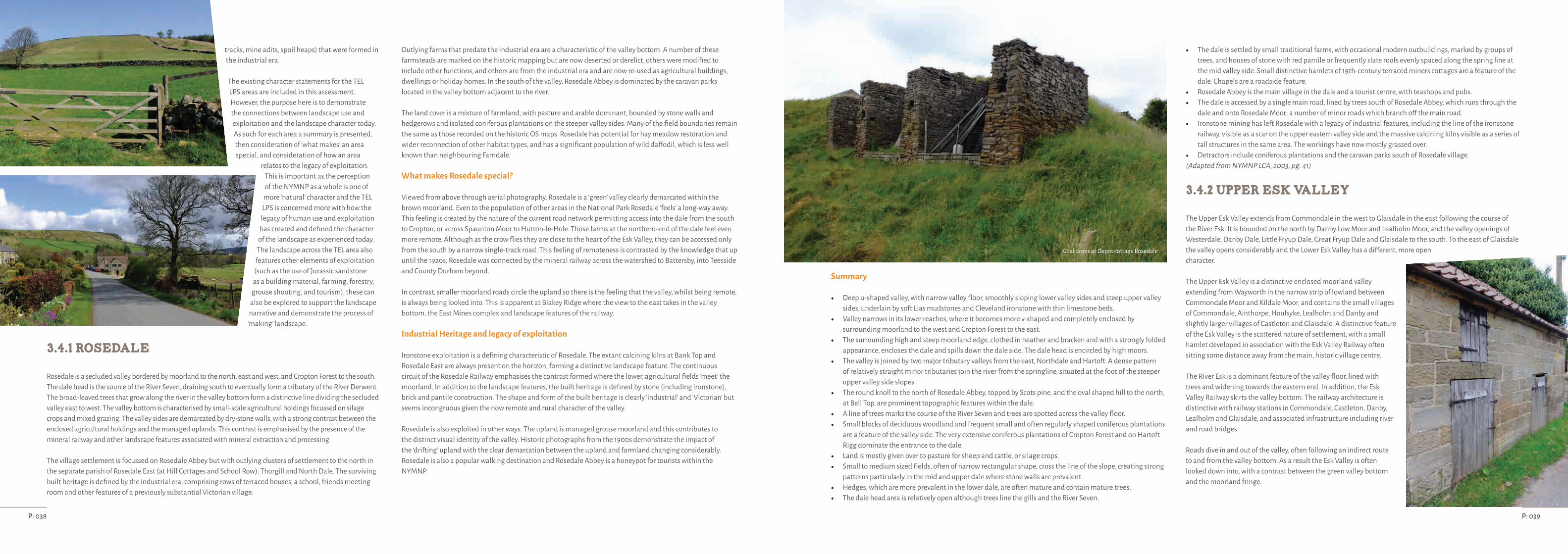
P: 039P: 038
tracks, mine adits, spoil heaps) that were formed in the industrial era.
The existing character statements for the TEL LPS areas are included in this assessment. However, the purpose here is to demonstrate the connections between landscape use and exploitation and the landscape character today. As such for each area a summary is presented, then consideration of ‘what makes’ an area special, and consideration of how an area
relates to the legacy of exploitation. This is important as the perception of the NYMNP as a whole is one of
more ‘natural’ character and the TEL LPS is concerned more with how the
legacy of human use and exploitation has created and defined the character
of the landscape as experienced today. The landscape across the TEL area also
features other elements of exploitation (such as the use of Jurassic sandstone
as a building material, farming, forestry, grouse shooting, and tourism), these can
also be explored to support the landscape narrative and demonstrate the process of
‘making’ landscape.
3.4.1 Rosedale
Rosedale is a secluded valley bordered by moorland to the north, east and west, and Cropton Forest to the south. The dale head is the source of the River Seven, draining south to eventually form a tributary of the River Derwent. The broad-leaved trees that grow along the river in the valley bottom form a distinctive line dividing the secluded valley east to west. The valley bottom is characterised by small-scale agricultural holdings focussed on silage crops and mixed grazing. The valley sides are demarcated by dry-stone walls, with a strong contrast between the enclosed agricultural holdings and the managed uplands. This contrast is emphasised by the presence of the mineral railway and other landscape features associated with mineral extraction and processing.
The village settlement is focussed on Rosedale Abbey but with outlying clusters of settlement to the north in the separate parish of Rosedale East (at Hill Cottages and School Row), Thorgill and North Dale. The surviving built heritage is defined by the industrial era, comprising rows of terraced houses, a school, friends meeting room and other features of a previously substantial Victorian village.
Outlying farms that predate the industrial era are a characteristic of the valley bottom. A number of these farmsteads are marked on the historic mapping but are now deserted or derelict, others were modified to include other functions, and others are from the industrial era and are now re-used as agricultural buildings, dwellings or holiday homes. In the south of the valley, Rosedale Abbey is dominated by the caravan parks located in the valley bottom adjacent to the river.
The land cover is a mixture of farmland, with pasture and arable dominant, bounded by stone walls and hedgerows and isolated coniferous plantations on the steeper valley sides. Many of the field boundaries remain the same as those recorded on the historic OS maps. Rosedale has potential for hay meadow restoration and wider reconnection of other habitat types, and has a significant population of wild daffodil, which is less well known than neighbouring Farndale.
What makes Rosedale special?
Viewed from above through aerial photography, Rosedale is a ‘green’ valley clearly demarcated within the brown moorland. Even to the population of other areas in the National Park Rosedale ‘feels’ a long-way away. This feeling is created by the nature of the current road network permitting access into the dale from the south to Cropton, or across Spaunton Moor to Hutton-le-Hole. Those farms at the northern-end of the dale feel even more remote. Although as the crow flies they are close to the heart of the Esk Valley, they can be accessed only from the south by a narrow single-track road. This feeling of remoteness is contrasted by the knowledge that up until the 1920s, Rosedale was connected by the mineral railway across the watershed to Battersby, into Teesside and County Durham beyond.
In contrast, smaller moorland roads circle the upland so there is the feeling that the valley, whilst being remote, is always being looked into. This is apparent at Blakey Ridge where the view to the east takes in the valley bottom, the East Mines complex and landscape features of the railway.
Industrial Heritage and legacy of exploitation
Ironstone exploitation is a defining characteristic of Rosedale. The extant calcining kilns at Bank Top and Rosedale East are always present on the horizon, forming a distinctive landscape feature. The continuous circuit of the Rosedale Railway emphasises the contrast formed where the lower, agricultural fields ‘meet’ the moorland. In addition to the landscape features, the built heritage is defined by stone (including ironstone), brick and pantile construction. The shape and form of the built heritage is clearly ‘industrial’ and ‘Victorian’ but seems incongruous given the now remote and rural character of the valley.
Rosedale is also exploited in other ways. The upland is managed grouse moorland and this contributes to the distinct visual identity of the valley. Historic photographs from the 1900s demonstrate the impact of the ‘drifting’ upland with the clear demarcation between the upland and farmland changing considerably. Rosedale is also a popular walking destination and Rosedale Abbey is a honeypot for tourists within the NYMNP.
Summary
• Deep u-shaped valley, with narrow valley floor, smoothly sloping lower valley sides and steep upper valley sides, underlain by soft Lias mudstones and Cleveland ironstone with thin limestone beds.
• Valley narrows in its lower reaches, where it becomes more v-shaped and completely enclosed by surrounding moorland to the west and Cropton Forest to the east.
• The surrounding high and steep moorland edge, clothed in heather and bracken and with a strongly folded appearance, encloses the dale and spills down the dale side. The dale head is encircled by high moors.
• The valley is joined by two major tributary valleys from the east, Northdale and Hartoft. A dense pattern of relatively straight minor tributaries join the river from the springline, situated at the foot of the steeper upper valley side slopes.
• The round knoll to the north of Rosedale Abbey, topped by Scots pine, and the oval shaped hill to the north, at Bell Top, are prominent topographic features within the dale.
• A line of trees marks the course of the River Seven and trees are spotted across the valley floor.• Small blocks of deciduous woodland and frequent small and often regularly shaped coniferous plantations
are a feature of the valley side. The very extensive coniferous plantations of Cropton Forest and on Hartoft Rigg dominate the entrance to the dale.
• Land is mostly given over to pasture for sheep and cattle, or silage crops.• Small to medium sized fields, often of narrow rectangular shape, cross the line of the slope, creating strong
patterns particularly in the mid and upper dale where stone walls are prevalent.• Hedges, which are more prevalent in the lower dale, are often mature and contain mature trees.• The dale head area is relatively open although trees line the gills and the River Seven.
• The dale is settled by small traditional farms, with occasional modern outbuildings, marked by groups of trees, and houses of stone with red pantile or frequently slate roofs evenly spaced along the spring line at the mid valley side. Small distinctive hamlets of 19th-century terraced miners cottages are a feature of the dale. Chapels are a roadside feature.
• Rosedale Abbey is the main village in the dale and a tourist centre, with teashops and pubs. • The dale is accessed by a single main road, lined by trees south of Rosedale Abbey, which runs through the
dale and onto Rosedale Moor; a number of minor roads which branch off the main road.• Ironstone mining has left Rosedale with a legacy of industrial features, including the line of the ironstone
railway, visible as a scar on the upper eastern valley side and the massive calcining kilns visible as a series of tall structures in the same area. The workings have now mostly grassed over.
• Detractors include coniferous plantations and the caravan parks south of Rosedale village.(Adapted from NYMNP LCA, 2003, pg. 41)
3.4.2 Upper Esk Valley
The Upper Esk Valley extends from Commondale in the west to Glaisdale in the east following the course of the River Esk. It is bounded on the north by Danby Low Moor and Lealholm Moor, and the valley openings of Westerdale, Danby Dale, Little Fryup Dale, Great Fryup Dale and Glaisdale to the south. To the east of Glaisdale the valley opens considerably and the Lower Esk Valley has a different, more open character.
The Upper Esk Valley is a distinctive enclosed moorland valley extending from Wayworth in the narrow strip of lowland between Commondale Moor and Kildale Moor, and contains the small villages of Commondale, Ainthorpe, Houlsyke, Lealholm and Danby and slightly larger villages of Castleton and Glaisdale. A distinctive feature of the Esk Valley is the scattered nature of settlement, with a small hamlet developed in association with the Esk Valley Railway often sitting some distance away from the main, historic village centre.
The River Esk is a dominant feature of the valley floor, lined with trees and widening towards the eastern end. In addition, the Esk Valley Railway skirts the valley bottom. The railway architecture is distinctive with railway stations in Commondale, Castleton, Danby, Lealholm and Glaisdale, and associated infrastructure including river and road bridges.
Roads dive in and out of the valley, often following an indirect route to and from the valley bottom. As a result the Esk Valley is often looked down into, with a contrast between the green valley bottom and the moorland fringe.
Coal drops at Depot cottage Rosedale
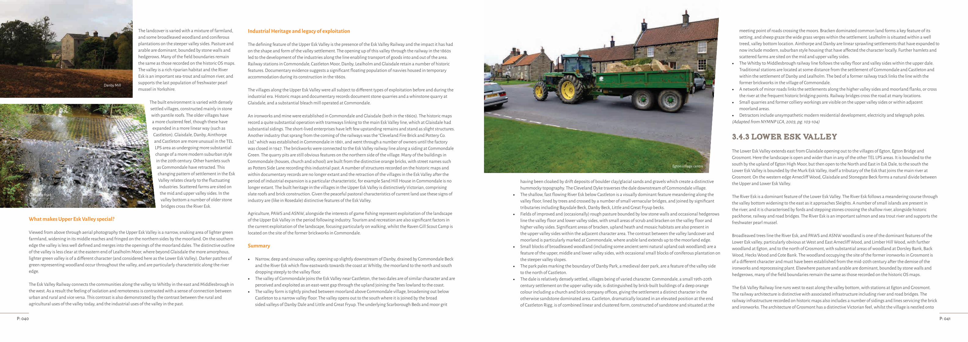
P: 041P: 040
The landcover is varied with a mixture of farmland, and some broadleaved woodland and coniferous plantations on the steeper valley sides. Pasture and arable are dominant, bounded by stone walls and hedgerows. Many of the field boundaries remain the same as those recorded on the historic OS maps. The valley is a rich riparian habitat and the River Esk is an important sea-trout and salmon river, and supports the last population of freshwater pearl mussel in Yorkshire.
The built environment is varied with densely settled villages, constructed mainly in stone with pantile roofs. The older villages have a more clustered feel, though these have expanded in a more linear way (such as Castleton). Glaisdale, Danby, Ainthorpe and Castleton are more unusual in the TEL LPS area as undergoing more substantial change of a more modern suburban style in the 20th century. Other hamlets such as Commondale have retracted. This changing pattern of settlement in the Esk Valley relates clearly to the fluctuating industries. Scattered farms are sited on the mid and upper valley sides. In the valley bottom a number of older stone bridges cross the River Esk.
What makes Upper Esk Valley special?
Viewed from above through aerial photography the Upper Esk Valley is a narrow, snaking area of lighter green farmland, widening in its middle reaches and fringed on the northern sides by the moorland. On the southern edge the valley is less well defined and merges into the openings of the moorland dales. The distinctive outline of the valley is less clear at the eastern end of Lealholm Moor, where beyond Glaisdale the more amorphous, lighter green valley is of a different character (and considered here as the Lower Esk Valley). Darker patches of green representing woodland occur throughout the valley, and are particularly characteristic along the river edge.
The Esk Valley Railway connects the communities along the valley to Whitby in the east and Middlesbrough in the west. As a result the feeling of isolation and remoteness is contrasted with a sense of connection between urban and rural and vice versa. This contrast is also demonstrated by the contrast between the rural and agricultural uses of the valley today, and the industrial uses of the valley in the past.
Industrial Heritage and legacy of exploitation
The defining feature of the Upper Esk Valley is the presence of the Esk Valley Railway and the impact it has had on the shape and form of the valley settlement. The opening up of this valley through the railway in the 1860s led to the development of the industries along the line enabling transport of goods into and out of the area. Railway stations in Commondale, Castleton Moor, Danby, Lealholm and Glaisdale retain a number of historic features. Documentary evidence suggests a significant floating population of navvies housed in temporary accommodation during its construction in the 1860s.
The villages along the Upper Esk Valley were all subject to different types of exploitation before and during the industrial era. Historic maps and documentary records document stone quarries and a whinstone quarry at Glaisdale, and a substantial bleach mill operated at Commondale.
An ironworks and mine were established in Commondale and Glaisdale (both in the 1860s). The historic maps record a quite substantial operation with tramways linking to the main Esk Valley line, which at Glaisdale had substantial sidings. The short-lived enterprises have left few upstanding remains and stand as slight structures. Another industry that sprang from the coming of the railways was the “Cleveland Fire Brick and Pottery Co. Ltd.” which was established in Commondale in 1861, and went through a number of owners until the factory was closed in 1947. The brickworks were connected to the Esk Valley railway line along a siding at Commondale Green. The quarry pits are still obvious features on the northern side of the village. Many of the buildings in Commondale (houses, church and school) are built from the distinctive orange bricks, with street names such as Potters Side Lane recording this industrial past. A number of structures recorded on the historic maps and within documentary records are no longer extant and the retraction of the villages in the Esk Valley after the period of industrial expansion is a particular characteristic, for example Sand Hill House in Commondale is no longer extant. The built heritage in the villages in the Upper Esk Valley is distinctively Victorian, comprising slate roofs and brick construction. Given the peaceful pastoral characteristics of current land use these signs of industry are (like in Rosedale) distinctive features of the Esk Valley.
Agriculture, PAWS and ASNW, alongside the interests of game fishing represent exploitation of the landscape of the Upper Esk Valley in the period following industry. Tourism and recreation are also significant factors in the current exploitation of the landscape, focusing particularly on walking, whilst the Raven Gill Scout Camp is located on the site of the former brickworks in Commondale.
Summary
• Narrow, deep and sinuous valley, opening up slightly downstream of Danby, drained by Commondale Beck and the River Esk which flow eastwards towards the coast at Whitby, the moorland to the north and south dropping steeply to the valley floor.
• The valley of Commondale joins the Esk Valley near Castleton, the two dales are of similar character and are perceived and exploited as an east-west gap through the upland joining the Tees lowland to the coast.
• The valley form is tightly pinched between moorland above Commondale village, broadening out below Castleton to a narrow valley floor. The valley opens out to the south where it is joined by the broad sided valleys of Danby Dale and Little and Great Fryup. The underlying Scarborough Beds and moor grit
having been cloaked by drift deposits of boulder clay/glacial sands and gravels which create a distinctive hummocky topography. The Cleveland Dyke traverses the dale downstream of Commondale village.
• The shallow, fast flowing River Esk below Castleton is a visually dominant feature meandering along the valley floor, lined by trees and crossed by a number of small vernacular bridges, and joined by significant tributaries including Baysdale Beck, Danby Beck, Little and Great Fryup becks.
• Fields of improved and (occasionally) rough pasture bounded by low stone walls and occasional hedgerows line the valley floor and lower valley sides, with small areas of scrub and bracken on the valley floor and higher valley sides. Significant areas of bracken, upland heath and mosaic habitats are also present in the upper valley sides within the adjacent character area. The contrast between the valley landcover and moorland is particularly marked at Commondale, where arable land extends up to the moorland edge.
• Small blocks of broadleaved woodland (including some ancient semi natural upland oak woodland) are a feature of the upper, middle and lower valley sides, with occasional small blocks of coniferous plantation on the steeper valley slopes.
• The park pales marking the boundary of Danby Park, a medieval deer park, are a feature of the valley side to the north of Castleton.
• The dale is relatively densely settled, villages being of varied character. Commondale, a small 19th-20th century settlement on the upper valley side, is distinguished by brick-built buildings of a deep orange colour including a church and brick company offices, giving the settlement a distinct character in the otherwise sandstone dominated area. Castleton, dramatically located in an elevated position at the end of Castleton Rigg, is of combined linear and clustered form, constructed of sandstone and situated at the
meeting point of roads crossing the moors. Bracken dominated common land forms a key feature of its setting, and sheep graze the wide grass verges within the settlement. Lealholm is situated within a well treed, valley bottom location. Ainthorpe and Danby are linear sprawling settlements that have expanded to now include modern, suburban style housing that have affected the character locally. Further hamlets and scattered farms are sited on the mid and upper valley sides.
• The Whitby to Middlesbrough railway line follows the valley floor and valley sides within the upper dale. Traditional stations are located at some distance from the settlement of Commondale and Castleton and within the settlement of Danby and Lealholm. The bed of a former railway track links the line with the former brickworks in the village of Commondale.
• A network of minor roads links the settlements along the higher valley sides and moorland flanks, or cross the river at the frequent historic bridging points. Railway bridges cross the road at many locations.
• Small quarries and former colliery workings are visible on the upper valley sides or within adjacent moorland areas.
• Detractors include unsympathetic modern residential development, electricity and telegraph poles.(Adapted from NYMNP LCA, 2003, pg. 103-104)
3.4.3 Lower Esk Valley
The Lower Esk Valley extends east from Glaisdale opening out to the villages of Egton, Egton Bridge and Grosmont. Here the landscape is open and wider than in any of the other TEL LPS areas. It is bounded to the south by the upland of Egton High Moor, but then open to the North and East in Esk Dale, to the south the Lower Esk Valley is bounded by the Murk Esk Valley, itself a tributary of the Esk that joins the main river at Grosmont. On the western edge Arnecliff Wood, Glaisdale and Stonegate Beck forms a natural divide between the Upper and Lower Esk Valley.
The River Esk is a dominant feature of the Lower Esk Valley. The River Esk follows a meandering course through the valley bottom widening to the east as it approaches Sleights. A number of small islands are present in the river, and it is characterised by fords and stepping stones crossing the shallow river, alongside historic packhorse, railway and road bridges. The River Esk is an important salmon and sea trout river and supports the freshwater pearl mussel.
Broadleaved trees line the River Esk, and PAWS and ASNW woodland is one of the dominant features of the Lower Esk valley, particularly obvious at West and East Arnecliff Wood, and Limber Hill Wood, with further woodland at Egton, and to the north of Grosmont, with substantial areas of woodland at Dorsley Bank, Back Wood, Hecks Wood and Cote Bank. The woodland occupying the site of the former ironworks in Grosmont is of a different character and must have been established from the mid-20th century after the demise of the ironworks and reprocessing plant. Elsewhere pasture and arable are dominant, bounded by stone walls and hedgerows, many of the field boundaries remain the same as those recorded on the historic OS maps.
The Esk Valley Railway line runs west to east along the valley bottom, with stations at Egton and Grosmont. The railway architecture is distinctive with associated infrastructure including river and road bridges. The railway infrastructure recorded on historic maps also includes a number of sidings and lines servicing the brick and ironworks. The architecture of Grosmont has a distinctive Victorian feel, whilst the village is nestled onto
Danby Mill
Glaisdale Ford
Egton village centre

P: 043P: 042
the steep slope that looks across the valley. As in the Upper Esk roads dive in and out of the valley with the perception that much of the valley is looked down into.
Scattered farms are sited away from the central valley. In the valley bottom a number of older stone bridges cross the River Esk. The built environment is varied with older stone built and pantile construction, mixed with later Victorian buildings related to the Industrial expansion of the area. Egton is an older, linear settlement with a later, Victorian hamlet lower down the slope focussed on the railway station at Egton Bridge. Egton has had some modern development of a more suburban feel. Grosmont is a larger Victorian village that built up around the Esk River crossing and tunnel of the Whitby to Pickering Railway, and later Grosmont Ironworks and Brickworks. Grosmont retains many of the features of a Victorian settlement including the church and co-operative society.
What makes Lower Esk Valley special?
Viewed from above through aerial photography the Lower Esk Valley is a regular green patchwork dominated by the lighter green of the farmland and darker green of woodland. The River Esk is a distinctive feature running west to east delineated by the line of trees the grow either side, and the snaking linear features of the railway line and road network. The darker, brown patches of the moorland are present on the southern edge, but these are marginal and the whole Upper Esk Valley is open towards the east. The open nature of the Upper Esk Valley makes it significantly different to the other TEL areas.
The Esk Valley Railway connects the communities along the valley to Whitby in the east and Middlesbrough in the west, and NYMR brings visitors north-to-south from Whitby to Pickering. As a result the Lower Esk Valley feels less remote than other parts of the TEL LPS area. The predominately rural, agricultural and forestry uses of the valley today contrast with the heavy industrial uses of the valley in the past. However the sights and sounds of the Victorian era can still be experienced at the eastern end of the valley during the NYMR's open season.
Industrial Heritage and legacy of exploitation
Grosmont is particularly significant in the exploitation of ironstone on the North York Moors, as ironstone was first discovered in the banks of the Murk Esk by engineers of the Whitby to Pickering Railway in 1835. The discovery of ironstone in Grosmont led to the discovery and exploitation of further ironstone across the TEL LPS area. Mineral extraction commenced soon after, with the ironstone initially transported by horse and wagon and then by the Pickering to Whitby, and much later, the Whitby to Middlesbrough railways. Later in 1863 the Grosmont Ironworks was completed. This substantial enterprise continued until 1891 with its fortunes fluctuating in line with changes in the demand for iron. Grosmont Ironworks was a substantial enterprise and had a considerable ‘life’ after its industrial peak recycling slag waste. The works comprised a number of tramways, including those that crossed the River Esk. The remains of these substantial industrial structures still stand in the River Esk. However, the scale and ingenuity of the Grosmont Ironworks, captured in its later phase of use by the Whitby photographer Frank Sutcliffe, fails to be demonstrated by the site in its current use as a car park, masked by substantial tree cover that has grown up over the period of its abandonment in the 20th century.
With the exception of the Esk Valley Railway and NYMR much of the evidence for former industry is less well known and more hidden than elsewhere in the TEL area. For example, by 1870 the Grosmont brickworks was in operation served by a siding from the railway. Like Commondale to the west, Grosmont bricks are orange, with a number of the village houses constructed from their distinctive products. Whilst the brickwork remains are inaccessible and fragmentary in their current condition the distinctive orange bricks define the character of the village. Other industrial exploits are recorded on historic maps but the physical remains are slight or less well known.
The industrial legacy is also demonstrated by short-lived or failed exploits. For example at the western end of the Lower Esk Valley Stonegate Beck is bounded by a very substantial earthwork feature cutting north-south from a siding of the main Esk Valley Railway. This is the line of the ill-fated Cleveland Extension Mineral Railway (Paddy Waddell's railway) that was intended to connect Glaisdale with Moorsholm.
This line was never completed but substantial earthwork remains are present crossing the upland and continue beyond the boundary of the TEL LPS.
The Lower Esk Valley also contains evidence of industry from the time prior to 1830, with alum workings at Eskdaleside and also, reputedly, at Grosmont, and with older water management at Egton demonstrated by the weir and sluice. However, these were on a smaller scale than the later Victorian endeavours. The legacy is such that a number of stone bridges and other structures are still extant.
Agriculture and woodland, alongside the interests of game fishing represent exploitation of the landscape of the Lower Esk Valley in the period following industry. Tourism and recreation are also significant factors in the current exploitation of the landscape, focussing particularly on the junction of the Esk Valley Railway and NYMR in Grosmont.
Summary
• Broad lower valley and associated tributaries of complex topographic form resulting from extensive glacial deposition. The valley overlies deltaic sandstones and mudstones; the lower lying parts east of Carr End are underlain by Middle and Lower Lias mudstones.
• The river cuts a narrow, steep, rocky and fast flowing meandering course through the area, dividing occasionally to leave islands isolated within the river. The course of the river alternately narrows as it follows an incised route through the glacial deposits, where it is generally hidden from view by its steep banks and fringing tree cover and widens to include a narrow flat flood plain. The river is joined by three significant tributaries from the south, (Glaisdale Beck, Murk Esk and Little Beck) and one from the north (Stonegate Beck). Dramatic waterfalls are a feature of the Murk Esk Valley.
• The valley sides are undulating and varied in form, frequently steep at their upper edges and close to the river, the central slopes being gentler. The tributary valleys of Murk Esk, Little Beck and Stonegate Beck have similar topography.
• Landcover is similarly complex and varied and comprises a mixture of farmland with a high density of broadleaved woodland and areas of coniferous and mixed plantations. Small patches of scrub, bracken,
rough pasture, wet grassland and areas of upland grass moor occur. A larger area of upland heath and upland heath/bracken mosaics occurs at the remnant moorland of Egton Low Moor on the northern upper valley side.
• Farmland comprises fields of pasture for sheep and cattle with occasional arable divided by a mixture of closely trimmed and overgrown hedgerows with frequent hedgerow trees of oak and ash on the lower valley sides, giving a well-wooded appearance to the dale. Walls and wire fences are also present but are less frequent than hedges.
• Blocks of mainly semi-natural ancient woodland are widespread but are associated mainly with the steeper areas adjacent to the River Esk and on the upper valley sides and linear woodland following the course of minor becks. In some locations areas of farmland are located above mid valley side woodlands, a pattern that rarely occurs elsewhere in the Park.
• Settlements include Eskdaleside, which has many buildings of a suburban character using mixed materials, and Egton, a hillside village constructed mainly in stone with pantile roofs. A number of settlements are influenced by their location on the railway, the Victorian railway architecture exerting a strong influence at Grosmont. Egton Bridge derives its character from the presence of the railway, the large church that dominates the village and the enclosing tree cover. Scattered farms of medium to large size are sited on the mid and upper valley sides. Goathland is elevated at 152m above sea level at the foot of the moors within the upper Murk Esk. The settlement has spread along its approach roads to include modern development; it is an important tourist centre.
• The Whitby to Middlesbrough railway line follows the valley floor, crossing the road and river in numerous locations. Carefully conserved railway stations and trackside features contribute significantly to the character of the dale. The NYMR is a key feature of Murk Eskdale, south of Grosmont, where the steam trains are visible by their plumes of smoke.
• Historic features include the numerous stone river bridges that are a feature of the dale and the packhorse bridge at Carr End.
• The busy A171, located on the ridge of land to the north of the valley forms the character area boundary. The A169 briefly crosses the character area to the east of Eskdaleside. A network of minor roads links the settlements along the valley sides or across the river at the frequent historic bridging points. Railway bridges cross the road at many locations.
• Recreational features include the rail trail between Grosmont and Goathland, the Newtondale Horse Trail and the Coast-to-Coast Walk, which follows the valley between Grosmont and Glaisdale, and the Cleveland Way on the coast at Whitby.
• Small quarries and small-scale mineral workings are visible on the upper valley sides where tree cover is sparse or within adjacent moorland areas.
• Detractors include unsympathetic modern residential development and overhead utilities poles. The overhead electric line to Whitby, supported on pylons, crosses the Little Beck valley. The mast at Limber Hill is a local detractor.
(Adapted from NYMNP LCA, 2003, pg. 104-105)
Grosmont station
The River Esk
The old school house Grosmont

P: 045P: 044
3.4.4 Murk Esk
The Murk Esk is a distinctive linear area running north-south following the Murk Esk from Grosmont to Goathland. It extends from Grosmont as far south as Fen Bog at the opening of Newtondale. It is bounded to the east by the route of the current A169 and to the west by Egton High Moor.
The Murk Esk river and its tributaries West Beck and Eller Beck follow a rocky meandering course, with dramatic waterfalls at Mallyan Spout and Thomason Foss forming distinctive features. The Murk Esk is a rich riparian habitat, important for salmon and sea trout. The valley sides are steep and heavily wooded containing a mixture of broadleaved and conifer and extend to the river banks. Other areas are rough pasture and include valley mire and wetland heath. The peat deposit at Fen Bog is up to 18m deep and contains distinctive mire vegetation. Farmland comprises fields of pasture for sheep and cattle. The variable topography is particularly significant as different activities have occurred in different locations through the constrained valley, and changes in gradient are a significant feature of the different phases of the railway lines. Although the vegetation and topography limit visibility of the train, during the operating season plumes of steam drifting above the treeline and the sound of engines from the NYMR are a characteristic feature of the landscape.
The settlement character is mixed, with some older pre-industrial structures at Beck Hole constructed in stone with pantile roofs. Esk Valley contains a number of distinctive workshops alongside a row of terraces built to accommodate mine workers. In contrast, Goathland has a distinctive upland, linear character with a number of large, interwar buildings including hotels and later developments that have a more suburban character built using mixed materials.
Across the Murk Esk area, scattered farms of medium to large size are sited on the mid and upper valley sides. Scattered field barns and other structures associated with mineral extraction are distinctive features through
the Murk Esk valley, for example the remains of Fen Bog House and buildings associated with whinstone quarrying adjacent to Murkside Bridge and Powder House at Esk Valley. Much of the railway architecture along the abandoned and still used railway (bridges, tunnels and culverts) is constructed from stone and has a distinctive monumental character.
What makes Murk Esk special?
Viewed from above through aerial photography, the Murk Esk is a distinctive green zone bounded on three sides by Goathland, Sleights and Egton High Moor, and opening at the north into the wide central valley of the main River Esk. To the south, the narrow valley bottom extends into Newtondale, and Fen Bog and is a distinctive feature set against the moorland. Linear features comprising the Murk Esk river and its tributaries and the railway lines (much of which is fringed with distinctive lines of trees) are distinctive. The demarcation against the moors is at its widest at Goathland and continues to the north. This area has numerous small fields, many of which retain the shape and form of those recorded on historic OS Maps. Darker, denser patches of woodland and even darker conifer plantations line river edges and the valley slopes, and are particularly apparent along the western boundary edge of the river. Here, rather than extend to the upland, the woodland is bordered by a zone of agricultural holdings squeezed in before the moorland edge.
The road network adds to the distinctive constrained, linear feel of the Murk Esk valley. Though close as the crow files, travel along the valley requires dropping in and out of the valley, with roads descending into the valley from the upland in the south, east and west. In the north the wider, open valley has a natural connection east-to-west. With the exception of Goathland that is located on an upland plateau, access to the Murk Esk landscape involves a descent. The topography and landform add to the feeling of constraint, with road bridges across the river at Beck Hole and Goathland and the road criss-crossing above and below the railway bridges. Other minor roads traverse north-south, winding along the moorland edge, or crossing through the ford at Lease Rigg.
Industrial Heritage and legacy of exploitationThe distinctive linear feel and the presence of early railway lines and the current NYMR heritage railway of the Murk Esk suggests connections north and south and this represents the industrial exploitation of this area with transport facilitating the movement of raw materials out of the moorland valleys, and people and other goods into the moorland landscape. Significantly, the topographic and landscape features in this area led to the development of innovative engineering solutions used in the early railway. For example, tunnels, bridges, inclines, and a ‘floating’ trackbed across the ‘quaking’ surface of Fen Bog.
The current NYMR runs south to north crossing Fen Bog in the south and following a narrow gap in the valley bottom along Ellerbeck, before crossing north to Goathland. From Goathland, the railway turns to the north of Darnholm and Beck Hole, then skirting the valley edge before crossing the Murk Esk river to the east of Esk Valley. The railway then heads north passing through the Grosmont tunnel and over the Murk Esk again, prior to reaching Grosmont Station. The current railway line is the 1865 deviation line. The historic 1836 railway is present from Moorgates on Goathland Moor to Incline Top, Beck Hole, Esk Valley continuing north to Grosmont. This is demarcated on the historic maps and exists as a series of alignments and causeways some of which are now Public Rights of Way.
Alongside the railway(s) the Murk Esk area contains substantial evidence of mineral exploitation. Uniquely for the TEL LPS area the evidence relating to ironstone extraction, processing and manufacture is documented in a single location. There is also substantial evidence of whinstone and sandstone quarrying and transportation. Some of this evidence is easily observed such as tramways, but the majority of the evidence is obscured under dense woodland and/or rough pasture. As such, the Murk Esk is the least well documented of the mineral landscapes that comprise the TEL LPS area but the Lidar survey undertaken through the Development Phase of the partnership has shed new light on the scale and complexity of the archaeological evidence in the Murk Esk landscape.
Historical archives also record the scale and ingenuity of mineral extraction and processing, but the extent of industrial impact is hard to imagine given the current picturesque setting(s). Given the constrained feel of the landscape at Beck Hole, it is hard to imagine the air filled with the fumes from the ironworks and associated open calcining clamps in the valley bottom.
In addition, 20th-century forestry plantations, including Plantations on Ancient Woodland Sites (PAWS), line the valley sides. The legacy of this 20th-century industrial use of the landscape is complex, as the trees have reached maturity but access difficulties has meant they have not been felled and have received little active management. As such, the Lidar survey and the mapping of the archaeological features in this landscape area provides an important woodland management tool as well as an ability to interpret the archaeological remains.
Fen Bog has a different character with the distinctive landcover the result of the railway construction. At the head of Newtondale it is constrained by the moorland, and by the steam railway line, and the Whitby to Pickering road. As a result, Fen Bog tends to look out of the TEL LPS area, its close proximity to RAF Fylingdales demonstrates the exploitation of the landscape in the latter half of the 20th century for military purposes.
Tourism is an additional defining feature of the landscape. The historic railway line was used for excursions from the 1880s, with day trippers attracted to the picturesque, natural features, tea rooms and orchards in Beck Hole. Tourism represents a significant 20th and 21st century use of the landscape. Goathland remains popular as the location of television's Heartbeat and the railway has appeared in numerous films and on television. The NYMR is a significant destination with the stations at Goathland and Grosmont conserved to represent different historic phases of use.
Summary
• Broad lower valley and associated tributaries of complex topographic form resulting from extensive glacial deposition. The valley overlies deltaic sandstones and mudstones; the lower lying parts east of Carr End are underlain by Middle and Lower Lias mudstones.
• The river cuts a narrow, steep, rocky and fast flowing meandering course through the area, dividing occasionally to leave islands isolated within the river. The course of the river alternately narrows as it follows an incised route through the glacial deposits, where it is generally hidden from view by its steep banks and fringing tree cover and widens to include a narrow flat flood plain. The river is joined by three significant tributaries from the south, (Glaisdale Beck, Murk Esk and Little Beck) and one from the north (Stonegate Beck). Dramatic waterfalls are a feature of the Murk Esk Valley.
• The valley sides are undulating and varied in form, frequently steep at their upper edges and close to the river, the central slopes being gentler. The tributary valleys of Murk Esk, Little Beck and Stonegate Beck have similar topographies.
• Landcover is similarly complex and varied and comprises a mixture of farmland with a high density of broadleaved woodland and areas of coniferous and mixed plantations. Small patches of scrub, bracken, rough pasture, wet grassland and areas of upland grass moor occur. A larger area of upland heath and upland heath/bracken mosaics occurs at the remnant moorland
The Murk Esk River

P: 047P: 046
of Egton Low Moor on the northern upper valley side.
• Farmland comprises fields of pasture for sheep and cattle with occasional arable divided by a mixture of closely trimmed and overgrown hedgerows with frequent hedgerow trees of oak and ash on the lower valley sides, giving a well-wooded appearance to the dale. Walls and wire fences are also present but are less frequent than hedges.
• Blocks of mainly semi-natural ancient woodland are widespread, but are associated mainly with the steeper areas adjacent to the River Esk and on the upper valley sides and linear woodland following the course of minor becks. In some
locations areas of farmland are located above mid valley side woodlands, a pattern that rarely occurs elsewhere in the Park.
• Settlements include Eskdaleside, which has many buildings of a suburban character using mixed materials, and Egton, a hillside village constructed mainly in stone with pantile roofs. A number of settlements are influenced by their location on the railway, the Victorian railway architecture exerting a strong influence at Grosmont. Egton Bridge derives its character from the presence of the railway, the large church that dominates the village and the enclosing tree cover. Scattered farms of medium to large size are sited on the mid and upper valley sides. Goathland is elevated at 152m above sea level at the foot of the moors within the Upper Murk Esk. The settlement has spread along its approach roads to include modern development; it is an important tourist centre.
• The Whitby to Middlesbrough railway line follows the valley floor, crossing the road and river in numerous locations. Carefully conserved railway stations and trackside features contribute significantly to the character of the dale. The NYMR is a key feature of Murk Eskdale, south of Grosmont, where the steam trains are visible by their plumes of smoke.
• Historic features include the numerous stone river bridges that are a feature of the dale and the packhorse bridge at Carr End.
• The busy A171, located on the ridge of land to the north of the valley forms the character area boundary. The A169 briefly crosses the character area to the east of Eskdaleside. A network of minor roads links the settlements along the valley sides or across the river at the frequent historic bridging points. Railway bridges cross the road at many locations.
• Recreational features include the rail trail between Grosmont and Goathland, the Newtondale Horse Trail and the Coast-to-Coast Walk, which follows the valley between Grosmont and Glaisdale, and the Cleveland Way on the coast at Whitby.
• Small quarries and small-scale mineral workings are visible on the upper valley sides where tree cover is sparse or within adjacent moorland areas.
• Detractors include unsympathetic modern residential development and overhead utilities poles. The overhead electric line to Whitby, supported on pylons, crosses the Little Beck Valley. The mast at Limber Hill is a local detractor.
(Adapted from NYMNP LCA, 2003, pg. 104-105)
3.4.5 Moorland
The TEL landscape areas are framed by the moorland. Glacial action exposed the Jurassic geology in the valley sides and the evidence of ironstone mining can clearly be seen, however the mineral deposits extend well below the moorland itself, for example in Rosedale, where abandonment plans show mine workings extending for hundreds of metres under the moor.
The moorland is characterised by its unenclosed, open and expansive character extending to the horizon. The moorland comprises acidic peaty soils drained by springs, gills and flushes, criss-crossing large tracts of managed heather moorland with extensive sheep grazing using traditional hefted flocks predominantly made up of Swaledales, known locally as ‘black face sheep’. There are relatively small areas that are unmanaged or have a primary conservation purpose rather than the more common combination of grouse management and sheep grazing. Occasional wind-swept trees are present on the upland, including hawthorn, rowan and the occasional oak. The moorland valleys are characterised by the presence of bracken, and some small-scale woodland concentrated in the dale heads and moorland fringe.
The moorland defines the steep, enclosed valleys of Rosedale, the Murk Esk and the main River Esk corridor. The fringing effect of the moorland is the defining characteristic of the TEL area. This is with the exception of the north-east boundary of the TEL LPS area beyond Grosmont where the Lower Esk Valley is a broader river corridor with a lowland character, the north-west boundary that extends beyond the Moorland edge to Great Ayton, the southern limits at Rosedale, which is constrained by the Cropton Forest, and at Fen Bog which is constrained by the very different geology and geomorphology of Newtondale. In addition, Sleddale Beck runs in a narrow gap between Kildale Moor and Commondale Moor connecting the Upper Esk Valley with the Northern and Western Fringe.
Some very sparse upland settlement is present. Including some occasional, isolated, farmsteads surrounded by walled fields and sheep folds. Some of the latter relates to the industrial era, such as The Lion Inn at Blakey Ridge that was enlarged during the industrial era. These structures are characterised by mixed stone, brick and pantile construction. Other features on the upland relate to grouse shooting, such as rows of shooting butts. A number of these are stone-built (including re-used stone from industrial sites), and a number have distinctive turf-capped walls. The other prominent feature of the moorland is the presence of prehistoric earthwork features (round barrows), and the later moorland crosses.
What makes the Moorland special?
Viewed from above through aerial photography the Moorland is a distinctive darker zone that surrounds the lighter, green valleys. An even darker zone represents plantation forestry but the tree line tends to skim the highest of the upland areas. Regular linear patterns represent evidence of moorland management through cutting and/or burning.
The moorland roads cross the upland between Hutton-le-Hole, Castleton and Westerdale with a number of
Moorgates railway bridge
MoorlandMurk side bridge
Blue Ber bridge South

P: 049P: 048
minor roads skirting Rosedale and descending into Danby. A number of other minor roads descend into the main Esk River valley from the A169 and A171. It is from the upland that the valleys which are central to the TEL story are descended into, and as a result the valleys are also looked into. This has a significant impact on how these areas of industrial activity must have been perceived at the height of industry.
The upland is generally well known and is recognised internationally for its important habitat and the species that it supports as well as the
National Park boasting the largest single expanse of such heather moorland in England. The uplands also sequester carbon and benefit water quality and flood risk management amongst a range of other public goods and services, often now referred to as ‘ecosystem services’. The moorland has a significant role in defining the special qualities of the NYMNP creating the feeling of openness and emptiness. The changing colour of the moorland through the year from purple in August to almost black in the winter is particularly characteristic.
Industrial Heritage and legacy of exploitation
Moorland coal deposits were exploited from before the industrial era. The arrival of improved transport links (with both the Whitby to Pickering and Esk-Valley Railway lines) that bought in coal from the North East changed the nature of this enterprise, but small scale exploitation of coal continued to be worked and used locally into the early 20th century. In contrast, the quarried mineral deposits exploited in the industrial era are located in the valley sides as such the moorland represents the changing ways in which the underlying geology was identified, valued and exploited.
Although there are pannier tracks, and other, much older prehistoric route ways across the moorland, the physical barrier provided by the moorland had a significant role to play in developing the story of industrial exploitation. It was the poor inland transport links from Whitby that led to the creation of the Whitby to Pickering railway, during the survey of which viable Ironstone deposits were identified in Grosmont in 1835. The physical barrier of the moorland also resulted in the distinctive nature of the Rosedale railway. Here the mineral railway crosses the upland
across Farndale and Baysdale Moor to descend via the Ingleby Incline and onwards to the North East. As such, the physical challenges posed by the moorland has resulted in the distinctive character of the industrial exploitation of the landscape in the TEL LPS area. The moorland has also been exploited in other ways. It was a grazed landscape from the medieval period onwards, and the continuing presence of moorland sheep connects to the exploitation of the moorland for food production. From the middle of the 19th-century, the same improvement in transport that supported the ironstone industry also enabled travel into the moors, and the development of grouse shooting which expanded after the 1850s. The legacy of this exploitation is in the grouse butts, in the distinctive linear patterns across the moorland created as a result of burning and the presence of differently aged plants as a result of heather management.
Common rights are particularly important for the moorland, for example Turbury on Glaisdale Moor which gives common rights for cutting peat turves, and the manor of Spaunton Moor Court Leet is one of the few remaining manorial courts in England, concerned with the protection of “common rights” particularly grazing rights.
The upland continues to be exploited for a variety of recreational and tourism activities and it is recognised of national importance for its distinctive biodiversity, and was a significant element in the designation of the North York Moors National Park in 1952.
Summary
• Open moorland, the central moors forming part of the Cleveland Hills, rising to a high point of 433m at Stony Ridge on Stockdale Moor and 402m at Cock Heads on Glaisdale Moor, and gradually falling in height towards the east. The moors drop off steeply into a series of well defined moorland dales to the north and south, whose intimate character is in stark contrast to the simplicity of the moorland landscape.
• The overall appearance is one of an undulating plateau, although locally there are marked variations in topographic form, particularly in the north where the closely spaced parallel dales have resulted in the development of pronounced steep sided moorland riggs. Towards the east glacial meltwater channels such as at Newtondale have cut deep narrow gorges across the moors.
• The moors are underlain by Middle Jurassic Ravenscar sandstone, mudstone and thin coals deposited as a deltaic series, which have given rise to acidic, peaty soils drained by a dispersed pattern of wet flushes, springs and minor gills draining radially into the surrounding dales.
• The Cleveland Dyke or Whinstone Ridge, formed from the only igneous rock to occur within the Park extends north west from Fylingdales Moor across Sleights Moor and has been quarried and mined for roadstone at several locations. At Sil Howe, the now partly filled quarries can be seen extending down towards the Esk Valley.
• Moorland gripping is a feature of Bilsdale East Moor, Badger Gill and Greenhow Moor. Grid iron pattern of drainage occurs on Commondale Moor.
• The eastern moors are bounded by the large coniferous plantations of Cropton and Langdale forests to the south and by the plantation at Newton House to the north, which intrude upon the openness of the moors.
• Occasional sandstone outcrops mark the moorland edges and scattered boulder fields are present on the moor tops.
• Expansive long distance views are available across the strong horizons of the moors, towards the dramatic
form of the limestone escarpment of the Tabular Hills to the south, into the central dales and towards the sea at the eastern end. The open skies create a dramatic and ever changing backdrop to the landscape. At night, the darkness of the skies is a key feature and significant contributor to the area's tranquility and sense of remoteness.• Extensive tracts of heather moorland (forming part of the largest continuous area of heather moorland in England, almost all of which is designated as SPA, SSSI and SAC), changing in colour from purple in summer to almost black in winter and mostly managed for grouse shooting, result in a distinctive mosaic pattern of different aged plants mixed with burnt areas and lines of grouse butts. Towards the east, moorland management has a less marked influence on the landscape. Other habitats on the moor tops include small areas of upland heath/grass mosaic, heather/blanket peat grassland mosaic, rough grassland and peat bog.• Moorland valleys, often steeply incised, provide relief and variety from the expanses of heather
moorland with occasional bog and flush communities. The predominant vegetation cover within the valleys is bracken or bracken/upland heath mosaics. Scattered tree cover or small woodlands creates a localised enclosure.
• Bracken predominates on the steeper slopes of the moorland edges intermixed with upland heath and bracken mosaics and very small areas of scrub, rough grassland and upland heath/grassland mosaics.
• Tree cover is limited to isolated pockets of deciduous woodland (a number of which are semi-natural or replanted ancient woodlands) in dale head areas and within moorland valleys and very occasional windswept specimens on the moor tops.
• The moorland, mostly grazed by sheep, is generally unenclosed although wire fences are present in some locations.
• Settlement is almost entirely absent; occasional isolated farms occur in moorland valleys surrounded by walled fields and sheepfolds and marked by groups of trees.
• The moors are rich in historic features, including ancient crosses, guide stones and boundary markers that form characteristic landmarks. Lines of round barrows follow the ridgelines of the moors and are visible as skyline features. Important collections of prehistoric carved rocks occur on Howdale and Stoup Brow Moors.
• The remains of small-scale quarries, historic collieries and jet workings and their associated spoil tips are visible on moorland edges, on the dale sides and in the dale head areas.
• The moors are crossed by few roads, although the A169 and A171 and the road between Hutton le-Hole and Castleton have a local impact. Elsewhere, minor roads access the moors and many areas are relatively inaccessible.
• Recreational features include the Lyke Wake Walk, the Crosses Walk and Bilsdale Circuit and the Newtondale Horse Trail. Prominent erosion scars occur in some locations along the Lyke Wake Walk. The
NYMR crosses the moors to the north of Newtondale, the steam trains visible by their plume of smoke. Grouse shooting parties and vehicles are a regular feature of the moors during the shooting season. Car parks situated within the open moorland are highly visible.
• Away from the roads and the railway, the noise of the wind and the call of moorland birds are often the only sounds present in the area.
• Detractors include the defence site at Fylingdales, the overhead electricity line to Whitby, Wheeldale Plantation, car parks, the A169 and A171 and its associated traffic and the scars created by the footpaths, shooting tracks and quarries of the moorland edges. The impact of Fylingdales on the night sky is significant.
(Adapted from NYMNP LCA, 2003, pg. 28-29)
3.4.6 Northern and Western Fringe
Bounded to the east by the steep northern-western slope of the North York Moors this area of lower ground looks north and west towards the Cleveland Plain and onwards towards Teesside. The outward-looking aspect of this area is in contrast to the enclosed valleys of the rest of the TEL LPS area.
Plantation forestry is a characteristic of the slope edge, whilst the scarp foot area is of a higher agricultural value than for most of the rest of the TEL LPS area and is characterised by a mixture of improved pasture and arable with medium-sized fields that have retained much of the same shape and form of those recorded in the first and second edition OS maps. The River Leven rises on Kildale Moor draining to the north west towards Great Ayton and onwards towards the River Tees.
The Esk Valley Railway skirts the lowland area in a swooping arc with stations at the small villages of Kildale and Battersby. Buildings are of sandstone, limestone or brick with slate or pantile roofs. Kildale is an estate focused on a much older settlement, although Kildale Hall is a more modern structure. Battersby is a small village and is characterised by two rows of brick-built railway terraces running north-south, parallel to the route of the then Rosedale Railway. Battersby station retains a number of distinctive features (a water tower, a platform watercrane and a turntable base) that relate to its industrial past. Ingleby Greenhow is larger and has had more substantial modern changes, with the proximity to Teesside giving this village a distinctive suburban and commuter feel.
Rosedale railway at Blakey Ridge Ingleby incline
Rosedale railway at East mines

P: 051P: 050
What makes the Northern and Western Fringe special?
Viewed from above through aerial photography, the northern and the western fringe is clearly demarcated from the upland, with a dense band of forestry skirting the steep slope which is surrounded by a regular patchwork of agricultural fields. Lines of dismantled mineral railways (of the Rosedale Railway, and Branch line that connected to Warren Moor) are clear.
Looking to the north, with the southern boundary of the uplands of the Cleveland Hills this zone looks and feels different to the rest of the TEL LPS area (which is either more enclosed or enclosing). The open and expansive nature of this area has impacted on the nature of change in the 20th-century, forming a distinctive and attractive commuter or retirement area for former residents of industrial Teesside. This makes those connections between the TEL LPS area and the urban areas of Teesside tangible beyond and before the lifetime of the TEL LPS.
Industrial Heritage and legacy of exploitation
The Esk Valley Railway is a significant feature of this area. A 1922 stained glass window in St Cuthbert's Church in Kildale features a steam train passing through the Kildale landscape. This demonstrates the connections between industry, transport and the local community. The railway line played a significant part in the ironstone industry transporting ironstone from Rosedale, Kildale (Warren Moor Mine) and those mines further east at Glaisdale and Grosmont. The most dramatic of these connections is the Rosedale railway which descended from the upland along the Ingleby Incline, joining the mainline at the then Battersby Junction.
This part of the TEL LPS area historically provided the connections to Teesside and industries to the North. This involved the movement of ironstone from the TEL LPS area and transport of coal into the TEL LPS area. These connections are also evident from the period of industrial decline in the 1890s-1920s where the population shifted away from the declining industries of the North York Moors into Teesside, whilst in the later part of the 20th century this movement reversed, with the population moving away from the now declining Teesside to the more picturesque villages. Today this gateway is important in engaging an urban population with the natural world, the landscape and in many cases their heritage. As such, tourism and recreational activities represent contemporary forms of exploitation of this area.
The area was also exploited in different ways and a defining characteristic is plantation conifer forestry. This is itself a legacy of government responses to war-time shortages of timber and specifically for pit props. With the decline of the coal mining industry prior to the felling of these plantations, their legacy is one that relates to changing social and economic circumstances in the later part of the 20th century.
Summary
• A distinctive, steeply graded escarpment landscape forming an outward facing transition area between moorland of the Cleveland Hills and lowlands of the Vale of Mowbray/Cleveland Plain to the west and north west underlain by soft Lias mudstones and Cleveland ironstone with thin limestone beds. The character area includes the gently rolling farmland at the scarp foot, where this is included within the National Park boundary.
• The edge follows a strongly indented shape with pronounced generally flat topped promontories, the form
of the escarpment broken in places by dales that cut through it, including Scugdale and Kildale. Natural rock outcrops are an infrequent feature and are generally masked by tree cover.
• Long views across the Vale of Mowbray and Cleveland Plain are a key feature, the detractors within these areas (including main roads, overhead transmission lines and the industrial areas of Teesside) having an influence on the character of the upland fringe.
• Roseberry Topping, isolated from the main face of the escarpment by the natural processes of erosion, overlooks the character area in the north and with its bent pinnacle shape is a key landmark of the western fringes of the National Park. A further prominent outlying conical hill (Whorl Hill at Faceby) contributes to the distinctive character of this fringe landscape.
• The River Leven and Scugdale Beck drain the area and a series of minor streams flow from the north and west facing slopes of the moors.
• The scarp slope is breached by Kildale, the steep upper slopes wooded and the gentler lower valley slopes a mixture of arable and pasture farmland divided by closely trimmed hedges and fences. The Whitby to Middlesbrough Railway passes through the dale, with a station at the hamlet of Kildale. Captain Cook's Monument overlooks the dale from Easby Moor.
• Very well treed with often extensive and sometimes blocky coniferous or mixed plantations clothing the steeper slopes with the top edge of the escarpment almost continuously wooded for considerable stretches. In other areas, smaller blocks of woodland or plantation are interspersed with steeply graded pasture, or moorland vegetation of heather or bracken spills over the scarp top, resulting in an open top to the escarpment.
• Medium to large blocks of mainly replanted ancient woodland are associated with moorland slopes or follow the line of becks.
• Improved pasture fields, with occasional arable confined to more gently graded lower slopes of the escarpment or the scarp foot areas, enclosed by well developed hedgerows with hedgerow trees or fences. Fields are generally medium in size within the gently undulating areas at the base of the escarpment becoming large in the flat land at the edge of the Vale of York and Cleveland Plain.
• Where scarp foot areas are included within the Park boundary, linear scarp foot settlements set at right angles to the slope generally along the line of a beck are a frequent feature of the area. Buildings are
constructed in sandstone with a mixture of pantile and slate roofs. A number of these settlements have been extended with modern brick built housing on outskirts e.g. at Swainby and Ingleby Greenhow. Occasional halls and associated parklands are present on the outskirts of settlements. Medium to large farms are scattered throughout the gently undulating landscape at the scarp foot.
• Over much of the area, busy main roads (the A171, A172 or A173) or the railway follow the character area boundary, intruding upon the area. Elsewhere the area is generally quiet and tends to be bypassed by visitors. The well-used Cleveland Way footpath crosses parts of the character area, alternately following the escarpment side and the moorland edge.
• Disused quarries and mineral workings (for alum and jet) are frequent and occasionally prominent where tree cover is reduced. Old alum quarries in the escarpment side at Carlton Bank marked by heaps of pink coloured burnt shale are visible as a prominent scar from many miles away. A line of small depressions about two thirds of the way up the slope marks a series of old jet workings. An extensive linear Whinstone Quarry is situated to the east of Great Ayton, visible as a v-shaped gash within the wooded Whinstone Ridge.
(Adapted from NYMNP LCA, 2003, pg. 111-112)
Landscape character and Scheme boundary
The rationale of the Scheme area is the narrative function of the landscape from east-to-west, telling the story of early railway and ironstone exploitation and incorporates a number of interconnected, linear routes that emerged in the key century of industry on the North York Moors from 1830 to the 1930s.
The TEL LPS boundary was reviewed in the Development Phase of the Scheme. The revised Scheme boundary reflects the underlying geology and the existing Landscape Character Areas better and also rationalises a ‘buffer’ of the moorland as this provides the context within which the ironstone industries and associated transport developed.
For the northern and the western fringe the natural connection to the north and west made defining the project boundary more complex, as a result the north-western edge of the TEL LPS boundary has been truncated to exclude Coates Moor, but extended to the north of Battersby Junction. Other adjustments have been made to ensure the complexity of cultural heritage is reflected in the TEL LPS boundary for example, the full length and extension routes of the Rosedale Mineral Railway, and associated whinstone mines at Goathland (that predated the discovery of ironstone but were important in the development of the Whitby to Pickering Railway). Other adjustments have been made to reflect the full extent of natural heritage Warren Farm, Warren Moor, Kildale
Kildale Church
Esk Valley line at Kildale
TEL boundary changes (Red = Final LPS boundary)

P: 053P: 052
significance for example the river catchments that retain water vole populations, important PAWS sites and potential locations to enhance habitat connectivity based on functional ecological units as far as is reasonably possible and linked to the overall priorities of the Scheme.
The landscape arc of the TEL LPS sits within and is a central part of the National Park and as such shares many of its special qualities. The special qualities of the North York Moors include: “wide sweeps of open heather moorland”; “strong feeling of remoteness”; and “tranquillity” (NYMNPA Management Plan, 2012 pg. 8). The special qualities of the National Park include “great diversity of landscapes” and “sudden contrasts associated with this”. The distinct contrasts encountered in the TEL LPS area contribute to the character of the NYMNP as a whole and relates to the idea of ‘sudden contrasts’, for example upland and valley, nature and industry.In addition to these special qualities the TEL LPS area has a more distinctive identity. This is based upon the sense of discovery and the ‘shock’ of knowing that these now ‘natural’ places were sites of extraordinary industrial expansion, and just as rapid industrial retraction. The ‘feeling’ of remoteness and wilderness experienced on the upland moor is challenged by the knowledge that a railway ran high across Farndale and Baysdale moors and linked Rosedale beyond the Cleveland Hills to Ferryhill in County Durham.
The significance of the TEL LPS area is its function as a landscape biography considering the landscape ‘before’, ‘during’ and ‘after’ industry and the ways in which humans have intervened and changed the landscape through time. As such understanding, protecting and enhancing the landscape and its legacy of exploitation is an important element in defining its local, national and international significance.
3.5 Communities
3.5.1 Local Communities across the NYMNP
area
As a whole the NYMNP is very sparsely populated, with no towns or large villages within its boundaries although it reaches close
to the edges of Whitby and Scarborough and the southern fringes of Middlesbrough and Redcar. The main local authorities are Scarborough, Ryedale and Hambleton and these centres of population lie outside the park. Much of the population lives in or around
small village, most of which pre-date the industrial period, but were shaped and grew from the Victorian period onwards, but the character is predominantly traditional, rural vernacular in scale and design. The settlements across the park are still generally poorly connected and have a strong sense of independence and local identity. In the development phase of the TEL LPS these communities were described as “separated by geography, connected by history”.
The TEL LPS project area covers c. 182km including 23 separate parish areas and a population of c.8,290 based on the most recent 2011 census. As with the NP, not all parishes fully fit within the Scheme area, and so the population represents all of the parishes that are fully and partially within the Scheme area.
These parishes and their populations include:
The parishes are characterised by their rural villages and hamlets, with isolated dwellings and a number are in sparse settings. Considering the TEL LPS area as fairly typical of the NP as a whole (and the parishes are fairly evenly spread through the 3 relevant local authority areas of Ryedale, Hambleton and Scarborough) it can be assumed to mirror its demographic and economic profile as outlined above.
The primary schools in the TEL LPS area are Goathland, Egton, St Hedda's (Egton Bridge), Glaisdale, Lealholm, Danby, Castleton, Ingleby Greenhow and Rosedale. All are recognised by OFSTED as “good” with St Hedda's, Glaisdale and Castleton recognised as “outstanding”. The Esk Valley Teaching Alliance is a long-standing alliance of eight schools centred on those primaries along the Esk Valley and is a focus for initial teaching training, professional development and best practice in a wide network of primary and secondary schools across the region (North Yorkshire County Council and Redcar and Cleveland). There are no secondary schools located in the TEL LPS area but the primaries feed into a number of secondary schools: Lady Lumley's in Pickering, Eskdale in Whitby, Caedmon College in Whitby and Stokesley School.
Despite the apparent advantages afforded to those communities within the NP area, as a whole these rural communities are impacted by an aging population, the affordability and availability of housing, closure of village shops, post offices and pubs, the withdrawal of transport, and very limited access to high speed broadband. These broader issues are considered within the most recent NYMNPA Management Plan. There are also likely to be highly localised and hidden pockets of rural deprivation that are too small to be picked up by multiple indices of deprivation statistics. For example, access to affordable public transport is an issue for some of the target audiences in Teesside and the coastal towns (Whitby and Scarborough). In the Development Phase of the TEL LPS a number of consultations on key issues relating to public transport have had a negative impact, for example the withdrawal or changes to bus routes. In contrast, the renegotiation of the Esk Valley Railway franchise will introduce a new early morning weekday commuter service from Whitby along the Esk Valley line to Middlesbrough, and year-round Sunday services (the new franchise is due to start in April 2016 with additional services beginning in 2017).
Economic data
Data is considered for the whole of the NYMNP area as drilling down into the TEL LPS area is extremely difficult as it crosses different Local Authority, ward and parish areas. The data also reflects ‘whole’ parish areas, a number of which fall outside the NP area. This approach is consistent to the NYMNPA Management Plan and other relevant reports, such as the 2014 Amec Report on the Economy of the North York Moors National Park (which was commissioned by the NYMNPA planning directorate but condenses much of the information about communities required for developing the LCAP).
The NYMNP area comprises 1436km2, with a population in 2011 of 23,400. Since the 2001 census figures the population has declined by 2%. The population is also ageing, with just less than half of the population aged between 18 and 59, and those aged under 18 are 17% of the population. Both of these groups are declining in comparison with figures from the 2001 census (Amec Report 2015). In contrast the population aged over 60 is now 35%, an increase since the 2001 census. It is understood that many younger people move away from the area for work with consequences for local facilities and communities (NYMNPA Management Plan, 2012 pg. 78).
Some 17,500 (75%) individuals are classed as economically active, and some 11,500 (49%) people in employment, in the NYMNP. Wholesale and retail is the largest employment sector, with health and social work, accommodation and food service, education, agriculture, forestry and fishing sectors also being significant. Self-employment rates are markedly high (almost double the national average), and
unemployment, including youth and long-term unemployment is low at 2.2% compared with a national figure of 4.4% (Amec Report 2015). Qualification levels within the NP are generally high, with fewer people with no qualifications than all surrounding areas.
Within the NP almost half of the resident population own their home outright, with a very small social rental sector, and private rental sector is similar to surrounding local authority areas. Average household income inside the National Park was some £32,974 in 2010 which is marginally above the corresponding figure for Yorkshire and the Humber.
The York and North Yorkshire Economic Assessment carried out in 2010 shows that from 2000-2010 there was a low level of job growth and, in terms of employment structure, high levels of self-employment and micro businesses, a low proportion of younger working people and high dependency on hospitality and retail across the NP. The NP area as a whole faces a decline in working age population and an increase in retired population.
The 2010 indices of multiple deprivation demonstrate differences between the NP area and those targeted for the TEL LPS. Using the aggregated data for local authority areas the rank of local concentration (which shows a population weighted average for a local authority district) demonstrates extensive variation. Those local authorities that form the southern and western areas within the NP are some of the least deprived in England, with Ryedale ranked overall 293 and Hambleton 261 (where the least deprived local authority area was ranked 326). In contrast Scarborough (which forms the north-eastern boundary of the NYMNP) is ranked 56. This data contrasts very strongly with the local authorities to the north of the NYMNP, with Stockton-on-Tees ranked overall 32, Redcar and Cleveland ranked 17, and Middlesbrough one of the most deprived local authority areas in England ranked 5. This data will be updated in the life-time of the TEL LPS but demonstrates extensive regional variation in social conditions, these differences also extend to related data such as health and education.
• Aislaby 240• Bransdale 90• Commondale 130• Danby 1410• Easby 90• Egton 450• Eskdaleside cum Ugglebarnby 2240• Farndale East 100• Farndale West 100• Glaisdale 1020• Goathland 440
• Grosmont 320• Hartoft 70• Ingleby Greenhow 370• Kildale 150• Lastingham 100• Lockton 250• Rosedale East Side 220• Rosedale West Side 90• Spaunton 70• Ugthorpe 190• Westerdale 150
Arch building
Local engagement

P: 055P: 054
Economy
Many of the National Park's businesses are tied to, or derive their income from the landscape. Since its designation as a protected landscape the economy of the NYMNP has traditionally relied on the agricultural, forestry, shooting and tourism sectors. The dependency on the visitor economy also means that many jobs are seasonal and/or part time.
The two biggest single employers in the National Park are Boulby Potash Mine and RAF Fylingdales. The Boulby Mine is the UK's only commercial potash mine and employs c. 1000 workers, making it the largest employer in the National Park. RAF Fylingdales employs around 360 people.
In the Development Phase of the TEL LPS planning permission was granted to York Potash Ltd. for a substantial Scheme to permit the extraction of polyhalite (an alternative form of potash to the sylvanite which is the predominate form mined at Boulby) within the national park, but outside of the TEL area (between Whitby and Scarborough to the North-East of the TEL area). The NYMNPA planning officers are currently working with the applicant, statutory undertakers and Ministry of Defence to finalise the planning conditions, Section 106 Agreement and other documents.
Tourism
During 2014, 11.27 million visitor days were spent in and around the National Park, comprising 7.29 million visitors and tourism was worth an estimated £581.58 million to the local economy and supported 10,478 jobs in the area (STEAM 2015). This shows a reverse in the pattern of decline in visitor numbers and spend which had taken place between 2009 and 2012. As a whole the National Park adopts a principle of ‘wise growth’ to balance growth aspirations with the principles of sustainability in tourism. The NP works closely with the family of protected landscapes, alongside Visit Britain, Visit England, Welcome to Yorkshire and other regional and local groups, and supports a range of tourism and destination strategies. The National Park also supports the NYM Tourism Network and Destination Management Partnership.
In the Development Phase of the TEL LPS the ‘Tour de Yorkshire’ cycle race took place. Stage 1 from
Bridlington to Scarborough was routed through much of the TEL LPS area, from Rosedale, through to Eskdale, then from Danby to Grosmont, where the peloton was ‘met’ by the steam from the NYMR. Over 3 stages, an estimated 1.5 million spectators came to see the race, and 6 million television viewers watched
around the world. The increasing interest and opportunities for engagement demonstrated by this event demonstrate the passion and engagement with the landscape, its various forms of exploitation through leisure and recreation, and potential to be marketed to new audiences.
Agriculture
The total value of output from agriculture in the NYM 2009 was calculated at £56m. Of this the largest proportion was dairy (24%) followed by cropping (23%). Benefits to the local economy are provided by the employment of 2,554 people in agriculture, fewer than half of which are employed on a full time basis. The number of people employed in farming has fallen significantly over the last 20 years with the largest decline being in full time workers (NYMNPA Management Plan, 2012 pg. 82). Income from agri-environment Schemes has been vital in securing the agricultural future of the whole of the National Park.
Timber production from both private and public woodlands is important to the economy and management of the National Park (NYMNPA Management Plan, 2012 pg. 88). In addition the majority of the National Park's moorland is managed for grouse. Moorland management for grouse shooting depends largely on investment by private owners and/or shooting tenants. The activity brings significant investment to rural communities and in some upland areas has overtaken agriculture as the primary economic land use (NYMNPA Management Plan, 2012 pg. 90). The wooded and steep sided valleys on the lowland fringes of the National Park have also made the North York Moors internationally known for driven pheasant shooting and this brings significant income to the area.
3.5.2 Visiting communities
Visitors are very important to the National Park. As a whole the North York Moors are relatively well-resourced in terms of most types of access and recreation provision, with a 2,300km network of Public Rights of Way and around 65,000 ha of open access land (45% of the National Park's area) as well as a number of long distance trails and cycle routes. There are a number of iconic destinations, villages and tourist attractions. The National Park operates visitor centres at Sutton Bank and Danby, and a number of National Park car parks. The area is serviced by a very wide range of local businesses, including hotels, bed and breakfasts, pubs, restaurants and cafes.
There are a number of youth hostels within the National Park. North Yorkshire County Council also operates outdoor education centres at East Barnby and Great Fryupdale, and Lady Lumleys School use the Rosedale
Centre and Yorkshire Bunkhouse for outdoor education. The scout and guide associations also operate centres at Commondale and Esk Valley. All attract a large number of people to the area, taking part in outdoor activities and completing recognised Schemes such as the Duke of Edinburgh award.
During the summer months, there are some places in the National Park where current visitor levels do cause congestion and disturbance. However, there are many other places and other times of the year when the NP, its communities and its businesses have the capacity to sustain more visitors than current levels. There is spare capacity at tourism-based facilities such as hotels, youth hostels and camp sites.
What we did in development?
In the Development Phase of the TEL LPS Visitor Surveys were commissioned to refine the broader picture of visitor behaviours within the NYMNP as a whole and to consider the TEL LPS area and objectives. The purpose was to identify the characteristics of those visiting, and those not visiting the NYMNP, to understand the reasons for visiting or not visiting, to identify the barriers to visiting the National Park at all or more frequently, to establish the awareness of, and level of interest in industrial archaeology and to identify the method by which those interested would like to learn more. Face-to-face interviews were conducted at selected locations within the NYMNP region (Goathland, Grosmont, Danby and Rosedale) and in Middlesbrough town centre. The survey included a sample size of 250 users and 259 non-users. The full report is included in the Appendix.
Survey results
The non-users surveyed had a fairly even spread of ages, but the users had a noticeable cluster in the 55 years plus. Almost all respondents to the survey identified themselves as white/British (just 1% as ‘other’), and similarly for non-users where 5% identified as ‘other’. Outside school holidays, the great majority of visitors are aged 55 or over, and children are only rarely part of the visitor group outside school holidays, but a more uniform age profile is seen during school holidays. Non-users often have children in their party on a typical day out.
Similarly users identify their occupation clustered as professional/middle manager (64%), and non-users 13% associated with this category. A very noticeable variation is also between unemployed/long-term sick and unskilled labour which accounted to 44% of the non-users, and just 4% of the users.
There was a very wide variation between users and non-users in relation to interests and hobbies, with users favouring walking, reading, travel, exploring heritage and non-users watching tv or dvds, cinema, walking and travel. This variation is also reflected in how the groups like to spend a day out, with users much more likely than non-users to like to go for walks, visit National Trust-type properties, explore the country's history and heritage, and to visit museums and cathedrals on a typical day out. Non-users are more likely to like to go to the beach or go shopping.
The barriers identified for non-visitors include lack of transport as the most significant factor. Other factors that were identified include lack of knowledge of the NYMNP, its offer as a destination or its limited appeal. Users use a wide range of sources, including websites, brochures, leaflets, Tourist Information Centres when planning a day out. Word-of-mouth is also a very important source of information for both users (especially school holiday visitors) and non-users.
Users and non-users were also asked about the TEL LPS, and there was considerable interest in finding out more about the industrial heritage of the area after a brief description of the TEL LPS ambitions. A greater proportion of non-users were unaware of the industrial heritage of the North York Moors (66%), compared with just 22% of users who were unaware of the industrial heritage of the North York Moors.
Both userss and non-userss were interested in the TEL LPS concept, and interested in finding out more, current visitors in a more traditional way (for example, display), and non-users online. Users
thought children would be interested in finding out more about the industrial heritage of the area. Interestingly (and statistically relevant) feedback suggested that current non-users would be interested in taking part in hands-on activities, such as community archaeology, hands-on building conservation and hands-on nature conservation. This suggests that for those who are not visitors to the Park, removing barriers and encouraging ownership through active participation will be important in raising interest in the TEL LPS. The results of this survey have been used to identify the ‘Ironstone Volunteers’ project that will be delivered through the TEL LPS.
Focus groups
An extension of the survey was undertaken to gain a better understanding of the barriers and motivations for visiting the NYMNP. The aim was to assess levels of interest in industrial heritage and to consider how the TEL LPS concept could be developed and marketed to maximise its appeal to potential visitors. A user group was interviewed in York, and non-user group interviewed in Middlesbrough. In both cases 10 participants took part.
In considering barriers, car ownership and transport remain central to non-users who cannot get to the Moors. Both users and non-users highlighted issues related to navigation, knowledge and signposting, with both groups not quite knowing what is offered by the NYMNP as a destination. They also perceive it as ‘en route’ to a preferred destination such as Whitby. The importance of food and drink in contributing to an enjoyable day out
Grosmont co-op
School party visiting Grosmont
Landslip at Rosedale East

P: 057P: 056
was highlighted again and both users and non-users would welcome greater availability of cafes, pubs and ice cream kiosks in the area. Common responses included:
“Definitely there are lots of places we don't know about. We have been up there and found places before we didn't even know existed.”
“Increasing the visual aids around the North York Moors could help you orientate and see the things there are to do …”
The focus groups were also asked about the TEL LPS concept and discussion was favourable, for example a respondent commented:
“I like the idea of it being remembered and protected. My father and grandfather worked in the Steel Industry and I want it to be preserved so my children can know about it.”
Interestingly, the stimulus materials used for the focus groups were very traditional (pictures of ‘ruins’ in the landscape), and this perhaps resulted in the negative feedback from the current non-users who believed that the concept was boring and would not interest them. This is perhaps demonstrated as the later discussion in this focus group raised the possibility of hands-on excavation work and some interest was aroused. This suggests that breaking down barriers between ‘experts’ and ‘non-users’ is important in creating interest and ownership in otherwise ‘traditional’ subjects. When hands-on activities were flagged up one respondent commented:
“Yes I would be more interested in that. You are actually doing something physical then aren't you? So you are actually doing it.”
The groups were asked about finding out more, and better information on sites or through the website were identified as very important.
3.5.3 Interpretation and Engagement
Strategy
The research has been used to inform the Interpretation and Engagement Strategy report and the target audiences that will be reached through the projects that will be delivered through the TEL LPS. These have been used consistently during the development of all of the projects. The target audiences vary according to geography and project type and its aims but each type features in the overall Scheme and the individual projects.
A number of specific audiences have been identified:
Serenity Seeker, The Great OutdoorsPeople that regularly visit National Parks and similar areas for extended walks. Often couples with transport, parking at a hub and utilising the facilities. May visit several times a year.
WeekenderFamilies or couples on a short break. The National Park will be one of several activities they will engage in over the weekend and may be weather dependent.
Family FunFamilies with younger children, who will want short walks, activities and good facilities. Will stay close to hubs due to pushchairs and little legs.
Family ExplorerFamilies with older children looking for longer walks, adventure, challenge and links to learning.
Hub VisitorVisitors looking for a drive out or a trip on the train with a destination that offers good facilities and opportunities for engagement through organised activities/displays. May undertake short walks and may be reliant on public transport.
The EnthusiastRegular visitor to heritage sites, enjoys exploring and applying knowledge. May have a specialist interest such as photography, fishing, nature, archaeology or local history.
The Accidental VisitorOn their way to the coast, stopping to admire views or to use hub facilities for a break, passing through but could be enticed to stay longer or make a return visit whilst in the area.
School GroupsEducational visits.
VolunteerPeople already working within the NYMNP or potentially working for TEL, usually local but targeting new audiences in Teesside.
Local ResidentOften Serenity Seeker / The Great Outdoors, or Enthusiast but some significant Non-users of wider landscape.
Non-userThese are not currently engaged with the TEL Landscape
In addition to these audiences, learning outcomes in the landscape have been identified.
Knowledge and understandingVisitors will:• Know that this landscape is not entirely natural; its shape and structures have been influenced by past
exploitation of its resources • Understand how the growth and decline of industry impacted on communities in TEL and how this is seen in
the physical and the intangible heritage• That the qualities and shaping of the former ironstone working and railways have influenced the habitats
which have developed and the species which can be supported • Understand that today's landscape is comprised of moorland, grassland and woodland, which needs careful
management to maintain its uses and tackle the pressures it faces
SkillsVisitors will:• Be able to read the clues in the landscape to spot reminders of our industrial past• Be able to identify the varied species of flora and fauna which This Exploited Land now supports.
Attitudes and valuesVisitors will:• Appreciate today's leisure experiences – NYMR, Rosedale, features in landscape – for their origins in the
industrial past• Appreciate the role of today's land managers in actively and sensitively managing the landscape and cultural
heritage to strengthen habitat connectivity and arrest past, present and future problems• Be motivated to explore sites of natural and historical interest in the landscape.
Enjoyment, inspiration and creativity Visitors will:• Enjoy discovering a different aspect of the North York Moors• Be inspired by the different perspectives on the landscape• Contribute their perspective on This Exploited Land through photography, art, writing etc. and within social media.
Activity, behaviour, progressionVisitors will:• Explore wider / discover new parts of This Exploited Land area• Contribute to the care of the industrial and the natural heritage – by responsible actions, by volunteering, or by
donating.
3.6 Threats, Risks & Opportunities
3.6.1 Threats to the significance of the
landscape
The landscape represents the period before, during and after industry. However change that has occurred in the period after industry places the cultural and natural values of the TEL landscape at risk.
The factors that place the landscape at risk are multiple, and can include:
• Lack of awareness of significance; • Uninformed decisions and competing
priorities;• Unsympathetic access and planning of visitor
access;• Structural decay of structures that were
never intended for longevity and the resulting fortuitous survival of the former industrial sites;
• Land use and management changes that impact upon biodiversity, habitat connectivity and the landscape settings;
• Changes to rural policy;• Time sensitivity of risks that increase
over time such as erosion and damage to historic structures, impacts of land use changes, the loss of oral histories and other generational values;
• Climatic factors; and• Climate change
The evidential value of the TEL LPS landscape is at risk as when buildings and structures fall out of use they are no longer maintained, and as such are left vulnerable to structural damage and deformation. In most cases the structural remains that have survived in the TEL LPS area are a result of the period ‘after’ industry as there was no subsequent redevelopment or new industrial activity, and their fortuitous survival means they are in a shape and form in which they were never intended to exist. As a result of lost facing stones, erosion of mortars and plasters, removal and collapse of roofs, the historic fabric is particularly vulnerable to the damaging impacts of water, wind, and frost erosion. The risk of physical erosion is exacerbated by the growth of vegetation, erosion from farm animals, and damage as a result of unsympathetic access or inappropriate behaviours, alongside land use changes and uninformed decisions that also place the TEL LPS landscape at risk.
River watching on the Murk Esk
Stepping stones on the Murk Esk

P: 059P: 058
Land use across the TEL LPS area is subject to change and fluctuation and this may impact the cultural and natural heritage. Fluctuations in moorland, woodland and river management, alongside changes in farming practices result in changes to the biodiversity values and can place particular species at risk, for example fords and weirs along the River Esk are barriers to fish movement, whilst the cyclical nature of forestry places the restoration of ancient woodland in jeopardy and risks the permanent loss of ancient native flora and other native woodland features. Conversely, in some cases it is the extant, abandoned historic fabric that has become a refuge for
wildlife, such as bats, owls and ring ouzels. This demonstrates the careful balance required for protecting and enhancing the cultural and natural values of the TEL LP landscape and whilst
they seem to conflict they can in fact be accommodated mutually with careful management.
For the local population as a whole, much is ‘known’ but this knowledge has only been informally handed down. As such an additional time sensitive factor is the slow erosion of generational values and the second-hand knowledge regarding the working and use of the landscape in the period following industry. The demise of the older generation of the population of the TEL area is a significant risk factor that will likely reduce the transmission of knowledge between generations.
Outside the communities of the TEL area the industrial past of the North York Moors has tended to be overlooked, as such the evidential value and interpretive potential is largely unknown. The ‘unknown’ nature of the TEL landscape makes uninformed decisions and unsympathetic access more likely as landscape features and biodiversity values can be overlooked in favour of the better known features of the landscape and NYMNP as a whole.
The story of change, decay and dynamism in the landscape and its communities is not clearly understood. Its scale and extent has been used to justify other development or anti-development landscape narratives. As such the TEL landscape and its significance is not necessarily neutral. This places aspects of its significance at some risk of physical and intellectual misuse.
3.6.2 Risks posed by climate and climate
change
Erosion of historic fabric and changes to biodiversity are time sensitive with risks accelerating through time and particularly in response to the likely impacts of changing climates. The UKCP 2009 projections for Yorkshire and Humber suggest that hotter drier summers, warmer wetter winters and more storms are likely. Significant effects of these may not be apparent until later in the century, but it is apparent physical features and biodiversity elements will be affected in different ways.
Landscape character and the way in which the landscape is experienced depend on the weather. Reaching from the valley bottoms to the upland it is possible to experience many different weather conditions in a short space of time across the TEL LPS area. Each season impacts on our understanding and enjoyment of the landscape in different ways and given the diversity of topography and land cover across the TEL LPS area adds to local distinctiveness.
Historic photographs of the Rosedale Railway in the 1890s and 1920s capture a bleak existence in the winter months, which contrast strongly with the soft greens and pastoral scenes depicted by the Rosedale Show held annually in August. As such a summer visitor might consider a Victorian railway worker at Bank Top to have been the most fortunate person in the world. Contrast that with a foggy, damp, cold day and a winter visitor might consider the same
worker to be one of the most unfortunate people in the world. This sense of bleakness is reflected in the settlement for the rail workers living at the top of the Ingleby Incline which was nicknamed ‘Siberia’. Other place names recorded on the historic maps of the TEL landscape such as Battling Hills Lane, Deadman's Pool, Doubting Castle, Hardstruggle, Hell Hole and Poverty Hill evoke an existence far removed from a more nostalgic perception of Victorian Britain.
Fylingdales Climate data http://www.metoffice.gov.uk/public/weather/climate/gcxm4j6mx
Fylingdales met office station located on the Eastern edge of the TEL LPS boundary provides the closest weather data relevant for the TEL LPS area. Here collated data gathered from 1981 to 2000 demonstrate the averages experienced.
The climate data from Fylingdales is from an upland weather station (262m above sea level), and is located at the eastern edge of the TEL area (so with more impacts from coastal weather phenomenon). This suggests cold rainy days are common in October/November to March/April, with May to September characterised by warm, slighter drier days. Though the wind decreases in the height of the summer (July and August) the uplands are windy. The number of days of air frost is significantly higher in the upland area than recorded at the nearest weather station at Loftus.
Loftus Climate data http://www.metoffice.gov.uk/public/weather/climate/gcxm4j6mx
Additional data is available from Loftus, located to the North of the TEL area in a more urban-setting (158m above sea level) (and again with some coastal weather phenomenon that may not be relevant for the TEL area). As an annual picture of weather encountered at lower ground in the TEL area the Loftus data presents a similar annual cycle to the Fylingdales data, though with increased temperatures, less days of recorded air frost, and less rainfall. It should be noted that wind speed recorded through both sets of weather data is consistently higher than for the lowland, central and southern GB.
Understanding current climate is important in order to plan for the risks posed by a changing climate in the
Month
JanFebMarAprMayJunJul
AugSepOctNovDec
Annual
Maximum
temp
(°C)
4.95.27.59.9
13.015.718.317.915.211.57.75.2
11.0
Minimum
temp
(°C)
0.0-0.11.12.85.48.3
10.410.38.55.82.80.54.7
Days of air
frost (days)
14.814.79.95.30.50.00.00.00.01.55.7
12.564.8
Sunshine (hours)
n/an/an/an/an/an/an/an/an/an/an/an/an/a
Rainfall
(mm)
86.972.677.875.657.475.564.880.484.493.4
108.8101.3978.9
Days of
rainfall >= 1
mm (days)
15.312.512.511.510.310.910.011.111.113.515.515.2
149.4
Monthly
mean wind
speed at 10m
(knots)
13.912.912.711.110.510.09.59.9
10.611.612.012.011.4
JanFebMarAprMayJunJul
AugSepOctNovDec
Annual
4.95.27.59.9
13.015.718.317.915.211.57.75.2
11.0
0.0-0.11.12.85.48.3
10.410.38.55.82.80.54.7
14.814.79.95.30.50.00.00.00.01.55.7
12.564.8
n/an/an/an/an/an/an/an/an/an/an/an/an/a
86.972.677.875.657.475.564.880.484.493.4
108.8101.3978.9
15.312.512.511.510.310.910.011.111.113.515.515.2
149.4
13.912.912.711.110.510.09.59.9
10.611.612.012.011.4
Month
JanFebMarAprMayJunJul
AugSepOctNovDec
Annual
Maximum
temp
(°C)
5.96.28.4
10.613.116.418.919.016.312.58.86.311.9
Minimum
temp
(°C)
1.51.42.53.96.59.111.111.59.57.04.01.85.8
Days of air
frost (days)
8.19.04.82.10.20.00.00.00.00.52.07.4
34.0
Sunshine (hours)
n/an/an/an/an/an/an/an/an/an/an/an/an/a
Rainfall
(mm)
48.836.942.346.841.261.862.959.452.854.166.555.4
628.8
Days of
rainfall >= 1
mm (days)
10.99.311.69.39.5
10.010.09.58.711.012.511.9
124.2
Monthly
mean wind
speed at 10m
(knots)
15.114.413.010.79.79.48.89.5
10.912.513.713.211.7
Eroding structures at Rosedale West
Collapsed cottages at Rosedale East
Hidden mine adit
Blackhouses at Rosedale East

P: 061P: 060
future. The UKCP 2009 projections for Yorkshire and Humber suggest that hotter drier summers, warmer wetter winters and more storms are likely. Significant effects of these may not be apparent until later in the century, but it is apparent physical features and biodiversity elements will be affected in different ways. Particular factors of concern include the number of days of air frost recorded in the upland areas (and with a wetter climate expected generally) this will contribute to further freeze/thaw damage on exposed stonework (where the archaeology of the uplands is already placed at risk because the remains are not buried). Whilst hotter, drier summers may inhibit food supply at vital times in their breeding season, for example, for the ring ouzel that have their most easterly grounds in the UK within Rosedale.
In line with the NYMNPA Management Plan the TEL LPS adopted the Lawton principles for biodiversity to make habitats bigger, better and more connected. The habit connectivity rationale are intended to improve resistance to future climate change by protecting and encouraging more robust landscapes in strategic corridors across the North York Moors. This rationale is reflected through all of the natural heritage projects to be delivered through TEL.
In contrast, the future resistance of the physical archaeological evidence is more pragmatic. This rationale is site-based and more subjective aiming to document in current condition, to retain the physical evidence of representative examples of iconic, domestic and landscape features, to take-down unsafe monuments to permit safe access, and where necessary to allow managed decline. This approach is in line with the NP/Historic England approach adopted in the NYMNP for coastal sites. The idea of ‘heritage ecology’ can also be suggested, here aiming to achieve bigger, better and more connections between the individual ‘sites’ and individual ‘projects’ targeted for work through the Scheme. For example ‘the ‘managed decline’ of a row of 19th century workers cottages, is balanced by the discovery of further rows of 19th century workers cottages through aerial survey. These ideas will be developed further during delivery of the TEL Scheme.
3.6.3 Opportunities
Many of the opportunities created by the landscape are connected to significance and threat.
These opportunities include:• To conserve a valuable chapter in the area's and nation's industrial heritage and arrest a decline which if left
un-checked would lead to permanent loss;• To prevent the permanent loss of biodiversity value of and from Priority Habitats and Species;• The ways in which the landscape ‘tells different stories’ and has the potential to engage a very wide range of
visitors and current non-visitors;• A very broad range of training and employment opportunities;• A very broad range of economic benefits connected with land use, including agriculture and the visitor
economy;• Health and well-being benefits associated with formal activities such as outdoor pursuits and less formal
activities such as simply ‘being outside’;• The social ‘glue’ provided by heritage and nature for ageing and remote communities; and• Potential to address climate change through better land management, for example ‘slowing the flow’
measures, carbon sequestration and work to reconnect and strengthen habitats and make species populations more resilient.
The TEL LPS will create opportunities and result in:
More resilient communities:• Better connections between people
and landscapes;• Addressing
intergenerational knowledge gaps, for example in ‘reading’ the landscape, its species and habitats and histories;
• A wider variety of opportunities for skill transfer and knowledge exchange, particularly for target audiences, local communities, volunteers and trainees; and
• Better understanding of significance and raised community awareness that will helps address anti-social behaviour, such as off-roading.
Increased awareness of significance of the landscape for visitors and current non-visitors:• A broader range of formal and informal education programmes and opportunities to engage new
audiences;• Wider variety of opportunities for active engagement with the landscape, with resulting positive health
impacts;• Better appreciation of the active benefits of the landscape (its ecosystem services such as food, water,
spaces for recreation and carbon sequestration) rather than a benign, ‘passive’ backdrop; and• Better appreciation of the ways in which the landscape is actively managed by a very wide range of people
and organisations.
Better management of cultural and natural heritage:• Better informed decisions and better understanding of priorities;• More sympathetic access and planning of visitor access;
• Structures maintained in their current condition; and• Pro-active response to likely changes in threats and risks, including climate change.
Better informed land management:• Greater awareness of landowners and more sympathetic land-use that encourages biodiversity, habitat
connectivity and the landscape settings;• Pro-active response to changes in rural policy;• Pro-active response to likely changes in threats and risks, including climate change;• Negative impacts of agricultural and forest intensification addressed through better land management, in
the form of agreements and passing on of best practise;• Better understanding of cultural and natural heritage features and significance that will result in their
better management through subsequent Schemes; and• Partnership working that will enable more agency objectives and priorities to be addressed – particularly
between public sector bodies that have suffered from significant budget changes.
3.6.4 The Ecosystems Approach and
Ecosystem services
Ecosystem services are defined as the services provided by the natural environment that benefit people. These are broadly explored in the NYMNPA Management Plan (NYMNPA 2012 pg. 13) and Natural England NCA documents (Natural England 2012).
TEL is a story that explores the exploitation of a landscape, largely regarding what happened before, during and after ironstone extraction and processing, but also how different forms of exploitation have interacted over time to create and shape the landscape we see today. This process continues and these days exploitation is perhaps more measured and managed, some would say controlled or even restricted. The interpretation of what constitutes this, or indeed the benefits that we get from the landscape, are considered through modern terms such as ‘Natural Capital’ and ‘Ecosystem Services’, indeed the latter is used in several places in this document.
Before we can effectively utilise the ‘Ecosystem Services’ provided by the landscape we must ensure that we consider how the natural systems that underpin these benefits work so that we are able to work with them and not against. We must also understand how these benefits relate to people, both those who use and manage the landscape, and how they interact with the systems and services. Local ownership and bottom-up approaches are crucial to create long-term sustainable solutions and this thinking is at the core of the TEL LP as well as being the National Park's default approach.
The integration of these different aspects is known as the ‘Ecosystems Approach’ and can be defined as ‘a strategy for the integrated management of land, water and living resources that promotes conservation and sustainable use in an equitable way’ (Convention on Biological Diversity, 1995). This approach provides a very useful set of principles that will be used to guide the approach taken in TEL, they are:
• Promote societal choice using transparent and equitable processes and tools - how we manage our natural environment is a matter of societal choice but it needs to be done in a fair and equitable way.
• Delegate decisions to the most suitable scale – this may be the local scale.• Assess adjacent effects – not just within a particular area but adjoining areas too.• Incorporate economic and social drivers – as well as environmental ones.• Encourage ecosystem resilience to change.• Respond to uncertainty in environmental limits – we need to take into account that we don't know at what
point our ecosystems could be changed irreversibly.• Operate at and across spatial scales• Champion a long term approach• Manage change to the best advantage• Champion biological diversity• Optimise evidence from multiple sources – including local data.• Maximise and maintain stakeholder engagement
The TEL landscape has significant stocks of natural capital, that is the natural assets, both living and non-living that provide value to people directly and indirectly. The flow of benefits (or goods and services) that stem from these stocks of natural capital are what we term Ecosystem Services (UK National Ecosystem Assessment, 2011). A good example that shows the distinction between natural capital and ecosystems services is that of a single veteran oak tree. It is in essence a block, a unit, an amount of natural capital that provides in itself a range of different ecosystem services such as shade that cools on a summer day, Carbon sequestration, its roots and leaves intercept and slow water flows, its roots and symbiotic bacteria contribute to soil formation and nutrient cycling, its majestic appearance and beauty inspire and refresh our well being and stories of its presence in past periods of human history or its folklore feed our sense of cultural heritage.
The NYMNPA Management Plan (NYMNPA 2012 pg. 13) and Natural England NCA documents (Natural England 2012) both explore the ecosystem services that the North York Moors and constituent parts of it provide. It is useful however to consider the ecosystem services that the TEL landscape provides so that we can use this to guide the delivery of the Scheme. The themes presented within these existing documents can be further refined for the TEL LP area broken down by the type of ecosystem service (supporting, provisioning, regulating or cultural):
The Ecosystems Approach – integrating people with natural systems and the benefits we get
from nature.

P: 063P: 062
Supporting Supporting services are essential for all of the other ecosystem services. The TEL landscape provides all of the basic functions such as soil formation, photosynthesis, primary production, nutrient cycling and water cycling.
The natural capital of the TEL area in the form of the woodland, grassland, moorland, wetlands, geology, soil, water, air and all of the biota that exist within this underpin or provide these basic functions and the fabric, connectivity and functioning of these allows this to work.
Provisioning Food is produced in the TEL area including livestock (sheep and cows) for meat and milk as well as breeding stock for providing animals to ‘finish’ in the lowlands.
Meadows provide hay and grasslands provide silage for livestock.
A smaller amount of arable farming sits within the valley landscapes.
Timber and wood products are provided through a productive forestry industry which penetrates the TEL area at key locations.
The fringing moorland on the higher ground provides game in the form of grouse and the valleys provide partridge and pheasant, as well as rabbit.
Woodlands provide fuel for open fires and wood burning stoves and an increasing number of biomass boilers providing local woodfuel supply chains.
The underlying Corallian aquifer provides freshwater to thousands of homes in and around the area and local watercourses provide drinking water for livestock
Sand from local deposits is used to make local artisan glassware.
Regulating The area's woodland and forests help regulate air quality by absorbing pollutants and settling The area's woodland and forests help regulate air quality by absorbing pollutants and settling particulates.
The blanket bog of the heather tops and the deep peat of Fen Bog lock up carbon mitigating climate change as do the woodlands and forests of the TEL area.
Water is filtered and cleaned through the landscape's geology feeding into the Corallian aquifer.
Along the River Esk and other water courses, natural vegetation, tree roots and bankside plant communities protect soils from damage and erosion.
Wildflowers, tree blossom and species rich verges provide rich sources of pollen and nectar that support populations of bees, moths and other insects that provide natural pollination on which crops rely.
The wetlands at the tops of Dales, for instance in Rosedale and the wet moorland lock up water and slow the flow to reduce flood risk as a form of natural hazard regulation.
Cultural The TEL landscape represents one of the most popular areas within the National Park for recreation and enjoyment; be it through walking, running, cycling or horse riding. The landscape provides a playground for people to recharge their batteries and get away from the daily grind.
The landscape provides peace, tranquillity, remoteness and dark skies that provide spiritual enrichment
and the reflection of the heritage and historic aspects of the landscape give a sense of perspective and scale that can boost mental health and wellbeing.
The sights, sounds and feel of the landscape can assist young people in cognitive development.
Understanding of the landscape in its entirety or in terms of its different aspects can provide a means to bring communities together, to build social links and to break down barriers be it through local history,
wildlife recording or shared outdoor pursuits. The TEL projects summarised in Part Two and detailed in Part Three of this document will contribute to the maintenance and enhancement of the services listed above. The monitoring and evaluation framework for TEL including the Biodiversity Evaluation and Monitoring Project will help us to consider the natural capital the landscape provides and the ecosystem services we get from this. The way the landscape is exploited leads to trade-offs between elements of natural capital and therefore also the amount of goods and services we can
gain or our ability to access them. The investment that the Scheme as a whole will make towards natural capital will result in significant benefits to local communities and to wider society.
The Ecosystems Approach principles and our bottom-up way of working will ensure everyone has a chance to learn about this crucial natural capital we have within the TEL landscape and find out how they can contribute to preserving it and exploiting its benefits sustainably for now and for the future.
3.7 Current Management
The TEL LPS is located within the area designated as the North York Moors National Park. The National Park is administered by its own authority. The National Park purposes are to conserve and enhance the natural beauty, wildlife and cultural heritage and to promote opportunities for the understanding and enjoyment of the special qualities of National Park by the public. In carrying out these aims, the Authority is also required to seek to foster the economic and social well-being of local communities within the National Park. The NYMNPA is also the area's local planning authority.
The National Park area contains a wide variety of different landowners and managers. These vary from large private and public estates (such as the Forestry Commission) through to individual households.
The significance of the TEL LPS area is demonstrated in the multiple international, national and local designations for cultural and natural heritage which are listed and discussed in detail in the Statement of
Vegetation damage
Traditional village agricultural show
Dipper in the Murk Esk

P: 065P: 064
Significance. The various different designations are the responsibility of statutary bodies, alongside landowners and managers.
The NYMNPA has a very long history of successfully engaging with communities and landowners to deliver its objectives. Alongside these roles the NYMNPA works with a very wide range of partners (including Natural England, Historic England, and the Environment Agency) to ensure cultural and natural heritage protection and forward planning for sustainable growth of communities. This includes a discretionary role in the maintenance of the Historic Environment Record.
The work of the NYMNPA is guided by its Management and Business Plans. The most recent NYMNPA Management Plan was produced in 2012. This updated the 1998 Management Plan and is accompanied by a State of the Park report every 3 years.
The First Management Plan was written in 1977 and reviewed in 1984. As a whole these documents demonstrate the changing emphasis and priorities of the NYMNPA as a place-based organisation that has had to adapt to new challenges and encompass new methods of working. The current Management Plan (2012) is a reflection of the experience of managing the National Park and adoption of new approaches, for examples ecosystem services. The Management Plan and Business Plan will be reviewed during the lifetime of the TEL LPS.
The National Park Authority’s (NPA) position on the Historic Environment is explained within the current Authority’s Management Plan, Business Plan and Historic Environment Action Plan, based upon the National Park’s First Statutory Purpose of conservation and enhancement of the cultural heritage.
Key actions relate principally to information collection and management, advice provision and practical site management / protection. The former is achieved via the Historic Environment Record (HER) – a digital index of all the recorded information about the history and archaeology of the National Park, supported by a mapping system to clearly portray all recorded data against current and historic map backgrounds and
aerial photographs. This information has been compiled by generations of archaeologists and historians, and includes modern research from within and around the National Park. Important research has also been sponsored by the NPA, including some excavation, and small grants are still available to support work which is relevant to Management, Business and Action plan objectives. Information from the HER is used to provide information and advice relating to consultations (planning applications, agri-environment, forestry, etc) and for practical protection and management. The clearest expression of the latter is via the Monument Management Scheme, supported by Historic England, which seeks to improve the management – and thereby the condition – of Scheduled Monuments in order to remove them from the “At Risk” Register. This Scheme is assisted by an active group of volunteers who help to monitor and record the condition of Scheduled monuments throughout the National Park.
The National Park Authority’s (NPA) position on the Natural Environment is also explained within the current Authority’s Management Plan and Business based upon the National Park’s First Statutory Purpose. For the natural environment the NYMNPA has adopted the Lawton principles for improving condition and connectivity of priority habitats. The Park approach to managing and improving habitat is concerned with looking strategically at the area’s habitat networks, considering the function of the connections rather than just the overall amount of habitat created or restored. The NYMNPA Management Plan states: “Improving connectivity involves creating linear links and expanding habitats to make the areas inter-reliant and more robust.
Improving connectivity requires consideration of the purpose of the connection and what is most appropriate in an individual location for the species concerned.” (NYMNPA MP pg. 32). Within the NYMNPA Management Plan the focus of this approach has been on the habitats other than the moorland (which is already considered to be well connected). The strategic connections for the NYMNP include the Esk Valley (East to West from Whitby to Kildale), Murk Esk (from Grosmont to Pickering), the coast from Staithes through to East Ayton, and two further north-south connections through Bilsdale to Helmlsey and on the Western Fringes of the National Park. These connections show at a broad level the potential networks of habitats across and beyond the Park and provide a rationale for habitat improvements and have been a focus for Park works to date.
To develop connectivity priorities, ‘polygons’ have been developed across the strategic connections in the NYMNP, with each polygon or group of polygons having a rationale and objectives for addressing key gaps in the National Park’s habitat networks. The NYMNPA has developed an in-house process for identifying and prioritising connectivity works to develop approaches from the desk-based assessment through to development and delivery of agreed works with landowners and managers. The habitat connectivity elements of the TEL LP project are driven by the overarching NYMNPA approach. The Esk Valley and Murk Esk are strategic connections established with the NYMNPA Management Plan and this has been further refined to include Rosedale as an additional strategic corridor within the TEL LP area. In the Development Phase Rosedale, Murk Esk and Esk Valley have been a priority for work undertaken by NYMNPA staff. These areas cover a broad range of existing habitats with key objectives for enhancing connectivity. Additional corridors are
noted within the NYMNPA Management Plan for the Leven Vale and Ingleby and Battersby. These are within the TEL LPS area and may represent areas of work to be developed subsequently within the Delivery Phase.
Rosedale railway
High Baring cottage

“When iron is found in a district, it means that there will be employment not only for the man, skilful and deft with his
hands, who has a turn, perhaps, for mechanics, for science, for what may be called the higher branches of ironmaking, but there
will be employment for countless numbers besides …”
Lady Bell 1907 At The Works
THE SCHEME
P: 067P: 066
Ghosts in the landscape - Ingleby Incline

4. THE Scheme
4.1 The TEL Landscape Partnership and
delivery of the Scheme
4.1.1 The Partnership’s Background
The TEL LPS was established in 2012 following a series of positive community consultation events held across the envisaged landscape partnership area. A wide range of local, regional and national organisations with an interest in the natural or historic environment were invited to a first meeting set up to gauge the level of interest in moving ahead with a new landscape scale programme. The idea of developing a new project to conserve and interpret the industrial heritage of the North York Moors had been a long and unfulfilled ambition of the National Park Authority but with the HLF's new Landscape Partnership grants programme in place and a momentum of wider interest in taking this forward, the timing was right to commit time and resources to realise the potential.
This first meeting was well attended and judged to be a success. Those attending agreed to be founder members of the new Partnership and agreed that the North York Moors National Park Authority should act as lead body on behalf of the new Partnership. The National Park Authority formally resolved to undertake the role and to resource the Stage One application.
From that point, the Partnership began to meet regularly to develop its approach to the landscape, to establish priorities and to test the robustness of the Partnership itself to see through what would be a long development and delivery process.
Terms of Reference were developed and agreed. These provided for the establishment of an Executive Group to be drawn from the wider Partnership membership to manage the detailed development of the proposals. This Executive Group was to meet monthly on a formal basis to drive progress.
At an operational level, the External Funding Officer of the National Park Authority was to coordinate activity and was charged with managing the process of seeking funding from the HLF's Landscape Partnership Programme. A target date for a Stage One submission was agreed as Spring 2013, the application deadline later being confirmed by HLF as 31 May 2013.
4.1.2 The Full Partnership
The Partnership comprises the named representatives of 27 local, regional or national organisations and its operations are carried out under a set of Terms of Reference adopted prior to the Stage One submission and a Partnership Agreement signed by the founding partners. These Terms were reaffirmed on 30 April 2015.The Partnership agreed to keep its membership under constant review to ensure wide representation and that specialist interests were roughly in balance. The review continues and will continue during the Delivery
Phase. The Partnership members reaffirmed their membership and continued support for TEL during the Development Phase at their meeting on 30 April 2015.
The Partnership meets twice a year as a minimum and more frequently as required. The meeting venue is moved around the TEL LPS landscape.
The Partnership Agreement remains in place until the approved Landscape Partnership Scheme is completely and successfully delivered and will only be dissolved once a Legacy strategy is agreed and in place.
Partners support the Partnership and TEL Staff Team with specialist expert advice and guidance and undertake specialist tasks as required.
4.1.3 The Executive
The Executive was set up in late 2012 by the Partnership. Its membership is drawn from the Partnership and any individual Partnership representative is entitled to be considered for membership of the Executive. The Executive agreed to meet monthly until the Stage One submission and to resume meeting monthly once the Stage One pass had been given by HLF. Had the first bid been unsuccessful, the Executive was determined that efforts would be made to refine and resubmit the application.
The Executive undertakes the detailed monitoring and direction of the Scheme on behalf of the Full Partnership.
Current membership comprises:
• 2 members of the National Park Authority (one has national museums experience and the other has a historic buildings background)
• 3 members from local history groups, providing a geographic spread across the landscape (Ingleby Greenhow, Rosedale and Grosmont)
• 1 local landowner representative• 1 natural environment representative (currently Yorkshire Esk Rivers Trust)• 2 directors of the National Park Authority (Conservation and Park Services)
During the Development Phase, the Executive was supported by the TEL LPS Programme Manager and the TEL LPS Heritage Officer with administrative support provided by the National Park Authority. Other Partnership members or specialists attend the Executive meetings as appropriate.
Meetings are monthly and regular throughout the year. The venues are rotated to ensure fairness and a better knowledge of the landscape area.
The Partnership and Executive share a Chair and Vice-Chair.
Membership of the Executive Group will be reviewed by the Full Partnership on a biennial cycle. Any member of the Partnership can be nominated or self-nominated for membership of the Executive. The Executive has powers to co-opt specialists as required.
The recommendations of the Executive are presented to the full Partnership for approval.
The Partnership is ‘real’ with opinions respected and responded to, this has been important through the development phase as there has not always been agreement but consensus has been reached.
ORGANISATION
Cleveland Industrial Archaeological SocietyCleveland Ironstone Mining Museum
Cleveland Mining Heritage SocietyEnvironment Agency
Esk Valley RailwayForestry CommissionGrosmont Heritage
Historic EnglandKirby, Great Broughton and Ingleby Greenhow LHS
National Railway MuseumNatural England
NE Yorkshire Ecological Data CentreNorth York Moors Association
North Yorkshire Moors RailwayNorth York Moors National Park Authority
Private LandownersRosedale Local History Society
Rosedale Parish CouncilRyedale District Council
Ryedale Folk MuseumScarborough Borough Council
University of HullVisit Yorkshire
Woodland TrustYork University
Yorkshire Esk Rivers TrustYorkshire Wildlife Trust
REPRESENTATIVE
Elizabeth MarshJanette Holt
Simon ChapmanKatie Asprey
Angie ThirkellAlan Eves/Petra Young
Tamsyn NaylorDr Keith Emerick
Geoff TaylorBelinda Morris
Christine RobertsonSimon Pickles
Ann GlassMark Sissons
Andrew Scott/Alison FisherAndrew Sutcliffe QC
Linda Chambers/Bernard GlassCllr Maisie Storey
Jos HolmesJennifer Smith
Derek GreenDr Will MayesJanet Deacon
Louise HackettSophie Norton
Angus OughtredElizabeth Round
P: 069P: 068
Rosedale
Visiting Grosmont church
Murk Esk
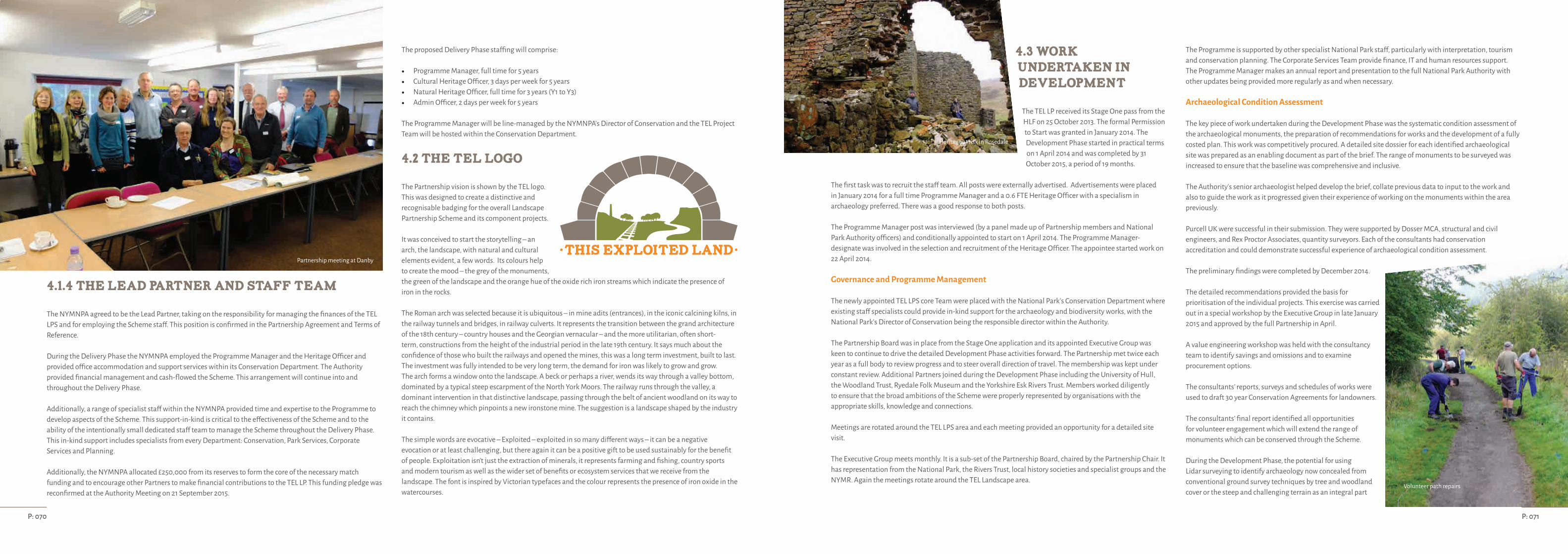
4.1.4 The Lead Partner and staff team
The NYMNPA agreed to be the Lead Partner, taking on the responsibility for managing the finances of the TEL LPS and for employing the Scheme staff. This position is confirmed in the Partnership Agreement and Terms of Reference.
During the Delivery Phase the NYMNPA employed the Programme Manager and the Heritage Officer and provided office accommodation and support services within its Conservation Department. The Authority provided financial management and cash-flowed the Scheme. This arrangement will continue into and throughout the Delivery Phase.
Additionally, a range of specialist staff within the NYMNPA provided time and expertise to the Programme to develop aspects of the Scheme. This support-in-kind is critical to the effectiveness of the Scheme and to the ability of the intentionally small dedicated staff team to manage the Scheme throughout the Delivery Phase. This in-kind support includes specialists from every Department: Conservation, Park Services, Corporate Services and Planning.
Additionally, the NYMNPA allocated £250,000 from its reserves to form the core of the necessary match funding and to encourage other Partners to make financial contributions to the TEL LP. This funding pledge was reconfirmed at the Authority Meeting on 21 September 2015.
The proposed Delivery Phase staffing will comprise:
• Programme Manager, full time for 5 years• Cultural Heritage Officer, 3 days per week for 5 years• Natural Heritage Officer, full time for 3 years (Y1 to Y3)• Admin Officer, 2 days per week for 5 years
The Programme Manager will be line-managed by the NYMNPA's Director of Conservation and the TEL Project Team will be hosted within the Conservation Department.
4.2 The TEL logo
The Partnership vision is shown by the TEL logo. This was designed to create a distinctive and recognisable badging for the overall Landscape Partnership Scheme and its component projects.
It was conceived to start the storytelling – an arch, the landscape, with natural and cultural elements evident, a few words. Its colours help to create the mood – the grey of the monuments, the green of the landscape and the orange hue of the oxide rich iron streams which indicate the presence of iron in the rocks.
The Roman arch was selected because it is ubiquitous – in mine adits (entrances), in the iconic calcining kilns, in the railway tunnels and bridges, in railway culverts. It represents the transition between the grand architecture of the 18th century – country houses and the Georgian vernacular – and the more utilitarian, often short-term, constructions from the height of the industrial period in the late 19th century. It says much about the confidence of those who built the railways and opened the mines, this was a long term investment, built to last. The investment was fully intended to be very long term, the demand for iron was likely to grow and grow.The arch forms a window onto the landscape. A beck or perhaps a river, wends its way through a valley bottom, dominated by a typical steep escarpment of the North York Moors. The railway runs through the valley, a dominant intervention in that distinctive landscape, passing through the belt of ancient woodland on its way to reach the chimney which pinpoints a new ironstone mine. The suggestion is a landscape shaped by the industry it contains.
The simple words are evocative – Exploited – exploited in so many different ways – it can be a negative evocation or at least challenging, but there again it can be a positive gift to be used sustainably for the benefit of people. Exploitation isn't just the extraction of minerals, it represents farming and fishing, country sports and modern tourism as well as the wider set of benefits or ecosystem services that we receive from the landscape. The font is inspired by Victorian typefaces and the colour represents the presence of iron oxide in the watercourses.
4.3 Work
Undertaken in
development
The TEL LP received its Stage One pass from the HLF on 25 October 2013. The formal Permission to Start was granted in January 2014. The Development Phase started in practical terms on 1 April 2014 and was completed by 31 October 2015, a period of 19 months.
The first task was to recruit the staff team. All posts were externally advertised. Advertisements were placed in January 2014 for a full time Programme Manager and a 0.6 FTE Heritage Officer with a specialism in archaeology preferred. There was a good response to both posts.
The Programme Manager post was interviewed (by a panel made up of Partnership members and National Park Authority officers) and conditionally appointed to start on 1 April 2014. The Programme Manager-designate was involved in the selection and recruitment of the Heritage Officer. The appointee started work on 22 April 2014.
Governance and Programme Management
The newly appointed TEL LPS core Team were placed with the National Park's Conservation Department where existing staff specialists could provide in-kind support for the archaeology and biodiversity works, with the National Park's Director of Conservation being the responsible director within the Authority.
The Partnership Board was in place from the Stage One application and its appointed Executive Group was keen to continue to drive the detailed Development Phase activities forward. The Partnership met twice each year as a full body to review progress and to steer overall direction of travel. The membership was kept under constant review. Additional Partners joined during the Development Phase including the University of Hull, the Woodland Trust, Ryedale Folk Museum and the Yorkshire Esk Rivers Trust. Members worked diligently to ensure that the broad ambitions of the Scheme were properly represented by organisations with the appropriate skills, knowledge and connections.
Meetings are rotated around the TEL LPS area and each meeting provided an opportunity for a detailed site visit.
The Executive Group meets monthly. It is a sub-set of the Partnership Board, chaired by the Partnership Chair. It has representation from the National Park, the Rivers Trust, local history societies and specialist groups and the NYMR. Again the meetings rotate around the TEL Landscape area.
The Programme is supported by other specialist National Park staff, particularly with interpretation, tourism and conservation planning. The Corporate Services Team provide finance, IT and human resources support.The Programme Manager makes an annual report and presentation to the full National Park Authority with other updates being provided more regularly as and when necessary.
Archaeological Condition Assessment
The key piece of work undertaken during the Development Phase was the systematic condition assessment of the archaeological monuments, the preparation of recommendations for works and the development of a fully costed plan. This work was competitively procured. A detailed site dossier for each identified archaeological site was prepared as an enabling document as part of the brief. The range of monuments to be surveyed was increased to ensure that the baseline was comprehensive and inclusive.
The Authority's senior archaeologist helped develop the brief, collate previous data to input to the work and also to guide the work as it progressed given their experience of working on the monuments within the area previously.
Purcell UK were successful in their submission. They were supported by Dosser MCA, structural and civil engineers, and Rex Proctor Associates, quantity surveyors. Each of the consultants had conservation accreditation and could demonstrate successful experience of archaeological condition assessment.
The preliminary findings were completed by December 2014.
The detailed recommendations provided the basis for prioritisation of the individual projects. This exercise was carried out in a special workshop by the Executive Group in late January 2015 and approved by the full Partnership in April.
A value engineering workshop was held with the consultancy team to identify savings and omissions and to examine procurement options.
The consultants’ reports, surveys and schedules of works were used to draft 30 year Conservation Agreements for landowners.
The consultants’ final report identified all opportunities for volunteer engagement which will extend the range of monuments which can be conserved through the Scheme.
During the Development Phase, the potential for using Lidar surveying to identify archaeology now concealed from conventional ground survey techniques by tree and woodland cover or the steep and challenging terrain as an integral part
P: 071P: 070
Partnership meeting at Danby
Heritage at risk in Rosedale
Volunteer path repairs
of the archaeological assessment works. No high resolution Lidar survey data was available for the TEL LPS area.
Consultation was carried out with English Heritage's specialist unit and with the South Downs National Park's HLF LiDar project team. There was a window of opportunity to carry out a survey during winter 2014-15 which would not reoccur until after Stage Two approval, the winter of 2016-17, well into the planned Delivery Phase. Lack of this knowledge would inhibit
the development of the volunteer programme of investigating, recording and conserving the lesser monuments.
The work was commissioned but limited by budget to the Murk Esk Valley which is the most wooded and challenging terrain, concealing the earliest stage of the industrial heritage, which includes the transition of the railway from horse-drawn to light steam to fully steam-hauled, a unique survival from the earliest days of railways.
Visitor Surveys
PCP Market Research were competitively procured to carry out a
range of visitor survey work and subsequent focus groups.
During the summer of 2014, visitor surveys were carried out at key visitor sites in the TEL LPS area and a parallel visitor survey was carried out in Middlesbrough, to the north of the National Park, to target non-users.
The brief for the survey work was informed by previous, wider survey work the National Park Authority had previously commissioned and the data and findings from the work was compared to the National Park's data with insights from the Authority's head of tourism and promotion.
Additional visitor surveys were carried out during the school Easter holiday period in 2015 to target families with children.
Two focus groups were carried out to further test the survey findings, one for visitors, held in York, and one for non-visitors, held in Middlesbrough.
Interpretation Strategy
PLB Projects were competitively procured to develop an Interpretation Strategy for the entire TEL LPS. The work was commissioned to get a better understanding of the audiences, current and target, and to consider the learning outcomes sought across the wider Landscape and at the key hubs.
The consultants were asked to look creatively at interpretation techniques and to review the original ideas collected during the development of the Stage One application. PLB's findings were analysed and assessed by the National Park's own interpretation and design officers to add an additional level of refinement and scrutiny.
A number of workshops were held during the consultation period with the Full Partnership and with the Executive Group to develop the thinking. The consultants also liaised with the communities in the ‘hubs’ and worked closely with the architects appointed for the Moors Centre proposals to help shape the final plans.The Interpretation Strategy was fully costed to inform the Delivery Plan.
Architectural Commission for works at the Moors National Park Centre
The Stage One application proposed to house new interpretation of the industrial and cultural heritage at the existing National Park visitor centre, the Moors Centre, in Danby, geographically right at the heart of the TEL landscape and, itself, the site of medieval iron smelting.
An architect's brief was prepared in consultation with the Authority's Park Services Department who manage the Centre and quotations invited. Local architectural firm BHD Partnership was the successful company.
Their brief was to look at the potential for accommodating the new interpretation within the existing building, particularly with a review of the non-public parts of the building, with limited new build. This limitation is a product of both the budget and the constricted site.
A number of options were considered and amended over an extended period to dovetail with the Interpretation Strategy work. A final Scheme with limited new build was agreed and submitted for planning consent.
Plantations on Ancient Woodland Sites (PAWS)TEL identified the potential for undertaking PAWS restoration across the entire Landscape area. Detailed data on these woodlands was limited so a woodland survey was commissioned for each woodland to inform the most appropriate approach to initiating restoration.
The TEL LP Team and National Park Woodland Officer worked closely with the Woodland Trust, as new partners, to develop the brief and methodology for assessment. The survey work was carried out by an independent consultancy, Woodlander Environmental, procured competitively, who demonstrated significant local knowledge as well as a useful combination of ecological and practical forestry knowledge.
The National Park Woodland Officer used the reports for initiating discussions with the relevant landowners and as the basis for entering into State Aid compliant 15 year Woodland Management Agreements to effect the works and contribute significant in-kind support.
Habitat Connectivity
During the Development Phase specialist officers from the National Park's Conservation Department undertook detailed assessments of the target landscape areas: the haymeadows and farmland in Rosedale and the riparian corridors along the Esk and Murk Esk. This work was substantial support in-kind to the TEL LPS.
Areas and landholdings were identified for intervention and a plan for each area developed. A lengthy period of engagement with individual farmers and landholders ensued resulting in detailed proposals for each holding and subsequently a provisional agreement between the National Park and the individual landholder. This work focussed on developing a sound programme of works that would commence from Year 1 using State Aid compliant 5 year Land Management Agreements.
Free passage for migratory fish
A number of man-made structures in the rivers impede the passage of migratory fish to reach their spawning grounds in the upper tributaries of the rivers. A number of key barriers for removal were identified and included within the Stage One application.
During the Development Phase, two barriers were surveyed and engineering solutions designed, costed and approvals sought. The consultant engineers were instructed to look at solutions for further sites which will be included as reserve projects.
Time in-kind from the National Park Rivers Officer was given to manage this work and to develop an agreement for one of these structures for progression in the first year of the Programme.
Water Voles
A detailed survey was commissioned to look at the water vole populations along the Esk and its tributaries. The water vole population is sparse and fragmentary.
The findings of this report have been built into the Habitat Connectivity programme and into potential actions at Fen Bog and in-kind support provided via the National Park's ecologist for establishing the brief, managing procurement and for helping to interpret the results and to integrate findings into the Stage 2 submission.
Bat survey work
The Archaeological Condition Assessment work flagged up the need to undertake bat surveys at each of the sites. A scoping survey was commissioned and Wold Ecology appointed to undertake the work. The purpose of this was to identify bat presence or likely presence and to assess the implications for the Delivery Phase construction works. The National Park's ecologist provided in-kind support for assessing the findings of the reports.
Minewater Discharge
A report by the University of Hull on historic minewater discharges was published after the Stage One application was submitted.
During the Development Phase, the TEL LPS Team established a new Partnership with the Environment Agency (EA) and the University of Hull to investigate the potential for undertaking minewater remediation and the potential for an early pilot project.
EA secured sufficient funding to undertake a pilot project. Public consultation was undertaken and agreement with the landowner and the shooting rights owner was secured to undertake the works during 2014-15 financial year.
The works were undertaken in March 2015 using local specialist contractors, assisted by volunteers from the University and the National Park.
Further funding has been secured by EA for two further Schemes during 2015-16.
“When the bilberries are exhausted, then down come the moor blackbirds; and if they are let alone, they show that bilberries are better appetisers than sherry-biters, or even than the roasted solan. I have literally seen them fifty at a time in this garden, on occasions when they had been left undisturbed for two or three days ”
The ways of the Ring Ousel. Rev. J. C. Atkinson. 1891. Forty Years in a Moorland Parish.
P: 073P: 072
Rope access inspection at Warren Moor
Fen Bog
Ring Ouzel (John Knight)

Communications
A quarterly electronic newsletter is produced and distributed to a ‘wider interest group’ of individuals and organisations. People are invited to register to receive this newsletter and continue to do so.
A number of blogs have been produced picking up on aspects of the TEL LP, written by a variety of authors including Executive members, landowners, special interest groups and key staff. The blog has been well received. The National Park's social media (Facebook and Twitter) accounts have been used to promote the Scheme, its aspirations and to flag up other communication routes.
During the Development Phase, the TEL LP Team has given talks to a wide variety of local and regional groups about the ironstone and railway history and how the Scheme plans to deliver its work. These invitations continue to be received and are forward planned well into 2016.
TEL LPS has been featured in the press. Articles have been published in The Times, the Northern Echo and in a range of local newspapers. The Team have produced articles for reproduction in local community publications.
BBC Radio York and BBC Radio Tees have each had major interviews about the Scheme. Radio Tees did a guided walk through the landscape with the Programme Manager which was transmitted during National Parks Week in July 2015 and has offered to carry more stories and reports as the Scheme develops. They shared images and a video on social media.
The TEL LPS Team registered the Scheme for the Heritage Open Day programme in 2015 which celebrated ‘European Industrial and Technical Heritage Year’. The Team managed a programme of walks and information points at two sites, Rosedale and Grosmont, over the weekend in September. Historic England selected the sites for inclusion in their ’10 Industrial Gems to Visit During Heritage Open Days’ webpage, at Number One in the list nationally!
In addition the Team has supported Cleveland Industrial Archaeological Society's annual guided walk and other local history society events.
Community engagement has carried on throughout the Development Phase. The Team has taken displays and information out to a number of local agricultural shows and has developed an interactive arch-building activity to engage families with children, and others, in the world of ironstone and railways.
The Team has established new linkages with a range of local museums with a common interest in the industrial heritage. These include Ryedale Folk Museum, Beck Isle Museum in Pickering, Whitby Museum and reconfirmed its partnership with the Cleveland Ironstone Mining Museum.
4.4 Outcomes and Outputs
4.4.1 Outcomes
The ambition of the TEL LPS is to enable positive changes, impacts and benefits for heritage, people and communities of the area. In considering the outcomes the whole Scheme will target all of the LPS objectives for HLF, with each of the TEL LPS themes and projects targeting a range of outcomes. As a whole the different aspects of the Scheme (historic environment, natural environment, access, interpretation and community engagement, cross-cutting and project management) contribute in different ways to ensuring objectives of the LPS and outcomes for HLF are successfully met.
These HLF outcomes include:
Outcomes for heritage: • H1 - Heritage will be better managed;• H2 -Heritage will be in better condition; and • H3 -Heritage will be identified/recorded.
At the completion of the TEL LPS there will be clear improvements in the way that cultural and natural heritage is managed, it will be in a better condition, and will be much better identified and recorded. The TEL LPS will involve some cultural heritage and biological recording. This will comply with HLF best practice for projects and related digital outputs.
Outcomes for people: • P1 - People will have developed skills; • P2 - People will have learnt about heritage; and • P3 - People will have volunteered time.
At the completion of the TEL LPS people will have developed skills and learnt about heritage from a range of formal and informal engagements across the TEL LPS area, many more people will have had the opportunity to take ownership of heritage through a very broad range of volunteering opportunities. All digital outputs created through the TEL LPS will comply with HLF best practice.
Outcomes for communities: • C1 - Negative environmental impacts will be reduced; • C2 -More people and a wider range of people will have engaged with heritage; and • C3 -The local area/community will be a better place to live, work or visit.
At the completion of the TEL LPS the local area will be a better place to live, work and visit as communities will have taken ownership of their heritage and shared it with a wider range of people, at the same time negative environmental impacts will be reduced and the TEL LPS area will be more resilient for its future generations. All
building and interpretation materials used through the TEL LPS will comply with HLF best practice for reducing negative environmental impacts.
The success or otherwise of reaching these outcomes will be reported on to HLF and will contribute a significant element of the evaluation that will be ‘embedded’ within the TEL LPS.
The outcomes are detailed within each of the projects detailed in Part Three of the LCAP and tabulated for the whole Scheme below:
4.4.2 Outputs
Alongside these outcomes each of the projects within the TEL LPS will contribute to a number of quantitative and qualitative outputs. The predicted quantitative outputs relate to the HLF outputs overall, but are refined for the TEL LPS and its individual projects. For a number of these projects the delivery details will be established in the first years of the TEL LPS.
Project area
Some 182.5km2 of the North York Moors National Park will be the focus of the TEL LP.
Advice and support
We anticipate at least 178 landowners / land managers will be engaged through built heritage, natural heritage or access, interpretation and engagement activities. Management agreements in place include:• 97 land managers contacted in Development Phase for Connectivity works resulting in 27 Biodiversity
Agreements starting in Year 1. We anticipate further engagement with these land managers for Years 2 to 5. • 5 land owners contacted in relation to PAWS restoration work resulting in 5 agreements for Year 1; further
engagement with additional land managers will be targeted for Years 2 to 5 agreements. • 4 land owners engaged for work on archaeological sites.
Biodiversity and Landscape Features
In the agreements that have already been finalised for delivery in Year 1 of the Scheme we anticipate:
• Work to maintain, restore, expand and achieve condition of 19.82 ha Lowland meadow • Work to restore 0.81 ha Purple moor grass & rush pasture• Work to maintain 18.87 ha Upland heathland • Work to maintain, restore, expand and achieve condition of 26.64 ha Lowland mixed deciduous woodland• Work to achieve condition of 0.16 ha Traditional orchard• Work to restore 0.71 ha Wood pasture• Work to restore 229.97 ha PAWS • Work to maintain extent of 0.03 ha Upland flushes• Work to expand 2 ponds• Work to restore 5.1 km River• Work to restore and expand 9.72 km Riparian habitat• Work to restore, expand and achieve condition of 7.9 km Hedgerows • Work to restore 0.35 km drystone walling • Work to restore 3.39 km fencing • Work to plant 178 individual trees
Habitat improvements will also benefit specific species including European eel, Brown/sea trout, Brook lamprey, Atlantic salmon, Water vole, ring ouzel and Wild daffodil.
Ref Project title H1 H2 H3 P1 P2 P3 C1 C2 C3 Arch 01 Historic Rail Trail Arch 02 Comb’s Wood Arch 03 Esk Valley Mine Arch 04 Grosmont Ironworks Arch 05 Warren Moor Mine Arch 06 Rosedale East Arch 07 Rosedale West Arch 08 Landslip and Reeking Gill Arch 09 Community Archaeology Arch 10 Rosedale Railway at Dalehead Arch 11 Sheriff’s Pit Arch 12 LiDar Survey Bio 1 Free Passage for Migratory Fish Bio 2 Esk habitat connectivity Bio 3 Murk Esk habitat connectivity Bio 4 Rosedale habitat connectivity Bio 5 PAWS Bio 6 Comb’s Wood Bio 7 Fen Bog Bio 8 Rosedale Ring Ouzels Bio 9 Water Voles Bio 10 Habitat monitoring
Bio 11 Minewater discharge Int 01 Telling the Story Int 02 Industry at the Moors Centre Int 03 Telling the Story at Grosmont Int 04 Telling the Story at Rosedale Int 05 Taking the Story to the People Int 06 Events Programme Int 07 Walks in the Land of Iron Int 08 Rail Trail Int 09 Rosedale Railway Int 10 TEL Web Presence Int 11 The Ironstone Tapestry Int 12 Our Exploited Land on Film Int 13 TEL Publications Int 14 TEL Audio Drama CC 01 Training Programme CC 02 Ironstone Volunteers CC 03 TEL Education Programme CC 04 TEL Community Grants Scheme CC 05 Visitor Giving and Sponsorship CC 06 TEL Legacy CC 07 Grosmont Conservation Area CC 08 Conservation Areas Review CC 09 Creating the Record PM 01 Managing the Programme PM 02 Programme Costs PM 03 Evaluating the TEL Scheme PM 04 Post HLF Programme Management
P: 075P: 074

Further outputs for natural environment works will be confirmed in the subsequent years of the Scheme.
Built heritage features (industrial features)
• 9 Grade II Listed structures will be recorded, repaired, conserved and interpreted.• 6 Undesignated historic features will be recorded, repaired, conserved and interpreted.• 2 Scheduled Monuments will be recorded, repaired, conserved and interpreted.
Altogether these comprise 7 structures relating to mining and extraction, 2 bridges and features along 2 railways.
Other: 2 additional sites will be designated as listed buildings, 1 Conservation Area will be designated, and HER records across the TEL LPS will be improved and added to.
Access
• A new permanent space for learning will be created.• 3 visitor information hubs will be developed at key locations in the landscape.• A mobile display unit will take the story outside the TEL LPS area.• Across the Scheme area sites and landscape features will be interpreted and signposted.• 2 footpaths will be improved (repaired) in an existing 19 km of walks that re-use old railways (Rosedale and
the Historic Rail Trail).• 1 ‘trail’ will be devised that links the historic sites and makes use of existing footpaths. • A project website, film and legacy artwork will be created. • A range of leaflets and guides will be created to help tell the story and navigate through the landscape. • A range of events will take place including heritage open days, festival of archaeology, film shows,
‘travelling’ art and site specific events. • Further outputs for access, engagement and interpretation will be confirmed in the subsequent years of the
Scheme.
Participation and learning activities
• Primary schools and secondary schools will take part in a range of learning activities. We anticipate that for each school within the TEL Scheme area, we will target 1 from outside the TEL Scheme area.
• FE and HE institutions, youth and community groups will be targeted with a range of learning resources and outreach.
Employment
Staffing for the Scheme will comprise Programme Manager (F/T) for 5 years, Cultural Heritage Officer (P/T 0.6) for 5 years, Natural Heritage Officer (F/T) for Y1 to Y3, Volunteer co-odinator (P/T 0.6) for 5 years, Administrative Support (P/T 0.4) for 5 years. The wider impact of the LP Scheme on local employment or the economy will be considered in the evaluation of the Scheme (which will begin in Year 1). At this stage we anticipate external contractors to deliver works with a value of c. £2.5 million.
Training and Skills
The Scheme will also support 2 graduate trainees each on a two year programme, 3 apprentices each on a two year programme, 6 student placements each for 13 weeks. Training will also be delivered in a very wide range of land management, heritage conservation, tourism, participation and interpretation activities.
Volunteers
The TEL LPS aims to recruit 200 volunteers, to take part in a predicted 18,000 days of activity. The Scheme will offer a very wide range of ‘packages’ for volunteers including ecological work, community archaeology, access works and education.
Community grants
The TEL LPS will deliver a community grants project worth £100,000 that will enable local groups to deliver small projects across the TEL LPS area.
4.5 Outline of financial arrangements
The National Park Authority will create a Common Fund for the TEL Scheme, administered separately from its core budgets. Cash contributions from Partners, sponsors and other funders will be credited to the Common Fund.
The NYMNPA has established accounting procedures and is governed by an approved raft of Standing Orders. North Yorkshire County Council acts as the accountable body and the NYMNPA accounts are subject to an annual external audit.
Records are kept of all financial transactions and all revenue and expenditure are coded to the This Exploited Land budget. All records are available to substantiate grant claims.
Partners and delivery agents will enter into formal contractual agreements with the NYMNPA using standard forms of contract. The TEL Project Team and the NYMNPA Finance Team will be responsible for monitoring compliance with contractual conditions before release of payments or interim payments.
The Programme Manager will be responsible for the timely submission of a Quarterly Progress Report to HLF in parallel with a Quarterly Payment Request in arrears.
These arrangements worked satisfactorily during the Development Phase.
Scheme costs compared with Stage One
During the Development Phase, the Partnership and its Executive Group endeavoured to ensure that the detailed Stage Two proposals and budgets retained the balance of spending and activity proposed at Stage One, as set out in the comparison table above. Prioritisation exercises were carried out at each stage of development to ensure that the envisaged core key projects were viable, affordable and practically deliverable and to affirm that none of the overall Scheme ambition was lost. Wherever possible, project ideas have been developed to ensure that opportunities and options were considered as part of the evaluation. The increase in proposed project numbers and the better understanding of the needs and resources required for successful, sustainable delivery meant that the proposed Scheme staffing has been strengthened but within the spirit and thinking presented at Stage One.
Proposed budget spreadsheets and cash-flow projections have been prepared and submitted to HLF as appendices to the Stage Two application documentation. A Delivery Phase overall timetable is included in Part Two.
Part Two of the LCAP is the summary of the 50 individual projects which make up the TEL Scheme.
Full project details for each of the 50 projects are set out in Part Three of the LCAP. Each project proposal contains a project description, details of location, delivery partner, consents and agreements entered into, planned outcomes and outputs, timetable, risk analysis and costs.
Volunteer time is critical to the successful delivery of TEL. The volunteer targets are ambitious but achievable and are in line with the NYMNPA experience. However, the significant cash value of this volunteer time has been excluded from the budget but will be carefully monitored, recorded and reported.
Match funding
Secured match
The NYMNPA has contributed the core match funding of £250,000 from its Reserves. This funding has been formally agreed by the Authority and confirmed at its meeting on 21 September 2015.
In addition, the NYMNPA has identified £67,500 of revenue funding from its annual budgets to be provided as match funding.
Landowners and land managers entering into land management agreements to deliver natural environment projects will make a 25% contribution to costs.
A number of Partner organisations have confirmed match funding for specific projects which are set out in detail in the project plans in Part Three.
Sources and Unsecured match
Further match funding is required to deliver the entire planned TEL Scheme. A funding strategy is in place with support from the Partnership. A number of specific grant targets have been identified and investigated and funding applications will be considered once the main programme has secured its approval from HLF. Anapplication has been made for substantial funding from an independent charitable trust. A decision is due in early November 2015.
Context of the TEL LPS
The long period of project development coincided with significant economic restraint within the public sector, and this is reflected in the match funding limitations faced by the TEL LPS partners.
The negotiations with landowners and land managers has also been impacted by the introduction of new and replacement agri-environment schemes at the national level.
The Overall Budget
The overall budget is reflected in the projects proposed, the Essential projects will be delivered in the Scheme, with Desirable and Aspirational projects delivered should further match funding be secured during the Delivery Phase of the TEL LPS. The Desirable Projects are worked up projects with details, costs and consents in place and are to be regarded as ‘Reserve’ projects which can be brought forward should either a planned project not go ahead for any reason or should additional external funding be secured. The Development Phase activity and the continuing community engagement have confirmed that there is significant scope to expand the Scheme if resources allow and the Aspirational Projects give sense of the wider appetite and scale of work that could be undertaken.
P: 077P: 076
THEME
ArchaeologyBiodiversity
InterpretationCross cutting
Programme ManagementContingencies
HLF GrantMatch funding
Total Scheme value
STAGE ONE£
1,040,000719,000695,000410,000465,000120,000
2,802,000647,000
3,449,000
STAGE TWO£
984,111719,000660,000446,000630,48380,000
2,802,000717,594
3,519,594
Rosedale West kilns

State Aid
The TEL Biodiversity Scheme Agreements that are included within the natural environment costs submitted as part of this application are either compliant with the State Aid approved Scheme SA.36578 (2013/N) “Environmental Enhancement Through Agriculture, National Parks (England and Wales)” or implemented under EC Regulation 1860/2004 – de minimis aid in the agricultural sector.
The North York Moors National Park Authority is recognised as the lead Authority for securing agricultural state aid clearance from the European Commission, working on behalf of the English and Welsh National Park Authorities, and is currently working on a new submission that will continue to ensure that all future biodiversity works committed to under the TEL Programme will be compliant with EC Regulation 702/2014 or EC Regulation 1408/2013 – de minimis aid in the agricultural sector.
4.6 Legacy and Sustainability
It is an ambition of the TEL LP that the achievements, community passions and knowledge base created by TEL continue to be sustained beyond the life of the HLF funding programme and will ensure a sustainable future for the natural and cultural heritage, its landscape context and the knowledge base developed and supported through the Scheme. The TEL LP has developed from community participation and involvement and demonstrates to the local community how engagement and research can result in positive changes to the management of the National Park. As this enthusiasm was the catalyst for the Scheme, the legacy and sustainability of the TEL LP will be generated by sharing, extending and spreading enthusiasm and passion. Evaluation will be a central, embedded element in the TEL LP and will inform project delivery, and lessons learned will be important to reflect upon in refining legacy and sustainability planning through the Scheme.
Legacy project
A stand-alone legacy project is included within the Scheme. The aim of this project is to ensure continuity of engagement in the LP beyond the life of the HLF funding. There are a number of initiatives that have potential to support and ensure the legacy of the TEL LPS vision. For example continuation of the partnership structures with facilitation from the National Park Authority beyond the life of the current Scheme and support from the already established groups. This may also involve considering how the work of the Partnership may be supported via the developing North York Moors Trust, which is currently in the process of being scoped out and potentially established. It is however recognised that much more discussion is required within the TEL Partnership and Executive Group regarding the future role any trust might play. The scope and scale of these initiatives will be developed from the mid-point of the TEL LP Scheme, with the results used to inform the final years of delivery. Already there is a keen appetite for formalising and securing the ‘legacy’, and the TEL LP developed from existing networks of local history and interest groups.
The development of the legacy project will be undertaken by TEL LP staff, and some of the LPS project budget has been allocated for this initiative. A separate project is concerned with establishing visitor giving and sponsorship Scheme. This is intended to create a source of match funding, and if successful, legacy funding. The initiatives and enthusiasm generated through these companion projects will ensure legacy and sustainability beyond the life of the TEL LP.
In addition to this specific initiative the LPS will deliver a broader range of legacy and sustainability ambitions across the Scheme area. These are very diverse but are captured broadly as follows:
Enhanced understanding leads to changes in protection status
The statuary protection of cultural and natural heritage will be improved across the TEL LP area. For example, the Conservation Area designation for Grosmont will protect the special qualities of the village beyond the lifetime of the TEL LPS; this will help raise the profile of the village and its development as a tourist destination. In a number of cases enhanced understanding that leads to changes in protection status has already been demonstrated in the Development Phase, for example:
• The results of the Lidar survey(s) are already being used to improve the quality of the HER records held by the NPA, adding further sites and enriching knowledge of ‘known’ sites. The addition of these features of interest to the HER will enhance their protection through the planning system.
• The assessment of woodland sites has revealed further PAWS in the NYMNP, this better understanding of the current resource will be mapped and can help to enhance their management and the overall picture of the woodland habitat networks in the locality.
• The mapping and assessment of land holdings has revealed further areas and features of interest, this extends knowledge of priority species and habitats enabling better mapping of current resource and can helps to enhance their management.
Partner's obligations for better management continue beyond the life of the HLF funding
Bodies consulted in the development of this Scheme will ensure success of the project beyond the life the TEL LPS. For example:• A cost is assigned to Highways Agency for the adoption of the fish passes Scheme; and• Features that are owned by local authorities are already committed to maintaining public access, for example
the Historic Rail Trail is within the ownership of the NPA and the site of Grosmont Ironworks is owned by Scarborough Borough Council.
Community ownership of the interpretation hubs will become the responsibility of the project Partners (Grosmont Heritage / Rosedale History Group) who are committed to developing and maintaining the displays. Both have a strong track record of active service and excellent connections with the local business forums and the local community in general. Moreover the TEL LPS ‘fits’ within the wider context of the 2012 NYMNPA Management Plan (which will be updated in the lifetime of the Scheme). As such the context of the work assures the legacy and sustainability of this initiative beyond the TEL LPS period. Owners’ responsibilities will be reinforced, with better knowledge of management best practice and the sense of stewardship enhanced and access improved
The TEL LPS projects reinforce land owner and manager responsibilities with regard to their stewardship of heritage and their maintenance and management of heritage assets. The TEL LPS will use an intelligent mix of appropriate tools for agreeing these actions and responsibilities depending on the complexity and nature of the situation. For example fully land charged and detailed agreements for more complex Schemes or a simple exchange of letters for simple standalone action. The NPA has a strong track record of using a range of tools with landowners and managers that will be brought to bear on TEL. The main tools are set out below but the project plans in Part Three detail out the specific examples further:
Section 39 Agreements under the Wildlife and Countryside Act 1981 on key monuments will provide for landowner maintenance of the conserved sites for a period of 30 years. These agreements will also be land charged to ensure that the commitments to conservation carry forward should the land change hands or be tenanted.
Additional or extended access rights will be considered and secured through negotiation with landowners through Section 39 Agreements (where appropriate and desirable) or where more appropriate separate access agreements can be prepared and negotiated to extend or improve access using permissive rights, for example to provide bridleway access where there is only currently access on foot or to secure access where there is currently none at all. Maintenance of such rights may be undertaken by the landowner or the National Park Authority depending on the circumstances. Each of the project plans in Part Three of this LCAP include details of landowner agreements be they Section 39 Agreements, access licences or otherwise.
Other landowners including the Forestry Commission have agreed to enter into Woodland Management Agreements which will ensure long-term improved management of forestry or woodland blocks where a number of TEL LPS project(s) will be delivered. Woodland Management Agreements will be 15 years in length, showing considerable commitment, as well as also being land charged, adding further security. They will include a schedule of commitments that the landowner will commit to ensure that the desired outcomes are achieved.
For wider land management for habitat connectivity and other natural and cultural heritage benefits 5 year Management and Capital Agreements, again under Section 39 of the Wildlife and Countryside Act, will be used which will also include significant commitment from the land owner or manager to the desired outcomes. Clauses will be added to these agreements to ensure the protection and maintenance of measures under the agreements for a further 5 years. Knowledge of best practice will be developed through these agreements and by working with those who enter into them, providing wider benefits to the area. It is hoped that work undertaken through these agreements will be sustained and/or strengthened through other Schemes and grants as confidence grows in those involved and improvements are made making them more able to access other Schemes (e.g. national agri-environment Schemes).
Through these various agreements and as a result of our ongoing engagement and partnership working with landowners and managers the Scheme will create a clearer awareness and an increased knowledge of methods appropriate for enhancing land management to ensure better cultural and natural heritage outcomes. The aim is to support land managers and owners so that they can provide the best possible stewardship of the area's heritage, which will contribute significantly to the legacy and sustainability of the TEL LPS.
Trainees and volunteers build enthusiasm that last beyond the LPS
The TEL LPS training and volunteer programme is at the heart of the Scheme's legacy plan, ensuring skills and experience are shared and lives are enriched beyond the life of the Scheme. A successful training and volunteer programme will therefore share, extend and spread enthusiasm and passion for the Scheme's focus. For example:
The creation of shared ownership and interest will contribute to and ensure a lasting legacy. Dedicated, project specific volunteer groups will continue beyond the funded programme to deliver a range of management and maintenance plans for key historic and natural habitats, interpretation and local history specialists will continue to manage information hubs, and will lead guided walks and tours and to ensure that on-site interpretation panels are maintained in good order.
The volunteer and training programme will ensure engagement with the Scheme beyond the life of the TEL LPS. The engagement of trainees and volunteers through the TEL LPS will enable projects/surveys to be undertaken in future years and data captured, managed and utilised to best effect.
The additional opportunities for engagement created by the volunteer programme will encourage monitoring and maintenance of the capital works. This builds upon existing local passions, for example the Rosedale History Group have undertaken photographic monitoring of the Rosedale East land slip over the last few years and fixed point photography by volunteer survey effort has been established for the local wild daffodil populations. The TEL LPS team will ensure best practice and enthusiasm will continue beyond the life of the TEL LPS linking into wider recording Schemes.
Events and education experience are remembered and the resources created enable activities beyond the TEL LPS
The activities and materials produced through the TEL LPS will continue to be used after the life time of the Scheme, and this may be supported by a broad range of local providers, such as the NYMR and local museums which provides opportunities to widen the scope of delivery during and after the lifetime of the Scheme. The aspiration of the TEL LPS education and events project is to engage a new generation with the landscape and its historical and natural values and encourage visitors and children to ‘remember’ the visit. This aspiration is difficult to measure during the lifetime of the Scheme and might only be demonstrated when future generations return to the National Park to share stories and experiences with their own children or indeed to take up a wider interest and commitment to heritage conservation regardless of geographic location.
Contributions to companion & future projects
A number of projects are central elements of the TEL LPS but will last beyond the life of the TEL LPS. For example ‘walks’ will provide links between key sites and around the landscape as a whole, whilst the digital resources and online communities generated through the project will ensure longevity and sustainability beyond the life of the TEL LPS. A number of projects also build upon past Schemes delivered by the NPA or local groups. For example the Rosedale Ring Ouzel project builds upon 15 years of voluntary survey of this priority species, and the aspirational Minewater Discharge Scheme builds upon the work undertaken by an MSc student at the University of Hull, who has
P: 079P: 078
Iron Kilns at Rosedale East
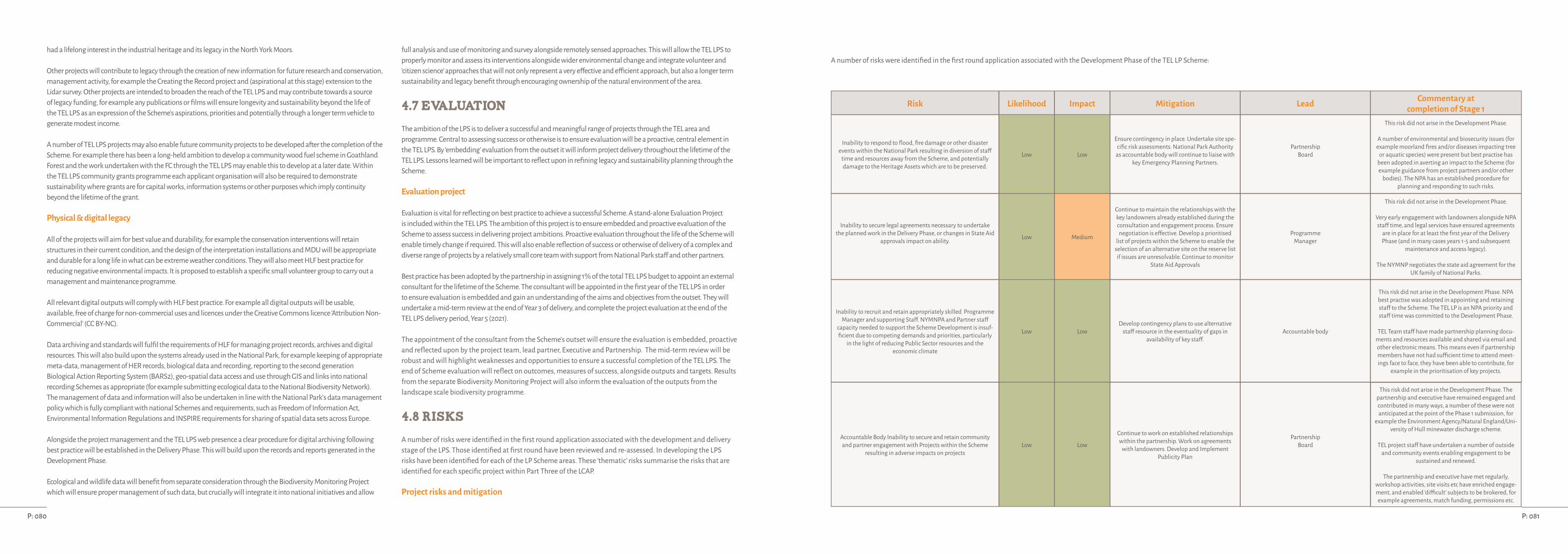
had a lifelong interest in the industrial heritage and its legacy in the North York Moors.
Other projects will contribute to legacy through the creation of new information for future research and conservation, management activity, for example the Creating the Record project and (aspirational at this stage) extension to the Lidar survey. Other projects are intended to broaden the reach of the TEL LPS and may contribute towards a source of legacy funding, for example any publications or films will ensure longevity and sustainability beyond the life of the TEL LPS as an expression of the Scheme's aspirations, priorities and potentially through a longer term vehicle to generate modest income.
A number of TEL LPS projects may also enable future community projects to be developed after the completion of the Scheme. For example there has been a long-held ambition to develop a community wood fuel scheme in Goathland Forest and the work undertaken with the FC through the TEL LPS may enable this to develop at a later date. Within the TEL LPS community grants programme each applicant organisation will also be required to demonstrate sustainability where grants are for capital works, information systems or other purposes which imply continuity beyond the lifetime of the grant.
Physical & digital legacy
All of the projects will aim for best value and durability, for example the conservation interventions will retain structures in their current condition, and the design of the interpretation installations and MDU will be appropriate and durable for a long life in what can be extreme weather conditions. They will also meet HLF best practice for reducing negative environmental impacts. It is proposed to establish a specific small volunteer group to carry out a management and maintenance programme.
All relevant digital outputs will comply with HLF best practice. For example all digital outputs will be usable, available, free of charge for non-commercial uses and licences under the Creative Commons licence ‘Attribution Non-Commercial’ (CC BY-NC).
Data archiving and standards will fulfil the requirements of HLF for managing project records, archives and digital resources. This will also build upon the systems already used in the National Park, for example keeping of appropriate meta-data, management of HER records, biological data and recording, reporting to the second generation Biological Action Reporting System (BARS2), geo-spatial data access and use through GIS and links into national recording Schemes as appropriate (for example submitting ecological data to the National Biodiversity Network). The management of data and information will also be undertaken in line with the National Park's data management policy which is fully compliant with national Schemes and requirements, such as Freedom of Information Act, Environmental Information Regulations and INSPIRE requirements for sharing of spatial data sets across Europe.
Alongside the project management and the TEL LPS web presence a clear procedure for digital archiving following best practice will be established in the Delivery Phase. This will build upon the records and reports generated in the Development Phase.
Ecological and wildlife data will benefit from separate consideration through the Biodiversity Monitoring Project which will ensure proper management of such data, but crucially will integrate it into national initiatives and allow
full analysis and use of monitoring and survey alongside remotely sensed approaches. This will allow the TEL LPS to properly monitor and assess its interventions alongside wider environmental change and integrate volunteer and ‘citizen science’ approaches that will not only represent a very effective and efficient approach, but also a longer term sustainability and legacy benefit through encouraging ownership of the natural environment of the area.
4.7 Evaluation
The ambition of the LPS is to deliver a successful and meaningful range of projects through the TEL area and programme. Central to assessing success or otherwise is to ensure evaluation will be a proactive, central element in the TEL LPS. By ‘embedding’ evaluation from the outset it will inform project delivery throughout the lifetime of the TEL LPS. Lessons learned will be important to reflect upon in refining legacy and sustainability planning through the Scheme.
Evaluation project
Evaluation is vital for reflecting on best practice to achieve a successful Scheme. A stand-alone Evaluation Project is included within the TEL LPS. The ambition of this project is to ensure embedded and proactive evaluation of the Scheme to assess success in delivering project ambitions. Proactive evaluation throughout the life of the Scheme will enable timely change if required. This will also enable reflection of success or otherwise of delivery of a complex and diverse range of projects by a relatively small core team with support from National Park staff and other partners.
Best practice has been adopted by the partnership in assigning 1% of the total TEL LPS budget to appoint an external consultant for the lifetime of the Scheme. The consultant will be appointed in the first year of the TEL LPS in order to ensure evaluation is embedded and gain an understanding of the aims and objectives from the outset. They will undertake a mid-term review at the end of Year 3 of delivery, and complete the project evaluation at the end of the TEL LPS delivery period, Year 5 (2021).
The appointment of the consultant from the Scheme's outset will ensure the evaluation is embedded, proactive and reflected upon by the project team, lead partner, Executive and Partnership. The mid-term review will be robust and will highlight weaknesses and opportunities to ensure a successful completion of the TEL LPS. The end of Scheme evaluation will reflect on outcomes, measures of success, alongside outputs and targets. Results from the separate Biodiversity Monitoring Project will also inform the evaluation of the outputs from the landscape scale biodiversity programme.
4.8 Risks
A number of risks were identified in the first round application associated with the development and delivery stage of the LPS. Those identified at first round have been reviewed and re-assessed. In developing the LPS risks have been identified for each of the LP Scheme areas. These ‘thematic’ risks summarise the risks that are identified for each specific project within Part Three of the LCAP.
Project risks and mitigation
A number of risks were identified in the first round application associated with the Development Phase of the TEL LP Scheme:
Risk Likelihood Impact Mitigation Lead Commentary at completion of Stage 1
Inability to respond to flood, fire damage or other disaster events within the National Park resulting in diversion of staff
time and resources away from the Scheme, and potentially damage to the Heritage Assets which are to be preserved.
Low Low
Ensure contingency in place. Undertake site spe-cific risk assessments. National Park Authority
as accountable body will continue to liaise with key Emergency Planning Partners.
PartnershipBoard
This risk did not arise in the Development Phase.
A number of environmental and biosecurity issues (for example moorland fires and/or diseases impacting tree
or aquatic species) were present but best practise has been adopted in averting an impact to the Scheme (for example guidance from project partners and/or other
bodies). The NPA has an established procedure for planning and responding to such risks.
Inability to secure legal agreements necessary to undertake the planned work in the Delivery Phase, or changes in State Aid
approvals impact on ability. Low Medium
Continue to maintain the relationships with the key landowners already established during the consultation and engagement process. Ensure negotiation is effective. Develop a prioritised
list of projects within the Scheme to enable the selection of an alternative site on the reserve list if issues are unresolvable. Continue to monitor
State Aid Approvals
ProgrammeManager
This risk did not arise in the Development Phase.
Very early engagement with landowners alongside NPA staff time, and legal services have ensured agreements
are in place for at least the first year of the Delivery Phase (and in many cases years 1-5 and subsequent
maintenance and access legacy).
The NYMNP negotiates the state aid agreement for the UK family of National Parks.
Inability to recruit and retain appropriately skilled Programme Manager and supporting Staff. NYMNPA and Partner staff
capacity needed to support the Scheme Development is insuf-ficient due to competing demands and priorities, particularly
in the light of reducing Public Sector resources and theeconomic climate
Low LowDevelop contingency plans to use alternative
staff resource in the eventuality of gaps in availability of key staff.
Accountable body
This risk did not arise in the Development Phase. NPA best practise was adopted in appointing and retaining staff to the Scheme. The TEL LP is an NPA priority and staff time was committed to the Development Phase.
TEL Team staff have made partnership planning docu-ments and resources available and shared via email and other electronic means. This means even if partnership members have not had sufficient time to attend meet-ings face to face, they have been able to contribute, for
example in the prioritisation of key projects.
Accountable Body Inability to secure and retain community and partner engagement with Projects within the Scheme
resulting in adverse impacts on projectsLow Low
Continue to work on established relationships within the partnership. Work on agreements
with landowners. Develop and Implement Publicity Plan
PartnershipBoard
This risk did not arise in the Development Phase. The partnership and executive have remained engaged and contributed in many ways, a number of these were not anticipated at the point of the Phase 1 submission, for
example the Environment Agency/Natural England/Uni-versity of Hull minewater discharge scheme.
TEL project staff have undertaken a number of outside and community events enabling engagement to be
sustained and renewed.
The partnership and executive have met regularly, workshop activities, site visits etc have enriched engage-ment, and enabled ‘difficult’ subjects to be brokered, for example agreements, match funding, permissions etc.
P: 081P: 080

Risk Likelihood Impact Mitigation Lead Commentary at completion of Stage 1
Inability to respond to flood, fire damage or other disaster events within the National Park resulting in diversion of staff
time and resources away from the Scheme, and potentially damage to the Heritage Assets which are to be preserved.
Low Low
Ensure contingency in place. Undertake site spe-cific risk assessments. National Park Authority
as accountable body will continue to liaise with key Emergency Planning Partners.
Partnership Board
This risk was considered low / low at the Phase 1 submission and remains low / low for the Delivery Phase of the Scheme.
The NPA has an established procedure for planning and responding to such risks.
Inability to recruit and retain appropriately skilled Programme Manager and supporting Staff.
NYMNP and Partner staff capacity needed to support the Scheme Delivery is insufficient due to competing
demands and priorities, particularly in the light of reducing Public Sector resources and the economic climate
Low LowDevelop contingency plans to use alternative
staff resource in the eventuality of gaps in avail-ability of key staff.
Accountable body
This risk was considered low / low at the Phase 1 submis-sion and remains low / low for the Delivery Phase of the
Scheme. The staffing for the TEL LP Delivery has been reviewed and has increased (marginally) to reflect the needs and ambition of the TEL LP and decreasing sup-port NPA will be able to provide for the Delivery Phase.
Moreover a number of ‘reserve’ projects are identified, this means there are options should any projects fail to
be delivered as a result of public sector reductions.
Inability to secure and retain community and partner engage-ment with Projects within the Scheme resulting in adverse
impacts on projectsLow Low
Continue to work on established relationships within the partnership. Work on agreements
with landowners. Develop and Implement Publicity Plan
Partnership Board
This risk was considered low/ low at the Phase 1 submis-sion and remains low/ low for the Delivery Phase of the
Scheme. The Development Phase has demonstrated the very strong community interest in the TEL LP, and the nature of the Scheme proposed has shifted slightly to
reflect and support these local enthusiasms, for example the development of ‘hubs’ across the landscape, and in
the prioritisation and scheduling of the activities for Delivery.
Other projects, such as the community grants Scheme is developed with the aim of encouraging and retaining
community and partner engagement.
Inability to achieve the optimum output from the funding resources caused by either underestimate of costs, impact of inflation above that assumed and inability to secure match
funding which has not already been committed to the Scheme.
Low (Phase 1 Medium)
Medium (Phase 1 High)
Work in the Development Phase to identify and secure additional match funding required.
Ensure appropriate procurement processes in place to ensure projects are competitively
priced, including ensuring that specifications are appropriately drafted to avoid additional
costs arising once contract awarded. Work in theDevelopment Phase on draft specifications
should provide an early indication of any varia-tion to original estimates and enable adjusted costs to be provided in the Phase 2 bid if neces-
sary. Regularly review inflation assumptions and contingencies to ensure they are adequate.
Programme Manager
This risk was assessed as medium / high during the Phase 1 submission, and the likelihood and impact have both decreased in the Development Phase. For example
professional guidance has enabled all aspects of the Scheme to be costed, with allowance for fees/inflation-
ary demands built into the budgets. The higher costs for some projects resulted in an extensive prioritisation exercise (as a whole Scheme, the different strands of the Scheme, and the different elements of the projects). For example best value for fish pass designs, and for the ar-
chaeological conservation schemes. Here guidance from partners such as Historic England and Natural England
have shaped the projects and activity plan.
Match funding has been challenging in the Develop-ment Phase, as other public bodies have little or no
resource to commit to a Scheme that is yet to achieve a round two pass. However match funding has been
secured via: NPA reserves, landowner match from the different land management agreements. A clear fund-
ing strategy has been developed to target match during the Delivery Phase.
At Phase 1 the likely risks associated with the Delivery Phase were considered: this risk register for the TEL LP has been reviewed in the Development Phase of the Scheme.Risk Likelihood Impact Mitigation Lead Commentary at
completion of Stage 1
Inability to deliver projects within theScheme as a result of adverse environmental and climatic
conditions or restrictions to movements caused by livestock disease.e.g wet summer, prolonged heavy snow
Medium Low
Ensure that there is flexibility within thework programme to allow for changing factors. Use appropriate contract terms to ensure that
financial impact is minimised e.g. JCT Form. Develop the events programme so as to ensure
that in the eventuality that an event needs tobe cancelled or participation is low it
does not have an impact on theScheme Outcomes. Consider the practicality
of taking out specific event insurance for large scale events.
Programme Manager
The risk was assessed at medium / low during the Phase 1 submission and remains so for the Development Phase.
Guidance has been sought for all of the strands of the TEL LP, and has been used in developing the activity/Scheme
plan for the Delivery years. This includes timing conserva-tion and biodiversity work at optimum times (eg tree plant-
ing, lime mortaring), but avoiding the constraints posed through work within a protected landscape (eg nesting
seasons/shooting seasons) and by undertaking any neces-sary surveys in good time so that works are well planned.
Contracts for the work will be let that reflect these con-straints, and contractor abilities to meet these require-ments will be central to procurement and assessment.
Failure to meet Health and Safety statutory requirements in relation to staff, service users and contractors resulting in
possible loss of life/serious injuries, prosecution, claims, media attention, fines.
Low Low
Continue to monitor and respond to changes in requirements. Ensure staff, contractors and vol-unteers are aware of responsibilities and trained
if appropriate. Check the contractors Health and Safety processes as part of the procurement
process.
Programme Manager
This risk was considered low/ low at the Phase 1 submis-sion and remains low/ low for the Delivery Phase of the
Scheme.
The NPA has an established procedure for fulfilling all HSE requirements with regular review and training. This best practice has been used by TEL staff in the Develop-
ment Phase and will continue to be used.
In developing the Scheme these have also been identified for each of the TEL LP areas. These ‘thematic’ risks summarise the risks that are identified for each specific project within Part Three of the LCAP.
Historic Environment works:
Risk Likelihood Impact Mitigation Lead
Landowner withdraws cooperation Low High
Early engagement prior to Stage One submission and throughout Development Phase.
All necessary agreements are in place (eg S39 agreements, land management and/or woodland agreements) for the first year of the programme and a clear plan for securing subsequent years’ agreements.
Alongside statuary agreements/ permissions (eg SMCs, Listed Building, Natural England, Bats etc). In the cases where agreements/permissions are time limited the application(s) have been factored into the Scheme.
TEL Team
Failure to meet Health and Safety statutory requirements in relation to staff, service users and contractors resulting in
possible loss of life/serious injuries, prosecution, claims, media attention, fines.
Low Low Developed contingency plans to second alternative staff resource to fill gap. NYMNPA
Changes to access landownership, biosecurity issues Low High Monitoring by Partnership and TEL Team. Land charges re-inforce the Scheme. TEL Team
Failure to secure competent contractor Low Low Prequalification exercise; extensive local experience of procuring successful contractors, previous procurement has confirmed a competitive market with a range of suitably experienced companies Consultancy
Lack of suitable experienced volunteers Low Medium Development Phase surveys and promotion of the TEL Scheme has confirmed interest. A number of volunteers have already registered. Volunteer Coordinator
P: 083P: 082

Natural environment:
Risk Likelihood Impact Mitigation Lead
Land owners withdraw co-operation. Low High Early engagement. The first year projects are agreed, with further work to be undertaken to ensure TEL LP objectives and best value for money in developing additional agreements with appropriate landowners for the TEL Scheme. Formal agreements signed. TEL Team / NYMNPA
Failure to deliver projects Low Low
Monitoring project delivery by the project team. Contributes to reporting and evaluation. Staffing approach for natural environ-ment work has been amended so that a full time officer is employed for the first three years, which will provide the required
capacity early on to secure the required agreements from land owners and managers as well as to ensure they are being delivered effectively.
TEL Team
Projects do not deliver specified outcomes. Low Medium
Monitoring the impact of the Scheme on biodiversity and habitat connectivity is difficult over just 5 years (as it takes time for improvements to achieve results). The rationale adopted is to aim for habitat improvements that will lead to improved wildlife cor-ridors. Selective monitoring through complementary TEL projects and engagement of trainees and volunteers will develop better understanding. The monitoring framework for biodiversity will provide a means to monitor success in delivery and on an ongoing
basis to ensure sustainability.
TEL Team
Changes to access landownership, biosecurity issues Low High Monitoring by TEL Team, some flexibility in scale of land management agreements. TEL Team
Uncertainties with regards to introduction of new national Agri-Environment Schemes (Countryside Stewardship) creates confu-sion amongst land owners/managers who are then reluctant to
make decisions about land management that relate to TEL
Low MediumClear communication between TEL Team and land managers. Excellent working relationship with Natural England. Constant review
through the lifetime of the TEL LP. The NPA has a strong track record of working with land owners and managers to secure positive out-comes whether using local or national Schemes and mechanisms designed to allow flexibility to secure best value.
TEL Team
Monitoring does not provide sufficient time-depth to under-stand site/species specific issues (eg Fen Bog, Ring Ouzels, Water
Voles)Low Medium
Any monitoring will be implemented early in the Scheme to enable data collection and analysis to inform conservation and management plans. Monitoring will also enhance existing records so the data collection will inform understanding. The monitoring framework will be
established so that it is can provide an ongoing framework ensuring sustainability of approach and for outcomes.Delivery partners / TEL
Access and interpretation:
Risk Likelihood Impact Mitigation Lead
Interpretation aspirations don't match practicalities on the ground, eg patchy mobile phone signal and technology chang-
ing rapidlyMedium Low Monitoring the position and adopting a pragmatic approach – sometimes ‘waiting’ will resolve practical difficulties. Scheme is
responsive to change and new opportunities as they arise within the project's lifetime TEL Team
Competing demands and priorities, in the light of reducing Public Sector resources and the economic climate causes un-
foreseen negative impactsLow High TEL is a key NPA priority and they have proactively worked with the Partnership to shape this proposal demonstrating support and
long-term commitment. In a worst case scenario ‘reserve’ projects may come into Delivery budget. NYMNPA / TEL Team
Costs exceed budget for the interpretation project Medium Medium Consultants have provided proposals with costs. The final proposals will be limited by the available budget. NPA/TEL Team TEL Team
Vandalism results in loss or damage that is then difficult to ‘replace’ given the TEL LP ambitions. Low High Vandalism is relatively rare and NPA works with local communities and relevant bodies to monitor negative impacts etc. TEL Team / NYMNPA
Lack of interest in the Scheme and its interpretation offers Low High Appetite for the various TEL LP projects has been demonstrated in the Development Phase of the Scheme, with projects developing from various communities. Barriers to users and non-users have been identified and will be addressed through the Scheme. TEL Team
Failure to add value to the TEL Programme Low Low The whole TEL LP is holistic, the majority of the projects are companions and interconnected to the other projects in the TEL Scheme including site conservation, connectivity, PAWS restoration, walks, visitor hubs etc TEL Team
Risk Likelihood Impact Mitigation Lead
Changes to access landownership, biosecurity issues Low High Monitoring by TEL Team. If problems arise alternatives (temporary or otherwise) will be promoted where appropriate, for example PROWs TEL Team / NYMNPA
Overlap with other partners. Low Low Best use of partnership skills and expertise to ensure all partners and communities take part in the TEL LP projects TEL Team
Cross cutting
Risk Likelihood Impact Mitigation Lead
Failure to recruit to key cross cutting projects (eg apprentices and volunteers) Low High
Best practice will be borrowed from NYMNP and other partners.A wider TEL interest group has been maintained and grown during the Development Phase. Interest in volunteering and other
project opportunities has continued to grow.TEL Team
Failure to achieve quality outcomes / deliver projects Low Low The TEL Team will have an ongoing support and monitoring role. Evaluation and reporting will inform the entire Scheme. TEL Team
Failure to retain good participants to cross cutting projects (eg apprentices and volunteers) Low Medium Empowering apprentices and volunteers to take ownership of the Scheme with support, expertise , advice and assisting with travel costs TEL Team
Changes to National Curriculum make curriculum-linking dif-ficult and results in poor uptake of TEL education programme Low Low New National Curriculum introduced in 2014 and unlikely to change during the lifetime of the Scheme. Appetite for TEL themes
has been demonstrated in the Development Phase of the Scheme. TEL Team
Overlap with other providers results in poor uptake of TEL cross cutting projects Low Low Very good relationship with local providers, many of whom are part of the broader partnership. Commitment to sharing resources. TEL Team
Projects fail to add value to the TEL Scheme and/or conflict with other projects Low Low All cross-cutting projects will be reviewed at midterm and be a central element of TEL legacy and evaluation. TEL Team
Poor uptake of cross cutting projects (eg visitor giving Scheme; small grant Scheme) Low Low The project emerged from community consultation which confirmed the level of local need and appetite TEL Team
Individual projects are too complex and/or costly to be delivered within the framework of the TEL Scheme Low Low Best use of partnership skills and expertise, alongside TEL Team knowledge and experience. Feasibility of the Scheme has been a central
element in the Development Phase. TEL Team
Project fatigue limits support to cross cutting initiatives. Low Low
Appetite for the ambitious TEL LP has been demonstrated in the Development Phase of the Scheme.
Events and the broad range of activities ensure enthusiasm is retained at potentially ‘risky’ Phases (eg years 2,3,4) and in the ‘off-site’ peri-ods in the Winter.
Best use of partnership skills and expertise, alongside TEL Team knowledge and experience.
TEL Team
P: 085P: 084

Project management:
Risk Likelihood Impact Mitigation Lead
Failure to recruit suitable staff to Scheme Low High Best practice will be borrowed from existing NYMNPA recruitment. Jobs created are attractive and for a longer period than a number of other Schemes. TEL Team
Public Sector changes and threats impact host body Low Medium
The Scheme is fully costed and robust to weather impacts.
TEL is a key NPA priority and they have proactively worked with the Partnership to shape this proposal demonstrating support and long-term commitment. Best use of partnership skills and expertise, alongside TEL Team knowledge and experience
TEL Team
Failure to retain good staff Low Medium Jobs created are attractive and last for 5 years (a longer period than a number of other NYMNP Schemes). TEL Team
Failure to recruit and retain suitable evaluation consultant Low Low
Best practice will be borrowed from other LP Schemes in preparing brief. Long-period of project involvement and ‘embedded’ nature of evaluation will be attractive.
Best use of partnership skills and expertise, alongside TEL Team knowledge and experience
TEL Team
At Stage 1 the likely risks associated with the completion of the TEL LP were also considered, this risk register for the ‘end’ of the TEL LP has been reviewed in the Development Phase of the Scheme:
Risk Likelihood Impact Mitigation Lead
Inability to ensure the sustainedmaintenance and legacy from the project post completion
resulting in a loss of opportunity and valuefrom the outcomes
Low High
Partnership will not be disbanded until the legacy is secured and this is agreed as part of the Constitution. Develop ManagementPlans for all sites involving Heritage and Biodiversity outcomes for at least 10 years post project completion. Ensure that
monitoring responsibilities are clearly defined and agreed. Establish strong and effective links with community and voluntary Groups to sustain the volunteer effort. Develop a Legacy Plan as part of the Landscape Conservation Action Plan. Investigate, and if appropriate, establish a ‘Visitor Giving’ Scheme to provide funding for the legacy and possibly the development of linked projects.
TEL Team
4.9 Conclusions
The still relatively remote landscape of This Exploited Land conceals a largely untold story of communities shaped by a century of intense industrial activity, a story of enterprise and innovation, of hard physical work at a scale hard to imagine, all in an area of outstanding landscape value, now protected by its designation as a National Park.
This Scheme has had a long gestation period. It first emerged as a real issue for local communities during the early years of this new century. It was recognised by the National Park Authority and many of its partners as a challenge to be addressed, with it becoming an increasing priority as the fragility of the heritage became ever more critical.
A comprehensive round of local community engagement in 2012 confirmed absolutely the need ‘to do something’ and a willingness for communities to join together to make it happen. From these early expressions of interest a partnership of organisations, groups and individuals came together and developed a strategic approach which resulted in the establishment of a formal Partnership to drive forward a broad, wide-ranging and ambitious programme with a view to becoming an HLF Landscape Partnership Scheme.
A Stage One success in 2013, led to a Development Phase during 2014 and 2015 within which the Partnership shaped its Landscape Conservation Action Plan, tested its initial project ideas for viability, sustainability and value for money, and carried out further work to better understand the heritage and landscape within which it sits.
This resulting LCAP with its 50 projects, and appendices of research evidence and costings, landowner consents and statutory approvals, is the TEL Partnership's ‘manifesto’ for our landscape, the core reference which sets out the vision, the plans and why this landscape and its natural and industrial heritage is so precious. This document is a testament to the enthusiasm of those involved and it is a plan they are committed to deliver and sustain.
As the formal five year Delivery Phase draws to its close in 2021, it will be just four years short of the 200th anniversary of the opening of the world's first public railway to use steam locomotives. Events are already being planned to celebrate the opening of the Stockton to Darlington Railway and the extraordinary impact of early railways here in the north east of England and around the rest of the world. The TEL LP is an important part of that trailblazing story.
Andrew Scott CBEChair, This Exploited Land LPS
P: 087P: 086
Note: TEL Team indicates HLF funded staff members together with other specialist officers from NYMNPA or Partner organisations, as appropriate.
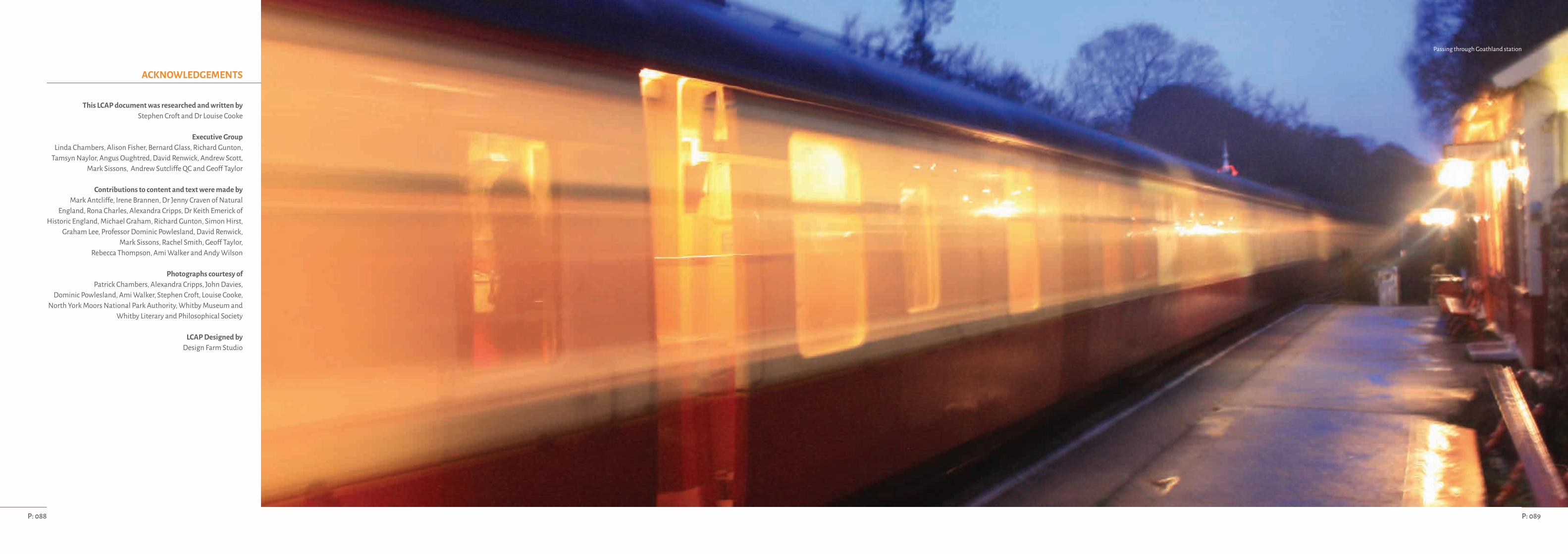
This LCAP document was researched and written by Stephen Croft and Dr Louise Cooke
Executive GroupLinda Chambers, Alison Fisher, Bernard Glass, Richard Gunton,
Tamsyn Naylor, Angus Oughtred, David Renwick, Andrew Scott, Mark Sissons, Andrew Sutcliffe QC and Geoff Taylor
Contributions to content and text were made byMark Antcliffe, Irene Brannen, Dr Jenny Craven of Natural
England, Rona Charles, Alexandra Cripps, Dr Keith Emerick of Historic England, Michael Graham, Richard Gunton, Simon Hirst,
Graham Lee, Professor Dominic Powlesland, David Renwick, Mark Sissons, Rachel Smith, Geoff Taylor,
Rebecca Thompson, Ami Walker and Andy Wilson
Photographs courtesy ofPatrick Chambers, Alexandra Cripps, John Davies,
Dominic Powlesland, Ami Walker, Stephen Croft, Louise Cooke, North York Moors National Park Authority, Whitby Museum and
Whitby Literary and Philosophical Society
LCAP Designed by Design Farm Studio
ACKNOWLEDGEMENTS
P: 089P: 088
Passing through Goathland station
5. Sources of information
Amec 2015 Report on the Economy of the North York Moors National Park.
Clifford, S and King, A. 2006. England in particular. A celebration if the commonplace, the vernacular and the distinctive. GB, Hodder and Stoughton.
Cranstone, D. 2012. This Exploited Land Background on the Iron Industry. Report for NYMNP.
Department for Communities and Local Government 2010. Indices of Deprivation.
Done, A and Muir, R. 2001. The Landscape History of Grouse Shooting in the Yorkshire Dales. Rural History 12 pp. 195-210.
English Heritage 2008. Conservation Principles, Policies and Guidancehttp://content.historicengland.org.uk/images-books/publications/conservation-principles-sustainable-management-historic-environment/conservationprinciplespoliciesguidanceapr08web.pdf/
Fortey, R. 2010. The Hidden Landscape. London: Bodley Head.
ICOMOS International Committee for the Conservation of theIndustrial Heritage (TICCIH) 2003. Nizhny Tagil Charter for the Industrial Heritage. http://ticcih.org/wp-content/uploads/2013/04/NTagilCharter.pdf
ICOMOS Australia 2013. Burra Charter. http://australia.icomos.org/publications/burra-charter-practice-notes/
Kerr, J. 1982. Conservation Plan: A guide to the preparation of conservation plans for places of European cultural significance. Sydney: National Trust of Australia.http://australia.icomos.org/publications/the-conservation-plan/
Muir, R. 2004. Landscape Encyclopaedia - A Reference Guide to the Historic Landscape. Cheshire: Windgather Press.
Natural England 2014. An Approach to Landscape Character Assessmenthttps://www.gov.uk/government/uploads/system/uploads/attachment_data/file/396192/landscape-character-assessment.pdf
Natural England NCA Profile: 25 North York Moors and Cleveland Hills (NE352). http://publications.naturalengland.org.uk/publication/2646022?category=587130
NYCC 2010 The North Yorkshire and Lower Tees Valley Historic Landscape Character Assessment. Historic Environment Team, North Yorkshire County Council.
NYCC 2011. North Yorkshire and York Landscape Characterisation Project. Chris Blandford Associates.
NYMNP 2003 Landscape Character Assessment (updated 2010)
NYMNPA 2012 NYMNPA Business Plan 2012-5
NYMNPA 2012 NYMNPA Management Planhttp://www.northyorkmoors.org.uk/about-us/how-the-authority-works/management-plan
Richardson and Dennison 2007 Archaeological Survey Former Grosmont Ironworks, Grosmont, North Yorkshire.
STEAM 2015 Scarborough Tourism Economic Activity Monitor. Global Tourism Solutions (UK) Ltd.
Spratt, D and Harrison, B. 1989. The North York Moors landscape heritage. Helmsley: North York Moors National Park.
Sykes, N. 1993. Wild plants and their habitats in the North York Moors. Helmsley: North York Moors National Park.
UK National Ecosystem Assessment, 2011. http://uknea.unep-wcmc.org
First Edition six-inch County Series Ordnance Survey mapping (1846-63).
Second Edition six-inch County Series Ordnance Survey mapping (1889-99).
HLF Landscape Partnerships Application Guidance Appendix 1: Digital Outputs
HLF Landscape Partnerships Application Guidance Appendix 3: Reducing negative environmental impacts
HLF Landscape Partnerships Application Guidance Appendix 4: Projects involving land, habitats and species.
Appendix
Supporting documents
• Interpretation Plans for the Danby Centre (undertaken by BHD architects for the Moors Centre at Danby• Built Heritage Conservation Assessment (undertaken by Purcell for 24 heritage structures)• Built Heritage Costed Options• LiDar survey of Murk Esk Valley (report by TEL project staff)• Interpretation plan (undertaken by PLB Projects)• Visitor Survey analysis (undertaken by Pickersgill Consultancy & Planning Ltd (PCP))• Built Heritage Site Dossiers (report by TEL project staff)• Background and history of ironworking in the NYMNP (2012 report by Cranstone Consultants)• Mine water discharge report (University of Hull report)• Water Vole surveys (Undertaken by MAB for NYMNP)• Bat scoping survey (Undertaken by Wold Ecology for NYMNP)• Species Actions Plans for NYMNP (NYMNP LBAP)• Habitat Connectivity Background Work (undertaken by NPA Conservation Department Staff)• Plantations on Ancient Woodland Sites Background Work (undertaken by NPA Conservation Department Staff and consultants)• Rosedale Wild Daffodil Survey (undertaken by NPA Conservation Department Staff)• Fish Passage Scheme and report• Grosmont Church Screens Concept Drawing• Stephen Croft Interview BBC Tees 29/07/2015
P: 091P: 090


