82
Prepared By: THE REGION FIVE DEVELOPMEN COMMISSION PAUL BUNYAN SCENIC BYWAY CORRIDOR MANAGEMENT PLAN UPDATE 2015

Prepared By:
THE REGION FIVE DEVELOPMEN COMMISSION
PAUL BUNYAN SCENIC BYWAY CORRIDOR MANAGEMENT
PLAN UPDATE 2015

In light funding changed through MAP 21 the Minnesota
Department of Transportation (MnDOT) requested that the Regional
Development Commissions (RDC) partner with Scenic Byways
throughout the state to update each Byways’ Corridor Management
Plans with the intent to better align them with current funding
opportunities.
The 2015 Paul Bunyan Scenic Byway Corridor Management Plan
Update is the first update to the original Corridor Management Plan.
Therefore, this document is a continuation of the Paul Bunyan Scenic
Byways’ ongoing planning and maintenance process. This plan
formally replaces the past Corridor Management plan from 2001.
The Paul Bunyan Scenic Byway Association has used this planning
update process as an opportunity to re-evaluate several elements of
importance including management, marketing, monitoring as well as
future funding.
In addition the Byway Association has used this planning update
process to reinforce the existing policies and practices pertaining to
management, marketing, monitoring and future funding in order to
both update as needed and reinforce past decisions that are still
valid.
A major premise of this Corridor Management Plan update
therefore, is to utilize portions of the previous corridor management
plan and other local planning mechanism whenever applicable.

Paul Bunyan Scenic Byway Corridor
Management Plan Update 2015
Published by the
Region Five Development Commission
For the Paul Bunyan Scenic Byway
2015

What is Corridor Management Planning? A Corridor Management Plan (CMP) is a written plan developed by the communities along a scenic byway that
outlines how to protect and enhance the byway’s intrinsic qualities and character that define their byway corridor.
Most states, and the National Scenic Byways Program, require corridor management plans (CMP) for scenic byway
designation. CMPs are community-based and flexible “living documents” that outline the goals, strategies, and
responsibilities for preserving and promoting the byway. CMPs typically address issues such as: tourism development,
historic and natural preservation, roadway safety, and economic development.
A CMP is designed to change with the community and respond to new proposals and developments along the byway
corridor and they are often guided by the “14-point plan” recommended by the National Scenic Byways Program.
What Does Corridor Management Planning Do? Corridor Management Plans (CMP) address wide variety of issues. The level of detail in a CMP is dependent upon its
role in the community, the document can be fairly short and address issues in broad terms. However, a more detailed
plan will be necessary if the CMP is to form the basis of state or national scenic byways applications, or for grant and
other funding applications.
It is important to remember that the CMP is a guide that addresses issues but does not necessarily offer solutions for
every problem. The CMP should address major goals, such as improved road access for other modes of transportation,
like bicycles, but does not have to lay out a specific plan for implementing the goal.
At the very least, a CMP should identify and discuss the byway’s intrinsic qualities, review the roadway’s current
condition and maintenance plans, explore visitor needs and expectations, and discuss how to promote the byway while
protecting its outstanding features in the future.
How Does Region Five Assist with Corridor Management Planning? The Region Five Development Commission was asked to partner with the Paul Bunyan Scenic Byway Association
by MnDOT to update its Corridor Management Plan. Region Five Staff met with the Byway Association, to discuss
the byway's intrinsic qualities, the current status of the byway's maintenance, marketing, monitoring, and funding
opportunities. Armed with this information, Region Five Staff drafted the Corridor Management Plan Update (2015)
with the intention of review and adoption.
In addition to Paul Bunyan Scenic Byway Association's Sustainability Plan (2008 - 2010), Region Five assisted in
developing an Investment Priorities Addendum which is meant to assist the Byway Association in planning,
prioritizing, programming and implementing its future projects.

Table of Contents Acknowledgements_________________________________________________4
Executive Summary_________________________________________________7
Introduction_______________________________________________________9
Citizen Participation________________________________________________20
The Byway Setting_________________________________________________27
Resource Summary_________________________________________________42
Implementation____________________________________________________46
Marketing________________________________________________________56
TAP Funding Alignment____________________________________________66
Monitoring_______________________________________________________69
Maps____________________________________________________________71
Appendices_______________________________________________________74

Acknowledgements The Association is particularly appreciative of the support provided by the following local government
jurisdictions: Crow Wing County, Jenkins, Ideal, and Timothy townships; and the communities of
Jenkins, Breezy Point, Crosslake, and Pequot Lakes. The contributions of the Paul Bunyan Scenic Byway
Association Board in providing direction to the Corridor Management Plan are gratefully acknowledged.
_____________________________________________________________________________________
Particular thanks to those members of the Paul Bunyan Scenic Byway Association who carefully
reviewed and submitted comments on the CMP:
Table 1: Paul Bunyan Scenic Byway Association Board Members
Paul Bunyan Scenic Byway Association Board Members
Rod Nelson, Chair Roger Hoplin, Vice Chair Kate Perkins, Secretary
Carol Ottoson, Treasurer Dave Badger Ron Johnson
Lynn Scharenbroich, Director
Emeritus
Ryan Sjoblad
Table 2: Advisors
Advisors
Carol Altepeter, Explore
Minnesota Tourism
Judd Brink, Birds of the Byway Kathy Moore, Moore Consulting
Krista Okerman Mary Plein, JM Plein
Consulting
Paul Thiede, Crow Wing County
Commissioner
Corrine Hodapp, USACE Jo Bierman, Crosslake Area
Historical Society
Cindy Myogeto, Crosslake Area
Chamber of Commerce
John Wetrosky, Pine River
Chamber of Commerce
Jenna Crawford, Pequot Lakes
Area Chamber of Commerce
Ken & Pam Perry, birders
Table 3: Paul Bunyan Scenic Byway Association Bold = Group of 54 Member
* = Charter Member
Group of 54 Members

Dave & Mary
Badger*
Bait Box
Marina*
Bay View Lodge
(Jim & Mary Ann
Berg)
Black Pine
Beach Resort*
Boyd Lodge*
Breezy Point
Resort*
Crosslake
Communication
Mary Lu & Dick
Dietz (Birch Breeze
Charitable Fund)
Don & Deanna
Engen
Ronda Hopkins
& Charles
Nolop
Lynn and Paul
Hunt* (Hunt
Utilities Group)
Ideal Community
Service
Organization
JM Plein Consulting Adeline Johnson Lakes State
Bank* (Pequot
Lakes and
Crosslake)
Lakeside Lawn
and Landscape
(Bruce Zeman)
John & Karen
Larsen
Moonlite Bay
Family Restaurant*
Rod Nelson Pequot Sand &
Gravel
Don & Buff
Spies*
Steve & Donna
Stricker
(Stricker Arts)
Towering Pines
Resort*
Wildwedge Golf,
Mini Golf, Maze
& RV Park*
Table 4: Regular Members
Al’s Marine AmericInn Lodge
& Suites
Beacon Shores
Resort, Daniel &
Karen Scholz
Expressions Shoe
Center, Dean
Brandt
Heath’s Resort,
Dave and Carol
Heath
Don Hickman Lake Country
Crafts and Cones,
Pat Netko
Lakeland Agency,
Mark & Trudi
Jurchen
Lakes Area
Gallery & Frame
Shoppe, Joe &
Kristi Kraemer
Moonlite Square,
LLC, Donna
Halverson
Norway Ridge
Supper Club,
Jackie Clark
Gregg & Krista
Okerman
Old Milwaukee
Saloon & Eatery
Paul Bunyan Ice,
Chris & Brenda
Greer
Pine River
Chamber of
Commerce
Pine River State
Bank, Chuck
Nelson
Pine Terrace
Resort
Pinedale, Vickey
Leonard
Tip Top Resort,
Gail Schultz
Wind, Water &
Wheels, Jim
Bergquist
Table 5: Funding Jurisdictions 2014
Funding Jurisdictions 2014 City of Jenkins - panel partner Ideal Township - donor Timothy Township - panel
partner
Table 6: In-Kind Donors
In-Kind Donors

Black Pine Beach
Resort
Boy Scouts of
America, Troop
36
Brainerd Daily
Dispatch
Curt Cogan, DNR Dave Badger
Echo Journal Jerry Peterson JM Plein
Consulting
Keith Simar Krista Okerman
Marina II
Restaurant
Northland Press Regina Gau Ron & Joan
Johnson
Stricker Arts
(Steve & Donna
Stricker)
Table 7: Project Supporters 2014
Project Supporters 2014 Dave Badger Black Pine Beach
Resort
Bait Box Marina Boy Scouts of
America, Troop
36
Brainerd Daily
Dispatch
Central Region
Partnership –
University of
Minnesota
Crow Wing
County
Commissioners
Crow Wing
County Highway
Department
Curt Cogan,
Department of
Natural Resources
Darryl Skallet,
Sons of the
American Legion
Explore
Minnesota
Toursim
Echo Journal JM Plein
Consulting
Ron & Joan
Johnson
Lake Country
Crafts & Cones
Marina II
Restaurant
Merrit Jewelers Rod Nelson Timothy
Township
US Army Corps
of Engineers –
Headwaters
District Crosslake
Whitefish Area
Lodging
Association
Table 8 – Reciprocal Membership
Reciprocal Membership Pequot Lakes Area Historical Society Greater Lakes Area Performing Artists

Executive Executive Summary
Executive Summary
Executive Summary
Summary

Executive Summary
The Corridor Management Plan (CMP) for the Paul Bunyan Scenic Byway traces the beginnings of the
Byway, from its conception as a means to ensure safer non-motorized travel along its roadways. Paul
Bunyan Scenic Byway's Mission, Vision, and Goals are:
Missions: Promote, preserve and enhance the recreational, historic, cultural, scenic, natural and
archeological resources along the 54-mile Paul Bunyan Scenic Byway.
Vision: Strengthen the quality of life and visitor experience along the Byway's route by promoting and
enhancing the area's resources and amenities that support economic vitality.
Goals: Build awareness of the Scenic Byway in clever and compelling ways through: Community &
regional projects and events; interesting stories from the area's past. Develop area amenities which are
free to the public. Encourage cooperation and collaboration among the Scenic Byway's jurisdictions,
preserving and enhancing the Byway's resources.
_____________________________________________________________________________________ The Paul Bunyan Scenic Byway Corridor Management Plan provides a roadmap to resources along the
route, identifies future improvements, facilities, and opportunities for interpretive programs and tourism
promotion. The CMP address three elements important to the future of the Scenic Byway: management,
marketing, and monitoring.
Sections 1 and 2 introduce the Byway and planning process and discuss how the pubic was involved in
the planning process Section 3 provides baseline information on the Byway corridor, summarizing the
physical, biological, transportation and socioeconomic characteristics of the area. Sections 4 and 5 focus
on Byway management, summarizing resources that exist in the Byway area, and how these resources can
be preserved, protected, and enhanced through a variety of implementation strategies.
Section 6 discusses strategies for marketing the Byway and presents a draft marketing plan based on the
Minnesota Office of Tourism Marketing Plan for Scenic Byways. Section 7 provides a guidance for
alignment with Transportation Alternatives Program (TAP) funding in lieu of other funding opportunities
that were either phased out or consolidated when the Federal Transportation Bill Map 21 was enacted.
The Scenic Byway passes through 10 local jurisdictions, each with its own special characteristics and
resources that contribute to the Byway’s recreational, cultural, historic, natural, and scenic values. Citizen
organizations, local governments, individuals, and business interests throughout the Byway area have
been involved in the planning process, identifying issues and interests, and providing information about
resources. Their input has provided guidance necessary to prepare a management plan that reflects local
values and opportunities to establish partnerships that support programs and activities to achieve common
goals.

Introduction Introduction
Introduction

Section 1 - Introduction
The Paul Bunyan Scenic Byway in Crow Wing County Minnesota was designated a State Scenic Byway
in June 1998. Located in the heart of the state’s North Central Pine and Lake Region, the 54-mile route
passes forests of jack, red, and white pine, spruce, cedar and birch/aspen mix. It circles around the 14
lakes of the Whitefish Chain and travels the north side of Pelican Lake. The natural resources of lakes and
woods provide natural, scenic, recreational, historic, and cultural resource opportunities for residents and
visitors alike.
The Byway area is one of the most popular visitor destination spots for Midwest travelers, many of whom
return annually for their family summer vacations at the numerous resorts located along the route. The
area’s growth in permanent and seasonal residents, and in tourism, has resulted in expanded recreational
opportunities oriented to these natural resources.
_____________________________________________________________________________________
1.1 What is a Byway and Byway Designation A byway is a set of roads that tell the story of their area’s archaeological, cultural, historic, natural,
recreational and scenic qualities in a compelling and extraordinary way. Byway routes are selected based
on their characteristics and how well they represent their region. Source: http://www.paulbunyanscenicbyway.org/about_paul_bunyan_scenic_byway
State of Minnesota Scenic Byway Designation Minnesota Scenic Byways are roads that pass through 22 transportation corridors that feature many of
Minnesota’s finest cultural, historic, natural, recreational, archaeological and cultural locations and
landscapes. Grassroots organizations have nominated these byways for byway designation and engage in
planning, conservation, preservation and marketing activities to ensure a quality byway experience for
visitors and residents.
Four state agencies, including the Minnesota Department of Transportation, the Minnesota Department of
Natural Resources, the Minnesota Historical Society and Explore Minnesota Tourism, partner with these
grassroots organizations and with local governments on byway projects. Source: http://www.dot.state.mn.us/scenicbyways/
National Scenic Byway Designation The National Scenic Byways Program is part of the U.S. Department of Transportation, Federal
Highway Administration. Established in Title 23, Section 162 of the United States Code under the
Intermodal Surface Transportation Efficiency Act of 1991 and reauthorized and expanded significantly
in 1998 under TEA-21 and again under SAFETEA-LU in 2005, the program is a grass-roots
collaborative effort established to help recognize, preserve and enhance selected roads throughout the
United States.
FHWA's May 18, 1995 interim policy provides the criteria for the National Scenic Byways Program.
This policy sets forth the procedures for the designation by the U.S. Secretary of Transportation of
certain roads as National Scenic Byways or All-American Roads based on their archaeological,
cultural, historic, natural, recreational, and scenic qualities. There are 150 such designated byways in

46 states. FHWA promotes the collection as America’s Byways®. This policy also specifies the type of
projects eligible for funding and lists the funding priority for grants. Source: http://www.fhwa.dot.gov/hep/scenic_byways/
1.2 The Paul Bunyan Scenic Byway The Paul Bunyan Scenic Byway is one of eight Scenic Byways in Minnesota that has been designated as
a National Scenic Byway under the National Scenic Byways Program, managed by the Federal Highway
Administration.
The Paul Bunyan Scenic Byway is a 54-mile driving route made up entirely of county roads that take
travelers through 13 jurisdictions and two counties (Crow Wing and Cass); with hiking and walking trails,
recreational parks and lakes, wildlife management areas, and historical artifacts. The route has a non-
profit organization, the Paul Bunyan Scenic Byway Association that manages the projects, programs and
events along the route. Source: http://www.paulbunyanscenicbyway.org/about_paul_bunyan_scenic_byway
The spine of the route is County State Aid Highway (CSAH) 16 that runs northeast from Trunk Highway
371 two miles north of Pequot Lakes. The nearly 13 miles along CSAH 16 passes sites of scenic,
recreational, historical, and natural interest, such as the Uppgaard Wildlife Management Area, Rush Lake
Floating Island, Island Lake Woods, and the site of a battle between the Dakota Sioux and Ojibwa in the
early 1800’s. CSAH 16 connects with CSAH 66 at the north end of Crosslake. At that point, Byway
travelers can select either the 12-mile north loop around the Whitefish Chain of Lakes or turn south and
travel south and west through 23 miles of beautifully wooded countryside and lakes on CSAH 3 and 11.
The DNR Walleye Stripping Station and the old Swanburg store are highlights along the north loop. The
Crosslake Historical Society museum and historic village, the Corps of Engineers dam and recreational
park, well known Breezy Point Resort and its famous Fawcett House, Lowell Wildlife Management Area,
and the historic DNR fire tower are among the points of interest along the southern loop. The Scenic
Byway connects with the Paul Bunyan State Trail, a paved hiking, biking, inline skating and
snowmobiling trail at three locations, offering opportunities to drive the Byway, park and bike or hike the
Trail. Numerous trails on publicly owned land along the 54-mile drive provide opportunities to stop and
hike through the woods. Public accesses to lakes on the Whitefish and the Ossawinnamakee chains and to
Pelican Lake are also located along the Byway.
The Paul Bunyan Scenic Byway Association
The Paul Bunyan Scenic Byway Association is a non-profit organization made up of businesses, agencies,
organizations and individuals.
Vision:
Strengthen the quality of life and visitor experience along the Byway's route by promoting and enhancing
the area's resources and amenities that support economic vitality.
Mission:
Promote, preserve and enhance the recreational, historical, cultural, scenic, natural and archeological
resources along the 54-mile Paul Bunyan Scenic Byway.

Byway Beginnings In 1995 Ideal Township, concerned for the safety of bicyclists on CSAH 16, raised funds to provide the
local match money necessary to pave the shoulders of CSAH 16. In order to increase the priority of
shoulder paving with the County Highway Department, the Minnesota Office of Tourism suggested the
roadway might qualify as a scenic byway and that such designation could increase the priority of the
paving project. A group of local residents worked together to complete the forms, inventory the byway,
and submit the application for state designation. The June 1998 designation resulted in an assurance of
shoulder paving on CSAH 16 by 2002. Paved shoulders, having become standard operating procedure for
Crow Wing County, have been completed along the entire 54-mile route providing safe opportunities for
non-motorized use. Certain segments are still considered bikeways. PBSBA continues to seek 8' paved
bike path shoulders throughout the route. Shoulder paving.
Since its designation, a group of local citizens, with support from partnering state agencies, local
government jurisdictions and organizations, have worked together preparing information, identifying and
implementing projects that will protect and enhance the resources along the corridor. The group is
organized as the Paul Bunyan Scenic Byway Association, a non-profit organization, made up of those
businesses, agencies, organizations and individuals that have supported its projects and programs. A
Board of Directors guides the work of the Association, to “preserve, protect and to enhance the scenic,
natural, cultural, historic, recreational, and archeological resources along the 54-mile Paul Bunyan Scenic
Byway.”
1.3 Corridor Management Planning
A Corridor Management Plan (CMP) is a written plan developed by the communities along a scenic
byway that outlines how to protect and enhance the byway's intrinsic qualities and character that define
their byway corridor.
Most states, and the National Scenic Byways Program, require corridor management plans (CMP) for
scenic byway designation. CMPs are community-based and flexible "living documents" that outline the
goals, strategies, and responsibilities for preserving and promoting the byway. CMPs typically address
issues such as:
• Tourism development
• Historic and natural preservation
• Roadway safety
• Economic development.
A CMP is designed to change with the community and respond to new proposals and developments along
the byway corridor and they are often guided by the "14-point plan" recommended by the National Scenic
Byways Program.
Source: http://www.scenic.org/issues/scenic-byways/byways-and-corridor-management-plans
What’s in a Corridor Management Plan?
Corridor management plans address a wide variety of issues. The level of detail in a CMP is dependent
upon its role in the community and the byway planning process. If the CMP is intended solely for the
local community, the document can be fairly short and address issues in broad terms. However, a more

detailed plan will be necessary if the CMP is to form the basis of state or national scenic byways
applications, or for grant and other funding applications.
It is important to remember that the CMP is a guide that addresses issues but does not necessarily offer
solutions for every problem. The CMP should address major goals, such as improved road access for
other modes of transportation, like bicycles, but does not have to lay out a specific plan for implementing
the goal.
At the very least, a CMP should identify and discuss the byway's intrinsic qualities, review the roadway's
current condition and maintenance plans, explore visitor needs and expectations, and discuss how to
promote the byway while protecting its outstanding features in the future.
Source: http://www.scenic.org/issues/scenic-byways/byways-and-corridor-management-plans
Federal Highway Administration’s 14-Points The Federal Highway Administration (FHWA) lists 14 components that must be in any CMP included in
a byway’s application for national recognition. The CMP will help your byway group envision future
changes and address issues before they become a problem.
The FHWA requirements for a CMP are:
1. A map identifying the corridor boundaries, location of intrinsic qualities, and land uses in the
corridor. U. S. Geological Survey maps of your corridor region are ideal and inexpensive base maps
for your corridor management planning group.
2. An assessment of the byway's intrinsic qualities and their context (the area surrounding them). The
end product is typically a catalogue of the byway's scenic, historic, natural, archeological, cultural,
and recreational qualities. A community visual assessment is an ideal way to involve a large number
of local residents in evaluating the byway's resources’ Say Can You See: A Visual Awareness
Toolkit for Communities, available from Scenic America, is a good way to start.
3. A strategy for maintaining and enhancing each of the byway's intrinsic qualities. Ask what you
want the byway corridor to look like in 10-15 years and develop goals and strategies to help you get
there.
4. A list of the agencies, groups, and individuals who are part of the team that will carry out the plan.
Be sure to include a description of each individual's responsibilities and a schedule of when and
how you will review their progress.
5. A strategy for how existing development along the corridor might be enhanced and how to
accommodate new development while preserving the byway's intrinsic qualities. Many
communities have long-term land use plans that can be adapted for this purpose.
6. A plan for on-going public participation. This might include forming a CMP steering committee
made up of local citizens, a schedule of regular public meetings, or a byway management planning
forum.

7. A general review of the road's safety record to locate hazards and poor design, and identify possible
corrections. Identify ways to balance safety with context-sensitive highway design practices that
accommodate safety needs while preserving the road's character.
8. A plan to accommodate commercial traffic while ensuring the safety of sightseers in smaller
vehicles, as well as bicyclists, joggers, and pedestrians. Some CMP's incorporate plans to apply for
Federal Transportation Enhancement funds to pay for the installation of special bicycle lanes along
the byway or the creation of hiking trails.
9. A listing and discussion of efforts to minimize anomalous intrusions on the visitor's experience of
the byway. This might include landscaping to screen an industrial site, relocating utility wires and
poles, or planning for the sensitive location of wireless telecommunications towers along the
byway.
10. Documentation of compliance with all existing local, state, and federal laws about the control of
outdoor advertising. Federal regulations prohibit all new billboards along designated scenic byways
that are classified as federal-aid primary, national highway system, or interstate roads. States are
free to impose stricter controls on billboards along scenic byways. Your CMP should also address
the continuous designation of the road to ensure that billboard companies will not be able to find a
loophole in your byway designation that would allow them to erect billboards along the corridor.
11. A plan to make sure that the number and placement of highway signs will not get in the way of
scenery, but still be sufficient to help tourists find their way. This includes, where appropriate, signs
for international tourists who may not speak English fluently. Two popular and effective ways of
addressing this issue are logo signs and tourist-oriented directional signs (TODS). Logo signs are
located on interstate highway rights-of-way and advertise gas, food, camping, and lodging at nearby
exits. Highway-oriented businesses can advertise their company's symbol, name, trademark, or a
combination of these things on a logo sign. A few states, like Utah and Maine, provide TODS
primarily on non-interstate rural highways to help motorists find local businesses. TODS indicate
only the name of local attractions, mileage to the establishment, and direction.
12. Plans for how to market and publicize the byway. Most marketing plans highlight the area's
intrinsic qualities and promote interest in the byway that is consistent with resource protection
efforts and maintenance of the byway's desired character.
13. Any proposals for modifying the roadway, including an evaluation of design standards and how
proposed changes may affect the byway's intrinsic qualities. Byway groups should work with their
state department of transportation to adopt context-sensitive highway design standards for the
byway. Context-sensitive design takes into account the area's built and natural environment; the
environmental, scenic, aesthetic, historic, community, and preservation impacts of a road project;
and provides access for other modes of transportation.
14. A description of what you plan to do to explain and interpret your byway's significant resources to
visitors. Interpretation can include visitor centers, leaflets, audio tours, information panels, and
special events. In this category, creativity makes a big difference.
Source: http://www.scenic.org/issues/scenic-byways/byways-and-corridor-management-plans
The Six Intrinsic Qualities
Scenic

Scenic Quality is the heightened visual experience derived from the view of natural and manmade
elements of the visual environment of the scenic byway corridor. The characteristics of the landscape are
strikingly distinct and offer a pleasing and most memorable visual experience. All elements of the
landscape--landform, water, vegetation, and manmade development--contribute to the quality of the
corridor's visual environment. Everything present is in harmony and shares in the intrinsic qualities.
Archaeological Archaeological Quality involves those characteristics of the scenic byways corridor that are physical
evidence of historic or prehistoric human life or activity that are visible and capable of being inventoried
and interpreted. The scenic byway corridor's archeological interest, as identified through ruins, artifacts,
structural remains, and other physical evidence have scientific significance that educate the viewer and
stir an appreciation for the past.
Cultural Cultural Quality is evidence and expressions of the customs or traditions of a distinct group of people.
Cultural features including, but not limited to, crafts, music, dance, rituals, festivals, speech, food, special
events, vernacular architecture, etc., are currently practiced. The cultural qualities of the corridor could
highlight one or more significant communities and/or ethnic traditions.
Historic
Historic Quality encompasses legacies of the past that are distinctly associated with physical elements of
the landscape, whether natural or manmade, that are of such historic significance that they educate the
viewer and stir an appreciation for the past. The historic elements reflect the actions of people and may
include buildings, settlement patterns, and other examples of human activity. Historic features can be
inventoried, mapped, and interpreted. They possess integrity of location, design, setting, material,
workmanship, feeling, and association.
Natural Natural Quality applies to those features in the visual environment that are in a relatively undisturbed
state. These features predate the arrival of human populations and may include geological formations,
fossils, landform, water bodies, vegetation, and wildlife. There may be evidence of human activity, but
the natural features reveal minimal disturbances.
Recreational Recreational Quality involves outdoor recreational activities directly association with and dependent upon
the natural and cultural elements of the corridor's landscape. The recreational activities provide
opportunities for active and passive recreational experiences. They include, but are not limited to,
downhill skiing, rafting, boating, fishing, and hiking. Driving the road itself may qualify as a pleasurable
recreational experience. The recreational activities may be seasonal, but the quality and importance of the
recreational activities as seasonal operations must be well recognized. Source: http://www.scenic.org/issues/scenic-byways/intrinsic-qualities-for-byways-designation
1.4 The 2015 Corridor Management Plan Update The original corridor management plan was developed in 2001and addressed three main elements:
•Management
The management component discusses such issues as: amenities along the route; safety;
development of enhancements; natural, cultural, scenic, and historic resource protection;
recreational opportunities; interpretation of key resources and points of interest.

• Marketing
The marketing component identifies opportunities and appropriate mechanisms to provide
information about the Byway to the public.
• Monitoring.
Finally, a component of the Plan included plans for ongoing monitoring and evaluating the
Byway program, visitor needs, local impacts, facility improvements and maintenance
requirements.
Throughout the years the Byway association has successfully implemented many of these strategies and
has also had several new opportunities as well as some challenges. In addition to these opportunities and
challenges, changes to the federal transportation bill (MAP 21) as well as changes in the economy and
transportation environment have prompted the Byway Association to update the original CMP to reflect
these changes.
The 2015 Paul Bunyan Scenic Byway Corridor Management Plan Update is the first update to the
original Corridor Management Plan. Therefore, this document is a continuation of the Paul Bunyan
Scenic Byways’ ongoing planning and maintenance process. This plan formally replaces the past Corridor
Management plan from 2001. The Paul Bunyan Scenic Byway Association has used this planning update
process as an opportunity to re-evaluate several elements of importance including management,
marketing, monitoring as well as future funding.
In addition, the Byway Association has used this planning update process to reinforce the existing
policies and practices pertaining to management, marketing, monitoring and future funding in order to
both update as needed and reinforce past decisions that are still valid. A major premise of this Corridor
Management Plan update therefore, is to utilize portions of the previous corridor management plan and
other local planning mechanism whenever applicable. The main areas of focus for the CMP update in
2014/2015 are described in detail in the paragraphs below.
Language Update
The first step in the CMP update process was to update any outdated language identified in the original
CMP. Examples of this include:
• Replacing language referring to goals that have already been achieved.
• Replacing language referring to establishments, individuals, organizations or agencies that no
longer exist or that are no longer located on the byway.
• The addition of language describing new establishments, individuals, organizations or agencies
that now exist along the byway.
Demographic Update
The second step in the CMP update process was to update any outdated demographic information
identified in the original CMP. As was mentioned above the original CMP was drafted in 2001 just after
the 2000 US Census and therefor utilized the most current available information. However after the 2010
US Census and certain changes in the way the US Census is now conducted, particularly the use of the

American Community Survey (ACS), which gathers data in 3, 5 and 7 year cycles within the 10 year US
Census cycle, significant new demographic information is available and warrants an update to the CMP.
Transportation Alternatives Program (TAP) Funding Alignment
Another lens through which the CMP was updated was that of funding opportunities. In light funding
changed through MAP 21 the Minnesota Department of Transportation (MnDOT) requested that the
Regional Development Commissions (RDC) partner with Scenic Byways throughout the state to update
each Byways’ Corridor Management Plans with the intent to better align them with current funding
opportunities, particularly the Transportation Alternatives Program (TAP).
The federal government has developed and passed a transportation bill referred to as MAP-21 that
established a consolidated program that provides funding for a variety of alternative transportation
projects, including many that were previously eligible activities under separately funded
programs. The TAP replaces the funding from pre-MAP-21 programs including Transportation
Enhancements, Scenic Byways, Safe Routes to School, and several other discretionary programs
with a competitive program to be developed by states.
Given this significant change in funding opportunities for Scenic Byways, and the fact that instead of
having a standalone funding source, byways will now be competing with other types of projects such as
Safe Routes to School, Trials, it was important to align the byways CMP with the new funding program
structure.
FHWA 14 Points
As was noted earlier in this section the Federal Highway Administration (FHWA) lists 14 components
that must be in any CMP included in a byway’s application for national recognition. As part of the CMP
update each of these 14 Points is examined.
Intrinsic Quality
In order to be designated a National Scenic Byway, a road must possess characteristics of regional
significance within at least one of the intrinsic qualities. Another aspect of the CMP update was to
identify and include any new elements along the byway relating to any of the six Intrinsic Qualities.
Investment Priorities Addendum
One of the elements identified in the CMP update work plan is to use strategies, recommendations, and
specific projects identified through the various elements of the CMP to identify investment priorities for
the byway; organize investments by transportation, intrinsic resource, planning and marketing categories
identifying specific projects assigning priority within each category.
The purpose of this activity is to understand the general investment priorities for the byway so as specific
projects are identified moving forward, they can be understood in the context of overall corridor
priorities. In order to fulfill this required aspect of the CMP update, an Investment Priority Addendum has
been developed and attached to the CMP update as Appendix A.
Formatting Update
Lastly, the CMP update included a formatting update. The formatting update allows the CMP to not only
perform its manifest function as a planning mechanism, but also to serve a latent function as a
promotional tool that can be used to market the many attractions of the Byway.

Many photos of the byway itself, the attractions along the byway and the surrounding area were
incorporated into the CMP update so that the document could also act as a “coffee table book” appealing
to not only the serious reader, but also to the casual reader as well.
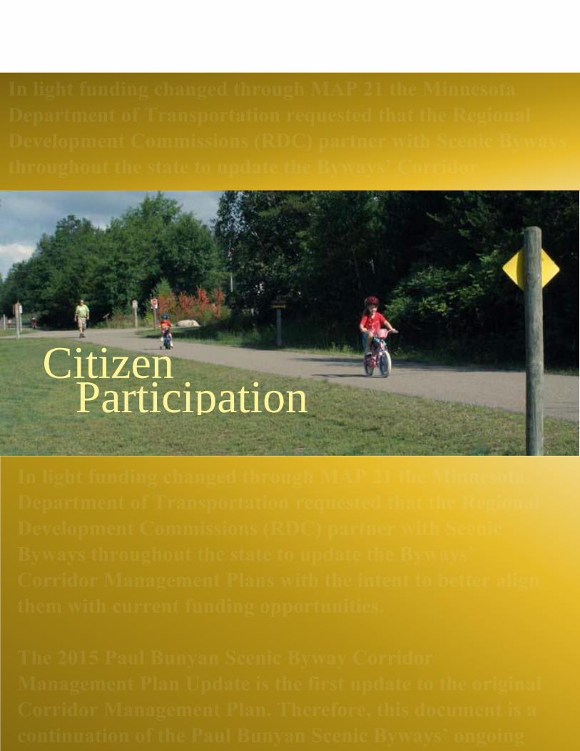
1.5 Citizen Participation The Paul Bunyan Scenic Byway passes through 14 local jurisdictions. Each jurisdiction has its unique
characteristics and possesses important resources that contribute to the intrinsic Byway qualities. The
Byway represents an opportunity to unify these communities. The Byway Association knows that local
and visitor interests and concerns need to be heard and incorporated into Byway plans and programs.
Because citizen participation is key to successfully implement actions that will protect and enhance
valuable corridor resources, the Association is committed to a collaborative process. Citizen participation
in the Byway provides the following functions:
• Provides input on important values to be considered in Byway management.
• Identifies issues and concerns regarding safety and increased road usage.
• Develops partnerships with interested entities to support Byway efforts.
• Develops a sense of community among all potentially affected interests.
• Is used to evaluate and monitor Byway activities, needs, issues, and marketing efforts.
During the development of the original CMP Association representatives met with citizen organizations,
local jurisdictions, business and industry groups to inform them about the Byway and planning activities
and to learn what issues and interests they may have in the Byway. Briefing materials that discuss the
Byway and its resources were used to begin discussions with groups and organizations in the corridor
area.
As a short-term public input strategy, Byway Association Board members maintained a “Listening Log”
noting contacts members had about the Byway, what they had learned from discussions, and how this
information can be used in preparing future updates to the CMP. Frequent contact with communities,
organizations, and individuals is an ongoing practice of each Byway Association member and serves to
keep interested parties up-to-date on the planning process, and how issues are being addressed.
CMP Update Participation
During the CMP update process Region Five Staff met several times with the Byway Association Board
to gather information regarding the byway. In addition Region Five Staff interviewed several Byway
Association Board members via telephone regarding several issues and questions relating to the CMP
update and the byway as a whole. Region Five Staff also coordinated with Byway Association Board
Members via e-mail whenever possible to reduce travel and reduce printing costs. Staff also met with
other local county officials in order to gather pertinent information relating to the development of this
plan update.
Furthermore, the Investment Priority Addendum was populated with projects based on direct input from
the Byway Association Board and included in the CMP update by Region Five Staff.
1.6 Program Goals

The Paul Bunyan Scenic Byway will continue to be a recognized area amenity and a local and visitor
travel destination. The Byway will serve as an area unifier, integrating goals and values with other
initiatives and programs within the corridor. The Paul Bunyan Scenic Byway Program will:
• Build awareness of the Scenic Byway in clever and compelling ways through Community &
regional projects and events
• Interesting stories from the area's past.
• Develop area amenities which are free to the public. Encourage cooperation and collaboration
among the Scenic Byway's jurisdictions, preserving and enhancing the Byway's resources
Citizen Participation

Section 2 – Citizen Participation
Citizen participation has been key to the Paul Bunyan Scenic Byway plans and activities. Active
participation by citizens was instrumental in the designation of the Byway in 1998 as well as in the
development of the original CMP in 2001. Since then, participation by a variety of local interests and
partnership among agencies, local jurisdictions and organizations has moved Byway efforts forward. The
Paul Bunyan Scenic Byway Association recognizes the continuing importance of citizen participation and
creative partnerships to ensure goals of the partnering agencies, as well as local interests, identified in the
Corridor Management Plan (CMP) continue during implementation of the Plan and specific Byway
projects.
_____________________________________________________________________________________
The initial CMP was developed using a comprehensive citizen participation program. This program
included:
• Obtaining input on important values, issues and concerns
• Developing a sense of awareness of the Byway and its value to the area
• Developing partnerships with interested entities to support Byway efforts
• Developing a sense of community and shared values
The process used, called Citizen Participation by Objectives, systematically identified potentially affected
interests and issues, the objectives of citizen participation, and the techniques most appropriate to reach
these interests. This section summarizes the process, objectives identified, techniques used, and the
results. Finally, recommendations for future citizen participation activities are discussed. Appendix B lists
the key objectives of the citizen participation process, recommended techniques and activities, and a
summary of the input received.
2.1 Methodology The first step was to identify potentially affected interests (PAIs) and issues. Byway Association
representatives listed nearly 50 agencies, organizations, individuals, and interest groups that could affect
or be affected by the Byway and Byway projects. A list of about 20 issues was then identified. A matrix
was used to associate each identified PAI with the issues. A second step was to review and respond to a
series of questions to identify specific objectives for participation. These two steps were the basis for
identifying ways in which public participation would meet the objectives and reach the affected interests.
2.2 Results The Byway Association realized there was limited awareness of the Byway within the local area. In order
to obtain meaningful public input and support for the Byway and specific projects, area residents needed
to know about the Byway and its value to the communities. Consequently, the primary objective of
citizen participation during the Corridor Management Plan preparation has been to increase knowledge
and understanding of the Byway and the management planning process. A number of activities to
accomplish this were recommended along with an implementation schedule (see Appendix B).
Of those recommended, activities that were implemented included:

• Producing and releasing materials to PAIs and media.
• Using existing clubs, organizations, newsletters, and media to provide and receive information.
• Participating, observing, and recording information on community issues and interests.
Byway representatives met formally with more than 20 organizations and local jurisdictions, and
informally with other citizen groups. The Inkslinger newsletter is sent twice a year to Association
members and others; occasional articles appear local newspapers, and a number of special articles and
stories about the Byway and its projects appear regularly in local and regional publications and were aired
on area radio stations.
The results of these efforts have been very positive in increasing knowledge, awareness and partnerships
for the Byway. Support for the Byway and its activities has grown, several jurisdictions have included
financial support to the Byway as part of their annual budgets; local service organizations are supporting
the Byway with financial and in-kind matches for projects that require local contributions. The Byway has
become a recognized amenity for residents and visitors. Formal and informal meetings have also provided
information about the Byway and its resources, issues of importance to area residents, and
ideas/suggestions that could improve the Byway. Some of the issues, ideas, and important resources
identified during meetings included:
• Paved shoulders, having become standard operating procedure for Crow Wing County, have been
completed along the entire 54-mile route providing safe opportunities for non-motorized use. Certain
segments are still considered bikeways. PBSBA continues to seek 8' paved bike path shoulders
throughout the route. Shoulder paving.
• At this writing, there is a need for rest facilities at these Byway kiosk points of interest: Old
Grade Road; Rice Lake/Lowell WMA; Chiarella FMA. However these following sites do have
rest facilities available as follows: Breezy Point has adjacent playground, park, and City Hall;
Historic Fire Tower has a picnic table; Gateway Gazebo is adjacent to a hotel; Ideal Township
has an adjacent playground, park, pavilion and restroom; Moonlite Bay - a restaurant; Pequot
Lakes - is on the Paul Bunyan State Trail and is adjacent to Chamber of Commerce building,
which is open 24 hrs.; Pine River - near bathrooms at adjacent picnic area; Timothy Township
kiosk has a picnic table; Veterans Memorial Walking Trail has benches and a picnic table; and the
Crosslake Corps of Engineers kiosk site has adjacent campground, park with seasonal restrooms,
and playground.
• Value of natural resources sites along the Byway, such as Uppgaard WMA and Rice
Lake/Lowell WMA: at the Rice Lake/Lowell WMA, a local Eagle Scout lead a crew of boy
scouts and created an access trail from roadway to kiosk; and with the partnership of local DNR
an interpretive panel on topic of shallow lakes was installed at the site. At the Veterans Memorial
Walking Trail a wetlands walkway has been added along with three interpretive panels on topic
of the surrounding wetlands, flora and fauna. A walking bridge over the wetlands was built,
giving access to the north side trail. Later, at the end of the wetlands walk, a trail around the
island was added. At the Historic Fire Tower a new access path has been added, the tower
structure was improved and historical structure restoration is ongoing.
How much progress since 2001?
• Partnering with other agencies, organizations and government jurisdictions to coordinate
projects of mutual interest (e.g., DNR fire tower project, partnership with the US Army Corps of
Engineers in Crosslake - share interpretive/exhibit room and park area for events and programs,
Merritt Jewelers created a Paul Bunyan Scenic Byway charm/pendant, Crow Wing County to
pave the road shoulders of the Paul Bunyan Scenic Byway, Sons of the American Legion to build
and maintain the Veterans Memorial Walking Trail, Whitefish Area Lodging Association to
update and distribute the popular Byway Tear Off maps every couple years, University of
Minnesota Master Gardeners to landscape and beautify many of the Byway's 14 kiosks).
How much progress since 2001?
• Use of the Byway as a tourism amenity, including such activities as organized motor coach
tours of the Byway-made available as part of existing events and last one was 2008; developing a
Byway day trips guide on the Byway's website; promoting points of interest in Inkslinger
newsletter; adding the Linda Ulland Memorial Gardens project - currently in its first phase of
construction; publicized the Historic Fire Tower's upgrades; installed Paul Bunyan-sized foot
prints at seven locations sites of interest along the Byway.
How much progress since 2001?
• To encourage product development that will promote the Byway and its resources, we have
included the Byway logo on our Paul Bunyan Scenic Byway brochures and exclusive Byway
Tear-Off Maps, Paul Bunyan Scenic Byway route is identified on county and state maps. Also a
Byway charm/pendant, tee shirts, and promoting online via the Explore Minnesota Tourism
website, the Whitefish Area Lodging Association website and our own Paul Bunyan Scenic
Byway Association website.
How much progress since 2001?
• Developing additional year around recreational opportunities throughout the Byway area. A
complete listing of information and suggestions from public participation activities is listed in
Appendix B. Table 2-1 summarizes the roles and responsibilities of participants in the Byway
planning process. A detailed listing of specific organizations and agencies contacted during the
planning process and their input is identified in Appendix B.
How much progress since 2001? A one-time grant through Legacy funds for a two-year Geo Hunt
event in 2009 & 2010; we have partnered with other organizations for area events.
The Citizen Participation process recognizes that objectives of public participation change as projects are
planned and implemented. The Association has been extremely successful in gaining awareness and
interest in the Byway. Increased support for the Byway and its activities are evident in the financial and
in-kind commitments made by organizations and jurisdictions. This support and clear evidence of
partnerships has resulted in a number of successful grant applications—from the National Scenic Byway
Program, the Minnesota Department of Natural Resources, and the Minnesota Office of Tourism—to
further goals of the Byway Association.
2.3 Future Citizen Participation Efforts It will be important for the Byway Association to continue to build support for the Byway, to broaden
knowledge of the Byway to a wider geographic audience, and to identify additional resources and sources
of information. In order to clarify citizen participation objectives following publication of the Corridor
Management Plan Update and implementation of specific projects, the Byway Association will regularly
review and update its list of PAIs and issues, and review and appropriately revise key objectives and the
participation methods.
Some participation activities initiated during the planning process will likely continue. Frequent contact
with local jurisdictions and tourism organizations is important to maintain an interest in and support for
the Byway. The occasional newspaper article and biannual newsletter provide continuing information
about Byway activities to Association members and the public.

Other activities, such as public meetings or exhibits at local events may be appropriate to initiate now that
the Corridor Management Plan is completed and implementation of specific projects move forward.
Enhancements were made in Scenic Byway's 'Paul Bunyan' Exhibit Room, participated in the Annual
Festival of the Arts at Pequot Lakes High School (2014), and other ongoing community event
participation.
Regularly reviewing participation objectives and revising these objectives to relate to a new phases of
Byway activities will aid the Association in selecting ways in which public participation can further
Byway goals. Are these Goals Still Relevant? New Goals? Yes, it is an ongoing process as we
continuously hone our objectives.
Continuing this iterative process throughout implementation of the Corridor Management Plan will:
• Update potentially affected interests of Byway activities, plans, and projects;
• Keep the Byway Association informed of local interests and issues;
• Provide new or updated information on other area projects and information on Byway
resources;
• Ensure public participation objectives relate to Byway goals and objectives during each phase of
Byway activities;
• Facilitate coordination of Byway activities with local, regional, and statewide activities relevant
to the Byway.
Table 4: Partners/Participants Role/Responsibilities
Partners/Participants Role/Responsibilities
Organization
Name
Role/Responsibilities
Paul Bunyan
Scenic Byway
Association
Up to 9
Member Board
• Overall Responsibility for planning, review.
• Review and implementation of the CMP
• Setting priorities
• Subcontract management
• Review and approval of subcontractor deliverables and payment.
• Association members financially support Byway projects and operations and
provide information used in planning and priority setting.
Minnesota
Department of
Transportation
(MnDOT)
• Partner agency in the State Scenic Byway Program
• State coordinator for National Scenic Byway Program
• Prepares and approves agreements for National Scenic Byway grant funds

• Provides review of grant applications for National Scenic Byway funds
• Reviews and offers input on state scenic byway planning documents
Minnesota
Office of
Toursim
(MOT)
• Partner agency in the State Scenic Byway Program
• Provides input and information regarding tourism issues
• Review of Byway documents
• Review and approval of grant funds available through MOT
• MN Dept. of Natural Resources (DNR) Partner agency in the State Scenic Byway
Program
• Provides information on natural resources issues
• Review and approval of grant funds and projects funded by grants provided through
the DNR
Historical
Society
• Partner agency in the State Scenic Byway Program with information relating to
cultural and historical resources.
• Local historical societies (Pequot Lakes and Crosslake) provide specific local
information on cultural and historic resources along the Byway and support Byway
activities related to cultural and historic resources.
Crow Wing
County
• Fiscal agent and lead agency for grant funds from the National Scenic Byway
Program and National Trail Recreation Program.
• Provides information on county issues and requirements (e.g., transportation,
planning, and zoning).
• Review and approval of contracts and contract payments.
• Provides financial and in-kind support to Byway activities.
Byway Cities
and Townships
•Provides information on local regulations and requirements
• Provide financial and in-kind support to the Byway and to projects within its
jurisdiction;
• Coordinate projects and activities that support the Byway
US Corps of
Engineers
• Provides information on resources along the Byway.
• Review of Byway plans and activities.
• Partner with the Byway on specific projects that relate to its interests.

Chambers of
Commerce
• Provides financial and in-kind support to Byway activities, information on tourism
and commerce.
Service
Organizations
• Provides financial and in-kind support to the Byway and specific Byway projects.
• Information and input on Byway resources
• Organization projects that support the Byway
Lake
Associations
• Provides information on Byway resources and project priorities
Economic
Development
Organizations
• Provides information on economic development activities within the Byway area.
Regional
Development
Commission
(RDC)
• Provides information on regional issues and requirements (e.g., transportation,
community development, economic development).

Byway Setting
The

Section 3 – The Byway Setting
This section summarizes the physical, biological, transportation, land use, and socioeconomic
characteristics of the area in which the Paul Bunyan Scenic Byway is located.
_____________________________________________________________________________________
3.1 Physical Conditions The Paul Bunyan Scenic Byway is located within the Pine River Watershed. The watershed contains 702
lakes with a total acreage of 60,394. Cross Lake Reservoir, Pine River Dam, and controls runoff from a
562-square mile basin, of which 24 percent is Lake Surface. The water in the Cross Lake Reservoir
includes 14 natural lakes (the Whitefish Chain). Along the shoreline, the ground generally rises
dramatically from the water and is densely covered with pine and hardwoods, such as oak and birch.
More than 50 percent of the shoreline is comprised of Norway, White and Jack Pine (USACE 1999).
The entire Pine River watershed lies within the Northern Lakes and Forests Ecoregion, which is
characterized by conifer and hardwood forests with generally flat and rolling terrain. The area experiences
warm, short summers followed by winters which may be at times intense with snow on the ground from
November to March. Mean annual precipitation is between 26 to 28 inches (MPCA 2000). February is
typically the driest month; June the wettest. The majority of precipitation falls May to September. The
mean temperature is 41.7 degrees Fahrenheit and ranges from a mean low of 8.0 degrees Fahrenheit in
January, to 70.1 degrees Fahrenheit in July. Wind patterns typically flow from the west to the east. In the
summer, warm moist air from the Gulf of Mexico dominates. In the winter, the area is dominated by cold,
dry air from Canada (USACE 1999).
Soils within the watershed are primarily silty sands and sandy soils. Silty sands are located underneath
woodland, mixed woodland and cropland areas. Sandy soils are commonly found in glacial outwash and
alluvium (MPCA 2000). Bedrock hydrogeology and ground water are primarily Precambrian igneous and
metamorphic rocks. The surficial aquifers are glacial outwash consisting of course-grained sands and
fine- grained alluvium (MPCA 2000). Groundwater is the principal source of drinking water in the area.
The topography of the Cross Lake Reservoir area ranges from 1,229 feet (reservoir shoreline) to 1,570 ft.
The topography is typical of glacial effects, mostly level with gently rolling hills (USACE 1999).
The Northern Lakes and Forests Ecoregion is characterized by predominately forested and wetland land
uses, which typically have low phosphorus exports compared to urban or agricultural uses. Low
phosphorus loading to the lakes, combined with the moderate size and depth of the lakes contributes to
generally good water quality (MPCA 2000). Lakes within the Cross Lake Reservoir currently fully
support swimming use criteria of the Minnesota Pollution Control Agency. The lakes, however, are
vulnerable to cultural induced eutrophication from point and non-point source pollution. Small increases
in the phosphorus content could result in a perceptible loss in secchi transparency and increased
frequency of nuisance algal booms. Extensive land development, urban and agricultural runoff,
nonconforming septic systems are pollution concerns within the area (USACE 1999).
3.2 Biological Conditions The Northern Lakes and Forest Ecoregion is characterized by conifer and hardwood forests interspersed
with fields and meadows, lakes and wetlands. These areas support a diversity of plant and animal life,
representative of the communities in which they live. Coniferous forests consist of pine (jack, red, and
white), spruce and fir. Maples, oak, birch, and aspen are characteristic of the deciduous forest areas, and
support a dense understory of brush and small trees. Wetlands generally occur in margins around the

lakes. The Uppgaard Wildlife Management Area (WMA) located along the Byway Spine (CSAH 16) is
typical of the Byway biological resources-a second growth mixed coniferous and deciduous forest with
lakes, meadow and marshland areas and flora and fauna that inhabit these communities. Large mammals
include the white-tailed deer, black bear, wolf, and badger. Large cats, such as bobcat, lynx and cougar
have been known to occur although these are rare sightings. Coyote also inhabit the area (DNR 1997).
The area supports a diverse small mammal population including red and gray fox, porcupine, raccoon,
skunk, gophers, chipmunk, squirrel, rabbits, mice and vole. Beaver and muskrat inhabit areas near lakes
and wetlands. Reptiles and amphibians include several species of turtles and snakes (non-poisonous),
salamander, toads and frogs (Staples Technical Institute, ud). The Byway area has become known for its
bird watching opportunities. The recently published “Birds of the Byway” identifies the variety of birds
that can been seen throughout the area. Year ‘round residents include chickadee, nuthatch, bobwhite,
woodpecker (red-bellied, downy, hairy, and pileated), titmouse and finch.
During various seasons, the area also sees a variety of migrant birds. Summer months’ colorful species
include the scarlet tanager, indigo bunting, eastern bluebird, northern oriole as well as the goldfinch in its
summer plumage. Redpoll, grosbeak, warblers, thrush, robin, vireo, sparrow, and junco are also seen in
the area at various seasons, either passing through or as summer residents (PBSB 2000).
The numerous lakes and wetland areas also support a variety of waterfowl. The Common Loon,
Minnesota’s state bird, is a most characteristic resident of lakes in the summer months. Other waterfowl
include the heron (great blue and green), swans, white pelican, a variety of ducks, and cormorants.
Raptors commonly seen in the area include owl, hawk, osprey, kestrel, turkey vulture, and the Bald Eagle.
The Minnesota Natural Heritage Program was consulted in preparing the Environmental Assessment for
the Byway Hiking
Trails Project. Special status species identified in the Byway area included the Bald Eagle and Blandings
Turtle (DNR 2000). According to DNR Nongame wildlife specialist Pam Perry, Blandings turtle are
uncommon in the area.
3.3 Transportation Systems The Paul Bunyan Scenic Byway is a paved two lane, undivided roadway along its 54-mile route. The
roadway is generally gently rolling terrain with areas of both flat and more rugged terrain. The roadways
are functionally classified as collector roads. Functional classification is the grouping of roadways
according to the traffic they are intended to serve. Design and operational characteristics of the road are
coordinated with the functional classification and with adjacent land uses. Collector roadways provide
both mobility and access, connecting local roads with arterial roads, which serve higher traffic volumes at
greater speed.
Major collectors connect population centers, link important local traffic generators with population
centers, and serve corridor movements with high traffic and trip lengths. Average Daily Traffic (ADT) is
the annual average two-way daily traffic. Consequently, while the high volume summer season is
represented in the annual average, the data do not show peak daily traffic volume that is experienced in
the summer travel months. ADT for outstate counties are counted every four years. The most recent
available data are for 2015; the ADT is scheduled for recount during 2019.

The Roadways Current Condition The Byway roadway ranges from 40 feet (two 12-foot driving lanes and two 8-ft shoulders) to 36-ft wide
along CSAH 15 and CSAH 1. Portions of the roadway through communities of Pequot Lakes, Crosslake,
and Breezy Point are urban design with curb and gutter. The remaining sections are rural design.
All county roads along the 54-mile route have been upgraded to standards during the past 34 years and
have a 9-ton structural capacity. This capacity would accommodate motor coach traffic. Safety issues
generally relate to shoulder widths and paving to accommodate non- motorized uses (e.g., bicyclists), and
heavy seasonal use of the roads, particularly along the south side of the Whitefish Chain of lakes (CSAH
16), through Crosslake (CSAH 3 and 66) and that portion of CSAH 11 between Breezy Point and Pequot
Lakes. Commercial traffic is higher along CSAH 16 that connects with State Highway 371 and along
roads through Crosslake that provide a route to Brainerd. Sand and gravel operations and construction
equipment also contribute to commercial traffic along the route.
Since 2001 the County Engineers Office has paved 8-ft shoulders for multi-use along CSAH 16, 11, and 3
and have marked and signed them for multi-use. CSAH 1 and 15 now have 6-ft paved shoulders with
advisory signing. CSAH 1 was reconstructed during the summer of 2001 and included shoulder paving as
part of the project. Shoulder paving for CSAH 16 took place in the spring of 2002. In addition, 8-ft
shoulder paving along CSAH 11 has been completed. The Byway Association will continue to work
closely with the County Engineer’s office to identify traffic and safety issues and provide improvements
to accommodate increased visitor and resident travel which maintaining the rural and scenic character of
the Byway route.
The Byway Spine The Spine of the Byway runs along CSAH 16 from Trunk Highway 371 to its intersection with CSAH 66.
The 13 miles travels over rolling terrain. CSAH 16 is surfaced with two 12-ft driving lanes and 8-ft paved
shoulders. Traveling east, average daily traffic ranges: 2891 from Trunk Highway 371 to CR112; 3225
from CR112 to CR145; 2558 from CR145 to Birchdale Villa Drive; 2391 from Birchdale Villa Drive to
Silver Peak Road; 1446 from Silver Peak Road to Johnie Street; 2502 from Johnie Street to CSAH66.
(Projected count, Crow Wing County 2015) The shoulders are marked as a bike path. A 4-way stoplight
has been installed at the CSAH 16 and Trunk Highway 371 intersection. And the turning lane from Trunk
Highway 371 onto CSAH 16 has been widened and a turning lane added on CSAH 16 at the AmericInn
property. Resurfacing is scheduled in 2015 for a 4.00 mile stretch of CSAH 16 from Peoria Road to 0.6
miles east of CSAH 39. In 2017, a 4.98 mile stretch of CSAH 16 from 0.6 miles. east of CSAH 39 to CSAH
66 is planned for resurfacing.
The North Loop The North Byway Loop travels north through Crosslake and Manhattan Beach CSAH 66), then west
(CSAH 1) and south (CSAH 15) around the Whitefish Chain. Average daily traffic along CSAH 66
through Crosslake to the intersection with CSAH 16 is considerably heavier than other segments with
traffic estimated at 5893 ADT. This segment is also urban design (curb and gutter) at 44-ft width
including parking lanes. Continuing north along CSAH 66, ADT is estimated at 1668 from
Crosslake/Manhattan Beach to CSAH 1.
CSAH 1 is a 36-ft roadway with two 12-ft driving lanes and 6-ft wide paved shoulders. Resurfacing
CSAH 1 was completed in 2001 and included paved shoulders. The Byway continues west along CSAH 1
to the City of Pine River. ADT is estimated 1390 from CSAH 66 to CR 134; 990 from CR 134 to Long

Farm Road; 1334 from Long Farm Road to Cass County Line; 2113 from Cass County Line to Trunk
Highway 371. CSAH 15 turns the Byway route south from CSAH 1, a 36-ft roadway with 6-ft paved
shoulders. ADT is lowest along this Byway segment, estimated at 556 from CSAH 1 to Silver Sands
Road; 1001 from Silver Sands Road to Trunk Highway 371.
The South Loop The Byway South Loop travels from Trunk Highway 371 in Pequot Lakes east on CSAH 11 to the
Breezy Point Resort Gates, then north and east to CSAH 3. The loop continues north on CSAH 3 until the
roadway becomes CSAH 66 at the Pine River Dam in Crosslake.
Average daily traffic is 1334 from Trunk Highway 371 through Pequot Lakes to CR 112; 6005 from CR
112 to Ranchette Drive; 5171 from Ranchette Drive to Shasta Drive; 3892 from Shasta Drive to CSAH 4
and the Breezy Point resort gates.
Continuing along CSAH 11, average daily traffic through Breezy Point to CSAH 3 is 3669 from CSAH 4
to Ski Chalet Drive; 4003 from Ski Chalet Drive to CSAH 3. (Projected count, Crow Wing County 2015)
The southern Byway loop continues north along CSAH 3 to CSAH 66 in Crosslake. ADT is 5393 from
CSAH 11 to CSAH 36; 5393 from CSAH 36 to Riverwood Lane; 6005 from Riverwood Lane to CSAH
66. Roadway shoulders are paved.
Projected 2015 formula: a*(b^((c-d)/20)
a = Last Traffic Count number
b = Correction Factor from MnDOT
c = Project year
d = Year Traffic Counted
Safety Safety has been a major concern for both motorized and non-motorized use of the Byway roads. Shoulder
paving along CSAH 1 (the North Loop) and along CSAH 16 (the Spine) offer safety for non-motorized
uses. This is particularly important along CSAH 16, which connects with the Paul Bunyan State Trail, a
100-mile hiking, biking, skating, and snowmobiling trail.
3.4 Land Use, Planning, and Ownership
Land Use Overview Land along the Byway is primarily in residential and agricultural uses. Commercial and urban uses are
located along the route as it passes through Crosslake, Pequot Lakes, Breezy Point, and Jenkins. Other
commercial uses are interspersed along the Byway roadway. Commercial uses outside communities are
characteristic of a rural area, and an area that supports a recreational and tourism economy. These include
marina, resorts, tree farming/nursery facilities, restaurants and cottage industries.
Counties
Crow Wing County Other commercial activities occur along the Byway, operating with County zoning variances. In 2008, the
Crow Wing County Board consolidated 5 separate county departments into a single Land Services
Department to improve services and reduce spending. Providing excellent customer service is the
foundation of our new streamlined department. Whether it’s protecting our natural resources, fairly

valuing property as part of the property tax process, or managing public lands for recreation and forestry,
we are devoted to professional, efficient, and effective programs and services.
Land Services is comprised of the 3 programs and services:
• Environmental Services: Addressing, land subdivisions, land use permits, septic systems, solid
waste management, stormwater management, surveying, and water planning.
• Property Valuation and Classification: Assessment: the valuation and classification process,
homestead classification, property tax reduction programs, and your right to be hear.
• Public Land Management: Forest management, land sales, and recreation
In Crow Wing County zoning classifications are divided into sixteen (16) different land use designations.
They include:
• Public Lands
• Agricultural/Forestry District
• Airport District
• Commercial District 1
• Commercial District 2
• Commercial/Heavy Industrial
• Commercial/Light Industrial
• Rural Residential – 20
• Rural Residential – 10
• Rural Residential – 5
• Rural Residential – 2.5
• Rural Residential – 1
• Sensitive Shoreland District
• Shoreland District
• Urban Growth District
• Waterfront Commercial Source: http://crowwing.us/90/Land-Services
Cass County While Crow Wing County has the primary responsibility for land use planning in the Byway area Cass
County oversees land use planning for a small portion of the Byway along CSAH 1. The Land
Department is responsible for managing 255,000 acres of tax forfeited land in Cass County.
Department activities include wildlife management, sale of timber, reforestation, forest inventory,
agriculture and gravel leases and easements pursuant to a comprehensive forest management plan and
coordinates management with state and federal resources management agencies. This Department also
oversees all county tax forfeit land sales and the land exchanges.
In Cass County zoning classifications are divided into sixteen (10) different land use designations. They
include:
• Shoreland
• Rural Residential – 1
• Rural Residential – 2.5
• Rural Residential – 5, 10 and 20

• Agricultural/Forestry
• Commercial 1
• Commercial 2
• Water Oriented Commercial
• Resource Protection Source: http://www.co.cass.mn.us/esd/land_use_zoning.html
Municipalities In addition to the County zoning services, several communities along the byway have their own zoning
ordinances and have planning and zoning commissions that make land use recommendations to their
respective city councils. These communities include:
• Pequot Lakes
• Breezy Point
• Crosslake
• Manhattan Beach
• Jenkins
Townships Crow Wing County manages all zoning services for all townships throughout the county with the
exceptions of Irondale and Crow Wing townships.
Signage and Outdoor Advertising Outdoor advertising along the Byway route is generally limited to on-site signage for specific businesses,
and these are primarily located within the communities through which the Byway passes. Crow Wing
County, and each jurisdiction having zoning responsibilities along the Byway route have signage and
outdoor advertising regulations. No outdoor advertising is allowed within the right-of-way of the Byway
roadway. A group of billboards are located at the intersection of CSAH 11 and 3, and several exist along
CSAH 3 north into Crosslake. A few billboards are located along CSAH 16 and CSAH 11.
In 1995, Crow Wing County placed a limit on the number of off-premise advertising signs that would be
allowed along local and state highways. That number is not to exceed the number that existed, was
approved or was pending review on July 25, 1995.
Communities along the Byway route will be encouraged to review off-site signage regulations for
compliance with National Scenic Byway billboard requirements. Many tourism businesses located off the
Byway route participate in the state service sign program.
Land Ownership Land ownership along the Byway is primarily private with some parcels in public ownership, primarily
state-owned. One parcel of federal land located at the Pine River Dam in Crosslake is owned and
managed by the U.S. Army Corps of Engineers. A small parcel located on the south side of CSAH 16 is
County tax forfeited land. Crow Wing State Forest is also located in the Byway area. The remaining
public land is owned and managed by the State of Minnesota.
Parcels owned by the Department of Natural Resources are located throughout the Byway, most of which
are managed for forestry purposes. The Uppgaard Wildlife Management Area (WMA) along CSAH 16
and the Lowell WMA along CSAH 11 are natural areas used primarily for hiking; hunting is also allowed
at designated times at these WMAs.
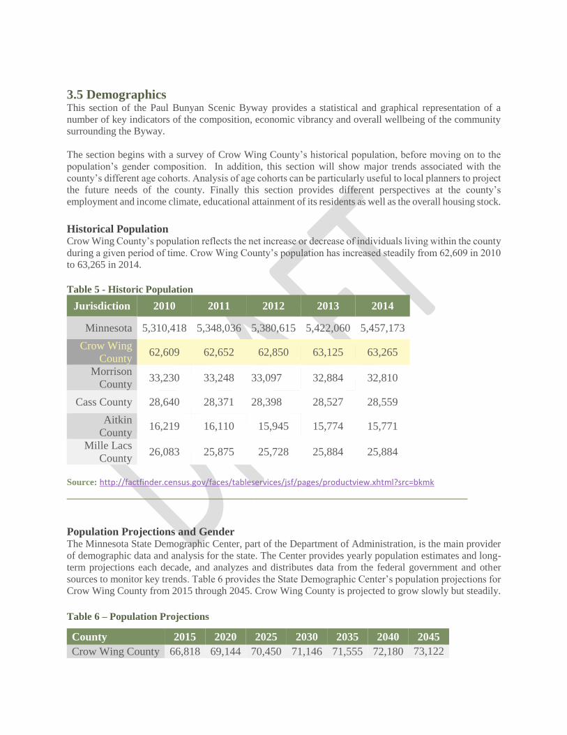
3.5 Demographics This section of the Paul Bunyan Scenic Byway provides a statistical and graphical representation of a
number of key indicators of the composition, economic vibrancy and overall wellbeing of the community
surrounding the Byway.
The section begins with a survey of Crow Wing County’s historical population, before moving on to the
population’s gender composition. In addition, this section will show major trends associated with the
county’s different age cohorts. Analysis of age cohorts can be particularly useful to local planners to project
the future needs of the county. Finally this section provides different perspectives at the county’s
employment and income climate, educational attainment of its residents as well as the overall housing stock.
Historical Population Crow Wing County’s population reflects the net increase or decrease of individuals living within the county
during a given period of time. Crow Wing County’s population has increased steadily from 62,609 in 2010
to 63,265 in 2014.
Table 5 - Historic Population
Jurisdiction 2010 2011 2012 2013 2014
Minnesota 5,310,418 5,348,036 5,380,615 5,422,060 5,457,173
Crow Wing
County 62,609 62,652 62,850 63,125 63,265
Morrison
County 33,230 33,248 33,097 32,884 32,810
Cass County 28,640 28,371 28,398 28,527 28,559
Aitkin
County 16,219 16,110 15,945 15,774 15,771
Mille Lacs
County 26,083 25,875 25,728 25,884 25,884
Source: http://factfinder.census.gov/faces/tableservices/jsf/pages/productview.xhtml?src=bkmk
________________________________________________________________________
Population Projections and Gender The Minnesota State Demographic Center, part of the Department of Administration, is the main provider
of demographic data and analysis for the state. The Center provides yearly population estimates and long-
term projections each decade, and analyzes and distributes data from the federal government and other
sources to monitor key trends. Table 6 provides the State Demographic Center’s population projections for
Crow Wing County from 2015 through 2045. Crow Wing County is projected to grow slowly but steadily.
Table 6 – Population Projections
County 2015 2020 2025 2030 2035 2040 2045
Crow Wing County 66,818 69,144 70,450 71,146 71,555 72,180 73,122
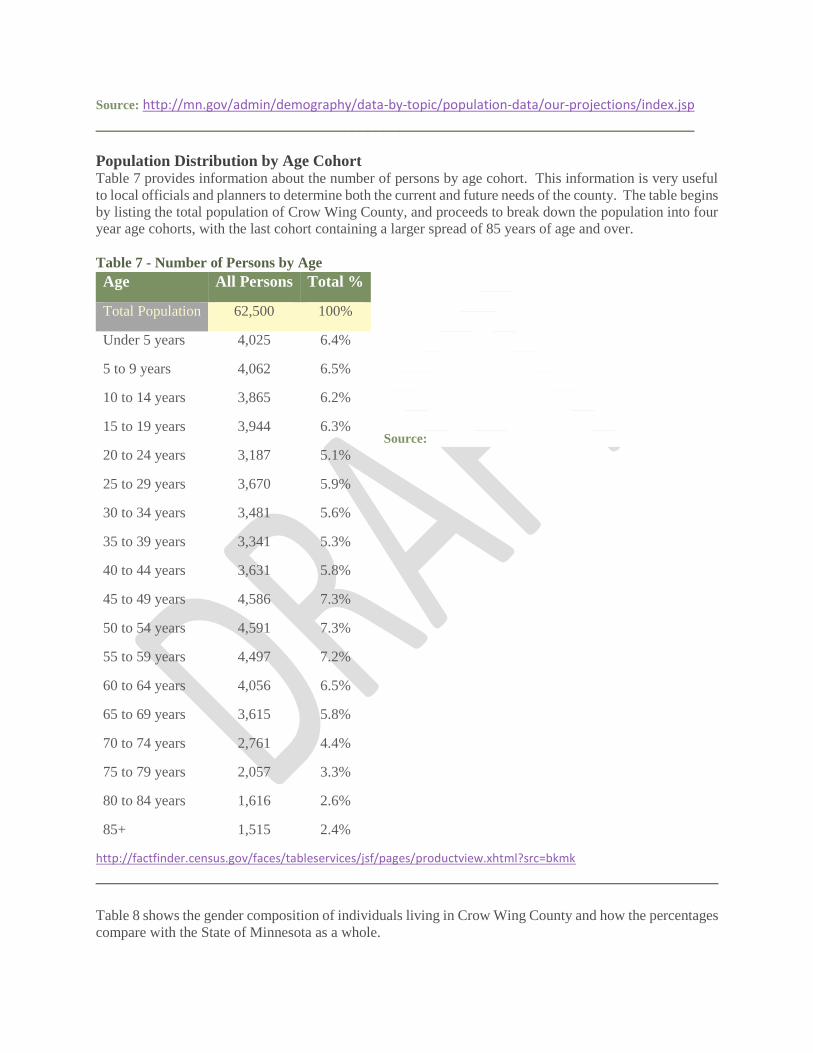
Source: http://mn.gov/admin/demography/data-by-topic/population-data/our-projections/index.jsp
___________________________________________________________________________
Population Distribution by Age Cohort Table 7 provides information about the number of persons by age cohort. This information is very useful
to local officials and planners to determine both the current and future needs of the county. The table begins
by listing the total population of Crow Wing County, and proceeds to break down the population into four
year age cohorts, with the last cohort containing a larger spread of 85 years of age and over.
Table 7 - Number of Persons by Age
Source:
http://factfinder.census.gov/faces/tableservices/jsf/pages/productview.xhtml?src=bkmk
______________________________________________________________________________
Table 8 shows the gender composition of individuals living in Crow Wing County and how the percentages
compare with the State of Minnesota as a whole.
Age All Persons Total %
Total Population 62,500 100%
Under 5 years 4,025 6.4%
5 to 9 years 4,062 6.5%
10 to 14 years 3,865 6.2%
15 to 19 years 3,944 6.3%
20 to 24 years 3,187 5.1%
25 to 29 years 3,670 5.9%
30 to 34 years 3,481 5.6%
35 to 39 years 3,341 5.3%
40 to 44 years 3,631 5.8%
45 to 49 years 4,586 7.3%
50 to 54 years 4,591 7.3%
55 to 59 years 4,497 7.2%
60 to 64 years 4,056 6.5%
65 to 69 years 3,615 5.8%
70 to 74 years 2,761 4.4%
75 to 79 years 2,057 3.3%
80 to 84 years 1,616 2.6%
85+ 1,515 2.4%
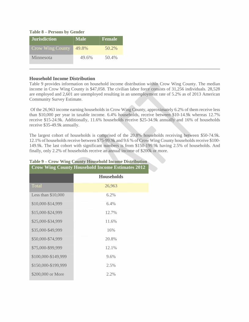
Table 8 – Persons by Gender
______________________________________________________________________________
Household Income Distribution Table 9 provides information on household income distribution within Crow Wing County. The median
income in Crow Wing County is $47,058. The civilian labor force consists of 31,256 individuals. 28,528
are employed and 2,601 are unemployed resulting in an unemployment rate of 5.2% as of 2013 American
Community Survey Estimate.
Of the 26,963 income earning households in Crow Wing County, approximately 6.2% of them receive less
than $10,000 per year in taxable income. 6.4% households, receive between $10-14.9k whereas 12.7%
receive $15-24.9k. Additionally, 11.6% households receive $25-34.9k annually and 16% of households
receive $35-49.9k annually.
The largest cohort of households is comprised of the 20.8% households receiving between $50-74.9k.
12.1% of households receive between $75-99.9k and 9.6 % of Crow Wing County households receive $100-
149.9k. The last cohort with significant numbers is from $150-199.9k having 2.5% of households. And
finally, only 2.2% of households receive an annual income of $200k or more.
Table 9 – Crow Wing County Household Income Distribution
Crow Wing County Household Income Estimates 2012
Households
Total 26,963
Less than $10,000 6.2%
$10,000-$14,999 6.4%
$15,000-$24,999 12.7%
$25,000-$34,999 11.6%
$35,000-$49,999 16%
$50,000-$74,999 20.8%
$75,000-$99,999 12.1%
$100,000-$149,999 9.6%
$150,000-$199,999 2.5%
$200,000 or More 2.2%
Jurisdiction Male Female
Crow Wing County 49.8% 50.2%
Minnesota 49.6% 50.4%
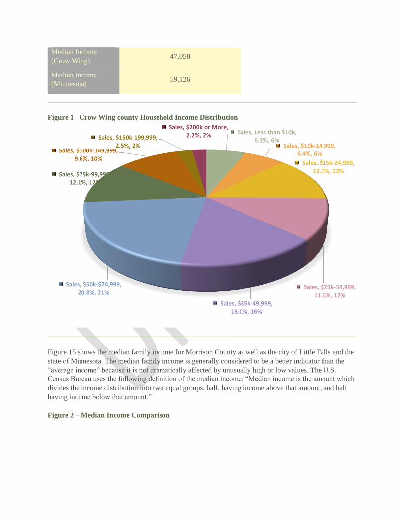
Median Income
(Crow Wing) 47,058
Median Income
(Minnesota) 59,126
______________________________________________________________________________
Figure 1 –Crow Wing county Household Income Distribution
______________________________________________________________________________
Figure 15 shows the median family income for Morrison County as well as the city of Little Falls and the
state of Minnesota. The median family income is generally considered to be a better indicator than the
“average income” because it is not dramatically affected by unusually high or low values. The U.S.
Census Bureau uses the following definition of the median income: “Median income is the amount which
divides the income distribution into two equal groups, half, having income above that amount, and half
having income below that amount.”
Figure 2 – Median Income Comparison
Sales, Less than $10k, 6.2%, 6%
Sales, $10k-14,999, 6.4%, 6%
Sales, $15k-24,999, 12.7%, 13%
Sales, $25k-34,999, 11.6%, 12%
Sales, $35k-49,999, 16.0%, 16%
Sales, $50k-$74,999, 20.8%, 21%
Sales, $75k-99,999, 12.1%, 12%
Sales, $100k-149,999, 9.6%, 10%
Sales, $150k-199,999, 2.5%, 2%
Sales, $200k or More, 2.2%, 2%

______________________________________________________________________________
Education A major concern of local communities and school boards across rural Minnesota is the maintenance of
quality education within areas of declining school age population. Some districts are using their proximity
to each other to pool resources to provide education programs such as foreign languages, developmental
education, and the education of exceptional children, as well as combining sports teams in order to be
able to continue to offer those opportunities for children to participate.
There are presently 8 public school districts that extend into Crow Wing County: Pine River-Backus,
Pequot Lakes, Crosby-Ironton, Aitkin, Brainerd, Onamia, Little Falls and Pierz.
Table 10: School Districts and Higher Education in Morrison County
School Districts in Crow Wing County
Pine River-
Backus
Pequot Lakes Crosby-
Ironton
Aitkin Brainerd Onamia
Little Falls Pierz
Higher Education Central Lakes College is one of 31 Minnesota State Colleges and Universities offering excellent,
affordable education in 46 communities across the state. CLC is a comprehensive community and
technical college serving about 6,000 students per year. With a knowledgeable, caring faculty and
modern, results-oriented programs in comfortable facilities, CLC is the college of choice for seekers of
success.
Educational Attainment
Series 1, Minnesota, $59,836
Series 1, Crow Wing County, $47,058
Series 1, Cass County, $45,045
Series 1, Morrison County, $47,649
Series 1, Aitkin County, $41,617
Series 1, Mille Lacs County, $47,862
Median Income Comparison
Minnesota Crow Wing County Cass County Morrison County Aitkin County Mille Lacs County

Education is crucial for the health and wellbeing of a community. Educational attainment shows the
extent of a community’s formal education through categories such as the following:
• Less than 9th Grade
• 9th to 12th Grade
• High School Graduate (includes Equivalency)
• Some college (no degree)
• Associate’s Degree
• Bachelor’s Degree
• Graduate or Professional Degree
Table 11- Educational Attainment
Crow Wing County Educational Attainment
Population 18 to 24 years 4,728
Less than high school graduate 12.4%
High school graduate (includes equivalency) 33.5%
Some college or associate's degree 47.8%
Bachelor's degree or higher 6.2%
Population 25 years and over 43,724
Less than 9th grade 2.3%
9th to 12th grade, no diploma 5.7%
High school graduate (includes equivalency) 30.8%
Some college, no degree 26.7%
Associate's degree 12.2%
Bachelor's degree 15.5%
Graduate or professional degree 7%
Percent high school graduate or higher 92%
Percent bachelor's degree or higher 22.5%
Population 25 to 34 years 7,030
High school graduate or higher 95.4%
Bachelor's degree or higher 26.8%
Population 35 to 44 years 6,876
High school graduate or higher 95.4%
Bachelor's degree or higher 26.8%
Population 45 to 64 years 17,858
High school graduate or higher 94.5%
Bachelor's degree or higher 22.8%
Population 65 years and over 11,960
High school graduate or higher 84.3%
Bachelor's degree or higher 21.6%

______________________________________________________________________________
Figure 3– Educational Attainment by Percentage
______________________________________________________________________________
Housing Total housing units in Crow Wing County is shown in Table 12. In addition to numbers of housing,
Table 12 shows the number of vacant houses. And lastly according to the American Community Survey
(ACS), Crow Wing County has a homeowner vacancy rate of 1.4% and a rental vacancy rate of 1.5%.
This information can be highly useful for city planners, developers, and property owners to determine the
level of demand for new housing, existing housing, or rental units.
Table 12- Number of Occupied and Vacant Housing
Number of Occupied and Vacant Housing in Morrison County
Housing Occupancy
Total housing units 40,333 100%
Occupied housing units 26,963 66.9%
Vacant housing units 13,370 33.1%
Homeowner vacancy rate 2.1 (X)
Rental vacancy rate 4.6 (X)
_____________________________________________________________________________
Figure 4 shows County Foreclosure Counts for Crow Wing County and the five counties that are
contiguous to it.
Figure 4 – Minnesota County 2014 Foreclosure Count
0.0%5.0%
10.0%15.0%20.0%25.0%30.0%35.0%
Less than 9thgrade
9th to 12th grade,no diploma
High schoolgraduate
Some college, nodegree
Bachelor's degree Graduate orprofessional
degree
Educational Attainment in Crow Wing County
Less than 9th grade 9th to 12th grade, no diploma High school graduate
Some college, no degree Bachelor's degree Graduate or professional degree

______________________________________________________________________________
2014 Forclosures, Crow Wing County,
72
2014 Forclosures, Cass County, 28
2014 Forclosures, Morrison County, 25
2014 Forclosures, Aitkin, 17
2014 Forclosures, Mille Lacs, 37
Crow Wing County Cass County Morrison County Aitkin Mille Lacs

Resource Summary

Section – 4 Resource Summary
The Paul Bunyan Scenic Byway Association identified resources, or points of interest along the Byway
route as part of its initial application for designation as a state scenic byway in 1998. During the Corridor
Management Planning process, these resources were reviewed and categorized by their intrinsic value (as
defined by the National Scenic Byways Program) and their significance evaluated to determine those
resources to emphasize for Byway planning, for project development and for marketing. The resource
inventory and evaluation process also provided direction for developing the overall Byway “story” or
theme. During the process, more than 80 resources were identified within the area of the 54-mile route.
These resources include those along the Byway roadways and resources located within the boundaries of
the Byway loops.
_____________________________________________________________________________________
4.1 Resource Evaluation The first step was field verification and mile marking of all resources identified in the original listing
submitted for Byway designation. During the field study, additional resources were identified and added
to the initial list. Other resources were identified during meetings with citizens, local government
jurisdictions, and organizations. This updated resource list was then used by the Byway Association
Board to identify the resource category. Resources were categorized by intrinsic value or quality.
Definitions of each of the six categories (intrinsic values) were reviewed, along with the initial
categorization to determine if there were resources that should be eliminated from or added to the listing,
or if there should be changes to specific resource categories. Additional research on a number of the
resources contributed to this re-evaluation process. Criteria were also developed to serve as a “checklist”
as the resources were reevaluated.
The Resource Summary was reviewed again, and those that most contributed to each intrinsic value
(category) were highlighted. This list was used to identify significance of the resources in terms of their
value locally, regionally, or nationally. The list also was used to rank each of the six intrinsic values. A
final Resource Evaluation was prepared that ranked the importance of each intrinsic quality to the Paul
Bunyan Scenic Byway, and identified the level of significance of resources along the Byway. Finally,
Byway significance worksheets were completed and an intrinsic value summary prepared for the top three
ranked categories.
The majority of resources were considered locally or regionally significant. That is, the Byway resources
are known within a local, statewide, or multi-state context; they contribute to a local or regional “theme.”
Two resources, Breezy Point Resort and the folklore of Paul Bunyan were considered to have national
significance.
4.2 Resources that Contribute to
Intrinsic Qualities In categorizing resources by intrinsic value and in ranking each intrinsic value, Board members found it
challenging to distinguish cultural and historic resources, and between natural and scenic resources. The
group recognized that the difference is not always clear, and that these values are closely tied, particularly
cultural and historic resources. The Minnesota Office of Tourism recognizes this relationship and is
currently emphasizing “cultural heritage” tourism. Similarly, natural and scenic resources are
distinguished primarily from each other by the level of human influence. Using this as the main factor,
most Byway resources were considered “scenic” rather than natural because of the degree to which the
landscape has been affected by human use.

Recreational resources were rated the highest and most important intrinsic value for the Paul Bunyan
Scenic Byway. The ranking was based on the variety of resources, availability of recreation year round,
location of resources all along the Byway, and the appeal of these opportunities for all age, gender and
family status groups. Historic and Cultural resources were ranked 2 and 3 respectively. The Byway has
many specific historic resource sites, or areas that tell a story of the area and how its past relates to the
present. These historic resources are the basis of the culture of the area.
Scenic and natural resources were ranked 4 and 5 respectively. While these two values were ranked
lower, the group recognized that the natural and scenic resources of the area (the lakes and woods and
wildlife they support) are the basis for the recreational, historic, and cultural values that exist along the
Byway. Finally, archeological resources were ranked last. Although no such resources have been
identified to date directly along the Byway, a number of Woodland culture Indian mounds (approximately
2,000 BP) are known to exist in the area, primarily located along the lakes.
These resources contribute to the cultural and historic context of the Byway area. Appendix C lists the
Byway resources, their location along the Byway, and the category each resource best represents. In many
cases, the resources contribute to several intrinsic quality categories. For example, most lakes represent
scenic and recreational qualities. Resort properties were originally designated cultural/historic and
recreational. However, this was revised to be listed only as cultural/historic resources because, while
resort properties offer recreational opportunities, these are available only to resort guests. Resort
properties that offer public recreation (e.g., golf at Breezy Point, skiing at Boyd Lodge), are thus
designated recreational as well as cultural/historic.
During the inventory review, three Byway areas, or segments, emerged: the Byway spine, the North
Loop, and the South Loop.While each segment contains some or all of the identified intrinsic qualities,
each has resources that more strongly characterize particular intrinsic qualities present along the Byway.
These characteristics suggest resources that can be enhanced along each segment to support the Byway
story.
The Byway Spine CSAH 16 was identified as the “spine” of the Byway route. Traveling along the south
side of the Whitefish Chain, this roadway is the “heart” of the family resort area. The 10 family owned
resorts located along this 13-mile segment date back to the 1920’s and 30’s and tell the story of the
industry beginnings as farms and logging camps. The spine also includes recreational opportunities
associated with the area natural resources-hiking and biking through the well-known Uppgaard Wildlife
Management Area and the Island Lake Woods site. Highlights along this roadway include:Resorts: Hay
Lake Lodge, Sunset Knoll, Clamshell Beach,Towering Pines, Black Pine Beach, Boyd Lodge, Pine
Terrace, Bay View, Lovelands all dating to the 1920’s and 30’s.
Uppgaard WMA: This 110-acre tract has been specially landscaped to attract wildlife. Wide walking
trails meander through the property, which includes two ponds. Island Lake Woods: 158-acre forested
area, much of which was replanted in 1958. The west edge abuts Upper Hay Lake. Hay Creek runs
through the parcel and is designated as a fish management area. Cross Lake/Rush Lake: Scenic views of
these popular recreational lakes that are part of the Whitefish Chain. Indian Battle site: Site of battle and
massacre of the Ojibwa Indians by the Dakota Sioux Indians in 1801.
North Loop This loop travels north from Crosslake around the north side of the Whitefish Chain of lakes. Here the
Corps of Engineers Dam, the old log landing, Northgate Lane and the Old Grade Road tell the story of the
logging industry. Historic town halls, churches, cemeteries, and an old store are also located along this
12-mile route. Route highlights include: Crosslake Historical Society Museum and Historic Village:

Showcasing the lake area’s first residents, the buildings date back to the late 1800s. COE Dam and
Recreational Park: Crosslake’s oldest historical site, the dam was originally built in 1885 and 1886 to
raise the water level for navigation including transport of logs.
The Old Log Landing is a historic grounds for dumping logs into the lake that were carried by railroad
over the Old Grade Road. Old Grade Road: This railroad bed was used to move logs during the 1880’s.
Timothy Township hall, Jenkins Township hall: Former one-room schoolhouses Walleye stripping
station: Operated by the DNR, walleye are intercepted as they enter the river to spawn. Driftwood Resort
Museum: Traces the history of family resorting in the Whitefish area.
South Loop The 23-mile southern loop passes along the north side of Pelican Lake. Here the variety of year-round
recreational resources is evident. Public access to Big Pine Lake and Pelican Lake are located along this
loop. The new Deacon’s Lodge Golf course, golf courses at Breezy Point resort, horseback riding stables,
the new ice arena, cross country ski trails, and hiking trails at the Chiarella site are among the variety of
recreation offered along the southern loop. This route also directly connects with the paved Paul Bunyan
State Trail at Pequot Lakes.
Highlights along this route include: Pine Lake: Scenic lake connected to the Whitefish and
Ossawinnamakee chains through creeks and streams. DNR Fire Tower: One of the few remaining actively
used fire towers in Minnesota; listed on the National Register of Historic Towers. Breezy Point Resort:
Once owned by Captain Billy Fawcett, this resort hosted the famous and infamous. Crosscountry skiing,
golfing and boat access are available to the public. Deacon’s Lodge: Ranked in the top 10 new public
courses; designed by Arnold Palmer. Chiarella Forest Management Area: Managed by the DNR, this 77-
acre tract is being developed with interpretive hiking trails. Paul Bunyan State Trail: Paved
hiking/biking/inline skating and snowmobiling trail following the old Burlington Northern railroad bed.
Table 4-1 Intrinsic Qualities Checklist*
Archeological Quality Physical evidence of historic or prehistoric human life that are visible and capable of being inventoried
and interpreted (identified through ruins, artifacts, structural remains) and have scientific significance.
Criteria: There is visible physical evidence Resources are accessible Resources are scientifically
important
Cultural Quality Evidence and expressions of customs or traditions of a distinct group of people (crafts, music, dance,
rituals, festivals, speech, food, special events). Geography -settlement patterns, climactic influences on
building styles, place names, stories and legends Criteria: The area is populated by a distinct group of
people. Traditions of its people are expressed in festivals, events, food, etc. Stories and legends contribute
to its people, activities, history.
Historic Quality Legacies of the past associated with physical elements of the landscape; reflect actions of people. Specific
set of events, an evolving historical story linking diverse events and time periods (e.g., development of
farming, a specific industry or social or political movement). Criteria: Clear relationship of people to the
physical setting Clear relationship of past to present

Natural Quality Features of visual environment that are in a relatively undisturbed state and predate arrival of human
populations (geological landforms, fossils, water bodies, vegetation and wildlife). Criteria: Resources are
visible along the Byway Resources are relatively undisturbed
Recreational Quality Outdoor recreational activities directly associated with and dependent on the natural and cultural elements
of the landscape; opportunities for active and passive recreational experience. Visual access to significant
resources and the relationship among the resources and between the resources and the road. Criteria:
There are a variety of recreational opportunities available throughout the year Resources exist in many
places along the byway. The relationship of the resources to the Byway and to each other support the
overall theme or Byway “story.”
Scenic Quality Heightened visual experience derived from the view of the natural and manmade elements of the visual
environment (views and vistas) existence or significant scenic views from the road and absence of
features that detract from the overall image of the road. Criteria: Views are frequent and contribute to a
sense of continuity along the Byway Views show a relationship to each other that creates a unified image
of the Byway There are a variety of views all along the Byway route* Definitions taken from Federal
Highway Administration, National Scenic Byways Program, 1999.“Byway Beginnings”

Implementation

Section 5 – Implementation
Once a Byway has been designated, resources identified and inventoried, it’s time to tell others about the
Byway travel opportunity. Interpretation, “telling the Byway story” is a key piece of the tourism picture.
Advertising and promotion may attract travelers; interpretation will provide visitors with information
about the resources and their value.
_____________________________________________________________________________________
5.1 Interpreting the Paul Bunyan Scenic Byway Interpretation is a communication process that forges emotional and intellectual connections between the
interests of the audience and the meanings inherent in the resource. Interpretation uses a variety of
methods to relate what is displayed to something within the experience of the visitor. The goal of
interpretation is to present a whole, rather than a part, and to provoke the visitor.
Interpretation gives visitors a reason to stay longer, and to “spread the word” about their experiences and
this translates into positive economic impacts. Interpretation expands local knowledge of the area and its
resources, may enhance support, and offer educational opportunities to schools and other not-for-profit
organizations.
Currently, the Paul Bunyan Scenic Byway is marked and identified as a Scenic Byway by highway signs
along the 54-mile route. While there are many interesting and important historic, natural, scenic, and
recreational resources along the route, there is little to indicate these points of interest, or to tie these
resources together to tell the Byway story. A first step in implementing an interpretive program is to
define a unifying “theme” that connects resources and sites into a cohesive product.
Lakes and Woods
The lakes and woods have been the focus of life for residents and travelers to the Paul Bunyan Scenic
Byway area since human populations expanded into the Great Lakes area between 12,500 and 9,000 years
ago. The Woodland Indians traveled seasonally through the lakes and rivers seeking deer, elk, antelope
and bison. Around the lakes of the Whitefish Chain they came to bury their dead in round, conical or
dome shaped mounds, one of the defining characteristics of the Woodland culture. Excavated Woodland
mounds include a series at the U.S. Army Corps of Engineers dam on Crosslake and around Lake Bertha.
The areas around the Mississippi River, including the Pine River, were favorite hunting and wild ricing
grounds for the Dakota Indians who also used the Pine River as a means to travel to and from the Gull
Lake and Leech Lake areas. Their way of life was a continuation of the Woodland culture that had existed
for a thousand years. Both the Dakota and Ojibwa traveled primarily by water. They came to the
Whitefish area via the Crow Wing and Gull rivers into Gull Lake, then into Sibley Lake at Pequot Lakes
and finally portaging canoes over to Upper Hay Lake.
These same waterways and portage trails became the route of the fur traders and explorers of the 1600s.
The arrival of Sieur Duluth in 1679 who traveled with the Dakota from Lake Superior signaled the
beginning of the fur trade in Minnesota. Beaver, mink, fisher, marten, and weasel pelts from the
Whitefish Chain were taken by canoe, traveling from Fond Du Lac to Grand Portage, the most important
fur trading location from the 1770s to the early 1800s. Jean Baptiste Perrault and his partner Alexis
Reaume wrote of the Whitefish Lake and Pine River in his diary in 1784. A temporary trading post
wasbuilt on the north shore of Whitefish Lake about 1801.

In 1805 Lt. Zebulon Pike, sent by President Jefferson to lay claim to the Louisiana Purchase, wrote of his
arrival at Whitefish Lake. Joseph Nicollet mapped and charted the waterways, describing the forests,
rivers and lakes through which he passed, including the Pine River and Whitefish Chain.
The woods became the source of the logging industry, and the lakes the mechanism to transport logs to
the sawmills.Today, the lakes and woods provide recreation for residents and visitors. Logging and Resort
Beginnings The area encompassing the Paul Bunyan Scenic Byway is known as the land of Paul Bunyan,
the famous logger whose legendary feats were told during late evenings at the logging camps that dotted
the north central woods and lakes area in the mid 1800’s. The lakes and land offered resources to meet an
escalating demand for lumber in the U.S. during the 1850s. The white and red pine forests provided the
lumber, the lakes and rivers the means to transport the lumber.
During the early logging years, logs were driven from the woods to the mill down the water courses
leading into the Mississippi and St. Croix rivers, making the Pine River a major thoroughfare for lumber
transport. In 1885-1886 the U.S. Army Corps of Engineers dam at Crosslake was constructed to increase
Mississippi River discharges during low flow periods to aid navigation, to control the heavy runoff from
spring break-up, and to lessen the potential for flooding downstream.
For the logging industry, this created an advantage. In the spring, logs were driven through the dam’s
sluiceway into the south fork of the Pine River and on to mills at Brainerd or south via the Mississippi
River to St. Paul. The last drive down the Pine River was the spring of 1902 and by 1910 there were
no more loads of logs dumped into Cross Lake. As the logging industry diminished in the early 1900’s,
the lakes and land again became a focus of a new industry.
Settlers and homesteaders arrived with the coming of the railroad in the early 1900s. Many tried farming
the land but found it difficult to make a living. Even before the coming of the railroad, hunters and
fishermen sought out the area, camping or finding lodging in the logging camps, which became the first
visitor “resorts.” Red Cedar Lodge located at the mouth of the Pine River and Upper Whitefish, had been
headquarters for a log booming assembly area. As the logging industry diminished, the loggers’ cabins
were turned into resort cabins.
Other resorts evolved as farmers supplemented their incomes by taking in fishermen and hunters. The
railroads promoted the growing resort business as well. Built originally to serve the logging industry,
towns grew up along the railway stops and the trains began hauling passengers. In Pequot Lakes and
Crosslake, the railroads provided service to the Whitefish Chain; horse-drawn carriages took visitors to
the resorts. As the tourism business grew, stories of Paul Bunyan changed as well.
The area, with its vast lakes became known as “Paul Bunyan’s Playground,” the lakes created by his
footsteps as he walked across the landscape. His fishing bobber sits above the town of Pequot Lakes,
which added “Lakes” to its name in 1940 to symbolize the importance of the lakes that drew a growing
tourist business and resort industry. Family resorts sprouted in the 1920s-1940s, drawing weekend
“fishermen” from throughout the region. Families arrived for their vacations, primarily to fish and swim
in the numerous lakes. The area had its famous visitors as well.
Captain Billy Fawcett’s Breezy Point Resort hosted the Hollywood elite-Clark Gable and Carol Lombard
are listed among the guests at the famous Fawcett House, which still stands in the center of this well-
known resort on Pelican Lake. Breezy Point, and other resorts, such as Manhattan Beach Lodge, were
known as getaway spots for Chicago mobsters of the 1930s. Old timers tell stories of the slot machines
buried in Pelican and Trout lakes - tossed in the lakes as a last ditch effort to stash the evidence during
police raids.

Today roadways that have replaced the railroads continue to bring visitors to the area.
Indian mounds have been excavated as new homes are built for the growing permanent and seasonal
populations. But the draw of the lakes and land remains the same-the visitors and new residents come to
the area to enjoy the natural resources, and those resources continue to provide the mainstay of the area’s
economy.
Today visitors and residents alike enjoy the varied recreational opportunities offered along the Byway
area-hiking in the woods; biking along the Paul Bunyan State Trail, a former railroad bed; fishing,
swimming, and boating in the lakes; horse-back-riding along country trails; snowmobiling and cross-
country skiing in the winter; birding and wildlife watching. The lakes and land are the focus of life for
visitors and residents, just as they were 2,000 years ago.
5.2 Interpretive Recommendations The following suggest possible “themes” for interpreting the Byway and its resources. These “themes”
are potential ways to tie the resources together, to “tell the story” of the Byway in a way that can connect
the resources to the traveler. These recommendations are variations of a focus on the lakes and woods.
Folklore theme The name “Paul Bunyan” is a nationally recognized folk legend. The image conjures up stories of logging
camps, history of the north woods, and the lakes created by Paul’s footprints as he walked across the
landscape. Minnesota tourism information labels this area as “Paul Bunyan’s Playground,” known for its
variety of recreational opportunities. The Byway is named after this legendary folk hero, and the Byway
logo is of Paul and Babe the Blue Ox. A Byway folklore theme focusing on Paul Bunyan could tie
history, culture, natural, scenic, and recreational resources together and capitalize on a nationally
recognized icon.
Natural Resource theme The Paul Bunyan Scenic Byway is located in the heart of Minnesota’s north central pine and lakes region.
The 54-mile route winds around the state’s most beautiful and well-known lakes, such as the Whitefish
Chain of Lakes, Pelican Lake, and the Ossawinnamakee Chain of lakes. The lakes and woods,
characteristic of the Byway area, are the core of its natural, scenic and recreational resources, and the
basis of the history and culture of the area. A Byway theme could focus on how the natural and scenic
resources of lakes and woods were the basis for the Indian culture, and the fur trading, logging and
subsequent resort and tourism industry. The lakes and woods story could be told from a “Paul Bunyan”
perspective, thus weaving this folk hero into the Byway story.
Human Use of Resources theme A third option is to focus on people, on the changing human use of the natural and scenic resources (lakes
and woods) beginning with the Woodland Indians, development of fur trading and exploration, to the
logging industry of the mid 1800’s, followed by the growth of the resort industry to the current
recreational uses of these resources. This focus connects the water and woods to people’s work and play,
past and present. The stories could be told through the Paul Bunyan legend. Interpretive emphasis would
be on the later history of the area. These are the intrinsic qualities for which the area is best known and
which were ranked of highest significance to the Scenic Byway.
One suggested theme phrase is “Legacy of Legend, Lakes, and Land.” This theme phrase can encompass
the Byway’s intrinsic qualities-history, culture/folklore, natural and scenic resources, and the past and
present use of the lakes and land. Furthermore, “legacy” has a future implication as well, and offers an
opportunity for natural resource stewardship interpretive messages.

The interpretive story, using the “Legacy of Legend, Lakes and Land” could begin with Paul Bunyan (the
well-known legend) telling the story of the area that is today known as “Paul Bunyan’s Playground.”
Through Paul Bunyan, the story could be told of the first people who used the lakes and the woods, then
move into his period, (the logging industry), then trace the settlement of the area and growth of the resort
and tourism industry. The end of the story then becomes a new beginning-the lakes and land continue the
legacy of human use of the resources. This can lead into a final stewardship message about the resources
of lakes and land.
5.3 Interpretive Planning Developing a Byway theme is one step in the Interpretive Planning process; it weaves the intrinsic
qualities and resources along the Byway into a cohesive story, establishing a connection between the
visitor and Byway resources. Interpretive planning is a process to identify effective ways to connect
visitors with resources in a way that results in greater understanding, appreciation and behavioral change.
Interpretive planning must also consider visitor needs and how, when and where to tell the story. In 2002
the Paul Bunyan Scenic Byway Association submitted an application to National Scenic Byways Program
grant to prepare an Interpretive Plan as its next step in developing the Byway Program. This interpretive
plan, completed in 2004 did the following:
• Identified traveler needs and interests;
• Developed an overall Byway theme and subthemes;
• Identified resources and evaluate their interpretive value; and
• Identified methods and locations to “tell the Byway story.”
5.4 Projects and Priorities Over the years, several projects to enhance existing Byway resources and provide information about the
Byway and its resources have been identified by the Byway Association, and by others during meetings
with agencies and organizations. The projects were prioritized and potential sources of funding identified.
Inherent in these discussions is the understanding that priorities can change, and will continue to change,
based on public input, and as opportunities are presented to implement other specific projects. This has
been the case for a number of suggestions and project ideas.
• The current Birds of the Byway project grew out of an idea to highlight the numerous osprey
nests that occur along the route. Shortly thereafter, funds became available through the Office of
Tourism for wildlife tourism marketing.The “Trail of the Osprey” became the Birds of the Byway
brochure.This project was completed in 2000.
• Enhancements to the DNR fire tower access and development of interpretive facilities were
identified by the Byway. Sibley Township also identified an interest in the project, separate from
the Byway. The Township provided funds and has worked with the DNR and Crow Wing County
Highway Department to improve access to this facility. This original project was completed in
2001. Sibley Township was annexed into the City of Pequot Lakes. Other supporters came
forward, and the site continues to enjoy regular improvements and increasing public visitation.
• Computerized information kiosks were made available to local jurisdictions along the Byway
and installation was considered a priority. Once obtained, the kiosks were found unsuitable for
the proposed use and the project discontinued by the Byway Association. Later, the Brainerd
Lakes Area Chambers of Commerce considered installing updated kiosks at several locations,
including one location along the Byway, as a pilot project. While this did not make it to fruition,
it points again to the importance of continuously reviewing projects and implementation actions,
including funding opportunities. Appendix C lists early projects that were initially identified,

potential funding sources, project status, and responsible jurisdictions, agencies and
organizations. Projects listed in Appendix C focus on developing facilities designed to enhance
Byway resources, or provide information about the Byway resources. The following describes
and discusses categories of projects, and their priority.
5.5 Planning Projects Interpretation The Paul Bunyan Scenic Byway Association has identified this as a top priority and has submitted an
application for a National Scenic Byway Organization grant. The Association recognizes that
interpretation is necessary to adequately tell the Byway story, to assess the value of the resources as they
relate to the Byway story, and to identify and implement specific projects-both development of facilities
and information— that will support the Byway Program. Completion and implementation of the
Interpretive Plan is necessary to provide a tourism product.
Marketing Marketing involves promoting the Byway as a tourism product. It assumes the Byway offers facilities,
resources, and information of significant interest to attract visitors. Preparing a Marketing Plan is
important to strategically target markets and to use appropriate mechanisms to reach those target markets.
The public participation process described in Section 2 has increased awareness of and interest in the
Byway, primarily among residents.
Public relations efforts, such as the bi-annual newsletter, regular website content and social media
additions and other news articles offer information about the Byway. These efforts-public participation
and public relations-provide important links to marketing. However, these are aimed at providing
information, gaining recognition and support of the Byway and its activities. Marketing is specifically
oriented toward attracting travelers for an economic benefit. Section 6 presents an initial marketing
strategy for the Byway. It suggests marketing strategies and priorities, identifies challenges to Byway
marketing and opportunities to use those challenges to promote the Byway. A comprehensive marketing
plan will identify: visitor characteristics and needs, target market groups, mechanisms to reach target
markets most effectively, and tie these to the Byway theme and resources. The Sustainability Plan,
developed in 2008, addresses funding and financial capacity for the PBSB. Sufficient funding is the
underpinning of any marketing effort.
5.6 Enhancement Projects Transportation Transportation safety issues, specifically paving shoulders along the Byway route have been addressed
since the original CMP in 2001. The Byway was initiated because of the desire by local residents to pave
shoulders along CSAH 16 to provide increased safety for bicyclists and pedestrians along the road.
Township officials along the north loop of the Byway have also noted the importance of paved shoulders.
Paved shoulders on CSAH 11 between Breezy Point Resort and Pequot Lakes have been cited as
important to bicyclists because that route also connects directly with the Paul Bunyan State Trail in
Pequot Lakes. With the increased popularity and use of the Paul Bunyan State Trail that connects with the
Byway at four locations, paved shoulders would provide additional opportunities and increased safety for
non-motorized travel between the Byway and the Trail. The table below lists the paved lane widths and
shoulder widths along the Byway.
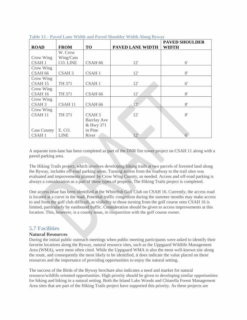
Table 13 – Paved Lane Width and Paved Shoulder Width Along Byway
ROAD FROM TO PAVED LANE WIDTH
PAVED SHOULDER
WIDTH
Crow Wing
CSAH 1
W. Crow
Wing/Cass
CO. LINE CSAH 66 12' 6'
Crow Wing
CSAH 66 CSAH 3 CSAH 1 12' 8'
Crow Wing
CSAH 15 TH 371 CSAH 1 12' 6'
Crow Wing
CSAH 16 TH 371 CSAH 66 12' 8'
Crow Wing
CSAH 3 CSAH 11 CSAH 66 12' 8'
Crow Wing
CSAH 11 TH 371 CSAH 3 12' 8'
Cass County
CSAH 1
E. CO.
LINE
Barclay Ave
& Hwy 371
in Pine
River 12' 6'
A separate turn-lane has been completed as part of the DNR fire tower project on CSAH 11 along with a
paved parking area.
The Hiking Trails project, which involves developing hiking trails at two parcels of forested land along
the Byway, includes off-road parking areas. Turning access from the roadway to the trail sites was
evaluated and improvements planned by Crow Wing County, as needed. Access and off-road parking is
always a consideration as a part of those types of projects. The Hiking Trails project is completed.
One access issue has been identified at the Whitefish Golf Club on CSAH 16. Currently, the access road
is located at a curve in the road. Potential traffic congestion during the summer months may make access
to and from the golf club difficult, as visibility to those turning from the golf course onto CSAH 16 is
limited, particularly by eastbound traffic. Consideration should be given to access improvements at this
location. This, however, is a county issue, in conjunction with the golf course owner.
5.7 Facilities Natural Resources During the initial public outreach meetings when public meeting participants were asked to identify their
favorite locations along the Byway, natural resource sites, such as the Uppgaard Wildlife Management
Area (WMA), were most often cited. While the Uppgaard WMA is also the most well-known site along
the route, and consequently the most likely to be identified, it does indicate the value placed on these
resources and the importance of providing opportunities to enjoy the natural setting.
The success of the Birds of the Byway brochure also indicates a need and market for natural
resource/wildlife oriented opportunities. High priority should be given to developing similar opportunities
for hiking and biking in a natural setting. Both the Island Lake Woods and Chiarella Forest Management
Area sites that are part of the Hiking Trails project have supported this priority. As these projects are
developed, there will also be a need to develop appropriate facilities for multi-modal access. Similar
projects along the Byway that emphasize the natural resource setting should be considered a priority.
Severalnmalready completed projects identified by the Byway Association focus on improvements to
sites relating to the Byway’s natural and scenic qualities and resources. These include:
• Lowell Wildlife Management Area
• Uppgaard Wildlife Management Area
• Trail Meets the Byway Recreation Developing additional recreational opportunities was also
identified as important to residents.
The increasing use of the Paul Bunyan State Trail for bicycling, in-line skating, hiking, and snowmobiling
demonstrate the popularity of these outdoor activities to residents and visitors. The Byway Hiking Trails
project is intended to provide additional hiking opportunities in the area. During public meetings,
additional snowmobile trails, particularly along the northern Whitefish area, and canoe access at Upper
Hay Lake were identified as recreational needs. Rush Lake residents are looking toward offering boat
tours that highlight geographic features. Other recreation-oriented projects include:
• Pine Lake picnic area
• USACOE Dike 16 trails
(not completed)
Cultural/Heritage Cultural heritage tourism been identified as one of several target markets by the Minnesota Office of
Tourism. Along the Paul Bunyan Scenic Byway, the Historic Village at Crosslake is a popular visitor
attraction and was identified during public meetings as a favorite spot. The Byway offers numerous
opportunities to relate the culture and history of the area that is closely tied to its natural resources. These
include:
• Byway stories (Part of many projects including the LUMG-Linda Ulland Memorial Gardens)
• Interpretive Center (in progress)
• Byway Art (Done. And continuing with a new Birds of the Byway Note Cards project.)
5.8 Cooperative Projects High priority should be given to projects proposed and led by jurisdictions, agencies, or organizations that
support the Byway, enhance resources along the Byway, and offer attractions for Byway travelers and
residents.
Crosslake is currently expanding its parks and recreation facilities with plans to prepare an off-
road biking/hiking trail along Westshore Drive between CSAH 16 and 39 (Done). In addition, the
City intends to improve the Crosslake nature trail area off CSAH 103, which connects with the
Byway’s CSAH 3 roadway. (A trail was completed but at this writing, we don't know the exact
route.)
The new Town Square project in Crosslake, completed in 2005 draws an increased number of visitors to
the area. The City of Breezy Point has received an outdoor recreation grant to improve its City Park
facilities along CSAH 11. The project includes a hiking trail, playing fields, and a pavilion.

The Pelican Woods Cemetery and Nature Trails in Breezy Point includes a walking trail and gardens
developed by local master gardeners. These goals, projects, and actions undertaken by local jurisdictions
within which the Byway travels, support Byway goals, enhance the Byway’s intrinsic values and its
resources, and provide facilities for resident and visitor enjoyment of the area.
The Byway Association should place high priority on working and coordinating with these and other
jurisdictions in Byway planning and facility development.

Marketing Marketing
Marketing

Section 6 - Marketing
The Paul Bunyan Scenic Byway Association has been involved in marketing activities, primarily through
its public information and public relations efforts since the Byway was officially designated in 1998. The
Association has worked closely with other tourism groups to promote the Byway as an adjunct amenity
for visitors, and to increase awareness and appreciation of the Byway and its resources among permanent
and seasonal residents. Paul & Babe's GeoHunt, Historic Mailboat presentations, Interpretive panels, Paul
Bunyan Exhibit Room, Photo Op cut-outs at Corps Playground, Paul Bunyan-sized foot prints.
_____________________________________________________________________________________
The Byway public information and public relations efforts are closely tied to marketing and represent a
first step toward designing and implementing marketing strategies to encourage Byway travel and attract
more visitors to the area. Public information activities are increasing awareness of the Byway within the
local area. Through the Corridor Management planning process, Byway Association representatives met
with local and area groups discussing the Byway, its purpose, value, and resources and sought ideas and
information about these resources, as well as others that may have been overlooked in the initial
inventory. This public information process had a “marketing” effect. As knowledge and awareness of the
Byway increase, appreciation of and interest in exploring its resources increase, thus promoting travel
among area residents and their visitors. This was borne out in the University of MN research project
designed to assess the economic impact of the Byway on the area.
Public relations provides another link to marketing, one aimed at gaining recognition and support for the
Byway. It is also a cost-effective method of promotion because it does not rely on paid advertising or
costly collateral materials. Rather, the focus is on placing editorial material in existing publications.
Feature stories in a national publication, or news items on local radio are examples of public relations that
also promote or “market” the Byway. Marketing involves promoting the Byway as a tourism product to
identified population segments. Clearly, the research cited above, shows that the PBSB is already being
viewed by many travelers as a tourist attraction.
This section of the Corridor Management Plan (CMP) summarizes current activities, identifies issues and
opportunities for promoting the Paul Bunyan Scenic Byway, and offers recommendations for Byway
marketing. Finally, a marketing plan, adapted from the Minnesota Scenic Byways Master Marketing Plan
is presented.
6.1 Current Activities The focus of the Paul Bunyan Scenic Byway Association promotional activities has been on informing
the community about the Byway and soliciting their ideas through presentations to community groups,
feature and news articles in local media, and regular updates of activities through the newsletter and
website. One promotional piece, “The Birds of the Byway” brochure, targeted to the growing segment of
bird enthusiasts, identifies prime spots for bird watching along the Byway as well as species likely to be
found during each season. In addition, the Pequot Lakes Visitor Guide lure book includes a Byway
feature and map. Specific promotional activities have included:
• Newsletter, “Inkslinger” is distributed bi-annually to all Association members, supporters and
local jurisdictions;
• For several years, a monthly column, “Byway Bylines,” was published in the Lake Country
Echo, a local weekly newspaper;

• A map and description of the Byway is included in the Pequot Lakes-Breezy Point Visitor
Guide;
• The Brainerd Lakes Area Chambers of Commerce have denoted the Byway route on its area
map since it was officially designated as a Byway.
• A website, www.paulbunyanscenicbyway.org is on line with links from the Brainerd and
Pequot Lakes Chambers of Commerce, the Whitefish Area Lodging Association, Minnesota
Office of Tourism, and National Scenic Byway websites;
• A brochure, “Birds of the Byway,” was published and distributed and is currently in its third
printing. The brochure prompted a birdsofthebyway.org website, and most recently Birds of the
Byway Note Cards.;
• Summary and feature presentations have been made to a number of area organizations and local
jurisdictions through which the Byway passes.
• A bus tour of a portion of the Byway was offered to visitors and residents during the first annual
Whitefish Area Lodging Association’s Eco-weekend, which featured points of environmental
interest in the Whitefish area.
6.2 Issues and Opportunities The Paul Bunyan Scenic Byway like many MN Byways faces a number of challenges in developing and
implementing a successful marketing program. Each challenge, or issue, however, presents an opportunity
to enhance effectiveness of marketing efforts.
Issue #1 Since its designation in 1998, a small group of volunteers has worked hard to increase awareness of the
Byway and its potential as an amenity for permanent and seasonal residents, and an attraction for visitors.
In order to sustain its activities, enhance Byway resources, and promote travel, the Association needs to
achieve more active participation by current members, and increase participation by a broader range of
community interests. Marketing efforts need to target area residents as well as visitors to increase interest
and participation in Byway activities.
Opportunity #1 Local service organizations are often seeking to be involved in the community and specific projects to
benefit the communities. Involving community organizations in projects that support Byway activities
will heighten awareness, broaden participation, and increase support, and at the same time, enhance
Byway resources. Furthermore, these groups will promote their activities, indirectly promoting the
Byway. Several local jurisdictions through which the Byway passes have prepared or updated
comprehensive plans, and are involved in park and recreation planning.
In Crosslake, park and recreation department plans for biking and hiking trails are located within the
Byway area. In Breezy Point, an Outdoor Recreation grant is being used to further develop a city park
adjacent to the Byway. A new Crow Wing County Recreation Board may also provide expertise and
financial resources. Supporting these efforts and incorporating these resources into the Byway Program
will broaden knowledge and support for the Byway.
Issue #2 The Paul Bunyan Scenic Byway connects with the Paul Bunyan Trail, a 100-mile paved biking,
hiking and snowmobile trail, at three locations. This has created confusion for many residents and visitors
who assume the Byway is the trail. This is complicated by the fact Byway designation was initially
sought in order to obtain county priority in paving shoulders along one Byway segment to provide a bike
path. To overcome this confusion, the Byway needs to build a stronger identity, distinct from the Paul
Bunyan Trail.
Opportunity #2 Although the Byway is often confused with the trail, the connections between
the trail and the Byway offer unique, cooperative marketing opportunities. The trail is well known,
publicized, and marketed. It is well represented by state legislative efforts. U.S. Representative Jim
Oberstar was a bicycle enthusiast who was also instrumental in introducing and supporting federal
legislation that established the National Scenic Byway Program in 1991. Since Rep. Oberstar’s passing in
2014, participation from other like-minded biking enthusiasts in trail and byway promotion might help
make the distinction between the two while promoting both.
Traveler profiles indicate visitors are interested in people, learning, and ideas. Marketing targeted to the
local history, culture and the variety of recreational opportunities along the Byway have and will continue
to help distinguish it from being simply a “bike path.” Exhibits at Trail-Byway connections that focus on
the natural, historic, cultural, and recreational resources along that segment of the Byway would
distinguish the Byway from the Trail yet offer a physical connection for bicyclists. The completed Trail
Meets the Byway project did indeed highlight the Byway at two physical connections to the State Trail.
Issue #3 Currently, the Byway is marked and identified as a Scenic Byway by signs along the 54-mile route.While
there are many interesting and scenic places along the route, there is currently not enough to indicate
these points of interest, or to tie these resources together to tell the Byway story. The Byway needs a
unifying “theme” to connect its resources and sites into a cohesive marketable product.
Opportunity #3 Paul Bunyan is a nationally recognized folk legend based in stories from logging camps. Minnesota
tourism information labels this area as “Paul Bunyan’s Playground,” known for its variety of recreational
opportunities. The Byway is named after this legendary folk hero, and the Byway logo is of Paul and
Babe the Blue Ox. A Byway theme needs to use the national recognition of Paul Bunyan and associated
folklore to tell the Byway story (see Section 5.0, Implementation). This is what prompted the "Explore the
Lore" theme; a working concept under the larger umbrella theme of 'Legacy of Legend, Lakes and Land'.
6.3 Recommendations Recommendation #1 Continue to develop the unified concept or “theme” of Legacy of Legend, Lakes and Land and the
underlying Explore the Lore theme for the Byway. Successful marketing will depend on developing this
Byway theme within which its resources, the “pieces,” fit together to tell a compelling story. The Byway
“story” should attract visitors, keep visitors interested, and offer a benefit to visiting the Byway. It can
also suggest target markets, and ways in which to reach those markets.
Recommendation #2 Develop a comprehensive marketing plan to guide overall promotional efforts for the Byway. The
marketing plan should:

• First and foremost, identify funding sources for any chosen marketing efforts.
• Identify and define population segments (target markets) on which to focus marketing efforts.
• Use a variety of tools and techniques to market the Byway.
• Establish priorities and timelines for marketing and promotional activities. Target markets may
be geographic, interest-related, or socioeconomically (age, income, family) related. The
National Scenic Byway Program has conducted research in Minnesota about current Byway
travelers. The Brainerd Lakes Area Chambers of Commerce, in cooperation with the University
of Minnesota tourism center, conducted a tourism study of visitor characteristics and
preferences. Studies like this can be used by the Paul Bunyan Scenic Byway Association to
help identify and define its target markets. The National Scenic Byways Program provides
assistance in measuring Byway visitation. Identifying target markets and developing the Byway
theme will suggest techniques that will most effectively market the Byway.
It is important that the Association use a variety of methods, particularly because it is likely the target
markets will include a mix of population segments (i.e., wildlife enthusiasts, older baby boomers, etc.).
The National Scenic Byways Association has available a Marketing Tool Kit to assist local Byway
organizations in marketing efforts. It does not, however, provide trained personnel to implement the
marketing ideas in the kit. Funding for professional help is the Byway's responsibility. Possible tools and
techniques include:
• Collateral materials - printed promotional materials such as brochures and maps
• Advertising - paid display ads in national, regional, and local print and broadcast media
• Exhibits - displays at tourism events, information centers, and at local events (e.g., Bean Hole
Days,Whitefish Area Property Owners Association annual meeting)
• Editorials - feature stories for print and broadcast media, tourism and special interest magazines
and newsletters Tour packages - special interest or vacation package tours. Special interest
packages could be developed in conjunction with related tourist areas (e.g., a tour of Lake
Country scenic byways, a watchable wildlife tour that includes the Byway as well as other
nearby wildlife areas). Vacation packages could be developed in partnership with airline, car
rental and lodging establishments for a “fly-drive” tour.
• Local business - post Byway activities and resources at local businesses; make sure employees
are aware of the Byway and points of interest and that they tell visitors about the Byway. Guest
service directories at lodging establishments can also provide information about the Byway.
•Internet - This is perhaps the fastest growing, most effective and efficient way for product
marketing. More and more information is available via the Internet-collateral material is
published on the Internet; maps are available on the Internet; travel reservations and plans are
made on the Internet. Publishing and distributing informational material via the Internet is cost
effective, particularly in terms of the time and dollars to publish and distribute printed
materials. The Internet can be used to allow visitors to custom design their Byway tour.
Recommendation #3 Use the Byway as an opportunity to expand the tourist season. Motoring trips are particularly suitable for
spring and fall seasons. This is also a prime time for wildlife viewing and bird watching. Some

population segments prefer travel during these seasons because they are less crowded with other
visitors and travel costs are often lower (lodging and air travel is often less because of lower demand).
Marketing Plan For the Paul Bunyan Scenic Byway: The Minnesota Scenic Byways Commission
developed a “Master Marketing Plan for Minnesota Scenic Byways” in July 1998 that provides a
statewide scope for marketing the state’s scenic byways. The plan provides direction to byway groups in
marketing the state and national scenic byways within Minnesota, and ways in which the nature and
extent of these byways can be conveyed to travelers. The Commission intended the Statewide Marketing
Plan to offer a unified approach to marketing state scenic byways, believing a unified approach would be
most effective “in raising awareness of Scenic Byways and use of these transportation assets.”
The Paul Bunyan Scenic Byway Association has reviewed this Statewide Marketing Plan and found its
goals, objectives, and strategies to be consistent with marketing concepts identified by the Association for
the Paul Bunyan Scenic Byway. The Paul Bunyan Scenic Byway Association has used the “Master
Marketing Plan” as the basis for the Paul Bunyan Scenic Byway Marketing Plan, adapting the statewide
plan to focus on those goals, objectives, and strategies that are specific to and priorities of the Paul
Bunyan Scenic Byway. In this way, the Paul Bunyan Scenic Byway marketing efforts are consistent with
statewide plans and can be easily integrated into the state’s scenic byway marketing efforts. It is hoped
that statewide Byway support will once again return to its 1998 level. At this time, the State Marketing
Plan is not supported either with staff or funding.
Marketing Goals
Repetition Increase awareness of the Paul Bunyan Scenic Byway by using various media to repeatedly identify the
Paul Bunyan Scenic Byway and its resources. As has been borne out over the years with the Byway's
frequent community participation, repetition aids in consumer recognition.
Synergy Create public awareness of the Paul Bunyan Scenic Byway as a tourism attraction through synergistic
efforts among all agencies, organizations, and interests that have a stake in the successful marketing of the
Paul Bunyan Scenic Byway. This includes the four state agencies that make up the State Scenic Byway
Commission (Office of Tourism, Department of Natural Resources, Historical Society, Department of
Transportation), local and regional tourism organizations, the travel and tourism industry, local and
regional government, economic development and business interests.
Partnering Continue to use partnerships with other public and private (profit and non-profit) entities whenever
possible and where applicable, in marketing products and marketing activities. Marketing efforts can be
enhanced and their success increased by working in partnership with other organizations.
Cooperation Seek opportunities to cooperatively market with other Scenic Byway interests. This may include
intersecting Byways, those that can be packaged as sequentially driven or theme related. Marketing
Objective To convey to travelers the Paul Bunyan Scenic Byway’s unique scenic, historic, cultural,
recreational, and natural resources, to generate an appreciation of these resources and stimulate travel
along this roadway. Marketing Strategies
Media Achieve media awareness and coverage of the Paul Bunyan Scenic Byway.

Focus initial efforts on increasing media awareness and coverage of the Paul Bunyan Scenic Byway. The
Byway Association has already taken steps to promote the byway in local and regional media outlets. A
monthly column “Byway Bylines” has appeared in the Lake Country Echo, a local weekly newspaper.
Several free-lance writers have expressed interested in writing stories of resources along the Byway. In
addition, regional publications and media have contacted the Association for Byway information. These
contacts have included potential stories of family resorting, watchable wildlife, and roadside art. To date,
these efforts have largely been ad hoc, or response to specific requests. The
Association could increase media coverage by developing a more strategic and proactive approach that
builds on these initial, and future contacts.
Activities
• Use the current website and social media to spread Byway info.
• Identify target geographical area
• Prepare list of media and contacts, including magazines, newspapers, radio and television
outlets within targeted geographical area
• Prepare basic media kit and tailor cover pages to targeted media or interest areas
• Develop and distribute press releases of Byway newsworthy events and activities
• Develop list of interest areas related to Byway resources to use for targeting specific media
markets
• Prepare list and gather photos for human interest and feature story ideas for submittal to targeted
media outlets
• Distribute information to targeted media
Prepare and distribute marketing materials and information. Basic informational materials can be tailored to specific target groups, including media, consumer groups,
tourist and tourism agencies and organizations, public agencies, service and special interest organizations.
The Association has developed a list of agencies, organizations and individuals that may have an interest
in or be affected by the Byway and the relevance the Byway may have to their interest. Having basic
informational materials available would allow Byway representatives to respond quickly to comments,
questions and requests. Support for and interest in the Byway can be enhanced if information is tailored to
the specific group’s interest area. Activities:
• Prepare informational materials about the Byway (information in the media kit may be
appropriate for this purpose)
• Identify interest area categories related to potentially affected interests
• Prepare briefing sheets related to interest area categories
• Continue to design, prepare and distribute maps, brochures, and other information about the
Byway

• Incorporate information in existing publications and on the Paul Bunyan Scenic Byway website
Create Consumer Awareness. Continue citizen participation activities initiated during the Corridor Management Planning process and
identify other participation techniques that will nurture awareness, interest, and support of the Paul
Bunyan Scenic Byway among local residents and visitors. The Association identified goals for citizen
participation during the Corridor Management Planning process. The goals emphasized a need to increase
awareness of the Byway, generate interest in the Byway, and obtain support for Byway activities. Specific
activities were identified and are being implemented during this planning phase. In order to maintain this
awareness, interest, and support, and to generate additional support, it is important to continue a citizen
involvement program.
Activities:
• Review and re-evaluate citizen participation objectives and priorities identified for corridor management
planning
• Identify any new or additional priorities and participatory techniques
• Revise citizen participation program, including additional techniques and develop implementation
schedule.
Create Cooperative Marketing Opportunities. The State Scenic Byway Commission supports marketing activities conducted in cooperation with other
scenic byway interests. Such cooperation offers an opportunity to leverage resources-personnel and
financial-and potentially achieve a greater return. The Paul Bunyan Scenic Byway relies largely on
donations of volunteer time and money. Financial assistance in the form of grants requires personnel time
to prepare grant applications and usually requires a local dollar match. By cooperative marketing a
broader network of personnel and financial resources would be available and could provide more
widespread awareness of the Paul Bunyan Scenic Byway and its resources and Byway travel increased.
Activities: • Participate in Scenic Byway conferences and workshops to network with other Byway
representatives
• Review Paul Bunyan Scenic Byway resources and identify cooperative marketing opportunities
based on common resource areas
• Identify geographically or theme related attractions, including other Scenic Byways, that offer
cooperative marketing opportunities Cooperative Marketing Opportunities Scenic Byways A
number of the State’s scenic byways travel through north central Minnesota; many also focus on
natural resources, such as lakes and woods. Cooperative promotion between these Byways could
include joint advertising, website links, and tour packaging as sequentially driven or theme
related routes. Scenic Byways most appropriate for cooperative marketing efforts include:
• The Great River Road - This route follows the Mississippi River 562 miles in Minnesota from
its source at Lake Itasca. The route passes through Bemidji, Cass Lake, Grand Rapids, Aitkin and
Brainerd. The Great River Road is located seven miles from the Paul Bunyan Scenic Byway at
CSAH 11 and 3 south of Crosslake.

• Lake Country - 88 miles of lake country between Detroit Lakes and Walker with a spur route
from Park Rapids to Itasca State Park
• Avenue of the Pines - 46 miles through Chippewa National Forest between Deer River and
Northome.
• Edge of the Wilderness - 47 miles through pine and hardwood forests, lakes and rolling hills
from Grand
Rapids north to Effie. Edge of the Wilderness is also a National Scenic Byway.
• Scenic Highway-28 miles through the Chippewa National Forest from Cass Lake to Blackduck.
Tourism Organizations Statewide, regional, and local organizations involved in tourism represent
an opportunity for cross marketing through website links, promotional information distribution,
and development of joint marketing information. The Minnesota Office of Tourism, for example,
publishes a Minnesota State Scenic Byway lure book that is available at visitor rest stops
throughout the state and is also distributed at conferences, workshops, and exhibits. The Pequot
Lakes-Breezy Point lure book includes a section on the Paul Bunyan Scenic Byway.
The Whitefish Area Lodging Association’s first annual Eco-Weekend organized by people who
were members of both organizations, featured natural resource areas of the Paul Bunyan Scenic
Byway. Tourism related organizations that could be tapped for cooperative marketing include:
• Chambers of Commerce (Pequot Lakes, Brainerd-Crosslake, Pine River)
• Whitefish Area Lodging Association
• Heartland Tourism Association
Special Events Special events in the area also offer cooperative opportunities to promote the Paul Bunyan Scenic Byway.
These may include:
• The Governor’s Fishing Opener if it comes to the area again
• Whitefish Area Lodging Association (WALA)-Golf Scramble & any other special events.
• Whitefish Area Property Owners Association annual meeting - Scenic Byway exhibit and
informational materials.
• Breezy Point Ice Fest - snowmobiling and winter recreation along the Byway Resource-Related
The Byway can also partner with interests that focus on the resources along the Byway (natural,
scenic, recreational, historic, and cultural).
• Pequot Lakes and Crosslake Historical Societies
• Paul Bunyan Trail - The Byway adjoins this well-known paved hiking/biking/inline skating and
snowmobile trail in four locations. Shoulders of CSAH 16 were paved and marked as a bikeway
in 2002, offering an opportunity to jointly promote biking the trail and byway. Annual Tour of the
Lakes bike ride could feature a Paul Bunyan Scenic Byway ride.

• Snowmobile trails - Groomed snowmobiling trails follow portions of Paul Bunyan Scenic
Byway. The Association could work with snowmobile organizations (e.g., Ideal Snow Pros) to
market the Byway. A special Byway snowmobile ride could be held as part of the Breezy Point
Ice Fest.

T.A.P
Alignment Funding

Section 7 – TAP Funding Alignment
The Transportation Alternatives Program (TAP) TAP combines funding for Transportation Enhancements, Safe Routes to School infrastructure, and
Scenic Byways - separate programs under the previous federal transportation bill - into one grant
program. Interested applicants must submit a letter of intent describing the key components of their
project. A regional representative will contact applicants to help review the project proposal and the steps
necessary for delivering a federally funded project prior to local communities and regional agencies
submitting a full grant application.
The TAP Guidebook can be found on MnDOTs website. The guidebook lays out Transportation
Alternatives Program information, the Federal program requirements, the qualifying requirements as well
as non-qualifying activities.
Eligible project sponsors include:
• Local governments
• Regional Transportation Authorities
• Transit Agencies
• Natural Resource or Public Land Agencies
• School Districts, Local Education Agencies, or Schools
• Tribal Governments; and
• And other local or regional governmental entity with responsibility for oversight of
transportation or recreational trails (other than a metropolitan planning organization or a state
agency) that the state determines to be eligible, consistent with the goals of subsection 213 of
title 23.
The Guidebook also lays out Local Match and Cost Sharing Requirements, as well as the timeline for
project development. Lastly it provides key contact information for Regional Development Organizations
and for the Area Transportation Partnership (ATP).
Minimum and Maxim Federal Request
• Minimum total project cost of $100,000.
• Maximum total project cost of $1,000,000.
Local Match Requirements
• Federal Contribution: 80%
• Local Cash Match: 20%
Selection Process

The selection process for TAP projects is extensive, beginning with a letter of intent from the potential
applicant which is reviewed by a regional staff member. The regional staff member works with potential
applicants to ensure project eligibility and ultimately project deliverability.
Once eligibility is determined, the potential applicant is invited to complete a full application. The full
application is then submitted to MnDOT and sent to the appropriate Regional Transportation Advisory
Council (TAC) to be reviewed and ranked. The Top two projects from each region receive additional
regional significance points at the ATP. Once the TACs have ranked the projects from their respective
regions, all TAP applications are reviewed by the TAP subcommittee and the ATIP before a final list is
sent to the ATP for review and inclusion in the State Transportation Improvement Program (STIP).
• Letter of Intent (LOI)
• RDO Eligibility Review
• Invitation to apply for Full Application
• Full application deadline
• Regional Ranking for Regional Significance Points
• Transportation Alternatives Program (TAP) Subcommittee ranking
• Annual Transportation Improvement Program (ATIP) Ranking
• Transportation Partnership (ATP) Review

Monitoring Monitoring
Monitoring
Monitoring Monitoring
Monitoring
Monitoring

Section 8 - Monitoring Ongoing monitoring and evaluating the Byway Program is essential for successful implementation of the
Corridor Management Plan and to meet goals of the Paul Bunyan Scenic Byway. Monitoring involves
regularly reviewing and critically evaluating Byway projects and programs, public participation activities
and input, marketing efforts, resource value and significance. It involves assessing changes that may
affect the Byway and its resources, such as development and transportation projects in the area, and
impacts that Byway projects may have on the area. Finally, it involves evaluating resident and visitor
needs and interests.
The following recommends monitoring activities that will support both management and marketing of the
Byway and implementation of the Corridor Management Plan.
Safety Continue to work together with state and local agencies and organizations to identify safety issues, access
to Byway resources, and roadway use by both motorized and non-motorized travelers.
Annual Review Conduct an annual review of Byway projects and activities, including public participation and marketing
efforts. Early on the Association developed a list of potential projects and their priority for
implementation. In some cases, project implementation has been accelerated, and in some cases, projects
have been dropped. It is important that the Byway Association Board regularly review its potential
projects and priority list in light of changing circumstances. An updated Investment Priorities Addendum
has been attached to this plan as Appendix A.
Key Partnerships Continue annual meetings with local jurisdictions. A few local government jurisdictions along the Byway
route have been supportive of Byway activities; some have also implemented projects that complement
the Byway. It is important for the Byway Association to maintain dialogue with these jurisdictions for
continued support and new support, to coordinate activities that affect the Byway, and to partner in
projects that benefit the Byway and its communities. Work with area Chambers of Commerce and the
Minnesota Office of Tourism to evaluate information, and to design and implement surveys that provide
information about Byway travelers.
Maps
Maps
Maps

Maps
1. Paul Bunyan Scenic Byway
2. Crow Wing County Zoning Map
(The Reminder of this Page Intentionally Left Blank)


Appendices
A. Potential Scenic Byway Funding Sources
B. Investment Priorities Addendum
C. Paul Bunyan Plan Maintenance

Appendix A: Potential Scenic Byway Funding Sources
Funding Source Responsible
Entity
Infrastructure Non-
Infrastructure
Notes
Scenic Byway Solicitation MnDOT X Final solicitation occurring in CY 2015
Transportation
Alternatives Program
(TAP)
ATPs / MnDOT X http://www.dot.state.mn.us/map-
21/tap.html
Regional Sustainable
Development Partnership
U of M X http://www.extension.umn.edu/rsdp/
Community Development
Funding
DEED X http://mn.gov/deed/government/financial-
assistance/community-funding/
Greater Minnesota Public
Infrastructure Program
DEED X http://mn.gov/deed/government/financial-
assistance/business-funding/infrastructure-
grants.jsp
Explore Minnesota Grant
Program
Explore MN X http://www.exploreminnesota.com/industry-
minnesota/ways-to-get-involved/grants/
Parks and Trails Legacy
Grant Program
DNR X http://www.dnr.state.mn.us/grants/recreatio
n/pt_legacy.html
Outdoor Recreation Grant
Program
DNR X http://www.dnr.state.mn.us/grants/recreatio
n/outdoor_rec.html
Highway Safety
Improvement Program
(HSIP) Rail-Crossings
MnDOT X
General transportation
programming
MnDOT;
Counties; Cities
X Share Byway needs with responsible
roadway entities; some may be able to be
accommodated through standard
transportation programming processes.
Minnesota Geospatial
Information Office
MnGeo X Not a funding source but may be used as
an information resource
http://www.mngeo.state.mn.us/
Minnesota State
Demographic Center
Admin
Minnesota
X Not a funding source but may be used as
an information resource
http://mn.gov/admin/demography/
State Health Improvement
Program (SHIP)
MDH X X http://www.health.state.mn.us/healthreform
/ship/
County Fair Arts Access
and Cultural Heritage
Grants
MDA X http://www.mda.state.mn.us/en/grants/gran
ts/countyfair.aspx
Recreational Trails
Program
DNR X http://www.dnr.state.mn.us/grants/recreatio
n/trails_federal.html
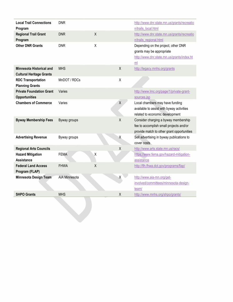
Local Trail Connections
Program
DNR http://www.dnr.state.mn.us/grants/recreatio
n/trails_local.html
Regional Trail Grant
Program
DNR X http://www.dnr.state.mn.us/grants/recreatio
n/trails_regional.html
Other DNR Grants DNR X Depending on the project, other DNR
grants may be appropriate
http://www.dnr.state.mn.us/grants/index.ht
ml
Minnesota Historical and
Cultural Heritage Grants
MHS X http://legacy.mnhs.org/grants
RDC Transportation
Planning Grants
MnDOT / RDCs X
Private Foundation Grant
Opportunities
Varies http://www.lmc.org/page/1/private-grant-
sources.jsp
Chambers of Commerce Varies X Local chambers may have funding
available to assist with byway activities
related to economic development
Byway Membership Fees Byway groups X Consider charging a byway membership
fee to accomplish small projects and/or
provide match to other grant opportunities
Advertising Revenue Byway groups X Sell advertising in byway publications to
cover costs
Regional Arts Councils X http://www.arts.state.mn.us/racs/
Hazard Mitigation
Assistance
FEMA X https://www.fema.gov/hazard-mitigation-
assistance
Federal Land Access
Program (FLAP)
FHWA X http://flh.fhwa.dot.gov/programs/flap/
Minnesota Design Team AIA Minnesota X http://www.aia-mn.org/get-
involved/committees/minnesota-design-
team/
SHPO Grants MHS X http://www.mnhs.org/shpo/grants/

Appendix B: Investment Priorities Addendum
Project Information
Project Manager Which Category Describes Your Project? (select all that apply) Funding
Local Project Priority Ranking
Project Name Location: Municipality
Location: Address
or Project Limits
Planning Transpor
tation
Intrinsic Resource
Marketing
Name Title Entity E-mail
Scenic Rec-
reational Archeolog
ical Historical Cultural
Natural
Total Estimated
Project Cost
Fully Funded
Partially Funded (list
amount funded)
Additional Funding Yet To Secure
What Specific Sources
Will Fund This
Project?
Other Fund Sources
Anticipated To Fulfill Project Needs?
EXAMPLE: Project xyz County, City,
Township
$ Yes/No $ $
List fund type by
name and source agency
List fund type by
name and source agency
1,2,3 etc.
Crosslake Winterfest - SoupFest
Crosslake, MN
USACE Campgrou
nds & Park
Carol Ottoson
coordinator
baitbox@cross
lake.net X $200 Yes
Memberships
0 3
Linda Ulland Memorial Scholarship
Crow Wing, Cass counties
Crow Wing, Cass
counties
Mike Schwieters
Coordinator
mike@boydlod
ge.com X X $1000 Yes
Memberships
0 1
Pequot Lakes Festival of the Arts
Pequot Lakes, MN
PL High School
Donna Stricker
Coordinator
X X $10 Yes Membershi
ps 0 5
St. Pat's Day - parade Crosslake,
MN CSAH 66
Corrine Hodapp
USACE Mgr.
y.mil X X $200 Yes
Memberships
0 3
Pequot Lakes Historic Fire Tower project
continuation
Pequot Lakes, MN
CSAH 11 Kate Perkins Coordinat
or
X X $2000 Yes Anonymous donation
Pequot Lakes
Historical Society
2
Byway Tear Off Map & distribution
Crow Wing & Cass counties
NA Dave Badger Coordinat
or
X X X X X X X X $5000 No 0 $5000 WALA,
Wood sales Membership
s 1
Inkslinger Newsletter MN NA Mary Plein Coordinat
or
[email protected] X $700 Yes
Memberships
Wood sales 1
Crosslake Days Chili Fest
Crosslake, MN
USACE Campgrou
nds & Park
Ron Johnson Coordinat
or
X $200 Yes Membershi
ps 5
Interpretive panel kiosks
Crow Wing & Cass counties
Crow Wing &
Cass counties
Dave Badger Coordinat
or
X $350 Yes
Memberships,
Jurisdiction donations
2
Organization evaluation-
sustainability
USACE Crosslake -
PBSBA office
Crosslake, MN
Rod Nelson Board Chair
Lerone01@co
mcast.net X 0 NA
Depends on
outcome
Memberships,
fundraising 1
Annual Membership Meeting
Bites Grill & Bar
Pine River, MN
Krista Okerman
Coordinator
gnkokerman@
msn.com X X $1750 No $500 $1250 Ticket sales
Memberships
1

Appendix C: Paul Bunyan Plan Maintenance
Paul Bunyan Scenic Byway Investment Needs Summary Update
Mechanism Estimate
The Investment Priority Addendum spreadsheet is intended to inform future planning processes, as well as to project
future investment needs for communities along the Paul Bunyan Scenic Byway.
This spreadsheet was developed by the Region Five Development Commission in Cooperation with the Paul Bunyan
Scenic Byway and made possible through a contract from MnDOT. Information contained in this spreadsheet was
obtained by several interviews, e-mails and phone conversations with multiple local stakeholder’s byway members and
community groups.
As such the current version of this document is a snapshot of planning activity along the byway as of May 2015. In order
to maximize the utility of this spreadsheet an updating mechanism must be developed. In order to update this
document a significant investment of staff time is required to regularly follow up with each entity and record new
planning projects or initiatives. Furthermore, an effort should be made to check off projects as they are completed or no
longer being considered.
Ideally a single entity familiar with the process, the communities along the byway and familiar with transportation needs
would be identified to update the spreadsheet annually. Based on the experience and time spent putting together the
initial Investment Priority Addendum spreadsheet, the following is an estimate of hours and activities needed to
maintain the document annually:
- 15 Hours interviewing local officials regarding new planning initiatives/projects via in person interviews, e-mails,
phone conversations.
o MnDOT Districts.(Dist. Planners)
o Counties (Engineers)
o Municipalities (City Admins. Clerks, or public works directors)
o Townships (Clerks, board supervisors)
o Other Agencies
- 20 Hours compiling responses and updating document/denoting competed projects.
- 5 Hours of follow up/requesting additional project information. I.e. funding questions, or project lead contact
info.
Total 40 Hrs

Published by the
Region Five Development Commission
For the Paul Bunyan Scenic Byway
2015
In light funding changed through MAP 21 the Minnesota
Department of Transportation (MnDOT) requested that the Regional
Development Commissions (RDC) partner with Scenic Byways
throughout the state to update the Byways’ Corridor Management
Plans with the intent to better align them with current funding
opportunities.
The 2015 Paul Bunyan Scenic Byway Corridor Management Plan
Update is the first update to the original Corridor Management Plan.
Therefore, this document is a continuation of the Paul Bunyan Scenic
Byways’ ongoing planning and maintenance process. This plan
formally replaces the past Corridor Management plan from 2001.
The Paul Bunyan Scenic Byway Association has used this planning
update process as an opportunity to re-evaluate several elements of
importance including management, marketing, monitoring as well as
future funding.
In addition the Byway Association has used this planning update
process to reinforce the existing policies and practices pertaining to
management, marketing, monitoring and future funding in order to
both update as needed and reinforce past decisions that are still
valid.
A major premise of this Corridor Management Plan update
therefore, is to utilize portions of the previous corridor management
plan and other local planning mechanism whenever applicable.


