Expedition 307 Porcupine Carbonate Mound Drilling: Geophysical View of the Challenger Carbonate Mound Akiko Tanaka 1,2 *, P. Gaillot 1 , T.G. Ferdelman 1 , A. Kano 1 , T. Williams 1 , K. Abe 1 , M.S. Andres 1 , M. Bjaerger 1 , E.L. Browning 1 , B.A. Cragg 1 , B. De Mol 1 , B. Dorschel 1 , A. Fourbert 1 , T.D. Frank 1 , Y. Fuwa 1 , J.J. Gharib 1 , J.M. Gregg 1 , V.A.I. Huvenne 1 , P. Léonide 1 , X. Li 1 , K. Mangelsdorf 1 , X. Monteys 1 , I. Novosel 1 , S. Sakai 1 , V. Samarkin 1 , K. Sasaki 1 , A.J. Spivack 1 , C. Takashima 1 , J. Titschack 1 , and J.P. Henriet 3 1 Integrated Ocean Drilling Project (IODP) Expedition 307 Science Party Geological Survey of Japan, AIST International Workshop on Core-Log- Seismic Integration: New Scientific and Technological Challenges
Transcript
Preliminary Results from IODP Expedition 307
Porcupine Carbonate Mound Drilling:
Geophysical View of the Challenger Carbonate Mound
Akiko Tanaka1,2*, P. Gaillot1, T.G. Ferdelman1, A. Kano1, T. Williams1, K. Abe1, M.S. Andres1, M.
Bjaerger1, E.L. Browning1, B.A. Cragg1, B. De Mol1, B. Dorschel1, A. Fourbert1, T.D. Frank1, Y. Fuwa1, J.J. Gharib1, J.M. Gregg1, V.A.I. Huvenne1, P.
Léonide1, X. Li1, K. Mangelsdorf1, X. Monteys1, I. Novosel1, S. Sakai1, V. Samarkin1, K. Sasaki1, A.J. Spivack1, C. Takashima1, J. Titschack1, and J.P.
Henriet3
1Integrated Ocean Drilling Project (IODP) Expedition 307 Science Party
2Geological Survey of Japan, AIST3RCMG, Ghent University
International Workshop on Core-Log-Seismic Integration: New Scientific and Technological Challenges
Location of Porcupine Seabight and Expedition 307 operations area.
Global distribution of cold-water coral reefs [www.unep.org].
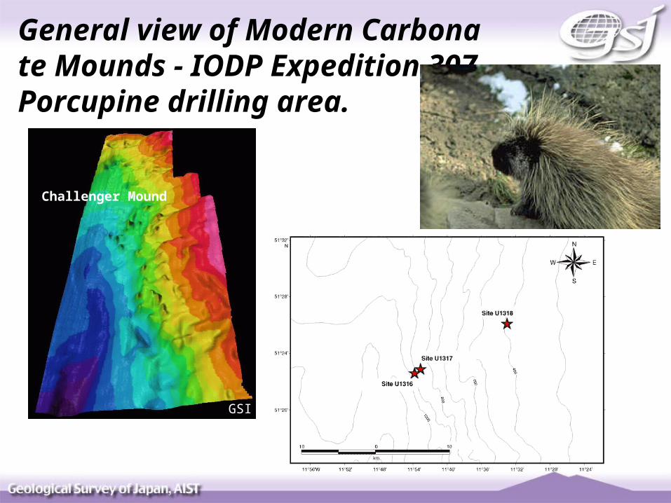
General view of Modern Carbonate Mounds - IODP Expedition 307 Porcupine drilling area.
Challenger Mound
GSI
Challenger Mound
Anneleen Foubert and Veerle Huvenne
Environmental Survey
Bathymetric setting of the Porcupine Basin off SW Ireland (contours in m), showing locations of mounds seismic profiles, side-scan sonographs and sample sites. [De Mol et al., 2002]
Seismic profile of the Belgica mound area, perpendicular to the slope. [De Mol et al., 2002]
Interpretation of high-resolution seismic profiles underlying Challenger Mound and slope (after De Mol et al., 2002).
Geological interpretation of Porcupine Basin stratigraphy in the Belgica province (after Naeth et al., 2005). Arrows = modeled pathways of hydrocarbon-rich gases.
Lithostratigraphy of the three sites projected on the seismic profile of Challenger Mound along a north-northwest to south-southeast transect.
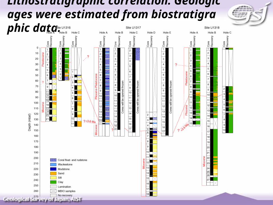
Lithostratigraphic correlation. Geologic ages were estimated from biostratigraphic data.
basic questions
- What is the sedimentology and structure of the mou
nd?
- What triggered mound initiation?
- How does the ecosystem interact with sedimentary f
luxes to make the mound grow?
- How are mound growth phases related to glacial-int
erglacial cycles?
- What role do microbial communities and geochemical
reaction play in the mound?
Details of logging operations completed during Expedition 307
Downslope seismic profile showing sigmoidal unit at Site U1316 and semitransparent seismic layer at Site U1317. Blow-up shows the high-amplitude reflectors and lenticular structures underlying drift sediments and adjacent mound.
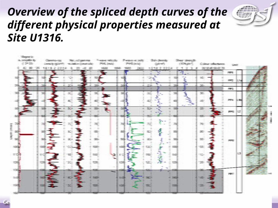
Overview of the spliced depth curves of the different physical properties measured at Site U1316.
Interpretation
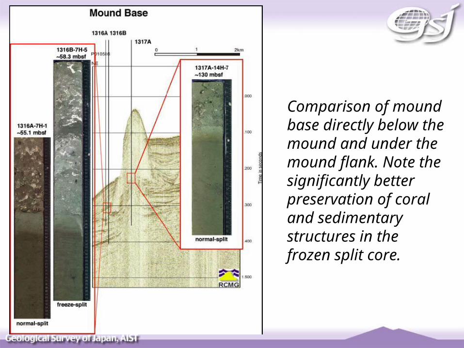
Comparison of mound base directly below the mound and under themound flank. Note the significantly better preservation of coral and sedimentary structures in the frozen split core.
Core-log integration at Hole U1317 gamma-ray, porosity, density, velocity. Post-cruise correlation between features recorded in these logs (especially acoustic, density and gamma-ray) offer potential to provide in-situ ground truth for core data. Initial examination shows that the core depths are offset 4-6 m downwards from the log depths.
summaryMound initiation on sharp erosion boundary- regional Miocene/Pliocene unconformity of at least 1.65 Ma
- siliciclastic pre-mound succession of Miocene age
Mound dominated by Pleistocene deep-water coral- 155 m thick coral-bearing succession
- 10 distinct layers of coral (Lophelia pertusa) presenting th
e active growth phase probably corresponding to Pleistocene in
terglacials
No evidence for hydrocarbon seeps- lithostratigraphy, pore water geochemistry and bacterial cou
nts detect no hydrocarbon fluid flow
- no significant gas quantities found in mound or sub-mound se
diment
Modern analogue to Phanerozoic- comparable in size, shape and geometry yet with coral frame-
work builders
My Research Interests on 307 Expedition
3-D Element-Concentration Mapping by X-ray CT using SR (SP8) (Ikeda et al., 2004).
Sedimentary Sequence
Analysis using Very Long Core at Lake Baikal (Nakano et al,