expand from currently more than 165 to about 200 CORS over the next two years. Since CORSnet-NSW provides accurate, reliable and easy-to-use access to fundamental positioning infrastructure in real time, surveyors are generally no longer willing or desirous to visit passive trig stations to connect to datum. LPI recognises that the passive trig station network is now mainly for its own internal use only. Trig stations can be located in remote areas and are often difficult and time-consuming to access and therefore have low appeal to external surveyors, when contrasted with the easy access and suitable quality of marks located along roads and urban corridors. Isolated trig stations are protected from road works and other development activities, which have destroyed many survey marks (PMs and SSMs) across NSW, and as such are expected to have a continual lifespan. Thus, trig stations serve as the profession’s ‘insurance’ policy, and LPI guards the vital links in the chain to current and previous realisations and propagations of datums. What Makes a Trig Station? Trig stations are the traditional backbone of a classical survey control network and form the primary or highest-order network, from which all other surveys are controlled. Trig stations come in a variety of forms and structures and usually consist of a primary monument or standpoint surrounded by witness or eccentric marks. The primary monument can take on a multitude of forms, ranging from survey pillars (concrete or steel) to plugs in stone underneath rock cairns or in rare cases galvanised iron (GI) pipes or stainless steel rods in soil. It should be noted that all CORSnet-NSW stations are also trig stations – these are known as ‘active’ trigs. Figure 2 illustrates the large variety of traditional trig station monuments in the NSW survey control network. Sometimes these marks have very high historical significance and are usually located in very prominent locations. Lighthouses, church spires, radio masts and tall towers are other forms of trig stations that are sometimes encountered. When the first major GNSS campaigns were initiated in the western part of NSW, the Geodetic Control Register (GCR) and the Survey Control Information Management System (SCIMS) were maintained as separate databases. This necessitated the inclusion of occupied Permanent Marks (PMs) and State Survey Marks (SSMs) into the GCR such that those locations could be elevated to the status of trig station – commensurate with the importance of those sites and the technical functionality of the GCR. This creation of new trig station sites also included some original State border survey marks being the remains of wooden posts (e.g. TS7344 Mile Post 181 East). However, a trig station is often more than just the physical infrastructure. It often includes the entire site or surrounding area, which may cover a significant portion of ground (up to a few hectares) and include remnants of cleared lanes to other distant trigs or marks, and permanent tenure and restrictions over the site to protect it. Trig stations usually occupy the highest and most prominent point in the local area, e.g. a hilltop, tall building or silo. While LPI (or its predecessors) may have been the first occupant of these areas since white settlement, they are now of prime interest and value to other parties, primarily landowners, developers and telecommunication operators. Almost two thirds of all trig stations consist of a pillar or ground mark located on private land. Only one third are located on government land, illustrating the importance of having a good relationship with landowners. In order to ensure that this key survey infrastructure is valued and protected by landowners, careful relationship management, face-to-face interaction and active trig maintenance are required by LPI. For one in ten trig stations, the mark type is currently unknown or uncertain, which could easily be rectified through a site visit if it is decided to maintain the trig in question. The witness or eccentric marks are connected to the primary station through a supplementary 3-dimensional terrestrial survey and are occupied if it is either not possible or inconvenient to occupy the primary standpoint. For example, unpiling any rock cairn generally introduces lengthy time delays and Work Health and Safety (WHS) concerns. Eccentric marks can also be used to monitor any potential movement of the main mark, although this is rarely (if ever) done. Often these marks physically consist of different objects, e.g. expended rifle cartridge in concrete, GI pipe, rod or numbered/unnumbered SSMs. On a side note, the issue of numbered SSMs that are eccentric to trig stations having two sets of coordinates and metadata in SCIMS (i.e. one as an eccentric mark and another as a unique SSM) is known to LPI and is being corrected. Brief History of the NSW Control Network The Trigonometrical Survey of New South Wales, as it was then known, commenced in 1867 with the selection of the first baseline at Lake George and continued with little interruption for almost 50 years until it was suspended for reasons of economy and war in 1916. By then, about one third of the State (mainly in the south-east) had been covered by a series of well-conditioned triangles of first and lower orders. The survey was resumed intermittently between the two World Wars with much of its progress attributable to the Royal Australian Survey Corps, particularly the connections to the Victorian and Queensland networks, and along the NSW North Coast. In the 1950s and 1960s, the Division of National Mapping (now Geoscience Australia) extended the first-order networks into the western part of the State, and other networks were established by the NSW Department of Lands (now LPI). Together with the first-order traverses performed by the Royal Australian Survey Corps, the geodetic network had extended to approximately half of the State prior to the national adjustment of 1966 – this had taken 100 years. A turning point in the geodetic survey network was reached in 1973 with the formulation of a plan to update, revise and complete the network to acceptable standards. This systematic rationalisation commenced in the Sydney- Newcastle-Wollongong region and continued through the coastal belt and then westwards. It was found that many of the stations listed in the old County Registers had disappeared as a result of the type of marking used and the difficulty of protection. Wherever possible, the old-style cairn and pole stations were replaced by a concrete pillar with demountable mast and vane, allowing constrained centring of theodolite and distance measuring equipment. Over recent years, the rapid uptake of GNSS technology amongst the surveying profession has seen the perceived importance of traditional trig stations wane as surveyors became less dependent upon line-of-sight to propagate datum. The establishment of CORSnet-NSW (see Figure 1), which commenced in earnest in 2009, has compounded this effect. It took only five years to cover more than two thirds of NSW with 150 active trig stations, and the network will Figure 1: CORSnet-NSW coverage map as of April 2015 (http://www.corsnet.com.au/). Figure 2: Trig station monuments in NSW. Clockwise from top left: Steel pillar, cairn and astro pillar, concrete pillar, obelisk, concrete pillar on grand cairn, and stonework veneer on concrete pillar. Preservation and Upgrade of Trigonometrical Stations in NSW Nicholas Gowans, Simon McElroy and Volker Janssen, Land and Property Information Land and Property Information (LPI) is the custodian of the geodetic infrastructure in New South Wales (NSW). This incorporates about 6,000 traditional ‘passive’ trigonometrical (trig) stations that formed the backbone of the survey control network and more than 165 ‘active’ CORSnet-NSW stations to date. Keeping the ageing passive geodetic infrastructure current and ready for utilisation requires regular maintenance such as fit-for-purpose assessments, verification of owner records, contact details, access details, and (most importantly) recent, time-stamped Global Navigation Satellite System (GNSS) observations. As this level of maintenance is neither viable nor justifiable for the entire network of trig stations in the modern era, LPI has selected a subset of ‘high-scoring’ trig stations based upon a number of factors including a ‘TrigStar’ rating, monument quality, and significance within the contexts of survey network, local community and heritage. LPI has adopted a campaign-style or project approach to carry out this trig network rationalisation, targeted preservation and survey upgrade across the State. This article outlines how this method provides an effective strategy to maintain geodetic infrastructure across NSW, upgrade traditional survey infrastructure with modern- day satellite-based positioning and contribute new GNSS observations towards the next-generation Australian datum. THE PROFESSION www.surveyors.org.au PROUD SPONSOR OF THE SIR THOMAS MITCHELL AWARD 2015
Transcript
expand from currently more than 165 to about 200 CORS over the next two years. Since CORSnet-NSW provides accurate, reliable and easy-to-use access to fundamental positioning infrastructure in real time, surveyors are generally no longer willing or desirous to visit passive trig stations to connect to datum.
LPI recognises that the passive trig station network is now mainly for its own internal use only. Trig stations can be located in remote areas and are often difficult and time-consuming to access and therefore have low appeal to external surveyors, when contrasted with the easy access and suitable quality of marks located along roads and urban corridors. Isolated trig stations are protected from road works and other development activities, which have destroyed many survey marks (PMs and SSMs) across NSW, and as such are expected to have a continual lifespan. Thus, trig stations serve as the profession’s ‘insurance’ policy, and LPI guards the vital links in the chain to current and previous realisations and propagations of datums.
What Makes a Trig Station?Trig stations are the traditional backbone of a classical survey
control network and form the primary or highest-order network, from which all other surveys are controlled. Trig stations come in a variety of forms and structures and usually consist of a primary monument or standpoint surrounded by witness or eccentric marks. The primary monument can take on a multitude of forms, ranging from survey pillars (concrete or steel) to plugs in stone underneath rock cairns or in rare cases galvanised iron (GI) pipes or stainless steel rods in soil. It should be noted that all CORSnet-NSW stations are also trig stations – these are known as ‘active’ trigs.
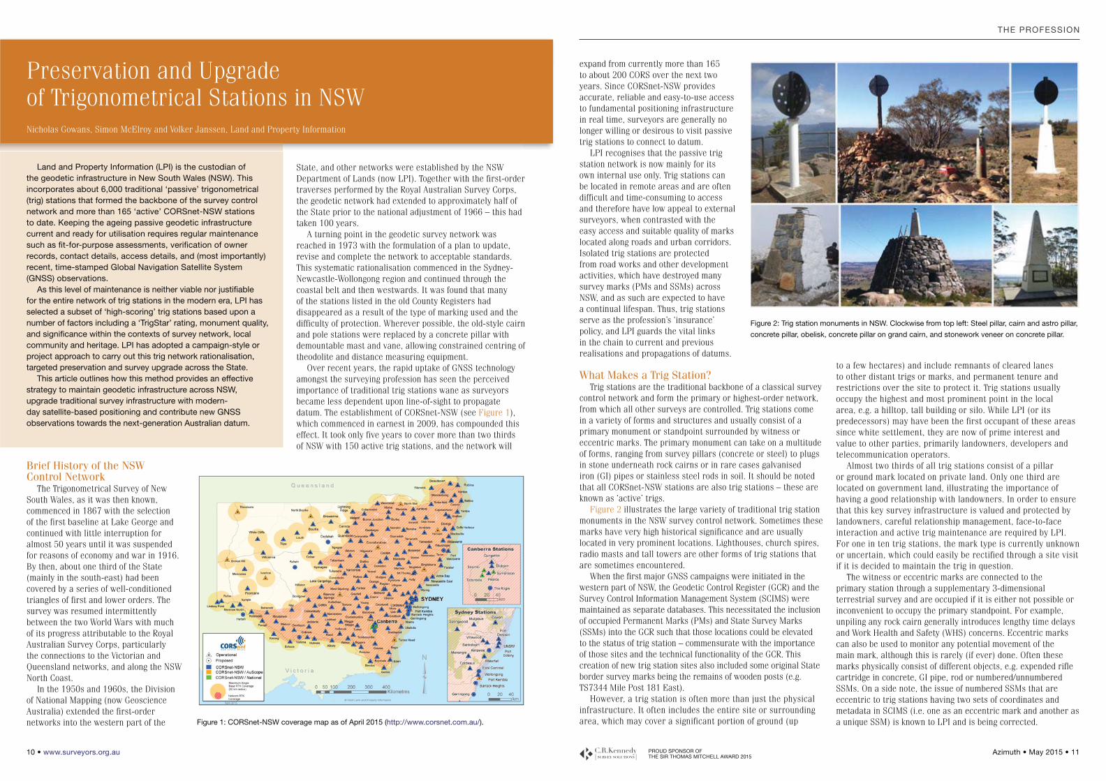
Figure 2 illustrates the large variety of traditional trig station monuments in the NSW survey control network. Sometimes these marks have very high historical significance and are usually located in very prominent locations. Lighthouses, church spires, radio masts and tall towers are other forms of trig stations that are sometimes encountered.
When the first major GNSS campaigns were initiated in the western part of NSW, the Geodetic Control Register (GCR) and the Survey Control Information Management System (SCIMS) were maintained as separate databases. This necessitated the inclusion of occupied Permanent Marks (PMs) and State Survey Marks (SSMs) into the GCR such that those locations could be elevated to the status of trig station – commensurate with the importance of those sites and the technical functionality of the GCR. This creation of new trig station sites also included some original State border survey marks being the remains of wooden posts (e.g. TS7344 Mile Post 181 East).
However, a trig station is often more than just the physical infrastructure. It often includes the entire site or surrounding area, which may cover a significant portion of ground (up
to a few hectares) and include remnants of cleared lanes to other distant trigs or marks, and permanent tenure and restrictions over the site to protect it. Trig stations usually occupy the highest and most prominent point in the local area, e.g. a hilltop, tall building or silo. While LPI (or its predecessors) may have been the first occupant of these areas since white settlement, they are now of prime interest and value to other parties, primarily landowners, developers and telecommunication operators.
Almost two thirds of all trig stations consist of a pillar or ground mark located on private land. Only one third are located on government land, illustrating the importance of having a good relationship with landowners. In order to ensure that this key survey infrastructure is valued and protected by landowners, careful relationship management, face-to-face interaction and active trig maintenance are required by LPI. For one in ten trig stations, the mark type is currently unknown or uncertain, which could easily be rectified through a site visit if it is decided to maintain the trig in question.
The witness or eccentric marks are connected to the primary station through a supplementary 3-dimensional terrestrial survey and are occupied if it is either not possible or inconvenient to occupy the primary standpoint. For example, unpiling any rock cairn generally introduces lengthy time delays and Work Health and Safety (WHS) concerns. Eccentric marks can also be used to monitor any potential movement of the main mark, although this is rarely (if ever) done. Often these marks physically consist of different objects, e.g. expended rifle cartridge in concrete, GI pipe, rod or numbered/unnumbered SSMs. On a side note, the issue of numbered SSMs that are eccentric to trig stations having two sets of coordinates and metadata in SCIMS (i.e. one as an eccentric mark and another as a unique SSM) is known to LPI and is being corrected.
Brief History of the NSW Control Network
The Trigonometrical Survey of New South Wales, as it was then known, commenced in 1867 with the selection of the first baseline at Lake George and continued with little interruption for almost 50 years until it was suspended for reasons of economy and war in 1916. By then, about one third of the State (mainly in the south-east) had been covered by a series of well-conditioned triangles of first and lower orders. The survey was resumed intermittently between the two World Wars with much of its progress attributable to the Royal Australian Survey Corps, particularly the connections to the Victorian and Queensland networks, and along the NSW North Coast.
In the 1950s and 1960s, the Division of National Mapping (now Geoscience Australia) extended the first-order networks into the western part of the
State, and other networks were established by the NSW Department of Lands (now LPI). Together with the first-order traverses performed by the Royal Australian Survey Corps, the geodetic network had extended to approximately half of the State prior to the national adjustment of 1966 – this had taken 100 years.
A turning point in the geodetic survey network was reached in 1973 with the formulation of a plan to update, revise and complete the network to acceptable standards. This systematic rationalisation commenced in the Sydney-Newcastle-Wollongong region and continued through the coastal belt and then westwards. It was found that many of the stations listed in the old County Registers had disappeared as a result of the type of marking used and the difficulty of protection. Wherever possible, the old-style cairn and pole stations were replaced by a concrete pillar with demountable mast and vane, allowing constrained centring of theodolite and distance measuring equipment.
Over recent years, the rapid uptake of GNSS technology amongst the surveying profession has seen the perceived importance of traditional trig stations wane as surveyors became less dependent upon line-of-sight to propagate datum. The establishment of CORSnet-NSW (see Figure 1), which commenced in earnest in 2009, has compounded this effect. It took only five years to cover more than two thirds of NSW with 150 active trig stations, and the network will
Figure 1: CORSnet-NSW coverage map as of April 2015 (http://www.corsnet.com.au/).
Figure 2: Trig station monuments in NSW. Clockwise from top left: Steel pillar, cairn and astro pillar,
concrete pillar, obelisk, concrete pillar on grand cairn, and stonework veneer on concrete pillar.
Preservation and Upgrade of Trigonometrical Stations in NSW Nicholas Gowans, Simon McElroy and Volker Janssen, Land and Property Information
Land and Property Information (LPI) is the custodian of the geodetic infrastructure in New South Wales (NSW). This incorporates about 6,000 traditional ‘passive’ trigonometrical (trig) stations that formed the backbone of the survey control network and more than 165 ‘active’ CORSnet-NSW stations to date. Keeping the ageing passive geodetic infrastructure current and ready for utilisation requires regular maintenance such as fit-for-purpose assessments, verification of owner records, contact details, access details, and (most importantly) recent, time-stamped Global Navigation Satellite System (GNSS) observations.
As this level of maintenance is neither viable nor justifiable for the entire network of trig stations in the modern era, LPI has selected a subset of ‘high-scoring’ trig stations based upon a number of factors including a ‘TrigStar’ rating, monument quality, and significance within the contexts of survey network, local community and heritage. LPI has adopted a campaign-style or project approach to carry out this trig network rationalisation, targeted preservation and survey upgrade across the State.
This article outlines how this method provides an effective strategy to maintain geodetic infrastructure across NSW, upgrade traditional survey infrastructure with modern-day satellite-based positioning and contribute new GNSS observations towards the next-generation Australian datum.
THE PROFESSION
www.surveyors.org.au PROUD SPONSOR OF THE SIR THOMAS MITCHELL AWARD 2015
Which Trig Stations Should Be Maintained?Understandably, all trig stations are not equal. LPI’s
motivation to preserve and maintain trig stations can vary with regard to several criteria, including:
Previous survey work performed (e.g. number of terrestrial and GNSS observations).Prominence within the survey network.Ease of access.Suitability for GNSS observations. Suitability for further survey work (e.g. vegetation level, towers or structures, security).Historical significance (e.g. TS Kosciuszko, TS Cameron Corner and TS Barringun Zero Obelisk both on the NSW/QLD border).Local community identification (e.g. lookouts, public visits).Land ownership (e.g. trig reserve, state forest, national park, private land).Monument quality (e.g. survey pillar, trig plug and cairn, obelisk, GI nail in remains of wooden post).Condition of monument (e.g. decaying pillar, unpiled cairn, plug missing).Uniqueness of structure (e.g. concrete pillar on grand cairn, stone veneer vs. standard concrete pillar).Number of Deposited Plans connected to the trig station.
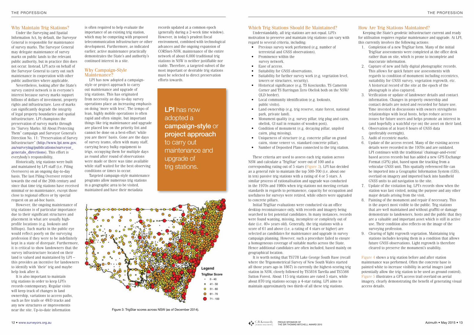
These criteria are used to assess each trig station across NSW and calculate a ‘TrigStar’ score out of 100 and a corresponding rating out of 5 stars (Figure 3). LPI has decided as a general rule to maintain the top 500-700 (i.e. about one in ten) passive trig stations with a rating of 4 or 5 stars. A similar process of rationalisation and upgrade was conducted in the 1970s and 1980s when trig stations not meeting certain standards in regards to permanence, capacity for occupation and usefulness for surveys were retired, while others were upgraded to concrete pillars.
Initial TrigStar evaluations were conducted via an office desktop reconnaissance only, with records and imagery being searched to list potential candidates. In many instances, records were found wanting, missing, incomplete or completely out of date (i.e. 40+ years old). Generally, the trig stations with a score of 61 and above (i.e. a rating of 4 stars or higher) are selected as candidates for maintenance and upgrade in survey campaign planning. However, such a procedure failed to ensure a homogeneous coverage of suitable marks across the State. Hence additional candidates are often included, based mainly on geographical location.
It is worth noting that TS778 Lake George South Base (recall where the Trigonometrical Survey of New South Wales started all those years ago in 1867) is currently the highest-scoring trig station in NSW, closely followed by TS5816 Tarella and TS5566 Sutton Forest. About 115 trig stations are rated 5 stars, while about 870 trig stations occupy a 4-star rating. LPI aims to maintain approximately two thirds of all these trig stations.
How Are Trig Stations Maintained?Keeping the State’s geodetic infrastructure current and ready
for utilisation requires regular maintenance and upgrade. At LPI, this currently involves the following actions:
1. Completion of a new TrigStar form. Many of the initial TrigStar assessments were completed at the office desk rather than on site, which is prone to incomplete and inaccurate information.
2. Capture of new and fully digital photographic records. This allows for quick future use assessments with regards to condition of monument including eccentrics, suitability for GNSS survey, vegetation regrowth, etc. A historical record of the site at the epoch of the photograph is also captured.
3. Verification or update of landowner details and contact information. Changes in property ownership and contact details are noted and recorded for future use. Time invested in discussions with owners strengthens relationships with local hosts, helps reduce access issues for future users and helps promote an interest in (and hopefully a watchful eye on) the asset on their land.
4. Observation of at least 6 hours of GNSS data (preferably overnight).
5. Audit of eccentric marks.6. Update of the access record. Many of the existing access
details were recorded in the 1970s and are outdated. LPI continues with the traditional ‘chainage-and-event’ based access records but has added a new GPS Exchange Format (GPX) plot, based upon the tracklog from a vehicular GNSS unit. This spatially referenced file can be imported into a Geographic Information System (GIS), overlaid on imagery and imported back into handheld GNSS units to aid navigation to the site.
7. Update of the visitation log. LPI’s records show when the station was last visited, noting the purpose and any other major details arising from the visit.
8. Painting of the monument and repair if necessary. This is the aspect most visible to the public. Trig stations that are well maintained and without graffiti or damage demonstrate to landowners, hosts and the public that they are a valuable and important asset which is still in active use. Their condition also reflects on the image of the surveying profession.
9. Clearing of light regrowth vegetation. Maintaining trig stations includes keeping them in a condition that allows future GNSS observations. Light regrowth is therefore cleared to preserve the monument’s usability.
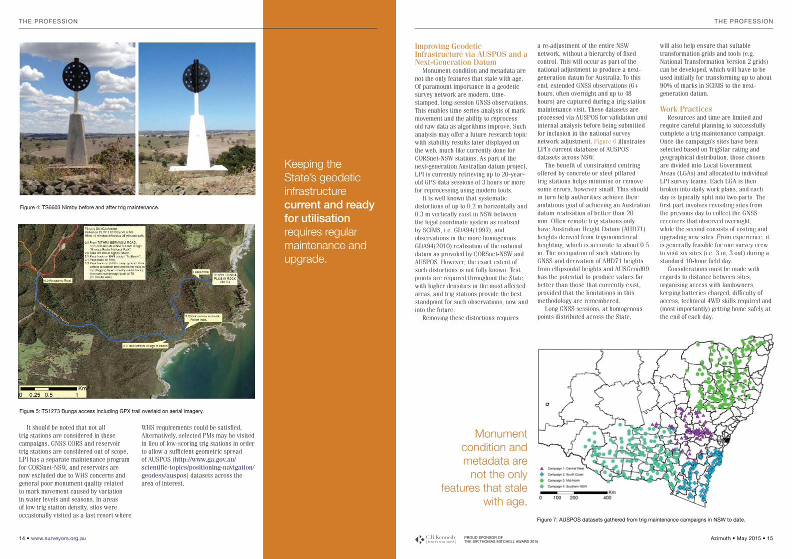
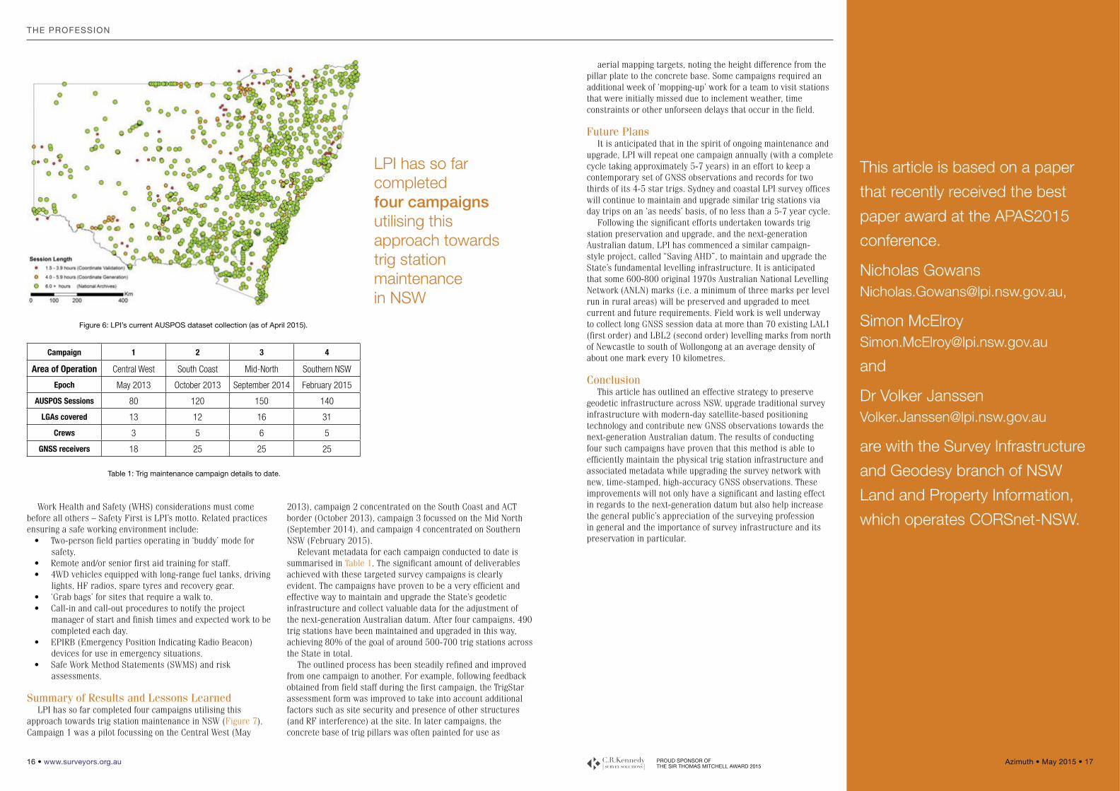
Figure 4 shows a trig station before and after station maintenance was performed. Often the concrete base is painted white to increase visibility in aerial images (and potentially allow the trig station to be used as ground control). Figure 5 illustrates a GPX access trail overlaid on aerial imagery, clearly demonstrating the benefit of generating visual access details.
Why Maintain Trig Stations?Under the Surveying and Spatial
Information Act, by default, the Surveyor General is responsible for maintenance of survey marks. The Surveyor General may delegate maintenance of survey marks on public lands to the relevant public authority, but in practice this does not occur. Instead, LPI acts on behalf of the Surveyor General to carry out such maintenance in cooperation with other public authorities where applicable.
Nevertheless, looking after the State’s survey control network is in everyone’s interest because survey marks support billions of dollars of investment, property rights and infrastructure. Loss of marks can significantly degrade the integrity of legal property boundaries and spatial infrastructure. LPI champions the preservation of survey marks through its “Survey Marks: All About Protecting Them” campaign and Surveyor General’s Direction No. 11: “Preservation of Survey Infrastructure” (http://www.lpi.nsw.gov.au/surveying/publications/surveyor_generals_directions). This effort is everybody’s responsibility.
Historically, trig stations were built and maintained by LPI staff (i.e. Piling Overseers) on an ongoing day-to-day basis. The last Piling Overseer retired towards the end of the 20th century and since that time trig stations have received minimal or no maintenance, except those close to regional offices or by special request on an ad-hoc basis.
However, the ongoing maintenance of trig stations is of particular importance due to their significant structures and placement in what are usually high-profile locations (e.g. lookouts and hilltops). Such marks in the public eye would reflect poorly on the surveying profession if they were to be indefinitely kept in a state of disrepair. Furthermore, it is critical to show landowners that the survey infrastructure located on their land is valued and maintained by LPI – this provides an incentive for landowners to identify with ‘their’ trig and maybe help look after it.
It is also important to maintain trig stations in order to keep LPI’s records contemporary. Regular visits will keep track of changes in land ownership, variations to access paths, such as fire trails or 4WD tracks and any new structures or improvements near the site. Up-to-date information
is often required to help evaluate the importance of an existing trig station, which may be competing with proposed telecommunication infrastructure or other development. Furthermore, as indicated earlier, active maintenance practically demonstrates the State’s and authority’s continued interest in a site.
Why Campaign-Style Maintenance?
LPI has now adopted a campaign-style or project approach to carry out maintenance and upgrade of trig stations. This has originated from necessity as day-to-day survey operations place an increasing emphasis on doing ‘more with less’. The tempo of lean, highly mobile operations is often rapid and often simple, but important things like trig maintenance and upgrade are placed low on the priority list and cannot be done on a best-effort ‘while you are there’ basis. Gone are the days of survey teams, often with many staff, carrying heavy bulky equipment to trigs, occupying them for multiple days as round after round of observations were made or there was time available while staff waited for the best observing conditions or times to occur.
Targeted campaign-style maintenance programs allow numerous trig stations in a geographic area to be visited, maintained and have their metadata
records updated at a common epoch (generally during a 2-week time window). However, in today’s prudent fiscal environment, combined with technological advances and the ongoing expansion of CORSnet-NSW, maintenance of the entire network of about 6,000 traditional trig stations in NSW is neither justifiable nor viable. Therefore, a targeted subset of the most important or desirable trig stations must be selected to direct preservation efforts towards.
Figure 3: TrigStar scores across NSW (as of December 2014).
LPI has now adopted a campaign-style or project approach to carry out maintenance and upgrade of trig stations.
THE PROFESSION THE PROFESSION
www.surveyors.org.au PROUD SPONSOR OF THE SIR THOMAS MITCHELL AWARD 2015
Improving Geodetic Infrastructure via AUSPOS and a Next-Generation Datum
Monument condition and metadata are not the only features that stale with age. Of paramount importance in a geodetic survey network are modern, time-stamped, long-session GNSS observations. This enables time series analysis of mark movement and the ability to reprocess old raw data as algorithms improve. Such analysis may offer a future research topic with stability results later displayed on the web, much like currently done for CORSnet-NSW stations. As part of the next-generation Australian datum project, LPI is currently retrieving up to 20-year-old GPS data sessions of 3 hours or more for reprocessing using modern tools.
It is well known that systematic distortions of up to 0.2 m horizontally and 0.3 m vertically exist in NSW between the legal coordinate system as realised by SCIMS, i.e. GDA94(1997), and observations in the more homogenous GDA94(2010) realisation of the national datum as provided by CORSnet-NSW and AUSPOS. However, the exact extent of such distortions is not fully known. Test points are required throughout the State, with higher densities in the most affected areas, and trig stations provide the best standpoint for such observations, now and into the future.
Removing these distortions requires
a re-adjustment of the entire NSW network, without a hierarchy of fixed control. This will occur as part of the national adjustment to produce a next-generation datum for Australia. To this end, extended GNSS observations (6+ hours, often overnight and up to 48 hours) are captured during a trig station maintenance visit. These datasets are processed via AUSPOS for validation and internal analysis before being submitted for inclusion in the national survey network adjustment. Figure 6 illustrates LPI’s current database of AUSPOS datasets across NSW.
The benefit of constrained centring offered by concrete or steel pillared trig stations helps minimise or remove some errors, however small. This should in turn help authorities achieve their ambitious goal of achieving an Australian datum realisation of better than 20 mm. Often remote trig stations only have Australian Height Datum (AHD71) heights derived from trigonometrical heighting, which is accurate to about 0.5 m. The occupation of such stations by GNSS and derivation of AHD71 heights from ellipsoidal heights and AUSGeoid09 has the potential to produce values far better than those that currently exist, provided that the limitations in this methodology are remembered.
Long GNSS sessions, at homogenous points distributed across the State,
will also help ensure that suitable transformation grids and tools (e.g. National Transformation Version 2 grids) can be developed, which will have to be used initially for transforming up to about 90% of marks in SCIMS to the next-generation datum.
Work PracticesResources and time are limited and
require careful planning to successfully complete a trig maintenance campaign. Once the campaign’s sites have been selected based on TrigStar rating and geographical distribution, those chosen are divided into Local Government Areas (LGAs) and allocated to individual LPI survey teams. Each LGA is then broken into daily work plans, and each day is typically split into two parts. The first part involves revisiting sites from the previous day to collect the GNSS receivers that observed overnight, while the second consists of visiting and upgrading new sites. From experience, it is generally feasible for one survey crew to visit six sites (i.e. 3 in, 3 out) during a standard 10-hour field day.
Considerations must be made with regards to distance between sites, organising access with landowners, keeping batteries charged, difficulty of access, technical 4WD skills required and (most importantly) getting home safely at the end of each day.
It should be noted that not all trig stations are considered in these campaigns. GNSS CORS and reservoir trig stations are considered out of scope. LPI has a separate maintenance program for CORSnet-NSW, and reservoirs are now excluded due to WHS concerns and general poor monument quality related to mark movement caused by variation in water levels and seasons. In areas of low trig station density, silos were occasionally visited as a last resort where
WHS requirements could be satisfied. Alternatively, selected PMs may be visited in lieu of low-scoring trig stations in order to allow a sufficient geometric spread of AUSPOS (http://www.ga.gov.au/scientific-topics/positioning-navigation/geodesy/auspos) datasets across the area of interest.
Figure 4: TS6603 Nimby before and after trig maintenance.
Keeping the State’s geodetic infrastructure current and ready for utilisation requires regular maintenance and upgrade.
Monument condition and metadata are
not the only features that stale
with age.
THE PROFESSION THE PROFESSION
www.surveyors.org.au PROUD SPONSOR OF THE SIR THOMAS MITCHELL AWARD 2015
Work Health and Safety (WHS) considerations must come before all others – Safety First is LPI’s motto. Related practices ensuring a safe working environment include:
Two-person field parties operating in ‘buddy’ mode for safety.Remote and/or senior first aid training for staff.4WD vehicles equipped with long-range fuel tanks, driving lights, HF radios, spare tyres and recovery gear.‘Grab bags’ for sites that require a walk to.Call-in and call-out procedures to notify the project manager of start and finish times and expected work to be completed each day.EPIRB (Emergency Position Indicating Radio Beacon) devices for use in emergency situations.Safe Work Method Statements (SWMS) and risk assessments.
Summary of Results and Lessons LearnedLPI has so far completed four campaigns utilising this
approach towards trig station maintenance in NSW (Figure 7). Campaign 1 was a pilot focussing on the Central West (May
2013), campaign 2 concentrated on the South Coast and ACT border (October 2013), campaign 3 focussed on the Mid North (September 2014), and campaign 4 concentrated on Southern NSW (February 2015).
Relevant metadata for each campaign conducted to date is summarised in Table 1. The significant amount of deliverables achieved with these targeted survey campaigns is clearly evident. The campaigns have proven to be a very efficient and effective way to maintain and upgrade the State’s geodetic infrastructure and collect valuable data for the adjustment of the next-generation Australian datum. After four campaigns, 490 trig stations have been maintained and upgraded in this way, achieving 80% of the goal of around 500-700 trig stations across the State in total.
The outlined process has been steadily refined and improved from one campaign to another. For example, following feedback obtained from field staff during the first campaign, the TrigStar assessment form was improved to take into account additional factors such as site security and presence of other structures (and RF interference) at the site. In later campaigns, the concrete base of trig pillars was often painted for use as
Campaign 1 2 3 4
Area of Operation Central West South Coast Mid-North Southern NSW
Epoch May 2013 October 2013 September 2014 February 2015
AUSPOS Sessions 80 120 150 140
LGAs covered 13 12 16 31
Crews 3 5 6 5
GNSS receivers 18 25 25 25
Table 1: Trig maintenance campaign details to date.
Figure 6: LPI’s current AUSPOS dataset collection (as of April 2015).
LPI has so far completed four campaigns utilising this approach towards trig station maintenance in NSW
THE PROFESSION
www.surveyors.org.au PROUD SPONSOR OF THE SIR THOMAS MITCHELL AWARD 2015
aerial mapping targets, noting the height difference from the pillar plate to the concrete base. Some campaigns required an additional week of ‘mopping-up’ work for a team to visit stations that were initially missed due to inclement weather, time constraints or other unforseen delays that occur in the field.
Future PlansIt is anticipated that in the spirit of ongoing maintenance and
upgrade, LPI will repeat one campaign annually (with a complete cycle taking approximately 5-7 years) in an effort to keep a contemporary set of GNSS observations and records for two thirds of its 4-5 star trigs. Sydney and coastal LPI survey offices will continue to maintain and upgrade similar trig stations via day trips on an ‘as needs’ basis, of no less than a 5-7 year cycle.
Following the significant efforts undertaken towards trig station preservation and upgrade, and the next-generation Australian datum, LPI has commenced a similar campaign-style project, called “Saving AHD”, to maintain and upgrade the State’s fundamental levelling infrastructure. It is anticipated that some 600-800 original 1970s Australian National Levelling Network (ANLN) marks (i.e. a minimum of three marks per level run in rural areas) will be preserved and upgraded to meet current and future requirements. Field work is well underway to collect long GNSS session data at more than 70 existing LAL1 (first order) and LBL2 (second order) levelling marks from north of Newcastle to south of Wollongong at an average density of about one mark every 10 kilometres.
ConclusionThis article has outlined an effective strategy to preserve
geodetic infrastructure across NSW, upgrade traditional survey infrastructure with modern-day satellite-based positioning technology and contribute new GNSS observations towards the next-generation Australian datum. The results of conducting four such campaigns have proven that this method is able to efficiently maintain the physical trig station infrastructure and associated metadata while upgrading the survey network with new, time-stamped, high-accuracy GNSS observations. These improvements will not only have a significant and lasting effect in regards to the next-generation datum but also help increase the general public’s appreciation of the surveying profession in general and the importance of survey infrastructure and its preservation in particular.