PROPERTY SURVEY SUMMARY SHEEP FOR FUDS PROPERTY NUMBER E05MI1241 ADAMSVILLE RADAR 21 September 2004 PROPERTY NAME: Adamsville Radar LOCATION: The Adamsville Radar property (also know as Cass Radar Station) was established as a radar station for the U.S. Army from 1958 until 1960. The Adamsville Radar property is approximately 4 acres located 4 miles northeast of the city of Adamsville in Cass County, Michigan, and is located at the northwest corner of the intersection of Calvin Center Road and Calvin Hill Street. The property is geographically located at N 41° 50’ 09.5”, W 85° 56’ 19.4”. The property is located in U.S. Congressional District 6 and EPA Region V. PROPERTY HISTORY: A historical archive search and contacting the former and present owners of the property yielded no lease documents from DoD operation of the radar station. However, James and Pam Whitcraft, the current owners, provided the government with copies of two newspaper articles from the South Bend (Indiana) Tribune, which covers the date the radar station went into operation and the date it was closed because it had been declared obsolete and excessed. In addition, a phone interview with the original owner, Mr. Leo Lawson, confirmed that the property was acquired by the U.S. Army through the Corps of Engineers via lease. The first article is from the evening edition of the South Bend Tribune and is dated April 3, 1958. The article reports that the Cass Radar Station, a 20-man U.S. Army radar station in southern Cass County, was expected to begin scanning operation on May 1, 1958. The station was part of the Chicago-Milwaukee Defense Area as a more effective warning system for Nike anti-aircraft missile units in the nearby metropolitan areas. The article reports the station was located on approximately 4 acres of land owned by farmer Leo Lawson. There was an office building, a technical equipment building, and a large concrete foundation for the radar net tower and screen constructed on the property. The second article is from the evening edition of the South Bend Tribune and is dated March 24, 1960. The article reports that the U.S. Army would begin dismantling the radar station within the next two weeks (of March 24, 1960) and abandon the defense site in the middle of May 1960. A telephone interview with the original owner, Mr. Leo Lawson, on September 17, 2004 verified that the dates and information in the two newspaper articles was accurate. In addition, Mr. Lawson confirmed that the Government had leased the land until the radar station was abandoned in May of 1960 and terminated the lease. The former radar station no longer exists and the property is currently used as farmland. PROPERTY VISIT: The property was visited by Mr. Tom Murrell, CEMVS-ED-P, with the St. Louis District on 25 March 2004. Although the radar station has long been dismantled, the concrete foundations for the office building and technical equipment building are still present on the property, as well as a small square concrete pad with a cut 6-inch pipe that may have been a well head. No other physical evidence or debris from any military improvements, ordnance and explosives, chemical warfare material, hazardous or toxic waste, or under/above ground storage tanks was observed. Encl 1
Transcript
PROPERTY SURVEY SUMMARY SHEEP
FOR FUDS PROPERTY NUMBER E05MI1241
ADAMSVILLE RADAR 21 September 2004
PROPERTY NAME: Adamsville Radar LOCATION: The Adamsville Radar property (also know as Cass Radar Station) was established as a radar station for the U.S. Army from 1958 until 1960. The Adamsville Radar property is approximately 4 acres located 4 miles northeast of the city of Adamsville in Cass County, Michigan, and is located at the northwest corner of the intersection of Calvin Center Road and Calvin Hill Street. The property is geographically located at N 41° 50’ 09.5”, W 85° 56’ 19.4”. The property is located in U.S. Congressional District 6 and EPA Region V. PROPERTY HISTORY: A historical archive search and contacting the former and present owners of the property yielded no lease documents from DoD operation of the radar station. However, James and Pam Whitcraft, the current owners, provided the government with copies of two newspaper articles from the South Bend (Indiana) Tribune, which covers the date the radar station went into operation and the date it was closed because it had been declared obsolete and excessed. In addition, a phone interview with the original owner, Mr. Leo Lawson, confirmed that the property was acquired by the U.S. Army through the Corps of Engineers via lease. The first article is from the evening edition of the South Bend Tribune and is dated April 3, 1958. The article reports that the Cass Radar Station, a 20-man U.S. Army radar station in southern Cass County, was expected to begin scanning operation on May 1, 1958. The station was part of the Chicago-Milwaukee Defense Area as a more effective warning system for Nike anti-aircraft missile units in the nearby metropolitan areas. The article reports the station was located on approximately 4 acres of land owned by farmer Leo Lawson. There was an office building, a technical equipment building, and a large concrete foundation for the radar net tower and screen constructed on the property. The second article is from the evening edition of the South Bend Tribune and is dated March 24, 1960. The article reports that the U.S. Army would begin dismantling the radar station within the next two weeks (of March 24, 1960) and abandon the defense site in the middle of May 1960. A telephone interview with the original owner, Mr. Leo Lawson, on September 17, 2004 verified that the dates and information in the two newspaper articles was accurate. In addition, Mr. Lawson confirmed that the Government had leased the land until the radar station was abandoned in May of 1960 and terminated the lease. The former radar station no longer exists and the property is currently used as farmland. PROPERTY VISIT: The property was visited by Mr. Tom Murrell, CEMVS-ED-P, with the St. Louis District on 25 March 2004. Although the radar station has long been dismantled, the concrete foundations for the office building and technical equipment building are still present on the property, as well as a small square concrete pad with a cut 6-inch pipe that may have been a well head. No other physical evidence or debris from any military improvements, ordnance and explosives, chemical warfare material, hazardous or toxic waste, or under/above ground storage tanks was observed.
Encl 1
CATEGORY OF HAZARDS: There is no category of hazards for this property. PROJECT DESCRIPTION: There are no potential projects at the former Adamsville Radar property. The following hazards were not found: CON/HTRW, BD/DR, HTRW, MMRP, and PRP. AVAILABLE STUDIES AND REPORTS: Available maps and historical records are on file in E05MI1241 – Adamsville Radar INPR backup files at CELRL. POINT OF CONTACT: Louisville District, Mr. Wandell Carlton, CELRL-PM-M, (502) 315-6837; and St. Louis District, Mr. Thomas Murrell, CEMVS-ED-P, (314) 331-8787. LEAD REGULATOR: Michigan Department of Environmental Quality, Mr. Bob Delaney, (517) 373-7406.
2 Encl 1
PROJECT SUMMARY SHEEP FOR
FUDS PROPERTY NUMBER E05MI1241 ADAMSVILLE RADAR
21 September 2004
PROJECT DESCRIPTION: The Adamsville Radar property (also known as Cass Radar Station) was established as a military defense radar site from 1958 until 1960. The Adamsville Radar property is approximately 4 acres, which was acquired by the War Department via lease in 1958. The property is currently owned by James and Pam Whitcraft of Cassopolis, Michigan. PROJECT ELIGIBILITY: Records and site maps indicate the property was possessed and leased by the U.S. Army and under their jurisdiction from 1958 until 1960. The Government used the property as a military defense radar site. Any military munitions and explosives of concern (MEC) or HTRW contamination related to War Department activities at the site is the result of Department of Defense (DoD) activities and is, therefore, eligible for removal under FUDS. This project has been evaluated in accordance with Appendix B of ER 200-3-1, Environmental Quality, Formerly Used Defense Sites (FUDS) Program Policy, 10 May 2004. POLICY CONSIDERATIONS: A review of historical documents, interviews with the original and former owners and property visits in 2004 yielded no surface evidence of MMRP or HTRW contamination or any other potential hazards due to DoD activities. The property is being used agricultural property with no indication of potential hazards due to former DoD activities. PROPOSED ACTIVITIES: None. POINT OF CONTACT: Louisville District, Mr. Wandell Carlton, CELRL-PM-M, (502) 315-6837; and St. Louis District, Mr. Thomas Murrell, CEMVS-ED-P, (314) 331-8787. LEAD REGULATOR: Michigan Department of Environmental Quality, Mr. Bob Delaney, (517) 373-7406.
Encl 3
Vicinity Map Adamsville Radar
DERP-FUDS Property No. E05MI1241 Cass County, MI
Encl 1 4
N 410 50’ 09.5” W 850 56’ 19.4”
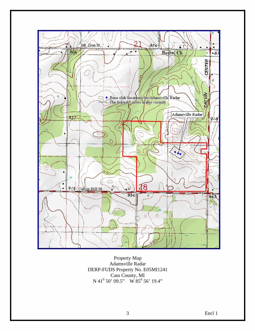
Property Map Adamsville Radar
DERP-FUDS Property No. E05MI1241 Cass County, MI
N 410 50’ 09.5” W 850 56’ 19.4”
Encl 1 3
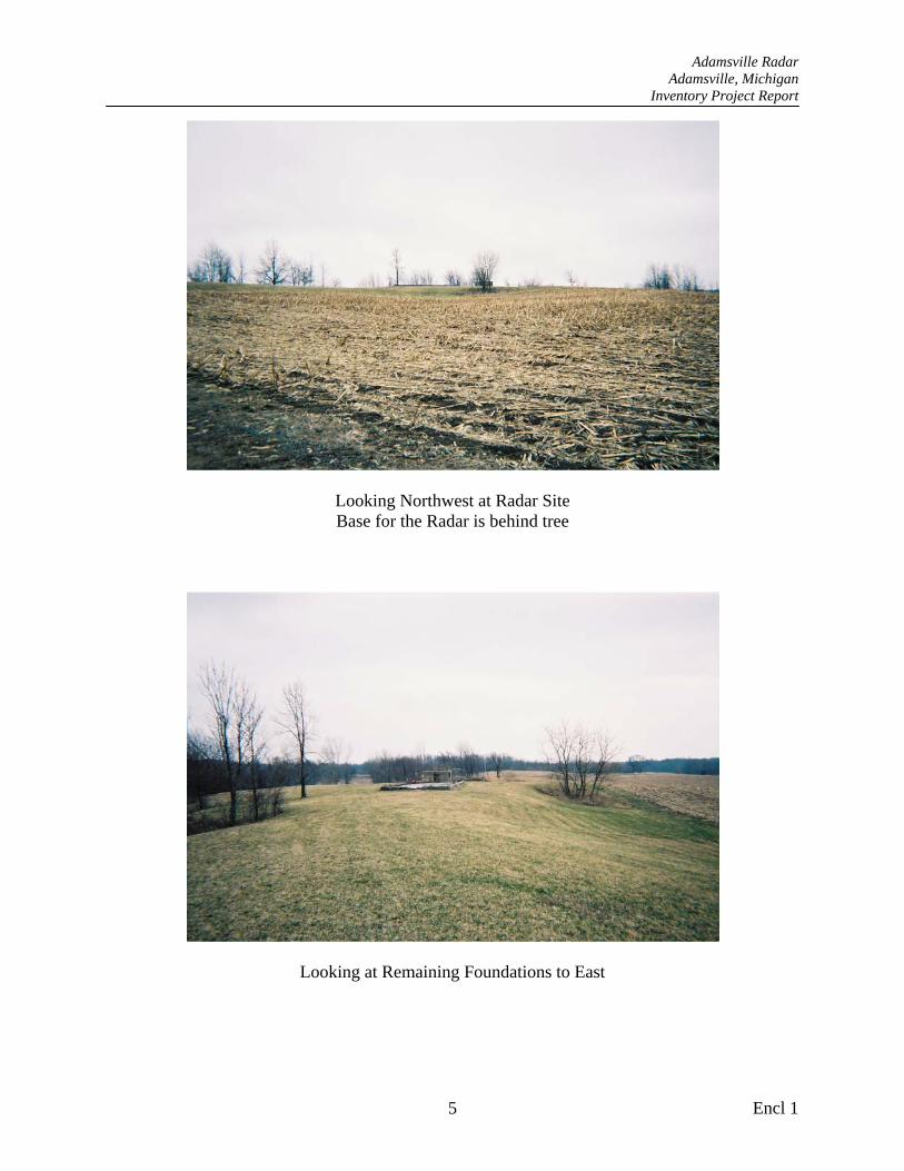
Adamsville Radar Adamsville, Michigan
Inventory Project Report
Looking Northwest at Radar Site Base for the Radar is behind tree
Looking at Remaining Foundations to East
Encl 1 5
Adamsville Radar Adamsville, Michigan
Inventory Project Report
Looking Southwest at Building Foundations Possible water well head in foreground
Second view of possible well head, looking east
Encl 1 6
Adamsville Radar Adamsville, Michigan
Inventory Project Report
Looking Northeast at old Foundations, From Left to Right is Operations Building, Radar Base and Maintenance/Generator Building
Close up of Radar Base with Abandoned Electrical Box
Encl 1 7
Adamsville Radar Adamsville, Michigan
Inventory Project Report
Top of Radar Base with Mounting Bolts
Operations Building Foundation, Looking West Current Property Owner’s Home in Background
Encl 1 8
Adamsville Radar Adamsville, Michigan
Inventory Project Report
Close Up of Remains of Operations Building
Remains of Maintenance/Generator Building
Encl 1 9
Encl 4
Inventory Project Report (INPR) Checklist (Use space at bottom of this worksheet for continuation) Checklist Preparer: Date: 21 September 2004 Name: Thomas. E. Murrell Title: Project Manager District: St. Louis Phone Number: (314) 331-8787 Email address: [email protected] Property information: Property Name: Adamsville Radar Property #: E05MI1241 Previous Names, if any: Cass Radar Station Former Service: U.S. Army Property Location (Section, Township, Range): Section 28 Township 7 S, Range 14 W. Street: City: County: Cass State: MI Latitude (D/M/S): N 410 50’ 09.5” Longitude (D/M/S): W 850 56’ 19.4” Current Use (residential, commercial, etc.): Agricultural Primary Property Owner Information (address multiple owners in Comments): Name: James and Pam Whitcraft Address (if other than above): Street: City: Cassopolis Phone Number: (269) 699-5048 County: Cass State: MI Indicate the status of the following checklist items in determining the completeness of the INPR. Provide a narrative in the comments section below to explain, and keyed to, the shaded boxes checked: Ye
s
No
NA
Property Document Search: Were the following records available and used in the preparation of the INPR?
1 Archive records x 2 Site maps, including facility as-built drawings x 3 Aerial or ground photographs x 4 Prior studies, documents, reports, property contamination records, or
public/private sampling data x
5 Compliance orders issued to current or past owners/operators x 6 Real estate records, deeds, or property transfer records x 7 Local historical societies and public libraries x 8 EPA/State environmental records or reports x 9 EOD incident reports x
10 Other documentation x
Encl 4
Indicate the status of the following checklist items in determining the completeness of the INPR. Provide a narrative in the comments section below to explain, and keyed to, the shaded boxes checked: Ye
s
No
NA
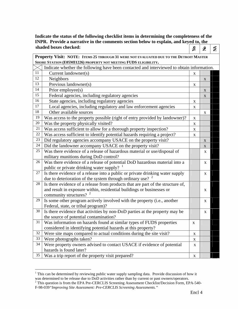
Property Visit: NOTE: ITEMS 25 THROUGH 31 WERE NOT EVALUATED DUE TO THE DETROIT MASTER
SHORE STATION (E05MI1226) PROPERTY NOT MEETING FUDS ELIGIBILITY. Indicate whether the following have been contacted and interviewed to obtain information.
11 Current landowner(s) x 12 Neighbors x 13 Previous landowner(s) x 14 Prior employee(s) x 15 Federal agencies, including regulatory agencies x 16 State agencies, including regulatory agencies x 17 Local agencies, including regulatory and law enforcement agencies x 18 Other available sources x 19 Was access to the property possible (right of entry provided by landowner)? x 20 Was the property physically visited? x 21 Was access sufficient to allow for a thorough property inspection? x 22 Was access sufficient to identify potential hazards requiring a project? x 23 Did regulatory agencies accompany USACE on the property visit? x 24 Did the landowner accompany USACE on the property visit? x 25 Was there evidence of a release of hazardous material or use/disposal of
military munitions during DoD control? x
26 Was there evidence of a release of potential DoD hazardous material into a public or private drinking water supply? 1
x
27 Is there evidence of a release into a public or private drinking water supply due to deterioration of the system through ordinary use? 2
x
28 Is there evidence of a release from products that are part of the structure of, and result in exposure within, residential buildings or businesses or community structures? 2
x
29 Is some other program actively involved with the property (i.e., another Federal, state, or tribal program)?
x
30 Is there evidence that activities by non-DoD parties at the property may be the source of potential contamination?
x
31 Was information on hazards found at similar types of FUDS properties considered in identifying potential hazards at this property?
x
32 Were site maps compared to actual conditions during the site visit? x 33 Were photographs taken? x 34 Were property owners advised to contact USACE if evidence of potential
hazards is found later? x
35 Was a trip report of the property visit prepared? x
1 This can be determined by reviewing public water supply sampling data. Provide discussion of how it was determined to be release due to DoD activities rather than by current or past owners/operators. 2 This question is from the EPA Pre-CERCLIS Screening Assessment Checklist/Decision Form, EPA-540-F-98-039“Improving Site Assessment: Pre-CERCLIS Screening Assessments.”
Encl 4
Indicate the status of the following checklist items in determining the completeness of the INPR. Provide a narrative in the comments section below to explain, and keyed to, the shaded boxes checked: Ye
s
No
NA
Property Eligibility Determination (refer to Chapter 3): 36 Is the property Categorically Excluded? x 37 Are there release, hold harmless, “as-is”, or indemnification clauses in
deeds or property transfer documents that limit DoD liability? x
38 Is there evidence of this property being a Third Party Site? x 39 Is the property eligible under FUDS? x 40 If necessary, has a “Categorical Exclusion or Ineligible Property”
worksheet been prepared (Worksheet B-1)? x
FUDS Property Screening: NOTE: ITEMS 41 AND 42 WERE NOT EVALUATED DUE TO THE DETROIT
MASTER SHORE STATION (E05MI1226) PROPERTY NOT MEETING FUDS ELIGIBILITY. 41 Was a CERCLA Preliminary Assessment completed? x 42 Was a RAC Worksheet prepared for the property? x Project Eligibility Determination (refer to Chapter 3): NOTE: ITEMS 43 THROUGH 51 WERE NOT EVALUATED DUE TO THE DETROIT MASTER SHORE STATION (E05MI1226) PROPERTY NOT MEETING FUDS ELIGIBILITY. 43 Have all typical hazards been investigated for possible occurrence at this
type of property? x
44 Were hazards identified? x 45 Are identified hazards of DoD Origin? x 46 If identified hazards were of non-DoD origin, has the lead regulatory
agency been informed? (Provide name, phone number, date) x
47 Is the current owner under a RCRA or CERCLA clean-up order? x 48 Has the “right of first refusal” been exercised by an adjacent DoD
installation? x
49 Is there evidence of beneficial use? x 50 Are there other policy considerations against recommending a project? x 51 Are eligible FUDS projects recommended? (If yes, identify projects below) x INPR Preparation and Review: NOTE: ITEMS 53 AND 54 WERE NOT EVALUATED DUE TO THE DETROIT MASTER SHORE STATION (E05MI1226) PROPERTY NOT MEETING FUDS ELIGIBILITY. 52 Is the INPR prepared consistent with INPR Content Matrix (Table B-2)? x 53 Is the INPR Property Survey Summary Sheet consistent with Table B-3? x 54 Is the Project Summary Sheet(s) consistent with Table B-4? x 55 If appropriate, has a “BD/DR Project Summary Sheet Checklist” been
prepared? (See Worksheet B-2) x
56 If the INPR recommends a PRP/HTRW project, has the PRP District reviewed the INPR? (See Figure B-1)
x
57 If the INPR recommends a PRP/HTRW project or a controversial or complicated HTRW project, has the HTRW Center of Expertise reviewed the INPR? (See Figure B-1)
x
58 If the INPR recommends a MMRP or PRP/MMRP project, has the OE Center of Expertise reviewed the INPR? (See Figure B-1)
x
59 Was the draft INPR coordinated with Office of Counsel and Real Estate? x
Encl 4
Indicate the status of the following checklist items in determining the completeness of the INPR. Provide a narrative in the comments section below to explain, and keyed to, the shaded boxes checked: Ye
s
No
NA
60 Was the draft INPR shared with the Lead Regulatory Agency after internal USACE review?
x
Narrative comments to explain above notations: (Key your comments to the checklist item number)
10. Documentation obtained for the Adamsville Radar property (E05MI1241)
consisted of two newspaper articles, South Bend Tribune, dated April 3, 1958 and
March 24, 1960. Additional documentation included DeLorme Xmap 4.5.
11. through 24. On 23 March 2004, Mr. Thomas Murrell, CEMVS-ED-P, USACE, St.
Louis District, visited the Cass County Recorders Office and the Equalization Office.
Mr. Jim Becraft of the Equalization Office indicated that he had toured the Adamsville
Radar site as a child in Cub Scouts. He placed the site on land that had been owned by
Mr. Leo Lawson and is currently owned by James and Pam Whitcraft. Property index
cards for Mr. Lawson were searched and there were no government leases recorded. On
25 March 2004, Mr. Murrell met with Pam Whitcraft at her office. Ms. Whitcraft said
they had bought the property from Leo Lawson and the foundations of the Adamsville
Radar facility were still on the property. She said that Leo Lawson had given her some
newspaper articles he had saved about the Army and the Adamsville Radar facility. She
said she would mail copies of these to Mr. Murrell in St. Louis. She gave Mr. Murrell
permission to go on her property and take pictures of what remained of the radar
buildings.
On 25 March 2004, Mr. Murrell visited the site of the former Adamsville Radar Site.
The concrete base for the actual radar was still present as were the foundations and floor
slabs for the operations building and the utilities building. Close by was a small concrete
square pad with a cut of 6” pipe in the center that may have been a well. No other
physical evidence or debris from any military improvements, ordnance and explosives,
chemical warfare material, hazardous or toxic waste, or under/above ground storage tanks
Encl 4
Narrative comments to explain above notations: (Key your comments to the checklist item number) was observed. Mr. Murrell took various pictures of all the remains of the facilities.
41. No Preliminary Assessment recommended.
42. No RAC Worksheet prepared.
43. No evidence of OE usage at the site or in reviewed records.