24


Din4 Environmental Institute
Region 9 Water Quality Project of Rural
Unregulated Water Sources NNR-08-229
Diné College Diné Environmental Institute
Perry H. Charley, Manager [email protected]
(505) 368-3514

• Din4 College:
t
Partnership
• US – EPA Region IX: Funding
• NN Water Resources: Maps and data
• Navajo IRB: Human Health protection & oversigh
• Din4 College: interns, staff & faculty
• University of Nevada: Technical assistance & analysis
• Student Association for International Water
Issues (SAIWI) – Graduate volunteer students to assist DEI interns in obtaining
field data & water samples

from al contaminants
• Comm
Water Quality Project Objectives
• Document unregulated water sources • Identify extent of domestic usage • Analyze parameters to determine public health risks from potential contaminantspotenti
E. Coli Metals: Arsenic, Uranium and Lead Site specific radiological surveys
unity survey (pending) • Optional Voluntary Community Monitoring

ata nagement te nager ecor erSite
Field Protocol
Water Sampling
Site D Ma Si Ma /R d
Characterization
Photography Radiological Characterization
Data Management Site Manager/Recorder
Cultural Sensitivity

Area of Effect

“ ”
Active & Inactive Water Sites
• 53 unregulated wells & 5 controls were documented/sampled
• 18 sites determined “areas of concern”areas of concern due to certain tests exceeding Maximum Contaminate Level (MCL).

Impacted Wells

655434E Well 13 270 09Y- 100 (above).
REGION 9 WATER QUALITY
LISTS OF WELLS
POSITIVE E.COLI & EXCEEDING As & U MCLs ANALYTICAL RESULTS
ARSENIC URANIUM E. COLI MCL:10 µg/L ICP-MS I DEXX
MCL: 30 µg/L Colisure®
17 0 27.2
3 3 88.4
22 59 74.4
1.0
SAMPLE NAME
DCRM080521-9T547 4108038E
639327N
DCRMO8O521-AM02
DCRM080521-100 655931E
4086912N
CHAPTER
Red Mesa (windmill)
Red Mesa (windmill)
Red Mesa (windmill)
Notes/Comments
Windmill: north of Red Mesa buttes
AM= Aero-Motor, designating a
windmill blade type, near church
Windmill: west of Goldtooth camp, east
Red Mesa buttes
DCRM080521-100A Red Mesa (windmill) 12 655434E Well 13 4093896N Windmill 5
DCRM080528- 0559 4118115E
647039N
DCRM080528- RMSW01 644126E
4101457N
DCRM080521-PCW01
DCRM080521-9T538 4104193E 649600N
DCRM080528-CH 4103125E 645539N
DCRM080521-PWS01 4091588E 646381N
Red Mesa (windmill)
Red Mesa (windmill)
Red Mesa
Red Mesa (windmill)
Red Mesa Chapter House (public water supply)
Red Mesa Store (Well)
21
22
50
12
12
21
20
260 270
>2 8.5
Windmill: ½ mile west of windmill
09Y- 100 (above).
windmill
1.0
windmill
4.1
36 Needs verification: A Duplicate w/
PWS01, results used for graph.
Windmill – east of chapter house
NTUA jurisdiction - referral
36
34
Active well heavily used by commu
for drinking – closure (?) *Appears
nity
as
Duplicate sample w/-PCW01 above.
Result not used in graph.
Black: 2008 sampling results Red: 2009 sampling results

4085192E
(Con’t) REGION 9 WATER QUALITY
LISTS OF WELLS
POSITIVE E.COLI & EXCEEDING As – U MCL ANALYTICAL RESULTS
SAMPLE NAME CHAPTER ARSENIC
MCL: 10 ug/L
URANIUM
MCL: 30 ug/L
E.COLI
IDEXX
RECOMMENDATION
DCTT080521-09B-17 649491E
4090354N
Tse Tah (windmill) <1.0 Windmill; not -0913, but 09B-17.
Also has two sets GPS coordinates
DCTC080522-9T227 4097409E
661475N
Teec Nos Pos 21.6 Might be 9T-227: needs verification;
Verified 3/27/09 by BMaxwell
DCTNP080522-502 TeecNosPos (windmill) 1 Windmill ;along Carrizo Mtn. road.
4085192E
660685N
DCAN080526-0531 4130476E
665113N
Aneth (windmill),
North Aneth past
Lansing’s
11 1.0 Windmill: near Lansing’s camp, west
of junction of Hovenweep turnoff.
Appears a Duplicate, used results in
graph.
DCAN080522-531 Aneth
1.0
Most likely the same windmill as
above (0531). Appears a Duplicate,
This result not used in graph.
DCAN080526-0513 4135843E
666086N
Aneth (windmill)
13
Windmill, south of Hovenweep Nat’l
Monument
DCMM080527-0710 Aneth (windmill)
2.0
MM = McCracken Mesa @ North
Aneth
DCMC080528-559 4117606E
648258N
Montezuma Creek 21 1.0 0559 at Red Mesa, but this looks to
be a different well. Needs verification
due to differing analytical data.

Summary
• Note: Comparison between 2008 (black) and 2009 (red) sampling.
• 1. In most cases, contaminant levels appear very similar between 2008 and 2009 in 5 unregulated wells re-sampled in the Red Mesa area.
•• 2. 2. E. Coli at well 9T547 was elevated compared to 2008 E. Coli at well 9T547 was elevated compared to 2008 analysis: 27.2 to 88.4
• 3. Red Mesa Chapter House was sampled as a Control in both years. Still shows Arsenic exceedances at 21 and 20 µg/L for 2008 and 2009 respectively.
• 4. PWS01, a heavily used well at Red Mesa Store, also shows exceedances: 21 & 20 µg/L (Arsenic) and 36 & 34 µg/L (total Uranium).

Im acted Wells
Well 547: Well # 100
Arsenic: 17µg/L (E.Coli 1.0)
E. Coli: 27.2 Impacted Wells p PSW01-Red Mesa Store Arsenic (21µg/L) Uranium (36µg/L)
Well# 100A Arsenic: 21µg/L Uranium: 260µg/L

Well 538 Arsenic: 50µg/L
Well 559: Arsenic: 21 µg/L Impacted E.Coli: 1.0
Wells Wells
Well 212 (AM02):
Arsenic: 12µg/L Uranium: 59 µg/L E. Coli: 74.4

Mesa area
Wells with Escherichia coli (E. coli)Contamination
• 12 of 53 water sources identified positive for E.
coli
• 5 of 12 water sources positive for E. coli in Red Mesa area
• 4 of 12 water sources positive for E. coli in Aneth/Montezuma Creek areas
• 1 site positive at Tse Tah • 2 sites at Teec Nos Pos
were positive

above MCL in Red
Wells with Arsenic Contamination
• 10 of 22 water
sources above MCL
• 9 of 22 water sources
above MCL in Red
Mesa area
• Remaining 2 of 10
above MCL in Aneth
area

• All 4 sa led sites in
Wells with Uranium Contamination
• 4 of 53 wells tested
positive for Total
Uranium
• All 4 sampled sites inmp
Red Mesa area

Issues and Concerns
• Who are the role players in the effort?
• Overlap – need to compare data
• No meetings, no interactions
• Identify funding sources for immediate and long term community needsterm community needs
• More Tribal-IHS interaction
• Issues concerning NTUA “waivers “ of MCl As exceedance for Red Mesa Chapter
• Avoid human use of unregulated water sources
• Increased public education & awareness

Other Problems
Dead cattle near pond and windmill
Inactive well
Graffito
Vandalism Trash in
reservoirs
Half filled reservoirs

Axhe’hee doo Ha’gone’
Dine’ College – Dine’ Environmental Institution


22 22
MC
L&
Co
nta
min
aR
es
ult
s(u
g/L
)
50
30
40
50
60
nt
Re
su
lts
(u
g/L
) Arsenic (As) Red Mesa & Aneth Areas
Contaminant Results (ug/L)
17
22
12
21 22
12 11 13
0
10
20
1 2 3 4 5 6 7 8 9
MC
L &
Co
nta
min
an
t
Number of Sample Sites
MCL 10 ug/L
Co
nta
mi
nt
Re
su
lt(u
g/L
)
30
40
50
60
na
nt
Re
su
lt (
ug
/L)
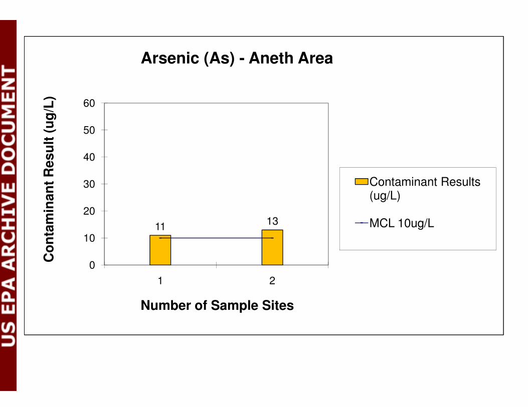
Arsenic (As) - Aneth Area
Contaminant Results (ug/L)
11 13
0
10
20
1 2
Co
nta
min
a
Number of Sample Sites
MCL 10ug/L

MC
L&
Co
nta
min
a g150
Re
su
lts
(ug
/L)
260
150
180
210
240
270
300
nt
Re
su
lts
(u
g/L
)
(U) Uranium ICPMS : Red Mesa Area
Contaminant Results (u /L)
59
36
0
30
60
90
120
1 2 3
MC
L &
Co
nta
min
an
t
Number of Sample Sites
(ug/L)
MCL 30 ug/L


