363-4477 42A14SE6114 2.4456 TULLY 010 1STH FLOOR 4 KINO ST. WEST. TORONTO ff. r. oAm'aan, P. E NO. MINING GEOPHYSICIST December 10, 1981 The President and Directors White Star Copper Mines Limited Suite 1500 4 King Street, West TORONTO, Ontario. M5H 1B6 RECEIVED Df C 311981 MINING IAN0S SECTION REPORT - Geophysical Exploration Programme and Follow-Up Diamond Drilling Programme Tully Township Property .' . Porcupine Mining. Division,. Ontario.. During the months of March and April, 1981, an Electromagnetic Survey was carried out on your Tully Township property located in the Porcupine Mining Division of Ontario, This programme was subsequently followed up by an approximate 1,365 foot Diamond Drilling programme consisting of four drill holes to test four separate conductors. Summary of Results of the Exploration' Programme The Electromagnetic Survey revealed several conductors of possible importance, the conductors representing zones of poor to moderate conductivity and are similar to the response expec ted over zones carrying in the neighbourhood of 57 e - 107 e sul phides. In general, the conductors are similar in nature to the gold bearing conductors existing on the Texmont property located immediately to the south-west of this property. Four drill holes were drilled, one in each of conductors A, B, C and D. All conductors intersected sulphide mineralization as expected. However, detailed sampling and assaying revealed either nil or very minor amounts of gold. No base metals of any apparent significance were present in any of the zones tested. Several other minor conductors exist on the property particularly on the north portion of claim number 501065. These zones were not tested by diamond drilling.
Transcript
363-4477 42A14SE6114 2.4456 TULLY 0101STH FLOOR
4 KINO ST. WEST. TORONTO
ff. r. oAm'aan, P. E NO.
MINING GEOPHYSICIST
December 10, 1981
The President and DirectorsWhite Star Copper Mines LimitedSuite 15004 King Street, WestTORONTO, Ontario.M5H 1B6
During the months of March and April, 1981, an Electromagnetic Survey was carried out on your Tully Township property located in the Porcupine Mining Division of Ontario,
This programme was subsequently followed up by an approximate 1,365 foot Diamond Drilling programme consisting of four drill holes to test four separate conductors.
Summary of Results of the Exploration' Programme
The Electromagnetic Survey revealed several conductors of possible importance, the conductors representing zones of poor to moderate conductivity and are similar to the response expec ted over zones carrying in the neighbourhood of 57e - 107e sul phides.
In general, the conductors are similar in nature to the gold bearing conductors existing on the Texmont property located immediately to the south-west of this property.
Four drill holes were drilled, one in each of conductors A, B, C and D. All conductors intersected sulphide mineralization as expected. However, detailed sampling and assaying revealed either nil or very minor amounts of gold. No base metals of any apparent significance were present in any of the zones tested. Several other minor conductors exist on the property particularly on the north portion of claim number 501065. These zones were not tested by diamond drilling.
- 2 -
Terms of Reference
This survey was carried out by agreement with White Star Copper Mines Limited.
The area surveyed covered the complete area of the twelve claim group known as claim numbers 501055 to 501065 inclusive and in addition, claim number 515807. The survey was carried out on north-south lines spaced 400 feet apart with a control base line established approximately in the centre of'the claim group. The survey was carried out under the direct field supervision of Mr. Philippe Roby of Senneterre, Quebec and Mr. Paul Perrault of Senneterre, Quebec. .
The total mileage surveyed was approximately 13 line miles and the total mileage line cut was approximately 14 line miles.
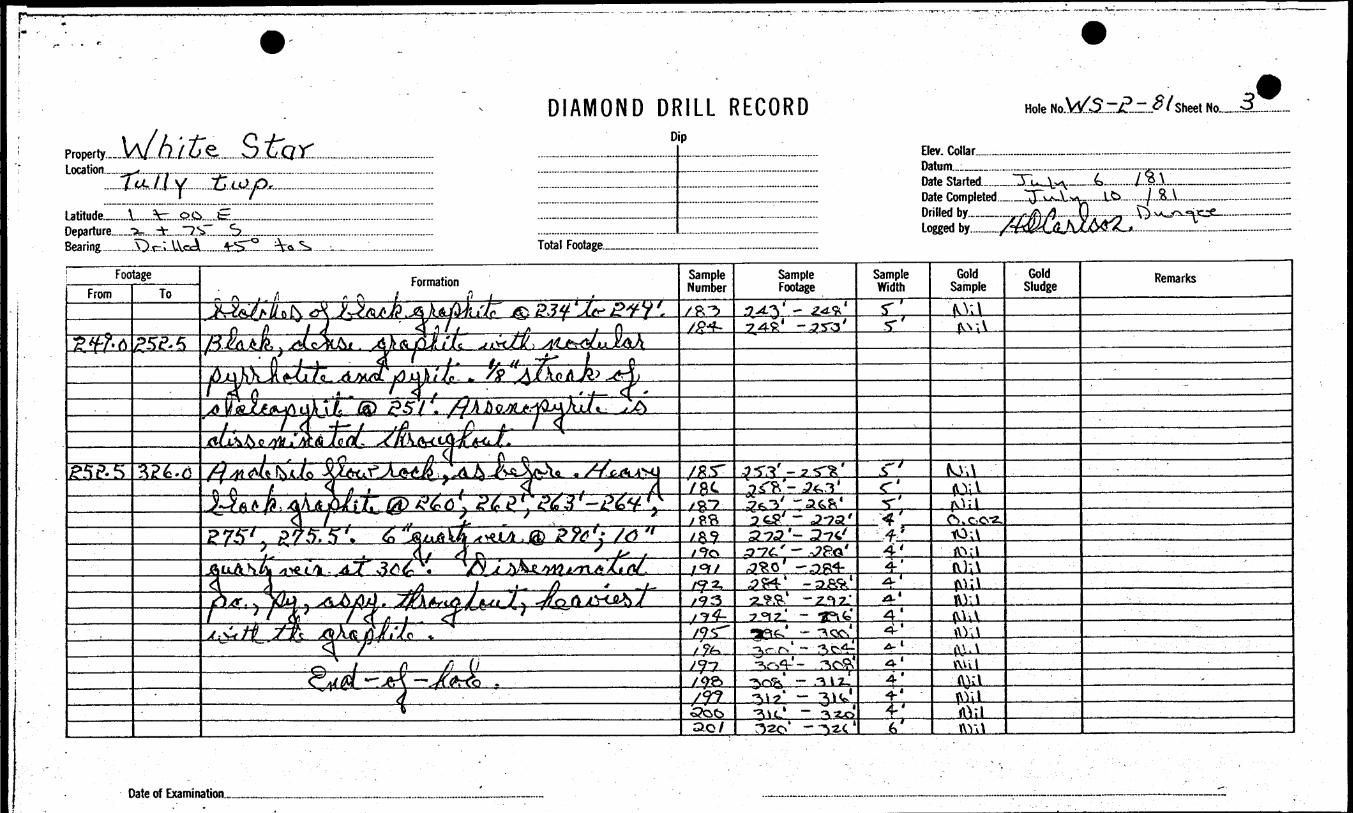
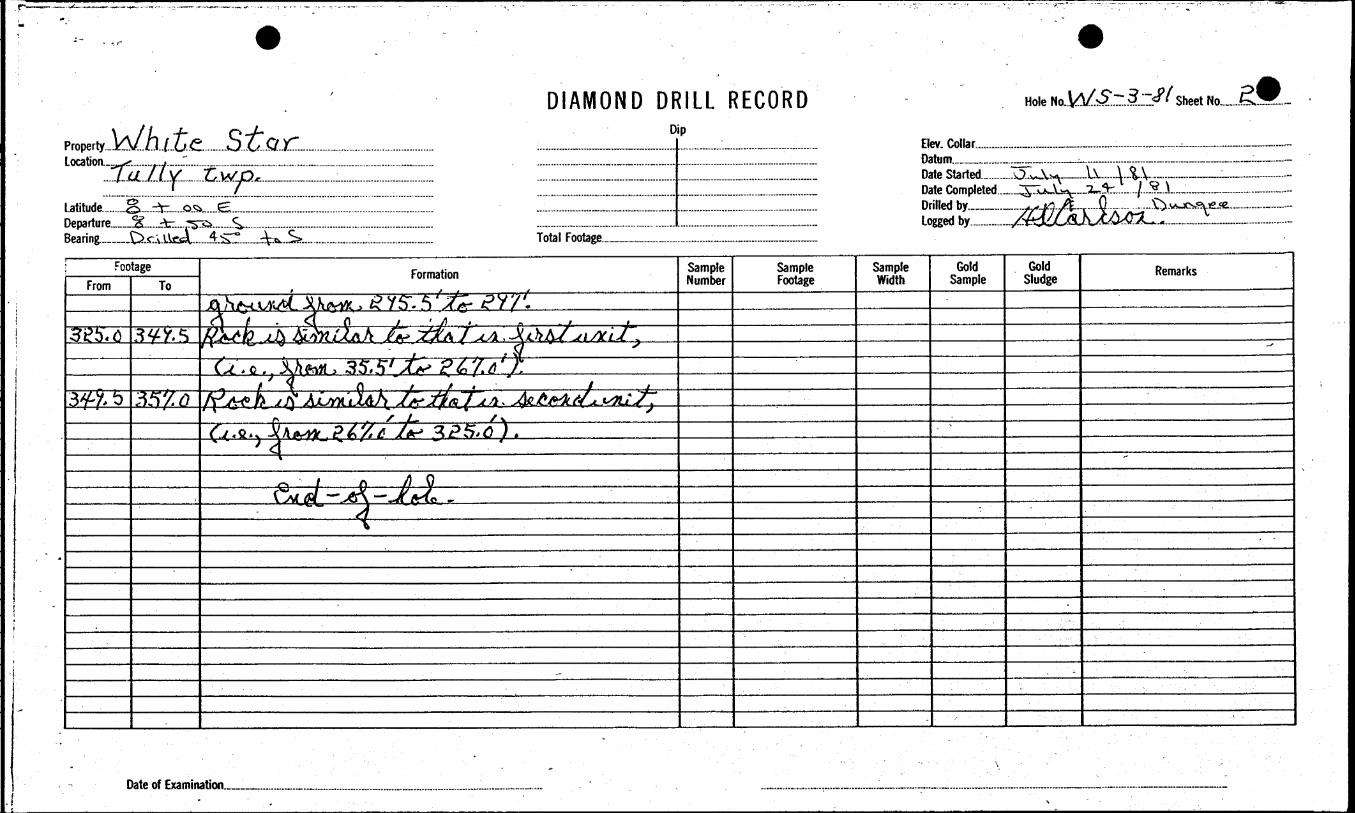
The drilling was carried out by Mr. Arthur Dungee of Thunder Bay, Ontario, utilizing AQ wireline equipment and consisted of four holes indicated as D.D.H. l to D.D.H. 4 inclusive. All holes were drilled at 45 angles.
All core was logged by Dr. H.D. Carlson, Consulting Geologist, of Timmins, Ontario.
The direct field supervision of the drilling was done by Mr. Philippe Roby of Senneterre, Quebec. The total footage drilled was l,365 feet.
All assaying was carried out by Swastika Laboratories of Swastika, Ontario.
Methods Used and Presentation bf Results
E lee tromagnetic Survey
The Electromagnetic Survey employed the Sheridan-Kelk Dual Frequency Magniphase Electromagnetic Instrument operated in the horizontal coil configuration with a transmitter-receiver separation of 200 feet. In general, readings of amplitude and phase of the resultant field at the high frequency (2400 cps) were recorded at station intervals of 100 feet.
The results of the survey, as plotted on the accompanying map, show only the profile of the high frequency phase.
In general, in areas considered of interest, the station interval was reduced to 50 feet,
Discussion of Results
The main feature revealed by the survey is a series of con ductors located in the south-west portion of the property. These conductors have been labeled conductors A, B, C and D, These conductors represent zones of sulphide mineralization of poor to moderate conductivity. The responses obtained over these zones are similar to responses which would be ob tained over zones bearing 57o - 157* sulphides over widths of 10 feet - 30 feet. All of these conductors were drilled and significant sulphide mineralization was cut in all drill holes.
Several conductors were indicated which were not tested by diamond drilling. These conductors may warrant further exploration as areal exploration developments in the areaunfold.
In the immediate area of this property and particularly on the Texmont property located immediately to the south-west of this property, some zones similar in nature to the ones tested have been shown to be gold bearing in commercial quantities.
Unfortunately, in the area tested by diamond drilling, no significate values were obtained associated with the sulphides.
Conclusions and Recommendations
It must be concluded that the programme executed has success fully delineated certain areas of sulphide mineralization and that the four conductive zones indicated, namely conductors A, B, C and D and investigated by diamond drilling have been initially determined riot to be gold bearing in sulphides.
The property should be maintained in good standing for as long as possible pending further developments in the area.
All of which is respectfully submitted.
J.P. Sheridan, P.Eng,
JPS/jlm
SWASTIKA LABORATORIES LIMITEDP.O. BOX 10, SWASTIKA, ONTARIO POK 1 TO
' -J— C~ -r~/..Ce.........^.^:^DIAMOND DRILL RECORD
Dip
Hole NoJk^lSLjsZ-JLj t No__/Lit-
7~
Latitude... Departure Bearing...
__ft..
Elev. Collar.. Datum...—~
Drilled by.__.—
Total Footage_____.
Date of Examination ,,
Property..
DIAMOND DRILL RECORDDip
Hole!
Departure _ S-.Jc
Elev. Collar. Datum.___. Date Started... Date Complete Drilled by. Logged by.,
Total Footage.__
Sheet No^
FootageFrom To
Formation Sample Number
Sample Footage
Sample Width
Gold Sample
Gold Sludge Remarks
L/flA
o . , 35,5'- .^ f \ . .Ut J i S oyffSrf A . y /f ALm iJLAJ\ I** ̂ ^7^ ̂ ~
Date of Examination.___
P"
W/820I98I
DIAMOND DRILL RECORD ..- /Hole No. .'.r..Z-? Sheet
Property., Location._
DipBev. Collar..........Datum.___.....
Drilled by.. Logged by..
Total Footage.___
Date of Examination..
Property..* Location...
Departure.__\j
DIAMOND DRILL RECORDDip
Hole No'•-±-Jt
Sheet No.....
l
Etev. Collar... Datum.
Total Footage..
DateDrilled by Logged by..
FootageFrom To
Formation
7^ t J/, 5 .
Sample Number
Sample Footage
Sample Width
Gold Sample
Gold Sludge Remarks
33775"
^fc;?g5- '/^jft'f/o f/-S21.
Sr^ ICT̂Li6|t^
Date of Examinati
5 ga
Ontario
Ministry of Natural Resources
GEOPHYSICAL - GEOLOGICAL - GEOCHEMICAL TECHNICAL DATA STATEMENT
FUc.
TO BE ATTACHED AS AN APPENDIX TO TECHNICAL REPORT . FACTS SHOWN HERE NEED NOT BE REPEATED IN REPORT
TECHNICAL REPORT MUST CONTAIN INTERPRETATION, CONCLUSIONS ETC.
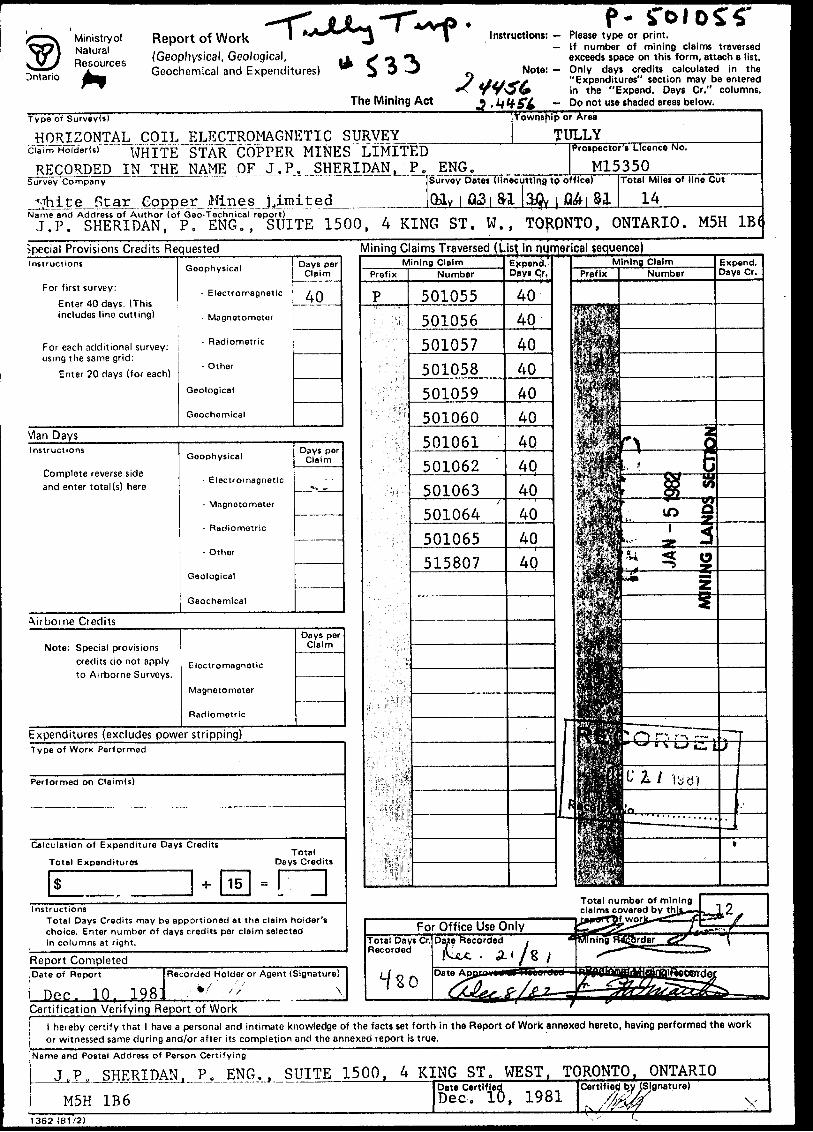
Type of Survey(s) Horizon t" a l doll ElectrmnflpnpfHf Survey Township or Area Tully TnwnsMp———————-..—————-—-
ouiJ^ 5K J5..i -r* aU um tt
w go Js g
Claim Hnlder(s) WMf-p Star flnpppr M-inpg
Recorded in name nf .T T P , P.F.ngSurvey fVimpany WfoifrA Star flnpppr M-inpg T.•^Tn^^Af^ Author of Report -T, P, gV>oy^^^fln > P , Fng^^^^^.^ Address of Author—A-Kiag Covering Dates of Survey March
(linecuttirig to Total Miles of Line fiiit 14 m i 1 A.Q
Ap 1*"1 T Ttirig to office)
QS1
SPECIAL PROVISIONSCREDITS REQUESTED
ENTER 40 days (includes line cutting) for first survey.ENTER 20 days for each additional survey using same grid.
Geophysical —Electromagnetic-
—Radiometric-n^-r
GrorhTniral,,,..,,...
DAYSper claim
40
AIRBORNE CREDITS (Special provision credit* do not apply to airborne lurveyi)
Magnetometer. .Electromagnetic. .R metnc(enter dayi per claim)
HATE. Dec. 10. 198W.MATHP*.Author of
Res. Geol.. .QualificationsPrevious Surveys
File No. Type Date Claim Holder
MINING CLAIMS TRAVERSED List numerically
501055(number)
.5.0.10.56.......501057
T P
501058
501059t
501060(••••••tt**t****t
501061
I1 j
501064t*i*i***t*f**'***
,,,.,,..?,,,...,..,........,J5.3,5.6Q.7,
TOTAL CLAIMS. 12
83 T te/vg'l
GEOPHYSICAL TECHNICAL DATA•^
GROUND SURVgYS — If more than one survey, specify data for each type of survey
Number nfrfctaH/^ 780 approximately_____Number of Readings 780 approximatelyo ?' - ,-Tnn f r- 5 0 ff" for areas r- - Aon Station mtervalfc&QO ft. - Considered of intei-ell*6sPacm8 4UUProfSe sraie. Oti^ inch - 100 units - 307a_______________.
zoN
32Q a oa
interval U n/a
Instrument —-^^^————— Accuracy — Scale constant.
,. Diurnal correction method.Base Station check-in interval (hours). Base Station location and value —-^—
Instrument —-——-Method D Time Domain CD Frequency Domain Parameters - On time __________________________ Frequency —————
-Off time__________________________ Range ———————— Delay time ————————————————————————— Integration time.
Power.array.
Electrode spacing, Type of electrode
l 5TH FLOOR 4 KING ST. WEST, TORONTO
on o/ i/y. f^. ^Jfiendan, P . ENG.
MINING GEOPHYSICIST
December 16, 1981
Ministry of Natural Resources Officer of the Mining Recorder 99 Wellesley Street, West Room 1522 - 1st Floor QUEENS PARK TORONTO, Ontario.
Attn: Mr. Matthews
Dear Mr. Matthews:
Re: Electromagnetic SurveyWhite Star Mines Limited
Please find enclosed herewith two copies of a report on an Electromagnetic Survey for White Star Copper Mines Limited together with a Geophysical- Geological-Geochemical Technical Data Statement, filed in duplicate.
Kindly record the assessment work carried out on these claims.
Yours very truly,
P. Spriel (Miss)
/smk
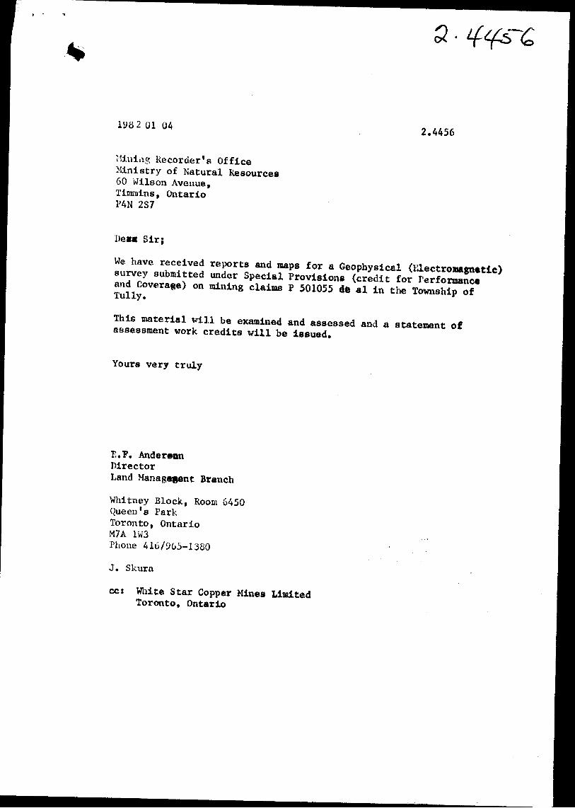
e 2 01 042.4456
Mining Recorder's Office Ministry of Natural Resources 60 Wilson Avenue, Tirarains, Ontario PAN 2S7
DeB* Sir;
We have received reports and maps for a Geophysical (Electromagnetic) survey submitted under Special Provisions (credit for Performance and Coverage) on mining claims P 501055 dfe al in the Township of Tully.
This material will be examined and assessed and a. statement of assessment work credits will be issued.
Yours very truly
E.F. AnderdonDirectorLand Management Branch
Whitney Block, Roora 6450 Queen's Park Toronto, OntarioM7A 1W3Phone 416/905-1380
J. Skura
cc: White Star Copper Mines Limited Toronto, Ontario
Ministry of Natural Resources
Ontario AM
Report of Work '(Geophysical, Geological, Geochemical and Expenditures)
f-l Instructions: - Please type or print.
— If number of mining claims traversed exceeds space on this form, attach a list.
^ Note: — Only days credits calculated in the J tijj4f/ " Expenditures" section may be entered
**s T TS?W in the "Expend. Days Cr." columns. The Mining Act____ * M ^Si - Do not use shaded areas below.