DOE/EA-1860 DRAFT ENVIRONMENTAL ASSESSMENT FOR THE RICHLAND CENTER RENEWABLE ENERGY ANAEROBIC DIGESTER- WASTE TO ENERGY PROJECT RICHLAND CENTER, WISCONSIN U.S. Department of Energy Office of Energy Efficiency and Renewable Energy Golden Field Office AUGUST 2011
Transcript
DOE/EA-1860
DRAFT ENVIRONMENTAL ASSESSMENT
FOR THE
RICHLAND CENTER RENEWABLE ENERGY ANAEROBIC DIGESTER-
WASTE TO ENERGY PROJECT
RICHLAND CENTER, WISCONSIN
U.S. Department of Energy Office of Energy Efficiency and Renewable Energy
Golden Field Office
AUGUST 2011
DOE/EA-1860
DRAFT ENVIRONMENTAL ASSESSMENT
FOR THE
RICHLAND CENTER RENEWABLE ENERGY ANAEROBIC DIGESTER-
WASTE TO ENERGY PROJECT
RICHLAND CENTER, WISCONSIN
U.S. Department of Energy Office of Energy Efficiency and Renewable Energy
Golden Field Office
AUGUST 2011
DOE/EA-1860 iii August 2011
COVER SHEET
RESPONSIBLE AGENCY: U.S. Department of Energy
TITLE: Draft Environmental Assessment for the Richland Center Renewable Energy Anaerobic Digester-Waste to Energy Project (DOE/EA-1860)
CONTACT: For more information about this Environmental Assessment (EA), please contact:
Melissa Rossiter NEPA Document Manager U.S. Department of Energy Office of Energy Efficiency and Renewability Golden Field Office 1617 Cole Boulevard Golden, Colorado 80401-3305 Desk Phone: 720-356-1566 Cell Phone: 720-291-1602 Email: [email protected]
ABSTRACT: The U.S. Department of Energy (DOE) has provided Federal funding to the Wisconsin Department of Commerce, Wisconsin Economic Development Corporation (WEDC) under the State Energy Program (SEP). WEDC is seeking to provide a $3.5 million SEP loan to Richland Center Renewable Energy (RCRE). These funds would be used to purchase equipment for an anaerobic digester located at a new wastewater treatment facility.
Before DOE decides whether to authorize WEDC to provide SEP funds to the proposed project, DOE must first complete a review of the proposed project under the National Environmental Policy Act (NEPA). Therefore, DOE has prepared this draft EA to analyze the potential environmental impacts of the proposed construction and operation of the proposed project and the alternative of not implementing this project (the No-Action Alternative).
The proposed wastewater treatment facility is expected to reduce demand on the local publicly owned treatment works (POTW) through reduction of organic loading discharged to the POTW from the dairy industry facilities. The proposed facility would also create a source of renewable energy through capture of methane produced in anaerobic processes as well as provide relief to local farmlands through management of solid waste. Such alternative disposal, treatment, and reuse of the dairy industries’ wastewater would ultimately eliminate land-spreading activities during periods of snow-covered or frozen ground, reducing potential runoff and discharge of nutrients into local waterways. The proposed project would be located on approximately 6 acres of current agriculture land purchased by RCRE. The project would include an approximately 1,190-foot access road, and approximately 7,450 feet of force main pipeline to connect the three dairy facilities to the wastewater treatment facility.
PUBLIC INVOLVEMENT: The public is provided with an opportunity to comment on this Draft EA by sending comments via email and U.S. mail marked to the attention of the NEPA Document Manager listed above. Envelopes and the subject line of emails should be labeled “Richland Center Renewable Energy Draft EA Comments.” Letters and emails should be postmarked or dated, respectively, no later than September 2, 2011. Use of email to submit comments would avoid processing delays associated with delivery of mail to Federal agencies.
DOE/EA-1860 iv August 2011
AVAILABILITY: This EA is available for review on the DOE Golden Field Office Reading Room Website, http://www.eere.energy.gov/golden/Reading_Room.aspx, and the DOE NEPA Website, http://www.energy.gov/nepa.
Acronyms and Abbreviations
DOE/EA-1860 v August 2011
ACRONYMS AND ABBREVIATIONS
AADT Average Annual Daily Traffic CEQ Council on Environmental Quality CFR Code of Federal Regulations COD chemical oxygen demand DAF dissolved air flotation dBA decibel on an A-weighted scale, used to approximate the human ear’s response to sound DOE U.S. Department of Energy EA Environmental Assessment EERE Energy Efficiency and Renewable Energy EPA U.S. Environmental Protection Agency FEMA Federal Emergency Management Agency GHG greenhouse gas GWP global warming potential MMBtu million British thermal units NAAQS National Ambient Air Quality Standards NEPA National Environmental Policy Act NHPA National Historic Preservation Act NOA Notice of Availability NRCS Natural Resources Conservation Service NRHP National Register of Historic Places OSHA Occupational Safety and Health Administration PMn particulate matter with an aerodynamic diameter less than or equal to a nominal n
micrometers POTW publicly owned treatment works RAS return activated sludge RCRE Richland Center Renewable Energy LLC Recovery Act American Recovery and Reinvestment Act of 2009 ROI region of influence SEP State Energy Program SWPPP storm water pollution prevention plan USACE U.S. Army Corps of Engineers U.S.C. United States Code USFWS U.S. Fish and Wildlife Service WAS waste activated sludge WDNR Wisconsin Department of Natural Resources WEDC Wisconsin Economic Development Corporation
Contents
DOE/EA-1860 vi August 2011
CONTENTS
Section Page
1. INTRODUCTION .................................................................................................................................. 1 1.1 National Environmental Policy Act and Related Procedures ......................................................... 1 1.2 Background .................................................................................................................................... 1
1.2.1 DOE’s Purpose and Need .......................................................................................................... 3 1.2.2 State of Wisconsin’s Purpose and Need .................................................................................... 4
1.3 Public and Agency Involvement .................................................................................................... 4 1.3.1 Public Scoping ........................................................................................................................... 4 1.3.2 Consultations ............................................................................................................................. 5 1.3.3 Draft Environmental Assessment .............................................................................................. 5
2.2.1 Project Location and Site Plan .................................................................................................. 8 2.2.2 Project Technology and Process Description ............................................................................ 8
2.2.3 Construction ............................................................................................................................ 14 Facility Construction .......................................................................................................... 14 2.2.3.1 Pipeline Construction and River Crossing .......................................................................... 15 2.2.3.2
2.3 No-Action Alternative .................................................................................................................. 18 3. AFFECTED ENVIRONMENT AND ENVIRONMENTAL CONSEQUENCES ......................... 19
3.1 No-Action Alternative .................................................................................................................. 19 3.2 Environmental Resource Areas Not Carried Forward for Further Analysis ................................ 19
3.3 Considerations Carried Forward for Further Analysis ................................................................. 20 3.3.1 Land Use ................................................................................................................................. 20
Affected Environment ........................................................................................................ 20 3.3.1.1 Environmental Consequences of the Proposed Project ...................................................... 20 3.3.1.2
3.3.2 Noise ........................................................................................................................................ 21 Affected Environment ........................................................................................................ 21 3.3.2.1 Environmental Consequences of the Proposed Project ...................................................... 22 3.3.2.2
3.3.3 Aesthetics ................................................................................................................................ 23 Affected Environment ........................................................................................................ 23 3.3.3.1 Environmental Consequences of the Proposed Project ...................................................... 24 3.3.3.2
Environmental Consequences of the Proposed Project ...................................................... 25 3.3.4.23.3.5 Air Quality and Meteorology .................................................................................................. 26
Affected Environment ........................................................................................................ 26 3.3.5.1 Environmental Consequences of the Proposed Project ...................................................... 27 3.3.5.2
3.3.6 Geology and Soils ................................................................................................................... 31 Affected Environment ........................................................................................................ 31 3.3.6.1 Environmental Consequences of the Proposed Project ...................................................... 32 3.3.6.2
3.3.7 Water Resources ...................................................................................................................... 32 Affected Environment ........................................................................................................ 32 3.3.7.1 Environmental Consequences of the Proposed Project ...................................................... 33 3.3.7.2
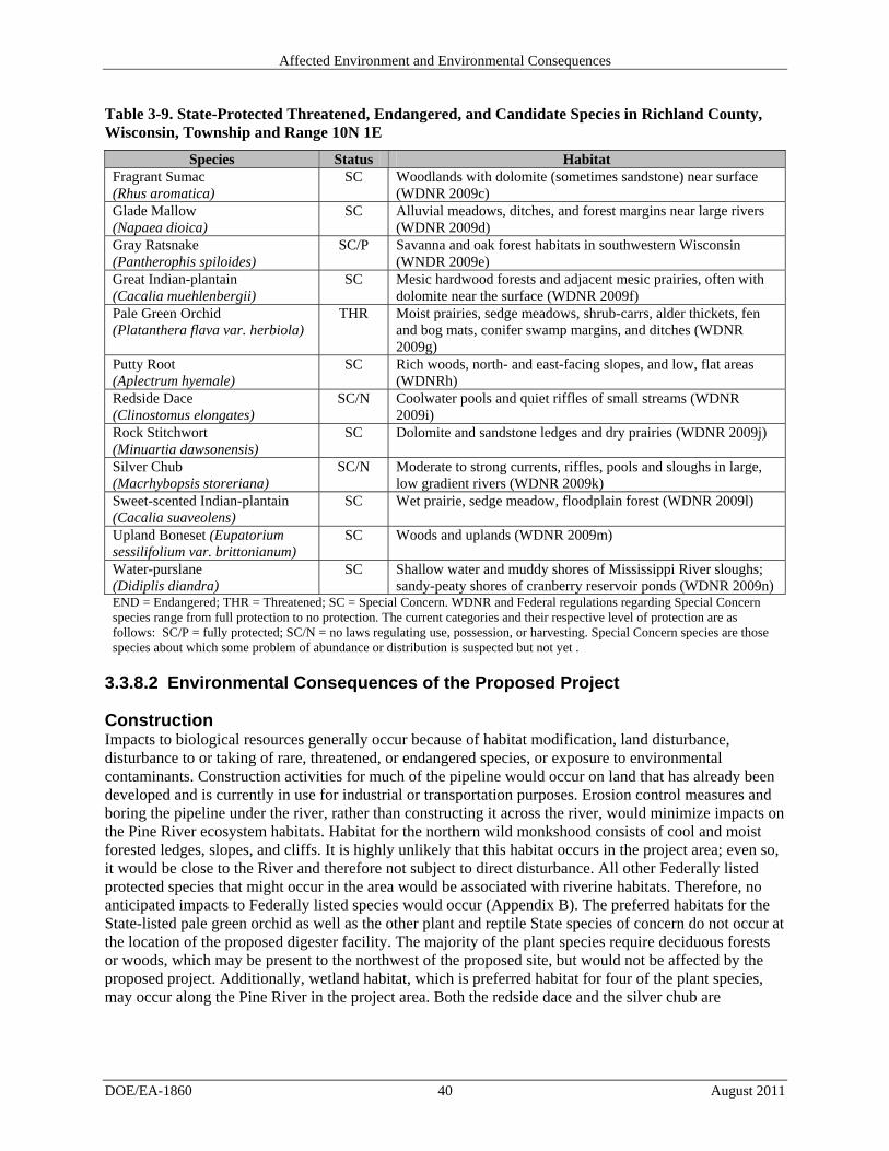
3.3.8 Biological Resources ............................................................................................................... 36 Affected Environment ........................................................................................................ 36 3.3.8.1 Environmental Consequences of the Proposed Project ...................................................... 40 3.3.8.2
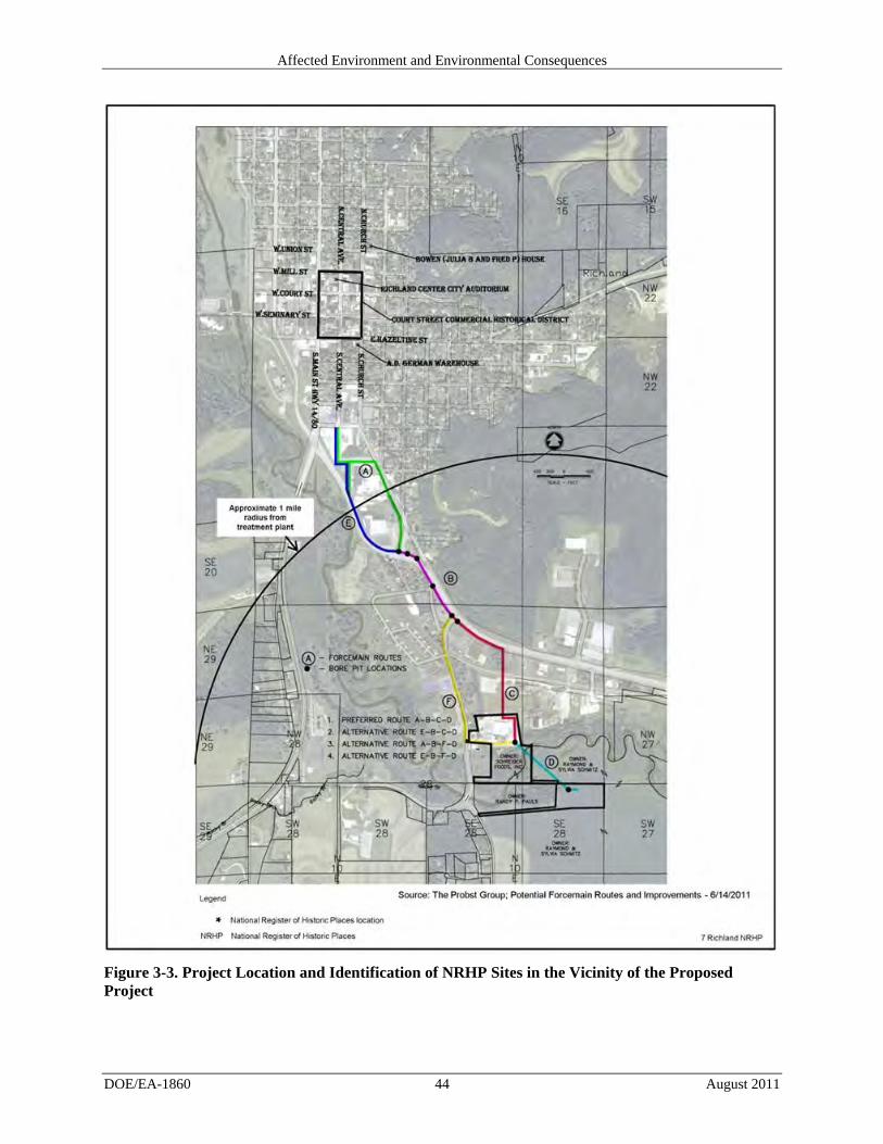
3.3.9 Historic and Cultural Resources .............................................................................................. 41 Affected Environment ........................................................................................................ 41 3.3.9.1 Environmental Consequences of the Proposed Project ...................................................... 43 3.3.9.2
3.3.10 Infrastructure ........................................................................................................................... 46 Affected Environment ........................................................................................................ 46 3.3.10.1 Environmental Consequences of the Proposed Action ....................................................... 46 3.3.10.2
3.3.11 Waste Management and Hazardous Materials ........................................................................ 47 Affected Environment ........................................................................................................ 47 3.3.11.1 Environmental Consequences of the Proposed Project ...................................................... 48 3.3.11.2
3.3.12 Transportation and Traffic ....................................................................................................... 50 Affected Environment ........................................................................................................ 50 3.3.12.1 Environmental Consequences of the Proposed Project ...................................................... 52 3.3.12.2
3.3.13 Socioeconomics and Environmental Justice ........................................................................... 56 Affected Environment ........................................................................................................ 56 3.3.13.1 Environmental Consequences of the Proposed Project ...................................................... 57 3.3.13.2
3.3.14 Human Health and Safety ........................................................................................................ 57 Affected Environment ........................................................................................................ 57 3.3.14.1 Environmental Consequences of the Proposed Project ...................................................... 58 3.3.14.2
3.4 Irreversible and Irretrievable Commitment of Resources ............................................................ 59 3.5 Unavoidable Adverse Impacts ..................................................................................................... 59 3.6 The Relationship Between Local Short-Term Uses of the Human Environment and the
Maintenance and Enhancement of Long-Term Productivity ....................................................... 60 4. CUMULATIVE Impacts ..................................................................................................................... 61
2-1 Alternative Pipeline Routes Showing Potential Disturbance Through Various Surface Media ................................................................................................................................................ 16
2-2 Products and Resources Required for Treating 1.27 million gallons of Daily Wastewater .............. 17 2-3 Permits, Regulations, and Applicant-Committed Measures ............................................................. 18 3-1 Common Noise Levels ...................................................................................................................... 21 3-2 Zoning Districts Corresponding to Features of the Proposed Project ............................................... 24
Contents
DOE/EA-1860 viii August 2011
3-3 National Ambient Air Quality Standards .......................................................................................... 26 3-4 Air Emissions Reported for Richland County, Wisconsin, for Calendar Year 2005 ........................ 27 3-5 Potential Air Emissions from the RCRE Facility .............................................................................. 28 3-6 Estimated Greenhouse Gas Generated and Captured as Biogas at the RCRE Facility ..................... 29 3-7 Estimated Greenhouse Gas Generated and Captured as Biogas at the RCRE Facility ..................... 30 3-8 Federally Threatened, Endangered and Candidate Species in Richland County, Wisconsin............ 38 3-9 State-Protected Threatened, Endangered and Candidate Species in Richland County,
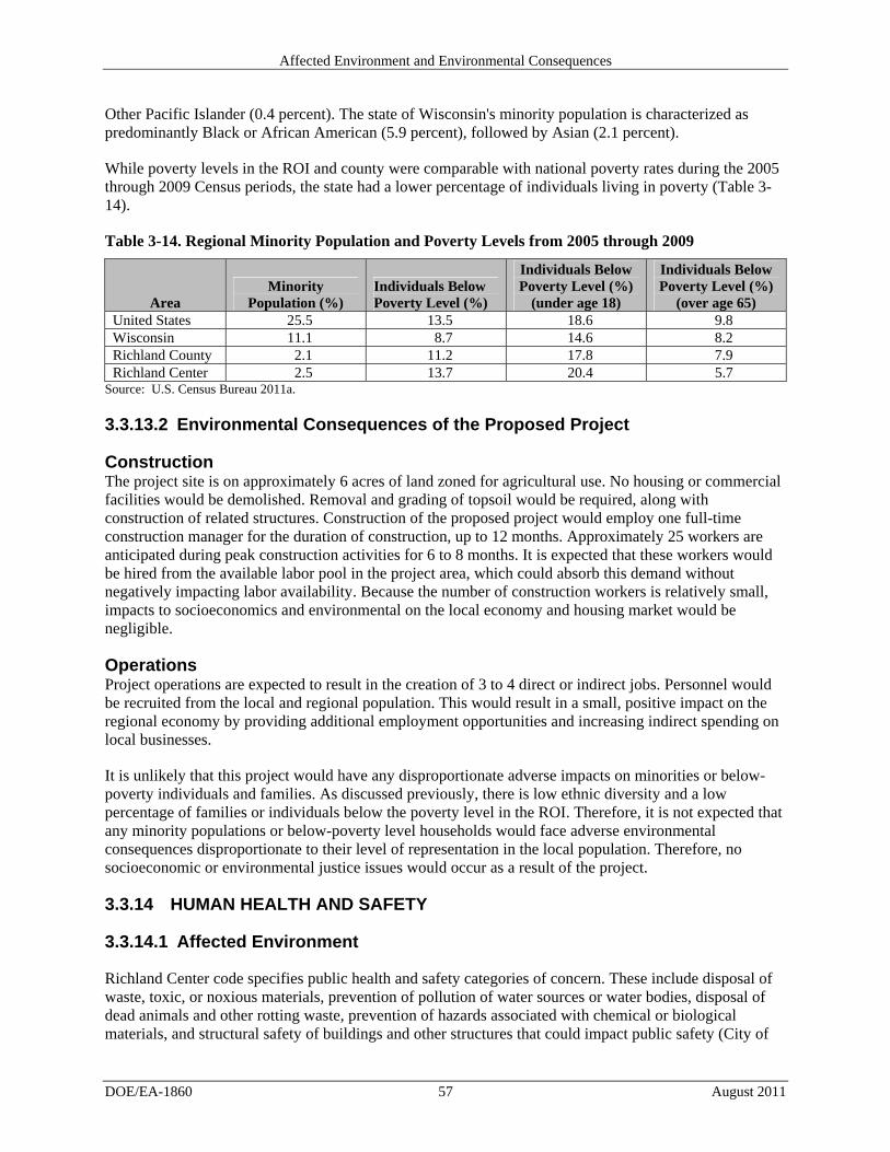
Wisconsin .......................................................................................................................................... 40 3-10 Maximum Quantity of Chemicals stored Onsite ............................................................................... 49 3-11 Current Number of Round Trips by Truck for Pickup and Removal of Wastewater ........................ 52 3-12 Population and Trends ....................................................................................................................... 56 3-13 Regional Employment and Income Statistics 2005 through 2009 .................................................... 56 3-14 Regional Minority Population and Poverty Levels from 2005 through 2009 ................................... 57
LIST OF FIGURES
Figure Page
1-1 Project Location Map .......................................................................................................................... 2 2-1 Wastewater Treatment Facility Process Schematic............................................................................. 9 2-2 RCRE Wastewater Treatment Facility location and Alternative Pipeline Routes ............................ 10 2-3 Proposed Site Layout of Wastewater Facility ................................................................................... 15 3-1 Wetlands in Relation to the RCRE Wastewater Treatment Facility and Pipeline Routes ................ 34 3-2 Wastewater Treatment Facility Site Plan and Floodplain Location .................................................. 35 3-3 Project Location and Identification of NRHP Sites in the Vicinity of the Proposed Project ............ 44 3-4 Aerial Overview of Wastewater Treatment Facility Location .......................................................... 45 3-5 2009 Average Annual Daily Traffic Counts in the Project ............................................................... 53 3-6 Potential Truck Routes for Feedstock Delivery and Sludge Removal .............................................. 55
APPENDICES
Appendix A: Public Scoping Material Appendix B: Agency Correspondence Appendix C: Wetlands Report
Introduction
DOE/EA-1860 1 August 2011
1. INTRODUCTION
1.1 National Environmental Policy Act and Related Procedures
The National Environmental Policy Act (42 U.S.C. 4321 et seq.; NEPA), the Council on Environmental Quality’s (CEQ’s) NEPA regulations [40 Code of Federal Regulations (CFR) Parts 1500 to 1508], and the DOE NEPA implementing regulations (10 CFR Part 1021) require that DOE consider the potential environmental impacts of a Proposed Action before making a decision to implement it. This requirement applies to decisions about whether to provide different types of Federal financial assistance to States and private entities.
In compliance with these regulations, this Environmental Assessment:
Examines the potential environmental impacts of the Proposed Action and the No-Action Alternative;
Identifies unavoidable adverse environmental impacts of the Proposed Action;
Evaluates the potential individual and cumulative, direct and indirect impacts of the Proposed Action;
Describes the relationship between local short-term uses of the human environment and the maintenance and enhancement of long-term productivity; and
Characterizes any irreversible and irretrievable commitments of resources that would be involved should DOE decide to implement its Proposed Action.
DOE must meet these requirements before it can make a final decision to proceed with any proposed Federal action that could cause significant impacts to human health or the environment. This EA provides DOE and other decision-makers the information needed to make an informed decision about the construction and operation of the proposed project. The EA evaluates the potential individual and cumulative impacts of the proposed project. For purposes of comparison, this EA also evaluates the impacts that could occur, if DOE did not provide funding (the No-Action Alternative), under which DOE assumes the project would not proceed. The EA does not analyze other action alternatives.
A portion of the proposed wastewater treatment facility is within a 100-year floodplain; therefore, this EA includes a floodplain assessment. However, the proposed project would not affect wetlands. This EA describes how DOE considered and evaluated these features of the natural environment in accordance with requirements of Executive Orders 11988, Floodplain Management, and 11990, Protection of Wetlands, and DOE’s implementing procedures in 10 CFR Part 1022, Compliance with Floodplain and Wetland Environmental Review Requirements.
1.2 Background
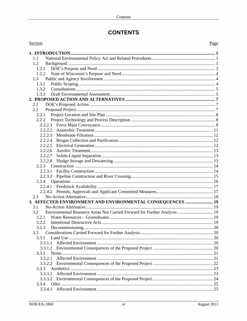
The Richland Center Renewable Energy Project (RCRE), a collaborated effort by Foremost Farms USA and Schreiber Foods, is proposing to purchase an anaerobic digester for a new wastewater treatment facility it is constructing just outside the city limits of Richland Center in Richland County, Wisconsin. The proposed project would be located on approximately 6 acres of current agricultural land purchased by RCRE and would include an approximately 1,190-foot long access road and approximately 7,450 feet of force main pipeline to connect the three dairy facilities to the wastewater treatment facility (Figure 1-1).
Introduction
DOE/EA-1860 2 August 2011
Figure 1-1. Project Location Map
Introduction
DOE/EA-1860 3 August 2011
The proposed project would be a new wastewater treatment facility designed to provide treatment of industrial process wastewaters through an anaerobic digester. The digester would take existing waste streams from at least two major food processors (Foremost Farms USA and Schreiber Foods) in the city of Richland Center as well as waste from a contract waste hauler. Implementation of the proposed project would result in mitigating the environmental hazards (e.g. odor and runoff) associated with the land-application of the liquid waste streams on a year-round basis and turning organic loading into electricity. The proposed project would also reduce the amount of wastewater going to the City of Richland Center sewage treatment plant.
RCRE estimates that the total project cost will be $20 million. RCRE was selected by the Wisconsin Economic Development Corporation (WEDC) to receive $3.5 million specifically for the anaerobic digester and other associated equipment for the proposed project. This money would come from funds the State of Wisconsin received from the DOE’s State Energy Program (SEP), which was funded by the American Recovery and Reinvestment Act of 2009 (Pub. L. 111-5, 123 Stat. 115; ARRA or Recovery Act). The purpose of the DOE SEP is to promote the conservation of energy and reduce dependence on foreign oil by helping states develop comprehensive energy programs and by providing them with technical and financial assistance. States can use SEP funds for a wide variety of activities related to energy efficiency and renewable energy (42 U.S.C. 6321 et seq. and 10 CFR Part 420). In the Recovery Act, Congress appropriated $3.1 billion to DOE’s SEP, and Wisconsin received $55 million pursuant to a statutory formula for distributing these funds.
The WEDC informed DOE that it proposes to use $3.5 million of its SEP funds for a loan to RCRE. The potential use of Federal SEP funds to assist in the financing of this project constitutes a Federal action subject to review under NEPA.
In accordance with NEPA implementing regulations, this Draft EA examines the potential environmental impacts of DOE’s Proposed Action (providing funding for the proposed project) and the No-Action Alternative. When complete, this EA will provide DOE with the information needed to make an informed decision about whether authorizing the State of Wisconsin to provide some of its Federal funds for the proposed project could result in significant environmental impacts. Based on the Final EA, DOE, as the lead agency, either will issue a Finding of No Significant Impact (FONSI), which may include mitigation measures, or determine that additional study is needed in the form of a more detailed EIS.
1.2.1 DOE’S PURPOSE AND NEED
DOE’s purpose and need is to support the mission of SEP, which was established by Congress and implemented by DOE. The goal of SEP is to reduce reliance on fossil fuels and emissions at the local and regional level, by authorizing SEP funds to be used for activities that meet congressional statutory aims to improve energy efficiency, reduce dependence on imported oil, decrease energy consumption, create and retain jobs, and promote renewable energy. Providing funding as part of Wisconsin’s SEP grant to the RCRE would partially satisfy the need of this program to assist U.S. cities, counties, states, territories, and American Indian tribes to develop, promote, implement, and manage energy efficiency and conservation projects and programs designed to:
Reduce fossil fuel emissions; Reduce the total energy use of the eligible entities; and Improve energy efficiency in the transportation, building, and other appropriate sectors.
SEP received funding through the Recovery Act. Congress enacted that law in part to create jobs, restore economic growth, and strengthen America's middle class through measures that modernize the nation's infrastructure, enhance America's energy independence, expand educational opportunities, preserve and
Introduction
DOE/EA-1860 4 August 2011
improve affordable health care, provide tax relief, and protect those in greatest need. Provision of funds for the proposed project under SEP would partially satisfy the needs identified under the Recovery Act.
The Proposed Action would support EERE’s mission of encouraging renewable energy resources and reducing dependency on fossil fuels through the recovered energy released from the anaerobic wastewater treatment process for the conversion of methane gas to electricity (DOE 2011).
1.2.2 STATE OF WISCONSIN’S PURPOSE AND NEED
Wisconsin is strategically deploying $55 million in SEP funds to support clean energy business development. The immediate goal of the SEP is the creation of jobs; however, the SEP long-term goals are to invest in projects that will ensure not only short-term job creation, but development of businesses that will create clean energy jobs for decades. The Proposed Project falls under the Wisconsin SEP market category “Job Creation and Retention through Clean Energy Technology.” Under this category, Wisconsin will invest in businesses that will create or retain full-time jobs in businesses that manufacture clean energy products (for example wind, solar, biofuels, and advanced electrical storage systems) or otherwise help reduce the consumption of fossil fuels (WEDC 2011). In addition, Wisconsin will improve the competitiveness of its businesses through energy efficiency and renewable energy deployment. Wisconsin will use SEP Recovery Act dollars to identify the best opportunities for energy savings in large commercial and industrial facilities and fund those projects that will produce the most strategic energy savings and job creation/retention prospects.
In addition, SEP-funded projects must further Wisconsin’s renewable energy goals or achieve energy savings along with the reduction of greenhouse gases (GHGs). For this project, DOE is the Federal action agency, the Wisconsin State Energy Office is the recipient of the Federal funding with WEDC administering the program, and the RCRE is the sub-recipient of this funding. The facility would be under the direct ownership of Foremost Farms USA and Schreiber Foods, Inc.
1.3 Public and Agency Involvement
1.3.1 PUBLIC SCOPING
NEPA provisions require public participation in the environmental review process. In accordance with the applicable regulations and policies, DOE sent notice of scoping letters to potentially interested local, State, and Federal agencies, including the U.S. Fish and Wildlife Service (USFWS), the Wisconsin Department of Natural Resources (WDNR), U.S. Department of Agriculture-Natural Resources Conservation Service (NRCS), the Wisconsin State Historical Preservation Office (SHPO), the U.S. Army Corps of Engineers (USACE), 11 American Indian tribes, Schreiber Foods Inc., Foremost Farms USA, the City of Richland Center, and the Township of Richland. DOE also sent scoping letters to other potentially interested individuals and organizations to solicit public comment. The scoping letter described the proposed project and solicited comments for potential issues to be analyzed in the Draft EA. DOE published the scoping letter on the DOE Golden Field Office Reading Room Website, http://www.go.doe.gov/reading_room.aspx.
DOE received three responses during the 15-day scoping period (ending July 16, 2011). Appendix A contains copies of all scoping materials issued and received. DOE considered the scoping comments and concerns when evaluating the potential impacts of the proposed project and in developing this draft EA.
Introduction
DOE/EA-1860 5 August 2011
1.3.2 CONSULTATIONS
On June 29, 2011, DOE requested information from the Green Bay Ecological Services Field Office of the USFWS (Appendix B) on the identification of listed or proposed species or designated or proposed critical habitat that might be present in the proposed project area. The DOE letter included a description of the proposed project and figures depicting the proposed project site. The USFWS responded in a letter dated August 1, 2011 (Appendix B) that “no federally-listed, proposed, or candidate species would be expected within the project area. No critical habitat is present. This precludes the need for further action on this project as required by the 1973 Endangered Species Act, as amended.” USFWS also noted that although the project is not expected to impact wetlands, if the project scope was to change and impact wetlands, that a wetland mitigation plan would be developed.
In a letter dated June 30, 2011 (Appendix B), DOE initiated consultation with the Wisconsin SHPO under Section 106 of the National Historic Preservation Act, as amended (16 U.S.C. 470 et seq.; NHPA). The letter and attachment described the proposed project and stated DOE’s belief that there would be no adverse effects to historic or archaeological resources in the project area. An Operations Program Associate of the Wisconsin Historical Society responded to DOE in a letter dated July 19, 2011 (Appendix B). The SHPO did not concur with the finding of “no effect on archeological resources” and recommended an archaeological survey for the digester site and selected force main pipeline route.
Through the U.S. Department of the Interior’s Native American Consultation Database, 11 tribes, located in Wisconsin, South Dakota, Minnesota, Michigan, and Nebraska, were identified by DOE that might have an historic link with the land that is now Richland County, Wisconsin. Tribes identified with a possible link to the general area and therefore with a possible interest in the proposed project are as follows:
Flandreau Santee Sioux Executive Committee Lower Sioux Indian Community of Minnesota Forest County Potawatomi Community of Wisconsin Hannahville Indian Community Ho-Chunk Nation Prairie Island Indian Community Santee Sioux Nation Sisseton-Wahpeton Oyate of the Lake Traverse Reservation Spirit Lake Tribal Council Upper Sioux Community of Minnesota Winnebago Tribal Council
On June 30, 2011, DOE sent letters to each of the above tribes requesting comments and input to the proposed project. As of the date of this Draft EA’s release, DOE had not received any response from any of the tribes.
DOE also submitted on June 29, 2011, letters to both WDNR and NRCS requesting comments on the proposed project. As of the date of this Draft EA’s release, DOE had not received any response from either agency.
1.3.3 DRAFT ENVIRONMENTAL ASSESSMENT
A Notice of Availability (NOA) for this Draft EA and public comment procedures for the EA were prepared and sent to Federal, State, tribal, and local agencies, as well as members of the public. The Draft
Introduction
DOE/EA-1860 6 August 2011
EA and NOA were posted on the DOE Golden Field Office Reading Room Website (http://www.eere.energy.gov/golden/Reading_Room.aspx) and DOE’s NEPA Website (http://www.energy.gov/nepa) on August 19, 2011, and is open for public comment for 15 days. Additionally, the NOA was published in the Richland News on August 18, 2011. The NOA describes how the public may comment on the proposed project’s potential effects on social, environmental, and economic factors pursuant to the NEPA process.
The public is invited to comment via email or written correspondence mailed to the postal or email address provided in the Cover Sheet. DOE will consider all submitted comments when preparing the Final EA. After completion of the Final EA, DOE would determine whether to issue a Finding of No Significant Impact or to prepare an Environmental Impact Statement.
Proposed Action and Alternatives
DOE/EA-1860 7 August 2011
2. PROPOSED ACTION AND ALTERNATIVES
2.1 DOE’s Proposed Action
DOE’s Proposed Action is to authorize the State of Wisconsin to use $3.5 million of its SEP funds for a loan to assist RCRE in purchasing equipment for wastewater treatment facility. DOE’s funding, through the SEP, would be from the Recovery Act.
2.2 Proposed Project
RCRE’s proposed project involves the construction of a new wastewater treatment facility designed to provide treatment of industrial process wastewaters. The facility would capture process wastewater transmitted via pipeline from three industrial dairy processing facilities located in Richland Center, Wisconsin, and treat the wastewater with anaerobic and aerobic processes, directly discharging treated effluent to surface water under the terms and conditions of a Wisconsin Pollution Discharge Elimination System (WPDES) permit issued to the facility. The proposed pipeline is a connected action and is therefore included in the analysis of potential environmental impacts from the proposed wastewater treatment facility. The proposed facility may accept other industrial wastewaters on a contract basis if the wastewaters are compatible with the treatment process and allowable effluent discharge. A major focus of the proposed facility is to recover energy released from the anaerobic wastewater treatment process through conversion of methane gas to electricity.
Currently, local dairy facilities segregate high-strength raw wastewater and land-apply them on a year-round basis. Remaining wastewater is discharged to the City of Richland Center publicly owned treatment works (POTW). The discharge from the dairy facilities causes operating issues for the POTW, resulting in occasional permit violations and complaints due to odor issues. The construction of the proposed facility would relieve the POTW loading issues and allow the dairy industry flexibility in process operations without regard to downstream impacts to the POTW due to process wastewater character changes.
The operational objectives of the proposed project are based on an industrial wastewater treatment facility that would:
Create a source of renewable energy through capture of methane produced in anaerobic processes and fueling an internal combustion engine-driven electrical generator to create energy sold to the local utility company;
Reduce the demand on the local POTW, through reduction of organic loading discharged to the POTW; and
Provide relief to local farmlands through management of solid waste and eliminating land-spreading activities during periods of snow-covered or frozen ground, reducing potential runoff and discharge of nutrients into local waterways.
The long-term goal for the proposed project is to completely treat all process wastewater the three local industrial dairy facilities generate and to discharge the treated effluent into the Pine River. RCRE would manage the anaerobic and aerobic sludge waste generated by the treatment processes via land-application as a soil conditioner and source of nutrients, primarily nitrogen and phosphorus. Sludge would be managed in a liquid or dried form, based on seasonal variations and the needs of local farmers. Richland County contains a large amount of agricultural fields and, therefore, there is an adequate market for the liquid and dried form sludge permitted through WDNR.
Proposed Action and Alternatives
DOE/EA-1860 8 August 2011
2.2.1 PROJECT LOCATION AND SITE PLAN
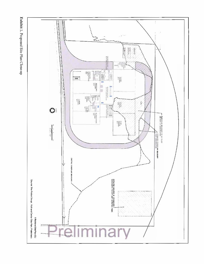
The proposed wastewater treatment facility and access driveway would be constructed on approximately 6 acres of land currently zoned agricultural. The property is located west of County Highway OO, in the Northeast quarter of the Southeast quarter of Section 28, Township 10N, Range 01E, Richland County, Wisconsin, just outside of the city limits of Richland Center, WI (Figure 1-1).
2.2.2 PROJECT TECHNOLOGY AND PROCESS DESCRIPTION
The proposed project consists of several different unit operations to treat industrial process wastewater for direct discharge to the Pine River. The individual processes include:
Force Main conveyance Anaerobic treatment Membrane filtration Biogas collection and purification Electrical generation Aerobic treatment Solids-liquid separation Sludge storage and dewatering
Figure 2-1 shows the process flow diagrams illustrating the different treatment processes.
Force Main Conveyance 2.2.2.1
Each dairy facility would perform in-house diversion and segregation of high-strength wastewater from normal-strength process wastewaters. High-strength wastewater from the dairy facilities differs from domestic wastewater (sewage). Normal milk processing plant wastewaters may be expected to have wastewater with chemical oxygen demand (COD1) concentrations over 15 times more concentrated than domestic sewage. High strength wastewaters consist of impurities separated from the raw milk, the first rinses of the dairies tanks, equipment and piping, and the byproduct residuals from operations such as whey protein separation and lactose production. These high strength wastewaters are generally not suitable for treatment as normal wastewaters. Two separate force main pipelines would be constructed of field welded high-density polyethylene piping, suitable for the anticipated conditions of use (pressure/temperature). The force main pipelines would be sized to accommodate the anticipated combined dairy facility flows, while maintaining adequate flow velocity to scour and keep solids in suspension. High-strength wastewater would be conveyed into an 8-inch-diameter force main pipeline dedicated to transfer the high-strength wastewater to the proposed facility. Similarly, each individual dairy would transfer normal-strength wastewater through a separate 12-inch-diameter dedicated force main pipeline to the proposed facility. Respective dairy facilities would be responsible for installing lift stations, pump stations, monitoring systems, and valving to discharge wastewater into the dedicated force main pipelines.
1. Chemical oxygen demand is a measure of the organic strength of the wastewaters. In this case with the dairy industries, the food processing waste streams are biodegradable in nature and the COD test provides an accurate measure of the food value contained therein.
Proposed A
ction and Alternatives
DO
E/E
A-1860
9 A
ugust 2011
Figure 2-1. Wastewater Treatment Facility Process Schematic
Proposed Action and Alternatives
DOE/EA-1860 10 August 2011
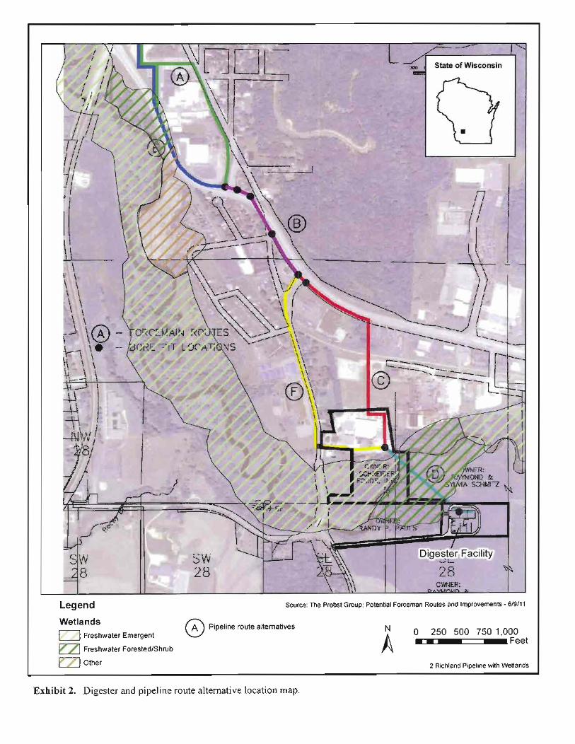
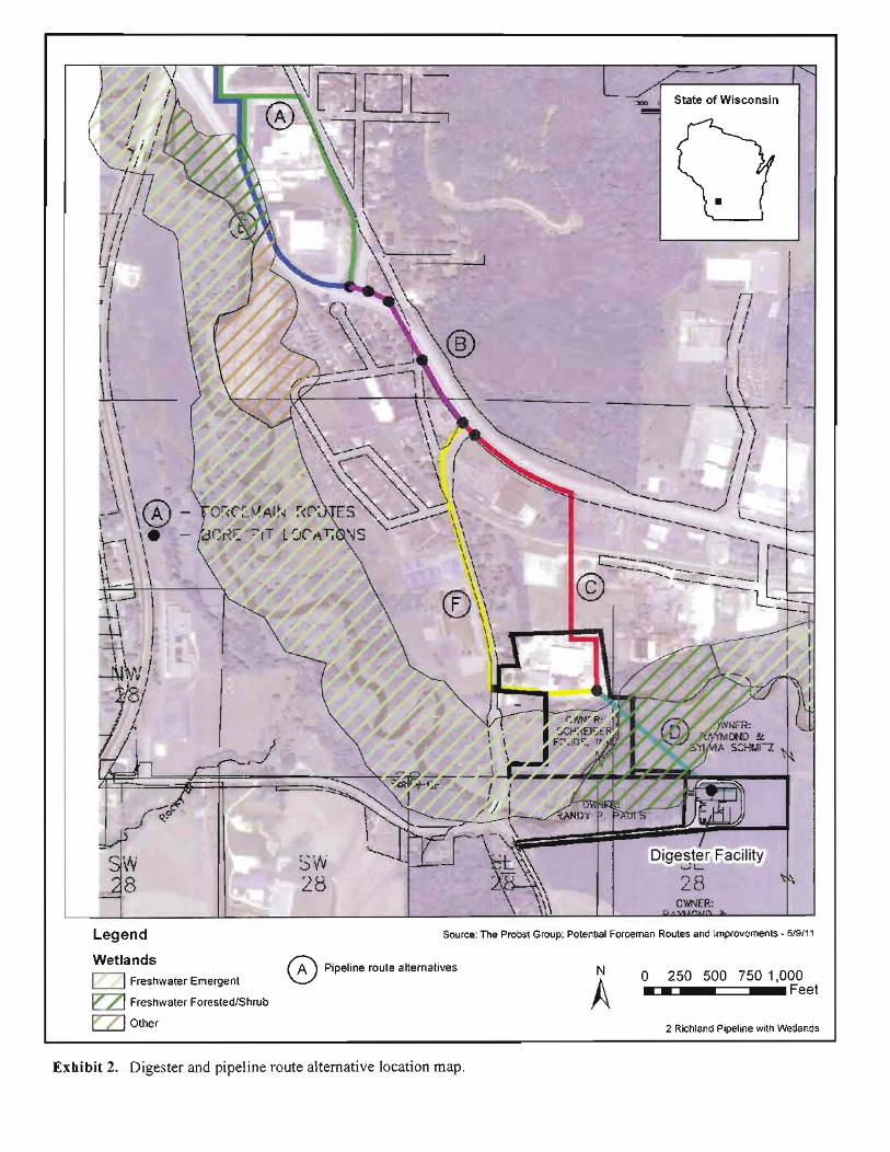
Figure 2-2. RCRE Wastewater Treatment Facility location and Alternative Pipeline Routes
Proposed Action and Alternatives
DOE/EA-1860 11 August 2011
RCRE is considering four alternative routes for the force main pipelines (consisting of sections A, E, F, C) (Figure 2-2). Sections B and D of the force main pipelines are common among all alternative routes being considered. Route A begins at the northernmost end of the pipeline, at the Foremost Farms and Schreiber Foods West (also known as the former Dean Food plant) facilities and follows along the west edge of the Sextonville Road to U.S. Highway 14 (Hwy 14) (approximate total length is 2,500 feet). Route E also starts at the northern facilities and travels south but on the east side of Hwy 14 for 2,400 feet, merging into section B. Section B is 1,350 feet long and would be mostly bored beneath Hwy 14 to minimize any impacts to the highway. From route B are alternative routes C and F. Route C continues southeast along Hwy 14 from route B until turning south to the Schreiber Foods East facility for a total length of 2,500 feet. Alternative route F from Section B to Schreiber Foods East travels south along Bohmann Road and then turns east toward Schreiber Foods, for a total of 2,730 feet. The final segment of the force main pipelines, Section D at 1,100 feet, connects Schreiber Foods with the proposed facility. The force main pipeline in this section would be directionally bored beneath the Pine River and the remainder of the distance to the facility would use open trench/vibratory plow. RCRE’s preferred route for the force main pipelines consists of sections A-B-C-D; approximately 7,450 feet.
Anaerobic Treatment 2.2.2.2
The proposed facility would receive high-strength wastewater from the high-strength force main pipeline that would discharge directly into an equalization/balance tank system. The wastewater would then be forward fed to the digester at a uniform rate. The anaerobic digester consists of two separate cast-in-place concrete tanks, each measuring 90 square feet, with an operating depth of 22.5 feet, representing 182,250 cubic feet each. Each digester would be equipped with membrane roofs to capture and contain biogas generated by the anaerobic process. High-strength wastewater would be uniformly fed from the flow equalization tanks into each digester for treatment. In addition, each digester would be equipped with a dedicated mix system to keep the contents in a uniformly mixed state to increase system operating efficiency.
The basis of design for the digester is for the proposed facility to have capacity to ultimately treat up to 120,498 pounds COD per day. The three existing dairy facilities expect to contribute a total of up to 73,750 pounds COD per day to the proposed facility. The wastewater flow, combined with the COD concentration of the waste stream, is the primary criteria used in the sizing of the digester and the biogas generator systems. If this entire hypothetical load was directed to the anaerobic digester, the resultant loading rate would be 402 COD pounds per 1,000 cubic feet per day, if only one digester was available. In the normal two digester operating mode, only 201 COD pounds per 1,000 cubic feet per day will be directed to each anaerobic digesters. Anaerobic digesters can successfully operate at ranges approaching 766 pounds per 1,000 cubic feet per day at operating efficiencies of greater than 97 percent (Callander and Barford 1983). The proposed anaerobic digester organic loading rate is well within historically established levels for dairy processing wastes.
The three dairy facilities are expected to discharge a total of 1.27 million gallons per day of wastewater to the proposed facility. The ultimate flow capacity of the proposed facility would be 1.75 million gallons per day. The anaerobic treatment process would receive the segregated and diverted high-strength wastewater conveyed to the site in the 8-inch force main pipeline. All the three dairy facilities are expected to discharge up to 462,000 gallons per day to the anaerobic process. The ultimate design capacity for the anaerobic system is 636,000 gallons per day. The majority of the normal-strength wastewater, composed of low-strength wastewaters, would convey to the proposed facility in the 12-inch force main pipeline and discharge directly to the aerobic treatment process. When combined with the pretreated effluent from the anaerobic digestion of the high-strength portion of the waste, discharge to the aerobic system is expected to be 636,000 gallons per day.
Proposed Action and Alternatives
DOE/EA-1860 12 August 2011
Membrane Filtration 2.2.2.3
Ultrafiltration membranes would be employed to separate anaerobically digested solids from solution, returning solids to the digester for continued treatment while allowing a continuous uniform forward flow of anaerobic effluent to the aerobic treatment units. The ultrafiltration membrane units would be assembled in a modular format, allowing sections of the ultrafiltration system to be taken offline or out of service for cleaning and maintenance. To insure that clogging is minimized, the materials fed to the membranes are passed through a prescreening process and the velocity of flow across the membranes is maintained at a level which continuously scours the membrane surfaces.
The ultrafiltration membrane system is composed of a series of treatment loops, capable of providing treatment of more than 474,000 gallons per day with one unit out of service. These membranes filter 100% of the particulate matter in the wastewater stream. The initially installed capacity with all units running would be more than 593,550 gallons per day. The facility would be designed to accommodate additional modules in the future. Each membrane module system would be composed of pumps, screens, automatic valving and prefabricated piping. The modules would share a clean-in-place system to provide automatic cleaning of individual treatment loops as necessary. Operation of the membrane system would provide a reliable means of continuous treatment and solids separation, while providing a continuous, stable forward feed to the aerobic treatment processes.
Biogas Collection and Purification 2.2.2.4
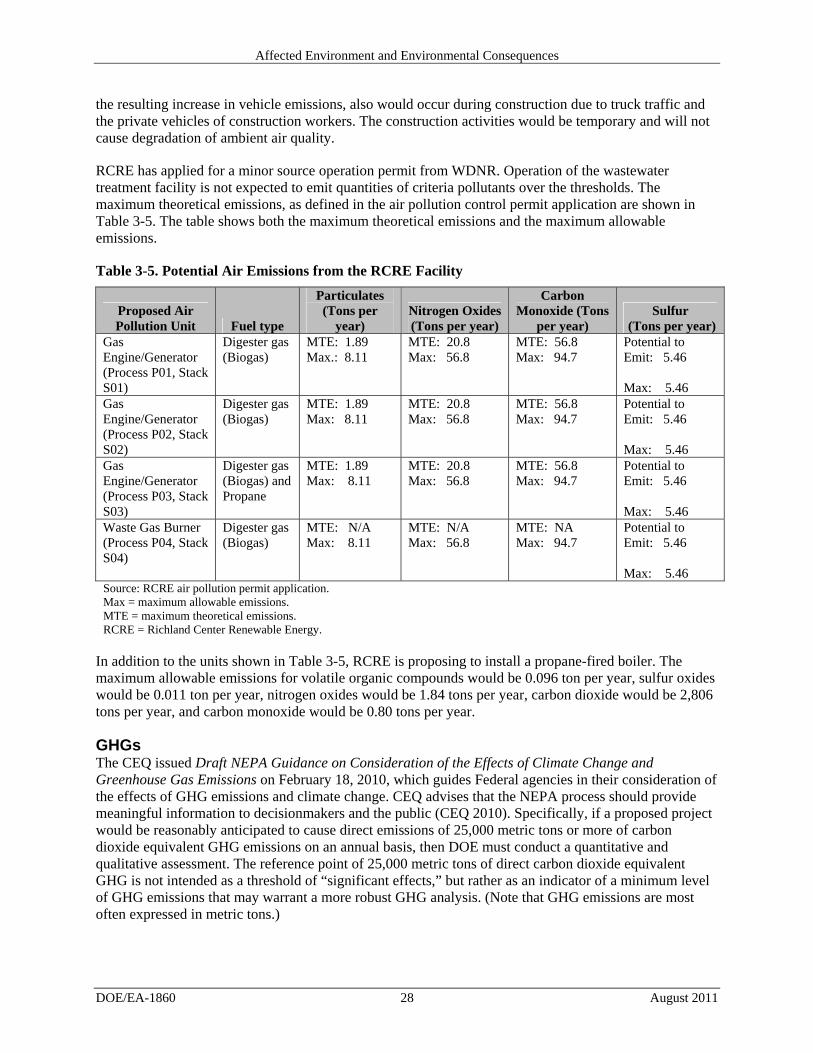
The anaerobic digestion process would generate biogas, which would be captured and purified for use in an internal combustion engine-powered electrical generator set. Biogas is composed of a mixture of methane (65 percent), carbon dioxide (35 percent) and trace gases. Biogas is generated at a rate of 8.65 cubic feet per pound COD reduced2 (Fehrs 2000). At the anticipated ultimate organic loading of 120,498 pounds COD daily, biogas generation is expected to average 687 cubic feet per minute, at 95 percent efficiency, of the incoming COD is reduced in the anaerobic digester.
The biogas collection and purification unit would be composed of sediment, sulfur, and moisture removal processes, with purified biogas forward fed to electrical generation systems, onsite boilers, or to the system flare. The gas purification system would include pressure and vacuum relief valves and a flare to burn off excess biogas. All system components would be sized to address maximum throughput and would be provided with significant turn-down capacity to effectively treat biogas generated at lower flow rates.
Electrical Generation 2.2.2.5
Biogas generated by the anaerobic treatment process would be used to fuel an internal combustion engine-driven electrical generation unit. All electricity generated at the proposed facility would be sold to the power grid under Power Purchase Agreements being sought with local utility companies. It is anticipated that the proposed project would generate approximately 400 million British thermal units (MMBtu) per day, approximately 11.7 million kilowatt-hours per year and consume by way of purchasing the electricity from a local utility 5 million kilowatt-hours per year. Dependant on the power company
2. COD is one method to measure the organic content of the wastewater. Another method to quantify the organic content of the wastewater is to measure the BOD. In essence, the organic matter contained in the wastewater is treated (or reduced) to minimize the environmental impact when it is discharged into a stream or river. There is a relationship between the amount of COD, in pounds, that is treated in an anaerobic treatment system and the amount of bio-gas that is generated as a by-product of that reduction.
Proposed Action and Alternatives
DOE/EA-1860 13 August 2011
that RCRE ultimately enters into a Power Purchase Agreement with, extra transmission lines may be required for the electricity they will sell back to the grid. The electrical generator RCRE selected for the site is a 1.4-megawatt gross capacity unit, equipped with heat recovery units to capture excess heat from the engine cooling and exhaust systems. The heat recovered from the engine cooling and exhaust units would be in excess of 5.1 MMBtu per hour and would be used to provide heat to the incoming wastewater and to maintain the temperature of the digester. The electrical generator would come in a self-contained unit for noise suppression, and would include exhaust and ventilation equipment, gas and smoke detectors, exhaust silencer, lubrication equipment, starting system, and flexible connections.
Aerobic Treatment 2.2.2.6
The aerobic treatment system would receive low-strength wastes segregated at the dairy facilities and pumped via the 12-inch force main pipeline directly into the aerobic system, as well as effluent from the anaerobic treated wastewater. The aerobic treatment process would be composed of two 1,005,000-gallon cast-in-place concrete tanks, with an operating water depth of 22.5 feet.
The anticipated ultimate organic loading is expected to be 25,527 pounds COD per day, based on a 95 percent COD reduction in the anaerobic digester. The aerobic system would have jet aeration and mixing systems sized to provide the oxygen demand to adequately address residual COD and any residual ammonia nitrogen loading present after nutrient uptake is accounted for. The aeration blower system would be composed of a series of at least three blowers sized to provide more than the required oxygen to meet anticipated process oxygen demand of 26,000 pounds per day. The blowers would be controlled and programmed so that blower air input would be adjusted to meet the demonstrated oxygen demand.
Solids-Liquid Separation 2.2.2.7
Mixed liquor suspended solids from the aerobic treatment system would flow to a dual purpose dissolved air flotation (DAF)/gravity clarifier unit and a conventional gravity clarifier for solids-liquid separation. Normal operation would be in gravity clarifier mode, where settled solids would be routed to the aerobic treatment system as return activated sludge (RAS). The conventional clarifier would be sized to handle the anticipated conditions of flow and loading.
In alternate operation, the DAF unit would separate solids from the mixed liquor suspended solids material, discharging float material to the aerobic treatment unit as RAS or thickened sludge to the anaerobic digester(s) as waste activated sludge (WAS). The clarifier and DAF/clarifier would be equipped with underflow pumps, bottom and top scraper mechanisms, and a means to discharge scum/float to the anaerobic digester(s) or sludge storage tanks. The DAF/clarifier would be supplied with an air solution tube and multi-armed surface scraper mechanism. DAF mode operation would be an alternate mode that may be used for the entire flow through the aerobic process during aerobic system upset, poor settling conditions, or to thicken WAS.
Sludge Storage and Dewatering 2.2.2.8
WAS, DAF system float, and waste anaerobic sludge would be stored in sludge storage vessels until further dewatering treatment or land-application processes could be completed. RCRE would contract with hauling companies that pick up the high-strength waste/sludge from the site, who then haul and land-apply the sludge on local agricultural fields that are permitted by the WDNR. The sludge storage vessels would be upright, silo storage tanks manufactured out of materials tolerant of anticipated conditions of storage. The sludge storage tanks would be equipped with mixing apparatus to keep the material
Proposed Action and Alternatives
DOE/EA-1860 14 August 2011
uniformly mixed and to prevent settling. In addition, the sludge tanks are equipped with an odor collection and control device to prevent odors from emanating from the sludge storage tanks or high strength waste tanks.
Depending on seasonal requirements and end user preferences, the waste sludge material could be provided in liquid or solid forms. Restrictions occur during the winter months, which ultimately decrease the acreage available and the number of days that the current dairy facilities can land-apply the waste; however, the new wastewater treatment facility would decrease the amount of high-strength sludge that needed to be land-applied. In the liquid state, sludge would be pumped into tanker vehicles for direct application to agricultural fields as a soil conditioner and source of nutrients. In solid form, the sludge would be loaded into manure spreaders or vehicles equipped with automatic offload devices. The proposed facility would be equipped with a sludge storage facility to accommodate up to 180 days of storage.
The sludge dewatering unit would be able to process 50 gallons per minute of sludge at 4 to 5 percent solids content and deliver a dry cake product at approximately 20 percent solids content. The sludge press is a rotary fan-type press, sized to operate approximately 8-hours per day, providing ample opportunity of future growth. The sludge press would be used when direct land-spreading is not appropriate. The bio-solids are mixed with materials that allow for separation of the solids from the liquid. The solids are placed into the storage area, while the liquid removed by the press is returned for treatment in the wastewater treatment system.
2.2.3 CONSTRUCTION
Facility Construction 2.2.3.1
Following issuance of appropriate environmental and building permits, RCRE anticipates construction of the proposed facility would take approximately 9 to 12 months. As part of site preparation activities, RCRE would develop appropriate erosion control measures, construction storm water permits, and a storm water pollution prevention plan. The entire wastewater treatment facility complex, including vehicle access, truck load-out facilities, and electrical generation is expected to operate within a 5- to 6-acre parcel, with a paved access road to County Highway OO, located in Richland County, Wisconsin.
RCRE would employ one full-time, onsite construction manager throughout the duration of construction activities. At the peak of construction activities, approximately 25 construction personnel are anticipated onsite for 6 to 8 months. RCRE would designate an area onsite for temporary construction and job trailers and storage areas during construction. One employee and contractor parking area would be designated for the duration of the construction project and a permanent, designated parking area for employees/visitors for the operation of the facility. The construction site entrance driveway would be provided with locked, fenced access. Construction equipment and construction manager and supervisor vehicles would be the only vehicles routinely allowed on the site. Inspectors and regulatory agency vehicles would be permitted access on an as-needed basis. The RCRE appointed construction manager would also be tasked with site safety and security duties.
RCRE would clear up to 6 acres (5 acres for the building site and 1 acre for the access road) of treeless, agricultural land for construction of the proposed facility. Clearing would remove topsoil and other material to a uniform grade. Topsoil would be stockpiled for reuse during final site grading. Construction would include the excavation and removal of approximately 6,500 cubic yards of soil to facilitate installation of partially buried anaerobic digester tanks. Soil would be transported and disposed of in accordance with local laws and ordinances. It is unlikely that landfill disposal of excavated soil would be necessary. RCRE would import approximately 1,200 cubic yards of fill material for use in foundation
Proposed Action and Alternatives
DOE/EA-1860 15 August 2011
preparation and as base material for concrete floors, tank bases, building foundation, and equipment slab foundations.
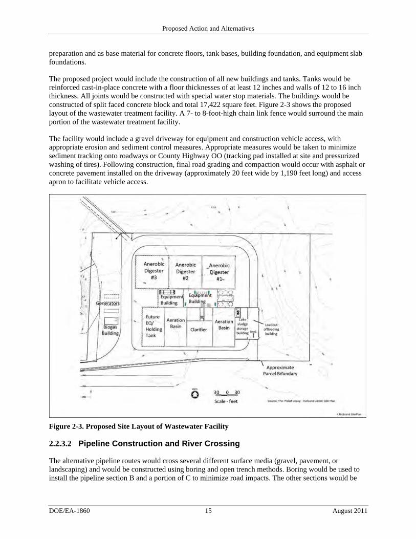
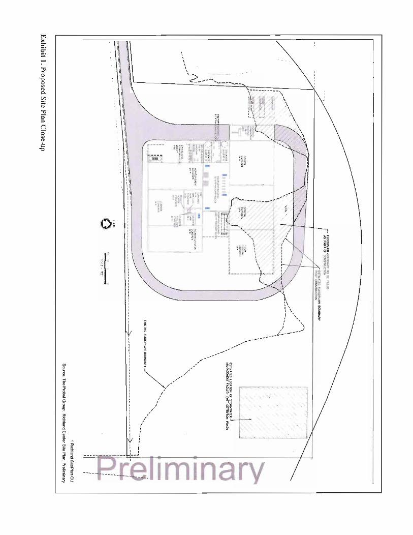
The proposed project would include the construction of all new buildings and tanks. Tanks would be reinforced cast-in-place concrete with a floor thicknesses of at least 12 inches and walls of 12 to 16 inch thickness. All joints would be constructed with special water stop materials. The buildings would be constructed of split faced concrete block and total 17,422 square feet. Figure 2-3 shows the proposed layout of the wastewater treatment facility. A 7- to 8-foot-high chain link fence would surround the main portion of the wastewater treatment facility.
The facility would include a gravel driveway for equipment and construction vehicle access, with appropriate erosion and sediment control measures. Appropriate measures would be taken to minimize sediment tracking onto roadways or County Highway OO (tracking pad installed at site and pressurized washing of tires). Following construction, final road grading and compaction would occur with asphalt or concrete pavement installed on the driveway (approximately 20 feet wide by 1,190 feet long) and access apron to facilitate vehicle access.
Figure 2-3. Proposed Site Layout of Wastewater Facility
Pipeline Construction and River Crossing 2.2.3.2
The alternative pipeline routes would cross several different surface media (gravel, pavement, or landscaping) and would be constructed using boring and open trench methods. Boring would be used to install the pipeline section B and a portion of C to minimize road impacts. The other sections would be
Proposed Action and Alternatives
DOE/EA-1860 16 August 2011
the open trench method for installation. Section D, further described below, uses both the bore and open trench method. Table 2-1 outlines the distance through various media for each alternative route.
The force main pipelines installed at the crossing of the Pine River would be bored. There would be no excavation of the channel bottom or bank during the boring process. Two pits would be excavated on either side of the river; the excavation for the pits would start approximately 35 feet away from the river. On the north side of the Pine River, the boring pit would be located in the existing gravel parking lot of Schreiber Foods. On the south side of the river, the boring pit would be located in the private farm field between the Pine River and the proposed project site. It is anticipated that 400 linear feet of boring would occur from the Schreiber property to the proposed site. Excavated materials would be moved to upland areas. Silt fencing would be installed around the excavation area to prevent disturbed earth from blowing into the Pine River. Boring pits are likely to disturb 1,200 square feet of earth at each location. Traditional open cut methods would be used to install the force main pipe from the south boring pit to the proposed project site. Typical pipe depth in the open cut sections would be 6 to 6.5 feet.
Table 2-1. Alternative Pipeline Routes Showing Potential Disturbance Through Various Surface Media (in linear feet)
Route Gravel Pavement Landscaping Direction boring
Effluent from the factory and storm water would be transmitted to the Pine River in one pipe. The pipe would be installed using traditional open cut methods from the project site to the point of discharge at the Pine River. Further field investigation and permitting process would dictate the actual location. Typical pipe depth would be approximately 6 to 6.5 feet.
2.2.4 OPERATIONS
During operations, the proposed project would require a permanent workforce of approximately 3 to 4 workers. RCRE anticipates hiring workers from existing local and regional resources. In addition,
Proposed Action and Alternatives
DOE/EA-1860 17 August 2011
resources and products, some of which could be obtained locally, are needed for the wastewater treatment. Table 2-2 summarizes the resources and products RCRE would require to completely treat approximately 1.27 million gallons of wastewater daily.
Table 2-2. Products and Resources Required for Treating 1.27 million gallons of Daily Wastewater
Output Treated wastewater effluent 1.25 million gallons/day Sludge as liquid 6,922,000 gallons/year Sludge as dry cake 7,200 tons/year Biogas 360 cubic feet/minute
Feedstock Availability 2.2.4.1
Feedstock is a bulk raw material constituting the principal input for an industrial process. The anaerobic digesters require a constant supply of feedstock, in this case, the high strength wastewater generated by Schreiber, Schreiber West, and Foremost at their dairy processing plants, for production of energy. The process wastewater will include the high strength wastewater that it is currently land spreading on local farm fields. The availability of feedstock is not expected to be limited. There are three individual dairy-based industries in the city of Richland Center who would commit to provide feedstock to the facility in the approximate total volumes referenced within this analysis.
High strength wastewater is currently segregated from the low strength wastewater at the dairies, and then removed from the facilities by truck. The force main pipeline described in Section 2.2.2.1, would directly feed the feedstock (wastewater) to the new proposed facility. The RCRE facility design provides for a capacity of 115,000 gallons of high-strength wastewaters (feedstock) per day from the three dairy facilities. This volume of high-strength wastewater per day currently requires a minimum of 20 truckloads of waste be removed from the city each day from the dairies since it cannot be treated by the current POTW. The volume of sludge associated with the treatment of the wastewater at the proposed treatment facility is estimated to be 18,964 gallons per day as liquid or 19.5 cubic yards per day as a solid cake. This equates to fewer than four truckloads per day for liquid sludge removal or, if removing solid cake, fewer than two truckloads per day from the RCRE site with the employment of the anaerobic digester. This means that there would be substantially fewer trucks routed through downtown Richland Center due to waste hauling activities.
Permits, Approvals and Applicant Committed Measures 2.2.4.2
The RCRE facility would require the issuance of a number of building and environmental permits for construction and operation of the facility (Table 2-3).
Proposed Action and Alternatives
DOE/EA-1860 18 August 2011
Table 2-3. Permits, Regulations, and Applicant-Committed Measures
Resource Area Permit/Regulation Agency Requirements/Applicant-Committed Measures Geology and soil
Building Local RCRE would use standard best management practices to reduce erosion and sediment runoff from construction.
Water and hazardous waste
Effluent Discharge (WPDES)
WDNR Land-application is a separate outfall of the WPDES permit. RCRE would ensure decreased land-spreading activities during the winter when environmental concerns are the greatest. The new facility would reduce the need to land-spread during these sensitive time periods.
Water Storm water (Construction and Operation)
WDNR/ Local
RCRE would continue to work with the State to ensure minimal impacts to floodplains from the facility site plan and storm water retention pond.
Chapter 30 of Wisconsin Statutes/Water Quality Determination
WDNR Through the State, RCRE would work to ensure that the pipeline river crossing met USACE standards and determination if a Section 404 permit was necessary.
Air quality Air Emissions (Construction and Operation)
WDNR General Conformity Rule – Section 176(c) of the Clean Air Act [42 U.S.C. 7506(c)] – requires Federal agencies to perform conformity reviews to demonstrate that their actions do not impede State Implementation Plans, plans that discuss local efforts to control air pollution. Because the proposed project would be sponsored and supported by DOE, the project must therefore be reviewed for general conformity. The potential air emissions from the project would be well below conformity threshold values established in 40 CFR 93.153(b). DOE determined that the project would be acceptable with respect to the General Conformity Rule and that a full conformity analysis would not be required (see Section 3.3.3.1 of this EA).
2.3 No-Action Alternative
Under the No-Action Alternative, DOE would not authorize the State of Wisconsin to use its SEP funds for this project. As a result, RCRE would delay construction of the wastewater treatment facility and pipeline as it looked for other funding sources. Such delay could jeopardize agreements and purchase options already secured as part of the proposed project. Further, POTW would continue experiencing operating issues and permit violations.
Although the RCRE project could proceed DOE assumes for purposes of this EA that the project would not proceed without SEP Federal funding. This assumption allows a basis of comparison between the potential impacts of the project as proposed and the impacts of not proceeding with the project. Similarly, without the proposed project there would be no environmental impacts related to construction and operation of the proposed facility. If DOE did not authorize the use of Federal funding for the proposed project, it is expected that the State of Wisconsin would identify some other project for its SEP funds that would promote energy efficiency or use renewable energy. If the proposed project did proceed without DOE’s financial assistance, and assuming the scope of the project remained the same, the potential impacts would be essentially identical to those this EA identifies.
Affected Environment and Environmental Consequences
DOE/EA-1860 19 August 2011
3. AFFECTED ENVIRONMENT AND ENVIRONMENTAL CONSEQUENCES
This section of the Draft EA describes the potential impacts of the proposed project and the No-Action Alternative on the affected resource areas.
3.1 No-Action Alternative
Under the No-Action Alternative, DOE would not authorize the use of Federal funds for a portion of the cost of the anaerobic digester equipment; therefore, the RCRE would not construct the wastewater treatment facility and there would not be any impacts to the resource areas analyzed in this Draft EA. However, without the addition of the new wastewater treatment facility, demand on the POWT facility may continue to cause compliance issues and odor nuisance. Land-application of the waste in the winter would continue to be a problem without the additional facility to reduce the amount of waste for land-application. Additionally, the jobs created and retained by construction and operation of the wastewater treatment facility would not be realized and the local area would forego the economic benefit associated with these new jobs.
3.2 Environmental Resource Areas Not Carried Forward for Further Analysis
Consistent with NEPA implementing regulations and guidance, DOE focuses the analysis in an EA on topics with the greatest potential for environmental impacts. This sliding-scale approach is consistent with NEPA [40 CFR 1502.2(b)], under which impacts, issues, and related regulatory requirements are investigated and addressed with a degree of effort commensurate with their importance. DOE concluded that the proposed project would result in no impacts or negligible impacts to the following resource areas and did not carry them forward for detailed description and analysis.
3.2.1 WATER RESOURCES – GROUNDWATER
Wisconsin's groundwater reserves are held in four principal aquifers: the sand and gravel aquifer, the eastern dolomite aquifer, the sandstone and dolomite aquifer, and the crystalline bedrock aquifer (WDNR 2006a). The City of Richland Center obtains its drinking water from the aquifer below the city; however, city water is not available at the proposed project site. The proposed facility would obtain the approximately 2,000 gallons/ day water from an on-site well for daily use of the facility. Increased water consumption during the construction of the wastewater treatment facility would occur with the added workforce, but would not have a long-term impact on groundwater resources. Non-potable water for treatment process and site needs would be provided by recycled effluent. The pipeline, even if drilled under the Pine River, would not impact the aquifers or the wells which are considerably deeper than the proposed depth of the pipeline. All sewers from the treatment process and floor drains would be treated through RCRE wastewater treatment system and all sanitary sewage will be segregated to a septic holding tank for processing to eliminate potential groundwater impacts. No other project actions present potential sources of groundwater contamination or would otherwise adversely affect groundwater.
3.2.2 INTENTIONAL DESTRUCTIVE ACTS
DOE considers intentional destructive acts (that is, acts of sabotage or terrorism) in its EAs and environmental impact statements (DOE 2006). Construction and operation of the proposed facility would not involve the transportation, storage, or use of radioactive, explosive, or toxic materials. The proposed
Affected Environment and Environmental Consequences
DOE/EA-1860 20 August 2011
project would not offer any particularly attractive targets of opportunity for terrorists or saboteurs to inflict adverse impacts on human life, health, or safety.
3.2.3 DECOMMISSIONING
At some time in the future, the wastewater treatment facility constructed under the proposed project could be decommissioned and removed. For purposes of this EA, it is assumed that this might occur after 20 years of operation, but it is recognized that the equipment could be operational for a longer period of time, or that the facility could shut down earlier for some unforeseen reason.
3.3 Considerations Carried Forward for Further Analysis
3.3.1 LAND USE
Affected Environment 3.3.1.1
The proposed wastewater treatment facility would be located within Richland County, near the southern extent of the city of Richland Center, although portions of the pipeline would run through the city proper. The proposed site is on privately owned property RCRE purchased from a private citizen, outside the city’s zoning limits. The city defines the extraterritorial joint zoning area where the proposed project would be located as agriculture (City of Richland Center 2011). Areas adjacent to the facility site to the north, west, and east are also zoned agriculture and are currently farmed lands. To the west of the property lies remnant patch of forest, buffering the Pine River zoned as open space. The Schreiber dairy facility and other industrial business are located just north of the Pine River and the proposed site. The nearest residence to the proposed facility is approximately 0.3 miles on the west side of Bohmann Road.
The alternative pipeline routes cover various land uses in the City of Richland Center. The majority of the routes from the northernmost point of the pipeline at Foremost Farms traverse industrial and community and commercial services land use (City of Richland Center 2011a). Alternative route F first traverses community and commercial services lands and then neighborhood residential land use areas south of Hwy 14. Alternative route D, which crosses the Pine River, is contained within the open space land use defined by the City (City of Richland Center 2011a) until it reaches the extraterritorial agricultural lands south of the River. Open space land use along the Pine River borders the pipeline alternative route E to the west.
Environmental Consequences of the Proposed Project 3.3.1.2
The proposed project would result in the conversion of approximately 6 acres of agriculture land to facilitate the construction of the treatment facility. Although RCRE would request a change in the zoning of the extraterritorial area from agriculture to industrial, the change would be consistent with the land use goals for the City of Richland Center. These goals include providing “adequate infrastructure and public services and an adequate supply of developable land to meet existing and future market demand for residential, commercial and industrial uses” (City of Richland Center 2007). Since the wastewater treatment facility would be located on property adjacent to industrial use and agriculture use land, the facility would be compatible with neighboring land uses (farming and the dairy facility) and there would be no conflicts with other land use planning. Schreiber Foods owns a parcel of land in the immediate area, including property along the north side of the Pine River, which is zoned industrial. The proposed industrial wastewater treatment plant will support that dairy facility’s operations. The pipeline route would be located belowground and the land use above the pipeline would remain compatible with the current usage. The operational-related activities that would occur at the facility would not substantially change the nature of the land use in the area, but would in fact support the dairy industry land use, and therefore, has minimal potential for adverse land use impact.
Affected Environment and Environmental Consequences
DOE/EA-1860 21 August 2011
3.3.2 NOISE
Affected Environment 3.3.2.1
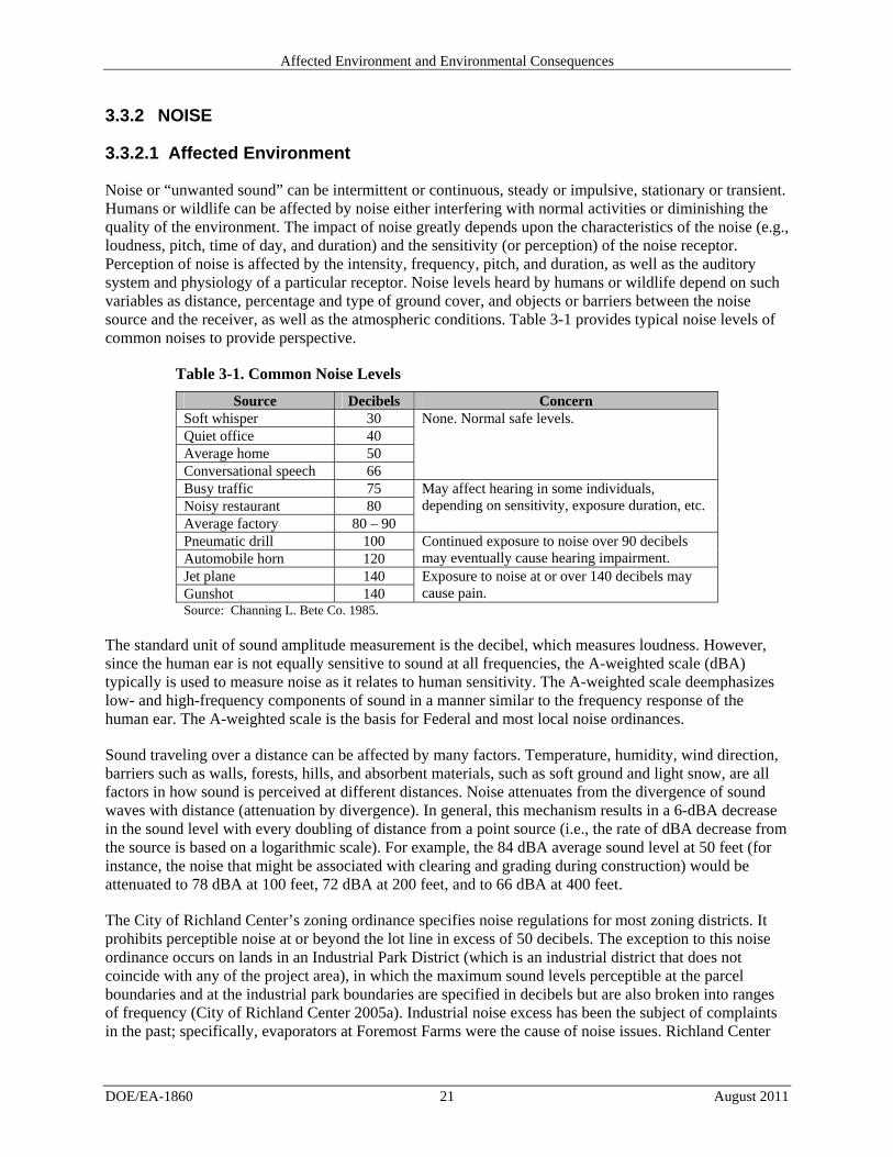
Noise or “unwanted sound” can be intermittent or continuous, steady or impulsive, stationary or transient. Humans or wildlife can be affected by noise either interfering with normal activities or diminishing the quality of the environment. The impact of noise greatly depends upon the characteristics of the noise (e.g., loudness, pitch, time of day, and duration) and the sensitivity (or perception) of the noise receptor. Perception of noise is affected by the intensity, frequency, pitch, and duration, as well as the auditory system and physiology of a particular receptor. Noise levels heard by humans or wildlife depend on such variables as distance, percentage and type of ground cover, and objects or barriers between the noise source and the receiver, as well as the atmospheric conditions. Table 3-1 provides typical noise levels of common noises to provide perspective.
Table 3-1. Common Noise Levels
Source Decibels Concern Soft whisper 30 None. Normal safe levels. Quiet office 40 Average home 50 Conversational speech 66 Busy traffic 75 May affect hearing in some individuals,
depending on sensitivity, exposure duration, etc. Noisy restaurant 80 Average factory 80 – 90 Pneumatic drill 100 Continued exposure to noise over 90 decibels
may eventually cause hearing impairment. Automobile horn 120 Jet plane 140 Exposure to noise at or over 140 decibels may
cause pain. Gunshot 140 Source: Channing L. Bete Co. 1985.
The standard unit of sound amplitude measurement is the decibel, which measures loudness. However, since the human ear is not equally sensitive to sound at all frequencies, the A-weighted scale (dBA) typically is used to measure noise as it relates to human sensitivity. The A-weighted scale deemphasizes low- and high-frequency components of sound in a manner similar to the frequency response of the human ear. The A-weighted scale is the basis for Federal and most local noise ordinances.
Sound traveling over a distance can be affected by many factors. Temperature, humidity, wind direction, barriers such as walls, forests, hills, and absorbent materials, such as soft ground and light snow, are all factors in how sound is perceived at different distances. Noise attenuates from the divergence of sound waves with distance (attenuation by divergence). In general, this mechanism results in a 6-dBA decrease in the sound level with every doubling of distance from a point source (i.e., the rate of dBA decrease from the source is based on a logarithmic scale). For example, the 84 dBA average sound level at 50 feet (for instance, the noise that might be associated with clearing and grading during construction) would be attenuated to 78 dBA at 100 feet, 72 dBA at 200 feet, and to 66 dBA at 400 feet.
The City of Richland Center’s zoning ordinance specifies noise regulations for most zoning districts. It prohibits perceptible noise at or beyond the lot line in excess of 50 decibels. The exception to this noise ordinance occurs on lands in an Industrial Park District (which is an industrial district that does not coincide with any of the project area), in which the maximum sound levels perceptible at the parcel boundaries and at the industrial park boundaries are specified in decibels but are also broken into ranges of frequency (City of Richland Center 2005a). Industrial noise excess has been the subject of complaints in the past; specifically, evaporators at Foremost Farms were the cause of noise issues. Richland Center
Affected Environment and Environmental Consequences
DOE/EA-1860 22 August 2011
also has an air brake ordinance in effect, which helps mitigate noise pollution (City of Richland Center 2007). In addition to industrial activities, other sources of noise in the project area include traffic, particularly from Hwy 14, and agricultural activities, which occur intermittently in agricultural areas, such as the proposed site of the wastewater treatment facility, as well as from passing airplanes. No noise data are available for the project area; however, it is estimated from data in Table 3-1 that surrounding noise levels are occasionally around 75 dBA from high traffic levels during the morning and early evening peak commute travel times and around 55 dBA during ambient conditions.
Environmental Consequences of the Proposed Project 3.3.2.2
Noise would be generated from construction of the pumping station and pipeline, construction of the wastewater treatment facility and access road, and operation of the digester facility. A larger area would be subject to noise during the construction phase than during the operations phase, since most of the length of the pipeline would not produce noise during operations. Certain receptors can be considered sensitive receptors for noise. This category sometimes includes schools, hospitals, retirement homes, wilderness areas, and some species or assemblages of wildlife.
Construction Construction noise would be consistent with industrial-level construction and would be localized, intermittent, and temporary. Typical noise levels are expected to occur in the range of 60 to 90 dBA. All construction noise activities would be limited to normal working hours during daytime (approximately 7:00 a.m. to 7:00 p.m.) over a period of 9 to 12 months. Construction noise would include sounds generated by construction vehicles, employee vehicles, and construction equipment, including boring equipment. Noise-generating activities would occur en route to construction locations and in four principal areas: at the pumping station, along the pipeline, the boring sites on either side of Hwy 14 and of the Pine River, and at the site of the digester facility.
Construction of the pumping station would occur within the existing industrial area, which is already subject to industrial noise, does not have sensitive receptors, and would also be considerably shorter in duration than the construction of the digester. Construction workers would represent the primary noise receptors. However, their protective equipment and activities would conform to the Occupational Safety and Health Administration’s (OSHA’s) standards, minimizing exposure to noise. Other human receptors during the pipeline construction would include employees and visitors of the dairy facilities and the businesses along Sextonville Road, Hwy 14, and Bohmann Drive, depending on which alternatives are chosen. Residents near Sextonville Road, some residents of the multi-family homes located off Koenig Court where it approaches Hwy 14, residents of the single-family homes and some of the residents of the Woodbury Village on Bohmann Drive would also potentially be subject to construction noise. The Doudna School, also located on Bohmann Drive, would potentially subject 400 elementary students and over 30 staff members to noise due to pipeline construction should the selected route occur on Bohmann Drive. Students and the staff of Doudna School could be considered sensitive receptors. However, these receptors would only be subject to noise from the pipeline construction, along Bohmann Drive (only if pipeline section Alternative F is selected), which would be short-term in duration.
Construction at the digester facility will take most of the estimated 9-12 months of construction but, other than the driveway situated across the street from approximately 3 residences on County Highway OO, the bulk of construction will occur over 1000 feet from the edge of the road. This distance will reduce the construction noise occurring at the digester facility site to normal, safe levels (less than 66 dBA) once it reaches County Highway OO and beyond, which includes all residences (and the school) in question.
Affected Environment and Environmental Consequences
DOE/EA-1860 23 August 2011
Receptors of noise could include wildlife throughout the project area. This is especially the case for construction near the Pine River, including the boring sites, but also parts of the pipeline and the digester facility would potentially subject wildlife to noise. At its closest point, the digester facility site lies approximately 50 feet from the edge of forested area that is contiguous with the Pine River, though it is approximately 600 feet from the River at its closest point. A portion of the right-of-way leading from County Highway OO to the digester site lies within 100 feet of the Pine River. The water-driven drill and the horizontal position of the drilling to bore the pipeline under the Pine River would minimize exposure of wildlife receptors to construction noise at the boring locations. Noise impacts to wildlife would be minimal and short-term.
During construction of the digester site, given the typical noise level for a dump truck of 91 dBA at 50 feet, and assuming a reduction of 6 decibels per doubling of distance, this noise level would reach normal, safe levels beyond 800 feet from the dump truck. The school is located some 2,000 feet from the proposed project site. The site is also approximately 1,000 feet from the closest existing industrial facility and would not present unsafe noise levels for employees working there. A handful of residential homes exist along County Highway OO, opposite the proposed entrance to the digester facility, and within approximately 1,300 feet of the main facility. The few residences that exist near the entrance of the right-of-way would be subject to some noise associated with vehicles turning into the site and the paving of the right-of-way near the entrance. The expected high noise level would be 85 dBA, the sound of a dump truck attenuated by 100 feet of distance. Since most of the construction would occur at the digester site, and the dump truck is the loudest typical example shown here, most of the noise level would be expected to be within normal, safe levels for residents of these homes.
Operations During operations, noise would be generated by vehicular traffic, including delivery trucks carrying wastewater and maintenance-related vehicles. The electrical generator would operate in a self-containment system designed to suppress noise. It also would include an exhaust silencer to minimize noise. Noise levels are expected to stay well below 75 decibels at the facility and would be less than noise levels during the construction phase. Even with a potential maximum level of noise at the facility of 90 decibels (factory level noise), the noise level would be reduced due to distance to approximately 37 decibels once it reached the nearest residence; a level well below Richland Center’s zoning regulations. In addition, the buffering by the buildings the generators are contained in would further reduce the noise level when it reaches potential receptors. The potential receptors for noise during operations would be the same as discussed above for construction. Trucks hauling waste would be reduced along County OO with the operation of the RCRE facility from a maximum of 20 to less than an average of 3 trucks, reducing overall noise impacts from truck traffic to neighboring residence. Overall, impacts from noise are expected to be short-term during construction and minimal during operations.
3.3.3 AESTHETICS
Affected Environment 3.3.3.1
The visual character, or aesthetics, of a particular area is subjective and depends upon the viewer. The aesthetic value placed on an area depends on a combination of the visual character, visual quality, and the opinion of the viewer. The project vicinity contains multiple types of views in Richland Center, ranging from industrial, to low-density (automobile-oriented) businesses, high-density residential, riverine and floodplain habitats, and agricultural fields. In terms of zoning, from the dairy factories to the wastewater treatment facility, the project sections pass through (or abut) the zoned districts shown in Table 3-2.
Affected Environment and Environmental Consequences
DOE/EA-1860 24 August 2011
Table 3-2. Zoning Districts Corresponding to Features of the Proposed Project
Section Zoning District(s) Alternative A General Industry, General Business, General Industry, Multi-Family Residential Alternative B Multi-Family Residential, General Business Alternative C General Business, General Industry Alternative D General Industry, Extra Territorial Zone (extends beyond zoned area) Alternative E General Industry, General Business, Multi-Family Residential Alternative F General Business, Single-Family Residential, Multi-Family (5 or more families) Residential,
General Business, Single-Family Residential Proposed Project Extra Territorial Zone (lies beyond zoned area) Source: City of Richland Center 2005b.
Richland Center specifies ordinances that relate to aesthetics, generally by zoning district. These include landscaping and maintenance thereof along the streets in all zoning districts except certain commercial and industrial zones, keeping yards clear and block corners visually clear. Lighting used to illuminate off-street parking areas must have no direct source or light visible from a street or adjacent land. Certain industrial districts are subject to requirements for visual screens (wall, fence, or planting) to block sight from residential areas. Industrial operations must also shield intense glare or heat with an enclosure (City of Richland Center 2005a). Richland Center is currently considered to have a light pollution problem and is addressing it by installing new streetlights and considering canopy trees on Main Street (City of Richland Center 2007).
Richland Center is actively working to improve aesthetics. The City is currently developing a greenbelt with a prairie and a wetland, which are intended to enhance the open space viewshed. The City has also acquired land consisting of bluffs and slopes to contain development and provide space for a new park. In addition, a sign ordinance is being used to help decrease impacts to the viewshed (City of Richland Center 2007).
Environmental Consequences of the Proposed Project 3.3.3.2
Construction During construction, there would be some aesthetic effects from the presence and activities of heavy equipment. While there would be soil disturbance, the construction crew would employ appropriate dust control measures, such as watering of exposed soils to control fugitive dust, which could otherwise temporarily degrade the visual quality of the construction sites and surroundings.
Other than the digester facility site itself, much of the area is either in an existing industrial area or along a highway, with the exception of the boring sites on either side of the Pine River. The pipeline construction should appear similar to roadside improvements in much of the area, such as along Hwy 14 and Bohmann Drive (if that alternative is selected).
Except for the access road from County Highway OO, the 6-acre agricultural site of the digester facility sits over 1000 feet from the road and from the nearest residential neighbors and passers-by. Because of this setback, only a small fraction of the viewshed would undergo a visual transformation during the construction phase from agricultural with a forested backdrop, as viewed from part of County Highway OO. Aesthetic and visual impacts from construction would be limited to 9 to 12 months, though the transformation of the digester site would be permanent.
Operations During the operations phase, the pipeline would not be visible, as it would be buried. Over the long term, the digester facility would provide a different view than the current agricultural landscape; it would
Affected Environment and Environmental Consequences
DOE/EA-1860 25 August 2011
appear more of an industrial nature. However, due to the fact that the facility is set back from County Highway OO, it would continue to be only a fraction of the vista for most people. The facility would also be surrounded by agriculture and the Pine River system for the foreseeable future. Therefore, aesthetic and visual impacts from the presence of the additional industrial features would exist but would be much smaller than if the facility were situated directly next to County Highway OO. The visual character of the area would remain mostly agricultural and forested.
3.3.4 ODOR
Affected Environment 3.3.4.1
Odor emissions are subject to the City of Richland Center’s ordinance. In all cases of odor zoning ordinance, uses on any particular lot must not emit odor in concentrations that can be detected beyond the lot line (City of Richland Center 2005a). Currently, discharge from dairy industries causes odor problems for the City of Richland Center’s POTW, which frequently receives complaints on the matter.
Environmental Consequences of the Proposed Project 3.3.4.2
Construction Construction of the project would produce short-term, low-level, intermittent, and transient emissions of nitrogen oxides, particulate matter with an aerodynamic size less than or equal to 10 microns, and carbon monoxide from the trucks and the operation of construction machinery. Due to the small and temporary increase in traffic that would be needed for construction, which would be completed within 9 to 12 months, no appreciable effects on odor would be expected.
Operations By receiving approximately 1.27 million gallons per day of wastewater, the operation of the digester facility would relieve the extreme loading problems in the POTW facility and decrease odor nuisances. Currently, the low strength wastewater from the dairy facilities is treated at the POTW, which lacks the updated technology to adequately control odor. The POTW is situated near downtown, 1.5 miles north of the proposed facility along the Pine River, with more receptors in the area where as the proposed project facility would be located outside the city limits in a less densely populated area. In addition, the new RCRE facility would result in fewer loads of stabilized, less putricible material being applied to local farm fields (high strength wastewater) which potentially also contributes to odor in the area.
The RCRE facility is designed specifically for the purpose of treating the type of wastewaters generated by the Schreiber and Foremost dairy facilities so the system will be able to adequately handle and treat the wastewater in a manner that does not generate offensive odors. RCRE would also implement the best available technology for the control of odors from the wastewater treatment system. At the RCRE facility, the purification process, which would be completely contained, includes removal of sulfur, which reduces odor. In addition, the facility would capture methane (as 65 percent of the purified biogas it would generate) and use it to fuel an internal combustion engine, releasing the by-products of the combustion, but negligible amounts of methane, which causes odor nuisances. Bacteria solid removal from the treated effluent by the ultrafiltration membranes would occur so that the liquids are not exposed to the air, thus further reducing potential odor issues. Overall, the odor condition would be greatly improved over existing conditions, resulting in beneficial impacts from the proposed project.
Affected Environment and Environmental Consequences
DOE/EA-1860 26 August 2011
3.3.5 AIR QUALITY AND METEOROLOGY
Affected Environment 3.3.5.1
The ambient air quality in an area can be characterized in terms of whether it complies with the primary and secondary National Ambient Air Quality Standards (NAAQS). The Clean Air Act (42 U.S.C. 7401 et seq.) requires the U.S. Environmental Protection Agency (EPA) to set NAAQS for pollutants considered harmful to public health and the environment. National primary ambient air quality standards define levels of air quality that the EPA has determined as necessary to provide an adequate margin of safety to protect public health, including the health of “sensitive” populations such as children and the elderly. NAAQS define levels of air quality deemed necessary to protect the public welfare, including protection against decreased visibility and damage to animals, crops, vegetation, and buildings. NAAQS have been established for six criteria pollutants: carbon monoxide, lead, nitrogen dioxide, ozone, particulate matter [which includes particulate matter with an aerodynamic size less than or equal to 10 microns (PM10) and less than or equal to 2.5 microns (PM2.5)], and sulfur dioxide. Table 3-3 lists the NAAQS primary and secondary standards for each criteria pollutant.
Table 3-3. National Ambient Air Quality Standards
Pollutant Primary
standards Secondary standards
Carbon monoxide 8-hour average 9 ppm None 1-hour average 35 ppm None
Lead Rolling 3-month average 0.15 μg/m3 Same as primary Quarterly average 1.5 μg/m3 Same as primary
Nitrogen dioxide Annual arithmetic mean 0.053 ppm Same as primary 1-hour 0.10 ppm None
Ozone 8-hour average (2008 standard) 0.075 ppm Same as primary
PM10 24-hour average 150 μg/m3 Same as primary
PM2.5 Annual arithmetic mean 15.0 μg/m3 Same as primary 24-hour average 35 μg/m3 Same as primary
Sulfur dioxide Annual arithmetic mean 0.03 ppm None 24-hour average 0.14 ppm None 3-hour average None 0.5 ppm 1-hour average 0.075 ppm None
Source: 40 CFR 50.4 through 50.13. g/m3 = micrograms per cubic meter. ppm = parts per million.
Regions that are in compliance with the NAAQS are designated as attainment areas. A nonattainment status is designated for areas where the applicable NAAQS are not being met. A maintenance status is designated for areas that have had a history of nonattainment, but are now consistently meeting the NAAQS. Richland County, Wisconsin’s, air quality meets the NAAQS and is thus classified as being in attainment for all criteria pollutants.
Affected Environment and Environmental Consequences
DOE/EA-1860 27 August 2011
Table 3-4 lists regional air pollutant emissions for Richland County. The emissions are for the year 2005, the most recent year with available data.
Table 3-4. Air Emissions Reported for Richland County, Wisconsin, for Calendar Year 2005
Radon The proposed project site is in an area of Richland County that is considered to have high potential for elevated indoor concentrations of radon gas. Radon is a radioactive gas that comes from the decay of radium and exists in varying amounts in most soils. Because radon is a gas, it can move through soil and into the atmosphere or into a building structure. The EPA’s map of radon zones assigns each county in the United States into one of three zones based on radon potential. Richland County is assigned to Zone 1, with a predicted average indoor radon screening level greater than 4 picocuries per liter (EPA 2011b). Zone 1 is considered to have the highest potential for radon.
GHGs GHGs, primarily carbon dioxide, are primarily produced by the burning of fossil fuels such as diesel and gasoline. GHGs can trap heat in the atmosphere and have been associated with global climate change. The Intergovernmental Panel on Climate Change, in its Fourth Assessment Report issued in 2007, stated that warming of the earth’s climate system is unequivocal, and that most of the observed increase in globally averaged temperatures since the mid-20th century is very likely due to the observed increase in anthropogenic (i.e., caused by human activity) GHG concentrations (IPCC 2007). The six major GHGs are carbon dioxide, methane, nitrous oxide, sulfur hexafluoride, hydrofluorocarbons, and perfluorocarbons. GHGs are well mixed throughout the lower atmosphere, such that any anthropogenic emissions would add to cumulative regional carbon dioxide emissions and to global concentrations of carbon dioxide. The effects from any individual source of GHGs therefore cannot be determined.
Climate and Meteorology The Wisconsin climate is typically continental with some modifications by lakes Michigan and Superior. The winters tend to be cold and snowy and the summers tend to be warm (UWEX 2011). The mean January temperature in Richland Center between 1971 and 2000 was 15.5 degrees Fahrenheit and the mean July temperature was 70.9 degrees Fahrenheit (MRCC 2011). The average annual precipitation is 35.6 inches. About two-thirds of the annual precipitation falls during the freeze-free period, with over four inches of precipitation during each of the months of June, July, and August. By contrast, the months of January, February, and December have less than 1.5 inches of precipitation each (MRCC 2011).
Environmental Consequences of the Proposed Project 3.3.5.2
RCRE has applied for a construction air permit for the proposed project. Construction activities for the wastewater treatment facility and pipeline would be temporary and would occur in a localized area. Emissions generated during construction would include particulate matter, vehicle and equipment emissions, and increased wind-borne dust (i.e., fugitive dust). A temporary increase in vehicle traffic, and
Affected Environment and Environmental Consequences
DOE/EA-1860 28 August 2011
the resulting increase in vehicle emissions, also would occur during construction due to truck traffic and the private vehicles of construction workers. The construction activities would be temporary and will not cause degradation of ambient air quality.
RCRE has applied for a minor source operation permit from WDNR. Operation of the wastewater treatment facility is not expected to emit quantities of criteria pollutants over the thresholds. The maximum theoretical emissions, as defined in the air pollution control permit application are shown in Table 3-5. The table shows both the maximum theoretical emissions and the maximum allowable emissions.
Table 3-5. Potential Air Emissions from the RCRE Facility
Proposed Air Pollution Unit Fuel type
Particulates (Tons per
year) Nitrogen Oxides (Tons per year)
Carbon Monoxide (Tons
per year) Sulfur
(Tons per year) Gas Engine/Generator (Process P01, Stack S01)
Digester gas (Biogas)
MTE: 1.89 Max.: 8.11
MTE: 20.8 Max: 56.8
MTE: 56.8 Max: 94.7
Potential to Emit: 5.46 Max: 5.46
Gas Engine/Generator (Process P02, Stack S02)
Digester gas (Biogas)
MTE: 1.89 Max: 8.11
MTE: 20.8 Max: 56.8
MTE: 56.8 Max: 94.7
Potential to Emit: 5.46 Max: 5.46
Gas Engine/Generator (Process P03, Stack S03)
Digester gas (Biogas) and Propane
MTE: 1.89 Max: 8.11
MTE: 20.8 Max: 56.8
MTE: 56.8 Max: 94.7
Potential to Emit: 5.46 Max: 5.46
Waste Gas Burner (Process P04, Stack S04)
Digester gas (Biogas)
MTE: N/A Max: 8.11
MTE: N/A Max: 56.8
MTE: NA Max: 94.7
Potential to Emit: 5.46 Max: 5.46
Source: RCRE air pollution permit application. Max = maximum allowable emissions. MTE = maximum theoretical emissions. RCRE = Richland Center Renewable Energy.
In addition to the units shown in Table 3-5, RCRE is proposing to install a propane-fired boiler. The maximum allowable emissions for volatile organic compounds would be 0.096 ton per year, sulfur oxides would be 0.011 ton per year, nitrogen oxides would be 1.84 tons per year, carbon dioxide would be 2,806 tons per year, and carbon monoxide would be 0.80 tons per year.
GHGs The CEQ issued Draft NEPA Guidance on Consideration of the Effects of Climate Change and Greenhouse Gas Emissions on February 18, 2010, which guides Federal agencies in their consideration of the effects of GHG emissions and climate change. CEQ advises that the NEPA process should provide meaningful information to decisionmakers and the public (CEQ 2010). Specifically, if a proposed project would be reasonably anticipated to cause direct emissions of 25,000 metric tons or more of carbon dioxide equivalent GHG emissions on an annual basis, then DOE must conduct a quantitative and qualitative assessment. The reference point of 25,000 metric tons of direct carbon dioxide equivalent GHG is not intended as a threshold of “significant effects,” but rather as an indicator of a minimum level of GHG emissions that may warrant a more robust GHG analysis. (Note that GHG emissions are most often expressed in metric tons.)
Affected Environment and Environmental Consequences
DOE/EA-1860 29 August 2011
The proposed project would create biogas, which is composed of 65 percent methane and 35 percent carbon dioxide, during the anaerobic digester process and has the potential to emit GHGs when the biogas is burned in an internal combustion engine during the electrical generation process.
The high strength wastewater received at the RCRE facility would be fed into anaerobic digesters that are equipped with insulated membrane roofs to capture and contain biogas generated by the anaerobic process. As stated in Section 2.2.2.4 of this EA, biogas generation is expected to average 687 cubic feet per minute, assuming that 95 percent of the incoming COD is reduced in the anaerobic digester. Assuming the maximum possible production time of 24 hours per day and 365 days per year, this calculates to approximately 361 million cubic feet of biogas per year. The methane portion of the biogas (assuming 65 percent of total biogas) would be about 235 million cubic feet (6.6 million cubic meters) per year and the carbon dioxide portion (assuming 35 percent) would be about 126 million cubic feet (3.6 million cubic meters). Total production would be approximately 4,800 metric tons of methane per year and approximately 7,100 metric tons of carbon dioxide per year. Total carbon dioxide equivalents of the captured GHGs are shown in Table 3-6.
Table 3-6. Estimated Greenhouse Gas Generated and Captured as Biogas at the RCRE Facility
Greenhouse Gas
Amount of gas captured per
year (meter3/year)
Density of gas (kilograms per
meter3)
Amount of gas captured per year (metric tons/year)
The proposed anaerobic digesters at the RCRE facility will generate and capture about 107,000 metric tons of carbon dioxide equivalent per year3 from high strength wastewater. These GHGs are currently being released to the atmosphere when the high strength wastewater and sludge are applied to the land. Therefore, the production of biogas in the digesters reduces the amount of GHGs currently being released to the atmosphere.
The GHG emissions from burning biogas in internal combustion engines in order to drive electrical generators is shown in Table 3-7. Recognizing that different emission factors exist for making GHG calculations, these emissions were calculated using emission factors provided by the California Climate Action Registry (CCAR 2009) and the EPA. The California Climate Action Registry includes a comprehensive list of GHG emission factors and, although prepared primarily for the State of California, it was developed in consultation with multiple local, State, and Federal agencies, including EPA. Specifically, GHG emissions were calculated by finding the carbon dioxide equivalent for three primary GHGs: carbon dioxide, nitrous oxide, and methane. The Registry includes a carbon dioxide emission factor for burning biogas, but does not have similar biogas factors for nitrous oxide or methane. As a result, emission factors for natural gas were used for these two GHGs. This was deemed reasonable because the carbon dioxide emission factors for biogas and natural gas were very similar, indicating similar carbon content, and once going through a combustion process, concentrations of nitrous oxide or methane in the off-gas would be expected to be minor in comparison with the carbon dioxide.
3. Carbon dioxide equivalent is a measure used to compare GHGs based on their global warming potential (GWP), using the functionally equivalent amount or concentration of carbon dioxide as the reference. The carbon dioxide equivalent for a gas is derived by multiplying the amount of the gas by its GWP; this potential is a function of the gas’ ability to absorb infrared radiation and its persistence in the atmosphere after it is released. The Intergovernmental Panel on Climate Change utilizes the 100-year GWPs to determine carbon dioxide equivalents. GWPs for common GHGs can be found at http://unfccc.int/ghg_data/items/3825.php.
Affected Environment and Environmental Consequences
DOE/EA-1860 30 August 2011
Table 3-7. Estimated Greenhouse Gas Emissions from the Internal Combustion Engines at RCRE based on MMBtu Output
Amount of heat produced from
burning biogas per year Gas Emission Factor
Emission (tons per
year)
Emission (metric tons per
year)
Global Warming Potential
Carbon dioxide equivalents
(metric tons per year)
400 MMbtu/day over 365 operating days = 146,000 MMbtu/year
CO2 114.8 lb/MMbtu 8,400 7,600 1 7,600
CH4 0.011 lb/MMbtu 0.80 0.73 21 15 N2O 0.00022
lb/MMbtu 0.016 0.015 310 4.5
Total 7,620 CO2 = carbon dioxide CH4 = methane. lb = pound. MMBtu = million British thermal units. N2O = nitrous oxide. RCRE = Richland Center Renewable Energy.
Comparing the values in Table 3-6 with those in Table 3-7 shows that the amount of carbon dioxide equivalent generated and captured as biogas exceeds that emitted by the burning of the biogas in internal combustion engines by nearly 100,000 metric tons per year. This represents an approximately 100,000-metric-ton-per-year net reduction in GHGs when comparing the existing practice of depositing the wastewater on the land (biogas not captured) with the RCRE process of generating and capturing biogas from the wastewater.
In addition, the proposed project would result in a net reduction of GHGs by generating electricity that would otherwise be produced by burning fossil fuels elsewhere within the local electrical grid. The proposed RCRE facility would generate approximately 11.7 million kilowatt-hours of electricity per year to be sold to the local electrical grid and would purchase approximately 5 million kilowatt-hours of electricity per year from that same grid. The facility would thus add a net increase of approximately 6.7 million kilowatts of electricity to the local electrical grid per year. As a result, the local electrical grid would not need to generate 6.7 million kilowatt-hours of electricity per year via its existing electrical-generating facilities. Using emission factors recommended by the EPA, this calculates to a reduction of 5,800 metric tons of carbon dioxide, 0.11 metric ton of methane (2.2 metric tons carbon dioxide equivalent), and 0.91 metric ton of nitrous oxide (28 metric tons carbon dioxide equivalent) per year. The emission factors used to calculate the GHG reduction by not producing electricity elsewhere are recommended by EPA in its eGrid program for evaluating reduction of electricity usage. The emission factors were those from the subregion designated as the Midwest Reliability Organization – East, which covers the RCRE project area (EPA 2011d).
Conformity Determination Section 176(c)(1) of the Clean Air Act requires Federal agencies to ensure that their actions conform to applicable implementation plans for the achievement and maintenance of the NAAQS for criteria pollutants. To achieve conformity, a Federal action must not contribute to new violations of standards for ambient air quality, increase the frequency or severity of existing violations, or delay timely attainment of standards in the area of concern (for example, a state or a smaller air quality region). Federal agencies prepare written Conformity Determinations for Federal actions that are in or affect NAAQS nonattainment areas or maintenance areas when the total direct or indirect emissions of nonattainment pollutants (or their precursors in the case of ozone) exceed specified thresholds. A conformity analysis is not required in attainment areas. Because the proposed project in Richland County, Wisconsin is located in an area that is attainment for all criteria pollutants, the conformity rule does not apply and the proposed project would meet conformity requirements.
Affected Environment and Environmental Consequences
DOE/EA-1860 31 August 2011
3.3.6 GEOLOGY AND SOILS
Affected Environment 3.3.6.1
Geology The proposed project area lies in southwestern Wisconsin, which did not experience glaciation during the last ice age and is therefore part of the so-called driftless area of the Midwest. The driftless area of southwestern Wisconsin is typified by sharply dissected cuestas with steep narrow ridges and deeply carved river valleys. The ridges are capped by St. Peter sandstone or Lower Magnesian limestone, with the substratum formed by Cambrian sandstone, which overlies dolomite and some shale. This region is dotted with crags and pinnacles, sink holes, natural bridges, and caves (Wilde et al. 1948; Mudrey et al. 1982; EPTEC 2009). Slopes between the lowland valleys and high ridge tops are steep (WDNR 2006b). The rolling topography of lowland river and creek valleys with intervening hills ranges in elevation in the project area from approximately 700 to 750 feet above mean sea level, sitting at approximately 700 feet above mean sea level near the proposed digester facility (USGS 1983a, 1983b). Elevation in the proposed project area ranges from approximately 700 to 750 feet above mean sea level; the decline runs north to south, with the low end of the range close to the Pine River (USGS 1983a, 1983b).
Seismicity The fact that all the visible layers of sedimentary rock in the region of the proposed project have remained horizontal since deposition indicates that the area has not undergone much tectonic activity. In fact, there were no earthquakes in all of Wisconsin between 1990 and 2006 (USGS 2009a). According to the U.S. Geological Survey’s National Seismic Hazard Maps, Richland County is an area of low seismic risk (USGS 2009b).
Soils and Farmland Richland County was named in 1842 for its rich farmland soil (Wisconsonline 2011). Climatic conditions in Richland County are cool, subhumid continental, which favors the formation of leached, acid soils with a thin, dark surface layer and a clay-enriched subsoil. The soil in the project area formed under native prairies with prairie flora and fauna (Wilde et al. 1948), though forests covered most of the county at the time of settlement. Natural fires and fires set by American Indians kept large expanses in a prairie condition, keeping the woody vegetation, mainly oaks (Quercus spp.) and then pines (Pinus spp.), from taking hold. Areas between prairies and deciduous forests are called savannas. Both savannas and prairies are associated with thick layers of organic matter (commonly 15 inches or more), dense with roots extending 20 feet below the ground surface. Fully developed forest soils typically have a very dark surface layer 2 to 4 inches thick overlying a 5- to 10-inch-thick grayish subsurface layer that is low in clay and organic matter, with a subsoil that has structural development, clay, and organic matter. The rich soils of Richland County resulted in a near total clearing and conversion to agricultural crops, which resulted in the loss of the thin surface and subsurface layers across much of the county (NRCS 2006).
DOE obtained soil types in the proposed project area via the Web Soil Survey (NRCS 2011b). According to Natural Resources Conservation Service (NRCS) soil maps, several soil types occur in the area. Prime farmland is land that has the best combination of physical and chemical characteristics for producing food, feed, forage, fiber, and oilseed crops, and is also available for these uses. Prime farmland could be cultivated land, pasture land, forest land, or other land, but it is not urban or built-up land or water areas (NRCS 2011b) and is protected by the Farmland Protection Policy Act (42 U.S.C. 4201 to 4209). The 6-acre site proposed for the wastewater treatment facility comprises all prime farmland. DOE submitted consultation letters to the NRCS on August 3, 2011, but has not received any comments to date.
Affected Environment and Environmental Consequences
DOE/EA-1860 32 August 2011
Environmental Consequences of the Proposed Project 3.3.6.2
The proposed project would require clearing and grading to prepare for foundation construction, drainage control, and paving activities, but this would not result in major changes to the topography of the site. There are no known active fault zones in southern Wisconsin and the seismicity is considered low potential for earthquakes. Therefore, the risk of earthquakes would be minimal.
The soil types of much of the area are considered prime farmland. However, much of the pipeline would be constructed on land already in industrial or transportation use. Construction of the digester site would result in the conversion of approximately 6 acres of prime farmland (Appendix B contains the prime farmland consultation letter with USDA). However, this loss is minimized by the relatively small size of the tract being converted; the average farm size in Richland County is 164 acres (USDA 2007). RCRE would employ erosion control measures during construction. The conversion of 6 acres of land will have a minimal impact on prime farm land and soils.
3.3.7 WATER RESOURCES
Affected Environment 3.3.7.1
Surface Water The City of Richland Center lies on the cusp of the Upper Pine River watershed and the Willow Creek watershed, which in turn are within the Lower Wisconsin watershed (City of Richland Center 2007). The Lower Wisconsin River basin drains approximately 4,940 square miles of south-central and southwestern Wisconsin (WDNR 2010). The Pine River valley itself is composed of complex terraces and wetlands formed by movement of the River through deep sand and gravel and by outwash from the drainage of glacial Lake Wisconsin (UW 2011).
No surface water features are found on the proposed site; however, a portion of the pipeline would cross the Pine River near the digester facility. The Pine River flows in a southerly direction through most of the City of Richland before turning northeast near the wastewater treatment facility toward Willow Creek. Wetlands bound both the east and west sides of the River near the facility location. City shore lands are protected by a greenbelt and parks surrounding Pine River, which runs through the community (City of Richland Center 2007).
Wetlands The US Army Corp of Engineers (USACE) defines wetlands as: “Those areas that are inundated or saturated by surface or ground water at a frequency and duration sufficient to support, and that under normal circumstances do support, a prevalence of vegetation typically adapted for life in saturated soil conditions. Wetlands generally include swamps, marshes, bogs, and similar areas” (EPA 2009). Wetlands have unique characteristics that set them apart from other ecosystems. These unique characteristics include soils that contain little or no oxygen, a substrate that is saturated or inundated with water for part of the growing season, and plants adapted to wet or seasonally saturated conditions. Wetlands provide wildlife habitat (including habitat for many threatened and endangered species), sediment stabilization/retention functions, and perform an important role in the nitrogen cycle. They also help to maintain stream flow during dry periods and provide groundwater recharge functions. Additionally, wetlands serve many functions, including the storage and slow release of surface water, rain, and seasonal floodwaters to surface waters. Due to their overall importance, certain wetland areas (considered “Waters of the United States”) are afforded regulatory protections from development at the Federal level through USACE. In the state of Wisconsin, WDNR enforces wetlands regulations.
Affected Environment and Environmental Consequences
DOE/EA-1860 33 August 2011
In May 2011, RCRE contracted McMahon to perform a wetlands delineation for the proposed wastewater treatment facility location (Appendix C). No wetlands were documented at the site; however, the Wisconsin Wetland Inventory Maps and the USFWS National Wetlands Inventory database identified freshwater emergent and a freshwater forested/scrub wetlands along the Pine River just north of the proposed facility. The final segment of the pipeline from the Schreiber facility to the treatment facility (route D) would be located beneath these wetlands. Freshwater forested/scrub wetlands also occur near the northern portion of the pipeline route on the western edge of alternative route E (Figure 3-1).
Floodplains Flooding potential is generally described in terms of flooding recurrence intervals, such as the 100-year or 500-year flood. The 100-year floodplain is the area projected to be inundated by a storm that has a 1-percent probability of occurring in any year. The 500-year floodplain is the area projected to be inundated by a storm with a 0.2-percent probability of occurring in any year. The 100-year floodplain is the national standard on which floodplain management and the National Flood Insurance Program (administered ultimately by the Federal Emergency Management Agency; FEMA) are based. A portion of the proposed wastewater treatment facility would be located within the Pine River 100-year floodplain according to the FEMA Flood Insurance Rate Map (Figure 3-2). As currently designed, the areas of the project that would be located within the floodplain are the drive access along the northern portion of the site, a 24-foot-high digester, a loadout/offloading building, the generator, and the storm water management facility. The figure shows the approximately 1.0 acre of floodplains that would be impacted by the current site plan and storm water retention pond.
Environmental Consequences of the Proposed Project 3.3.7.2
In accordance with regulations under the Clean Water Act and WPDES, RCRE would obtain a “General Permit for Construction Activities” from WDNR prior to construction. The permit application requires the development of a storm water pollution prevention plan (SWPPP). Adherence to proper storm water management procedures and best management practices during construction, as identified in the SWPPP, would minimize erosion and sediment impacts and water quality degradation of receiving waters and the Pine River watershed and, therefore, impacts to surface water resources are expected to be temporary and minor during construction. Additionally, RCRE would bore the pipeline approximately 10 feet below River bottom and rather than installing it via open trench, thus minimizing impacts to the Pine River. The treatment facility would directly discharge treated effluent to surface water under the terms and conditions of the WPDES permit issued to the facility.
Although a portion of route E for the pipeline appears to fall within a wetlands area, the pipeline would follow the eastern side of Hwy 14 and would not impact the wetland. The final section of the pipeline, route D, would cross the Pine River from a bore pit at Schreiber Foods to the digester facility. There are freshwater forested/scrub wetlands in this area of the River crossing; however, by boring under the River, no aboveground vegetation or habitat would be disturbed. The method chosen (i.e., underground boring) for installation of this section of the pipeline would cause no impact to wetlands. Any impervious surfaces from construction of the treatment facility would be set back a minimum of 50 feet from the wetlands boundary to the north and northwest.
Affected Environment and Environmental Consequences
DOE/EA-1860 34 August 2011
Figure 3-1. Wetlands in Relation to the RCRE Wastewater Treatment Facility and Pipeline Routes
Affected Environment and Environmental Consequences
DOE/EA-1860 35 August 2011
Figure 3-2. Wastewater Treatment Facility Site Plan and Floodplain Location
Floodplain Assessment DOE regulations at 10 CFR Part 1022, “Compliance with Floodplain and Wetland Environmental Review Requirements,” are being met by this section of the EA. These regulations direct DOE to consider alternatives to a proposed project that “avoid adverse impacts and incompatible development in the floodplain.” These regulations require that the DOE notify appropriate government agencies (USACE for wetlands and FEMA for floodplains) and interested parties of a proposed floodplain action; consider alternatives that would avoid or minimize impacts to floodplains; and design or modify the action to minimize potential harm to floodplains.
The current site plans are preliminary and RCRE would make every attempt to minimize any impacts to the floodplain through adjustment of the footprint of the site and the equipment for the final design. McMahon Engineering, under the direction of RCRE, computed and certified the base flood elevation (BFE) for the site. Current 100-year flood elevation at the property is at approximately 722 feet above mean sea level. Flood control ordinances of Richland County require a minimum building elevation of 2 feet above flood level (724 feet). The portion of the property upon which the generator is proposed to be located would be filled to 2 feet above the floodplain elevation. The loadout/offloading building and digester would be excavated and constructed within the floodplain; however, the finished ground elevation along the northern side of the loadout/offloading building and digester would be constructed to an elevation above flood stage. A portion of the drive access and the storm water management facility would remain within the floodplain. The footprint of the facility is estimated to include approximately 1 acre of 100-year floodplain which would result in a small loss of floodplain capacity.
Affected Environment and Environmental Consequences
DOE/EA-1860 36 August 2011
Based on the calculations that have been performed, there will be less than a 1/100” impact in flooding in the immediate project area, which complies with local, state and federal regulations pertaining to developments in a floodplain. The impacts in the floodplain will be very negligible and will not increase the typical flood elevation in the unaltered floodplain. RCRE will continue to work with the local authorities to ensure that the project did not have any adverse impact on the floodplain and/or the neighboring floodway. RCRE has applied for a Wisconsin Chapter 30 permit from the Wisconsin Department of Natural Resources, and consultation with USACE would occur as part of the permit process.
3.3.8 BIOLOGICAL RESOURCES
Affected Environment 3.3.8.1
Vegetation Pre-settlement vegetation in the region of Richland County depended on the use of fire by American Indians, who often used fire to maintain the tallgrass prairie communities of grasses and forbs. In the absence of fire, however, plant communities transformed through succession to shrubs and finally to oak and pine forests with patches of savanna remaining between the deciduous forests and prairies. At the time of settlement, much of the area was covered with woodland, but since settlement, the region has experienced an almost complete conversion to agriculture (NRCS 2006).
The natural habitat in the proposed project area falls into the Western Coulee and Ridges Ecological Landscape (WDNR 2006b). This classification divides Wisconsin into 16 categories based on unique combinations of physical and biological characteristics. Historical vegetation in the Western Coulee and Ridges Ecological Landscape, which typifies much of the southwestern band of the state, consisted of southern hardwood forests, oak savanna, scattered prairies, and floodplain forests and marshes along the major rivers. Most of the land was cleared by Euro-American settlers for agriculture, except for the steepest slopes, which became oak-dominated after prolonged fire suppression. Currently, vegetation is a mix of forest, agriculture, grassland and wetlands in the river valleys. Forests are mainly mixed oak (Quercus spp.)-shagbark hickory (Carya ovata) dominated, and to a lesser extent, sugar maple (Acer saccharum), red maple (Acer rubrum) and basswood (Tilia americana) dominated forest areas, the latter corresponding to less pre-settlement fire pressure. Bottomland hardwood forests dominated by silver maple (Acer saccharinum), ashes (Fraxinus spp.), elms (Ulmus spp.), cottonwood (Populus deltoides), and red maple occur in valley bottoms of major rivers. Along the cooler, steep, northern slopes exists some rare, relict conifer forests with white pine (Pinus strobus), hemlock (Tsuga canadensis) and yellow birch (Betula alleghaniensis) (WDNR 2006c).
Toward the northern reaches of the proposed project area, land use varies from low to high intensity urban, with attendant structures and impervious surface, as well as landscape plants. Moving toward the south away from the urban zone, plant communities in the proposed project area consist mainly of broad-leaved deciduous forested wetlands as well as emergent wet meadows along the Pine River corridor, which also contains some open water areas. In some areas, the forest patches extend well beyond the river. These habitats are interspersed with agricultural land (WDNR 1998; NRCS 2006, 2011b).
The Pine River County Trail, an abandoned railbed transformed for public use with crushed limestone, runs 14.3 miles between Richland Center and Lone Rock, Wisconsin. The trail follows the Pine River to its confluence with the Wisconsin River just south of Gotham, crossing the River several times and passing 250-foot-high river bluffs. The trail passes farmlands, woods, ridge-tops, marshes, and several town parks, which are noted for birding (Wisconsin Bird Conservation Initiative 2004).
Affected Environment and Environmental Consequences
DOE/EA-1860 37 August 2011
The nearest protected lands of the WDNR are several miles away, with the Orion Mussel Bed and the Avoca Prairie and Savannah 8 to 10 miles to the south, and Bear Creek Sedge Meadow about 10 miles to the east (WDNR 2011a).
Wildlife Wildlife species present in the project area include those commonly associated with the various kinds of habitat that occur there. In the open land, which consists of cropland, pasture, and meadows, as well as areas overgrown with grasses, herbs, shrubs, and vines, wildlife includes those species that are attracted to these habitats: Hungarian partridge (Perdix perdix), ring-necked pheasant (Phasianus colchicus), bobwhite quail (Colinus virginianus), sharp-tailed grouse (Tympanuchus phasianellus), eastern meadowlark (Sturnella magna), field sparrow (Spizella pusilla), killdeer (Charadrius vociferus), cottontail rabbit (Sylvilagus floridanus), and red fox (Vulpes vulpes). Woodlands, which include deciduous and/or coniferous woody plants and their associated grasses and forbs, attract wild turkey (Meleagris gallopavo), ruffed grouse (Bonasa umbellus), thrushes (multiple species in the Family Turdidae), woodpeckers (Family Picidae), owls (Order Strigiformes), tree squirrels (Sciurus spp.), porcupine (Erethizon dorsatum), raccoon (Procyon lotor), white-tailed deer (Odocoileus virginianus), and black bear (Ursus americanus). Marshy and swampy wetland areas provide habitat for ducks and geese (Family Anatidae), herons and bitterns (Family Ardeidae), rails (Family Rallidae), kingfishers (Order Coraciiformes), muskrat (Ondatra zibethicus), otter (Lutra canadensis), mink (Mustela vison), beaver (Castor canadensis), and other species (NRCS 2006).
Many birds have been confirmed to breed in the greater vicinity of the proposed project area. These include: red-tailed hawk (Buteo jamaicensis), killdeer, American woodcock (Scolopax minor), common nighthawk (Chordeiles minor), chimney swift (Chaetura pelagica), downy woodpecker (Picoides pubescens), willow flycatcher (Empidonax traillii), least flycatcher (Empidonax minimus), house wren (Troglodytes aedon), blue-gray gnatcatcher (Polioptila caerulea), eastern bluebird (Sialia sialis), American robin (Turdus migratorius), gray catbird (Dumetella carolinensis), and blue-winged warbler (Vermivora pinus) (Wisconsin Society for Ornithology 2011). A large number of other bird species migrate through the area but do not breed there.
Bald Eagle and Migratory Bird Species The bald eagle was removed from the Federal list of endangered and threatened wildlife and plants on August 9, 2007. However, the bald eagle remains protected under the Bald and Golden Eagle Protection Act, which prohibits disturbance of bald and golden eagles. The USFWS developed National Bald Eagle Management Guidelines to provide landowners, land managers, and others general recommendations for land management practices that uphold the provisions of the Act. In that the bald eagle is known to occur in the Western Coulee and Ridges ecological landscape (WDNR 2006c), this species could be present in the vicinity of the project area.
Bald eagle nests have been documented in Richland County (USFWS 2010) and the confirmed nest sites are located along the southern edge of the county (Kreitinger and Paulios 2010). Most eagle nests in the region are located along the Wisconsin River and its tributaries, usually within 50 feet of open water. Some stretches along the Wisconsin River can have nests 1 to 2 miles apart. The WDNR is not aware of any current nests in the vicinity of the project area. The closest known occupied nests are 8 miles to the northeast and about 7 miles to the south (Goltz 2011).
Many migratory birds are likely to be present in the area seasonally. These birds are protected under the Migratory Bird Treaty Act.
Affected Environment and Environmental Consequences
DOE/EA-1860 38 August 2011
Threatened, Endangered, and Candidate Species The Endangered Species Act of 1973, as amended, protects endangered species and the ecosystems upon which they depend. Endangered species are defined as: “any species which is in danger of extinction throughout all or a significant portion of its range,” and is listed as endangered under the Endangered Species Act. A threatened species is “any species which is likely to become endangered in the foreseeable future throughout all or a significant portion of its range” and is listed as threatened under the Endangered Species Act. Candidate species are those that are eligible for listing as endangered or threatened. Candidate species have no protection under the Act, but are often considered for planning purposes.
The USFWS maintains a list of protected species by county. Table 3-8 lists all Federally listed threatened, endangered, or candidate species which potentially occur in Richland County (USFWS 2011a).
Table 3-8. Federally Threatened, Endangered, and Candidate Species in Richland County, Wisconsin
Species Status Habitat Northern Wild Monkshood (Aconitum noveboracense)
Threatened North facing slopes
Whooping crane (Grus americanus) Non-essential experimental population
Open wetlands and lakeshores
Higgins' eye pearly mussel (Lampsilis higginsi) Endangered Lower Wisconsin River Sheepnose (Plethobasus cyphyus) Proposed as endangered Wisconsin River Hine's emerald dragonfly (Somatochlora hineana)
Endangered Calcareous streams and associated wetlands overlying dolomite bedrock
Source: USFWS 2011a.
Northern Wild Monkshood Northern wild monkshood is Federally protected as a threatened species. It is perennial, found on moist, moss ledges and cliff bases with cold air drainage resulting in a cool soil environment. It is also found on partially shaded sandstone cliffs and talus slopes. It is a glacial relict and occurs in association with eastern hemlock (Tsuga canadensis), eastern white pine (Pinus strobus), and yellow birch (Betula allegheniensis) (WDNR 2009a), but is also known to be found in association with sugar maple (Acer saccharum), yellow birch (B. alleghaniensis), and certain other species (USFWS 1983). In Wisconsin, this species is known to occur in Richland County and four neighboring counties, Sauk to the east, Grant to the south, and Vernon and Monroe to the north (NRCS 2011a). The Richland County population of northern wild monkshood is discussed in the 1983 recovery plan for this species as occurring along the Pine River on privately owned land (USFWS 1983). The Nature Conservancy reports that Pine River Cliffs, a site with Cambrian sandstone cliffs cut by the Pine River, supports a substantial population of northern monkshood (TNC 2011). Therefore, it is possible that this species could occur in the region of the project area.
Whooping Crane The whooping crane is included in the list of Federally protected species that are distributed in Richland County as a non-essential experimental population. Reintroduction of a nonessential experimental eastern migratory population began in 2001. Nesting is based in and around (including neighboring counties) Necedah National Wildlife Refuge, approximately 60 miles north-northeast of the proposed project area (Operation Migration 2011). Wisconsin’s Whooping Crane Management Plan (WDNR 2006d) shows multiple sightings, which may include nest sites, of whooping cranes in Richland County during the 5 years from 2002 through 2006. Most of the Richland County observations appeared in the Wisconsin River area and adjoining river and wetland areas, including one site in Richland Center and one along the Pine River in Gotham, approximately 7 miles south-southeast of the proposed project area (WDNR
Affected Environment and Environmental Consequences
DOE/EA-1860 39 August 2011
2006d). Whooping cranes could potentially use wetlands associated with the Pine River within close proximity to the proposed project area as stopover habitat.
Higgins’ Eye Pearly Mussel Higgins' eye pearly mussel is a Federally listed endangered species that is found in Richland County. It is a freshwater mussel of large rivers, usually found in deep water with moderate currents (USFWS 2011b). Since its presence in Richland County is associated with the Lower Wisconsin River (USFWS 2011a, 2011b), which offers the deep habitat of large rivers that it requires, this species is not likely to exist in the vicinity of the project area, which is in proximity to the Pine River, a smaller tributary of the Wisconsin River.
Sheepnose The sheepnose, a freshwater mussel Federally proposed as an endangered species, live in relatively large rivers and streams where they are usually found in shallow areas with moderate to swift currents flowing over coarse sand and gravel, and sometimes in deep runs in larger rivers (USFWS 2011c). A 2002 status assessment report on the sheepnose includes its distributional history. This report lists this species’ Richland County observation as associated with the Wisconsin River (USFWS 2002). In addition, a conservation plan for the prairie-forest border ecoregion, which includes the southern and eastern parts of Wisconsin, including Richland County, lists the sheepnose as a conservation target in the Lower and Middle Wisconsin River, but does not mention the Pine River as related to this species (TNC 2011). Given the sheepnose’s affinity for relatively large rivers, it is unlikely to occur in the smaller Pine River, and therefore unlikely to occur in the vicinity of the proposed project area.
Hine’s Emerald Dragonfly Hine's emerald dragonfly is a Federally listed endangered species. It lives in calcareous spring-fed marshes, those high in calcium carbonate, and associated wetlands, particularly sedge meadows, overlying dolomite bedrock (USFWS 2011d). While the USFWS county listing of Federally protected species identifies Hine’s emerald dragonfly as occurring in Richland County (USFWS 2011e), the recovery plan for this species lists only Door, Kewaunee, and Ozaukee counties as the Wisconsin counties with historical or present (as of the time of publication) distribution. The 20 sites in Wisconsin all contained small, calcareous marshy streams. This included marshes dominated by cattails (Typha spp.), sedge meadows dominated by sedges (Carex spp.), ridge-swale, river estuary, cedar swamps, and low-gradient first and second order streams (USFWS 2001). Critical habitat in Wisconsin exists only in Door and Ozaukee counties (Federal Register Sept 5, 2007, Volume 72:51102). However, WDNR also lists this species as occurring in Richland County (WDNR 2011b).
State-Listed Species In addition to the Federally protected species listed above, several species that occur in or near the project area are protected at the State level. Table 3-9 presents State-listed species from the Township and Range 10N 1E in Richland County, which encompasses the project area and its surroundings (WDNR 2009b). Preferred habitat for State-listed species in the township and range includes deciduous forests, riverine habitats, and wetland habitats associated with rivers.
The State also designates protected ecological communities. Those that occur in the township and range of the project area include: dry cliffs, southern dry-mesic forest, southern mesic forest, southern sedge meadow, and wet prairie. None of the protected ecological communities occurs in the project area. DOE submitted consultation letters to the USFWS and the WDNR on June 29, 2011, to solicit comments on the project and information regarding the potential presence of protected species or habitat in the area.
Affected Environment and Environmental Consequences
DOE/EA-1860 40 August 2011
Table 3-9. State-Protected Threatened, Endangered, and Candidate Species in Richland County, Wisconsin, Township and Range 10N 1E
Species Status Habitat Fragrant Sumac (Rhus aromatica)
SC Woodlands with dolomite (sometimes sandstone) near surface (WDNR 2009c)
Glade Mallow (Napaea dioica)
SC Alluvial meadows, ditches, and forest margins near large rivers (WDNR 2009d)
Gray Ratsnake (Pantherophis spiloides)
SC/P Savanna and oak forest habitats in southwestern Wisconsin (WNDR 2009e)
Great Indian-plantain (Cacalia muehlenbergii)
SC Mesic hardwood forests and adjacent mesic prairies, often with dolomite near the surface (WDNR 2009f)
Pale Green Orchid (Platanthera flava var. herbiola)
THR Moist prairies, sedge meadows, shrub-carrs, alder thickets, fen and bog mats, conifer swamp margins, and ditches (WDNR 2009g)
Putty Root (Aplectrum hyemale)
SC Rich woods, north- and east-facing slopes, and low, flat areas (WDNRh)
Redside Dace (Clinostomus elongates)
SC/N Coolwater pools and quiet riffles of small streams (WDNR 2009i)
Rock Stitchwort (Minuartia dawsonensis)
SC Dolomite and sandstone ledges and dry prairies (WDNR 2009j)
Silver Chub (Macrhybopsis storeriana)
SC/N Moderate to strong currents, riffles, pools and sloughs in large, low gradient rivers (WDNR 2009k)
Upland Boneset (Eupatorium sessilifolium var. brittonianum)
SC Woods and uplands (WDNR 2009m)
Water-purslane (Didiplis diandra)
SC Shallow water and muddy shores of Mississippi River sloughs; sandy-peaty shores of cranberry reservoir ponds (WDNR 2009n)
END = Endangered; THR = Threatened; SC = Special Concern. WDNR and Federal regulations regarding Special Concern species range from full protection to no protection. The current categories and their respective level of protection are as follows: SC/P = fully protected; SC/N = no laws regulating use, possession, or harvesting. Special Concern species are those species about which some problem of abundance or distribution is suspected but not yet .
Environmental Consequences of the Proposed Project 3.3.8.2
Construction Impacts to biological resources generally occur because of habitat modification, land disturbance, disturbance to or taking of rare, threatened, or endangered species, or exposure to environmental contaminants. Construction activities for much of the pipeline would occur on land that has already been developed and is currently in use for industrial or transportation purposes. Erosion control measures and boring the pipeline under the river, rather than constructing it across the river, would minimize impacts on the Pine River ecosystem habitats. Habitat for the northern wild monkshood consists of cool and moist forested ledges, slopes, and cliffs. It is highly unlikely that this habitat occurs in the project area; even so, it would be close to the River and therefore not subject to direct disturbance. All other Federally listed protected species that might occur in the area would be associated with riverine habitats. Therefore, no anticipated impacts to Federally listed species would occur (Appendix B). The preferred habitats for the State-listed pale green orchid as well as the other plant and reptile State species of concern do not occur at the location of the proposed digester facility. The majority of the plant species require deciduous forests or woods, which may be present to the northwest of the proposed site, but would not be affected by the proposed project. Additionally, wetland habitat, which is preferred habitat for four of the plant species, may occur along the Pine River in the project area. Both the redside dace and the silver chub are
Affected Environment and Environmental Consequences
DOE/EA-1860 41 August 2011
associated with riverine habitat, which may be available adjacent to the proposed site but would not be impacted by the proposed project. No construction would take place in any State-listed protected community.
If bald eagles were to occur in the Pine River near the proposed project area, they would be associated with the very edge of the river, which would not experience direct construction activities. Any adult birds in the area would avoid the construction area by flying around it. Construction noise from either side of the River would be attenuated by distance and forest barrier prior to reaching the edge of the River, and is therefore unlikely to affect nesting eagle chicks.
While numerous terrestrial species are known to occur in the vicinity of the project area, many of these are accustomed to agricultural areas, which are periodically disturbed by farm equipment such as tractors. Construction activities may cause some of them to avoid the immediate area, but these species are not likely to be adversely affected in the long term by this project.
Operations The land conversion associated with this project would be the 6 acres of prime farm land that would be transformed for construction of the digester facility. Six acres represents a small footprint compared with the agricultural land in the area. Additionally, conversion may provide other environmental benefits to the local biological resources by eliminating the associated environmental hazards of land-spreading wastewater. Impacts from the loss of terrestrial wildlife habitats are expected to be minor and may be offset by the project’s environmental benefits.
3.3.9 HISTORIC AND CULTURAL RESOURCES
Affected Environment 3.3.9.1
Regulatory Background Cultural resources are archaeological sites, historical structures and objects, and traditional cultural properties. Historic properties are cultural resources that are listed in or eligible for listing in the National Register of Historic Places (NRHP) because they are significant and retain integrity (36 CFR 60.4). Section 106 of the NHPA requires that Federal agencies take into account the effects of their actions on historic properties. Section 101(b)(4) of NEPA requires Federal agencies to coordinate and plan their actions to identify any unique historic or cultural characteristics of the geographic area (40 CFR 1508.27) around their proposed action and act accordingly. The first step of the process is for an agency to determine whether an action is an undertaking [36 CFR 800.3(a)]. The proposed project is an “undertaking” because it is “a project, activity- …carried out with Federal financial assistance…” [36 CFR 800.16(y)].
The regulations at 36 CFR Part 800, “Protection of Historic Properties,” describe the process for compliance with Section 106 of the NHPA, including defining the area of potential effect, steps taken to identify resources, evaluating effects, and initiating consultation with interested parties including the State Historic Preservation Office and other concerned parties. The regulations state that if the undertaking does not have the potential to cause effects on historic properties, the agency has no further obligations under Section 106 [see 36 CFR 800.3(a)(1)]. According to regulations on the protection of historic properties [36 CFR 800.5(a)(2)(v)], an “adverse effect” can include “introduction of visual, atmospheric, or audible elements that diminish the integrity of the property’s significant historic features.” A project can have adverse visual effects by involving either a negative aesthetic or obstructive effect on historic properties. An obstructive effect is one that diminishes the historic property’s integrity by blocking the property from view or by blocking the view from the property.
Affected Environment and Environmental Consequences
DOE/EA-1860 42 August 2011
Existing Cultural and Historic Conditions The following section describes the existing historic and cultural resources conditions in the area of the proposed wastewater treatment facility and associated pipeline. The City of Richland Center was established in the mid-1800s as an agricultural support community. It was named the capitol of Richland County in 1852 and has an architectural heritage that includes buildings from the 1850s and 1860s. In addition, renowned architect Frank Lloyd Wright was born in and designed a warehouse in Richland Center.
DOE conducted a review of the Wisconsin Historic Preservation database and the NRHP database, both of which identify the same five historic properties in or around Richland Center. These sites are:
1. A.D. German Warehouse, designed by Frank Lloyd Wright; 2. Julia B. and Fred P. Bowen House; 3. Court Street Historic District; 4. Richland Center City Auditorium; and 5. Richland Center Archeological District, located at a restricted address to protect the site.
There are an additional 11 NRHP listed resources in Richland County, including a farm district, a bridge, historic homes, buildings, archaeological sites, historic districts, and five effigy mounds. An effigy mound is a raised pile of earth in the shape of a stylized animal, symbol, religious or human figure. These were generally built from 350 to 1300 AD by early indigenous people. American Indian societies in Wisconsin built more such mounds than in any other region of North America.
The area of potential effect DOE considered for evaluation of direct impacts to cultural resources during construction of the wastewater treatment facility and pipeline consists of the 6-acre property for the proposed facility and the associated properties through which the pipeline would run. The 6-acre digester parcel has been previously disturbed by agricultural activities. In addition, DOE used a 1-mile radius area of potential effect to evaluate indirect impacts such as visual and noise intrusion on nearby historic properties from the digester and pipelines (Figure 2-1). The alternative pipeline routes under consideration would run primarily across the properties of dairy factories and under city streets and a state highway in Richland Center. In a few cases, the final pipeline route may require easements, but all proposed routes are primarily in previously disturbed areas.
Status of Consultations On June 30, 2011, DOE sent a letter concluding that the proposed project would not have an adverse effect on historic properties or cultural resources and requested Wisconsin SHPO concurrence on our finding. The Wisconsin SHPO responded by letter July 19, 2011 (Appendix B), and provided an opinion that that no historic properties would be adversely affected by the digester and pipeline projects.
As part of scoping, DOE sent a letter on June 30, 2011, requesting comment and input to 11 American Indian tribes that have indicated an interest in Richland County activities through the U.S. Department of the Interior’s Native American Consultation Database, a tool for identifying consultation contacts for Indian tribes, Alaska Native villages and corporations, and Native Hawaiian organizations. These 11 tribes are located in Wisconsin, South Dakota, Minnesota, Michigan, and Nebraska. To date, no comments have been received from the tribes.
Data Review and Evaluation DOE’s review of the NRHP and State databases for the presence of previously identified cultural resources in or near the proposed digester and pipeline identified the five previously noted sites in Richland Center and the other 11 sites in Richland County. The review confirmed that none of the NRHP-listed properties are within 1 mile of the proposed digester site (Figure 3-3). The majority of the Richland
Affected Environment and Environmental Consequences
DOE/EA-1860 43 August 2011
Center historic properties are located in the downtown area of Richland Center, more than a mile north of the digester site. The clerk/treasurer of Richland Center has indicated that he believes the Richland Center Archeological District, which has a restricted address, is farther from the proposed digester than the other NRHP sites in Richland Center (Elliott 2011). The effigy mounds are substantially farther away, with the nearest more than 5 miles from the digester location. The alternative pipeline routes would be underground and, while much closer to the Richland Center NRHP sites, would have no impact on the historic properties.
Environmental Consequences of the Proposed Project 3.3.9.2
Construction The site would comprise a 6-acre parcel consisting of previously disturbed agricultural lands. There are no records of any archaeological findings on the site during its agricultural use. The presence of unknown archaeological sites is unlikely. If archaeological resources were encountered during construction of either the digester and support facilities or the pipeline, ground-disturbing activities would immediately cease, and the Wisconsin SHPO would be contacted for resolution and further instruction regarding additional studies and/or potential avoidance, minimization, or mitigation measures in accordance with the NHPA.
Operations Once in operation, the proposed digester and support facilities would be a localized vertical visual presence in the nearby community. The proposed facility is a mile from the NRHP properties in Richland Center and even farther from the effigy mounds. It would be sited so that existing woods would help block the view from the city and the NRHP properties – its distance would also insulate the city from any facility noise emissions (Figure 3-4). Further, a foundry and several other industrial facilities are located between the proposed facilities and Richland Center, with structures taller than those that would occur at the digester site. The digester and support structures would not be visible from Richland Center, nor would there be any noise impacts (Section 3.3.2 of this EA). Therefore, DOE concludes that adverse visual and noise impacts on the NRHP properties are unlikely.
Affected Environment and Environmental Consequences
DOE/EA-1860 44 August 2011
Figure 3-3. Project Location and Identification of NRHP Sites in the Vicinity of the Proposed Project
Affected Environment and Environmental Consequences
DOE/EA-1860 45 August 2011
Figure 3-4. Aerial Overview of Wastewater Treatment Facility Location
Affected Environment and Environmental Consequences
DOE/EA-1860 46 August 2011
3.3.10 INFRASTRUCTURE
Affected Environment 3.3.10.1
City Utilities of Richland Center is the locally and community owned and operated electric, water, and sewer utility. It serves more than 4,000 customers in Richland Center (CURC 2011a). City Utilities is a member of the municipal electric company, WPPI Energy, a Sun Prairie-based power company serving 51 customer-owned electric utilities (CURC 2011b).
CURC has 3,022 electricity customers and a peak load of 22,000 kilowatts. It maintains 518 street and security lights within the city of Richland Center. This utility comprises the following structural components (City of Richland Center 2007):
634 in-use transformers 1600 poles of various sizes 36.58 miles of urban primary distribution line 3.1 miles of rural primary distribution line 4.2 miles of 69KV transmission line
In addition, the Northern Natural Gas Pipeline runs north-to-south through Richland County and to Richland Center, providing Richland Center with natural gas (City of Richland Center 2007). Seventy-six percent of Richland Center homes are heated with natural gas (Onboard Informatics 2011).
Water service infrastructure consists of three operating wells, two reservoirs (each with a half-million-gallon capacity), and miles of pipe in the ground. The distribution system has about 37 miles of water mains, which range in size from 2 to 14 inches in diameter, 785 valves for isolation control, and 356 hydrants for flushing and fire protection, and over 2,400 meters (CURC 2011c). City water would not be available at the proposed site; therefore, an on-site well would be developed.
City Utilities also provides solid waste and recycling collection services (see Section 3.3.10 of this EA for detail) for residential customers, streetlights, and many services (CURC 2011d). It also provides services for businesses, including programs in environmental management and back-up power generation (CURC 2011e).
Richland Center has three free-standing telecommunication towers for cellular phones (City of Richland Center 2007), seven communications towers for microwave, and other towers provide communications for other purposes. Multiple providers offer land-based phone lines, high-speed Internet cable, cellular phone service, and cable television. WRCO AM and FM broadcast from Richland Center, with another 20 radio station signals reaching the city. Five television stations broadcast near Richland Center, with most of them situated in Madison (Onboard Informatics 2011).
Environmental Consequences of the Proposed Action 3.3.10.2
Construction During construction, RCRE would add the necessary infrastructure, including a wastewater pipeline, a clean treated water pipeline for effluent, and a tie-in electrical line to the power grid. Demand on utilities during the construction phase is expected to fall within the capabilities of existing utilities. Due to the short duration of the construction phase (approximately 9 to 12 months), the demand on existing utilities services for construction is expected to be minimal. Direct use of existing public utility systems would be limited to electrical lines.
Affected Environment and Environmental Consequences
DOE/EA-1860 47 August 2011
Operations During operations, the demand on potable water and electrical utilities would be expected to be met within the capabilities of existing utilities. A backup generator, which would rely on municipal energy, would be located onsite. The operations phase of the facility would require potable water from the on-site well for employee use and non-potable water from the recycled effluent. No impact to the city water supply would occur. The digester would also produce methane, which would be used to fuel a combustion engine and create up to 1.4 megawatts of energy per year to sell to a local utility company. Therefore, the project would also have a net positive effect on energy availability to the local utility.
3.3.11 WASTE MANAGEMENT AND HAZARDOUS MATERIALS
Affected Environment 3.3.11.1
The City of Richland Center’s wastewater collection system contains 38 miles of sewer main ranging in size from 6- to 21-inch-diameter pipe. It handles a daily average of 1.36 million gallons, or 493 million gallons per year, though it is designed to handle 1.6 million gallons per day, or 584 million gallons per year, and serve a customer base of over 90,000 in terms of residential customers only. The system serves 1,795 residential customers, 303 commercial customers, 87 municipal and school customers, and 21 industrial customers. Storm water management occurs through a system of storm sewers, a dike system, and a drainage channel which runs from the northern edge of the city boundary to Wisconsin State Highway 80 (WIS 80; City of Richland Center 2007).
The City of Richland Center wastewater recycling facility is responsible for treating and purifying wastewater in order to protect the environment in the Pine River watershed. At the recycling facility, wastewater undergoes a complex treatment process to produce two end products: clean, treated water and rich organic biosolids (CURC 2011f). Clean, treated water is returned to the Pine River and the biosolids, treated through an anaerobic digester at the exiting POTW, are stabilized for use as a fertilizer. Land-application, or land-spreading, of treated biosolids offers farmers an inexpensive alternative to chemical fertilizers. Biosolids are rich in organic matter and have a high content of nitrogen, phosphorus, and other plant nutrients (CURC 2011f). However, land-spreading creates a potential environmental hazard during periods of snow-covered or frozen ground through the resulting potential for runoff and discharge of nutrients into local waterways.
The original treatment plant was built in the 1930s and was replaced by a $2 million plant in 1977, and a major upgrading occurred from 1988 to 1995 (CURC 2011f). In 2002, a new $1.7 million primary treatment process was added to the plant. The City of Richland Center’s four industries―two yogurt and milk plants, one butter factory, and a cheese factory―account for 80 percent of the loading capacity. The facility expansions were necessary to accommodate the residential expansion as well as the industries, increasing the plant capability 60 percent, from 4,500 to 7,500 pounds of biological oxygen demand (CURC 2011f).
The City of Richland Center is considering another upgrading or constructing an additional wastewater treatment facility to accommodate future growth of the city, correct operating deficiencies, address odor issues in the downtown Richland Center area, and upgrade processes (Towne and Country Engineering 2007; CURC 2011g). The proposed RCRE facility would be in addition to the options the City is considering to accommodate the growth and demand by the city.
The City of Richland Center currently contracts its solid waste collection and recycling through private companies rather than performing those services through the Public Works Department, although the City operates a transfer station where items may be taken for a fee (City of Richland Center 2011b). Two
Affected Environment and Environmental Consequences
DOE/EA-1860 48 August 2011
private companies are contracted by the city to meet solid waste demands of Richland Center (City of Richland Center 2007).
Environmental Consequences of the Proposed Project 3.3.11.2
Construction RCRE is responsible for submitting a waste management plan to the State of Wisconsin that addresses the waste that would be generated by the proposed project. The plan would describe the procedures for disposing of any sanitary or hazardous waste (such as construction or demolition debris, old light bulbs, lead ballasts, piping, discarded equipment, and asbestos) that is generated as a result of the proposed project. As part of the plan, RCRE must ensure that it would comply with all Federal, State, and local regulations for waste disposal.
During construction, minor amounts of construction debris and refuse would be created and would need to be disposed of. Because no buildings or other structures currently exist at the site, there would be no demolition debris. Areas of soil would need to be excavated during construction of the wastewater treatment facility and associated pipelines. The soil excavations could result in the generation of nonhazardous waste and would need to be managed in an appropriate manner. Also during construction, small amounts of potentially hazardous waste materials (e.g., waste oils, solvents, and paints) could be generated. Hazardous waste generated during construction would be properly managed and stored on site in accordance with the Resource Conservation and Recovery Act. Best management practices such as providing fencing around the construction site and responding immediately to any spills would help reduce the potential for a release to occur. Thus, impacts from hazardous waste disposal are expected to be minor.
Approximately 25 employees would be expected to work on this project during the construction phase, during which time it is expected that RCRE would provide temporary, portable wastewater facilities, and the resulting wastewater would be transported to commercial services for disposal. Since the POTW will no longer be receiving the normal strength wastewater from the dairy facilities, as this wastewater is transferred to the proposed facility, this additional demand is negligible.
Operations During operations, the products and resources listed in Table 2-2 of Section 2.2.4 of this EA would be required for treating 1.27 million gallons of raw wastewater per day. The products input into the treatment system include 100 gallons of sulfuric acid per month, 1,500 gallons of sodium hydroxide per month, about 33 gallons of magnesium hydroxide per month, and 50 pounds of miscellaneous nutrients per month. Table 3-10 lists the maximum quantity of material to be stored onsite at any given time. Storage, use, and disposal of these products would comply with all Federal, State, and local regulations. RCRE would have in place the appropriate spill prevention, control, and countermeasure and emergency response plans, as well as any spill containment devices, as needed. These measures would be expected to minimize the potential for impacts from spills of hazardous materials.
Beneficial, long-term impacts from the proposed project would occur as the new wastewater facility decreased the amount of organic loading on the current POTW facility, reducing the potential for permit violations. During operations, the proposed facility is expected to intercept 1.27 million gallons per day of wastewater from the dairy facilities—high-strength wastewater originally slated for landspreading and normal strength wastewater originally for processing at the POTW facility. Sanitary wastewaters generated by the three dairy facilities would be segregated within the facilities and they would continue to dispose of such wastewaters to the POTW. The force main pipeline to the proposed facility would reduce the amount of waste currently delivered to the POTW and would transport wastewater directly to the new facility via the pipeline, reducing the need to haul land-spreading waste through Richland Center. The
Affected Environment and Environmental Consequences
DOE/EA-1860 49 August 2011
pipeline is expected to discharge approximately 114,000 gallons per day of high-strength wastewater into the anaerobic digester. The pipeline design and construction would be required to conform to applicable regulations and codes regulating the movement of wastewater.
Table 3-10. Maximum Quantity of Chemicals Stored Onsite (gallons)
The output from the proposed project would include 1.25 million gallons of treated wastewater effluent per day, 6.9 million gallons of liquid sludge per year, 7,200 tons of dry sludge per year, and 360 cubic feet of biogas per minute. Both the liquid and dry sludge would be managed through land-application as a soil conditioner and as a source of nitrogen and phosphorus. The sludge would be managed in a liquid or dried form based on seasonal variations and the needs of local farmers. RCRE would obtain a permit from the WDNR that allows for land spreading of the sludge on local farm fields. Although land spreading of sludge on local farms would still occur as part of the proposed project, it is substantially reduced from the current amount of sludge that is land applied to local farms (from 20 truckloads per day to less than 3). RCRE would also contract with local haulers who have made necessary arrangements with local farmers for the application of sludge on their farm fields. Additionally, arrangements have been made with the farmer who owns the land surrounding the RCRE project site to accept some of the sludge that will be generated at the wastewater treatment facility. Richland County contains a large amount of agricultural fields and, therefore, there is an adequate market for the liquid and dried form sludge. It is not anticipated that any of the sludge would be hauled to a landfill.
The decision to dispose of bio-solids on either a dry or wet basis is generally dependent upon weather and field conditions. During periods when the ground is snow-covered, exceptionally wet or when crops are in the growing season, the bio-solids will be de-watered to be stored for landspreading at a future date when field conditions are appropriate. The bio-solids, which are in effect green manure, are provided to the farmers at no charge. The proposed facility would reduce and potentially eliminate the land-application of sludge during the periods of frozen or snow-covered ground, thus reducing the potential environmental hazard of runoff and discharge of nutrients into local waterways. The facility would use the biogas produced during the water treatment process to fuel an internal combustion engine that would drive an electrical generation unit to produce electricity for the power grid.
Septic requirements for the operation of the facility would be minimal. All sewers from the treatment process and floor drains would be treated through RCRE wastewater treatment system. Sanitary sewage would be segregated into a septic holding tank where the supernatant would be disinfected on site and the remainder of the contents removed and disposed of by a septic hauler. Operation of the proposed facility will have no or negligible impact on hazardous waste and a beneficial impact to waste management.
Affected Environment and Environmental Consequences
DOE/EA-1860 50 August 2011
3.3.12 TRANSPORTATION AND TRAFFIC
Affected Environment 3.3.12.1
Transportation Richland Center lies midway between La Crosse and Madison, Wisconsin. It is also situated halfway between the big-city markets in Chicago, Illinois, and Minneapolis, Minnesota. Hwy 14 and WIS 80 meet in Richland Center and provide links to other major arterial highways running through Wisconsin. Running along Richland County’s southern border, and about 6 miles from the project area, is the 100-mile Wisconsin Scenic Byway 60, which follows the Lower Wisconsin River from the Empire Prairie to the Mississippi River (CPN 2010). The Wisconsin and Southern Railroad operates hundreds of miles of track throughout the region. Lone Rock, approximately 16 miles southeast of the project area, and Muscoda, approximately 13 miles to the south-southeast, lie along the publicly owned line operated by the railroad, and provide distribution opportunities for local industry. A railroad line that connected Lone Rock and Richland Center in the past no longer serves as a railroad and has been converted to a trail called Pine River Bike Trail (CPN 2010; WisDOT 2011a).
There are three airports in the area. The Richland Center Municipal Airport is situated 5 miles southeast of the project area in Sextonville. The Tri-County Regional Airport in Spring Green, Wisconsin, is approximately 12 miles southeast of the project area. Joshua Sanford Field is located about 22 miles away in Hillsboro, Wisconsin. The nearest airport certified for carrier operations is Volk Field, approximately 42 miles from the project area in Camp Douglas, Wisconsin (City of Richland Center 2011a).
There is no regular bus or train service to Richland Center, although the Senior Coalition offers low-cost trips throughout the county for seniors who have medical appointments in Madison or LaCrosse. A shared taxi service offers transportation within 1 mile of Richland Center. Many trucking companies operate in the area and service a variety of interests (Fortney 2011).
As shown in Figure 1-1, the primary roads that service Richland Center and the project area are Hwy 14 (which is also West 6th Street in the northern parts of the city), WIS 80 (also overlapping partly with WIS 56 and Allison Park Drive to the north, and Main Street in the city center), Bohmann Drive, County Highway Q, and County Highway OO. Hwy 14 and WIS 80 run north-to-south in most of densely settled part of the city, with Hwy 14 lying west of WIS 80. Toward the southern reaches of the city, Hwy 14 veers to the southeast to Lone Rock, while WIS 80 veers to the southwest and heads to Muscoda. County Highway Q leads into the Richland Center from the west. County Highway OO roughly connects Hwy 14 and WIS 80 south of the city. Bohmann Road runs approximately north-to-south and connects US 14 and County Highway OO. Major roads in the vicinity of the project area have the following characteristics:
HWY 14 is a four-lane highway, with two travel lanes in each direction, an elevated median, and turn lanes at the intersections with WIS 80 (South Main St.), Bohmann Drive, Sextonville Road, and County Highway O.
WIS 80 is a two-lane highway with one through travel lane in each direction plus turn lanes at the intersections with Hwy 14 and County Highway OO.
South Main Street (also designated as WIS 80 north of Hwy 14) is a two-lane roadway with one through travel lane in each direction plus turn lanes at the intersection with Hwy 14.
Sextonville Road is a two-lane roadway with one through travel lane in each direction plus turn lanes at the intersection with Hwy 14.
Affected Environment and Environmental Consequences
DOE/EA-1860 51 August 2011
Bohmann Drive is a two-lane roadway with one through travel lane in each direction plus turn lanes at the intersections with Hwy 14 and County Highway OO.
County Highway OO is a two-lane highway with one through travel lane in each direction plus turn lanes at the intersections with WIS 80 and Bohmann Drive.
County Highway O is a two-lane highway with one through travel lane in each direction plus turn lanes at the intersection with Hwy 14.
Richland County has many miles of trails that are utilized for hiking, biking, horseback riding, and/or snowmobiling. Most notable in the vicinity of the project area is the Pine River Trail (also known as the Pine River Bike Trail), which consists of a 19.5-mile corridor from Lone Rock to Richland Center on an abandoned railroad line owned and operated under a joint county/private partnership arrangement. The WDNR is considering possible future development of a 20-mile connector northward from Richland Center to a linkage with the Hillsboro State Trail in Hillsboro, following various roadways and the Pine River (County of Richland 2007). Sections of County Highway OO and other county highways are considered the best conditions for cyclists. Cycling is prohibited on certain sections of roadways; often these sections have high volumes of vehicular traffic and/or lack shoulders. Additionally, the Pine River offers transportation and recreation opportunities via canoe and kayak (WisDOT 2011b).
Richland Center’s Master Plan (City of Richland Center 2007) articulates the City’s concerns regarding transportation. While it focuses on providing residents with a range of transportation options, it also raises concerns about safety and minimizing conflicts among different modes of transportation. One of the two areas of safety concern explicitly mentioned in the Master Plan lies approximately 1 mile southeast of the intersection of Bohmann Drive and Hwy 14, on Hwy 14 at Richland Square and Burnstad’s Market. The Master Plan also lists as an objective “[coordinating] transportation planning with land use development by providing a transportation framework with which various land development patterns can be supported” (City of Richland Center 2007).
Traffic The Wisconsin Department of Transportation collects traffic count data and reports them in the form of Average Annual Daily Traffic 4(WisDOT 2010). Figure 3-5 shows the primary travel routes to the project site and average daily traffic along these routes. As Figure 3-6 indicates, Hwy 14 is the busiest roadway in the area, averaging approximately 6,000 vehicles per day in the northern area of the project site to nearly 15,000 vehicles closer to the anaerobic digester site. In contrast, in the vicinity of the project, County Highway OO averages approximately 530 to 1,300 vehicles per day and WIS 80 carries 3,100 to 3,400 vehicles per day. The 2007 Master Plan clarified the WIS 80 high traffic count by explaining that regular traffic delays occur most often at Hwy 14 intersections and Sextonville Road. This was attributed to industrial traffic and shift changes (City of Richland Center 2007). All but one of the numbers represents 2009 observations. The exception is the green “3400X,” one of the traffic observations for WIS 80, which was observed prior to 2004.
Currently, feedstock (see section 2.4.1.1 for definition) is removed by truck from the dairy facilities for land application. Each load of wastewater from a dairy facility requires two trips for the truck: entering the city to reach the facility and leaving the facility and city with the wastewater. Current liquid waste hauling activities are shown in Table 3-11. The number of trips depends on the capacity of the trucks
4. Average Annual Daily Traffic (AADT) represents the average daily number of vehicles traveling in both directions over a designated section of highway. AADT varies depending on the vehicle mix, day of the week, and seasonality.
Affected Environment and Environmental Consequences
DOE/EA-1860 52 August 2011
used; the table shows the range of large and small capacity trucks and the subsequent number of trips. The availability of land for distributing the liquid waste in land-application varies over time. Therefore, the exact routes trucks travel also varies. Lack of waste removal, such as on days of inclement weather, can force factories to stop operations due to limited onsite waste storage. As weather permits, trucking activity occurs daily.
Table 3-11. Current Number of Round Trips by Truck for Pickup and Removal of Wastewater
Source Gallons/day Truckloads/day
6,000 gallon trucks 3,000 gallon trucks Foremost Farms USA 70,000 12 23 Schreiber Foods East 35,600 6 12 Schreiber Foods West 9,600 2 3 Three Factory Total 115,200 20 38
Environmental Consequences of the Proposed Project 3.3.12.2
Construction With the exception of the access road running from County Highway OO and the proposed facility, which would be constructed and paved, construction vehicles would travel on existing roads, driveways, and parking lots to the project site. Approximately 25 construction employees commuting to and from the construction sites would increase traffic volume during construction. Multiple force main pipeline sites are likely to be under construction at the same time to expedite the construction phase. Material suppliers and heavy construction service vehicles would further increase volumes. The expected duration of this increase is 9 to 12 months, with the number of construction employees and types of service vehicles depending on the stage of the construction process. The exact construction site locations would depend on the final selection of pipeline routes and would include the digester site. Impacts to traffic would therefore vary according to the alternative routes ultimately chosen and what segments were currently under construction at any given point in time. Construction of the force main pipeline across roads would occur with minimal, if any, disruption of traffic flow.
Construction-associated vehicles would travel on Hwy 14, especially the section between East Gage Street and Bohmann Drive, and also potentially 880 feet beyond Bohmann Drive, which lies in close proximity to Richland Square on Hwy 14, one of the two greatest traffic concerns articulated in the City of Richland Center Master Plan (City of Richland Center 2007). Construction vehicles would also potentially travel on Sextonville Road, especially between Lincoln Street and Pleasant View Court. Construction-related traffic would increase along Bohmann Drive and County Highway OO, as well as along roads leading to all of these areas from the sources and destinations of workers, materials, equipment, and removal materials (i.e., excavated soil).
Affected Environment and Environmental Consequences
DOE/EA-1860 53 August 2011
Figure 3-5. 2009 Average Annual Daily Traffic Counts in the Project A (Source: WisDOT 2011c)
Affected Environment and Environmental Consequences
DOE/EA-1860 54 August 2011
Construction impacts to existing transportation resources would be temporary and mainly localized (i.e., limited to proximity of the project site areas under construction at any point in time). Construction and worker vehicles would add to existing local traffic and would potentially cause minor congestion and higher traffic noise along the routes. The construction traffic associated with the digester facility site would have the most impact at the beginning and end of the construction phase when equipment and materials are brought in and removed. Commuter traffic from the construction workers is expected to be minor in comparison to existing traffic volumes, as workers would be phased in and it is possible that some workers would commute together. Commuter traffic to and from the digester facility site and whichever pipeline sites are under construction at any given point in time would occur mainly at the beginning and end of the work day. Periodic visits by inspectors and regulators should generate negligible impacts.
In addition to impacts to traffic, concerns about construction impacts to transportation include tracking sediment from unpaved construction areas onto public roadways. Measures would be taken to prevent sediment tracking, thereby minimizing this impact. The contractor would be responsible for installing and maintaining a tracking pad at the site entrance/exit in accordance with WDNR Technical Standard 1057. The tracking pad would be a minimum of 50-feet long, with 3- to 6-inch clear or washed stone. If conditions on the site are such that the sediment was not removed from vehicle tires by the tracking pad, then tires would be washed with pressurized water. The tracking pad would remain onsite until the driveway was stabilized (gravel installed).
Operations The majority of traffic-related impacts during operations would result from the transport of wastewater to the digester facility by truck. The digester would receive all waste streams from at least three dairies via the force main pipeline, and would not require trucking of the waste. This will result in substantially fewer trucks traveling through downtown Richland Center for waste hauling activities since currently the high strength wastewater is land applied and not treated at the POTW. However, additional wastewater may be trucked in from other locations, to ensure a steady supply of wastewater material or feedstock for continued operations of the anaerobic digester. If needed, it is anticipated that zero to three truckloads per day, seven days a week, of outside feedstock would support the electrical generation needs of the facility. All truck traffic would be directed to travel on U.S., State, and County highways—primarily County Highway O, Hwy 14, County Highway OO, and WIS 80—to avoid travel within the city of Richland Center. It is expected that the truck route leaving WIS 80 would travel westbound on County Highway O to County Highway OO to the facility. No trucks are expected to originate from inside the city or to access the facility from Bohmann Drive. It is possible that future trucks may come from areas to the north, but these trucks would also be directed to use U.S., State, and County highways. County Highway OO is expected to undergo reconstruction, which would then become the preferred route to the facility.
Hours of delivery are expected to occur during a single daytime operating shift, and truck drivers would only be granted access to the facility during this limited timeframe each day. Some onsite storage capacity for feedstock would be built into the digester facility so that feedstock could be stored onsite and delivery would not be required (for such times as holidays). A fourth, smaller milk processing facility that is located within the city of Richland Center, could conceivably send high-strength wastewater to the proposed wastewater treatment facility. Since the processing facility is near the Foremost facility, it is likely that if this fourth dairy facility were to utilize the proposed project on a regular basis, it could tie into the proposed force main pipeline.
Approximately 3 to 4 employees would be required for operation of the proposed wastewater treatment facility. In addition to these individuals commuting to and from the facility, there would be vehicles associated with maintenance and inspection employees on an occasional basis. The impacts of these trips on traffic resources are expected to be negligible.
Affected Environment and Environmental Consequences
DOE/EA-1860 55 August 2011
Figure 3-6. Potential Truck Routes for Feedstock Delivery and Sludge Removal
The access road would have a gated entrance with access restricted to facility personnel vehicles, wastewater and sludge transport vehicles, and authorized visitors. All delivery vehicles would be required to check in with the facility personnel upon arrival. An intercom and camera would be used to communicate with operations staff. The vehicle drivers would then receive instructions on when to proceed to the receiving station and the process building. From the process building, the delivery vehicles would be directed to the proper loading/unloading station. For wastewater unloading or liquid sludge loading, the trucks would be directed to the enclosed loading/unloading station. If the receiving station was occupied, the arriving vehicle would wait in a designated parking area until such time as the driver was instructed to proceed to the receiving station entrance. After unloading, based on a pre-arranged plan, transport vehicles selected under a contracted plan with the transport companies would be reloaded with liquid sludge at the same station for land disposal as a method for reducing the number of trucks entering and leaving the facility. Trucks would be instructed to move to the solids separation station loading area, where they would be loaded with biosolids and then exit the facility.
Since the driveway to the digester facility would be finished with asphalt or concrete pavement, vehicles traveling from the digester facility would not track sediment onto the roadways when they left, nor would they generate road safety problems associated with gravel, sand, and soil on the paved roadways. Overall, impacts to transportation and traffic are expected to be manageable during construction and minimal during operations. The volume of truck traffic hauling wastewater from the factories through the city would decrease under the proposed project.
Affected Environment and Environmental Consequences
DOE/EA-1860 56 August 2011
3.3.13 SOCIOECONOMICS AND ENVIRONMENTAL JUSTICE
Affected Environment 3.3.13.1
Socioeconomics The proposed project site and economic region of influence (ROI) is Richland Center, which is located in Richland County, Wisconsin. The U.S. Census Bureau estimated the population of Richland Center to be 5,025 people during the period of 2005 through 2009 (U.S. Census Bureau 2011a), which accounted for approximately 28 percent of the total population of Richland County. The populations of both the state of Wisconsin and Richland County increased from 1990 to 2009, while the population of Richland Center experienced a small decrease during the same period (U.S. Census Bureau 2011a, 2011b). Table 3-12 displays selected population statistics.
Table 3-12. Population and Trends
Area 1990
Population 2000
Population 2005 – 2009 Population
Population Trend 1990 – 2009 (%)
Wisconsin 4,891,769 5,363,675 5,599,420 + 14.5 Richland County 17,521 17,924 17,991 + 2.7 Richland Center 5,081 5,114 5,025 - 1.1 Source: U.S. Census Bureau 2011a, 2011b.
The total civilian labor force in Richland Center during the 2005 through 2009 Census periods was just over 4,000, with an unemployment rate slightly higher than both the county and state (U.S. Census Bureau 2011a). The per capita income of Richland Center is comparable to Richland County, both of which were lower than the state. Median household income was significantly lower in Richland Center than the county and state. Table 3-13 displays selected employment statistics for the region.
The major occupations in Richland County and the state are (1) management, professional, and related occupations; (2) production, transportation, and material moving occupations; and (3) sales and office occupations. Richland Center differed with service occupations replacing sales and office occupations. The top three industry sectors in Richland Center, Richland County, and Wisconsin were the same and are: (1) manufacturing; (2) educational services, and health care and social assistance; and (3) retail trade (U.S. Census Bureau 2011a).
Table 3-13. Regional Employment and Income Statistics 2005 through 2009
Area Workforce Per Capita Income
($) Median Household Income
($) Unemployment Rate
(%) Wisconsin 3,065,789 26,447 51,569 4.2 Richland County 9,735 21,529 43,422 3.7 Richland Center 4,001 20,110 35,056 4.5 Source: U.S. Census Bureau 2011a.
Environmental Justice The populations of Richland Center and Richland County are much more ethnically homogenous than the state of Wisconsin and the United States as a whole. Richland Center and Richland County have similar percentages of minority populations. Minority populations constitute no more than 2.5 percent in the ROI, compared with more than 11 percent in the state and more than 25 percent in the United States as a whole. Of the small minority population in Richland Center, a majority (1.3 percent) is Native Hawaiian and Other Pacific Islander, followed by 0.7 percent of the minority population identifying themselves as some other race. Richland County's minority population composition is also a majority Native Hawaiian and
Affected Environment and Environmental Consequences
DOE/EA-1860 57 August 2011
Other Pacific Islander (0.4 percent). The state of Wisconsin's minority population is characterized as predominantly Black or African American (5.9 percent), followed by Asian (2.1 percent).
While poverty levels in the ROI and county were comparable with national poverty rates during the 2005 through 2009 Census periods, the state had a lower percentage of individuals living in poverty (Table 3-14).
Table 3-14. Regional Minority Population and Poverty Levels from 2005 through 2009
Area Minority
Population (%) Individuals Below Poverty Level (%)
Individuals Below Poverty Level (%)
(under age 18)
Individuals Below Poverty Level (%)
(over age 65) United States 25.5 13.5 18.6 9.8 Wisconsin 11.1 8.7 14.6 8.2 Richland County 2.1 11.2 17.8 7.9 Richland Center 2.5 13.7 20.4 5.7
Source: U.S. Census Bureau 2011a.
Environmental Consequences of the Proposed Project 3.3.13.2
Construction The project site is on approximately 6 acres of land zoned for agricultural use. No housing or commercial facilities would be demolished. Removal and grading of topsoil would be required, along with construction of related structures. Construction of the proposed project would employ one full-time construction manager for the duration of construction, up to 12 months. Approximately 25 workers are anticipated during peak construction activities for 6 to 8 months. It is expected that these workers would be hired from the available labor pool in the project area, which could absorb this demand without negatively impacting labor availability. Because the number of construction workers is relatively small, impacts to socioeconomics and environmental on the local economy and housing market would be negligible.
Operations Project operations are expected to result in the creation of 3 to 4 direct or indirect jobs. Personnel would be recruited from the local and regional population. This would result in a small, positive impact on the regional economy by providing additional employment opportunities and increasing indirect spending on local businesses.
It is unlikely that this project would have any disproportionate adverse impacts on minorities or below-poverty individuals and families. As discussed previously, there is low ethnic diversity and a low percentage of families or individuals below the poverty level in the ROI. Therefore, it is not expected that any minority populations or below-poverty level households would face adverse environmental consequences disproportionate to their level of representation in the local population. Therefore, no socioeconomic or environmental justice issues would occur as a result of the project.
3.3.14 HUMAN HEALTH AND SAFETY
Affected Environment 3.3.14.1
Richland Center code specifies public health and safety categories of concern. These include disposal of waste, toxic, or noxious materials, prevention of pollution of water sources or water bodies, disposal of dead animals and other rotting waste, prevention of hazards associated with chemical or biological materials, and structural safety of buildings and other structures that could impact public safety (City of
Affected Environment and Environmental Consequences
DOE/EA-1860 58 August 2011
Richland Center 2005c). One noted area of concern is the current, year-round land-application of the liquid waste, which represents a considerable environmental hazard. In addition to these areas, existing public health and safety concerns in the project area include traffic on Hwy 14 and incidents between different modes of transportation. Much of this is discussed in previous sections of this EA.
Environmental Consequences of the Proposed Project 3.3.14.2
Construction Potential occupational health and safety risks during construction of the project would be expected to be typical of risks for any other industrial construction site. These include, but are not limited to the movement of heavy objects, including construction equipment; slips, trips, and falls; the risk of fire or explosion from general construction activities (e.g., welding); and spills and exposures related to the storage and handling of chemicals and disposal of hazardous waste. The health and safety of construction workers would be protected by adherence to accepted work standards and regulations set forth by OSHA (29 CFR Parts 1910 and 1926). The RCRE-appointed construction manager would be tasked with site safety and security duties. All personnel involved with construction activities would be properly trained and required to comply with OSHA regulations. Thus, it is expected that minor adverse safety impacts may occur during construction, and following OSHA procedures would minimize the risk for injuries. Verification following construction and installation of the equipment would ensure proper installation and design specifications prior to operations. Other construction safety measures would include providing clean, safe drinking water, waste disposal, portable toilets, fencing around open pits, and limiting access to the digester site with a locked fence.
As discussed in Section 3.3.2 of this EA, construction noise levels onsite primarily would be limited to the immediate vicinity of the project site and would mainly impact the health of the construction workers. However, adherence to appropriate OSHA standards would protect the workforce from excessive noise.
Operations During operation of the digester, overall adverse impacts to human health and safety are not expected to be significant. Primary concerns to human health and safety at the project area include air emissions, chemicals stored onsite, process gases, and physical risks associated with deliveries. The management team would plan, direct, and implement environmental health and safety programs, procedures, and policies to ensure compliance with regulatory standards. The environmental health and safety planning personnel would address, among other issues, OSHA’s Laboratory Safety Standard, requirements for preparation of chemical hygiene plans, hazard communication standard, the Occupational Exposure to Hazardous Chemicals in Laboratories Standard, and limits on airborne contaminants. Material safety data sheets and personal protective equipment requirements would be made readily accessible to ensure that workers are prepared to handle any required chemicals. A comprehensive occupational health and safety program would include new employee training, safety meetings, emergency drills, and safety audits. In addition, the environmental health and safety team would maintain a contingency plan that addresses emergency events such as accidental spills, releases, explosions, or fires. The plans would help minimize injuries to people and damage to the environment. They would also be distributed to public emergency responders including the Richland Center Police and Fire departments.
Operational risks from the accidental release of process gases would be minor. The gas purification system includes pressure and vacuum relief valves and a flare to burn off excess biogas. Security measures would be taken to prevent unauthorized access by including a lock-gated fence. The project would include security fencing and lighting. Odor would be controlled through a purification system and activated charcoal. Operations of the digester facility should increase public health and safety through eliminating the practice of applying treated sludge to land, and avoiding the current problems with air quality, odor, and excess nutrients in the local ecosystem.
Affected Environment and Environmental Consequences
DOE/EA-1860 59 August 2011
3.4 Irreversible and Irretrievable Commitment of Resources
A commitment of resources is irreversible when its primary or secondary impacts limit the future options for a resource or limit those factors that are renewable only over long periods of time. Examples of nonrenewable resources are minerals, including petroleum. An irretrievable commitment of resources refers to the use or consumption of a resource that is neither renewable nor recoverable for use by future generations. An example of an irretrievable resource is the loss of a recreational use of an area. While an action may result in the loss of a resource that is irretrievable, the action may be reversible. Irreversible and irretrievable commitments of resources are primarily related to construction activities.
For the proposed project, resources consumed during construction of the project, including labor, fossil fuels, and construction materials, would be committed for the life of the project. Nonrenewable fossil fuels would be irretrievably lost through the use of gasoline- and diesel-powered construction equipment during construction. The proposed project would commit the current 6-acre agricultural area for the construction of the treatment plant facility. Site preparation would include the grading and filling of land to provide a developable site plan, which would impact the soils, as described in Section 3.3.4 of this EA. Although these resources could be reclaimed in the future, it is unlikely that they would be restored to their original conditions and functionality. Therefore, these commitments are considered irreversible.
The implementation of the proposed project would potentially result in the irretrievable commitment of energy and small quantities of process chemicals and nutrients. Irretrievable commitment of building materials for construction of the facility would also occur. The expenditure of Recovery Act funding from DOE would also be irreversible.
3.5 Unavoidable Adverse Impacts
Unavoidable adverse impacts associated with the proposed wastewater treatment facility include:
Long-term loss of approximately 6 acres of agricultural land (prime farmland) resulting from the construction of the wastewater treatment facility;
A minimal increase in noise and air emissions during construction;
Increased storm water run-off during construction and operations at the proposed facility location; and
Soil disturbance for portions of the force main pipeline;
Construction of the wastewater treatment facility would cause unavoidable temporary noise and air emissions; however, during construction, particulate emissions would be controlled by using standard dust mitigation techniques (e.g., spraying of water over exposed soils). Impacts from storm water run-off during construction would be mitigated through State-implemented WPDES requirements, and impacts from the increases in storm water runoff and water pollutants due to additional impervious areas would be reduced from adherence to storm water management controls. The other unavoidable adverse impacts that could occur throughout the operational life of the facility include impacts to approximately 1.0 acre of floodplains from the site plan. Overall, impacts of the proposed wastewater treatment facility on the environment and human health would be minimal.
Affected Environment and Environmental Consequences
DOE/EA-1860 60 August 2011
3.6 The Relationship Between Local Short-Term Uses of the Human Environment and the Maintenance and Enhancement of Long-
Term Productivity
The CEQ regulations require consideration of “the relationship between short-term uses of man's environment and the maintenance and enhancement of long-term productivity” (40 CFR 1502.16). Short-term use of the environment, as used in this EA, is that used during the life of the project, whereas long-term productivity refers to the period of time after the project has been decommissioned, the equipment removed, and the land reclaimed and stabilized. Construction and operation of the wastewater treatment facility would require short-term uses of land and other resources. These pertain to the activities that have been described throughout Chapter 3 and include such effects as aesthetic impacts from the conversion of agricultural land to an industrial facility; impacts on air quality from fugitive dust emissions during construction and minor emissions from the digester; and erosion and sedimentation impacts on surface waters, which generally would be mitigated through the use of required control measures.
With respect to long-term productivity, the Proposed Action would support DOE’s objective of encouraging renewable energy resources and reduced dependency on fossil fuels through the recovered energy released from the anaerobic wastewater treatment process. The long-term benefits of the proposed project include the relief to the local POTW from reduction of organic loading from the dairy industries, reduced land-spreading activities and consequent run-off, and creation of a renewable energy source.
Cumulative Impacts
DOE/EA-1860 61 August 2011
4. CUMULATIVE IMPACTS
Cumulative impacts are those potential environmental impacts that result “from the incremental impacts of the action when added to other past, present, and reasonably foreseeable future actions regardless of what agency (Federal or non-Federal) or person undertakes such actions. Cumulative impacts can result from individually minor but collectively significant actions taking place over a period of time” (40 CFR 1508.7).
Because the impacts of the proposed project generally would be minor and localized, DOE focused its evaluation of cumulative impacts of the proposed project and reasonably foreseeable future actions within the City of Richland Center.
4.1 Reasonably Foreseeable Actions
DOE reviewed information on past, present, and reasonably foreseeable future projects and actions that could result in impacts to a particular resource over the same period and in the same general location as the proposed project. To determine cumulative impacts from past, existing, and reasonably foreseeable projects, DOE conducted online research to identify current and future projects in to the vicinity of the wastewater treatment facility location.
For future actions to be relevant to the cumulative impacts analysis, the actions must affect resources (be the cause of some type of effect whether beneficial or adverse) within the ROI for the analysis. For this analysis, the ROI is the City of Richland Center, and four potential future projects were identified in the area: (1) a new municipal wastewater treatment facility outside the city of Richland Center, (2) upgrades to the existing POTW within the city limits, (3) rebuild of old County Hwy 14, and (4) the RCRE proposed facility expansion to include the addition of a third anaerobic digester.
New Wastewater Treatment Facility Even with implementation of the new wastewater treatment facility discussed and outlined in this EA, the City of Richland Center is considering a new facility outside the city in the Buena Vista area. The City is currently accepting bids for the new treatment facility but the construction may be on hold with the dairy industries constructing their own facility (this proposed project) (Olsen 2011). Steps have been taken to prepare the new site for construction, including an environmental assessment, archaeology study, rezoning from agriculture, and property acquirement (CURC 2011g).
Upgrades to Existing POTW Another option under consideration to reduce odors in the city and meet the increased demands from residents is an upgrade of the current POTW. Proposed improvements include:
Installation of a new RAS/UV building, to include RAS pumps for final clarifiers;
With respect to primary treatment, replacement of DAF with primary clarifiers and using two existing final clarifiers as primary clarifiers;
With respect to existing aeration basins, use of one existing final clarifier as selector tank, replacement of existing aeration system with fine bubble aeration, and replacement of blowers and exterior blower piping;
Installation of two 60-foot-diameter clarifiers on the northeastern portion of the property;
Cumulative Impacts
DOE/EA-1860 62 August 2011
Improved ventilation and odor control for influent wastewater area;
Replacement of existing DAF with a smaller unit used only for WAS thickening prior to digestion;
Conversion of existing sludge holding tank to a new anaerobic digester with fixed cover and replacement of existing boiler, gas handling, and other equipment for operating anaerobic digester;
Replacement of existing gravity belt thickener used for digested sludge;
Provision of odor control for headworks, primary clarifiers, gravity belt thickener, digester, and sludge storage tank;
Provision of a new generator to serve most of treatment plant; and
Upgrading the heating, ventilation, air conditioning, and plumbing in the main building.
Rebuild of Old County Highway 14 The other reasonably foreseeable action identified is the rebuild of the old County Hwy 14 on the north end of the city from just west of Hive Drive east to Orange Street projected for completion in 2013. The stretch of highway runs adjacent to the University of Wisconsin-Richland Center campus. New pavement, curb and gutter, sewers, and sidewalks are planned from Hive Drive to Westside Drive, and new pavement, curb and gutter, sewers, and replacement of some existing portions of sidewalk are planned from Westside Drive to North Orange Street (Capital Times 2011).
RCREC Facility Expansion The layout of the proposed RCRE wastewater treatment facility allows for potential inclusion of a third anaerobic digester as the dairy facilities increase their production. With a third digester, the facility would be able to increase the organic loading by 50 percent and, at full capacity, would increase the production of electricity by a similar ratio. Expansion of one or more of the dairy facilities, which would then provide the necessary feedstock for the third digester, would utilize the existing pipeline system that will be installed, with no significant increase to the truck traffic to the site.
4.2 Summary of Cumulative Impacts
Cumulative Greenhouse Gas Impacts While the scientific understanding of climate change continues to evolve, the Intergovernmental Panel on Climate Change’s Fourth Assessment Report has stated that warming of the earth’s climate is unequivocal, and that warming is very likely attributable to increases in atmospheric GHGs caused by human activities (anthropogenic) (IPCC 2007). The Panel’s Fourth Assessment Report indicates that changes in many physical and biological systems, such as increases in global temperatures, more frequent heat waves, rising sea levels, coastal flooding, loss of wildlife habitat, spread of infectious disease, and other potential environmental impacts are linked to changes in the climate system, and that some changes may be irreversible (IPCC 2007).
The release of anthropogenic GHGs and their potential contribution to global warming are inherently cumulative phenomena. The proposed wastewater treatment facility would potentially reduce to need for some fossil fuels through electricity production, decreasing the emission of carbon dioxide by approximately 7,300 metric tons per year. With the addition of a third digester, this number would
Cumulative Impacts
DOE/EA-1860 63 August 2011
increase as more electricity was generated from the biogas. The City-proposed wastewater treatment plant, if constructed, would also produce electricity, cumulatively decreasing carbon dioxide in the area by 14,600 metric tons per year. However, the rebuild of old County Hwy 14 would increase the use of construction vehicles for a brief time, causing a short-term increase in GHG emissions. The actions when considered cumulatively would not measurably impact the concentration or emissions of greenhouse gases, although they would contribute to ongoing global efforts to reduce GHGs and slow climate change.
Noise/Aesthetics/Odor Short-term cumulative impacts from noise can occur if the rebuild of Old County Hwy 14 or upgrades to the current POTW facility occur simultaneously with the installation of the pipeline associated with the proposed project. Cumulative impacts from construction and operation of the RCRE facility and the potential new municipal wastewater facility would not occur since the projects would be separated both temporally and spatially. Positive cumulative long-term benefits to odor in the city would be realized from implementation of the proposed project with either the upgrades to the POTW or the construction of the new treatment facility. Organic loading to the current POTW facility would further decrease with the new facilities and newer technology (either upgrades to the old POTW or new construction) would ensure decreased odor production.
Air Quality and Meteorology The rebuild of the Old County Hwy 14 in conjunction with upgrading equipment at the POTW and implementation of the proposed project would cause short-term cumulative impacts to air quality. A temporary increase in vehicle traffic, and the resulting increase in vehicle emissions, would occur during construction due to truck traffic and the private vehicles of construction workers. However, the construction activities would not be expected to produce a cumulative degradation of ambient air quality.
Geology and Soils Minor cumulative impacts to soils would occur from the construction of both wastewater treatment facilities as farmland is converted to impervious surfaces. Soils would not be available for agricultural production; however, the cumulative acreage converted is likely to be less than 15 acres, which is still smaller than the average size farm in Wisconsin (USDA 2007). Therefore, impacts to prime farmland would be negligible. Onsite soil erosion would occur; however, implementation of a SWPPP and standard business management plans would minimize potential cumulative soil erosion impacts as well as impacts to the Pine River. No additional impacts to soils would occur with the inclusion of the third digester since the construction would be incorporated within the current building design footprint.
Waste Management and Hazardous Waste The proposed project is expected to produce negligible waste. Although the reasonably foreseeable projects also likely involve the production of waste, the cumulative impacts would not cause a noticeable difference in local waste management and disposal capacities. The proposed project in conjunction with either City action (i.e., upgrades to the existing POTW or development of a new municipal wastewater treatment facility) would provide cumulative long-term beneficial impacts to wastewater management. The facilities would increase the treatment of wastewater, proving clean effluent to discharge into the local water system while decreasing the amount of sludge needed for storage. Land-application needs during the winter would be decreased with the third digester even with increased production, thus reducing the potential for run-off, resulting in a positive cumulative impact on the environment.
Traffic and Transportation During construction of the pipeline, short-term cumulative impacts to traffic could occur during upgrading and/or re-construction of Old County Hwy 14. Spatially, these projects would be located in an area that has high traffic rates, and impacts may be felt during peak traffic hours. Long-term beneficial
Cumulative Impacts
DOE/EA-1860 64 August 2011
cumulative impacts to traffic would be realized with the rebuild of Old County Hwy 14 to allow for improved traffic flow along with the reduction of wastewater hauling trucks through the city center.
References
DOE/EA-1860 65 August 2011
5. REFERENCES
Callander, I.J. and Barford, J.P. 1983. “Cheese whey anaerobic digestion- effect of chemical flocculant addition.” Biotechnology letters 5:153-158.
Capital Times. 2011. “DOT sets public meeting for rebuild of Hwy. 14 in Richland Center.” http://lacrossetribune.com/news/local/state-and-regional/article_b658890e-517b-11e0-97fb-001cc4c03286.html#ixzz1QCxUfGTv (accessed June 24, 2011).
Channing L. Bete Co. 1985. Noise and You: The ABCs of Hearing Conservation. Channing L. Bete Co., Inc. South Deerfield, MA. 16 pp.
City of Richland Center 2005a. “Chapter 400 Zoning Ordinance For The City Of Richland Center.” http://www.ci.richland-center.wi.us/images/Zoning_Land_Use/Ch%20400-411%20Zoning.pdf (Uploaded 2 December 2005; Document contains Chapters 400-411) (accessed July 7, 2011).
City of Richland Center 2005b. “RCCP Zoning Model.” http://www.ci.richland-center.wi.us/images/Zoning_Land_Use/RCCP_Zoning-Model.jpg (Uploaded 21 September 2005). (accessed July 7, 2011).
City of Richland Center. 2005c. “Chapter 329 Prohibiting Nuisances Which Affect The Public Health.” http://www.ci.richland-center.wi.us/images/Building_Safety/CH%20329%20Nuisances-Public%20Health.pdf. (Uploaded 15 December 2005). (accessed July 7, 2011).
City of Richland Center 2007. City of Richland Center Master Plan. Available at http://www.ci.richland-center.wi.us/Planning_%20ZoningA.htm
City of Richland Center 2011a. “Community–Economic and Redevelopment Development – Profile.” http://www.ci.richland-center.wi.us/city_demographics.htm (accessed June 21, 2011).
City of Richland Center 2011b. “Richland Center Public Works.” http://www.ci.richland-center.wi.us/public_works.htm (accessed June 24, 2011).
CURC (City Utilities of Richland Center) 2011a. “About Us”. http://www.cityutilitiesofrc.com/about_us/ (accessed June 30, 2011).
CURC (City Utilities of Richland Center) 2011b. “Power Supply.” http://www.cityutilitiesofrc.com/customer_services/default.asp?CategoryNumber=3&SubcategoryNumber=1 (accessed June 30, 2011).
CURC (City Utilities of Richland Center) 2011c. “Water Service.” http://www.cityutilitiesofrc.com/customer_services/default.asp?CategoryNumber=4 (accessed June 30, 2011).
CURC (City Utilities of Richland Center) 2011d. “Customer Services.” http://www.cityutilitiesofrc.com/customer_services/ (accessed July 1, 2011).
CURC (City Utilities of Richland Center) 2011e. “For Your Business.” http://www.cityutilitiesofrc.com/business_customers/ (accessed July 1, 2011).
References
DOE/EA-1860 66 August 2011
CURC (City Utilities of Richland Center) 2011f. “Wastewater Services.” http://www.cityutilitiesofrc.com/customer_services/default.asp?CategoryNumber=6 (accessed June 22, 2011).
CURC (City Utilities or Richland Center) 2011g. “April 5 Joint Council & Utility Commission Meeting.” http://www.cityutilitiesofrc.com/media/Powerpoint_for_Joint_Session_-_April_5_(A1172359).pdf (accessed June 22, 2011).
CPN (Community Profile Network) 2010. “Richland County Community Guide, Richland.” http://www.villageprofile.com/wisconsin/richland/main.html (accessed June 24, 2011).
County of Richland 2007. Richland County Comprehensive Plan (Adopted July 17, 2007 Effective January 1, 2010). www.swwrpc.org/complan/richland/richland-county/Richland%20County%20Final%20Plan.pdf (accessed May 27, 2011).
CEQ (Council on Environmental Quality) 2010. “Draft NEPA Guidance on Consideration of the Effects of Climate Change and Greenhouse Gas Emissions.” Memorandum for Heads of Federal Departments and Agencies. February 18.
DOE (U.S. Department of Energy) 2006. Memorandum. Office of NEPA Policy and Compliance. Need to Consider Intentional Destruction Acts in NEPA Documents. December 1.
DOE (U.S. Department of Energy) 2011. “Biomass Program.” http://www1.eere.energy.gov/biomass/ (accessed February 23, 2011).
Elliot, J. 2011. City of Richland Center County Clerk. Personal communication with Steve Frank. June 20.
EPA (U.S. Environmental Protection Agency) 2009. “Section 404 of the Clean Water Act: How Wetlands are Defined and Identified.” http://www.epa.gov/wetlands/facts/fact11.html (accessed June, 21 2011.
EPA (U.S. Environmental Protection Agency) 2011a. “Air Emission Sources, State and County Emission Summaries.” Report generated and retrieved from http://www.epa.gov/air/emissions/index.htm (accessed June 16, 2011).
EPA (U.S. Environmental Protection Agency) 2011b. “EPA Map of Radon Zones.” Retrieved from http://www.epa.gov/radon/states/wisconsin.html (accessed June 16, 2011).
EPA (U.S. Environmental Protection Agency) 2011c. “Greenhouse Gas Equivalencies Calculator.” Calculated and retrieved from http://www.epa.gov/cleanenergy/energy-resources/calculator.html (accessed June 28, 2011).
EPTEC (EPTEC, Inc.) 2009. Hazard Mitigation Plan, Richland County, Wisconsin – draft http://www.co.richland.wi.us/pdfs/Richland%20Haz%20Mit%20Plan.pdf (accessed May 20, 2011).
Fehrs, J.E. 2000. Vermont methane pilot project resource assessment. Report prepared for the Vermont Department of Public Services and the Vermont Department of Agriculture.
References
DOE/EA-1860 67 August 2011
Fortney, M.J. 2011. Assistant Director of Richland Chamber and Development Alliance, Personal communication with Marlene Cole. June 29.
Goltz, D. 2011. Wildlife Biologist, Wisconsin Department of Natural Resources. Personal communication with Marlene Cole. June 15.
IPCC (Intergovernmental Panel on Climate Change) 2007. Climate Change 2007: The Physical Science Basis. Contribution of Working Group I to the Fourth Assessment Report of the Intergovernmental Panel on Climate Change [Solomon, S., D. Qin, M. Manning, Z. Chen, M. Marquis, K.B. Averyt, M. Tignor and H.L. Miller (eds.)]. Cambridge University Press, Cambridge, United Kingdom and New York, NY, USA, 996 pp. Available online at: http://www.ipcc.ch/ipccreports/ar4-wg1.htm (accessed July 11, 2011).
Kreitinger, K. and Paulios, A. eds. “Wisconsin All-Bird Conservation Plan, Bald Eagle” (Haliaeetus leucocephalus). Dated 2007 – 2010. http://www.wisconsinbirds.org/plan/species/baea.htm (accessed May 20, 2011).
MRCC (Midwestern Regional Climate Center) 2011. “Climate of the Midwest, Climate Summaries.” Retrieved from http://mcc.sws.uiuc.edu/climate_midwest/mwclimate_data_summaries.htm (accessed June 16, 2011).
Mudrey, M.G.; Brown, B.A.; and Greenberg, J.K. 1982. Bedrock Geologic Map of Wisconsin. University of Wisconsin-Extension Geological and Natural History Survey. 1 pp. http://wisconsingeologicalsurvey.org/zip/Map18pdf.zip (accessed May 19, 2011).
Olsen, E. 2011. “Treatment Plant Move on Hold.” Richland Observer, April 7, 2011. http://rcrenewable.com/news-room/ (accessed June 24, 2011).
Onboard Informatics 2011. “Richland Center, Wisconsin.” http://www.city-data.com/city/Richland-Center-Wisconsin.html (accessed July 8, 2011).
Operation Migration 2011. “Deke's Way - Ultralight-guided Whooping crane Migration Route.” http://www.operationmigration.org/migration_map.html (accessed May 26, 2011).
TNC (The Nature Conservancy) 2011. The Prairie-Forest Border Ecoregion: A conservation plan. http://conserveonline.org/library/PrairieForestBorder_FINALREPORT_wExhibits.pdf Accessed 31 May 2011. 336 pp.
Towne and Country Engineering 2007. “Wastewater Facilities Upgrade Public Information Meeting November 14, 2007.” http://www.ci.richland-center.wi.us/Wastewater%20Facilities%20Upgrade.pdf (accessed June 22, 2011).
NRCS (Natural Resources Conservation Service) 2006. Soil Survey of Richland County, Wisconsin. Subset of Major Land Resource Area 105. 151 pp. http://soildatamart.nrcs.usda.gov/Manuscripts/WI103/0/Richland_WI.pdf (accessed May 5, 2011).
References
DOE/EA-1860 68 August 2011
NRCS (Natural Resources Conservation Service) 2011a. “PLANTS Profile: Aconitum noveboracense, A. Gray ex Coville, northern blue monkshood.” http://plants.usda.gov/java/nameSearch?keywordquery=Aconitum+noveboracense&mode=sciname&submit.x=0&submit.y=0, Time Generated: 05/05/2011 05:09 PM CDT. (accessed May 5, 2011).
NRCS (Natural Resources Conservation Service) 2011b. Web Soil Survey (online resource). http://websoilsurvey.nrcs.usda.gov/app/WebSoilSurvey.aspx (accessed May 11, 2011).
U.S. Census Bureau. 2010a. 2005-2009 census statistics for the ROI. Available at www.census.gov. Accessed July 5, 2011.
U.S. Census Bureau. 2010b. 2000 census statistics for the ROI. Available at www.census.gov. Accessed July 5, 2011.
USDA (U.S. Department of Agriculture) 2007. The Census of Agriculture- 2007. Census Publication for Wisconsin. http://www.agcensus.usda.gov/Publications/2007/Full_Report/Volume_1,_Chapter_2_County_Level/Wisconsin/index.asp (accessed June 21, 2011).
USFWS (U.S. Fish and Wildlife Service) 1983. National Recovery Plan for Northern Monkshood (Aconitum noveboracense). http://www.fws.gov/northeast/nyfo/es/Northern%20Monkshood.pdf (accessed May 11, 2011).
USFWS (U.S. Fish and Wildlife Service) 2001. Hine’s Emerald Dragonfly (Somatochlora hineana Williamson) Recovery Plan. http://www.fws.gov/midwest/endangered/insects/hed/pdf/hedplan.pdf (accessed May 31, 2011).
USFWS (U.S. Fish and Wildlife Service) 2002. Status Assessment Report for the sheepnose, Plethobasus cyphyus, occurring in the Mississippi River system. (U.S. Fish and Wildlife Service Regions 3, 4, and 5). www.fws.gov/midwest/mussel/documents/plethobasus_status.pdf (accessed May 31. 2011).
USFWS (U.S. Fish and Wildlife Service) 2010. “Bald Eagle Nesting in the Upper Midwest County Distribution.” Last updated 1 September 2010. http://www.fws.gov/midwest/eagle/population/baeacounties.html (accessed May 20, 2011).
USFWS (U.S. Fish and Wildlife Service) 2011a. County Distribution of Wisconsin's Federally Threatened, Endangered, Proposed, and Candidate Species. Dated January 2011. http://www.fws.gov/midwest/endangered/lists/pdf/wisc11cty.pdf (accessed May 15, 2011).
USFWS (U.S. Fish and Wildlife Service) 2011b. Higgins Eye Pearlymussel. http://www.fws.gov/midwest/endangered/clams/pdf/hepm-facts.pdf (accessed May 31, 2011).
USFWS (U.S. Fish and Wildlife Service) 2011c. Sheepnose (a freshwater mussel) Plethobasus cyphyus. http://www.fws.gov/midwest/endangered/clams/sheepnose/pdf/SheepnoseFactSheetJan2011.pdf (accessed May 31, 2011).
USFWS (U.S. Fish and Wildlife Service) 2011d. Hine’s Emerald Dragonfly Somatochlora hineana. http://www.fws.gov/midwest/endangered/insects/hed/pdf/hed-color.pdf (accessed May 31, 2011).
References
DOE/EA-1860 69 August 2011
USFWS (U.S. Fish and Wildlife Service) 2011e. “US Counties within Wisconsin in which the Hine's Emerald dragonfly, is known to or is believed to occur.” http://ecos.fws.gov/speciesProfile/profile/countiesByState.action?entityId=445&state=Wisconsin (accessed May 31, 2011).
USGS (U.S. Geological Survey) 2009a. “Seismicity of Wisconsin 1990 – 2006. Page last updated October 21, 2009.” Earthquake Hazards Program, Wisconsin, http://earthquake.usgs.gov/earthquakes/states/wisconsin/seismicity.php (accessed May 19, 2011).
USGS (U.S. Geological Survey) 2009b. “Wisconsin, Seismic Hazards Map.” Page last updated October 26, 2009. http://earthquake.usgs.gov/earthquakes/states/wisconsin/hazards.php (accessed May 27, 2011).
USGS (U.S. Geological Survey) 1983a. Richland Center Quadrangle 7.5 Minute Series Topographic.
UW (University of Wisconsin extension) 2011. “Lower Wisconsin River Basin.” http://basineducation.uwex.edu/lowerwis/ (accessed June 20, 2011).
UWEX 2011. UWEX (University of Wisconsin-Extension) 2011. “Climate of Wisconsin.” Retrieved from http://www.uwex.edu/sco/stateclimate.html (accessed June 16, 2011).
Wilde, S.A.; Whitford, P.B.; and Youngberg, C.T. 1948. “Relation of soils and forest growth in the driftless area of southwestern Wisconsin.” Ecology 29:173-180.
Wisconsin Bird Conservation Initiative. 2004. “Great Wisconsin Birding & Nature Trail: Pine River County Trail.” Updated 2004. http://www.wisconsinbirds.org/trail/sites/PineRiver.htm (accessed May 12, 2011).
WIDC (Wisconsin Department of Commerce) 2011. “State Energy Program - Recovery Act (SEP-ARRA) - Clean Energy Business Loan Program.” Located at: http://www.commerce.state.wi.us/BD/BD-SEP-ARRA.html (accessed February 23, 2011).
WDNR (Wisconsin Department of Natural Resources) 1998. “WISCLAND Land Cover Data.” Viewed via DNR WebView Online Resource. (Metadata last updated 8 December 1998, available at ftp://gomapout.dnr.state.wi.us/landcover/wlc_grid/doc/wlc_meta.txt) http://dnr.wi.gov/maps/gis/datalandcover.html (accessed May 11, 2011).
WDNR (Wisconsin Department of Natural Resources) 2006a. “Wisconsin aquifers.” http://dnr.wi.gov/wnrmag/html/supps/2006/apr06/aquifer.htm#sub1 (accessed June 21, 2011).
WDNR (Wisconsin Department of Natural Resources) 2006b. “Ecological Landscapes of Wisconsin.” http://dnr.wi.gov/landscapes/ Last revised 8 February 2006 (accessed May 9, 2011).
WDNR (Wisconsin Department of Natural Resources) 2006c. “Western Coulee and Ridges Landscape, Overview.” http://dnr.wi.gov/landscapes/index.asp?mode=detail&Landscape=11&Section=overview Last revised 8 February 2006 (accessed May 9, 2011).
References
DOE/EA-1860 70 August 2011
WDNR (Wisconsin Department of Natural Resources) 2006d. Wisconsin Whooping Crane Management Plan. December 6, 2006. http://www.dnr.wi.gov/org/land/er/birds/wcrane/pdfs/WC_Mgmt_Plan.pdf (accessed May 31, 2011. 91 pp.
WDNR (Wisconsin Department of Natural Resources) 2009a. “Endangered Resources Program Species Information Northern Wild Monkshood (Aconitum noveboracense).” Last Revised: July 09, 2009 http://dnr.wi.gov/org/land/er/biodiversity/index.asp?mode=info&Grp=20&SpecCode=PDRAN01070 (accessed May 5, 2011).
WDNR (Wisconsin Department of Natural Resources) 2009b. Elements by Townrange for Richland County. Last Updated 6 October 2009. http://www.dnr.state.wi.us/org/land/er/nhi/CountyData/pdfs/Richland_County.pdf (accessed June 2, 2011).
WDNR (Wisconsin Department of Natural Resources) 2009c. “Endangered Resources Program Species Information Fragrant Sumac (Rhus aromatica).” Last revised 9 July 2009. http://www.dnr.state.wi.us/org/land/er/biodiversity/index.asp?mode=info&Grp=20&SpecCode=PDANA08010 (accessed June 8, 2011).
WDNR (Wisconsin Department of Natural Resources) 2009d. “Endangered Resources Program Species Information Glade Mallow (Napaea dioica).” Last revised 9 July 2009. http://dnr.wi.gov/org/land/er/biodiversity/index.asp?mode=info&Grp=20&SpecCode=PDMAL0X010 (accessed June 9, 2011).
WDNR (Wisconsin Department of Natural Resources) 2009e. “Endangered Resources Program Species Information Gray Ratsnake (Pantherophis spiloides).” Last revised 9 July 2009. http://www.dnr.state.wi.us/org/land/er/biodiversity/index.asp?mode=info&Grp=49&SpecCode=ARADB13035 (accessed June 9, 2011).
WDNR (Wisconsin Department of Natural Resources) 2009f. “Endangered Resources Program Species Information Great Indian-plantain (Cacalia muehlenbergii).” Last revised 9 July 2009. http://dnr.wi.gov/org/land/er/biodiversity/index.asp?mode=info&Grp=20&SpecCode=PDASTD7040 (accessed June 9, 2011).
WDNR (Wisconsin Department of Natural Resources) 2009g. “Endangered Resources Program Species Information Pale Green Orchid (Platanthera flava var. herbiola).” Last revised 9 July 2009. http://www.dnr.state.wi.us/org/land/er/biodiversity/index.asp?mode=info&Grp=20&SpecCode=PMORC1Y082 (accessed June 9, 2011).
WDNR (Wisconsin Department of Natural Resources) 2009h. “Endangered Resources Program Species Information Putty Root (Aplectrum hyemale).” Last revised 9 July 2009. http://www.dnr.state.wi.us/org/land/er/biodiversity/index.asp?mode=info&Grp=20&SpecCode=PMORC03010 (accessed June 9, 2011).
WDNR (Wisconsin Department of Natural Resources) 2009i. “Endangered Resources Program Species Information Redside Dace (Clinostomus elongatus).” Last revised 9 July 2009. http://dnr.wi.gov/ORG/LAND/ER/biodiversity/index.asp?mode=info&Grp=13&SpecCode=AFCJB05010 (accessed June 9, 2011).
References
DOE/EA-1860 71 August 2011
WDNR (Wisconsin Department of Natural Resources) 2009j. “Endangered Resources Program Species Information Rock Stitchwort (Arenaria stricta ssp. dawsonensis).” Last revised 9 July 2009. http://dnr.wi.gov/ORG/LAND/ER/biodiversity/index.asp?mode=info&Grp=20&SpecCode=PDCAR0G070 (accessed June 9, 2011).
WDNR (Wisconsin Department of Natural Resources) 2009k. “Endangered Resources Program Species Information Silver Chub (Macrhybopsis storeriana).” Last revised 9 July 2009. http://www.dnr.state.wi.us/org/land/er/biodiversity/index.asp?mode=info&Grp=13&SpecCode=AFCJB53040 (accessed June 9, 2011).
WDNR (Wisconsin Department of Natural Resources) 2009l. “Endangered Resources Program Species Information Sweet-scented Indian-plantain (Cacalia suaveolens).” Last revised 9 July 2009. Google.com cached version of http://dnr.wi.gov/org/land/er/biodiversity/index.asp?mode=info&Grp=20&SpecCode=PDASTDX010 Cached on 28 May 2011 http://webcache.googleusercontent.com/search?q=cache:TU_sW6aGONMJ:dnr.wi.gov/org/land/er/biodiversity/index.asp%3Fmode%3Dinfo%26Grp%3D20%26SpecCode%3DPDASTDX010+Sweet-scented+Indian-plantain+(Cacalia+suaveolens)+wisconsin+dnr&cd=1&hl=en&ct=clnk&gl=us&source=www.google.com (accessed June 9, 2011).
WDNR (Wisconsin Department of Natural Resources) 2009m. “Endangered Resources Program Species Information Upland Boneset (Eupatorium sessilifolium var. brittonianum).” Last revised 9 July 2009. http://www.dnr.state.wi.us/org/land/er/biodiversity/index.asp?mode=info&Grp=20&SpecCode=PDAST3P1T1 (accessed June 9, 2011).
WDNR (Wisconsin Department of Natural Resources) 2009n. “Endangered Resources Program Species Information Water-purslane (Didiplis diandra).” Last revised 9 July 2009. http://www.dnr.state.wi.us/org/land/er/biodiversity/index.asp?mode=info&Grp=20&SpecCode=PDLYT04010 (accessed June 9, 2011).
WDNR (Wisconsin Department of Natural Resources) 2010. Lower Wisconsin River Basin. http://dnr.wi.gov/water/basin/lowerwis/index.htm (accessed June 20, 2011).
WDNR (Wisconsin Department of Natural Resources) 2011a. “DNR Maps Online Resource.” https://dnrmaps.wi.gov/imf.jsp?site=sna-ext (accessed May 9, 2011).
WDNR (Wisconsin Department of Natural Resources) 2011b. Endangered, Threatened, and Special Concern Plants and Animals and Native Natural Communities in Richland County. http://dnr.wi.gov/org/land/er/nhi/countyElements/pdfs/Richland.pdf (accessed May 5, 2011).
Wisconsonline 2011. “Richland County, Wisconsin.” http://www.wisconline.com/counties/richland/ (accessed May 20, 2011).
Wisconsin Society for Ornithology 2011. “Wisconsin Breeding Bird Atlas.” http://www.uwgb.edu/birds/wbba/index.htm, Query for “Richland Center Quad.” http://www.uwgb.edu/birds/wbba/data/quadlist.asp (accessed May 11, 2011).
WisDOT (Wisconsin Department of Transportation) 2010. “Traffic counts.” Last modified 8 October 2010. http://www.dot.wisconsin.gov/travel/counts/ (accessed June 20, 2011).
References
DOE/EA-1860 72 August 2011
WisDOT (Wisconsin Department of Transportation) 2011a. Wisconsin Railroads and Harbors 2011. Uploaded 16 March 2011. http://www.dot.wisconsin.gov/localgov/docs/railmap.pdf (accessed June 28, 2011).
WisDOT (Wisconsin Department of Transportation) 2011b. Richland County Bicycle Map. Dated 04 April 2011 (on WisDOT website) http://www.dot.wisconsin.gov/travel/bike-foot/docs/bikerichland.pdf (accessed June 26, 2011).
WisDOT (Wisconsin Department of Transportation) 2011c. 2009 Traffic Counts for Richland Center http://www.dot.wisconsin.gov/travel/counts/docs/richland/richlandcenter2009.pdf (accessed June 20, 2011).
DOE/EA-1860 August 2011
Appendix A: Public Scoping Material
Distribution List- Richland Center
Mayor Larry Fowler City of Richland Center 450 South Main Street, Richland Center, Wisconsin 53581 Township of Richland Chairman Stephen Knuth 23231 Covered Bridge Road Richland Center, WI 53581 Schreiber Foods Inc. Jim Turek Environmental Programs Director Schreiber Foods, Inc. 425 Pine Street Green Bay, WI 54301 Foremost Farms USA Jim Wittenberger Environmental & Regulatory Affairs Manager E10889 Penny Lane Baraboo, WI 53913 Ray Schmitz 475 North Central Avenue Richland Center, WI 53581 Randy Pauls 26918 County Rd OO Richland Center, WI 53581
Department of Energy Golden Field Office Golden, Colorado Subject: Notice of Scoping - Richland Center WI Renewable Energy Anaerobic Digester In regards to preparing a draft environmental assessment: We live directly across from the proposed site for the anaerobic digester in Richland Center. We bought our house because of the beauty of the setting here in the hills and valleys of Southwest Wisconsin. Directly across from us is a huge cornfield, the meandering Pine River, the woods along the river filled with deer and visited by bald eagles, blue herons, sand hill cranes, and lots of other creatures. There is darkness at night to see the moon and stars, and a country quiet of birds singing and wind blowing. The proposed site is zoned Agricultural and we feel this project will greatly disturb the unique ecosystem that exists along the Pine River and alter the flood plain. A viable alternative is already in the works and over two million dollars of tax money has already been spent to start building a new city-owned facility located in the country south of Richland Center. The dairies had planned to go in on this and now have changed their minds leaving the city wondering what to do. We need to be better stewards of our tax dollars and complete one project that works for our whole community and area. Not just handing out more tax dollars for individual businesses!!! The short term use of changing this ecosystem and the long term changes are many, along with irreversible commitments of resources: loss of farmland, damage to the flood plain, changes to the ecosystem, destroying the present habitat for our wildlife, increase in traffic, changing our beautiful rural landscape with roads, traffic, lights, odor, noise. Our property will be devalued - will we be compensated for this loss???? The effects of the project on the flood plain could be significant in that the drive access, portions of the 24-foot high digester, a portion of the service building, and the storm water management facility would be located in the
flood plain. We are at the end of a complex levee system that was built in and around Richland Center about 20 years ago and the flood plain is very important to deal with a major flooding situation. We shouldn’t mess with it!!! These are some of the Potential Environmental Effects or Issues for the Environmental Assessment: 1. The flood plain will be affected. 2. The land use will change from agricultural - long access road built, more
traffic, ecosystem changed, wildlife affected, night sky lit up, large facility built on farmland and in the flood plain 3. We are concerned about odor!! Right now the Energy Project is saying
only the local dairies will use this facility. BUT they are also considering letting other community dairies truck their waste in and also using dairy farm waste. The proposed site is being bought from a local dairy farmer whose farm is adjacent to this site.
4. Noise - There will be more truck traffic on our county road and the
access going into the facility. There will be lots of noise and congestion during the building construction and any future construction that may happen. We want to keep the quiet of our country setting!
5. Visual - Instead of watching a variety of wildlife in the woods along the
river and watching the seasonal changes of the farmer’s field, we will get to look at a black topped 20-foot wide 1,190 feet long road with truck traffic and lights at night. We have asked that the road be gated and marked Private with minimal lighting.
6. Transportation and traffic will be greatly increased on our once quiet
rural road, and especially during the construction time. We feel this project should be incorporated with Richland City’s already proposed and started wastewater treatment plant using tax money. The dairies shouldn’t leave the city “high and dry” on a project they were a partner to until recently. Don’t waste tax money on two similar projects in the same community!!!
We are personally very opposed to this project that will be directly across from our quiet, lovely, rural home….Steve and Pat Madsen
Sent: Tuesday, July 19, 2011 11:28 PM To: Rossiter, Melissa Cc: Nancy Wirkus; 'Pat Wirkus' Subject: Public Input on Richland Center Renewable Energy Anaerobic Digester Dear Madam, I would like to express a couple of comments and concerns on the proposed project to build an anaerobic digester in the Richland Center area in the site proposed on Highway OO. 1) The proposed plant will be built in an area (in or near the floodplain) that has been flooded twice in the past ten years. Also the proposed site is at a similar elevation to a local business (the WRCO radio station) that was inundated by flooding and recently purchased and relocated by FEMA. 2) The proposed site may potentially contaminate the local groundwater and have a detrimental effect on the nearby river (the Pine river) if there is a flood, leak, or spill. 3) The proposed site will also impact the local residents with an offending odor and impact property values in the area. 4) The liquid and solid waste generated by the plant will be applied to local farm fields and without "incorporation into the soil" the waste will attract pests. I hope I've expressed some concerns that will be considered and evaluated with the proposed scoping and consideration of the project. The project may be beneficial but I believe the site chosen is not the best site for the plant and there may be suitable alternatives which can be made that will not have the potential negative effect on the area. If you have any questions or would like to discuss the project further please feel free to contact me. Thank you, Pat Wirkus Concerned Citizen
Sent: Thursday, July 21, 2011 8:54 PM To: Rossiter, Melissa Subject: comments Good evening Melissa, Our names are Darrin and Deb Liegel, and the proposed wastewater treatment plant will be located approximately 1500 feet straight across from our house. I am very very very concerned about losing the quality of life we now have, the air quality, the decline in our property value (which is what we have for retirement), the increased truck traffic (which again will affect the air quality and will make it unsafe for our grandchildren to play in our yard) and the overall reason "why" does this facility need to be built so close to our rural community and on the banks of the Pine River. Schreiber and Foremost Farms had a gentleman's agreement with the city of Richland Center to build this same facility on a purchased piece of land outside of town, with EVERYONE'S approval. For some reason, (money I am sure) they reniged on the agreement, left our city with a debt for land and expense of $2million and our citizens will now have to pay for this. Please please consider not allowing this project to be built at this site. The life we know now as good, will be gone. What else is there? We have worked for 30 years to get our place to where it is now, and we moved to the country for that very reason, clean air, less traffic and quiet. This will all be taken from us in an instant when this facility is built. Who compensates us for our loss we have worked so hard for and live for? There is a very good alternative for the factories, which would be to go ahead with their first plan and build with the city of Richland Center, who have the land and plans made, but can't go ahead without the willingness of Schrieber and Foremost Farms. Thank you for your time and please consider not approving this facility at it's proposed location. Sincerely, Darrin and Deb Liegel