38
RURAL LAND USE PLAN CHAPTER 8 Fauquier County Board of Supervisors Adopted July 11, 2019
RURAL LAND USE PLANCHAPTER 8
Fauquier County Board of SupervisorsAdopted July 11, 2019
Chapter 8: Rural Land Use Plan 2
I. Introduction . . . . . . . . . . . . . . . . . . . . . . . . . . . . . . . . . . . . . . . . . . . . . . . . . . . . . . . . . . . . . . . 4Purpose . . . . . . . . . . . . . . . . . . . . . . . . . . . . . . . . . . . . . . . . . . . . . . . . . . . . . . . . . . . . . . . . . . . . . . .5
II. Rural Development and Character . . . . . . . . . . . . . . . . . . . . . . . . . . . . . . . . . . . . . . . . . . . . 5A. Background . . . . . . . . . . . . . . . . . . . . . . . . . . . . . . . . . . . . . . . . . . . . . . . . . . . . . . . . . . . . . . . . . . . . . .6
1. Agricultural Trends . . . . . . . . . . . . . . . . . . . . . . . . . . . . . . . . . . . . . . . . . . . . . . . . . . . . . . . . . . .62. Forestry Trends . . . . . . . . . . . . . . . . . . . . . . . . . . . . . . . . . . . . . . . . . . . . . . . . . . . . . . . . . . . . . .83. Existing Pattern of Development . . . . . . . . . . . . . . . . . . . . . . . . . . . . . . . . . . . . . . . . . . . . . . . .94. Development Potential . . . . . . . . . . . . . . . . . . . . . . . . . . . . . . . . . . . . . . . . . . . . . . . . . . . . . . . .95. Septic and Wastewater Management . . . . . . . . . . . . . . . . . . . . . . . . . . . . . . . . . . . . . . . . . . . .10B. Land Conservation Tools and Trends . . . . . . . . . . . . . . . . . . . . . . . . . . . . . . . . . . . . . . . . . . . 11
1. Zoning and Subdivision . . . . . . . . . . . . . . . . . . . . . . . . . . . . . . . . . . . . . . . . . . . . . . . . . . . . . . . . . . . 112. Conservation Easements . . . . . . . . . . . . . . . . . . . . . . . . . . . . . . . . . . . . . . . . . . . . . . . . . . . . .123. Purchase of Development Rights Program . . . . . . . . . . . . . . . . . . . . . . . . . . . . . . . . . . . . . . .134. Agricultural and Forestal Districts . . . . . . . . . . . . . . . . . . . . . . . . . . . . . . . . . . . . . . . . . . . . . .135. Land Use Taxation . . . . . . . . . . . . . . . . . . . . . . . . . . . . . . . . . . . . . . . . . . . . . . . . . . . . . . . . . .14
C. Rural Character . . . . . . . . . . . . . . . . . . . . . . . . . . . . . . . . . . . . . . . . . . . . . . . . . . . . . . . . . . . . . . . . . .151. Viewshed Protection . . . . . . . . . . . . . . . . . . . . . . . . . . . . . . . . . . . . . . . . . . . . . . . . . . . . . . . . .152. Dark Sky Protection . . . . . . . . . . . . . . . . . . . . . . . . . . . . . . . . . . . . . . . . . . . . . . . . . . . . . . . . . .153. Rural Settlements and Settlement Edges . . . . . . . . . . . . . . . . . . . . . . . . . . . . . . . . . . . . . . . .164. Rural Historic Resources . . . . . . . . . . . . . . . . . . . . . . . . . . . . . . . . . . . . . . . . . . . . . . . . . . . . .16
D. Rural Development and Character Goals, Objectives and Implementation Actions . . . . . . . . . . .18
III. Rural Economy . . . . . . . . . . . . . . . . . . . . . . . . . . . . . . . . . . . . . . . . . . . . . . . . . . . . . . . . . . 20A. Agriculture . . . . . . . . . . . . . . . . . . . . . . . . . . . . . . . . . . . . . . . . . . . . . . . . . . . . . . . . . . . . . . . . . . . . . .21
1. Traditional Farming . . . . . . . . . . . . . . . . . . . . . . . . . . . . . . . . . . . . . . . . . . . . . . . . . . . . . . . . . .212. On Farm/Value Added Activities . . . . . . . . . . . . . . . . . . . . . . . . . . . . . . . . . . . . . . . . . . . . . . . .213. Equine and Other Animal Activities . . . . . . . . . . . . . . . . . . . . . . . . . . . . . . . . . . . . . . . . . . . . .22
B. Rural Tourism . . . . . . . . . . . . . . . . . . . . . . . . . . . . . . . . . . . . . . . . . . . . . . . . . . . . . . . . . . . . . . . . . . . .231. Agritourism, Ecotourism & Heritage Tourism . . . . . . . . . . . . . . . . . . . . . . . . . . . . . . . . . . . . .242. Wineries/Breweries/Distilleries/Cideries . . . . . . . . . . . . . . . . . . . . . . . . . . . . . . . . . . . . . . . . .25
C. Rural Businesses . . . . . . . . . . . . . . . . . . . . . . . . . . . . . . . . . . . . . . . . . . . . . . . . . . . . . . . . . . . . . . . . .261. Home Based Businesses . . . . . . . . . . . . . . . . . . . . . . . . . . . . . . . . . . . . . . . . . . . . . . . . . . . . .262. Rural Businesses and Services . . . . . . . . . . . . . . . . . . . . . . . . . . . . . . . . . . . . . . . . . . . . . . . .273. Alternative Energy Operations . . . . . . . . . . . . . . . . . . . . . . . . . . . . . . . . . . . . . . . . . . . . . . . . .27
D. Rural Economy Goals, Objectives and Implementation Actions . . . . . . . . . . . . . . . . . . . . . . . . . . .27
IV. Additional and Full Size Maps . . . . . . . . . . . . . . . . . . . . . . . . . . . . . . . . . . . . . . . . . . . . . . 30
Chapter 8: Rural Land Use Plan 3
I. IntroductionIt would be difficult to overstate the role that our rich rural landscape plays in defining Fauquier’s identity. From green grasslands and fields of stately corn that carpet the Rappahannock River basin to woodlands of the Blue Ridge’s bosomy foothills, the breathtaking terrain – largely unchanged since the county’s inception – comprises both heart and soul of Fauquier County. The rural lands and the way of life they have nourished for hundreds of years symbolize and inform what it means to be from Fauquier County. The landscape of Fauquier is an enormous source of pride: One of the most common refrains from people who move here, when asked why, is, “How rural it is, the beauty. The open spaces.” A place to breathe.
The immense value placed on the rural lands was codified in the late 1960s with the adoption of the first Comprehensive Plan. In it, a population of more than 200,000 by the end of the century was forecast. Alarmed at the prospect of unchecked development on the cherished landscape, the plan’s authors designated distinct growth areas, called Service Districts, leaving the vast majority of the county’s land outside of these growth areas, a concept that persists today.
The county has amplified that first vision, buttressed its power with policy, lent depth and heft to its own past with extensive research and promoting its history, and – using mapping and data gathering – bringing into focus quality and quantity of resources including the county’s waters and rich soils, its valleys and steep hillsides, its unparalleled views and starlit night skies. Across the county – from Remington to Buckland to Upperville – through commitment and careful stewardship, the people of Fauquier County have retained 90 percent of its rural land, an accomplishment unrivaled by analogous counties in metropolitan areas nationwide. Since the first plan, Fauquier’s population has more than doubled to 70,000, and the dire numbers projected in it were averted. For 50 years, Fauquier has been setting the standard for preserving and protecting its rural lands while continuing to grow its population and economy.
As everywhere, in Fauquier, technology – whether automobile or Internet – is the primary driver of growth. Today we are faced with almost unimaginable technologies – from autonomous vehicles to robotic aircraft – whose impacts are unfathomable. Today also we have a very different demographic than what was present when the first Comp Plan was adopted. Fifty years ago, Fauquier’s population was largely home-grown – people who have lived and breathed its rural heritage, who ride and farm, hunt and fish its fields, forests, rivers and streams, who are deeply embedded in its culture and its land. Since the 1980s, thousands of new residents have moved here, coming from and commuting to counties closer in to Metro DC. They bring new businesses and industries, new vitality, ideas and leadership, and new ways of thinking about the future of the county. It is this dynamic mix of folks – the legacy farmers and other locals who’ve been here for generations and their more recently arrived neighbors who are raising their own children to love the county equally – who inherit the mantle of stewardship.
As the future hurtles towards us, we must continuously take the measure of the narrative of Fauquier. It is a story that is whispered in the winds that dance upon its open fields, rustle its tall timbers, sweep its untrammeled views, wend its winding country roads – a story that is written in its air, its land, its beauty and its soul.
It is who we all are.
Chapter 8: Rural Land Use Plan 4
Purpose
The purpose of this chapter is to address land use in the rural areas of the County and to outline the County’s policies and plans to protect and preserve farmland, historic sites and open space. Fauquier County has a long history of preserving its rural landscape, and recognizing the importance of its agricultural and forestal uses, natural resources, historic sites and unique open spaces. This Rural Lands Plan serves as an integral part of the Comprehensive Plan in conjunction with the County’s Service District Plan (Chapter 6), and the Villages Plan (Chapter 7) that also outlines the provisions for growth and development throughout the County.
In 1986 the Rural Lands Chapter was revised, partly to address growing concerns about the amount of rural lands being developed. At that time, the County instituted sliding scale standards to establish the by-right density of minor residential development in the rural agricultural and rural conservation zoning districts. The latest complete review of the Comprehensive Plan was started in 1992 and approved by the Board of Supervisors in September of 1994. In this iteration, the character and economy of the rural area are discussed along with strategies to foster a thriving rural area. The first half of this chapter is focused on preserving the physical beauty, historical heritage and environmental quality of the County, while growing its rural and agricultural economy to better serve its people and protect its heritage. The second half of this chapter identifies enterprise opportunities for the rural economy that are consistent with the vision and character of Fauquier County, and suggests policies that can guide their development and minimize negative impacts.
All of this is intended to further the vision and goals of the County’s Comprehensive Plan, especially, Guiding Principle A in the County’s Vision, which states that “the County’s natural and cultural heritage are intrinsic to the County’s character.” This chapter works in tandem with the goals of both the Natural and Heritage Resources Chapters to promote long term planning and protection for these resources and the rural economy that benefits from them. This in turn also furthers Guiding Principle C which reads, “A strong and diverse local economy is necessary for the sustained vitality of the County.”
II. Rural Development and CharacterFor over half a century, Fauquier County has been a leader among localities in America for its rural protection policies and implementation measures. As an early implementer of many currently accepted state-of-the-art rural protection strategies, including purchase of development rights, agricultural and forestal districts, land-use taxation programs and sliding scale rural zoning, the County has benefited from the steady success of these programs in maintaining the integrity of its rural agricultural economic base and lifestyle. At the same time, the County’s rural policy framework has been supported by its Service District approach to growth management. These two policy pillars have worked to maintain the County’s extremely high quality of life and valued rural character in the face of strong regional growth pressures. As the 21st century progresses and economic, social and technological changes bear down on Fauquier County, it is especially important to assess, update and refine these policy frameworks so that they can continue to serve this most treasured legacy of land, people and history.
Fauquier County’s rural character is embodied in the interplay of economy, history, culture and nature that make the 651 square miles of the County so treasured to many. While the County includes decidedly non-rural settlements, its authentic rural character is a key aspect of its quality of life and one to be valued and protected.

Chapter 8: Rural Land Use Plan 5
A. Background
1. Agricultural Trends
Fauquier County’s farmland has been largely protected from conversion to non-agricultural development. Between 2002 and 2012, the County only lost approximately 4% of farmed acreage. This relatively minor decrease occurred despite a 14% increase in population over this time period. Fauquier’s success in preserving agricultural lands in the face of intense growth pressure from the Washington area provides an example for metro-adjacent localities nationwide.
While farmland in the County has been protected from residential development, traditional farming itself has declined. Between 2002 and 2012, the number of farms in the County dropped from 1,344 to 1,258, a 6% decrease. The number of full-time farmers in the County fell from 721 to 548, a 24% decrease. Adjusted for inflation, the value of agricultural production in the County fell by a little more than 7% over this same time period. The farming population continued to age with the average age increasing from 57.8 to 60.2 years. Conversely to traditional farmers, the number of part-time farmers has increased from 623 to 710, or approximately 14%, over this same time period. This shift toward part-time farming reflects broader shifts in the agricultural industry as a whole.
Whereas in 1997 over 50% of farms were centered on beef and dairy cattle, in 2012 they constituted just 35% of all farms. Area farmers have diversified into a variety of crops – fruits, vegetables, forage crops and specialty crops such as mushrooms, herbs and flowers, as well as sod. They have expanded their productions to include livestock such as horses, goats, sheep, alpacas, emus, and other products such as honey. Local farms also account for a large share of local timber sales.
Changes can be seen in the makeup of agricultural commodity sales. The value of livestock sales and products has dropped across nearly all commodity groups. The value of sales of cattle, for example, decreased by approximately 25% between 2002 and 2012 when adjusted for inflation. The value of sales of the County’s most well-known commodity, horses, decreased by 75% when adjusted for inflation. These reductions have been accompanied by a transition toward grain production with the value of sales increasing by nearly
Chapter 8: Rural Land Use Plan 6
320% over this time period. As seen in the chart above, the other commodity groups that saw an increase in the value of sales were vegetables (27%), fruits and nuts (22%), other crops and hay (14%), hogs (2%), and other livestock (268%).
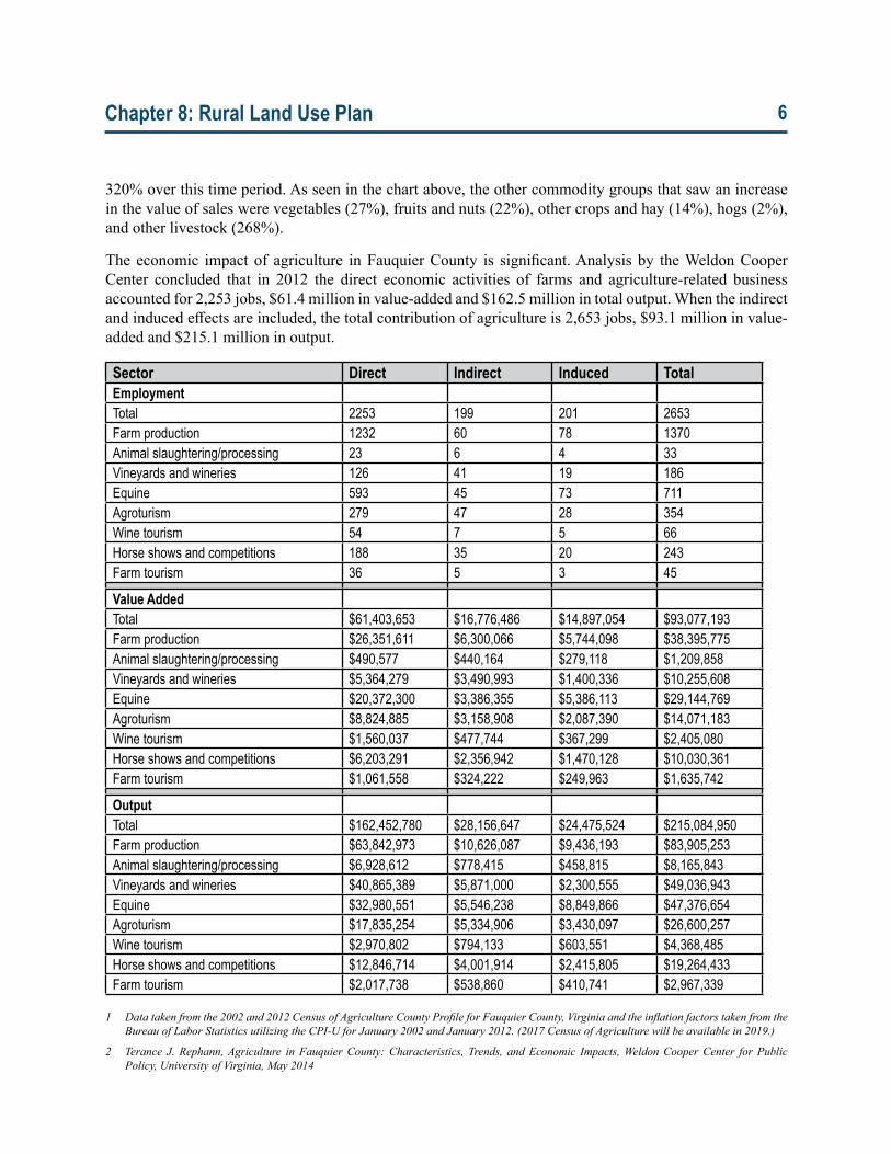
The economic impact of agriculture in Fauquier County is significant. Analysis by the Weldon Cooper Center concluded that in 2012 the direct economic activities of farms and agriculture-related business accounted for 2,253 jobs, $61.4 million in value-added and $162.5 million in total output. When the indirect and induced effects are included, the total contribution of agriculture is 2,653 jobs, $93.1 million in value-added and $215.1 million in output.
Sector Direct Indirect Induced TotalEmploymentTotal 2253 199 201 2653Farm production 1232 60 78 1370Animal slaughtering/processing 23 6 4 33Vineyards and wineries 126 41 19 186Equine 593 45 73 711Agroturism 279 47 28 354Wine tourism 54 7 5 66Horse shows and competitions 188 35 20 243Farm tourism 36 5 3 45
Value AddedTotal $61,403,653 $16,776,486 $14,897,054 $93,077,193Farm production $26,351,611 $6,300,066 $5,744,098 $38,395,775Animal slaughtering/processing $490,577 $440,164 $279,118 $1,209,858Vineyards and wineries $5,364,279 $3,490,993 $1,400,336 $10,255,608Equine $20,372,300 $3,386,355 $5,386,113 $29,144,769Agroturism $8,824,885 $3,158,908 $2,087,390 $14,071,183Wine tourism $1,560,037 $477,744 $367,299 $2,405,080Horse shows and competitions $6,203,291 $2,356,942 $1,470,128 $10,030,361Farm tourism $1,061,558 $324,222 $249,963 $1,635,742
OutputTotal $162,452,780 $28,156,647 $24,475,524 $215,084,950Farm production $63,842,973 $10,626,087 $9,436,193 $83,905,253Animal slaughtering/processing $6,928,612 $778,415 $458,815 $8,165,843Vineyards and wineries $40,865,389 $5,871,000 $2,300,555 $49,036,943Equine $32,980,551 $5,546,238 $8,849,866 $47,376,654Agroturism $17,835,254 $5,334,906 $3,430,097 $26,600,257Wine tourism $2,970,802 $794,133 $603,551 $4,368,485Horse shows and competitions $12,846,714 $4,001,914 $2,415,805 $19,264,433Farm tourism $2,017,738 $538,860 $410,741 $2,967,339
1 Datatakenfromthe2002and2012CensusofAgricultureCountyProfileforFauquierCounty,VirginiaandtheinflationfactorstakenfromtheBureau of Labor Statistics utilizing the CPI-U for January 2002 and January 2012. (2017 Census of Agriculture will be available in 2019.)
2 Terance J.Rephann,Agriculture inFauquierCounty:Characteristics, Trends, andEconomic Impacts,WeldonCooperCenter forPublicPolicy,UniversityofVirginia,May2014
Chapter 8: Rural Land Use Plan 7
3 ForestryInventoryandAnalysis,U.S.ForestService4 TimberMartSouth-South,P.O.Box1278Highlands,NC287415 VirginiaDepartmentofForestry
2. Forestry Trends
The forestland of Fauquier County is one of its most precious resources. They are used for recreation, watershed protection, wildlife management, and a variety of forest products. Forests provide for carbon sequestration, groundwater infiltration, contribute to the rural character, and provide important habitat for both game and non-game wildlife.
Current estimates of Fauquier County forestland show a total of 208,558 acres (about 50% of the County), with 11,701 acres in state ownership (mostly the Phelps and Thompson Wildlife Management Area, but also Whitney State Forest and Weston Wildlife Management Area) and 5,851 acres in County and municipal ownership. The remaining 191,006 acres is owned by private landowners. The largest single forest type is Oak-Hickory at 169,579 acres, with approximately 14,600 acres in Loblolly Pine and 16,000 acres in other hardwoods.
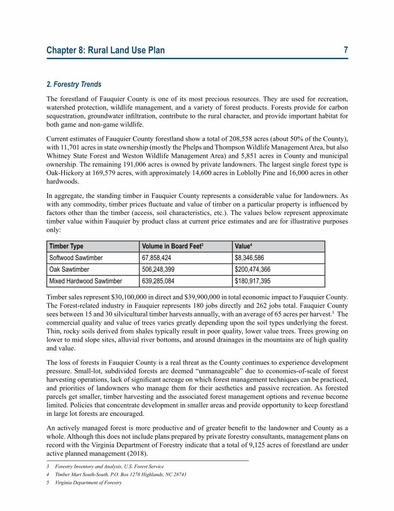
In aggregate, the standing timber in Fauquier County represents a considerable value for landowners. As with any commodity, timber prices fluctuate and value of timber on a particular property is influenced by factors other than the timber (access, soil characteristics, etc.). The values below represent approximate timber value within Fauquier by product class at current price estimates and are for illustrative purposes only:
Timber Type Volume in Board Feet3 Value4 Softwood Sawtimber 67,858,424 $8,346,586Oak Sawtimber 506,248,399 $200,474,366Mixed Hardwood Sawtimber 639,285,084 $180,917,395
Timber sales represent $30,100,000 in direct and $39,900,000 in total economic impact to Fauquier County. The Forest-related industry in Fauquier represents 180 jobs directly and 262 jobs total. Fauquier County sees between 15 and 30 silvicultural timber harvests annually, with an average of 65 acres per harvest.5 The commercial quality and value of trees varies greatly depending upon the soil types underlying the forest. Thin, rocky soils derived from shales typically result in poor quality, lower value trees. Trees growing on lower to mid slope sites, alluvial river bottoms, and around drainages in the mountains are of high quality and value.
The loss of forests in Fauquier County is a real threat as the County continues to experience development pressure. Small-lot, subdivided forests are deemed “unmanageable” due to economies-of-scale of forest harvesting operations, lack of significant acreage on which forest management techniques can be practiced, and priorities of landowners who manage them for their aesthetics and passive recreation. As forested parcels get smaller, timber harvesting and the associated forest management options and revenue become limited. Policies that concentrate development in smaller areas and provide opportunity to keep forestland in large lot forests are encouraged.
An actively managed forest is more productive and of greater benefit to the landowner and County as a whole. Although this does not include plans prepared by private forestry consultants, management plans on record with the Virginia Department of Forestry indicate that a total of 9,125 acres of forestland are under active planned management (2018).
Chapter 8: Rural Land Use Plan 8
3. Existing Pattern of Development
The rural areas encompass a significant portion of the County’s 651 square mile area. Just over 591 square miles (90.7%) of the land is zoned for Rural Agriculture (RA) and Rural Conservation (RC). The remaining 9.3% is located within the County’s towns and service districts, where residential, commercial and industrial development is focused. The smaller villages and residential settlements are considered as part of the rural area. The area of the County north of Warrenton has rolling topography and is largely shaped by the Loudoun Valley with the Bull Run Mountains in the east, the Blue Ridge Mountains in the west, and the Broken Hills to the south. The Broken Hills includes the stretch of Route 17 between Marshall and Warrenton and forms the southern border of the Loudoun Valley. The highest peaks of the Broken Hills are Wildcat Mountain at 1,368 feet, Rappahannock Mountain at 1,300 feet and Pignut Mountain at 1,040 feet. Closer to Warrenton, farms and homes dot the smaller valleys in between the Broken Hills. In this vast area of the County, there is just one Service District (Marshall) and a single town (The Plains) as well as six nationally recognized Rural Historic Districts. A number of small communities existed during the Colonial era and many existing rural communities, like Upperville, Paris or Hume, date from the early Federal period. Many of the farms in this area were originally created by large land grants, with stone walls, board fences and tree-lined lanes a common sight. Today, many are under conservation easements ensuring that the existing character will continue into the future.
South of the Warrenton and New Baltimore Service Districts, hugging the Rappahannock River, the rich farmland of Southern Fauquier has sustained a rural lifestyle for the County’s farmers since Fauquier’s first European settlers arrived 300 years ago. Today this area is home to the County’s rich dairy industry, as well as pick-your-own farms, horse and cattle operations. The history here is rich with four rural historic areas determined eligible for recognition in the National Register of Historic Places. Despite this legacy, more recent residential and commercial development along major arteries has led to a suburban feel in many parts. Most of the Service Districts are located in this area along the Route 28 and Route 29 corridors and largely developed in the last 50 years. Groundwater is more prevalent due to the Culpeper Basin geology, which bisects the County in the area of the Service Districts. The existing rural communities tend to be less well-defined, with a scattered development pattern. In the southeastern corner of the County, forests cover much of the former agricultural lands. However, the County’s Purchase of Development Rights Program has preserved a number of farms located around and south of Route 28.
4. Development Potential
While not to the same extent as our neighbors, during the 1970s and 80s, the County experienced some significant growth, averaging 3.0 percent annually. Since the 1990s, the growth rate has slowed. In 2000, the growth rate for the prior decade was 1.2% annually, and in 2010, the annual growth rate was 1.7%. The neighboring jurisdictions, except Clarke and Rappahannock, grew at much faster rates than Fauquier County.
In 2010, Fauquier County was home to 65,203 people with approximately half residing in the rural areas. By 2017, the County grew by an additional 5,044 people to 70,247.6 Based on counts of new housing, approximately 1,500, or 30%, of these new residents have moved to the rural area. The annual growth rate in the County overall in the 2010-17 time period was 1.07%, with a corresponding growth rate of 1.3% in the towns and Service Districts and 0.87% in the rural lands.
6 PopulationdatafromtheWeldonCooperCenter,UniversityofVirginia.
Chapter 8: Rural Land Use Plan 9
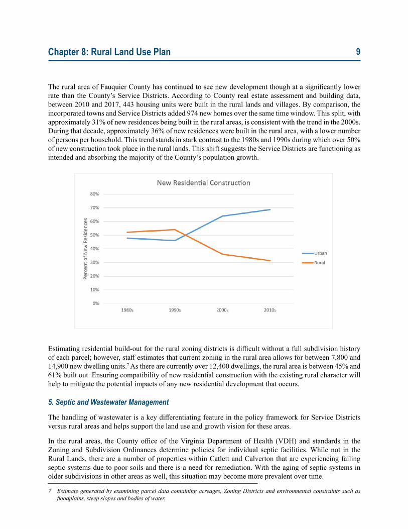
The rural area of Fauquier County has continued to see new development though at a significantly lower rate than the County’s Service Districts. According to County real estate assessment and building data, between 2010 and 2017, 443 housing units were built in the rural lands and villages. By comparison, the incorporated towns and Service Districts added 974 new homes over the same time window. This split, with approximately 31% of new residences being built in the rural areas, is consistent with the trend in the 2000s. During that decade, approximately 36% of new residences were built in the rural area, with a lower number of persons per household. This trend stands in stark contrast to the 1980s and 1990s during which over 50% of new construction took place in the rural lands. This shift suggests the Service Districts are functioning as intended and absorbing the majority of the County’s population growth.
Estimating residential build-out for the rural zoning districts is difficult without a full subdivision history of each parcel; however, staff estimates that current zoning in the rural area allows for between 7,800 and 14,900 new dwelling units.7 As there are currently over 12,400 dwellings, the rural area is between 45% and 61% built out. Ensuring compatibility of new residential construction with the existing rural character will help to mitigate the potential impacts of any new residential development that occurs.
5. Septic and Wastewater Management
The handling of wastewater is a key differentiating feature in the policy framework for Service Districts versus rural areas and helps support the land use and growth vision for these areas.
In the rural areas, the County office of the Virginia Department of Health (VDH) and standards in the Zoning and Subdivision Ordinances determine policies for individual septic facilities. While not in the Rural Lands, there are a number of properties within Catlett and Calverton that are experiencing failing septic systems due to poor soils and there is a need for remediation. With the aging of septic systems in older subdivisions in other areas as well, this situation may become more prevalent over time.
7 Estimategeneratedbyexaminingparceldatacontainingacreages,ZoningDistrictsandenvironmentalconstraintssuchasfloodplains,steepslopesandbodiesofwater.
Chapter 8: Rural Land Use Plan 10
In general, the County should maintain its current policies for individual septic systems in the rural lands and should consider alternative systems to address health issues associated with failing systems.
B. Land Conservation Tools and Trends
Private property owners and farmers are truly the key land stewards in the County. These land owners have actively participated in voluntary preservation and land management programs through State, County and non-profit organizations over the last 40-plus years. As a result, approximately 107,000 acres or over 25% of the County’s land area is currently in some form of conservation easement or land protection program. Some of the management tools and incentives for the preservation of agricultural opportunities, and historic and environmental resources are zoning and subdivision regulations, land use taxation, permanent conservation easements, Purchase of Development Rights Program, and Agricultural and Forestal Districts, each of which is discussed below.
1. Zoning and Subdivision An important tool in rural land preservation is the County’s Zoning Ordinance. Fauquier’s rural lands are zoned Rural Agricultural (RA) or Rural Conservation (RC), representing 90.7% of the County’s land area.
• The RA District generally contains those areas where agriculture and forestry are the predominant uses. The regulations are designed to assist in the protection and preservation of the agricultural uses and to mitigate land use conflicts between agricultural uses and appropriately limited residential development.
• The RC District contains our mountains, which are environmentally sensitive, have physical limitations and contain much of our timber resources. The regulations are designed with emphasis on the conservation of these areas to minimize potential adverse environmental impact while accommodating very low density residential uses.
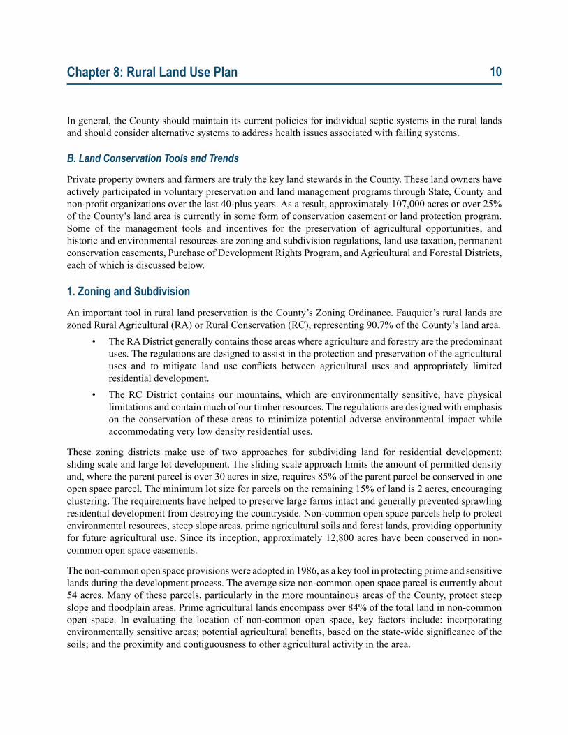
These zoning districts make use of two approaches for subdividing land for residential development: sliding scale and large lot development. The sliding scale approach limits the amount of permitted density and, where the parent parcel is over 30 acres in size, requires 85% of the parent parcel be conserved in one open space parcel. The minimum lot size for parcels on the remaining 15% of land is 2 acres, encouraging clustering. The requirements have helped to preserve large farms intact and generally prevented sprawling residential development from destroying the countryside. Non-common open space parcels help to protect environmental resources, steep slope areas, prime agricultural soils and forest lands, providing opportunity for future agricultural use. Since its inception, approximately 12,800 acres have been conserved in non-common open space easements.
The non-common open space provisions were adopted in 1986, as a key tool in protecting prime and sensitive lands during the development process. The average size non-common open space parcel is currently about 54 acres. Many of these parcels, particularly in the more mountainous areas of the County, protect steep slope and floodplain areas. Prime agricultural lands encompass over 84% of the total land in non-common open space. In evaluating the location of non-common open space, key factors include: incorporating environmentally sensitive areas; potential agricultural benefits, based on the state-wide significance of the soils; and the proximity and contiguousness to other agricultural activity in the area.
Chapter 8: Rural Land Use Plan 11
The other successfully used land development tool is the large lot development provision allowing 100-acre parcels and up to three 50-acre parcels. Large lots are not subject to subdivision provisions, such as public roads. Once a large lot is created, it can never be further subdivided into parcels smaller than the 50-acre or 100-acre minimum.
Sliding Scale
Size of Parcel (acres) Number of Lots Permitted Required Non-Common Open Space (acres)
0 – 9.99 110 – 19.99 220 – 34.99 3 25.5 – 29.7535 – 54.99 4 29.75 – 46.7555 – 79.99 5 46.75 – 68.080 – 104.99 6 68.0 – 89.25105 – 129.99 7 89.25 – 110.5130 – 154.99 8 110.5 – 131.75155 – 179.99 9 131.75 – 152.0180 – 204.99 10 152.0 – 174.25205 and above 11 plus one additional lot for each
additional 50 acres174.25 plus
As the RA and RC districts represent over 90% of the County’s land area, it is vital that the standards in these zoning districts be maintained to support the long term protection of rural character and resources in the County. Additionally, the Subdivision Ordinance requires central water and hydrogeologic testing for subdivisions of 7 lots or more. This provision ensures a level of protection for the potential depletion of groundwater resources from small subdivisions and should be maintained as a key measure of rural protection.
2. Conservation Easements
Conservations easements are a relatively flexible and effective tool that involves a voluntary legal agreement in which the landowner conveys property interest to a qualified organization for the principal purpose of protecting a property’s conservation and preservation values. It can be crafted to meet the specific characteristics, use and resources of a particular property. Conservation easements protect a wide variety of natural and cultural resources, including watershed areas, the settings for historic homes, scenic views, community lands and much more. In a conservation easement program, a landowner voluntarily agrees to forego some or all development potential of the property in perpetuity in exchange for tax benefits. A variety of organizations—including the Virginia Outdoors Foundation, The Nature Conservancy, the Land Trust of Virginia, the Piedmont Environmental Council as well as the County itself—hold permanent conservation easements on land in the County. According to County records, these easements currently cover about 57,500 acres.
Chapter 8: Rural Land Use Plan 12
A 2014 survey of landowners who donated easements to the Virginia Outdoors Foundation between 2000 and 2014 found that 90 percent of them manage the land for agricultural production or forestry. Approximately 60 percent used the Virginia Land Preservation Tax Credits they received to sustain, expand or start a new farming or forestry operation, and 20 percent did the same for a business unrelated to farming or forestry. The survey also showed that about three-quarters of easement donors reinvested their tax benefits back into additional conservation practices on their land. In 2015, Fauquier County became the first county in Virginia to reach the milestone of 100,000 acres dedicated to various forms of conservation easement.8
3. Purchase of Development Rights Program
The Purchase of Development Rights Program (PDR) has been a major initiative of the County to permanently preserve agricultural lands. The PDR program was initiated in 2002, and in 2004, the Conservation Easement Service District was approved as the funding mechanism, dedicating real estate tax revenue as the primary funding source. For the PDR Program, $0.006 of the 2018 tax rate of $0.982 is allocated to the PDR Program, which represents only 0.61% of the tax rate. To date, nearly $16 million has been invested, with nearly $6 million in grant funding secured to augment county funding. Currently ranked first in Virginia among PDR programs, the County has preserved over 12,600 acres of land and 66 farms (2018) through the program. Large blocks of contiguous preserved farmland (in excess of 2,000 acres in several locations) help reduce conflicts with non-agricultural land uses. The PDR program has also assisted farm owners in the development of markets for locally produced products.
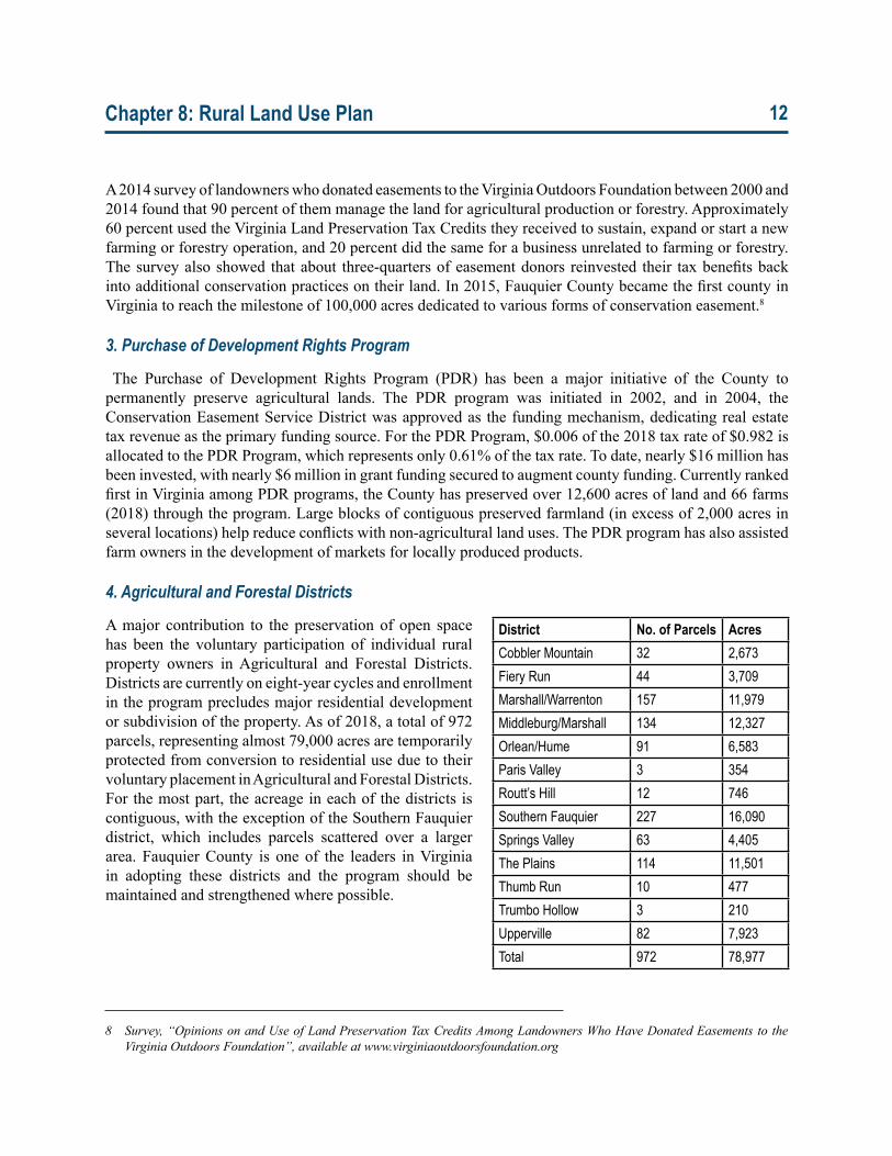
4. Agricultural and Forestal Districts
A major contribution to the preservation of open space has been the voluntary participation of individual rural property owners in Agricultural and Forestal Districts. Districts are currently on eight-year cycles and enrollment in the program precludes major residential development or subdivision of the property. As of 2018, a total of 972 parcels, representing almost 79,000 acres are temporarily protected from conversion to residential use due to their voluntary placement in Agricultural and Forestal Districts. For the most part, the acreage in each of the districts is contiguous, with the exception of the Southern Fauquier district, which includes parcels scattered over a larger area. Fauquier County is one of the leaders in Virginia in adopting these districts and the program should be maintained and strengthened where possible.
District No. of Parcels AcresCobbler Mountain 32 2,673Fiery Run 44 3,709Marshall/Warrenton 157 11,979Middleburg/Marshall 134 12,327Orlean/Hume 91 6,583Paris Valley 3 354Routt’s Hill 12 746Southern Fauquier 227 16,090Springs Valley 63 4,405The Plains 114 11,501Thumb Run 10 477Trumbo Hollow 3 210Upperville 82 7,923Total 972 78,977
8 Survey,“OpinionsonandUseofLandPreservationTaxCreditsAmongLandownersWhoHaveDonatedEasementstotheVirginiaOutdoorsFoundation”,availableatwww.virginiaoutdoorsfoundation.org
Chapter 8: Rural Land Use Plan 13
5. Land Use Taxation
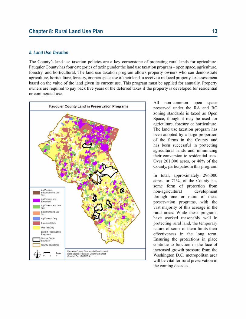
The County’s land use taxation policies are a key cornerstone of protecting rural lands for agriculture. Fauquier County has four categories of taxing under the land use taxation program – open space, agriculture, forestry, and horticultural. The land use taxation program allows property owners who can demonstrate agriculture, horticulture, forestry, or open space use of their land to receive a reduced property tax assessment based on the value of the land given its current use. This program must be applied for annually. Property owners are required to pay back five years of the deferred taxes if the property is developed for residential or commercial use.
All non-common open space preserved under the RA and RC zoning standards is taxed as Open Space, though it may be used for agriculture, forestry or horticulture. The land use taxation program has been adopted by a large proportion of the farms in the County and has been successful in protecting agricultural lands and minimizing their conversion to residential uses. Over 201,000 acres, or 48% of the County, participates in this program.
In total, approximately 296,000 acres, or 71%, of the County has some form of protection from non-agricultural development through one or more of these preservation programs, with the vast majority of this acreage in the rural areas. While these programs have worked reasonably well in protecting rural land, the temporary nature of some of them limits their effectiveness in the long term. Ensuring the protections in place continue to function in the face of increased growth pressure from the Washington D.C. metropolitan area will be vital for rural preservation in the coming decades.
Chapter 8: Rural Land Use Plan 14
C. Rural Character
1. Viewshed Protection
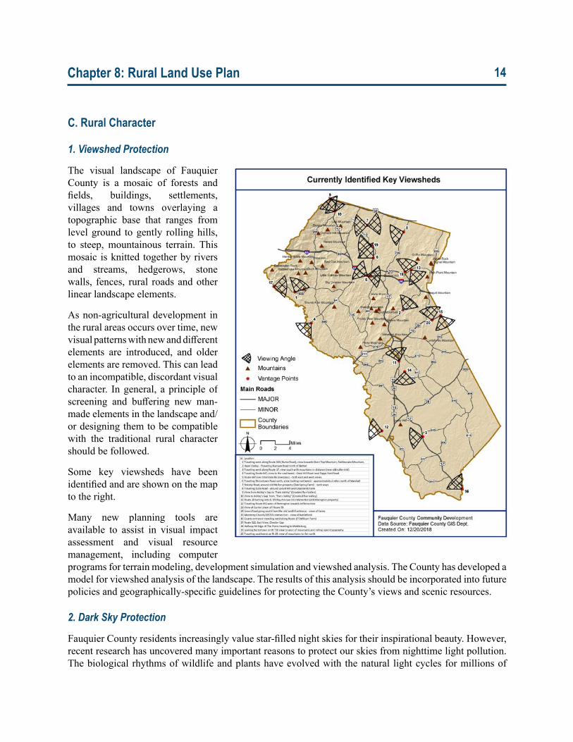
The visual landscape of Fauquier County is a mosaic of forests and fields, buildings, settlements, villages and towns overlaying a topographic base that ranges from level ground to gently rolling hills, to steep, mountainous terrain. This mosaic is knitted together by rivers and streams, hedgerows, stone walls, fences, rural roads and other linear landscape elements.
As non-agricultural development in the rural areas occurs over time, new visual patterns with new and different elements are introduced, and older elements are removed. This can lead to an incompatible, discordant visual character. In general, a principle of screening and buffering new man-made elements in the landscape and/or designing them to be compatible with the traditional rural character should be followed.
Some key viewsheds have been identified and are shown on the map to the right.
Many new planning tools are available to assist in visual impact assessment and visual resource management, including computer programs for terrain modeling, development simulation and viewshed analysis. The County has developed a model for viewshed analysis of the landscape. The results of this analysis should be incorporated into future policies and geographically-specific guidelines for protecting the County’s views and scenic resources.
2. Dark Sky Protection
Fauquier County residents increasingly value star-filled night skies for their inspirational beauty. However, recent research has uncovered many important reasons to protect our skies from nighttime light pollution. The biological rhythms of wildlife and plants have evolved with the natural light cycles for millions of
Chapter 8: Rural Land Use Plan 15
years. Artificial night lighting can disrupt these patterns, impacting migration, feeding, breeding, and even seasonal foliage changes. Of particular importance to the agricultural economy are the effects of excessive night lighting on plants and their pollinators. Plant species that bloom at night depend on night pollinators such as moths and bats and can be indirectly affected if their populations are reduced or deterred by nearby light pollution. Night lighting on trees can encourage growth and photosynthesis beyond the time when it is safe to do so, which can make trees more susceptible to harsh weather conditions and less likely to survive. For this reason, some public lands are becoming certified as “Dark Sky Parks,” which are about conserving and experiencing “Nature at Night,” not just with the starry skies above, but with the nocturnal world below. Sky Meadows State Park is being considered for certification as a Dark-Sky Park by the International Dark Sky Association.
In order to preserve the resource of dark skies, the County should continue to encourage all property owners, including agricultural users, to install only the level of outdoor lighting necessary for safety, security, and utility purposes while limiting light trespass onto neighboring properties. The County should maintain the existing standards in the Zoning Ordinance for full shielding of all outdoor lighting and the use of other best available technologies to ensure that the rural areas remain free from the long term effects of unwanted light pollution.
3. Rural Settlements and Settlement Edges
In addition to incorporated towns and Service Districts, the County is home to villages that have evolved as outgrowths of an agricultural economy and served as the center for farm services, socializing, mail pickup and the purchase of daily goods. Chapter 7 of the Fauquier County Comprehensive Plan, Villages Plan, lists 43 villages in the County.
In general, County zoning and subdivision regulations discourage expansions of the existing rural settlements. The County should not encourage settlement extensions or new settlements to be built in rural areas outside of Service Districts. To do so would create competition with and undermine the principal of the Service Districts.
Another important principle is that small towns, and rural settlements need to retain a defined edge with the surrounding countryside. Residential and commercial development in rural settlements should be directed towards adaptive reuse of existing structures (done in architecturally sensitive ways that preserve historic character and integrity) and careful infill of vacant properties.
For rural lands around settlement edges, the County should maintain the open landscape through required open space if and when adjoining parcels are proposed for residential or commercial development. In this manner, a permanent green belt could be created that would serve both the pre existing village and any new non-agricultural development proposed in its immediate vicinity.
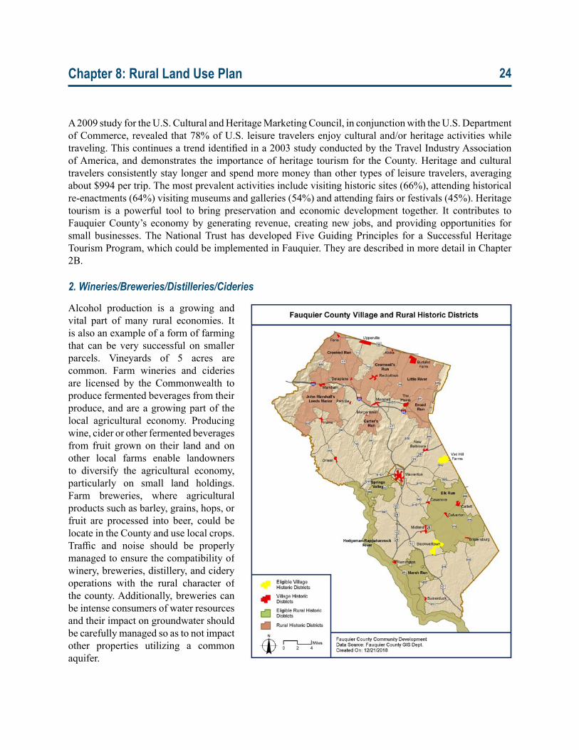
4. Rural Historic Resources
The County has a wealth of historic resources that have been extensively, although not exhaustively, studied and documented. In addition to 22 Village Historic Districts, the resources include six designated rural historic districts9 (Crooked Run Valley, John Marshall Leeds Manor, Cromwell’s Run, Carter’s Run, Little
9 DistrictsaredefinedinAppendixIIofChapter2B–HistoricResourcesas,“asignificantconcentration,linkage,orcontinuityofsites,structures,orobjectsunitedhistoricallyoraestheticallybyplanorphysicaldevelopment.Examplesinclude:centralbusinessareasorresidentialneighborhoods,townsorvillages,aseriesoffarmsorestates,transportationnetworks,oraseriesofarchaeologicalsitesassociatedwiththesamehistoricevent,suchasabattlefield.”
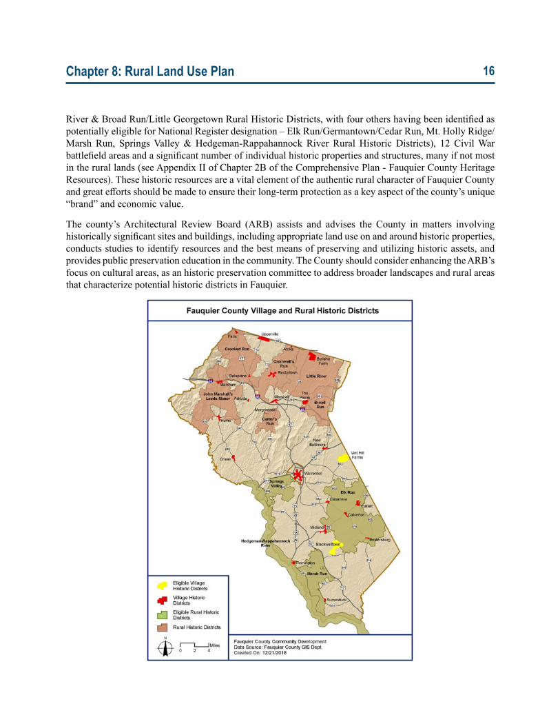
Chapter 8: Rural Land Use Plan 16
River & Broad Run/Little Georgetown Rural Historic Districts, with four others having been identified as potentially eligible for National Register designation – Elk Run/Germantown/Cedar Run, Mt. Holly Ridge/Marsh Run, Springs Valley & Hedgeman-Rappahannock River Rural Historic Districts), 12 Civil War battlefield areas and a significant number of individual historic properties and structures, many if not most in the rural lands (see Appendix II of Chapter 2B of the Comprehensive Plan - Fauquier County Heritage Resources). These historic resources are a vital element of the authentic rural character of Fauquier County and great efforts should be made to ensure their long-term protection as a key aspect of the county’s unique “brand” and economic value.
The county’s Architectural Review Board (ARB) assists and advises the County in matters involving historically significant sites and buildings, including appropriate land use on and around historic properties, conducts studies to identify resources and the best means of preserving and utilizing historic assets, and provides public preservation education in the community. The County should consider enhancing the ARB’s focus on cultural areas, as an historic preservation committee to address broader landscapes and rural areas that characterize potential historic districts in Fauquier.
Chapter 8: Rural Land Use Plan 17
D. Rural Development and Character Goals, Objectives and Implementation ActionsGoal 1: Manage and protect the County’s water resources to provide sufficient potable water and support aquatic ecosystems.
Objective1.1:Minimizetheimpactsofwastewaterdisposalsystemsongroundwaterresources.
Action 1.1.1: Limit residential densities in the rural lands to minimize the number of individual wastewater disposal systems.
Action 1.1.2: Identify and work with owners to remediate all failing systems, prioritizing where there may be impacts on impaired streams in the County.
Action 1.1.3: Study the impact of alternative wastewater treatment options to refine policies and standards to encourage the most effective wastewater disposal in the rural lands.
Action 1.1.4: Work with the Virginia Department of Health to promote environmentally compatible alternative systems and, where appropriate, communal systems to address existing failing septic systems.
Action 1.1.5: Work with Fauquier County Water and Sanitation Authority (FCWSA) where communal systems may be installed to best address existing failing systems, to ensure that they are designed and built to acceptable FCWSA standards and may be taken into the FCWSA system over time.
Action 1.1.6: Support legislation to require real estate disclosures to home buyers of properties with individual sanitary sewer systems (both conventional and alternative).
Objective1.2:Managetheimpactsofruraldevelopmentongroundwaterresources.
Action 1.2.1: Retain requirements for hydrogeologic testing for subdivisions of seven (7) lots or more.
Action 1.2.2: Develop policies to address land uses that are intense consumers of groundwater to protect the resources for other aquifer users.
Goal 2: Preserve the rural character of the majority of Fauquier County.
Objective2.1:EncouragelandusesthatareintrinsictothecharacterofFauquier’sRuralLands.
Action 2.1.1: Continue to utilize the Zoning Ordinance to ensure that “commercial” uses not compatible with the rural zoning be more appropriately located within Villages, Service Districts and Towns.
Action 2.1.2: Continue to support the work of conservation organizations in establishing and holding conservation easements and extinguishing residential development potential.
Action 2.1.3: Retain and support the Purchase of Development Rights program through both County and grant funding as a voluntary farmland preservation tool.
Chapter 8: Rural Land Use Plan 18
Action 2.1.4: Focus on the protection of prime agricultural soils, the creation of large contiguous blocks of preserved farmland, key open space resources such as stream valleys, steep wooded slopes and other sensitive environmental areas as a distinct priority in the implementation of open space protection policies.
Action 2.1.5: Expand the term for Agricultural and Forestal Districts to the longest permitted by State Code, 10 years.
Action 2.1.6: Continue to limit residential densities within the Rural Lands to ensure the preservation of the rural character through policies such as the sliding scale.
Action 2.1.7: Maintain the land use taxation program as a key tool to encourage agricultural land and production within the County.
Action 2.1.8: Encourage the reuse of existing structures where possible.
Objective2.2:LimittheabilityfordevelopmentthatisnotcomplementarytotheexistingcharacterofFauquier’sRuralLands.
Action 2.2.1: Retain sliding scale density, non-common open space and large lot development requirements within the RA and RC zoning districts.
Action 2.2.2: Ensure that development adjacent to interstate interchanges and major intersections in the Rural Lands maintain their scenic character by requiring landscape buffers and setbacks.
Action 2.2.3: Continue to support and strengthen the standards in the current Zoning Ordinance to reduce light pollution in the County caused by uplighting, excessive lighting, glare, light trespass, and inconsistent light.
Action 2.2.4: Maintain a hard edge surrounding the County’s Service Districts and Villages through the use of open space and easements to ensure a clear distinction between these and the Rural Lands.
Objective2.3:Expandeducationalopportunitiestoaidintheoptimalutilizationofruralland.
Action 2.3.1: Provide education resources to Agricultural and Forestal District members and prospective members.
Action 2.3.2: Monitor the impacts of the land use taxation program on both the County tax base and the overall preservation of the farm economy and rural character.
Action 2.3.3: Continue to encourage State Legislators to utilize Land Use values in the calculation of the Composite Index.
Action 2.3.4: Develop a community-based educational program on the value of the Dark Sky and on technical lighting topics targeting individuals in the building materials, electrical contracting, design, construction, and associated industries, as well as individual homeowners.
Action 2.3.5: Support the Dark Sky Park effort at the Sky Meadows State Park in northern Fauquier and seek opportunities for collaboration that will support commitment to protecting the Park’s night landscape.
Chapter 8: Rural Land Use Plan 19
Objective2.4:MaintainthescenicqualityoftheCounty’straditionalformandsettlementpattern.
Action 2.4.1: Utilize GIS technology to identify and designate important viewshed corridors that can be protected through the creation of development standards.
Action 2.4.2: Include a thorough evaluation of the impacts on scenic viewsheds in the design phase of any privately or publicly funded transportation, utility, communications, energy or other infrastructure project and work with Federal, State or County agencies to ensure that these projects include adequate safeguards for important scenic viewsheds that may be affected.
Action 2.4.3: Work with easement holders to utilize language in conservation easements that would protect the viewsheds and visual resources on eased lands and surrounding scenery.
III. Rural EconomyThe success of the rural economy and the preservation of rural character are interdependent – one cannot exist without the other. The county’s unique sense of place and authentic agricultural heritage draws residents, businesses and visitors alike. At the same time technology, market dynamics and demographics are changing the nature of farming and the farm economy.
The County needs to consider ways it can continue to support this economy in the context of the desired vision for the future. In part, this means supporting both large and small farming operations. The County should also be prepared to respond to new rural related business and agricultural models including new agricultural techniques, value-added farm products, on-site events, sales, and services. These business opportunities can allow rural landowners to diversify their sources of income and engage niche agricultural and tourism markets. Many of these strategies are especially well suited for rural areas positioned like Fauquier County near major metropolitan areas.
Along with their economic benefits these new methods and activities also create challenges for rural communities. Higher levels of traffic, noise, and activity may strain infrastructure and produce conflicts with surrounding landowners. The County should continue to track changes and be prepared to implement specific and coherent policies to responsibly regulate these new activities.
The intent of this section of the plan is to identify enterprise opportunities for the rural economy that are consistent with the vision and character of Fauquier County, as well as to suggest policies that can guide their development and minimize negative impacts on their rural surroundings. The policies in this section will focus on three primary facets of the rural economy:
• Agriculture• Tourism• Rural Businesses
A separate sub-section addressing each is provided on the following pages.
Chapter 8: Rural Land Use Plan 20
A. Agriculture
1. Traditional Farming
Historically, the economy and culture of Fauquier County have both been centered on agriculture. Over time, the character of its farms has changed. Early orchards and field crops were replaced by livestock and pasture, sheep and hogs replaced by beef and dairy cattle. In more recent years, the county has experienced an increase in small produce farms and specialty operations such as wineries. Each of these changes has led to corresponding alterations in appearance and activities, and should be supported by changes to the attendant policies.
According to the most recent (2012) Census of Agriculture, 1,258 farms operating on over 228,000 acres were active in the County. This constitutes more than half of the County’s total land area. These farms collectively sold almost $54 million of products—approximately 60% of which was earned through the sale of livestock and 40% through the sale of crops. The $54 million dollars of sales makes Fauquier County the 16th highest value producer of agricultural products out of the 95 counties in the Commonwealth of Virginia. In 2013, a survey by the Fauquier County Department of Agricultural Development showed strong farmer support for additional animal processing facilities and other cooperative processing facilities in the County as farmers attempt to capture more direct to consumer and retailer markets.
Fauquier County Department of Agricultural Development is charged with “promoting the County agricultural industry, increasing the economic viability of farming and advising the Board of Supervisors on agricultural economic development issues”. The Department administers the Purchase of Development Rights Program, promoting area products through its farm product and services directory, maintaining the Fauquier Agriculture Home Grown program, coordinating the annual Fall Farm Tour, and serving as County liaison for agricultural advocacy and business groups.
The County is fortunate to have considerable collaboration amongst local, regional and state organizations, including the Department of Agricultural Development, Farm Bureau, Virginia Cooperative Extension Service, John Marshall Soil and Water Conservation District, Rappahannock-Rapidan Regional Commission and others, whose advice, policies and programs have contributed to the recommendations herein.
2. On Farm/Value Added Activities
Value added activities on farms include small businesses that are a logical extension of the farm use, farm product sales and services related to agriculture (i.e., farm co-ops, wayside stands, welding services, farm machinery repair, rental and leasing), to provide economical and convenient services to the rural economy, and to provide for the operation of home-based businesses that are compatible with the rural landscape. Such uses should be compatible in scale, size, and intensity with the primary agricultural use and the rural environment, and be subject to performance standards.
In particular, wayside farm stands provide an additional point of sale for agricultural goods and can supplement the income of local farmers. They enhance the agricultural identity of Fauquier County by directly connecting local farmers and consumers. Current regulations limit wayside stand operators to the sale of items produced on the property and require structures to be removed during the non-growing season. Regulations could be carefully modified to enhance agricultural economic opportunities without detracting from the basic rural character and setting or overall agricultural economy.
Chapter 8: Rural Land Use Plan 21
Interest in these activities is likely to grow as more people take an interest in local foods and developing relationships with farmers. In 2012, 143 farms in the county reported making direct food sales to customers as part of their farm income. This figure increased over 50% from 2007, when only 95 farms reported making such sales. Additionally, 119 farms reported producing and selling value-added commodities.
Marketing local foods and agricultural products depends on the availability of local distribution facilities such as warehouses and cold storage for locally grown produce and meat. When a number of value-added and processing services are aggregated into a facility serving a whole community of farmers, these centers are sometimes called “food hubs.” The Agricultural Development Department is currently coordinating the regional Food Port Feasibility Study.
3. Equine and Other Animal Activities
Equine activities are a significant part of the rural economy in the County. In 2012, 5,282 horses were reported living on 569 farms in Fauquier County, 147 of which conducted animal sales. That year, 450 horses were sold for a value of $2,139,000 and Fauquier was ranked second in the state in terms of horse and pony inventory. The most recent comprehensive study of the economic impacts of the horse industry was in 2010. At that time in Fauquier County, employment was at 883; the value-added contribution was $31.7 million; total sales were $53.7 million and tax revenue was $2.1 million. Of the value-added contribution, 78% is attributable to horse operations, 14% to shows/competitions and 8% to racing.10
In addition to horse farms, Fauquier County is notable in the state for its equine competitions such as the Great Meadow Invitational three day event, and the Virginia Gold Cup and the International Gold Cup steeplechase races, hosted at Great Meadow event center in Old Tavern. These events draw tens of thousands of visitors to the county every year. There are also smaller steeplechase, point-to-point, polo and similar events held through the County. The Upperville Colt and Horse Show is the oldest horse show in the country, established in 1853, and the Warrenton Horse Show, established in 1899, are nationally recognized Heritage Competitions11 located within the County. Similarly, the Warrenton Pony Show is also the oldest in the country, debuting in 1919. The County also has a long heritage in fox hunting and at least eight local hunts are wholly or partly in the county. The Piedmont Fox Hound (1840), the oldest continuing hunt in the United States, has territory within the County. Other notable long-standing hunts with territory within the County include, Casanova Hunt (1909), Orange County Hounds (1900) and the Warrenton Hunt (1887).
Other animal activities also represent a significant part of the County’s rural economy. Animal activities include those involving alpacas, bees, cats, dogs, donkeys, goats, rabbits and sheep, to name but a few. Many of the county’s animal operations are on small acreage farms or large residential parcels. While these farms, activities, and events are important elements of the rural culture of the county, small acreage operations can also create unintended consequences. Too many animals on small acreage can be detrimental to the health of the animals themselves, as well as damaging grazing lands and surrounding water resources. Improper grazing and waste/manure management techniques can increase nutrient loads in waterways, spread harmful bacteria, and cause erosion that diminishes both the fertility of the soil and water quality. Educating landowners and producers is paramount.
10 Terance J. Rephann, The Economic Impact of the Horse Industry in Virginia, Weldon Cooper Center for Public Policy,UniversityofVirginia,March2011.
11 ThedesignationofaUSEquestrianHeritageCompetitionisreservedforcompetitionsthathavebeenestablishedforalongperiodoftimeandhavemadesubstantialcontributiontowardthedevelopmentandpromotionofthesport,bothwithinthebroadercommunity,byachieving,maintainingandpromotingtheequestrianidealsofthesportsmanshipandcompetition.Asof2019,therewereonly29suchrecognizedcompetitionsintheUnitedStates.
Chapter 8: Rural Land Use Plan 22
There are a number of important factors to consider in protecting environmental degradation of the land from small animal husbandry, boarding and breeding operations. These factors to consider include:
• Size and location of animal waste piles and use of manure compost piles• Setbacks from waterways and wells for various animal facilities and activities• Location and maintenance of animal washing areas• Use of pesticides• Disposing of unused pharmaceuticals • Managing animal mortality• Grazing area per animal unit• Pasture management (mowing, rotation, compost fertilization)• Natural and built buffers and filter strips between pasture and water resources• Water access points for animals
B. Rural TourismFauquier County’s legacy of preservation of its rural lands has provided many practical benefits in the realms of agriculture and natural resource conservation. The county’s relatively intact rural setting is also valued for its beauty and recreational opportunities. Drawing on this interest, some rural landowners have begun to utilize their properties not only for production, but also as sites to host events and activities for rural tourism.
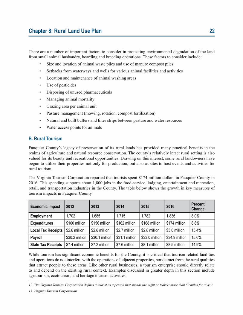
The Virginia Tourism Corporation reported that tourists spent $174 million dollars in Fauquier County in 2016. This spending supports about 1,800 jobs in the food-service, lodging, entertainment and recreation, retail, and transportation industries in the County. The table below shows the growth in key measures of tourism impacts in Fauquier County.
Economic Impact 2012 2013 2014 2015 2016 Percent Change
Employment 1,702 1,685 1,715 1,782 1,836 8.0%Expenditures $160 million $156 million $162 million $168 million $174 million 8.8%Local Tax Receipts $2.6 million $2.6 million $2.7 million $2.8 million $3.0 million 15.4%Payroll $30.2 million $30.1 million $31.1 million $33.0 million $34.9 million 15.6%State Tax Receipts $7.4 million $7.2 million $7.6 million $8.1 million $8.5 million 14.9%
While tourism has significant economic benefits for the County, it is critical that tourism related facilities and operations do not interfere with the operations of adjacent properties, nor detract from the rural qualities that attract people to these areas. Like other rural businesses, a tourism enterprise should directly relate to and depend on the existing rural context. Examples discussed in greater depth in this section include agritourism, ecotourism, and heritage tourism activities.
12 TheVirginiaTourismCorporationdefinesatouristasapersonthatspendsthenightortravelsmorethan50milesforavisit.
13 VirginiaTourismCorporation
Chapter 8: Rural Land Use Plan 23
All tourism enterprises should operate with the understanding that the primary uses of rural areas remains agriculture, historic preservation and natural resource conservation. Conflicts that occur between tourism and primary uses should be settled in favor of the primary uses. One issue common to all rural tourism enterprises is the concern that the operation does not disrupt the character or functionality of the rural area. Elements to consider in regard to this issue include traffic generation, the scale and placement of buildings, frequency of events and activity, operating hours of activities, the size and appearance of signage, and levels of noise or light produced by the activities, water and sewer impacts as well as access for public safety among other items.
Any facilities involved in the tourism enterprise should not be distinctly different in size or appearance than those used by other rural businesses. The approval of a tourism operation should be contingent upon adequate infrastructure capacity, minimal interference with farming, cultural, and natural resources, and potential impacts on adjoining properties and the surrounding community.
One of the most important ways that the County can support rural tourism is through the continued preservation of the rural setting itself—protecting natural and agricultural lands from residential and commercial development and maintaining the traditional rural character. The County can aid in rural tourism opportunities by promoting attractions and utilizing standards and policies that permit the development of small businesses and services that can support compatible rural tourism enterprises.
1. Agritourism, Ecotourism & Heritage Tourism
Agritourism is a term that is applied to activities that allow visitors to tour some or all of an operational farm, participate in the cultivation or harvest of farm products, purchase and consume products grown directly on the farm, or participate in festivals or activities related to significant agricultural seasons or events. Examples include farm tours, pick-your-own farm operations, roadside farm-stands, wineries, or fall harvest festivals. In 2012, 36 farms reported earning income from agritourism activities—a figure that more than doubled from the 2007 figure of 17 farms. These activities can often bring in additional revenue to help sustain the farming operation.
Acceptable agritourism enterprises in the rural lands must be incidental to and directly supportive of the agricultural use of the property. Events and facilities should not have significant impacts on the agricultural viability of the farm or the rural character of the area in which it is located.
Ecotourism is a term that is applied to enterprises that provide equipment and/or access in order to allow visitors to participate in outdoor recreational activities in a natural environmental setting that feature little or no human development activity. Examples of ecotourism include hiking, mountain biking, canoeing and kayaking, river tubing, fishing, hunting, camping, rock climbing, and bird watching. Ecotourism activities typically require, or at least benefit from, a rural setting. Demand for ecotourism opportunities is high in rural areas adjacent to large metropolitan areas. In addition to the Piedmont and Blue Ridge ecosystems, Fauquier County hosts numerous recreational amenities including the Appalachian Trail, the Rappahannock River, Sky Meadows State Park, and the George Thompson and Phelps wildlife areas.
Fauquier’s history and many historic sites attract heritage tourism events and experiences, which allow visitors to develop an appreciation of the local heritage and culture, leading to the protection of the resources. These heritage tourism activities involve the visitation and historical interpretation of structures, landscapes, and places of notable cultural or historic significance.
Chapter 8: Rural Land Use Plan 24
A 2009 study for the U.S. Cultural and Heritage Marketing Council, in conjunction with the U.S. Department of Commerce, revealed that 78% of U.S. leisure travelers enjoy cultural and/or heritage activities while traveling. This continues a trend identified in a 2003 study conducted by the Travel Industry Association of America, and demonstrates the importance of heritage tourism for the County. Heritage and cultural travelers consistently stay longer and spend more money than other types of leisure travelers, averaging about $994 per trip. The most prevalent activities include visiting historic sites (66%), attending historical re-enactments (64%) visiting museums and galleries (54%) and attending fairs or festivals (45%). Heritage tourism is a powerful tool to bring preservation and economic development together. It contributes to Fauquier County’s economy by generating revenue, creating new jobs, and providing opportunities for small businesses. The National Trust has developed Five Guiding Principles for a Successful Heritage Tourism Program, which could be implemented in Fauquier. They are described in more detail in Chapter 2B.
2. Wineries/Breweries/Distilleries/Cideries
Alcohol production is a growing and vital part of many rural economies. It is also an example of a form of farming that can be very successful on smaller parcels. Vineyards of 5 acres are common. Farm wineries and cideries are licensed by the Commonwealth to produce fermented beverages from their produce, and are a growing part of the local agricultural economy. Producing wine, cider or other fermented beverages from fruit grown on their land and on other local farms enable landowners to diversify the agricultural economy, particularly on small land holdings. Farm breweries, where agricultural products such as barley, grains, hops, or fruit are processed into beer, could be locate in the County and use local crops. Traffic and noise should be properly managed to ensure the compatibility of winery, breweries, distillery, and cidery operations with the rural character of the county. Additionally, breweries can be intense consumers of water resources and their impact on groundwater should be carefully managed so as to not impact other properties utilizing a common aquifer.
Chapter 8: Rural Land Use Plan 25
C. Rural BusinessesCommercial uses that are not compatible with the dominant agricultural land use pattern should be directed to locate in towns and Service Districts. Small businesses that are consistent with the rural economy and culture can offer services to rural residents, help farms stay economically viable and may provide valuable contributions to the vitality of the County’s rural areas. Small home-based businesses can provide rural communities with important alternative sources of income that contribute to the diversity and stability of the local economy.
The County may permit non-agriculturally related commercial uses by special exception or special permit in the rural lands if the use is agriculturally and rurally compatible in scale and intensity; poses no threat to public health, safety and welfare; contributes to the preservation of historically significant structures or landscapes; and if it helps to preserve farmland and open space and continue agricultural operations.
The rural areas contribute significantly to the county’s economic success. 2014 data from the US Census indicates that 4,582 jobs were in the rural areas of Fauquier County. Almost 40% of these jobs report incomes greater than $3,333 dollars per month.
The top five non-agricultural industry sectors for jobs in rural areas include “Construction” (20.4%), “Administration and Support, Waste Management and Remediation” (9.2%), Manufacturing (8.5%), “Other Services - Excluding Public Administration” (6.7%), and “Educational Services” (6.2%).
1. Home Based Businesses
One of the greatest challenges facing most rural communities is the limited availability of employment opportunities. Residents who do not work in traditional rural professions such as agriculture or forestry are often forced to commute long distances to find work in nearby suburban and urban areas. This contributes to congestion on county roads, less local tax base and potentially a lesser sense of commitment to the place one lives.
An increasingly available option for some rural residents is the possibility of working directly from their homes. These opportunities have become more numerous as telecommuting technologies have improved and the practice has acquired increased credibility and acceptance with employers.
Other home occupations, such as small contracting businesses and auto repair garages, can potentially have greater impact on their surroundings. These types of businesses may be attracted to rural areas by lower land prices and the potential to locate further from neighbors, reducing the risk of nuisance complaints. However, these businesses should not operate at such a scale that would impact adjacent properties.
With an increasing number of “baby boomers,” retiring to homes in the Rural Lands, this offers a unique opportunity as this group sees a growing number of entrepreneurs. The highest number of business start-ups in the country are created from those 55 and older. Fauquier County should encourage both home-based businesses and telecommuting as a way to work within the existing rural setting without the need to attract new forms and types of commercial development in order to serve local employment needs.
Chapter 8: Rural Land Use Plan 26
2. Rural Businesses and Services
By facilitating strategically located small-scale businesses, the County can enhance the vitality and sustainability of its rural areas, while creating employment opportunities. Rural businesses and services are most appropriately located in the County’s villages, which were the traditional locations for the basic goods and services available to a farm community.
These businesses should be limited in size, with carefully delineated permissible uses. Reusing existing buildings, especially historic buildings, is preferable to building new structures. Such existing buildings would need to be renovated and reused at a scale that is appropriate for the area and does not require additional infrastructure.
3. Alternative Energy Operations
While solar panels as a supplemental source of power have long been in use for residential and farm operations, recent developments in the industry have seen the expansion of utility scale photovoltaic energy generation facilities appearing in rural areas. Utility scale solar operations are subject to federal and state review, which reduces the regulatory considerations of local governments. As large scale solar farms become more common, however, the County may consider regulations to ensure that these operations don’t detract from the rural character of the county and from the traditional and emerging farm economy. As the industry expands, the County should continue its policy principles of ensuring that these uses do not detract from the basic agricultural character and economy of its rural lands.
While the wind energy industry has grown rapidly across the United States, there are not yet any constructed commercial wind farms in Virginia. The current design of utility-scale wind energy infrastructure tends to locate significant structures along ridgelines which has a significant impact on the rural viewsheds. This impact is not considered compatible with the County’s goals of preserving its rural character.
D. Rural Economy Goals, Objectives and Implementation ActionsGoal 3: Ensure that Fauquier County has a thriving rural economy.
Objective 3.1: Utilize County initiatives to support the broad variety of the County’s agriculturaleconomy.
Action 3.1.1: Support the Department of Agricultural Development and other County supported ventures that provide agricultural assistance, community education, marketing strategies, information on agricultural support businesses, and information about alternative agricultural uses.
Action 3.1.2: Utilize the Farm Fresh brochure and “Fauquier Agriculture: Home Grown” logo and branding to build awareness of the importance of agriculture to the local economy.
Action 3.1.3: Streamline permitting and approval procedures for value-added facilities.
Action 3.1.4: Define standards for appropriately scaled small cooperative infrastructure such as cold storage, processing and equipment co-ops for sales, service, rental and sharing, and meat and produce processing facilities.
Chapter 8: Rural Land Use Plan 27
Action 3.1.5: Consider permitting the sale of agricultural items produced locally by market operators at wayside stands.
Action 3.1.6: Consider allowing permanent semi-enclosed structures to serve as wayside stands that are compatible in material, scale and architecture to other proximate agricultural structures.
Action 3.1.7: Provide assistance to landowners in filing applications that support agricultural uses in the rural areas.
Action 3.1.8: Continue to utilize the Fauquier Education Farm for education and training.
Action 3.1.9: Continue and promote the Fauquier Farm Link program to match landowners and farmers looking for farmland.
Action 3.1.10: Continue to evaluate and refine County policies to protect soils and prevent adverse environmental impacts from overgrazing and mismanagement.
Action 3.1.11: Evaluate the Zoning Ordinance to ensure consistency between treatment of wineries and other rural alcohol-producing facilities and the minimization of their impacts on the rural character.
Objective3.2:EncourageprivateinvestmenttosupportthebroadvarietyoftheCounty’sagriculturaleconomy.
Action 3.2.1: Continue to promote the creation of direct marketing initiatives such as farmers markets, regional food hubs and Community Supported Agriculture (CSAs) ventures.
Action 3.2.2: Support the development of an equine quarantine facility at Dulles International Airport.
Action 3.2.3: Support the development of businesses necessary to support the equine and other animal industries as well as veterinary services.
Objective3.3:UtilizeCounty initiatives to support thebroad varietyof theCounty’s rural tourismopportunities while protecting its authentic character.
Action 3.3.1: Ensure that permanent structures that support rural tourism enterprises are for activities that derive their value from the property.
Action 3.3.2: Continue to evaluate the regulatory requirements for events over 150 persons in the rural lands.
Action 3.3.3: Continue to evaluate County regulatory requirements as new tourism opportunities arise, while protecting rural resources.
Action 3.3.4: Limit food and/or beverages sold as part of an agritourism activity to those value-added products produced from or grown on the land or surrounding land in Fauquier County, unless they are secondary and incidental to the primary agritourism business.
Chapter 8: Rural Land Use Plan 28
Action 3.3.5: Support and promote historic, cultural and natural resource-based tourism activities such as the wine trail, farm tours, interpretive battlefield sites.
Action 3.3.6: Identify and map existing and potential assets and opportunities for local ecotourism such as the Rappahannock River and Appalachian Trail.
Action 3.3.7: Complete the development of the Rappahannock Station Battlefield Park.
Action 3.3.8: Pursue opportunities to develop trails and multi-use paths for recreational use, prioritizing those that link natural trail heads.
Objective3.4:EncourageprivateinvestmenttosupportthebroadvarietyoftheCounty’sruraltourismopportunities.
Action 3.4.1: Encourage private landowners to provide easements for the creation of an equestrian trail network.
Action 3.4.2: Encourage the adaptive reuse of historic buildings for location appropriate uses.
Action 3.4.3: Continue to explore public/private partnerships to promote the expansion of broadband and cellular infrastructure.
Objective3.5:Ensurethatbusinesseslocatedintherurallandsdonotadverselyimpacttheintrinsiccharacter of the area.
Action 3.5.1: Ensure that permanent structures supporting a rural business or tourism enterprise are significantly set back from property boundaries, are appropriately sized, do not obstruct views of significant natural features from adjacent properties or public roads, and minimize light and noise pollution.
Action 3.5.2: Require operating hours of rural businesses or tourism enterprises to be consistent with the operating hours of other similar businesses within the RA or RC Zoning Districts.
Action 3.5.3: Ensure that contractor and vehicle-oriented home businesses minimize visual and other impacts on nearby properties.
Action 3.5.4: Explore additional standards for locating alternative energy generating facilities to ensure preservation of environmental, cultural, and scenic resources and maintaining prime agricultural lands for agriculture.
Action 3.5.5: Require a decommissioning plan for utility scale energy projects that provides information on the project’s life space, cost to decommission the facility, the manner in which the facility will be decommissioned and the site restored, and the methods by which funds will be available for decommissioning and restoration.
Action 3.5.6: Encourage low maintenance ground cover and activities on alternative energy generating facilities, such as bee pollinating plantings, native plantings, beekeeping and sheep grazing, that provide other ecological benefits.
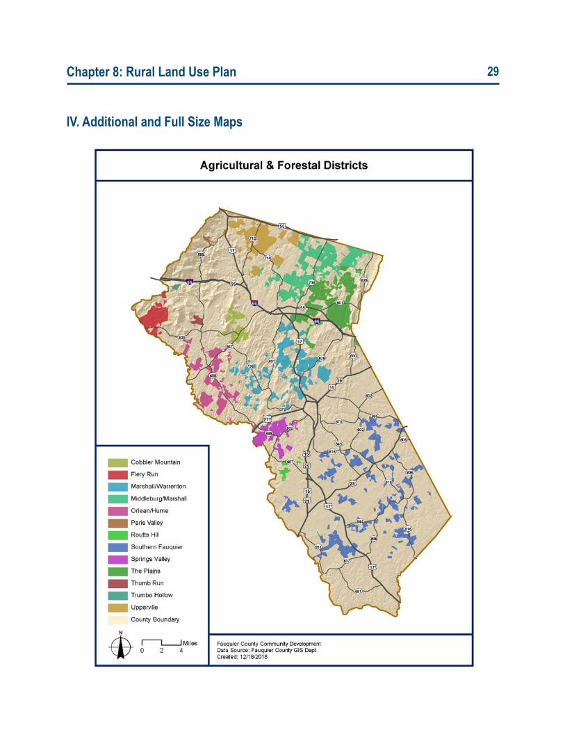
Chapter 8: Rural Land Use Plan 29
IV. Additional and Full Size Maps
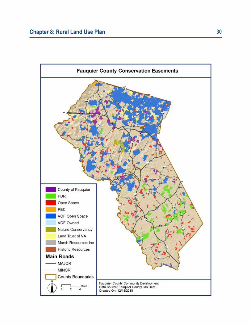
Chapter 8: Rural Land Use Plan 30
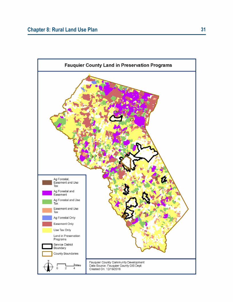
Chapter 8: Rural Land Use Plan 31
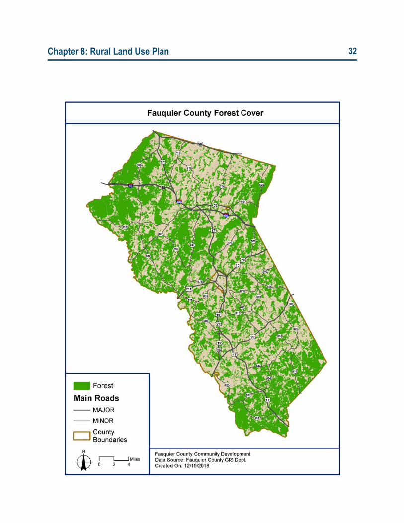
Chapter 8: Rural Land Use Plan 32
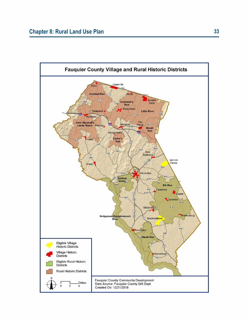
Chapter 8: Rural Land Use Plan 33
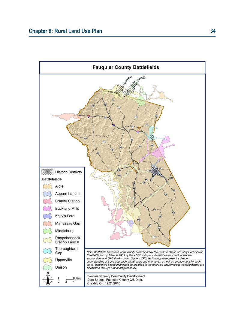
Chapter 8: Rural Land Use Plan 34
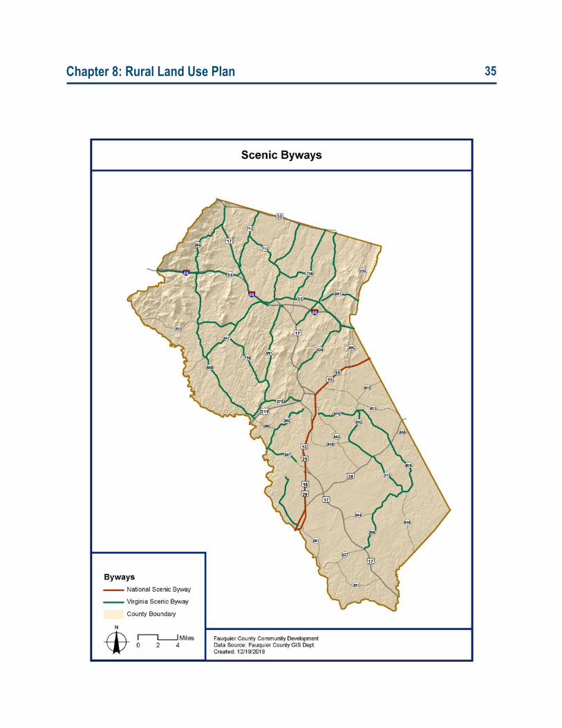
Chapter 8: Rural Land Use Plan 35
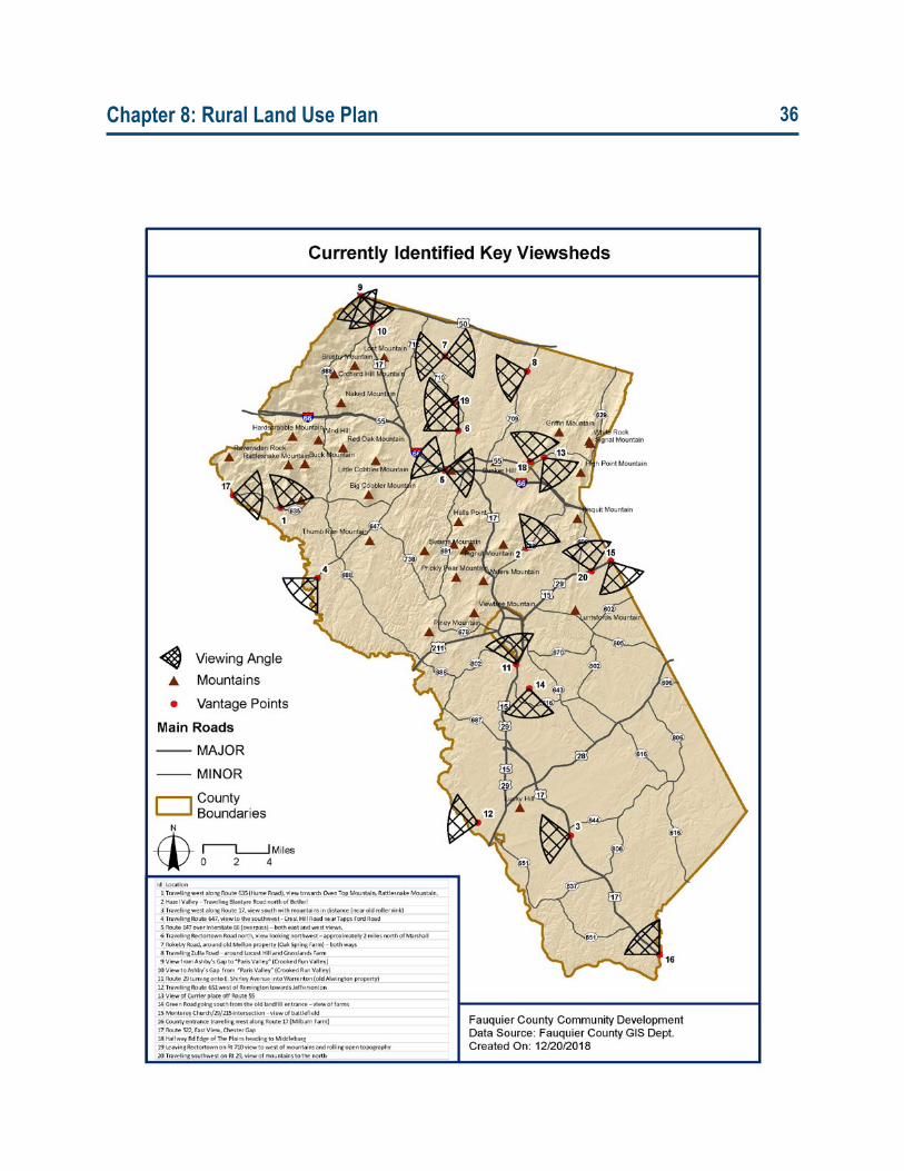
Chapter 8: Rural Land Use Plan 36
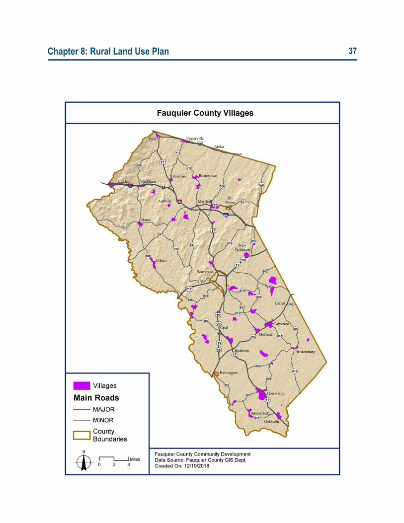
Chapter 8: Rural Land Use Plan 37
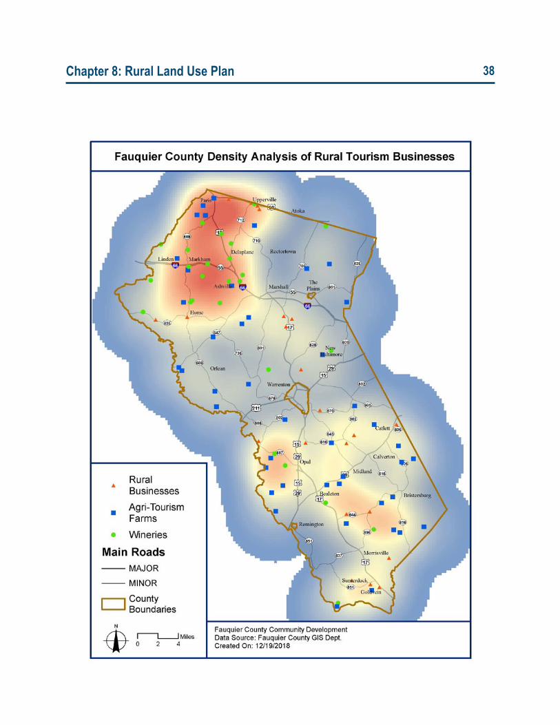
Chapter 8: Rural Land Use Plan 38


