93
8 th March 2016, 14.00-15.30 ATM Theatre, World ATM Congress 2016 SESAR and Spectrum 1 #SESAR @WorldATM_now
| Date post: | 22-Jan-2018 |
| Category: |
Technology |
| Upload: | sesar-joint-undertaking |
| View: | 1,107 times |
| Download: | 0 times |

8th March 2016, 14.00-15.30
ATM Theatre, World ATM Congress 2016
SESAR and Spectrum
1
#SESAR @WorldATM_now
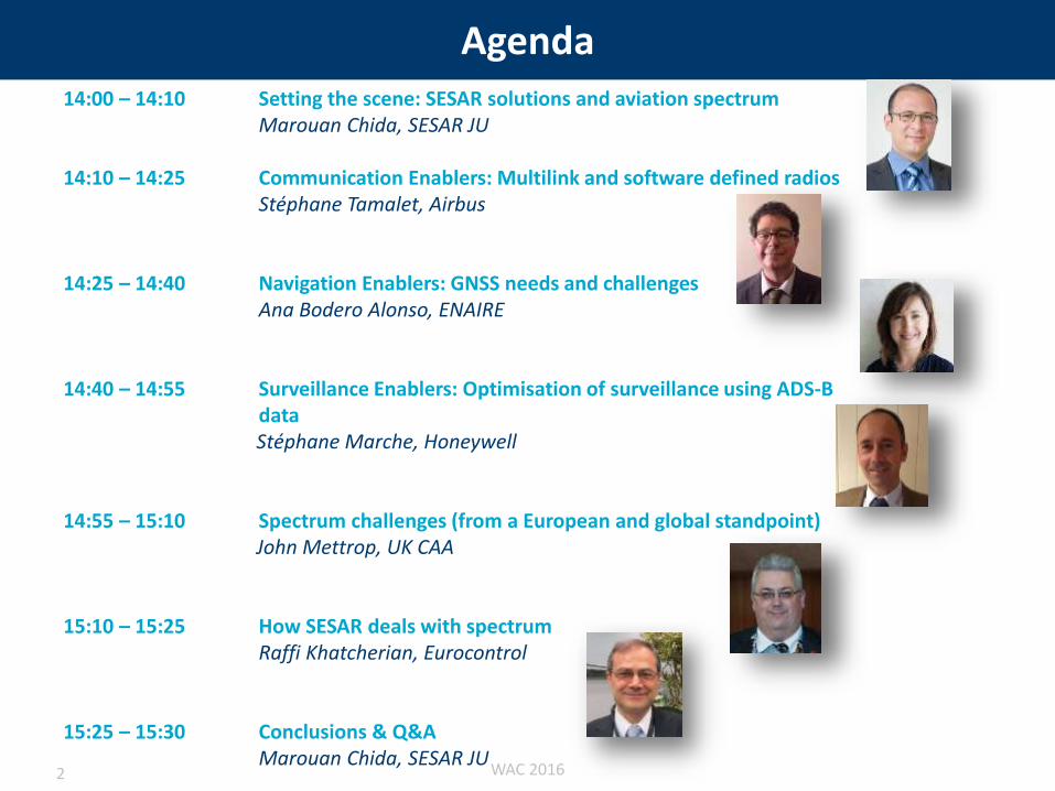
Agenda14:00 – 14:10 Setting the scene: SESAR solutions and aviation spectrum
Marouan Chida, SESAR JU
14:10 – 14:25 Communication Enablers: Multilink and software defined radiosStéphane Tamalet, Airbus
14:25 – 14:40 Navigation Enablers: GNSS needs and challengesAna Bodero Alonso, ENAIRE
14:40 – 14:55 Surveillance Enablers: Optimisation of surveillance using ADS-B data Stéphane Marche, Honeywell
14:55 – 15:10 Spectrum challenges (from a European and global standpoint)John Mettrop, UK CAA
15:10 – 15:25 How SESAR deals with spectrum Raffi Khatcherian, Eurocontrol
15:25 – 15:30 Conclusions & Q&AMarouan Chida, SESAR JU
WAC 20162

Spectrum Enabling SESAR
Marouan CHIDA
SJU
3
#SESAR @WorldATM_now
Introduction
1 Context
2 Overview of some CNS developments in SESAR
WAC 20164

Introduction
1 Context
2 Overview of some CNS developments in SESAR
WAC 20165
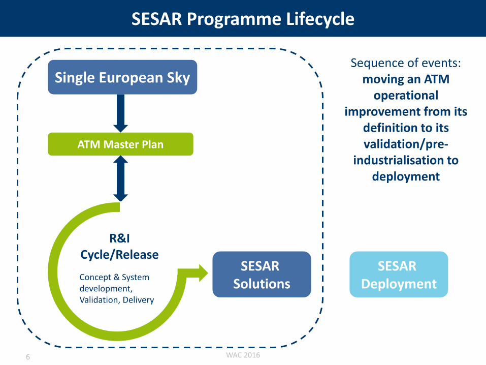
SESAR Programme Lifecycle
Single European Sky
ATM Master Plan
SESAR Solutions
Sequence of events: moving an ATM
operational improvement from its
definition to its validation/pre-
industrialisation to deployment
Concept & System development, Validation, Delivery
R&I Cycle/Release
SESAR Deployment
WAC 20166

Inn
ova
tio
n p
ipel
ine Phase 1
Phase 2/1
Phase 2/2
Phase 3
Delivery
The SESAR Pipeline
WAC 20167
Introduction
1 Context
2 Overview of some CNS developments in SESAR
WAC 20168
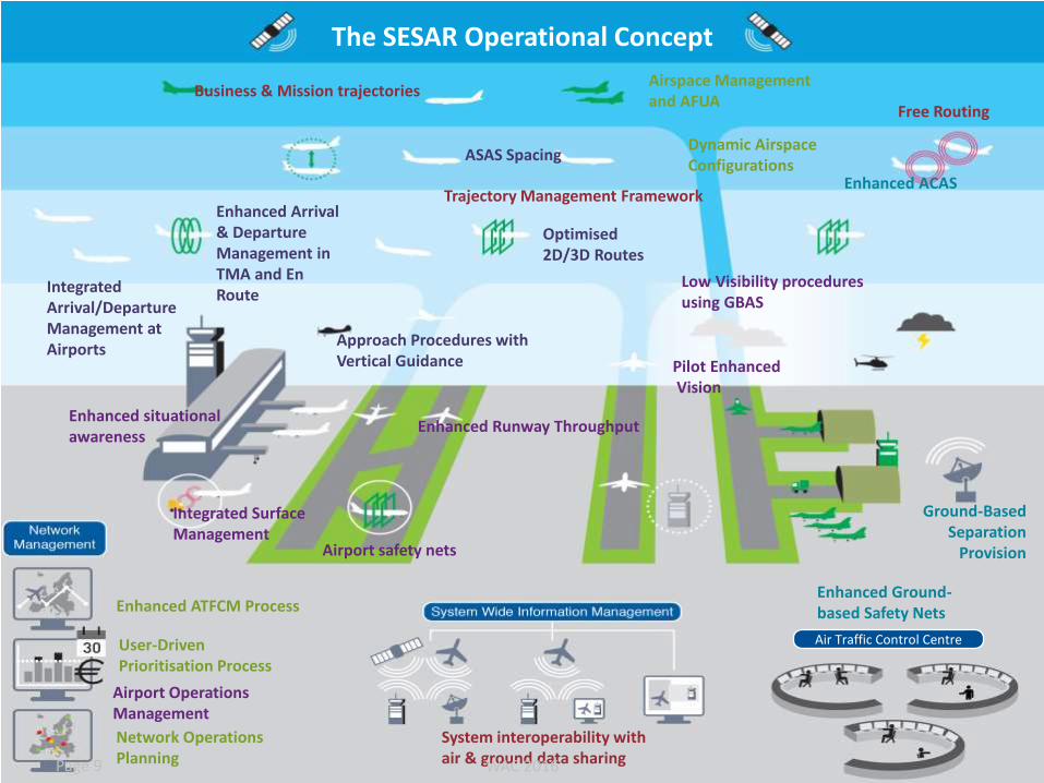
System interoperability with air & ground data sharing
Business & Mission trajectoriesFree Routing
Trajectory Management Framework
Enhanced Ground-based Safety Nets
Enhanced ACAS
Ground-Based Separation
Provision
Airspace Management and AFUA
Enhanced ATFCM Process
Network Operations Planning
User-DrivenPrioritisation Process
Dynamic Airspace Configurations
Integrated Arrival/Departure Management at Airports
Enhanced Arrival & Departure Management in TMA and En Route
ASAS Spacing
Optimised 2D/3D Routes
Approach Procedures with Vertical Guidance
Integrated Surface Management
Airport Operations Management
Enhanced Runway ThroughputEnhanced situational awareness
Pilot EnhancedVision
Low Visibility procedures using GBAS
Airport safety nets
Air Traffic Control Centre
The SESAR Operational Concept
WAC 2016Page 9
Communication
WAC 2016Page 10

Initial 4DOperational Objective:
1. Share and synchronize airborne and ground trajectory.
2. “Flying to Time constraints” to optimize sequences as defined by ATC.
A big potential !
The 4D Trajectory is a basis
for a multitude of services
(separation, situation
awareness, enhanced
prediction, flow and capacity
management….)
Significantly validated
in SESAR
And more to come (PEGASE,
VLD,PCP…)WAC 201611

Surface operations - Taxi Clearance
– Safety improvements (No voice communication misunderstanding )
– Enhanced situational awareness
• Traffic display around the runway
• Indications and alerts for risk of collision or runway incursion
– Navigation efficiency
– Reduction of crew workload
– Consistent presentation of the information to the pilot and to the controller on the Surface Manager
– Continuation on the ground of the Trajectory Management
Taxi clearance can providethe following improvements:
Examples of Taxi clearances displayed on ND
Example of Textual Taxi
clearance received from ATC Ground request menu
WAC 201612

Navigation
WAC 2016Page 13
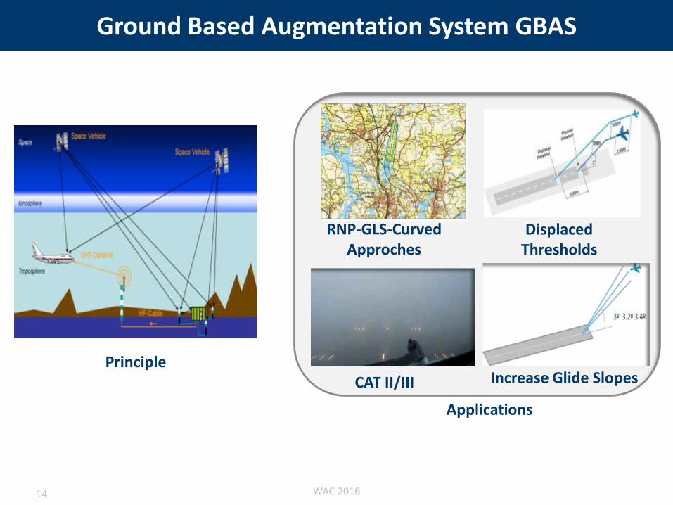
Ground Based Augmentation System GBAS
Displaced Thresholds
RNP-GLS-Curved Approches
CAT II/III Increase Glide SlopesPrinciple
Applications
WAC 201614

GBAS CAT II/III Validation
Aircraft Integration &
Validation
MMR Development &
Verification
Airbus ThalesToulouse Valence/Paris
CAT IIIb
Flight Tests &
System
Validation
Mainline aircraft
Airborne Development & Verification
Thales DSNAStuttgart Toulouse
Ground Development & Verification
Airport Implementation & Validation
GBAS Site
Prototype I
Ground & System Development
Business Aircraft
9.12 Airborne Development & VerificationIndraNavia DFSNorway Frankfurt
Prototype II
Ground / System Development
Interoperability
Flights
CAT II/IIIa
Flight Tests &
System
Validation
optional
Honeywell Honeywell Aircraft Integration &
Validation
Avionics Receiver
Development & Verification
BrnoBrno
WAC 201615

Augmented Approaches to Land (Demo)
• GNSS Augmentation Systems
– Focus on RNP to xLS technology • GLS: GBAS (Ground Based
Augmentation System) Landing System
• SLS: SBAS (Satellite Based Augmentation System) Landing System
• ILS: Instrument Landing System
Enhanced Flight Vision System (EFVS)Extends the visual segment by providing
Sensor Vision of the runway before natural vision
Synthetic Vision Guidance System (SVGS)Extends the instrument segment by providing
Synthetic Vision and guidance cues
WAC 201616

Surveillance
WAC 2016Page 17

ADS-B
Step 1: ADS-B OutA/C information broadcasted for ground use only: better traffic surveillance at lower cost
ADS-B
ADS-B Receiver
Air Traffic Control
Step 4: ASEPA/C instructed to maintain separation fromanother aircraft during a limited period : safer separation and reduction of air traffic controller workload
ADS-B
ADS-B
Step 2: ATSAW Display of other ADS-B A/C info in the cockpit : better traffic situation awareness enhancing safety
Step 3: ASPA S&MA/C instructedto maintainspacing froma target aircraft :better trafficsequencingenhancingcapacity.
AFR6512A320 M323 +11
90
1st Flight test performed on 27/11/2012
on A320 test A/C
WAC 201618
Airborne Collision Avoidance System evolution
Project aims at defining and assessing feasibility of ACAS evolutions required to support aircraft operations in the future SESAR environment. In this context it addresses (within the updated scope):
– The benefits associated with the implementation of extended hybrid surveillance capability into TCAS II in terms of the reduced use of 1090 MHz frequency;
– Development and validation of surveillance functions for the new generation of ACAS, referred as ACAS X (in particular its active variant ACAS Xa).
– Support of the validation activities of ACAS Xa within the project SESAR 4.8.1.
– Technical validation of ACAS Xa through flight testing in European environment and in cooperation with FAA.
– Performance study of new traffic situation awareness and collision avoidance systems designed for general aviation.
WAC 201619

System interoperability with air & ground data sharing
Business & Mission trajectoriesFree Routing
Trajectory Management Framework
Enhanced Ground-based Safety Nets
Enhanced ACAS
Ground-Based Separation
Provision
Airspace Management and AFUA
Enhanced ATFCM Process
Network Operations Planning
User-DrivenPrioritisation Process
Dynamic Airspace Configurations
Integrated Arrival/Departure Management at Airports
Enhanced Arrival & Departure Management in TMA and En Route
ASAS Spacing
Optimised 2D/3D Routes
Approach Procedures with Vertical Guidance
Integrated Surface Management
Airport Operations Management
Enhanced Runway ThroughputEnhanced situational awareness
Pilot EnhancedVision
Low Visibility procedures using GBAS
Airport safety nets
Air Traffic Control Centre
The SESAR Operational Concept
WAC 2016Page 20

The session14:00 – 14:10 Setting the scene: SESAR solutions and aviation spectrum
Marouan Chida, SESAR JU
14:10 – 14:25 Communication Enablers: Multilink and software defined radiosStéphane Tamalet, Airbus
14:25 – 14:40 Navigation Enablers: GNSS needs and challengesAna Bodero Alonso, ENAIRE
14:40 – 14:55 Surveillance Enablers: Optimisation of surveillance using ADS-B data Stéphane Marche, Honeywell
14:55 – 15:10 Spectrum challenges (from a European and global standpoint)John Mettrop, UK CAA
15:10 – 15:25 How SESAR deals with spectrum Raffi khatcherian, Eurocontrol
15:25 – 15:30 Conclusions & Q&AMarouan Chida, SESAR JU
WAC 201621
Presented byStéphane TAMALET (AIRBUS)
COMMUNICATION:MULTILINK & SOFTWARE DEFINED
RADIOS
#SESAR @WorldATM_now

COLLABORATIVE NETWORK PLANNING
Needs for a Future Communication Infrastructure
Assumptions
AUTOMATIONHuman operators
concentrate on high value-added
tasks
INTEGRATION OF AIRPORTS
THE 4D TRAJECTORY
PRINCIPLE
THE SYSTEM WIDE
INFORMATION MANAGEMENT
Future ATM concept introduces new ATM servicesthat will be demanding in data exchanges

Needs for a Future Communication Infrastructure
Assumptions
Air traffic will continue growing
Assumptions
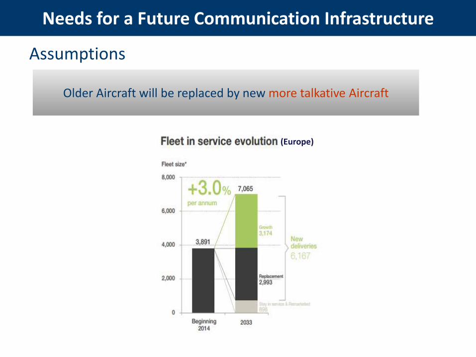
Needs for a Future Communication Infrastructure
(Europe)
Older Aircraft will be replaced by new more talkative Aircraft
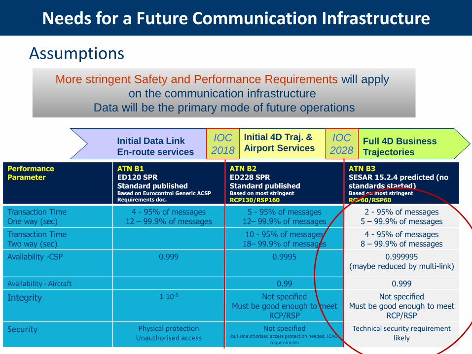
Needs for a Future Communication Infrastructure
Assumptions
PerformanceParameter
ATN B1ED120 SPR Standard publishedBased on Eurocontrol Generic ACSP Requirements doc.
ATN B2ED228 SPR Standard publishedBased on most stringent
RCP130/RSP160
ATN B3SESAR 15.2.4 predicted (no standards started)Based on most stringent
RCP60/RSP60
Transaction TimeOne way (sec)
4 - 95% of messages12 – 99.9% of messages
5 - 95% of messages12– 99.9% of messages
2 - 95% of messages5 – 99.9% of messages
Transaction TimeTwo way (sec)
10 - 95% of messages18– 99.9% of messages
4 - 95% of messages8 – 99.9% of messages
Availability -CSP 0.999 0.9995 0.999995(maybe reduced by multi-link)
Availability - Aircraft 0.99 0.999
Integrity 1-10-5 Not specifiedMust be good enough to meet
RCP/RSP
Not specifiedMust be good enough to meet
RCP/RSP
Security Physical protectionUnauthorised access
Not specifiedbut Unauthorised access protection needed, ICAO
requirements
Technical security requirement likely
More stringent Safety and Performance Requirements will apply
on the communication infrastructure
Data will be the primary mode of future operations
Full 4D Business
Trajectories
Initial 4D Traj. &
Airport ServicesInitial Data Link
En-route services
IOC
2018
IOC
2028

Needs for a Future Communication Infrastructure
Assumptions
At some term, current VDL Mode 2 infrastructure might not be sufficient
to support the increased data traffic, and the more stringent Safety
and Performance requirements

Needs for a Future Communication Infrastructure
Assumptions
Future ATM concept introduces new ATM services
that will be demanding in data exchanges
Air traffic will continue growing
Older Aircraft will be replaced by new more talkative Aircraft
More stringent Safety and Performance Requirements will apply
on the communication infrastructure
Data will be the primary mode of future operations
(voice only for emergency)
At some term, current VDL Mode 2 infrastructure might not be sufficient
to support the increased data traffic, and the more stringent Safety
and Performance requirements

Needs for a Future Communication Infrastructure
Conclusions
Better performances will be needed
No single comm. technology meets all requirementsacross all operational flight domains
A Future Communication Infrastructure (FCI) Will be required !
New data communication services will be requiredto enable the key SESAR principles
Use of scarce available spectrum must be optimized
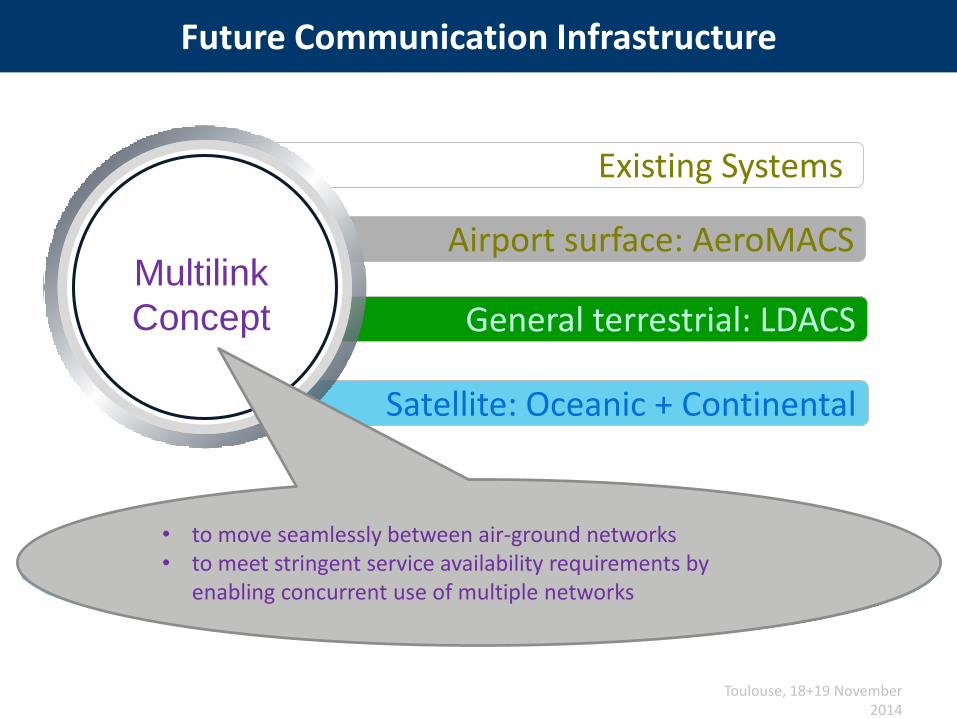
Future Communication Infrastructure
Toulouse, 18+19 November 2014
Existing Systems
Airport surface: AeroMACS
General terrestrial: LDACS
Satellite: Oceanic + Continental
Multilink
Concept
• to move seamlessly between air-ground networks• to meet stringent service availability requirements by
enabling concurrent use of multiple networks

Aircraft already carry many radios
31
Aircraft Control Domain
(ACD)
Airline Information Services Domain(AISD)
Passenger Information and Entertainment Services Domain
(PIESD)
CO
MN
AV
SU
RV
VHF x3 HF x2 SATCOM
INMARSAT
Or IRIDIUM
WIFI
Cellular 3G/3G+
Ku Satcom
Air-to-Ground Cellular
ILS x2 DME x2
XPDR / MODE S / ADS-B x2
GNSS x2
ADF VOR RA x2
Weather Radar

Issue : additional radios imply more penalties
32
Aircraft Control Domain
(ACD)
Airline Information Services Domain(AISD)
Passenger Information and Entertainment Services Domain
(PIESD)
NA
VS
UR
V
ILS x2 DME x2
XPDR / MODE S / ADS-B x2
GNSS x2
ADF VOR RA x2
Weather Radar ADS-B
CO
M VHF x3 HF x2 SATCOM
INMARSAT
Or IRIDIUM
WIFI
Cellular 3G/3G+
Ku Satcom
Air-to-Ground CelullarTerrestrial
LDACSSatellite
IRISAirport Surface
AeroMACSCellular 4G/5G Ka Satcom
Hybrid S-Band Sat / Air-to-Ground
INMARSAT European Comm. System
Additional radios => Penalties: Weight / Volume / Electrical Power / Cooling/ Costs / More sources
of unreliability /obsolescence risk/Spares to be
stored / ...

Solving the « more radios-less penalties » equation
33
Costs, size, weight and power must
be reduced
More radios needed
Use of Software Defined Radios (SDR)
Could help solving this equation
Under Study within project SESAR 9.44:
Project scope
• Investigate the technical and business feasibility, for new on-board flexible radio
architectures and equipment (such as SDR)
• Develop prototypes of candidate solutions and validate.
Partners:AIRBUS (Project Manager)
ALENIA HONEYWELL SELEX
Decommissioning / Rationalisation of
older radios

• Conventional federated radios architectures
Flexible radios architecture principles
PA/LNA
in ceiling
Transceiver in
Avionics bay
Transceiver in
Avionics bay
Antenna
Feeder/Coax
Coax
RF Section
(amplification, filtering, analog
up/down conversion, channel
selection,….)
Baseband
Section
( digital down/up conversion,
modulation/demodulation,
coding/decodong, …)
RF SectionHigh frequencies (carrier) Analog
Baseband SectionLower frequenciesMore and more Digital Signal Processing
DAC ADC
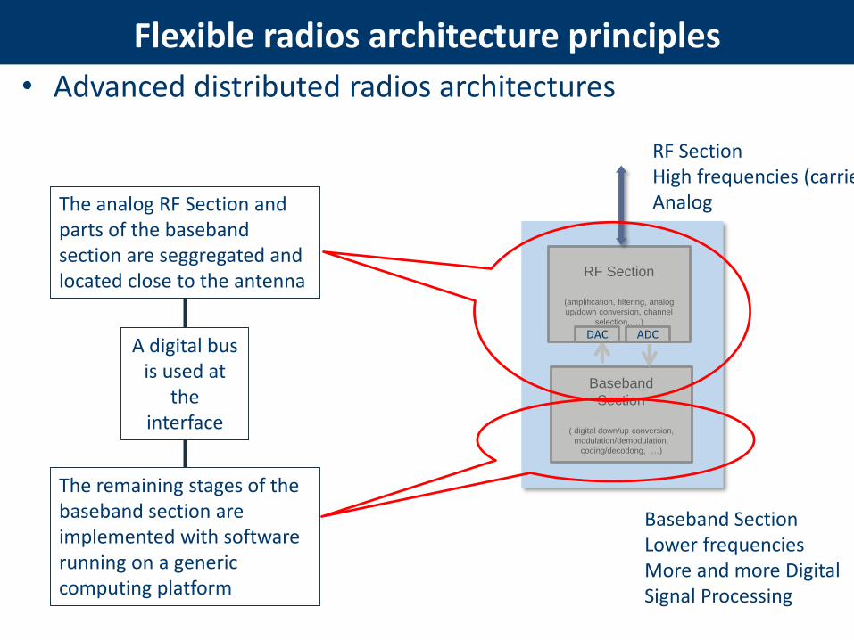
• Advanced distributed radios architectures
Flexible radios architecture principles
RF Section
(amplification, filtering, analog
up/down conversion, channel
selection,….)
Baseband
Section
( digital down/up conversion,
modulation/demodulation,
coding/decodong, …)
RF SectionHigh frequencies (carrier) Analog
Baseband SectionLower frequenciesMore and more Digital Signal Processing
DAC ADC
The analog RF Section and parts of the baseband section are seggregated and located close to the antenna
The remaining stages of the baseband section are implemented with software running on a generic computing platform
A digital bus is used at
the interface

• Advanced distributed radios architectures
Flexible radios architecture principles
RF Section
(amplification, filtering, analog
up/down conversion, channel
selection,….)
Baseband
Section
( digital down/up conversion,
modulation/demodulation,
coding/decoding, …)
RF SectionHigh frequencies (carrier) Analog
Baseband SectionLower frequenciesMore and more Digital Signal Processing
DAC ADC
Generic
Radio software
Computing platform
Antenna
Feeder/Coax
Digital
link
RF Front
End

• Advanced distributed radios architectures (benefits)
Flexible radios architecture principles
Generic
Radio software
Computing platform
Antenna
Feeder/Coax
Digital
link
RF
Frond
End
Benefits:
• Simplified RF section• Reduced signal amplification• Better Signal/Noise Ratio • Weight/costs savings
• Simplified Aircraft Wiring• Reduction of interference issues• Thinner, lighter, and bundled digital cables• Reduction of installation burden
• Computing platforms can be reused/sharedto host software of different radios
• Platform costs factorization • Weight/size/power reduction with multi-radio
basebands integration,• Flexibility for evolutions (software update)
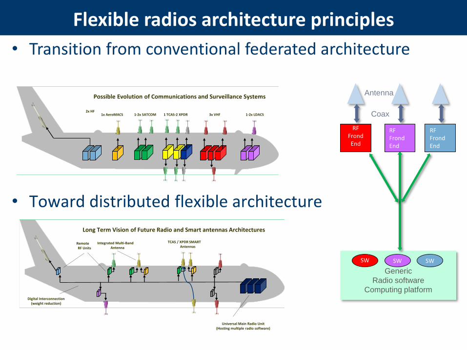
• Transition from conventional federated architecture
• Toward distributed flexible architecture
Flexible radios architecture principles
Generic
Radio software
Computing platform
Antenna
Coax
RF FrondEnd
1-2x LDACS3x VHF1-2x SATCOM1x AeroMACS2x HF
Possible Evolution of Communications and Surveillance Systems
Universal Main Radio Unit(Hosting multiple radio software)
Integrated Multi-BandAntenna
Remote RF Units
Digital Interconnection(weight reduction)
Long Term Vision of Future Radio and Smart antennas Architectures
1 TCAS-2 XPDR
TCAS / XPDR SMARTAntennas
SW
RF FrondEnd
RF FrondEnd
SW SW
• New data communication services Will be required to enable the key SESAR principles
• Aircraft will have to be equipped with additional radios
• Software Defined Radios technologies may provide flexibility to upgrade Aircraft radios
• Software Defined Radios technologies may ease transition to new spectrum-efficient radio technologies
Conclusions
39

Ana Bodero Alonso, ENAIRE
Navigation: GNSS Needs and Challenges

Agenda
• GNSS Systems for Navigation.
• Current Use of GNSS Signals in Navigation.
• GNSS SESAR Projects.
• Main Threats for GNSS Based Navigation.
• Interference Detection and Reporting in GNSS.
• Mitigation of GNSS Threats.
• GNSS Standards for Repeaters/Jammers.
41

16/03/2015
42
GNSS Systems for Navigation

43
16/03/2015
GPS – Global Positioning System.
Position, navigation and time everywhere with 4 o more satellites in view.
GNSS Systems for Navigation
Space Segment 32 satellites
Ground Segment ground stations for monitoring and control
Owner Department of Defense (DoD) (USA)
Service Provider National Executive Committee for Space-Based PTN (USA)
44
16/03/2015
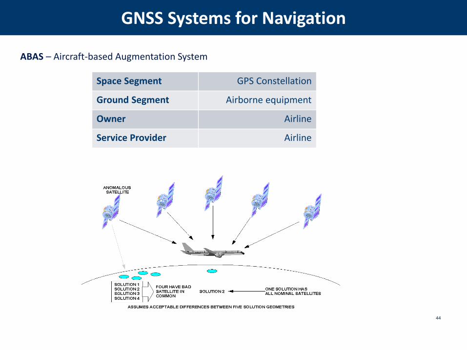
ABAS – Aircraft-based Augmentation System
GNSS Systems for Navigation
Space Segment GPS Constellation
Ground Segment Airborne equipment
Owner Airline
Service Provider Airline

45
16/03/2015
SBAS – Satellite Based Augmentation System.
In Europe: EGNOS (European Geostationary Navigation Overlay Service).
GNSS Systems for Navigation
Space Segment GPS Constellation + 3 GEO Satellites
Ground Segment world network of stations and centers
Owner European Commission
Service Provider ESSP
46
16/03/2015
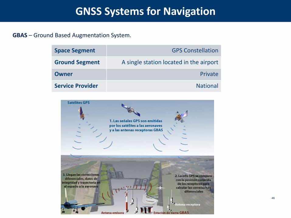
GBAS – Ground Based Augmentation System.
GNSS Systems for Navigation
Space Segment GPS Constellation
Ground Segment A single station located in the airport
Owner Private
Service Provider National
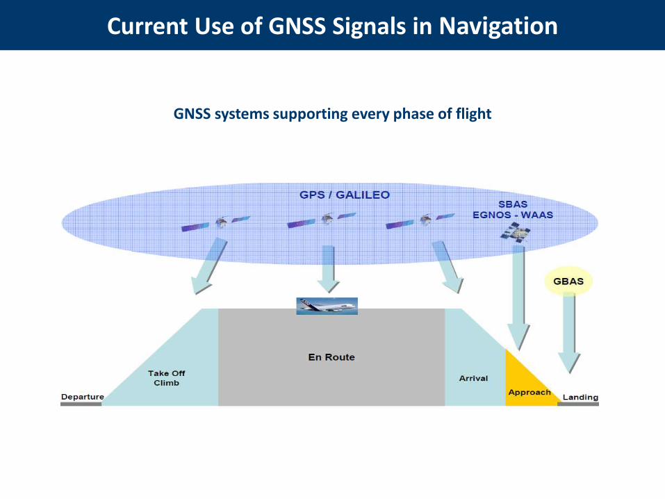
Current Use of GNSS Signals in Navigation
GNSS systems supporting every phase of flight

48
GNSS signals are continuously used in Europe for Air Navigation in every phase of flight.
There is a need to protect GNSS signals in order to guarantee the correct behaviour of:
Airborne GNSS navigation equipment, especially in the arrival and approach phases of flight.
EGNOS ground infrastructure, needed to build the EGNOS signals.
GBAS installations supporting CAT I precision approach services.
GPS national receivers for GNSS performance monitoring purposes.
Current Use of GNSS Signals in Navigation

5.6.3 Approach Procedure with Vertical Guidance (APV)
6.8.5 6.8.8
GBAS operationalimplementation / Enhanced arrival procedures to reduce occupancy time using GBAS
15.3.4 GNSS Baseline study
15.3.6GBAS Cat II/III L1 Approach
15.3.7 Multi GNSS CAT II/III GBAS
49
GNSS SESAR Projects
15.3.4 Task 6 - GNSS Vulnerability Assessment
15.3.6 Task 32.5 - GNSS Repeater Study
(ongoing)
15.3.7 Task ST3.4C – Environment
Interference (ongoing)
50
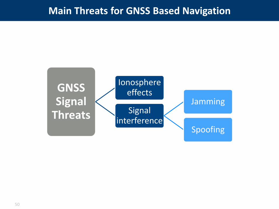
Main Threats for GNSS Based Navigation
GNSS Signal
Threats
Ionosphere effects
Signal interference
Jamming
Spoofing

• Ionosphere effects:
– Considered as a threat during severe to extreme ionosphere storms.
– Potential loss of GNSS navigation for a contained geographical area and a limited timescale.
– Most vulnerable flight procedures: SBAS/LPV NPA, GBAS precision approach CAT I, II,III. Degradation of position accuracy and loss of receiver lock.
– Severe to extreme ionosphere storms happen statistically one to ten times during an11-year solar cycle.
– Impact on aviation operations happens more often at high and low latitudes.
– Next ionospheric peak predicted around 2023.
– Need to achieve robustness against single frequency loss and loss of constellation.
51
Main Threats for GNSS Based Navigation

• Signal Interference:
– Considered a risk for all GNSS-based aviation operations.
– GPS aviation receivers susceptible to interference caused by:
• PPD (jammers),
• Industrial/commercial in or out of band emissions,
• PED carried onboard aircraft,
• GNSS repeaters (spoofing).
– Anti-spoofing techniques are normally a military technology, not yet available for civilusers.
– Intentional jamming is relatively easy to achieve.
52
Main Threats for GNSS Based Navigation

ICAO/NSP (Navigation Systems Panel):
– To improve GNSS availability and performance.
– Global guidelines for GNSS signal supervision.
– Templates for interference reporting.
CEPT/ECC and ETSI:
– To normalize the use of GNSS repeaters for commercialapplications.
– Criteria to evaluate compatibility between aviation andno-aviation services.
16/03/2015
53
Interference Detection and Reporting in GNSS
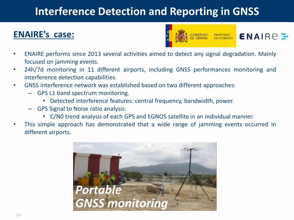
Interference Detection and Reporting in GNSS
ENAIRE’s case:
• ENAIRE performs since 2013 several activities aimed to detect any signal degradation. Mainlyfocused on jamming events.
• 24h/7d monitoring in 11 different airports, including GNSS performances monitoring andinterference detection capabilities.
• GNSS interference network was established based on two different approaches:– GPS L1 band spectrum monitoring.
• Detected interference features: central frequency, bandwidth, power.– GPS Signal to Noise ratio analysis:
• C/N0 trend analysis of each GPS and EGNOS satellite in an individual manner.• This simple approach has demonstrated that a wide range of jamming events occurred in
different airports.
54
Portable GNSS monitoring

• Ionosphere effects:
– Use of NOTAM (predictive and reactive).
– Other navigation means or back up should be available.
– For GBAS CAT I, ground subsystem is responsible for mitigating iono effect.
– For GBAS CAT II/III mitigation actions are performed both by airborne equipment and ground system.
– With MC/MF GBAS, the use of two different frequencies combined with a better signal structure for the new signals removes completely the ionospheric gradients.
– Future work expected in SESAR 2020 – PJ14.
55
Mitigation for GNSS Threats

• Signal Interference:
– PPD (jammers) affecting GBAS and RIMS -> GNSS receivers away from crowded highways (GBAS siting), illegal in most countries, SW and HW mitigations.
– Detect and identify their origin asap.
– ADS-B as a means of detecting GPS signal losses/corruption.
– MF/MC receivers are a good instrument to minimize jamming impact on aviation. With MC/MF GBAS, the possibility to process and monitor signals from two frequencies independently increases system robustness.
– Anti-spoofing: future authenticating augmentation signals.
– Repeaters: regulation needed including also suitable protection zone.
– Mitigation through improved technologies based on receiver and aircraft integration level.
56
Mitigation for GNSS Threats

57
ECC Recommendation (10)02.
“the use of radio frequencies by GNSS repeaters should be restricted to professional applications
for government associated agencies, and related stakeholders”
GNSS Standards for Repeaters/Jammers
It is convenient to develop specific standards to regulate the use of jammers and repeaters
ECC Recommendation (04)01.
“not allow the placing on the market nor the use of jammers except in the very limited context
of authorized use which may be permitted by a national legislation;”

Stéphane Marche, Honeywell
Surveillance Enablers: Optimisation of surveillance using ADS-B data
58
#SESAR @WorldATM_now

59
SURVEILLANCE: NEW TECHNIQUES TO OPTIMIZE SPECTRUM USAGE
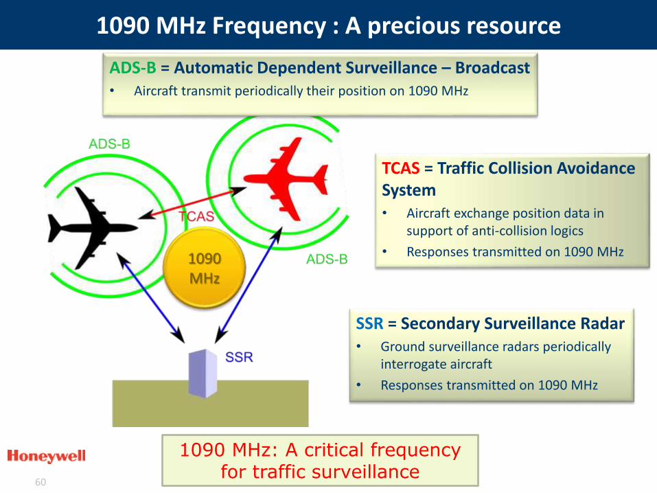
1090 MHz Frequency : A precious resource
60
TCAS = Traffic Collision Avoidance System• Aircraft exchange position data in
support of anti-collision logics
• Responses transmitted on 1090 MHz
SSR = Secondary Surveillance Radar• Ground surveillance radars periodically
interrogate aircraft
• Responses transmitted on 1090 MHz
1090 MHz: A critical frequency for traffic surveillance
ADS-B = Automatic Dependent Surveillance – Broadcast• Aircraft transmit periodically their position on 1090 MHz
1090 MHz

ADS-B: Automatic Dependent Surveillance Broadcast• Short term: Backward Compatible solutions:
– SESAR Project led by Honeywell with Eurocontrol and Airbus
– Objective: Improve ADS-B message reception in case of congestion
– Defined, prototyped and validated 3 mitigation techniques to increase probability of correct reception
• Long term: Radical link evolutions to reduce spectrum usage
SESAR addresses 1090 MHz Congestion
61
Backward compatible mitigations improve ADS-B reception by ~20%
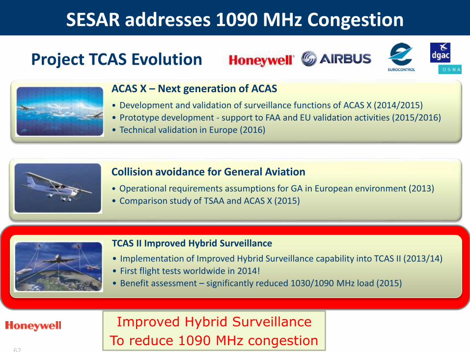
Project TCAS Evolution
SESAR addresses 1090 MHz Congestion
62
Improved Hybrid Surveillance
To reduce 1090 MHz congestion
TCAS II Improved Hybrid Surveillance
• Implementation of Improved Hybrid Surveillance capability into TCAS II (2013/14)
• First flight tests worldwide in 2014!
• Benefit assessment – significantly reduced 1030/1090 MHz load (2015)
ACAS X – Next generation of ACAS
• Development and validation of surveillance functions of ACAS X (2014/2015)
• Prototype development - support to FAA and EU validation activities (2015/2016)
• Technical validation in Europe (2016)
Collision avoidance for General Aviation
• Operational requirements assumptions for GA in European environment (2013)
• Comparison study of TSAA and ACAS X (2015)
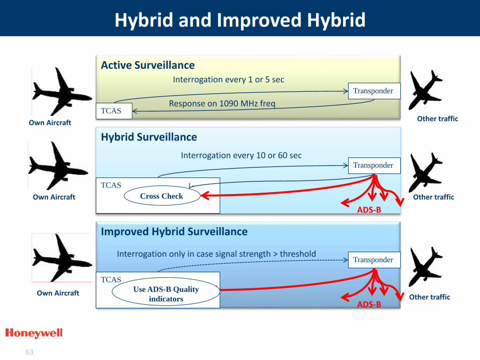
Hybrid and Improved Hybrid
63
Active Surveillance
TCAS
Transponder
Interrogation every 1 or 5 sec
Response on 1090 MHz freq
Own Aircraft Other traffic
TCAS
Transponder
Hybrid Surveillance
Interrogation every 10 or 60 sec
ADS-B
Cross CheckOwn Aircraft Other traffic
TCAS
Transponder
Improved Hybrid Surveillance
Interrogation only in case signal strength > threshold
ADS-B
Use ADS-B Quality
indicatorsOwn Aircraft Other traffic

Validation exercises in SESAR
64
Roof-top testing
2014
RF load reduction simulations
2015
Aug 2014: First flight
test worldwide!Flight testing
• Aug 2014, Oct 2014, Apr 2015
• Toulouse area
System confirmed as functional
Requirements met
Correct surveillance methods
behavior & transitions
RF Load Savings: 71%
Results depend on
the environment
Savings up to 89%
Honeywell Improved Hybrid Surveillance prototype

Complementary flight tests with Honeywell B757
65
2015
Oct 2015
2016
Birmingham -> Helsinki -> Island -> Acores
RF load savings: 83%
19 Jan 2016Cross European Flight
RF load savings: 86.5%
Opportunity flights confirm benefits in various European environments

Conclusion
66
• 1090 MHz frequency load should be monitored
– any congestion would result in serious safety and capacity issues that cannot be fixed immediately
• Improved Hybrid Surveillance benefits validated in SESAR
– > 80% reduction of TCAS use of 1090 MHz frequency
– Probably translates into >40% of 1090 MHZ RF load reduction
• Backward compatible solution
– Utilizes current infrastructure and minimizes additional investment to protect spectrum
1090 MHz
Efficient mitigation solution validated in SESAR
John MettropUK Civil Aviation Authority
Chair Aeronautical Spectrum Frequency Consultation Group &International Telecommunication Union Working Party 5B
SPECTRUM CHALLENGES & WORLD RADIOCOMMUNICATION
CONFERENCE
#SESAR @WorldATM_now
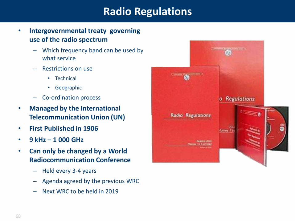
Radio Regulations
• Intergovernmental treaty governing use of the radio spectrum
– Which frequency band can be used by what service
– Restrictions on use
• Technical
• Geographic
– Co-ordination process
• Managed by the International Telecommunication Union (UN)
• First Published in 1906
• 9 kHz – 1 000 GHz
• Can only be changed by a World Radiocommunication Conference
– Held every 3-4 years
– Agenda agreed by the previous WRC
– Next WRC to be held in 2019
68

What is a WRC?
• Purpose– To revise the Radio Regulations
– To address any radiocommunication matter of worldwide character
– To review & direct to the activities of the Radiocommunication Bureau
– To determine the agenda for the next WRC
• WRC-15 By the Numbers– Approximately 4100 Registered Delegates
Representing 156 Administrations, 6 UN Agencies & 105 other operating agencies
– 4 Weeks in Length
– Budget of £4.7M (excluding delegate costs)
– Interpretation/Translation into 6 Languages
– 33 Agenda Items• 7 Committee’s, 9 Working groups & 82 other groups• 503 Contributions• 1105 Scheduled meetings ( ≈1500 hours)• Peak day 77 scheduled meetings totalling 98 hours• Longest Plenary: 09:00 25th – 22:00 26th with 3x2 hour breaks
69

Major Results for Aviation from WRC-15
• Global Flight Tracking/ ADS-B via Satellite– Spectrum allocation
– Cannot claim protection from existing systems
• Remotely Piloted Aircraft – Potential frequency bands
– Operate on a non-protected, no interference basis
– Studies to be completed
– No use before 2023
• Wireless Avionics intra-communication
– Allocation in the band used by radio altimeters
– Must protect radio altimeters
• Aviation allocations not affected by IMT outcome
70
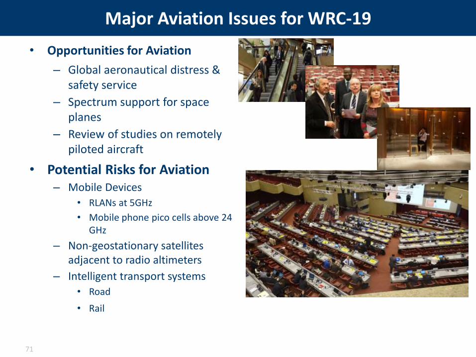
Major Aviation Issues for WRC-19
• Opportunities for Aviation
– Global aeronautical distress & safety service
– Spectrum support for space planes
– Review of studies on remotely piloted aircraft
• Potential Risks for Aviation– Mobile Devices
• RLANs at 5GHz
• Mobile phone pico cells above 24 GHz
– Non-geostationary satellites adjacent to radio altimeters
– Intelligent transport systems
• Road
• Rail
71

Who is Involved Regionally for WRC?
72
Inter-American Telecommunication
Commission (35)
European Conference of Postal and Telecommunications Administrations (46)
Asia-Pacific Telecommunity
(35)
African Telecommunications
Union (46)
League of Arab States (22)
North Atlantic Treaty Organization (26)
Caribbean Telecommunications Union
(15)
Regional Commonwealth in
the Field of Communications
(12)
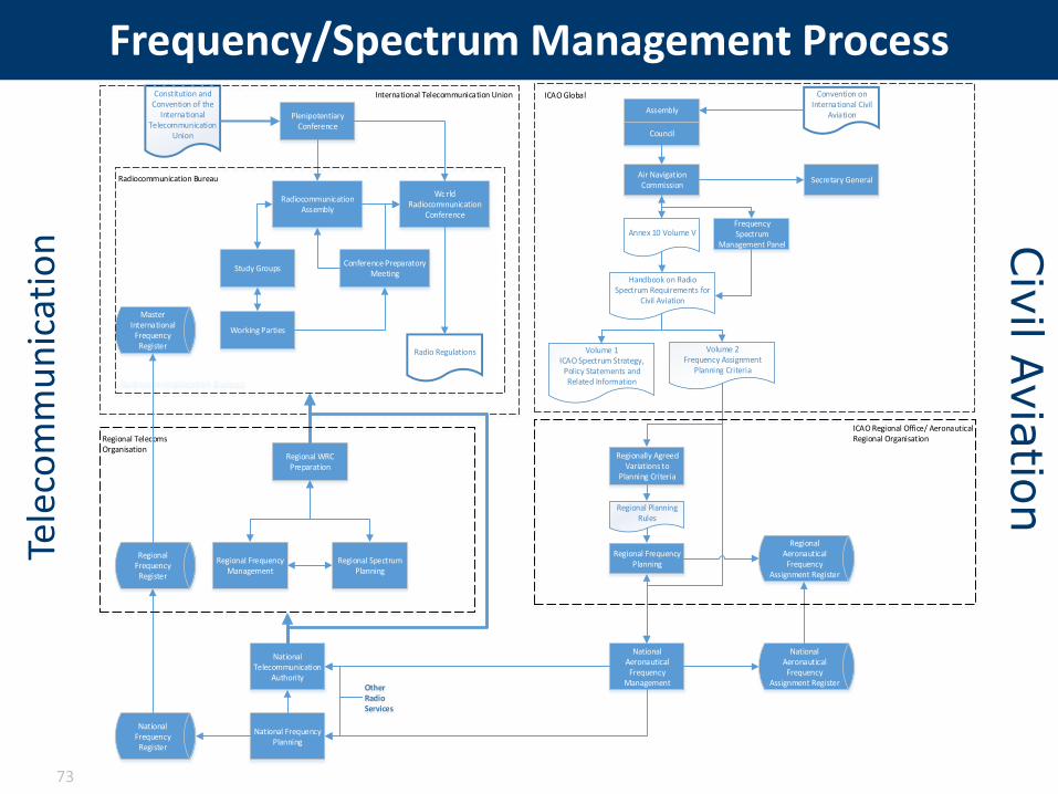
Frequency/Spectrum Management Process
73
Radio Regulations
World Radiocommunication
Conference
Study Groups
Working Parties
Conference Preparatory Meeting
Radiocommunication Assembly
Constitution and Convention of the
International Telecommunication
Union
Plenipotentiary Conference
Convention on International Civil
AviationAssembly
Council
Air Navigation Commission
Secretary General
Frequency Spectrum
Management Panel
Annex 10 Volume V
Handbook on Radio Spectrum Requirements for
Civil Aviation
Volume 1ICAO Spectrum Strategy,
Policy Statements and Related Information
Volume 2Frequency Assignment
Planning Criteria
Regionally Agreed Variations to
Planning Criteria
Regional Planning Rules
Regional Frequency Planning
Regional Aeronautical Frequency
Assignment Register
National Aeronautical Frequency
Management
National Telecommunication
Authority
National Aeronautical Frequency
Assignment Register
National Frequency Planning
National Frequency
Register
Other RadioServices
Regional WRC Preparation
Master International
Frequency Register
Regional Frequency Management
Regional Spectrum Planning
Radiocommunication Bureau
Radiocommunication Bureau
International Telecommunication Union ICAO Global
Regional Telecoms Organisation
ICAO Regional Office/ Aeronautical Regional Organisation
Regional Frequency
Register
Tele
com
mu
nic
atio
n Civ
il Avia
tion
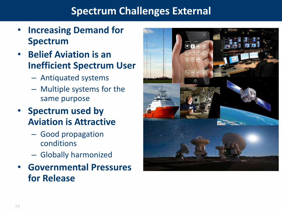
Spectrum Challenges External
• Increasing Demand for Spectrum
• Belief Aviation is an Inefficient Spectrum User– Antiquated systems
– Multiple systems for the same purpose
• Spectrum used by Aviation is Attractive– Good propagation
conditions
– Globally harmonized
• Governmental Pressures for Release
74

Spectrum Challenges Internal
• Belief that Aviation Owns the Spectrum
• How to Modernise the ATM system– Understanding of the long term goal
(2050+)– Globally harmonization– Rationalisation of systems– Removal of redundant systems
• Integration of New Technologies – Remotely piloted aircraft– Space planes
• How to Make Spectrum an Early Consideration
• Avoiding Own Goals– Placing all our systems in the same
frequency band– Don’t set un-necessary precedents– False promises
• Resources– Experts– Funding for Research – Availability of Information
75
Raffi KhatcherianSenior ATM Expert, Spectrum Manager
EUROCONTROL DPS/POLSESAR WP15.01.06 Spectrum Project Manager
SESAR SPECTRUM STRATEGY AND VISION
#SESAR @WorldATM_now

Spectrum is like a piece of land allocated for a duly justified purpose and limited duration
77

But when the demand exceeds the offer
78
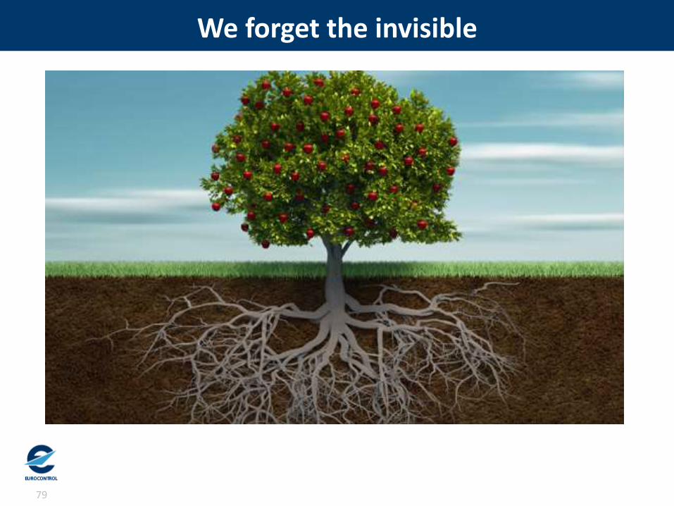
We forget the invisible
79
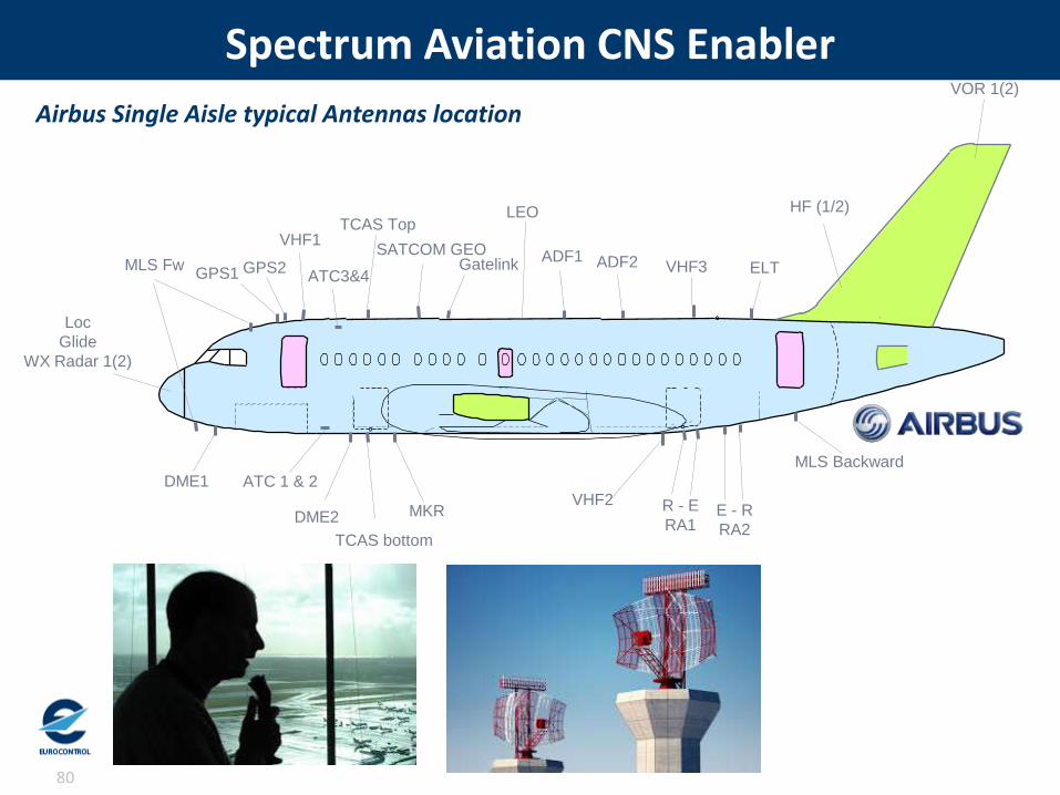
Spectrum Aviation CNS Enabler
80
GPS1 GPS2
VHF1
ATC3&4
TCAS Top
SATCOM GEOGatelink
ADF1 ADF2 VHF3 ELT
DME1 ATC 1 & 2
DME2
TCAS bottom
MKRVHF2 R - E
RA1E - R
RA2
VOR 1(2)
HF (1/2)
Loc
Glide
WX Radar 1(2)
LEO
MLS Fw
MLS Backward
Airbus Single Aisle typical Antennas location

• Secure the long-term availability of suitable radio spectrum to meet all of aviation's future objectives through cooperative engagement in the global spectrum environment.
• The Network manager will prepare and coordinate the network strategic spectrum aspects that will be documented in the NOP and NSP
SESAR and NM Spectrum Vision and Strategy
81

• Create a framework which will deliver benefits to aviation and enable the sector to react effectively to external influences in a changing external spectral environment.
The Approach
82

• Aeronautical spectrum allocations will continue to be under significant pressure from other sectors for the foreseeable future.
• New spectrum bands for aviation use are unlikely to be made available.
• The assignment and use of spectrum within a State will remain a sovereign issue and voting rights at ITU World RadiocommunicationConferences will remain only with Member States.
Assumptions
83
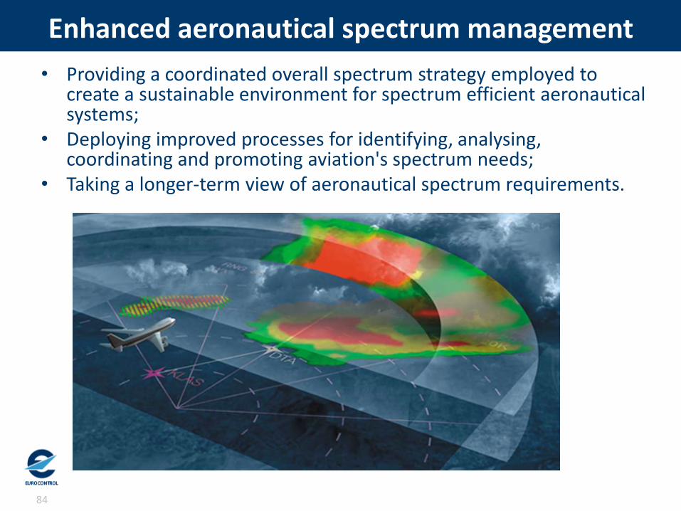
• Providing a coordinated overall spectrum strategy employed to create a sustainable environment for spectrum efficient aeronautical systems;
• Deploying improved processes for identifying, analysing, coordinating and promoting aviation's spectrum needs;
• Taking a longer-term view of aeronautical spectrum requirements.
Enhanced aeronautical spectrum management
84

• Providing spectrum expertise for ACNS teams to ensure an inter-discipline approach to development, deployment and removal of outdated aeronautical systems;
• Promoting the development of spectrally efficient ACNS systems to minimise the demand for additional spectrum to support future aviation growth;
• Promoting the withdrawal of obsolete and redundant systems in compliance with the future deployment programme.
Holistic Avionics+CNS&S (ACNS&S) approach
85
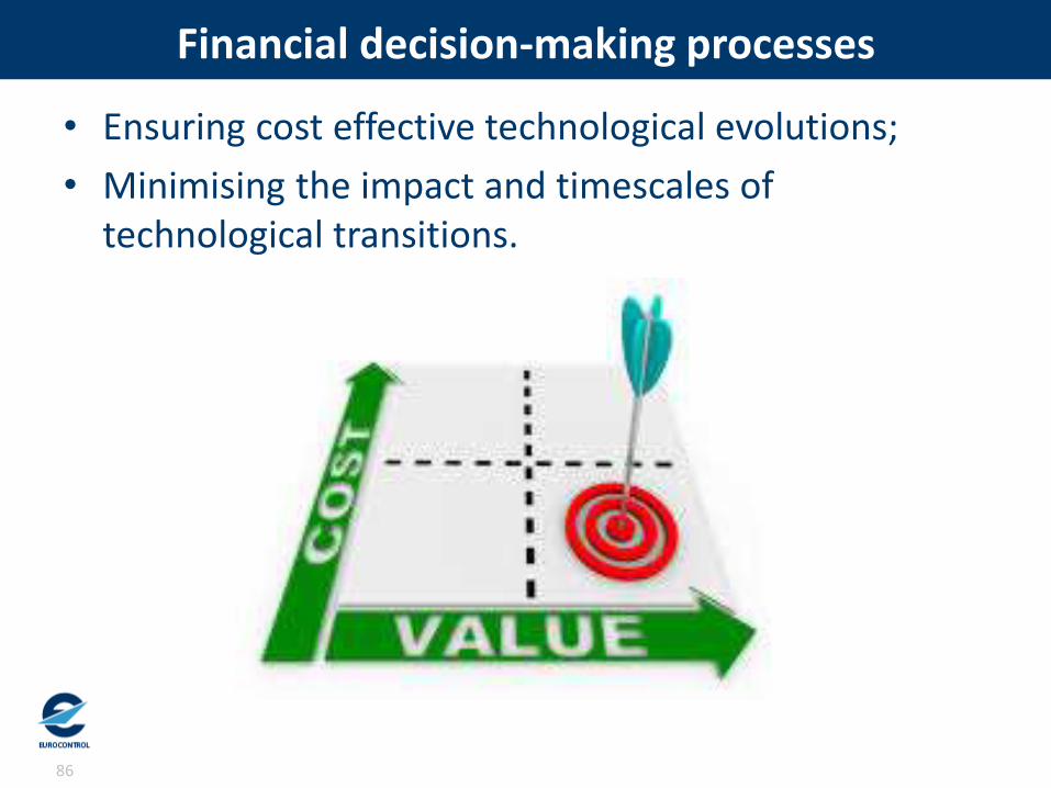
• Ensuring cost effective technological evolutions;
• Minimising the impact and timescales of technological transitions.
Financial decision-making processes
86

• SESAR recognised the importance and supported the development of the aviation spectrum vision and long term strategy
• Increased coordination on spectrum issues with different CNS&S panels
• Increasing support to add spectrum into the Global Air Navigation Plan
From SESAR to ICAO
87

CONCLUSION
Marouan CHIDA
SJU
88
#SESAR @WorldATM_now

System interoperability with air & ground data sharing
Business & Mission trajectoriesFree Routing
Trajectory Management Framework
Enhanced Ground-based Safety Nets
Enhanced ACAS
Ground-Based Separation
Provision
Airspace Management and AFUA
Enhanced ATFCM Process
Network Operations Planning
User-DrivenPrioritisation Process
Dynamic Airspace Configurations
Integrated Arrival/Departure Management at Airports
Enhanced Arrival & Departure Management in TMA and En Route
ASAS Spacing
Optimised 2D/3D Routes
Approach Procedures with Vertical Guidance
Integrated Surface Management
Airport Operations Management
Enhanced Runway ThroughputEnhanced situational awareness
Pilot EnhancedVision
Low Visibility procedures using GBAS
Airport safety nets
Air Traffic Control Centre
The SESAR Operational Concept
WAC 2016Page 89
The session14:00 – 14:10 Setting the scene: SESAR solutions and aviation spectrum
Marouan Chida, SESAR JU
14:10 – 14:25 Communication Enablers: Multilink and software defined radiosStéphane Tamalet, Airbus
14:25 – 14:40 Navigation Enablers: GNSS needs and challengesAna Bodero Alonso, ENAIRE
14:40 – 14:55 Surveillance Enablers: Optimisation of surveillance using ADS-B data Stéphane Marche, Honeywell
14:55 – 15:10 Spectrum challenges (from a European and global standpoint)John Mettrop, UK CAA
15:10 – 15:25 How SESAR deals with spectrum Raffi Khatcherian, Eurocontrol
15:25 – 15:30 Conclusions & Q&AMarouan Chida, SESAR JU
WAC 201690

Conclusion
SESAR is the major ATM transformation programme in Europe
SESAR has developed advanced technological solutionsto improve the performance and efficiency of ATM
Allocation of suitable radio Spectrum is essential
SESAR is coordinating global aviation spectrum needs today and with a view of the future spectrum strategy
WAC 201691
Thank you !
WAC 201692

Thanks for your attention
93


