29
Southern Shan Plateau Expedition Report 2010 Hopong Region
| Date post: | 13-Jul-2018 |
| Category: |
Documents |
| Upload: | phungthuan |
| View: | 217 times |
| Download: | 0 times |

Southern Shan Plateau Expedition Report
2010
Hopong Region

ii
Report compiled by Imogen Furlong, Fleur Loveridge, Pete Talling and Phil Roswell, July 2010
Report revised November 2010.
For further information please contact: [email protected]
Cover Photograph: the expedition team in Stone Scripture Cave

iii
Contents
INTRODUCTION 2�
LOGISTICS 2�
Travel and Permits 2�
Base Camp 3�
Surveying 3�
Publication 3�
HTAM SAM AREA 4�
Htam Sam Cave 4�
Kyauk Sa (Stone Scripture) Cave 5�
Ganbiya Gu (Supernatural Cave) 5�
Barefoot River Cave 5�
Thaye Gu (Ghost Cave) 5�
Kyu-wa Gu (Water Buffalo Cave) 5�
Gold Pot 6�
Gawpin Gu (Unexplored Enrtrance) 6�
PARPANT AREA 8�
White Water Buffalo and Tiger Cave 8�
Happy Monk Cave 8�
OTHER CAVES EXPLORED 10�
Muddy Waters Cave 10�
Undersold/Overlooked Cavp 10�
Truck Stop Chock Cave 10�
ENVIRONMENT 12�
Geology and Geomorphology 12�
Hydrology and Hydrogeology 13�
Weather 14�
REFERENCES 15�
SPELEOLOGICAL GLOSSARY 15�

1
Figure 1 Phil Rowsell and Fleur Loveridge surveying in Stone Scripture Cave
Figure 2 Yan Naing in the Beautiful Stone Scripture Cave

2
Introduction
In January 2010, four independent cavers from the United Kingdom, Imogen Furlong, Dr Phil Rowsell, Fleur Loveridge and Dr Peter Talling journeyed to the Hopong area of the Southern Shan State to explore and map the region’s caves. They spent 15 days exploring caves along the road NH4 that runs from Taunggyi to the Htam Sam Cave, including an area near Parpant village. They concentrated their efforts in the area of Htam Sam and Hopong Spring. This is an area not visited by foreigners for some decades, and it is understood to be the first caving expedition to this area. However, many of the caves are of spiritual significant and are consequently well known to the local population.
The January 2010 expedition came about as a result of the 2009 reconnaissance by Dr Joerg Dreybold to the southern part of Myanmar and his subsequent expedition lecture at the Hidden Earth Conference in 2009. Imogen Furlong, attended this lecture and set up the Southern Shan Plateau 2010 expedition. The main focus of Htam Sam cave, lying as it does in a restricted area of the Southern Shan State, was suggested from an Air Bagan inflight magazine article.
Logistics
Travel and Permits
Mr Phyoe Wai Yar Zar, the managing director of All Asia Exclusive, facilitated permits, transport and guides for the expedition. The team entered Myanmar from Bangkok, arriving by air into Yangon. Direct air transfer was then made to Heho, from where a short taxi journey reached Taunggyi, capital of the Southern Shan State, and base camp for the expedition. Upon arrival in Taunggyi, the team were very promptly met by their guide.
The expedition guide Yan Naing and driver Dan Oo were both highly professional and exceptionally welcoming. We were very impressed with the quality of service and will be requesting their assistance in next year’s (Jan 2011) expedition to the same region.
In the course of the 2010 expedition many contacts have been made in the Taunggyi area. Most notably Ko Yin Lay the prominent Siador in Hopong region, has proved invaluable in helping the team to gain access to cave sites for exploration and mapping purposes.

3
Base Camp
The base camp was situated in Taunggyi at the Eastern Hotel, from where private hired transport was taken to the restricted region of Hopong each day. The team had to clear the immigration checkpoint and police checkpoint each day, and return to Taunggyi by 6pm each evening. The journey time was up to 2 hours each way each day depending on the precise location.
Surveying
All of the finds of the expedition were all GPS logged (see plans in Annex A) and surveyed to BCRA Grade 5. Surveys were conducted using hand held magnetic compass and clinometers with distances measured by tape measure. Surveys were hand drawn in the field and have subsequently been drafted using the software Adobe Illustrator. Copies of the surveys are included in Annex 2 of this report.
The area around Htam Sam was also subject to surface survey in order to provide an insight into the relationship between the main cave entrances in the area.
Publication
The initial findings of the reconnaissance to Hopong have been reported in Decent Magazine (Issue 214), the specialist caving magazine in the United Kingdom, (See Annex 3). In addition, a lecture and short film were presented to cavers from around the world at the Hidden Earth Conference in Leek, Derbyshire, United Kingdom on 26th September 2010.
Figure 3 Yan Niamg in Stone Scripture cave; Htam Sam Area

4
Htam Sam Area
Htam Sam Cave
Htam Sam is a large cave whose entrance is situated east of Hopong village along the NH4 Road. It has a sizable cave entrance of 10m by 10m. The cave has a vast collection of speleotherms and is a site of spiritual importance. At the time of visiting Htam Sam was being developed by Ko Yin Lay, a prominent Siador of the area, into a place of pilgrimage and worship.
The cave has a manually dug out floor which has been concreted in parts, with many walkways to facilitate access by pilgrims. A significant amount of landscaping has taken place with shrines, walls, and channels built for diverting the the active stream in the cave to allow easy pedestrian access. Building work within the cave was still underway in January 2010. The cave was surveyed to 586m where a man made dam causes impounding of the stream in a large lake. This was the limit of available access in 2010, but it is understood that the cave continues beyond for a significant distance. The team will request a return in January 2011 to allow further mapping of the cave to its source.
Figure 4 Htam Sam Temple Cave

5
Kyauk Sa (Stone Scripture) Cave
This cave is located approximately 100m further south from the Htam Sam cave entrance, and is also a cave of large proportions. There are very significant amounts of calcite deposit to be found in this cave. There is a noticeable draft to the entrance which runs through to another entrance on the other side of the NH4 road. This cave was mapped on 21st January 2010 and found to be 225m long entrance to entrance.
At the time of mapping this cave was not open to the public, but future plans for development had been made, and some preliminary building work had started at the site. At the time of visiting, excavations were underway at the southern entrance.
Ganbiya Gu (Supernatural Cave)
Located to the east side of the Htam Sam approach road, this entrance can be reached by walking up a 20m bank. The cave was surveyed on 24th January 2010 to a length of 163m. The passage starts in an easterly direction, turning abruptly south after 80m. A small squeeze at the end was explored to a fist sized hole emitting a strong draught, implying cave beyond. The cave also has a substantial density of speleothems and flowstone deposits as well as some fine helictite formations. At the time of mapping this cave was not open to the public.
Barefoot River Cave
West from Htam Sam the HatHti Creek sinks into the ground and an arched cave entrance can be found approximately 100m further downstream. This entrance leads into an active underground stream. The stream passage was explored both upstream to a sump and downstream to a junction. One way led to an open entrance doline adjacent to which the Htam Sam shops are located. The other way continues with the stream to a sump. The cave from the upstream sump to downstream sump measures 245m.
Thaye Gu (Ghost Cave)
This cave is located along the east bank of the HatHti Creek. It has a large fossil entrance and chokes with mud after a 20m. This cave was not surveyed.
Kyu-wa Gu (Water Buffalo Cave)
Located on the west (opposite) side of the valley to Thaye Gu this cave also had similar proportions. It is a dry fossil cave which soon chokes. This cave was not surveyed

6
Gold Pot
Gold Pot cave is located on the hillside 1km west of Htam Sam. It has a 5m wide vertical entrance shaft formed where the underlying phreatic development intersects the current topography. The shaft was descent for 15m landing into a mud filled chamber. This leads down and through a calcite constriction into an impressive calcite filled chamber. A noticeable change in temperature and humidity is apparent when moving from the entrance shaft to the chamber. In the floor of the chamber a further drop leads to a choked floor. The main passage has been blocked by calcite deposit. There are a number of delicate formations here. Evidence suggests this cave has not been visited before. The cave was surveyed and found to be 122m long.
Figure 5 Delicate formations found in Gold Pot
Gawpin Gu (Unexplored Entrance)
A small depression with several trees is the start of a small stream sink which subsequently disappears after 8m. A 3m climb down leads to another 3m climb down and possible way on if this is cleared loose stones. There was a good draught found here, blowing out strongly.

7
Figure 6 Fleur Loveridge in the Entrance to Gold Pot
8
Parpant Area
White Water Buffalo and Tiger Cave
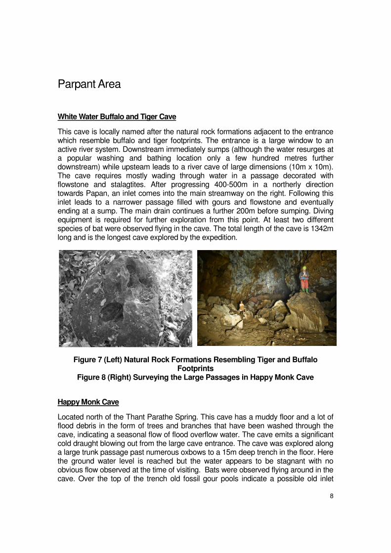
This cave is locally named after the natural rock formations adjacent to the entrance which resemble buffalo and tiger footprints. The entrance is a large window to an active river system. Downstream immediately sumps (although the water resurges at a popular washing and bathing location only a few hundred metres further downstream) while upsteam leads to a river cave of large dimensions (10m x 10m). The cave requires mostly wading through water in a passage decorated with flowstone and stalagtites. After progressing 400-500m in a northerly direction towards Papan, an inlet comes into the main streamway on the right. Following this inlet leads to a narrower passage filled with gours and flowstone and eventually ending at a sump. The main drain continues a further 200m before sumping. Diving equipment is required for further exploration from this point. At least two different species of bat were observed flying in the cave. The total length of the cave is 1342m long and is the longest cave explored by the expedition.
Figure 7 (Left) Natural Rock Formations Resembling Tiger and Buffalo Footprints
Figure 8 (Right) Surveying the Large Passages in Happy Monk Cave
Happy Monk Cave
Located north of the Thant Parathe Spring. This cave has a muddy floor and a lot of flood debris in the form of trees and branches that have been washed through the cave, indicating a seasonal flow of flood overflow water. The cave emits a significant cold draught blowing out from the large cave entrance. The cave was explored along a large trunk passage past numerous oxbows to a 15m deep trench in the floor. Here the ground water level is reached but the water appears to be stagnant with no obvious flow observed at the time of visiting. Bats were observed flying around in the cave. Over the top of the trench old fossil gour pools indicate a possible old inlet

9
passage since blocked by the precipitation of calcite. The cave was surveyed to a length of 429m on 25th/26th January 2010.
Hopong Spring Cave
Hopong Spring cave is located on the opposite side of the NH4 road at the Hopong Springs bathing site. Access is via a flight of concrete steps and descent of an earth slope. The cave has a large bat population and out of depth water in what is essentially one long rift passage. The cave was explored and surveyed on 28th
January 2010. The river passage continues to a sump, which can be bypassed by a muddy climb over the top. After regaining the river this continues for a further 20m before progress Is barred by flowstone descending to the water level. The rift passage continues above, but it was not possible to climb into this unaided. The total surveyed length to date is 127m. The volume of water suggests a long cave passage beyond, and it is anticipated that this is the final resurgence for the waters in the Parpant catchment. Consequently a return trip is planned in 2011.
Figure 9 Washing in Hopong Spring

10
Other Caves Explored
Muddy Waters Cave
This cave entrance is located at the end of a small active river bed on the north side of the NH4. A scramble up the bank to an entrance, where walk in sized passage leads to an active stream. This water, the continuation of the surface river, can be followed for some 25m down through a clean washed tube, until it becomes too tight to continue. (Passage is unsurveyed.)
Undersold/Overlooked Cavp
In this same area, another cave entrance is located at the terminus of the downstream dry river bed, likely to be the flood overflow for the water entering the ground at Muddy Waters Cave. A short scramble up leads to a dry entrance. A short drop to a muddy chamber leads to large walking sized passage with high mud banks. This was explored to a mud sump. Total surveyed length 168m.
Truck Stop Chock Cave
Located in the bottom of a large depression by the side of the NH4 road and at the end of a dry stream bed, next to limestone cliffs this cave entrance showed potential. However, it was found to be choked with flood debris and rocks. Some 2 hours was then spent prospecting in the area for other entrances at the base of the cliffs and in shakeholes and dolines within the dry valley. No further entrances were found. However the nature of the terrain and the steep dry valley gives an indication that there may be potential for a further reconnaissance in this vicinity.
Figure 10 Location of Truck Stop Chock Cave

11
Figure 11 Phil Rowsell shows KoYinLay the Surveys of Htam Sam Cave
Figure 12 Spectacular Formations in Gold Pot

12
Environment
Geology and Geomorphology
The Permian and Triassic carbonate sequences of Eastern Myanmar are extensive and large tracts of the Shan Plateau are comprised of these sediments (Figure 13). Although the main lithology throughout is limestone, this is often dolomitic rather than calcitic. The stratigraphy and ages of these deposits were uncertain for some time, with the major carbonate units variously referred to as the Plateau Limestone, eg in [1], or the Shan Dolomite Group, eg [2], in older publications. More recently, a revised stratigraphic assessment has been made [3] which divides the carbonates into two main units:
1. The Thitsipin Limestone Formation, named for a type section at Thitsipin
village near the township of Ye-ngan in the Southern Shan State. The
Formation comprises five main lithofacies:
a. Poorly bedded conglomerate
b. Laminated calcareous shale and other fined grained carbonate
sediments
c. Massive fined grained calcareous sediments
d. Thick bedded calcareous sandstone with some calcareous mud
e. Massive or poorly bedded cherty wackestone (matrix supported
calcareous grains within carbonate mud)
Some sections of the formation are partially dolomitised and comprise fine
grained dolomite.
2. The Thitsipine Limestone Formation then passes transitionally upwards
into the Nwabangyi Dolomite Formation
a. Calcareous conglomerate and sandstone with some carbonate
mud.
b. Poorly bedded dolomitic wackestone
c. Thin bedded dolomitc and bioclastic wackestone
d. Thinly laminated turbitic dolomitic mudstone
The formation often suffers from shattered and brecciation.
The overlying Permian limestones tends to be more crystalline and less sandy than the underlying Devonian strata. The younger limestones also contain a greater proportion of calcium carbonate, up to 98% [4].
The sequence of carbonate rocks is thought to be of considerable thickness, with estimates in the range of 5000ft (approximately 1650m) in the Northern Shan State [1] and up to 1000m in the Southern Shan State [5].

13
The presence of these abundant carbonate beds has a major impact on the scenery in the Shan States, leading to “dramatic scarp and ridge scenery and with spectacular karstic features” [3]. The carbonates that form the Shan Plateau also form a natural geographic break between the elevated and cooler plateau states and the hotter lowlands to the east.
3 Zin Taung 4 Sedawgyi Dam 5 Thipaw 6 Mandalay 7 Tonbo Range 8 Pyinoolwin 9 Dattaw Range 10 Magyiye area 11 Lungyaw 12 Kubyin-Lebyin 13 Nwabangyi 14 Thitsipin 15 Linwe-Sin area 16 Ywangan 17 Taunggyi 18 Loikaw
Figure 13 Extent of the Permian and Triassic Carbonates in Eastern Myanmar
Hydrology and Hydrogeology
Most of the caves explored comprise large phreatic passages that would have been formed when the local groundwater table was at a higher elevation. Theses passages are now either dry (for example Stone Scripture Cave and Supernatural Cave) or have been capture by the present hydrological system (eg Barefoot River Cave, Htam Sam). In many cases the current water courses are “misfit” to these older passages or in some cases use them only in the rainy season as flood overflow routes (eg Undersold Cave). In Happy Monk Cave this recent flood overflow function has cut down through the old phreatic passage to intersect the current water table.

14
Many of the active stream caves end in sumps, where the current water table is coincident with the old phreatic level, or when the extensive calcite formations and flowstones within those caves come down to meet the water. In the dry phreas these extensive formations often block the passages themselves, where calcite deposits associated with old water flow has come to entirely fill the passages.
Weather
During most days the temperature was +30ºC and cloudless days were pretty common.
We were glad to only endure one rainy spell throughout the expedition, and were pleased that it was only light rain, as the active river caves clearly take significant water flows in the rainy season. January is typically the dry season in Myanmar, and the area had seen little rain since November 2009. Despite these dry conditions, significant permanent streams flowed both underground and on the surface over non karstic geologies. This year round water supply thus supports many rural villages.
Figure 14 Fleur Loveridge in the Dry River Passage of Happy Monk Cave

15
References
[1] Geological Map of the Socialist Republic of the Union of Burma, Prepared under the auspices of the earth science research division, research policy direction board, Government of the Socialist Republic of the Union of Myanmar, 1:1,000,000 March 1977.
[2] Bender, F. (1983) Geology of Burma, Gerbruder Borntraeger, Berlin.
[3] Oo, T., Hlaing, T. & Htay, N. (2002) The Permian of Myanmar, Journal of Asian Earth Sciences, 20, 683-689.
[4] Chibber, H. L. (1934) Geology of Burma, MacMillan and Co Limited, London.
[5] Robertson Research International Ltd (1997) Burma, South East Asia Geological Map Series, 1:2,000,000, with explanatory notes, June 1997.
Speleological Glossary
Catchment The area which drains water into a cave system
Resurgence Where the water returns to the surface after travelling underground (this is also known as a Spring)
Sink: Where the water from a stream goes underground
Squeeze: A constriction in the cave passage requiring the person to squeeze through
Sump: Where a passage is submerged beneath the water and requires diving gear to continue exploration

��������
������������� ����


��������
�������������

�


�


��������
������ ���������


