SHINGLETON FOREST MANAGEMENT UNIT COMPARTMENT REVIEW PRESENTATION COMPARTMENT # 102 ENTRY YEAR: 2010 Compartment Acreage: 1480 County: Alger Revision Date: Oct. 27, 2008 Stand Examiner: Kristen Matson Legal Description: T49N, R13W, Sections 4, 9-15 RMU (if applicable): Management Goals: To manage the compartment in accordance with the principles of sustainable forest eco-system management. Soil and Topography: Rolling hills and steep bluffs. Mainly Kalkaska Sand in the east part, and Garlic Sand in the west. Ownership Patterns, Development, and Land Use in and Around the Compartment: Most of the surrounding ownership is owned by Heartwood Forestland Fund IV, with private parcels also on the north, east and west. Unique, Natural Features (include only non-site specific and non-sensitive information): Archeological, Historical, and Cultural Features (include only non-site specific and non-sensitive information): Old pine camp. Special Management Designations or Considerations: Watershed and Fisheries Considerations: Excellent. These streams are all SQCW, supporting excellent trout populations. The Sucker also supports a good anadromous salmon and steelhead run. Salmon, however, move upstream during late summer/early fall, and the low water results in a perched culvert at H- 58, blocking most of their migration. Grand Marais Creek still shows CCC habitat improvement structures, although most have deteriorated beyond usefulness. Wildlife Habitat Considerations: Compartment 102 is part of the Grand Marais Sandy End Moraine and Outwash ecological sub-subsection, and is located east of Grand Marais near Lake Superior. The Sucker River serves as the southeast boundary and subsequently wraps around to the north of the compartment. Baker Creek and Grand Marias Creek also flow through this compartment. Northern hardwoods, aspen association, and pine plantation comprise the majority of the landscape. Beech bark disease affects many of the beech, and recent management in this area has focused on removing beech. Heartwood Forestland Fund IV owns substantial acreage within this compartment. Intensive timber management on these lands has impacted treatment decisions on State forests in this compartment. The compartment is close to, but outside of, the Grand Marais wintering yard for white-tailed deer.
Transcript
SHINGLETON FOREST MANAGEMENT UNIT COMPARTMENT REVIEW PRESENTATION
COMPARTMENT # 102 ENTRY YEAR: 2010
Compartment Acreage: 1480 County: Alger
Revision Date: Oct. 27, 2008 Stand Examiner: Kristen Matson Legal Description: T49N, R13W, Sections 4, 9-15 RMU (if applicable): Management Goals: To manage the compartment in accordance with the principles of sustainable forest eco-system management. Soil and Topography: Rolling hills and steep bluffs. Mainly Kalkaska Sand in the east part, and Garlic Sand in the west. Ownership Patterns, Development, and Land Use in and Around the Compartment: Most of the surrounding ownership is owned by Heartwood Forestland Fund IV, with private parcels also on the north, east and west. Unique, Natural Features (include only non-site specific and non-sensitive information): Archeological, Historical, and Cultural Features (include only non-site specific and non-sensitive information): Old pine camp. Special Management Designations or Considerations: Watershed and Fisheries Considerations: Excellent. These streams are all SQCW, supporting excellent trout populations. The Sucker also supports a good anadromous salmon and steelhead run. Salmon, however, move upstream during late summer/early fall, and the low water results in a perched culvert at H-58, blocking most of their migration. Grand Marais Creek still shows CCC habitat improvement structures, although most have deteriorated beyond usefulness. Wildlife Habitat Considerations: Compartment 102 is part of the Grand Marais Sandy End Moraine and Outwash ecological sub-subsection, and is located east of Grand Marais near Lake Superior. The Sucker River serves as the southeast boundary and subsequently wraps around to the north of the compartment. Baker Creek and Grand Marias Creek also flow through this compartment. Northern hardwoods, aspen association, and pine plantation comprise the majority of the landscape. Beech bark disease affects many of the beech, and recent management in this area has focused on removing beech. Heartwood Forestland Fund IV owns substantial acreage within this compartment. Intensive timber management on these lands has impacted treatment decisions on State forests in this compartment. The compartment is close to, but outside of, the Grand Marais wintering yard for white-tailed deer.
Wildlife objectives and considerations include maintaining and providing age class, structural, and tree species diversity for species associated with northern hardwood forest; maintaining early successional young deciduous forest for associated wildlife species; and maintaining riverine systems by placing no-cut buffers along Sucker River, Baker Creek, and Grand Marais Creek for species associated with riverine and floodplain habitats. Hemlock, oak, and cedar will be retained where present to provide cover, species diversity, and a source of mast. Mineral Resource and Development Concerns and/or Restrictions: Surface sediments consist of lacustrine (lake) sand & gravel. There is insufficient data to determine the glacial drift thickness. The Cambrian Munising Formation and Precambrian Jacobsville Sandstone subcrop below the glacial drift. The Trempealeau could be used for stone and the Jacobsville was used as a building stone in the past. Gravel pits are located three miles to the west, but there could be some potential. There is no commercial oil and gas production in the UP. Vehicle Access: H-58 and The Old Seney Road are in the northwest, and there are dirt two-tracks accessing the eastern portion of the compartment. Survey Needs: A survey request was entered to establish the property lines for stands that will be harvested. Recreational Facilities and Opportunities: Recreational facilities include the North Country Trail, and the snowmobile trail which is on the Old Seney Road. The area is also used for hunting, fishing and berry picking. Fire Protection: All stands located in Sections 11 through 15 with the exception of stand # 23 in Section 15 are within the Blind Sucker Zone Dispatch Area. Some of the stands within the zone dispatch area are more prone to large fire occurrences due to the grass and pine timber types as well as a response time of one hour or more from the nearest office. The west half of the compartment is primarily composed of hardwood and lowland timber types, therefore fire occurrences are rare. Steep terrain and low ground can hinder access to some areas. Additional Compartment Information:
The following 5 reports from the Operations Inventory System (OIPC) are attached: ♦ Cover Type by Age Class ♦ Cover Type by Management Objective ♦ Compartment Volume Summary ♦ Proposed Treatments – No Limiting Factors ♦ Proposed Treatments – With Limiting Factors
The following information is displayed, where pertinent, on the attached compartment maps: ♦ Base feature information, stand numbers, cover types ♦ Proposed treatments ♦ Proposed road access system ♦ Suggested potential old growth
NotCoded 0-9 10-19
STAND AGE CLASS
COVER TYPE Total20-29 30-39 40-49 50-59 60-69 70-79 80-89 90-99100-109
110-119
120-129
130-139
140-149
150-159
AllAged
Table 3
Page 1 of 1TABLE 3:
(acres shown in boxes)
11/5/2008 10:50:22 AM Michigan Department of Natural Resources - Operations Inventory SystemIndividual Compartment Report
LAKE SUPERIOR STATE FOREST SHINGLETON FOREST AREA ALGER 102COMPARTMENT:COUNTY
41 15 97 78 5Aspen 236
Cedar 66
82Grass 82
Hemlock 3123 8
105Jack Pine 105
23Lowlnd Brush 23
2 4 72Mx Swmp Cnfr 8810
15Non Stocked 15
2Red Pine 2
72 34 17Spruce Fir 123
2Swamp Hrdwds 2
8 30Upland Hdwds 728690
5Water 5
11 2 2 8White Pine 3411
125 41 122 188 148 23 85 1480Total 39 8 701
A S V
MANAGEMENT OBJECTIVE TYPE
COVER TYPE TotalC G H J I L P N Q X O B R K Y
Table 3A
F E T D U M Z W
Page 1 of 1TABLE 3A:
(acres shown in boxes)
11/5/2008 10:50:24 AM Michigan Department of Natural Resources - Operations Inventory SystemIndividual Compartment Report
LAKE SUPERIOR STATE FOREST SHINGLETON FOREST AREA ALGER 102COMPARTMENT:COUNTY
Beech Bark Disease is evident throughout the stand. Remove all beech except for 2-3/acre for wildlife and retention. Thin the remaining trees to apx 80 BA, maintaining species and structural diversity. Terraced terrain. Property lines are marked. Soil=Kalkaska-Cusino Complex, 0-6% slopes
Fmd :comnts
Wld Agree with FMFM comments. Avoid a winter cut due to the proximity of the deer wintering yard.:
Beech bark disease is evident throughout the stand. Remove all beech, except for 2-3/acre for wildlife and retention. BA is variable. If necessary, thin the remaining trees to apx 80 BA, maintaining species and size diversity. Soil=Kalkaska Sand, 0-6% slopes
Fmd :comnts
Wld Agree with FMFM comments. Avoid a winter cut due to the proximity of the deer wintering yard.:
Adjacent to Old Seney Rd & snowmobile trail. Select cut to apx 80 BA, emphasizing species and size diversity. BBD is in the stand; leave 3-5 large beech per acre for wildlife. Near Baker Creek; follow BMP guidelines (stand 53 is buffer). Adjacent to private land, survey needed. Soil=Cusino Loamy Sand, 0-6% slopes.
Fmd :comnts
Wld Agree with FMFM comments. Avoid a winter cut due to the proximity of the deer wintering yard.:
Heavily thinned last entry to remove the BBD beech. FTP W41-1312 (underplanting oak, white pine & hemlock) has not been started yet. 91/1=r.maple, y.birch, hemlock, white pine Soil= Garlic Sand, 0-6% slopes
Thinned heavily last entry, due to removal of the BBD beech. FTP W41-1312 (underplanting oak, white pine & hemlock) is still open. [6/18/08 jb] only planted hemlock. Soil=Garlic Sand, 0-6% slopes.
Fmd :comnts
Wld Complete W41-1312 by planting w.pine and oak.:
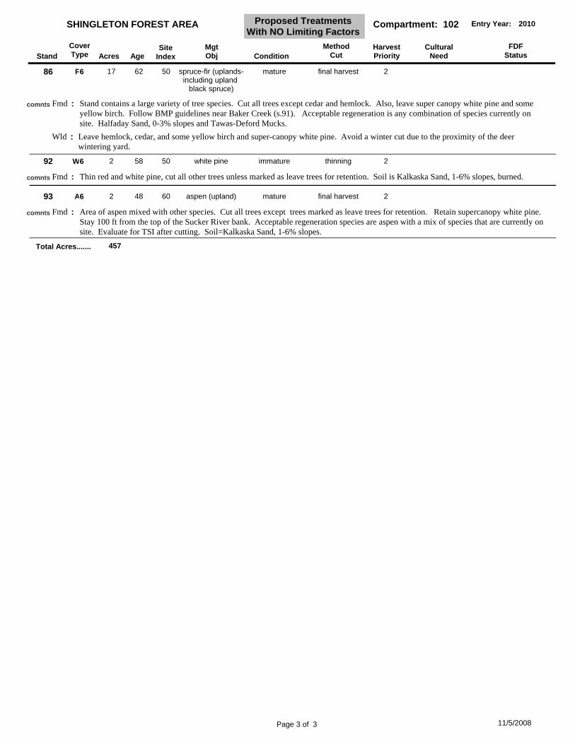
35 A5 17 48 62 mature final harvest 2aspen (upland)
Aspen with a mix of other species. Adjacent to H-58. Cut all trees except those marked for retention. The preferred regeneration species is aspen, but a mix with other species currently on site is acceptable. Adjacent to private land; survey needed. Evaluate for TSI after cutting. 91/2=w.spruce, w.pine, p.birch Wallace Sand 0-15% slopes, and Halfaday Sand, 0-3% slopes
Fmd :comnts
Wld Leave some super-canopy white pine in retention, and avoid a winter cut due to the proximity of the deer wintering yard.:
Beech Bark Disease is evident throughout the stand. Remove all beech, except for 2-3/acre for wildlife and retention. Thin the remaining trees to apx 80BA, maintaining species and structural diversity. Terraced terrain. Stay approximately 50 away from the bluff (stand 9). Adjacent to a subdivision; survey work is needed. Soil=Kalkaska Sand, 0-6% slopes
Fmd :comnts
Wld Agree with FMFM comments. Avoid a winter cut due to the proximity of the deer wintering yard.:
Beech bark disease is evident. Remove all beech, except 2-3/acre for wildlife and retention. Thin other trees to apx 80 BA. Terraced terrain. Stay approximately 50 feet away from the bluff (stand 9). Adjacent to a small subdivision; survey work is needed. Kalkaska Sand, 0-15% slopes. 99/2=p.birch, y.birch, cherry
Fmd :comnts
Wld Agree with FMFM comments. Avoid a winter cut due to the proximity of the deer wintering yard.:
Aspen mixed with other trees; widespread large w.pine. Cut all trees except hemlock, and supercanopy white pine. Aspen mixed with species currently on site will be acceptable regeneration. Small stand near a seasonal pond; follow BMP guidelines. Paquin Sand, 0-3% slopes. 98/2=w.spruce, b.fir, w.pine
Fmd :comnts
Wld Avoid a winter cut due to the proximity of the deer winter yard.:
Adjacent to Old Seney Rd and snowmobile trail. Stand was partially cut in 1998-1999. BA is variable - 70-140. Select cut to apx 80 BA, emphasizing size and species diversity. Leave all hemlock and supercanopy white pine. BBD is found in this stand. Leave 3-5 large beech trees per acre for wildlife. Orange paint is still visible. Ancillary data is available. Soil=Cusino Loamy Sand, 0-6% slopes.
Fmd :comnts
Wld Agree with FMFM comments. Avoid a winter cut due to the proximity of the deer wintering yard.:
Page 1 of 3 11/5/2008
StandCoverType Acres Age
SiteIndex
MgtObj Condition
MethodCut
HarvestPriority
CulturalNeed
FDFStatus
SHINGLETON FOREST AREA Compartment: 102Proposed Treatments With NO Limiting Factors
Heavily thinned last entry to remove the BBD beech. FTP W41-1312 (underplanting oak, white pine & hemlock) has not been started yet. 91/1=r.maple, y.birch, hemlock, white pine Soil= Garlic Sand, 0-6% slopes
Thinned heavily last entry to remove BBD beech. FTP W41-1312 (underplanting oak, white pine & hemlock) is still open. [6/18/08 jb] only planted hemlock. 98/1=hemlock, w.pine. Soil=Garlic Sand, 0-6% slopes.
Fmd :comnts
Wld Finish FTP W41-1312 by planting white pine and oak. Agree with FMFM comments.:
Select cut to 80-90BA, maintaining size and species diversity. Leave the scattered supercanopy white pine, and all hemlock. BBD is evident in the stand; leave 3-5 beech trees per acre. Acceptable regeneration includes all hardwood and conifer species currently on site. Ancillary data is available. Soil is Garlic Sand, 0-6% slopes.
Fmd :comnts
65 A5 17 48 60 mature final harvest 2aspen (upland)
Area of aspen mixed with a variety of other species. Cut all trees except scattered white and red pine, and any other trees marked as leave trees for retention. Acceptable regeneration species are aspen with a mix of species that are currently on site. Evaluate for TSI after cutting. Soil=Kalkaska Sand, 0-6% slopes. 35/1=red and white pine
Fmd :comnts
66 A6 4 50 60 mature final harvest 2aspen (upland)
Area of aspen mixed with a variety of other species. Cut all trees except scattered white and red pine, and any other trees marked as leave trees for retention. Acceptable regeneration species are aspen with a mix of species that are currently on site. Evaluate for TSI after cutting. Soil=Kalkaska Sand, 0-6% slopes.
Fmd :comnts
70 A6 11 57 66 mature final harvest 2aspen (upland)
Area of aspen mixed with other species, within a jack pine plantation. Cut all trees except scattered white and red pine, and any other trees marked as leave trees for retention. Acceptable regeneration species are aspen with a mix of species that are currently on site. Evaluate for TSI after cutting. Soil=Kalkaska Sand, 0-6% slopes. 35/1=red and white pine
Select cut maintaining species and size diversity. Leave 3-5 beech per acre for wildlife. Leave all hemlock, and supercanopy white pine. Adjacent to private land, may need survey work. Ancillary data is available. Soil is Garlic Sand, 0-6% slopes.
Fmd :comnts
Wld Agree with FMFM comments.:
75 A6 6 55 66 mature final harvest 2aspen (upland)
Area of aspen mixed with other species, within a jack pine plantation. Cut all trees except scattered white and red pine, cherry, and any other trees marked as leave trees for retention. Acceptable regeneration species are aspen with a mix of species that are currently on site. Evaluate for TSI after cutting. Soil=Kalkaska Sand, 0-6% slopes.
Fmd :comnts
82 A6 8 48 60 mature final harvest 1aspen (upland)
Adjacent to H-58. Clearcut all trees, except those individually selected for retention. Acceptable regeneration is Aspen with a mix of species currently on site. Adjacent to private land; survey work is needed. Evaluate for TSI after cutting. Wallace Sand, 0-3% slopes. 91/2=w.spruce, p.birch
Fmd :comnts
Wld Leave some super-canopy white pine in retention, and avoid a winter cut due to the proximity of the deer wintering yard.:
83 A6 7 48 60 mature final harvest 1aspen (upland)
Adjacent to H-58. Clearcut all trees, except those individually selected for retention, and all apple and oak trees. Acceptable regeneration is Aspen with a mix of species currently on site. Adjacent to private land; survey work is needed. Evaluate for TSI after cutting. Wallace Sand, 0-3% slopes.
Fmd :comnts
Wld Leave some super-canopy white pine in retention, and avoid a winter cut due to the proximity of the deer wintering yard.:
Page 2 of 3 11/5/2008
StandCoverType Acres Age
SiteIndex
MgtObj Condition
MethodCut
HarvestPriority
CulturalNeed
FDFStatus
SHINGLETON FOREST AREA Compartment: 102Proposed Treatments With NO Limiting Factors
Stand contains a large variety of tree species. Cut all trees except cedar and hemlock. Also, leave super canopy white pine and some yellow birch. Follow BMP guidelines near Baker Creek (s.91). Acceptable regeneration is any combination of species currently on site. Halfaday Sand, 0-3% slopes and Tawas-Deford Mucks.
Fmd :comnts
Wld Leave hemlock, cedar, and some yellow birch and super-canopy white pine. Avoid a winter cut due to the proximity of the deer wintering yard.
:
92 W6 2 58 50 immature thinning 2white pine
Thin red and white pine, cut all other trees unless marked as leave trees for retention. Soil is Kalkaska Sand, 1-6% slopes, burned.Fmd :comnts
93 A6 2 48 60 mature final harvest 2aspen (upland)
Area of aspen mixed with other species. Cut all trees except trees marked as leave trees for retention. Retain supercanopy white pine. Stay 100 ft from the top of the Sucker River bank. Acceptable regeneration species are aspen with a mix of species that are currently on site. Evaluate for TSI after cutting. Soil=Kalkaska Sand, 1-6% slopes.
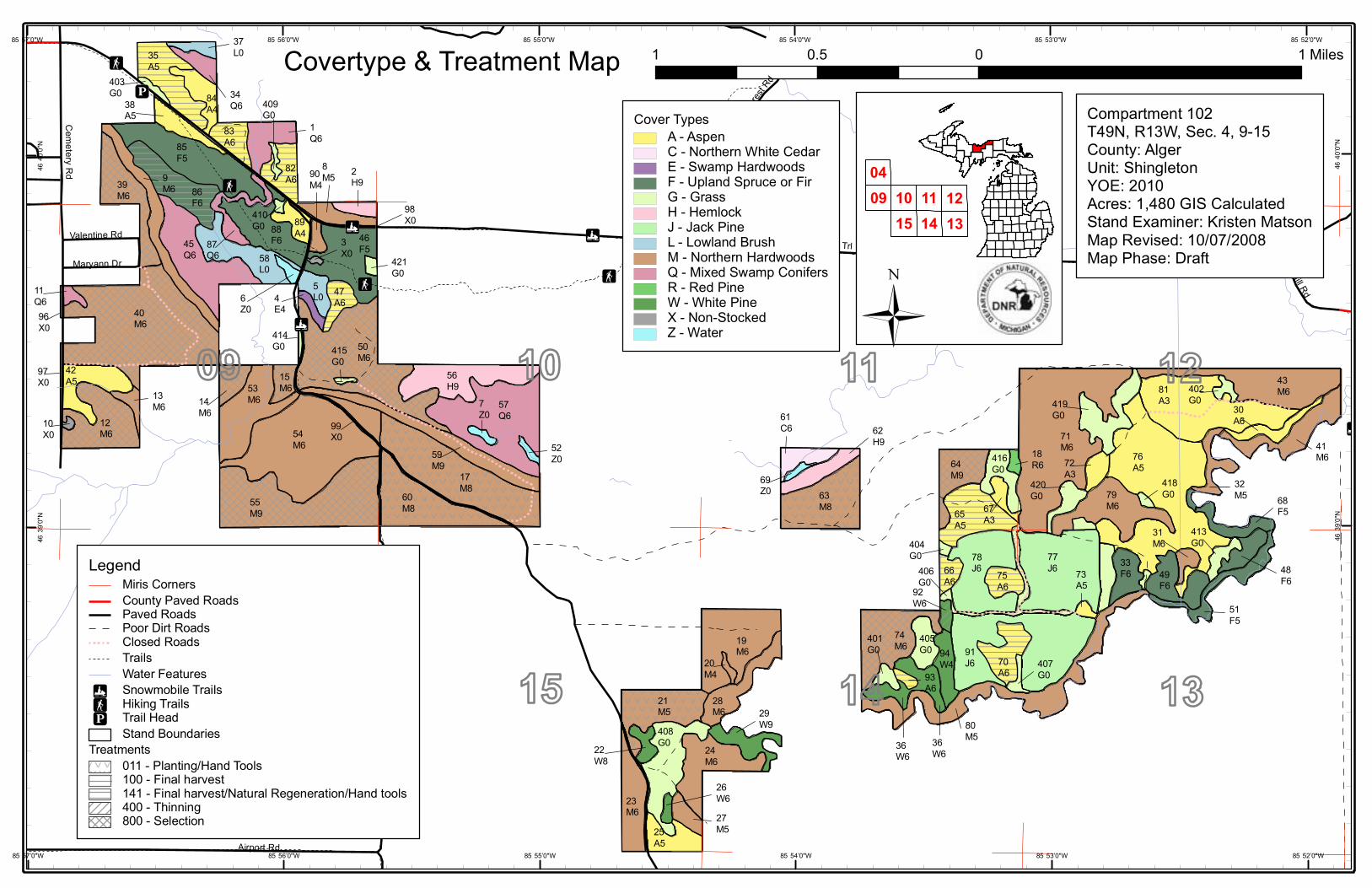
Compartment 102T49N, R13W, Sec. 4, 9-15County: AlgerUnit: ShingletonYOE: 2010Acres: 1,480 GIS CalculatedStand Examiner: Kristen MatsonMap Revised: 10/29/2008Map Phase: Pre-Review
1 0 10.5 Miles
111315
10 1214
0904
Grand Marais Truck Trl
Airport Rd
Cem
etery Rd
Schoo
l For
est R
d
Maryann Dr
Pullup Hill Rd
Valentine Rd
408G0
70A6
74M619
M6
33F6
78J6
77J6
65A5
79M6
63M8
17M8
54M6
76A5
12M6
57Q6
71M6
53M6
47A6
40M6
46F5
88F6
39M6
83A685
F5
37L035
A5
84A438
A5
403G0
86F6
45Q6 58
L0
82A6
1Q6
409G0
87Q6
9M6
11Q696X0
97X0
10X0
42A5
13M6
56H9
7Z0
52Z059
M9
415G0
50M6
15M6
414G0
4E4
5L06
Z0
90M4
8M5 2
H9
421G0
3X0
55M9
60M8
89A4
410G0
61C6 62
H9
69Z0
20M4
28M6
21M5
23M6
25A5
24M6
29W9
22W8
27M5
26W6
80M536
W6
91J6
75A6
405G0
92W6
66A6
404G0
406G0
73A5
407G0
49F6
418G0
419G0
81A3
43M6402
G030A6
41M6
32M5
413G0
31M6
48F6
51F5
68F5
420G0
72A3
34Q6
14M6
401G0
64M9
416G0
18R6
67A3
94W4
93A6
36W6
98X0
99X0
85°56’0"W
85°56’0"W
85°55’0"W
85°55’0"W
85°54’0"W
85°54’0"W
85°53’0"W
85°53’0"W
85°52’0"W
85°52’0"W46
°39’
0"N
46°3
9’0"
N
46°4
0’0"
N
46°4
0’0"
N
Dedicated & Proposed Special Conservation Area Map
LegendMiris CornersStand Boundaries
Dedicated Special Conservation AreasCritical Coastal Habitat (Piping Plover)Potential Old Growth StandsDeer Wintering AreasCold Water LakesCold Water Streams
1 0 10.5 Miles
9
1315
10 12
14
11
Compartment 102T49N, R13W, Sec. 4, 9-15County: AlgerUnit: ShingletonYOE: 2010Acres: 1,480 GIS CalculatedStand Examiner: Kristen MatsonMap Revised: 10/29/2008Map Phase: Pre-Review
Type
Mgt. Unit
102Compartment:
Page 1 of 1
Shingleton
Description
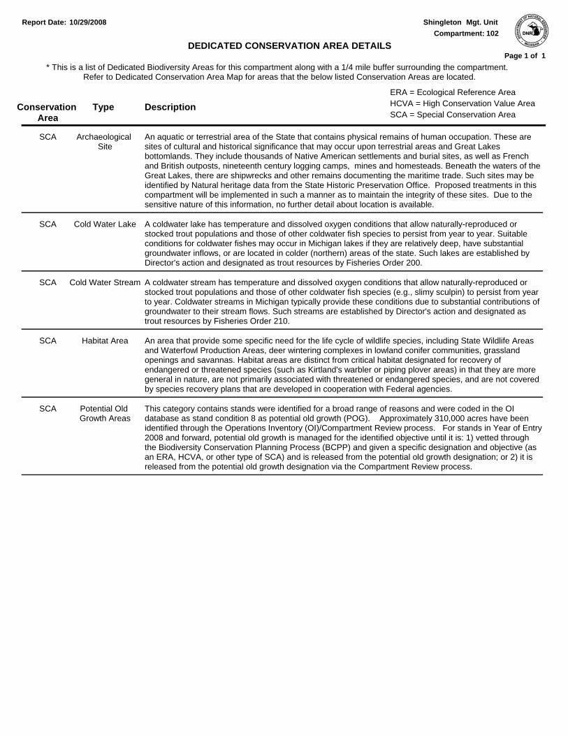
10/29/2008Report Date:
* This is a list of Dedicated Biodiversity Areas for this compartment along with a 1/4 mile buffer surrounding the compartment. Refer to Dedicated Conservation Area Map for areas that the below listed Conservation Areas are located.
DEDICATED CONSERVATION AREA DETAILS
Conservation Area SCA = Special Conservation Area
HCVA = High Conservation Value AreaERA = Ecological Reference Area
An aquatic or terrestrial area of the State that contains physical remains of human occupation. These are sites of cultural and historical significance that may occur upon terrestrial areas and Great Lakes bottomlands. They include thousands of Native American settlements and burial sites, as well as French and British outposts, nineteenth century logging camps, mines and homesteads. Beneath the waters of the Great Lakes, there are shipwrecks and other remains documenting the maritime trade. Such sites may be identified by Natural heritage data from the State Historic Preservation Office. Proposed treatments in this compartment will be implemented in such a manner as to maintain the integrity of these sites. Due to the sensitive nature of this information, no further detail about location is available.
Archaeological Site
SCA
A coldwater lake has temperature and dissolved oxygen conditions that allow naturally-reproduced or stocked trout populations and those of other coldwater fish species to persist from year to year. Suitable conditions for coldwater fishes may occur in Michigan lakes if they are relatively deep, have substantial groundwater inflows, or are located in colder (northern) areas of the state. Such lakes are established by Director's action and designated as trout resources by Fisheries Order 200.
Cold Water LakeSCA
A coldwater stream has temperature and dissolved oxygen conditions that allow naturally-reproduced or stocked trout populations and those of other coldwater fish species (e.g., slimy sculpin) to persist from year to year. Coldwater streams in Michigan typically provide these conditions due to substantial contributions of groundwater to their stream flows. Such streams are established by Director's action and designated as trout resources by Fisheries Order 210.
Cold Water StreamSCA
An area that provide some specific need for the life cycle of wildlife species, including State Wildlife Areas and Waterfowl Production Areas, deer wintering complexes in lowland conifer communities, grassland openings and savannas. Habitat areas are distinct from critical habitat designated for recovery of endangered or threatened species (such as Kirtland's warbler or piping plover areas) in that they are more general in nature, are not primarily associated with threatened or endangered species, and are not covered by species recovery plans that are developed in cooperation with Federal agencies.
Habitat AreaSCA
This category contains stands were identified for a broad range of reasons and were coded in the OI database as stand condition 8 as potential old growth (POG). Approximately 310,000 acres have been identified through the Operations Inventory (OI)/Compartment Review process. For stands in Year of Entry 2008 and forward, potential old growth is managed for the identified objective until it is: 1) vetted through the Biodiversity Conservation Planning Process (BCPP) and given a specific designation and objective (as an ERA, HCVA, or other type of SCA) and is released from the potential old growth designation; or 2) it is released from the potential old growth designation via the Compartment Review process.