45
United States Forest Service Northern Region Idaho Panhandle National Forests St. Joe Ranger District June 2016 St. Joe Travel Management Decision Notice & Finding of No Significant Impact
| Date post: | 24-Jul-2018 |
| Category: |
Documents |
| Upload: | doannguyet |
| View: | 214 times |
| Download: | 0 times |

United States Forest Service
Northern Region
Idaho Panhandle National Forests
St. Joe Ranger District
June 2016
St. Joe Travel Management
Decision Notice &
Finding of No Significant Impact
In accordance with Federal civil rights law and U.S. Department of Agriculture (USDA) civil rights regulations and policies, the USDA, its Agencies, offices, and employees, and institutions participating in or administering USDA programs are prohibited from discriminating based on race, color, national origin, religion, sex, gender identity (including gender expression), sexual orientation, disability, age, marital status, family/parental status, income derived from a public assistance program, political beliefs, or reprisal or retaliation for prior civil rights activity, in any program or activity conducted or funded by USDA (not all bases apply to all programs). Remedies and complaint filing deadlines vary by program or incident.
Persons with disabilities who require alternative means of communication for program information (e.g., Braille, large print, audiotape, American Sign Language, etc.) should contact the responsible Agency or USDA’s TARGET Center at (202) 720-2600 (voice and TTY) or contact USDA through the Federal Relay Service at (800) 877-8339. Additionally, program information may be made available in languages other than English.
To file a program discrimination complaint, complete the USDA Program Discrimination Complaint Form, AD-3027, found online at http://www.ascr.usda.gov/complaint_filing_cust.html and at any USDA office or write a letter addressed to USDA and provide in the letter all of the information requested in the form. To request a copy of the complaint form, call (866) 632-9992. Submit your completed form or letter to USDA by: (1) mail: U.S. Department of Agriculture, Office of the Assistant Secretary for Civil Rights, 1400 Independence Avenue, SW, Washington, D.C. 20250-9410; (2) fax: (202) 690-7442; or (3) email: [email protected] .
USDA is an equal opportunity provider, employer and lender.
The Forest Service uses the most current and complete data available. Geographic information system (GIS) data and product accuracy may vary. They may be developed from sources of differing accuracy, accurate only at certain scales based on modeling or interpretation, incomplete while being created or revised, etc. Using GIS products for purposed other than those for which they were created may yield inaccurate or misleading results. If a map contains contours, these contours were generated and filtered using the Digital Elevation Model (DEM) files. Any contours generated from DEMs using a scale of less than 1:100,000 will lead to less reliable results and should only be used for display purposes. For more information contact the St. Joe Ranger District, 222 S. 7th Street Suite 1, St. Maries, Idaho, 83861; (208)245-2531. Reported mileages are estimates and may vary depending on how they are rounded and what models and equations they are used for or result from.

i
St. Joe Travel Management DN & FONSI Table of Contents DECISION .................................................................................................................................................................... 1
Changes from the Existing Condition .................................................................................................................. 1 District-wide Public Motorized Access ................................................................................................................ 2 Maps ..................................................................................................................................................................... 4 Seasonal Designations .......................................................................................................................................... 5 Trail Maintenance Using Motorcycles ................................................................................................................. 5 Motorized Access for Dispersed Camping ........................................................................................................... 6 Parking along Designated Public Motorized Routes ............................................................................................ 7 Design Features .................................................................................................................................................... 8 Monitoring and Adaptive Management ............................................................................................................... 8 Education ............................................................................................................................................................. 9 Enforcement ....................................................................................................................................................... 10
BACKGROUND ......................................................................................................................................................... 11 DECISION RATIONALE ........................................................................................................................................... 12
Purpose and Need ............................................................................................................................................... 12 Protection of Resources and Environmental Consequences ............................................................................... 16 Regulatory Framework ....................................................................................................................................... 17 Coordination with Cooperators .......................................................................................................................... 25 Public Input ........................................................................................................................................................ 25
ALTERNATIVES ....................................................................................................................................................... 29 Alternatives Considered But Eliminated From Detailed Study .......................................................................... 29 Alternatives Considered in Detail ...................................................................................................................... 29
FINDING OF NO SIGNIFICANT IMPACT .............................................................................................................. 29 A. Context .......................................................................................................................................................... 30 B. Intensity ......................................................................................................................................................... 31
IMPLEMENTATION ................................................................................................................................................. 34 RESPONSIBLE OFFICIAL & CONTACT INFORMATION ................................................................................... 34
Tables Table 1: Changes in Motorized Designations on Trails ................................................................................................. 2 Table 2: Changes in Motorized Designations on Roads ................................................................................................ 2 Table 3: Alternative D Modified – Resulting Miles of Public Motorized Access ......................................................... 2 Table 4: Seasonal Motorized Use Designations ............................................................................................................ 6 Table 5: Trails to be Maintained by Motorcycle Crew .................................................................................................. 6 Table 6: Elk Security Habitat Comparison of Existing Condition with Alternative D and D Modified ..................... 16
Appendices Appendix A: Change in Road and Trail Designations Appendix B: Map of Changes in Trail and Road Designations

1
DECISION NOTICE & FINDING OF NO SIGNIFICANT IMPACT
St. Joe Travel Management United States Forest Service, Idaho Panhandle National Forests, St. Joe Ranger District
Shoshone, Benewah, Clearwater, and Latah Counties, Idaho
DECISION
After careful consideration of the purpose and need and potential effects of the alternatives analyzed and documented in the St. Joe Travel Management Environmental Assessment (EA) (May 2016), the associated project record, and comments from the public I have decided to implement Alternative D, with one modification, as the result of the pre-decisional administrative review (objection) process. I will allow single-track motorized (STM) use without a seasonal designation on Trail 191 because we can accommodate that use, comply with forest plan requirements, and minimize damage to resources. Other than that, the decision is the same as Alternative D as described in the St. Joe Travel Management EA (May 2016). I will refer to the decision as “Alternative D Modified” or “the decision”. The EA and related documents are located on the internet at: http://www.fs.usda.gov/detail/ipnf/landmanagement/projects/?cid=stelprd3848552.
Alternative D Modified includes the designation of motorized routes, prohibition of motorized travel off designated routes (except as described for parking and motorized access to existing dispersed camping sites), design features to protect resources, monitoring and adaptive management, and motorized access for Forest Service trail maintenance on some non-motorized trails. This decision will remain in effect unless something warrants a reconsideration of the decision (e.g., changing conditions, new information, etc.).
A number of travel management decisions have already been decided and are incorporated in the alternatives. Passenger car and full-size vehicle access on roads is virtually unchanged from the current condition (EA Appendix A).
Alternative D Modified was developed with extensive public involvement. The general public and the collaborative focus group suggested route by route designations (PF: PD-27 through PD-34, PD-54). We considered those suggestions in light of resource conditions. Motorized use was considered for roads and trails where impacts could be minimized. Routes were identified for non-motorized use based on the recreation experience, or where resource conditions indicated impacts to resources could not be minimized with motorized designations, or where motorized designations would require extensive reconstruction. Additional routes requiring new construction or reconstruction could be designated for motor vehicle use in the future; after appropriate planning, analysis, and public disclosure.
Changes from the Existing Condition My decision changes designations on approximately 182 miles of roads and 114 miles of trails, including specific route changes listed by road and trail in Appendix A. Cross-country motorized use will not be allowed off designated routes, except for parking and to access existing dispersed camping sites within 300 feet of designated roads and 100 feet of designated trails on existing routes. Motorized game retrieval off designated routes will not be allowed. See Alternative D Modified map at the end of this decision notice.
Alternative D Modified would change designations on 114 miles of the 669 miles of trail (17.8%) on the St. Joe Ranger District. Of these, the greatest change would be in the miles of trail being converted from STM to seasonal STM, followed by STM to non-motorized (Table 1). Overall, STM trails will be reduced by about 26 miles on the St. Joe Ranger District (Table 1). Most of the popular loops across the district will still be designated for motorized
St. Joe Travel Management DN & FONSI (June 2016)
2
use. There will be fewer miles for STM use in the Big Creek, Fly-Mosquito, Little North Fork of the (LNF) Clearwater/Foehl Creek, Simmons/Stateline, Slate Creek/Cedar Mountain, and Wonderful/Shefoot recreation analysis areas, to minimize effects to elk security habitat and bull trout. Motorcycles will still have access to these areas; however, there will be fewer miles to ride, and the motorized season will be shorter on 70 of these miles because they will be designated for Seasonal STM use. Seasonal STM trails represent a change for riders who have used these trails in the past during the fall and for hunting access. More details about seasonal designations are given in the Seasonal Designations section on page 5.
Table 1: Changes in Motorized Designations on Trails
Existing Designation Alternative D Modified Designation Trail Miles Alt D Modified:
Percent Change (of 114.2 Miles) Non-motorized STM 6.4 5.6% Non-motorized Seasonal STM 5.3 4.6%
STM Non-motorized 37.7 33.0% STM Seasonal STM 64.8 56.7%
Total Miles of Change 114.2
Of the approximately 1,510 miles of road where public motorized use is currently allowed and the Forest Service has jurisdiction on the St. Joe Ranger District, Alternative D Modified would change designations on 182 miles (11.3% of 1,510 miles), with the largest change resulting in OHV ≤ 50” roads being closed to motorized vehicles (Table 2). Access for OHV < 50” use on roads will be reduced by approximately 82 miles overall (Table 2). Most of the road segments that would be closed to motorized use are less than 2.5 miles long, and many are dead-end and stacked roads. The decision adds 25.8 miles of OHV < 50” on roads that are currently closed.
Table 2: Changes in Motorized Designations on Roads
Existing Designation Alternative D Designation Road Miles Alt D Modified:
Percent Change (of 182 Miles) Closed OHV<50” 25.8 14.2% Closed Seasonal OHV<50” 9.3 5.1%
Seasonal Open (full-size) Seasonal OHV<50” 4.2 2.3% Open (full-size) Closed 10.7 5.9% Open (full-size) OHV<50” 5.4 2.9%
OHV<50” Closed 126.6 69.6% Total Miles of Change 182
District-wide Public Motorized Access The decision results in approximately 342.4 miles of trails designated for motorized vehicle use and approximately 1,416 miles of roads designated for motorized use (Table 3). An additional 19.8 miles of OHV ≤ 50” trails and 14.3 miles of STM trails, located within or on the district boundary, are managed by different ranger districts or the Bureau of Land Management (BLM); designations of these trails was decided previously. Other roads with other jurisdictions also provide access to the National Forest System; examples include State Highways 3 and 6, Forest Highway 50, and the Palouse Divide Road.
Table 3: Alternative D Modified – Resulting Miles of Public Motorized Access
Passenger Vehicles
High Clearance
OHV ≤ 50” Year-long*
OHV ≤ 50” Seasonal STM
STM Seasonal
Total Motorized Access
Trails - - 47.2 - 225.1 70.1 342.4 Roads 441 599 358 18 - - 1,416 Total 441 599 405.2 18 225.1 70.1 1,758.4

St. Joe Travel Management DN & FONSI (June 2016)
3
Figure 1: The Idaho Panhandle and location of the St. Joe Ranger District

St. Joe Travel Management DN & FONSI (June 2016)
4
Maps The St. Joe Ranger District covers a large area (approximately 725,000 acres of NFS lands). It is difficult to present the district on a single map with the level of detail needed to see individual roads and trails and their numbers; therefore, the district is divided into the following six maps for the development of the travel management plan (Figure 2):
Map 1 - Northern St. Maries area Map 2 - Big Creek, Slate Creek, and North Fork
St. Joe areas Map 3 - Nelson/Shefoot, Bird Creek to Gold
Creek areas
Map 4 - Simmons, Upper Joe, Snow Peak, and Mallard Larkins areas
Map 5 - Grandmother Mountain/Freezeout, Monumental Buttes and Montana Peak areas
Map 6 - Southwest corner of the district
Figure 2: Map Key for St. Joe Travel Management EA
Maps are available for review on the project website (http://www.fs.fed.us/nepa/nepa_project_exp.php?project=26188) and at the St. Joe Ranger District office in St. Maries, Idaho.
Mileage figures are based on geographic information system (GIS) miles and may differ from actual miles on the ground. Reported mileages are estimates and may vary depending on how they are rounded, and what models and equations they are used for or result from. Trail and road data is the best available information, and includes data from the field and satellite imagery.
Changes from the existing condition are shown on the Alternative D Modified Map (Appendix B).

St. Joe Travel Management DN & FONSI (June 2016)
5
Seasonal Designations See Table 4 for specific routes (pg. 6).
Seasonal roads will have one of two designations:
Seasonal OHV ≤ 50” Roads: Designated for OHV ≤ 50” use from May 22nd through the day before elk archery season; non-motorized during the rest of the year, including the elk hunting season.
Palouse Divide Park and Ski Area: (Boundary Road 377 from Highway 6 east to the junction with 377 A, and Highway 6 west to Road 1796) Managed by the Clearwater NF, this area is only open to full-size motorized vehicles from April 1st through December 15th. The area is closed as an Idaho Park and Ski cross-country ski trail during the winter. Hume Creek Road 1479, from the junction with Road 377 to the junction with Road 1950, would have the same seasonal designation.
Seasonal trails will have one of two different designations:
Seasonal STM Trails: Designated for STM use from May 22nd to the day before elk archery season. These trails would be non-motorized during the elk hunting seasons, when elk security is more critical, and during the winter months.
Big Creek (BC) Seasonal STM Trail: Designated for STM use from July 15th through the day before elk archery season, and non-motorized the rest of the year. This is different from the regular season designation, providing a non-motorized opportunity in the spring and early summer before most of the non-motorized trails are clear of snow, and protects elk security during hunting season.
The seasonal designations were developed to provide motorized access in the summer and to maintain or improve elk security habitat. The forest plan requires management activities to maintain existing levels of elk security and, where possible, improve elk security in high- and medium-priority elk management units (EMUs). Alternative D Modified increases elk security habitat in all medium- and high-priority EMUs and maintains or increases elk security levels in the low-priority EMUs (EA Tables 70 through 72 and DN Table 6).
This decision includes many routes without seasonal designations, but the lack of seasonal restrictions does not imply those routes will be accessible yearlong with wheeled vehicles, primarily due to snow conditions.
Trail Maintenance Using Motorcycles This decision allows motorcycle trail crews (administrative use) to clear specified non-motorized trails once a year, only when necessary and with signed permission by the District Ranger. In most cases, this would entail one day to clear a trail of downfall. The trail will be signed at the trailhead with the following posting: “Notice: Administrative use of motorized vehicles and equipment are on the trail today to clear downfall”.
This includes the trails listed in Table 5 (pg. 6). Motorcycles will not be used for trail maintenance within recommended wilderness, the Wild & Scenic River corridor (in the “wild” section upstream from Spruce Tree Campground), the wild section of eligible Wild & Scenic River (LNF Clearwater River Trail 50), Mallard Larkins Pioneer Area, Snow Peak Wildlife Management Area, Hiawatha Rail Trail, Hobo Cedar Grove, Hobo Historical and Cornwall Steam Donkey Trails.

St. Joe Travel Management DN & FONSI (June 2016)
6
Table 4: Seasonal Motorized Use Designations Roads Trails
Seasonal OHV ≤ 50” Roads
5/22 to EHS1 Palouse Divide Park and
Ski Area Seasonal STM Trails
5/22 to EHS1
Big Creek Seasonal STM Trails
7/15 to EHS1
Dunn Peak Rd 1934 from Rd 1934A to Uhlman Ck
Palouse Divide Rd 337: Rd 1976 to Rd 377A:
4/1 – 12/15
Middle Simmons Ck Trail 80 (Road 1278 to Trail 73)
Lower Big Creek Trail 44
Dunn Peak Lookout Rd 1934A Hume Creek Rd 1479:
Hwy 6 to Rd 1950: 4/1 – 11/30
Upper Simmons Ck Trail 80 (Trail 73 - Trail 77)
Roundhouse Gulch Rd 1251 Malin Ridge Trail 197
Lower Rd 1950 to Rd 1954 Pierce Ridge Trail 563
Fagan Preston Rd 1954 Bear Creek Trail 185
Fly Peak Trail 88
Angle Point Trail 89
Foehl Creek Trail 120
Washout Point Trail 290
Jug Camp Trail 318
Foehl to Buttes Trail 595
Fly Ck Trail 629: Twin Lakes to Trail 28
Sherlock Trail 76
Walo Point Trail 2
Peggy Peak Trail 28
Three Lakes Divide Trail 72 from Simmons Pk to Rd 1278
Wampus Creek Trail 73 1 – Elk Hunting Season (EHS) routes will be designated for motorized use through the day before elk hunting (archery) season.
Table 5: Trails to be Maintained by Motorcycle Crew Area Trails
Big Creek 565
Bird Creek /Gold Creek 5 (bottom portion), 51
Bussel Creek 258
Fly/Mosquito 75, 631
LNF/Foehl Creek 13, 123
Simmons-Stateline 74, 80 (from Red Ives Road to junction with Trail 72), 81 (from Trail 80 to Road 1219)
Slate Creek/Cedar Mtn. 158 (Foolhen Mtn to Slate Creek Meadows), 173 (junction with Trail 175 to Arid Peak)
Wonderful Shefoot 26
Motorized Access for Dispersed Camping
This decision includes the following motorized access corridors for dispersed camping on established routes to existing sites: (1) within a 300-foot corridor on either side of the center line of roads designated for motorized use; and (2) within a 100-foot corridor on either side of trails designated for motorized use. In both cases, these corridors are applicable as long as resource damage does not occur.
Most of the existing dispersed camping sites are located within 300 feet of designated open roads. All cross-county motorized travel is prohibited, except for established routes to existing dispersed campsites within 300 feet of roads or within 100 feet of trails, and parking along designated routes.

St. Joe Travel Management DN & FONSI (June 2016)
7
Minimizing Damage from Motorized Access for Dispersed Camping:
Limiting motorized access for dispersed camping to these access corridors will minimize damage to resources by prohibiting cross-country travel beyond the corridors in areas where, considering terrain and vegetation, it is possible. The steep terrain and heavy vegetation on the St. Joe Ranger District have been, and will continue to be, deterrents to the proliferation of new dispersed campsites. Recently, motorized users have not created many new routes to dispersed sites, with the exception of shortcuts to existing sites. The Forest Service has been successful in identifying shortcuts and discouraging motorized use by flagging them off, placing barriers, and posting information explaining reasons for the blocked access. In the past 15 years, few if any new dispersed sites have been created, and resource concerns have not been identified related to dispersed camping sites (PF: REC-21, REC-46).
Motorized access for dispersed camping will not supersede the following existing regulations:
36 CFR 261.12 National Forest System roads and trails. The following are prohibited: (c) Damaging and leaving in a damaged condition any such road, trail, or segment thereof.
36 CFR 261.15 Use of vehicles off roads. It is prohibited to operate any vehicle off National Forest System, State or County roads: (h) in a manner which damages or unreasonably disturbs the land, wildlife, or vegetative resources.
The following stipulations for motorized access to dispersed campsites will be listed on the MVUM:
Establishing or constructing new sites or new routes to sites will not be allowed.
Cutting, damaging, or harming trees or vegetation to access dispersed camping sites will not be allowed.
Moving, going around, going over, or going past barriers (e.g., gates, boulders, berms, barriers, signs, etc.) intended to restrict or discourage access will not be allowed.
Fording live streams with motorized vehicles will not be allowed, unless the route across the stream is designated for motorized use.
Motorized cross-country travel from developed recreation sites (e.g., campgrounds, picnic sites, trailheads, boat launches, etc.) to access dispersed campsites will not be allowed. In developed recreation sites motorized access will be restricted to designated roads and parking areas.
Exceptions for motorized dispersed camping access within a 300-foot corridor from designated roads:
Motor vehicle use will not be allowed off the road in the Wild River corridor unless the route is designated on the MVUM; therefore, motorized access to dispersed camping will not be allowed in the corridor unless specifically designated.
Motorized access is prohibited in recommended wilderness areas; therefore, cross-country motorized access to dispersed sites within recommended wilderness areas will not be permitted.
Parking along Designated Public Motorized Routes Motor vehicles may be parked up to 30 feet from the edge of the road surface, when and where it is safe to do so without causing damage to NFS resources or facilities; unless prohibited by state law, a traffic sign, or an order (Forest Service Manual (FSM) 7716.1(1)).

St. Joe Travel Management DN & FONSI (June 2016)
8
Design Features 1. Trails 105 and 107 will be signed at the boundary of the eligible Wild and Scenic River corridor for the
LNF Clearwater River, to prohibit motorized use within the corridor of the eligible Wild and Scenic River.
2. Where appropriate, trail signs will be posted to notify the public of designation changes (e.g., where a motorized trail meets a non-motorized trail) near trail junctions.
3. If Threatened, Endangered, and Sensitive (TES) plant species are discovered on, or adjacent to, trails or roads with a change from the existing management, an agency botanist will be notified so that measures could be taken to maintain population viability.
4. If new populations of noxious weeds are found, treatment would be implemented in accordance with priorities set by the noxious weed program. Noxious weed species that are new invaders to the St. Joe District will be slated for eradication. Other weed infestations would be treated according to IPNF or St. Joe Ranger District direction and priorities.
5. Recreational riding in meadows or open areas will not be allowed. This statement will be included on the MVUM.
6. All alternatives will follow direction in the IPNF programmatic biological assessments for road and trail maintenance (USDA 2004a, 2004b).
7. Craddock Peak Trail 83 requires maintenance before it would be included on the MVUM.
Monitoring and Adaptive Management Monitoring is conducted on the St. Joe Ranger District, on a sample basis, to verify whether projects meet 2015 Forest Plan and project objectives. For this project, monitoring would be used to identify unforeseen environmental impacts, changes in public demand, or other changed conditions that may lead the Responsible Official to consider revising designations. In addition, the following specific monitoring will be conducted:
1. Single-track motorized crossings in bull trout-occupied streams (Simmons Creek [4 crossings], Beaver Creek, Fly Creek [2 crossings], and Foehl Creek [2 crossings]) will be monitored annually for five years, during anticipated spawning season, to determine if there is spawning activity or degradation to in-stream habitat at the nine crossings. Spawning activity is considered as an observation of suitable spawning substrate, and redd construction and or staging at a crossing. Degradation is considered increased erosion of the approaches, or localized bank instability, as a result of increased STM use. If spawning activity or degradation is observed then adaptive management actions may be taken (e.g., hardening approaches, hardening the crossings, or both). After five years, if there is no change to the existing condition, additional monitoring may not be required and will be reevaluated at that time. Depending on the action to be implemented, additional analysis would be conducted at that time and, if needed, considered under a separate decision and associated consultation.
2. Ten percent or more of the areas previously treated for noxious weeds are monitored each year. Agency botany and weed specialists survey for noxious weed sites when they travel district roads and trails. District personnel and the public report suspected new noxious weed sites to the botany and weeds specialists.
3. Each year trails and roads with potential maintenance activities are reviewed for known Sensitive plant species. Sensitive plant sites within road and trail templates are protected through the maintenance program.

St. Joe Travel Management DN & FONSI (June 2016)
9
4. A cultural resource inventory plan will be implemented to inventory at least 50 acres of open road buffers per year. This inventory will begin in areas that receive heavy dispersed recreational use. If cultural sites are identified in these areas a monitoring plan would be developed to protect them, per the NHPA Section 106 Protocols for compliance with the Travel Management Rule Clearwater, Idaho Panhandle and Nez Perce National Forests in North Idaho USDA Forest Service, Northern Region (PF: CR-1, CR-2).
5. Motorized access to dispersed sites:
Forest Service personnel (e.g., law enforcement officers (LEO), forest protection officers (FPO), recreation crews, and other Forest Service employees) will monitor use and resource impacts. Recreation crews routinely monitor dispersed sites when they clean them.
If unacceptable resource impacts occur (e.g., rutting or damage to vegetation) appropriate management actions would be taken to correct problems (e.g., block access, rehabilitate the site, etc.).
Additional well-established motorized access routes to existing dispersed camping sites beyond the 300-foot corridor may be designated, as the routes are evaluated for resource effects and receive cultural resource clearance.
If new user-created routes are created to access dispersed sites, appropriate corrective action would be taken to block or discourage use of that route.
6. Forest Service employees, Forest Service LEOs, other local law enforcement officers, volunteers, contractors, and other forest users monitor motorized travel designations for effectiveness and compliance in conjunction with their regular assignments (also, see sections on Education and Enforcement).
7. Roads with seasonal designations will be monitored for use violations, since these roads are the most likely to experience unauthorized use. Monitoring of seasonal roads will occur when gates are closed for elk security, once during the elk hunting season, and again when gates are opened for motorized access. Depending on the situation, actions would be implemented to deter further violations or designations may be adjusted. Additional analysis and public involvement would be conducted, if needed.
8. Trails personnel travel and monitor motorized trails at least once yearly. Trail condition reports are filed with the Trails Program Manager, who may assign work to repair safety hazards or resource damage. Areas with known trail use violations or places where there is a distinct change in allowed use will be emphasized. This includes: Grandmother Mountain, Lines Creek Trail 246, Copper Ridge Trail 263, and LNF Clearwater Trail 50. Depending on the damage or the extent of use violations, the Trails Program Manager may recommend a review of the trail designation.
9. We will monitor for illegal motorized access on the bottom portion of the abandoned section of Grandfather Mountain Trail 275, and take appropriate measures (e.g., physically blocking the access).
Education Education is a key component for the enforcement of the new travel management policy. Special crews and law enforcement would patrol the district making sure forest visitors have the district MVUM to help them find places to enjoy their motorized activities, and to explain the conditions and stipulations for motorized use on the St. Joe Ranger District.

St. Joe Travel Management DN & FONSI (June 2016)
10
A concerted effort will be made to educate users about ways to avoid resource damage with motorized vehicles. The following information will also be included on the MVUM:
Do not establish or construct new sites, or new routes to sites.
Only drive to dispersed campsites using existing routes. Existing routes have obviously been used for years, are mostly devoid of surface vegetation, and are free of barriers placed to deter vehicle use. The St. Joe Ranger District has inventories of these sites (PF: REC-46, REC-46a, and REC-46b).
Only use established dispersed camping sites. Established sites are those where repeated camping activities are obvious (e.g., fire rings and areas for tents and trailers).
Only use an existing route to access a dispersed camping site. Do not use these routes for repetitive recreational riding or shortcuts to other sites or locations.
Enforcement Motor vehicle use off designated routes (i.e., cross-country) will be prohibited, except for parking up to 30 feet from the edge of the road surface when and where it is safe to do so without causing damage to NFS resources or facilities, and on established routes to existing dispersed campsites within the 100-foot and 300-foot corridors for dispersed camping. This change in enforcement strategy and legal authority will greatly enhance the Forest Service’s ability to enforce regulations that control motor vehicle travel on National Forests.
Implementation and enforcement of travel management decisions require maps that are accurate and readily available to the public. Under the travel management rule, the MVUM is the principle enforcement tool for motor vehicle regulations. The map will display only those roads and trails designated for motor vehicle use. If a route is not shown on the MVUM it is not available for public motorized travel. Routes not designated for motor vehicle use (e.g., non-motorized routes, single-purpose routes, administrative routes, unauthorized routes, and temporary routes) will not be shown on the MVUM. The MVUM will be free to the public; available in print (black and white) and on the IPNF website. An electronic copy will be provided to the Idaho Department of Parks and Recreation for posting on their website. Print copies will be distributed to local businesses and chambers of commerce.
It is prohibited to possess or operate a motor vehicle on NFS lands other than in accordance with the designations on the MVUM (36 CFR 261.13). Violations of prohibitions found in 36 CFR 261 are subject to a fine of up to $5,000, imprisonment for up to six months, or both (Title 18 of US Code Section 3571(e)). This prohibition applies regardless of the presence or absence of signage.
In some situations, violators may be held accountable for the cost of repairing or restoring areas damaged during the violation. Actually catching violators is not always possible, but enforcement of travel management decisions will target known problem areas. A multi-pronged approach to enforcement will be used, which includes observations by law enforcement officers and Forest Service personnel, public education, monitoring and adaptive management, cooperation with user groups, and help from volunteers.
The Law Enforcement and Investigations staff of the U.S. Forest Service is comprised of professional patrol officers and criminal investigators dedicated to the protection of visitors, employees, and natural resources on NFS lands. Uniformed patrol officers are called “LEOs” (Law Enforcement Officers). LEOs patrol NFS lands to provide public safety services, prevent and detect violations, and to take appropriate law enforcement action in response to any incident they encounter. They are trained officers with an emphasis on natural resource protection with the objective to: (1) protect the public, employees, natural resources, and properties under the jurisdiction of the Forest Service; (2) investigate and enforce applicable laws and regulations that effect the NFS; and (3) prevent criminal violations through informing and educating visitors and users of applicable laws and regulations.

St. Joe Travel Management DN & FONSI (June 2016)
11
The Idaho Panhandle National Forest has full-time LEOs who are responsible for issuing citations for travel management violations associated with the 2005 Travel Management Rule (36 CFR 261.13). The St. Joe Ranger District has permanent and seasonal staff trained as Forest Protection Officers (FPO) who have limited law enforcement authority and responsibilities compared to LEOs, but are capable of writing citations. All other Forest Service employees (both temporary and permanent) have some training as well as the responsibility to know the rules, observe and record situations, and report suspected violations as they go about their normal duties.
The Forest Service does not rely solely on LEOs and FPOs for enforcing travel management decisions. The Forest Service maintains cooperative relationships with state and county law enforcement agencies that provide mutual support across jurisdictional boundaries. The Forest Service also works with volunteers and interest groups to help educate visitors and provide information on when and where specific uses are allowed. The key to ensuring a long term sustainable travel management plan, for the St. Joe Ranger District, will be people working together at the local level. All of these individuals and groups are important components in each step of implementation, monitoring, and revision.
Depending upon the allocated funds and Forest emphasis items, the Forest has the ability to change priorities to increase law enforcement patrols. This would most likely occur through two options: (1) the Forest can determine which programs, such as developed recreation, travel management enforcement, and wildlife management, should be emphasized, and allocate the funds to accomplish objectives related to those priorities, or (2) prioritize the work of existing permanent staff so that there is increased emphasis on enforcement of travel management violations. The decision associated with this travel planning analysis would not affect the number of law enforcement personnel on the forest.
Educating forest users about new travel management rules and regulations will be important for the success of implementing the Travel Management Plan. Prevention of violations is more desirable than apprehending violators. Many actions can be taken to prevent inadvertent violations of travel restrictions. These include: (1) providing a clear easy to understand MVUM; (2) educating the public to use and carry the MVUM when they are on the District; (3) improving trail signage showing travel restrictions; and (4) use FPOs to educate visitors and enforce the travel plan. Law enforcement can serve as an education tool to produce positive travel management on the Forest.
BACKGROUND The initial planning stages for the St. Joe Travel Management Plan began in 2006, and the development of the proposed action began in 2007 when we started the public involvement process. In the fall of 2008 we shared the initial proposed action with the public. Alternative C was developed based on comments on the proposed action, which asked us to include additional motorized routes. The original EA included Alternative B (i.e., the proposed action) and Alternative C, and was made available to the public in September 2009. Based on comments on the 2009 EA, the team developed an alternative called “Alternative C Modified” because it was similar to Alternative C. The Forest Service began consultation with the U.S. Fish and Wildlife Service (USFWS) in late 2009, and USFWS issued a biological opinion for the project in November 2011.
For a variety of reasons, a decision was not finalized at that time. The Idaho Panhandle National Forest (IPNF) approved a new forest plan in 2015, so the St. Joe Travel Management EA was updated to reflect direction in the new forest plan in addition to other changes. “Alternative C Modified” was renamed “Alternative D”. The EA was made available for an additional comment period in August 2015 and was again updated in December 2015 to respond to comments and add clarification.
In January 2016 the draft decision notice was released to the public, initiating the 45-day pre-decisional administrative review (objection) period. The draft decision notice identified Alternative D for selection. We received three objections. On March 25, 2016 Mary Farnsworth, the objection reviewing officer (IPNF Forest

St. Joe Travel Management DN & FONSI (June 2016)
12
Supervisor), met with the three objectors for an objection resolution meeting. On April 5, 2016 the objection reviewing officer provided direction to me, the responsible official for this project, in letters to each objector (PF: OBJ-5, OBJ-8, OBJ-11). The May 2016 EA, the project record, and this decision notice incorporate information learned from the objections. Responses to objection instructions are summarized in the project file (PF: OBJ-15).
The National Environmental Policy Act requires agencies to prepare supplements to environmental impact statements if the agency makes substantial changes in the proposed action that are relevant to environmental concerns, or there are significant new circumstances or information relevant to environmental concerns. I determined that the changes to the EA and project record add clarification, but they do not change the findings and are not significant new circumstances or information relevant to environmental concerns, and do not have bearing on the decision or its impacts. The EA was released for a legal comment period in September 2009 and in August 2015. It was also available, along with the draft decision notice, for the objection process. For all of these reasons, I have decided to not circulate the updated EA (May 2016) for an additional comment period.
DECISION RATIONALE I have made my decision to implement the proposed action based on:
How well the management action addresses the project's purpose and need to meet the minimization criteria regarding damage to resources, conflicts between uses, and the compatibility of motor vehicle use;
how well the designations protect natural resources, and the limited environmental consequences as documented in the Finding of No Significant Impact (pg. 29), EA, Biological Opinion, and the project file documents;
regulatory consistency, including consistency with the Travel Management Rule and the IPNF Forest Plan;
coordination with federal, state, and local cooperators; and
public input.
Purpose and Need I considered requirements of the Travel Management Rule (PF: PD-129) and selected Alternative D, with the modification for Trail 191, because it provides a manageable system of designated public motor vehicle access routes that minimizes damage to resources and minimizes conflicts between motor vehicle use and existing or proposed recreational uses. My decision will provide the public with clear information for where they can use motorized vehicles, where they can expect to encounter motorized vehicles, and where they can go to be away from motorized vehicles. This decision also works toward the IPNF Forest Plan desired condition to have motor vehicle use designations complete and make MVUMs available (Forest Plan [pg. 35] FW-DC-AR-08).
Application of Minimization Criteria
This travel management planning process is not the beginning of travel management on the St. Joe Ranger District. It is a continuation of travel management that began decades ago to minimize effects to resources affected by public motorized travel (PF: ACT-24). Early efforts to manage motorized travel on the IPNF began with specially-designated areas where it was recognized that motorized use conflicted with management goals. For example, in 1969 the Mallard-Larkins area in the St. Joe NF was classified as a “Pioneer Area” under US Department of Agriculture regulations, which stipulated no roads or motorized transportation. Other special areas having motorized travel restrictions prior to comprehensive travel planning included the Hobo Creek

St. Joe Travel Management DN & FONSI (June 2016)
13
Cedar Grove and the Upper Fishhook Creek Research Natural Area. These restrictions were implemented in order to maintain the special characteristics and high aesthetic values of the areas.
The IPNF first initiated comprehensive forest-level travel planning as a result of Executive Order (EO) 11644 signed in 1972 (amended by EO 11989 in 1977). In response to this EO, the IPNF published its first Travel Plan in September 1976. Based on monitoring, the travel plan was updated periodically through the years (PF: ACT-18, ACT-21 through ACT-24).
The new IPNF Forest Plan was approved in January 2015. Based on that, forest orders were issued that prohibit motorized use in recommended wilderness areas and on Trail 50 (PF: PD-104, PD-105). This changed the existing condition for travel management on the St. Joe Ranger District. Prior to that time many of the trails, in what is now allocated for recommended wilderness, were available for motorized use. The 2009 EA proposed changing them to non-motorized (i.e., not designated for motorized use). Based on the 2015 forest plan and the subsequent closure orders, these trails are closed with the existing condition (Alternative A); therefore, the resulting change in the miles of motorized routes and the resulting improvement for resources from Alternative D Modified is less pronounced than originally described in the 2009 EA. Trails in recommended wilderness that were undesignated, but had been available for motorized use in the past, and Trail 50, which had been very popular for motorcycle riders to access the Little North Fork of the Clearwater River, are currently closed to motorized use.
The IPNF has been actively incorporating travel management to minimize effects to resources for decades. Those efforts continued with the 2015 Forest Plan and will continue with the St. Joe Travel Management Plan, as described below.
(1) Damage to soils, watersheds, vegetation, and other forest resources:
As demonstrated in the EA, resources will be adequately protected with this decision, and the project improves conditions. The public identified the trails they would like for motorized use, the Forest Service then considered those suggestions, trail by trail (PF: PD 28 through 34, PD-54), and incorporated some of them in the proposed action. Others, including Trails 5, 13, 51, lower 72, lower 81, 86, 158, lower 193, 629, and 631, will not be designated for motorized use, specifically to protect water quality, fisheries, and wildlife security areas (EA Appendix B [Trails]).
Proximity to streams, stream and river crossings, stream edge degradation, and protection of riparian areas and meadows were considered during identification of motorized routes to minimize damage to vegetation, water, and fish habitat (EA pp. 12-13, 113-114, 126-128). We limited motorized crossings on trails in bull trout-occupied streams to locations that do not have bull trout spawning and rearing habitat (EA pp. 13, 24, 43) because this will minimize the potential for damage to fish eggs and fry at those locations (EA pg. 126). The USFWS determined that the lack of spawning-sized substrate at the remaining motorized crossings will effectively and reasonably minimize adverse effects to bull trout (EA pg. 24; PF: PI-219 pg. 41). Although the USFWS does not anticipate spawning to occur at motorized crossing locations, they estimate that could happen in the future if conditions change (PF: PI-219 pg. 44). We have been monitoring these locations since 2010 (EA pg. 30; PF: F-54) and will continue monitoring them for five years after the plan is implemented (Monitoring and Adaptive Management #1). Monitoring shows the crossings still do not provide spawning habitat (PF: F-54), so motorized use at the crossings will not directly impact spawning fish, eggs, or fry. The US Fish and Wildlife Service (USFWS) determined the plan will improve the quantity and quality of bull trout spawning and rearing habitat and improve habitat conditions in bull trout migratory corridors.
To increase elk security areas, Alternative D Modified will decrease motorized access in some areas (Bussel Creek, Bruin Creek, Mosquito Creek), and seasonal designations will be used to improve security habitat in the Simmons Creek and Fly-Mosquito areas. This will also benefit other wildlife species (EA
St. Joe Travel Management DN & FONSI (June 2016)
14
pp. 148, 154-155, 156, 158, 161, 163, 164, 166, 170-171). See additional discussion of minimizing harassment of wildlife in section 2 below.
We developed sideboards (EA pg. 10) and design features, in part, to minimize damage. New construction, major reconstruction, and user-created trails are not included in this project. As a couple of examples: (1) Champion Creek Road 1428 has a major washout that will require major reconstruction to accommodate OHV use without contributing sediment (EA pp. 13, 57), so it will not be designated for motorized use until the required work can be completed; and (2) Whitetail Peak Trail 41, Bernier Creek Trail 188, and the bottom of Blackjack Trail 86 would require reconstruction to accommodate motorcycles (EA pg. 65), so they will not be designated for motorized use at this time. The public suggested additional trails for OHV<50” use, but they would require major reconstruction to make them safe and meet trail specifications to protect resources, so they are not designated for OHV<50” use (EA pg. 39).
Trail maintenance reduces erosion and sediment and is used to minimize damage to resources (EA pg. 89-90, 115). It is important to understand that in order to minimize damage, maintenance is required whether a trail is non-motorized or motorized. We cannot minimize damage simply by not allowing motorized use on a trail. Motorized trails are maintained annually to minimize damage to resources as documented in trail condition reports (PF: REC-7, REC-52). When maintenance needs are identified, they are scheduled and are completed in a timely manner using a variety of funding methods: Forest Service trails funding, volunteer labor, Idaho Department of Corrections crews, and Idaho Parks and Recreation (EA pg. 90). As specified in Design Feature 7 (pg. 8), maintenance needs will be addressed on Craddock Peak Trail 83 before it is designated for motorized use to minimize damage from motorized use of this trail. Trails personnel travel and monitor motorized trails at least once a year, and work is scheduled as needed. Areas with known trail use violations or places where there is a change in allowed use will be emphasized for monitoring, including the Grandmother Mountain area, Lines Creek Trail 246, Copper Ridge Trail 263, LNF Clearwater Trail 50, and Grandfather Mountain Trail 275 (Monitoring and Adaptive Management #8 and #9). This will minimize impacts to resources from unexpected disturbance to ensure that such disturbance will not persist or become permanent.
In order to minimize potential for damage, motorized use off designated routes will only be allowed in limited areas for parking and to access existing dispersed camping sites. This means that recreational riding in meadows or open areas and motorized game retrieval off designated routes will not be allowed, so this will minimize damage that might occur without this restriction (EA pp. 26, 29, 31, 58, 63, 105, 106, 115, 119, 120, 129, 130, 132, 134, 149, 154, 163, 174-176, 178-186, 191). With Design Feature 5 (pg. 8) recreational riding in meadows or open areas will not be allowed.
Monitoring and adaptive management will be used to minimize damage to vegetation and cultural resources (pg. 8). Ten percent or more of the areas previously treated for noxious weeds are monitored each year (Monitoring and Adaptive Management #2), and each year trails and roads with potential maintenance activities are reviewed for known Sensitive plant species (Monitoring and Adaptive Management #3). A cultural resource inventory plan will be implemented to inventory at least 50 acres of open road buffers per year (Monitoring and Adaptive Management #4). This inventory will begin in areas that receive heavy dispersed recreational use. If cultural sites are identified in these areas a monitoring plan would be developed to protect them, per the NHPA Section 106 Protocols for compliance with the Travel Management Rule Clearwater, Idaho Panhandle and Nez Perce National Forests in North Idaho USDA Forest Service, Northern Region (PF: CR-1, CR-2). Monitoring and corrective actions will be used to minimize damage in areas where motorized use off designated routes will be allowed to access dispersed camping sites (Monitoring and Adaptive Management #5).

St. Joe Travel Management DN & FONSI (June 2016)
15
Overall, damage to soils, watersheds, vegetation, and other forest resources will be reduced because fewer miles of roads and trails will be available for motorized use, there will be no motorized crossings in locations with fish spawning habitat (EA pp. 13, 24), elk security habitat will be increased in every high- and medium-priority elk management unit, and motorized travel off designated routes will be prohibited (except in limited areas to access existing dispersed camping sites). Maintenance and adaptive management will also allow us to minimize damage from motorized use.
(2) Harassment of wildlife and significant disruption of wildlife habitats:
Idaho State law prohibits the use of any motorized vehicle to molest, stir up, rally or drive any game animal or game bird (Idaho Department of Fish and Game 2009). In addition, the decision strategically reduces motorized access in order to improve elk security. Just closing routes does not necessarily improve elk security habitat. In order to increase elk security routes have to be closed in locations that create non-motorized areas that are at least 250 acres in size at least a half mile from a motorized route. I determined Alternative D Modified will minimize the opportunities to use motorized vehicles to illegally harass wildlife because it will improve elk security in all high- and medium-priority elk management units (EMUs) on the St. Joe Ranger District (EA pp. 169-171).
The wildlife analysis addresses the potential for wildlife harassment by considering elk security, mortality risk, habitat avoidance and displacement, and disruption of wildlife linkage/movement. As discussed above, we specifically developed alternatives to maintain or improve wildlife security areas.
My decision keeps Turner Peak Trail 191 as STM without a seasonal designation, which is the one difference from Alternative D as described in the EA. Although Trail 191 will be designated for motorized use during hunting season, elk security will increase compared with the existing condition in both EMU 7-1 and 7-2 (Table 6). This trail receives light use (EA pg. 59; PF: REC-58, REC-62), and the vegetation and topography along the trail provide ample areas for wildlife security. I weighed the public desire to keep this trail open and available against the impacts to elk security and determined at this time that elk security could be substantially improved without unnecessarily restricting public access to this trail.
(3) Conflict between motor vehicle use and existing or proposed recreational uses of NFS lands or neighboring federal lands:
Route designations are consistent with management on adjacent lands (EA pp. 4, 15, 22, 40, 43, 68, 73, 79, 88, 93) and do not present a conflict of use. Routes will be designated on National Forest System lands and on other lands where the Forest Service has agreements with the adjacent landowners. Routes on other lands were identified for designation in cooperation with other land managers for consistent management, or to provide access to proposed national forest designated routes (EA pg. 4). We met with adjacent land managers for Potlatch Corporation, Idaho Department of Lands, Forest Capital (and later Hancock and Molpus), Bureau of Land Management, Nez Perce-Clearwater National Forest, Lolo National Forest, and the Coeur d’Alene River Ranger District to ensure coordination of travel management on adjacent lands and shared roads (EA pg. 16; PF: PD-45, PD-47, PD-49, PD-50, PI-77). Recently, we double-checked with adjacent landowners to ensure they still agree with the proposed designations (PF: PD-115).
Alternative B did not designate any OHV ≤ 50” routes on mixed ownership lands, but we received suggestions from the public to designate OHV ≤ 50” routes in several of the areas. Those routes are incorporated in Alternative D Modified where they would meet resource objectives, are consistent with the management of the adjacent lands, provide access to motorized routes on National Forest System lands, and the Forest Service has jurisdiction based on an agreement with the other land owners (EA pg. 40). Other specific routes were suggested. Those that would meet resource objectives, fall within the

St. Joe Travel Management DN & FONSI (June 2016)
16
sideboards, are physically feasible, and are compatible with adjacent land management were incorporated in Alternative D (see discussion of Public Input beginning on pg. 25).
Conflicts among users, as opposed to uses, of NFS lands are discussed in the EA under Alternatives Considered but Eliminated from Detailed Study (EA pg. 20), Recreation (EA pp. 56, 59, 62, 84, 86), and in the project file (PF: PD-59).
(4) Compatibility of motor vehicle use with existing conditions in populated areas, taking into account sound, emissions, and other factors when developing the alternatives:
The largest population areas adjacent to NFS lands on the St. Joe Ranger District are Avery, Marble Creek, Calder, Emida, and Clarkia. These are small communities with low populations and long traditions of motorized use in and around them. Forest Highway 50 goes through the small town of Avery, and is across the St. Joe River from Calder and the Marble Creek community. State Highway 6 bisects the town of Emida and a graveled, primary forest road (Road 299) provides access from the community to privately owned land before entering the national forest. The small community of Clarkia is right next to State Highway 3 and two primary, gravel forest roads (Road 301 and Road 321) provide access from the community to privately owned land before entering the national forest.
Motorized access through and near these communities would not change with Alternative D Modified. The sound of motor vehicles is compatible with the culture of these communities. Recreational vehicles and log trucks have traveled through these communities for decades and are part of the local culture. In general, the air quality in these areas is excellent, except when fires are burning in surrounding areas and atmospheric conditions allow smoke to accumulate. The State of Idaho requires mufflers and spark arresters on off-highway vehicles (PF: REC-65), and motor vehicle emissions are minimal and are rarely, if ever, noticed (PF: AQ-1).
Protection of Resources and Environmental Consequences
As described in the EA, this document, and in the Finding of No Significant Impact, resources will be adequately protected, and the project improves conditions slightly. See previous Minimization Criteria discussion. Alternative D Modified will not have significant effects on the quality of the human environment based on the context and intensity of its impacts (see Finding of No Significant Impact beginning on pg. 29). Overall the project will reduce motorized access, and thereby reduce impacts of motorized use. Effects to resources (i.e., water, fish, plants, cultural resources, and wildlife) will be reduced from the existing condition (pg. 31), but in most cases the effects would be too small to measure or would only be noticeable at specific sites where vegetation regrows once motorized use is eliminated (pg. 31). This project is a continuation of travel management efforts that began on the St. Joe Ranger District in the late 1960s, which have been refined and expanded over the years, as needed, to protect resources (PF: ACT-24).
A limited number of roads (35 miles) and trails (11.7 miles) would be designated for motorized use where motorized use is currently not designated (DN Appendix A; PF: PD-121). I determined the effects of designating these routes for motorized use would be minimal (see Finding of No Significant Impact), the three trails are suitable and sustainable for motorized use (EA pg. 65), and the designations and resulting conditions are consistent with the Forest Plan, as described for Alternative D in the EA.
Table 6: Elk Security Habitat Comparison of Existing Condition with Alternative D and D Modified
EMU Forest Plan Priority
for Improvement Alternative A
Existing Secure Habitat Alternative D
Secure Habitat Alt D Mod - STM Trail 191
Secure Habitat 7-1 High 7602 acres 12.6% 13,603 acres 22.5% 13,151 acres 21.4%
7-2 Medium 8480 acres 18.0% 11,147 acres 23.6% 9,749 acres 20.7%

St. Joe Travel Management DN & FONSI (June 2016)
17
The one difference in Alternative D Modified is that Trail 191 will continue to be designated for STM use. Alternative D Modified complies with the forest plan direction for elk security, although security habitat would not be increased as much as it would have been with Alternative D (see Table 6). Trail 191 does not fall within riparian areas and is not located in a bull trout-occupied drainage. Compared with Alternative D, the decision would result in no measureable difference in effects for watersheds, fisheries, noxious weeds, rare plants, the roadless expanse, cultural resources, civil rights, climate change, and environmental justice because the effects are essentially the same, whether or not the trail is designated for motorized use during hunting season.
The project is consistent with laws and regulations for the protection of the environment as discussed in the Regulatory Framework section below.
Regulatory Framework
Travel Management Rule
The project was developed in accordance with and is consistent with the Travel Management Rule (PF: PD-129).
Public Involvement
The St. Joe Ranger District used extensive public involvement when developing the proposed action, identifying issues, and developing alternatives to the proposed action (EA pp. 14-19; EA Appendix D).
Coordination with Federal, State, County, and Other Local Governmental Entities and Tribal Governments
Previous District Rangers and I coordinated with appropriate federal, state, county entities, and tribal governments.
All information that went to the public also went to the County Commissioners for Benewah and Shoshone Counties. During the fall and winter of 2007-2008, Chuck Mark discussed the project with Shoshone County Commissioners and Benewah County Commissioners (PF: PI-12A).
On March 13, 2008, District Ranger Chuck Mark convened a meeting with the Bonneville Power Administration (BPA), the Bureau of Land Management (BLM), Idaho Department of Fish and Game (IDFG), Idaho Department of Parks and Recreation (IDPR), and Idaho Department of Lands (IDL) (EA pg. 15; PF: PI-77). Other agencies were invited to the meeting (PF: PI-83).
Chuck Mark met with representatives of the Coeur d’Alene Tribe on March 18, 2008 and asked them to become involved in the travel management planning on the St. Joe ranger District (PF: PI-78). He met with them again on April 9, 2009 (PF: PI-149). Other District Rangers met with representatives of the Coeur d’Alene Tribe in subsequent years to discuss the St. Joe travel management plan (PF: PI-202, PI-220, PI-221, and PI-222). In 2015 and 2016 I met with representatives of the Coeur d’Alene Tribe and updated them on the status of the project (PF: PI-239, PI-355).
On October 30, 2008 the proposed action was sent to Shoshone County Commissioners, Benewah County Commissioners, Lakes Highway District, Clearwater County Commissioners, Clearwater County Sheriff, the Coeur d’Alene Tribe, the Nez Perce Tribe, Governor Butch Otter of Idaho, Idaho State Senator Joyce Broadsword, Idaho Representative Marge Chadderon, Idaho Department of Environmental Quality (DEQ), Idaho Department of Parks and Recreation (IDPR), Idaho Department of Fish and Game IDFG), Idaho Transportation Department (ITD), Idaho Representative Dick Harwood, Idaho Representative Bill Sali, US Senator Larry Craig, USDA Natural Resource and Conservation Service (NRCS), Lolo National Forest (NF), Lochsa Ranger District of the Nez Perce-Clearwater NF, Coeur d’Alene River Ranger District of the IPNF, Palouse Ranger District of the Nez Perce-Clearwater NF, US Fish and Wildlife Service (USFWS), Bonneville

St. Joe Travel Management DN & FONSI (June 2016)
18
Power Administration, and the US Environmental Protection Agency (EPA) (PF: PI-122, PI-123).
In 2012 District Ranger Wade Sims met with the Benewah County Natural Resource Committee to discuss the St. Joe Travel Management Plan (PF: PI-224).
I met with Shoshone County and Benewah County and their natural resource committee members on three separate occasions in 2015 to discuss road access and motorized roads and trails. I shared maps and progress updates (EA Appendix D; PF: PI-240).
Shoshone County has adopted the Benewah County Natural Resource Plan (PF: PD-113), and I considered discussions of recreation and access from this plan. Although the County Natural Resource Plans state that the counties would like to have most roads open for motorized vehicles, management of the national forests is guided by the National Forest Management Act, the forest plan, and other laws and regulations. Motorized access is managed to protect resources and provide a range of opportunities for the public. The alternatives were developed with a focus on providing quality motorized routes, rather than attainment of the most miles.
The Idaho Roadless Commission was briefed about the project on May 16, 2014 and May 18, 2016 (PF: REC-38, REC-64).
In February 2016 my staff met with the Bureau of Land Management (BLM) to again verify that the proposed travel management for the trails system in the Grandmother Mountain area is consistent with that of the trails on the BLM land adjacent to the National Forest System lands (PF: PI-346).
Revision of Designations
For this project, monitoring would be used to identify unforeseen environmental impacts, changes in public demand, or other changed conditions, which may lead the Responsible Official to consider revising designations (EA pg. 29). Future management decisions may also require changes in designations. Future decisions would be made following requirements for public involvement and coordination with governmental entities, and would be reflected on the motor vehicle use map.
Criteria for Designation of Roads, Trails, and Areas
(a) General Criteria
The environmental assessment discloses effects on natural resources (EA Chapter 3). User-created routes would not be designated for motorized use since they are illegally constructed and, in some cases, because they present unsafe riding conditions (PF: PD-59). Designating routes for motorized use could lead to safer conditions because people will have the ability to know the types of vehicles they may encounter on any given route. The provision for recreation opportunities is discussed throughout the Recreation section in the EA beginning on page 51 and was considered during the development of alternatives.
Needs for access to other lands, developed recreation sites, and trailheads were also considered during alternative development. All of the action alternatives would designate existing main access routes for full-size vehicles (EA pg. 27).
Route designations are consistent with management on adjacent lands and do not present a conflict of use. Routes would be designated on National Forest System lands and on other lands where the Forest Service has agreements with the adjacent landowners. Routes on other lands were identified for designation in cooperation with other land managers for consistent management, or to provide access to proposed national forest designated routes (EA pg. 4). We met with adjacent land managers for Potlatch Corporation, Idaho Department of Lands, Forest Capital (and later Hancock and Molpus), Bureau of Land Management, Nez Perce-Clearwater National Forest, Lolo National Forest, and the Coeur d’Alene River Ranger District to ensure coordination of travel management on adjacent lands and shared roads (EA pg. 16; PF: PD-45, PD-47, PD-49, PD-50, PI-77). Recently, we double-checked with adjacent landowners to
St. Joe Travel Management DN & FONSI (June 2016)
19
ensure they still agree with the proposed designations (PF: PD-115).
Alternative B did not designate any OHV ≤ 50” routes on mixed ownership lands, but we received suggestions from the public to designate OHV ≤ 50” routes in several of the areas. Those routes are incorporated in Alternative D Modified where they would meet resource objectives, are consistent with the management of the adjacent lands, provide access to motorized routes on National Forest System lands, and the Forest Service has jurisdiction based on an agreement with the other land owners (EA pg. 40). Other specific routes were suggested. Those that would meet resource objectives, fall within the sideboards, are physically feasible, and are compatible with adjacent land management were incorporated in Alternative D Modified (EA pg. 40).
Conflicts among users, as opposed to uses, of NFS lands are discussed in the EA under Alternatives Considered but Eliminated from Detailed Study (EA pg. 20), Recreation (EA pp. 56, 59, 62, 84, 86), and in the project file (PF: PD-59). Trail and road maintenance is discussed in the EA on pages 89-90, and the administrative use of motorcycles to maintain specific non-motorized trails, is included as part of Alternative C (EA pg. 39) and Alternative D (EA pp. 42-43).
(b) Specific Criteria for Trails and Areas
Alternative D Modified was developed to be consistent with the Travel Management Rule (PF: PD-129) and address the specific minimization criteria for designating trails and areas for motorized use. See detailed discussions of the minimization criteria in the previous Purpose and Need section. The decision will adequately protect resources because it was developed to minimize:
1) damage to soils, watersheds, vegetation, and other forest resources;
2) harassment of wildlife and significant disruption of wildlife habitats;
3) conflict between motor vehicle use and existing or proposed recreational uses of NFS lands or neighboring federal lands; and
4) compatibility of motor vehicle use with existing conditions in populated areas, taking into account sound, emissions, and other factors when developing the alternatives.
(c) Specific Criteria for Designation of Roads
(1) Speed, volume, composition, and distribution of traffic on roads:
Speed, volume, composition, and distribution of traffic on roads were considered during the development of alternatives. Existing main access routes will be designated for full-size vehicles to provide access to other lands, developed recreation sites, and trailheads (EA pg. 27). The decision provides some roads for OHV < 50” use with no full-size traffic allowed. This designation will provide routes for OHV < 50” riders where they will not have to worry about encountering full-size traffic and will provide more opportunities for family riding experiences. Some roads that provide access for high-clearance vehicles also provide good OHV < 50” access, away from the higher use areas. Although full-size vehicles will be allowed on these roads, they provide a more remote riding experience, and the traffic is considerably slower. The busier routes that are suitable for passenger cars generally have higher speeds, more traffic, and the chance of encountering log trucks (EA pg. 12 Alternative Development).
(2) Compatibility of vehicle class with road geometry and road surfacing:
St. Joe Travel Management DN & FONSI (June 2016)
20
OHV riding has become a family sport and is becoming more popular on the St. Joe Ranger District, so the Forest Service utilized existing roads to create most of the OHV < 50” routes. Some of these are wide roads with gradual grades and few obstacles, which provide an easier, more family-oriented experience. To provide more challenging experiences, we identified older roads that have narrowed but still have the width required for OHV < 50” use (EA pg. 12 Alternative Development).
National Forest Management Act (NFMA)
NFMA requires projects to be consistent with the applicable forest plan. Alternative D Modified does not require any forest plan amendments, and project activities are consistent with the Idaho Panhandle National Forests Forest Plan (discussion of IPNF Forest Plan Consistency below).
IPNF Forest Plan Consistency
My decision is consistent with Forest Plan requirements related to access and designating summer public motorized routes. It does not require any forest plan amendments. Project activities are consistent with the 2015 Idaho Panhandle National Forests Forest Plan (16 USC 1604 (i)). Forest Plan consistency is covered in the EA (pp. 10, 12, 13, 17, 20, 21, 22, 23, 45, 73-74, 84, 93, 115, 130, 136, 142, 170-172, 186-187, 192), and in project file documents F-43, W-23, and WL-22.
Desired Conditions
Alternative D makes progress toward many desired conditions of the Plan without adversely affecting progress toward or maintenance of other desired conditions (2015 Forest Plan pg. 3). Alternative D is consistent with the following Forest-wide Desired Conditions related to designating summer public motorized routes.
FW-DC-AR-04: Provide recreation opportunities and experiences in a range of settings.
FW-DC-AR-05: A variety of motorized and non-motorized recreation opportunities are available.
FW-DC-AR-06: Solitude and non-motorized experiences are available in remote settings. Non-motorized areas are of sufficient size and configuration to minimize disturbance from other uses. Non-motorized use is also available in more developed areas, but provides less opportunity for solitude. A well-maintained non-motorized trail network accesses locations of interest for a variety of users.
FW-DC-AR-07: A transportation system is in place that provides safe and efficient public access to the Forest for a variety of activities.
FW-DC-AR-08: Motor vehicle use designations are complete, accurate signing is in place, and motor vehicle use maps are available. Loop opportunities are part of both the road and trail systems.
FW-DC-AR-09: The transportation system is connected to state, county, local public, and other federal roads and trails. The transportation system provides reasonable access to facilities, private inholdings, and infrastructure.
Alternative D is consistent with the following desired conditions related to designating summer public motorized routes for the St. Joe Geographic Area:
GA-DC-AR-SJ-06: Summer trails offer both motorized and non-motorized opportunities. Motorized trail opportunities are prevalent in the lower St. Joe drainage while non-motorized opportunities are emphasized in the backcountry of the upper St. Joe drainage, including the Mallard Larkins area and the designated wild portion of the St. Joe River.
Objectives

St. Joe Travel Management DN & FONSI (June 2016)
21
This decision will contribute to the following Forest Plan Objectives, and it will not prevent the attainment of other applicable objectives:
FS-OBJ-WL-02 (Elk): The decision will increase elk security to more than 30 percent in medium priority Elk Management Unit 7-5 (EA pp. 23, 169-171).
FW-OBJ-WTR-01: Alternative D Modified will maintain or trend toward improvement in watershed conditions (EA pg. 114; PF: W-23).
FW-OBJ-WTR-02: Alternative D Modified will maintain or trend toward improvement in watershed conditions, including 303d-listed streams and streams or watersheds with approved TMDLs (EA pp. 114-115, 129; PF: W-23).
Guidelines
This decision is designed in accordance with all applicable Forest Plan Guidelines including:
FW-GDL-WL-13 (Elk): The decision maintains or improves existing level of elk security in all elk management units and improves elk security in the following high- and medium-priority elk management units: 6-2, 6-3, 6-5, 6-8, 6-9, 7-1, 7-2, 7-3, and 7-5 (EA pp. 169-171).
FW-GDL-WL-21: The project will reduce motorized access near mines which are potential habitat for bats (EA pp. 153, 163).
FW-GDL-WL-23: The project will reduce disturbance near known active nesting and rearing areas for Harlequin ducks (EA pp. 155-156).
FW-GDL-WL-11, FW-GDL-WL-14, FW-GDL-WL-20, FW-GDL-WL-22, and FW-GDL-WL-25: The project is designed in accordance with these guidelines because it reduces the extent of motorized access across the district (PF: WL-22).
FW-GDL-IRA-01: The project maintains wilderness potential in all inventoried roadless areas (EA pg. 186).
Standards
The designation of routes is consistent with all applicable standards including:
FW-STD-RIP-01: The decision will reduce the amount of motorized trail through riparian areas and across streams, resulting in a minor benefit to stream conditions (PF: F-43, W-23).
FW-STD-RIP-02: The decision will restrict trail use to designated trails, eliminating the use of user-created trails and reducing potential negative impacts on RHCA conditions (PF: F-43, W-23).
FW-STD-WTR-01: No new ground-disturbing activity is proposed. The decision will maintain or improve RHCA conditions and watershed conditions through the overall reduction of riparian motorized access (PF: W-23).
FW-STD-WL-01: The decision is consistent with the Northern Rockies Lynx Management Direction (EA pg. 148; PF: WL-22, WL-37).
FW-STD-IRA-02 & 03: The project is consistent with the Idaho Roadless Rule (EA pg. 186).
Management Area Direction
Management Area (MA) allocations are specific to areas across the Forest that have similar management needs and desired conditions. Alternative D is consistent with management area direction related to designating public motorized access on the St. Joe Ranger District:
MA1b (Recommended Wilderness): Motor vehicle use is not allowed (MA1b-STD-AR-02).

St. Joe Travel Management DN & FONSI (June 2016)
22
MA1c (Wilderness Study Areas): This includes the Grandmother Mountain Wilderness Study Area on the St. Joe Ranger District. The existing wilderness character and potential for inclusion in the National Wilderness Preservation System is retained for the national forest portion of the Grandmother Mountain WSA, while uses allowed prior to the legislation continue (MA1c-DC-AR-01). Motor vehicle use is limited to single-track vehicles. ATV and UTV use is not allowed (MA1c-STD-AR-02).
MA2a (Wild and Scenic Rivers): The St. Joe River is designated as wild from St. Joe Lake down to Spruce Tree Campground. It is designated as recreational from Spruce Tree Campground down to the town of Avery. Motor vehicle use is not allowed in designated wild river segments (except on designated roads on the St. Joe Motor Vehicle Use Map) (MA2a-STD-AR-01). Motor vehicle use is allowed in designated recreational river segments (MA2a-GDL-AR-05).
MA2b (Eligible Wild and Scenic Rivers): The Little North Fork (LNF) of the Clearwater River is identified as eligible for inclusion as part of the Wild and Scenic Rivers System with two segments identified as recreational and one segment identified as wild. Eligible wild river segments provide non-motorized opportunities (MA2b-DC-AR-02). Motor vehicle use does not occur in wild segments (MA2b-DC-AR-4). Eligible recreational river segments provide a wide variety of motorized and non-motorized recreational opportunities (MA2b-DC-AR-06). Additional routes and areas should not be designated for motor vehicle use in eligible wild river segments (MA2b-GDL-AR-01). Motor vehicle use is allowed in eligible recreational river segments (MA2b-GDL-AR-06).
MA3 (Botanical, Pioneer, and Recreational Areas): On the St. Joe Ranger District these include Emerald Creek Recreational Area, Hobo Cedar Grove Botanical Area, Mallard Larkins Pioneer Area, and Sandhouse Cedar Grove Botanical Area. Motor vehicle use in Botanical and Pioneer Areas is not allowed (MA3-STD-AR-02). Motor vehicle use is allowed in Recreational Areas (Emerald Creek) (MA3-GDL-AR-01).
MA4a (Research Natural Areas): On the St. Joe Ranger District these include Five Lakes Butte, Fortynine Meadows, Theriault Lake, and Upper Fishhook. Motor vehicle use is not allowed (MA4a-STD-AR-01).
MA5 (Backcountry): Motor vehicle use is allowed (MA5-GDL-AR-01).
MA6 (General Forest): Motor vehicle use is allowed (MA6-GDL-AR-01).
Idaho Water Quality Standards and the Clean Water Act
The intent of the Federal Clean Water Act (CWA) is to, "...restore and maintain the chemical, physical, and biological integrity..." of streams. The CWA directs the Forest Service to meet federal, state, interstate, and local requirements for water quality. The State of Idaho established the Idaho Water Quality Law and Water Quality Standards to protect beneficial uses. The State’s Anti-degradation Policy (IDAPA 58.01.02.051) directs that existing uses and the level of water quality necessary to protect those uses must be maintained and protected.
The decision is consistent with the Idaho State Water Quality Standards and the Clean Water Act because it will reduce overall negative effects to water resources by reducing motorized access in riparian areas (including wetlands and floodplains), and no new ground-disturbing construction activity would occur. It will reduce overall soil disturbances and the amount of sediment and petroleum products that could reach aquatic environments throughout the analysis area, by reducing the amount of motorized routes in riparian areas and on sensitive landtypes. Changes in stream temperatures would be too small to measure because any changes in temperatures would result over time from riparian vegetation recovery in areas where routes would convert from motorized to non-motorized use (EA pg. 115).

St. Joe Travel Management DN & FONSI (June 2016)
23
The US Environmental Protection Agency supports the project because it will maintain and improve the chemical, physical, and biological integrity of streams (PF: PI-264).
Floodplain and Wetland Protection Executive Orders 11988 and 11990
The decision is consistent with Executive Order 11988 (Floodplain Management) and Executive Order 11990 (Protection of Wetlands) (EA pg. 115) because:
The amount of motorized access would be reduced in riparian areas, which includes floodplains, and the remaining routes are maintained periodically to protect riparian areas (EA p. 115);
motorized cross-country travel would be prohibited, which would reduce the potential for motorized use in floodplains; and
no ground-disturbing activity is proposed.
Regional Soil Quality Standards
Regional soil quality standards do not apply to existing roads and trails; however, they would apply to areas designated to access dispersed camping sites. No new ground- or soil-disturbing road or trail construction would occur. The decision complies with Regional Soil Quality Standards because motorized cross-country travel is prohibited; other than minimal access on established routes to existing dispersed sites, and to allow for parking along designated routes. Prohibiting cross-country travel will reduce soil damage (EA pg. 115).
Endangered Species Act
Section 7 of the Endangered Species Act (ESA) directs federal agencies to ensure that actions authorized, funded, or carried out by them are not likely to jeopardize the continued existence of any threatened or endangered species, or result in the destruction or adverse modification of their critical habitat. The project complies with the ESA. The Forest Service evaluated the proposed activities with regard to threatened and endangered species and completed biological assessments. The US Fish and Wildlife Service (USFWS) issued a biological opinion (BiOp) for the project. We met with the USFWS after the draft DN was released and discussed the project (PF: PI-345). On May 3, 2016 I sent a letter to the USFWS explaining changes since the 2011 BiOp was issued and requested their agreement that the determinations in the original BiOp are still valid (PD: PI-353). In a June 6, 2016 letter the USFWS stated the original effects determination from the 2011 BiOp and the original BiOp remain valid (PF: PI-354).
The biological assessments and the biological opinion are included as Appendix A of the EA. They include the following determinations for threatened or endangered plant, fish, and wildlife species:
The USFWS determined the plan is not likely to jeopardize the continued existence of bull trout, or adversely modify its critical habitat, and the design features minimize the incidental take of bull trout (EA pg. 24; EA Appendix A [Biological Opinion] pg. 45).
The project will have no effect on threatened or endangered plant species because no federally listed endangered plant species are known or suspected to occur in the Idaho Panhandle National Forests, and no threatened species have been found on the St. Joe Ranger District (EA pp. 137, 142).
The project will have no effect on grizzly bear (EA pg. 145; PF: RR-WL). There is no known grizzly bear population occupying the St. Joe Ranger District, and the USFWS determined that a resident population of grizzly bears does not exist in the Bitterroot Ecosystem. The project area is not within any Bear Management Unit, linkage zone, or area of known grizzly bear use.

St. Joe Travel Management DN & FONSI (June 2016)
24
The project will have no effect on woodland caribou because the project is not within the Southern Selkirk Mountains Caribou Recovery Area, and there has been no caribou occupation of the St. Joe District for well over 100 years (Evans 1960) (EA pg. 145; PF: RR-WL).
The project may affect but is not likely to adversely affect Canada lynx (EA pg. 149). The decision complies with applicable Standards and Guidelines of the Northern Rockies Lynx Management Direction. Habitat connectivity for lynx will be improved, and no designated critical habitat will be affected. While the resulting transportation system may have minor effects on individual lynx, none of these effects will rise to a level that would likely cause adverse impacts. The USFWS concurred with these findings (EA Appendix A).
Executive Order 12962 Recreational Fisheries
The intent of this order is to improve the quantity, function, sustainable productivity, and distribution of U.S. aquatic resources for increased recreational fishing opportunities. The plan complies with this executive order because it will maintain or improve habitat and fishery potential, which in turn will maintain the potential for recreational fishing opportunities (EA pg. 130).
Executive Order 11644 Use of Off-Road Vehicles on Public Land
The decision complies with this executive order because wildlife are protected from harassment by state law, and prohibition of cross-country travel by off-road vehicles and the use of seasonal designations reduce the potential for harassment of wildlife and aquatic species. Idaho State law prohibits the use of any motorized vehicle to molest, stir up, rally or drive any game animal or game bird. In addition, this decision will reduce motorized access; therefore, reducing the possibilities to use motorized vehicles to illegally harass wildlife. The wildlife analysis does not speak directly to “harassment of wildlife”, but it indirectly addresses the potential for wildlife harassment by considering mortality risk, habitat avoidance and displacement, and disruption of wildlife linkage/movement (EA pg. 144; EA Appendix B [Trails]; PF: PD-26 through PD-34, PD-60). We developed Alternative D Modified to maintain or improve wildlife security areas and conditions for aquatic species (EA pg. 13).
Forest Service Manual 2080 (Noxious Weeds)
Forest Service Manual 2080 directs the Forest Service to control noxious weeds on NFS lands, and cooperate fully with State, County, and Federal officers. The weed control program on the St. Joe Ranger District uses integrated pest management approaches, and weed control efforts are coordinated with the Inland Empire Cooperative Weed Management Area, consisting of federal, state, county, and private entities (EA pg. 136). The travel management plan will reduce the introduction, intensification, and spread of noxious weeds slightly by reducing the miles of roads and trails designated for motorized use, and prohibiting the use of motorized vehicles off motorized routes (EA pg. 136).
Forest Service Manual 2670 (Rare Plants)
Forest Service direction requires that programs or activities be reviewed for potential effects on rare species and outlines policy, objectives, and procedures. The decision meets the intent of Forest Service policy (EA pg. 142) by:
Maintaining viable populations of TES plants as stated in determination of effects;
maintaining habitat for plant species listed under the Endangered Species Act;
not affecting federally listed species because none have been found on the district; and
not impacting Regional sensitive or Forest species of concern.

St. Joe Travel Management DN & FONSI (June 2016)
25
Idaho Roadless Rule
All alternatives are consistent with the Idaho Roadless Rule. The Idaho Roadless Rule (USDA Forest Service 2008) specifically states that nothing in the rule “…shall be construed as affecting existing roads or trails in Idaho Roadless Areas. Decisions concerning the future management of existing roads or trails in Idaho Roadless Areas shall be made during the applicable travel management process.” Alternative D maintains wilderness potential in all roadless areas (EA pg. 186). The Idaho Roadless Commission was briefed about the project on May 16, 2014 and May 18, 2016 (PF: REC-38, REC-64, and REC-65).
National Historic Preservation Act
The National Historic Preservation Act (NHPA) directs all federal agencies to take into account the effects of their undertakings on properties included in or eligible for the National Register. Qualified archaeologists have systematically analyzed the potential impacts of implementation of the St. Joe Travel Management Plan. Consultation with the State Historic Preservation Office and Native American groups has been completed in accordance with the NHPA. The plan will result in better protection of cultural resources than current conditions (EA pg. 192).
Rehabilitation Act of 1973 and the Americans with Disabilities Act
This plan designates routes for motorized vehicles to all people regardless of race, sex, national origin, age, or disabilities. No groups, classes, or persons will be disproportionately negatively affected by the travel management alternatives. The St. Joe Ranger District travel management plan applies equally to all members of the public, and therefore is not discriminatory to any person or group. It complies with the Rehabilitation Act of 1973 and the Americans with Disabilities Act (EA pg. 194).
Environmental Justice Executive Order 12898
Executive Order 12898 requires federal agencies to identify and address disproportionately high and adverse human health or environmental effects of its programs, policies, and activities on minority populations and low-income populations. This decision complies with Executive Order 12898 because no disproportionate impacts to minority or low-income populations were identified during the extensive public involvement efforts employed over the course of this analysis (EA pg. 194).
Coordination with Cooperators See previous discussion under Travel Management Rule beginning on page 17. The St. Joe Ranger District worked with cooperators (Idaho Department of Lands, Idaho Fish and Game, Potlatch Corporation, the Bureau of Land Management, and Forest Capital which became Molpus and Hancock) to identify routes to designate for motorized use. The previous District Rangers and I met and worked with Shoshone County and Benewah County multiple times during this process. We’ve also met with the Bonneville Power Administration and Idaho Department of Parks and Recreation. Former District Rangers and I have met with representatives of the Coeur d’Alene Tribe at least annually to keep them informed about the project. Routes would be designated on NFS lands and on other lands where the Forest Service has agreements with cooperators. We also worked with cooperators to identify motorized routes to ensure consistent management or to provide access to proposed national forest designated routes.
Public Input
We used an extensive and collaborative public involvement process to the develop the proposed action and the action alternatives, considering input from a wide range of potentially affected or interested parties (EA pp. 14-18 and Appendix G). In addition to receiving hundreds of comments from the general public, this included

St. Joe Travel Management DN & FONSI (June 2016)
26
working extensively with a “Focus Group” composed of various recreation interests in the motorized and non-motorized community. This collaborative group attempted to reach common ground on access management across the St. Joe Ranger District. The diverse user perspectives that this group, and the public in general, provided were extremely important in my deliberations on this decision. We considered the recommendations and evaluated them based on the individual circumstances for each trail and road. Alternative D Modified designates routes for motorized use where ground conditions could support the proposed use and resources could be adequately protected.
As with most decisions concerning the management of national forests, this one will not completely address what every person wants, but it provides plenty of opportunities for motorized recreation and non-motorized recreation in a variety of settings across the district. With this decision many of the favorite motorized routes will still be available (EA pg. 27), and people who prefer less motorized access will have large areas to be away from motorized vehicles (EA pp. 49, 61).
My staff and I looked hard at the quality of the experience versus the quantity of motorized access EA pp. 12-13, 56). Although the quantity of trails and roads available for motorized use is important, it is only part of the experience. The action alternatives were developed to emphasize access for higher quality experiences including loops, destinations, connecting routes, and longer rides in order to minimize damage from routes that do not provide this higher-quality experience. Alternative D provides opportunities for high-quality motorized experiences on trails and roads across the St. Joe Ranger District and minimizes resource damage by reducing the number of shorter routes.
Copper Ridge Trail 263
One particular trail of concern is Copper Ridge Trail 263. It has been a popular STM trail for decades and many people are very disappointed to lose the opportunity to ride their motorcycles on it, since it is good for beginner and intermediate riders. I understand the frustration, but Trail 263 is within recommended wilderness (MA1b), and the IPNF Forest Plan allocates these areas for providing non-motorized and non-mechanized opportunities (2015 Forest Plan pg. 26).
Grandmother Mountain
On the other hand, Alternative D Modified continues STM use on trails in the Grandmother Mountain Wilderness Study Area (WSA). Many people expressed concerns over continuing to allow motorized vehicles to use trails in this WSA. It is clear from the input I received that some people who hike in the WSA would prefer the trails not be designated for motorized use, so I considered that alternative but eliminated it from detailed study (EA pg. 22). The Forest Plan clearly states that existing uses that were in place prior to acquisition by the Forest Service will continue (Forest Plan pg. 49), and motor vehicle use is limited to single-track vehicles (2015 Forest Plan pg. 50).
The St. Joe Ranger District Trails Program Manager reviewed each trail in the Grandmother Mountain WSA to verify that we can adequately protect resources while STM use continues (PF: REC-57). It is important to understand that we cannot minimize damage to resources simply by not allowing motorized use on trails. All trails require maintenance, whether they have motorized use or not. Trail maintenance regularly occurs in the Grandmother Mountain WSA, and we have plans to continue maintenance projects in the future (PF: REC-56). It is my determination that STM use can be designated in the WSA, and that resources are adequately protected with proper maintenance.
The wilderness evaluation for the Grandmother Mountain Roadless Area (which includes the WSA) determined that this area’s suitability for recommendation as wilderness is limited due to its moderate availability rating, complex boundary, and intermixed ownership. This determination is consistent with BLM management of the WSA, which also did not recommend it for wilderness. The continuation of existing STM use, with no expansion of new uses, is consistent with maintaining the suitability of the area as required by law.

St. Joe Travel Management DN & FONSI (June 2016)
27
OHV Trails
Some members of the public would like to see more trails designated for OHV < 50” use. The St. Joe Ranger District trails program manager knows the trails very well, and every system trail that is suitable for OHV < 50” use was proposed. Due to the steep terrain, many of our trails are not suitable for OHV < 50” use because the use would cause resource damage and or be unsafe for riders, and would require reconstruction. The public suggested a few trails for OHV ≤ 50” use, but they would require major reconstruction to make them safe and meet OHV ≤ 50” trail specifications; therefore, they are not included in this alternative. However, these OHV ≤ 50” trail suggestions are recorded for potential future projects (discussions of future opportunities beginning on EA pg. 58). Alternative D also includes over 300 miles of roads that would be designated for OHV < 50” use where full-size vehicles would not be allowed. These roads, due to their condition and maintenance standards, provide opportunities for adventurous recreational experiences.
Seasonal Designations
I received mixed input on seasonal designations. Some individuals were concerned that they would not be able to ride their motorcycles to hunt in their favorite areas. The Idaho Department of Parks and Recreation expressed concerns that the seasons for motorized use would be short, with motorcyclists losing the month of September. Some people like the seasonal designations because it provides non-motorized hunting opportunities. Idaho Conservation League recommended more seasonal designations to increase wildlife security. I considered two additional alternatives with more seasonal designations but eliminated them from detailed study as described in the EA on page 23. The decision includes 70 miles of seasonal STM miles, allowing more trails to be designated for motorized use part of the year while minimizing effects to wildlife. As part of the objection process, I decided to designate Trail 191 for STM use without a seasonal designation.
Enforcement
People expressed concern about the Forest Service’s ability to enforce travel management designations. One purpose of this project is to identify designated travel routes on a motor vehicle use map to make compliance, and therefore enforcement easier. The EA discloses a comprehensive and detailed plan for enforcement consistent with the Travel Management Rule (EA pp. 31-32), which is included as part of this decision (pg. 10). While I cannot guarantee that everyone will follow travel management designations, I operate knowing that the majority of forest visitors will respect these designations, and I will work with adjacent landowners, local law enforcement, and the public to obtain cooperation. To document the efforts we have used to enforce travel management designations in the past, the project file contains monitoring reports of travel infractions (PF: ACT-15, ACT-28); monitoring reports of gates, barriers, and general road conditions (PF: WL-65 through 71); as well as measures taken to correct gate and barrier breaches (PF: ACT-4, ACT-29).
Specific Recommendations
The public suggested specific recommendations for alternatives. Where those suggestions can be implemented and resources can be adequately protected, they were incorporated in the action alternatives analyzed in detail or were considered but not given detailed study (EA pp. 19-25). The following suggestions from the public were incorporated in Alternative D Modified:
An alternative with a fall closure for the Nelson-Shefoot-Tanglefoot-Big Dick area: The following trails will not be designated for motorized use in Alternative D Modified: Packsaddle Trail 26, Skookum Creek Trail 193, and Clear Creek Trail 194. Bear Creek Trail 185 will have a seasonal STM designation; therefore, it would be non-motorized in the fall. I recognize that designating Trail 191 as STM will not provide a non-motorized experience in the fall for that specific trail, but the trail receives light use, and the decision increases elk security areas where non-motorized hunting opportunities are available.
An alternative maintaining a motorized loop system in the Simmons area: Trails 77, 78, 284, and 478 would be designated for motorized use in the Simmons area. In addition, Alternative D designates Three

St. Joe Travel Management DN & FONSI (June 2016)
28
Lakes Divide Trail 72, Wampus Creek Trail 73, Washout Point Trail 290, and the middle and upper portions of Simmons Creek Trail 80 for seasonal STM use from May 22nd through the day before elk archery season.
An alternative proposed by the collaborative focus group adding a number of motorized trails to those presented in the proposed action: The focus group prioritized their most important trails for motorized access. The interdisciplinary team and the responsible official compared the differences between the proposed action and the focus group’s proposal, then considered each trail, one by one, to determine if motorized access would be feasible; depending on the trail condition, resource objectives, and the sideboards for this project. Most of the priority trails suggested by the focus group are incorporated in some way in Alternative D (PF: PD-60). Some would be designated as seasonal (open to STM during the summer, and non-motorized during the elk hunting season when elk security is more critical) and some would be designated as motorized without seasonal restrictions. Alternative D Modified provides more combined year-long and seasonal STM trails than Alternatives B and C.
Bronson Meadows Trail 155: The decision designates Bronson Meadows Trail 155 for STM use. In order to compensate for the resulting loss of elk security, Pierce Ridge Trail 563 is changed from STM to Seasonal STM, which provides wildlife security during elk hunting season.
Motorized trail opportunities between Turner and Gold Creek: To address a comment from the public, pointing out that there were no motorized trail opportunities between Turner and Gold Creek, Craddock Peak Trail 83 and Quarles Peak Trail 385 will be designated for STM use. Malin Ridge Trail 197 will be designated for Seasonal STM use. Craddock Peak Trail 83 requires some tread maintenance before it would be shown on the MVUM.
OHV ≤ 50” routes in areas of mixed land ownerships: Alternative B did not propose any OHV ≤ 50” routes on mixed ownership lands, but we received suggestions from the public to designate OHV ≤ 50” routes in several areas. Those routes are incorporated in Alternative D Modified where they would meet resource objectives, are consistent with the management of the adjacent lands, provide access to motorized routes on NFS lands, and the Forest Service has jurisdiction based on agreements with the cooperators.
Objection Process
In January 2016 an updated Travel Management EA (December 2015) and draft Decision Notice were released to the public, initiating the 45-day objection period. Alternative D of the EA was identified as the selected alternative. Three objectors responded during objection period (PF: OBJ-1, OBJ-2, OBJ-3). The objection reviewing officer (IPNF Forest Supervisor) met with the objectors on March 25, 2016. On April 5th, 2016 letters were sent to the objectors with the findings of the objection review. Instructions to the responsible official (myself) were included in the letters to the objectors (PF: OBJ-5, OBJ-8, OBJ-11).
Overall, the objection review process found that the EA was developed on sound analysis methods and best available science. However, the reviewing officer identified three points that needed further analysis or clarification: (1) analyze effects to unroaded areas, greater than 1,000 acres, contiguous to inventoried roadless areas; (2) clarify how motorized road densities were calculated; and (3) explain why snowmobiling would have no cumulative effect on Harlequin ducks and western toad. The Travel Management EA and project record were updated to address these items. Other minor changes were made for clarity or to correct typographical errors. Individual objection issues are address in project file document OBJ-15.
The objection reviewing officer determined that Trail 191 should be designated for STM use without a seasonal restriction. The Forest Service does not intend to unnecessarily restrict motorized travel, and I can make this adjustment while minimizing harassment of wildlife and adequately protecting other resources. The Idaho Department of Fish and Game recommended we consider making Trail 191 non-motorized during hunting season. I considered that option and determined that Alternative D Modified increases elk security in the

St. Joe Travel Management DN & FONSI (June 2016)
29
affected elk management units over existing conditions. Although the improvement is not as much as originally proposed in Alternative D, the decision meets the 2015 Forest Plan direction for elk security; furthermore, along with other designations, this decision provides large areas of elk security habitat and provides other routes for non-motorized hunting experiences in the Wonderful-Shefoot Recreation Analysis Area.
ALTERNATIVES
Alternatives Considered But Eliminated From Detailed Study The National Environmental Policy Act (NEPA) requires the Forest Service to analyze a reasonable range of alternatives. I consider the action alternatives analyzed in detail in the EA along with the alternatives considered but not given detailed study to be an adequate range of alternatives. The public suggested alternatives and possibilities for public motorized access on the St. Joe Ranger District. As discussed previously, many of those suggestions were incorporated in the action alternatives. Others were considered but were eliminated from detailed study. These are discussed in the EA (pp. 19-25).
Alternatives Considered in Detail
The interdisciplinary team developed four alternatives and analyzed them in detail. They include:
Alternative A: No-Action Alternative; the existing condition. I did not select this alternative because it would not improve resource conditions, and many of the trails currently have no designation, either motorized or non-motorized, so I need to make a determination for those trails (EA Appendix B [Trails]) Also, it would allow cross-country motorized use, and I cannot minimize damage to resources while allowing that to continue.
Alternative B: The original proposed action sent to the public on October 30, 2008; developed with extensive public involvement to designate motorized routes in compliance with the Travel Management Rule. I did not select this alternative for implementation because it unnecessarily restricts motorized access. I prefer to allow people access to their national forest if I can designate routes for motorized access and still address the minimization criteria in the Travel Management Rule.
Alternative C: In response to Alternative B, we developed Alternative C to address the public’s desire to maintain popular existing motorized opportunities. It includes more motorized access than Alternative B and also meets the requirements of the 2015 Forest Plan and the Travel Management Rule. I did not select this alternative for implementation because it also unnecessarily restricts motorized access. I was able to use seasonal designations that would provide elk security during hunting season, allow motorized access in the summer, and still comply with requirements of the Travel Management Rule.
Alternative D: Developed to address the public’s desire to maintain specific favorite and popular motorized routes that were not included in Alternative C. It includes additional seasonal designations to minimize effects to elk security habitat, meets Travel Management Rule requirements, and includes more total motorized access than Alternatives B and C. Based on the objection process, I modified Alternative D to designate Turner Peak Trail 191 as STM without a seasonal designation.
FINDING OF NO SIGNIFICANT IMPACT
After considering the environmental effects described in the St. Joe Travel Management Environmental Assessment (EA) and the associated project file documents, I have determined that the changes in motorized route designations in Alternative D, with Trail 191 designated for STM use (Alternative D Modified), will not have a significant effect on the quality of the human environment, based on the context and intensity of its

St. Joe Travel Management DN & FONSI (June 2016)
30
impacts (40 CFR 1508.27). Therefore, an environmental impact statement will not be prepared. I base my finding on the context and intensity of effects as described below.
A. Context
The significance of an action must be analyzed in several contexts such as society as a whole (human, national), the affected region, the affected interests, and the locality. Significance varies with the setting of the proposed action. For instance, in the case of a site-specific action, significance would usually depend upon the effects in the locale rather than in the world as a whole. Both short- and long-term effects are relevant (40 CFR 1508.27 (a)).
This project is not the beginning of travel management on the St. Joe Ranger District. Motorized access management began in the 1970s and has continued through the years as requirements and conditions have changed. This effort is a continuation of many previous efforts to provide motorized recreational access for the public and protect resources (EA pg. 3; PF: ACT-24).
Motorized access changes are proposed for a small amount of the total miles of roads and trails currently available for motorized use. The St. Joe Ranger District currently provides approximately 1,881 miles of motorized roads and trails, and motorized access would be designated on approximately 1,758 miles of roads and trails with Alternative D Modified (pg. 2).
There would be no change to existing main access roads. These roads are currently available for motorized use, and will continue to be designated for public motorized use (EA pg. 3). The proposed designations are consistent with route designations on adjacent private, state (Idaho Department of Lands and Idaho Department of Fish and Game), and federal (Bureau of Land Management, Nez Perce-Clearwater National Forest, Lolo National Forest, and the Coeur d’Alene River Ranger District of the Idaho Panhandle National Forest) lands (EA pg. 4).
This project does not propose any new road or trail construction (EA pg. 10). It only proposes designation of public motorized use on trails and roads that currently exist.
Most of the reduction in roads designated for motorized use would be on stacked roads (i.e., numerous roads accessing the same area and located 800 feet to 1000 feet apart) and short dead-end roads that do not provide connections to loops or access to destinations. Most of the reduction is on roads less than 2.5 miles long (EA pp. 13, 17, 20, 45; EA Appendix B).
The level of motorized use on the St. Joe Ranger District is relatively light compared to National Forest System lands located closer to large population centers (EA pg. 50; PF: REC-58, REC-61). The majority of people who visited the IPNF and responded to National Visitor Use Monitoring surveys about their experience rated their perception of crowding in the general forest area, outside of developed recreation sites, as a 1 to 3 on a scale of 1 to 10, with 1 being defined as “hardly any one there”. This also suggests that, for the most part, recreational use outside of developed campgrounds or along the St. Joe River corridor is widely dispersed, as well as light. The public has told us that they have seen a reduction in motorized use of trails on the St. Joe Ranger District over the last 20 years (EA pp. 56, 59), so it is unlikely that the proposed trail designations will result in a noticeable concentration of use on trails designated for STM use.
It is unlikely that making a Motor Vehicle Use Map (MVUM) available to the public will make much of a change in motor vehicle use numbers on the St. Joe Ranger District because the change in miles of motorized routes is relatively minor, all National Forests across the country are also providing MVUMs, and the level of motorized use on the St. Joe Ranger District is relatively light.
The proposed designation changes are of limited scope and would affect only the immediate area where motorized access would change. Benefits and the possible adverse effects are not likely to be noticed outside

St. Joe Travel Management DN & FONSI (June 2016)
31
the project area. The effects of changes in motorized designations may be noticed within a given recreational analysis area, but would not be evident when considering the district as a whole. The proposed motorized designations are compatible with management of adjoining lands (EA pp. 4, 16) and will not change Recreation Opportunity Spectrum (ROS) settings (EA pg. 54). The water quality benefits likely to occur would be realized at the site level where motorized access is reduced in and near riparian areas; however, the change would be too small to measure at the watershed level (EA pg. 114). The decision will result in some benefits for fisheries when all indicators are considered (EA pg. 129); however, the cumulative effects of the decision would not change 5th and 6th level HUC condition classes. Potential effects to wildlife species would not extend beyond the spatial extent of the proposed actives (EA pg. 145). The slight improvements to roadless characteristics and wilderness attributes (solitude and naturalness) may be noticed within, or immediately adjacent to, each roadless area and contiguous unroaded area (EA pp. 174-176), but not beyond. The small change in route designations does not indicate an expected change in motor vehicle use, petroleum products, or carbon levels at the scale of the St. Joe Ranger District (EA pg. 195).
B. Intensity This refers to the severity of impact (40 CFR 1508.27 (b)). The following are considered in evaluating intensity:
1. Impacts that may be both beneficial and adverse:
I considered beneficial and adverse impacts associated with activities as presented in the St. Joe Travel Management EA (pp. 50-195). I conclude that Alternative D Modified does not rely on beneficial effects to balance adverse environmental effects. Alternative D Modified would not affect many resources because the changes in the miles of motorized routes available to the public are relatively small and the project scope, design, and design features effectively eliminate or reduce to negligible most of the potential impacts. Also, the potential adverse effects are minimal and, if noticeable, will be evident only in the local area of motorized use. Even the beneficial effects will be noticeable only in the local area where motorized use is no longer allowed.
The public will continue to have motorized access in most areas of the St. Joe Ranger District, and many of those routes include long loops or provide access to special destinations. Designating motorized use on the St. Joe Ranger District will give people who use motorized vehicles clear direction on where they can travel, and it will provide spaces where quiet and solitude are available for people who want an exclusively non-motorized experience.
The cumulative change and benefit to 6th level watersheds and fisheries will be too small to measure, and watershed condition class ratings will not change; however, the benefits may be noticeable over time at local sites where vegetation heals or sediment is no longer produced (EA pp. 106-107, 114, 118, 129).
The USFWS determined the project is not likely to jeopardize the continued existence of bull trout or adversely modify its critical habitat. They determined that overall, the anticipated long-term effect of the decision will be to improve the quantity and quality of bull trout spawning and rearing habitat and improve habitat conditions within migratory corridors. Decreasing the overall stream sediment load will help to minimize the adverse impacts to bull trout. Spawning is not expected to occur at any of the motorized stream crossings, and the USFWS determined the low level of unquantifiable incidental take of bull trout is not likely to significantly affect the abundance or distribution of bull trout spawning populations in the streams with motorized crossings (Simmons, Washout, Fly, Beaver, and Foehl). The USFWS believes no reasonable and prudent measures are necessary to further reduce the incidental take of bull trout as a result of implementing this plan. They stated the IPNF has designed the plan and incorporated mitigation measures into the plan’s design to minimize to the greatest extent practicable the potential for take of bull trout. See the 2011 biological opinion and 2016 letter from USFWS (PF: PI-219 pg. 41, PI-354). The

St. Joe Travel Management DN & FONSI (June 2016)
32
USFWS recognizes that the IPNF has implemented many habitat restoration and enhancement projects in order to minimize the impacts of previous land management actions (PF: PI:-219 pg. 33).
The decision will maintain viable populations of Threatened, Endangered, and Sensitive plants; not affect federally listed species because none have been found on the district; and not adversely affect Sensitive or Forest Species of Concern (EA pg. 142). At the same time Alternative D Modified will slightly reduce risk of noxious weed invasion and spread (EA pp. 134-136).
Adequate habitat will be maintained for all wildlife species, and the project will result in slight improvements from a reduction in the miles of motorized routes and the prohibition of cross-country motorized use (EA pg. 172). With respect to fringed myotis, Alternative D Modified will allow motorized access to three more potential roost sites (mines) than currently exists. The main mine adit (nearest the road) is gated, and the other two are shallow or partially caved. The road accessing these sites (Road 3472K), although closed, may receive some level of OHV < 50” use and is available for administrative use. As a result, it is not likely that designating this road for OHV < 50” use would increase potential effects to fringed myotis (EA pg. 153).
Wilderness potential will be maintained in the roadless expanse, including inventoried roadless areas and contiguous unroaded areas greater than 1,000 acres. Prohibiting cross-country motorized use may improve naturalness, and solitude will increase slightly in eight of the fourteen inventoried roadless areas (see EA page 176).
Alternative D Modified could potentially affect cultural resources by allowing motorized use on routes that are currently closed to motorized use, increasing the potential for damage to sites; however, it will result in better overall protection of cultural resources than the existing condition (EA pg. 192). Those areas that are currently closed to motorized use that would be designated for motorized use in Alternative D Modified were examined for cultural resources, had previous surveys, or did not require surveys because they have low potential for containing cultural resources (PF: CR-5). Consultation with the State Historic Preservation Office has been completed, and a protocol was established to ensure protection of cultural resources (PF: CR-1, CR-2, CR-4).
The decision will designate routes for motorized vehicles to all people regardless of race, sex, national origin, age, or disabilities. No groups, classes, or persons would be disproportionately negatively affected by this decision (EA pg. 194).
Economics is not a deciding factor because no analysis could reliably determine whether local economies would change as a result of the slight change in the miles of routes that would be available for motorized use (EA pg. 194). Economic effects of this small change would not be discernable outside the local area, if even there.
No disproportionate impacts to minority or low-income populations were identified during extensive public involvement efforts employed over the course of this analysis (EA pg. 194).
The small change in route designation do not indicate an expected change in motor vehicle use, petroleum products, or carbon levels (EA pg. 195).
2. The degree to which the decision affects public health or safety:
It is my determination that Alternative D Modified would have no significant effects on public health and safety. Designating routes for motorized use may lead to slightly safer conditions because people will be able to know what types of vehicles they may encounter on any given route (EA pg. 18). Safety was considered during the development of the alternatives (EA pp. 12, 23, 29, 39, 60, 61, 70, 75, 89, 90). The public suggested a few specific trails for OHV ≤ 50” use that would require major reconstruction to make them safe and meet OHV ≤ 50” route specifications. These trails are not included in any of the action

St. Joe Travel Management DN & FONSI (June 2016)
33
alternatives (EA pp. 23, 39) because they could not be safely used at this time or that use would result in environmental damage. The St. Joe Ranger District conducts regular trail inventories and inspections where trail maintenance needs are noted. The District prioritizes maintenance needs by the degree of damage, and whether there are potential safety hazards for trail users (both non-motorized and motorized trails develop hazardous areas requiring repairs). Repairs to trail segments, with hazards or environmental damage, are made as soon as possible. Deferred maintenance of trails is documented, and these trails are scheduled for future maintenance (EA pg. 90).
3. Unique characteristics of the geographic area such as proximity to historic or cultural resources, parklands, prime farms, wetlands, wild and scenic rivers or ecologically critical area:
The decision will have no significant effects on unique characteristics of the area. There would be an overall reduction in potential adverse effects to cultural resources, and the decision will result in better protection of cultural resources than the existing conditions (EA pg. 192). The decision is consistent with the St. Joe Wild & Scenic River Development and Management Plan (EA pp. 94-95), and there will be a slight reduction in motorized access in the Wild & Scenic river corridor with the limitations on motorized access for dispersed camping.
4. The degree to which the effects on the quality of the human environment are likely to be highly controversial:
The term “controversial” refers to whether substantial disputes exist as to the size, nature, or effect of the major federal action rather than to the existence of opposition to a use (Perry 1991). I recognize that some members of the public are opposed to portions of this decision because they want motorized use where it will be prohibited, and other members of the public don’t want motorized use where it will be allowed, yet I did not identify substantial disputes over the size, nature, or effect on the quality of the human environment.
5. The degree to which the possible effects on the human environment are highly uncertain or involve unique or unknown risk:
The effects on the human environment are not uncertain and do not involve unique or unknown risk. The trails, with the exception of three, that will be designated for motorized use are currently used as motorized routes. The three trails that do not currently receive motorized use are suitable for motorized use, and resources can be adequately protected. Roads that were not available for public motorized use that will now be available had had administrative use in the past, so the possible effects are not highly uncertain and do not involve unknown risk.
6. The degree to which the action may establish a precedent for future actions with significant effects or presents a decision in principle about future consideration:
Alternative D Modified will not set a precedent for future actions with significant effects because motorized access has been occurring on the St. Joe Ranger District for decades, and Alternative D reduces the number of miles of motorized routes. The decision may be adjusted if warranted by changing conditions or new information (DN pg. 8).
7. Whether the action is related to other actions with individually insignificant but cumulatively significant impacts:
I considered the combined effects of past, present, and reasonably foreseeable future actions, which are documented in the Travel Management EA and associated resource reports. Past actions considered in the cumulative effects analysis include those that contributed to establishing the existing baseline conditions of the project area. Resources will be adequately protected, and the decision results in slight improvements for most resources; therefore, there is no indication of significant cumulative effects to the environment.
8. The degree to which the action may adversely affect districts, sites, highway structures, or objects listed in or


Appendix A St. Joe Travel Management EA
Decision Notice
Roads and Trails Changes in Designations:
Between Existing Condition and Alternative D Modified
June 2016

St. Joe Travel Management Draft DN Appendix A: Roads and Trails
1
Table 1: Change in Road Designations
Road # Road Name Miles Existing Alternative
A Alternative D Modified
3761 Upper Trickle Creek 0.13 Closed Open Other
1251 Round House Gulch 2.72 Closed Seasonal OHV<50"
1934 Dunn Peak 9.00 Closed Seasonal OHV<50"
1934A Dunn Peak Lookout 1.78 Closed Seasonal OHV<50"
1292 Upper Forage Creek 1.21 Closed OHV<50"
1280 Malin Peak 4.15 Closed OHV<50"
3472K Mineral Spur, Kelly Div 1.29 Closed OHV<50"
3483 Moss Creek 2.35 Closed OHV<50"
1962 Dew 0.94 Closed OHV<50"
1962UA 1962 UA 0.16 Closed OHV<50"
1970 Spring 0.48 Closed OHV<50"
1980 Ew Drop 1.83 Closed OHV<50"
1424 Grey Gulch 2.50 Open OHV<50"
1411 Aspen Saddle 1.24 Open OHV<50"
1498 Little Bear Creek 0.05 Open OHV<50"
1900 Norton Creek 0.35 Open OHV<50"
3432 Freezeout Mary Mix Conn 0.02 Open OHV<50"
761D Rutledge Creek Spur 3 0.40 Open OHV<50"
1290 Forage Creek 6.17 Open Other OHV<50"
3321A Christmas Time 0.27 Open Closed 3321B Christmas Carol 0.97 Open Closed 3335 Poacher 0.05 Open Closed 3357 Hobo-Cedar Grove 0.38 Open Closed 3399 Bruin 3.33 Open Closed 3406UA Hansy Mining Spur A 0.09 Open Closed 3406UB Hansy Mine Spur B 0.20 Open Closed 3406UC Hansy Mining Spur C 0.11 Open Closed 498 Hidden Creek 1.15 Open Closed 1488 Nugget Point 0.33 Open Other Closed 3321F Christmas Tree 0.81 Open Other Closed 1205 Red Ives Work Center 1.98 OHV<50" Closed 1223F 1223 UF 0.95 OHV<50" Closed 1223UC 1223 UC 0.60 OHV<50" Closed 1223UE 1223 UE 1.04 OHV<50" Closed 1224A 1224 UA 1.92 OHV<50" Closed 1227 Entente Creek 1.95 OHV<50" Closed 1227UB 1227 UB 0.85 OHV<50" Closed 1227UC 1227 UC 1.21 OHV<50" Closed 1227UD 1227 UD 0.45 OHV<50" Closed 1242 East Mink 1.24 OHV<50" Closed 1242A Mink 0.67 OHV<50" Closed
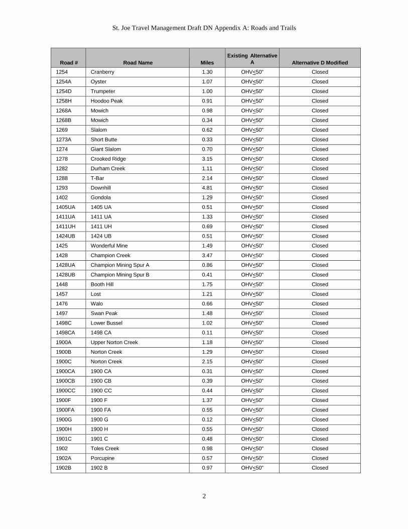
St. Joe Travel Management Draft DN Appendix A: Roads and Trails
2
Road # Road Name Miles Existing Alternative
A Alternative D Modified
1254 Cranberry 1.30 OHV<50" Closed 1254A Oyster 1.07 OHV<50" Closed 1254D Trumpeter 1.00 OHV<50" Closed 1258H Hoodoo Peak 0.91 OHV<50" Closed 1268A Mowich 0.98 OHV<50" Closed 1268B Mowich 0.34 OHV<50" Closed 1269 Slalom 0.62 OHV<50" Closed 1273A Short Butte 0.33 OHV<50" Closed 1274 Giant Slalom 0.70 OHV<50" Closed 1278 Crooked Ridge 3.15 OHV<50" Closed 1282 Durham Creek 1.11 OHV<50" Closed 1288 T-Bar 2.14 OHV<50" Closed 1293 Downhill 4.81 OHV<50" Closed 1402 Gondola 1.29 OHV<50" Closed 1405UA 1405 UA 0.51 OHV<50" Closed 1411UA 1411 UA 1.33 OHV<50" Closed 1411UH 1411 UH 0.69 OHV<50" Closed 1424UB 1424 UB 0.51 OHV<50" Closed 1425 Wonderful Mine 1.49 OHV<50" Closed 1428 Champion Creek 3.47 OHV<50" Closed 1428UA Champion Mining Spur A 0.86 OHV<50" Closed 1428UB Champion Mining Spur B 0.41 OHV<50" Closed 1448 Booth Hill 1.75 OHV<50" Closed 1457 Lost 1.21 OHV<50" Closed 1476 Walo 0.66 OHV<50" Closed 1497 Swan Peak 1.48 OHV<50" Closed 1498C Lower Bussel 1.02 OHV<50" Closed 1498CA 1498 CA 0.11 OHV<50" Closed 1900A Upper Norton Creek 1.18 OHV<50" Closed 1900B Norton Creek 1.29 OHV<50" Closed 1900C Norton Creek 2.15 OHV<50" Closed 1900CA 1900 CA 0.31 OHV<50" Closed 1900CB 1900 CB 0.39 OHV<50" Closed 1900CC 1900 CC 0.44 OHV<50" Closed 1900F 1900 F 1.37 OHV<50" Closed 1900FA 1900 FA 0.55 OHV<50" Closed 1900G 1900 G 0.12 OHV<50" Closed 1900H 1900 H 0.55 OHV<50" Closed 1901C 1901 C 0.48 OHV<50" Closed 1902 Toles Creek 0.98 OHV<50" Closed 1902A Porcupine 0.57 OHV<50" Closed 1902B 1902 B 0.97 OHV<50" Closed
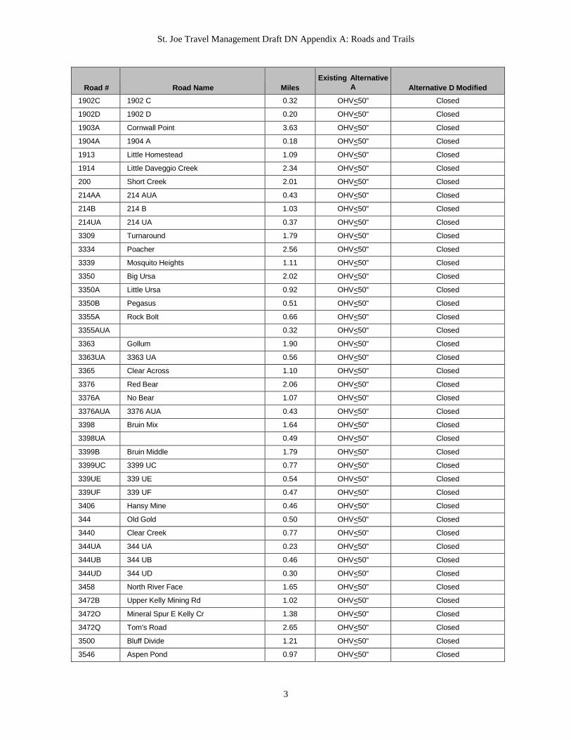
St. Joe Travel Management Draft DN Appendix A: Roads and Trails
3
Road # Road Name Miles Existing Alternative
A Alternative D Modified
1902C 1902 C 0.32 OHV<50" Closed 1902D 1902 D 0.20 OHV<50" Closed 1903A Cornwall Point 3.63 OHV<50" Closed 1904A 1904 A 0.18 OHV<50" Closed 1913 Little Homestead 1.09 OHV<50" Closed 1914 Little Daveggio Creek 2.34 OHV<50" Closed 200 Short Creek 2.01 OHV<50" Closed 214AA 214 AUA 0.43 OHV<50" Closed 214B 214 B 1.03 OHV<50" Closed 214UA 214 UA 0.37 OHV<50" Closed 3309 Turnaround 1.79 OHV<50" Closed 3334 Poacher 2.56 OHV<50" Closed 3339 Mosquito Heights 1.11 OHV<50" Closed 3350 Big Ursa 2.02 OHV<50" Closed 3350A Little Ursa 0.92 OHV<50" Closed 3350B Pegasus 0.51 OHV<50" Closed 3355A Rock Bolt 0.66 OHV<50" Closed 3355AUA 0.32 OHV<50" Closed 3363 Gollum 1.90 OHV<50" Closed 3363UA 3363 UA 0.56 OHV<50" Closed 3365 Clear Across 1.10 OHV<50" Closed 3376 Red Bear 2.06 OHV<50" Closed 3376A No Bear 1.07 OHV<50" Closed 3376AUA 3376 AUA 0.43 OHV<50" Closed 3398 Bruin Mix 1.64 OHV<50" Closed 3398UA 0.49 OHV<50" Closed 3399B Bruin Middle 1.79 OHV<50" Closed 3399UC 3399 UC 0.77 OHV<50" Closed 339UE 339 UE 0.54 OHV<50" Closed 339UF 339 UF 0.47 OHV<50" Closed 3406 Hansy Mine 0.46 OHV<50" Closed 344 Old Gold 0.50 OHV<50" Closed 3440 Clear Creek 0.77 OHV<50" Closed 344UA 344 UA 0.23 OHV<50" Closed 344UB 344 UB 0.46 OHV<50" Closed 344UD 344 UD 0.30 OHV<50" Closed 3458 North River Face 1.65 OHV<50" Closed 3472B Upper Kelly Mining Rd 1.02 OHV<50" Closed 3472O Mineral Spur E Kelly Cr 1.38 OHV<50" Closed 3472Q Tom's Road 2.65 OHV<50" Closed 3500 Bluff Divide 1.21 OHV<50" Closed 3546 Aspen Pond 0.97 OHV<50" Closed
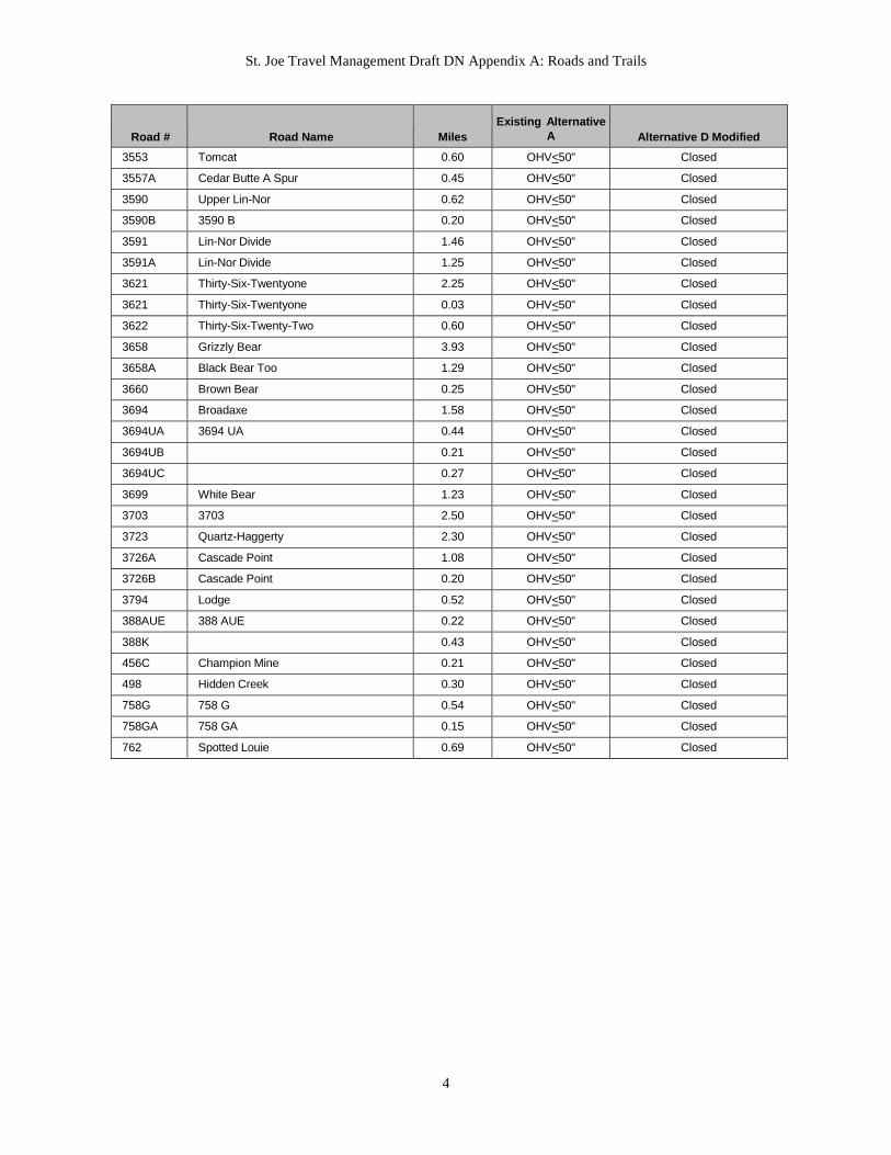
St. Joe Travel Management Draft DN Appendix A: Roads and Trails
4
Road # Road Name Miles Existing Alternative
A Alternative D Modified
3553 Tomcat 0.60 OHV<50" Closed 3557A Cedar Butte A Spur 0.45 OHV<50" Closed 3590 Upper Lin-Nor 0.62 OHV<50" Closed 3590B 3590 B 0.20 OHV<50" Closed 3591 Lin-Nor Divide 1.46 OHV<50" Closed 3591A Lin-Nor Divide 1.25 OHV<50" Closed 3621 Thirty-Six-Twentyone 2.25 OHV<50" Closed 3621 Thirty-Six-Twentyone 0.03 OHV<50" Closed 3622 Thirty-Six-Twenty-Two 0.60 OHV<50" Closed 3658 Grizzly Bear 3.93 OHV<50" Closed 3658A Black Bear Too 1.29 OHV<50" Closed 3660 Brown Bear 0.25 OHV<50" Closed 3694 Broadaxe 1.58 OHV<50" Closed 3694UA 3694 UA 0.44 OHV<50" Closed 3694UB 0.21 OHV<50" Closed 3694UC 0.27 OHV<50" Closed 3699 White Bear 1.23 OHV<50" Closed 3703 3703 2.50 OHV<50" Closed 3723 Quartz-Haggerty 2.30 OHV<50" Closed 3726A Cascade Point 1.08 OHV<50" Closed 3726B Cascade Point 0.20 OHV<50" Closed 3794 Lodge 0.52 OHV<50" Closed 388AUE 388 AUE 0.22 OHV<50" Closed 388K 0.43 OHV<50" Closed 456C Champion Mine 0.21 OHV<50" Closed 498 Hidden Creek 0.30 OHV<50" Closed 758G 758 G 0.54 OHV<50" Closed 758GA 758 GA 0.15 OHV<50" Closed 762 Spotted Louie 0.69 OHV<50" Closed
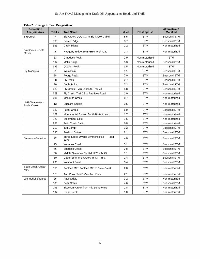
St. Joe Travel Management Draft DN Appendix A: Roads and Trails
5
Table 2: Change in Trail Designations Recreation
Analysis Area Trail # Trail Name Miles Existing Use Alternative D
Modified Big Creek 44 Big Creek: CCC CG to Big Creek Cabin 5.5 STM Seasonal STM
563 Pierce Ridge 3.7 STM Seasonal STM
565 Cabin Ridge 2.2 STM Non-motorized
Bird Creek - Gold Creek 5 Haggerty Ridge from FH50 to 1st road 2.3 STM Non-motorized
83 Craddock Peak 2.9 Non-motorized STM
197 Malin Ridge 5.3 Non-motorized Seasonal STM
385 Quarles Peak 3.5 Non-motorized STM
Fly-Mosquito 2 Walo Point 1.1 STM Seasonal STM
28 Peggy Peak 7.0 STM Seasonal STM
88 Fly Peak 2.7 STM Seasonal STM
89 Angle Point 7.3 STM Seasonal STM
629 Fly Creek: Twin Lakes to Trail 28 5.8 STM Seasonal STM
629 Fly Creek: Trail 28 to Red Ives Road 1.0 STM Non-motorized
631 Mosquito Creek 8.7 STM Non-motorized
LNF Clearwater – Foehl Creek 13 Buzzard Saddle 3.5 STM Non-motorized
120 Foehl Creek 5.9 STM Seasonal STM
122 Monumental Buttes: South Butte to end 1.7 STM Non-motorized
123 Steamboat Lake 1.6 STM Non-motorized
233 Twin Creek Cabin 0.8 STM Non-motorized
318 Jug Camp 1.3 STM Seasonal STM
595 Foehl to Buttes 2.1 STM Seasonal STM
Simmons-Stateline 72 Three Lakes Divide: Simmons Peak - Road 1278 4.0 STM Seasonal STM
73 Wampus Creek 3.1 STM Seasonal STM
76 Sherlock Creek 3.8 STM Seasonal STM
80 Middle Simmons Ck: Rd 1278 - Tr 73 1.1 STM Seasonal STM
80 Upper Simmons Creek: Tr 73 – Tr 77 2.4 STM Seasonal STM
290 Washout Point 3.4 STM Seasonal STM
Slate Creek-Cedar Mtn. 158 Foolhen Mtn: Foolhen Mtn to Slate Creek 2.8 STM Non-motorized
173 Arid Peak: Trail 175 – Arid Peak 2.1 STM Non-motorized
Wonderful-Shefoot 26 Packsaddle 3.2 STM Non-motorized
185 Bear Creek 4.6 STM Seasonal STM
193 Skookum Creek from mid-point to top 2.8 STM Non-motorized
194 Clear Creek 1.0 STM Non-motorized

Appendix B St. Joe Travel Management EA
Decision Notice
Map Changes in Designations:
Between Existing Condition and Alternative D Modified
June 2016

!! !!
!!
!!
!!
!!
!!!!
!!
!!
!!
!!
!!
!!!!!!
!!
!!
!!
!!
!!
!!!!
!!
!!!!
!!!!
!!
!!
!!
!!
!!
!!
!!
!!!!
!!!!!!
!!
!!!!
!!!!
!!!!
!!
!!
!!
!!
!! !!!!
!!!!!!
!! !!
!!
!!
!!
!!
!!
!!
!! !!
!!
!!
!!
!!!!
!!
!!!!!!
!!
!!!!
!!
!!
!!
!!
!! !! !!
!! !!!!
!! !!
!! !!
!!
!!!!
!!
!!
!!!!
!!
!!!!
!!
0 4 8 12 162Miles
1:280,000Scale -
µThe following product is reproduced from geospatial information prepared by the U.S. Department of Agriculture, Forest Service. GIS data and product accuracy may vary. They may be: developed from sources of differing accuracry, accurate only atcertain scales, based on modeling or interpretation, incomplete while being createdor revised, etc. Using GIS products for purposes other than those for which they arecreated may yield inaccurate or misleading results. The Forest Service reserves the right to correct, update, modify or replace GIS products without notification. For more information, contact the St. Joe Ranger District at (208) 245-2531.
Created on 04/25/2016 by RS
Travel Management PlanSt. Joe Ranger District
Idaho Panhandle National ForestsAlternative D Modified - Decision Notice
LegendChanges from Alternative A to Alternative D
Road SymbolMotorOpenCloseOpenCloseSeason
Alternative AMotorizedOpenClosedOpen Other PrivateClosedSeasonal Full Size
Alternative D ModifiedClosedOHV <50"OHV <50"OHV <50" Other PrivateSeasonal OHV <50"Seasonal OHV <50"
Trail SymbolMotorNonmo
!! STM!! Nonmo!! STM
Alternative AMotorizedNon-MotorizedSingle-track MotorNon-motorizedSingle-track Motor
Alternative D ModifiedNon-motorizedSingle-track MotorOHV <50"Seasonal STMSeasonal STM
No Changes to Trails No Changes to Roads
Alternative D Modified - Changes from Existing Condition


