44
St. Maries Creosote Site St. Maries, Idaho Proposed Plan July 2005 US Environmental Protection Agency Region 10

St. Maries Creosote Site St. Maries, Idaho
Proposed Plan
July 2005
US Environmental Protection Agency
Region 10

Proposed Plan – July 2005 St. Maries Creosote Site, St. Maries, Idaho
Table of Contents
1.0 PURPOSE OF PROPOSED PLAN................................................................................. 3
2.0 COMMUNITY ROLE IN SELECTION PROCESS..................................................... 3
3.0 SITE BACKGROUND ..................................................................................................... 4 3.1 SITE CHARACTERISTICS ................................................................................................... 6 3.2 CONCEPTUAL SITE MODEL .............................................................................................. 7 3.3 RESULTS OF SITE INVESTIGATIONS .................................................................................. 8
4.0 SUMMARY OF SITE RISKS.......................................................................................... 9 4.1 HUMAN HEALTH RISK ASSESSMENT.............................................................................. 10 4.2 ECOLOGICAL RISK ASSESSMENT.................................................................................... 11 4.3 CONCLUSIONS OF RISK ASSESSMENT............................................................................. 12
5.0 REMEDIAL ACTION OBJECTIVES AND CLEANUP LEVELS .......................... 13 5.1 REMEDIAL ACTION OBJECTIVES .................................................................................... 13 5.2 CLEANUP LEVELS .......................................................................................................... 13
5.2.1 Cleanup Levels for Upland Soil............................................................................ 14 5.2.2 Cleanup Levels for Groundwater.......................................................................... 14 5.2.3 Cleanup Levels for Sediments............................................................................... 14
6.0 SUMMARY OF REMEDIAL ALTERNATIVES ....................................................... 18 6.1 COMMON ELEMENTS...................................................................................................... 20 6.2 DESCRIPTION OF ALTERNATIVES ................................................................................... 21
7.0 EVALUATION OF ALTERNATIVES ........................................................................ 26 7.1 OVERALL PROTECTION OF HUMAN HEALTH AND THE ENVIRONMENT........................... 27 7.2 COMPLIANCE WITH APPLICABLE OR RELEVANT AND APPROPRIATE REQUIREMENTS (ARARS) ................................................................................................................................... 28 7.3 LONG-TERM EFFECTIVENESS AND PERMANENCE .......................................................... 29 7.4 REDUCTION OF TOXICITY, MOBILITY, OR VOLUME OF CONTAMINANTS THROUGH TREATMENT............................................................................................................................... 30 7.5 SHORT-TERM EFFECTIVENESS ....................................................................................... 30 7.6 IMPLEMENTABILITY ....................................................................................................... 32 7.7 COST.............................................................................................................................. 33 7.8 STATE/SUPPORT AGENCY ACCEPTANCE ........................................................................ 33 7.9 COMMUNITY ACCEPTANCE............................................................................................ 33
8.0 PREFERRED ALTERNATIVE.................................................................................... 33
8.1 CONTAINMENT OF UPLAND SOILS AND GROUNDWATER................................................ 34 8.2 REMOVAL AND TREATMENT OF BANK SOILS, SHORELINE SEDIMENTS, AND NEARSHORE SEDIMENTS ................................................................................................................................ 34 8.3 ASSESSMENT, MONITORING, AND CAPPING OF OFFSHORE SEDIMENTS ......................... 35 8.4 SUMMARY OF PREFERRED ALTERNATIVE ...................................................................... 35
9.0 GLOSSARY OF TERMS............................................................................................... 36
1
Proposed Plan – July 2005 St. Maries Creosote Site, St. Maries, Idaho
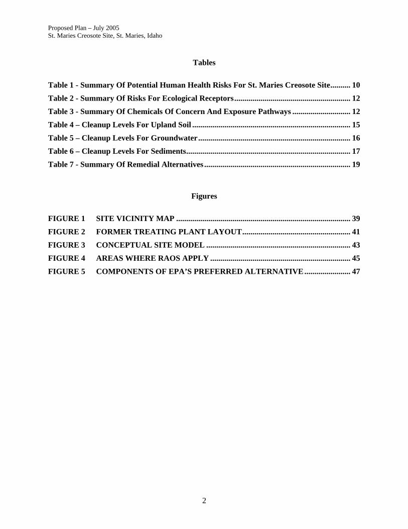
Tables
Table 1 - Summary Of Potential Human Health Risks For St. Maries Creosote Site.......... 10
Table 2 - Summary Of Risks For Ecological Receptors.......................................................... 12
Table 3 - Summary Of Chemicals Of Concern And Exposure Pathways ............................. 12
Table 4 – Cleanup Levels For Upland Soil ............................................................................... 15
Table 5 – Cleanup Levels For Groundwater............................................................................ 16
Table 6 – Cleanup Levels For Sediments.................................................................................. 17
Table 7 - Summary Of Remedial Alternatives ......................................................................... 19
Figures
FIGURE 1 SITE VICINITY MAP ....................................................................................... 39
FIGURE 2 FORMER TREATING PLANT LAYOUT...................................................... 41
FIGURE 3 CONCEPTUAL SITE MODEL ........................................................................ 43
FIGURE 4 AREAS WHERE RAOS APPLY ...................................................................... 45
FIGURE 5 COMPONENTS OF EPA’S PREFERRED ALTERNATIVE....................... 47
2

Proposed Plan – July 2005 St. Maries Creosote Site, St. Maries, Idaho 1.0 Purpose of Proposed Plan This Proposed Plan describes the remedial alternatives considered for the St. Maries Creosote Site (the Site) in St. Maries, Idaho. This Proposed Plan identifies the preferred remedial alternative and the rationale for this preference. The Proposed Plan was developed by the U.S. Environmental Protection Agency (EPA), as lead agency, in consultation with the Coeur d’Alene Tribe (the Tribe), and is being issued as part of EPA’s public participation responsibilities under Section 117(a) of the Comprehensive Environmental Response, Compensation, and Liability Act (CERCLA, or the Superfund Statute) of 1980, as amended, and Section 300.430(f)(2) of the National Oil and Hazardous Substances Pollution Contingency Plan (NCP). This Proposed Plan is being provided as required by the Superfund Statute to: 1) inform the public of the EPA's preferred remedy; 2) highlight key information in the administrative record, especially the Remedial Investigation (RI), Baseline Risk Assessment (BLRA), and the Feasibility Study (FS) Reports; 3) describe the remedial alternatives analyzed during the FS, and; 4) solicit public comments pertaining to the preferred alternative as well as all the remedial alternatives evaluated. Changes to the preferred remedy, or a change from the preferred remedy to another remedy, may be made if public comments or additional data indicate that such a change will result in a more appropriate remedial action. The final decision regarding the selected remedy will be made after the EPA has taken into consideration all public comments made during the comment period. The final decision will be contained in a Record of Decision (ROD) issued by the EPA. 2.0 Community Role in Selection Process The EPA relies on public input to ensure that the concerns of the community are considered in selecting an effective remedy for each Superfund site. The Administrative Record for this Site, which includes such documents as the Baseline Risk Assessment, the RI Report, the FS Report, and supporting documentation, has been made available to the public for a thirty-day public comment period that begins on July 22, 2005, and concludes on August 22, 2005. All information considered in the development of this Proposed Plan is included in the Administrative Record for public review. An information repository has been established at the St. Maries Public Library, 822 W. College Avenue, St. Maries, Idaho, where site related information may be reviewed. A public meeting will be held on Thursday August 11, 2005, from 7:00 to 9:00 PM, at the Avista Building, 502 College Street, St. Maries, Idaho, to receive public comments. Comments received at the public meeting, as well as written comments submitted during the comment period, will be addressed in the Responsiveness Summary that will be attached to the ROD (the document which formalizes the selection of the remedy).
3

Proposed Plan – July 2005 St. Maries Creosote Site, St. Maries, Idaho All written comments should be addressed to: Tony Fournier, Community Involvement Coordinator U.S. EPA, Region 10 1200 6th Avenue Seattle, WA 98101-1128 Telephone: 1-206-553-2578 or Toll-free: 1-800-424-4372 Email: [email protected] 3.0 Site Background St. Maries (population 2,800) is located along the southern bank of the St. Joe River in Benewah County, Idaho. The Site lies along the south bank of the river, approximately 2,600 feet downstream from the confluence with the St. Maries River and is within the boundaries of the Coeur d’Alene Indian Reservation (see Figure 1). The Site was used as a pole treating facility and is located on the river side of a flood control levee. In December 1998, the City of St. Maries reported a product sheen on the riverbank and in the water of the St. Joe River to the federal National Response Center. Following discovery of the sheen, the City of St. Maries and Carney Products Company, Ltd. (Carney Products), the most recent property lessee, conducted a removal action at the Site pursuant to a CERCLA Unilateral Administrative Order with EPA oversight. The action, in February 1999, included excavation and removal of approximately 195 tons of debris and creosote-impacted soil along the bank of the St. Joe River in the area of the observed seeping creosote. Since the removal, small areas of sheen have been noted intermittently on the river surface near the removal area. A containment boom and adsorbent pads continue to be maintained to control the sheens. The layout of the facility is shown in Figure 2. Creosote, derived from coal tar, is the most widely used wood preservative in the United States. Creosote is a complex mixture consisting of aromatic hydrocarbons, anthracene, naphthalene, and phenanthrene derivatives. At least 75% of the mixture is polynuclear aromatic hydrocarbons (PAHs). Seven of these PAH compounds are classified as carcinogenic [benzo(a)pyrene, benzo(a)anthracene, benzo(b)fluoranthene, benzo(k)fluoroanthene, dibenz(a,h)anthracene, chrysene, and indeno(1,2,3-cd)pyrene)]. Investigations were conducted by the City of St. Maries, Carney Products, and EPA from 1998 to 2000. The results of these investigations indicated that sediments, soil, and groundwater had been impacted by past creosote treating operations. To confirm and expand on these investigations, the City of St. Maries, Carney Products, EPA, and the Tribe entered into an Administrative Order on Consent (AOC) under CERCLA in August 2001 to perform a Remedial Investigation, Baseline Risk Assessment, and Feasibility Study for the Site. The St Maries Creosote Site was proposed for listing on the National Priorities list (NPL) in December 2000. Although EPA has not proceeded to finalize listing of the Site, investigations
4

Proposed Plan – July 2005 St. Maries Creosote Site, St. Maries, Idaho and cleanup are being conducted in accordance with the Superfund law and the regulations set forth in the NCP. The City of St. Maries and Carney Products, with oversight from EPA and in consultation with the Tribe, began an RI and BLRA in August 2001, focusing on the uplands (the ground above and next to the river) where the pole treating took place, groundwater, riverbank soils, nearshore and offshore sediments, and surface water. An FS was begun in January 2003. This Proposed Plan includes the areas studied in the RI. From 1939 through 1964, the site was used for peeling and treating logs to be used for poles. The bottom portion of the poles was soaked in large butt vats filled with creosote to prevent the poles from rotting once installed into the ground. The butt vats were located in the uplands approximately 50 to 75 feet from the bank of the St. Joe River. Historically, as the treated poles were loaded onto rail cars, creosote dripped onto the soil around the butt vats and rail cars. Additionally, dumping of process wastes, including creosote, may have occurred along the riverbank. Historical photographs show that during operations, three treating tanks, two aboveground storage tanks, and a wood-fired boiler building were located in the main treatment area. Site features are shown in Figure 2. A number of businesses, including B.J. Carney & Company (not related to Carney Products, Ltd.), have been associated with activities at the Site. These businesses were involved in the operation and maintenance of the treating operation from approximately 1942 to 1964, when the treatment facilities were demolished and removed. The Site has not been used for treating since 1965. Since approximately 1965, the Site and surrounding area have been used only for peeling, sorting, and storage of untreated poles. Carney Products, Ltd., shut down operations in early 2003. They had leased the property from the City of St. Maries. B.J. Carney & Co, Inc., Carney Products, Ltd., and the City of St. Maries have been identified by EPA as potentially responsible parties (PRP) that are liable for cleanup costs at the Site. To date, EPA Region 10 has conducted several community involvement activities at the Site. EPA compiled a 100-address mailing list and sent out four fact sheets, dated from December 2000 through May 2002. EPA also established an information repository at the St. Maries Library. An information repository is a place where interested citizens can go to review site information. A St. Maries web page was created within the EPA Region 10 web site (www.epa.gov/r10earth). People can find site history, contacts, and technical and community involvement documents on this web page. On June 17 and 18, 2002, EPA staff held community interviews at the St. Maries Library to listen to citizens' and local officials' suggestions and concerns regarding the site. The information gathered was used to write the site's Community Involvement Plan (CIP), published in August 2002. The CIP outlines EPA's planned community involvement activities and community members' recommendations. The CIP also lists citizens' and local officials' various concerns, and ways people said they wanted to be involved regarding site cleanup. It is a "living" document that can be updated at any time as new information is gathered from stakeholders.
5
Proposed Plan – July 2005 St. Maries Creosote Site, St. Maries, Idaho In October 2002, EPA worked closely with a local group that applied for a Technical Assistance Grant (TAG) for the Site. Despite a number of revisions to the application, EPA found there were several difficulties in meeting the criteria that could not be overcome by the group. Therefore, EPA and the local group agreed a grant could not be awarded. 3.1 Site Characteristics The Site is located just north of the downtown of St. Maries. The former creosote treating operation covered approximately 0.7 acre. Concrete pads and foundations mark the former location of treatment operations. An abandoned railroad track is located on the north side of the former treatment area. The highest creosote concentrations were found in soils beneath the former treatment area. Creosote was observed in soil borings completed between the treatment area and the river, in hand auger borings completed in soils along the riverbank, and in surface and subsurface sediments. A plume of contaminated groundwater extends north, approximately 175 feet (ft), from the treatment area to the river. The Site is located on the south side of the St. Joe River and is in a flat-lying area with an approximate elevation of 2,135 ft above sea level. The river channel is about 300 ft wide. The deepest portion of the channel has a depth ranging from 25 to 31 ft. The mean annual flow for the St. Joe River ranges from 1,000 to 3,800 cubic feet per second (cfs). The St. Joe River drains into the southern end of Lake Coeur d’Alene, which in turn drains into the Spokane River. Flow regulation at the Post Falls Dam on the Spokane River controls water levels in Lake Coeur d’Alene and the lower portion of the St. Joe River, including the reach adjacent to the Site. Except during flood conditions, water in the St. Joe River near the Site is slack. Immediately south of the Site is an earthen flood-control levee protecting the town of St.Maries from seasonal floodwaters of the St. Joe River. The estimated frequency of Site flooding is five to ten times per decade. To minimize damage due to flooding in the town of St. Maries, a levee system has been constructed within the town. In the early 1940s, the US Army Corps of Engineers (USACE) erected dikes along the southern bank of the St. Joe River. Since then, the levee system has grown in height and extent so that there are now eight levee districts within the town. The two major levees, Meadowhurst and Riverdale, are 14,000 and 11,000 feet long, respectively, and protect large tracts of the town. With the construction of levees, small-scale flooding within the town has been virtually eliminated; however, the levee system does not protect the Site from flooding. For the St. Joe River at the confluence with the St. Maries River, at the 100-year flow rate of 69,000 cfs the flood level is 2,142 ft above sea level. The levee system is protective up to 2,149 ft above sea level, 7 ft above the 100-year flood level. The Site is underlain by fluvial and deltaic floodplain deposits comprised of interbedded unconsolidated sand, silt, and clay to a depth of at least 65 ft. A veneer of fill material 2 to 5 ft thick overlies the Site and armors much of the southern riverbank. Native alluvial sediments underlie the fill and include four recognizable units: upper silt unit (15 to 20 ft thick), interbedded unit (12 to 21 ft thick), sand unit (13 to 16 ft thick), and lower silt unit (at least 10 ft thick). The surface of the deepest unit (the lower silt unit) generally slopes to the northeast, towards the river. The lower silt unit is acting as an aquitard for the groundwater above.
6
Proposed Plan – July 2005 St. Maries Creosote Site, St. Maries, Idaho The depth to groundwater varies seasonally, ranging from 2.5 to 7 ft below ground surface (bgs). During most of the year, groundwater flow is northward toward the river. However, the groundwater flow direction varies in response to river stage and during the summer when the river stage is high groundwater flow is southward. Temporary and local reversals in flow direction (southward from the river to the Site) also occur when the river rises during floods. Generally, groundwater in the upper silt unit flows north to the river at a rate of approximately 38 to 136 feet per year. Groundwater in the sand unit flows north to the river at a rate of approximately 313 feet per year. Near the shore, the river bottom generally consists of unconsolidated fine-grained sediments with a high percentage of natural organic material. The central channel of the river is predominantly fine to medium sand, overlain with woody debris and logs. Native sediment underlying the surface substrate consists of coarser-grained, compacted material, with trace silts and clays present. 3.2 Conceptual Site Model Significant concentrations of creosote constituents have been found in soil and groundwater in and around the former treating area, in riverbank soils, and in shoreline, nearshore and offshore sediments. A conceptual site model for the Site showing how contamination has moved from the uplands to the river is shown in Figure 3. Creosote was released at the site through spills, leaks, drips, and potentially disposal of wastes. The major source area is the former treating area. There may have also been disposal of wastes at the riverbank that contributed to the impacts observed in the bank soils and shoreline and nearshore sediments. Creosote released in the upland portion of the site has migrated from the surface soils to subsurface soils and to groundwater. Creosote has moved through soil both in the dissolved phase and as a dense non-aqueous phase liquid (DNAPL). Dissolved phased constituents of creosote have contaminated groundwater in the uplands at concentrations greater than drinking water standards. This contaminated groundwater migrates towards the river and is released to sediments and surface water. Concentrations in groundwater are at levels that have been shown to accumulate in sediments to levels that could be harmful to aquatic and benthic organisms. Creosote as a DNAPL will move vertically underground under the force of gravity through porous soils until it reaches a denser, confining layer (e.g., silt). It can then move horizontally along the surface of the confining layer. DNAPL will move horizontally through more porous, thinner “lenses” of fine-grained sands. DNAPL was observed in sand lenses at depths of up to 49 ft bgs and at shallower depths of 9 to 11 ft bgs. It is believed that creosote in this shallower zone has moved laterally towards the river, resulting in releases to the sediment and surface water. The movement of creosote through these migration pathways has resulted in extremely high concentrations of creosote along the riverbank and in shoreline and nearshore sediments. Once the creosote reached the river sediments, contaminated sediments were mobilized during periodic flooding events and deposited down stream. Through time, the periodic flooding and
7

Proposed Plan – July 2005 St. Maries Creosote Site, St. Maries, Idaho re-depositing of contaminated sediments has resulted in contaminated sediments observed at least 900 ft downstream of the site. Creosote in the upland soil, groundwater, and sediments will continue to act as a source of contamination to the environment unless actions are taken to control ongoing releases. 3.3 Results of Site Investigations The Site has been extensively investigated with several phases of sampling having been conducted since 1999. Samples have been collected from soils, groundwater, sediment, and surface water at the Site and in the vicinity to define the extent of contamination. High concentrations of chemicals were found in samples collected from the Site. The levels of unacceptable risks from exposure to these chemicals have been assessed and are discussed in Section 4.0. Soil concentrations of PAH, the dominant constituent of creosote, vary substantially with depth and relative distance from the treatment area. Soil samples were collected using soil borings, test pits, direct push probes, and hand augers. The maximum detected concentration of all PAH compounds (total PAH) at the Site was 33,503 milligrams per kilogram (mg/kg) found in a sample collected from soils along the riverbank removal area at a depth of 1 to 2 ft. This contamination was removed in February and March 1999. The highest concentration of total PAH detected in soils remaining in the upland area of the Site is 15,094 mg/kg found in a sample collected from soils at a depth of 2 ft below the former treatment area. Creosote was found in soil at depths up to 54 ft beneath the former treatment area. Three rounds of groundwater sampling were conducted for the RI. Samples were collected from six wells completed in the shallow aquifer zone (upper silt unit from 5 to 20 ft bgs) and five wells completed in the deep aquifer zone (sand unit from 35 to 55 ft bgs). PAHs were detected in many of the samples. The maximum detected groundwater concentration of total PAH was 11,449 micrograms per liter (µg/L) collected from a shallow aquifer well located midway between the treatment area and the river. Based on the sampling results, a plume of contaminated groundwater extends from the treatment area to the river and contains about 900,000 gallons of water. Because of the site’s close proximity to the river, dissolved PAH in groundwater could migrate and partition to river sediment causing a potentially unacceptable risk to benthic organisms. To evaluate this potential, measured groundwater concentrations from the site were used as input parameters to EPA’s BIOSCREEN model to first estimate a groundwater concentration at the mudline of the river. The output from this model was then used to calculate an estimated sediment concentration using sediment-water partitioning coefficients. Results showed that after 30 years naphthalene could accumulate in sediments to concentrations (21.8 mg/kg) that are more than 10 times the concentrations toxic to benthic organisms [2.1 mg/kg, the second lowest apparent effects threshold (2LAET)]. Creosote product, in the form of a DNAPL, was encountered in subsurface soil cores and sediment. Small but measurable quantities of DNAPL have accumulated in piezometers
8

Proposed Plan – July 2005 St. Maries Creosote Site, St. Maries, Idaho installed in the upland area of the Site during RI/FS monitoring activities. Based on field observations and physical and chemical testing, the amount of creosote with the potential to migrate is limited. However, during times of low water, creosote can be seen seeping in small quantities from the riverbank into the river. In the river, surface sediment [0 to 10 centimeters (cm) in depth] samples were collected from 18 locations and subsurface sediment samples (up to 14 ft bgs) were collected from 10 locations within the river. The highest concentration of total PAH detected in surface sediment was 21,000 mg/kg found in a sample collected in 2002 from the area just outside of the 1999 removal area in the nearshore sediments. The highest concentration of total PAH detected in subsurface sediment in the nearshore area was 51,709 mg/kg found at 1 ft depth in a sample collected approximately 40 ft from the riverbank removal area. This nearshore area of highly contaminated surface and subsurface sediments extends nearly 150 ft into the river from the riverbank and nearly 400 ft along the shoreline. The concentration of total PAH at one location was as great as 991 mg/kg at a depth of 10 ft in this nearshore area. An area of less highly contaminated surface and subsurface sediments extends beyond the nearshore area to the offshore. This offshore area extends up to 150 ft into the river from the riverbank and up to 900 ft along the shoreline, downstream from the Site. PAH concentrations in surface sediment in the offshore area are generally less than cleanup levels; however, higher concentrations were observed in sediment core layers just beneath the surface layer. For example, the concentration of total PAH at the sampling location furthest downstream was 24,000 mg/kg at a depth of 2 ft. Total PAH was observed in down gradient sediments at depths of up to 7 ft. Three rounds of surface water sampling were conducted for the RI. Surface water samples were collected from 5 locations in the St. Joe River. Creosote constituents were not detected at concentrations above water quality standards in any of the surface water samples collected from the river. This proposed plan addresses soil, groundwater, and sediment impacted by releases of creosote from pole treating operations at the Site. These releases have resulted in a localized area of soil contamination to a depth of approximately 54 ft, a plume of contaminated groundwater that flows from the former treatment area to the St. Joe River, and an extensive area of impacted sediments in the nearshore and offshore areas. There is no current exposure to contaminated soils unless the surface soils are disturbed. The groundwater plume is not affecting current drinking water sources or surface water quality in the St. Joe River. Sediment dwelling aquatic organisms are currently exposed to contaminated sediments at concentrations where adverse effects can be observed. 4.0 Summary of Site Risks As part of the RI/BLRA/FS, an assessment of the human health and ecological risks at the Site was conducted. Currently (July 2005) there is no human exposure to the contaminants found at the Site or migrating from the Site. However, if site groundwater is used for drinking water, it
9

Proposed Plan – July 2005 St. Maries Creosote Site, St. Maries, Idaho would pose an unacceptable risk. For ecological receptors, there is current risk to benthic organisms living in the sediment from exposure to Site contaminants. The BLRA contains detailed information on the potential current and future risks of the Site’s contaminants to human and ecological health. Human health risks are summarized in Table 1. Risks to ecological receptors are summarized in Table 2. The chemicals of concern identified for human and ecological receptors are listed in Table 3. 4.1 Human Health Risk Assessment Under EPA’s oversight, the City of St. Maries and Carney Products prepared the BLRA using the data collected during the RI. The RI and FS reports serve as the basis for determining appropriate action at the Site. These documents are available for review in the Administrative Record prepared for the Site. The BLRA included an evaluation of exposure to carcinogenic and non-carcinogenic contaminants at the Site. Carcinogenic and non-carcinogenic risks for several current and future exposure scenarios were calculated. (See the box on risk for a summary of the risk calculation method.) For humans, there were no unacceptable excess cancer risks (greater than 10-4) or non-carcinogenic risks (hazard index (HI) greater than 1) for current or future exposure scenarios except for a hypothetical on-site resident exposed to drinking water. The Site is in a unique situation with regard to human use. It lies on a floodway between the St. Joe River and a flood control levee. On average, water inundates the Site every other year. This frequent flooding restricts likely Site use. Placement of a residence on the Site is not allowed due to City zoning. A rezoning would be necessary but is considered unlikely because of the likelihood of flooding. Additionally, groundwater use is prohibited by City code. Table 1 - Summary of Potential Human Health Risks for St. Maries Creosote Site
Risk Scenario Carcinogenic Risk Non-Carcinogenic Risk (Hazard Index)
Current on-site adult recreationalist/trespasser
5 x 10⁻⁶ 0.006
Current on-site child recreationalist/trespasser
1 x 10⁻⁵ 0.02
Future on-site commercial/industrial workers
5 x 10⁻⁶ 0.0001
Future on-site construction workers 2 x 10⁻⁶ 0.1 Future hypothetical on-site resident (drinking water only)
4 x 10⁻³ (shallow gw); 1 x 10⁻³ (deep gw)
20 (shallow gw); 7 (deep gw)
10
Proposed Plan – July 2005 St. Maries Creosote Site, St. Maries, Idaho Risk to human health is estimated using a four-step process: Step 1: Analyze contamination Step 2: Estimate Exposure Step 3: Assess Potential Health Dangers Step 4: Characterize Site Risk. In Step 1, EPA looks at concentrations of contaminants found at a site, as well as scientific studies regarding health effects. In Step 2, EPA considers the different ways people might be exposed to contaminants identified at the site. EPA calculates a “Reasonable Maximum Exposure” which portrays the highest level of human exposure that could reasonably be expected to occur. In Step 3, EPA uses the information from Step 2, combined with toxicity information of each chemical to assess potential health risks. The likelihood of any kind of cancer resulting from a Superfund site is described as a probability; for example, “1 in 10,000 chance.” It means that for every 10,000 people exposed, one extra cancer may occur. An extra cancer means that one more person could get cancer than would normally be expected to from all other causes. EPA considers a risk unacceptable when the total excess lifetime cancer risk for a reasonable maximum exposure exceeds 10-4 (1 in 10,000). Total excess lifetime cancer risks below 10-6, (1 in one million), are considered acceptable. For non-cancer health effects, EPA calculates a “hazard index.” The key concept is that a “threshold level” (measured as a hazard index of less than 1) exists below which non-cancer health effects are not predicted. In Step 4, EPA determines whether site risks are great enough to cause health problems for people at or near the Superfund site. The results of the three previous steps are combined, evaluated, and summarized. The EPA adds up the potential risks from the individual contaminants and exposure pathways and calculates a total site risk. 4.2 Ecological Risk Assessment
An Ecological Risk Assessment indicated that the potential for significant ecological impacts at the Site is high. The BLRA indicated that there is current risk to benthic invertebrates and benthic fish in the nearshore area. Potential risk to mink could not be ruled out. No significant risk was found for pelagic fish and aquatic invertebrate communities exposed primarily to the water column. Two threatened or endangered species are known to use the St. Joe River: American bald eagle and bull trout. American bald eagles (Haliaeetus leucocephalus) have been observed feeding along the St. Joe River corridor. There are no nests near the Site. The St. Joe River is part of the Lake Coeur d' Alene basin, which supports the spawning of the federal-listed threatened bull trout (Salvenlinus confluentus). The bull trout migrates up the St. Joe River past the Site and finally into the St. Maries River. The St. Joe River within 15 miles downstream of the site is a migratory pathway and feeding area critical to anadromous fish species. The St. Joe River is included in the Coeur d’Alene Lake Basin Recovery Unit of the Bull Trout Recovery Plan prepared by the US Fish and Wildlife Service in 2002 to ensure protection of this species.
11

Proposed Plan – July 2005 St. Maries Creosote Site, St. Maries, Idaho Table 2 - Summary of Risks for Ecological Receptors
Receptor Exposure Pathway
Potential for Risk
Aquatic invertebrates (i.e., zooplankton) Surface water No Benthic invertebrates (i.e., sediment dwelling insect larvae, worms, and other organisms)
Sediment Yes
Benthic fish (i.e., brown bullhead trout) Sediment Yes Pelagic fish (i.e., bull trout) Surface water No Piscivorous riparian wildlife (i.e., mink) Fish consumption Yes
Table 3 - Summary of Chemicals of Concern and Exposure Pathways Chemical of Concern Human Health Ecological Receptors Naphthalene X X Acenaphthylene X Acenaphthene X X Fluorene X X Phenanthrene X Anthracene X Fluoranthene X X Pyrene X X Benz(a)anthracene X X Chrysene X X Benzo(b)fluoranthene X X Benzo(k)fluoranthene X X Benzo(a)pyrene X X Indeno(1,2,3,-c,d)pyrene X X Dibenzo(a,h)anthracene X X Benzo(g,h,i)perylene X 2-Methylnaphthalene X Benzene X Toluene X Ethylbenzene X Xylenes X Carbazole X Dibenzofuran X 4-Methylphenol X 2,4-Dimethylphenol X 4.3 Conclusions of Risk Assessment The following unacceptable risks were identified for the site:
• Potential future human exposure to contaminated drinking water • Current aquatic and benthic organisms exposure to contaminated sediments (i.e., brown
bullhead trout and sediment dwelling insect larvae, worms, and other organisms) • Current piscivorous mammals (i.e., mink) from consumption of contaminated fish
12

Proposed Plan – July 2005 St. Maries Creosote Site, St. Maries, Idaho It is EPA’s current judgment that the Preferred Alternative identified in this Proposed Plan is necessary to protect public health, welfare, and the environment from actual or threatened releases of hazardous substances into the environment. 5.0 Remedial Action Objectives and Cleanup Levels Remedial action objectives and cleanup levels necessary to address the risks identified for the site are discussed below. 5.1 Remedial Action Objectives Remedial Action Objectives (RAOs) provide a general description of the goals that the response action is expected to accomplish. The RAOs for the Site are:
• RAO 1 – Protect aquatic and benthic organisms by preventing direct contact of benthic organisms with COCs in surface sediment in the St. Joe River at concentrations greater than protective levels.
• RAO 2 – Prevent migration of impacted groundwater to surface sediment in the St.
Joe River that would result in COC concentrations greater than protective levels for aquatic and benthic organisms.
• RAO 3 – Prevent the downstream transport of COCs that result in COC
concentrations in water or sediment that exceed levels protective of aquatic and benthic organisms.
• RAO 4 – Prevent residential and commercial ingestion of and dermal contact with
COCs in groundwater at concentrations greater than protective levels.
EPA has determined that the RAO initially identified in the FS with an objective to prevent visible oil films or sheens in the St. Joe River, did not establish an appropriate analysis for developing remedial alternatives for the Site. RAOs are intended to specify the contaminants and media of interest, exposure pathways and preliminary remediation goals that allow a range of treatments and alternatives to be developed to protect human health and the environment. Instead, this RAO established a subjective, narrative standard based on whether films or sheens are visible, and was not used to develop remedial alternatives. EPA believes that the above four RAOs more appropriately describe what the response action is intended to accomplish. 5.2 Cleanup Levels Cleanup levels for upland soil, groundwater, and sediment are listed in Tables 4 through 6, respectively. The rationale for selection of specific cleanup levels is discussed below. The list of chemicals of concern is based on protection of groundwater as a drinking water source and the protection of ecological receptors associated with sediment.
13

Proposed Plan – July 2005 St. Maries Creosote Site, St. Maries, Idaho 5.2.1 Cleanup Levels for Upland Soil The Site does not pose an unacceptable risk to human health from direct contact exposure to soils; however, significant concentrations of chemicals of concern were found in soil that currently act as a source of contaminants to groundwater and sediment. Therefore, cleanup levels for soil are based on EPA Region 9 Preliminary Remediation Goals (PRGs) for protection of groundwater. Soil cleanup levels for the site chemicals of concern are listed in Table 4. Areas of the site to which these cleanup levels apply are discussed in Section 8.0.
5.2.2 Cleanup Levels for Groundwater Site groundwater poses a risk from two exposure pathways:
• Human health risk from use as a potential drinking water source • Ecological risk to aquatic and benthic organisms from migration to and accumulation in
sediments Because of these two different pathways, cleanup levels for groundwater for each chemical of concern were selected as the lowest of either the federal drinking water standards, called Maximum Contaminant Levels (MCLs) (or the EPA Region 9 PRGs for tap water where MCLs have not been established), or a site-specific groundwater concentration calculated to be protective of sediment. Selection of the lowest of these values ensures that both of the above risk pathways will be protected. The calculation method is described in detail the RI. Groundwater cleanup levels for the site chemicals of concern are listed in Table 5. Areas of the site to which these cleanup levels apply are discussed in Section 8.0.
5.2.3 Cleanup Levels for Sediments Shoreline, nearshore, and offshore sediment currently pose an unacceptable risk to aquatic and benthic organisms. The Coeur d’Alene Tribe, the state of Idaho, and EPA have not established freshwater sediment cleanup levels that would be applicable for the Site; therefore, the following approach for delineating the extent of contaminated sediment at the site and establishing boundaries for cleanup has been selected: Step One. Screen sediment concentrations against the values listed in Table 6. These values are the Washington State Sediment Quality Standards (SQS) and corresponding Lowest Apparent Effects Threshold (LAET), and Minimum Cleanup Levels (MCUL) and corresponding second Lowest Apparent Effects Threshold (2LAET) equivalents for sediments in Puget Sound. The LAET and 2LAET values are used in cases of either very low total organic carbon (<0.2%) or high organic carbon (>4%) sediment concentrations. Exceedance of the SQS will mark the reason to initiate biological testing (see step two below). The MCUL is the maximum allowed chemical concentration in sediment to be achieved after completion of cleanup actions.
14

Proposed Plan – July 2005 St. Maries Creosote Site, St. Maries, Idaho Step Two. For those sediments that exceed the above SQS (or LAET) value, perform follow-up biological testing. Methods used by Washington State for at least two acute effects tests and one chronic effects test will be followed. Follow-up biological testing will be used to demonstrate site-specific effects to benthic organisms. The use of marine standards for invoking bioassay testing is justified because PAH compounds have a mode of action of narcosis (arrested activity) for aquatic animals. This mode of action is not significantly affected by ion strength of the medium, which is the main difference between freshwater and marine water. The result of this approach will be to more firmly delineate sediment cleanup boundaries using results from site-specific biological testing during remedial design. Table 4 – Cleanup Levels for Upland Soil Chemical of Concern Soil Cleanup Level
(mg/kg) (1) Naphthalene 4 Acenaphthylene Not Available Acenaphthene 29 Fluorene 28 Phenanthrene Not Available Anthracene 590 Fluoranthene 210 Pyrene 210 Benz(a)anthracene 0.08 Chrysene 8 Benzo(b)fluoranthene 0.2 Benzo(k)fluoranthene 2 Benzo(a)pyrene 0.4 Indeno(1,2,3,-c,d)pyrene 0.7 Dibenzo(a,h)anthracene 0.08 Benzo(g,h,i)perylene Not Available 2-Methylnaphthalene Not Available Benzene 0.002 Toluene 0.6 Ethylbenzene 0.7 Xylenes 10 Carbazole 0.03 Dibenzofuran Not Available 4-Methylphenol Not Available 2,4-Dimethylphenol 0.4 (1) EPA Region 9 Preliminary Remediation Goal for the protection of groundwater using a dilution and attenuation factor (DAF) of 1.
15
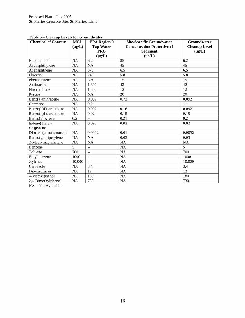
Proposed Plan – July 2005 St. Maries Creosote Site, St. Maries, Idaho Table 5 – Cleanup Levels for Groundwater Chemical of Concern MCL
(µg/L) EPA Region 9
Tap Water PRG
(µg/L)
Site-Specific Groundwater Concentration Protective of
Sediment (µg/L)
Groundwater Cleanup Level
(µg/L)
Naphthalene NA 6.2 85 6.2 Acenaphthylene NA NA 45 45 Acenaphthene NA 370 6.5 6.5 Fluorene NA 240 5.8 5.8 Phenanthrene NA NA 15 15 Anthracene NA 1,800 42 42 Fluoranthene NA 1,500 12 12 Pyrene NA NA 20 20 Benz(a)anthracene NA 0.092 0.72 0.092 Chrysene NA 9.2 1.1 1.1 Benzo(b)fluoranthene NA 0.092 0.16 0.092 Benzo(k)fluoranthene NA 0.92 0.15 0.15 Benzo(a)pyrene 0.2 -- 0.21 0.2 Indeno(1,2,3,-c,d)pyrene
NA 0.092 0.02 0.02
Dibenzo(a,h)anthracene NA 0.0092 0.01 0.0092 Benzo(g,h,i)perylene NA NA 0.03 0.03 2-Methylnaphthalene NA NA NA NA Benzene 5 -- NA 5 Toluene 700 -- NA 700 Ethylbenzene 1000 -- NA 1000 Xylenes 10,000 -- NA 10,000 Carbazole NA 3.4 NA 3.4 Dibenzofuran NA 12 NA 12 4-Methylphenol NA 180 NA 180 2,4-Dimethylphenol NA 730 NA 730 NA – Not Available
16

Proposed Plan – July 2005 St. Maries Creosote Site, St. Maries, Idaho Table 6 – Cleanup Levels for Sediments
Chemical Parameter SQS (mg/kg-OC)
LAET [ug/kg (dry
weight)]
MCUL (mg/kg-OC)
2LAET [ug/kg (dry weight)]
Naphthalene 99 2100 170 2100 Acenaphthylene 66 560 66 1300 Acenaphthene 16 500 57 500 Fluorene 23 540 79 540 Phenanthrene 100 1500 480 1500 Anthracene 220 960 1200 960 2-Methylnaphthalene 38 670 64 670 LPAH, Total 370 5200 780 5200
Fluoranthene 960 1700 1200 2500 Pyrene 160 2600 1400 3300 Benz(a)anthracene 1000 1300 270 1600 Chrysene 110 1400 460 2800 Total Benzofluoranthenes
110 3200 450 3600
Benzo(a)pyrene 230 1600 210 1600 Indeno (1,2,3,-c,c)pyrene 99 600 88 690 Dibenzo (a,h)anthracene 34 230 33 230 Benzo(g,h,i)perylene 12 670 78 720 HPAH, Total 21 12,000 5300 17,000 Note the change of units. Generally, 2LAET is used at very low (<0.2%) or high (> 4%) Total Organic Carbon sediment concentrations.
17
Proposed Plan – July 2005 St. Maries Creosote Site, St. Maries, Idaho 6.0 Summary of Remedial Alternatives Remedial alternatives investigated during the FS are summarized in Table 7. Alternatives were developed that address five subareas of the Site:
1. Upland Soils and Groundwater (approximately 0.44 acres). Includes the area around the former treatment facilities that contains soil and groundwater with COCs above cleanup levels.
2. Bank Soils (approximately 0.05 acres). Area of the 1999 removal action. 3. Shoreline Sediments (approximately 0.05 acres). In-water area of highly
contaminated sediments adjacent to the 1999 removal action area. 4. Nearshore Sediments (approximately 0.71 acres). In-water area of highly
contaminated sediments that extends approximately 150 ft into the river and 400 ft along the shoreline.
5. Offshore Sediments (approximately 2.3 acres). In-water area of lesser contaminated sediments that extends approximately 150 ft into the river and at least 900 ft downstream from the Site along the shoreline.
These areas are shown in Figure 4. In addition to the alternatives evaluated in the FS, this Proposed Plan introduces a new alternative (Alternative 8) that is a combination of containment, removal, and capping actions that were introduced in the FS. As a cost saving measure, on-site treatment with off-site disposal is included in this alternative.
18

Proposed Plan – July 2005 St. Maries Creosote Site, St. Maries, Idaho Table 7 - Summary of Remedial Alternatives
Remedial Action Component Alternative 1 2 3a 3b 3c 4a 4b 4c 5 6 7 8
Upland Soils and Groundwater • No action • Natural attenuation x x x• Enhanced biodegradation by air sparging x x• Containment – 3-sided slurry wall to depth of 60 ft (to lower
silt unit) • Containment – 3 sided sheetpile wall to depth of 60 ft (to lower
silt unit) • Containment – 4 sided sheetpile and slurry wall to depth of 60
ft (to lower silt unit) with surface soil cap • Soil solidification • Removal
Bank Soils • No action • Removal to fill unit with thin layer cap • Solidification to upper silt unit with 2 ft cap x x x x x x• Removal to upper silt unit, backfill to original bathymetry x x x x
Shoreline Sediment • No action • Removal of top 2 ft with thin layer cap • Removal of top 2 ft with clean backfill x x x• Removal of top 3 ft with clean backfill x x x• Removal of top 6 ft with clean backfill • Removal of top 8 ft with clean backfill
Nearshore Sediment • No action • Thin layer cap • 2 to 3 ft cap over existing sediments x x x• Removal of top 3 ft with clean backfill x x x• Removal of top 6 ft (average) with clean backfill • Removal of top 8 ft (average) with clean backfill
Offshore Sediment • No action • Monitoring with cap over 20 to 100% of existing sediments x x x x x x x x• 2 ft cap over existing sediments • Removal of top 6 ft with clean backfill
x x x
x
x
x x
x x
x x x x x x
x x x x x x
x x x x
19

Proposed Plan – July 2005 St. Maries Creosote Site, St. Maries, Idaho 6.1 Common Elements Several activities are common to the remedial alternatives, except the No Action alternative. The common components are:
• Regulatory status of waste. It is assumed that soils, sediments, and groundwater containing COC related to creosote at the Site are considered to “contain” F034 listed hazardous waste. Under EPA’s “contained in policy”, environmental media, such as soils, sediments and groundwater, that are contaminated with hazardous waste must be managed as hazardous waste under RCRA regulations. Additionally, soil and sediment from the Site contain creosote at concentrations greater than land disposal restrictions (LDR), and therefore if removed, must be treated prior to land disposal off site. Land disposal restrictions for soil and sediment may be met either by treatment to less than 10 times universal treatment standards (UTS) or by 90% reduction of contaminants, whichever is less stringent, or to another level if a treatment variance is approved. Attainment of these standards qualifies the media for land disposal. These reduction levels appear to be attainable using the thermal treatment technologies proposed in this plan.
For alternatives that include removal of soil and/or sediments, these materials would be treated, either at an off-site facility (Alternatives 2 through 7) or on site using mobile treatment technologies (Alternative 8), prior to final off-site disposal at a permitted landfill. The type of landfill that could be used may depend on the concentration of contaminants in soil or sediment after treatment.
• Permitting exemption. On site CERCLA cleanup actions are exempt from obtaining
federal, state, or local permits; however, the substantive requirements of applicable permits must be met.
• Institutional controls. Institutional controls are actions, such as legal controls or
administrative restrictions, which help minimize the potential for human exposure to contamination by ensuring appropriate land or resource use. Institutional controls are used when contamination is first discovered, when remedies are ongoing and when residual contamination remains on site at a level that does not allow for unrestricted use and unlimited exposure after cleanup. For all alternatives except alternative 7, contamination will remain on site after clean up actions are implemented, therefore institutional controls to restrict groundwater use (e.g., prohibition on well drilling at the Site) and land use (e.g., limiting site use to industrial practices) are included in each alternative. Statutory five-year reviews will be completed every five years after the start of cleanup activities.
• Monitoring. Monitoring will be used to assess the performance of the remedy to ensure
that protection of human health and the environment will be achieved and maintained. For example, monitoring may include the collection of groundwater samples to ensure that contaminants from the upland are not migrating to the river. Monitoring may also
20

Proposed Plan – July 2005 St. Maries Creosote Site, St. Maries, Idaho
include measuring the thickness of the nearshore and offshore sediment caps to ensure their long-term performance and stability.
6.2 Description of Alternatives A summary of the eight different alternatives is presented below. Detailed descriptions of the remedial actions included in the alternatives are included in the FS. Costs for each alternative (except “no action”) are presented as total present value (2004). Costs shown for the operation and maintenance category are based on 30 years, although the actual period could be longer. Costs assume a discount rate of 7 percent over a 30-year operation period. Estimated costs have a plus 50 to minus 30 percent accuracy. Alternative 1 – No Action Total Cost: $0 Alternative 2 – Bank and Shoreline Removal, Enhanced Natural Recovery of Nearshore Sediments, Monitoring of Groundwater and Offshore Sediments, Off-Site Disposal Estimated Total Cost: $4,181,000 (Capitol Cost: $2,306,000; O&M Cost: $1,875,000) Estimated Removal Volume: 1,296 cubic yards (CY) Estimated Construction Timeframe: Less than one year Estimated Time to Achieve RAOs: Uncertain due to effectiveness and rate of natural recovery processes and time needed to further assess offshore sediment contamination Alternative 2 is a combination of removal, natural recovery, and monitoring. Bank soils, shoreline sediments, and adjacent nearshore sediments would be removed in order to prevent further degradation of the St. Joe River. Natural processes would be allowed to reduce COC concentrations in groundwater to levels protective of sediments prior to reaching the sediments. Impacted nearshore sediments would be removed to a depth of 2 ft. A thin-layer cap of clean sediment would be placed over the area of remaining impacted nearshore sediments. This cap would be monitored to determine the effectiveness. Additional chemical and biological testing to determine the extent and depth of contaminated sediments will be conducted to determine the boundaries of the offshore area that would be capped. Costs are based on capping up to 20% of the offshore area. The actual area to be capped will be determined based on the additional monitoring data. Institutional controls would be used to restrict groundwater and land use, and to protect the sediment cap. Alternative 3a – Bank and Shoreline Removal and Solidification, Nearshore Sediment Cap, Monitoring of Groundwater and Offshore Sediments, Off-Site Disposal Estimated Total Cost: $5,101,000 (Capitol Cost: $3,345,000; O&M Cost: $1,756,000) Estimated Removal Volume: 1,559 CY Estimated Construction Timeframe: One year Estimated Time to Achieve RAOs: Uncertain due to effectiveness and rate of natural recovery processes and time needed to further assess offshore sediment contamination Alternative 3a is a combination of removal, in-place solidification, capping, and monitoring. Bank soils, shoreline sediments, and adjacent nearshore sediments would be addressed through a
21

Proposed Plan – July 2005 St. Maries Creosote Site, St. Maries, Idaho combination of removing some material and solidifying other material in order to prevent further degradation of the St. Joe River. Natural processes would be allowed to reduce COC concentrations in groundwater to levels protective of sediments prior to reaching the sediments. Impacted nearshore sediments would be removed to a depth of 2 ft. An engineered cap of clean sediment would be placed over the area of remaining impacted nearshore sediments. The cap would be monitored to determine the effectiveness. Additional chemical and biological testing to determine the extent and depth of contaminated sediments will be conducted to determine the boundaries of the offshore area that would be capped. Costs are based on capping up to 20% of the offshore area. The actual area to be capped will be determined based on the additional monitoring data. Institutional controls would be used to restrict groundwater and land use, and to protect the sediment cap. Alternative 3b – Bank and Shoreline Removal and Solidification, Nearshore Sediment Cap, Enhanced Biodegradation of Groundwater, Monitoring of Offshore Sediments, Off-Site Disposal Estimated Total Cost: $6,746,000 (Capitol Cost: $4,680,000; O&M Cost: $2,066,000) Estimated Removal Volume: 2,092 CY Estimated Construction Timeframe: One year Estimated Time to Achieve RAOs: Uncertain due to effectiveness and rate of biodegradation processes and time needed to further assess offshore sediment contamination Alternative 3b is a combination of enhanced natural recovery, removal, in-place solidification, capping, and monitoring. Bank soils, shoreline sediments, and adjacent nearshore sediments would be addressed through a combination of removing some material and solidifying other material in order to prevent further degradation of the St. Joe River. Natural biodegradation processes would be enhanced through air sparging in order to reduce COC concentrations in groundwater to levels protective of sediments prior to reaching the sediments. Impacted nearshore sediments would be removed to a depth of 2 ft. An engineered cap of clean sediment would be placed over the area of remaining impacted nearshore sediments. The cap would be monitored to determine the effectiveness. Additional chemical and biological testing to determine the extent and depth of contaminated sediments will be conducted to determine the boundaries of the offshore area that would be capped. Costs are based on capping up to 20% of the offshore area. The actual area to be capped will be determined based on the additional monitoring data. Institutional controls would be used to restrict groundwater and land use, and to protect the sediment cap. Alternative 3c – Bank and Shoreline Removal and Solidification, Nearshore Sediment Cap, Containment of Groundwater, Monitoring of Offshore Sediments, Off-Site Disposal Estimated Total Cost: $7,024,000 (Capitol Cost: $5,268,000; O&M Cost: $1,756,000) Estimated Removal Volume: 3,065 CY Estimated Construction Timeframe: One year Estimated Time to Achieve RAOs: Uncertain due to time needed to further assess offshore sediment contamination Alternative 3c is a combination of removal, solidification, containment, capping, and monitoring. Bank soils, shoreline sediments, and adjacent nearshore sediments would be addressed through a combination of removing some material and solidifying other material in order to prevent further
22
Proposed Plan – July 2005 St. Maries Creosote Site, St. Maries, Idaho degradation of the St. Joe River. A 3-sided soil/bentonite containment wall would be constructed to prevent contaminated groundwater in the fill and shallow silt units from reaching the sediments. Impacted nearshore sediments would be removed to a depth of 2 ft. An engineered cap of clean sediment would be placed over the area of remaining impacted nearshore sediments. The cap would be monitored to determine the effectiveness. Additional chemical and biological testing to determine the extent and depth of contaminated sediments will be conducted to determine the boundaries of the offshore area that would be capped. Costs are based on capping up to 20% of the offshore area. The actual area to be capped will be determined based on the additional monitoring data. Institutional controls would be used to restrict groundwater and land use, and to protect the sediment cap. Alternative 4a – Bank and Shoreline Removal and Solidification, Removal and Backfilling of Nearshore Sediment, Monitoring of Groundwater and Offshore Sediments, Off-Site Disposal Estimated Total Cost: $8,727,000 (Capitol Cost: $7,408,000; O&M Cost: $1,319,000) Estimated Removal Volume: 5,175 CY Estimated Construction Timeframe: Less than one year Estimated Time to Achieve RAOs: Uncertain due to effectiveness and rate of natural recovery processes and time needed to further assess offshore sediment contamination Alternative 4a is a combination of removal, solidification, capping, and monitoring. Bank soils, shoreline sediments, and adjacent nearshore sediments would be addressed through a combination of removing some material and solidifying other material in order to prevent further degradation of the St. Joe River. Natural processes would be allowed to reduce COC concentrations in groundwater to levels protective of sediments prior to reaching the sediments. Impacted nearshore sediments would be removed to a depth of 3 ft. The removal area would be capped to match the existing river bathymetry. The cap would be monitored to determine the effectiveness. Additional chemical and biological testing to determine the extent and depth of contaminated sediments will be conducted to determine the boundaries of the offshore area that would be capped. Costs are based on capping up to 20% of the offshore area. The actual area to be capped will be determined based on the additional monitoring data. Institutional controls would be used to restrict groundwater and land use, and to protect the sediment cap. Alternative 4b – Bank and Shoreline Removal and Solidification, Removal and Backfilling of Nearshore Sediment, Enhanced Biodegradation of Groundwater, Monitoring of Offshore Sediments, Off-Site Disposal Estimated Total Cost: $10,398,000 (Capitol Cost: $8,769,000; O&M Cost: $1,629,000) Estimated Removal Volume: 5,708 CY Estimated Construction Timeframe: One year Estimated Time to Achieve RAOs: Uncertain due to effectiveness and rate of biodegradation processes and time needed to further assess offshore sediment contamination Alternative 4b is a combination of removal, solidification, enhanced biodegradation, capping, and monitoring. Bank soils, shoreline sediments, and adjacent nearshore sediments would be addressed through a combination of removing some material and solidifying other material in order to prevent further degradation of the St. Joe River. Natural biodegradation processes would be enhanced through air sparging in order to reduce COC concentrations in groundwater
23

Proposed Plan – July 2005 St. Maries Creosote Site, St. Maries, Idaho to levels protective of sediments prior to reaching the sediments. Impacted nearshore sediments would be removed to a depth of 3 ft. The removal area would be capped to match the existing river bathymetry. The cap would be monitored to determine the effectiveness. Additional chemical and biological testing to determine the extent and depth of contaminated sediments will be conducted to determine the boundaries of the offshore area that would be capped. Costs are based on capping up to 20% of the offshore area. The actual area to be capped will be determined based on the additional monitoring data. Institutional controls would be used to restrict groundwater and land use, and to protect the sediment cap. Alternative 4c – Bank and Shoreline Removal and Solidification, Removal of Nearshore Sediment, Containment of Groundwater, Monitoring of Offshore Sediments, Off-Site Disposal Estimated Total Cost: $10,677,000 (Capitol Cost: $9,358,000; O&M Cost: $1,319,000) Estimated Removal Volume: 6,681 CY Estimated Construction Timeframe: Less than one year Estimated Time to Achieve RAOs: Uncertain due to rate of natural recovery processes and time needed to further assess offshore sediment contamination Alternative 4c is a combination of removal, in-place solidification, containment, and capping. Bank soils, shoreline sediments, and adjacent nearshore sediments would be addressed through a combination of removing some material and solidifying other material in order to prevent further degradation on the St. Joe River. A soil/bentonite containment wall (3-sided) would be constructed to contain groundwater in the fill and shallow silt units to prevent impacted groundwater from reaching the sediments. Impacted nearshore sediments would be removed to a depth of 3 ft. The removal area would be capped to match the existing river bathymetry. The cap would be monitored to determine the effectiveness. Additional chemical and biological testing to determine the extent and depth of contaminated sediments will be conducted to determine the boundaries of the offshore area that would be capped. Costs are based on capping up to 20% of the offshore area. The actual area to be capped will be determined based on the additional monitoring data. Institutional controls would be used to restrict groundwater and land use, and to protect the sediment cap. Alternative 5 – Integrated Removal of Bank Soils, Shoreline Sediments, and Nearshore Sediments, Containment of Groundwater, Capping of Offshore Sediments, Off-Site Disposal Estimated Total Cost: $28,291,000 (Capitol Cost: $27,395,000; O&M Cost: $896,000) Estimated Removal Volume: 15,428 CY Estimated Construction Timeframe: One to two years Estimated Time to Achieve RAOs: Achieved upon completion of construction Alternative 5 is a combination of removal, containment, and capping. Bank soils, shoreline sediments, and nearshore sediments would be excavated by constructing a temporary sheetpile cell around the impacted area. Soil and sediment within the cell would be removed to an average depth of 8 ft. The area would be backfilled with clean material to match the existing river bathymetry. The river side of the sheetpile cell would be removed after completion of the removal and backfilling activities. The upland side of the sheetpile wall would remain and become part of the groundwater containment wall. The sheetpile removed from the river would be reused to form the other two sides of the groundwater containment wall. The containment
24

Proposed Plan – July 2005 St. Maries Creosote Site, St. Maries, Idaho wall would be constructed to a depth of 60 ft to prevent impacted groundwater from reaching the sediments. To prevent erosion of sediments in the offshore, an erosion resistant cap would be installed over 100% of the area. The type of cap will be determined during remedial design using additional chemical and biological testing to determine the extent and depth of contaminated sediments. Groundwater and the sediment cap would be monitored to evaluate long-term protectiveness. Institutional controls would be used to restrict groundwater and land use, and to protect the sediment cap. Alternative 6 – Solidification of Upland Soils, Removal of Bank Soils, Shoreline Sediments, Nearshore Sediments, and Offshore Sediments, Off-Site Disposal Estimated Total Cost: $44,039,000 (Capitol Cost: $43,792,000; O&M Cost: $247,000) Estimated Removal Volume: 34,121 CY Estimated Construction Timeframe: One to two years Estimated Time to Achieve RAOs: Achieved upon completion of construction Alternative 6 is a combination of removal and solidification. Bank soils, shoreline sediments, and adjacent nearshore sediments would be removed in order to prevent further degradation of the St. Joe River. Upland soils would be solidified to prevent leaching of COC from soil to groundwater and prevent impacted groundwater from reaching sediments in the St. Joe River. Solidification of the upland soils would be achieved through in-situ shallow soil mixing with a cement and bentonite mix. The specific methods to be used would be determined during remedial design. The solidification would extend to the bottom of the interbedded unit (approximately 35 ft). Bank soils, shoreline sediments, and nearshore sediments, and offshore sediments would be removed to an average depth of 8 and 6 ft, respectively. The area would be backfilled with clean material to match the existing river bathymetry. Alternative 7 – Complete Removal of Upland Soils, Bank Soils, Shoreline Sediment, Nearshore Sediment, and Offshore Sediment, Off-Site Disposal Estimated Total Cost: $67,186,000 (Capitol Cost: $66,939,000; O&M Cost: $247,000) Estimated Removal Volume: 56,821 CY Estimated Construction Timeframe: One to two years Estimated Time to Achieve RAOs: Achieved upon completion of construction Alternative 7 includes the complete removal of accessible soil and sediment from the Site that exceed cleanup levels. Soil would be removed to an approximate depth of 60 ft. Shoring would be required to allow excavation in these soils and to minimize infiltration of groundwater into the excavation. The methods to be used would be determined during remedial design. Bank soils, shoreline sediments, and nearshore sediments, and offshore sediments would be removed to an average depth of 8 and 6 ft, respectively. The area would be backfilled with clean material to match the existing river bathymetry. Alternative 8 (New) – Removal of Bank Soils, Shoreline Sediments, and Nearshore Sediments, Containment and Capping of Upland Soils, Monitoring and Capping of Offshore Sediments, Off-Site Disposal Estimated Total Cost: $10,239,000 (Capitol Cost: $9,479,000; O&M Cost: $760,000) Estimated Removal Volume: 13,300 CY
25

Proposed Plan – July 2005 St. Maries Creosote Site, St. Maries, Idaho Estimated Construction Timeframe: One to two years Estimated Time to Achieve RAOs: Achieved upon completion of construction Alternative 8 is a combination of containment, removal, and capping that was developed by EPA as the proposed plan was assembled. It is similar to Alternative 5 with modifications to provide a higher level of long-term effectiveness at lower cost. Upland soils and groundwater would be contained on site with a four-sided sheetpile and slurry wall in a waste management area. The wall will be extended into the lower silt unit (approximate depth of 60 ft) to prevent migration of DNAPL and impacted groundwater to the river. The area will be capped to prevent precipitation and flood water infiltration and be resistant to scouring during flood events. Groundwater inside and outside this waste management area will be monitored to evaluate the effectiveness of the containment cell. Bank soils, shoreline sediments, and nearshore sediment will be removed, treated on site, and disposed off site. Removal of these most highly contaminated areas (to a depth of 8 ft) and backfilling with clean material to the original bathymetry will restore the aquatic and benthic environment and prevent further migration of contaminated sediments downstream. Engineering methods will be used during removal activities to control potential short-term, off-site impacts. The area will be monitored to evaluate performance and long-term stability. Additional chemical and biological testing to determine the extent and depth of contaminated sediments will be conducted to determine the boundaries of the offshore area that would be capped (costs assume 100% of the area will be capped). Physical conditions of the river would also be assessed to determine design parameters for a scour-resistant cap. The material and thickness of the cap will be determined during remedial design. The cap would be monitored to verify performance and long-term stability. Institutional controls would be used to restrict groundwater and land use, and to protect the sediment cap. 7.0 Evaluation of Alternatives Nine criteria are used to evaluate the different alternatives individually and against each other in order to select a remedy. The nine evaluation criteria are: (1) overall protection of human health and the environment; (2) compliance with Applicable or Relevant and Appropriate Requirements (ARARs); (3) long-term effectiveness and permanence; (4) reduction of toxicity, mobility, or volume of contaminants through treatment; (5) short-term effectiveness; (6) implementability; (7) cost; (8) state/support agency acceptance; and (9) community acceptance. This section of the Proposed Plan profiles the relative performance of each alternative against the nine criteria, noting how it compares to the other options under consideration. The nine evaluation criteria are discussed below. A detailed analysis of the original seven alternatives can be found in the FS. This evaluation differs from the FS analysis of alternatives in that the Site was divided into five subareas (as
26

Proposed Plan – July 2005 St. Maries Creosote Site, St. Maries, Idaho shown in Figure 4), and the remedial actions for each subarea are compared against the nine criteria. Alternative 8 is included in this evaluation. For each of the five subareas a variety of remedial actions, ranging from minimal action to full removal, were presented in the FS. One action for each of the five subareas was selected and combined to form a complete alternative. The alternatives range from least aggressive, Alternative 2 (Natural Attenuation, Limited Removal, and Limited Capping), to intermediate, Alternatives 3, 4, and 5, and 8 (Biodegradation, Containment and Removal), and most aggressive, Alternative 7 (Complete Removal). 7.1 Overall Protection of Human Health and the Environment Determines whether an alternative eliminates, reduces, or controls threats to public health and the environment through institutional controls, engineering controls, or treatment. Protection of human health and the environment was evaluated by checking to see that each remedial action could achieve the RAOs (see Section 5.0). Sediment is only a concern for ecological receptors so human protection is not considered for this medium. Because the “no action” remedial actions are not protective of human health and the environment, it was eliminated from consideration under the remaining eight criteria. Upland Soils and Groundwater. Alternatives 2, 3a, 3b, 4a, and 4b rely on natural attenuation or enhanced biodegradation to prevent DNAPL and groundwater from further impacting sediments near the site and it is uncertain whether these technologies would be effective. Natural attenuation of contaminants is a combination of degradation, adsorption, dilution, and dispersion processes that result in reduced concentrations of contaminants over time. The time needed to reduce concentrations to acceptable levels is site specific and can take tremendously long periods of time, especially for DNAPL sites. For DNAPL sites, the EPA recommends that natural attenuation be selected as part of a remedy only in conjunction with source removal or containment. Alternatives 2, 3a, 3b, 4a, and 4b do not include source removal or containment in the uplands. Though natural degradation processes are most likely occurring along the edges of the contaminated upland area, data show that dissolved phase contaminants and DNAPL are reaching the St. Joe River at concentrations greater than risk-based protective levels. If natural processes are occurring, there has not been adequate time or distance needed to reduce contamination by natural processes; therefore, using natural attenuation or enhanced biodegradation to address contaminated upland soils and groundwater is not considered protective of human health and the environment. The remaining actions include a containment wall (Alternatives 3c, 4c, and 5), containment cell (Alternative 8), solidification (Alternative 6), or complete removal (Alternative 7) to prevent leaching of contaminants in soil to groundwater and subsequent migration of groundwater to the river. Except for no action, the alternatives prevent direct contact with soil or ingestion of contaminated groundwater using containment, removal, or institutional controls and are anticipated to adequately protect human health and the environment from the contaminants in soil and groundwater.
27

Proposed Plan – July 2005 St. Maries Creosote Site, St. Maries, Idaho Bank Soils. All of the remedial actions include removal or solidification of bank soils and are considered to be protective of human health and the environment. Shoreline Sediment. All of the remedial actions include removal of shoreline sediments and are considered to be protective of the environment; however, alternatives that include removal of contaminated material from greater depths are considered to provide a higher degree of protectiveness. Nearshore Sediment. Alternative 2 includes monitored natural recovery of the nearshore sediment, which is not considered protective of the environment. Alternatives 3a, 3b, and 3c include capping of nearshore sediment, which would be effective unless there is vertical migration of contaminants through the cap. Alternatives 4a, 4b, and 4c include a combination of removal and capping of nearshore sediments that would be more protective than the previous alternatives. Alternatives 5, 6, 7, and 8 include removal of all of the contaminated nearshore sediments, which offers the highest degree of protection for the environment. Offshore Sediment. Alternatives 2, 3a, 3b, 3c, 4a, 4b, 4c, and 8 include additional assessment, monitoring, and potential capping of 20% to 100% of the offshore sediments. Though there is potential that during the assessment process a flood event could occur that would further distribute contaminated sediments downstream, these alternatives will eventually provide environmental protection and prevent scour. Alternative 5 includes capping 100 % of the offshore sediments would be protective of the environment. Alternatives 6 and 7, which include dredging of contaminated sediment would be protective of the environment. 7.2 Compliance with Applicable or Relevant and Appropriate Requirements (ARARs) Evaluates whether the alternative meets federal, state, and tribal environmental statutes, regulations, and other requirements that pertain to the Site or whether a waiver is justified.
Upland Soils and Groundwater. The National Primary Drinking Water Standards under the Safe Drinking Water Act are relevant and appropriate to the groundwater contamination. The point of compliance for Maximum Contaminant Levels (MCLs) for remedies where waste materials will be managed in place are at and beyond the edge of the waste management area. Alternatives 5 and 8 would comply with this ARAR but the other alternatives would not. Bank Soils. All of the remedial actions would comply with ARARs. Shoreline Sediment. All of the remedial actions would comply with ARARs. Nearshore Sediment. All of the remedial actions would comply with ARARs. Offshore Sediment. All of the remedial actions would comply with ARARs.
28

Proposed Plan – July 2005 St. Maries Creosote Site, St. Maries, Idaho 7.3 Long-Term Effectiveness and Permanence Considers the ability of an alternative to maintain protection of human health and the environment over time. Upland Soils and Groundwater. Alternatives 2, 3a, and 3b do not include treatment and the long-term effectiveness of natural attenuation for preventing soil leaching and migration of groundwater or DNAPL to the river is uncertain. Alternatives 3b and 4b may offer long-term effectiveness but it is unclear whether there is sufficient room between the zone of contaminated groundwater and the river for air sparging to be effective. Alternatives 3c, 4c, 5, and 8 include a wall to provide long-term protection to sediment quality by preventing contact with contaminated groundwater. Alternative 8 provides the highest level of protection of these four alternatives because the wall fully encloses the contaminated area and includes a surface cap to exclude precipitation or surface water. Alternatives 6 and 7 would have the highest long-term effectiveness by including solidification and removal, respectively. Bank Soils. All of the remedial actions include bank soil removal that would be effective in the long term unless there is recontamination via migrating groundwater. Alternatives 3c, 4c, 5, 6, 7, and 8 include either soil (and groundwater) containment, solidification, or removal of upland soils to prevent recontamination of bank soils. Shoreline Sediment. Alternative 2, which includes removal of two feet of contaminated sediment, placement of a thin cap, and monitored natural recovery has the lowest potential for permanence because of the potential for seepage through the cap or scouring. Alternatives 3a, 3b, and 3c, which include removal of two feet of sediment and replacement with a two-foot thick scour-resistant sand and gravel cap, would be more permanent because of the more substantial capping materials. Alternatives 4a, 4b, and 4c, which include removal of three feet of sediment and replacement with three feet thick of scour-resistant sand and gravel backfill, would be slightly more permanent because of the thicker layer of capping materials. Alternatives 5, 6, 7, and 8, which include between 6 and 8 feet of sediment removal and replacement with scour-resistant sand and gravel backfill, are considered to be the most effective and permanent actions. Nearshore Sediment. The thin layer cap for Alternative 2 has a risk of being scoured away during a flood event and therefore is not considered effective in the long term. Alternatives 3 and 4, which include removal of the top 2 to 3 ft of material and replacement with clean backfill, would leave in place residual contamination that could leach to surface sediments. Alternatives 5, 6, 7,and 8 include removal of all sediment with the potential to cause risk to receptors and is considered the most effective and permanent action. Offshore Sediment. Alternatives 2, 3, 4, 5 and 8 include a cap for the offshore sediments, which is considered effective in the long-term if scour-resistant capping materials are used. Alternatives 6 and 7 include removal and treatment of the contaminated material, which is considered the most protective in the long-term.
29

Proposed Plan – July 2005 St. Maries Creosote Site, St. Maries, Idaho 7.4 Reduction of Toxicity, Mobility, or Volume of Contaminants Through Treatment Evaluates an alternative’s use of treatment to reduce the harmful effects of principal contaminants, their ability to move in the environment, and the amount of contamination present. Upland Soils and Groundwater. The remedial actions include monitoring, containment, soil solidification, or removal (with treatment). Alternatives 2, 3a, 3c, 4a, 4c, 5, and 8, which rely on monitored natural attenuation or containment do not include treatment and are ranked lowest under this criterion. Alternatives 3b and 4b include air sparging, which may reduce contaminant concentrations in groundwater before the point of discharge to the river but the effectiveness of this method is uncertain. Alternative 6 includes solidification to reduce the mobility of contaminants; however, the toxicity and volume of material remaining on site would not be reduced. Alternative 7 includes removal with off-site thermal treatment of soils to reduce the concentrations of COC (greater than 10x UTS) prior to disposal at an off-site landfill. Bank Soils. The remedial actions include solidification or removal (with treatment). As with the actions for upland soils, removal of bank soils with either on-site or off-site treatment would do the most to reduce toxicity, mobility and volume of contaminants. Shoreline Sediment. The remedial actions include removal and treatment of impacted sediments to up to 8 ft in depth. All of the removal actions would be effective in reducing toxicity, mobility and volume of contaminants. Alternatives 5, 6, 7, and 8 would result in more reduction in toxicity, mobility and volume, than Alternatives 2, 3, and 4 because a greater quantity of material would be removed and treated. Nearshore Sediment. The remedial actions include monitoring, capping or removal (with treatment). Monitoring (Alternative 2) and capping options (Alternatives 3 and 4) do not include treatment and are ranked lowest under this criterion. Alternatives 5, 6, 7, and 8 include removal and thermal treatment of contaminated sediments, which would reduce their mobility, toxicity and volume. Offshore Sediment. The remedial actions include assessment, monitoring, capping or removal. The assessment, monitoring and capping actions (Alternatives 2, 3, 4, 5, and 8) do not include treatment and are therefore ranked lowest under this criterion. Alternatives 6 and 7 include removal and treatment of contaminated sediments, which would reduce their mobility, toxicity and volume. 7.5 Short-Term Effectiveness Considers the length of time needed to implement an alternative, the length of time until cleanup standards are met, and the risks the alternative poses to workers, residents, and the environment during implementation. Upland Soils and Groundwater. Alternatives 2, 3a, and 4a rely on monitoring, which poses little risk to workers. Risk of sediment recontamination is not reduced by this alternative and therefore it is uncertain when or if sediment cleanup levels will be attained. Alternatives 3b and
30

Proposed Plan – July 2005 St. Maries Creosote Site, St. Maries, Idaho 4b include air sparging, which could be implemented safely and has the potential for slightly reducing the potential for sediment recontamination. The rate at which reduction in contaminants would be achieved by this method is uncertain. Alternatives 3c, 4c, 5, and 8 include containment, which would take longer to install (a few months) with more heavy equipment than previous alternatives. Short-term impacts due to noise and dust would be monitored and minimized. Reductions in risks to the environment would be achieved sooner after implementation. Soil solidification (Alternative 6) and complete removal (Alternative 7) would require substantially more excavation and therefore would require more construction time and potentially pose more risk than installation of a slurry or sheetpile wall. These two alternatives would achieve risk reduction sooner than the other alternatives. On-site treatment (Alternative 8) may also include short-term impacts from noise and air emissions that can be controlled during construction and will be monitored. Bank Soils. The soil solidification and removal actions would pose approximately the same short-term risk to workers and the environment for Alternatives 2 through 8. There is a potential for short-term impacts to the aquatic environment during removal actions; however, use of proper engineering controls, such as silt curtains, would be included during any removal operation to minimize these impacts. There is also a potential during on-site treatment activities (Alternative 8) for short-term impacts from noise and air emissions of the mobile treatment unit. The length of time needed to implement the alternatives, and the length of time until cleanup standards are met, are about the same for all alternatives. Shoreline Sediment. The removal actions would pose approximately the same short-term risk to workers and the environment. Engineering controls would be used to minimize short-term impacts to the aquatic environment. There is also a potential during on-site treatment activities (Alternative 8) for short-term impacts from noise and air emissions of the mobile treatment unit. The length of time needed to implement the alternatives, and the length of time until cleanup standards are met, are about the same for all alternatives. Nearshore Sediment. The monitored natural recovery component of Alternative 2 has the lowest short-term risk to workers but may not reduce risk to the environment if a flood scours the nearshore areas. Alternatives 3 and 4, which include capping, have the next lowest short-term risk to the workers and the environment because there would be minimal disruption of contaminated sediment. Alternatives 5, 6, 7, and 8 have the highest short-term risk to the environment because of the potential for incidental releases during dredging. Engineering controls would be used to minimize short-term impacts to the aquatic environment. There is also a potential during on-site treatment activities (Alternative 8) for short-term impacts from noise and air emissions of the mobile treatment unit. The length of time needed to implement the alternatives, and the length of time until cleanup standards are met, are about the same for all alternatives. Offshore Sediment. Alternatives 2, 3, 4, 5 and 8 include capping which should have minimal short-term risk to the environment. Cleanup standards would be met upon the installation of the cap. Alternatives 6, and 7 have the highest short-term risk to the environment because of the potential for incidental releases during dredging. Engineering controls would be used to minimize short-term impacts to the aquatic environment. Cleanup standards would be met upon
31

Proposed Plan – July 2005 St. Maries Creosote Site, St. Maries, Idaho completion of the dredging. The length of time needed for implementation is the same for all alternatives. 7.6 Implementability Considers the technical and administrative feasibility of implementing the alternative such as relative availability of goods and services. While all of the actions can be implemented at the Site, some are more easily implemented than others. In general, the technical implementability decreases with increasing complexity of construction and use of specialized equipment. Administrative implementability decreases with the increase in substantive requirements that apply to permitting. Actions requiring construction and/or operations in the uplands may also be impacted by periodic flooding of the site that would need to be accounted for during design. Upland Soils and Groundwater. Alternatives 2, 3a, and 4a rely on monitoring, which is easy to implement. Alternatives 3b and 4b include air sparging which would be easy to implement although it may be difficult to verify that the sparging zone includes all of the contaminated groundwater. Alternatives 3c, 4c, 5, and 8 include sheetpile or slurry walls, which should be relatively easy to implement because this is well known technology. Alternative 6, which includes solidification of contaminated soil may be difficult to implement because the technology is relatively uncommon. Alternative 7, which includes removal of all upland soils would be the most technically complex to implement. This action would require a highly engineered construction design including the use of sheetpile walls, excavation, shoring, dewatering, water treatment, and off-site soil treatment and disposal. Bank Soils. All of the alternatives include removal so this does not affect the relative implementability between alternatives for bank soils. Shoreline Sediment. Although the depth of sediment removal varies, this does not affect the relative implementability between alternatives for shoreline sediment. Nearshore Sediment. Alternative 2 includes monitored natural recovery, which would be the easiest to implement. Alternatives 3 and 4 include capping, which would be the next easiest to implement. Alternatives 5, 6, 7, and 8 include dredging, that would be the most difficult to implement. Offshore Sediment. Alternatives 2, 3, 4, 5 and 8 include assessment, monitoring, and capping, which would not be difficult to implement because capping is a commonly used remedy. Alternatives 6 and 7 include dredging, which would be the more difficult to implement than capping.
32
Proposed Plan – July 2005 St. Maries Creosote Site, St. Maries, Idaho 7.7 Cost Includes estimated capital and operation and maintenance costs as well as present worth costs. Present worth cost is the total cost of an alternative over time in terms of today’s dollar value. Cost estimates are expected to be accurate within a range of +50 to -30 percent. Alternative 2 has the lowest estimated costs ($1,178,000). Costs increase with the increased complexity of the proposed remedial actions and the quantity of material requiring treatment. Alternatives were developed to give a broad range of options that would span from less aggressive, lower cost remedies to very aggressive, higher cost remedies. The most aggressive alternative, Alternative 7 that includes complete removal and thermal treatment of soil and sediment containing contaminants, is the most costly with an estimated cost of $67,190,000. These estimates are approximate and made without detailed engineering design. The actual cost of the project would depend on the final scope of the remedial action and on other unknowns. 7.8 State/Support Agency Acceptance Considers whether the state agrees with the EPA’s analyses and recommendations of the RI/FS and the Proposed Plan. The state of Idaho is conducting a final review of this proposed plan and the preferred alternative concurrent with the public comment period. The state will provide comments to EPA by the end of the public comment period. The EPA has consulted with the Coeur d’Alene Tribe throughout the RI, BLRA, and FS process. 7.9 Community Acceptance Considers whether the local community agrees with the EPA’s analyses and preferred alternative. Comments received on the Proposed Plan are important indicators of community acceptance. Community acceptance of the preferred alternative will be evaluated after the public comment period ends and will be described in the ROD for the Site. 8.0 Preferred Alternative Alternative 8 was selected as the Preferred Alternative. Actions for each subarea were selected based on the results of the comparison of alternatives. Actions for each subarea are shown in Figure 5. This combination of actions is considered to achieve the best balance of meeting the nine criteria over the other alternatives considered. It will achieve substantial risk reduction by containing, removing, and treating source materials. This combination reduces risks sooner, costs less than some of the other alternatives, and is more permanent and more protective. The following actions were selected as the preferred alternative in this Proposed Plan. Note that the
33

Proposed Plan – July 2005 St. Maries Creosote Site, St. Maries, Idaho preferred alternative is based on current information and details of the remedy could change in response to public comment or new information. 8.1 Containment of Upland Soils and Groundwater To contain the upland soils that are a continuing source of contaminants and DNAPL to groundwater and the St. Joe River, the area of soil containing concentrations of chemicals of concern greater than soil cleanup levels protective of groundwater would be contained by a four-sided wall and capped to minimize water infiltration. Impacted groundwater within the wall would not have to meet groundwater cleanup levels because this would be a waste management area (WMA); however, groundwater outside the wall would need to meet groundwater cleanup levels. The wall will be designed to surround the area of impacted soil and groundwater as delineated in the RI. For the containment cell, a sheetpile wall would be installed near the top of the riverbank to serve as a buttress for bank soils, shoreline sediments, and nearshore sediments removal. A bentonite slurry wall would be installed beginning at the upstream and downstream ends of the sheetpile wall and extending landward to encircle the area of contaminated soil. The sheetpile and bentonite containment walls would be extended into the lower silt unit (approximate depth of 60 ft) to prevent DNAPL and impacted groundwater from reaching the sediments. A low-permeability cap would then be placed over the top of the WMA to prevent infiltration of precipitation or surface water during flood events. The cap would also need to be scour-resistant to maintain integrity during flooding events. Groundwater would be monitored for 30 years on the inside and outside of the WMA to verify the effectiveness of the system. There may be additional monitoring requirements. Institutional controls would be used to restrict groundwater and land use. These actions will achieve RAOs 2 and 4. 8.2 Removal and Treatment of Bank Soils, Shoreline Sediments, and Nearshore Sediments Bank soils, shoreline sediments, and nearshore sediments would be excavated or dredged to an average depth of 8 ft. Removal of these most highly contaminated areas and backfilling with clean material to the original bathymetry will restore the aquatic and benthic environment and prevent further migration of contaminated sediments downstream. After dewatering sediments, the contaminated soil and sediment would be thermally treated on site and the treated soil would be taken off site to a permitted landfill for disposal. Engineering methods will be used during removal activities to control potential short-term, off-site impacts. The area will be monitored to evaluate performance and long-term stability. These actions will achieve RAOs 1 and 3. As a cost-reduction measure, on-site thermal treatment is proposed instead of off-site incineration (Alternatives 2 through 7). If concentrations of chemicals of concern in excavated and dredged material can be reduced to less than soil treatment standards (< 10xUTS or 90% reduction, whichever is less stringent, or to another level if a treatment variance is approved), then material may be disposed of in a permitted landfill. However, because the material is considered a listed hazardous waste, it may need to be disposed of in a RCRA Subtitle C landfill unless the final concentration of chemicals of concern are low enough to allow for disposal elsewhere.
34
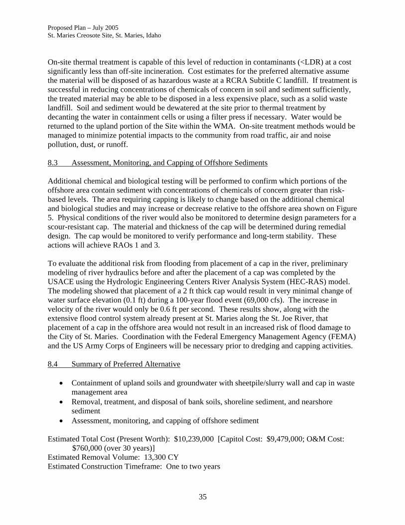
Proposed Plan – July 2005 St. Maries Creosote Site, St. Maries, Idaho On-site thermal treatment is capable of this level of reduction in contaminants (<LDR) at a cost significantly less than off-site incineration. Cost estimates for the preferred alternative assume the material will be disposed of as hazardous waste at a RCRA Subtitle C landfill. If treatment is successful in reducing concentrations of chemicals of concern in soil and sediment sufficiently, the treated material may be able to be disposed in a less expensive place, such as a solid waste landfill. Soil and sediment would be dewatered at the site prior to thermal treatment by decanting the water in containment cells or using a filter press if necessary. Water would be returned to the upland portion of the Site within the WMA. On-site treatment methods would be managed to minimize potential impacts to the community from road traffic, air and noise pollution, dust, or runoff. 8.3 Assessment, Monitoring, and Capping of Offshore Sediments Additional chemical and biological testing will be performed to confirm which portions of the offshore area contain sediment with concentrations of chemicals of concern greater than risk-based levels. The area requiring capping is likely to change based on the additional chemical and biological studies and may increase or decrease relative to the offshore area shown on Figure 5. Physical conditions of the river would also be monitored to determine design parameters for a scour-resistant cap. The material and thickness of the cap will be determined during remedial design. The cap would be monitored to verify performance and long-term stability. These actions will achieve RAOs 1 and 3. To evaluate the additional risk from flooding from placement of a cap in the river, preliminary modeling of river hydraulics before and after the placement of a cap was completed by the USACE using the Hydrologic Engineering Centers River Analysis System (HEC-RAS) model. The modeling showed that placement of a 2 ft thick cap would result in very minimal change of water surface elevation (0.1 ft) during a 100-year flood event (69,000 cfs). The increase in velocity of the river would only be 0.6 ft per second. These results show, along with the extensive flood control system already present at St. Maries along the St. Joe River, that placement of a cap in the offshore area would not result in an increased risk of flood damage to the City of St. Maries. Coordination with the Federal Emergency Management Agency (FEMA) and the US Army Corps of Engineers will be necessary prior to dredging and capping activities. 8.4 Summary of Preferred Alternative
• Containment of upland soils and groundwater with sheetpile/slurry wall and cap in waste management area
• Removal, treatment, and disposal of bank soils, shoreline sediment, and nearshore sediment
• Assessment, monitoring, and capping of offshore sediment Estimated Total Cost (Present Worth): $10,239,000 [Capitol Cost: $9,479,000; O&M Cost:
$760,000 (over 30 years)] Estimated Removal Volume: 13,300 CY Estimated Construction Timeframe: One to two years
35

Proposed Plan – July 2005 St. Maries Creosote Site, St. Maries, Idaho Estimated Time to Achieve RAOs: Achieved upon completion of construction Actions for each subarea were selected based on the results of the comparison of alternatives. This combination of actions is considered to achieve the best balance of meeting the nine criteria over the other alternatives considered. It will achieve substantial risk reduction by containing, removing, and treating source materials. This combination reduces risks sooner, costs less than some of the other alternatives, and is more permanent and protective. Note that the preferred alternative is based on current information and details of the remedy could change in response to public comment or new information. CERCLA requires that remedial actions that result in any hazardous substances, pollutants, or contaminants remaining at the site above levels that allow for unlimited use and unrestricted exposure be subject to a statutory five-year review to ensure protection of human health and the environment. The Site will be subject to statutory five year reviews by EPA because there will be contaminants left in place at concentrations greater than levels protective of unrestricted use and unlimited exposure. Based on the information currently available, EPA believes the preferred alternative meets the threshold criteria and provides the best balance of tradeoffs among the other alternatives with respect to the balancing and modifying criteria. The EPA expects the preferred alternative to satisfy the following statutory requirements of CERCLA Section 121(b): 1) be protective of human health and the environment; 2) comply with ARARs; 3) be cost effective; 4) utilize permanent solutions and alternative treatment technologies to the maximum extent practicable; and 5) meets the preference for selecting remedies with treatment as a principal element. 9.0 Glossary of Terms This glossary defines many of the technical terms used in this Proposed Plan. Comprehensive Environmental Response, Compensation, and Liability Act (CERCLA): A federal law passed in 1980 and modified in 1986 by the Superfund Amendments and Reauthorization Act, commonly known as Superfund, to investigate and clean up abandoned or uncontrolled hazardous waste sites. Under the program, EPA can either: 1) pay for site cleanup when parties responsible for the contamination cannot be located or are unwilling or unable to perform the work; or, 2) take legal action to force parties responsible for site contamination to clean up the site or pay back the federal government the cost of the cleanup. Chemicals of Concern (COCs): Contaminants, identified during the site investigations and risk assessments, that pose a potential risk because of their toxicity and potential routes of exposure to public health and the environment. Groundwater: Water, filling spaces between soil, sand, rock and gravel particles beneath the earth's surface, that often serves as a source of drinking water and that moves and can go into surface water.
36

Proposed Plan – July 2005 St. Maries Creosote Site, St. Maries, Idaho Institutional Controls: Controls placed on property to ensure safe access and future development, or to alert buyers about the history of a site. Maximum Contaminant Levels (MCLs): The maximum permissible level of a contaminant in water that is or may be consumed as drinking water. These levels are determined by EPA and are applicable to all public water supplies. Monitoring Wells: Special wells installed at specific locations on or off a hazardous waste site where groundwater can be sampled at selected depths and studied to determine such things as the direction in which the groundwater flows and the types and concentrations of contaminants present. National Oil and Hazardous Substances Pollution Contingency Plan (NCP): The Federal regulation that guides the Superfund program. Natural Recovery. A natural process. Natural attenuation of contaminants is a combination of degradation, adsorption, dilution, and dispersion processes that result in reduced concentrations of contaminants over time. Operation and Maintenance (O&M): Activities conducted at a site after response actions occur, to ensure that the cleanup or containment system continues to be effective. Plume: A body of contaminated groundwater flowing from a specific source. The movement of the groundwater is influenced by such factors as local groundwater flow patterns, the character of the aquifer in which groundwater is contained, and the density of contaminants. Toxicity: A measure of the degree to which a substance is harmful to human and animal life.
37

Proposed Plan – July 2005 St. Maries Creosote Site, St. Maries, Idaho
This page intentionally blank
38

Printed from TOPO! @2000 National Geographic Holdings (www.topo.coml
IDAHO
Figure 1. Site Vldnlty Map.
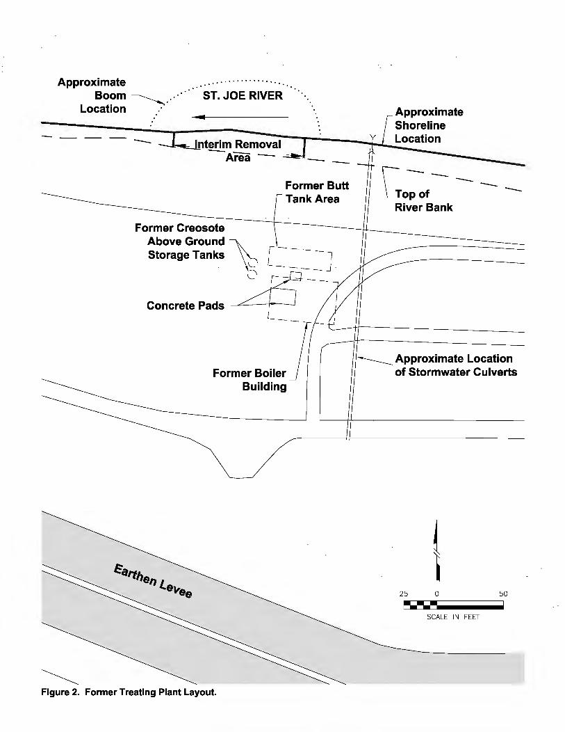
Approximate .. · · · · · · · · · · · · · · ·. Boom ------..., ... · ·. ST. JOE RIVER
Location .·
-Former Butt Tank Area
Approximate Shoreline Location
- - -FormerCre~o;s;o;t~e~-----1-------------U-----------
Above Ground ~ -----
~
Storage Tanks [ - - - - l "--- --- J
Concrete Pads ~ _--:__ L
Former Boiler Building
Figure 2. Former Treating Plant Layout.
----Approximate Location of Stormwater Culverts
25 0 50
~---SCALE IN FEET

Figure 3. Conceptual Site Model Showing Potential Migration and Exposure Pathways.

ST. JOE RIVER Nearshore Sediment
80 0 160 ----SCALE IN FEET
Figure 4. Areas where RAOs apply.
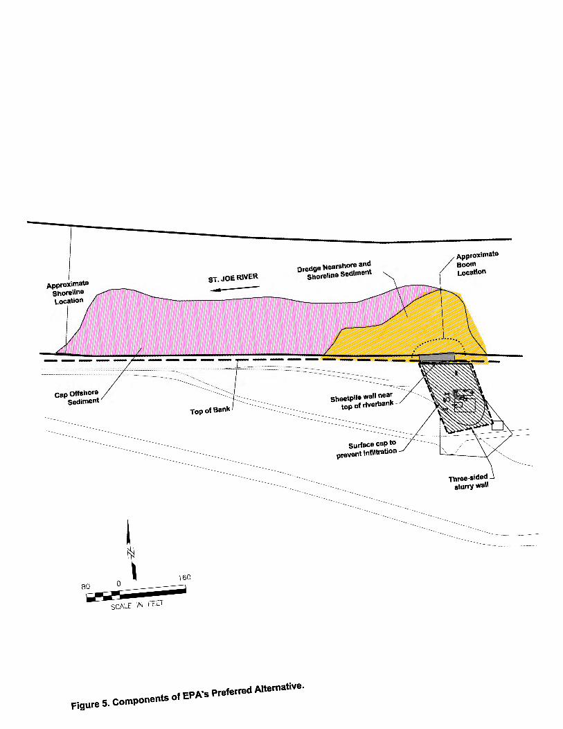
cap Offshore Sediment
80 0 ----SCALE IN FEET
~50
a
ST. JOE RIVER
Dredge Nearshore and Shoreline Sediment
Figure 5. Components of EPA's Preferred Alternative.
Approximate Boom Location


