8/9/2013 1 Subsurface Exploration PART 1 Topics Covered • I. SUBSURFACE EXPLORATION PROGRAM • II. EXPLORATORY BORINGS IN THE FIELD • III. PROCEDURES FOR SAMPLING SOIL • IV. OBSERVATION OF WATER LEVELS
Transcript
8/9/2013
1
Subsurface Exploration
PART 1
Topics Covered
• I. SUBSURFACE EXPLORATION PROGRAM
• II. EXPLORATORY BORINGS IN THE FIELD
• III. PROCEDURES FOR SAMPLING SOIL
• IV. OBSERVATION OF WATER LEVELS
8/9/2013
2
SUBSURFACE EXPLORATION
• Soil exploration is a part of SITE INVESTIGATION.
• Site investigation, in general deals with determining in general, THE SUITABILITY OF THE SITE FOR THE PROPOSED CONSTRUCTION.
Site Investigation
8/9/2013
3
Introduction:
WHAT?
• Attempt at understanding the subsurface conditions such as:• SOIL AND ROCK PROFILE
• GEOLOGICAL FEATURES OF THE REGION
• POSITION AND VARIATION OF GROUND WATER TABLE
• PHYSICAL PROPERTIES OF SOIL AND ROCK
• CONTAMINATION, IF ANY
• GENERAL DATA OF ADJACENT STRUCTURES, HYDROLOGICAL DATA, TOPOGRAPHY, SOIL MAPS, SEISMICITY, ETC.
Introduction (Cont’d)…
WHY?
• To DETERMINE THE TYPE OF FOUNDATIONrequired for the proposed project at the site, i.e. shallow foundation or deep foundation.
• To make RECOMMENDATIONS REGARDING THE SAFE BEARING CAPACITY or pile load capacity since it is the subsoil that provides the ultimate support for the structures.
8/9/2013
4
TO AVOID THIS!
THIS!
Foundation Weakening Due to Soil
Liquefaction in Adapazari, Turkey
8/9/2013
5
THIS!A sinkhole covers a street intersection in
downtown Guatemala City, Wednesday,
June 2, 2010. Authorities blamed heavy
rains caused by tropical storm Agatha as
the cause of the crater that swallowed a a
three-story building but now say they will
be conducting further studies to determine
the cause.
AND THESE!
SINKHOLES
LEANING TOWER OF PISA
8/9/2013
6
Introduction (Cont’d)…
HOW?
• The three important aspect are PLANNING, EXECUTIONand report writing.
• PLANNING• To minimize cost of explorations and yet give
reliable data.
• Decide on quantity and quality depending on type, size and importance of project and whether investigation is preliminary or detailed.
Introduction (Cont’d)…
• EXECUTION:• COLLECTION OF DISTURBED
AND/OR UNDISTURBED SAMPLESof subsurface strata from field.
• CONDUCTING IN-SITU TESTS OF SUBSURFACE material and obtaining properties directly or indirectly.
• STUDY OF GROUND WATER CONDITIONS and collection of sample for chemical analysis.
• Geophysical exploration, if necessary.
• Laboratory testing on samples
8/9/2013
7
Introduction (Cont’d)…
A complete site investigation will consist of:
• PRELIMINARY WORK
• Collecting general information and already existing data such as study of geologic events , seismic maps, etc. at or near site.
• Study site history – if previously used as quarry, agricultural land, industrial unit, etc.
• SITE RECONNAISSANCE: ACTUAL SITE INSPECTION.
• To judge general suitability
• Decide exploration techniques
Introduction (Cont’d)…
• EXPLORATION• PRELIMINARY INVESTIGATIONS: Exploratory borings or
shallow test pits, representative sampling, geophysical investigations, etc
• DETAILED INVESTIGATIONS: Deep boreholes, extensive sampling, in-situ testing, lab testing, etc.
• DEPTH AND SPACING: In general, depth of investigation should be such that any/all strata that are likely to experience settlement or failure due to loading. Spacing depends upon degree of variation of surface topography and subsurface strata in horizontal direction.
8/9/2013
8
PHILIPPINE SEISMIC MAP
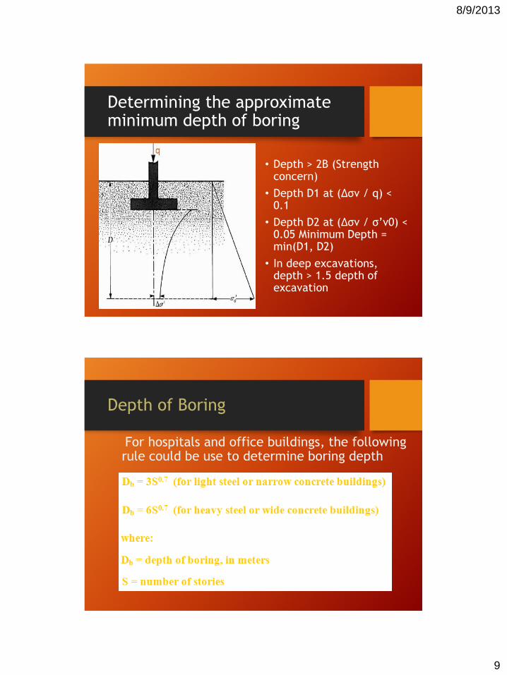
Depth of Boring
• The approximate required minimum depth of the borings should be predetermined.
• The estimated depths can be changed during the drilling operation, depending on the subsoil encountered.
• To determine the approximate minimum depth of boring, engineers may use the following rule:
8/9/2013
9
Determining the approximate minimum depth of boring
Light red 2.5YR 6/8 Nil (original decomposed soil)
Test Pit Wall Photograph
Western Wall Section
Test Pit Wall Drawing
Western Wall Section Drawing
8/9/2013
13
BOREHOLES
•AUGER BORINGS: • Simplest method of exploration and sampling.
• Power driven or hand operated.
• Max. depth 10 m
• Suitable in all soils above GWT but only in cohesive soil below GWT
• Hollow stem augers are used for sampling or conducting Standard Penetration Tests.
Hand operated augers
• Post hole auger • Helical auger• Portable power-
driven helical
augers
8/9/2013
14
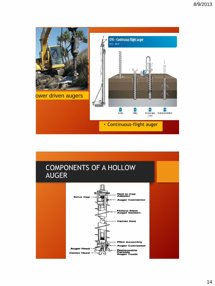
Power driven augers
• Continuous-flight auger
COMPONENTS OF A HOLLOW AUGER
8/9/2013
15
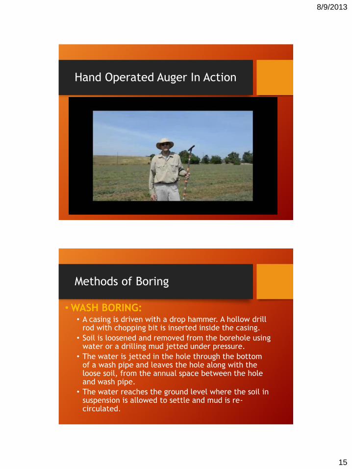
Hand Operated Auger In Action
Methods of Boring
• WASH BORING: • A casing is driven with a drop hammer. A hollow drill
rod with chopping bit is inserted inside the casing.
• Soil is loosened and removed from the borehole using water or a drilling mud jetted under pressure.
• The water is jetted in the hole through the bottom of a wash pipe and leaves the hole along with the loose soil, from the annual space between the hole and wash pipe.
• The water reaches the ground level where the soil in suspension is allowed to settle and mud is re-circulated.
8/9/2013
16
Schematic for wash boring
8/9/2013
17
Wash Boring
Methods of Boring
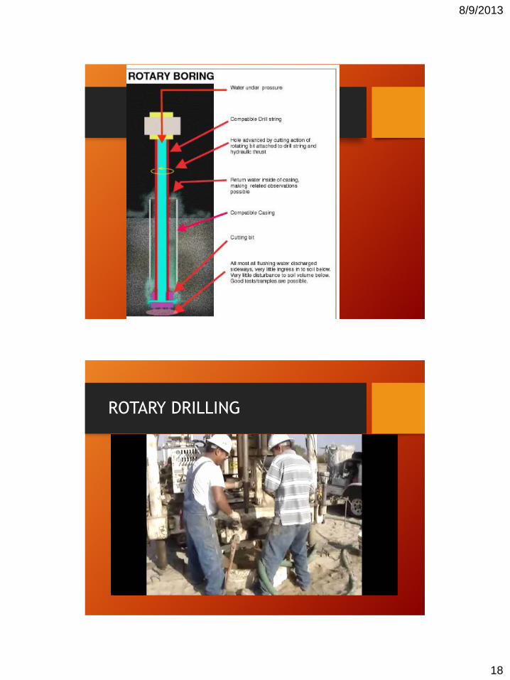
Another example of wash boring is called mud rotary drilling (soil) or core drilling (rock).
• MUD ROTARY(ROTARY DRILLING)• Hollow drill rods with a drill bit is rotated into
the soil. Drilling mud is continuously pumped into the hole. The bit grinds the soil and the return flow brings the cuttings to the surface.
8/9/2013
18
ROTARY DRILLING
8/9/2013
19
Methods of Boring
• PERCUSSION DRILLING:
• often used to penetrate hard rock for subsurface exploration or for the purpose of drilling wells.
PERCUSSION DRILLING
8/9/2013
20
SAMPLES
DISTURBED UNDISTURBED
(The structure of the soil is disturbed (The true in-situ structure and water content
to a considerable degree) is retained as closely as possible)
Remoulded Representative Block Drive
Wash
PROCEDURES FOR SOIL SAMPLING
8/9/2013
21
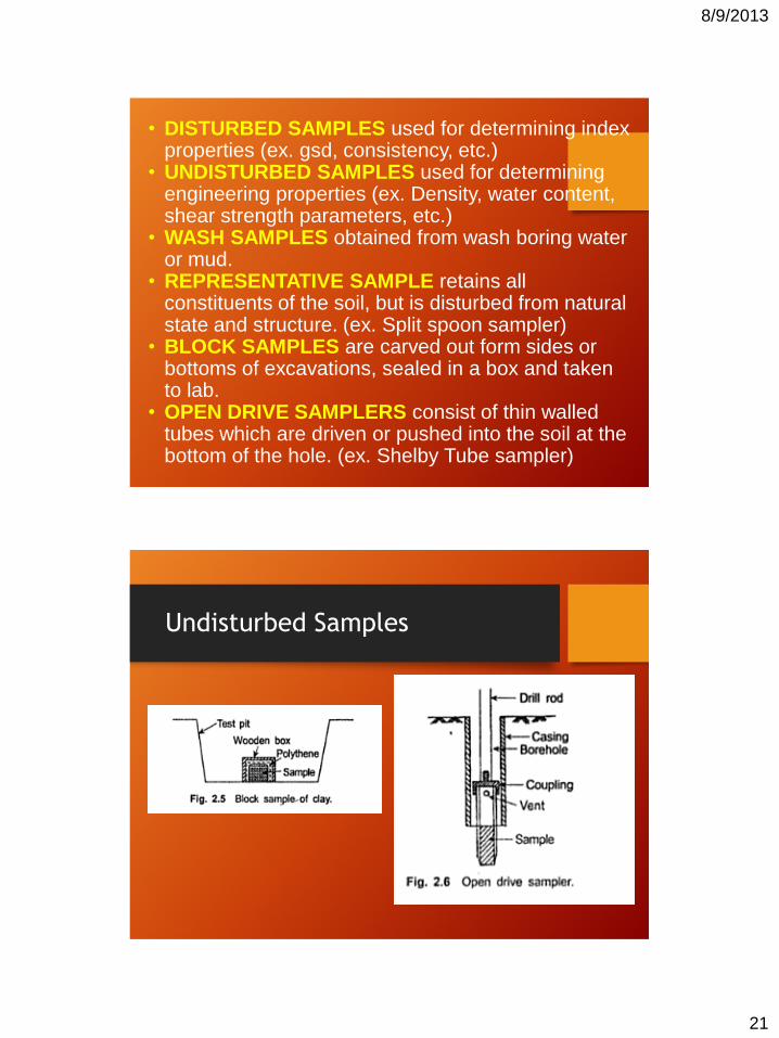
• DISTURBED SAMPLES used for determining index properties (ex. gsd, consistency, etc.)
• UNDISTURBED SAMPLES used for determining engineering properties (ex. Density, water content, shear strength parameters, etc.)
• WASH SAMPLES obtained from wash boring water or mud.
• REPRESENTATIVE SAMPLE retains all constituents of the soil, but is disturbed from natural state and structure. (ex. Split spoon sampler)
• BLOCK SAMPLES are carved out form sides or bottoms of excavations, sealed in a box and taken to lab.
• OPEN DRIVE SAMPLERS consist of thin walled tubes which are driven or pushed into the soil at the bottom of the hole. (ex. Shelby Tube sampler)
Undisturbed Samples
8/9/2013
22
SPLIT SPOON SAMPLING
• Is the most common
way to collect disturbed
samples but still
representative
SKETCH OF SPLIT SPOON SAMPLER
8/9/2013
23
Good quality samples necessary.
AR<10%
sampling tube
soil
(%) 100..
....2
22
DI
DIDOAR
area ratio
Thicker the wall, greater the disturbance.
DEGREE OF DISTURBANCE
SPLIT SPOON SAMPLING
8/9/2013
24
Methods of Sampling
• Requirements to minimize disturbance to samples• Area ratio = (D2
w-D2e) x 100%
D2e
• Area ratio should be as low as possible. (<10%).
• It represents the amount of soil displaced.
• Inside clearance = (Ds-De) x 100%
ratio De
• The inside clearance allows elastic expansion of the sample and minimizes frictional drag on the sample.
• The inside clearance should be between 0.5% to 3%.
• The outside clearance = (Dw-Dt) x 100%
ratio Dt
• Outside clearance is necessary to reduce the driving force and resistance to withdrawal.
• The outside clearance should be between 0% and 2%.
• Diameter of samples should not be less than 38mm. (Generally between 50-150mm).
8/9/2013
25
FIELD STANDARD PENETRATION NUMBER
N60 = where:
N60 = standard penetration number corrected for field conditions
N = measured penetration number
ηH = hammer efficiency %
ηB = correction for borehole diameter
ηS = sampler correction
ηR = correction for rod length
FIELD STANDARD PENETRATION NUMBER
8/9/2013
26
UNDRAINED SHEAR STRENGTH OF CLAY
cu = KN60
where:
K = constant = 3.5 – 6.5 kN/m2
N60 = standard penetration number obtained from the field
For frictional soils (sands, gravels, silty sands, etc), the
strength of the soil increases with the effective overburden
stresses σ’v. The greater the depth of the soil, the greater
σ’v and the greater the strength of the soil will usually be
(within some limits). Thus the greater the depth, the greater
the N value usually is in the SPT. Thus the raw N value is
not just a soil property, but also a depth property.
Therefore we need to correct N for frictional soils,
(N1)60 = CNN60
where: (N1)60 = corrected N value to a standard value of
95.6kPa (2ksf).
CN = correction factor
N60 = N value obtained from the field
8/9/2013
27
RELATIONSHIP BETWEEN RELATIVE DENSITY (DR) AND (N1)60 FOR FINE TO MEDIUM SAND:
Dr (%) = 1.55(N1)60 + 40 [for 0 ≤ (N1)60 ≤ 25]
Dr (%) = 0.84(N1)60 + 58.8 [for 25 ≤ (N1)60 ≤ 50]
FOR FINE TO MEDIUM SAND WITH FINES (THAT IS, % PASSING NO.200 SIEVE, FC) BETWEEN 15% AND 20%,
(N1)60 = (N60 +12.9)(
EFFECTIVE PEAK ANGLE OF FRICTION OF GRANULAR SOILS,
ϕ' (deg) = 27.1 + 0.3(N1)60 – 0.00054[(N1)60]2
CORRELATION AMONG N60, Φ',
ϕ' = tan-1
where:
N60 = field standard penetration number
= effective overburden pressure
Pa = atmospheric pressure in the same unit as σ’o
(≈100 kN/m2)
ϕ' = soil friction angle
SIMPLE CORRELATION BETWEEN Φ' AND (N1)60:
ϕ' =
8/9/2013
28
RELATIVE DENSITY OF SANDS VS. N
SPLIT SPOON SAMPLING
8/9/2013
29
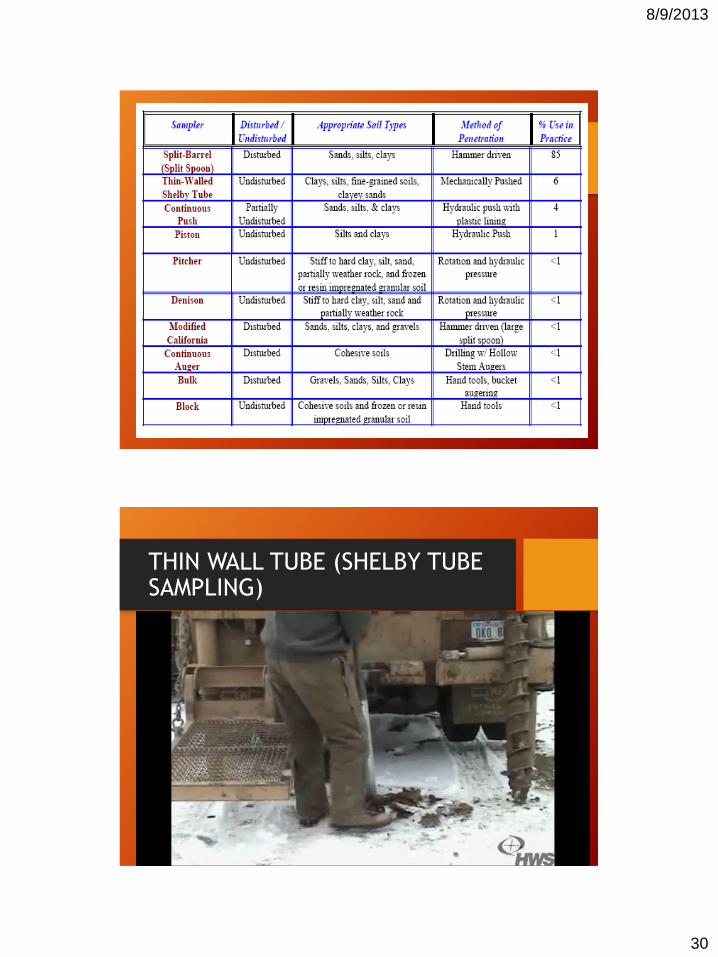
THIN WALL TUBE
• Thin-wall open-tube samplers
(Shelby Tube Samplers) are used
for soils that are particularly
sensitive to sampling disturbance.
• They are suitable for fine soils up
to a firm consistency, and free
from large particles.
• Shelby Tubes are available in
carbon steel and in stainless steel.
Usual diameters are 3" or 4" OD.
Types of Samplers (Undisturbed)
8/9/2013
30
THIN WALL TUBE (SHELBY TUBE SAMPLING)
8/9/2013
31
OBSERVATION ON WATER LEVELS
Presence of a water table near a foundation
significantly affects a foundation’s load-
bearing capacity and settlement. The water
level will change seasonally. In many cases,
establishing the highest and lowest possible
levels of water during the life of a project
might be necessary.
SIGNIFICANCE
• Determine flow directions
• Identify changes in gradients
• Measurements for aquifer
testing
• Determine the volume of water
or drawdown in the well casing
for proper purging
8/9/2013
32
HOW DO WE MEASURE WATER LEVEL?
MANUAL METHODS
• The usual basic measurement in groundwater studies is that of water levels in wells.
• If water is encountered in a borehole during a field exploration, it should be recorded. In soils with high hydraulic conductivity, the level of water should stabilize about 24 hours after completion of the boring.
8/9/2013
33
CHALKED STEEL TAPE
• One of the instruments that gives most accurate measurement
• This method utilizes a graduated tape with weight attached to its end. The lower 3-4 ft. is coated with carpenter’s chalk.
• Steel tape should have limited elasticity
• Weight should be brass or stainless steal
8/9/2013
34
ELECTRIC MEASURING TAPES
• Consist of a pair of insulated wires whose exposed ends are separated by an air gap in an electrode and containing a source of power.
• When the electrode contacts the water surface, a current flows through the tape circuit and is indicated by an ammeter-needle deflection, light, and (or) audible signal.
• The “hold” depth against the reference point on the well is read directly from the tape as depth to water.
8/9/2013
35
Air Line Method
• A small diameter air-type tube of known length is installed from the surface to a depth below the lowest water level expected.
• Compressed air (compressor, bottled air, or tire pump) is used to purge the water from the tube. The pressure, in pounds per square inch (psi), needed to purge the water from the air line multiplied by 2.31 (feet of water or one psi) equals the length in feet of submerged airline.
• The depth to water below the center of the pressure gage can be easily calculated by subtracting the length of air line below the water surface from the total length of the air line (assuming the air line is essentially straight). Accuracy depends on the precision to which the pressure can be read.
8/9/2013
36
PRESSURE TRANSDUCERS
• Pressure transducers are temperature sensitive and cables are subject to stretching with time.