21
Tabel

Tabel
T - 1
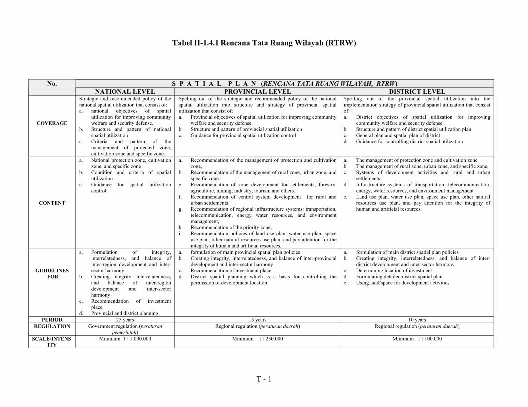
Tabel II-1.4.1 Rencana Tata Ruang Wilayah (RTRW)
S P A T I A L P L A N (RENCANA TATA RUANG WILAYAH, RTRW)No.NATIONAL LEVEL PROVINCIAL LEVEL DISTRICT LEVEL
COVERAGE
Strategic and recommended policy of thenational spatial utilization that consist of:a. national objectives of spatial
utilization for improving communitywelfare and security defense.
b. Structure and pattern of nationalspatial utilization
c. Criteria and pattern of themanagement of protected zone,cultivation zone and specific zone.
Spelling out of the strategic and recommended policy of the nationalspatial utilization into structure and strategy of provincial spatialutilization that consist of:a. Provincial objectives of spatial utilization for improving community
welfare and security defense.b. Structure and pattern of provincial spatial utilizationc. Guidance for provincial spatial utilization control
Spelling out of the provincial spatial utilization into theimplementation strategy of provincial spatial utilization that consistof:a. District objectives of spatial utilization for improving
community welfare and security defense.b. Structure and pattern of district spatial utilization planc. General plan and spatial plan of districtd. Guidance for controlling district spatial utilization
CONTENT
a. National protection zone, cultivationzone, and specific zone
b. Condition and criteria of spatialutilization
c. Guidance for spatial utilizationcontrol
a. Recommendation of the management of protection and cultivationzone,
b. Recommendation of the management of rural zone, urban zone, andspecific zone.
e. Recommendation of zone development for settlements, forestry,agriculture, mining, industry, tourism and others.
f. Recommendation of central system development for rural andurban settlements
g. Recommendation of regional infrastructure systems: transportation,telecommunication, energy water resources, and environmentmanagement,
h. Recommendation of the priority zone,i. Recommendation policies of land use plan, water use plan, space
use plan, other natural resources use plan, and pay attention for theintegrity of human and artificial resources.
a. The management of protection zone and cultivation zoneb. The management of rural zone, urban zone, and specific zone,c. Systems of development activities and rural and urban
settlementsd. Infrastructure systems of transportation, telecommunication,
energy, water resources, and environment managemente. Land use plan, water use plan, space use plan, other natural
resources use plan, and pay attention for the integrity ofhuman and artificial resources.
GUIDELINES FOR
a. Formulation of integrity,interrelatedness, and balance ofinter-region development and inter-sector harmony
b. Creating integrity, interrelatedness,and balance of inter-regiondevelopment and inter-sectorharmony
c. Recommendation of investmentplace
d. Provincial and district planning
a. formulation of main provincial spatial plan policiesb. Creating integrity, interrelatedness, and balance of inter-provincial
development and inter-sector harmonyc. Recommendation of investment placed. District spatial planning which is a basis for controlling the
permission of development location
a. formulation of main district spatial plan policiesb. Creating integrity, interrelatedness, and balance of inter-
district development and inter-sector harmonyc. Determining location of investmentd. Formulating detailed district spatial plane. Using land/space for development activities
PERIOD 25 years 15 years 10 yearsREGULATION Government regulation (peraturan
pemerintah)Regional regulation (peraturan daerah) Regional regulation (peraturan daerah)
SCALE/INTENSITY
Minimum 1 : 1.000.000 Minimum 1 : 250.000 Minimum 1 : 100.000
T - 2
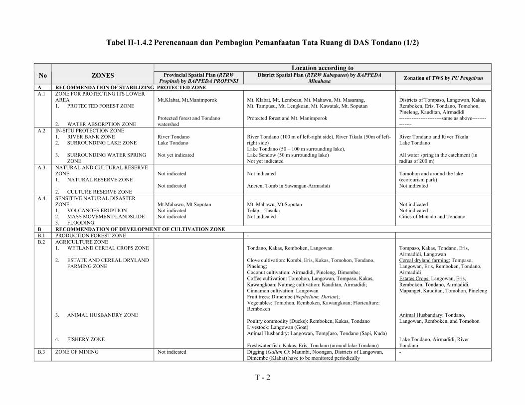
Tabel II-1.4.2 Perencanaan dan Pembagian Pemanfaatan Tata Ruang di DAS Tondano (1/2)
Location according toNo ZONES Provincial Spatial Plan (RTRW
Propinsi) by BAPPEDA PROPINSIDistrict Spatial Plan (RTRW Kabupaten) by BAPPEDA
Minahasa Zonation of TWS by PU Pengairan
A RECOMMENDATION OF STABILIZING PROTECTED ZONEA.1 ZONE FOR PROTECTING ITS LOWER
AREA1. PROTECTED FOREST ZONE
2. WATER ABSORPTION ZONE
Mt.Klabat, Mt.Manimporok
Protected forest and Tondanowatershed
Mt. Klabat, Mt. Lembean, Mt. Mahawu, Mt. Masarang,Mt. Tampusu, Mt. Lengkoan, Mt. Kawatak, Mt. Soputan
Protected forest and Mt. Manimporok
Districts of Tompaso, Langowan, Kakas,Remboken, Eris, Tondano, Tomohon,Pineleng, Kauditan, Airmadidi------------------------same as above---------------
A.2 IN-SITU PROTECTION ZONE1. RIVER BANK ZONE2. SURROUNDING LAKE ZONE
3. SURROUNDING WATER SPRINGZONE
River TondanoLake Tondano
Not yet indicated
River Tondano (100 m of left-right side), River Tikala (50m of left-right side)Lake Tondano (50 � 100 m surrounding lake),Lake Sendow (50 m surrounding lake)Not yet indicated
River Tondano and River TikalaLake Tondano
All water spring in the catchment (inradius of 200 m)
A.3. NATURAL AND CULTURAL RESERVEZONE1. NATURAL RESERVE ZONE
2. CULTURE RESERVE ZONE
Not indicated
Not indicated
Not indicated
Ancient Tomb in Sawangan-Airmadidi
Tomohon and around the lake(ecotourism park)Not indicated
A.4. SENSITIVE NATURAL DISASTERZONE1. VOLCANOES ERUPTION2. MASS MOVEMENT/LANDSLIDE3. FLOODING
Mt.Mahawu, Mt.SoputanNot indicatedNot indicated
Mt. Mahawu, Mt.SoputanTelap � TasukaNot indicated
Not indicatedNot indicatedCities of Manado and Tondano
B RECOMMENDATION OF DEVELOPMENT OF CULTIVATION ZONEB.1 PRODUCTION FOREST ZONE - -B.2 AGRICULTURE ZONE
1. WETLAND CEREAL CROPS ZONE
2. ESTATE AND CEREAL DRYLANDFARMING ZONE
3. ANIMAL HUSBANDRY ZONE
4. FISHERY ZONE
Tondano, Kakas, Remboken, Langowan
Clove cultivation: Kombi, Eris, Kakas, Tomohon, Tondano,Pineleng;Coconut cultivation: Airmadidi, Pineleng, Dimembe;Coffee cultivation: Tomohon, Langowan, Tompaso, Kakas,Kawangkoan; Nutmeg cultivation: Kauditan, Airmadidi;Cinnamon cultivation: LangowanFruit trees: Dimembe (Nephelium, Durian);Vegetables: Tomohon, Remboken, Kawangkoan; Floriculture:Remboken
Poultry commodity (Ducks): Remboken, Kakas, TondanoLivestock: Langowan (Goat)Animal Husbandry: Langowan, Tomp[aso, Tondano (Sapi, Kuda) Freshwater fish: Kakas, Eris, Tondano (around lake Tondano)
Tompaso, Kakas, Tondano, Eris,Airmadidi, LangowanCereal dryland farming: Tompaso,Langowan, Eris, Remboken, Tondano,AirmadidiEstates Crops: Langowan, Eris,Remboken, Tondano, Airmadidi,Mapanget, Kauditan, Tomohon, Pineleng
Animal Husbandary: Tondano,Langowan, Remboken, and Tomohon
Lake Tondano, Airmadidi, RiverTondano
B.3 ZONE OF MINING Not indicated Digging (Galian C): Maumbi, Noongan, Districts of Langowan,Dimembe (Klabat) have to be monitored periodically
-
T - 3
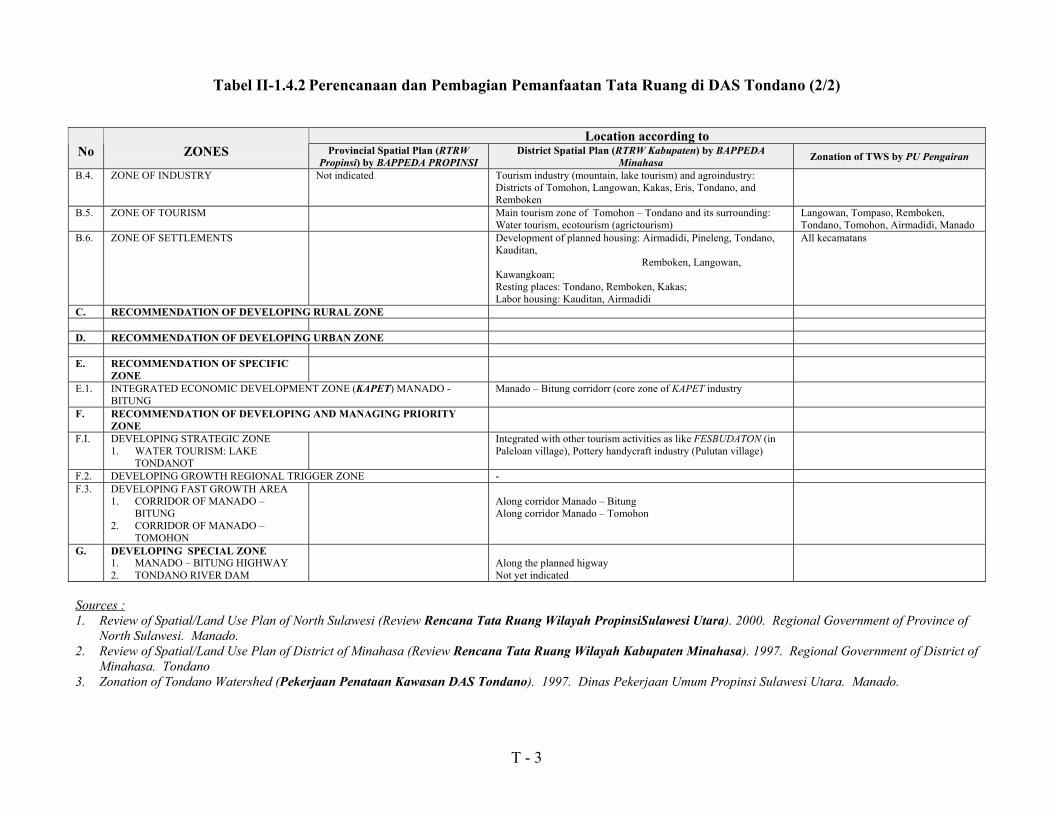
Tabel II-1.4.2 Perencanaan dan Pembagian Pemanfaatan Tata Ruang di DAS Tondano (2/2)
Location according toNo ZONES Provincial Spatial Plan (RTRW
Propinsi) by BAPPEDA PROPINSIDistrict Spatial Plan (RTRW Kabupaten) by BAPPEDA
Minahasa Zonation of TWS by PU Pengairan
B.4. ZONE OF INDUSTRY Not indicated Tourism industry (mountain, lake tourism) and agroindustry:Districts of Tomohon, Langowan, Kakas, Eris, Tondano, andRemboken
B.5. ZONE OF TOURISM Main tourism zone of Tomohon � Tondano and its surrounding:Water tourism, ecotourism (agrictourism)
Langowan, Tompaso, Remboken,Tondano, Tomohon, Airmadidi, Manado
B.6. ZONE OF SETTLEMENTS Development of planned housing: Airmadidi, Pineleng, Tondano,Kauditan, Remboken, Langowan,Kawangkoan;Resting places: Tondano, Remboken, Kakas;Labor housing: Kauditan, Airmadidi
All kecamatans
C. RECOMMENDATION OF DEVELOPING RURAL ZONE
D. RECOMMENDATION OF DEVELOPING URBAN ZONE
E. RECOMMENDATION OF SPECIFICZONE
E.1. INTEGRATED ECONOMIC DEVELOPMENT ZONE (KAPET) MANADO -BITUNG
Manado � Bitung corridorr (core zone of KAPET industry
F. RECOMMENDATION OF DEVELOPING AND MANAGING PRIORITYZONE
F.I. DEVELOPING STRATEGIC ZONE1. WATER TOURISM: LAKE
TONDANOT
Integrated with other tourism activities as like FESBUDATON (inPaleloan village), Pottery handycraft industry (Pulutan village)
F.2. DEVELOPING GROWTH REGIONAL TRIGGER ZONE -F.3. DEVELOPING FAST GROWTH AREA
1. CORRIDOR OF MANADO �BITUNG
2. CORRIDOR OF MANADO �TOMOHON
Along corridor Manado � BitungAlong corridor Manado � Tomohon
G. DEVELOPING SPECIAL ZONE1. MANADO � BITUNG HIGHWAY2. TONDANO RIVER DAM
Along the planned higwayNot yet indicated
Sources :1. Review of Spatial/Land Use Plan of North Sulawesi (Review Rencana Tata Ruang Wilayah PropinsiSulawesi Utara). 2000. Regional Government of Province of
North Sulawesi. Manado.2. Review of Spatial/Land Use Plan of District of Minahasa (Review Rencana Tata Ruang Wilayah Kabupaten Minahasa). 1997. Regional Government of District of
Minahasa. Tondano3. Zonation of Tondano Watershed (Pekerjaan Penataan Kawasan DAS Tondano). 1997. Dinas Pekerjaan Umum Propinsi Sulawesi Utara. Manado.

T - 4
Tabel II-1.4.3 Skor untuk menentukan Penggunaan Lahan
yang dianjurkan
1. Classification of Intensity of Daily Rainfall and its Score
No Intensity of daily rainfall(mm/day) Class Score
1.2.3.4.5.
< 13.6013.6 � 20.720.7 � 27.727.7 � 34.8> 34.8
very lowlowmoderatehighvery high
1020304050
2. Classification Soil Type and its Score
NoSoil Type
(Center for Soil Research,Bogor)
Classification Score
1.
2.3.
4.
5.
Aluvial, Gley Planosol,Hidromorf Kelabu, Laterik AirTanahLatosolBrown Forest Soil, Non CalcicBrown, MediteranAndosol, Laterit, Grumusol,Podsol, PodsolikRegosol, Litosol, Organosol,Renzina
Not sensitive
Low sensitiveModeratelysensitive
Sensitive
Very sensitive
15
3045
60
75
3. Classification of Slope and its ScoreNo Slope gradient ( % ) Classification Score1.2.3.4.5.
00 - 0808 � 1515 � 2525 � 40
> 40
FlatGentle
ModerateSteep
very steep
20406080
100
T - 5
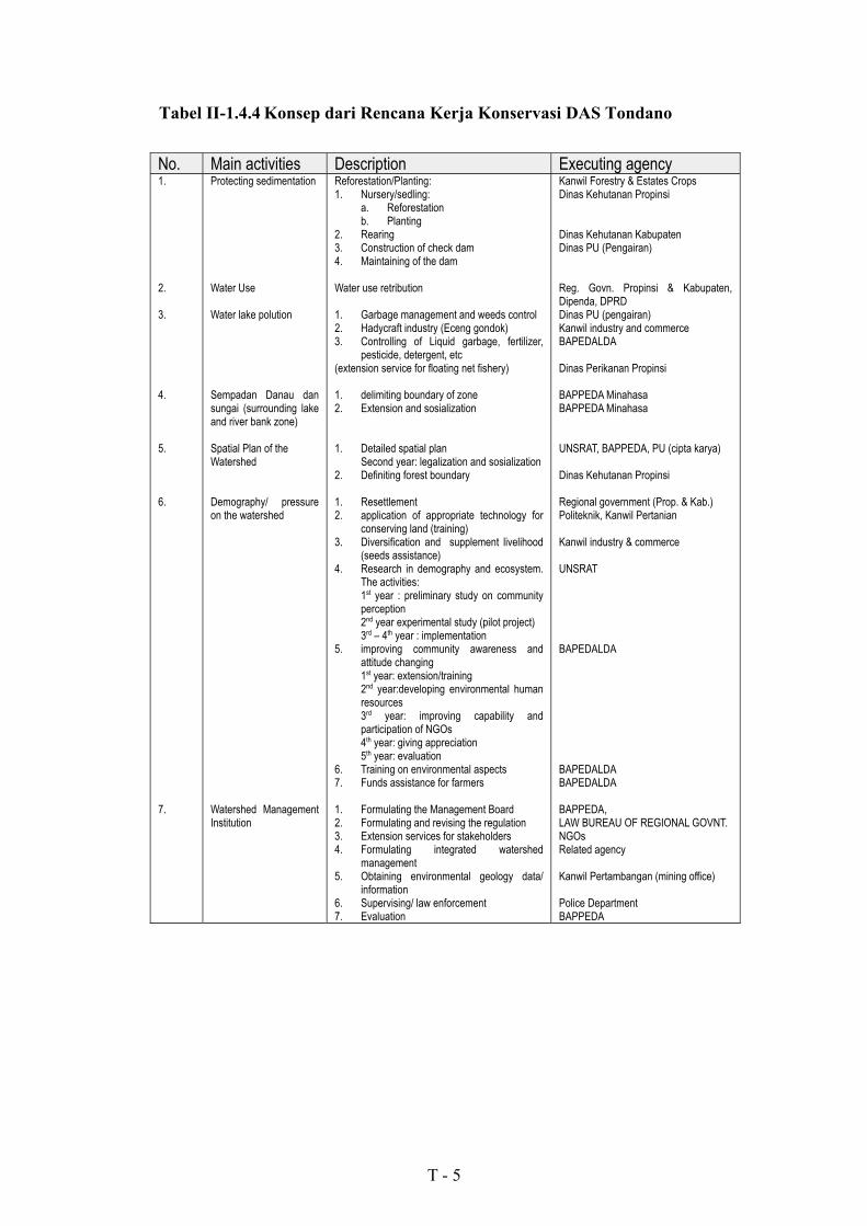
Tabel II-1.4.4 Konsep dari Rencana Kerja Konservasi DAS Tondano
No. Main activities Description Executing agency1.
2.
3.
4.
5.
6.
7.
Protecting sedimentation
Water Use
Water lake polution
Sempadan Danau dansungai (surrounding lakeand river bank zone)
Spatial Plan of theWatershed
Demography/ pressureon the watershed
Watershed ManagementInstitution
Reforestation/Planting:1. Nursery/sedling:
a. Reforestationb. Planting
2. Rearing3. Construction of check dam4. Maintaining of the dam
Water use retribution
1. Garbage management and weeds control2. Hadycraft industry (Eceng gondok)3. Controlling of Liquid garbage, fertilizer,
pesticide, detergent, etc(extension service for floating net fishery)
1. delimiting boundary of zone2. Extension and sosialization
1. Detailed spatial planSecond year: legalization and sosialization
2. Definiting forest boundary
1. Resettlement2. application of appropriate technology for
conserving land (training)3. Diversification and supplement livelihood
(seeds assistance)4. Research in demography and ecosystem.
The activities:1st year : preliminary study on communityperception2nd year experimental study (pilot project)3rd � 4th year : implementation
5. improving community awareness andattitude changing1st year: extension/training2nd year:developing environmental humanresources3rd year: improving capability andparticipation of NGOs4th year: giving appreciation5th year: evaluation
6. Training on environmental aspects7. Funds assistance for farmers
1. Formulating the Management Board2. Formulating and revising the regulation3. Extension services for stakeholders4. Formulating integrated watershed
management5. Obtaining environmental geology data/
information6. Supervising/ law enforcement7. Evaluation
Kanwil Forestry & Estates CropsDinas Kehutanan Propinsi
Dinas Kehutanan KabupatenDinas PU (Pengairan)
Reg. Govn. Propinsi & Kabupaten,Dipenda, DPRDDinas PU (pengairan)Kanwil industry and commerceBAPEDALDA
Dinas Perikanan Propinsi
BAPPEDA MinahasaBAPPEDA Minahasa
UNSRAT, BAPPEDA, PU (cipta karya)
Dinas Kehutanan Propinsi
Regional government (Prop. & Kab.)Politeknik, Kanwil Pertanian
Kanwil industry & commerce
UNSRAT
BAPEDALDA
BAPEDALDABAPEDALDA
BAPPEDA,LAW BUREAU OF REGIONAL GOVNT.NGOsRelated agency
Kanwil Pertambangan (mining office)
Police DepartmentBAPPEDA

T - 6
Tabel II-1.5.1 Distribusi dari Penghutanan kembali di dalam dan di sekitar
DAS Tondano pada tahun 1976 � 1999
FailureFiscal Year Location Area (ha) Fired Fail Cleared
Away Total Success Grown species
1976/1977
1977/1978
1980/1981
1981/1982
1983/1984
1984/1985
1985/1986
1986/1987
1988/1989
1991/1992
1992/1993
1993/1994
1994/1995
1995/1996
1996/1997
1998/1999
Mt. PotongNoongan
Mt. SoputanKayuwatu
Mt. MasarangMt. Mahawu
Mt. Mahawu
Mt. Soputan
Mt. SoputanMt. KawatakTumaratas
MakalonsowMt. Lembean
Mt. Lembean
Makalonsow
Ranolambot
Mt. Soputan
RanolambotNoongan
Makalonsow
Makalonsow
Makalonsow
Rerer
71529
2.400200
175200
170
100
500100100
200100
300
100
150
150
100200
200
400
600
100
710
00
17565
78
100
11500
0100
0
0
0
0
00
200
0
0
0
0297
1.7860
0135
92
0
00
25
300
0
0
50
0
00
0
0
0
0
00
614200
00
0
0
035
0
00
0
0
0
0
00
0
0
0
0
0297
2.400200
175200
170
100
1153525
30100
0
0
50
0
00
200
0
0
0
0232
00
00
0
0
3856575
1700
300
100
100
150
100200
0
400
600
100
Pine, etcPine, etc
Pine, etcPine, etc
Pine, etcPine, etc
Pine, etc
Pine, etc
Pine, NantuPine, NantuPine, Nantu
Pine, NantuPine, Nantu
Pine, Nantu
Nantu, etc
Nantu, etc.
Nantu, etc.
Nantu, etc.Nantu, etc.
Gmelina, Nantu
Gmelina, Nantu
Gmelina, Nantu
Gmelina, MPTSSource: Statistics of Dinas Kehutanan Dati I Sulawesi Utara, 1999.Personal communication with Katuuk, 2000

No. Location Activities Area/UnitI. Tondano Sub-district
1 Kelurahan' Rinegetan Private Forest / Estate 50 ha2 Kelurahan' Sumalangka Private Forest / Estate 50 ha3 Kelurahan' Wewelen Private Forest / Estate 25 ha4 "Kelurahan' Tataaran II Private Forest / Estate 25 ha5 Kelurahan' Tataaran II Private Forest / Estate 50 ha6 Kelurahan' Paleloan Private Forest / Estate 25 ha7 Kelurahan' Tuutu Private Forest / Estate 50 ha
KBD 0,5 ha8 Kelurahan' Wawalintowan Private Forest / Estate 50 ha
II. Toulimambot Sub-district 1 Kelurahan' Kiniar Private Forest / Estate 50 ha
UP-UPSA' 1 unit2 Kelurahan' Taler Private Forest / Estate 50 ha
III Eris Sub-district1 Desa' Touliang Oki Private Forest / Estate 50 ha
UP-UPSA 1 unit2 Desa' Tandengan Private Forest / Estate 50 ha3 Desa' Eris Private Forest / Estate 50 ha
IV Kakas Sub-district1 Desa' Simbel Private Forest / Estate 50 ha2 Desa' Toulimambei Private Forest / Estate 50 ha3 Desa' Tounumomei Private Forest / Estate 50 ha 4 Desa' Kaweng UP-UPSA 1 unit
V Remboken Sub-district1 "Desa' Talikuran Private Forest / Estate 50 ha2 Desa' Paslaten Private Forest / Estate 50 ha3 "Desa' Sionia Private Forest / Estate 50 ha4 Desa' Kaima Private Forest / Estate 50 ha
VI Tomohon Sub-district1 "Desa' Rurukan Preventor / Check Dam 1 unit
VII Langowan Sub-district1 Desa' Teep Private Forest / Estate 50 ha2 Desa' Touneiei Private Forest / Estate 50 ha3 Desa' Manembo Private Forest / Estate 50 ha4 Desa' Winebetan Private Forest / Estate 50 ha5 Desa' Kaayuran Atas Private Forest / Estate 50 ha
KBD 1 unit6 Desa' Waleure KBD 0,5 unit 7 Desa' Temboan Private Forest / Estate 25 ha8 Desa' Noongan KBD 0,5 ha
VIII Tompaso Sub-district1 Desa' Toure Private Forest / Estate 50 ha2 Desa' Tonsewer Private Forest / Estate 50 ha
IX Pineleng Sub-district1 Desa' Sawangan Private Forest / Estate 50 ha
Preventor / Check Dam 1 unit2 Desa' Ramangia Private Forest / Estate 50 ha
KBD 1 unit3 Desa' Tombuluan Private Forest / Estate 50 ha4 Desa' Kembes Private Forest / Estate 50 ha5 Desa' Koka Private Forest / Estate 25 ha
X Airmadidi Sub-district1 Kelurahan' Sukur Private Forest / Estate 50 ha2 Kelurahan' Sarongsong I Preventor / Check Dam 1 unit3 Desa' Tanggari Private Forest / Estate 50 ha
KBD 1 unit4 Desa' Rumengkor Private Forest / Estate 25 ha5 Desa' Kembuan Private Forest / Estate 50 ha6 Desa' Kolongan Private Forest / Estate 50 ha
XI Dimembe Sub-district1 Desa' Paniki Atas Private Forest / Estate 50 ha
Preventor / Check Dam 1 unit2 Desa' Matungkas Private Forest / Estate 50 ha
Preventor / Check Dam 1 unit
** UP-UPSA (Unit Percontohan Usaha Pelestarian Sumber Daya Alam) = Demonstration Plot for Conservation of Natural Resources
Tabel II-1.5.2 Kegiatan Penghijauan kembali di DAS Tondano pada tahun anggaran 1999/2000
Notes: * KBD = Kebun Bibit Desa (Village Nursery)
T-7

(1) Harvested Area of Food Crops in the Study Area (1998) unit: haSub-district Lowland paddy Upland paddy Maize Cassava Swee potetoes Ground nuts Green grams Soybeans Total
Longowan 1,400 0 870 2 3 12 0 0 2,287 Kakas 2,070 40 874 0 12 0 0 0 2,996 Tompaso 1,028 0 2,201 2 4 21 0 0 3,256 Remboken 604 0 1,483 39 13 62 0 0 2,201 Eris 344 0 282 3 0 0 0 0 629 Tondano 1,926 0 2,764 8 6 55 0 0 4,759 Toul imambot 2,310 0 2,787 3 0 36 0 5 5,141 Tomohon 49 0 89 6 6 7 0 0 157 Kauditan 454 0 245 19 0 4 0 0 722 Airmadidi 329 35 1,080 0 0 20 0 8 1,472 Pineleng 56 18 958 6 8 4 0 0 1,050 Study Area 10,514 75 12,675 82 44 217 0 13 23,620
(2) Production of Food Crops in the Study Area (1998) unit: tons
Sub-district Lowland paddy Upland paddy Maize Cassava Swee potetoes Ground nuts Green grams SoybeansLongowan 7,840 0 2,696 54 30 15 0 0 Kakas 9,936 84 2,526 0 0 1 0 0 Tompaso 6,029 0 6,709 26 100 24 0 0 Remboken 2,947 0 5,339 585 65 59 0 0 Eris 1,664 0 1,008 39 0 0 0 0 Tondano 8,628 0 9,508 134 23 65 0 0 Toul imambot 9,471 0 5,379 49 0 39 0 5 Tomohon 239 0 196 66 83 8 0 0 Kauditan 2,146 0 649 273 0 4 1 0 Airmadidi 1,582 74 2,268 0 0 20 0 8 Pineleng 224 33 3,399 71 37 5 0 0 Study Area 50,482 158 36,278 1,226 301 235 1 13
(3) Yield of Food Crops in the Study Area (1998) unit: kg/ha
Sub-district Lowland paddy Upland paddy Maize Cassava Swee potetoes Ground nuts Green grams SoybeansLongowan 5.600 3.099 27.000 10.000 1.250 Kakas 4.800 2.100 2.890 0.000 Tompaso 5.865 3.048 13.000 25.000 1.143 Remboken 4.879 3.600 15.000 5.000 0.952 Eris 4.837 3.574 13.000 Tondano 4.480 3.440 16.750 3.833 1.182 Toul imambot 4.100 1.930 16.333 1.083 1.000 Tomohon 4.878 2.202 11.000 13.833 1.143 Kauditan 4.727 2.649 14.368 1.000 Airmadidi 4.809 2.114 2.100 1.000 1.000 Pineleng 4.000 1.833 3.548 11.833 4.625 1.250 Study Area 4.801 2.107 2.862 14.951 6.841 1.083 1,824 1,058 Source: Laporan Tahunan, Dinas Pertanian Tanaman Pangan Kab. Minahasa
Tabel II-1.6.1 Produksi dari Hasil Panen Utama
T-8
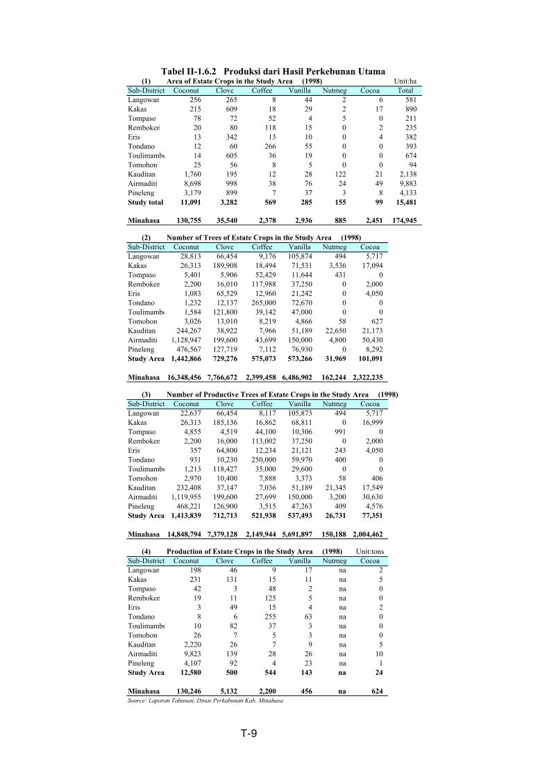
(1) Area of Estate Crops in the Study Area (1998) Unit:haSub-District Coconut Clove Coffee Vanilla Nutmeg Cocoa TotalLangowan 256 265 8 44 2 6 581 Kakas 215 609 18 29 2 17 890 Tompaso 78 72 52 4 5 0 211 Remboken 20 80 118 15 0 2 235 Eris 13 342 13 10 0 4 382 Tondano 12 60 266 55 0 0 393 Toulimambo 14 605 36 19 0 0 674 Tomohon 25 56 8 5 0 0 94 Kauditan 1,760 195 12 28 122 21 2,138 Airmaditi 8,698 998 38 76 24 49 9,883 Pineleng 3,179 899 7 37 3 8 4,133 Study total 11,091 3,282 569 285 155 99 15,481
Minahasa 130,755 35,540 2,378 2,936 885 2,451 174,945
(2) Number of Trees of Estate Crops in the Study Area (1998)Sub-District Coconut Clove Coffee Vanilla Nutmeg CocoaLangowan 28,813 66,454 9,176 105,874 494 5,717 Kakas 26,313 189,908 18,494 71,531 3,536 17,094 Tompaso 5,401 5,906 52,429 11,644 431 0 Remboken 2,200 16,010 117,988 37,250 0 2,000 Eris 1,083 65,529 12,960 21,242 0 4,050 Tondano 1,232 12,137 265,000 72,670 0 0 Toulimambo 1,584 121,800 39,142 47,000 0 0 Tomohon 3,026 13,010 8,219 4,866 58 627 Kauditan 244,267 38,922 7,966 51,189 22,650 21,173 Airmaditi 1,128,947 199,600 43,699 150,000 4,800 50,430 Pineleng 476,567 127,719 7,112 76,930 0 8,292 Study Area 1,442,866 729,276 575,073 573,266 31,969 101,091
Minahasa 16,348,456 7,766,672 2,399,458 6,486,902 162,244 2,322,235
(3) Number of Productive Trees of Estate Crops in the Study Area (1998)Sub-District Coconut Clove Coffee Vanilla Nutmeg CocoaLangowan 22,637 66,454 8,117 105,873 494 5,717 Kakas 26,313 185,136 16,862 68,811 0 16,999 Tompaso 4,855 4,519 44,100 10,306 991 0 Remboken 2,200 16,000 113,002 37,250 0 2,000 Eris 357 64,800 12,234 21,121 243 4,050 Tondano 931 10,230 250,000 59,970 400 0 Toulimambo 1,213 118,427 35,000 29,600 0 0 Tomohon 2,970 10,400 7,888 3,373 58 406 Kauditan 232,408 37,147 7,036 51,189 21,345 17,549 Airmaditi 1,119,955 199,600 27,699 150,000 3,200 30,630 Pineleng 468,221 126,900 3,515 47,263 409 4,576 Study Area 1,413,839 712,713 521,938 537,493 26,731 77,351
Minahasa 14,848,794 7,379,128 2,149,944 5,691,897 150,188 2,004,462
(4) Production of Estate Crops in the Study Area (1998) Unit:tonsSub-District Coconut Clove Coffee Vanilla Nutmeg CocoaLangowan 198 46 9 17 na 2 Kakas 231 131 15 11 na 5 Tompaso 42 3 48 2 na 0 Remboken 19 11 125 5 na 0 Eris 3 49 15 4 na 2 Tondano 8 6 255 63 na 0 Toulimambo 10 82 37 3 na 0 Tomohon 26 7 5 3 na 0 Kauditan 2,220 26 7 9 na 5 Airmaditi 9,823 139 28 26 na 10 Pineleng 4,107 92 4 23 na 1 Study Area 12,580 500 544 143 na 24
Minahasa 130,246 5,132 2,200 456 na 624 Source: Laporan Tahunan, Dinas Perkabunan Kab. Minahasa
Tabel II-1.6.2 Produksi dari Hasil Perkebunan Utama
T-9
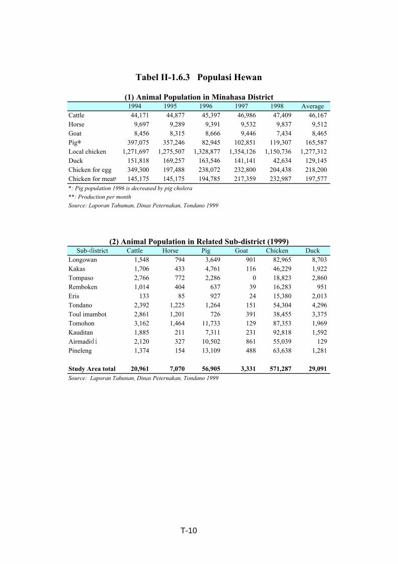
1994 1995 1996 1997 1998 AverageCattle 44,171 44,877 45,397 46,986 47,409 46,167 Horse 9,697 9,289 9,391 9,532 9,837 9,512 Goat 8,456 8,315 8,666 9,446 7,434 8,465 Pig* 397,075 357,246 82,945 102,851 119,307 165,587 Local chicken 1,271,697 1,275,507 1,328,877 1,354,126 1,150,736 1,277,312 Duck 151,818 169,257 163,546 141,141 42,634 129,145 Chicken for egg 349,300 197,488 238,072 232,800 204,438 218,200 Chicken for meat* 145,175 145,175 194,785 217,359 232,987 197,577 *: Pig population 1996 is decreased by pig cholera**: Production per monthSource: Laporan Tahuman, Dinas Peternakan, Tondano 1999
Sub-district Cattle Horse Pig Goat Chicken DuckLongowan 1,548 794 3,649 901 82,965 8,703 Kakas 1,706 433 4,761 116 46,229 1,922 Tompaso 2,766 772 2,286 0 18,823 2,860 Remboken 1,014 404 637 39 16,283 951 Eris 133 85 927 24 15,380 2,013 Tondano 2,392 1,225 1,264 151 54,304 4,296 Toul imambot 2,861 1,201 726 391 38,455 3,375 Tomohon 3,162 1,464 11,733 129 87,353 1,969 Kauditan 1,885 211 7,311 231 92,818 1,592 Airmadidi 2,120 327 10,502 861 55,039 129 Pineleng 1,374 154 13,109 488 63,638 1,281
Study Area total 20,961 7,070 56,905 3,331 571,287 29,091 Source: Laporan Tahunan, Dinas Peternakan, Tondano 1999
Tabel II-1.6.3 Populasi Hewan
(1) Animal Population in Minahasa District
(2) Animal Population in Related Sub-district (1999)
T-10

Woody perennials Herbaceous crops
Type Woody trees Estate crops Fruit trees
Coconut Clove Others+
I-1 △ ◎ △ X △ △ Northern part of Airmadidi and Pineleng
I-2 △ △ ◎ X △ △ Tondano, Tompaso, Remboken, Touliambot,and southernpart of Airmadidi and Pineleng
I-3 ○ ◎ ○ X ○ △ Relatively steep slope area of Langowan, Kakas, Eris, Airmadidi and Pineleng
I-4 ○ ○ ◎ X X △ Relatively steep slope area of Langowan, Kakas, Eris, Airmadidi and Pineleng
I-5 ○ ○ X ◎ X X Tondano, Tompaso, Remboken, Airmadidi and Pineleng
I-6 ○ ○ ○ ○ ○ ○ Housing area of all the Study Area and Airmadidi (along Bitung road)
II-1 △ ○ △ X △ ◎ Southern and western part of the study area
II-2 △ △ ○ X △ ◎ Southern and western part of the study area
III-1 △ ◎ X X △ ◎ Flat area of Airmadidi, Pineleng, Tompaso and Remboken
III-2 △ X ◎ X X ◎ Flat area of Airmadidi, Pineleng, Tompaso, Remboken, Tondanoand ToulimumbotNote: * ; Others include coffee, cocoa and vanilla.◎ :Pre-d ominant ○ :Dominant △:Frequent X:Neglesible
▲ : shows the limited area.
Tabel II-1.7.1 Jenis Sistem Pertanian Hutan di Wilayah Studi
Major Area
T-11

Majority Minority Majority Minority Majority Minority
1 Langowan Tumaratas-Rarinis II-1 III-2 III-1 III-2 I-11
Noogan I-1, II-1 III-2 I-1
2 Kakas Kawang III-1 I-4
Totolan-Panasen-Kalawiran II-2 II-2 I-4
3 Tompaso Tempot II-2 I-2, -5, III-2 III-1, -2
Tonsewer-Touure III-1 III-1 III-1, -2
4 Remboken Palestan-Tampusu III-2 III-2 III-2 I-3
Tampusu-Kasuratan III-1,2 I-3
Kasuratan I-2, II-2 I-5, III-2
Kasuratan-Parepei I-2, II-2 I-6, III-1 III-2 III-1 I-4
Parepei III-1,2 III-2 III-1 I-4
Parepei-Pulatan II-2 I-2, II-1 I-4
Pulutan III-1,2
5 Tomohon Rurukan-Temboan II-1, -2 II-1 II-1 I-4
Kumelembau II-1, -2 II-1 II-1
6 Tondano Ruaukan-Sumalangka III-2 I-2, II-2 II-2 I-2 II-2
Sumalangka-sasaran-Suluan I-2, III-2 I-6 I-2, III-2 I-3
Tataaran 8, 11 III-1,2 I-3
Tataaran-Palesten III-1, -2 II-2 I-1, -5 I-3
7 Toulimambot Papakalan-Makalonsouw III-2 III-1 I-2, III- 2 III-2 I-4
8 Eris I-4 I-4
9 Kauditan III-1 I-1 I-3 I-4
10 Airmadidi Suluan-Kembuan I-1, -2, I- 5 III-1, -2 III-1, -2 I-3 I-3
Suluan-Rumengkor I-2, I-5 I-1, II-1, -2 I-1,2 III-1 I-3 I-4
Rumenkor I-1, I-3 III-1, -2 III-1, -2 I-1 I-4 I-1
Airmadidi Atas-Maunbi I-1,I-6 I-5, III-1 I-1 I-4
Airmadidi Bawah-Tanggari I-1 I-6, II-2 I-1, -3 I-4
Tanggari-Tonsealama I-2 II-2,III-2 I-4 I-4
11 Pineleng Rumengkor-Kembes I-1 I-2, III-1, -2 I-3, III-1 I-4
Kembes-Tombuluan I-1, III-1 II-1, -2, III-2 I-3 I-1, -2 I-4
Tombuluan-Kumangata I-1, III-1 I-3 I-1, -2 I-4
Kumangata-Sawangan I-1 I-5, -6, II-1 I-1 III-1 I-4
Kembes-Koka I-1, II-1 III-1 I-3 I-1, -2 I-4
Source: Field reconnassance by JICA Study TeamNote : Gothic letter shows predominant system in the Study Area.
Flat (Less than 8%) Slope I (8% to 25%) SlopeII (More than 25%)
Tabel II-1.7.2 Sistem Pertanian Hutan di Wilayah Studi
Sub-District Location
T-12
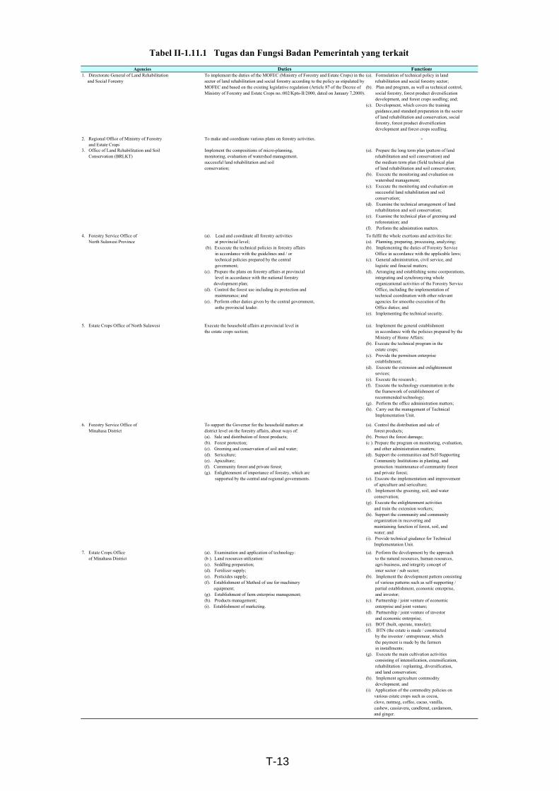
Agencies Duties Functions1. Directorate General of Land Rehabilitation and Social Forestry
To implement the duties of the MOFEC (Ministry of Forestry and Estate Crops) in thesector of land rehabilitation and social forestry according to the policy as stipulated byMOFEC and based on the existing legislative regulation (Article 87 of the Decree ofMinistry of Forestry and Estate Crops no.:002/Kpts-II/2000, dated on January 7,2000).
(a). Formulation of technical policy in land rehabilitation and social forestry sector;(b). Plan and program, as well as technical control, social forestry, forest product diversification development, and forest crops seedling; and;(c). Development, which covers the training guidance,and standard preparation in the sector of land rehabilitation and conservation, social forestry, forest product diversification development and forest crops seedling.
2. Regional Office of Ministry of Forestry and Estate Crops
To make and coordinate various plans on forestry activities. -
3. Office of Land Rehabilitation and Soil Conservation (BRLKT)
Implement the compositions of micro-planning,monitoring, evaluation of watershed management,successful land rehabilitation and soilconservation;
(a). Prepare the long term plan (pattern of land rehabilitation and soil conservation) and the medium term plan (field technical plan of land rehabilitation and soil conservation;(b). Execute the monitoring and evaluation on watershed management;(c). Execute the monitoring and evaluation on successful land rehabilitation and soil conservation;(d). Examine the technical arrangement of land rehabilitation and soil conservation;(e). Examine the technical plan of greening and reforestation; and(f). Perform the admistration matters.
4. Forestry Service Office of North Sulawesi Province
(a). Lead and coordinate all forestry activities at provincial level; (b). Exxecute the technical policies in forestry affairs in accordance with the guidelines and / or technical policies prepared by the central government;(c). Prepare the plans on forestry affairs at provincial level in accordance with the national forestry development plan;(d). Control the forest use including its protection and maintenance; and(e). Perform other duties given by the central government, asthe provincial leader.
To fulfil the whole exertions and activities for:(a). Planning, preparing, processing, analyzing;(b). Implementing the duties of Forestry Service Office in accordance with the applicable laws;(c). General administration, civil service, and logistic and finacial matters;(d). Arranging and establishing some coorporations, integrating and synchronyzing whole organizational activities of the Forestry Service Office, including the implementation of technical coordination with other relevant agencies for smoothe execution of the Office duties; and(e). Implementing the technical security.
5. Estate Crops Office of North Sulawesi Execute the household affairs at provincial level inthe estate crops section;
(a). Implement the general establishment in accordance with the policies prepared by the Ministry of Home Affairs:(b). Execute the technical program in the estate crops;(c). Provide the permitson enterprise establishment;(d). Execute the extension and enlightenment sevices;(e). Execute the research ;(f). Execute the technology examination in the the framework of establishment of recommended technology;(g). Perform the office administration matters;(h). Carry out the management of Technical Implementation Unit.
6. Forestry Service Office of Minahasa District
To support the Governor for the household matters atdistrict level on the forestry affairs, about ways of:(a). Sale and distribution of forest products;(b). Forest protection;(c). Greening and conservation of soil and water;(d). Sericulture;(e). Apiculture;(f). Community forest and private forest;(g). Enlightenment of importance of forestry, which are supported by the central and regional governments.
(a). Control the distribution and sale of forest products;(b). Protect the forest damage;(c ). Prepare the program on monitoring, evaluation, and other administration matters;(d). Support the communities and Self-Supporting Community Institutions in planting, and protection /maintenance of community forest and private forest;(e). Execute the implementation and improvement of apiculture and sericulture;(f). Implement the greening, soil, and water conservation;(g). Execute the enlightenment activities and train the extension workers;(h). Support the community and community organization in recovering and maintaining function of forest, soil, and water; and(i). Provide technical giudance for Technical Implementation Unit.
7. Estate Crops Office of Minahasa District
(a). Examination and application of technology:(b ). Land resources utilization:(c). Seddling preparation;(d). Fertilizer supply;(e). Pesticides supply;(f). Establishment of Method of use for machinery equipment;(g). Establishment of farm enterprise management;(h). Products management;(i). Establishment of marketing.
(a). Perform the development by the approach to the natural resources, human resources, agri-business, and integrity concept of inter sector / sub sector;(b). Implement the development pattern consisting of various patterns such as self-supporting / partial establishment, economic enterprise, and investor;(c). Partnership / joint venture of economic enterprise and joint venture;(d). Partnership / joint venture of investor and economic enterprise;(e). BOT (built, operate, transfer);(f). BTN (the estate is made / constructed by the investor / entrepreneur, which the payment is made by the farmers in installments;(g). Execute the main cultivation activities consisting of intensification, extensification, rehabilitation / replanting, diversification, and land conservation;(h). Implement agriculture commodity development; and(i). Application of the commodity policies on various estate crops such as cocoa, clove, nutmeg, coffee, cacao, vanilla, cashew, cassiavera, candlenut, cardamom, and ginger.
Tabel II-1.11.1 Tugas dan Fungsi Badan Pemerintah yang terkait
T-13
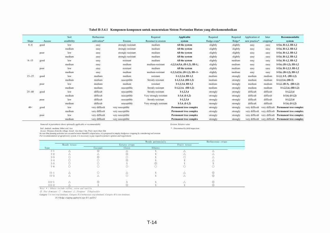
Tabel II-3.4.1 Komponen-komponen untuk menentukan Sistem Pertanian Hutan yang direkomendasikan
Soil Herbaceous Required Applicable Required Required Application of Inter RecommendableSlope Access erodibility cultivation* Erosion Resistact to erosion system Hedge crops* Ridge* new practice* cropping* system0--8 good low easy strongly resistant medium All the system slightly slightly easy easy I-5,6, II-1,2, III-1,2
medium easy strongly resistant medium All the system slightly slightly easy easy I-5,6, II-1,2, III-1,2poor low easy strongly resistant medium All the system slightly slightly easy easy I-5,6, II-1,2, III-1,2
medium easy strongly resistant medium All the system slightly slightly easy easy I-5,6, II-1,2, III-1,28--15 good low easy resistant medium All the system slightly medium easy easy I-5,6, II-1,2, III-1,2
medium easy medium medium-resistant I-1,2,3,4,5,6, (II-1,2), III-1,2 slightly medium easy easy I-5,6, (II-1,2), III-1,2poor low easy resistant medium All the system slightly medium easy easy I-5,6, II-1,2,3, III-1,2
medium easy medium medium-resistant -1,2,3,4,5,6, (II-1,2), III--1-2 slightly medium easy easy I-5,6, (II-1,2), III-1,215--25 good low medium medium resistant I-1,2,3,4, III-1,2 medium strongly medium medium I-1,2, I-5, (III-1,2)
medium medium susceptible Stronly resistant I-1,2,3,4, (III-1,2) medium strongly medium medium I-1,2,3,4, (III-3)poor low medium medium resistant I-1,2,3,4, III-1,2 medium strongly medium medium I-1,2, (II-3), (III-1,2)
medium medium susceptible Stronly resistant I-1,2,3,4, (III-1,2) medium strongly medium medium I-1,2,3,4, (III-1,2)25--40 good low difficult susceptible Stronly resistant I-1,2,3,4 strongly strongly difficult difficult I-1,2,3,4
medium difficult susceptible Very strongly resistant I-3,4, (I-1,2) strongly strongly difficult difficult I-3,4, (I-1,2)poor low difficult susceptible Stronly resistant I-1,2,3,4 strongly strongly difficult difficult I-1,2,3,4
medium difficult susceptible Very strongly resistant I-3,4, (I-1,2) strongly strongly difficult difficult I-3,4, (I-1,2)40< good low very difficult very susceptible Permanent tree complex strongly strongly very difficult very difficult Permanent tree complex
medium very difficult very susceptible Permanent tree complex strongly strongly very difficult very difficult Permanent tree complexpoor low very difficult very susceptible Permanent tree complex strongly strongly very difficult very difficult Permanent tree complex
medium very difficult very susceptible Permanent tree complex strongly strongly very difficult very difficult Permanent tree complex
Numerals in parenthesis shows optionally applicable or recommendable. Erosion: Relative value
Soil: Andsols; medium, Other soil; less * : Determined by field inspection. Access: Distance from the village. Good : less than 1 km, Poor; more than 1kmIn case that farming activities are excuted at more than40% sloped area, it is proposed to employ hedgerow cropping by considering soil erosion.For recommendation of agroforestry system, it is necessary to pay regard to farmers opinion and requirement.
Woody perennials Herbaceous cropsWoody trees Estate crops Fruit trees
Type Coconut Clove OthersI-1 △ ◎ △ X △ △I-2 △ △ ◎ X △ △I-3 ○ ◎ ○ X ○ △I-4 ○ ○ ◎ X X △I-5 ○ ○ X ◎ X XI-6 ○ ○ ○ ○ ○ ○
II-1 △ ○ △ X △ ◎II-2 △ △ ○ X △ ◎
III-1 △ ◎ X X △ ◎III-2 △ X ◎ X X ◎
Note: * ; Others include coffee, cocoa and vanilla.
◎ :Pre-dominant ○ :Dominant △:Frequent X:Neglesible
Category I is tree crop dominant, Category II is herbaceous crop dominant, Category III is non dominant.
II-3:Hedge cropping applied to type II-1 and II-2
T-14
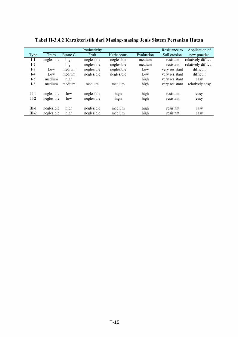
Productivity Resistance to Application ofType Trees Estate C Fruit Herbaceous Evaluation Soil erosion new practiceI-1 neglesible high neglesible neglesible medium resistant relatively difficultI-2 high neglesible neglesible medium resistant relatively difficultI-3 Low medium neglesible neglesible Low very resistant difficultI-4 Low medium neglesible neglesible Low very resistant difficultI-5 medium high high very resistant easyI-6 medium medium medium medium high very resistant relatively easy
II-1 neglesible low neglesible high high resistant easyII-2 neglesible low neglesible high high resistant easy
III-1 neglesible high neglesible medium high resistant easyIII-2 neglesible high neglesible medium high resistant easy
Tabel II-3.4.2 Karakteristik dari Masing-masing Jenis Sistem Pertanian Hutan
T-15
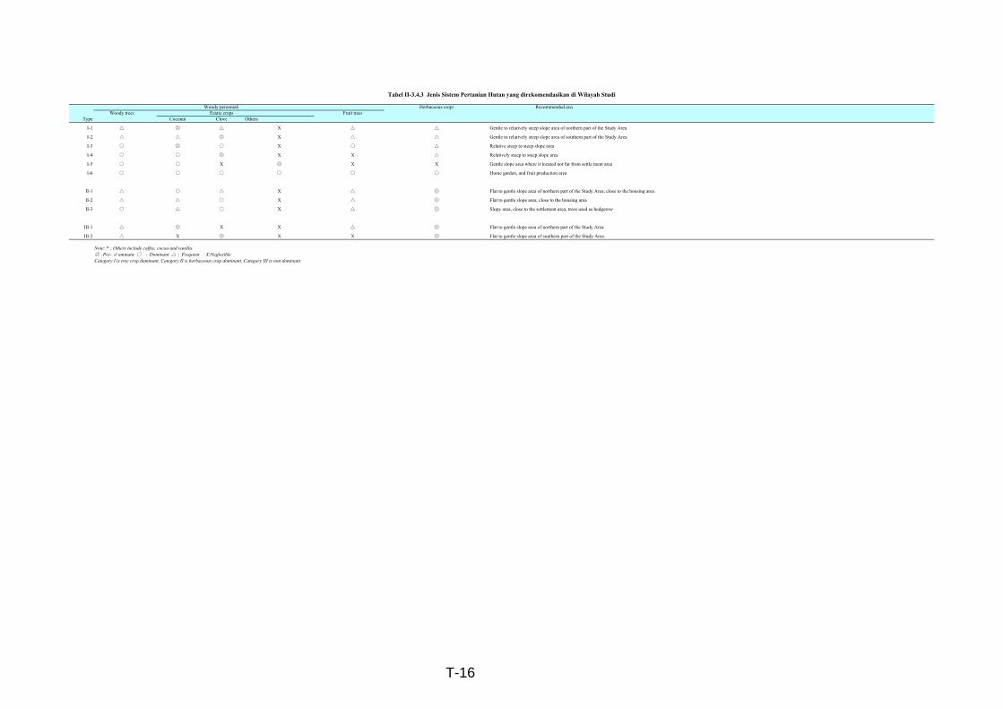
Woody perennials Herbaceous crops Recommended areaWoody trees Estate crops Fruit trees
Type Coconut Clove Others
I-1 △ ◎ △ X △ △ Gentle to relatively steep slope area of northern part of the Study Area
I-2 △ △ ◎ X △ △ Gentle to relatively steep slope area of southern part of the Study Area
I-3 ○ ◎ ○ X ○ △ Relative steep to steep slope area
I-4 ○ ○ ◎ X X △ Relatively steep to steep slope area
I-5 ○ ○ X ◎ X X Gentle slope area where it located not far from settle ment area
I-6 ○ ○ ○ ○ ○ ○ Home garden, and fruit production area
II-1 △ ○ △ X △ ◎ Flat to gentle slope area of northern part of the Study Area, close to the housing area
II-2 △ △ ○ X △ ◎ Flat to gentle slope area, close to the housing area
II-3 ○ △ ○ X △ ◎ Slopy area, close to the settlement area, trees used as hedgerow
III-1 △ ◎ X X △ ◎ Flat to gentle slope area of northern part of the Study Area
III-2 △ X ◎ X X ◎ Flat to gentle slope area of southern part of the Study Area
Note: * ; Others include coffee, cocoa and vanilla.◎ :Pre-d ominant ○ :Dominant △:Frequent X:NeglesibleCategory I is tree crop dominant, Category II is herbaceous crop dominant, Category III is non dominant.
Tabel II-3.4.3 Jenis Sistem Pertanian Hutan yang direkomendasikan di Wilayah Studi
T-16
T - 17
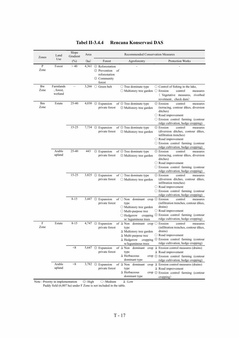
Tabel II-3.4.4 Rencana Konservasi DAS
SlopeGradient Area Recommended Conservation Measures
Zones LandUse (%) (ha) Forest Agroforestry Protection Works
PZone
Forest > 40 4,361 ◎ Reforestation◎ Prevention of
reforestation◎ Community
forest
- -
BwZone
Farmlands, forest,wetland
- 3,266 ○ Green belt ○ Tree dominate type○Multistory tree garden
○ Control of fishing in the lake,○ Erosion control measures( Vegetative measures, riverbedrevetment、 check dam)
BmZone
Estate 25-40 4,030 ◎ Expansion ofprivate forest
◎ Tree dominate type◎Multistory tree garden
◎ Erosion control measures(terracing, contour dikes, diversionditches)
○ Road improvement○ Erosion control farming (contour
ridge cultivation, hedge cropping)15-25 7,734 ◎ Expansion of
private forest◎ Tree dominate type◎Multistory tree garden
◎ Erosion control measures(diversion ditches, contour dikes,infiltration trenches)
○ Road improvement○ Erosion control farming (contour
ridge cultivation, hedge cropping)Arableupland
25-40 443 ◎ Expansion ofprivate forest
◎ Tree dominate type◎Multistory tree garden
◎ Erosion control measures(terracing, contour dikes, diversionditches)
○ Road improvement○ Erosion control farming (contour
ridge cultivation, hedge cropping)15-25 3,825 ◎ Expansion of
private forest○ Tree dominate type○Multistory tree garden
◎ Erosion control measures(diversion ditches, contour dikes,infiltration trenches)
○ Road improvement○ Erosion control farming (contour
ridge cultivation, hedge cropping)8-15 3,447 ◎ Expansion of
private forest○Non dominant crop
type○Multistory tree garden○Multi-purpose tree○Hedgerow cropping
w/ leguminous trees
◎ Erosion control measures(infiltration trenches, contour dikes,drains)
○ Road improvement◎ Erosion control farming (contour
ridge cultivation, hedge cropping)F
ZoneEstate 8-15 4,747 ◎ Expansion of
private forestΔNon dominant crop
typeΔMultistory tree gardenΔMulti-purpose treeΔHedgerow cropping
w/leguminous trees
○ Erosion control measures(infiltration trenches, contour dikes,drains)
○ Road improvement◎ Erosion control farming (contour
ridge cultivation, hedge cropping)<8 5,647 ◎ Expansion of
private forestΔNon dominant crop
typeΔHerbaceous crop
dominant type
Δ Erosion control measures (drains)Δ Road improvement◎ Erosion control farming (contour
ridge cultivation, hedge cropping)Arableupland
<8 3,782 ◎ Expansion ofprivate forest
ΔNon dominant croptype
ΔHerbaceous cropdominant type
Δ Erosion control measures (drains)Δ Road improvement◎ Erosion control farming (contour
cropping)Note : Priority in implementation ◎:High ○:Medium Δ:Low
Paddy field (6,007 ha) under F Zone is not included in the table.

T - 18
Tabel III-1.1.1 Profil Tanah pada umumnya (Kelompok Selatan) (1/3)
Horizon/Layer Depth (cm) ExplanationA 0-30 Color: black (7.5yr 2/1), Structure: Crumb, Size: very fine to
medium, Texture: sandy loam, Consistency: very friable tofriable, Root condition: dense
C 30-49 Buried horizon; Sandy fractionI 49-82 Color: brownish black (10yr 2/2), Structure: Crumb, Size: very
fine to fine, Texture: sandy loam, Consistency: friable, Rootcondition: lacked
II 82-97 Color: black (10yr 2/1), Structure: crumb, Size: very fine to fine,Consistency: friable
III 97-100 Color: black (10yr 2/1), Structure: Crumb to blocky, Size: fine tomedium, Texture: sandy loam, Consistency: friable
Tabel III-1.1.1 Profil Tanah pada umumnya (Kelompok Timur) (2/3)
Horizon/Layer Depth (cm) ExplanationA 0-15 Color: very dark brown (7.5YR 2/3), Structure: blocky
Size: fine to medium, Texture: clay, Consistency: friable to firm,Root condition: dense
B 15-77 Color: brownish black (75YR 4/3-4/6), Structure: blockySize: medium-coarse, Texture: clay, Consistency: friable to firm,Root condition: lacked
BC 77-115 Color: brown (75YR 4/4-4/6), Structure: crumb to blockySize: fine to medium, Texture: clay, Consistency: friable to firm,sticky, Root condition: lacked
Tabel III-1.1.1 Profil Tanah pada umumnya (Kelompok Barat) (3/3)
Horizon/Layer Depth (cm) ExplanationAp 0-10 Color: brownish black (7.5YR 3/2), Structure: Crumb to blocky,
Size: fine to medium, Texture: clay loam, Consistency: friable,Root condition: dense
BA 10-31 Color: dark brown (7.5YR 3/3), Structure: crumb to blocky, Size:medium, Texture: clay, Consistency: friable to firm, sticky, Rootcondition: lack
B 31-86 Color: brownish black to dark brown (10YR 3/2), Structure:crumb to blocky, Size: medium to coarse, Texture: clay,Consistency: friable to firm, Root condition: lack
BC 86-102 Color: dark brown (7.5YR 3/4), Structure: blocky, Size: fine tomedium, Consistency: firm and sticky, Root condition: lack

Upper: Area (ha)Lower: Ratio (%)
No. Legend East Area South Area West Area Intensive Area1 Natural/Semi/natural forest 327 735 66 1,128
9.8 21.6 1.3 9.52 Secondary forest 70 478 52 600
2.1 14.1 1.0 5.03 Planted forest (Timber) 11 12 1 24
0.3 0.4 0.0 0.24 Planted forest (Firewood) 83 6 359 448
2.5 0.2 7.0 3.85 Bush 120 48 74 242
3.6 1.4 1.4 2.06 Estate (Clove) 731 19 200 950
22.0 0.6 3.9 8.07 Estate (Others) 684 269 1,491 2,444
20.5 7.9 29.0 20.68 Mixture of estate and arable upland 461 742 618 1,821
13.8 21.7 12.0 15.39 Arable upland 368 859 1,895 3,122
11.0 25.2 36.8 26.310 Pasture 0 0 36 36
0.0 0.0 0.7 0.311 Paddy field 388 125 125 638
11.6 3.7 2.4 5.412 Swamp 10 2 8 20
0.3 0.1 0.2 0.213 Water body 1 0 5 6
0 0 0.1 0.014 Settlement and others 85 105 216 406
2.5 3.1 4.2 3.4Total (ha) 3,339 3,400 5,146 11,885Total (%) 100.0 100.0 100.0 100.0
Tabel III-1.3.1 Wilayah dari masing-masing Penggunaan Lahan di Tiga Wilayah
T-19
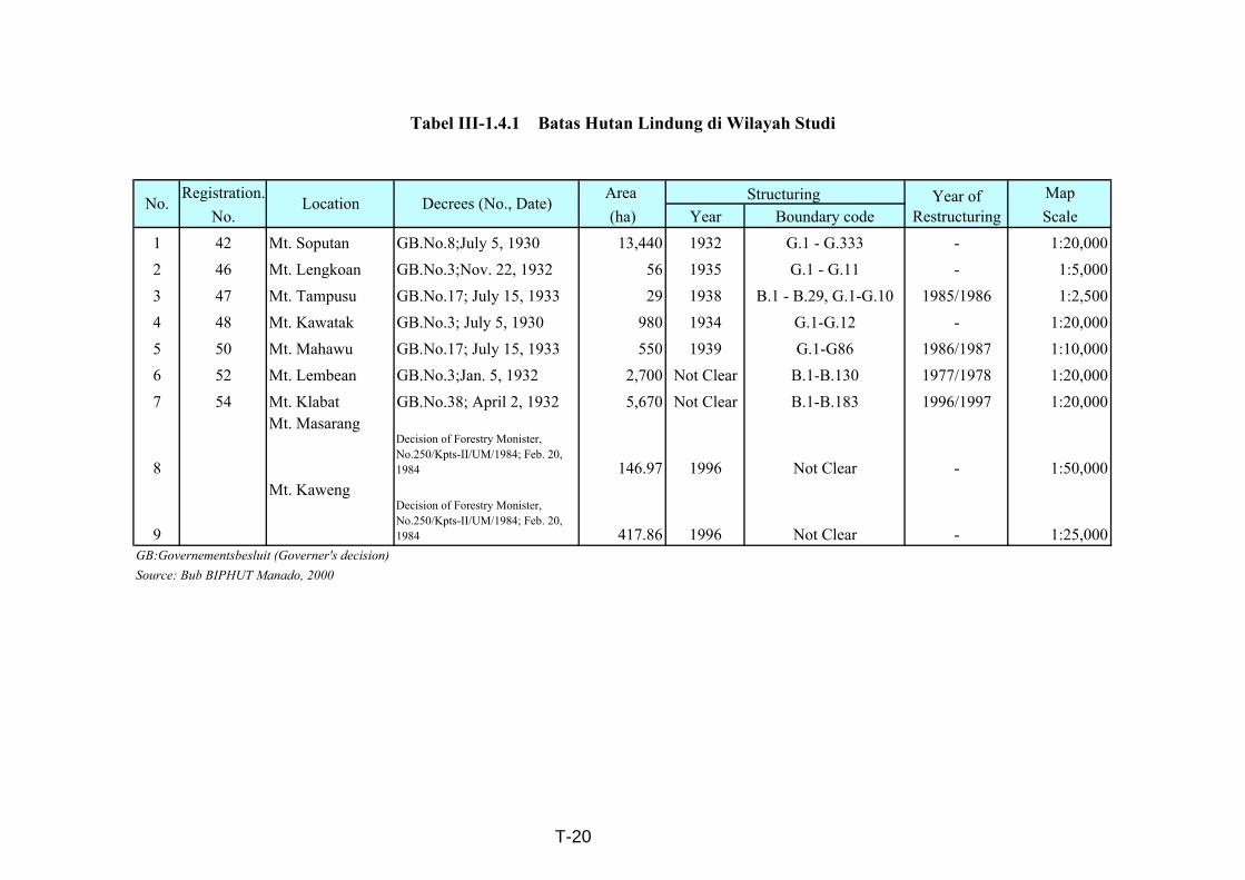
Registration. Area MapNo. (ha) Year Boundary code Scale
1 42 Mt. Soputan GB.No.8;July 5, 1930 13,440 1932 G.1 - G.333 - 1:20,0002 46 Mt. Lengkoan GB.No.3;Nov. 22, 1932 56 1935 G.1 - G.11 - 1:5,0003 47 Mt. Tampusu GB.No.17; July 15, 1933 29 1938 B.1 - B.29, G.1-G.10 1985/1986 1:2,5004 48 Mt. Kawatak GB.No.3; July 5, 1930 980 1934 G.1-G.12 - 1:20,0005 50 Mt. Mahawu GB.No.17; July 15, 1933 550 1939 G.1-G86 1986/1987 1:10,0006 52 Mt. Lembean GB.No.3;Jan. 5, 1932 2,700 Not Clear B.1-B.130 1977/1978 1:20,0007 54 Mt. Klabat GB.No.38; April 2, 1932 5,670 Not Clear B.1-B.183 1996/1997 1:20,000
8
Mt. MasarangDecision of Forestry Monister,No.250/Kpts-II/UM/1984; Feb. 20,1984 146.97 1996 Not Clear - 1:50,000
9
Mt. KawengDecision of Forestry Monister,No.250/Kpts-II/UM/1984; Feb. 20,1984 417.86 1996 Not Clear - 1:25,000
GB:Governementsbesluit (Governer's decision)Source: Bub BIPHUT Manado, 2000
Tabel III-1.4.1 Batas Hutan Lindung di Wilayah Studi
Structuring Year ofRestructuring
No. Location Decrees (No., Date)
T-20


