To: From: Meeting Date: Report No: T a u r a n g a Oty Independent Hearings Commissioner Environmental Planning 14 October 2010 DC370 Title of Report: LIMITED NOTIFIED APPLICATION FOR LAND USE CONSENT UNDER THE RESOURCE MANAGEMENT ACT 1991 AT 1 TAIPARI STREET, MAUNGATAPU, TAURANGA (RCI 5054) Purpose of Report: Statutory Significance of Decision: N/A Report Writer: Shanan Miles Summary To hear and determine a limited notified land use consent application pursuant to Section 88 ofthe Resource Management Act 1991 made by Two Degrees Mobile Limited. Report Outline: This report considers and makes a concluding recommendation to refuse consent to establish and operate a telecommunications facility comprising a 20 metre tall monopole, panel and dish antennae and associated equipment cabinets in the Residential A Zone. TCC Ref: 3451432
Transcript
To:
From:
Meeting Date:
Report No:
T a u r a n g a Oty
Independent Hearings Commissioner
Environmental Planning
14 October 2010
DC370
Title of Report: LIMITED NOTIFIED APPLICATION FOR LAND USE CONSENT UNDER THE RESOURCE MANAGEMENT ACT 1991 AT 1 TAIPARI STREET, MAUNGATAPU, TAURANGA (RCI 5054)
Purpose of Report: Statutory
Significance of Decision: N/A
Report Writer: Shanan Miles
Summary
To hear and determine a limited notified land use consent application pursuant to Section 88 ofthe Resource Management Act 1991 made by Two Degrees Mobile Limited.
Report Outline:
This report considers and makes a concluding recommendation to refuse consent to establish and operate a telecommunications facility comprising a 20 metre tall monopole, panel and dish antennae and associated equipment cabinets in the Residential A Zone.
TCC Ref: 3451432
1.0 INTRODUCTION
My name is Shanan Miles. I hold the position of Environmental Planner within the Customer & Environmental Services Group at Tauranga City Council. My qualifications include a Bachelor of Arts (Geography) Degree from Massey University. I am also an Associate Member of the New Zealand Planning Institute.
I have three years post graduate planning experience in positions held in New Zealand, of which the last two years has been with Tauranga City Council processing resource consent and other resource management related applications.
2.0 THE APPLICANT & PROPERTY DETAILS
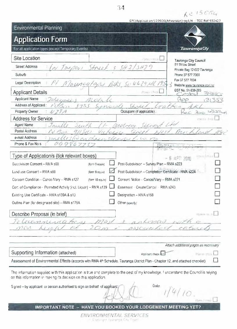
Site location:
Applicant:
Address for Service:
Legal Description:
Site Area:
District Plan Zone:
Proposed City Plan Zone:
Designations/Limitations:
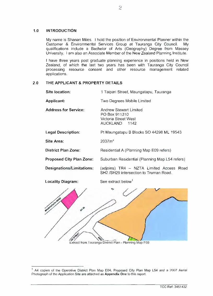
Locality Diagram:
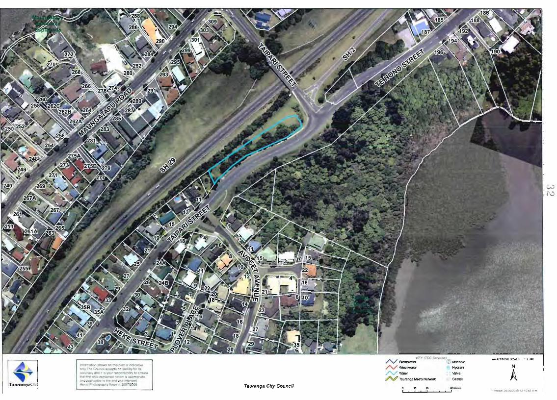
1 Taipari Street, Maungatapu, Tauranga
Two Degrees Mobile Limited
Andrew Stewart Limited POBox 911310 Victoria Street West AUCKLAND 1142
Extract from Tauranga District Plan - Planning Map E09
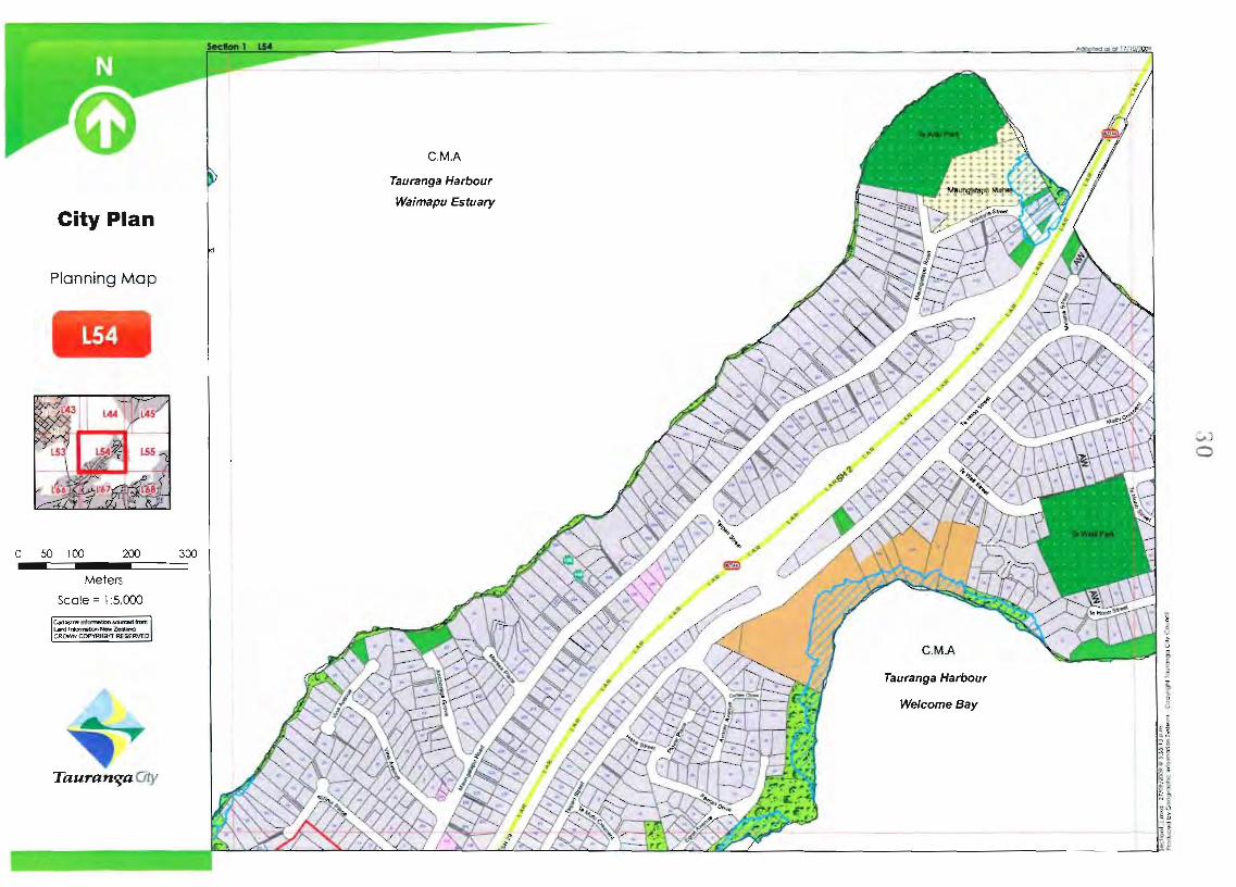
A4 copies of the Operative District Plan Map E04, Proposed City Plan Map L54 and a 2007 Aerial Photograph of the Application Site are attached as Appendix One to this report.
TCC Ref: 3451432
3.0 PROPOSAL
3.1 Proposal
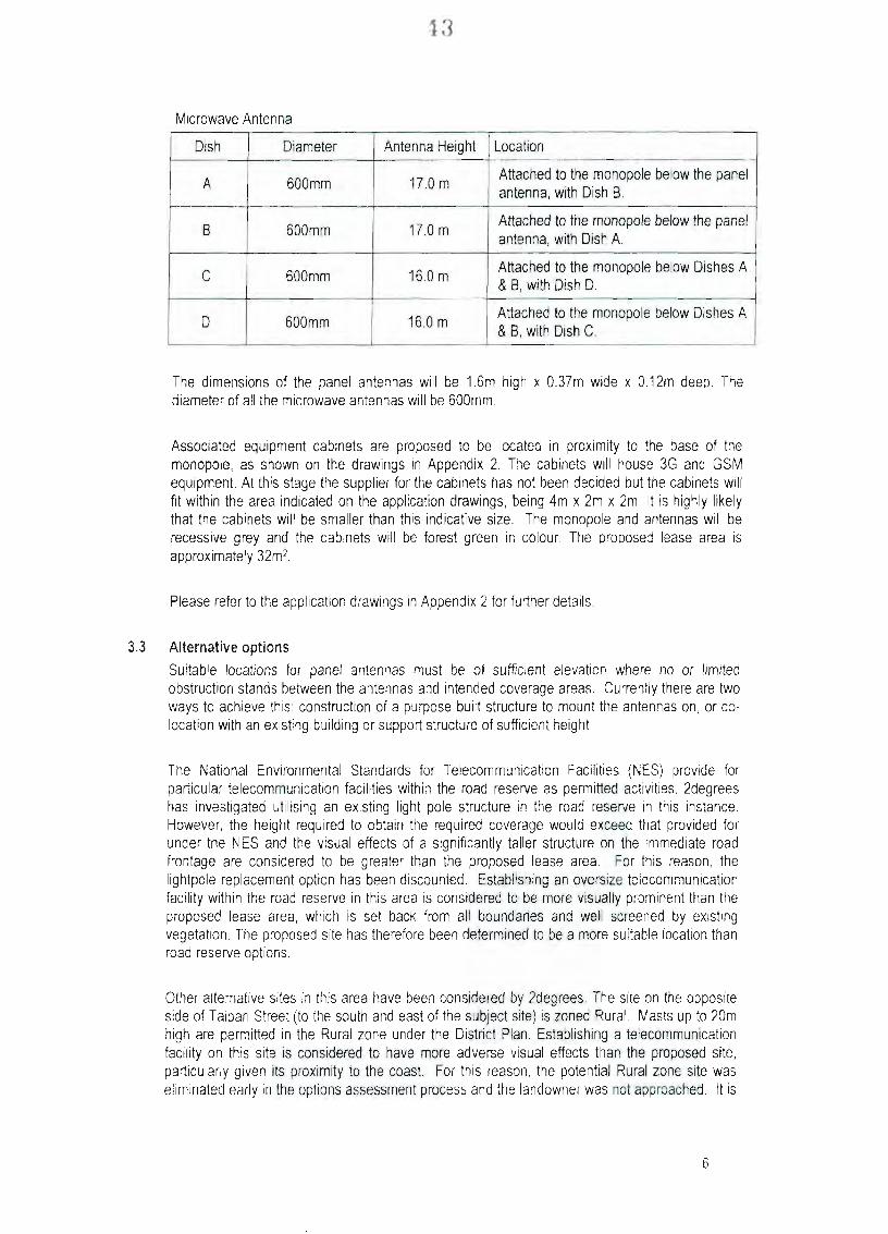
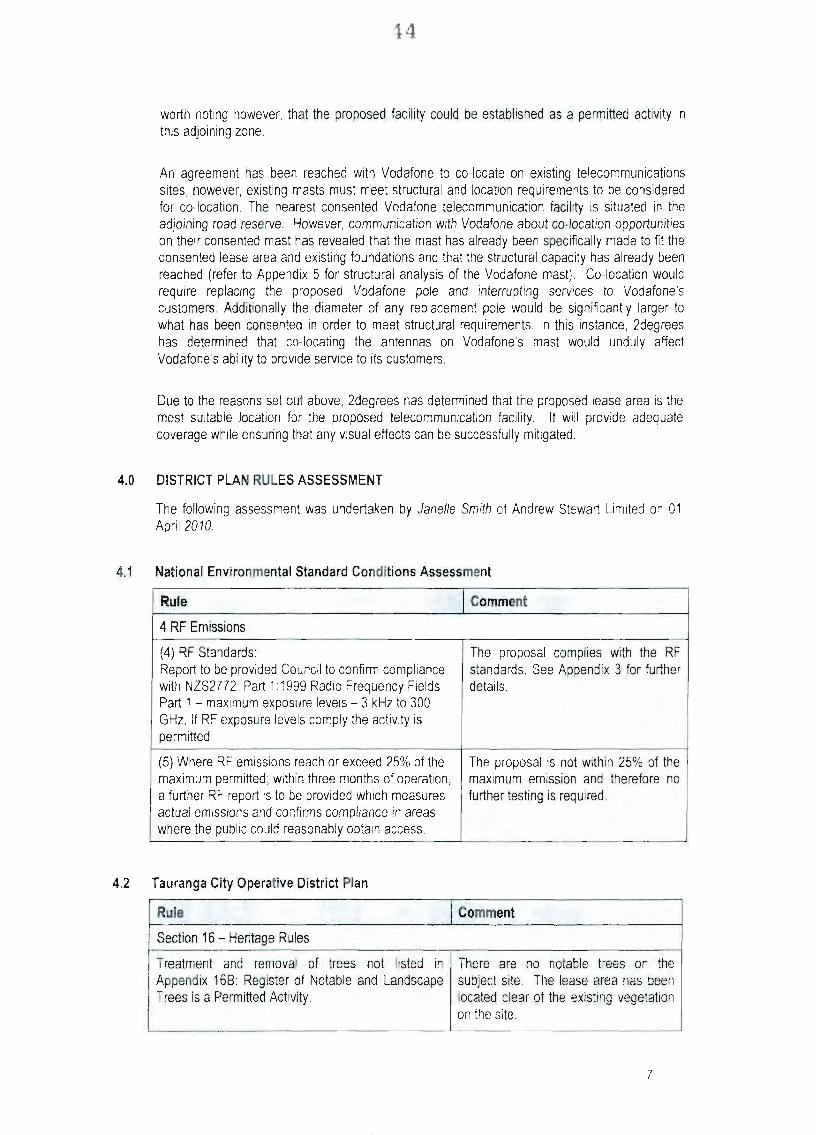
The Applicant proposes to establish and operate a telecommunications facility from within a 32m^ leased portion of the application site. The proposed facility comprises a 17 metre tall mast/monopole (with a maximum diameter of 0.6 metres), three panel antennae (each measuring 1.6 metres in height and 0.592m^ in area), four microwave dish antennae (each having a diameter of 0.6 metres) and associated equipment cabinets (to fit within a profile measuring 2.0 metres in width, 4.0 metres in length and 2.0 metres in height) located at the base of the mast. The lease area is to be defined by a mesh fence and the facility is to have a maximum height of 20 metres (monopole and antennae).
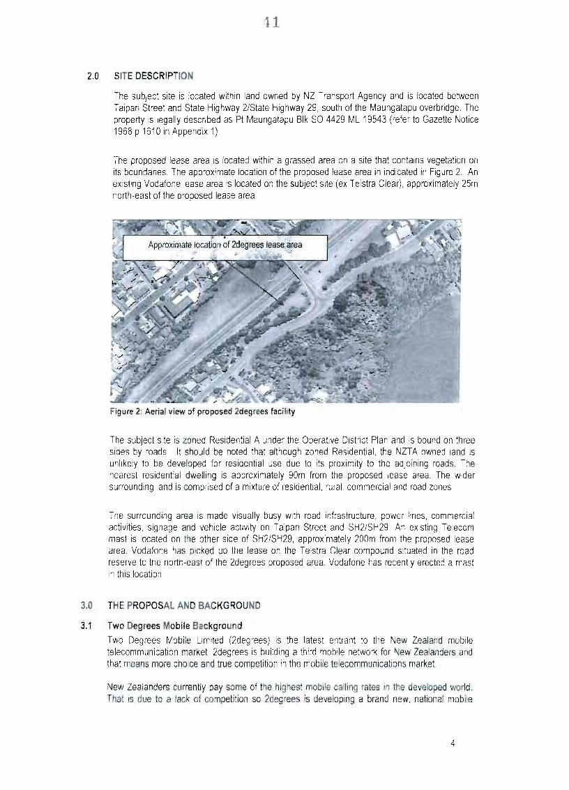
4.0 SITE AND SURROUNDS
4.1 Site Description
The application site comprises approximately 2037m^ of land zoned Residential A. The site is currently free from built form but has high voltage overhead power lines running through its centre. Well-established vegetation, reaching heights of up to 10 metres, occupies the majority of the site, in particular along the southern boundary (adjoining Taipari Street). Vehicle access is gained via a single vehicle crossing located in the south western corner of the subject site.
4.2 Surrounds
The application site is adjoined on its south-eastern boundary by Taipari Street, which is classed as a Local Road in the Tauranga District Plan Road Hierarchy. Further east is a large (27,582m^) area of undeveloped land, which is covered in well-established native vegetation and zoned Rural. Further east is Welcome Bay (zoned Costal Marine Area). Land to the south and north east of the application site is characterised by residential land use of a medium density. The site is adjoined on its northern and western boundaries by road reserve associated with State Highway 29, which bisects the suburb of Maungatapu. Within this road reserve, approximately 25 metres east of the application site, is an existing Vodafone telecommunications facility, which is similar in nature to the proposed facility and includes a 20 metre tall mast. State Highway 29 is located 30 metres north of the application site at a ground level approximately four metres below that of the application site.
5.0 REASONS FOR THE APPLICATION
5.1 Operative Tauranga District Plan 2003
The proposed telecommunications facility is a land use activity not listed as permitted, controlled, limited discretionary, non-complying or prohibited within Chapter 19 {Residential Activity Zone Rules) of the Operative Plan. As such pursuant to clause 19.5(a) of the Operative Plan the proposed telecommunications facility has a Discretionary activity status within Chapter 19.
Clause 24.1 of Chapter 24 (Transport Activity and Other Network Utility Rules) prescribes a Discretionary activity status for the following:
TCC Ref: 3451432
''Radio and telecommunication masts up to, and including, 20m high together with associated antennae dishes not exceeding 5m in diameter, aerials not exceeding 6m high and 75mm in diameter..., provided the total height of the mast and associated equipment shall have a maximum height no greater than 26m. The mast shall have a maximum diameter of 1350mm. Buildings not exceeding 30m' gross floor area (GFA)".
Clause 24.1 of Chapter 24 (Transport Activity and Other Network Utility Rules) prescribes a Permitted activity status for the following:
"Radio and telecommunication aerials up to 4m in height and antennae dishes up to 1.8m in diameter and panel antennae with panel area not exceeding 1.2m' attached to a building or structure".
As identified within the application (attached as Appendix Two to this report) the proposal is for a monopole (mast) and associated equipment to have a maximum height of 20 metres and having a (maximum) diameter of 600 millimetres. Equipment cabinets (building) are proposed to be installed at the base of the mast with a footprint (GFA) no greater than 8m^. Proposed to be attached to the mast are four microwave dishes with diameters of 0.6 metres, three panel antennae measuring 1.6 metres in height and 0.592m^ metres in area.
The proposed telecommunications facility therefore has Discretionary activity status within Chapter 24.
Subsequent to the application being lodged (6 April 2010) Plan Change 48 has become operative (3 May 2010). The purpose of Plan Change 48 was to address significant resource management issues associated with the impacts of permitted non-residential activities, being home-based businesses, offices, health centres and education.
Under Plan Change 48 the wording of clause 19.5(a) was amended to exclude non-residential activities, with non-residential activities not listed as permitted, controlled, limited discretionary or prohibited within Chapter 19 now having a non-complying activity status pursuantto clause 19.6(e).
Plan Change 48 was not intended to alter the activity status of network utilities (as prescribed within Chapter 24) and whilst the proposed telecommunications facility is not a "Residential Activity" in terms of the Chapter 10 definition of the same, it is not considered to be a "Non-Residential Activity" in the context of Plan Change 48 or clauses 19.5(a) or 19.6(e). Plan Change 48 made no changes to Chapter 24.
Overall, the proposal is considered to be a Discretionary Activity.
6.0 NOTIFICATION AND SUBMISSIONS
6.1 Notification
Pursuant to Section 95A of the Act, the application was considered to have adverse effects on the environment that were not more than minor and therefore Public Notification was not required.
TCC Ref: 3451432
Pursuant to Section 95E of the Act, 20 persons were considered adversely affected by the activity's effects and the application was processed on a Limited Notified basis.
On Wednesday 11 August 2010 those persons considered adversely affected were notified of the application.
A copy of the Notification Recommendation and Determination made by Council staff under delegation is attached as Appendix Three to this report.
6.2 Submissions Received
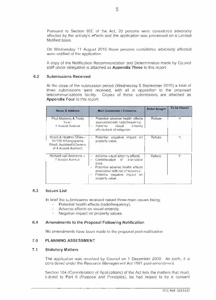
At the close of the submission period (Wednesday 8 September 2010) a total of three submissions were received, with all in opposition to the proposed telecommunications facility. Copies of these submissions are attached as Appendix Four to this report.
1 Name & Adciress
1 Paul Manning & Trudy Yule -
1 Avocet Avenue
Bruce & Heather Shaw -10/126 Whangaparoa
Road, Auckland (Owners of 4 Avocet Avenue)
Richard van Arendonk -7 Avocet Avenue
Main Comments / Concerns
- Potential adverse health effects associated with radiofrequency.
- Adverse visual amenity effects/lack of mitigation.
- Potential negative impact on property value.
- Adverse visual amenity effects. - Consideration of alternative
sites. - Potential adverse health effects
associated with radiofrequency. - Potential negative impact on
property value.
Relief Sought
Refuse
Refuse
Refuse
To be Heard? 1
Y
N
Y
6.3 Issues List
In brief the submissions received raised three main issues being: Potential health effects (radiofrequency). Adverse effects on visual amenity. Negative impact on property values.
6.4 Amendments to the Proposal Following Notification
No amendments have been made to the proposal post-notification.
7.0 PLANNING ASSESSMENT
7.1 Statutory Matters
The application was received by Council on 1 December 2009. As such, it is considered underthe Resource Management Act 1991 post-amendment.
Section 104 (Consideration of Applications) of the Act lists the matters that must, subject to Part II (Purpose and Principles), be had regard to by a consent
TCC Ref: 3451432
authority when considering an application and any submissions received. They include;
(a) Any actual and potential effects on the environment of allowing the activity; (b) Any relevant provisions of a policy statement, plan or proposed plan; and (c) Any other matter the consent authority considered relevant and reasonably
necessary to determine the application.
Section 104B of the Act advises that a consent authority may grant or refuse a discretionary activity and if it grants the application, may impose conditions under Section 108 ofthe RMA.
7.2 Section 104(1)(a) - Actual and Potential Effects on the Environment
In my view the actual and potential adverse effects of the proposed telecommunications facility fall within the following groupings:
(a) Streetscape Effects (b) Effects on Residential Character and Visual Amenity (c) Noise Effects (d) Effects of Radiofrequency Emissions (e) Effects on the High Voltage Electricity Transmission Network.
7.2.1 Streetscape Effects
As identified within the application, portions of the proposed facility are located within the three metre Streetscene Setback anticipated by the Plan (rule 19.2.1.4(a) refers) as it relates the application site's frontage to State Highway 29 (SH29).
The encroachment ranges from 0.2 to 1.1 metres and spans approximately eight metres and relates to part of the 2.4 metre tall security fence (considered to be a 'building' in accordance with the Chapter 10 definition) and a small portion of the monopole foundation. I note however, that the proposed monopole and equipment cabinets observe the anticipated streetscene setback.
Given the nature of the proposed encroachments, that the facility is setback a minimum of 28 metres from SH29 and the nature of the subject streetscape, I consider that adverse streetscape effects are less than minor.
I note that none of the submissions received raised concern over this encroachment into the Streetscene Setback.
7.2.2 Effects on Residential Character and Visual Amenity
Several landuse activities contribute to the character of the subject locality, with these including road infrastructure, utility structures and residential dwellings. Of note is the presence of a Vodafone telecommunications facility located approximately 35 metres northeast of the facility being considered. The Vodafone facility is similar to that proposed by Two Degrees facility, including a 20 metre tall monopole, antennae and equipment cabinets.
Notwithstanding the foregoing, it is my opinion that the dominant landuse and contributor to character in the subject locality is residential.
The application and associated Visual Assessment prepared by the Isthmus Group
TCC Ref: 3451432
Limited consider that visual effects associated with the proposal are generally limited to areas within the immediate surrounds and consider that the monopole is in keeping with the bulk and height of existing electricity and telecommunication structures in the vicinity of the application site.
Submissions from Paul Manning & Trudy Yule (of 1 Avocent Avenue) and Richard van Arendonk (of 7 Avocent Avenue) state that their decision to purchase their properties was partially driven by the character and amenity of the locality. Both submissions state that the existing Vodafone facility has adversely affected their visual amenity and they raise concern over the effects that the proposed facility will have on their visual amenity and outlook. They also consider that the existing vegetation will not adequately screen the proposed facility.
Council's Landscape Architect^ has reviewed the proposal (including the visual assessment prepared by Isthmus Group Limited) and considers that the presence of a second monopole in close proximity to the existing (Vodafone) structure will clutter the skyline. He has also raised concern about the reliance on existing vegetation outside of the lease area to mitigate adverse effects due to the lack of certainty and control over long-term retention of the same. He does however concur with the Isthmus assessment of affected persons, including the methodology employed in identifying the same.
In considering potential effects on character and visual amenity, I note that components of the proposed facility are not anticipated on the application site, which is zoned Residential A. The proposed monopole (and associated antennae), at 20 metres in height, exceeds the anticipated building height for the application site by 11 metres. Although I concur with the application that the slim design and recessive colouring of the monopole will reduce the potential visual effects of the proposal, I considered that the monopole is not consistent with the anticipated residential character of the application site and surrounding residential neighbourhood. This is due largely to the height being proposed.
I concur with the application comments that existing utility structures contribute to the character of the subject locality but I do not consider that this provides justification for an additional utility structure (monopole). In this respect I note that the proposed monopole is approximately six metres taller than the electricity transmission lines and may, in combination with existing utility structures, result in adverse character and visual amenity effects.
It is my view that both the application and the Isthmus assessment rely heavily on the mitigation provided by existing vegetation within the application site. Although this vegetation is located within the application site, I note that the proposed lease area shown on the application site plan^ is limited to an area immediately surrounding the facility and does not encompass the vegetation relied upon for mitigation. The application has not demonstrated that they will have any control over the retention or maintenance of this vegetation.
The Applicant considers that the removal of existing vegetation is unlikely but has proffered replacement planting in the event that vegetation within the application site is removed.
I considered that the level of mitigation (buffering) provided by this vegetation is of
2 A full copy of Council's Landscape Architect's comments are attached as Appendix Five to this report. See Appendix 2 ofthe Application Material attached as Appendix Two to this report.
TCCRef: 3451432
8
such an extent that its removal would result in a significant impact in terms of preservation and maintenance of character and visual amenity in the area. The Applicant has not elaborated on the type or location of replacement planting and as such its mitigation value cannot be assessed.
The application also puts forward a permitted baseline argument, stating that some of the components (antennae and cabinets) of the proposed facility are permitted within the application site and that the monopole is permitted on nearby Rural zoned land (located approximately 45 metres south east of the application site).
In relation to those components of the proposed facility permitted on the application site, I note that the proposed cabinet footprint is 8m^, which is double that anticipated by the Plan. In terms of the proposed antennae, whilst they are permitted by the Plan, they can only be attached to existing buildings, which have a maximum permitted height of nine metres on the application site.
In relation to the comment made in the application that the proposed facility could be established as a permitted activity on nearby Rural zoned land, I considered this somewhat fanciful due to topographic constraints (i.e. steep slope). I also note that this Rural zoned site is approximately 10 metres lower in elevation than the application site.
A site visit was conducted to the properties located at 1 and 7 Avocet Avenue as these two properties will, in my view, be the most affected by the proposed facility, with the proposed facility located approximately 90 metres away. This visit revealed that for both properties the bulk of their living and bedroom areas (habitable rooms) have views orientated towards the proposed facility. Both also have first floor decks, which also have outlooks orientated towards the application site. The outdoor living areas for both properties are also located on the northern side of the dwellings, with the outdoor living area of 7 Avocet Avenue in particular having clear views towards the application site.
Council's Landscape Architect accompanied me on this site visit and took some photographs (see Council's Landscape Architect's comments attached as Appendix Five to this report). Council's Landscape Architect considers that the acjverse visual effects are at the high end of the scale identified within the Isthmus report.
I consider that the 20 metre height of the proposed monopole in combination with the relatively short distance (90 metres) separating the facility from nearby dwellings, will result in the proposed facility becoming a prominent feature when viewed from residential properties on Avocet Avenue in particular.
It is my opinion that the proposed facility, on its own and in combination with existing utility structures, will result in more than minor effects on the visual amenity currently enjoyed by the properties adjacent the application site located at 1 and 7 Avocet Avenue as it will be a prominent feature when viewed from the majority of the habitable rooms and outdoor living areas of both dwellings. These effects will be especially significant from the first floor deck of 1 Avocet Avenue and the outdoor living area of 7 Avocet Avenue.
7.2.3 Noise Effects
Aside from construction noise associated with the establishment of the facility, the proposal has potential to generate adverse noise effects on an ongoing basis via
TCC Ref: 3451432
the equipment cabinets associated with the facility.
The application identifies that the exact supplier of the cabinets has not been decided but states that the cabinets will produce noise levels that are no greater than those currently used by Two Degrees Mobile (which meet the applicable noise standards).
To support this statement an Acoustic Assessment prepared by JPStyles Ltd Acoustics and Vibration was provided with the application. The acoustic assessment was carried out with the cabinets operating at maximum fan speed and took measurements at a distance of one metre from the cabinets. The acoustic assessment identifies that the loudest LIO reading obtained during testing was 40 dBA.
Council's Team Leader: Environmental Health" has reviewed the proposal and has raised no concern in relation to potential noise effects, noting that measurements were carried out on a 'worst case scenario' and that the nearest residential property is a considerable distance away (90 metres).
Whilst 40 dBA exceeds the 35 dBA LIO limit for night time (10:00pm to 7:00am) noise levels, this reading was obtained while the fans were operating at maximum speed and at a distance of one metre from the cabinet.
In considering potential adverse noise effects I note that the proposed cabinet location is a minimum of 90 metres from the nearest residentially zoned site and the application has identified that the facility will comply with the noise limits specified by the Application Site's Residential A zoning.
Potential adverse noise effects are considered to be less than minor.
7.2.4 Effects of Radiofrequency Emissions
The application was accompanied by two Technical Reports prepared by the National Radiation Laboratory^ to address potential effects associated with radiofrequency emissions. These are generic reports based on a worst case scenario for a 'typical' cell site consisting of:
Three panel antennae mounted at a height of eight metres above ground level. Two dish antennae mounted at a height of four metres above ground level, A maximum 10 watts of power delivered to each panel antennae feeder, A maximum loss of 1 dB.
The National Radiation Laboratory describe their function as being the administration of radiation protection legislation and provision of independent advice to central and local government, the public and industry. The National Radiation Laboratory is an agent of the Government.
The Technical Report concludes that calculations have shown that exposures to radiofrequency radiation to someone on the ground near such a cell site would be
4
A full copy of Council's Team Leader: Environmental Health's comments are attached as Appendix Five to this report.
Full copies of these reports are attached as Appendix 3 to the application, which is attached as Appendix Two to this report.
TCC Ref: 3451432
10
less than 1.3 percent of the limit specified within NZS 2772.1:1999 Radiofrequency Fields Part 1: Maximum exposure levels - 3kHz to 300 GHz.
A report prepared by Trevor Mynott^, an RF Engineer from Two Degrees Mobile, was also provided with the application. These confirm that the radiofrequency fields (including in combination with the existing Vodafone facility) at places in the vicinity of the facility that are reasonably accessible to the general public will comply with NZS 2772.1:1999 Radiofrequency Fields Part 1: Maximum exposure levels - 3kHz to 300 GHz. The report goes further to state that radiofrequency fields will be less than 25 percent of the allowable level.
Submissions from Paul Manning & Trudy Yule and Richard van Arendonk have both raised concern over potential health effects associated with radiofrequency emissions, in particular the close proximity to residential dwellings and a nearby childcare centre. Both raise concern over how conclusive studies have been in terms of long-term exposure and potential effects on children.
The activity status for facilities generating radiofrequency is prescribed within Regulation 4 of the Resource Management (National Environmental Standards for Telecommunication Facilities) Regulations 2008 (the NES).
Regulation 4 of the NES states that a telecommunication facility is a permitted activity as far as radiofrequency fields are concerned if the network operator plans and operates the facility:
Operates the facility in accordance with NZS 2772.1:1999 Radiofrequency Fields Part 1: Maximum exposure levels - 3kHz to 300 GHz, Provides notice to the relevant local authority that takes into account exposure from other telecommunications facilities in the vicinity and predicts whether radiofrequency field levels at places in the vicinity of the facility comply with NZS 2772.1:1999 Radiofrequency Fields Part 1: Maximum exposure levels - 3kHz to 300 GHz.
The application has demonstrated and confirmed that the proposed telecommunications facility complies with the requirements of Regulation 4 of the NES and is therefore considered to be a permitted activity under the same. As such, pursuant to section 104(1)(2) of the Act, the Consent Authority may disregard the adverse effects on the environment associated with radiofrequency emissions in making its decision on whether to grant this application.
7.2.5 Effects on the High Voltage Electricity Transmission Network
The application site has high voltage electhcity transmission lines running through its centre in a north easterly direction. Given that the application proposes to construct a 20 metre tall monopole approximately 13 metres from the transmission lines, it is considered that the proposal has the potential to result in adverse effects on the electricity transmission network both during construction and operation of the proposed telecommunications facility.
To address potential effects on the electricity transmission network, a report prepared by Linetech Consulting entitled "Report on Proposed Clearances at Two
6 Full copies of this report is attached as Appendix 3 to the application, which is attached as Appendix Two to this report.
TCCRef: 3451432
11
Degrees Communications Mast - Welcome Bay, Tauranga" and dated 9 July 2010, was provided by the Applicant (attached as Appendix Two to this report).
The Linetech report considers the proposal against two criteria, being the New Zealand Electrical Code of Practice (NZECP34:2001) and Transpower New Zealand's Corridor Management Policy.
The Linetech report concludes that the proposed telecommunications facility complies with New Zealand Electrical Code of Practice (NZECP34:2001) and makes recommendations in relation to construction methodology.
The Linetech report has been reviewed by Transpower (New Zealand) Limited, who are considered to be the only potentially adversely affected party in relation to potential effects on the high voltage electricity transmission network. As such, pursuant to Section 104(3)(a)(ii) of the Act, effects on Transpower (New Zealand) Limited must not be considered in making a decision whether to grant consent.
7.2.6 Conclusion on Actual and Potential Effects on the Environment
Overall, it is my opinion that the proposal has potential to result in adverse residential character and amenity effects on the environment that are more than minor. In all other respects I consider that adverse effects will be less than minor.
7.3 Section 104(1)(b)(i) - Relevant Provisions of the Resource Management (National Environmental Standards for Telecommunications Facilities) Regulations 2008
As previously discussed in Section 7.2.4 (Effects of Radiofrequency Emissions) of this report. Regulation 4, in relation to the activity status of radiofrequency fields, is relevant to the proposed telecommunications facility.
The application has demonstrated and confirmed that the proposed telecommunications facility complies with the requirements of Regulation 4 of the NES and is therefore considered to be a permitted activity under the same.
7.4 Section 104(1)(b)(iii) - Relevant Provisions of the National Policy Statement on Electricity Transmission
The National Policy Statement on Electricity Transmission sets out the objectives and policies to enable the management of the effects on the electricity transmission network under the Act. These objectives and policies are intended to, amongst other things, guide decision makers in the determination of resource consent applications.
Given the nature (height) and close proximity of the proposed telecommunications facility to the transmission network, it is my view that the following provisions of the National Policy Statement on Electricity Transmission are relevant to the proposal:
5 - Objective To recognise the national significance of the electricity transmission network by facilitating the operation, maintenance and upgrade of the existing transmission networl< and the establishment of new transmission resources lo meet Ihe needs of present and future generations, while:
managing the adverse environmental effects of the network; and
TCC Ref: 3451432
12
managing the adverse effects of other activities on Ihe network.
Policy 10 In achieving the purpose of the Act, decision-makers must to the extent reasonably possible manage aciivities to avoid reverse sensitivity effects on the electricity transmission network and to ensure that operation, maintenance, upgrading, and development ol the electricity transmission network is not compromised.
Comment: The Applicant has undertaken consultation with Transpower (New Zealand) Limited and commissioned Linetech Consulting to prepare a report to address potential effects of the proposal on the electricity transmission network. Transpower (New Zealand) Limited have reviewed this report and have subsequently provided their written approval.
It is therefore my view that Transpower (New Zealand) Limited have accepted any reverse sensitivity effects on the electricity transmission network associated with the proposal and that operation, maintenance, upgrading, and development of the electricity transmission network is not compromised.
7.5 Section 104(1)(b)(v) - Relevant Provisions of the Regional Policy Statement
The Bay of Plenty Regional Policy Statement identifies the strategic direction for the Bay of Plenty Region and promotes the sustainable management of the region's natural and physical resources.
7.5.1 Chapter 6 - Land
Objective 6.3.1(a) - Tho adoption o l sustainable land use and management practices.
Policy 6.3.1 (a)(viii) - To manage the use and development of land resources in a way which enables people and communities to provide for their social, economic and cultural wellbeing.
Policy 6.3.1 (b)(iii) - To avoid, remedy or mitigate adverse effects on the environment associated with the inappropriate subdivision, use, and development of land.
Policy 6.3.1 (b)(viii) - To manage the use and development of land resources in a way which enables people and communities to provide for their social, economic and cultural wellbeing.
Comment: It is my view that the proposal is not entirely consistent with the relevant provisions of Chapter 6, more specifically Policy 6.3.1(b)(iii), in that the activity will potentially result in adverse (amenity) effects on the environment that are more than minor and that appropriate measures to mitigate these effects have not been proffered within the application..
7.5.2 Chapter 13 - Physical Resources / Built Environment
Objective 13.3.1(a) - A built environment that enables efficient use, development and piotection of natural and physical resources while avoiding, remedying and mitigating adverse effects on the environment.
Policy 13.3.1 (b)(i) - To promote the integrated management and efficient use of physical resources and the built environment within the region and across the region's boundaiies.
Policy 13.3.1(b)(iii) - To provide for the long-term security of existing physical resources and built environments.
Policy 13.3.1 (b)(iv) To protect transportation and utility networks, infrastructure and public works from the adverse effects of subdivision and land use.
TCC Ref: 3451432
.13
Policy 13.3.1 (b)(v) - To promote the efficient use and development ol existing and future infrastructure and utility networks.
Policy 13.3.1(b)(vi) - To avoid or reduce the adverse effects on the environment, relating lo Ihe use and development of the built environment and the construction, operation, and decommissioning of physical resources and infrastructure.
Comment: I consider that the proposal is consistent with the relevant provisions of Chapter 13 in relation to the activity's potential effects on the existing high voltage transmission network.
I consider that the proposal is not entirely consistent with Chapter 13 in that co-location of the necessary equipment onto the existing adjacent Vodafone site would be a more efficient use of land, whilst minimising potential effects on the environment associated with a second telecommunications monopole in the subject locality. In this respect the technical (structural) constraints associated with co-location outlined within the application (including a wider pole) and potential disruption to Vodafone customers are both noted. It is my view however, that the adverse visual effects associated with a second telecommunications monopole in the subject locality will be ongoing and should be given more weight.
7.6 Section 104(1)(b)(vi) - Relevant Provisions of the Operative Tauranga District Plan 2003 and the Proposed City Plan 2009
The Tauranga District Plan was made operative in 2003 and is the primary planning document to assess this application against.
The Proposed City Plan was publicly notified on 17 October 2009 and is still in its infancy, with the initial submission period having closed on 15 December 2009, the period for further submissions having closed on 1 April 2010 and hearings in relation to the same currently being held. Therefore at the time of considering a decision on this application consideration must be given to the relevant objectives and policies of the Proposed City Plan and rules as they relate to Special Ecological Sites (Chapter 5), Historic Heritage (Chapter 7) and associated earthworks provisions contained within the General Rules Chapter (Chapter 4).
7.6.1 Relevant Provisions of the Operative Tauranga District Plan 2003
7.6.1.1 Assessment Criteria of the Operative Tauranga District Plan 2003
As a discretionary activity pursuant to clauses 19.5(a) and 24.1 of the Operative Tauranga District Plan 2003, the relevant assessment criteria are contained within clauses 19.5.1 and 24.5.1 and are outlined below;
19.5.1 Assessment of Applications and Conditions Unless otfierwise stated in tfie Plan, in considering an application for a discretionary activity under this rule. Council shall have regard to:
(a) The matters of assessment applicable to the proposed activity
(b) The "example" conditions set out in Rule 11.4.
(d) For non-residential land uses which are discretionary activities consideration shall also be given to, but not limited to:
TCC Ref: 3451432
14
(i) The extent to which the development's design maintains or enhances the anticipated residential scale, character and amenity of the residential neighbourhood
(ii) The compatibility of the proposed site layout/buildings with the appearance, layout and scale of other buildings and sites in the surrounding residential neighbourhood, including setback of existing buildings from road boundaries
(iii) The extent to which there are any cumulative effects from the proposal, whether on its own or in combination with other activities in the neighbourhood, on the maintenance or enhancement of residential character and outlook and on residential coherence.
(iv) The retention of existing vegetation on the site, and the incorporation of existing trees and native vegetation into the site and landscape design
(v) The extent and quality of the landscaping proposed and the effectiveness of proposed planting in enhancing the streetscape of the area
(vi) The extent to which the proposal provides for the visual and aural privacy of occupants and neighbours including the extent to which occupants of adjoining properties using their main living area/s and bedroom/s can be seen from the site
(vii) The location of carparking on site in relation to residential activities (both on and off site) and the extent of adverse impacts on the visual and aural privacy of these residential activities.
(viii) The numbers of Carparks provided on the site in relation to the requirements of Chapter 24 Transportation Activity and other Utility Network Rules, the layout and internal circulation of the parking areas to ensure safe and efficient vehicle parking and circulation and pedestrian circulation on the site.
(ix) The extent of potential reduction in the availability of on-street parking for residents, occupants or visitors to the site or neighbourhood.
(x) The extent to which vehicular traffic generated by any activity can be accommodated without compromising the functionality of the road (taking into account its place in the hierarchy, traffic volumes, safety and efficient pedestrian movement) or without loss of residential amenity in the neighbourhood.
(xi) Any cumulative effect of traffic generation from the activity in conjunction with traffic generation from other activities in the surrounding residential neighbourhoods.
(xii) Hours of operation of the activity and it's duration and nature.
(xiii) The degree to which the intensity of residential use or any other use on a site has an effect on the sustainability of infrastructural services.
24.5.1 Assessment of Applications and Conditions Unless otherwise stated in the Plan, in considering an application for a discretionary activity under this rule. Council shall have regard to the matters of assessment applicable to the proposed activity and the "example" conditions set out in Rule 11.4.
I have considered the proposal against these relevant assessment criteria in preparation of my notification report, the drafting of this hearings report and also in the preparation of the draft conditions (attached as Appendix 6 to this report).
TCC Ref: 3451432
15
7.6.1.2 Objectives and Policies of the Operative Tauranga District Plan 2003
(a) Chapter 3 - Amenity Values
Issue 3.1 - Adverse Effects of the Intensification of Activities Intensification of land-use activities throughout the Tauranga District has the potential to create adverse effects on amenity values and the health and safety of communities.
Objective 3.1.1 - Noise and Vibration in Al l Zones To avoid, remedy or mitigate unreasonable noise or vibration-induced annoyance, disturbance or injury.
Policy 3.1.1.2 - Noise Received in Residential Areas Business activity operating near Business Zone/Residential Zone boundaries shouid not give rise to noise levels normally considered unacceptable in Residential Zones, nor create noise levels which are unreasonable for occupiers of neighbouring properties.
Comment: The application has demonstrated that the proposed facility will comply with the noise limits prescribed within Chapter 19 of the Operative District Plan. It is considered appropriate that a condition be placed on the consent to reflect these noise standards should consent be granted (see Condition 3 of the draft conditions attached to this report as Appendix Six). It is my view that the proposal is consistent with Objective 3.1.1 and Policy 3.1.1.2.
Objective 3.1.2 - Exterior Lighting and Glare To avoid, remedy or mitigate significant adverse effects of exterior lighting and glare on Ihe enviionment and on the amenity values ofthe surrounding area.
Policy 3.1.2.1 - Exterior Lighting and Glare Activities should be managed in a way that ensures that the intensity, location and direction ol artificial lighting avoids light spill and glare on to sites within the Residential, Future Urban, Rural-Residential or Marae Community Zones. Light emissions from activities will be controlled where the use of artificial lighting will extend the operation ol outdoor activities into night-time hours.
Comment: The proposed telecommunications facility does not include any external lighting and is therefore considered to be consistent with Objective 3.1.2 and Policy 3.1.2.1.
Issue 3.2 - Residential Area Activities and Development Subdivision, use and developmenl within the residentiai areas of Tauranga City can compromise the residential environment and consequently have significant adverse effects.
Objective 3.2.1 - Residential Amenity, Character, Intensity and Scale To ensure use and development within or adjacent to Residential Zones maintains and enhances Ihe amenity vaiues within those zones.
Policy - 3.2.1.1 - Intensity, Height and Scale Use and development within a Residential Zone should be of an intensity, height and scale that can avoid or substantially mitigate adverse effects on existing and foreseeable amenity values.
Comment: It is my opinion that the proposed telecommunications facility is inconsistent with Objective 3.2.1 and Policy 3.2.1.1, in that the visual amenity effects associated with the height and location of the proposed monopole will result in adverse effects on the visual amenity values of the subject locality. Whilst I recognise that existing utility structures (including the existing Vodafone mast) do contribute to the existing character and amenity of the area, the proposed monopole cannot, in my view, be seen as maintaining or enhancing the existing and
TCC Ref: 3451432
16
foreseeable amenity values in the subject locality and is not anticipated on the application site.
Objective - 3.2.3 - Streetscene and Outlook To maintain an attractive streetscene and to protect residential outlook.
Policy - 3.2.3.1 - Residential Outlook Non-residential activities within or adjacent to Residential Zones should be designed, sited and screened to mitigate against any adverse visual effects on adjacent and adjoining activities.
Comment: According to the application, telecommunications monopoles and associated equipment by their nature need to be designed so that there is limited obstruction between the facility and the intended coverage area, which means they need to be constructed to a certain height. The application identifies that the monopole was designed to be slim-line and is be recessive grey in colour to mitigate adverse effects associated with its height and location.
The proposal relies on existing vegetation within the application site to partially screen the monopole, however approximately the top nine metres will still be visible from residential properties to the south of the application site. Further, as discussed within Section 7.2.2 (Effects on residential Character and Visual Amenity) of this report, this vegetation is outside of the proposed lease area and there is no certainty about the long-term retention of this vegetation.
Issue 3.7 - Effects of Network Utilities Network utilities such as rail, ioad, and electrical radio-communication and telecommunication networks can be visually or audibly obtrusive. Because of these special characteristics their effects on amenity values are of special concern. Other works such as landfills have significant potential for adverse effects, particularly on neighbourhood amenity, and for this reason are specifically addressed here.
Objective - 3.7.2 ~ Adverse Effects of Network Utilities To avoid, remedy or mitigate the adverse effects of network utilities on amenity values.
Policy - 3.7.2.1 - Co-siting of Utilities Co-siting of network utilities should be undertaken where technically feasible and practical.
Policy - 3 . 7 . 2 . 2 - Undergrounding of Utilities Infrastructure associated with network utilities should ideally be placed underground unless:
(a) Alternative placement will reduce adverse effects on the amenity vaiues ol the surrounding area.
(b) The existence of a natural or physical feature or structure renders underground placement Impractical.
(c) The operational or technical requirements of the network utility infrastructure dictate that it must be placed above ground.
(d) It is existing infrastructure.
Where network utility infrastructure is required to be placed above ground it should, as far as practicable, be designed, located and managed in a manner that avoids, remedies or mitigates adverse effects on the amenity values ol the surrounding environment.
Comment: Issue 3.7 is clear in identifying adverse effects of network utility structures on amenity values as being of special concern. This is further confirmed within the anticipated environmental results contained within Clause 3.7.6 of the Plan. This clause identifies that an anticipated outcome is for network utility infrastructure (such as the proposed facility) to be compatible with, and sympathetic to, amenity values and neighbourhood character.
TCC Ref: 3451432
17
In the context of Issue 3.7 and the anticipated environmental results, my interpretation of Policy 3.7.2.1 (Co-siting of Utilities) is that if it is technically feasible and practical, the equipment should be co-cited on the existing Vodafone monopole to avoid adverse effects on amenity and the residential character of the subject locality.
The application identifies that the Applicant has an agreement with Vodafone to co-locate on their existing telecommunications sites''. The application was also accompanied by an engineering assessment^, which identifies that the existing Vodafone monopole does not have the structural capacity to accommodate the equipment proposed by the Applicant.
The application excludes co-location on the nearby Vodafone monopole as an option, stating that this would require the replacement of the existing foundations and monopole, which would unduly affect Vodafone's ability to provide service to its customers.
In my opinion, the application has not provided sufficient information to determine whether or not co-citing is technically feasible but has provided some comment on the practicality of doing so.
Given that the pertinent issue (3.7), objective (3.7.2) and anticipated environmental result (3.7.6) for Policy 3.7.2.1 place the most emphasis on avoidance of adverse effects, it is my opinion that the application has not demonstrated that the proposal is consistent with this policy.
In relation to Policy 3.7.2.2 (Undergrounding of Utilities) the application has addressed the technical requirements for the proposed facility to be located above ground, incorporating underground components where technically feasible. In my view the proposal is consistent within this policy.
(b) Chapter 7 - Physical Resources
Issue 7.6 - Other Network Utilities - Safeguarding Infrastructure Use and development adjacent to network utility structures can seriously undermine the ability of those structures to perform their functions. This in turn could compromise the ability of people to provide for their health and welfare through utility services.
Objective - 7.6.1 - Safe Use and Development To ensure use and development does not adversely affect established network utility structures.
Policy -7.6.1.1 - Safe Use and Development Near Network Utilities The security, safety and reliability of the District network utility infrastructure will be accorded priority in the assessment of subdivision, use and development.
Comment: Objective 7.6.1 and 7.6.1.1 relate to the proposal insofar as how the proposed telecommunications facility may adversely effect the existing high voltage electricity transmission lines that run through the application site. As previously stated within Section 7.2.5 (Effects on the High Voltage Electricity Transmission Network) of this report, Transpower have considered the proposal and have provided their written approval. It is therefore considered that the proposal will
See Section3.3 ofthe Application Material attached as Appendix Two to this Report. See Structural Assessment attached as Appendix 6 to the Application Material attached as Appendix
Two to this Report.
TCC Ref: 3451432
18
not result in adverse effects on the security, safety or reliability of network utilities.
Conclusion - Obiectives and Policies of the Operative Tauranqa District Plan 2003
The application has demonstrated that the proposed telecommunications facility is consistent with some but not all of the relevant objectives and policies. It is my view that the proposal is not consistent with the relevant objectives and policies of the Operative District Plan in relation to character and visual amenity.
7.6.2 Relevant Provisions of the Proposed Tauranga City Plan 2009
As outlined previously within section 7.2 of this report, the Proposed Tauranga City Plan is still in its infancy, with only some rules contained within Chapters 4 (General Rules), 5 (Natural Environment) and 7 (Heritage) having effect from date of notification (17 October 2009).
Notwithstanding the operative rules contained within the aforementioned chapters, consideration must be given to the relevant objectives and policies of the proposed Tauranga City Plan in making a decision on the proposal.
7.6.2.1 Operative Rules within Chapters 4, 5 and 7
It is noted that the proposal does not trigger the requirement for resource consent under those operative rules contained within Chapters 4, 5 and 7 of the Proposed City Plan as the application site does not contain any special ecological sites or items/sites of historic heritage value.
7.6.2.2 Objectives and Policies of the Proposed Tauranga City Plan 2009
(a) Chapter 10 - Network Utilities and Designations
10.4.1.1 Objective - Provision of Network Utilities a) The importance of network utilities to the City's, region's and nation's social and economic
wellbeing are recognised;
b) The sustainable, secure and efficient use and development of network utilities within the City is provided.
10.4.1.1.1 Po l i cy - Provision of Network Utilities a) By providing for a range of network utilities to operate throughout the City to meet the
community's needs;
b) By ensuring that the provision for network utilities that cross jurisdictional boundaries are managed in an integrated manner;
c) By enabling the efficient establishment, operation and maintenance of network utilities;
d) By recognising Ihe technical and operational requirements of network utilities and the benefits they provide when assessing resource consent applications.
10.4.1.2 Objective - Efficient Operation of Established Network Utilities The efficient operation of established network utilities is not adversely affected by subdivision, use and deveiopment.
10.4.1.2.1 Policy - Efficient Operation of Network Utilities By ensuring the security, safety and reliability of the City's existing network utilities is considered in the assessment of subdivision, use and developmenl.
TCC Ref: 3451432
19
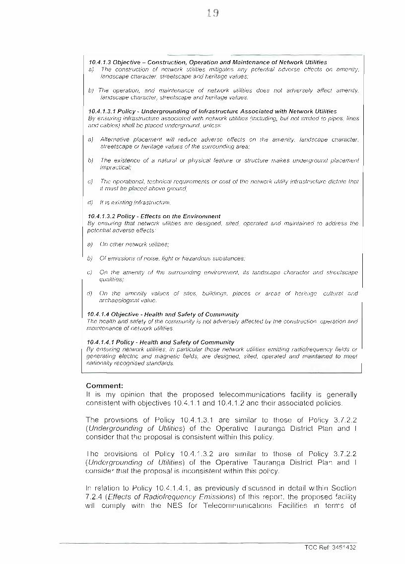
10.4.1.3 Objective - Construction, Operation and Maintenance of Network Utilities a) The construction of network utilities mitigates any potential adverse effects on amenity,
landscape character, streetscape and heritage vaiues;
b) The operation, and maintenance of network utilities does not adversely affect amenity, landscape character, streetscape and heritage vaiues.
10.4.1.3.1 Policy - Undergrounding of Infrastructure Associated with Network Utilities By ensuring infrastructure associated with network utilities (including, but not limited lo pipes, lines and cables) shall be placed underground, unless:
a) Alternative placement wiil reduce adverse effects on the amenity, landscape character, streetscape or heritage vaiues of the surrounding area;
b) The existence of a natural or physical feature or structure makes underground placement impractical;
c) The operational, technical requirements or cost of the network utility infrastructure dictate that il must be placed above ground;
d) It Is existing infrastructure,
10.4.1.3.2 Policy - Effects on the Environment By ensuring that network utilities are designed, sited, operated and maintained to address the potential adverse effects:
a) On other network utilities;
b) Of emissions of noise, light or hazardous substances;
c) On the amenity of the surrounding environment. Its landscape character and streetscape qualities;
d) On the amenity vaiues of sites, buildings, places or aieas of heritage, cultural and archaeological value.
10.4.1.4 Objective - Health and Safety of Community The health and safety of the community is not adversely affected by the construction, operation and maintenance of network utilities.
10.4.1.4.1 Policy • Health and Safety of Community By ensuring network utilities, in particular those network utilities emitting radiofrequency fields or generating electric and magnetic fields, are designed, sited, operated and maintained to meet nationally recognised standards.
Comment: It is my opinion that the proposed telecommunications facility is generally consistent with objectives 10.4.1.1 and 10.4.1.2 and their associated policies.
The provisions of Policy 10.4.1.3.1 are similar to those of Policy 3.7.2.2 (Undergrounding of Utilities) of the Operative Tauranga District Plan and I consider that the proposal is consistent within this policy.
The provisions of Policy 10.4.1.3.2 are similar to those of Policy 3.7.2.2 (Undergrounding of Utilities) of the Operative Tauranga District Plan and I consider that the proposal is inconsistent within this policy.
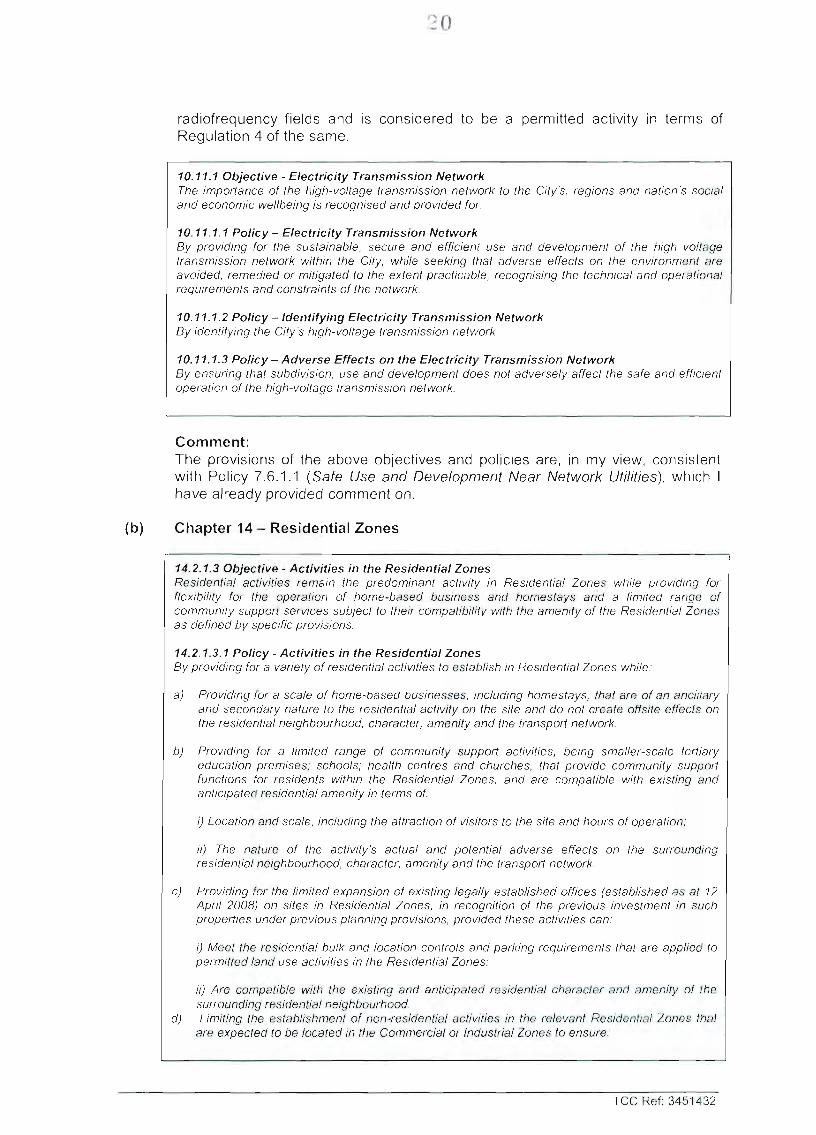
In relation to Policy 10.4.1.4.1, as previously discussed in detail within Section 7.2.4 (Effects of Radiofrequency Emissions) of this report, the proposed facility will comply with the NES for Telecommunications Facilities in terms of
TCC Ref: 3451432
20
radiofrequency fields and is considered to be a permitted activity in terms of Regulation 4 of the same.
10.11.1 Objective - Electricity Transmission Network The importance of the high-voltage transmission network to the City's, regions and nation's social and economic wellbeing is recognised and provided for.
10.11.1.1 Po l i cy - Electricity Transmission Network By providing for the sustainable, secure and efficient use and deveiopment of the high voltage transmission network within the City, while seeking that adverse effects on the environment are avoided, remedied or mitigated to the extent practicable, recognising the technicai and operational requirements and constraints of the network.
10.11.1.2 Po l i cy - Identifying Electricity Transmission Network By identifying the City's high-voltage transmission network.
10.11.1.3 Policy - Adverse Effects on the Electricity Transmission Network By ensuring that subdivision, use and development does not adversely affect the safe and efficient operation of the high-voltage transmission network.
Comment: The provisions of the above objectives and policies are, in my view, consistent with Policy 7.6.1.1 (Safe Use and Development Near Network Utilities), which I have already provided comment on.
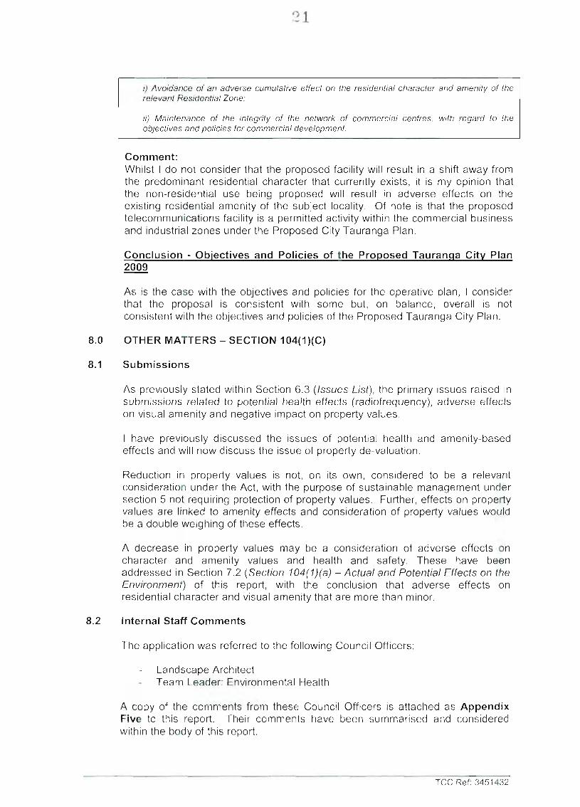
(b) Chapter 14 - Residential Zones
14.2.1.3 Objective - Activities in the Residential Zones Residential activities remain the predominant activity in Residentiai Zones while providing for flexibility for the operation of home-based business and homestays and a limited range of community support services subject to their compatibility with the amenity of the Residentiai Zones as defined by specific provisions.
14.2.1.3.1 Policy - Activities in the Residential Zones By providing for a variety of residentiai activities to establish in Residential Zones while:
a) Providing for a scale of home-based businesses, including homestays, that are of an ancillary and secondary nature to the residentiai activity on the site and do not create otisite effects on the residential neighbourhood, character, amenity and the transport network.
b) Providing for a limited range of community support activities, being smaller-scale tertiary education premises; schools; health centres and churches, that provide community support functions for residents within the Residentiai Zones, and are compatible with existing and anticipated residentiai amenity in terms of:
i) Location and scaie, including the attraction of visitors to the site and hours of operation:
li) The nature of the activity's actual and potential adverse effects on Ihe surrounding residential neighbourhood, character, amenity and the transport network.
c) Providing for the limited expansion of existing legally established offices (established as at 12 April 2008) on sites in Residentiai Zones, in recognition of the previous investment in such properties under previous planning provisions, provided these activities can:
i) Meet the residential bulk and location controls and parking requirements that are applied to permitted land use activities in the Residential Zones;
ii) Are compatible with the existing and anticipated residentiai character and amenity of the sunounding residential neighbourhood.
d) Limiting the establishment of non-residential activities in the relevant Residentia! Zones that are expected to be located In the Commercial or Industrial Zones to ensure:
TCC Ref: 3451432
21
i) Avoidance of an adverse cumulative effect on the residential character and amenity of the relevant Residential Zone;
ii) Maintenance of the integrity of the network of commercial centres, with regard to the objectives and policies lor commercial development.
Comment: Whilst I do not consider that the proposed facility will result in a shift away from the predominant residential character that currently exists, it is my opinion that the non-residential use being proposed will result in adverse effects on the existing residential amenity of the subject locality. Of note is that the proposed telecommunications facility is a permitted activity within the commercial business and industrial zones under the Proposed City Tauranga Plan.
Conclusion - Obiectives and Policies of the Proposed Tauranqa City Plan 2009
As is the case with the objectives and policies for the operative plan, I consider that the proposal is consistent with some but, on balance, overall is not consistent with the objectives and policies of the Proposed Tauranga City Plan.
8.0 OTHER MATTERS - SECTION 104(1)(C)
8.1 Submissions
As previously stated within Section 6.3 (Issues List), the primary issues raised in submissions related to potential health effects (radiofrequency), adverse effects on visual amenity and negative impact on property values.
I have previously discussed the issues of potential health and amenity-based effects and will now discuss the issue of property de-valuation.
Reduction in property values is not, on its own, considered to be a relevant consideration under the Act, with the purpose of sustainable management under section 5 not requiring protection of property values. Further, effects on property values are linked to amenity effects and consideration of property values would be a double weighing of these effects.
A decrease in property values may be a consideration of adverse effects on character and amenity values and health and safety. These have been addressed in Section 7.2 (Section 104(1)(a) - Actual and Potential Effects on the Environment) of this report, with the conclusion that adverse effects on residential character and visual amenity that are more than minor.
8.2 Internal Staff Comments
The application was referred to the following Council Officers;
Landscape Architect Team Leader: Environmental Health
A copy of the comments from these Council Officers is attached as Appendix Five to this report. Their comments have been summarised and considered within the body of this report.
TCC Ref: 3451432
22
9.0 PART II OF THE RMA - PURPOSE & PRINCIPLES
9.1 Part II of the RMA - Section 5 - Purpose
Section 5 of Part II identifies the purpose of the Act as promoting the sustainable management of natural and physical resources. This means managing the use of natural and physical resources in a way that enables people and communities to provide for their social, cultural and economic well-being (a) while sustaining those resources for future generations, protecting the life supporting capacity of ecosystems (b), and avoiding, remedying or mitigating adverse effects on the environment (c).
I consider that the proposal is consistent with Section 5(2)(a) and (b) as it will not adversely impact on the ability of natural or physical resources to meet the foreseeable needs of future generations.
However, it is my view that the proposal is not consistent with Section 5(2)(c) of Part II, in that the proposal potentially results in adverse effects that are more than minor.
The proposal has gone some way to mitigate the adverse effects on the residential character and visual amenity of the subject locality but it is my view that the bulk of these effects could be avoided through co-location on an existing telecommunications monopole (such as the Vodafone monopole located adjacent the application site for example).
Further, my concern over reliance on existing vegetation located outside of the proposed lease area is considered to be a relevant consideration and has been discussed within Section 7.2.2 (Effects on Residential Character and Visual Amenity).
9.2 Part II of the RMA - Section 6 - Matters of National Importance
Section 6 of the Act sets out a number of matters of national importance, including the preservation and protection of outstanding natural features, the natural character of the coastal environment, and historic heritage.
It is my view that none of the Matters of National Importance are relevant to the proposal being considered.
9.3 Part II of the RMA - Section 7 - Other Matters
Section 7 identifies a number of "other matters" to be given particular regard by Council in the consideration of any assessment for resource consent, and includes the efficient use of natural and physical resources, and the maintenance and enhancement of amenity values.
I believe that the proposal is reasonably consistent with the matters outlined within Section 7, with the exception of 7(c) - the maintenance and enhancement of amenity values.
As discussed at some length in sections 7.2.2 (Effects on Residential Character and Visual Amenity), 7.6.2 (Relevant Provisions of the Proposed Tauranga City Plan 2009), 7.6.1.2 (Objectives and Policies of the Operative Tauranga District Plan 2003) and 7.6.2.2 (Objectives and Policies of the Proposed Tauranga City
TCC Ref: 3451432
23
Plan 2009) it is my view that the proposed telecommunications facility results in adverse amenity effects that are potentially more than minor. The proposal can therefore not, on my view, be seen as maintaining or enhancing the amenity of the subject locality.
9.4 Part II of the RMA - Section 8 - Treaty of Waitangi
Section 8 requires Council to take into account the principles of the Treaty of Waitangi.
It is my opinion that the proposal does not offend against any of the principles of the Treaty of Waitangi.
10.0 RECCOMENDATION
Pursuant to Sections 104 and 104B ofthe Resource Management Act 1991 it is my opinion that;
a) The adverse effects of the activity on the environment would be more than minor; and
b) The activity is not consistent with the objectives and policies of the Operative Tauranga District Plan and the Proposed Tauranga City Plan; and
c) The activity is not consistent with the Regional Policy Statement (RPS).
Therefore I recommend that the application should be REFUSED.
In the event that the event consent is granted draft conditions have been included as Appendix Six to this report.
AUTHOR
Shanan Miles Date Environmental Planner
TCC Ref: 3451432
24
DECISION ON RESOURCE CONSENT APPLICATION
Pursuant to Section 113 of the Resource Management Act 1991, every decision on an application for resource consent sfiall be in writing and state the fol lowing:
(a) the reasons for the decision; and
(aa) the relevant statutory provisions that were considered by the consent authority; and
(ab) any relevant provisions of the following that were considered by the consent authority:
(1) a nat iona l po l icy s ta tement : (ii) a N e w Z e a l a n d coas ta l po l icy s ta tement : (ill) a reg iona l po l icy s ta tement : (iv) a p r o p o s e d reg iona l po l icy s ta tement : (v) a plan: (vi) a proposed plan; and
(ac) the principal Issues that were In contention; and
(ad) a summary of the evidence heard; and
(ae) the main findings of fact; and
(b) in a case where a resource consent is granted for a shorter duration than specified in the application, the reasons for deciding on the shorter duration.
TCC Ref: 3451432
25
ATTACHMENTS TO THIS REPORT:
Appendix One;
Appendix Two;
Appendix Tree;
Appendix Four;
Appendix Five;
Appendix Six;
Operative District Plan Map E09 Proposed Tauranga City Plan Map L54 2007 Aerial Photograph of Subject Locality
Full Copy of the Application and Additional Information Provided
Processing Planner's Notification Assessment and Decision
Submissions
Council Officers' Comments on Proposal
Draft Conditions
TCC Ref: 3451432
26
APPENDIX ONE
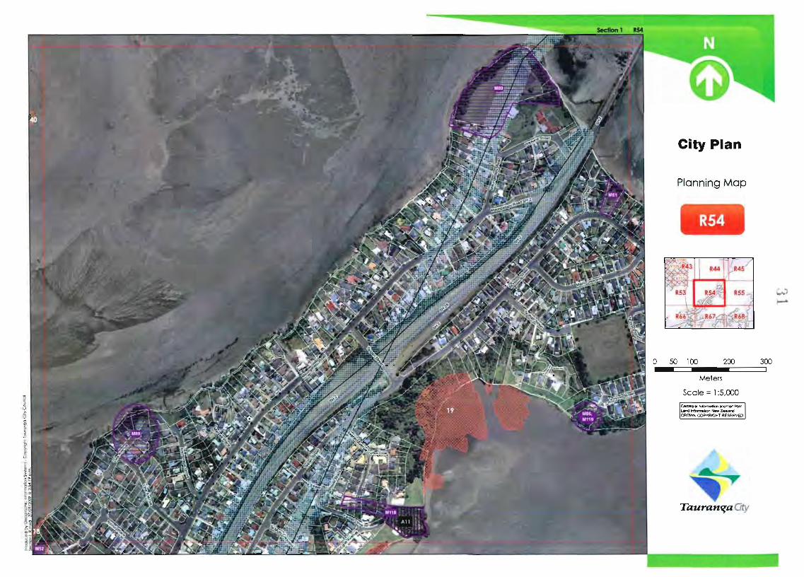
Operative District Plan Map E09 Proposed Tauranga City Plan Map L54 Proposed Tauranga City Plan Map R54
Phone & Fax No.s ^yf9/&yyr7 i r i > I LZ '...,.. LPi^ Li
Type of Application/s (tick relevant boxes) PiVl
Subdivision Consent - RMA s88 (farm 9 equiv) I I Post-Subdivision - Survey Plan - RMA s223
Land use Consent - RMA s88 (form 9 equ:v) l i J Post-Subdivision - Con^eticni"CertiliSaie--FlMS^'6^2^L~.
Consent Condition - CancelA^ary - RMA s127 (form 10 equiv) I I Consent Notice - CancelA/ary - RMA s221
Cert, of Compliance - Permitted Activity (incl. Liquor) - RMA si 39 I I Easement - Create/Cancel - RMA s243
Existing Use Certificate-RMAS139A& SlO [ U Designation-RMAs168
Outiine Plan (for designated site)-RMAsi76A I I Other (specify):
Describe Proposal (in brief) Plaiw,
/.c.n
J n D a n a
/ i> CeULX-^ o f ^-^vcrT/ / r t ' - ^ J / y p e / 1 / .r ^r yv/~.i'7'^Cc</ / . ^ y y / i c' r
/71C\A / f / o / i / / ^ ' C J y ~ > l ^^AiCrs^r; y / ^ ~ c : / ' <^-^-^v.<...- / -/
Supporting Information (attached)
Attach additional pages as necessary
Applicant cfieck c j ' Planner check I I
Assessment of Environmental Effects (accords wilh RMA 4* Schedule, Tauranga District Plan - Chapter 12, and attached checklist) L J
The information supplied vi/ith this application is true and complete to the best of my knowledge. I understand the Council is relying on this information in making its decision on this application.
Signed - by applicant or person authorised to sign on behalf of applicani^/^l Date:
i / ( IO. Pk
IMPORTANT NOTE - HAVE YOU BOOKED YOUR LODGEMENT MEETING YET?
'arik.: checl: I I
ENVIRONMENTAL SERVICES C'l C 7py ught Tauranga City' Cour.""'
Disclaimer: This form is for guidance only. It does not comprise any type of Council approval, nor does it in any way prevent Council from 1 making a request for additional information required to process the application |
Supporting Information - General
Descnption of Proposal Activity Status Relevant Rules, Objectives and Policies of the Districi Plan (incl. any Plan Changes) Relevant provisions of the National Policy Statement, NZ Coastal Policy Statement, Regional Plan, and Strategies Assessment of actual and potential effects (incl. altemative sites and monitoring requirements)
Deposit Fee/s (incl GST) - Refer Environmental Services Group - Scheduie of Fees and Charges - $
Certificate of Title (not less than 3 months old) & any restriction details - building line, covenant, consent notice, easements
Full set of Development Plans (Scale -1:100 or 1:200) - refer District Plan Information requirements under Chapter 12,1
Identification of Persons interested or affected by the proposal, including: - Written Approval of Affected Persons (unconditional, correctly completed, including signing of the AEE and plans) / / / / - Record of Consultation with any parties (incl. with Tangata Whenua), and any response.
Note - Reference shouldbe made to the Tauranga City Council Policy entitled: "Tangata Whenua Consuitalion in relation to Resource Consents" - which requires a wntten response from the affected Iwi or Hapu.
Specialist Assessments (Landscape, Visual, Traffic, Noise, Arborist, Geotechnical) are from appropriately qualified experts
other Consents Required: Environment Bay of Plenty (discharge, earthworks); NZ Historic Places (archaeological) y \ / 4
Earthworks and Excavation: the extent (illustrated and described), finished contours, and geotechnical detail
Asplicant
checl< ,
13
^'i3^,lel
CneC"
D
B^ Q^ hf
n D
e" D FT
U 1 1 1 1
D D
1 1 1 1 1 1
IMPORTANT NOTE For comprehensive information requirements (for all application types), you are strongly advised to refer to the Fourth Schedule of the Resource Management Act 1991, and Chapter 12 of the Tauranga District Plan.
Additional guidance for certain types of applications
If for a Subdivision - Section 88
Scheme Plan Detail: the position of all existing and new boundaries, services and easements / amalgamation; the areas of all new allotments
Applicant Plaiifier
cfieck ch.=ck
D D
If for a Consent Condition - Cancellation or Variation - Section 127
Referenced the approved consent & cleariy identified whether seeking cancellation or varialion
Assessment of Environmental Effects accords with RMA 4'" Schedule & corresponds with scale and significance of effects the change or cancellation may have on the environment
Detail the effects of the character, intensity and scale of the activity / use
Evidence how the activity / use was lawfully established prior to the ruie becoming operative, proposed plan being notified, or designation being removed
E N V I R O N M E N T A L S E R V I C F S
Applicant
cfieck
If for a Permitted Activity - Section 139
Demonstrate permitted activity status, and how ail associated permitted activity conditions have been satisfied
If for an Existing Use - Section 139A and Section 10
Iffor an associated Liquor Licence application - Section 139
All licensed areas (indoor and outdoor) are cleariy outlined on the plans
All carparking and loading spaces associated with the premises are cleariy outlined on the plans
Detail any other land use activities operating from this site and associated carparking
Detail the hours of operation (indoor and outdoor) of all activities operating from this site
Attach - Copies (including plans) of all previous planning certificates/resource consents/certificates of compliance
If for a Temporary Activity or Event - Refer to: Application Form (Temporary Activity/Events)
If for an Outline Plan - Section 176A
Reference the designation
Detailed height, shape and bulk of the public work, project or work;
Shown location on the site of the works, and likely finished contour of the site;
Detailed vehicular access, circulation and provision for parking;
Shown landscaping proposed;
Detailed any other matters to avoid, remedy or mitigate any adverse effects on the environment
If for a Consent Notice - Cancellation or Variation - Section 221
Referenced the approved consent & cleariy identified whether seeking cancellation or variation
Attach copy of Consent Notice details
If for a Post-Subdivision Application - Section 223 (survey plan) and/or Section 224 (certificate)
Survey plan and supporting documentation align with specific conditions of the approved subdivision consent
Plans and supporting documentation align with specific conditions of the approved subdivision consent
pplicant
cfieck
n n n u 11
Plome
check
1 i u D U U
Apolicant
cfieck
D U D U D n
ApDiicant
ctieck
D D
Applicant
cfieck
u n
Pianne
chric.k
1 1 n
1 1 1 1 u
Planner
chesK
u D
Plai-ne'
checK
D n
Lodgement Meeting Advice Notes - for the Applicant
- Information provided with an application lodged with the Council is public information, unless classified othen/vise.
- Council can only accept your application when all details are completed, all relevant information is provided, the application is signed and the deposit fees are paid,
- Under RMA s88(3), if an application does not include an adequate assessment of environmental effects, within 5 working days after first lodged, the Council may determine the application is incomplete and return it with written reasons
- Under RMA s92, the Council may request additional information or seek to commission a specialist report in order to better understand your appiication, and make an informed decision.
Although a hard copy is required. An electronic copy of all documentation & plans is strongly encouraged.
EN VIR ON MEN TAL SER VICES v: Copyi;:;hl Tirjra.'.g.-j C.:ty Coun:;.;'
Tauran^aChy Disclaimer: This form does not comprise any lype of Council approval, nor does it in any way prevent Council from making a request for
additional information required to process the application
Street Address
Council Reference RC
Meeting Record
Date
Time
Attended By
Applicant
Agent / Specialists
Council Staff
Meeting Notes
Use additional pages as necessary
Meeting Outcome
Accepted - to be vetted for adequacy of information
Under s88(3) of the Resource Management Act, if an application does not include an adequate assessment of environmental effects, within 5 workinq davs after first lodoed, the Council may determine the application is incomplete and return it with written reasons.
1.
2.
3.
Not Accepted - for the reasons stated below Applicant
check
1 1 n u
r-.e ocyc
c, lecK
n D 1 1
Pignrisr
check
u u D
Office Use Only
- Retained ohginal copy for the file
- Supplied copy to Ihe Applicani /Agent
- Time/cost for meeting attendance charged
'..•^un:.ilAppih\i>:';^ Ud,:i :i::c
RC
Cui:.:.ilCU'JI;Wl:.! Rek'turt :
Planner check
D D D
I •(/'Ji'iiii f<Ju::p! /*';.'*- 'i'tinct:
Council Stamp - d a t e received:
.4. '•:' •' .
•.If - •
Pa.mei checli i 1
EN VIR ONM EN TA L SER VICES :::-. Cc-.'ynglr Tajrcirpga C' v Cou'ici
38
RESOURCE CONSENT APPLICATION
1.0 THE APPLICANT AND PROPERTY DETAILS
To:
Applicants Name:
Address for Service:
Name and Address for Fees:
Site Address:
Legal Description:
Owners of Site:
Site Area:
District Plan Zoning:
Designations/limitations:
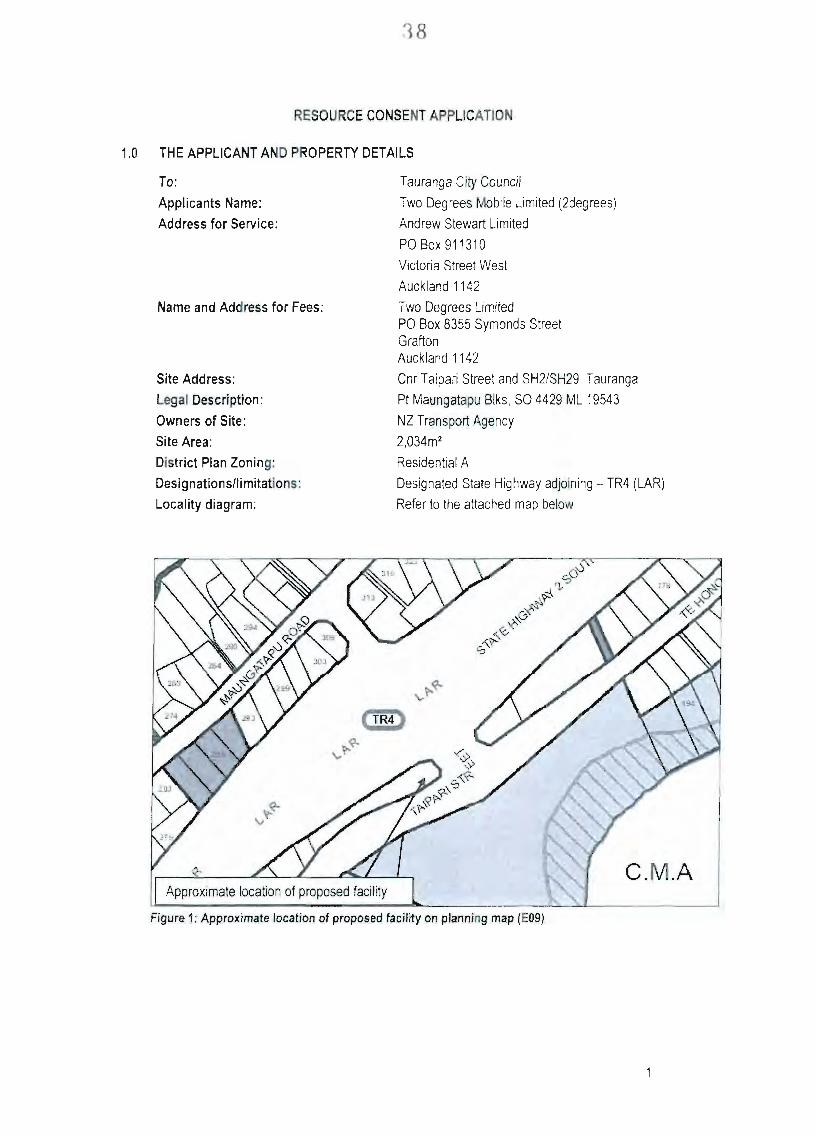
Locality diagram:
Tauranga City Council
Two Degrees Mobile Limited (2degrees)
Andrew Stewart Limited
POBox 911310
Victoria Street West
Auckland 1142
Two Degrees Limited PO Box 8355 Symonds Street Grafton Auckland 1142
Cnr Taipari Street and SH2/SH29, Tauranga
Pt Maungatapu Blks, SO 4429 ML 19543
NZ Transport Agency
2,034m^
Residential A
Designated State Highway adjoining - TR4 (LAR)
Refer to the attached map below
Figure 1: Approximate location of proposed facility on planning map (EOS)
39
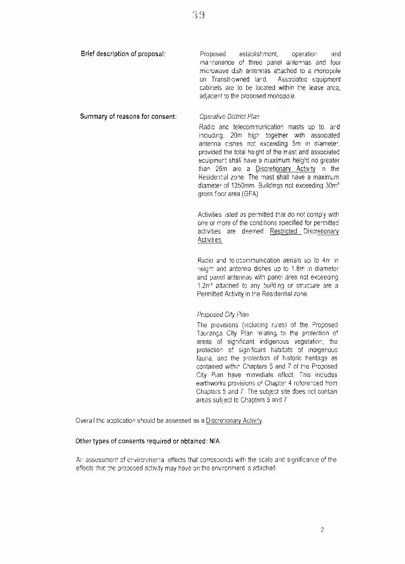
Brief description of proposal: Proposed establishment, operation and maintenance of three panel antennas and four microwave dish antennas attached to a monopole on Transit-owned land. Associated equipment cabinets are to be located within the lease area, adjacent to the proposed monopole.
Summary of reasons for consent: Operative District Plan
Radio and telecommunication masts up to, and including, 20m high together with associated antenna dishes not exceeding 5m in diameter, provided the total height of the mast and associated equipment shall have a maximum height no greater than 26m are a Discretionarv Activitv in the Residential zone. The mast shall have a maximum diameter of 1350mm, Buildings not exceeding 30m^ gross floor area (GFA).
Activities listed as permitted that do not comply with one or more of the conditions specified for permitted activities are deemed Restricted Discretionarv Activities.
Radio and telecommunication aerials up to 4m in height and antenna dishes up to 1.8m in diameter and panel antennas with panel area not exceeding 1.2m^ attached to any building or structure are a Permitted Activitv in the Residential zone.
Proposed City Plan
The provisions (including rules) of the Proposed Tauranga City Plan relating to the protection of areas of significant indigenous vegetation, the protection of significant habitats of indigenous fauna, and the protection of historic heritage as contained within Chapters 5 and 7 of the Proposed City Plan have immediate effect. This includes earthworks provisions of Chapter 4 referenced from Chapters 5 and 7. The subject site does not contain areas subject to Chapters 5 and 7.
Overall the application should be assessed as a Discretionarv Activity.
Other types of consents required or obtained: N/A
An assessment of environmental effects that corresponds with the scale and significance of the effects that the proposed activity may have on the environment is attached.
An assessment of effects that the proposed activity may have on the environment is attached in accordance with section 88 of the Resource Management Act and the Fourth Schedule to the Act. It is intended to provide the information necessary for a full understanding of the proposal and any actual or potential effects the proposed activity may have on the environment.
This report contains the following infonnation; i. i i . iii.
IV.
V.
A description of the proposed activity. A description of the site and surrounding locality and site history. An assessment of the actual and potential effects of the proposal on the environment and mitigation measures undertaken to prevent any actual or potential effect. An analysis ofthe provisions ofthe relevant Operative District Plan.
An assessment of the proposal in terms of Part 11 of the Resource Management Act 1991
Signature of Applicant or duly authorised agent
Janelle Smith
Environmental Planner
Andrew.Stewart Ltd
Date: 01 April 2010
41
2.0 SITE DESCRIPTION
The subject site is located within land owned by NZ Transport Agency and is located between Taipari Street and State Highway 2/State Highway 29, south of the Maungatapu overbridge. The property is legally described as Pt Maungatapu Blk SO 4429 ML 19543 (refer to Gazette Notice 1968 p 1610 in Appendix 1).
The proposed lease area is located within a grassed area on a site that contains vegetation on its boundaries. The approximate location ofthe proposed lease area in indicated in Figure 2. An existing Vodafone lease area is located on the subject site (ex Telstra Clear), approximately 25m north-east of the proposed lease area.
1 ^ ^ : Approximate tocatiorv of 2degrees lease area
s : ^ \ •• '- t ^ / < ' #r7-^
• V
» - i V _
Figure 2: Aerial view of proposed 2degrees facility
The subject site is zoned Residential A under the Operative District Plan and is bound on three sides by roads. It should be noted that although zoned Residential, the NZTA owned land is unlikely to be developed for residential use due to its proximity to the adjoining roads. The nearest residential dwelling is approximately 90m from the proposed lease area. The wider surrounding land is comprised of a mixture of residential, mral, commercial and road zones.
The surrounding area is made visually busy with road infrastructure, power lines, commercial activities, signage and vehicle activity on Taipari Street and SH2/SH29. An existing Telecom mast is located on the other side of SH2/SH29, approximately 200m from the proposed lease area, Vodafone has picked up the lease on the Telstra Clear compound situated in the road reserve to the north-east of the 2degrees proposed area. Vodafone has recently erected a mast in this location.
3.0 THE PROPOSAL AND BACKGROUND
3.1 Two Degrees Mobile Background
Two Degrees Mobile Limited (2degrees) is the latest entrant to the New Zealand mobile telecommunication market. 2degrees is building a third mobile network for New Zealanders and that means more choice and true competition in the mobile telecommunications market.
New Zealanders currently pay some of the highest mobile calling rates in the developed worid. That is due to a lack of competition so 2degrees is developing a brand new. national mobile
42
phone network. Many millions of dollars have already been invested in technical infrastmcture, smart tools and people to ensure that customers will experience a service that's second to none.
Mobile phone sites have already been built in Auckland, Wellington and Christchurch and 2degrees is adding to the growing networi( every month.
Wherever possible, 2degrees tries to co-locate on existing infrastructure particulariy with Telecom, Vodafone and Woosh. Often this is not possible due to structural and space issues or landowner and resource consent constraints
Dual band antennas are used which allow 2degrees to run 2G and 3G services through the same antenna. This means often only 3 panel antennas per site are required thus reducing visual effects.
Consequently 2degrees is actively and progressively seeking suitable sites to place its equipment in an environmentally friendly manner with a low impact telecommunications facility in Tauranga. This will provide mobile phone wireless coverage for Tauranga City.
3.2 The Proposal 2degrees is seeking to establish, operate and maintain the proposed telecommunications facility as part of setting up their wireless network. Once the network is operational the proposed facility will provide an alternative choice of mobile phone coverage in Tauranga.
The proposed facility involves the installation of three panel antennas, four microwave dish antennas and a lightning rod attached towards the top of a telecommunications monopole reaching an overall maximum height of 20 metres.
The antennas will be mounted on the proposed monopole in the following locations;
RF Panel Antenna
Sector
Sector 1
Sector 2
Sector 3
Orientation (Degrees)
40 deg
160 deg
280 deg
Antenna Mid Height
18.8 m
18.8 m
18.8 m
Location
Attached to top of the monopole, together with Sectors 2 and 3.
Attached to top of the monopole, together with Sectors 1 and 3.
Attached to top of the monopole, together with Sectors 1 and 2.
43
Microwave Antenna
1 Dish
A
B
C
D
Diameter
600mm
600mm
600mm
600mm
Antenna Height
17,0 m
17.0 m
16.0 m
16.0 m
Location
Attached to the monopole below the panel antenna, with Dish B.
Attached to the monopole below the panel antenna, with Dish A.
Attached to the monopole below Dishes A & 8, with Dish D.
Attached lo the monopole below Dishes A & B, with Dish C.
The dimensions of the panel antennas will be 1.6m high x 0.37m wide x 0.12m deep. The diameter of all the microwave antennas will be 600mm
Associated equipment cabinets are proposed to be located in proximity to the base of the monopole, as shown on the drawings in Appendix 2. The cabinets will house 3G and GSM equipment. At this stage the supplier for the cabinets has not been decided but the cabinets will fit within the area indicated on the application drawings, being 4m x 2m x 2m. It is highly likely that the cabinets will be smaller than this indicalive size. The monopole and antennas will be recessive grey and the cabinets will be forest green in colour. The proposed lease area is approximately 32m2.
Please refer to the application drawings in Appendix 2 for further details.
3.3 Alternative options
Suitable locations for panel antennas must be of sufficient elevation where no or limited obstruction stands between the antennas and intended coverage areas. Currently there are two ways to achieve this; construction of a purpose built structure to mount the antennas on, or co-location with an existing building or support structure of sufficient height.
The National Environmental Standards for Telecommunication Facilities (NES) provide for particular telecommunication facilities within the road reserve as pennitted activities. 2degrees has investigated utilising an existing light pole structure in the road reserve in this instance. However, the height required to obtain the required coverage would exceed that provided for under the NES and the visual effects of a significantly taller structure on the immediate road frontage are considered to be greater than the proposed lease area. For this reason, the iightpole replacement option has been discounted. Establishing an oversize telecommunication facility within the road reserve in this area is considered to be more visually prominent than the proposed lease area, which is set back from all boundaries and well screened by existing vegetation. The proposed site has therefore been determined to be a more suitable location than road reserve options.
Other alternative sites in this area have been considered by 2degrees. The site on the opposite side of Taipari Street (to the south and east of the subject site) is zoned Rural. Masts up to 20m high are permitted in the Rural zone under the District Plan. Establishing a telecommunication facility on this site is considered to have more adverse visual effects than the proposed site, particulariy given its proximity to the coast. For this reason, the potential Rural zone site was eliminated eariy in the options assessment process and the landowner was not approached. It is
44
worth noting however, that the proposed facility could be established as a permitted activity in this adjoining zone.
An agreement has been reached with Vodafone to co-locate on existing telecommunications sites; however, existing masts must meet structural and location requirements to be considered for co-location. The nearest consented Vodafone telecommunication facility is situated in the adjoining road reserve. However, communication with Vodafone about co-location opportunities on their consented mast has revealed that the mast has already been specifically made to fit the consented lease area and existing foundations and that the structural capacity has already been reached (refer to Appendix 5 for structural analysis of the Vodafone mast). Co-location would require replacing the proposed Vodafone pole and interrupting services to Vodafone's customers. Additionally the diameter of any replacement pole would be significantly larger to what has been consented in order to meet structural requirements. In this instance, 2degrees has determined that co-locating the antennas on Vodafone's mast would unduly affect Vodafone's ability to provide service to its customers.
Due to the reasons set oul above, 2degrees has determined that the proposed lease area is the most suitable location for the proposed telecommunication facility. It will provide adequate coverage while ensuring that any visual effects can be successfully mitigated.
4.0 DISTRICT PLAN RULES ASSESSMENT
The following assessment was undertaken by Janelle Smith of Andrew Stewart Limited on 01 April 2010.
4.1 National Environmental Standard Conditions Assessment
1 Rule Comment
4 RF Emissions
(4) RF Standards; Report lo be provided Council to confirm compliance with NZS2772: Part 1:1999 Radio Frequency Fields Part 1 - maximum exposure levels - 3 kHz to 300 GHz. If RF exposure levels comply the activity is permitted.
(5) Where RF emissions reach or exceed 25% of the maximum permitted; within three months of operation, a further RF report is to be provided which measures actual emissions and confinns compliance in areas where the public could reasonably obtain access.
The proposal complies with the RF standards. See Appendix 3 for further details.
The proposal is not within 25% of the maximum emission and therefore no further testing is required.
4.2 Tauranga City Operative District Plan
Ruie Comment
Section 16 - Heritage Rules
Treatment and removal of trees not listed in Appendix 16B: Register of Notable and Landscape Trees is a Permitted Activity.
There are no notable trees on the subject site. The lease area has been located clear of the existing vegetalion on the site.
45
Section 17 - Natural Policy Area Rules
The subdivision, land use, development and protection of natural and physical resources conlained within a Natural Hazard Policy Area, either for a coastal erosion or inundation hazard or flooding, are subject to the provisions of this Chapter.
The subject site is not in a known Natural Hazard Policy Area.
Section 24 - Transportation Activity and Other Network Utility Rules
Table 24.1 sets out the activity status of activities in each zone.
1 Radio and telecommunication masts up to, and including, 20m high together with associated antenna dishes not exceeding 5m in diameter, are Discretionary activities in the Residential zone, provided the total height of the mast and associated equipment shall have a maximum height no greater than 26m, The mast shall have a maximum diameter of 1350mm, Buildings not exceeding 30m^ gross floor area (GFA).
1 Radio and telecommunication aerials up to 4m in height and antenna dishes up to 1,8m in diameter and panel antennas wilh panel area not exceeding 1,2m= attached to any building or structure are Permitted activities in the Residential zone.
Radio and telecommunication ancillary equipmenl shelters up to 3m high and 4m^ gross floor area (GFA) per site are Permitted activities in the Road zone.
The proposed mast and associated antenna dishes comply with the dimensions of this rule. The associated cabinets comply with the standards for size, having a maximum GFA of 8m . The proposal is therefore a Discretionary activity, as it is located within the Residential zone.
The panel antennas are to be attached to the top of the mast. The dimensions ofthe panel antennas, being 1.6m high, 0.37m wide and 0.12m deep, comply with this rule. The proposal is therefore a Permitted activity, as it is located within the Residenlial zone.
Discussion with Council have resulted in the cabinets being assessed as buildings associated with the mast. Despite this, the cabinets comply with this standard.
24.3.1 Permitted Activity Conditions for Activities in the Road Zone and Other Network Utilities
24.3.1.1 Activities in the Road Zone
24.3.1.2 Zoning of Stopped or Closed Road
24.3.1.3 Traffic Safety and Convenience - Signs
24.3.1.4 Ground Reinstatement :
24.3.1.5 Building Height
24.3,1,6 Traffic Managemenl, Safely and |
N/A
N/A
No signs will be visible from the road. See 24.3.1.9 below.
The proposal involves minor excavations. The maximum volume of earthworks required for the facility include:
Monopole Pad 18.0m^
Cabinets Pad 7.0m3
Total 25.0m3 |
The proposed mast and antennas have a height of 20m, which complies with the specified maximum heighl for telecommunication masts.
Access to the proposed |
46
Convenience telecommunication facility is from Taipari Street. The facility will generally be serviced on a 6-monthly basis so additional traffic to the site will be minimal,
24.3.1.7 Visual Amenity Residential and Reserve Outlook
) The subject site and adjoining properties are zoned Residential A. The proposed lease area is approximately 90m from the nearest residential dwelling. The lease area will be within 4.5m of the road boundary; however, road zones are not included within this condition. As the site adjoins a residentially zoned property the proposal does not comply wilh this rule and as such is a Restricted Discretionary Activity.
b) N/A, However, it is noted that a fence will surround the 2degrees lease area. Existing vegetation provides suitable screening between the proposed lease area and the adjoining residential dwellings.
c) See b) above.
d) N/A
e) The power cables to the site will be underground.
f) N/A - the zoning is Residential A, However, it should be noted that the nearest residential dwelling is approximately 90m from the proposed lease area.
24.3.1.8-Visual Amenity-Streetscape g) The proposed lease area is located approximately 90m from the nearest residential dwelling. Existing vegetation provides screening from Taipari Street and SH2/SH29, as well as the wider surrounding area.
24.3.1.9 Visual Amenity - Signs Signage will be located on the facility warning that a telecommunications facility is operating. This will be contained within the site and be minimal.
24.3.1.10 Overshadowing The proposed facility will comply with the overshadowing standards, given lhat the sile is bound on three sides by road and is located approximately 90m from the nearest residential dwelling.
17
24.3.1.11 Noise and Disturbance
1 24.3.1.12 Exterior Lighting and Glare
24.3.1.13 Impacts on Natural Resources
24.3.1.14 Heritage Condilions
24.3.1.15 Hazardous Substances
1 24.3.1.16 Natural Hazards
1 24.3.1.17 Dust
24.3.1.18 Radio Frequency Radiation
Activities that transmit radiofrequency fields shall comply with the maximum exposure levels for the general public in NZS 2772.1:1999 Radiofrequency fields.
The cabinets will emit a small amount of noise however this will be within the noise limits set out within the District Plan. 1
There is no lighting associated with the proposed facility.
There will be no impact on natural resources.
The site is not identified in the Heritage Register or Register of Notable and Landscape Trees.
The facility will not produce hazardous substances.
The site is not identified as being subject lo Natural Hazards.
The proposed facility will not create a dust nuisance.
The facility will comply with the radiofrequency limits outlined in the National Environmental Standards for Telecommunication Facilities. This overrides the radio frequency rules in the District Plan.
Overall the proposal is considered to be a Discretionary activity under the Operative District Plan.
* Rule clarification was sought from Council in regards to the cabinets associated with telecommunication masts, as Table 24.1 provides for 'buildings not exceeding 30m^ GFA' and for 'ancillary equipment shelters up to 3m high and 4m^ GFA per site'. Although the 2degrees cabinets may be less than 2m in height and therefore are not technically defined as a building, for the purpose of the Table 24.1 rules, the cabinets have been assessed as a building lhat is ancillary to a mast/monopole. The rule refen'ing to 'radio and telecommunication ancillary equipment shelters up to 3m high and 4m^ gross floor area (GFA) per site' is interpreted as being intended for cabinets that are ancillary to telecommunications but do not have an associated mast. These rules were discussed with Council who confinned that the 30m^ building rule applies where it is ancillary to a masVmonopoie. 2degrees is therefore assessing cabinets associated with masts under the rule providing for buildings not exceeding 30m^ GFA.
4.3 Proposed Tauranga City Plan
The provisions (including rules) of the Proposed Tauranga City Plan relating to the protection of areas of significant indigenous vegetation, the protection of significant habitats of indigenous fauna, and the protection of historic heritage as contained within Chapters 5 and 7 of the Proposed Tauranga City Plan have immediate effect. This includes earthv/orks provisions of Chapter 4 referenced from Chapters 5 and 7. As the subject site does not contain areas subject lo Chapters 5 and 7, these provisions are not relevant to the application.
10
48
5.0 REASONS FOR THE APPLICATION
Section 9 of the Act prevents the use of land that contravenes a rule in a plan, or a proposed plan, unless that activity is authorised by resource consent, or by existing use rights. The Tauranga District Plan is the relevant operative plan. The Proposed Tauranga City Plan is the relevant proposed pian.
As discussed in 4.3 above, the rules under the proposed plan that have immediate effect are not relevant lo this application. The rules that trigger the need for a resource consent application under the Operative District Plan are set oul in the table above. The following activities are Discretionary Activities wilhin the Residential A zone:
Radio and telecommunication masts up to, and including, 20m high logether with associated antenna dishes not exceeding 5m in diameter, provided the total height of the mast and associated equipment shall have a maximum height no greater than 26m The mast shall have a maximum diameter of 1350mm. Buildings not exceeding 30m^ gross floor area (GFA).
Additionally consent is required for activities listed as permitted that do not comply with one or more of the condilions specified for permitted activilies are deemed Restricted Discretionary Activities (rule 24.3.1.7a)
Overall, the application is a Discretionarv Activity.
6.0 ASSESSMENT OF ENVIRONMENTAL EFFECTS
6.1 General Overview
Activities associated with the proposal may result in environmental effects. The potential adverse effects created as a result of this proposal are considered to relate to the following;
• Visual effects
• Radiofrequency
• Noise
The actual and potential environmental effects, and associated mitigation measures will be considered in more detail below. However, as with all environmental effects assessments, it is firstiy useful to establish whal can occur as or right as a pemiitted activity (i.e. without the need for a resource consent). This is known as the permitted baseline.
6.2 Permitted Baseline
The permitted baseline approach to effects assessments enables the consent authority to disregard any adverse effects on the environmeni if those effects are related to an activity/activities permitted by the plan. In this case, the Operative District Plan provides for a number of permitted activities, including the construction of buildings with a maximum height of 9m, residential activities, education facilities, health centres, home-based businesses, offices and visitor accommodation.
It is also noted that the land on the opposite side of Taipari Street is zoned Rural. Masts up to 20m high are permitted in the Rural Zone under the District Plan.
11
49
Overall, the permitted baseline is considered to have some relevance to this application, as some structures are provided for as pennitted activities and the proposed facility is provided for as a permitted activity in the adjoining Rural zone. It should be noted that all of the permitted activities can create adverse environmental effects that need to be balanced against the effects ofthe proposed telecommunication facility, including those that are positive.
6.3 Actual and Potential Effects
Actual and potential adverse effects of the activity on the environment have been identified and are discussed as follows;
6.3.1 Visual Effects
Suitable locations for panel antennas must be of sufficient elevation where no or limiled obstruction stands belween the antennas and intended coverage areas. Currently there are two ways to achieve this: constmction of a purpose built structure to mount the antennas on, or co-location with an existing building or support struciure of sufficient heighl. An agreemeni has been reached with Vodafone to co-locate on existing telecommunications sites; however, exisling masts must meet structural and location requiremenls to be considered for co-location.
The nearest consented Vodafone telecommunication facility is situated in the adjoining road reserve. However, communication wilh Vodafone about co-location opportunities on their consented mast has revealed that the mast has already been specifically made to fif the consented area and foundations and that the stnjctural capacity has already been reached. Co-location would require replacing the proposed Vodafone pole (at considerable cost) and inlernjpting Vodafone's service to its customers. Additionally the replacement pole would have to be substantially larger to accommodate both operators equipment. In this instance, 2degrees has determined that locating the antennas on a new mast in the proposed location have the lowest visual impact in an area with an urban character,
The surrounding area is made visually busy by the presence of existing infrastructure, traffic fiows and proximity to a major intersection. It is therefore considered an appropriate location for a telecommunications facility such as that proposed.
The proposal has been designed to ensure lhat sufficient elevation is obtained, while any visual effects are minimised. The equipment cabinets will not be visible from the surrounding properties, as the existing vegetalion on the site provides adequate screening.
Post establishment, the cabinets will be serviced once every 6 months, or as required. While the mast is not accessible lo the general public, any damages and graffiti will be removed/repaired during these routine services, Notwithstanding this, 2degrees have a 24 hour response policy for the removal of graffiti.
The site is bound on three sides by road, with the nearest dwelling being approximately 90m from the proposed lease area. Although the site is considered to be adequately set bacl( from any 'sensitive' uses, a number of measures have been taken to mitigate any potential visual effects. These measures include the slim-line design of antennas, recessive grey colouring of the antennas to ensure visual continuity with the surrounding environment and ensuring the facility is locaied in an area that is already well screened by existing mature vegetation,
A visual assessment was undertaken by Isthmus Group for this site, The assessment looked at the visual effects the proposal may have from various public view points. The report concluded
12
50
that given the existing infrastructure in the surrounding area and with the recommended mitigation measures, the landscape and visual effects of the proposed monopole and associated struclures will be no more than minor (see Appendix 5 for Visual Assessment)
In summary, the proposed 2degrees facility is considered to be located in an appropriate location, given the presence of exisling activities and struclures wilhin the surrounding environment. The proposed mast and antenna structures will not add any significant material visual changes to the scene. Given the design, colour and location of the proposal antennas, il is considered that the struclures will be consistent with the character of the locality, blending seamlessly into the background and having significantly lower visual effects than the Plan provides for. The proposed facility will not give rise to dominance effects on neighbouring properties or the surrounding environmeni. Overall, any adverse visual effects arising from the telecommunications facility are considered to be minor.
6.3.2 Radiofrequency
The report attached in Appendix 3 shows compliance with NZS2772; Part 1 and hence radiofrequency activity is permitted in terms of the National Environmenlal Standards for Telecommunication Facilities 2008.
Also given the panel and microwave antennas are mounted near the lop of a 20 metre monopole at the rear of the site, the radiofrequency fields will not be in an area where the public could reasonably be exposed.
The cumulative effects of the radiofrequency emitted from the proposal monopole with the Vodafone antennas approximately 25m from proposed 2degrees facility) and exisling Telecom antennas (approximately 200m from proposed 2degrees facility) will be less than minor.
As the proposal complies with the New Zealand Standard it is therefore considered lhat any potential adverse effects from radiofrequency exposure will be less than minor.
6.3.3 Noise
The supplier for the cabinets has not yel been confirmed however, the cabinets used in previous cities have proven to be extremely quiet. The cabinets that are to be used within Tauranga will have noise levels the same or less than these cabinets that were previously used. The acoustic report for these cabinets has been supplied in Appendix 4 to demonstrate noise levels that will be emitted from the cabinets.
The subjecl site and some properties in the vicinity of the site are zoned Residential. Noise generated by non-residential activities within residential zones shall not exceed (wilhin the boundary of any olher site):
7:00am to 10:00pm 45 dBA (LIO)
10pm-7am 35dBA(L10) 55 dBA (Lmax)
The cabinets will be approximately 90m from the nearest residential dwelling. The proposal will easily comply wilh the permitted activity standards within the residential zone, due to the distance between the proposed cabinets and the nearest boundary.
13
51
In summary, it is considered lhat as the noise limits in the Disirict Plan are not exceeded, the effects will be negligible and do not adversely affect the surrounding properties.
6.4 Summary of Effects
Overall, there will be no adverse effects on the environment resulting from the proposed activity.
7 NOTIFICATION ASSESSMENT
The Resource Management (Simplifying and Streamlining) Amendment Act has amended the nofificafion provisions for resource consent applieafions. There is no longer a presumption that a council must publicly notify a resource consent applicafion unless the proposal meets certain tests (either that the applicafion relates to a controlled activity, or that the effects are minor).
Sections 95A to 95F of the Act (as amended) set out the public nofification and limited nofificafion provisions for resource consent applications.
7.1 Public Notification
Under section 95A of the Act, an application is required to be publicly nofified if the council decides that the activity will have or is likely to have adverse effects on the environment that are more than minor.
In deciding whether an activity will have or is likely to have adverse effects on the environment that are more than minor. Council must disregard any effects on persons or own or occupy the subject land or any land adjacent to the subject land. Additionally, Council must disregard any effect on a person who has given written approval to the application.
Pursuant to section 95D(b) of the Act, a person may be treated as not being adversely affected if the plan permits an acfivity wilh that effect.
Actual and potential adverse effects of the activity on the environment have been idenfified and are discussed in section 6 of this report and found to be no more than minor.
7.2 Limited Notification
Pursuant to secfion 95B of the Act, if Council does not publicly notify an application, it must decide under secfions 95E and 95F of the Act if there are any affected persons. A person is an affected person if the activity's adverse effects on the person are minor or more than minor.
Pursuant to section 95E(2)(a) of the Act, a person may be treated as not being adversely affected if the plan permits an activity with that effect. If a person has given written approval to the acfivity, the person must not be treated as an affected person.
Having regard to the above provisions, no persons are considered to be potentially adversely affected by the proposal for the following reasons:
the nearest residential dwelling is over 90m from the proposed lease area;
the site is bound on three sides by roads, which ensures that the proposed lease area is at least 30m from the nearest property;
14
52
the existing vegetation on the site is to be retained and provides screening of the proposed cabinets and lower half ofthe mast;
the surrounding area is considered to be visually busy with exisfing infrastructure
Overall, no persons are considered to be potentially adversely affecled by the proposal.
8.0 ASSESSMENT (SECTION 104)
8.1 Statutory Matters
Matters to be considered by the Council when assessing an application for resource consent under s104 of the Act include, (subject to Part 11), any actual and potential effects on the environment and any relevant provisions of a plan or proposed plan.
8.2 Actual and Potential Effects on the Environment (Section 104(1 )(a))
As set out in Section 6 ofthis report, it is considered that the proposal will have a less than minor effect on the surrounding environment, and there are no persons considered adversely affected,
8.3 District Plan and any Relevant Statutory Documents (Section 104(1)(b))
Obiectives and Policies ofthe Operative District Plan
The Objectives and Policies are contained within Chapters 3-9 of the Operative District Plan. In assessing this proposal, the relevant objectives and policies are contained within Chapters 3 and 7 of the Disirict Plan. These are discussed as follows:
3.1.1 Objectives: Noise and Vibration in All Zones
• To avoid, remedy or mitigate unreasonable noise or vibration-induced annoyance, disturbance or injury.
3.1.1.2 Policy: Noise Received in Residential Areas
• Business activity operating near Business Zone/Residential Zone boundaries should not give rise to noise levels nonnally considered unacceptable in Residential Zones, nor create noise levels which are unreasonable for occupiers of neighbouring properties.
Comments
The subject site is zoned residential but is owned by NZ Transport Agency. The noise generated from the cabinets associated with the telecommunication facility will comply with the standards specified in the plan within the boundaries ofthe nearby residential sites.
3.2.3 Objective: Streetscene and Outlook
" To maintain an attractive streetscene and to protect residential outlook.
3.2.3.1 Policy: Residential Outlook
• Non-residential activities within or adjacent to Residential Zones should be designed, sited and screened to mitigate against any adverse visual effects on adjoining dwellings.
15
53
Comments
The location of the proposed telecommunication facility is well set back from the road boundaries and is approximately 90m from the nearest residential dwelling. There is existing vegetation around the boundaries of the site that provides screening of the cabinets and lower part of the mast. The cabinets will therefore not be visible from the road or the nearby residentially zoned properties.
Overall, the proposal is not considered to affect the attractiveness of the streetscape or the outiook ofthe adjoining residential properties.
3.1.2 Objective: Adverse Effects of Network Utilities
• To avoid, remedy or mitigate the adverse effects of network utilities on amenity values.
3.7.2 1 Policy: Co-siting Of Utilities
• Co-siting of network utilities should be undertaken where technically feasible and practical,
3.7.2.2 Policy: Undergrounding of Utilities
' Infrastructure associated with network utilifies should ideally be placed underground unless:
(a) Alternative placement will reduce adverse effects on the amenity values ofthe surrounding area
(b) The existence ofa natural or physical feature or structure renders underground placement impractical
(c) The operational or technical requirements ofthe network utility infrastructure dictate that it must be placed above ground
(d) It is existing infrastructure.
Where network utility infrastructure is required to be placed above ground it should, as far as practicable, be designed, located and managed in a manner that avoids, remedies or mitigates adverse effects on the amenity values ofthe surrounding environment
Comments
As discussed in seclion 6 of this report, there is a consented Vodafone facility in the road reserve adjacent to the subject site, approximately 25m north-east of the proposed 2degree lease area. However, the consented Vodafone stnjcture has already been constructed and does not have the capacity to support additional antennas. Co-location would require replacing the specifically constructed pole however the foundations and bolt configuration is specifically designed to fit the Telstra Ciear lease area and this design is different to the 2degrees configuration. In this instance, 2degrees has therefore determined that locating the antennas on the mast in the proposed location have the lowest visual impact in an area with an urt)an character.
The operational requirements of telecommunicafion facilities dictate that the associated infrastructure must be placed above ground. However, the location of the proposed facility is considered lo be appropriate, with no more than minor adverse effects on the amenity values of the surrounding environment,
7.6.1 Objective: Safe Use and Development
• To ensure use and development does not adversely affect established network utility structures.
16
54
7.6.1.1 Policy: Safe Use and Development Near Network Utilities
• The security, safety and reliability of the District network utility infrastructure wili be accorded priority in the assessment of subdivision, use and development.
Comments
Council recognises the importance of network utilities. These objecfives and policies seek to ensure that use and development adjacent to network utility structures is managed appropriately. In this instance, the subjecl site is zoned residential but owned by NZ Transport Agency and unlikely to be developed for residential purposes in the future due to its strategic location adjacent to SH2/SH29 and Taipari Street. The proposed location of the facility is considered to be appropriate for the reasons outiined throughout this report and summarised below;
• The proposal is designed lo improve the microcellular capacity of the 2degrees network wilhin Tauranga, whilst avoiding or minimising any adverse effects on the environment;
• Suitable locations for microwave antennas must be of sufficient elevation where no or limited obstruction stands between the antennas and intended coverage areas. In this instance, 2degrees has determined that the proposed location will have the lowest visual impact on the character of the area;
• The proposed facility is considered to be compatible with the surrounding environment, which is used for a mixture of residential, business and infrastmcture purposes;
• The RF emission from the proposed antenna is well within the levels stipulated by Regulation 4 ofthe NES for Telecommunication Facilities; and
• The proposed cabinets will comply with noise controls wilh adjoining properties.
Relevant Assessment Cntena
In addition lo the criteria set out in Seclion 104 of the Act, Chapter 11 sets out matters of assessment which Council shall have regard to when assessing Discretionary Activities. These include matters such as the relevant provisions of the Plan, traffic management, noise, general amenity and landscape features. As discussed in Section 6 of this report, the adverse effects of the proposal are considered to be no more than minor.
Any noise generated will be within stipulated levels for the adjoining residenlial zone. The antennas will not emit any light, and due to their location a slimline mast, these will not create overshadowing effects on adjacent land.
The proposed antennas and cabinets will only require servicing and inspection on a six monthly basis. As a result, the effect of such inspections on existing traffic volumes in the road network serving all proposed sites will be negligible.
8.4 Summary
In summary, it is considered that the adverse effects on the environment of the proposed antennas attached to the proposed mast will be no more than minor effect and it can be concluded that the proposal is in accordance with the objectives and policies for the provision of network utility services within Tauranga City.
With respect to the purposes and principles of the Act which are contained in Sections 5 to 8 of the Act, il is considered that the proposed development will be an appropriate and sustainable use of the site. The proposal will provide improved telecommunication facilities wilhin populated
17
55
areas without detracting from the qualities of the locality in which they are located, or detract from the safety and convenience of the adjacent land uses. The proposed facility will provide greater choice in mobile phone wireless providers for the Isthmus area in Tauranga City. It will allow sustainable growlh by encouraging other providers to co-locate on 2degrees' structures.
The proposal is not anticipated to adversely affect the amenity of neighbouring sites due to the mixed-use nature of the sun-ounding area and the separation distance between the proposed lease area and the nearest residenfial dwelling being approximately 90m. There are no special ecosystems or environmenlal values of the sites which would be compromised by the proposal.
9.0 DETERMINATION OF APPLICATIONS FOR DISCRETIONARY OR NON-COMPLYING ACTIVITIES (SECTION 104B)
As a Discretionary Activity, section 104B of the Act stales lhat the Council may grant or refuse consent to the applicant's proposal, and if granted, impose conditions under section 108 of the Act.
It is considered that the proposal will have no more than minor adverse effects on the environment and will not be contrary to the objectives and policies ofthe Operative District Plan. Hence, in accordance with Section 104B ofthe Act, it is considered appropriate for consent to be granted.
10.0 SECTION 125
Section 125 of the Act provides for resource consents to be valid for the timeframe specified on the consent or if no timeframe is specified, for five years. In relation to the proposal, 2degrees is seeking a time period of 5 years to give effect to the resource consent.
A five year consent period will give 2degrees the flexibility to install the telecommunications facility to provide for initial network coverage as demand requires. To this extent the liming of installing the facility may vary, although it is anticipated to be in the short lo medium lerm. For this reason, a five year period to give effect to this consent is sought.
11.0 CONCLUSION
Resource consent is required for the proposed establishment, operalion and maintenance of a telecommunication facility on NZ Transport Agency land near SH2/SH29 and Taipari Street. The proposed antennas are to be attached to a support structure. Associated cabinets will be located within the lease area adjacent to the mast. Overall, resource consent is required for a Discretionan/ Activity.
The assessment earned out in this report demonstrates that the site is an appropriate location for the development, that the overall potenfial adverse environmental effects of the proposal will be less than minor, and that no persons are considered to be adversely affected by the aclivily.
The proposal satisfies Part II of the Act as it promotes the sustainable management of the natural and physical resources of the City, The proposed facility will facilitate improved communications belween individuals and therefore support the overall social and economic well-being ofthe community.
Overall, given that any adverse effects of the proposal will be less than minor and that no persons are considered to be adversely affected, granting consent to the proposal on a non-
18
56
notified basis is considered to be in accordance with secfion 95 of the Act, subject to the imposition of fair and reasonable conditions,
12.0 RECOMMENDATION (SECTION 104B)
That for the reasons stated in this report (and subject to appropriale conditions), this application be granted consent.
AUTHOR
Signature of Applicant or duly authorised agent
Janelle Smith
Environmental Planner
Andrew Stewart Umited
DATE: 01 April 2010
19
57
Appendix 1:
Gazette Notice
58
tm THE NEW 2EALAND GAZETTE No. 58
Declaring Land Token for Bttier Utillsatitm in lhe Cily of Taaranga
PURSUAKT to section 32 of the Public Works Act 1928, the Mmister of Works hereby dedares thai, a sufficient agrecincnl to that effect having been catered into, the land described in the Schedule hereto is hereby tiken for better utilisation from aiKJ aifccr the 23rd day of Seplember 1958.
3 I9is l 9 1 i \
3 9.7 1 21
SCHEDULE ScjirtH AUCKJAND L^ND DISTTIICT
ALL those pieces of land situated in the City of Tauranga described as follows;
Being Parts 'Maungatapu B Block, situatod in Blocks
ff 3* f ^ ^ • ' " ' ^ ^ ' »*""••'** Survey Distriot; cotoured J yellow on plan.
0 34.4 Part Maungatapu B Block, situated in Block X^V, Tauranga Suivey District; coloured yeHow on plan.
(PttTts MaungaAapu lc 2^ Block, sStaated in Block XV, Tauianga Survey District; ootourod sepia on pflan.
As the same are more perticularly delineated on tbe plan marked M.O.W. 22237 (S.O. 44298) deposited in the office of the Minislea- of Works at Wellingloo, and thereon coloured as above-mentioned.
Dated at WeUington this 14tb day of August 1968. PERCy B. ALLEN, Minister of Works.
(P.W. 71/3/2y0; D.O. 71/3/2/0>
Declaring Land Taken for a Post Office In rhc City of Patmerslon North
PtnrnMNT to section 32 cyf the Public Works Aot 1928, the Minister of •Works hereby deckras that, a sufficient agreement to that effect having been entered into, ihc land described in the Schedule herelo is hereby taken for a post office from and after the 23rd day of September 1968.
SCHEDULE WBLLINCTTON LAND DISTRICT
Au , that piece of land containing 5.8 perches situated in the Cily of Pabnerston North, Wefllington K.D., being Lot 2, D.P. 2«913, bei»gf part iS«c(ion 37], T<wn of PalmerJton North. AH certiScftie of title. No. 50/1499, Wellington Land Rcgi.!try.
Dated at WclHngton this 16th day of 'August '1968. PERCY B. ALLEN. Minister of Worki.
f P.W. 20/1889; D.O. 39/116/0)
Declaring Land Acquired for a Governmenl Work and Not Required for That Purpose to be Crown Land
PURSUANT to section 35 of the Public Works Act 1928. the Minister of Works hereby dedaros the land described in the Scheduie hereto to be Crown land, subject to the Land Act •1>4«, as frorm the 23rd day of September 1968.
SCHEDULE SOUTH AUOCIJ^ND LAND DISTRICT
ALL that piece of land containing I rood 37.7 porches situated in the Borough of Whakatane, being Lot 49, D.P. S. 12232, and being part AUotmeot 8, Waimaoa Parish. Part certificate of title, •Volume 1053, folio 129, South Auckland Land Registry.
Dated at Wellington this '14th day of August '1968. PERCY B, ALLEN, -Minister oT Works.
( a c . 4/77/24; D O . 54/'IS)
Declaring Land Acquired for a Government Work and Not Required for That Purpose to be Crown Land
PtmsUANT to section 35 of the Public Works Act 1928, the Minister of Works hereby declares the land described in the Schedule hereto to bc Crown land, subject to the I-and Act 1948, as from tho 23rd day of September 1968.
SCHEDULE TAJIANATJ LAND Disnucr
ALL that piece of land cootaioing 1.5 perches situated in Block X, Opunake Survey District, Egrnont County, Taranaki R„D., being part Section 7, Block XXXI, Town of Opunake. Al tho same ij more particularly delineated on the plan marked M.O.W. 22388 (SO, 9945) deposited in (he office of the Minister of Works at Wellington, aad thereon edged red. ipart Proclamaition No, 2116.
iDated afWeJiington this 2nd day of August 1968.
PERCY B. ALLEN. Minister of Works. (P.W. 25/109/1; D.0 .19/6 /2 /3)
Declaring Land Acquired for a Government Work arul Not Required for That Purpose to be Crown Land
PURSUANT lo section 35 of the Public Works Act 1928, the Minister of Works hereby declares the land described in the Schedule hereto to be Crown land, subject to the Land Act 1948, as from fhe 23rd day of September il968.
SCHEDULE WELUNimjN LAND Drsnucr
ALL that piece of land containing 23J9 perches siiluated in Block XI, Port Nicholson Survey District, Qty of Wellington, Weiiington R D , and being Section 26, Evans Bay District; part Proclamation No. 6086, Weilinglon Land Registry; as the same is more particulariy delineated on the pian marked M.O.W. 19605 (S.O. 23895) deposited in the office of the Minister of Works at Wellington, and thereon edged red:
Dated at Wellington this 9th day of August 1968.
PERCY B, ALLBN, Minister of Works. (P.W. 23/381/18/279; D.'O. 20/1/0/69)
Declaring Land Acquired for a Government Work and Not Required for Thar Purpose to be Crown Land
PURSUANT to section 35 of the Public Works Act 1928, the Minister of Works hcrcby declares the 3and described in tba Schedule hereto to bc Crown land, subject to Ihe Land Act 1948, as from the 23rd day of September 1968.
A. R. p .
0 0 28.8
0 3 39.5
0 2 22
SCHEDULE WELLtNcrroN LAND DiSTHicr
ALL those pieces of land situated in the City of Pataerston Norlh, WeUington H.D., described as follows:
Being Lot 9. D.P. 29133, being part Scciion 368, Town
of Palmerston North; part certificaie of title No. 5D/240, Wellington Land Registry.
Lots 46 to 51 (indusive), Di" . 29134. being part Section 368, Town of Palmerston iN'ortfa; part certificate of title No. 5D/786. Wellington Laad Registry.
Lots 107 to n o (inclusive), D.P. 29134, heing part Section 368, Town of Pataerston North; pan certificate of title No. 5D/788, Wellington Land Registry.
Dated at Wellington this 13th day of August 1968. PERCY B. ALLEN, Minister o / Worto.
(P.W. X/1/2/37; D.O. 52/12/61)
Declaring Land Acquired for a Government Work and Not Required for Thai Purpose to be Crown Land
PURSUANT lo section 35 of the Pubh'c Works Act 1928, the M blister of Works hereby declares the land described in the Schedule hereto ro be Crown land, subject to the Land Act 1} 948. as from the 23rd day of September 1968.
SCHEDULE WEIXINCTON LAND DISTRICT
ALL that piece of land containing 1 rood 5.38 perches situated in Block 1, Olahoua Survey District, Borough of Maslerion, Weilinglon R.D., and being pan Lot 11, D J . 3491; being part Section 80. Masterton Small Farm Settlement; part Declaration No. 607978, Wellington Land Registry; as the iame is more particularly delineated on the pian marked M.O.W. 19762 (S.O. 25900) deposited in the office of the Minister of Works at Wellington, and thereon colourtri sepia.
'Dated at Wellington tiis '14th day of August 1968. 'PERCY B. ALLEN, Minfetei of -Works.
(P.W. 31/2439; D.O. 13/3/44/0)
Declaring Land Acquired for a Government W&rk and Not Required for That Purpose to be Crown Land
injRSUANT to section 35 of the Public Works Act 1928, the Minister of Works hereby declares the land described in the Schedule hereto to be (jeemed to bave been Crown land, subject to the Ijmd A a 1948. as from the Sth day of June 1968.
SCHEDULE WtaxiNoroN LAND DISTRICT
ALL that piece of land containing 6 acres 2 roods 11.4 perches situated in tte Crty of Porirua, WelUngton RX).. and being Lot 1. D.P. 28852; all certificate of title No. 58/267, WeUington Land Registry.
Dated at WelliDgtcn this 16th day of August 1968. PERCY B. ALUBN. Minister of Works.
(H.C. X/244; D.O. 22/0/3)
59
Appendix 2:
Application Plans
GO
WAIMAPU ESTUARY
S^^ - / - -
\ GRASS
ACCESS ROUTE TO TAIPARI STREET
- - - _ L f G A L _ BOUNDARY
PROPOSED 2degrees o / LEASE AREA (8.0nnx4.0m) ' ^^
PROPOSED 2degrees FENCE ic GATE
VEGETAT ON
LOCALITY MAP SCALE 1:5000
PROPOSED 2(Jegrees SITE PT MAUNGATAPU B N: 638236 I m N (NZMG)
E; 2790609mE (NZMG)
LAT: 3742 '59 .8 "S (WGS84)
L0NG:176"10'51.7"E (WGS84)
PROPOSED 2(3egrees CABINETS TO FIT
WITHIN PROFILE
PROPOSED 2degrees POWER ROUTE (REFER TO NOTE 5)
PROPOSED 2degrees TYPE (2) MONOPOLE (20m)
VEGETATION
DETAIL PLAN SCALE 1:100
ff^J
LEGEND - EXISTING SERVICES
TC "
FO -
sw -
SS -
T -
@
G -
• "C •
• FO •
• SW •
s s •
T •
WATER MAIN
POWER
POWER (OVERHEAD)
GAS
TELSTRA
FIBRE OPTIC
STORMWATER
SANITARY SEWER
TELECOM
STORMWATER MANHOLE
SANITARY SEWER MANHOLE
LEGEND
LEGAL BOUNDARIES
RF ANTENNA IN
SECTOR
S.'CTfi» 1
SLCTCR 2
SECTOR 3
AZ;MUTH(Deg)
'•c-
•50-
280'
ANTINNA MrD HEIGHT
:,AGL)(m1
:'d.B
l a a
18.8
FORMATION ANTFMNA
-vpr
CN=X2G6R
C\3X306R
CNPX306R
^EEDE'? f FNGTH (m)
?,'0
27.0
270
FE-DTf? TYP;
"BC
TBC
TBC
NOTE, ANTENNA AZlMbTH AND ~rPt. " 0 BE CONFiRI/ED 3Y 2degrses RF
ENGINEER, ANTENNA D!MENS10NS(r^n): ARCUS CN=X3D6R = 'BOc- x 37.0-* « ' 2 0 c
SITE LAYOUT PUN SCALE 1:500
0 " H -YPE
A
-3
C
D
MICROWAVE ANTENNA
.\ZiWUTH (Dec)
^3C'
' 3C
TBC
TSC
ANTENNA HOGHT(AG.)(M)
170
;7.o
•:6.o
•5,2
INFORMAl
AN^NNA TYPE
600(8
cOCs
SCCJ
6G3«
"ION
EAR END SITE
30P-iSC
BCP-'BC
BOP-'BC
30=--EC
THISDSAWJGWM PRODUCT D R» r*0 3Hi«£hS >*08r.f a*?^H) WD H*v SCT at .iTKED WITHtJ^ TV£W
PewaaiO". T^t MSiCN «W«W TME P^WtSP, Of TWO XC(£B '*06:L£ JM^TD WHICN AOIPTS » J*aiUTY
S^XU; TVEa DRAWINGS BE *.THIH1 OH ^^S Wn>«WT AJT>10«S?nitlC0S0.
USE omas io is SHOWN, ONIV
SCAL£ -ROM TH3 DRAWING ^Ofi APPROXiMATt USE
NOTES:
ACCESS FROM TAIPARI STREET
ANTENNA HEIGHTS ARE ABOVE GROUND
LEVEL (APPROX.).
IT IS THE CONTRACTOR'S RESPONSIBILITf TO LOCATE AND PROTECT ALL EXISTING SERVICES IN THE VICINITf OF THE SITE (INCLUDING THOSE NOT NECESSARILY SHOWN) PRIOR TO COMMENCEMENT OF ANY WORKS ON SITE, SERVICES SHOWN ARE INDICATIVE ONLY,
ALL EXISTING SURFACES AND FEATURES SHALL BE FULLY REINSTATED TO THEIR ORIGINAL CONDITION TO THE SATISFACTION OF THE ENGINEER ON COMPLETION OF THE WORKS,
ROUTE TO BE CONFIRMED ON SITE BETWEEN CONTRACIOR, OWNER AND/OR AUTHORITY. POWER SUPPLY DIRECTLY FROM STREET BY CONTRACTORS. REFER TO ELECTRICAL STD-E-710 FOR FURTHER DETAILS.
REFER TO 2degrees STD D500 SERIES FOR
SIGNS A, B, C, & D (SELECT AS
REOUIRED)
CONTOUR INTERVAL
0.25m MINOR
1 .Om M/VJOR
K H A R R I S O N
G R I E R S O N
C D N S U L T I N Q E N C I N E E R S S u n v E V O R S » u A N N F P S
I W l ! Cogia HOM 23 Amtnlum « « f m m at»»I19566 33Mr«099663390