86
Annual Report of the National Earthquake Hazards Reduction Program for Fiscal Year 2010 October 2011

Annual Report of the
National Earthquake Hazards Reduction Program for Fiscal Year 2010
October 2011

This annual report of the National Earthquake Hazards Reduction Program (NEHRP) for fiscal year 2010 is submitted to Congress by the Interagency Coordinating Committee (ICC) of NEHRP, as required by the Earthquake Hazards Reduction Program Reauthorization Act of 2004 (42 U.S.C. 7701 et. seq., as amended by Public Law 108–360).
The members of the ICC are as follows:
Dr. Patrick D. Gallagher, Chair of the ICC
Under Secretary of Commerce for Standards and Technology and Director National Institute of Standards and Technology U.S. Department of Commerce
Mr. W. Craig Fugate
Administrator Federal Emergency Management Agency
Dr. Subra Suresh
Director National Science Foundation
Mr. Jacob J. Lew
Director Office of Management and Budget Executive Office of the President
Dr. John P. Holdren
Science Advisor to the President and Director, Office of Science and Technology Policy Executive Office of the President
Dr. Marcia McNutt
Director U.S. Geological Survey
Disclaimer: Certain trade names or company products are mentioned in the text to specify adequately the experimental
procedure and equipment used. In no case does such identification imply recommendation or endorsement by the National
Institute of Standards and Technology, nor does it imply that the equipment is the best available for the purpose.

Preface
This annual report describes program activities of the National Earthquake Hazards Reduction Program (NEHRP) during fiscal year 2010, and how the results of these activities are being used to reduce earthquake risk in the United States.
NEHRP is a unique federal program in that it involves the relevant activities of four federal agencies, each of which has a distinct role in reducing earthquake risk. Each agency role is necessary to achieve the goals of NEHRP, and none is sufficient to achieve these goals alone. Additionally, NEHRP has strong partnerships with state and local governments, multistate consortia, professional organizations, professional practitioners, and academic research institutions.
2010 was a rewarding and demanding year for NEHRP. Major accomplishments were seen in analyses and publications required for revision of earthquake-resistant building codes, in modernization of our earthquake monitoring and notification capabilities, and in advances in engineering research on earthquake-resistant design and construction practices. In addition, with NEHRP support, state and local governments took important steps to improve their earthquake response capabilities and to reduce the impacts of future earthquakes.
During 2010, major earthquakes in Haiti, Chile, Mexico, and New Zealand drew heavily on NEHRP personnel and resources. When foreign earthquakes strike, NEHRP agencies provide the scientific and technical information and support needed by our government and by domestic businesses with foreign interests. This includes estimates of potential impacts, assessment of aftershock hazards, investigations to record the causes and extent of property losses and casualties, and recommendations for the seismic safety considerations in reconstruction.
Most important are the lessons learned, or reinforced, from foreign events and how these experiences apply to reducing earthquake risk in the United States. During our post-earthquake studies we acquired a large amount of scientific, engineering, and social knowledge that can be applied in detail to advance progress toward NEHRP goals. The major lessons can be simply stated:
− Devastating earthquakes strike without warning, often where their size and impacts are not fully expected.
− Earthquake preparedness and resilience planning and actions can greatly reduce losses of life, property, economic capacity, and societal well-being.
These lessons seem obvious. During 2010 we saw nature teach them to us again, at the expense of others less fortunate and less prepared. There is no need or justification for us to be forced to re-learn these lessons at home. Our challenge is to see that new knowledge and

experience gained in 2010 by our core program and from foreign disasters are applied to domestic practices and policies to reduce earthquake risks and ensure public safety.

Table of Contents
Preface ................................................................................................................................................... i
Table of Contents ............................................................................................................................ iii
Executive Summary ........................................................................................................................... v
Chapter 1 Introduction .................................................................................................................... 1
1.1 Overview ................................................................................................................................................ 1
1.2 Agency roles and responsibilities ..................................................................................................... 1
1.3 Coordination and oversight ............................................................................................................... 3
1.4 Program highlights ............................................................................................................................. 4
1.5 Structure of this report ....................................................................................................................... 6
Chapter 2 Program Budgets for FY 2011 and FY 2012 ............................................................ 7
2.1 Introduction .......................................................................................................................................... 7
2.2 FY 2011 budgets listed by program goal ...................................................................................... 8
2.3 FY 2012 requested budgets listed by program goal ................................................................... 9
Chapter 3 2010 Activities and Results ...................................................................................... 11
3.1 Goal A: Improve understanding of earthquake processes and impacts ............................... 11
3.2 Goal B: Develop cost-effective measures to reduce earthquake impacts on individuals, the built environment, and society at large .................................................... 18
3.3 Goal C: Improve the earthquake resilience of communities nationwide .............................. 25
3.4 Develop, operate, and maintain NEHRP facilities .................................................................... 34
Chapter 4 State Activities to Promote Implementation of Research Results ................... 38
Chapter 5 NEHRP Response to Major Earthquakes in 2010 ................................................ 48
1. Haiti ........................................................................................................................................................ 48
2. Chile ....................................................................................................................................................... 50
3. Northern Baja California, Mexico ................................................................................................... 53
4. New Zealand ........................................................................................................................................ 54
Chapter 6 Related Activities Supporting NEHRP Goals ...................................................... 55
6.1 Interagency Committee on Seismic Safety in Construction ................................................... 55

6.2 EarthScope ......................................................................................................................................... 55
6.3 Subcommittee on Disaster Reduction .......................................................................................... 57
6.4 International activities ..................................................................................................................... 57
Appendix A Cooperating Organizations Receiving NEHRP Support................................. 59
Appendix B NEHRP Management Chronology ....................................................................... 67
Appendix C List of Acronyms...................................................................................................... 69
Appendix D Notable Earthquakes of 2010 ............................................................................... 73

Executive Summary
This document is the annual report of the National Earthquake Hazards Reduction Program (NEHRP) for fiscal year (FY) 20101 presented by the NEHRP Interagency Coordinating Committee (ICC). This report, required by Public Law 108–360, describes the activities of the NEHRP agencies during the year and their progress toward reducing the impacts of future earthquakes in the United States. Additionally, this report gives program budgets for 2011 and those proposed for 2012.
The four NEHRP agencies are the Federal Emergency Management Agency (FEMA), the National Institute of Standards and Technology (NIST), the National Science Foundation (NSF), and the U.S. Geological Survey (USGS). NIST serves as the NEHRP lead agency and its Director chairs the ICC. The NEHRP agencies have distinct roles and responsibilities in the program that are mutually dependent and supporting. These are described in detail below.
The NEHRP ICC is composed of the Administrator of FEMA; the Directors of NIST, NSF, and USGS; and the Directors of the White House Office of Science and Technology Policy and Office of Management and Budget.
A few of the significant accomplishments of NEHRP in 2010 are listed below.
Completion of NEHRP Recommended Seismic Provisions
During 2010 FEMA published the NEHRP Recommended Seismic Provisions for New Buildings and Other Structures, 2009 Edition (FEMA P-750). These provisions form the foundation for the formal process used in revising national model building codes for increased seismic safety. This edition is the seventh in a series first published in 1985. This publication serves as the principal means of ensuring that the results of NEHRP research and investigations are put into practice and is essential for introducing new earthquake-related knowledge, innovative concepts, and design methods to improve national model building standards and codes.
NEES first full year of operation under NEEScomm
On October 1, 2009, the George E. Brown, Jr. Network for Earthquake Engineering Simulation (NEES) began its second 5-year cycle of operations under new management, the NEES
1 This report covers FY 2010 as defined by the Federal Government, a period that began on October 1, 2009, and
ended on September 30, 2010. For convenience and readability “FY” is not repeated in subsequent references to
this period, except in budget discussions. Consequently, all references to the year 2010 should be interpreted as
FY 2010 unless calendar year 2010 is specified.
Executive Summary v

Community and Communication Center (NEEScomm). After a highly competitive and extensive proposal review and evaluation period conducted by NSF, the grant for NEES operational management (NEEScomm) was awarded to Purdue University. NEES consists of 14 geographically distributed, shared-use laboratories that support several types of experimental work: geotechnical centrifuge research, shake table testing, large-scale structural testing, tsunami wave basin experiments, and field site research. The equipment sites and a central data repository are connected to the global earthquake engineering community via the NEEShub, a facility powered by HUBzero software developed at Purdue University specifically to help the scientific community share resources and collaborate. These resources jointly provide the means for collaboration and discovery to improve the seismic design and performance of civil and mechanical infrastructure systems.
Rapid assessment of earthquake impacts
In 2010 USGS introduced a major enhancement to its system for Prompt Assessment of Global Earthquakes for Response (PAGER). The original PAGER system estimated, within tens of minutes, population numbers subjected to various degrees of shaking during an earthquake. The enhanced system estimates impacts in terms of fatalities and economic losses. These impact scales are broken up into four, color-coded categories starting with “green” estimating minor losses and impacts up to “red” for over 1,000 fatalities and $100 billion in losses. The enhanced PAGER system has proven extremely valuable to local, state, national (e.g., FEMA), and international emergency response and aid agencies in providing early estimates of the scope and impact of major earthquake disasters.
Response to earthquakes in Haiti, Chile, Mexico, and New Zealand
NEHRP agencies responded to major foreign earthquakes throughout 2010. These events included the earthquake in Haiti, magnitude 7.0 on January 12; offshore Chile, magnitude 8.8 on February 27; in northern Baja California, Mexico, magnitude 7.2 on April 4; and on the south island of New Zealand, magnitude 7.0 on September 3. The event in Haiti was a major disaster that killed over 230,000 and triggered a major international relief response. From immediately after the event through many weeks following NEHRP coordinated the national scientific and technical response to this earthquake and provided support to our embassy, our military, other government agencies, and international relief efforts. The Haiti response was an
Figure 1. White House website (http://www.whitehouse.gov) displays NEHRP map of earthquake shaking in Haiti. Image courtesy of USGS.
Page vi

extremely intense effort during which employees from the NEHRP agencies were deployed to Port au Prince and environs. The events near Chile, in New Zealand, and in Baja California required efforts that were similar, although not as demanding, to address national needs arising from these earthquakes.
The ICC is proud of these response efforts and of the advances and progress toward program goals made by NEHRP agencies and cooperating states, organizations, and institutions. The ICC remains committed to guiding and supporting the hard work, creativity, and teamwork of the NEHRP agencies and of hundreds of dedicated partners in the public and private sectors to achieve earthquake safety and risk reduction nationwide.
Executive Summary vii


Chapter 1
Introduction
1.1 Overview The National Earthquake Hazards Reduction Program (NEHRP) is a multiagency program directed toward ensuring the Nation’s resilience to earthquakes. Congress initially authorized NEHRP in 1977 and has subsequently reauthorized the program on 2- to 5-year intervals. Congress last reauthorized NEHRP in 2004 (Public Law 108–360, National Earthquake Hazards Reduction Program Reauthorization) with funding authorizations and legislatively mandated responsibilities for the four NEHRP agencies: the Federal Emergency Management Agency (FEMA), the National Institute of Standards and Technology (NIST), the National Science Foundation (NSF), and the U.S. Geological Survey (USGS).
Both the House of Representatives and the Senate are considering new reauthorizations of NEHRP. In the interim, NEHRP agencies have continued to perform their duties as outlined in Public Law 108–360. This legislation requires the NEHRP Interagency Coordinating Committee (ICC) to submit an annual report to Congress. This report is intended to meet this requirement and is transmitted accordingly to the Committee on Science and Technology and the Committee on Natural Resources of the House of Representatives and the Committee on Commerce, Science, and Transportation of the Senate.
1.2 Agency roles and responsibilities NIST is the lead agency for NEHRP. In this role NIST provides the leadership needed to coordinate the activities of the NEHRP agencies, to reach out to other relevant federal, state, and local organizations, to interact with the elements of the academic and private sectors interested in earthquake safety, and to represent the program at national and international levels.
The specific roles of the NEHRP agencies are described below.
Federal Emergency Management Agency FEMA’s NEHRP activities are led and executed by the Risk Reduction Division of the Federal Insurance and Mitigation Administration at FEMA headquarters, and through the FEMA Regions. FEMA’s primary NEHRP responsibilities are as follows: promoting the implementation of research results; promoting better building practices; providing assistance to states to improve earthquake preparedness; and supporting increased public understanding and awareness of earthquake risk. FEMA works closely with other NEHRP agencies and
Chapter 1: Introduction 1

professional organizations to improve earthquake-resistant design guidance for building codes and standards for new and existing buildings, structures, and lifelines.
National Institute of Standards and Technology NIST, in addition to serving as lead agency, develops, evaluates, and tests earthquake-resistant design and construction practices for implementation in building codes and engineering practice. NEHRP Directorate, Secretariat, and applied research activities are conducted in the Building and Fire Research Laboratory (BFRL) at NIST.2
National Science Foundation NSF supports basic research and research facilities in earth sciences, engineering, and social, behavioral, and economic sciences relevant to understanding the causes and impacts of earthquakes. NSF’s NEHRP-related support is carried out primarily through research grants to individual universities, university consortia, and other organizations. These grants are awarded primarily through the agency’s Directorate for Engineering and Directorate for Geosciences.
U.S. Geological Survey USGS operates and supports earthquake monitoring, data analysis, and notification facilities, provides earthquake hazard assessments, and conducts and supports targeted research on earthquake causes and effects. The Earthquake Hazards Program Office at USGS headquarters leads the agency’s NEHRP work. USGS research and monitoring activities are conducted by USGS scientists at offices in Albuquerque, NM; Anchorage, AK; Golden, CO; Memphis, TN; Menlo Park and Pasadena, CA; and Seattle, WA, as well as through grants and cooperative agreements with universities, state geological surveys, and other organizations.
Cooperating Organizations NEHRP agencies support and work with many cooperating organizations, described briefly in Appendix A of this report. These organizations are essential in furthering the work of NEHRP in research, development, and implementation. Many of these organizations receive support from multiple NEHRP agencies and other sources with interests common to NEHRP goals.
2 Due to the NIST reorganization in October 2010, BFRL is now part of the Engineering Laboratory.
Page 2

1.3 Coordination and oversight The work of NEHRP is coordinated at the highest level by the ICC and at the working level by the Program Coordination Working Group (PCWG). In addition, the activities of NEHRP are reviewed and guided by an external advisory panel of non-federal government experts.
Interagency Coordinating Committee In 2004 Congress established the ICC to “...oversee the planning, management, and coordination of the Program.” The ICC is composed of the head of each NEHRP agency as well as the Directors of the White House Office of Science and Technology Policy and Office of Management and Budget. In addition to program oversight, the ICC is responsible for developing the NEHRP strategic plan, an implementation plan, an integrated NEHRP budget, and annual reports. The Director of NIST chairs the ICC.
The ICC held its ninth meeting on February 26, 2010. The meeting was the first since many of the Obama administration’s leaders were appointed. The meeting focused on general familiarization with the statutory roles and responsibilities, agency NEHRP budgets, and review of the NEHRP strategic plan.3 The policy issues discussed by the ICC included the need to form key linkages with other government agencies, NEHRP reauthorization, and budget coordination. The committee also reviewed NEHRP’s response to the Haiti earthquake and emphasized the need to learn any lessons from this event that might improve earthquake safety and response in the United States.
Advisory Committee on Earthquake Hazards Reduction Congress established the Advisory Committee on Earthquake Hazards Reduction (ACEHR) in 2004 to assess the following: “trends and developments in the science and engineering of earthquake hazards reduction; effectiveness of the Program in carrying out statutory activities; the need to revise the Program; and the management, coordination, implementation and activities of the Program.”
The ACEHR is composed of leading experts in earthquake safety and related issues representing a balance of research and practitioner expertise, of regional, state, and local interests, and of the relevant elements of the private sector. The ACEHR met in November 2009 and in March 2010. The Special Assistant to the President for Homeland Security and Senior Director for Resilience Policy attended the November 2009 meeting. At the suggestion of the Special Assistant, the ACEHR developed a white paper on achieving national disaster
3 NEHRP, Strategic Plan for the National Earthquake Hazards Reduction Program, Fiscal Years 2009–2013, October
2008, http://www.nehrp.gov/pdf/strategic_plan_2008.pdf.
Chapter 1: Introduction 3

resilience4 that emphasized the needs for and benefits of resilience to disasters and recommended actions to be taken at the federal level toward this end. At its March 2010 meeting the ACEHR developed its annual report on the effectiveness of NEHRP.5 This report contained general recommendations for the management, coordination, and implementation of NEHRP and specific recommendations for each NEHRP agency. In addition to the two face-to-face meetings, the ACEHR held two telephone conferences during the year to review drafts of the documents mentioned above.
Program Coordination Working Group The PCWG is composed of working-level program managers from each NEHRP agency. The group, chaired by NIST, meets to coordinate agency activities, review reporting and planning documents, discuss issues and joint opportunities, and exchange relevant information. The PCWG met seven times in 2010.
1.4 Program highlights
Federal Emergency Management Agency During 2010 FEMA published the NEHRP Recommended Seismic Provisions for New Buildings and Other Structures, 2009 Edition (FEMA P-750). These provisions form the foundation for the formal process used in revising national model building codes for increased seismic safety. During the year FEMA worked to ensure that these provisions were incorporated into the newest edition of the International Building Codes. This step is the culmination of many of NEHRP’s efforts in engineering and geological research and in earthquake hazard assessments and monitoring. These codes are the basis by which states and communities can protect against earthquakes. In addition, FEMA provided a total of $2.3 million in grants to 33 states and territories to assist in earthquake preparedness and mitigation efforts. Other mitigation activities included
Figure 2. NEHRP recommended provisions—the key to seismic safety in building codes. Cover photo © NISEE, University of California, Berkeley Godden Collection, 1998.
4 ACEHR, Achieving National Disaster Resilience through Local, Regional, and National Activities: A White Paper,
February 2010, http://www.nehrp.gov/pdf/ACEHRWhitePaperFeb2010.pdf.
5 ACEHR, Effectiveness of the National Earthquake Hazards Reduction Program, May 2010,
http://www.nehrp.gov/pdf/2010ACEHRReport.pdf.
Page 4

the QuakeSmart program to engage community business interests in earthquake safety, the National Technical Assistance Program to support training to mitigate the effects of earthquakes, and various other technical projects related to implementation of relevant practices and policies.
National Institute of Standards and Technology NIST continued its research staff recruitment activities, adding three research structural engineers in 2009 and 2010. The staff members are engaged in research that supports further development of performance-based seismic design (PBSD), which NIST and FEMA are jointly undertaking.
NIST participated in post-earthquake reconnaissance teams that visited Chile following the major earthquake that occurred there in early 2010. Because numerous Chilean buildings had been designed referencing U.S. model building code provisions, their performance in the earthquake is relevant to efforts to improve those codes.
NIST continued its support of extramural research via a contract to the Applied Technology Council, which together with its subcontractor, the Consortium of Universities for Research in Earthquake Engineering (CUREE), serves as the NEHRP Consultants Joint Venture (NCJV). In 2010, three NCJV projects were completed, leading to the publication of two technical briefs and one in-depth project report.
In a separate activity that is related to NEHRP, NIST created a new technical position in late 2010, the Director of Disaster and Failure Studies. This director will support actions related to post-earthquake reconnaissance and the creation and maintenance of a database of reconnaissance data that addresses the need cited in the NEHRP strategic plan for a post-earthquake information management system.
The NEHRP Secretariat at NIST continued its support of ICC, ACEHR, and PCWG activities.
National Science Foundation In addition to establishing the Purdue University NEES Community and Communication Center (NEEScomm) in the leadership role for operational management of the George E. Brown, Jr. Network for Earthquake Engineering Simulation (NEES), NSF through NEES research has supported research advances in earthquake-resistant bridge, steel-frame building, reinforced-concrete building, and foundation design. Of particular importance is the development and application of NEEShub by NEEScomm. NEEShub is an innovative software concept that allows for straightforward sharing of data, experiment control, and experimental results between NEES sites. This “cyberinfrastructure” development greatly expands user and general access to NEES facilities and results. NSF also supported scientific and engineering reconnaissance studies of the earthquakes in Haiti, Chile, Baha California, and New Zealand and initiated several long-term follow-up studies of lessons learned in these earthquakes. In the
Chapter 1: Introduction 5

summer of 2010 NSF sponsored a workshop to identify the areas in which follow-up work was needed. In cooperation with USGS, NSF continued its support for the Southern California Earthquake Center, a focus of geological and geophysical studies and of relevant high-performance computing for earthquake studies in the western United States.
U.S. Geological Survey USGS made significant progress in several areas during 2010. The PAGER system, discussed above, was made operational. This system gives early estimates of the impact of major earthquakes in terms of fatalities and economic losses. USGS made progress in modernizing existing elements of the Advanced National Seismic System (ANSS) through the application of funding available through the American Recovery and Reinvestment Act (ARRA). The modernization effort included regional seismic networks, the National Earthquake Information Center (NEIC), and certain geodetic networks. USGS scientists and engineers also worked with various building code developers to incorporate their national seismic hazard maps into these standards. These efforts included the development of risk-targeted design maps, a new concept to specify construction standards in terms of probability of building collapse due to seismic shaking over various exposure times.
1.5 Structure of this report The NEHRP strategic plan6 serves as the framework for this document. The strategic plan defines goals and objectives for the program and standards for the operation of NEHRP facilities, all of which closely track the activities defined by Congress for the program in the 2004 reauthorization. Objectives within each goal define activities, expected results, and outcomes for the 5-year strategic planning period (FY 2009–2013). In this report, NEHRP accomplishments for 2010 are described for each strategic plan objective and for NEHRP facility operations.
Page 6
6 NEHRP, Strategic Plan for the National Earthquake Hazards Reduction Program, Fiscal Years 2009–2013, October
2008, http://www.nehrp.gov/pdf/strategic_plan_2008.pdf.

Chapter 2
Program Budgets for FY 2011 and FY 2012
2.1 Introduction The program budgets for fiscal years (FY) 2011 and 2012 are presented in terms of the funds directed toward or requested for National Earthquake Hazards Reduction Program (NEHRP) goals, as defined in the current NEHRP strategic plan. Each goal is associated with a NEHRP “Program Activity” defined in Public Law 108–360, Section 103(2). This legislation also authorized the development, operation, and maintenance of certain NEHRP facilities: the Advanced National Seismic System (ANSS), the George E. Brown, Jr. Network for Earthquake Engineering Simulation (NEES), and the Global Seismographic Network (GSN). Table 2.1 shows the relationships between these congressionally defined activities and the goals set out in the strategic plan.
Table 2.1—Relationships of NEHRP Strategic Goals to Statutory Program Activities
NEHRP Strategic Goals NEHRP Program Activities
(as defined by Congress in P.L. 108–360)
Goal A: Improve understanding of earthquake processes and impacts.
Improve the understanding of earthquakes and their effects on communities, buildings, structures, and lifelines, through interdisciplinary research that involves engineering, natural sciences, and social, economic, and decision sciences.
Goal B: Develop cost-effective measures to reduce earthquake impacts on individuals, the built environment, and society at large.
Develop effective measures for earthquake hazards reduction.
Goal C: Improve the earthquake resilience of communities nationwide.
Promote the adoption of earthquake hazards reduction measures by federal, state, and local governments.
Develop, operate, and maintain NEHRP facilities.
Develop, operate, and maintain ANSS, NEES, and the GSN.
Chapter 2: Program Budgets for FY 2011 and FY 2012 7

2.2 FY 2011 enacted budgets listed by program goal Table 2.2 lists the FY 2011 NEHRP enacted budgets, by program goal, for the following NEHRP agencies: Federal Emergency Management Agency (FEMA), National Institute of Standards and Technology (NIST), National Science Foundation (NSF), and U.S. Geological Survey (USGS).
Table 2.2—FY 2011 Enacted Budgets
Program Goal Funds Allocated to Goal ($M)1
FEMA2 NIST3 NSF USGS Total
Goal A: Improve understanding of earthquake processes and impacts.
0.1 0.2 29.8 11.5 41.6
Goal B: Develop cost-effective measures to reduce earthquake impacts on individuals, the built environment, and society at large.
3.1 2.6 19.0 24.7
Goal C: Improve the earthquake resilience of communities nationwide.
4.6 1.3 17.1 23.0
Develop, operate, and maintain NEHRP facilities:
ANSS—USGS 8.4 8.4
NEES—NSF 20.0 20.0
GSN—NSF and USGS 3.5 5.4 8.9
Total: 7.8 4.1 53.3 61.4 126.6
Notes on Table 2.2: 1 Budgets are rounded to nearest $0.1 million.
2 The FEMA FY 2011 budget is an estimated allocation from the Department of Homeland Security (DHS) appropriation, which covers program activities but excludes salaries and expenses (S&E) and state grants administered by the FEMA Grants Directorate.
3 NIST budget supports NEHRP lead-agency functions and earthquake risk mitigation research and development (R&D).
Page 8

2.3 FY 2012 requested budgets listed by program goal Table 2.3 lists the President’s requested FY 2012 NEHRP agency budgets by program goal.
Table 2.3—FY 2012 Requested Budgets
Program Goal Funds Allocated to Goal ($M)1
FEMA2 NIST3 NSF USGS Total
Goal A: Improve understanding of earthquake processes and impacts.
0.1 0.2 29.8 10.4 40.5
Goal B: Develop cost-effective measures to reduce earthquake impacts on individuals, the built environment, and society at large.
3.5 2.6 17.2 23.3
Goal C: Improve the earthquake resilience of communities nationwide.
3.3 1.3 16.7 21.3
Develop, operate, and maintain NEHRP facilities:
ANSS—USGS 8.1 8.1
NEES—NSF 20.5 20.5
GSN—NSF and USGS 3.5 5.3 8.8
Total: 6.9 4.1 53.8 57.7 122.5
Notes on Table 2.3: 1 Budgets are rounded to nearest $0.1 million.
2 The FEMA FY 2012 budget is an estimated allocation from the DHS appropriation, which covers program activities but excludes S&E and state grants administered by the FEMA Grants Directorate.
3 NIST budget supports NEHRP lead-agency functions and earthquake risk mitigation R&D.
Chapter 2: Program Budgets for FY 2011 and FY 2012 9

Page 10

Chapter 3
2010 Activities and Results
The organization of this chapter follows that of the NEHRP strategic plan for fiscal years 2009–2013. The strategic plan defines the NEHRP program in terms of broad strategic goals and more specific objectives and related strategic priorities. The goals are directly linked to the NEHRP activities defined in Public Law 108–360, Section 103(2). Key outcomes for each goal are also listed in the plan. By following the structure of the strategic plan, this report allows the reader to directly assess how accomplishments in 2010 are furthering progress toward our stated objectives. Accomplishments are not categorized by NEHRP agency but rather are cast in terms of collective progress based on cooperative efforts.
3.1 Goal A: Improve understanding of earthquake processes and impacts The research supported and undertaken under Goal A provides a strong foundation for the development and implementation of practical earthquake risk-reduction measures pursued under other strategic goals. Strategic Goal A is directly related to the congressionally defined NEHRP program activity “Improve understanding of earthquakes and their effects on communities, buildings, structures, and lifelines through interdisciplinary research that involves engineering, natural sciences, and social, economic, and decision sciences.” Program accomplishments for 2010 are listed under the four objectives established for Goal A in the strategic plan.
Objective 1: Advance understanding of earthquake phenomena and generation processes
Advances in earthquake modeling driven by high-performance computing
Over the past year, researchers at the Southern California Earthquake Center (SCEC) have made several major advances using high-performance computing for sophisticated models of earthquake fault rupture and resulting strong ground shaking. These advances include the development of new open-source tools to create highly detailed records of ground shaking resulting from historic and scenario earthquakes, seismic hazard maps based on previous large-scale modeling efforts, and the single largest, most comprehensive theoretical model of an earthquake created to date.
In the past year, SCEC scientists have developed the CyberShake platform, which incorporates deterministic three-dimensional rupture and wave propagation effects to predict ground
Chapter 3: 2010 Activities and Results 11

shaking levels in southern California. This has resulted in the most sophisticated seismic hazard map yet developed, including the effects of uncertainties in earthquake source properties, Earth structure, and local site conditions. However, even this sophisticated model does not provide the necessary resolution to allow detailed use of the results presented for hazard mitigation; further effort is ongoing in this area.
As part of this ongoing effort, SCEC scientists, with support from the National Science Foundation’s (NSF) Division of Earth Sciences and Office of Cyberinfrastructure, have performed the largest simulation of the effects of a significant earthquake yet undertaken. The rupture model used for this scenario required more than 7.5 hours of sustained operation on 2,160 cores in the TeraGrid Kraken computer at Oak Ridge National Laboratory, and produced more than 2 terabytes of input used for the seismic waveform simulation. The waveform modeling required 24 hours of sustained operation on over 223,000 computer cores at the Jaguar machine at Oak Ridge National Laboratory, then the fastest supercomputer on the planet. The simulation demonstrates the sophistication of models that can be analyzed using today’s supercomputing infrastructure; models that can provide precise and accurate estimates of ground shaking that will have significant long-term impact on seismic hazard modeling in the United States.
San Andreas fault—geologic studies
Geologists supported by NEHRP have been conducting systematic studies of the details of prehistoric offsets along faults on the San Andreas complex in California. At SCEC, the Southern San Andreas Fault Evaluation (SoSAFE) Project is studying the timing of large, prehistoric earthquakes and the associated displacement of the southern San Andreas and San Jacinto faults over the past 2,000 years. (Strain in the Earth’s crust is built up by relative motion between tectonic plates and is released, in part, by fault displacement during earthquakes.) Fault slip rates are important inputs to earthquake hazard assessments and understanding interactions between fault strands.
During 2010 the SoSAFE project focused on determining fault slip rates and identifying prehistoric earthquakes on the San Jacinto fault, a strand of the San Andreas system that runs down the western side of the Salton Sea. Up to 10 prehistoric earthquakes have been identified as occurring at two separate sites during the last 1,200–1,500 years.
Farther north along the main strand of the San Andreas through the Carrizo Plain north of Los Angeles, scientists from Arizona State University and the University of California at Irvine have conducted the most comprehensive analysis of this part of the San Andreas fault system to date. The results show a substantially reduced estimate of time passage between large earthquakes on the south-central San Andreas fault, which implies more frequent smaller earthquakes than previously believed.
Page 12
Understanding fault slip behaviors
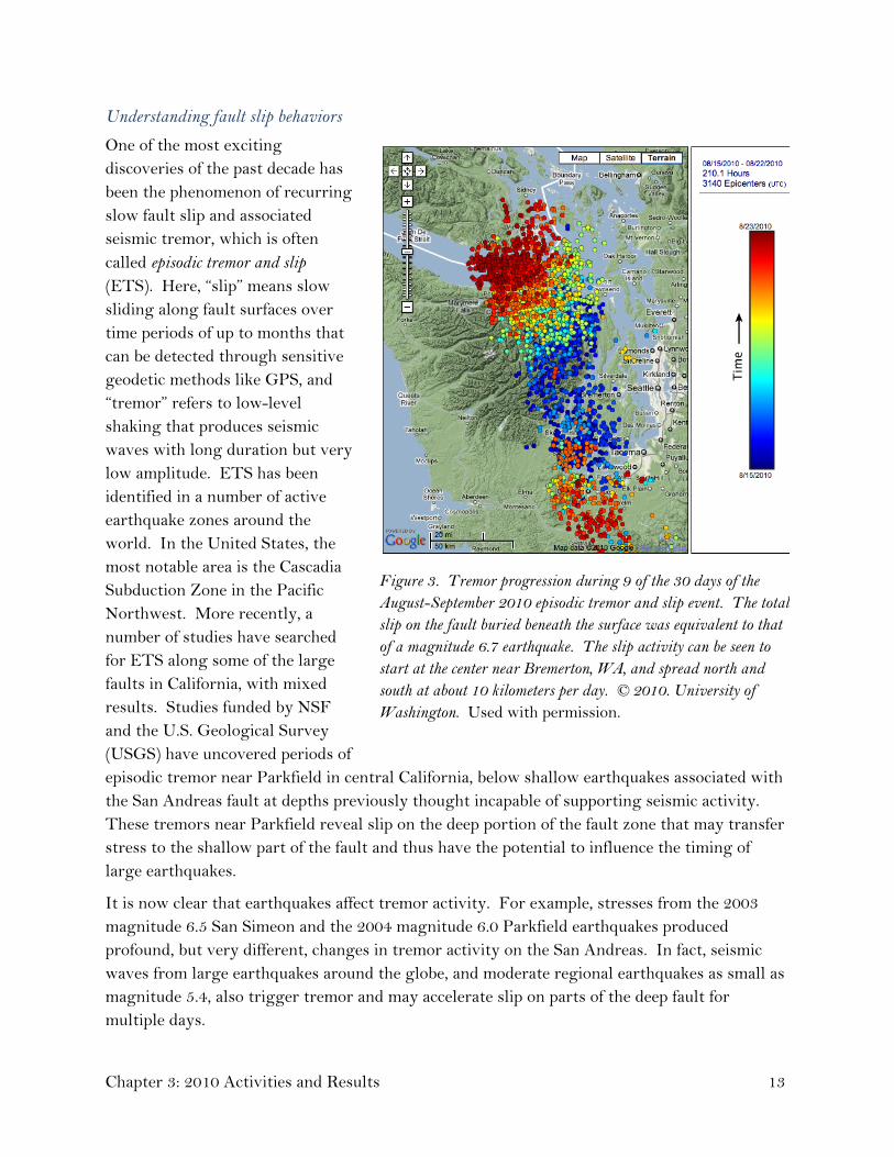
One of the most exciting discoveries of the past decade has been the phenomenon of recurring slow fault slip and associated seismic tremor, which is often called episodic tremor and slip (ETS). Here, “slip” means slow sliding along fault surfaces over time periods of up to months that can be detected through sensitive geodetic methods like GPS, and “tremor” refers to low-level shaking that produces seismic waves with long duration but very low amplitude. ETS has been identified in a number of active earthquake zones around the world. In the United States, the most notable area is the Cascadia Subduction Zone in the Pacific Northwest. More recently, a number of studies have searched for ETS along some of the large faults in California, with mixed results. Studies funded by NSF and the U.S. Geological Survey (USGS) have uncovered periods of episodic tremor near Parkfield in central California, below shallow earthquakes associated with the San Andreas fault at depths previously thought incapable of supporting seismic activity. These tremors near Parkfield reveal slip on the deep portion of the fault zone that may transfer stress to the shallow part of the fault and thus have the potential to influence the timing of large earthquakes.
Figure 3. Tremor progression during 9 of the 30 days of the August-September 2010 episodic tremor and slip event. The total slip on the fault buried beneath the surface was equivalent to that of a magnitude 6.7 earthquake. The slip activity can be seen to start at the center near Bremerton, WA, and spread north and south at about 10 kilometers per day. © 2010. University of Washington. Used with permission.
It is now clear that earthquakes affect tremor activity. For example, stresses from the 2003 magnitude 6.5 San Simeon and the 2004 magnitude 6.0 Parkfield earthquakes produced profound, but very different, changes in tremor activity on the San Andreas. In fact, seismic waves from large earthquakes around the globe, and moderate regional earthquakes as small as magnitude 5.4, also trigger tremor and may accelerate slip on parts of the deep fault for multiple days.
Chapter 3: 2010 Activities and Results 13

Mechanics of movement along the creeping portion of the San Andreas fault
Understanding the mechanics of movement along plate boundary faults is essential to understanding the physics of earthquakes and earthquake occurrence. One major question has been, “What makes a fault weak and causes it to exhibit slow movement, or creep, rather than break suddenly in an earthquake?” Three general hypotheses have been proposed for the weakness of fault zones: extremely high fluid pressures in the fault zone lubricating the rock of either side of the fault; abnormally low frictional strength of fault zone materials; or weakening of fault materials due to heating or other processes during movement. This question was answered recently through laboratory testing of fault zone rocks recovered by the San Andreas Fault Observatory at Depth (SAFOD), an element of the NEHRP-related EarthScope program. One of the goals of SAFOD was to retrieve samples of the rock materials from the creeping portion of the San Andreas Fault Zone. Approximately 31 meters of drilling core have been recovered from across the fault zone at a depth of 2.7 kilometers.
Experiments on these materials completed in 2010 at a USGS laboratory in Menlo Park, CA, indicate that the minerals in the fault zone are inherently weak. These tests indicate that the frictional strength of minerals in the immediate fault zone is two to three times less than that of the rock adjacent to the fault zone. The combination of these measurements of fault core strength with other borehole observations yields a consistent picture of the state of stress in the creeping portion of the San Andreas fault at the SAFOD site, where the fault is intrinsically weak in an otherwise strong crust.
USGS support for targeted research in earthquake studies
USGS annually funds targeted, external research in earthquake hazards, physical processes, and effects. This assistance adds a significant range of expertise to the USGS Earthquake Hazards Program within NEHRP. In 2010, USGS funded more than 100 grants and cooperative agreements supporting seismic monitoring and research on earthquake hazards in regions with seismic risk nationwide. The support was directed to 60 institutions in 19 states and territories. This work included studies of the effects of earthquake shaking and the physical conditions and processes that cause earthquakes (see the discussion of ETS, above). The greatest funding allocated to a single effort provides multiyear support to SCEC through a cooperative agreement funded jointly with NSF. SCEC, in turn, supports workshops and small grants that serve to develop a comprehensive and coordinated research approach to advance the understanding of earthquakes in southern California and elsewhere, and to communicate useful knowledge for reducing earthquake risk. All recent USGS grant and cooperative agreement awards, and reports that describe research results, are available at http://www.earthquake.usgs.gov/research/external.
Page 14

Objective 2: Advance understanding of earthquake effects on the built environment
Testing of bridge designs to withstand earthquakes
Using the facilities of the George E. Brown, Jr. Network for Earthquake Engineering Simulation (NEES), an engineering research team at the University of Nevada, Reno, is running large-scale tests on a number of materials and innovations to potentially revolutionize seismic design of future bridges to help protect lives, prevent damage, and avoid bridge closures after strong earthquakes. After a succession of eight separate earthquake simulations in June 2010, a 110-foot-long, 200-ton concrete bridge model withstood powerful jolting equivalent to three times the acceleration of the 1994 magnitude 6.9 Northridge, CA, earthquake, and survived in good condition.
The bridge model was shaken with bi-directional forces to realistically simulate an earthquake. The researchers mimicked the Northridge, CA, earthquake using recorded data of the actual earthquake. The performance of the test bridge under the amplified earthquake ground motions indicates that the test bridge would have survived the Northridge quake in good condition. The test was attended by about 50 engineers and industry representatives, including officials from Nevada and California concerned with the earthquake safety of highway and bridge structures.
Earthquake-resistant design of steel frame buildings
Conventional earthquake-resistant steel frame systems for buildings are often designed so that they develop significant inelastic deformation during severe earthquake shaking. In lay terms, the steel frame is bent during severe shaking, resulting in significant damage and permanent deformations. Engineers using a NEES earthquake simulator at Lehigh University are testing
innovative “self centering” steel frame systems that have the potential to avoid structural damage under severe shaking. These systems result in a lateral force-drift behavior that softens without inelastic deformation (permanent bending) of the structural members, and therefore, without the resulting structural damage and residual drift. The softening behavior is created by gap openings at selected connections (e.g., a separation at the beam-column interfaces of the frame). The yielding capacity of the lateral force-drift behavior can be quite large
Figure 4. Testing steel building frame in NEES facility at Lehigh University. © 2010. Lehigh University. Used with permission.
Chapter 3: 2010 Activities and Results 15

and is not controlled by steel deformation capacity. Under this new concept, energy dissipation under seismic loading is not from damage to main structural members, but from energy dissipation elements that are specified in the design process and can be replaced if damaged.
Advanced information technology for earthquake engineering research—NEEShub
An important requirement of the NEES infrastructure is the capacity to share data, experimental control, and results between the various NEES sites. Purdue University is developing NEEShub to meet this requirement. NEEShub will be the central access point to robust, high-quality software tools and experimental databases for research, to collaborative capabilities for researchers and practicing professionals, and to the NEES Academy, which provides educational material for all users. The first release of NEEShub was implemented in July 2010.
Shaking a city block: Understanding how soils and structure foundations respond to seismic shaking in a dense urban environment
When the ground shakes in an earthquake, the foundation of a building embedded in soil shakes along with the above-ground portion of the building. As the building moves, it sends out vibrations from its foundation, and those vibrations travel back through the surrounding soil to neighboring buildings. For the first time, researchers have shaken scale models of an entire city block of buildings with an earthquake simulator in a controlled laboratory environment and measured the interactions among structures in that block, using the geotechnical centrifuge at the NEES Center for Geotechnical Modeling at the University of California (UC), Davis. The centrifuge allows researchers to test small structural models (on the scale of buildings in a model train set-up) placed in small boxes filled with soil. To investigate the behavior of soil-building systems during earthquakes, researchers have mounted an earthquake simulator (i.e., shake table) in the centrifuge so that the models of soil-building systems can be shaken while the centrifuge is spinning (or "in flight").
Results from this study will provide data that will help engineers account for building interactions in their designs. This is a cooperative effort involving research by UC Berkeley, Davis, and San Diego, the University at Buffalo, and the Consortium of Universities for Research in Earthquake Engineering (CUREE).
Construction-induced stresses may impact soil stability during earthquakes
Scientists at Northwestern University, working collaboratively with subcontractor GeoEngineers, Inc., have developed a methodology to account for the effects of construction-induced stresses on the dynamic properties of clays. The study, funded by NSF, has shown that the foundation soils at the Port of Anchorage, AK, wharf expansion project will have significantly altered soil properties that will affect the response of the completed facility to the design earthquake loading in this seismically active area. The research team developed two- and three-dimensional numerical simulations of the construction of the wharf structure facility
Page 16

to compute the stress changes at various locations in the foundation soils. By supplementing data collected as part of the design of the structure with results of state-of-the-art laboratory experiments on soil specimens from the alignment of the facility, researchers showed that key dynamic properties of the clay change by as much as 100 percent as a result of the additional stresses imposed by the wharf.
This work addresses fundamental issues concerning changes in soil structure as related to the incremental non-linearity of soils, and the impact of these changes on the performance of structures under both static and cyclic loading during earthquake shaking. Results of the research provide guidance in selecting stiffness values for seismic loading conditions that account for effects of construction-induced stress changes that heretofore have been neglected in practice.
Full-scale three-story building subjected to simulated earthquake shaking
Reinforced masonry structures are designed to ensure life safety in rare, extreme earthquakes, although they may be heavily damaged, and to sustain minimal damage in more frequent moderate earthquakes. While these structures have performed well in past domestic earthquakes, their safety under extreme earthquake conditions has not been proven and current analysis methods have proven difficult to apply. This research is developing improved analysis and design methods for low-rise (one to three stories) reinforced masonry buildings, which are more common than high-rise masonry buildings.
A full-scale, 120-ton, three-story, reinforced masonry shear wall structure was subjected to a simulated magnitude 7.5 earthquake on the world’s largest outdoor shake table—a NEES facility at UC San Diego—in February 2010. The test specimen resembled common apartment, school, or hotel buildings constructed of reinforced, bearing-wall masonry. This collaborative project between NEES and the National Institute of Standards and Technology (NIST) was the first time this type and size of structure had been tested on a shake table. Testing results showed that this type of reinforced masonry wall system, designed according to current code provisions, performs well under extreme earthquake loads.
Figure 5. Full-scale seismic testing of a three-story building design in the NEES facility at UC San Diego. © 2010. University of California, San Diego. Used with permission.
Chapter 3: 2010 Activities and Results 17

Objective 3: Advance understanding of the social, psychological, and economic factors linked to implementing risk-reduction and mitigation strategies in the public and private sectors
Urban planning in the post-disaster recovery period
Researchers at the University of Illinois at Urbana-Champaign, supported by NSF, have found that the key characteristic of post-disaster recovery processes is the compression of time; normal planning and construction processes occur faster than usual. Not all of these processes can be sped up as easily as others. Planning and construction of cities is a complex social process, and understanding urban growth involves a variety of disciplines, including economics, political science, sociology, and the natural sciences. The key insight from this research is that post-disaster reconstruction can be understood through all these existing disciplines, as with normal urban growth, but with the application of time compression. This insight will help planners to adapt existing urban growth theories to the unique circumstance of post-disaster reconstruction, showing which things can speed up, which things cannot, and how they affect one another. Improved understanding of post-disaster recovery will help the Federal Emergency Management Agency (FEMA) and local governments in managing reconstruction following large disasters, potentially making post-disaster planning more effective and more efficient.
Objective 4: Improve post-earthquake information management
New project for disaster and failure studies
In 2010 NIST retained a new Director of Disaster and Failure Studies who will lead overall efforts to gather and retain post-event data from structural failures, earthquake and wind events, and wildfires and building fires. NIST plans for this position to support NEHRP-related activities that are associated with the creation and maintenance of the post-earthquake information management system that was cited as a strategic priority in the NEHRP strategic plan.
3.2 Goal B: Develop cost-effective measures to reduce earthquake impacts on individuals, the built environment, and society at large NEHRP activities under Goal B are designed to develop practical and cost-effective methods and measures for earthquake risk assessment and mitigation that build upon the research results obtained under Goal A. Goal B is directly linked to the congressionally defined NEHRP program activity “Develop effective measures for earthquake hazards reduction.”
Page 18

Objective 5: Assess earthquake hazards for research and practical application
National Seismic Hazard Maps
In 2010 USGS scientists and engineers worked with the Building Seismic Safety Council (BSSC) and American Society of Civil Engineers (ASCE) Minimum Design Loads on Buildings and Other Structures Standards Committee to assist in implementing the 2008 USGS National Seismic Hazard Maps into engineering practice. These hazard maps are based on the scientific research of seismologists and geologists across NEHRP. Due to these sustained efforts, the updated USGS hazard maps were accepted into the 2009 NEHRP Recommended Seismic Provisions for New Buildings and Other Structures (FEMA P-750) and the ASCE document entitled Minimum Design Loads for Buildings and Other Structures (ASCE 7-10). The ASCE 7-10 standard will be the primary seismic safety reference for the 2012 version of the International Building Code (IBC). The IBC is the model building code upon which building codes adopted by states and localities throughout most of the United States for building design and construction are based.
Seismic hazard assessments for specific uses
In addition to providing hazard assessments for building codes, USGS scientists have completed development of fault displacement hazard models, in collaboration with the California Geological Survey, that are being used for lifeline designs in California. With support from the U.S. Nuclear Regulatory Commission, USGS scientists have reviewed the new 2010 seismic hazard model standard for nuclear power plants in the central and eastern United States, and several site-specific proposed nuclear power plant seismic hazard analyses. Additionally, USGS scientists have constructed preliminary seismic hazard models for regions with recent damaging earthquakes in Central and South America.
Seismic hazard in the Sacramento River Delta
A multiyear program of work to evaluate the seismic hazard in the Sacramento River Delta has been initiated by USGS. Expected shaking from earthquakes in the San Francisco Bay Region may break vulnerable earth dams in the delta, leading to salt-water contamination of a substantial fraction of the state’s drinking and irrigation water. The project includes four tasks: 1) reviewing potential seismic sources and strong site effects that modify shaking; 2) determining the three-dimensional geology and seismic velocity structure from the East Bay through the delta; 3) expanding broadband seismometer deployment in the delta with the goal of using the seismic data to estimate velocity structure and to simulate ground motions for large regional earthquakes; and 4) calculating synthetic ground motions in the delta for a set of scenario earthquakes in the East Bay.
Chapter 3: 2010 Activities and Results 19

Developing new earthquake forecast model for California
In 2010 USGS, in collaboration with the California Geological Survey and SCEC, launched a 30-month project to update the statewide Uniform California Earthquake Rupture Forecast (UCERF). This model, last updated in 2008, provides input to the USGS national seismic hazard maps and is used by the California Earthquake Authority (CEA) to determine its reinsurance coverage and to evaluate earthquake insurance premiums in the state. The new project is leveraged by substantial financial support from the CEA and is being managed by the Working Group on California Earthquake Probabilities. Planned improvements to the model include (a) considering the effects of fault segmentation and multiple fault ruptures on long-term earthquake probabilities, (b) developing methods for incorporating earthquake clustering and triggering statistics into time-dependent rupture forecasts, and (c) establishing procedures for updating UCERF immediately after a large earthquake.
Amplification of seismic shaking in the Pacific Northwest
The cities of Seattle and Tacoma lie atop deep sedimentary basins that amplify and distort seismic motions from nearby earthquakes. Basin surface waves (large-amplitude seismic waves that propagate near the Earth’s surface) are a particular hazard in this urban area, and hazard maps for the urban region are strongly dependent on the accuracy of models of the seismic velocities in basins. Researchers at the University of Washington, supported by a USGS grant, analyzed a broad suite of data to improve and refine the basin velocity model relative to that underlying the USGS urban seismic maps published in 2007. The researchers developed a new method to calculate the propagation of surface waves within the basin, and calibrated their improved model using a variety of data from earthquakes, seismic surveys using artificial sources, and ambient seismic noise studies. The new model significantly refines the predicted velocity structure of the upper several kilometers of the basin, allowing more accurate modeling of ground shaking from earthquakes.
Objective 6: Develop advanced loss-estimation and risk-assessment tools
Mobile seismic risk assessment tool
Many communities in earthquake-prone areas need to evaluate the seismic risks of their building stocks to make informed risk mitigation decisions. These evaluations have been expensive and time-consuming to perform. FEMA first addressed this need in 1988 with the publication of a screening methodology, Rapid Visual Screening of Buildings for Potential Seismic Hazards (FEMA 154). FEMA 154 was broadly welcomed by communities, but it was labor-intensive to apply. FEMA has developed a modern tool called the Rapid Observation of Vulnerability and Estimation of Risk (ROVER). ROVER converts the previous paper-based rapid visual screening procedure into an electronic version for smart phone devices, enabling handheld mobile devices to become data collection and evaluation tools. It greatly reduces the burden of data collection, storage, processing, and management, providing a faster and more
Page 20

efficient way to conduct field evaluations of large numbers of buildings to determine their seismic risks. The software is currently under FEMA technical evaluation and is expected to be released to the public soon. By the end of 2010, ROVER had been tested through several demonstration projects. One project is reported herein for Utah (see below) as a state assistance earthquake program activity.
Quantification of building seismic performance design factors
FEMA completed the final draft of Quantification of Building Seismic Performance Design Factors: Component Equivalency Methodology (FEMA P-795). This publication presents a methodology to allow comparison between new building components and existing building components with established seismic performance factors. This project was undertaken at the request of the International Code Council’s Evaluation Service (ICC-ES), which needs this methodology to evaluate new building components located in seismic zones. FEMA also conducted an educational seminar to introduce the publication to about 40 industry experts and obtain their review comments. The document is based on the recently completed publication Quantification of Building Seismic Performance Design Factors (FEMA P-695), which presents a new methodology for reliably quantifying building system performance and response parameters for use in seismic design.
Estimating the structural integrity of tall buildings after earthquakes
Procedures for rapidly estimating the impacts of ground motion on tall buildings were developed by engineers at the California Institute of Technology, with support from USGS. They modeled the responses of tall buildings to a wide range of synthetic ground motion patterns. After a real earthquake, the synthetic shaking that most closely matches the actual ground motion recorded in the event is used to estimate building performance (ranging from ready for immediate re-occupancy to ready to collapse). Researchers analyzed the responses of various 18-story model buildings to synthetic ground motions, measuring peak transient inter-story drift ratios (IDR, permanent lateral displacement of one story with respect to another) for earthquake-like ground shaking. For near-source recordings from large earthquakes in the Los Angeles basin, performance can be rapidly estimated by determining the best fit of recorded strong motion to a set of synthetic recordings. This result suggests that following a major earthquake, a rapid assessment of potential damage states across a large inventory of buildings could be performed by querying a pre-calculated IDR database. Such an analysis could be used to identify those buildings most likely to have been compromised and to prioritize inspections.
Chapter 3: 2010 Activities and Results 21

Objective 7: Develop tools to improve the seismic performance of buildings and other structures
Ensuring the seismic safety of existing buildings
One of the most complex and challenging aspects of striving for national earthquake resilience is the issue of improving the earthquake safety of existing buildings. In 2010, NEHRP produced two new publications related to the evaluation and rehabilitation of existing reinforced concrete buildings. Older reinforced concrete buildings are considered to be among the most dangerous to their occupants in earthquakes. To assist engineers in categorizing older reinforced concrete buildings when they are developing building inventories, NIST has published Concrete Model Building Subtypes: Recommended for Use in Collecting Building Inventory Data (NIST GCR 10-917-6). To support planning activities for the applied research that will support the transfer of knowledge gained in the ongoing NEES Grand Challenge project, “Mitigation of Collapse Risk in Vulnerable Concrete Buildings,” NIST has published Program Plan for the Development of Collapse Assessment and Mitigation Strategies for Existing Reinforced Concrete Buildings” (NIST GCR 10-917-7). Both of the NIST documents lay the foundations for identifying and addressing seismic vulnerabilities of existing concrete buildings.
Performance-based seismic design
Under the concept of performance-based seismic design (PBSD), an expected structure performance objective may be established that not only provides for seismic safety but also a level of retained function following an earthquake. In support of improved nonlinear structural analysis capabilities for buildings, NIST has published the document Applicability of Nonlinear Multiple-Degree-of-Freedom Modeling for Design (NIST GCR 10-917-9). Earlier work completed by FEMA concluded that current nonlinear static analysis procedures, based on single-degree-of-freedom (SDOF) models (building models idealized as one-dimensional spring-mass systems), are limited in their ability to capture the complex behavior of multistory structures. During earthquakes such buildings experience multiple-degree-of-freedom (MDOF) shaking, and improved nonlinear analysis techniques to more reliably address MDOF effects were needed. This project focused on improving nonlinear MDOF modeling for structural design practice by providing guidance on the minimum level of MDOF model sophistication necessary to make performance-based engineering decisions and on the selection of appropriate nonlinear analysis methods.
FEMA completed the preliminary draft of the Guidelines for Seismic Performance Assessment of Buildings (FEMA P-58), and the accompanying data calculation tool, Information Management and Performance Assessment Calculation Tool (IMPACT). When completed, this performance assessment methodology will allow a designer to assess seismic performance of individual buildings in future earthquakes.
Page 22

These products have been developed under the first phase of a project to create performance-based seismic design guidelines for new and existing buildings. The goal of this project is to be able to evaluate how a building is likely to perform in a given earthquake, considering uncertainties inherent in both the potential hazard and the actual building response. The project will permit the design of new buildings or the upgrade of existing buildings with a realistic understanding of the risk of casualties, occupancy interruption, and economic loss that may occur as a result of future earthquakes.
Earthquake hazard tools for individual applications
The earthquake hazard maps produced by USGS are used in the development of design maps that are, in turn, incorporated into the seismic safety elements of model building codes. Although the seismic safety elements of model building codes are adopted by individual communities to ensure public safety, they do not ensure building functionality following an earthquake. New PBSD guidelines require seismic hazard information based on site-specific, user-defined criteria. USGS is developing a web-based application that allows the user to define a location, soil type, structure vibration periods, and other parameters to customize the earthquake hazard to any performance-based design study. The data and data analyses used for these custom products are exactly the same as used in hazard maps for the building codes. The hazard analysis web tool will allow the user to retrieve results from the hazard map database that meet specific needs and applications.
Continued publication of NEHRP “Techbriefs”
The “Techbrief” series of publications, in newsletter format, focuses on providing clear and succinct guidance to practicing engineers faced with transferring research-based knowledge into practice. In 2010, NEHRP produced two Techbriefs, Seismic Design of Cast-in-Place Concrete Diaphragms, Chords, and Collectors: A Guide for Practicing Engineers (NIST GCR 10-917-4), and Nonlinear Structural Analysis for Seismic Design: A Guide for Practicing Engineers (NIST GCR 10-917-5). Techbriefs have proven popular not only with practicing engineers but also as teaching resources on seismic safety design concepts in university courses in advanced engineering.
Figure 6. NIST Techbrief series is designed to convey research results for application by practicing engineers. Cover photo Image courtesy of Farzad Naeim, John A. Martin & Associates.
Chapter 3: 2010 Activities and Results 23

Objective 8: Develop tools to improve the seismic performance of critical infrastructure
Testing the earthquake response of wind turbines
The San Gorgonio Pass north of Palm Springs, CA, is the site of large farms of wind turbines. The pass is the topographical expression of the Banning strand of the San Andreas fault that runs through the pass in an east to west direction. This situation raises the question of the performance of wind turbines during an earthquake. During 2010 the NEES earthquake shaking simulation facility at UC San Diego was used to test a 65-kilowatt wind turbine. The turbine was 70 feet tall and weighed over 23,400 pounds. UC San Diego engineers ran over 90 individual experiments on the turbine, subjecting it to ground motions that simulated those experienced during the magnitude 7.2 Landers earthquake that occurred in southern California in 1992. These tests were the first steps toward understanding how earthquakes impact wind turbines. This question will become more important as California grows more reliant on wind energy produced in regions in close proximity to active faults.
Figure 7. Testing the response of a wind turbine to seismic shaking at UC San Diego NEES facility. © 2010. UC San Diego. Used with permission. Water supply safety in earthquakes
Researchers at Cornell University recently completed a large-scale infrastructure test program for the San Francisco Public Utilities Commission. This study was developed as a proof of concept for a major seismic upgrade to a large-diameter water supply pipeline that crosses the Hayward fault in the East Bay. The tests were performed with the Large-Scale Lifelines Testing Facility at Cornell University, part of NEES. The design entails enclosing the new pipeline in a segmental, reinforced concrete vault with special joints that can accommodate lateral offset and compressive deformation during fault rupture, thereby allowing for rotation and compression of the pipeline inside the vault at ball and slip joints, respectively. The protective vault is approximately 300 feet long.
A critical aspect of the design is the relative movement of the concrete segments to accommodate lateral offset and compressive deformation of the fault. Understanding the movement of the segments relative to each other and the enclosed pipeline is a key element in the design process. The Cornell team coordinated with members of the utility design team in
Page 24

developing and completing this comprehensive test program. Funding for testing was provided by the San Francisco Public Utilities Commission.
Testing of container cranes used at port facilities Container cranes are used to load and unload ships in ports and are critical to port operations and to the import and export aspects of national economies. During the 1995 earthquake near Kobe, Japan, many container cranes at the Port of Kobe either collapsed or were damaged beyond repair, leading to significant economic losses for the port and surrounding region. Because cranes are unique structures and their replacement can take more than a year, their functionality after an earthquake is critical to the continued operation of the port as well as post-disaster recovery for the region where they are located. This “choke point” aspect of crane operations has been demonstrated recently in Haiti. To better understand how container cranes respond during an earthquake, two subscale container crane test specimens were developed and tested on shake tables using the NEES facility at the University at Buffalo. Researchers specified shake table motions from a large database of seismic records representing the highest level of shaking expected to be encountered in a given geographical area.
The results were used to develop a second experimental test program, which included the design and construction of a 1/10th-scale model of a container crane. The objective of these tests was to measure the response of the crane from small levels of shaking to those large enough to cause it to collapse. The data collected from these tests provided information on the likelihood of degree of damage as a function of the level of shaking. When damage to the test crane occurred, repairs similar to those used in the field were made. The repaired crane was tested again to determine how well the repairs performed during subsequent seismic events. These tests were the largest ever performed in the United States and the first to include a structure driven to collapse.
The results of this comprehensive series of large-scale tests will be used to assess the expected performance of existing container cranes and, if necessary, to design retrofit measures to reduce the possibility of damage during earthquakes. The test results will also be used to develop improved design standards for construction of future cranes.
3.3 Goal C: Improve the earthquake resilience of communities nationwide Through activities supported under Goal C, NEHRP agencies work to apply research results developed under Goal A and risk-reduction methodologies developed under Goal B to practical measures that will increase public safety and reduce losses in future earthquakes. Work under this goal includes the monitoring and reporting of seismic activity worldwide. Goal C is directly related to the congressionally defined NEHRP program activity “Promote the adoption
Chapter 3: 2010 Activities and Results 25

of earthquake hazard reduction measures by federal, state, and local governments, national standards and model code organizations, architects and engineers, building owners, and others with a role in planning and constructing buildings, structures, and lifelines.”
Objective 9: Improve the accuracy, timeliness, and content of earthquake information products
Improved NEHRP earthquake notification products
NEHRP produces a suite of earthquake notification products for emergency and infrastructure managers, government officials, scientists, and the general public. The products are produced by the USGS National Earthquake Information Center (NEIC) and regional seismic networks supported by the Advanced National Seismic System (ANSS). The products are based on data from ANSS and the Global Seismographic Network (GSN), both described below in the facilities section of this chapter. During 2010 USGS worked to improve and expand usage of its primary notification products:
− The Earthquake Notification Service (ENS) provides subscribers with basic information on earthquake occurrences such as location and magnitude. Notifications are provided through e-mail and text messages. Subscriptions are free and may be customized according to the user’s interests. Notifications are usually provided within 5 minutes for earthquakes within the United States and within 20 minutes for earthquakes worldwide. In 2010 there were more than 250,000 subscribers to the ENS.
− ShakeMap is a display in map format showing the geographic distribution and severity of ground shaking from earthquakes. These displays are posted on the websites of regional networks and the NEIC in near-real time and are used by federal, state, and local organizations, both public and private, for post-earthquake response and recovery, and by the general public and scientific communities. In 2010 scenario ShakeMaps were produced to support a national emergency response exercise planned for 2011 in the central United States.
− ShakeCast is an application for automating ShakeMap delivery to users for notification of shaking levels at user-selected facilities. This application may be downloaded from the NEIC website: http://earthquake.usgs.gov/research/software/shakecast/. The user can define the location of facilities and structures of interest, such as power lines, overpasses, bridges, and hospitals, and immediately determine the level of shaking experienced at that location. This application has many practical uses in an earthquake emergency, such as setting priorities for the emergency dispatchers and for the inspection of facilities and structures. During 2010 ShakeCast was adopted for operations by the U.S. Nuclear Regulatory Commission and the International Atomic Energy Agency.
− The Prompt Assessment of Global Earthquakes for Response (PAGER) system was improved during 2010 to combine ShakeMap results with data on population and
Page 26

building inventories to provide fatality and economic loss impact estimates following significant earthquakes worldwide. These enhancements were jointly supported by FEMA and the U.S. Agency for International Development. Most rescues in any earthquake emergency occur within the first 100 hours after the event. Early PAGER assessment of the magnitude of the disaster and areas most likely to be in need of rescue operations saves valuable time in the allocation and direction of response resources.
− The primary NEHRP portal for comprehensive information on current and historical seismicity and general earthquake information is through the USGS Earthquake Hazards Program website at http://earthquake.usgs.gov/. The number of visitors to this site swells dramatically after significant seismic activity. For example, in the first 24 hours following the magnitude 8.8 offshore Maule, Chile, earthquake on February 27, 2010, the site received 11,513,179 page views. The magnitude 7.2 Baja California earthquake on April 4, 2010, resulted in 17,445,628 page views in the first 24 hours and 93,272,807 page views in the following 30 days. Although the relatively small magnitude 4.4 Los Angeles earthquake on March 16, 2010, did not generate as many page views within 24 hours as the larger earthquakes, it caused peak traffic of 52,519 requests per second just after the earthquake occurred, compared to a peak traffic load of 11,388 requests per second for the earthquake in Chile. Sustained activity on this site averages about 400,000 visits per day. This site is ranked 2,750 (by amount of traffic) among all worldwide websites and ranked 770 among U.S. websites according to Alexa.com.
Figure 8. USGS earthquake website activity during 2010. Image courtesy of USGS.
Chapter 3: 2010 Activities and Results 27

Earthquake early warning
Seismic waves that transmit strong shaking travel from an earthquake source through the Earth’s crust at about 2 miles per second. This means that if an earthquake is detected near its epicenter, a warning of imminent strong shaking can be transmitted to population centers at some distance away. Although the concept is simple, the warning process is complex. Data from sensors must be continuously analyzed to determine if a strong earthquake has occurred nearby and, if so, the system must automatically issue a warning. A few tens of seconds of warning can allow for schoolchildren (if properly trained) to get under their desks, for hospitals to suspend delicate surgeries, for manufacturers to halt sensitive machining processes, and for transportation officials to halt traffic entering vulnerable transportation facilities. Such warning systems are currently in place in Japan, Mexico, and Taiwan and are under development in several other countries.
After a period of concept development and software testing during 2007–2009, the California Integrated Seismic Network (CISN), a component of ANSS, began to create a working prototype of an early warning system in 2010. Data from 382 seismic stations in California are being used in the prototype test. The CISN has established a testing center at SCEC, although no formal warnings will be issued during the prototype test. The same technology can be used to warn rescue workers of dangerous aftershocks following a major earthquake. This development is being completed in close coordination with the California Emergency Management Agency. Prototype testing is expected to last through 2012. Earthquake early warning raises important societal issues regarding its use and expected responses by the general public. These issues must be addressed before these warnings are widely broadcast.
Assessment of earthquake predictions
The National Earthquake Prediction Evaluation Council is a federal advisory committee established by statute that provides advice and recommendations to the USGS Director on earthquake predictions and related scientific research. The council supports the Director’s delegated responsibility under the Stafford Act (Public Law 93–288) to issue timely warnings of potential geologic disasters. In 2010 the council met with scientists and state officials in California to discuss coordination between federal and state prediction evaluation procedures, and to refine procedures for rapid analysis and reporting in response to an earthquake crisis. The council also reviewed the activities of the Collaboratory for the Study of Earthquake Predictability centered at SCEC, an international research collaboration created to foster rigorous application of the scientific method to the field of earthquake prediction research.
Objective 10: Develop comprehensive earthquake scenarios and risk assessments
Impacts of earthquakes on the central United States
In October 2009 the Mid-America Earthquake Center at the University of Illinois published the results of a major study concerning the impact on the central United States of a major
Page 28

earthquake in the New Madrid Seismic Zone near southeastern Missouri. This study was supported by FEMA in preparation for a National Level Exercise for emergency response to be conducted in May 2011. This study drew extensively on NEHRP publications, earthquake scenarios, and impact analysis tools (e.g., HAZUS-MH).
The study assesses the potential impacts of a magnitude 7.7 earthquake caused by a fault rupturing over the entire length of the New Madrid Seismic Zone. This is admittedly an extreme, but still plausible, event. The results of the study indicate that Tennessee, Arkansas, and Missouri would be most severely impacted; Illinois and Kentucky would suffer less severe losses. For this scenario earthquake, the study projected that nearly 715,000 buildings could be damaged in the eight-state study region. About 42,000 search and rescue personnel working in 1,500 teams would be required to respond to the earthquake. The study also suggested that damage to critical infrastructure (essential facilities, transportation and utility lifelines) would be substantial in the 140 impacted counties near the fault zone, including 3,500 damaged bridges and nearly 425,000 breaks and leaks in both local and interstate pipelines. Approximately 2.6 million households would be without power after the earthquake. Nearly 86,000 injuries and fatalities could result from the damage caused. Nearly 130 hospitals would be damaged, most located in the impacted counties near the fault zone. There would be extensive road damage and substantial travel delays in both Memphis, TN, and St. Louis, MO, thus hampering search and rescue as well as evacuation. Moreover, roughly 15 major bridges would be unusable, including highway and railroad structures essential for interstate commerce across the Mississippi and Ohio rivers. Three days after the earthquake, 7.2 million people would be displaced and 2 million people would be seeking temporary shelter. The study projected estimated direct economic losses for the eight-state region totaling nearly $300 billion; indirect losses are estimated to total at least twice this amount.
Objective 11: Support development of seismic standards and building codes and advocate their adoption and enforcement
New, risk-targeted seismic design maps for model building codes
Through collaboration between USGS and the Building Seismic Safety Council (with FEMA support), the probabilistic basis for the ground-motion amplitudes used in designing new buildings in the United States has recently undergone a significant conceptual shift. In the 2000–2009 triennial editions of the International Building Code (IBC)—as well as in the referenced editions of the ASCE standard entitled Minimum Design Loads for Buildings and Other Structures—the ground motions used for building design for most areas of the U.S. were developed using a uniform earthquake hazard approach. In the 2012 IBC (and in the 2010 update of the ASCE standard), the ground motions used for building design will be based on a uniform risk of building collapse from earthquake shaking.
Chapter 3: 2010 Activities and Results 29

These risk-targeted ground motions, when used for design according to the IBC (or the ASCE standard), are expected to result in buildings having a collapse probability of 1 percent in 50 years. This new approach results in uniform building collapse risk from earthquake ground motions across the United States. Changes in the earthquake hazard with the geographic location are factored into this risk-based approach to determine the appropriate load values for use in structural design, all within the uniform collapse risk framework.
NEHRP interactions with the International Code Council
The NEHRP Recommended Seismic Provisions for New Buildings and Other Structures (FEMA P-750 and P-750CD) is one of the most important FEMA NEHRP publications and is a national resource for design professionals and the standards and codes development community. In 2010, the International Code Council held its Code Change Hearings and Final Action Hearings for the IBC, the International Existing Building Code (IEBC), and the International Residential Code (IRC). FEMA, through its Code Resource Support Committee (CRSC), attended and provided testimony on several proposed code changes for the 2012 edition of the model codes. FEMA was successful in submitting and defending several important code changes, including new seismic design maps for the IBC and IRC developed for FEMA P-750 and adopted by ASCE, improved special inspection requirements for steel frame construction, and improved IRC provisions for braced wall systems.
Acceleration and Hazard Curves
Horizontal ground acceleration from earthquake shaking exerts a force on the base of a building. This acceleration is usually measured as a percentage of gravitational acceleration, or “g”. A ground shaking acceleration equal to 100% g exerts a force on the base of the building equivalent to its weight, 50% g shaking level exerts a force equal to half the building weight. A hazard curve for a specific site shows a plot of shaking acceleration versus the probability that that shaking level will be exceeded in one year.
FEMA staff also successfully submitted a code change on behalf of the National Oceanic and Atmospheric Administration (NOAA) National Tsunami Hazard Mitigation Program that added a new Appendix L, Tsunami Generated Flood Hazard, to the codes. In addition, FEMA and the CRSC provided testimony in support of changes with which they concurred as well as in opposition to changes that weakened the seismic provisions of the codes, thereby ensuring that these model codes continue to adequately address natural hazards.
Objective 12: Promote the implementation of earthquake-resilient measures in professional practice and in private and public policies
Southern California Multi-Hazards Demonstration Project
The USGS Multi-Hazards Demonstration Project (MHDP), a multiyear effort initiated in 2007, has the goal of linking research results and data with information dissemination to
Page 30

provide an integrated approach to hazards research, warning, and mitigation in southern California, where catastrophic losses from natural hazards such as earthquakes, tsunamis, fires, landslides, and floods exceed $3 billion per year. During 2010, MHDP funding continued to support installation of new earthquake monitoring sites and upgrades of existing monitoring sites along the southern San Andreas fault. New sites are equipped with both seismic and GPS instrumentation with real-time telemetry, capable of instant detection of ground shaking and displacement. This work is coordinated with USGS-sponsored testing of a prototype earthquake early warning system. The USGS MHDP also continued support for a coordinated suite of field studies aimed at improving the earthquake history of southern California faults used to improve probabilistic seismic hazard analysis.
Building code adoption tracking
One of the effective ways to reduce seismic risk in local communities is to adopt and implement proper seismic-resistant building codes. The adoption of hazard-resistant codes has been considered the number one performance measurement in the FEMA NEHRP scorecard. To track code adoption by local communities, FEMA developed and now maintains the Building Code Adoption Tracking (BCAT) system. This system uses the Building Code Effectiveness Grading Schedule (BCEGS) from the Insurance Services Office (ISO) as the primary source to monitor building code adoption and implementation by jurisdictions in seismic areas. As of September 2010, 43 percent of jurisdictions with high and very high seismic risk that are registered in BCEGS had adopted proper codes, without any weakening amendments, to protect their at-risk building stocks. This is an 18 percent increase from FY 2009. Additional code adoption tracking data were collected for BCAT from Hawaii, Idaho, Kansas, and Washington during 2010.
Seismic rehabilitation training for one- and two-family wood-frame dwellings
FEMA released Seismic Rehabilitation Training for One- and Two-Family Dwellings (FEMA P-593 CD) in January 2010. This CD-only product contains slide presentations, an instructional guide, and speaker’s notes for training contractors, code officials, and other parties interested in the seismic retrofitting of existing, light wood-frame dwellings. This product has been used by the International Code Council as the basis for a series of webinars for their membership.
Objective 13: Increase public awareness of earthquake hazards and risk
Earthquake drill—Pierce County, Washington
In October 2009, the Pierce County Emergency Management Department led an earthquake exercise for a magnitude 7.0 earthquake on the Tacoma fault. The Hazard Mitigation Program of the Washington Emergency Management Division (EMD), the Pierce County Emergency Management Department, the University of Washington (UW), and USGS participated in the development and implementation of the earthquake exercise. USGS supplied data used to
Chapter 3: 2010 Activities and Results 31

develop the various damage reports and exercise activities, and held training sessions on the geological and seismological aspects of the Tacoma fault. UW staff developed scenario ShakeMaps for the main shock and two aftershocks and fed these into the exercise in "real-time," and USGS built a mock "Did You Feel It?" website. Pierce County and the USGS Seattle office continue to cooperate in making USGS real-time earthquake products more useful for emergency operations centers. Washington EMD will use ground motion models, developed by USGS, as the basis for state and local planning.
Great California ShakeOut
In October 2009, more than 6.9 million Californians participated in the “Great California ShakeOut,” the largest earthquake drill ever held in the United States. The ShakeOut is an annual earthquake preparedness event that engages families, schools, businesses, emergency responders, and other organizations in a “drop, cover, and hold on” drill and a wide range of other activities designed to teach what to do before, during, and after an earthquake. Organization of the event was led by SCEC, in partnership with USGS, the California Emergency Management Agency (Cal EMA), several California cities and companies, and over 200 affiliates of the Earthquake Country Alliance. As in the previous year’s event, FEMA and Cal EMA provided funding for several activities, including the printing of over 1 million ShakeOut flyers in five languages (English, Spanish, Vietnamese, Korean, and Chinese).
The ShakeOut model has now been adopted by groups in Nevada, the Midwest, the Pacific Northwest, and Utah, and is spreading internationally to Canada and New Zealand. The ShakeOut approach is fundamentally changing how the public receives reliable information on preparing for earthquakes and mitigating their effects.
FEMA earthquake website enhancement project
In 2010, FEMA completed Phase II of its project to update and enhance the content and organization of the FEMA earthquake website (www.fema.gov/hazard/earthquake/index.shtm). When completed in 2011, the new website will be designed to enhance the FEMA earthquake program’s visibility and to better meet FEMA goals for outreach and dissemination to its constituents. Improvements in 2010 included the streamlining of information, improved navigation and page-to-page linkages, and the elimination of redundant and outdated material.
FEMA also continued to update and maintain the NEHRP earthquake coordinators website. This website provides state and federal earthquake coordinators with training on earthquake basics, hazards, risks, building techniques, advocacy and partnerships, and priorities and successful activities (www.training.fema.gov/emiweb/EarthQuake/welcome.htm).
Page 32

QuakeSmart
When disaster strikes, local businesses are often not prepared to resume operations, a critical part of a community’s ability to fully recover. FEMA created the QuakeSmart program to help local businesses mitigate earthquake losses and get back up and running as quickly as possible after a disaster. A cornerstone of the program is FEMA’s recognition that partnerships are key to raising awareness and to making sure that businesses take action to become “QuakeSmart.”
In support of its mission, QuakeSmart developed materials, delivered training, and increased its partnerships with internal and external stakeholders in 2010. Activities included a successful dialogue between FEMA and local chambers of commerce and businesses in the New Madrid Seismic Zone during the QuakeSmart Memphis Roundtable, which also resulted in a formal public-private partnership with ServiceMaster. ServiceMaster hosted an employee awareness campaign during Preparedness Month, September 2010. As part of the campaign, QuakeSmart staff provided information to ServiceMaster employees on basic earthquake risk-reduction techniques for employees and homeowners and formal training to its technical field staff on nonstructural earthquake mitigation. With QuakeSmart coordination, the Central United States Earthquake Consortium was able to work with ServiceMaster on the distribution of earthquake safety information.
National Earthquake Technical Assistance Program
Through the National Earthquake Technical Assistance Program (NETAP), FEMA headquarters and the agency’s regional offices supported the development of training curricula on earthquake mitigation topics and provided courses for state and local officials and businesses throughout the United States. In 2010, there was high demand for NETAP training courses, including ATC 20 Post-earthquake Safety Evaluation of Buildings, FEMA 154 Rapid Visual Screening of Buildings for Potential Seismic Hazards, FEMA P767 Earthquake Mitigation for Hospitals, and FEMA 74 Reducing the Risks of Nonstructural Earthquake Damage. Through these and other courses, FEMA was able to increase state and local knowledge of earthquake mitigation, which in turn supported the effective implementation of local NEHRP-funded projects.
Objective 14: Develop the Nation’s human resource base in earthquake safety fields
NEES support for undergraduate research
The Education, Outreach, and Training (EOT) component of NEES supports an active program entitled Research Experiences for Undergraduates (REU). During the summer of 2010 the NEES REU program, by leveraging funding from multiple sources, was able to support 30 undergraduate engineering students at various NEES facilities around the country. The students participated in ongoing research experiments and developed their own research problems and experiments.
Chapter 3: 2010 Activities and Results 33

USGS postdoctoral research program
Established in 2001, the Mendenhall Program continues to be the flagship postdoctoral research program for USGS. Mendenhall Fellowships are highly prestigious and highly competitive 2-year postdoctoral research fellowships at USGS. These fellowships offer a competitive salary to new Ph.D. graduates and support for the research they conduct, including support for field work, equipment, data, and analyses. Since 2001, over 30 scientists have received Mendenhall Fellowships to work at USGS centers on research problems in earthquake fields related to the USGS role in NEHRP.
Southern California Earthquake Center educational programs
During 2010 SCEC continued to collaborate with the National Association of Geosciences Teachers, the Coalition for Earth System Education, and local and national science educator organizations to promote education on earthquake phenomena and seismic safety. In addition, SCEC supports three internship programs: Summer Undergraduate Research Experiences (SURE, 189 interns since 1994), Undergraduate Studies in Earthquake Information Technology (UseIT, 148 interns since 2002), and Advancement of Cyberinfrastructure Careers through Earthquake System Science (ACCESS, 31 interns since 2007).
NIST support for graduate research
In 2010, NIST hired its first graduate student for a summer research experience in support of its Earthquake Risk Mitigation R&D Program. The student experience was very successful, and NIST anticipates continuing its activities in this area.
3.4 Develop, operate, and maintain NEHRP facilities Public Law 108–360 requires that NEHRP “develop, operate, and maintain” certain facilities essential to the NEHRP mission. These facilities are the Advanced National Seismic System (ANSS, maintained by USGS), the George E. Brown, Jr. Network for Earthquake Engineering Simulation (NEES, maintained by NSF), and the Global Seismographic Network (GSN, maintained by both USGS and NSF). Reports on the activities and status of these facilities during 2010 follow.
George E. Brown, Jr. Network for Earthquake Engineering Simulation The mission of NEES is to accelerate improvements in seismic design and performance by serving as a collaboratory for engineering. Supported by NSF, the mission of NEES aligns with and supports the goals and relevant objectives of the NEHRP strategic plan.
The NEES network of 15 experimental sites began operations in 2004 under the stewardship of NEESinc, a nonprofit organization based in Davis, CA. At the end of the first 5 years of NEES operations nearly 130 multiyear, multi-investigator research projects had been completed or were in progress. In 2009 the number of experimental equipment sites was reduced to 14 and
Page 34

the management of NEES operations began to transition from NEESinc to the NEES Community and Communication Center (NEEScomm) headquartered at Purdue University’s Discovery Park. NEEScomm operations officially started on October 1, 2009, for the period 2010–2014.
Today, NEEScomm manages the operations of the large, complex, and geographically distributed NEES laboratory infrastructure that encompasses hundreds of millions of dollars of investment and enables major advances in earthquake engineering research. NSF’s investment in NEES facilities has created a legacy of 14 advanced equipment sites for experimental research dedicated to the reduction of earthquake losses, a vast amount of experimental data, and a greatly expanded foundation of educational and human resources in earthquake engineering. With 160 research projects now completed or in progress, the range of topics is impressive, from the use of nees@UCLA equipment to monitor damage to buildings during aftershocks in Chile, to the collection of extensive ground motion data at the nees@UCSB Wildlife Liquefaction Array field site during the northern Baja California earthquake of April 4, 2010.
During 2010 NEEScomm achieved several noteworthy milestones, including the following:
− Managing a seamless transition from NEESinc to NEEScomm without interrupting ongoing research, site operations, EOT activities, and information technology functions.
− Launching NEEShub, a cyberinfrastructure based on established user requirements.
− Engaging the NEES community in the management of the network through the establishment of a 12-member governance board, a project advisory committee, a users forum, and other groups that promote communication and exchange of views.
− Developing a new NEES strategic plan.
− Reaching out to foreign engineering research interests to take advantage of shared facilities, data, and research results.
The NEES initiative continues to provide focus, coordination, and unprecedented experimental opportunities for earthquake engineering research in the United States.
Advanced National Seismic System Through FY 2010 and continuing into FY 2011, USGS seismic monitoring activities have been dominated by work funded under the American Recovery and Reinvestment Act (ARRA) related to upgrading seismic instrumentation throughout the United States; implementing new real-time acquisition and processing systems at regional network facilities of the Pacific Northwest Seismic Network (University of Washington), the University of Utah Seismograph Station, the Center for Earthquake Research and Information (University of Memphis), and the Lamont Doherty Earth Observatory; hardening the 24/7 operations at the NEIC, and adding portable seismic station capabilities that are seamlessly integrated with network operations.
Chapter 3: 2010 Activities and Results 35

During 2010 USGS and its monitoring partners upgraded 322 stations out of an installed total of 613. Upgrades primarily involve replacing legacy data-loggers and installing electronically quieter and higher-dynamic-range broadband and strong-motion sensors. In addition, 44 out of a planned 135 wireless strong-motion systems have been installed in urban areas that include San Francisco, Seattle, Salt Lake City, and Memphis. Four major regional seismic monitoring centers are upgrading to new acquisition systems that will enable improved data exchange between networks, ensure robustness within an operational center, and ensure interoperability between network centers for the computation and distribution of critical emergency-response products like ShakeMap and PAGER. Real-time integrated portable stations have been deployed in support of USGS and partnering agencies’ responses to earthquakes in Oklahoma, Arkansas, and Haiti.
Global Seismographic Network The GSN is a worldwide network of seismic recording stations with standardized instrument design, data formats, and communication protocols. The network is a joint program implemented by USGS through its Albuquerque Seismological Laboratory and by NSF through Incorporated Research Institutions for Seismology (IRIS) and the Institute of Geophysics and Planetary Physics of the University of California.
The NEIC relies on the GSN to fulfill its responsibility for reporting on all significant seismic events worldwide—including, for example, the Haiti earthquake disaster of January 2010. Supplemental funding, received following the Sumatra earthquake and Indian Ocean tsunami of 2004, enabled USGS to modernize NEIC’s facilities and establish 24/7 on-site staffing. Those funds also made it possible for USGS and its partners to make considerable strides in enhancing the GSN with new seismic monitoring stations in the Caribbean and improved data telemetry worldwide. These capabilities have, in turn, significantly enhanced the agency’s ability to support NOAA’s tsunami warning capabilities, which rely on data from the GSN and other USGS seismic networks. Data from the new Caribbean stations contributed to the USGS rapid response for the Haiti event.
In 2010, the focus of USGS and NSF efforts in the GSN was the replacement of aging equipment at existing stations. Both USGS and NSF allocated ARRA funds for the life-cycle replacement and upgrade of equipment at stations of the GSN. ARRA funds have already greatly accelerated the deployment of so-called “next generation” recording systems at GSN seismic station sites. The ARRA funding has enabled the GSN to double the upgrade rate and upgrades at over 50 percent of the network have been completed.
Now exceeding 150 stations worldwide, the GSN is considered complete for land areas except for North Africa and the Indian subcontinent. USGS, NSF, and IRIS are continuing to work on filling the remaining coverage gaps, expanding into ocean areas, developing replacements for the primary sensors, and improving quality control practices.
Page 36

Chapter 3: 2010 Activities and Results 37

Chapter 4
State Activities to Promote Implementation of Research Results
FEMA Earthquake State Assistance Program The Earthquake Hazards Reduction State Assistance Program (cooperative agreements) is a responsibility of the Federal Emergency Management Agency (FEMA) under Public Law 108–360, which directs the agency to support state efforts to mitigate seismic risks and reduce future losses from earthquakes. Under the program, FEMA provides funds each year to eligible states and U.S. territories with moderate to high seismic risk. In 2010, FEMA awarded $2.3 million to 33 states and territories.
In partnership with FEMA, states use the funds to support effective implementation of earthquake risk reduction activities related to earthquake training and awareness, seismic mitigation plans, property inventories and seismic safety inspections, building code adoption, and the development of multistate groups. Highlights of successful state, territorial, and local government efforts in 2010 are presented below with the applicable FEMA Regions indicated.
Alabama – Region IV
In 2010, Alabama created 20,000 earthquake brochures, delivered them to county emergency management offices for public awareness, and distributed the brochures at different venues throughout the state. Alabama also supported several multi-group meetings, conferences, and workshops to encourage cross-functional development in the earthquake program. Other activities included updating the 6th-grade science curriculum to include a focus on state earthquake awareness, and promoting The Great Central U.S. ShakeOut scheduled for April 2011.
Alaska – Region X
In 2010, Alaska supported an active earthquake mitigation program in close partnership with the State Seismic Hazard Safety Commission. An important accomplishment was the earthquake exercise Alaska Shield/Northern Edge, in which state, federal, and local partners tested their response to a major earthquake and resulting tsunamis in terms of casualties, rescue, and sheltering. Another successful initiative was the “Quake Cabin,” an earthquake motion simulator used to teach nonstructural seismic hazard mitigation and preparedness. Through this tool, audiences experienced the effects of an earthquake on the contents of a typical residence. The “Quake Cabin” and accompanying educational materials visited schools,
Page 38

community fairs, and company safety days. Other activities in 2010 included the continued deployment of a near real-time earthquake-monitoring system in seven emergency operations centers and the cataloging of active earthquake faults in an online database; assessment of the seismic structural safety of elementary, middle, and high schools in the Kodiak Island Borough (seismic retrofits were completed on several at-risk schools); and additional seismic retrofit projects, including the installation of seismic safety gas shut-off valves in schools, fire stations, and critical facilities in the Municipality of Anchorage. Funds also were used to support the statewide post-disaster damage assessment training program.
Arizona – Region IX
In Arizona, activities were focused on the Arizona SHAKE Campaign, a statewide outreach initiative designed to raise public awareness and education about seismic risks. In 2010, state efforts included the establishment of a multistate group of cooperative networks and partnerships to coordinate seismic hazard information and activities.
Arkansas – Region VI
Outreach and educational activities in Arkansas included the “New Madrid Seismic Zone: What We Know and How to Prepare” conference at Arkansas State University on February 2 and 3 as part of Earthquake Awareness Week; an earthquake preparedness presentation for the Home Instruction for Parents of Preschool Youngsters Program of Northeast Arkansas in Pocahontas on April 19; and a teachers’ in-service workshop on August 10. Several courses made available by FEMA through the National Earthquake Technical Assistance Program (NETAP), including ATC 20 Post-earthquake Safety Evaluation of Buildings and FEMA 154 Rapid Visual Screening of Buildings for Potential Seismic Hazards, were also conducted in partnership with the Arkansas Department of Emergency Management, the Central United States Earthquake Consortium (CUSEC), the Arkansas Geological Survey, the American Society of Civil Engineers (Arkansas Chapter), the University of Arkansas, and the Arkansas Electric Cooperative Corporation.
California – Region IX
California continued to broaden its network of earthquake education stakeholders, the Earthquake Country Alliance (ECA), which is responsible for coordinating California’s annual public earthquake drill, The Great California ShakeOut. In 2010, the ShakeOut included 8 million participants, a 13 percent increase over the 2009 ShakeOut. California is now providing lessons learned and coaching to other states and countries that are joining the ShakeOut. To support the ECA, the California Emergency Management Agency and its partners conducted nine regional workshops to broaden the base of earthquake education stakeholders and to promote educational tools to unify earthquake preparedness messaging for the public. California also partnered with the California Earthquake Authority to co-fund market research to further social science on public emergency preparedness. In 2011, the results will contribute
Chapter 4: State Activities to Promote Implementation of Research Results 39

to identifying the “value” that the public places on preparedness. All earthquake education stakeholders will have access to this information to position their existing and new public messaging for maximum impact. The first campaign to use this product will be a statewide PBS television project rolling out in the summer of 2011 and culminating in ShakeOut 2011.
Georgia – Region IV
Georgia used its 2010 assistance funds to establish an earthquake program. Activities undertaken as part of this initiative included the development of a partnership with the Georgia Institute of Technology and the identification of a seismologist to serve as the Georgia Seismologist/State Earthquake Specialist; the development of the Emergency Managers Guide to Earthquakes and the Emergency Managers Mini Guide to Earthquakes; the creation of a state earthquake plan; and the conduct of multistate coordination efforts, such as attending CUSEC annual program managers meetings and other earthquake-related events.
Guam – Region IX
A significant accomplishment for Guam was the adoption of the 2009 International Building Code (IBC) and the delivery of 2009 IBC fundamentals training to more than 150 engineers, architects, building officials, building owners, facility managers, emergency managers, and first responders, at least 29 of whom were supported by FEMA assistance funds. In addition, nearly 39,000 participants took part in Guam’s first island-wide earthquake drill, “The Great Guam ShakeOut.” Participants included schools, families, public and private organizations, volunteer groups, and the military. Guam produced and distributed earthquake awareness outreach materials, including brochures, posters, and items for schoolchildren, and conducted earthquake outreach for more than 1,500 elementary schoolchildren. Community outreach and public education also were part of National Preparedness Month activities in September 2010.
Hawaii – Region IX
In 2010, the Hawaii State Earthquake Advisory Committee continued its work in the following areas: assisting counties in updating seismic portions of their local mitigation plans; conducting seismic safety inspections and inventories of critical structures and lifelines; increasing seismic awareness and earthquake education; and making recommendations on earthquake mitigation projects through the State Hazard Mitigation Forum.
Idaho – Region X
In Idaho, NEHRP soil classification and liquefaction susceptibility maps were completed in partnership with the Idaho Geological Survey (IGS) for the Idaho Falls area. Similar projects are scheduled for Teton County and the Treasure Valley metro area, including Boise, Meridian, and Nampa. The Idaho Bureau of Homeland Security (IBHS) completed a project to collect structural data sets for critical facilities in Bingham, Bonneville, Jefferson, Madison, and Teton counties in eastern Idaho. The data from both of these projects will significantly improve
Page 40

seismic hazard modeling using HAZUS-MH. IGS researchers from Idaho State University also reported the discovery of a previously unknown active fault in the Sawtooth Range, about 65 miles east of Boise. The fault, which was imaged in heavy forest cover using LIDAR, is estimated by researchers to have been active twice in the last 10,000 years. Additional accomplishments include the updating by the IBHS of the earthquake hazard annex to the Idaho Emergency Operations Plan; the delivery of training to engineers interested in participating on a state damage assessment team; and the delivery of FEMA NETAP courses (ATC 20 Post-earthquake Safety Evaluation of Buildings and FEMA 154 Rapid Visual Screening of Buildings for Potential Seismic Hazards) in partnership with the Structural Engineers Association of Idaho.
Illinois – Region V
Illinois used its 2010 assistance funds for a number of activities, including enhancing its website to include an earthquake hazard hunt for the home and other information; purchasing a portable earthquake exhibit for use at events throughout the state; enhancing the earthquake annex to the Illinois Emergency Operations Plan; and conducting earthquake awareness activities during Earthquake Awareness Month in April and throughout the year, including the distribution of news releases and publications.
Kentucky – Region IV
Kentucky conducted public outreach through participation in the Kentucky Center for Safe Schools Annual Conference, creation and distribution of a new earthquake preparedness brochure, and the development of a portable display booth for its earthquake program. Both Kentucky and South Carolina, along with Mississippi, Maryland, Washington, and FEMA Regions IV, VIII, and X, also developed and participated in the first virtual rollout of the FEMA-credentialed E-313 Basic HAZUS-MH class in which technical geographic information systems (GIS) and earthquake loss estimation methodologies were taught to federal, state, local, and private industry students. The class was unique in its linking of local, regional, and national participants, as well as in its demonstration and teaching of internationally significant methodologies relative to the HAZUS-MH for Haiti earthquake scenario developed by FEMA Regions IV and VIII.
Maine - Region I
Maine used its 2010 assistance funds to train a natural hazards planner in the use of HAZUS-MH and to update the State Hazard Mitigation Plan using HAZUS-MH and ArcGIS. Work also was carried out with federal, state, and local stakeholders to gather additional GIS data for use with HAZUS-MH. Additional accomplishments included outreach for building officials on the adoption of the new state building code, specifically on the code’s seismic provisions; the development of an earthquake safety and informational pamphlet for public outreach; and an earthquake seminar held with staff from the Weston Observatory. FEMA NETAP funds also
Chapter 4: State Activities to Promote Implementation of Research Results 41

were used to train about 50 local building officials through the FEMA 154 Rapid Visual Screening of Buildings for Potential Seismic Hazards course.
Mississippi – Region IV
In Mississippi, assistance funds were used to develop an earthquake incident annex to the State Catastrophic Emergency Management Plan. Other activities included National Level Exercise (NLE) 2011 planning workshops and the provision of media coverage for the NLE 2011 and ShakeOut during Earthquake Awareness Week.
Missouri – Region VII
Activities in Missouri included ramp-up work for the New Madrid bicentennial observances; earthquake mitigation outreach to schools, including a “drop, cover, and hold on” video and a manual for schools; “drop, cover, and hold on” drills; participation in meetings with school administrators, principals, teachers, and facilities managers, and in training on incremental seismic mitigation for schools. Other activities included preparations for the Great Central U.S. ShakeOut and the New Madrid Seismic Zone (NMSZ) conference held in Cape Girardeau, MO, with about 150 local and state participants.
Montana – Region VIII
The objective of the 2010 Montana Seismic Project was to obtain a better understanding of the seismic vulnerabilities of state-owned buildings located within the Intermountain Seismic Belt, specifically those state-owned facilities essential for continuity of government operations where seismic evaluation may be needed. The 2010 project completed 61 Tier 1 facility evaluations, an inventory report, and a database for tracking Tier 1 results.
Nevada – Region IX
The Nevada Earthquake Safety Council (NESC) advises the Nevada Division of Emergency Management on earthquake issues and carries out programs to encourage mitigation and preparedness. In 2010, NESC accomplishments included updating the book Living with Earthquakes in Nevada, distributing copies to citizens throughout the state, and posting it on the web at http://www.nbmg.unr.edu/dox/sp27.pdf; honoring students at Carson High School in Carson City for their preparation of an animation to accompany the song “Drop, Cover, and Hold,” http://www.nbmg.unr.edu/Geohazards/Earthquakes/EarthquakeResources.html; reaching out to county and city officials in rural communities through earthquake and other hazard presentations at quarterly meetings of the Nevada Hazard Mitigation Planning Committee; joining with California to heighten earthquake awareness during the ShakeOut on October 21; and focusing on the safety of tourists and business continuity in the tourism industry through an ad hoc committee on visitors.
Page 42

New Mexico – Region VI
New Mexico has undertaken a number of activities with its 2010 assistance funds, including team-building efforts in support of the statewide earthquake program and preparations for upcoming training courses scheduled for 2011.
New York – Region II
The Inventory of State Buildings Project was initiated in New York in 2010. Integration of inventory data collection with existing state building fire code inspections by the New York State (NYS) Office of Fire Prevention and Control emerged as the most appropriate approach. Among the tools being evaluated for potential use is the U.S. Department of Homeland Security’s “Integrated Rapid Visual Screening” tool. Efforts are under way to schedule training in the spring of 2011 for fire inspectors. State emergency management officials also worked with the NYS Geological Survey and the Lamont-Doherty Earth Observatory to establish portable seismic stations at three locations in the Town of Berne, where more than 30 minor seismic events occurred over a 2-year period. A special article on the Berne earthquakes, including HAZUS-MH loss-estimation results for a “what if” magnitude 6.0 event at this location, was co-authored by project staff and appeared in the March 2010 issue of the NYS Emergency Management Times: http://www.semo.state.ny.us/uploads/2010_03_EMT.pdf.
North Carolina – Region IV
North Carolina conducted three outreach seminars in western North Carolina on earthquake risk and nonstructural retrofit techniques. A wide variety of stakeholders attended the seminars, including emergency managers, educators, and members of the banking and finance industries. As a direct outcome of the seminars, a nonstructural retrofit project was piloted for an emergency operations center in a western North Carolina county that is particularly vulnerable to earthquake hazards.
Oklahoma – Region VI
Based on the new seismic risk criteria in the 2012 International Residential Code (IRC), Oklahoma was one of three new states to join the FEMA assistance program in 2010. The majority of Oklahoma’s activities in 2010 were focused on obtaining a better understanding of seismic risk throughout the state and establishing an earthquake program in partnership with FEMA and state universities. The earthquake program includes plans to educate emergency managers, local engineers, schools, and private citizens across Oklahoma in earthquake mitigation.
Oregon – Region X
In 2010, Oregon initiated the Seismic Rehabilitation Grant Program, which awarded $15 million to 14 schools and 11 emergency services facilities. In the first round of awards to K–12 schools, every $1 million from the program will help protect more than 800 children.
Chapter 4: State Activities to Promote Implementation of Research Results 43

Individual K–12 grant awards ranged from $120,000 to $1,490,000, with an average award of about $777,000 for buildings deemed to be at high to very high risk of collapse. With its FEMA earthquake assistance funds, Oregon produced a case study on seismic retrofit projects to help guide future retrofits. Oregon also continued to support the Oregon Seismic Safety Policy Advisory Commission, the mission of which is to reduce exposure to earthquakes, influence agencies in meeting the goals of earthquake resilience, and improve public understanding of earthquakes in Oregon.
Puerto Rico – Region II
Educational and training activities in Puerto Rico (PR) included the development of interactive natural-disaster courses for the public, educational campaigns, and training sessions on earthquakes, tsunamis, and family plans, which attracted more than 8,700 participants from January 2009 to May 2010. An initiative of the PR Seismic Network and the National Weather Service was the “LANTEX” exercise. The objective of the exercise, which was conducted in 2009 and 2010, was to evaluate the reception and dissemination of messages needed to activate evacuation plans in 44 participating coastal municipalities. FEMA assistance funds also were used to support earthquake drills held in schools island-wide (1,100 in 2009 and 2010) and to provide ongoing educational material and workshops for senior citizens in geriatric centers located in at-risk areas. The Puerto Rico Emergency Management Agency (PREMA) has trained 30,000 members of community groups to maintain radio communications throughout the island in the event of a disaster. As part of an interagency agreement with the PR Seismic Network, PREMA provided funding support for the 24-hour operations of the PR Seismic Network. PREMA also launched an Internet portal where the public can learn how to prepare for catastrophic events.
South Carolina – Region IV
In 2010, South Carolina held a state-specific HAZUS-MH course targeting county emergency managers. Other highlights included coordination with state agencies to inspect and evaluate critical lifelines, updating of seismic hazard maps, printing and distribution of South Carolina earthquake guides and brochures for homeowners, and producing a new isoseismic map of the 1913 Union County earthquake that was accompanied by a summary report of geologic and geophysical investigations on the nature of the earthquake. In partnership with other states, universities, and earthquake research centers, South Carolina held a United States Seismic Array (USArray) coordination meeting in Columbia, SC, to decide on potential locations for the placement of USArray seismometers. South Carolina also hosted a very successful Earthquake Awareness Week in 2010, with 100 percent public school participation by two counties in the earthquake drill.
Page 44

Tennessee – Region IV
Tennessee partnered with the 249th Eng. Battalion, a reserve component of the U.S. Army Corps of Engineers (USACE), to complete an on-site, comprehensive electric generator power survey of 225 critical infrastructure facilities in five highly vulnerable counties (Dyer, Obion, Weakley, Lake, and Gibson) in the NMSZ in West Tennessee. The critical facilities (law enforcement stations, fire stations, emergency medical stations and collection points, and emergency management operations centers) do not have permanent back-up generators for emergency power. The completed surveys will allow for the delivery and placement of temporary generators within 72 hours of an event in cooperation with the USACE, as tasked through FEMA in the Federal Response Framework.
Texas – Region VI
Texas, similar to Oklahoma, was a newcomer to the FEMA state assistance program based on the new seismic risk criteria in the 2012 IRC. Activities included the development of a work plan to establish an earthquake program and the implementation of procedures for working with partners throughout Texas, including universities, the emergency management community, educational groups, and local and private organizations.
Utah – Region VIII
FEMA provided funds, training support, and technical assistance to Utah to plan and execute a building assessment pilot project targeting 80 public and charter schools. The pilot project, which screened about 10 percent of the public schools in the Wasatch Front, will lead the way in developing a complete inventory of vulnerable school buildings in the area. Twenty local engineers who participated in the project used FEMA 154, a nationally accepted standard procedure for rapid assessment, so local communities can understand vulnerabilities in their existing building stock. During the process, Utah volunteers also tested FEMA’s ROVER tool to digitize its data collection and building assessment records. The project will enable Utah to identify those schools requiring further engineering evaluation and future seismic retrofitting. The project will also provide a model that Utah can employ toward a more comprehensive building assessment project for other state-owned critical facilities.
Vermont – Region I
Vermont developed site class, amplification, and liquefaction hazard maps, through detailed geologic and engineering analysis, for the Burlington quadrangle, which includes the City of Burlington. The objectives of the study are to develop GIS-compatible site class, amplification, and liquefaction hazard maps for the study area; evaluate the seismic vulnerability of representative essential facilities; update the HAZUS-MH damage analysis for the area; and provide outreach to the local government and private practice engineering community, owners of essential facilities, other relevant agencies, and the public.
Chapter 4: State Activities to Promote Implementation of Research Results 45

Virgin Islands – Region II
The Virgin Islands Emergency Management Agency has begun a project with its FEMA assistance funds to prepare inventories and conduct seismic safety inspections of critical structures and lifelines. The primary goal of this project, which is a collaborative effort between the Department of Planning and Natural Resources and the Department of Public Works, is to enhance seismic safety and reduce loss of life and property damage associated with emergencies caused by earthquakes.
Washington – Region X
In the state of Washington, the Pilot School Seismic Safety Assessment Project was conducted to evaluate all public school buildings and critical facilities and establish the seismic risk for each. This will result in the prioritization of structures needing seismic retrofit and permit a targeted approach for alleviating the risk of potentially dangerous structures. The assessments were conducted by volunteer engineers from the Structural Engineering Association of Washington using the ASCE 31 standard on seismic evaluation of existing buildings. The Washington Geological Survey also completed local site class assessments at each school facility to determine soil conditions and assess liquefaction potential. Another significant accomplishment was the development of the Seismic Mitigation Policy Gap Analysis and Database, which identified and cataloged every seismic risk reduction policy, plan, executive order, and program in the United States. The new Seismic Policy Database classifies each risk reduction strategy identified from state hazard mitigation plans into each phase of emergency management. This will help identify the most effective seismic policies for Washington. Washington State Emergency Management also supported the FEMA Integrated Emergency Management Course earthquake functional exercise for Snohomish County during September 13–17, 2010 (the scenario was a magnitude 7.2 earthquake on the Southern Whidbey Island fault); developed templates for K–12 school earthquake procedures for school administrators, classroom teachers, students, and custodial and maintenance personnel; and trained more than 200 professionals on seismic mitigation techniques.
Wyoming – Region VIII
The Wyoming State Geological Survey (WSGS) completed a draft report on 16 earthquake scenarios for Wyoming. Using HAZUS-MH and assistance from FEMA Region VIII, earthquake scenarios for 12 quaternary faults and 4 historic epicenters were completed to provide earthquake loss estimates for state and local mitigation plans. The WSGS is working on an Internet map service which will provide online maps and reports relating to the
Page 46

Chapter 4: State Activities to Promote Implementation of Research Results 47
earthquake scenarios to the public through a web interface. The WSGS also purchased 30 earthquake response kits (72-hour response) for placement in schools at high seismic risk.7
7 These survival kits are designed for the classroom with the emergency supplies needed for any disaster. They
contain the most effective provisions for emergency preparedness including food, water, lighting, radio, first-aid,
sanitation, and shelter supplies.

Chapter 5
NEHRP Response to Major Earthquakes in 2010
Major earthquakes in 2010 placed unusual demands on the personnel and resources of the NEHRP agencies. In this chapter NEHRP’s responses to these events are reviewed in very short summaries.
1. Haiti
Immediate response
On January 12, 2010, a magnitude 7.0 earthquake struck near Port-au-Prince, Haiti, at 4:53 p.m. local time. According to official estimates, 222,570 people were killed, 300,000 people were injured, 1.3 million people were displaced, 97,294 houses were destroyed, and 188,383 homes were damaged in the Port-au-Prince area and in much of southern Haiti.8 The number of deaths include at least 4 people killed by a local tsunami in the Petit Paradis area near Leogane. Tsunami waves were also reported at Jacmel, Les Cayes, Petit Goave, Leogane, Luly and Anse-a-Galets. This was the most deadly known natural disaster in the history of the western hemisphere.
Immediately following the earthquake, the NEHRP agencies began providing critical science information to federal officials, emergency response organizations, United Nations representatives, and the media regarding the earthquake, its impacts, and its subsequent aftershocks. Less than 25 minutes after the earthquake struck, the U.S. Geological Survey’s (USGS) National Earthquake Information Center released its estimate of the affected population to aid agencies and other critical users, providing situational awareness ahead of news reports. In the days following the earthquake USGS organized a series of government-wide conference calls to coordinate the U.S. response and to exchange information. Working with the Earthquake Engineering Research Institute’s (EERI) Learning from Earthquakes Program, the Geotechnical Extreme Events Reconnaissance Association (GEER), and other interests, USGS and the National Science Foundation (NSF) supported several teams to go to Haiti to assist in the damage assessment and recovery process, and to conduct scientific and engineering studies of the impacts of the event. Aftershocks were of great concern to response
8 Casualty and damage estimates from the USGS National Earthquake Information Center:
http://earthquake.usgs.gov/earthquakes/eqinthenews/2010/us2010rja6/#summary.
Page 48

workers in Haiti and a request was made to USGS to issue a statement on aftershock probabilities; this was done on January 22, 2010. The acquisition and application of remote sensing assets was coordinated through the Disaster Response Coordination Group at the USGS Earth Resources Observation and Science (EROS) Data Center.
The NEHRP response to the Haiti earthquake was a challenge because there were very few, if any, engineering or seismological counterparts residing in the country. Living conditions for the response teams were essentially those associated with campouts, and water and food supplies were difficult to obtain. Nevertheless, by January 19, 2011, teams of scientists and engineers were on the ground, assisting the response and recovery operations and collecting data and information. One of these efforts included installing portable seismographs to record ground response from aftershocks. These data are important for the rebuilding effort. A collection of team reports can be found on the EERI clearinghouse site at http://www.eqclearinghouse.org/20100112-haiti/category/reports-from-the-field.
Intermediate-term assistance and studies
Since the earthquake, NSF has issued 32 Rapid Response Research (RAPID) grant awards to study the cause and effects of the event. These awards use an accelerated proposal and review process that allows researchers to deploy to the field in a timely manner. USGS has responded to an appeal from the Government of Haiti to the United States for guidance on the short- and long-term seismic hazards facing the country, including hazard maps to help guide the rebuilding effort. To respond to this request USGS formed an Earthquake Disaster Assistance Team (EDAT) with support from the U.S. Agency for International Development’s (USAID) Office of Foreign Disaster Assistance (OFDA). An initial seismic hazard map that vastly improves upon prior evaluations (which did not properly recognize the hazard posed by several major faults) was developed; this map and associated products under development provide the information that engineers require to rebuild a more resilient and safer nation.
Long-term studies
EERI, with NSF support, held a workshop in late September 2010 to address emerging research needs and opportunities arising from the Haiti earthquake. The workshop report made many specific recommendations for further studies that will help in understanding what happened in Haiti, why the disaster was so deadly, and lessons that can be learned to avoid future catastrophes of this nature. The report also prescribed five general attributes for research activities:
− Focus on the effectiveness of proposed strategies within the developing world, including the problems of fragmentation, poverty, fragility, corruption, and limited institutional capacity.
− Engage Haitians in the research with the goals of improving research results and building local institutional capacity. These partnerships should be built with proper
Chapter 5: NEHRP Response to Major Earthquakes in 2010 49

consideration of the ethical issues associated with performing research in a developing country.
− Include clear definitions, metrics, and timescales for measuring progress and effectiveness.
− Incorporate Haitian perspectives and culture.
− Consider the long-term sustainability (both environmental and institutional) of any strategies.
The full report of this workshop is available at the EERI website: http://www.eqclearinghouse.org/20100112-haiti/haiti-rapids-and-research-needs-workshop. Additional information on this event is available at http://earthquake.usgs.gov/earthquakes/eqinthenews/2010/us2010rja6/.
2. Chile
Immediate response
On February 27, 2010, a magnitude 8.8 earthquake struck just offshore from the coast of central Chile at 3:34 a.m. local time. At that time this was the fifth-largest earthquake ever recorded. At least 521 people were killed, 56 were reported missing, about 12,000 were injured, and 800,000 were displaced, and at least 370,000 houses, 4,013 schools, 79 hospitals, and 4,200 boats were damaged or destroyed by the earthquake and the ensuing tsunami in the Valparaiso-Concepcion-Temuco area.9 Damage occurred in the capital city of Santiago, some 210 miles from the epicenter. The total economic loss in Chile was estimated at 30 billion U.S. dollars. Tsunami warnings were issued throughout the Pacific basin.
As was done following the Haiti earthquake, NEHRP agencies immediately began to organize scientific and engineering assistance and impact studies. On March 1, 2010, USGS began a series of conference calls to
Figure 9. Damage to Torre O’Higgins building in Concepcion, Chile. Earthquake shaking caused the collapse of columns supporting the 12th floor. Image courtesy of NIST.
9 Casualty and damage estimates from the USGS National Earthquake Information Center:
http://earthquake.usgs.gov/earthquakes/eqinthenews/2010/us2010tfan/#summary.
Page 50

coordinate government responses and the exchange of information. Representatives from the United States embassy in Santiago participated in these calls. Unlike with Haiti, scientists and engineers in the United States had many professional counterparts in Chile and these contacts were of great assistance in organizing the NEHRP response effort. All of the NEHRP agencies participated in post-earthquake field reconnaissance activities following the earthquake.
Intermediate-term assistance and studies
Field reconnaissance was performed by cooperative, multiagency teams associated with EERI, GEER, and the American Society of Civil Engineers (ASCE). The EERI and GEER teams were supported by NSF. The EERI team, which was in Chile the week of March 15, 2010, included individual teams assigned to investigate buildings, bridges, tsunami damage, social science issues, and the performance of hospitals. Engineers from the National Institute of Standards and Technology (NIST) and the Federal Emergency Management Agency (FEMA) participated in these reconnaissance teams. In March 2010 the Incorporated Research Institutions for Seismology consortium began to work with scientists from U.S. universities and the University of Chile to deploy 60 broadband seismic instruments to record aftershocks for approximately 6 months. In addition, NSF awarded several RAPID grants for engineering and earth science studies of impacts of this earthquake. EERI established a clearinghouse at http://www.eqclearinghouse.org/20100227-chile/ for data and information collected by the reconnaissance teams.
The earthquake in Chile presented a unique opportunity to study the response of the modern built environment to large ground motions. With support from an NSF RAPID award, the NEES equipment site operated by the University of California, Los Angeles (UCLA) sent personnel and state-of-the-art monitoring equipment to Chile immediately after the earthquake to gather strong-motion aftershock data from buildings. With Chilean cooperation, the UCLA team deployed the monitoring systems on three buildings in an initial 2-week period, and on a fourth building in May 2010. The primary objective of this RAPID award was to gather timely and important data on the response of damaged and undamaged structures to strong shaking during aftershocks.
Long-term studies
Following the reconnaissance work, NIST co-sponsored a Chile earthquake workshop with ASCE and the Pacific Earthquake Engineering Research (PEER) Center. The workshop assembled U.S. and Chilean engineers to discuss their field observations, particularly with respect to possible implications for U.S. model building codes. Since the Chilean government had adopted many of the seismic design provisions found in U.S. codes, the Chilean earthquake provides an unprecedented opportunity to study the performance of some building types that are prevalent in seismically active areas in the United States. As a result of the conclusions reached in the workshop, NIST initiated several research projects that focus on issues that arose in the earthquake.
Chapter 5: NEHRP Response to Major Earthquakes in 2010 51

On August 19, 2010, EERI convened a workshop with primary support from NSF. The purposes of this workshop were to discuss key observations from the Chile earthquake, postulate themes for emerging research needs and opportunities, explore opportunities for collaboration among researchers in the United States and Chile, and summarize the workshop findings in a written report to NSF. Invited meeting participants included individual researchers and practitioners from the United States and Chile with direct knowledge of the earthquake and its effects, representatives of the NEHRP agencies, and representatives of several U.S. federal agencies with an interest in earthquake risk reduction and international programs. The following main findings and recommendations emerged from the workshop:10
− The event represents an enormous test bed on how earthquakes occur and how they affect technologically advanced societies, the study of which can lead to rapid and vital advances in knowledge and practices.
− The opportunity to learn from the Chile earthquake, and to plan ahead for a great Cascadia earthquake, is unprecedented and fundamental to advancing seismic risk reduction in the Pacific Northwest.
− Detailed study of the geologic movements associated with the earthquake, the generated tsunami, and inundation zones can lead to vitally needed improvements in tsunami prediction.
− This is the largest earthquake ever recorded by strong-motion instruments. For the first time we can calibrate ground motion prediction models using actual recorded ground motions from a great earthquake.
− Of particular importance are effects of ground movement and failure on buildings, bridges, ports, and other facilities, many examples of which were documented for the first time.
− The earthquake shook an immense population of mid-rise buildings that are designed using building code provisions closely related to the provisions used in the United States. Thus, this earthquake was a large shaking laboratory that tested building design practices, and the observed performance will relate directly to determining future design practices in the United States.
10 EERI, The 27 February 2010 Central South Chile Earthquake: Emerging Research Needs and Opportunities, Workshop
Report, November 2010, http://www.eqclearinghouse.org/20100227-chile/wp-
content/uploads/2010/11/Chile-Workshop-Report_FINAL.pdf.
Page 52
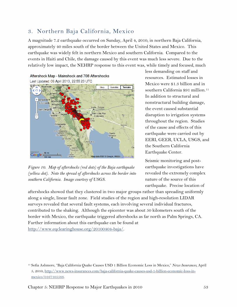
3. Northern Baja California, Mexico A magnitude 7.2 earthquake occurred on Sunday, April 4, 2010, in northern Baja California, approximately 40 miles south of the border between the United States and Mexico. This earthquake was widely felt in northern Mexico and southern California. Compared to the events in Haiti and Chile, the damage caused by this event was much less severe. Due to the relatively low impact, the NEHRP response to this event was, while timely and focused, much
less demanding on staff and resources. Estimated losses in Mexico were $1.3 billion and in southern California $91 million.11 In addition to structural and nonstructural building damage, the event caused substantial disruption to irrigation systems throughout the region. Studies of the cause and effects of this earthquake were carried out by EERI, GEER, UCLA, USGS, and the Southern California Earthquake Center.
Seismic monitoring and post-earthquake investigations have revealed the extremely complex nature of the source of this earthquake. Precise location of
aftershocks showed that they clustered in two major groups rather than spreading uniformly along a single, linear fault zone. Field studies of the region and high-resolution LIDAR surveys revealed that several fault systems, each involving several individual fractures, contributed to the shaking. Although the epicenter was about 50 kilometers south of the border with Mexico, the earthquake triggered aftershocks as far north as Palm Springs, CA. Further information about this earthquake can be found at http://www.eqclearinghouse.org/20100404-baja/.
Figure 10. Map of aftershocks (red dots) of the Baja earthquake (yellow dot). Note the spread of aftershocks across the border into southern California. Image courtesy of USGS.
11 Sofia Ashmore, “Baja California Quake Causes USD 1 Billion Economic Loss in Mexico,” News Insurances, April
5, 2010, http://www.news-insurances.com/baja-california-quake-causes-usd-1-billion-economic-loss-in-
mexico/0167105588.
Chapter 5: NEHRP Response to Major Earthquakes in 2010 53

4. New Zealand On September 3, 2010, a magnitude 7.0 earthquake occurred on the South Island of New Zealand, about 25 miles west of Christchurch.12 Although there was no loss of life due to this earthquake, structural and nonstructural damage was sustained in the nearest town, Darfield, and in Christchurch. Total losses are estimated to be about $3 billon.13 There was unusually widespread soil failure, or liquefaction, that damaged roadways, bridges, and other lifelines.
Because New Zealand is an advanced country with modern building codes and well-developed seismic monitoring and notification facilities (that remained intact), there was little need for immediate response by the NEHRP agencies. Nevertheless, there were lessons to be learned from the structures that were damaged, those that were not, and the characteristics of the liquefaction features. EERI and the PEER Center sent a reconnaissance team that included members from USGS, the California Seismic Safety Commission, and private interests. The most important observations of this team were that there was considerable damage to unreinforced masonry buildings that had not been strengthened, widespread liquefaction and resulting damages to buildings on soft and sandy soils, and substantial damage to building contents and nonstructural components.14 More information on this event can be found at http://eqclearinghouse.org/20100903-christchurch/.
12 The date is according to Coordinated Universal Time (UTC). The local date was September 4, 2010. This was
the first of two recent earthquakes near Christchurch. A second of magnitude 6.1, nearer to Christchurch,
occurred on February 21, 2011, falling outside the timeframe of this report. The second earthquake caused
much heavier damage in Christchurch.
13 New Zealand Earthquake Commission, “EQC Revises Its Cost Estimate for Canterbury Earthquake,” December
20, 2010, http://www.eqc.govt.nz/abouteqc/publications/mediastatements/revised-estimate.aspx.
14 EERI, Learning from Earthquakes: The Mw 7.1 Darfield (Canterbury), New Zealand Earthquake of September 4, 2010,
EERI Special Earthquake Report, November 2010,
http://www.eeri.org/site/images/eeri_newsletter/2010_pdf/EERI_NewZealand_EQRpt-web.pdf.
Page 54

Chapter 6
Related Activities Supporting NEHRP Goals
Public Law 108–360, the Earthquake Hazards Reduction Program Reauthorization Act of 2004, requires that the annual report to Congress include a description of activities being carried out by the National Earthquake Hazards Reduction Program (NEHRP) agencies that contribute to NEHRP goals but are not officially included in the program. Highlights of these programs and activities are described below.
6.1 Interagency Committee on Seismic Safety in Construction The Interagency Committee on Seismic Safety in Construction (ICSSC) is a formal federal executive branch body of representatives from agencies that are associated with seismic design and construction of government facilities. The ICSSC met in 2009 and 2010, primarily focusing on standards for seismic evaluation and rehabilitation of existing buildings that are owned or leased by federal agencies. Through the NEHRP Secretariat, the ICSSC is now working with the Building Seismic Safety Council to update the federal standards for evaluating and rehabilitating existing buildings. The update process is based on a philosophy of maximizing the use of national model building codes and standards, in keeping with the directives issued to the agencies in the Office of Management and Budget’s Circular A-119.
6.2 EarthScope EarthScope is a multidisciplinary earth science program aimed at exploring in unprecedented detail the four-dimensional structure, dynamics, and evolution of North America. EarthScope is supported by the National Science Foundation (NSF) in partnership with the U.S. Geological Survey (USGS) and the National Aeronautics and Space Administration (NASA). The EarthScope Facility, successfully completed in September 2008, comprises three core components: the Plate Boundary Observatory, the San Andreas Fault Observatory at Depth, and the United States Seismic Array. To date, more than 1,100 permanent global positioning system (GPS) stations, 1,200 seismic stations, 80 strainmeters, 280 magnetotelluric stations, and 21 tiltmeters have been installed as part of the EarthScope Facility. The EarthScope Facility, and more broadly the EarthScope program, provides a framework for broad, integrated studies of fault properties and earthquake processes, and for the analysis of seismic and volcanic hazards, fluids, and magma in the crust and mantle, plate-boundary processes, large-scale continental deformation, continental structure and evolution, and deep-Earth structure. EarthScope has developed the cyberinfrastructure to integrate, distribute, and
Chapter 6: Related Activities Supporting NEHRP Goals 55

analyze the diverse data sets collected by the facilities. In addition, the EarthScope Education and Outreach Program is actively engaging the general public, educators, and students to teach them about EarthScope science and to promote science literacy.
San Andreas Fault Observatory at Depth The San Andreas Fault Observatory at Depth (SAFOD) is a 3-kilometer deep hole drilled directly into the San Andreas fault, midway between San Francisco and Los Angeles, near Parkfield, CA. SAFOD is providing the first opportunities to observe directly the conditions under which earthquakes occur and to collect rocks and fluids from the fault zone for laboratory study. SAFOD also includes a long-term observatory intended to continuously monitor the physical conditions within an active earthquake nucleation zone. Data collected by SAFOD are providing unique insights into the physical and material conditions within a zone of active faulting. Analysis of the SAFOD core is well under way. At the 2010 American Geophysical Union Fall Meeting, more than 35 papers presented results from studies of SAFOD core, including information on the roles of different minerals and fault fluids in earthquake and faulting processes.
Plate Boundary Observatory The Plate Boundary Observatory (PBO) is a geodetic observatory designed to study the three-dimensional strain field resulting from deformation across the active boundary zone between the Pacific and North American plates in the western United States. PBO includes 1,200 GPS stations, 80 strainmeters, and 79 seismic stations. PBO’s regional-scale geodetic network has provided surprising new information on the Pacific-North American plate boundary, showing for example that extension in the Basin and Range Province is not uniform, as was once widely believed, but instead focused near its western and eastern edges. In addition, PBO GPS measurements are being used to understand the distribution of soil moisture and snow depth, key inputs to climate models, across the western United States, and vegetation greenness, a measure of the health of the environment and of environmental response to drought.
United States Seismic Array The United States Seismic Array (USArray) is a continent-scale seismic and magnetotelluric observatory designed to provide a foundation for integrated studies of continental lithosphere and deep Earth structure over a wide range of scales. USArray consists of four major components: (1) a Reference Network of permanent seismic stations that forms part of the Advanced National Seismic System (ANSS), (2) a Transportable Array of about 400 seismic stations, (3) a Flexible Array pool of approximately 2,100 portable seismic instruments for use in experiments proposed by individual scientists, and (4) a Magnetotelluric Array with permanent and transportable instruments. The Transportable Array is a rolling network of seismometers, moving from west to east across the United States, with stations spaced every 70 kilometers. The first stations were installed in 2004 in California, and the stations should cross
Page 56

the Mississippi River in March 2011. To date, approximately 1,100 Transportable Array stations have been deployed.
6.3 Subcommittee on Disaster Reduction The Subcommittee on Disaster Reduction (SDR) is an element of the President’s National Science and Technology Council and facilitates national strategies for reducing disaster risks and losses that are based on effective use of science and technology.
Mitigating natural and technological disasters requires a solid understanding of science and technology, rapid implementation of research information into disaster reduction programs and applications, and efficient access to diverse information available from both public and private entities. Chartered in 1988, the SDR provides a unique federal forum for information sharing; development of collaborative opportunities; formulation of science- and technology-based guidance for policy makers; and dialogue with the U.S. policy community to advance informed strategies for managing disaster risks.
Representatives of NEHRP participate in SDR meetings and provide briefings on program developments. SDR serves as a forum for NEHRP agencies to reach out to and coordinate with other federal agencies doing work related to NEHRP goals and objectives. In February 2010 SDR published a report entitled “Science and Technology Responding to the Earthquake in Haiti: An Initial Survey of Federal Agency Efforts.
6.4 International activities
U.S.-Japan Cooperative Program on Natural Resources In 1964, the United States and Japan established the U.S.-Japan Cooperative Program on Natural Resources (UJNR) to promote bilateral cooperation in research and data exchange. Today, the UJNR involves 18 U.S. agencies and 10 Japanese agencies. The NEHRP agencies play important roles in the UJNR panels on wind and seismic effects and on earthquake research. The U.S. sides of these panels are chaired by the National Institute of Standards and Technology (NIST) and USGS, respectively.
U.S.-Japan Panel on Wind and Seismic Effects
After about 2 years of limited interaction with Japan, the NEHRP Secretariat initiated discussions with leaders at Japan’s Building Research Institute and Public Works Research Institute about reinvigorating the 40-year relationship that facilitates information exchange and research cooperation between the two nations. These contacts led to informal discussions in late 2010, with plans for a formal meeting of leaders representing the two nations’ wind and earthquake engineering research programs in early 2011.
Chapter 6: Related Activities Supporting NEHRP Goals 57

Page 58
U.S.-Japan Panel on Earthquake Research
The eighth joint meeting of the UJNR Panel on Earthquake Research was held in Nagaoka, Japan, in 2010. The 21 members of the U.S. delegation to the meeting included representatives from USGS, NIST, NASA, the Southern California Earthquake Center, and UNAVCO, and 8 early-career scientists supported by NSF and USGS. The meeting included very productive exchanges of information on approaches to systematic observation and modeling of earthquake processes. The technical sessions focused on the earthquake cycle, episodic tremor and slow slip, strong-motion prediction and seismic hazards, early warning and rapid assessment of earthquakes and tsunamis, and studies of recent earthquakes. A field trip was also held to the epicentral region of the 2004 Niigata Chuetsu earthquake, and to the Kashiwazaki Nuclear Power Plant, the world’s largest, that was damaged by the 2007 Niigata Chuetsu Oki earthquake.
U.S.-China cooperation in earthquake studies Cooperation between the United States and China in earthquake studies continued with a high level of activity during 2010, focusing on three broad topics: (1) geophysical data exchange (including strong-motion data) and a discussion of main lessons learned from the deadly 2008 Wenchuan earthquake; (2) initiation of significant technical upgrades to the jointly operated China Digital Seismic Network (CDSN), which consists of 10 broadband observatory-grade seismographic installations; and (3) technical exchanges on topics that included seismic and landslide hazard maps, seismo-tectonics, earthquake aftershock probabilistic forecasting (as presently is done in California), seismic and GPS network operations, and strong ground motion data processing and analysis.
NEES sharing results and facilities with foreign interests The George E. Brown, Jr. Network for Earthquake Engineering Simulation (NEES), through NEEScomm, has continued its collaboration with the E-Defense program in Japan, administered by the National Research Institute for Earth Science and Disaster Prevention. During 2010 NEEScomm entered into agreements with the Port and Airport Research Institute (PARI) of Japan in which the parties agree to cooperate in the implementation of joint research on earthquake and tsunami engineering, sharing NEES and PARI facilities.
In addition to the two cooperative efforts with Japan, NEES is engaged in ongoing discussions with the European Union, Canada, China, and Taiwan to share data and facilities and conduct joint experiments. The director of NEEScomm visited China in March 2010 and met with research engineers and scientists from 14 universities and institutes and officials from the National Science Foundation of China to discuss opportunities for research collaboration. This visit laid the foundation for a workshop held at Purdue University in August 2010 involving 17 participants from China and 21 research and NSF officials from the United States.

Appendix A
Cooperating Organizations Receiving NEHRP Support
During 2010, NEHRP provided partial support in the form of either contracts or financial assistance for the following organizations, either directly or through a recipient, to advance NEHRP goals and objectives. This listing does not include the many academic institutions to which NEHRP provides financial assistance for individual research grants and cooperative agreements. For each organization that is presented, a link to its Internet website is provided.
Applied Technology Council The Applied Technology Council (ATC) is a nonprofit corporation established in 1973 through the efforts of the Structural Engineers Association of California. ATC's mission is to develop and promote state-of-the-art, user-friendly engineering resources and applications for use in mitigating the effects of natural and other hazards on the built environment. ATC also identifies and encourages needed research and develops consensus opinions on structural engineering issues in a nonproprietary format. Project work is conducted by a wide range of highly qualified consulting professionals, thus incorporating the experience of many individuals from academia, research, and professional practice who would not be available from any single organization. Funding for ATC projects is obtained from government agencies and from the private sector. (http://www.atcouncil.org)
Consortium of Universities for Research in Earthquake Engineering The Consortium of Universities for Research in Earthquake Engineering (CUREE) is a nonprofit organization, established in 1988, which is devoted to the advancement of earthquake engineering research, education, and implementation. CUREE’s membership, comprising some two dozen universities and many associated faculty members, works to identify new ways that research can solve earthquake problems; to collect and synthesize information and make it easily accessible; to establish national and international hazard research relationships; to perform earthquake engineering and related research; to manage research consortia and cooperative programs; and to educate experts, practitioners, students, and the public. (http://www.curee.org)
Earthquake Engineering Research Institute (EERI) EERI is a national, nonprofit, technical society of engineers, geoscientists, architects, planners, public officials, and social scientists. EERI members include researchers, practicing
Appendix A: Cooperating Organizations Receiving NEHRP Support 59

professionals, educators, government officials, and building code regulators. The objective of EERI is to reduce earthquake risk by (1) advancing the science and practice of earthquake engineering, (2) improving understanding of the impact of earthquakes on the physical, social, economic, political, and cultural environment, and (3) advocating comprehensive and realistic measures for reducing the harmful effects of earthquakes.
In 2009, EERI organized a new seminar series on the topic of soil liquefaction during earthquakes. The seminars discussed recent progress in the evaluation of liquefaction hazards during earthquakes and gave participants the tools to assess the potential for triggering liquefaction, its consequences, and its mitigation. More than 300 participants attended the seminars. A second series of seminars focusing on practitioners on the East Coast and in the Midwest were held in April and May of 2010.
Each year, EERI issues at least one new oral-history publication with support from the Federal Emergency Management Agency (FEMA). These important publications help preserve the historical record of earthquake science and engineering and are critical to providing a sense of history to those active in the earthquake field as well as those young people considering it as a career. In early 2010, EERI published the oral history of Professor Robert Whitman of the Massachusetts Institute of Technology.
The long-awaited Contributions of Earthquake Engineering was completed and distributed in 2010. EERI believes that this document is a valuable tool for demonstrating how investments in earthquake engineering and science have resulted in technical advances that apply beyond earthquakes to other hazards, civil infrastructure, applied information technology, and homeland security. This publication will also help demonstrate the value and far-ranging consequences of earthquake engineering and science research and implementation to other federal agencies, Congress, and state and local governments.
EERI and the Canadian Association for Earthquake Engineering held the 9th U.S. National and 10th Canadian Conference on Earthquake Engineering: Reaching Beyond Borders, during July 25–29, 2010, in Toronto, Ontario, Canada. More than 700 papers were accepted for oral presentations and another 200 for poster presentations. Attendance topped 900, with participants from throughout North and South America, Europe, and Asia.
Two prestigious NEHRP FEMA/EERI fellowships are awarded annually, one to a senior graduate student and the other to a professional in an earthquake field, to enable qualified individuals to enhance their knowledge and improve their professional capabilities. The current Professional Fellow is working on multidisciplinary research into a novel approach to improve seismic hazard assessment and ground motion simulation by applying machine learning tools.
Since 2006, EERI's Student Activities Committee has overseen the Undergraduate Seismic Design Competition (SDC). Today the competition is an exciting fixture of EERI Annual
Page 60

Meetings. This past February in San Francisco, approximately 200 undergraduate students from 22 teams took part in the largest SDC to date.
The mission of the EERI Earthquake Mitigation Center is to promote and encourage reduction of earthquake risk through the development and dissemination of information related to the assessment and mitigation of earthquake risks. The center continues to be a work in progress, aimed at providing products and programs to encourage the seismic rehabilitation of buildings and lifelines in all seismically prone regions of the United States. Last year, EERI gained access to the slide library of the California Office of Emergency Services, Bay Area Regional Earthquake Preparedness Project. EERI scanned the annotated slide presentations and added them to the resources of the mitigation center website, making them available to seismic safety advocates, engineers, and others throughout the United States and the world. EERI also has completed preliminary work on a web interface to provide access to a photo database of thousands of images from earthquakes taken over the past several years by team members in EERI's Learning from Earthquakes Program. The images are now accessible through the mitigation center website, along with the images obtained from the California Office of Emergency Services. (http://www.eeri.org)
Incorporated Research Institutions for Seismology The Incorporated Research Institutions for Seismology (IRIS) is a National Science Foundation (NSF)-supported university research consortium dedicated to exploring the Earth’s interior through the collection and distribution of seismographic data. IRIS partners with the U.S. Geological Survey (USGS) in the operation of the Global Seismographic Network, which provides data for global seismological research and is one of the primary data sources used by the USGS National Earthquake Information Center in tracking global earthquake activity. The IRIS Program for Array Seismic Studies of the Continental Lithosphere loans portable seismograph systems for national and international field investigations, including many that have contributed to studies of earthquakes and Earth structure under NEHRP. The IRIS Education and Outreach Program enables audiences beyond seismologists to access and use seismological data and research for educational purposes. The IRIS United States Seismic Array (part of the NSF-funded EarthScope project) includes permanent stations that have contributed to the USGS Advanced National Seismic System (ANSS) as well as portable stations that are systematically collecting data from across the continental United States. Data collected by all of these IRIS programs are assessed, archived, and distributed by the IRIS Data Management System, along with data contributed from numerous national and international sources, including ANSS, U.S. regional networks, and other NEHRP programs. (http://www.iris.edu)
National Institute of Building Sciences Congress chartered the National Institute of Building Sciences (NIBS) in 1974 as an independent, nongovernmental, nonprofit organization. NIBS balances public and private
Appendix A: Cooperating Organizations Receiving NEHRP Support 61

expertise to mobilize uniquely authoritative support for the public interest in building sciences, engineering, construction, and technology. NIBS involves the national building community in shaping its program and priorities through its Consultative Council; other councils address specific issues in security and disaster preparedness, facility performance and sustainability, and information resources and technologies. (http://www.nibs.org)
Since 1979, the Building Seismic Safety Council (BSSC) of NIBS has provided a national forum for improving earthquake-resistant design and construction, benefiting both the building community and the public in general. Supported by some 65 voting member organizations, the BSSC has been involved in developing the 2009 NEHRP Recommended Seismic Provisions for New Buildings and Other Structures (FEMA P-750), and in working with FEMA on practical building code applications of these provisions. (http://www.bssconline.org)
Natural Hazards Center The University of Colorado Natural Hazards Center (NHC) is a boundary organization that inhabits a central niche within networks of hazard-related knowledge production, dissemination, and application. NHC activities seek to build societal capacity to manage hazards through linking knowledge, policy, and practice and providing physical and virtual “spaces” in which diverse communities can interact. The NHC disseminates information on extreme events and their management to researchers in hazard-related disciplines, students in those disciplines, hazard management practitioners, policy makers and agency personnel, private-sector organizations concerned with reducing losses from extreme events, and other audiences.
The NHC helps researchers from a variety of disciplines become familiar with one another’s work while also ensuring that researchers come to better understand the challenges faced by officials responsible for loss-reduction policies and programs at various governmental levels and in the private sector. Recently the center has also stepped up its efforts to place hazards within the context of broader environmental issues such as climate change and variation and to establish linkages with research communities in those areas.
NHC products include the Natural Hazards Observer newsletter; one of the most widely used websites in the hazards field; the biweekly electronic newsletter Disaster Research; a listserv for student researchers; the American Society of Civil Engineers journal Natural Hazards Review, which is co-edited by the NHC director; monographs and special publications; and library and information services. NHC feeds are also available on Twitter at HazCenter.
NSF funding enables the NHC to award small travel grants for post-disaster quick-response research. The center’s largest groups of awards to date were made following the 9-11 terrorist attacks and Hurricane Katrina, and it also funded quick-response projects after the 2010 Haiti earthquake.
Page 62

The NHC Hazards Workshop, held annually in July, typically attracts several hundred participants from the United States and around the world. The workshop is organized around keynote talks and plenary and concurrent sessions, based on topics suggested by researchers, practitioners, NHC staff, and federal, state, and local agency personnel. Plenary sessions at the 2010 workshop focused on findings from the National Research Council’s “America’s Climate Choices” study, the Haiti earthquake, and the BP Deepwater Horizon oil spill.
NHC personnel communicate extensively with the mass media and the general public on issues related to hazards, disasters, and risk. In 2010, commentaries by the NHC director on the Haiti earthquake appeared on CNN.com and on the website of Campus Progress. She was also featured in a National Public Radio story on post-disaster research in Haiti, in Associated Press stories that appeared in numerous media outlets, on the Science Daily website, and in a November 2010 issue of Scientific American Mind. The director and assistant director appeared on Denver’s PBS television station for interviews on the Haiti earthquake and the Deepwater Horizon oil spill, respectively. The director was also interviewed on the Boulder, CO, public radio station KGNU during the September 2010 Fourmile Wildfire. Parts of that interview appeared in a number of other media outlets.
The center is supported by a consortium of NEHRP and other federal agencies. (http://www.colorado.edu/hazards/)
Southern California Earthquake Center The Southern California Earthquake Center (SCEC), headquartered at the University of Southern California, was founded in 1991 with a mission to
− gather data on earthquakes in southern California and elsewhere;
− integrate information into a comprehensive and physics-based understanding of earthquake phenomena; and
− communicate that understanding to society at large as useful knowledge for reducing earthquake risk.
A community of over 600 scientists from 16 core institutions, 47 participating institutions, and elsewhere participate in SCEC. SCEC also partners with a large number of other research, education, and outreach organizations in many disciplines. During 2010, the center was in the fourth year of its third phase, SCEC3, a 5-year program funded by NEHRP partners NSF and USGS.
To support this community, SCEC engages in information technology research that will revolutionize our methods of doing collaborative research and distributing research products online. In addition, the SCEC Communication, Education, and Outreach Program offers student research experiences, web-based education tools, classroom curricula, museum displays,
Appendix A: Cooperating Organizations Receiving NEHRP Support 63

public information brochures, online newsletters, and technical workshops and publications. (http://www.scec.org)
Regional Earthquake Consortia
Cascadia Region Earthquake Workgroup (CREW)
The Cascadia Region Earthquake Workgroup (CREW) is a coalition of private and public representatives working together to improve the ability of the Cascadia region to reduce the effects of earthquake events. In fiscal year (FY) 2010, CREW created a public education document to address the crustal earthquake risk in the Cascadia region of northern California, Oregon, Washington, and British Columbia. The CREW document discusses how science, safety, and preparedness can help private and public sectors in the area to be more resilient to earthquake effects. CREW, in coordination with the Pacific Northwest Seismic Network, EERI, and Urban Design and Planning, also organized an open educational discussion to discuss lessons learned from local and global impacts of and responses to the 2010 Haiti and Chile earthquakes and how they relate to the Cascadia area. (http://www.crew.org/)
Central United States Earthquake Consortium (CUSEC)
The eight-state CUSEC region, which also includes FEMA Regions IV, V, VI, and VII, was very active in FY 2010. In the area of public outreach, CUSEC worked in close partnership with the University of Memphis Center for Earthquake Research and Information (CERI), EERI, and USGS on New Madrid earthquake bicentennial activities that will take place throughout 2011. CUSEC also worked with SCEC to develop the ShakeOut program for the central United States. The goal of 1 million participants has been set for the first such ShakeOut, with more than 300,000 already signed up. Work also is continuing on the educational CUSEC State GeoCache Initiative, the first of its kind in the United States. This project is utilizing a fun and family-oriented geocaching experience to expand the outreach efforts of CUSEC in a new and unique way. CUSEC also completed and distributed the Central U.S. Earthquake Guide, which provides information on earthquake science, past earthquakes, earthquake preparedness, and mitigation, and continued to publish the CUSEC Journal, a quarterly e-mail and web-based publication.
Training continued to be a mainstay of CUSEC efforts. A nonstructural mitigation for hospitals workshop focused on providing hospital officials with a greater understanding of earthquake mitigation techniques. The “Get Your Home Ready for Earthquakes” seminar helped homeowners to understand the importance of earthquake risk reduction, and participants learned how to inspect buildings for potential seismic hazards through a FEMA training course sponsored by CUSEC. The consortium also sponsored FEMA training on how to conduct post-earthquake safety evaluations of buildings. (http://www.cusec.org/)
Page 64

Northeast States Emergency Consortium (NESEC)
The most effective way to reduce seismic vulnerability is for government jurisdictions to adopt and enforce building codes that include strong seismic provisions. In the Northeast, where many jurisdictions have not yet adopted strong seismic building codes, it is important to promote and support their adoption and enforcement. To address this issue, NESEC continued to develop and enhance the online Hazard-Resistant Building Code Database, which allows the public in the Northeast States to determine if their state and local jurisdictions have building code regulations for earthquakes and other hazards. By entering their zip code at http://www.nesec.org/building_codes/, citizens can obtain state-level building code and enforcement data. NESEC also provides the public with information on how to request building code enforcement ratings and grades for their community.
NESEC continues to operate the HAZUS-MH and GIS Emergency Management Risk Assessment Center. NESEC’s priority is to provide direct HAZUS-MH and GIS support to states and local jurisdictions that do not have an in-house capability (they can click this link to request assistance: http://www.nesec.org/resources/). HAZUS-MH information provides the spatial and temporal backdrop on which effective and efficient earthquake risk and loss assessment can be accomplished. This information, coupled with infrastructure data, can help to mitigate the impact of earthquakes and other hazards. NESEC has conducted numerous HAZUS-MH studies of the potential impact of earthquakes striking in New York City, Boston, and New England. The results have been used to support the development of state and local hazard mitigation plans and strategies in the Northeast.
In November 2009, NESEC hosted a national meeting of state earthquake program managers and other NEHRP partners from across the Nation. The group met in Cambridge, MA, to learn from past earthquakes, share best practices, and discuss programs and policies to accelerate the implementation of earthquake loss reduction and mitigation strategies. (http://www.nesec.org/)
Western States Seismic Policy Council (WSSPC)
WSSPC, a regional earthquake consortium for western states, is headquartered in Sacramento, CA. WSSPC members are the directors of state geological surveys and state emergency management departments from 13 western states, 3 U.S. territories, a Canadian territory, and a Canadian province, and liaisons from 7 western-state seismic safety councils and commissions.
In FY 2010, WSSPC adopted nine policy recommendations in the areas of tsunami identification and evacuation notification, post-earthquake clearinghouses and information management systems, adoption of seismic provisions in the International Building Code, seismic design of new schools, and identifying and mitigating hazards in seismically vulnerable schools. WSSPC member states were surveyed about their adoption of the WSSPC policy recommendations, and the survey results will be used as a baseline for gauging future progress
Appendix A: Cooperating Organizations Receiving NEHRP Support 65

Page 66
on adoption of policies that reduce earthquake losses. Policy survey results are available on the WSSPC website at www.wsspc.org.
WSSPC organized an earthquake early warning session held at the NHC Hazards Workshop. Speaker presentations were filmed and are posted on the WSSPC website. In FY 2010, WSSPC also redesigned its website and added content on “Earthquake and Tsunami Resources and Mitigation.” Annual state reports and WSSPC Annual Reports are also available on the site. (http://www.wsspc.org)

Appendix B
NEHRP Management Chronology
Table B.1—Chronology of Fiscal Year (FY) 2010 NEHRP Management Meetings
ACEHR Advisory Committee on Earthquake Hazards Reduction
ICC Interagency Coordinating Committee on Earthquake Hazards Reduction
PCWG Program Coordination Working Group
Date Committee Location
October 20, 2009 PCWG National Science Foundation (NSF)
November 23–24, 2009 ACEHR NSF
January 5, 2010 ACEHR Conference call
January 28, 2010 PCWG NSF
February 17, 2010 PCWG NSF
February 26, 2010 ICC Office of Science and Technology Policy
March 15–16, 2010 ACEHR National Institute of Standards and
Technology
March 25, 2010 PCWG NSF
April 26, 2010 PCWG NSF
April 28, 2010 ACEHR Conference call
June 25, 2010 PCWG NSF
August 3, 2010 PCWG NSF
Appendix B: NEHRP Management Chronology 67

Page 68

Appendix C
List of Acronyms
ACCESS Advancement of Cyberinfrastructure Careers through Earthquake System Science
ACEHR Advisory Committee on Earthquake Hazards Reduction
ANSS Advanced National Seismic System
ARRA American Recovery and Reinvestment Act
ASCE American Society of Civil Engineers
ATC Applied Technology Council
BCAT Building Code Adoption Tracking
BCEGS Building Code Effectiveness Grading Schedule
BSSC Building Seismic Safety Council
Cal EMA California Emergency Management Agency
CDSN China Digital Seismic Network
CEA California Earthquake Authority
CERI Center for Earthquake Research and Information
CISN California Integrated Seismic Network
CREW Cascadia Region Earthquake Workgroup
CRSC Code Resource Support Committee
CUREE Consortium of Universities for Research in Earthquake Engineering
CUSEC Central United States Earthquake Consortium
DHS U.S. Department of Homeland Security
ECA Earthquake Country Alliance
EDAT Earthquake Disaster Assistance Team
EERI Earthquake Engineering Research Institute
EMD Emergency Management Division (State of Washington)
ENS Earthquake Notification Service
EOT Education, Outreach, and Training
Appendix C: List of Acronyms 69

EROS Earth Resources Observation and Science
ETS Episodic Tremor and Slip
FEMA Federal Emergency Management Agency
FY Fiscal Year
GEER Geo-Engineering Earthquake Reconnaissance Association
GIS Geographic Information System
GPS Global Positioning System
GSN Global Seismographic Network
HAZUS-MH Hazards U.S.-Multihazard
IBC International Building Code
IBHS Idaho Bureau of Homeland Security
ICC Interagency Coordinating Committee
ICC-ES International Code Council Evaluation Service
ICSSC Interagency Committee on Seismic Safety in Construction
IDR Inter-story Drift Ratio
IEBC International Existing Building Code
IGS Idaho Geological Survey
IMPACT Information Management and Performance Assessment Calculation Tool
IRC International Residential Code
IRIS Incorporated Research Institutions for Seismology
ISO Insurance Services Office
MDOF Multiple Degree of Freedom
MHDP Multi-Hazards Demonstration Project
NCJV NEHRP Consultants Joint Venture
NEES George E. Brown, Jr. Network for Earthquake Engineering Simulation
NEEScomm NEES Community and Communication Center
NEESinc NEES Consortium, Inc.
NEHRP National Earthquake Hazards Reduction Program
NEIC National Earthquake Information Center
Page 70

NESC Nevada Earthquake Safety Council
NESEC Northeast States Emergency Consortium
NETAP National Earthquake Technical Assistance Program
NHC Natural Hazards Center
NIBS National Institute of Building Sciences
NIST National Institute of Standards and Technology
NLE National Level Exercise
NMSZ New Madrid Seismic Zone
NOAA National Oceanic and Atmospheric Administration
NSF National Science Foundation
NYS New York State
OFDA Office of Foreign Disaster Assistance
PAGER Prompt Assessment of Global Earthquakes for Response
PARI Port and Airport Research Institute
PBO Plate Boundary Observatory
PBSD Performance-Based Seismic Design
PCWG Program Coordination Working Group
PEER Center Pacific Earthquake Engineering Research Center
PR Puerto Rico
PREMA Puerto Rico Emergency Management Agency
RAPID Rapid Response Research Grant
REU Research Experiences for Undergraduates
ROVER Rapid Observation of Vulnerability and Estimation of Risk
SAFOD San Andreas Fault Observatory at Depth
SCEC Southern California Earthquake Center
SDC Undergraduate Seismic Design Competition
SDOF Single Degree of Freedom
SDR Subcommittee on Disaster Reduction
SoSAFE Southern San Andreas Fault Evaluation Project
Appendix C: List of Acronyms 71

SRA Spectral Response Acceleration
SURE Summer Undergraduate Research Experiences
UC University of California
UCLA University of California, Los Angeles
UCERF Uniform California Earthquake Rupture Forecast
UJNR U.S.-Japan Cooperative Program on Natural Resources
USACE U.S. Army Corps of Engineers
USAID U.S. Agency for International Development
USArray United States Seismic Array
UseIT Undergraduate Studies in Earthquake Information Technology
USGS U.S. Geological Survey
UW University of Washington
WSGS Wyoming State Geological Survey
WSSPC Western States Seismic Policy Council
Page 72

Appendix D
Notable Earthquakes of 2010
This appendix gives a chronology of notable earthquake activity worldwide during the period from October 1, 2009, through September 30, 2010.15
January 10, 2010. Off coast of northern California. Magnitude 6.5.
The earthquake struck at 4:27 p.m. (Pacific time) just to the west of Eureka, CA. The shock was strongly felt in Eureka and Ferndale and caused light to moderate damage in these towns.
January 12, 2010. Near Port-au-Prince, Haiti. Magnitude 7.0.
The epicenter of the earthquake was only 10 miles from Port-au-Prince, the bustling capital city of this Caribbean country. One of the most destructive natural disasters in history, the quake reduced buildings to rubble, instantly taking lives and destroying homes. According to official estimates, 222,570 people were killed, 300,000 were injured, 1.3 million were displaced, 97,294 houses were destroyed, and 188,383 homes were damaged in the Port-au-Prince area and in much of southern Haiti. The number of deaths include at least 4 people killed by a local tsunami in the Petit Paradis area near Leogane.
February 10, 2010. Illinois. Magnitude 3.8.
This earthquake was widely felt in northeastern Illinois and the Chicago area, raising public concern. No damages were reported.
February 27, 2010. Offshore Maule, Chile. Magnitude 8.8.
At least 521 people were killed, 56 were reported missing, about 12,000 were injured, and 800,000 were displaced, and at least 370,000 houses, 4,013 schools, 79 hospitals, and 4,200 boats were damaged or destroyed by the earthquake and the ensuing tsunami in the Valparaiso-Concepcion-Temuco area. At least 1.8 million people were affected in Araucania, Bio-Bio, Maule, O'Higgins, Region Metropolitana, and Valparaiso. The total economic loss in Chile was estimated at 30 billion U.S. dollars. Electricity, telecommunications, and water supplies were
15 Events included here are considered noteworthy in terms of magnitude, location (areas of high or low
seismicity), or impact (e.g., physical impact on lives and property, psychosocial impact on earthquake awareness in
areas where felt earthquakes are infrequent). This list is not intended to be all-inclusive.
Appendix D: Notable Earthquakes of 2010 73
disrupted and the airports at Concepcion and Santiago had minor damage. The tsunami damaged or destroyed many buildings and roads at Concepcion and other locations in Chile and in the Pacific basin. Aftershocks from this earthquake continued throughout 2010.
April 4, 2010. Northern Baja California, Mexico. Magnitude 7.2.
The magnitude 7.2 Sierra El Mayor earthquake of Sunday, April 4, 2010, occurred in northern Baja California, approximately 40 miles south of the border between the United States and Mexico. Two people were killed and at least 233 were injured in the Mexicali area. The quake caused damage to canals, drains, and water systems serving communities located in the Mexicali and San Luis valleys (California) covering an area of more than 150,000 acres. An aftershock of magnitude 5.7 occurred on June 15, 2010, near Mexicali just north of the U.S.-Mexico border.
July 7, 2010. Southern California. Magnitude 5.4.
The earthquake occurred in southern California at 4:53 p.m. (Pacific time) about 30 miles south of Palm Springs. The earthquake occurred near the Coyote Creek segment of the San Jacinto fault, which is one of the strands of the San Jacinto fault. It was followed by more than 60 aftershocks during the first hour. Although this event was widely felt in southern California, no significant damage was reported.
July 16, 2010. Gaithersburg, MD. Magnitude 3.4.
This minor earthquake was felt throughout the greater Washington, DC area, raising public concern in a region where earthquake shaking is rarely felt. No damages were reported.
September 3, 2010. Near Christchurch, New Zealand. Magnitude 7.0.
Two people were seriously injured and many buildings and structures were damaged in the Christchurch area. Widespread ground failures (liquefaction) contributed significantly to the damages. Losses were estimated at approximately $3 billion.
Page 74

Appendix D: Notable Earthquakes of 2010 75

Page 76


