STKN-12 MINIMUM FILING FEE: $100.00 FILE ORIGINAL & ONE COPY TYPE OR PRINT IN BlACK INK [Fo1 ei:plana1ion ol entrits raquirEKI, 500 boolllel' How 10 File an ApplieatiM 10 Appropriale Wa1e1 In Cal~omla') STATE OF CALIFORNIA State Water Resources Control Board DIVISION OF WATER RIGHTS 901 P Street! sacramento P. 0. Box 2000, Sacramento, CA 95812-2000 (Chock one box only) [!] APPLICATION TO APPROPRIATE WATER BY PERMIT or D REGISTRATION OF SMALL DOMESTIC USE APPROPRIATION' (II this lorm is uSOO to reg is tar a small domes1icuse appropriatjon, 1ha 1erms 'applicafon" and "applican\' herein, and in rela1ed forms, shall mean "registra1ion· and "reQis11a'lt".) 1. APPLICANT City of Stockton Application No. ?)oS3J (Lea~e blank) ( 209 ) 937 - 8700 (Name ot appl1can1) Municipal Utilities Department (Telephone number where you may be readied between 6 a. m. and 5 p. m .• incl~de area code) 425 N, El Dorado Street Stockton California 95202 (Mailing address) (City or 1own) (Stale) (Zip code) 2. SOURCE a. The name of the source al the point of diversion is --~S~•~n~J~o_a_g~u~i~n~R~i_v_e~r~---------- (U unnamed, stale lha1 '1s an unnamed stream, sp,-ing, e1q tributary to Sacramento - San Joaquin Delta {Supplement A to Paragraph 2) b. In a normal year does the stream dry up at any point downstream rrom your project? YES D NO m If yes, during what monlhs Is ii usually dry? From to ---------- Whal alternate sources are available to your project should a portion of your requested direcl diversion season be excluded because of a dry stream or nonavailability of water? overdraf ted groundwater basin 3. POINTS of DIVERSION and REDIVERSION a. The point(s) of diversion will be In the County of s an J i oaou n b. Lisi all points giving coord1na1e d1s\ancos from section_corner i Poin1 is within Township I ' Base and or other ~e as allowed by Board regula11ons i. e (40-acre subdivision) Section Range Meridian California Coordina1e System . s 5.600 1 and W 5.800' from NE I NE 1/4 ol NE 114 11 2N 4E M.D. corner of T,2N R.4E/California/ 1/4 or 1/4 coordinates: zone 3 3563500N,, I 1713000E. 114 of 1/4 c. Does applicant own the land at the point of diversion? YES D NO [Kl d. If applicant does not own the land at point ol diversion, state name and address of owner and what steps have been taken to obtain right of access: (see Supplement A to Paragraph 3) 4. PURPOSE of USE, AMOUNT and SEASON a. In the table below, state the purpose(s) for which water is to be appropriated, the quantities of water for each purpose, and lhe dates between which diversions will be made. Use gallons per day if rate is less than 0,025 cubic fool per second (approximately 16,000 gallons per day). Purpose musl only be "Domestic' for registration of small domestic use.' DIRECT DIVERSION STORAGE PURPOSE QUANTITY SEASON OF DIVERSION AMOUNT COLLECTION SEASON OF USE RATE I AMOUNT (Irrigation, Domes1ic, etc.) (Cubic fee1 p,Jr Beginnin~ Dale Ending Date Acre-feet Beginning Date Ending Dale S&COnd 01 · (Acrn·leel (Mo. & ay) (Mo. & Day) per annum (Mo. & Day) (Mo. & Day) gallons per day) , per year) ' I Municioal & 317 cfs ! 125,900 Jan, 1 Dec. 31 Industrial ; I I -- I I ' TOT Al AMOUNT TOTAL AMOUNT I 125,900 b. Total combined amount taken by direct diversion and storage during any one yearw1II be 125 • 900 ·Notto exceed 4,500 gallons per day by direct diversion or 10 acre-feel per annum by storage. WR1 (5,'91) acre,leel. \. \q /p \ ?fl efY FOR0053-R1 11 I ou
Transcript
STKN-12
MINIMUM FILING FEE: $100.00 FILE ORIGINAL & ONE COPY
TYPE OR PRINT IN BlACK INK [Fo1 ei:plana1ion ol entrits raquirEKI, 500 boolllel' How 10 File an ApplieatiM 10
Appropriale Wa1e1 In Cal~omla')
STATE OF CALIFORNIA
State Water Resources Control Board DIVISION OF WATER RIGHTS
901 P Street! sacramento P. 0. Box 2000, Sacramento, CA 95812-2000
(Chock one box only)
[!] APPLICATION TO APPROPRIATE WATER BY PERMIT or
D REGISTRATION OF SMALL DOMESTIC USE APPROPRIATION'
(II this lorm is uSOO to reg is tar a small domes1icuse appropriatjon, 1ha 1erms 'applicafon" and "applican\' herein, and in rela1ed forms, shall mean "registra1ion· and "reQis11a'lt".)
1. APPLICANT
City of Stockton
Application No. ?)oS3J (Lea~e blank)
( 209 ) 937 - 8700 (Name ot appl1can1)
Municipal Utilities Department (Telephone number where you may be readied between 6 a. m. and 5 p. m .• incl~de area code)
425 N, El Dorado Street Stockton California 95202 (Mailing address) (City or 1own) (Stale) (Zip code)
2. SOURCE
a. The name of the source al the point of diversion is --~S~•~n~J~o_a_g~u~i~n~R~i_v_e~r~---------(U unnamed, stale lha1 ~ '1s an unnamed stream, sp,-ing, e1q
tributary to Sacramento - San Joaquin Delta {Supplement A to Paragraph 2)
b. In a normal year does the stream dry up at any point downstream rrom your project? YES D NO m If yes, during what monlhs Is ii usually dry? From to ----------Whal alternate sources are available to your project should a portion of your requested direcl diversion season be excluded because of a dry stream or nonavailability of water? overdraf ted groundwater basin
3. POINTS of DIVERSION and REDIVERSION
a. The point(s) of diversion will be In the County of s an J i oaou n
b. Lisi all points giving coord1na1e d1s\ancos from section_corner i Poin1 is within Township I ' Base and or other ~e as allowed by Board regula11ons i. e (40-acre subdivision) Section Range Meridian California Coordina1e System .
s 5.600 1 and W 5.800' from NE I NE 1/4 ol NE 114 11 2N 4E M.D.
corner of T,2N R.4E/California/ 1/4 or 1/4
coordinates: zone 3 3563500N,, I 1713000E. 114 of 1/4
c. Does applicant own the land at the point of diversion? YES D NO [Kl
d. If applicant does not own the land at point ol diversion, state name and address of owner and what steps have been taken to obtain right of access: (see Supplement A to Paragraph 3)
4. PURPOSE of USE, AMOUNT and SEASON
a. In the table below, state the purpose(s) for which water is to be appropriated, the quantities of water for each purpose, and lhe dates between which diversions will be made. Use gallons per day if rate is less than 0,025 cubic fool per second (approximately 16,000 gallons per day). Purpose musl only be "Domestic' for registration of small domestic use.'
DIRECT DIVERSION STORAGE
PURPOSE QUANTITY SEASON OF DIVERSION AMOUNT COLLECTION SEASON
OF USE RATE I AMOUNT (Irrigation, Domes1ic, etc.) (Cubic fee1 p,Jr Beginnin~ Dale Ending Date Acre-feet Beginning Date Ending Dale
S&COnd 01 · (Acrn·leel (Mo. & ay) (Mo. & Day) per annum (Mo. & Day) (Mo. & Day) gallons per day) , per year)
TOT Al AMOUNT TOTAL AMOUNT I 125,900 b. Total combined amount taken by direct diversion and storage during any one yearw1II be 125 • 900 ·Notto exceed 4,500 gallons per day by direct diversion or 10 acre-feel per annum by storage. WR1 (5,'91)
acre,leel. \. \q /p \ ?fl efY
FOR0053-R1 11 I ou
~
STKN-12
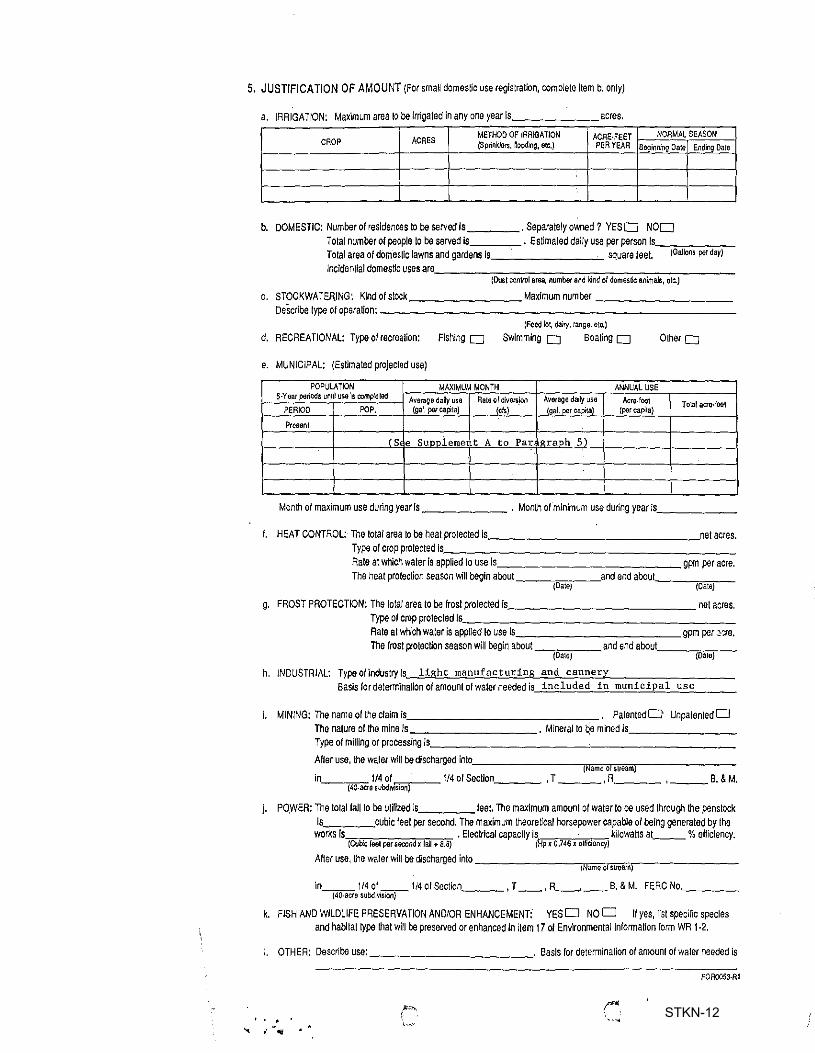
5. JUSTIFICATION OF AMOUNT (For small domestic use registration, complete Item b. only)
a IRRIGATION· Maximum area 10 be Irrigated in any one year Is acres
ACRES METHOD OF IRRIGATION ACRE-FEET NORMAL SEASON
CROP (SprinkJ11rs, ~l)oding, etc.) PER YEAR 88Qinning Dale Ending Dale
b. DOMESTIC: Number of residences to be sarved Is ____ . Separately owned? YESD NOD Total number of people to be served is . Es~maled dally use per person ls_~~-~-To!al area of domestic lawns and gardens Is square feet. (Gallons per day)
lncldentlaldomestlc uses are. ______________________ _ (Oust oon1rol area, numbor and kind of domestic animals, 11tc.)
c. STOCKWATERJNG: Kind of stock ________ Maxlmum number----------DeScribe type of operation:---------------------------
(Feed lo~ dairy, 1ang9, etc.)
d. RECREATIONAL: Typeolrecrealion: Fishing O Swimming O Boating 0 O~ero
e. MUNICIPAL: (Estimated projected use)
POPULATION MAXIMUM MONTH ANNUAL USE 5-Year periods unnl u~ '1s completed Average daily use Rate or diversion Average daily use Acre-1001
PERIOD POP. (gal, per capita) (els) (gal. per capita) (percapila) Total aa&-foot
Present
( S e Sunnleme t A to Par loraDh 5)
Month of maximum use during year Is ______ . Month of minimum use during year is. _____ _
f. HEAT CONTROL: The Iota! area to be heat protected is, ________________ ,net acres. Type or crop protected Is. _____________________ _ Aale at which water Is applied to use ls ______________ gpm per acre. The heat prolection season will begin about __ ~=-~and end about ___ =--
(Date) (Date)
g. FROST PROTECTION: The total area to be frosl protected ls _____________ net acres. Type olcropprotectedts. __________________ _ Rate at which water is appl!ed 10 use is ____________ gpm per .~·:re. The frost p-otectlon season will begin about_~---and end about ___ =--
(Oate) (Da1e)
h. INDUSTRIAL: Typeofindustryls light manufacturing and cannery Basis for determination of amount of water needed is included in municipal use
/. MIN/NG: Thenameoftheclaimis ______________ . PatentedO UnpatentedD The nature of the mlne Is . Mineral to ~e mined Is _______ _
Type of milling or processing is·-----------~----------
A~er use, the waler wlll be discharged into·---------,,,===,--------( ame o s11eam
in 1/4 of 1/4 or Section ____ , T ___ , R ____ , ___ B. & M. (40-aae subdiVJsion)
j. PO.WEA: The total fall 10 be utilized is feet. The maximum amounl or water lo be used through the penstock Is cubic feel per second. The maximum theoretical horsepower capable of being generated by the
works Is . Electrical capacity Is - . kilowatts at __ % efficiency. (Cubic feel per second x fall+ B}l) (Hp x 0.746 x eJtrt1aocy)
AHer use, the we.!er will be discharged into ________ ====--------i ame o stream
in ___ 1/4 0.1-. __ 1/4 of Section ___ , T __ , R~ __ B. & M. FERC No. ___ _ (40,acre subd1V1s1on)
k. FISH AND WILDLIFE PRESERVATION ANO/OR ENHANCEMENT: YES D NOD If yes, list specific species and habitat type that will be preserved or enhanced in item 17 ot Envlronmental lnformaUon form WR 1-2.
OTHER: Describe use: ____________ .. Basis for determination of amounl of waler needed is
FOA0053·Rl
STKN-12
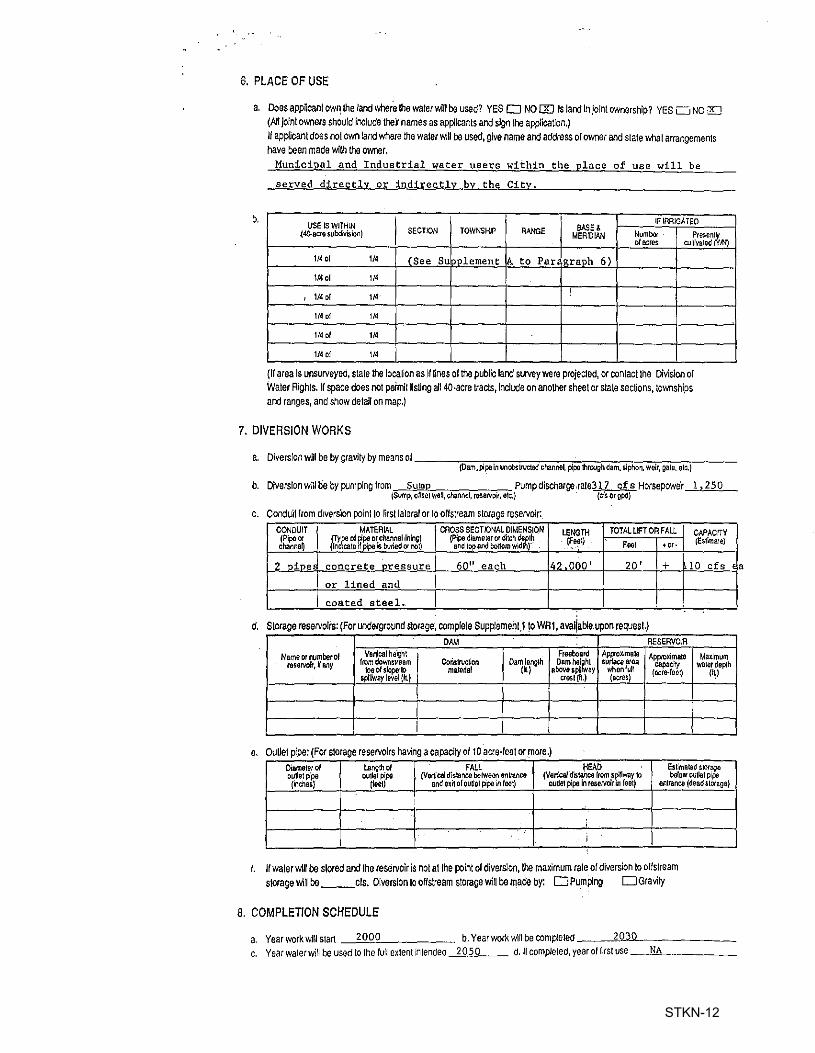
6. PLACE OF USE
a. DoesappUcanl ow~ the land wher8 Iha water will be used? YES D NO I][) Is land In Joint ownership? YES u NO t!J (All Joint owners should Include thef names as appHcants and sign !he applicat!on.)
b.
If applicant does not own lard where the waler will be used, give name and address of owner and stale what arrangements have been made wilh the owner.
Municipal and Industrial water users within the place of use will be
served directly or indirectly by the City.
USE IS WITHIN
I BASE& IF IRRIGATED
~,40.aeto subdivision) SECTION TOWNSHIP RANGE MERIDIAN Numbef Presen~ olacres cul1ivated M)
1/4 of 10 (See Su lnnlement !\. to Par oraoh 6) \/4 cl 1/4
1/.1 or 1/4 !
' 114 of 114
114 ol 1/4
1/.1 of 114
(ti area Is unsurveyed, state the location as If lines of the public lard survey were projecled, or contact the Division of Water Rights. Ir space does not peimU listing all 4-0-acre tracts, lnclUo'e on another sheet or state sections, townships and ranges, and show detall on map.)
7. DIVERSION WORKS
a. Diversion will be by gravity by means ol ___ ~-~~~~~-~-.-~~~-~-~---(Dam,Ppein unobstrvc:ted cMnne~ plpa 1hrou11hdam. siphon, weir, ~le, e1c.)
b. Diversion will be by pumping from Sum Pumpdiscllarge,rale317 cf s Horsepower~~2~5-0~-(Sump, 0Nse1 well, channel, reservo~. e1c.) {cfs or 11?dl
c. Conduit from diversion po'rnt 10 rirst laleral or 10 off stream storage reservoir:
CONDUIT MATERIAL CROSS SECTIONAL DIMENSION USNGTH TOTAlLIFTORFAU CAPACrTY (Pipeoc &,Yfei of ?,pe or channel liling) {Pipe diame1ar or ditch c.kit1h (F~l)
'"' (Es1~a1e)
cl.inne~ ieate 11 pipe is bvried or r.ot) andtopendbortomwid r . +01•
2 nine concrete oressure 60" each 4? 000' 20' + 10 cf s 1
or lined and I coated steel. ;
d. Storage reservoirs: (For underground storage, complete Supplement 1 to WAI, avatia~e.upon request.) . ·. DAM RESERVOIR
Nameornumberol Vanicalheigh\ ! Fre(lboard App-oximale Appicxlmate Maximum rese,volt, Jr a.ny from downt11eam Coristruc~on Dam len111h Damhoi~l suliace area cap,adty waterdopth
toe ol slope· ID materiel 1•1 oboves~ ay when lull (acre-leot) (CJ spillway level (It) i Cr!lSl(h.) {acres)
I ' I I
e. ouue1 pipe: (For slorage rese,volrs ha\ling a capacity of 10 acre-reet or more.) Diamtrterof Len~th of FALL HEAD Es~mated slOrSQe ouUetp'pe 01.11181 pipo (Vertical distance belWeen oritrance (Vanblfd'tS!ailca r,om spillway 1o below ou11e1 pipe (inches) (feet) and e~i1 oloullel p'pe in loot) ou~e1 pipe in reseNoir in foet) entrance (deadslorB11e)
;
; ;
f. If waler will be slored and Iha reservoir is not al the point of diverslon, !he maximum rale of diversion to off stream storage v.11 be __ els. Diversion to off see am storage v.11 be made by: D Pu.m~ng D Gra1;1y
8. COMPLETION SCHEDULE
a. Year work will s1art 2000 b. Year work wHI be compleled __ _,2",o"""'---------c. Year wa1erwill be used to the lull exlent intended 2050 d. H compleled, year ol first use ____NA_ ______ _
a
STKN-12
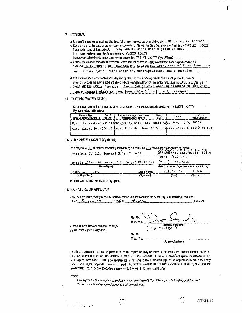
9. GENERAL
a. Name o( the p:,s/ omce most used by !hose living near lhe proposed polntol diversion Is s toe kton, California b. Does any part ol lhe place of usa oompcise a subdivision on frle with the Sia le Departmen/ of Real Esta le? YES IBJ NOD
Hyes,s!atenameollhesubdJ\'l'sron Many subdivisions within place of use. II o,, Is sulx/lvl~on ol lheS<I lands co,nlemplaled? YESD NOD Is ii planned lo lndMdually m,1ereach service conneclion? YES[!] NOD II yes, 'Mien? ________ ~
c. Lisi the names and addressas of dive rte rs of water from the source ol supply dowiistream from lhe proposed point o/ diversion: U.S. Bureau of Reclamation, California Department of Water Resources,
and various agricultural entities, municipalities, and industries,
d. Is Iha source uS<ld lor navlgaUon, lncludii,i us,, by pleasure bcals, for a ~gnincanl part ol e)ch yearat lhe polnl of diversion, or does lhe source subslanUally conulb~e lo a walerwaywtjch Is used for nallg\Uon, Including use by pleasura boats? YESC1tf NOD Jlyes,explaln: The point of diversion is 'adjacent to the Deep
Water Channei which is used. frequeri.t'1Y f~~· ma·j~r ship transport,
10. EXISTING WATER RIGHT
Do you claim an exlsllrg nghl lorlhe use ol all or part ol lhe waler sough I by lhlsapplicaUon? YES [KJ NOD If yes, com~ele !able below:
Nal\Jre ofRi]hl Year of fv~ of vs e made In recan1 year1 Season Source location of {r'p.anln,~.oro~11•r.) F'rnllhe hdvdrli;i M1ouni IH:nown o/Ust Point of Diversion
Rieht to wastew£ ter dis Pharged by City (See ~ater Cc de Sec. 121( , 7075)
Citv claims bem fit of ..rater Code Sections I 15 et eq,' 1485, 6 11460 et s
11. AUTHORIZED AGENT (Optional)
W1lh respect lo OD all matters concemlrg !his waler righl applicalion OlhoS<I mailers de•onaled as follows: i 950 555 Cap~tol Malli Su te
Virginia Cahill, Special Water Council Sacramento, Caliiornia 95814 (916) 444-3900
Morris Allen, Director of Municipal Utilities (209 ) 937 • 8700 (Named li;ien1J (Te,'ephcoe number d ai;ienl be~eon 8 a. m, and 5 p, m,)
2500 Navy Drive Stockton California 95206 iM.aili,,g 111Sd1auJ jCil)'O( town) (S'tate) (Zip code)
Is aulhorized to act on my.behalf as my agent.
12. SIGNATURE OF APPLICANT
I (we) deciare underpenal~of perju,y Iha! Ule above ls IIUe and correct lo Ille besl ol my (our) knowledge and belief, Oa1ed :f,=iau«rV :t.1 199-',at 5feckfM ,Calilornla
'
i'' there Is more than one ownerol lhe project, pease lndicale !heir retallonship,)
~~~ Ms.Mr. ~ Miss. Mrs. -
/ {Sign111.re of appi'icant) \C ;+y Maae:ie.-)
Ms. Mr. Miss. Mrs. ________________ _
{S1gn11ure ofall¢can0
Mefllional Information needed for preparanon of this appllcallon may be round In the lnslrucllon Bocklel ennted 'HOW TO FILE AN APPLICATION TO APPROPRIATE WATER IN CALIFORNIA'. 11 thero Is lnsulllclenl space lor answers In lhls form, attach extra sheets. Please cross-relerence an remarks to the numbered Item o/ the appllcaUon lo which they may reler. Send original appllcallon and one copy 10 lhe STATE WATER RESOURCES CONTROL BOARD, DIVISION OF WATER RIGHTS, P. o. Box 2000, Sacramenlo, CA 95810, wllh $100 minimum llllrg lee.
NOTE:
If this app(Jcatlon Is approved tor a permit, a minimum perm/f teo of $rOO will be required before /he permit Is Issued. There Is no additional fee for registration of small domestic usa.
/·""
q,
I
STKN-12
SUPPLEMENT.A TO PARAGRAPH 2
This application seeks in part to rncover at the point of diversion an amount of water equal to that discharged into the San Joaquin Aiyer at the City's Regional Wastewater Control Facility (RWCFI located in Sections 19, 20, and 21, T 1 N; R 6 E, MDBM, about 4,000' upstream from the confluence of Burns Cutoff, and such additfonal amount!! required to meet the need for supplemental supplies for the Stockton area. The estimated amounts of water to be discharged from the RWCF are as follows:
Quantity Section(s) Township Range Portion of C.M. Weber Grant within Place of Use boundaries and within Township and Range,
Portions of: 2,12,24,36,25 2N SE None
All of: 1 2N SE
Portions of: 1, 12 IN SE None
Portions of: 7,13,18,21,22,23 2N 6E All 33
All of: 1-6,8-12,14- 2N 6E 17,19,20,29-32
Portions of: 4,15,18,27,34,21 IN 6E All 28,33
All of: 5-9,16,17,22 IN 6E
Portions of: 3,5,9,10 1S 6E All except portions of sections G and 3
All of: 4 IS 6E
Portions of: 4,8,9,17,18 2N 7E All except portions of sections 81 ~ 86,H,M,93,94
All of: 5,6,7 2N 7E All except all of sections J,K,L 88-92
Portions of: 1,12,11,25,26 IN 7E All except portions of sections M,86,93,94
All of: 13,14,23,24,27 IN 7E 28,33,34
Portions of: 3,4,5,8i9,10 IS 7E All except portions of sections O and 27
All of: None IS 7E
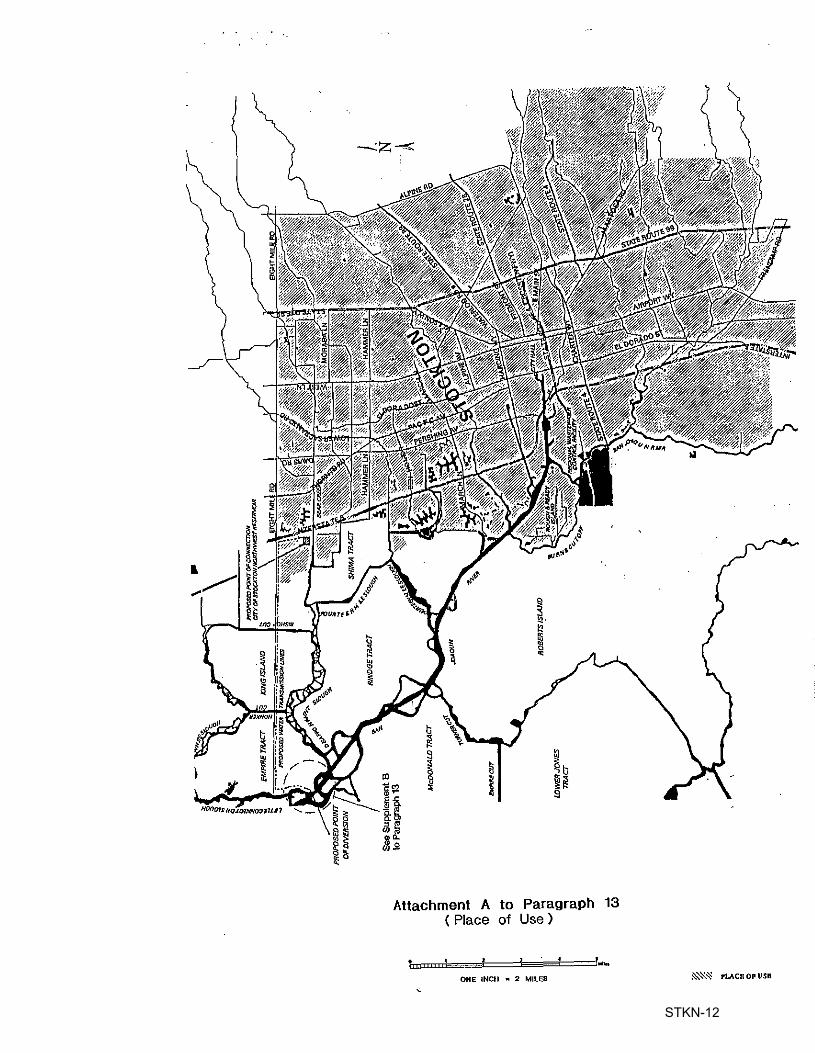
Area within Place of Use boundary - 81,441 acres. (See Attached Place of Use Map)
STKN-12
Attachment A to Paragraph 13 ( Place of Use )
ONE INCH • 2 MILES ~'Z-:S ruce 011 use
STKN-12
" u < ••••• , l< "'
I "
i
I ! I I o_., j--
z < I ! ...1+ -!· wJ - I
01 z ! I a
1:.:,··,--i a:
1~/ I I I i '! I~ I ! j~ 1 I 1G
I 1" \"'L p'°11ntt0m
•:JT'T I ! \ i I I
I I I I I I I I '_ J -!·1-;
., ... , ··J·-'
.:. J
-~_:) -·· -1 =] -- I
' _::~-i'-\ I j I
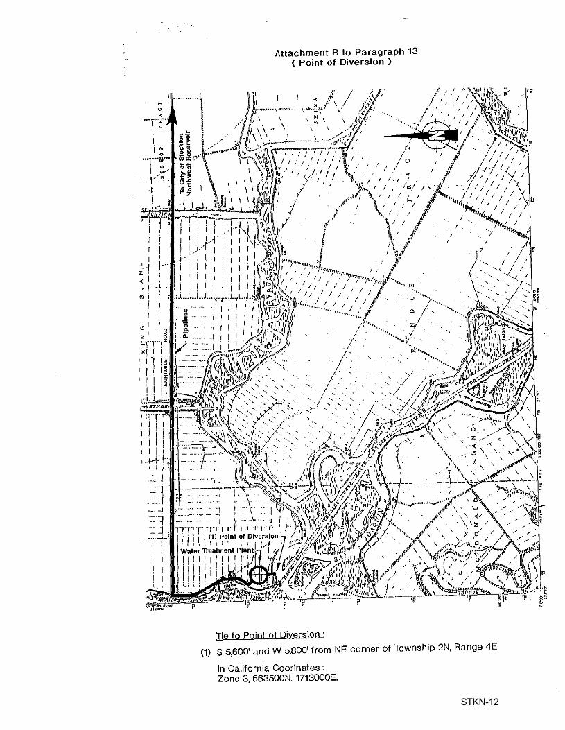
Attachment B to Paragraph 13 ( Point of Diversion )
Tie to Point of Diversion : (1) S 5,600' and W 5,800' from NE corner of Township 2N, Range 4E
In California Coorinates: Zone 3, 563500N., 1713000E.
STKN-12
Attachment A to Paragraph 13 ( Place of Use )
ONE INCi-i = 2 MILES
STKN-12
cl z I I g
1~1 .. ~,.....,.o: I<! I I I ·1 ~
1 I I ~ ~
I l [
I I I I i I I I I
I I I I , .1-1-1-
, , ,1--'
= l = 1
. ~- J •... I
=]
= J, 'TT
I I I I
Attachment B to Paragraph 13 ( Point of Diversion )
Tie to Point of Diversion :
(1) S 5,600' and W 5,800' from NE corner of Township 2N, Range 4E
In California Coorinates : Zone 3, 563500N., 1713000E.
STKN-12
,, , S"FATE OF CALIFORNIA . STATE WATER RESOURCES CONTROL BOARD
DIVISION OF WATER RIGHTS
I
901 e Street. Sacramento . · P. 0. Box 2009. Sacramento. CA 95812 -2000 ,; ·i \ \ . APPLICATION TO APPROPRIATE WATER BY PERMIT
ENVIRONMENTAL INFORMATION
(THIS IS NOT .A CEOA DOCUMENT)
APPLICATION NO. :3 OS3 I {leave blank)
The following information will aid in the environmental review of your application as required by the California Environmental Quality Act (CEQA). IN ORDER FOR YOUR APPLICATION TO BE ACCEPTED AS COMPLETE. ANSWERS TO THE QUESTIONS LISTED BELOW MUST BE COMPLETED TO THE BEST OF YOUR ABILITY. Failure to answer all questions may result in your application being returned to you, causing delays in processing. If you need more space, attach additional sheets. Additional inforination may be required from you to amplify further or clarify the information requested in this form.
PROJECT DESCRIPTION
1. Provide a description of your project. including but not limited to type of construction activity, structures existing or to be built, area to be graded or excavated and project operation. including how the water will be used.
The City of Stockton seeks, in part,· to recover at the point of diversion, to
be l~cated near the confluence ·of~he San Joaquin-River and Little Connection
Slough, an amount of water equal to that discharged into the San Joaquin River
at the City's Regional Wastewater Control Facility located in Sections 19, 20,
and 21, TIN, R6E, MDBE, about 4000 feet upstream from the confluence of Burns
Cutoff, and such additional amounts required to meet the need for supplemental
supplies for the Stockton area. This water will be treated, at or near the
point of diversion, and delivered to the City's water distribution system via
pressure pipelines to be constructed in, or adjacent to, Eight Mile Road.
WR 1-2 (3/94)
STKN-12
GOVERNMENTAL REQUIREMENTS Before a final decision can be made on your water right application. we must consider the information contained in an environmental document prepared in compliance with the requirements ofJl:QA. If an envtronmental document has been prepar~d-for your project by another agency, we must consider it. If one has not been prepared, a determination must be made as to who is responsible for the preparation of the environmental document for your project. The following questions are designed to aid us in that determination.
2. Contact your county planning or public works department for the following information: · (a) Person contacted Thomas M. Gau Date of contact April 11, 1996
Department Colnlnunity Development Telephone (209 )_4'-'6-=-8-'-2c.c3'--'4-'-4 ___ _
(b) Assessor's Parcel No. 069-090-06 and 069-010-11 -~~-'-=-~~~~~~~~--------( c) County Zoning Designation. AG~40 ---~--------------(d) Are any county permits required for your project? __ Y_e_s _____ _
If you answered yes. check___a_l)p_ropri ate spaces below: x "'Gracling Permit, · x U$e Permit. Watercourse
Obstruction Permit. Change of Zoning, General Plan Change, Other (explain):
Encroachment Permit, Building Permits (e) Have you obtained any of the required permits described above? No
If you answered yes, provide a complete copy of each permit obtained.
3. Are any additional state or federal permits required for your project? __ [i.e., -from Federal Energy Regulatory Commission, U.S. Forest Service, Bureau of land Management, Soil Conservation Service, Department of Water Resources (Division of Safety';'of Dams), Reclamation Board, Coastal Commts.si.or:t, State' Lands· Commissfon,etc.] For each agency from which a permi1;/is ,required.provide the fcil]owing informatioo:
), contabted .. Tom Coe Agency US Army Corps of Engineers
Date:of'eoiltact·: March 29 1 1996 Te 1 ephone ( 916) --'5""5-'-7---'5=2=so"-------
4. Has any public agency prepared an .environmental document for any aspect of your project? -=No~----
If so, please submit:.,a copy' of cthe ilatest ~nvironmental• document(s) ~~~~~e~ge~~i~uding a copy of !,~.e notice of det!rmination adopted by the ~ ..
t i ~-If npt, explain below whether yQ1Lexpect that:a public agency other than the Stafe Water Resources Control . -Board will be ·prepa"ri ng an environmental document for your project or whether the applicant. if it is a California "
' . -2-,·.
STKN-12
public agency, will be preparing the environmental document for your project: , , , ,
The City of Stockton will be the lead agency and prepare all required
environmental doci.imentation in compliance with the CEQA requireinents, :i. It ~ ' ~ ;
is anticipated th~t thi~~ project will require an Environmental i.rmpacd.Report,
Note: When completed, p] ease submit a copy of the final environmental document (including notice of determination) or notice of exemption to the State Water Resources Control Board. Processing of your water right application cannot proceed until such documents are submitted.
5.' Will your project, during construction or, operation. generate waste or wastewater containing such things as sewage·;- industrial chemicals. metals.or agr·icultural chemicals, or cause eros·ion; turbidity or sedimentation? Yes
co·nstruction will create the possibility of turbidity and/ If SO, explain: or sedimentation for which· mitigation measures will be implemented, Water use within the City (Place of Use) will generate wastewater, which will be treated at the City's .Wastewater Treatment Plant prior to discharge to the San Joaquin River, in accordance with the NPDES.permit issued by the Regional Board.
If you answered yes or you are unsure of your answer. contact your local Regional Water Quality Control Board for the following information (See attachment for address and telephone number):
' Will a waste discharge permit be required for your project?~-----Person contacted Date of contact --What method of treatment and disposal wi 11 be used? ________ _
6. Have any archeo l ogi cal reports been prepared on this project. or Wi 11 you be
preparing an archeological report to satisfy another public agency? __ _ An archeological report will be prepared for this project.
Do you know of any archeological or historic sites located·within the · general project area? No If so, explain:
-3-
STKN-12
'
ENVIRONMENTAL SETTING
7. Attach lllREE COMPLETE SETS of color photographs, clearly dated and labeled. showing the vegetation currently existing at the following locations:
(a) Along the stream channel immediately downstream from the proposed point(s) of diversion h b' 11 11
Attached as Ex i it A
(b} Along the stream channel immediately upstream from the proposed point(s) of diversion Also included in the attached Exhibit 11A11
(c) At the place(s) where the water is to be used Attached as Exhibit "B11
Note: It is very important that you submit n,) less than three complete sets of photographs as required above. If less than three sets are submitted, processing of your application will be delayed until you furnish the remaining sets! ·· · ··
8. From the list given below, mark or circle the general plant community types which best describe those which occur within your project area (Note: See footnote denoted by* under Question 11 below):
Tree Dominated Communities Subalpine Conifer Red Fir Lodgepole Pine Mixed Conifer
Sierran Mixed Conifer White Fir Klamath Mixed Conifer
Douglas-Fir Jeffrey Pine Ponderosa Pine Eastside Pine Redwood Pinyan-Juniper Juniper Aspen . _ Closed-Cone Pine•Cypress Montane Hardwood-Conifer Montane Hardwood Valley Foothill Hardwood
Blue Oak Woodland Valley Oak Woodland Coastal Oak Woodland
Valley Foothill Hardwood-Conifer Blue Oak-Digger Pine ·
,·
Eucalyptus 't Montane Riparian 1. Valley Foothill Riparian Desert Riparian ~ Palm Oasis ? Joshua Tree
Literature source: Mayer, K.E., and W.F. Laudenslayer, Jr .. (eds). 1988. A µuide to Wildlif~ Habitats of California. Caljfornia. DepartmeDt of Forestry and Fire Protection, Sacramento. 166 pp. (Note: You may view a copy of .this document at,our public counter at _the ad~res~ giv~n at ttJe top of this form or you may purchase a copy by call 1 ng the,:Ca l 1 form a Depar:tment of Fi sh }md Game, Wildl 1fe Habitat Relationships (WH~) Program, at 9f6/653-7203) ·i, l_ l . ·t
9. Provide below an estimate of the type,·number. and size (trunk/stem diameter at chest height) of trees and large shrubs that are planned to be removed or destroyed due to construction and operation of your project. Consider all aspects of your project. including diversion structures, water distribution
. and use.facilities. and changes in the places of use due to additional water development.
It is not anticipated that any large trees will be required to be removed
at the point of diversion or along the pipeline route.
FISH AND WILDLIFE CONCERNS
10. Identify the typical species of fish which occur in the source( s) from which you propose to divert water and discuss whether or not any of these fish species or their habitat has been or would be affected by your project (Note: See footnote denoted by* under Question 11 below): - - ..
Typical fish found in the Delta include: chinook salmon, striped bass,
American shad, delta smelt, Sacramento splittail, and longfin smelt.
Other fish found in the Delta include freshwater resident species (sun
fish, catfish and minnows), steelhead trout, and green and white sturgeon.
-5-
STKN-12
11. Identify the typical species of riparian and terrestrial wildlife. in the project area and discuss whether or not any of these species and/or their habitat has been or would be affected by your project through construction of water diversion and distribution works and changes in th~places of water use (Note: See·footnote denoted by* below):
Species typical in the Place of Use are listed in the Species List included
in the Biological Analyses in the San Joaquin County Multi-species Habitat
Conservation and Open Space Plan, dated March 29, 1996. This list is attached
as Exhibit "C". Species typical in the Delta, and thus potentially present at
Point of Diversion, are listed in the EIR/EIS on the Delta Wetlands Project.
Table 3H-5 from that EIR/EIS lists some typical species and·is attached as
as Exhibit "D". A more complete list is included in Table H2-4 of the. Delta
Wetlands EIR/EIS Vol. II, and this list is att.ached as Exhibit "E".
*Note:. The purposes or:Questions 10 and 11 are to provide a prel1minary assessment of the presence of typical pl ant and animal species in the project area and whether these species might be affected by your project. Detailed site surveys to quantify populations of specific species or determine the presence of rare or endangered species may be required at a later date. It is very important that you answer these questions accurately. If you are unable to obtain appropriate answers from your local California Department of Fish and Game biologists (See attachment for address and telephone number) or you do not have adequate information or expertise to complete your answers, you should hire a fishery consultant and/or a wildlife consultant to review your project and prepare suitable answers for you. For information on available qualified fishery or wildlife consultants near you, consult your local telephone directory yellow pages under Environmental and Ecological Services, or call the California Environmental Protection Agency, Registered Environmental Assessor. (REA) Program, at 916/324-6881 or the University of California. Cooperative Extension Service (See your local telephone directory white pages).
12. Does your proposed project involve any construction or grading-related activity which .has significantly altered or would significantly alter the bed or bank of any stream or lake? Yes
If so, explain: The intake structure will likely alter the north hank a£
the San Joaquip. River at the point of div~rsion. This ~ ~
cipated to be ·t~nfiiled,. however, to the i~ediate area :3f
at tfie intake cbau-
nel (or pipes)cto be constructed at the point of diversion.
/ /
-6-' . '
STKN-12
CERTIFICATION
I hereby certify tha't the statements I have furnished above and in the attached exhibits are complet~ to the best of my ability, and _that the facts. statements and information pre~ented are true and correct to the best of m(knowledge. ·