2
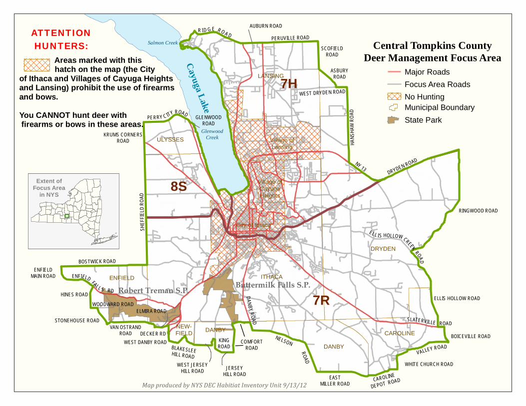
NEW YORK STATE DEPARTMENT OF ENVIRONMENTAL CONSERVATION Tompkins County Deer Management Focus Area Boundary For ease of reference, the DMFA boundary description has been separated into segments along Cayuga Lake and through each town that is partially incorporated into the DMFA. Lakeshore Those parts of Tompkins County beginning at the mouth of Glenwood Creek near Duboise Corner(Town of Ulysses) and southerly along the west shore of Cayuga Lake; thence easterly and all other variations thereof along the south shore of Cayuga Lake; thence northerly along the east shore of Cayuga Lake to the mouth of Salmon Creek near Myers; Town of Lansing Thence northeasterly along Salmon Creek to Ridge Road (34B); thence easterly along Ridge Road (34B) to Auburn Road (34 & 34B) in south Lansing; thence easterly along Auburn Road (34 &34B) to Peruville Road (34B) near Terpening Corners; thence easterly along Peruville Road (34B) to Scofield Road in Howland Corners; thence southerly along Scofield Road to Asbury Road; Town of Dryden Thence southeasterly along Asbury Road to West Dryden Road; thence easterly along West Dryden Road to Hanshaw Road; thence southerly along Hanshaw Road to State Highway 13; thence easterly along State Highway 13 to Dryden Road (State Highway 13 & 366); thence easterly along Dryden Road (State Highway 13 & 366) to Dryden Road (13); thence easterly along Dryden Road (13) to Ringwood Road; thence southerly and southwesterly along Ringwood Road to Ellis Hollow Creek Road; thence southerly along Ellis Hollow Creek Road to Ellis Hollow Road; thence southeasterly along Ellis Hollow Road to Slaterville Road (79); Town of Caroline Thence easterly along Slaterville Road (79) to Boiceville Road; thence southerly along Boiceville Road to Valley Road; thence westerly along Valley Road to White Church Road; thence westerly and southerly along White Church Road to Caroline Depot Road; thence westerly along Caroline Depot Road to Coddington Road; thence southerly along Coddington Road to East Miller Road; Town of Danby Thence westerly along East Miller Road to Nelson Road; thence northerly and westerly along Nelson Road to Danby Road (96B); thence northerly along Danby Road to Comfort Road; thence westerly and southerly along Comfort Road to Jersey Hill Road; thence westerly along Jersey Hill Road to West King Road; thence westerly and northerly along West King Road to West Jersey Hill Road; thence southerly and westerly along West Jersey Hill Road to Blakeslee Hill Road; Town of Newfield Thence westerly along Blakeslee Hill Road to West Danby Road (34 & 96); thence northerly along West Danby Road (34 & 96) to Decker Road; thence northerly along Decker Road to Elmira Road (13); thence westerly along Elmira Road (13) to the intersection of Millard Hill Road and Van Ostrand Road; thence westerly along Van Ostrand Road to Douglas Road; thence northwesterly along Douglas Road to Stone house Road; Town of Enfield Thence northwesterly along Stonehouse Road to Woodard Road; thence westerly along Woodard Road to Hines Road; thence northerly along Hines Road to Enfield Falls Road (327); thence northwesterly along Enfield Falls Road (327) to Enfield Main Road (327); thence northerly along Enfield Main Road (327) to Bostwick Road; thence easterly along Bostwick Road to Sheffield Road; thence northerly along Sheffield Road to Krums Corners Road; thence northerly along Krums Corners Road to Perry City Road; Town of Ulysses Thence easterly along Perry City Road to Glenwood Road; thence southeasterly along Glenwood Road to Glenwood Creek; thence easterly along Glenwood Creek to the point of beginning.