50
REPORT: TRUCK TRAFFIC ANALYSIS IN EASTERN KANKAKEE COUNTY Kankakee County Planning Department July, 2012

REPORT: TRUCK TRAFFIC ANALYSIS IN EASTERN KANKAKEE
COUNTY
Kankakee County Planning Department
July, 2012
P a g e | i
Report: Truck Traffic Analysis in Eastern Kankakee County
ACKNOWLEDGEMENTS
Funding to support this report was provided by a generous grant from the Illinois Department of Transportation.
Illinois Department of Transportation
2300 S. Dirksen Parkway
Springfield, IL 62764
This report was developed by the Kankakee County Planning Department.
Kankakee County Planning Department
189 E. Court Street, Room 201
Kankakee, IL 60901
Planning Staff:
Michael Van Mill, AICP – Executive Director
Delbert Skimerhorn, Sr., AICP, GISP – Planner / GIS Specialist
Michelle Sadler – Office Manager
P a g e | ii
Report: Truck Traffic Analysis in Eastern Kankakee County
Table of Contents
Content Page
Acknowledgements…………………………………………………………………………………………………… i
Welcome……………………………………………………………………………………………………………………. 1
Purpose…………………………………………………………………………………………………………………….. 1
Objectives…………………………………………………………………………………………………………………. 3
Scope of Study / Characteristics of Study Area………………………………………………………….. 3
Road Network………………………………………………………………………………………………………. 4
Rivers……………………………………………………………………………………………………………………. 7
Railroads……………………………………………………………………………………………………………….. 8
Municipalities……………………………………………………………………………………………………….. 9
Truck Traffic Conditions & Challenges of Increasing Truck Traffic………………………………. 12
Truck Traffic Conditions………………………………………………………………………………………… 12
Total Traffic………………………………………………………………………………………………………….. 14
Total Truck Traffic…………………………………………………………………………………………………. 14
Percentage Trucks………………………………………………………………………………………………… 14
Analysis…………………………………………………………………………………………………………………. 15
Challenges…………………………………………………………………………………………………………….. 17
Regional Growth Outlook………………………………………………………………………………………. 17
Stakeholder Interviews……………………………………………………………………………………………… 29
Conclusions, Strategies & Recommendations…………………………………………………………….. 31
Illiana Expressway…………………………………………………………………………………………………. 31

P a g e | iii
Report: Truck Traffic Analysis in Eastern Kankakee County
Table of Contents (continued)
Content Page
Future Land Use Planning…………………………………………………………………………………….. 31
Transportation Planning………………………………………………………………………………………… 31
Regional Planning………………………….………………………………………………………………………. 32
Stakeholders……………………………..………………………………………………………………………….. 32
Appendix…………………………………………………………………………………………………………………… 33
Resolutions of Support for Illiana Expressway……………………………………………………… 34
Study Area Map with Traffic Counts…………………………………………………………………….. 45
Table of Figures and Tables
Content Page
Figure 1: East‐West Traffic Funnel Map……………………………………………………………………… 2
Figure 2: Study Area Map………………………………………………………………………………………….. 4
Table 1: Truck Traffic Data for the Momence Area 2011…………………………………………… 12
Table 2: Truck Traffic Data for Illinois Routes 1 and 17 Outside Momence………………… 13
Figure 3: 2040 Corridor Travel Performance……………………………………………………………… 19
Figure 4: Intermodal Facility Map………………………………………………………………………………. 22
Figure 5: South Suburban Airport Map………………………………………………………………………. 24
Figure 6: 6000 N Road Interchange and Proposed Alignment……………………………………. 25

P a g e | 1
TRUCK TRAFFIC ANALYSIS IN EASTERN
KANKAKEE COUNTY
WELCOME
Kankakee County is experiencing significant growth in truck freight movements across its region and in particular in the eastern end of the County. The increase in truck traffic is partially attributable to growth of industries within the Kankakee County community but, more significantly to the growth and success of the intermodal facilities located outside Kankakee County’s borders. The goals for this report are to define the escalating truck freight volume and the issues facing Kankakee County in its eastern portions, identify truck traffic generation trends, evaluate community preparedness, and how the proposed Illiana Expressway may influence regional traffic movement.
PURPOSE
The issue of increasing truck traffic is not a recent phenomenon. It is well documented by the U.S. Department of Transportation that since 1970 overall truck travel in the United States has increased significantly (well over 200%) while highway capacity has remained relatively flat. Truck traffic volumes across the U.S. are expected to grow even greater in the future. According to the Transportation Research Board’s 2003 report Strategies for Managing Increasing Truck Traffic:
“Forecasts of future freight flows indicate that this growth trend will continue. The volume of domestic freight is projected to increase by 87% between 1998 and 2020, whereas the volume of international freight is projected to increase by 107% during the same period. The rapid increase in truck traffic is being influenced by dramatic changes in the global economy, consumer demand, and logistics practices…(pg. 3)”

P a g e | 2
Recent Kankakee County traffic data finds that truck traffic accounts for over 30% of total traffic on several eastern Kankakee County roadways. The high percentage of truck traffic on these facilities is alarming and poses many challenges to Kankakee County’s local transportation infrastructure. These challenges are magnified in our eastern portion as trucks funnel in and out of Indiana. This report will detail the issues involved; the potential solutions represented by the Illiana Study, and the recommendations for localized transportation improvements to remedy some of the situations. This report will be distributed in Kankakee County and will be made available to the Illiana Study.
Figure1: East‐West Traffic Funnel Map
Source: Kankakee County Planning Department

P a g e | 3
OBJECTIVES
• Illustrate the truck‐related challenges facing local municipalities, major employers, and major trucking operations within Kankakee County to ensure that their viewpoints are represented. Interviews will be conducted with key stakeholders to identify challenges.
• Evaluate and document regional and local projects and planning activities that could impact the increasing truck/fright movement in and around the Momence and Grant Park area. Interviews of key government officials and local citizen will be conducted. Plans and regional development proposals that have potential implications for Kankakee County and the eastern end will be documented.
• Rail freight in the eastern portion of Kankakee County is another issue that has been raised. Interviews with local officials and representative of the railroads will be conducted. These viewpoints will also be available for the Illiana Study.
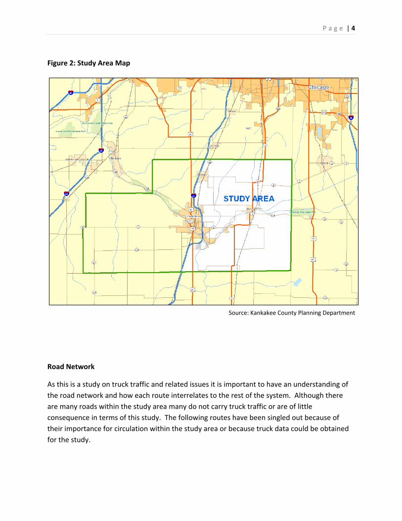
SCOPE OF STUDY / CHARACTERISTICS OF STUDY AREA The geographic location of the study area is all of Kankakee County lying east of Interstate 57. This area encompasses 347 square miles and is comprised of urbanized areas along the Interstate 57 corridor, small municipalities, and agricultural land. Lying totally within the study area are the Villages of Aroma Park, Grant Park, Hopkins Park, St. Anne, Sammon’s Point, and Sun River Terrace, and the City of Momence. Municipalities that are divided by Interstate 57 and therefore only partially included in the study area include; the Villages of Bourbonnais, Bradley, Chebanse, and Manteno and the City of Kankakee. The following map shows the boundary of the study area as well as geographical features such as major roads, railroads, rivers, and municipal boundaries. Each of these geographical features will be described in detail later in this chapter.
P a g e | 4
Figure 2: Study Area Map
Source: Kankakee County Planning Department
Road Network
As this is a study on truck traffic and related issues it is important to have an understanding of the road network and how each route interrelates to the rest of the system. Although there are many roads within the study area many do not carry truck traffic or are of little consequence in terms of this study. The following routes have been singled out because of their importance for circulation within the study area or because truck data could be obtained for the study.

P a g e | 5
Interstate 57
Forming the western boundary of the study area, this route passes through the center of Kankakee County from the Will County Line on the north to the Iroquois County Line on the south. In the study area, the facility is a four(4) lane divided limited access highway with interchanges at; County Highway 9 in Manteno (Exit 321), Illinois Route 50 in Bradley (Exit 315), Illinois Route 17 in Kankakee (Exit 312), U.S. Route 45/52 (Exit 308), and at the County Line in Chebanse (Exit 302).
U.S. Route 45/52
The only Federal Route within the study area, this route carries traffic in a north‐south direction beginning in Illinois at the Wisconsin Border east of Antioch and it leaves Illinois at the Irvin S. Cobb Bridge over the Ohio River near Brookport. Within the study area, the route is a two (2) lane rural cross‐section facility that travels from Exit 308 on Interstate 57 south five (5) miles to the Iroquois County Line between the Village of Chebanse and Sugar Island passing through the recently incorporated Village of Sammon’s Point along the way.
Illinois Route 1
Also known as the “Dixie Highway”, this mostly two (2) lane roadway travels 325.19 miles on a north‐south path along the eastern edge of the State of Illinois from Halsted Street on the south side of Chicago to Cave‐in‐Rock on the Ohio River in southern Illinois. Within the study area, this route starts at the Will County Line just north of the Village of Grant Park and travels south until it merges with Illinois Route 17 on the east side of the Village of Grant Park. It then heads west and then south passing through the City of Momence until it separates from Illinois Route 17 just east of the Village of Sun River Terrace. At this point, Illinois Route 1 travels south to the Iroquois County Line passing through the Village of St. Anne along the way. This route is a two (2) lane facility all the way through the study area for 26 miles and with the exception of where it passes through municipalities it has a rural cross‐section.

P a g e | 6
Illinois Route 17
Serving as the “Main Street” for many communities, this route travels 209.40 miles from the Illinois River at Lacon, IL to the Indiana State Line east of Grant Park. For most of this distance, the route is a two (2) lane facility. In the study area, the route begins at Exit 312 on Interstate 57 and travels east as a four (4) land divided highway to its intersection with Illinois Route 1 east of the Village of Sun River Terrace. From there it becomes a two (2) lane facility that merges with Illinois Route 1 through the City of Momence and the Village of Grant Park until it splits with Illinois Route 1 just east of the Village of Grant Park. It then continues east to the Indiana‐Illinois State Line where it becomes Indian Route 2.
Illinois Route 50
This route travels from U.S. Route 45/52 in the City of Kankakee to U.S. Route 41 in Skokie Illinois for a distance of 66.49 miles. It is a four (4) lane facility for the majority of this distance. In the study area it begins at Exit 315 on Interstate 57 and parallels the Canadian National Railroad as it travels north passing through the Villages of Bradley, Bourbonnais, and Manteno to the Will County Line. It is a four (4) lane facility throughout the study area and serves as a commercial corridor for the municipalities that were previously mentioned.
Illinois Route 114
A short route of only 7.40 miles, this two (2) lane facility connects Illinois Route 1/17 at the City of Momence with Indiana Route 10 at the Indiana‐Illinois State Line on the south side of the Kankakee River. The entire distance of Illinois Route 114 is in the study area.

P a g e | 7
County Highway 8 (St. George Road)
This two (2) lane route travels through the study area from Interstate 57 about two (2) miles north of Exit 315 and heads directly east to Illinois Route 1/17. With the exception of the Hamlet of St. George, this route passes through farmland as it traverses Bourbonnais and Ganeer Townships for 11 miles.
County Highway 9
This route is the major east‐west corridor for the northern end of Kankakee County. It begins at the Will County Line at Warner Bridge Road and heads east passing through the Hamlet of Deselm, the Village of Manteno, and the Hamlet of Whitacre until it terminates at Illinois Route 1/17 just west of the Village of Grant Park. In the study Area, it travel 11 miles from Exit 321 on Interstate 57 until its point of termination at Illinois Route 1/17.
County Highway 44 (Armour Road)
Recently extended, this route now travels east‐west from U.S. Route 45/52 to Illinois Route 1 in the City of Momence. In the study area it is mostly a two (2) lane facility traveling from Interstate 57 and heading directly east until it becomes Second Street in the City of Momence.
Rivers
Portions of two (2) rivers lie within the study area. The Kankakee River enters the study area at the Indiana‐Illinois State Line and travels east through the City of Momence where it turns and travels in a southwesterly direction to the Village of Aroma Park where it meets with the confluence of the Iroquois River. It then travels northwest until it exits the study area at the Interstate 57 Bridge. The Kankakee River is significant to the study area as there are few places that traffic can cross which can create a barrier to vehicle movements. As the river travels west from the State Line through the study area the first river crossing is seven (7) miles from the

P a g e | 8
State Line at Illinois Route 1. The next river crossing is five (5) miles farther west at Illinois Route 17 just west of the Village of Sun River Terrace and the third river crossing is another fine miles southwest at Bridge Street in the Village of Aroma Park. Finally, the fourth and last crossing in the study area is the bridge at Interstate 57.
The Iroquois River poses similar problems. From its entrance into the study area to its termination at the Kankakee River in Aroma Park there is only one crossing as it travels this distance of 6 six (6) miles. This crossing is at the Sugar Island Bridge located one‐half mile north of the Iroquois County line.
Railroads
There are four (4) railroads that traverse the study area. The Union Pacific Railroad is a Class 1 railroad that travels the entire distance of the study area passing through the Villages of Grant Park and St. Anne and the City of Momence. There are no grade separated crossings for its entire length through the study area although there are plans to construct one just south of the Village of Grant Park.
The Kankakee, Beaverville, & Southern Railroad is a Class 3 railroad that travels southeasterly from the City of Kankakee to Iroquois County passing through the Village of Aroma Park and St. Anne. There is one grade separated crossing within the Village of Aroma Park but the roadway under the crossing is a narrow single lane facility with minimal height clearance.
The Canadian National Railroad is also a Class 1 railroad and although it travels the entire length of the County from north to south it only travels through the study area where it is located east of Interstate 57. While there are several grade separated crossings in the metropolitan area outside of the study area, the only grade separated crossing within the study area is at Otto Road three (3) miles north of the Iroquois County line.
The only east‐west railroad in the study area, the Norfolk & Southern Railroad is a Class 1 railroad that travels through the study area from Interstate 57 just north of Exit 312 to the Indiana State Line about two (2) miles north of the Kankakee River. There are no grade separated crossings on this rail line within the study area.
P a g e | 9
Municipalities
As mentioned previously, there are several municipalities within the study area. Each municipality is described below.
Aroma Park
This village of 743 residents is located at the confluence of the Kankakee and Iroquois Rivers in the southwestern region of the study area. Aroma Park is part of the Kankakee Metropolitan Area and is considered a bedroom community as there is little business and industry in the municipality. Off the beaten path, Aroma Park is one of only two municipalities in the study area that do not have the benefit of a state route within its boundary.
Bourbonnais
Located on the west central edge of the study area the majority of this municipality is located outside of the study area. However, its 18,631 residents and its many businesses and industries have an impact on traffic in the study area. The Village is also part of the Kankakee Metropolitan Area.
Bradley
The commercial hub of the Kankakee Region and the Kankakee Metropolitan Area, Bradley is home to the Northfield Square Mall, and many retail outlets and restaurants that line both sides of Illinois Route 50. As of the 2010 U.S. Census, Bradley is home to 15,895 residents.
Chebanse
Another bedroom community, Chebanse is located along Interstate 57 at the southwest corner of the study area and has 1,088 residents.

P a g e | 10
Grant Park
This Village is located in the northeastern corner of the study area at the junction of Illinois Route 1 and 17. With 1,331 citizens the Village of Grant Park has a small town atmosphere that offers little in the way of commerce with the exception of a few industrial enterprises.
Hopkins Park
This municipality has historically been a poor rural community with a large minority population plagued by high unemployment rates and little commerce or industrial development. Like the Village of Aroma Park this community does not have the benefit of a state highway within its boundary. As of the 2010 U.S. Census, 603 people call the Village of Hopkins Park home.
Kankakee
The County Seat of Kankakee County and once the regions commercial hub, the City of Kankakee is the largest municipality in the County with a population of 27,537. Because of its history as a governmental center and commercial hub for the region many of the roads in the area funnel into the City of Kankakee. The City is also part of the Kankakee Metropolitan Area.
Manteno
Once a sleepy little town along the Canadian National Railroad, the Village of Manteno has grown substantially over the past few decades in both population and industry. The redevelopment of the Manteno State Hospital into an industrial park has helped to spur this growth. Now home to 9,204 residents the Village of Manteno contributes substantially to truck traffic in the study area. Preliminary information indicates that the village of Manteno will become part of the Kankakee Metropolitan Area in the near future.
Momence
An old river town that was once under consideration for the County Seat the City of Momence is the largest municipality on the eastern end of Kankakee County. With 3,310 residents, the City has a well‐established mix of residential, commercial, and industrial uses.

P a g e | 11
St. Anne
Located at the cross roads of two railroads and Illinois Route 1 this small community of 1,257 residents is mainly a bedroom community. There is little industry and commercial ventures in the municipality however, agriculture in the form of specialty crops is dominant in the area.
Sammon’s Point
One of the County’s newest municipalities, this Village of 279 residents is located along U.S. Route 45/52 south of the City of Kankakee. The Village has little in the way of commercial businesses and no industry.
Sun River Terrace
Begun in the 1980’s when three (3) subdivisions combined to form the Village, this municipality of 528 residents is located at the cross roads of Illinois Route 1 and 17 near the center of the study area. Even though it has the benefit of being located along two (2) state highways there is no commercial or industrial development of any consequence within the Village.
P a g e | 12
TRUCK TRAFFIC CONDITIONS & CHALLENGES OF INCREASING TRUCK TRAFFIC
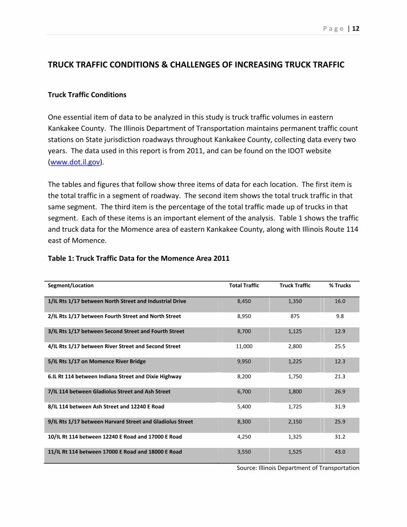
Truck Traffic Conditions One essential item of data to be analyzed in this study is truck traffic volumes in eastern Kankakee County. The Illinois Department of Transportation maintains permanent traffic count stations on State jurisdiction roadways throughout Kankakee County, collecting data every two years. The data used in this report is from 2011, and can be found on the IDOT website (www.dot.il.gov). The tables and figures that follow show three items of data for each location. The first item is the total traffic in a segment of roadway. The second item shows the total truck traffic in that same segment. The third item is the percentage of the total traffic made up of trucks in that segment. Each of these items is an important element of the analysis. Table 1 shows the traffic and truck data for the Momence area of eastern Kankakee County, along with Illinois Route 114 east of Momence.
Table 1: Truck Traffic Data for the Momence Area 2011
Segment/Location Total Traffic Truck Traffic % Trucks
1/IL Rts 1/17 between North Street and Industrial Drive 8,450 1,350 16.0
2/IL Rts 1/17 between Fourth Street and North Street 8,950 875 9.8
3/IL Rts 1/17 between Second Street and Fourth Street 8,700 1,125 12.9
4/IL Rts 1/17 between River Street and Second Street 11,000 2,800 25.5
5/IL Rts 1/17 on Momence River Bridge 9,950 1,225 12.3
6.IL Rt 114 between Indiana Street and Dixie Highway 8,200 1,750 21.3
7/IL 114 between Gladiolus Street and Ash Street 6,700 1,800 26.9
8/IL 114 between Ash Street and 12240 E Road 5,400 1,725 31.9
9/IL Rts 1/17 between Harvard Street and Gladiolus Street 8,300 2,150 25.9
10/IL Rt 114 between 12240 E Road and 17000 E Road 4,250 1,325 31.2
11/IL Rt 114 between 17000 E Road and 18000 E Road 3,550 1,525 43.0
Source: Illinois Department of Transportation
P a g e | 13
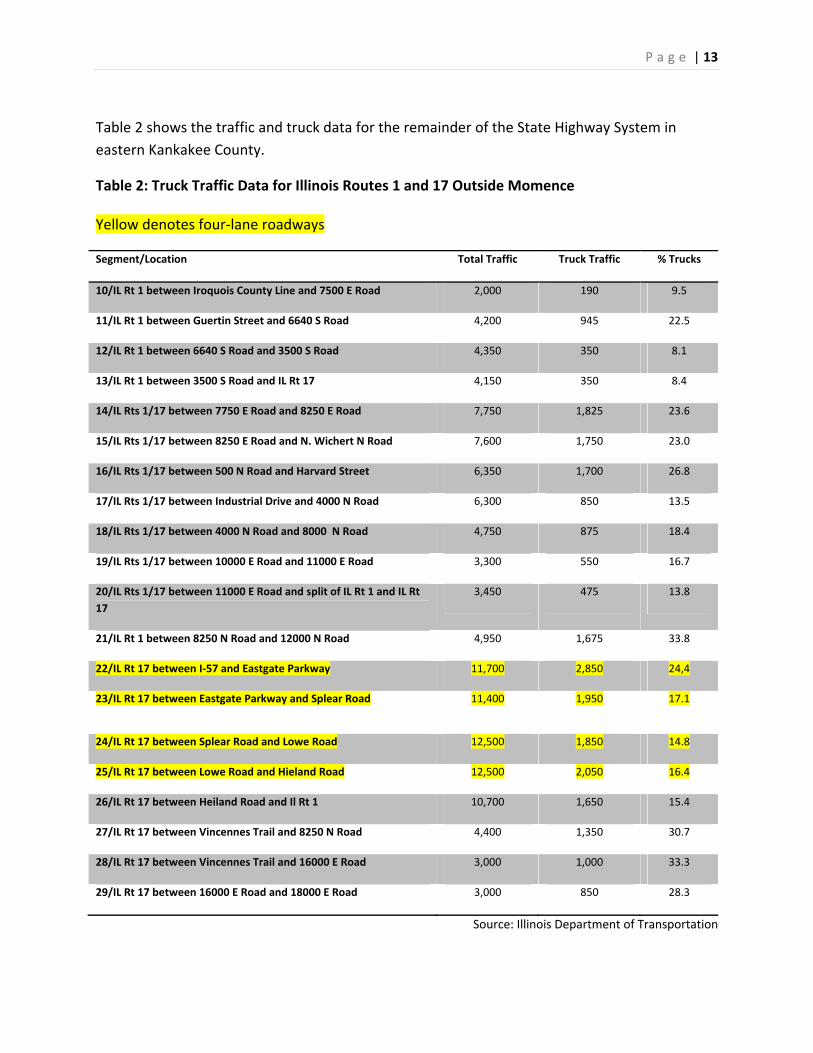
Table 2 shows the traffic and truck data for the remainder of the State Highway System in eastern Kankakee County.
Table 2: Truck Traffic Data for Illinois Routes 1 and 17 Outside Momence Yellow denotes four‐lane roadways
Segment/Location Total Traffic Truck Traffic % Trucks
10/IL Rt 1 between Iroquois County Line and 7500 E Road 2,000 190 9.5
11/IL Rt 1 between Guertin Street and 6640 S Road 4,200 945 22.5
12/IL Rt 1 between 6640 S Road and 3500 S Road 4,350 350 8.1
13/IL Rt 1 between 3500 S Road and IL Rt 17 4,150 350 8.4
14/IL Rts 1/17 between 7750 E Road and 8250 E Road 7,750 1,825 23.6
15/IL Rts 1/17 between 8250 E Road and N. Wichert N Road 7,600 1,750 23.0
16/IL Rts 1/17 between 500 N Road and Harvard Street 6,350 1,700 26.8
17/IL Rts 1/17 between Industrial Drive and 4000 N Road 6,300 850 13.5
18/IL Rts 1/17 between 4000 N Road and 8000 N Road 4,750 875 18.4
19/IL Rts 1/17 between 10000 E Road and 11000 E Road 3,300 550 16.7
20/IL Rts 1/17 between 11000 E Road and split of IL Rt 1 and IL Rt 17
3,450 475 13.8
21/IL Rt 1 between 8250 N Road and 12000 N Road 4,950 1,675 33.8
22/IL Rt 17 between I‐57 and Eastgate Parkway 11,700 2,850 24,4
23/IL Rt 17 between Eastgate Parkway and Splear Road 11,400 1,950 17.1
24/IL Rt 17 between Splear Road and Lowe Road 12,500 1,850 14.8
25/IL Rt 17 between Lowe Road and Hieland Road 12,500 2,050 16.4
26/IL Rt 17 between Heiland Road and Il Rt 1 10,700 1,650 15.4
27/IL Rt 17 between Vincennes Trail and 8250 N Road 4,400 1,350 30.7
28/IL Rt 17 between Vincennes Trail and 16000 E Road 3,000 1,000 33.3
29/IL Rt 17 between 16000 E Road and 18000 E Road 3,000 850 28.3
Source: Illinois Department of Transportation
P a g e | 14
Total Traffic
It is generally accepted that when the total traffic in a segment of two lane roadway approaches 12,000 vehicles, that segment is approaching its capacity to accommodate the traffic, and should be considered for an increase in carrying capacity to a four lane section. Only one two lane segment in the study area (segment number 4 in Table 1) is nearing the 12,000 vehicle per day limit. This segment is Illinois Route 1/17 in downtown Momence and carries 11,000 vehicles per day which would make it 91% of its capacity. There are several other segments that are between 60 and 70% of capacity all along Illinois Route 1/17 within the Momence area.
Total Truck Traffic
The higher the absolute volume of truck traffic in a segment, the more that traffic impacts the carrying capacity of the segment. This situation is most prevalent in the eastern end of the study area along Illinois Route 1, 17, and 114. Nearly every segment of these three (3) roadways north and east of the Village of Sun River Terrace has a truck volume of 10% or higher of the total traffic volume with some segments reaching as high as 43%. Table 1 illustrates these volumes.
The daily traffic volumes do not indicate turning movements at intersections. The intersection of Illinois Routes 1 and 17 with Illinois Route 114 has an extraordinary number and percentage of turning movements, both by cars and by trucks, making it one of the most congested intersections in Kankakee County.
Percentage Trucks
When calculating the carrying capacity of a segment of roadway, the normative percentage is 10%. Any increase above 10% decreases the carrying capacity of the roadway. Research is being performed to determine if this increase above the 10% level also impacts the number and severity of crashes experienced in that segment of roadway.
A number of roadway segments in the study area have over 25% of the total vehicles in the segment consisting of trucks. This is particularly true of all segments that run east‐west into Indiana from Illinois.

P a g e | 15
The highest truck volumes are occurring at the entryways into the County north and east of Grant Park and east of Momence. At these locations truck volumes are hovering in the 30% and higher range. Illinois Route 1 as it enters Kankakee County from Will County has a truck volume of 34%, Illinois Route 17 which enters Kankakee County from Indiana just east of Grant Park has truck volumes ranging from 28% to 33%, and Illinois Route 114 which enters Kankakee County from Indiana just east of Momence has truck volumes ranging from 27% to 43%.
As these routes converge in the City of Momence the road network continues to see high truck volumes. There are two segments in Momence that carry over 2,000 trucks per day. The same segment (segment number 4 in Table 1) in downtown Momence that carries 11,000 total vehicles per day carries 2,800 trucks per day. This means that 25% of the traffic on this segment is truck traffic. The segment (segment number 9 in Table 1) of Illinois Route 1 and 17 at the intersection with Illinois Route 114 carries 2,150 trucks per day representing 26% of the total traffic for that segment. These percentage figures and the raw vehicle data have led to increasing concerns among local citizens in the eastern portion of Kankakee County.
Analysis
The data shows that there is a large percentage of truck traffic passing through the eastern portion of Kankakee County. This can be attributed to many factors. Below is an analysis of the most influential factors. They include:
• Intermodal facilities to the north and west of Kankakee County, most notably, the CenterPoint Intermodal Center in Elwood, Illinois.
• Congestion on Interstate 80 and other northern routes forces haulers to seek alternative routes.
• Barriers, both natural and man‐made, funnel traffic to a limited number of access points.
These factors combine to force truck traffic to utilize roads within the study area even though they have neither a pickup or delivery destination within the study area.
In 2001, the Texas Department of Transportation conducted a statewide survey to determine what local transportation organizations were doing to mitigate increase truck traffic and to identify new ways to address the negative impacts of higher truck traffic. This study formulates six (6) conclusions which remain relevant today.

P a g e | 16
• Stronger and more fortified pavement structures are needed.
• Attention to preventative maintenance programs is increasing in importance.
• Greater priority to shoulder widening projects is needed.
• It was found that several Texas communities were implementing design guidelines for two‐lane facilities with intermitting passing lanes where traffic volumes do not justify a four lane facility.
• Many local transportation organizations responded that there is a need for dedicated truck lanes.
• Truck traffic is increasing faster than available funding for planning and improvements.1
Intermodal Facilities
Many intermodal facilities have been developed or are in the process of being developed north and northwest of the study area in Will and Cook County. These facilities and the truck traffic they generate is a tremendous contributing factor on the truck traffic in the study area. Many trucks from these facilities pass through the study area on the way to other destinations due to a lack of higher tier transportation routes in the area. This is especially true for traffic heading east‐west. These facilities will be described in depth later in this report.
Congestion
Traffic congestion along Interstate 80 has been a problem for many years. Even with capacity improvements, this route is plagued by long wait times and bottle necks. In fact, a report released in September of 2011 by the American Transportation Research Institute and the Federal Highway Administration which highlighted the 250 most congested highway locations ranked the intersection of Interstate 65 and Interstate 80 in Gary Indiana as the 6th most congested bottleneck for truck traffic in the nation. It is no surprise that the trucking industry would find ways to avoid this area and as state routes close to the Interstate become more congested, alternative routes would be utilized. With Lake Michigan as a substantial barrier to the north, this leaves southern routes such as those within the study area as the most viable alternatives.
Barriers
1 Strategies for Managing Increasing Truck Traffic. Transportation Research Board, 2003.

P a g e | 17
In the eastern portion of the study area, regardless of whether traffic is moving east‐west or north‐south at some point it is likely to pass through the City of Momence. This is caused by the limited number of crossing of the Kankakee River. In this part of the study area, there are only two (2) locations that the Kankakee River can be crossed. One of these crossings is in downtown Momence and the other just west of the Village of Sun River Terrace. This causes traffic, especially truck traffic which has limited routes, to be funneled into these locations even though the traffic does not have a destination in the area.
Another barrier in the study area is the lack of grade separated rail crossings. In fact, all rail crossings in the study area are at grade which when coupled with the high truck volumes can create long wait times and traffic backups.
Challenges
The increasing truck traffic situation and the potential for regional truck traffic growth poses many types of challenges for the Kankakee County region, local communities, and transportation organizations responsible for planning, operating, and maintaining the system and infrastructure. According to the Transportation Research Board’s Strategies for Managing Increasing Truck Traffic report, the challenges of increasing volumes of truck traffic include:
• Traffic Congestion • Transportation System Deficiencies • Safety • Infrastructure Deterioration • Multi‐Modal Connections • Environmental Impacts • Quality of Life • Economic Development • Loss of Production Due to Congestion
Regional Growth Outlook
The Kankakee County region, including Will County and southern Cook County, is poised for substantial economic growth with a number of major economic drivers in various stages of approval and planning. Key regional projects that will have a dramatic impact on the future County economic development and positive and negative truck volume implications include:
P a g e | 18
• Illiana Expressway
• Joliet/Wilmington Intermodal Facilities & Logistic Centers
• South Suburban Airport
• County Planning and Growth Management Initiatives
• Local Comprehensive Plans – Momence & Grant Park
Illiana Expressway
The Illiana Expressway is a proposed limited access east/west roadway facility connecting I‐65 in Indiana with I‐55 in Illinois. Since 2011, and the result of a memorandum of understanding between the Governors of Illinois and Indiana signed in 2010, the States’ transportation departments have partnered to evaluate and formulate a recommended corridor for this infrastructure project.
According to the May 2011 Illiana Corridor Fact Sheet prepared by IDOT and INDOT, the benefits of the roadway include:
Providing an alternative route for motorists traveling the I‐90/94 corridor
Relieving traffic on the I‐80 Borman/Kingery Expressway and US 30
Serving as a bypass for trucks around the congested metropolitan highways
Providing access to one of the largest “inland port” intermodal freight areas in the US and the South Suburban Airport
Supporting economic development in the area and the potential for substantial job creation.
At present, the Corridor team has narrowed the route into three (3) possible general corridors: A3S2, B3, and B4. These corridors are depicted on the Illiana Team’s graphic shown below. The three corridors will proceed through the public hearing process and be evaluated for usage, environmental constraints and costs. Each corridor is approximately 2000 feet wide. According to the study, the final “working alignment” will be selected and narrowed to 400 foot roadway.
P a g e | 19
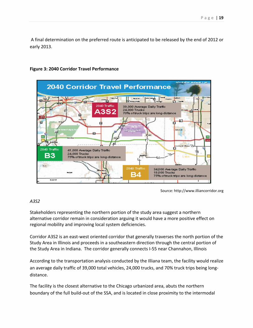
A final determination on the preferred route is anticipated to be released by the end of 2012 or early 2013.
Figure 3: 2040 Corridor Travel Performance
Source: http://www.illiancorridor.org
A3S2
Stakeholders representing the northern portion of the study area suggest a northern alternative corridor remain in consideration arguing it would have a more positive effect on regional mobility and improving local system deficiencies. Corridor A3S2 is an east‐west oriented corridor that generally traverses the north portion of the Study Area in Illinois and proceeds in a southeastern direction through the central portion of the Study Area in Indiana. The corridor generally connects I‐55 near Channahon, Illinois According to the transportation analysis conducted by the Illiana team, the facility would realize an average daily traffic of 39,000 total vehicles, 24,000 trucks, and 70% truck trips being long‐distance.
The facility is the closest alternative to the Chicago urbanized area, abuts the northern boundary of the full build‐out of the SSA, and is located in close proximity to the intermodal
P a g e | 20
and transportation facilities in the Joliet area. Of the three alternative corridors, the A3S2 corridor would likely have the least positive impact on truck traffic growth and economic benefit for the Kankakee County region.
B3
The B3 corridor connects to I‐55 at the IL‐129 interchange location, and continues east running south of Peotone and Beecher. The B3 corridor would run parallel to an east‐west electric transmission line, crossing West Creek in Lake County, IN. Between the towns of Cedar Lake and Lowell, the corridor shifts north of the electric transmission line to avoid environmental concerns and existing development. The connection at I‐65 is located approximately 3 miles south of the US 231 interchange. The recently released Tier One Draft Environmental Impact Statement (July 2012) states that “(T)here are no major man‐made or natural environmental constraints within this area to restrict the placement of the interchange. Public support for the B3 alignment is strong among stakeholders in the southern portion of the study area, including Kankakee County communities. In 2011, the County and many municipalities passed support resolutions for an alignment mirroring the B3 corridor. These resolutions have been submitted to IDOT as part of the public input process. The consensus support has not gone unnoticed. The Tier One Draft Environmental Impact Statement (EIS) recognizes this broad based support as documented in the report.
“Corridor B3 received more stakeholder support than any other alternative corridor.”
“Corridor B3 was supported by numerous stakeholders based on having the best combination of maximizing travel benefits and reducing impacts in a “buildable” corridor. This included support from some communities that were directly impacted.”
The B3 alignment is projected to create an average daily traffic of 41,000 total vehicles, 24,000 trucks, and 75% of truck trips are long‐distance. Of the three alternatives being considered, it is projected that B3 would have the highest average daily traffic, capture an equal amount of truck traffic as A3S2, and a greater percentage of long‐distance truck traffic than A3S2. B4
In order to further evaluate concerns expressed by the Towns of Cedar Lake and Lowell and others in Indiana, a new alternative corridor was identified that essentially combines Corridor B3 west of the Illinois/Indiana state line, with Corridor C4 east of the state line. This new alternative corridor is named Corridor B4. Corridor B4 is identical to Corridor B3 from the I‐55

P a g e | 21
connection point until just west of the Illinois/Indiana state line where Corridor B4 proceeds southeast. The Illiana team projects B4 will generate an average daily traffic of 34,000 total vehicles, 18,000 trucks, and 75% of truck trips are long‐distant.
Intermodal and Logistics Centers
In recent years, several intermodal facilities have been developed in close proximity to the study area. Two (2) are located along Interstate 55 in Will County and two (2) are in south suburban Cook County.
The largest facility is the CenterPoint Intermodal Center (Elwood) located in the old Joliet Arsenal Ammunitions Plant in Elwood, IL. This facility has 2,500 acres of industrial property and distribution facilities. Just north of the Elwood facility lies the CenterPoint Intermodal Center (Joliet) in Joliet, IL. This is a 1,000 acre facility featuring 20 million square feet of industrial space. In southern Cook County the Canadian National Railroad has a logistics park located in Harvey. This facility is over 500 acres with over 2.5 million square feet of warehouse space. Further north, the Norfolk and Southern Railroad has an intermodal facility located on 47th Street in the City of Chicago.
In addition to these existing facilities, two (2) new intermodal facilities have been proposed in the area. The Ridgeport Logistics Center located just off Lorenzo Road in western Will County is currently under construction. Once completed this facility will have 1500 acres of rail served warehouses and industrial facilities. The other facility is the CenterPoint Intermodal Center (Crete) located along Illinois Route 1 in Crete Illinois. Plan for this facility include a 1,000 acre industrial park with distribution facilities. The following map locates these facilities in relation to the study area.

P a g e | 22
Figure 4: Intermodal Facility Map
Source: Kankakee County Planning Department
These facilities have and will continue to have dramatic impacts to travel patterns in the area. In fact a September, 2010, report by the Will County Center for Economic Development entitled Inland Port Impact Study states (Page 4):
“The opening of the Joliet UP Intermodal in August, 2010, is expected to create 14,000 new jobs at full build‐out. At the same time, it will add significantly to existing county‐wide freight volumes and increase the number of conflicts at rail crossings and between trucks and passenger vehicles. Proposals for a new intermodal facility in eastern Will County and a transload facility in the far southwest will potentially facilitate the geographic spread of the impacts with implications for future infrastructure investment, land use policy and natural resources.”
One significant finding of the report was “The congestion is currently occurring most predominately in the northwest portion of the County, but is predicted to spread east and south due to anticipated growth.”

P a g e | 23
It is clear that transportation plans for the study area and the region as a whole must take into consideration the impacts that these facilities will have on travel patterns now and into the future.
South Suburban Airport (SSA)
Located in southeast Will County and directly north of the Kankakee County line, the South Suburban Airport is a new facility proposed by the Illinois Department of Transportation – Division of Aeronautics. The facility was approved as a feasible location for the proposed airport by the Federal Aviation Administration (FAA) in its Record of Decision in the Tier I Environmental Impact Statement issued in July 2002. In June 2012, IDOT Division of Aeronautics submitted to the FAA the South Suburban Airport Master Plan – Alternatives Development and Evaluation Report. IDOT is continuing to provide components of the SSA Master Plan and Airport Layout Plan complementing the anticipated Tier II Environmental Impact Statement.
The SSA project is decades in the planning process. It was not until 2002, with the FAA’s Record of Decision, that definitive progress was made to establish the final location of the facility. The current plans call for an Inaugural Airport Program (IAP) with an ultimate airport build out proposal of approximately 20,000 acres.
The alternatives outlined in the most recent Master Plan Document call for cargo facilities in the northeasterly portion of the airport development. It will be accessed by an upgraded and improved Eagle Lake Road.

P a g e | 24
Figure 5: South Suburban Airport Map
Source: Illinois Department of Transportation
Kankakee County Comprehensive Plan/KATS Long Range Trans Plan
6000 N Road Interchange
This project is identified in the Kankakee Area Transportation (KATS) Plan and if constructed will likely ease truck traffic congestion in the northwest corner of the study area. The project consist of a new interchange on Interstate 57 at 6000 N Road and improvements to 6000 N Road between Illinois Route 102 and Vincennes Trail. This route would direct truck traffic from the Interstate to the factories and warehouse in the Illinois Diversatech Campus without the need to travel through the Village of Manteno. A corridor planning grant study was performed by Bernadine, Lochmueller, & Associates, Inc. in 2002. This study focused on a 35 mile long by 2 mile wide corridor centered on 6000 N Road. The following map shows the preferred alignment for this route.

P a g e | 25
Figure 6: 6000 N Road Interchange and Proposed Alignment
Source: Kankakee County Planning Department
To date, only the interchange and the segment of roadway between U.S. Route 45/52 and Illinois Route 50 are slated for construction.
Momence
City of Momence Comprehensive Plan
The City of Momence adopted a new Comprehensive Land Use Plan in March 2010. The Transportation element of the Plan identifies the key issues of high truck traffic, documents the issue as a “priority” and proposes ways to mitigate the effects. The following is an excerpt (pg. 20) of the Plan:
“Momence has its origins and growth into a community rooted in an important transportation role – the Vincennes Trail north of the

P a g e | 26
Kankakee River. Today the successors to the Vincennes Trail, Illinois Route 1 (Dixie Highway) along with Illinois Route 114 are major truck routes creating congestion and safety concerns within the City.
Routing truck traffic around the City to avoid the residential and commercial sections is a priority. One option is to improve 11250 E Road and 1500 N Road to arterial standards and signalizing the intersections with IL Route 114 and IL Route 1/17. (1500 N Road is currently gravel; however, there is a needed rail crossing. Improvements to 11250 E Road will also be necessary.) This will allow east‐west truck traffic to by‐pass residential areas of the City and the congestion at the bridge while improving access to industrial areas south of the river.
Another option, a second bridge over the river, most likely at Vincennes trail, will allow north‐south traffic, particularly truck traffic, to by‐pass the residential and commercial sections of the Momence.
While both of the above options to ease some of the truck traffic are important to the City, maintaining traffic along Dixie Highway, through the commercial areas, is also necessary to help sustain the health of these areas. Finding a balance between the truck traffic by‐pass options and economic well‐being is vital.”
Momence Transportation Network
Dixie Highway (Illinois Routes 1 and 17) and Washington Street are the principal north‐south, east‐west thoroughfares in Downtown Momence. Dixie Highway has a five‐lane cross‐section with north‐south travel lanes, two parallel parking lanes and one center turn lane. Washington Street has a four‐lane cross section with east‐west travel lanes and two diagonal parking lanes. North of Washington Street, Dixie Highway has a moderate Average Daily Traffic (ADT) volume of approximately 9,600 vehicles per day with truck traffic at 1,125 ADT; south of Washington Street, ADT is somewhat higher at approximately 11,000 vehicles per day with truck traffic at 2,800 ADT. The relative shorter distance to Interstate 57 via Illinois Route 17 south of Momence may account for the slightly higher traffic volumes south of the Washington Street – Dixie Highway intersection. Dixie Highway is also an Illinois Class II Truck Route, which allows for 20,000 pound single axle and 34,000 pound tandem axle trucks. Due to tight corners at Washington Street and Dixie Highway, trucks and other large vehicles have significant turning challenges at this intersection.
P a g e | 27
The Illinois Department of Transportation (IDOT) has developed plans to redesign Dixie Highway with new turning radii at several intersections, including Washington Street and Dixie Highway. The new radii are wider to accommodate heavy truck turning movements but would also result in the loss of some parking spaces and trucks traveling to within six feet of the corner commercial buildings. In July 2011, the Illinois Historic Preservation Agency (IHPA) issued an adverse impact letter to IDOT, stating the new turning radii would significantly impact the building resources located within the National Register of Historic Places. Any federal or state‐funded project that adversely impacts resources within a National Register District must be reviewed under a formal consultation process between IHPA and the funding agency or department under requirements specified in both Section 106 of the National Historic Preservation Act and Section 4 of the Illinois State Agency Historic Resources Preservation Act.
However, the Dixie Highway road project is currently not scheduled to be funded by IDOT. A separate streetscape and road project for Washington Street is funded by the Illinois Transportation Enhancement Program (ITEP) and is scheduled to be designed in 2012. Using ITEP funds, an opportunity exists to design a new Washington Street streetscape environment that reflects streetscape enhancement concepts presented in this Master Plan.
Momence Plan Analysis
While the City’s comprehensive plan offers options to address the truck traffic problem, it is silent about the Illiana project and its benefits in mitigating truck traffic. The option of the by‐pass appears to be an attractive project to redirect truck traffic around the City. An initial review by County Planning Department staff of the by‐pass alternative found it feasible but issues of costs and roadway jurisdiction appear to be major hurdles. As for a second bridge, this alternative appears to be remote at best.
It is recommended that the City continue to support efforts to construct the Illiana Expressway (B3) as the most feasible and beneficial project to curb its truck traffic problem. Although outside the City’s planning boundary, the City should complete a study/plan that prepares them for the impacts of the Illiana.
Grant Park
Located in the far northeast corner of Kankakee County with direct routing to Indiana, the Village of Grant Park experiences a high percentage of truck traffic compared to total traffic. The impact, however, may not be as prominent in the Village as compared to the City of
P a g e | 28
Momence as much of the traffic does not travel directly through the community but on its eastern edge which is currently sparsely developed.
The Village of Grant Park adopted a comprehensive plan in 1989. The plan remains the Village’s current plan with little or no amendments. Given the gap in time since the Village has performed any planning exercises, it is not a surprise that no formal plans have been completed to evaluate the benefits or effects if the Illiana Expressway. It should be noted that on February 16, 2010, the Village took formal action by resolution (10‐02‐16‐01) to support the Illiana Expressway aligned in the general configuration of the B3 alternative.
In early 2012, Village officials contacted the Kankakee County Planning Department to request assistance to update its plan. The County Planning Department is presently engaged in conducting the planning process with the Village. The issue of truck traffic and the Illiana Expressway will be incorporated in the plan document.
Grant Park Transportation Network
Illinois Route 1/17 travels through the Village in a general east/west alignment until it reaches the far eastern edge of the Village limits. At this junction, Illinois Route 1 and 17 splits with Illinois Route 1 heading north into Will County where it continues to the Borman Expressway and IL Route 30. From the split, Illinois Route 17 generally runs east for approximately 7 miles to the Indiana Stateline where it becomes Indiana State Route 2.
In the study area, Illinois Route 1 north of the Village carries 4950 vehicles per day of which 1675 (34%) are trucks. Illinois Route 17, east of the Village, carries between 3000 and 4400 vehicles per day of which 850 to 1350 or between 28% and 33% are trucks. After the two road combine in the Village, the percentage of truck traffic decreases dramatically. Heading west and then south towards Momence, the roadway carries between 3300 and 6300 vehicles per day of which 475 to 850 are trucks. The percentage of trucks on this stretch of road is between 13% and 18%.

P a g e | 29
STAKEHOLDER INTERVIEWS
During the months of April and May 2012, Kankakee County Planning staff conducted several stakeholder interviews to collect specific information pertaining to east/west truck travel patterns, localized truck routing strategies, and the degree of significance the proposed Illiana Expressway may have upon stakeholder long term planning.
The Planning staff identified two industries to perform key interviews: local cartage facilities and local Class I railroads.
Local Cartage Facility Owners
Interviews were conducted with three major cartage companies. The three firms total over 1800 employees. The questions included:
• Do they tell their drivers what routes to take/what routes they actually use?
• Would the 6000 N Road Interchange change travel behavior in anyway?
• Are there travel issues, particularly in the eastern portion of Kankakee County?
• How they deal with railroad crossing issues in the eastern portion of Kankakee County?
• What are the general impressions of the adequacy of the roadway network in Kankakee County?
The responses by the three businesses were very similar for each question listed above. Each company, to a certain extent, gives direction to their drivers on routing their travel. In general, drivers are directed to use State Routes and the interstate system. The 6000 N Road interchange provides minimal benefit to the local companies. This response is due, in part, to the physical location of the companies interviewed. None of the businesses indicated any particular travel or rail crossing issues in eastern Kankakee County. The businesses expressed a favorable position on the adequacy of Kankakee County’s roadway network.
Railroads
Two of the three Class I rail lines were interviewed for this report. Staff met with Canadian National at their facility in Homewood, IL and with Norfolk & Southern at their facility in downtown Chicago, IL. The following questions were asked:
P a g e | 30
• Are there issues with the B3 corridor that have rail implications that we need to make the Illiana Study consultants aware of?
• Are there any issues with grade crossing of the UP and the Norfolk Southern in Momence? If so, are there long‐term solutions either being discussed or planned that deal with that issue?
• Are there future plans for their line in Kankakee County?
• Are there any potential for intermodal sites on their line?
Neither rail line has been following the developments of the Illiana Expressway. Based on their responses, neither believes that there are any rail implications. As for issues with grade crossings, neither railroad expressed any concerns nor did they share any plans for improvements. Neither the Canadian National nor Norfolk & Southern shared future plans for their respective lines. Both rail lines indicated that their current intermodal facilities are growing and expanding. The Canadian National stated their facility is growing in the Harvey, IL area. The Norfolk & Southern indicated growth in the south suburbs.
P a g e | 31
CONCLUSIONS, STRATEGIES & RECOMMENDATIONS
Illiana Expressway
The Illiana Expressway appears to be the single most important public infrastructure project providing the largest positive benefit to reduce through truck traffic in Kankakee County and, in particular, the eastern portion of the County. As documented in this report, much of the increase in truck traffic is the result of intermodal and warehouse development in Will County. The Illiana study recognizes this situation and clearly identifies the roadway improvement as a way to rectify truck traffic congestion.
Kankakee County and its municipalities are on record supporting the B3 corridor.
Future Land Use Planning
In evaluating local plans, the City of Momence, Village of Grant Park, and Kankakee County acknowledge the truck traffic issues in the area and are taking steps to improve the situation. From the truck bypass in Momence to the new 6000 N Road interchange and access road, infrastructure improvements are being planned to manage truck traffic congestion in the study area. However, with the increasing number of new and expanding intermodal facilities to the west and north, this may not be enough. The County and its municipalities will need to continue to monitor truck traffic and evaluate their plans to keep pace with travel demands.
In the event B3 is selected as the preferred corridor, the County and its municipalities should review their future land use sections of their comprehensive plans to take into consideration the impacts this new roadway will have on their communities.
Transportation Planning
Kankakee County and to a lesser extent, its municipalities, must identify future transportation needs both internally and regionally and anticipate future growth in travel demand. This is especially true for truck traffic which should prompt the County to include an extensive truck traffic management section into its long range transportation plans.
As the intermodal facilities develop to full build‐out and the trucks generated by these new facilities begin to appear on our roadways, the County should draft and implement a congestion management plan with a focus on truck traffic.

P a g e | 32
Ever reducing budgets, increasing costs and increased traffic creates an uncertain future for our roadway infrastructure. It is clear that future infrastructure dollars will need to be spent wisely to protect and enhance the local transportation system. As such, this report recommends that traffic generation and travel patterns be monitored on a regular basis and future traffic be forecasted to help determine future infrastructure needs especially in relation to the movement of goods.
Safety improvements should be a top priority of any transportation improvement program and safety in the study area is no exception. Projects that decrease congestion and improve safety on our roadways should be given high priority.
Regional Planning
Because overall freight/truck planning activities are difficult to conduct at the small MPO level, petition the IL Department of Transportation to support and fund additional studies to maintain updated truck traffic data, updated regional and statewide truck forecasting, support regional freight corridor plans that demonstrate an understanding of the freight movement system and how well it functions.
Work with State and local governments to develop innovated design guidelines and advocate adequate infrastructure funding to meet anticipated demand.
Stakeholders
In order to understand and mitigate truck traffic issues in the region, staff will need to engage stakeholders on a regular basis to ensure that their concerns are being addressed. Stakeholders include the State of Illinois, local government units, railroads, and trucking and cartage companies.

P a g e | 33
APPENDIX
P a g e | 34
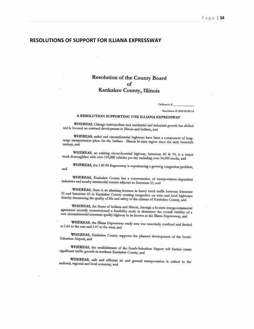
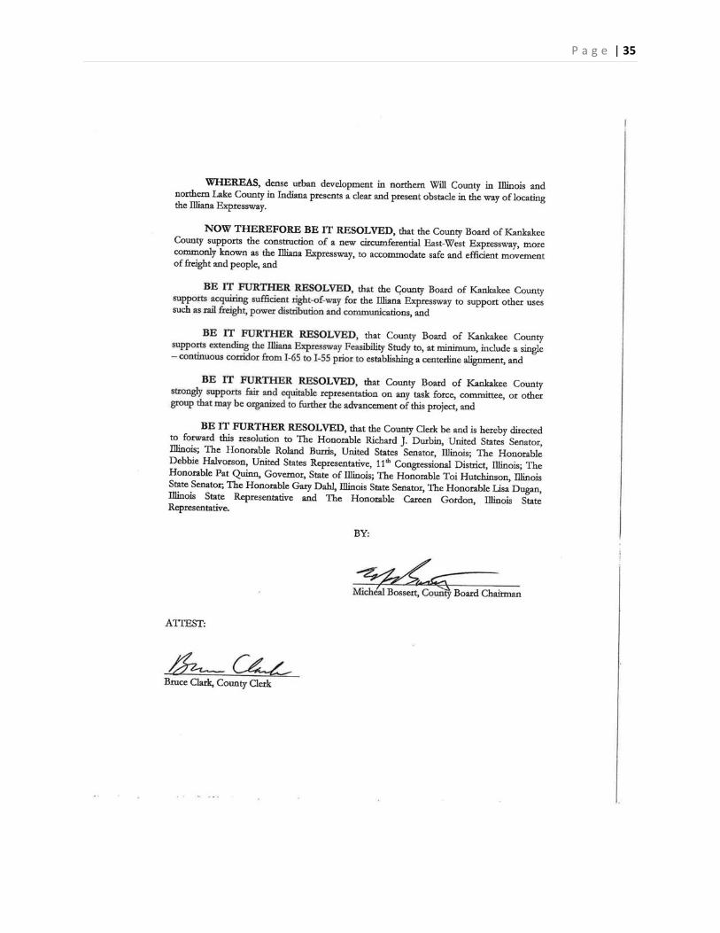
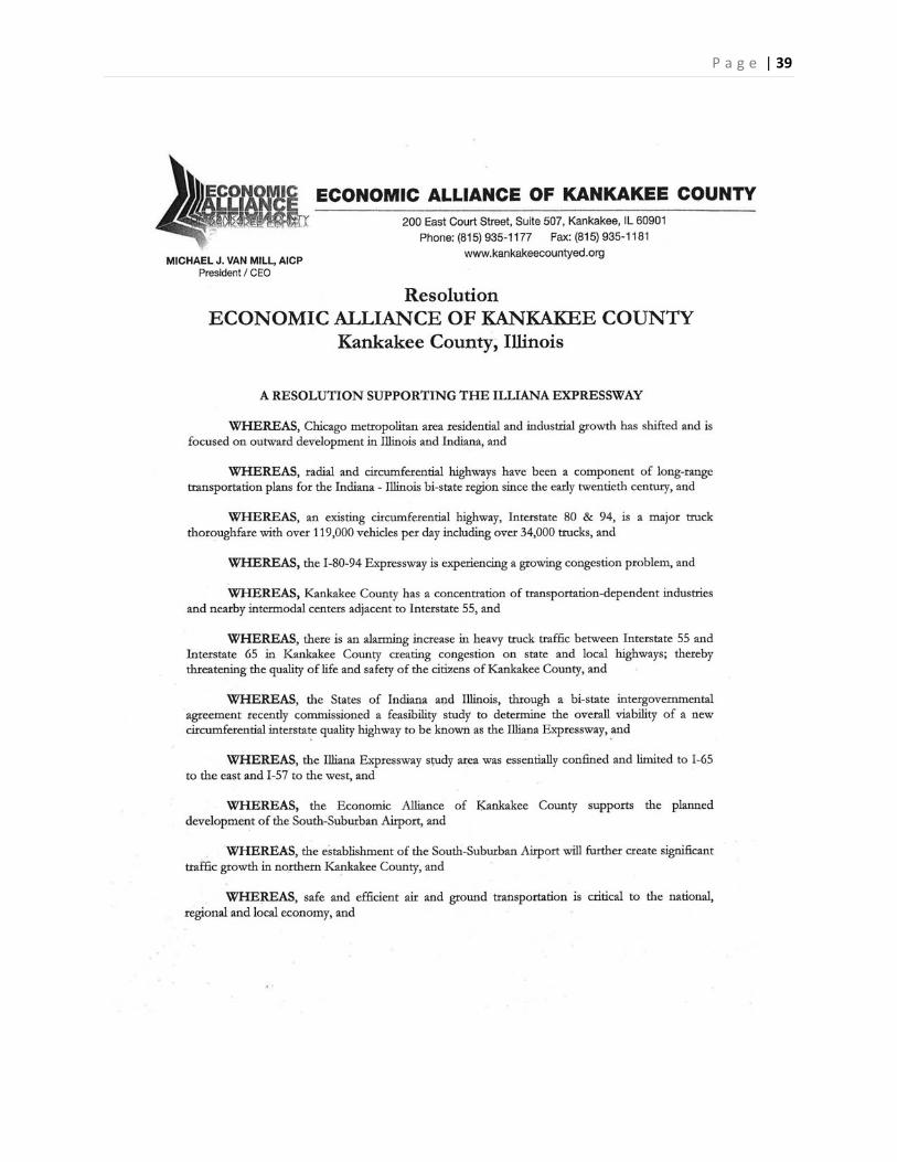
RESOLUTIONS OF SUPPORT FOR ILLIANA EXPRESSWAY
P a g e | 35

P a g e | 36

P a g e | 37

P a g e | 38
P a g e | 39
P a g e | 40
P a g e | 41

P a g e | 42

P a g e | 43

P a g e | 44

P a g e | 45
STUDY AREA MAP WITH TRAFFIC COUNTS
KANKAKEE
BRADLEY
BOURBONNAIS
MANTENO
HOPKINS PARK
GRANT PARK
MOMENCE
AROMA PARK
ST. ANNE
SAMMONS POINTCHEBANSE
SUN RIVER TERRACE
£¤45
£¤52
£¤45
£¤45
£¤52
OP50
OP1
OP115
OP17
OP114
OP102
OP1
OP17
OP17
OP17
OP1
OP1
OP50 OP1
OP1
OP17
OP50
MN54
MN32
MN37
MN8
MN44
MN51
MN19
MN58
MN13
MN50
MN57
MN17
MN35
MN16 MN1
MN9
MN42
MN3
MN2MN33
MN55MN56
MN22
MN38
MN52
MN14
MN21MN4
MN37
MN42
MN58
MN3
MN14
MN2
MN9
MN13
MN3
MN9
MN2
MN44
MN9MN9
MN33
MN37
MN8
MN13
MN2
MN37
MN16
MN32
MN13
MN54
MN57
MN35
MN42
MN13
MN50
MN2
MN37
MN37
MN8
MN51
§̈¦57
§̈¦57
§̈¦57
EASTERN KANKAKEE COUNTYTRAFFIC COUNT COMPARISONS
2012
¯
4950167534%
300085028%
4400135031%
3000100033%
475087518%
345047514%3300
55017%
630085013%
3550152543%
6350170027%
4250132531%
7750182524%
7600175023%
41503508%
43503508%
200019010%
420094523%
395050513%
570060011%
73006259%
485052511%
90507508%
36200580016%
27900610022%
88006507%
89507508%
31800510016%
74506559%
96008108%
106004504%
2610014506%
2230011505%
148008256% 18300
11256%
10700165015%
12500205016%
23800495020%
18100562531%
850085010%
11700285024%
12500185015%
11400195017%
114
2ND
5TH
4TH
6TH
1-17
DIXI
E
4000 N
3RD
PINE
HILL
ELM
GREG
G
B
INDIANA
ASH
RIVER
3500 N
LOCU
ST
1125
0E
1200
0E
MARK
ET
VINCE
NNES
MAPL
E
OHIO
RAILR
OAD
FRAN
KLIN
ILLINO IS
MILL
7TH
INDUSTRIAL
RIVER SOUTH
WASHINGTON
WALN
UT
RIVER NO RTH
MECHANIC
METCALF
CEDA
R
GLAD
IOLU
S
NORTH
THOM AS
DOE
WATER
KEYSER
OAK
HOBBIE
HARV
ARD
PARK
HARDINVERM ONT
VIRDE
N
CHER
RY
DEERSON
3000 N
CHES
TNUT
HICK
ORY
GROVE
CLARK
LOUI
SE
BRO
WN
WILL
OW
ST IRLIN G
WILB
UR
OREGON
SPRU
CE
JOLLY JACKS
SYCA
MORE
VIRG
INIA
BIRCH
ST JAMES
BENN
ETT
YALE
CIRCLE
PARRISH
MICHIG AN
CHOC
OLAT
E
ASH
7TH
RIVER
WALN
UT
4000 N
4TH
LOCU
ST
ELM
WALN
UT
MAPL
EMA
PLE
1-17
3RD
WALN
UT
MECHANIC
MOMENCE
OP1
SEE "MOMENCE MAP"
MOMENCE MAP
8450135016%
895087510%
8700112513%
11000280025%9950
122512%
8300215026%
8200175021%
6700180027%
5400172532%
LegendINTERSTATECOUNTY HIGHWAYSSTATE & US HIGHWAYSLOCAL ROADSFOUR LANE FACILITIESINCORPORATED AREA
200019010%
200019010%
AVERAGE DAILY TRAFFIC COUNT (ALL VEHICLES)AVERAGE DAILY TRAFFIC COUNT (TRUCKS ONLY)PERCENTAGE OF TRUCKS
AVERAGE DAILY TRAFFIC COUNT (ALL VEHICLES)AVERAGE DAILY TRAFFIC COUNT (TRUCKS ONLY)PERCENTAGE OF TRUCKS
FACILITIES AT OR BELOW RECOMMENDED TRUCK CAPACITY
FACILITIES ABOVE RECOMMENDED TRUCK CAPACITY


