Page 1
UNIVERSIDAD AUSTRAL DE CHILE FACULTAD DE CIENCIAS FORESTALES
Respuestas ambientales a cambios climáticos y culturales en la Región de
la Araucanía, Chile.
TESIS DOCTORAL
ANA MARIA ABARZÚA VÁSQUEZ
VALDIVIA – CHILE 2009
Page 2
ii
Respuestas ambientales durante el Cuaternario tardío a cambios climáticos
y culturales en la Región de la Araucanía, Chile.
Tesis presentada a la Facultad de Ciencias Forestales de la Universidad Austral de Chile en cumplimiento parcial de los requisitos para optar al grado de Doctor en Ciencias Forestales
por
ANA MARIA ABARZÚA VÁSQUEZ
VALDIVIA – CHILE 2009
Page 3
iii
UNIVERSIDAD AUSTRAL DE CHILE FACULTAD DE CIENCIAS FORESTALES
INFORME DE APROBACIÓN DE TESIS DE DOCTORADO
La Comisión Evaluadora de Tesis comunica al Dr. Guillermo Trincado, Director de la Escuela de Graduados de la Facultad de Ciencias Forestales que la tesis de doctorado presentada por la candidata
ANA MARIA ABARZÚA VÁSQUEZ
Ha sido aprobada en el examen de defensa de Tesis rendido el día 13 de marzo de 2009, como requisito para optar al grado de Doctor en Ciencias. Y, para que así conste para todos los efectos firman: Profesor Patrocinante de Tesis: Dr. Mario Pino Q. Comisión Evaluadora de Tesis: Dr. Antonio Lara Dr. Carlos Le Quesne Dr. Tom Dillehay
Page 4
iv
AGRADECIMIENTOS
Muchas personas e instituciones han participado directa e indirectamente en el desarrollo
de esta tesis doctoral. El Instituto de Geociencias de la Universidad Austral de Chile ha sido el
nicho para desarrollar preguntas científicas relevantes relacionadas con la evolución del paisaje,
principalmente durante el Cuaternario. En particular quisiera agradecer a mi profesor
patrocinante, Dr. Mario Pino por su constante apoyo, su confianza, su manera optimista de
avanzar con el desarrollo de la ciencia y el impulsarme siempre a descubrir temas nuevos.
Dentro de nuestro Instituto, muchos estudiantes, académicos y auxiliares han colaborado
con el desarrollo de este trabajo, agradezco la ayuda en terreno y en el laboratorio de Alia
Gajardo-Pinchicura, Leo Jarpa, Alejandra Martel, Pedro Hervé, Francisco Ríos, Leonora
Salvadores y Rodrigo Vega. Por supuesto, agradezco el apoyo y constante discusión con los
profesores Sandor Mulsow, Antón Huber, Robert Brumer y Alejandra Zúñiga. A Sandra,
Eduardo y Jorge.
Quisiera agradecer al Dr. Johannes Wallner por trabajar juntos en el Lago Budi, así como
a Prof. Mäusbacher, Daut, Jussi, Schneider, Dressler, Kirchner, Jule, Thomas y Dana por su
colaboración en esta tesis y hospitalidad en el Instituto de Geografía de la Universidad de Jena
en Alemania.
A mis colegas y amigos de doctorado con los cuales hemos compartido en terreno, en
discusiones científicas y hemos intentado mejorar nuestro Programa de estudio, Teresa Parada,
Duncan Christie, Mariela Nuñez, Daisy Nuñez, Carolina Jara, Ariel Muñoz e Iván Arismendi.
También agradezco la compañía, ayuda en terreno y en laboratorio de mis amigos: Belcha, Any
León, Dr. Antonio Maldonado, Dra. Cecilia Smith, MSc Jean Piere Francois, Rodrigo Pizarro,
Rodrigo Molina, Nury Lagos, Paz Villalobos y Flaco Carvajal.
A los profesores Vera Markgraf y Juan Armesto por sus críticos comentarios y
correcciones de este manuscrito, así también la valiosa discusión con los profesores integrantes
de la Comisión evaluadora de tesis: Tom Dillehay, Antonio Lara, Carlos Le-Quesne y Pablo
Donoso.
Page 5
v
En especial agradezco a la profesora Dra. Carolina Villagrán por su amistad y su
formación en palinología y botánica durante mi Licenciatura y Magíster, herramientas con la
cuales he podido desarrollar esta tesis doctoral.
Finalmente, les doy las gracias a mi familia (mamá, cuca, alfi, nana) y a mis amigos de la
vida por estar cerca (a veces lejos) y siempre dispuestos a ver fotos y escuchar una nueva historia
o aventura de miles de años.
Esta tesis ha sido financiada con la colaboración de muchos fondos: Universidad Austral
de Chile (DID 2007-08 y FORECOS P04-065-F), Araucanian Polity Formation in Chile-Project
(BSN-34567-04), European Union: ALFA-Project EUFORLA, Institute of Geography,
Friedrich-Schiller University of Jena y la beca doctoral de CONICYT-Chile.
Page 6
vi
TABLA DE CONTENIDOS
Título ............................................................................................................................................. ii
Certificado de examinación ................................................................................................... iii
Agradecimientos ....................................................................................................................... iv
Tablas de contenidos ............................................................................................................... vi
Lista de Figuras ....................................................................................................................... viii
Lista de Tablas ........................................................................................................................... ix
Lista de Abreviaciones .............................................................................................................. x
Capítulo 1:...................................................................................................................................... 1
1.1 Resumen y Abstract ........................................................................................ 1
1.2 Introducción general........................................................................................ 3
1.3 Referencias ....................................................................................................... 7
Capítulo 2: Late Quaternary climatic and cultural reconstructions in Araucanian
Chilean Region .................................................................................................... 10
2.1 Abstract and key words ................................................................................ 11
2.2 Introduction ................................................................................................... 12
2.3 Environmental settings ................................................................................ 14
2.4 Methods .......................................................................................................... 15
2.5 Results
Geochemical sediment description and chronology ........................................ 17
Pollen record ......................................................................................................... 17
Charcoal record .................................................................................................... 19
2.6 Discussion ..................................................................................................... 19
2.7 Summary and conclusions .......................................................................... 25
2.8 Acknowledgements ...................................................................................... 26
Page 7
vii
2.9 References ...................................................................................................... 26
Figures and tables .................................................................................................. 33
Capítulo 3: Paleolimnological investigations at Lago Budi, Araucanian Region,
Chile (38.9°S): Chronology of relative sea level changes and climatic
indications during the Late Glacial and Holocene. ................................. 41
3.1 Abstract and key words ................................................................................ 42
3.2 Introduction ................................................................................................... 43
3.3 Environmental settings ................................................................................ 44
3.4 Methods .......................................................................................................... 46
3.5 Results
Sedimentology and chronology of Lago Budi ................................................... 47
Pollen record .......................................................................................................... 48
Vegetation and climate reconstructions ............................................................. 49
3.6 Discussion and conclusions ........................................................................ 51
3.7 Acknowledgements ...................................................................................... 54
3.8 References ...................................................................................................... 54
Figures and tables .................................................................................................. 61
Capítulo 4: Discusión general .............................................................................................. 70
4.1 Referencias discusión general ........................................................................ 73
Page 8
viii
LISTA DE FIGURAS
Capítulo 2
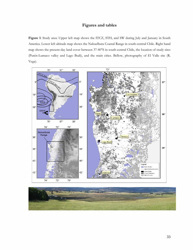
1. Study area ............................................................................................................................. 33
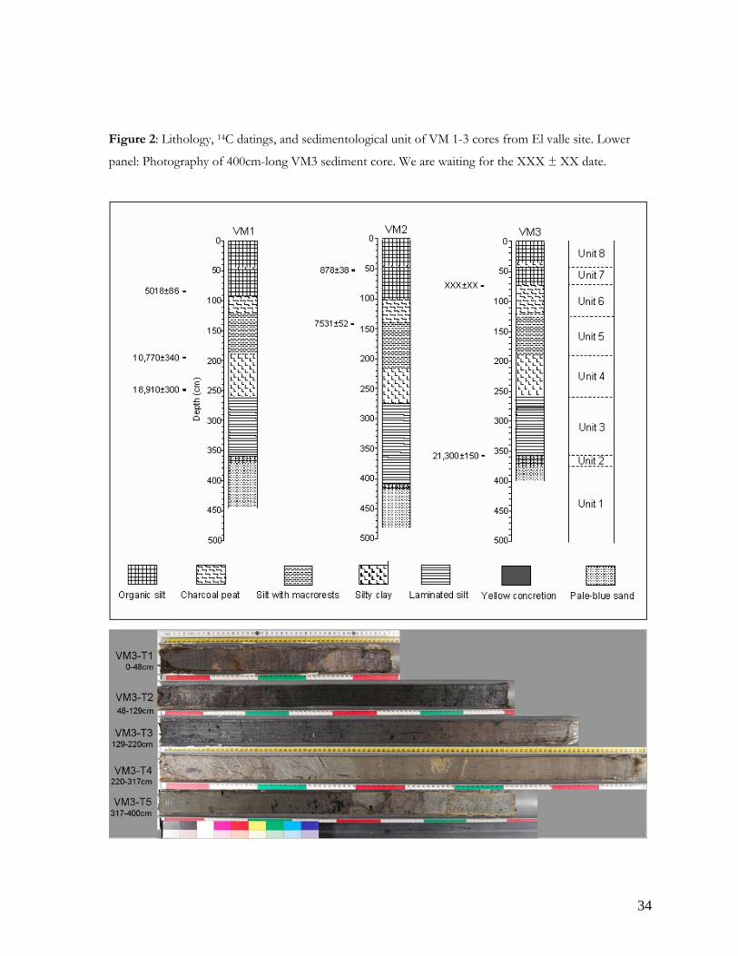
2. Lithology, 14C datings, and sedimentological unit of VM 1-3 cores from El valle ... 34
3. Sedimentary features from El Valle .……....................................................................... 35
4. Age model from El Valle ……......................................................................................... 36
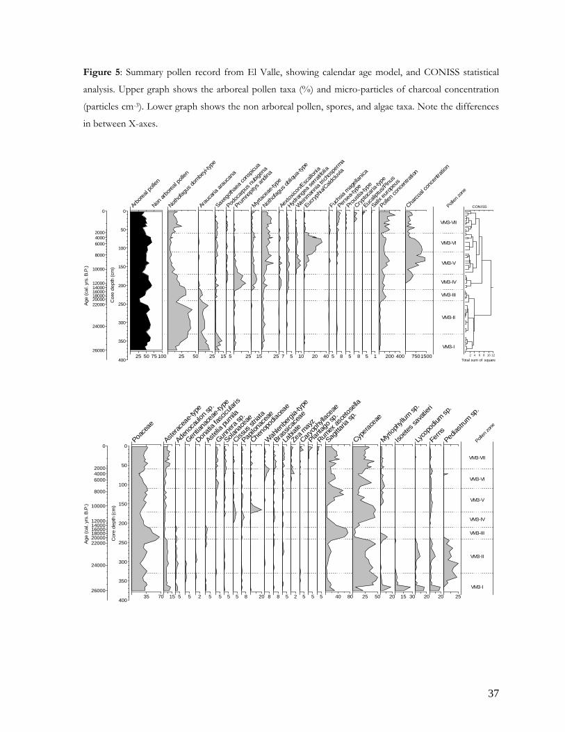
5. Pollen record from El Valle ………................................................................................ 37
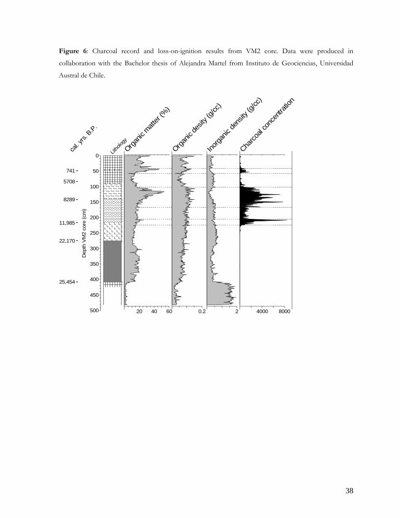
6. Charcoal record from El Valle ……................................................................................ 38
Capítulo 3
1. Study area .......................................................................................................................... 61
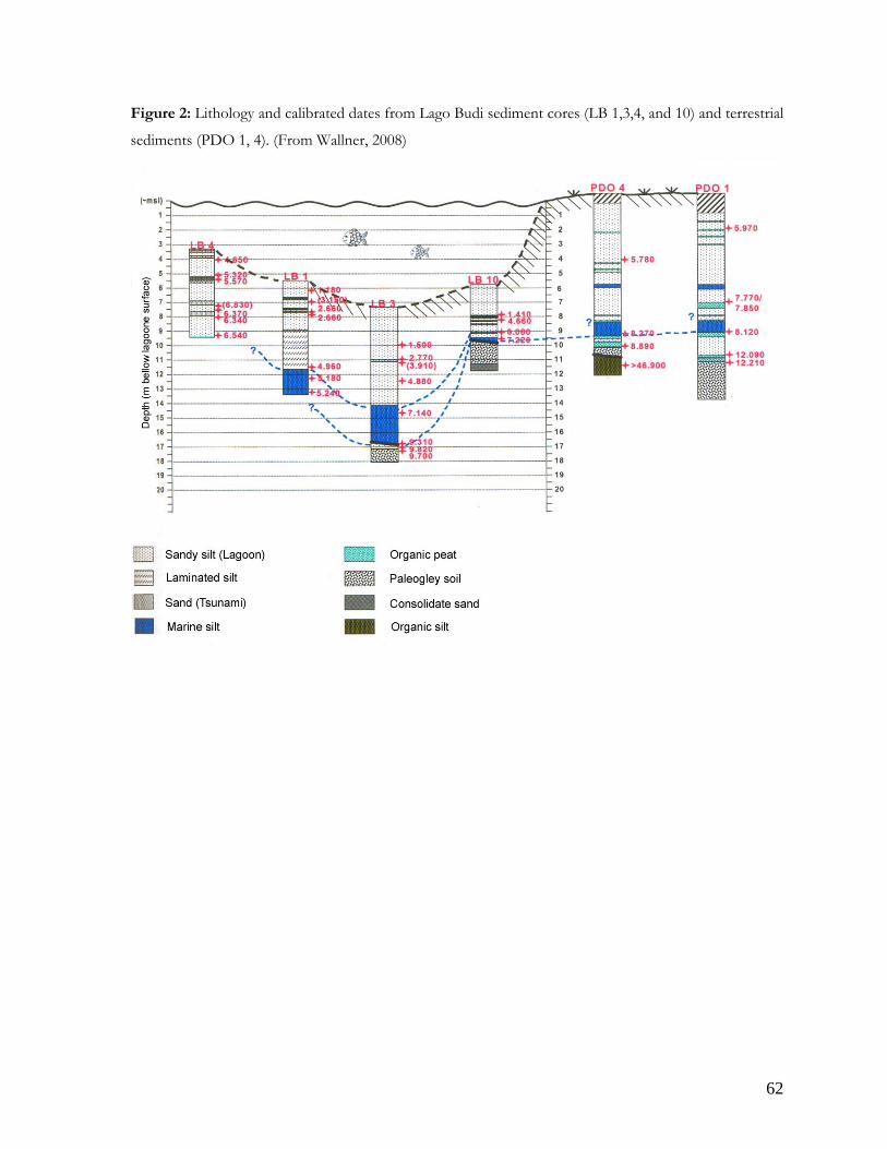
2. Lithology from Lago Budi sediment cores .................................................................. 62
3. Tsunami layers from Lago Budi records ...................................................................... 63
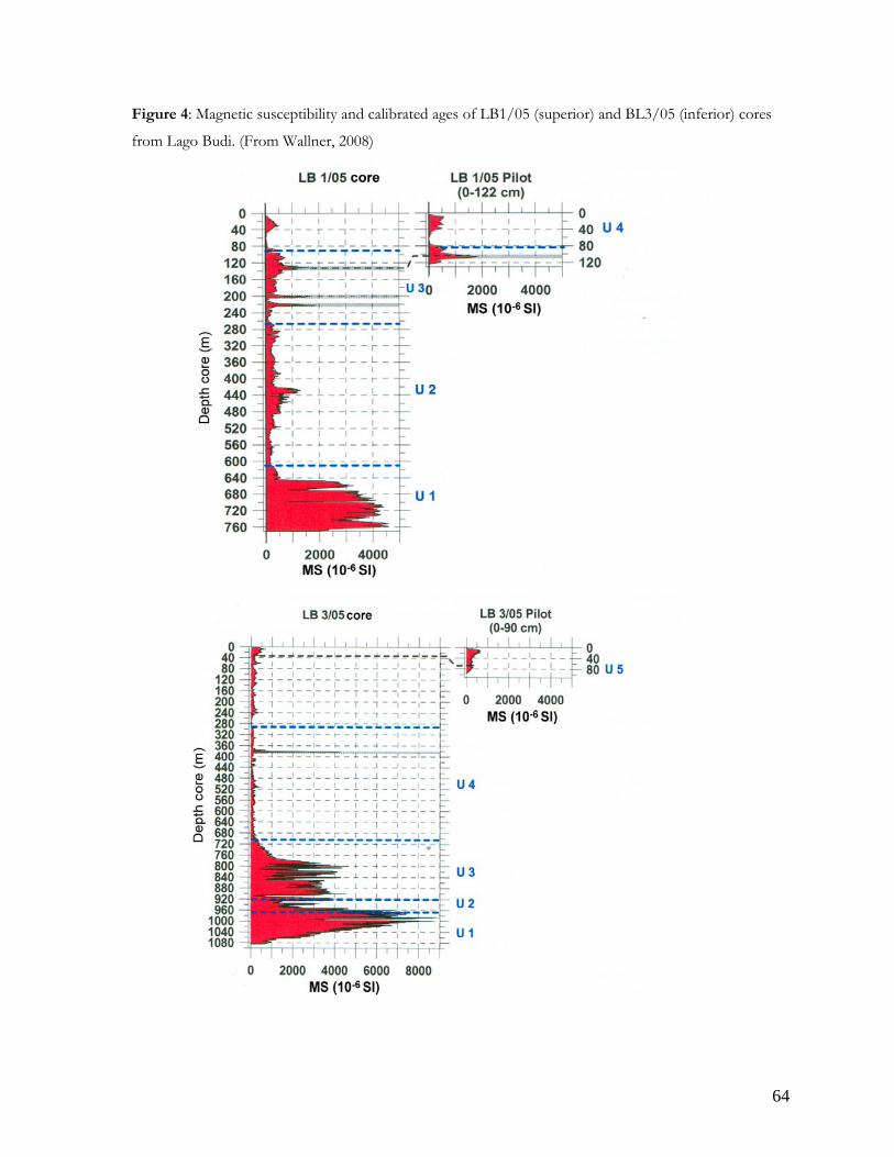
4. Magnetic susceptibility from Lago Budi record .......................................................... 64
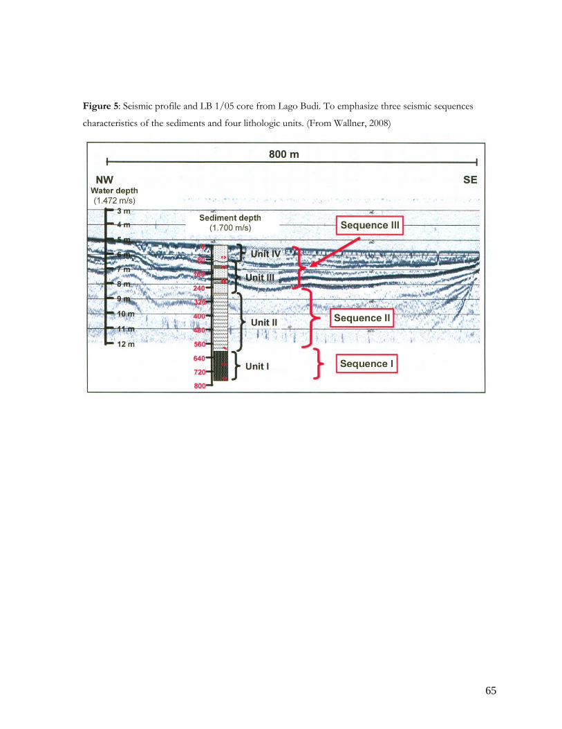
5. Seismic profile from Lago Budi ..................................................................................... 65
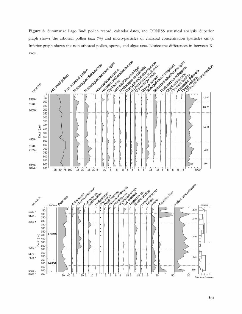
6. Pollen record from Lago Budi ....................................................................................... 66
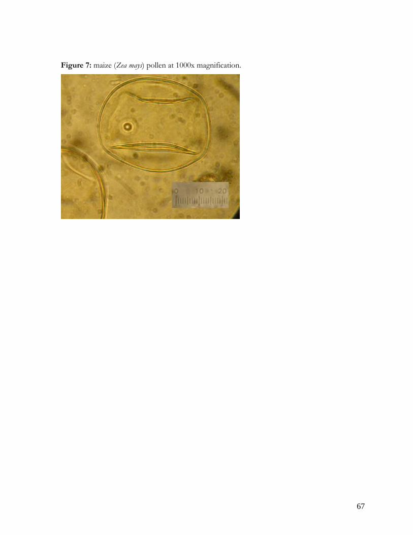
7. Picture of Zea mays pollen ............................................................................................... 67
Page 9
ix
LISTA DE TABLAS
Capítulo 2
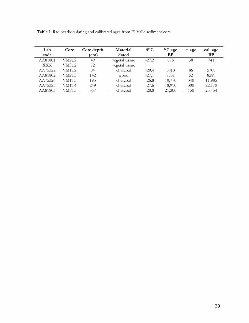
1. Radiocarbon datings from El Valle……............................................................................ 39
2. Summary pollen assemblages from El Valle……............................................................. 40
Capítulo 3
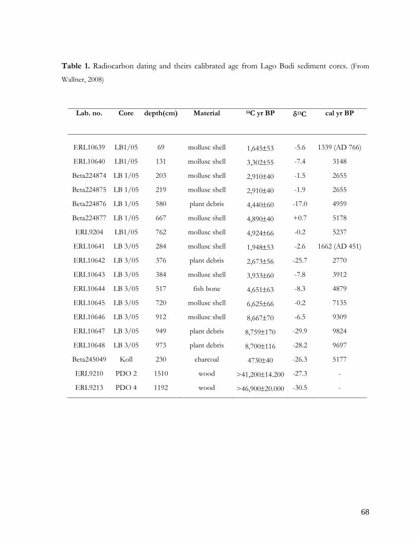
1. Radiocarbon datings from Lago Budi ................................................................................ 68
2. Summary pollen assemblages from Lago Budi ................................................................. 69
Page 10
x
LISTA DE ABREVIATURAS UMG: Último Máximo Glacial
LGM: Last Glacial Maximum
ka AP: mil años calendario antes del presente
kyr BP: thousand calendar years before the present
SW: Southern Westerlies
STH: South Pacific Subtropical High-pressure System
ITCZ: Intertropical Convergence Zone
ENSO: El Niño Southern Oscillation
MS: Magnetic susceptibility
AMS: Acellerator mass spectrometer
msl: mean sea level
m a.s.l.: meters above sea level
HMT: Holocene Marine Transgresion
e.g.: for example
Page 11
1
RESUMEN
Los valles intermontanos y costeros de la Cordillera de Nahuelbuta (38°) son un área
clásicamente poblada por el pueblo Mapuche y por lo tanto, muy sencible para evaluar el
impacto humano en la estructura del paisaje frente a cambios climáticos durante el Holoceno.
Esta latitud representa una transición climático-vegetacional de la celda de alta presión
(Anticiclón del Pacífico), al régimen de precipitaciones del cinturón de vientos del oeste y al
efecto estacional de El Niño Oscilación del sur. Es de esperar entonces que variaciones durante
el Cuaternario en estos tres sistemas climáticos hayan afectado la distribución y composición de
la vegetación en el área. El objetivo de esta tesis es desarrollar un modelo paleoecológico y
paleoclimático que permita comprender el efecto de posibles cambios ambientales asociados a
variaciones climáticas y culturales en la Región de la Araucanía (38°S), Chile. Para lograr este
objetivo se determinó la cronología, dirección y magnitud de los cambios ambientales
considerando el de análisis de registros sedimentológicos, geoquímicos y biológicos, asociado a
información histórica y arqueológica disponible en dos áreas de estudio: el valle Purén-Lumaco
(38°S) y el Lago Budi (39°S).
El registro obtenido en el valle Purén-Lumaco abarca 26 mil años calendario antes del presente
(ka AP), evidenciando uno de los posibles refugios glaciales para los bosques templados
lluviosos (bosques de Araucaria-Nothofagus), asociados a un paleolago en el área y condiciones
frío-húmedas características del Ultimo Máximo Glacial (UMG, 30-19 ka AP). El debilitamiento
del Anticiclón del Pacífico permitió un desplazamiento hacia el ecuador del margen norte del
cinturón de vientos del oeste y de la Circulación Circumpolar Antártica, implicando mayores
precipitaciones y menos temperaturas en Chile central.
Durante el UMG, el Lago Budi constituía un río y el nivel del mar se encontraba cientos de
metros más bajo que su nivel actual. A partir de 12 ka AP comienza una tendencia sostenida de
calentamiento climático, comienza la sedimentación en el Lago Budi y el paleolago en Purén-
Lumaco desaparece, formándose el sistema complejo de cuencas pantanosas del área. Entre 9 y
5 mil años AP se registra el periodo más cálido en ambos registros, en el Lago Budi como una
transgresión marina y en Purén-Lumaco con el desarrollo de una turba y elementos cálidos del
bosque templado. Por primera vez en Chile, ambos registros evidencian la presencia de polen de
maíz (Zea mays) a partir de ~5 ka AP, apoyando el inicio de prácticas agrícolas y las
interpretaciones arqueológicas de la Región de la Araucanía.
Page 12
2
ABSTRACT
Nahuelbuta Coastal Range (38°S) has been inhabited by an extremely dense and ancient
population of indigenous Mapuche communities thus represents an interesting area to evaluate
the human impact in the landscape at different time scales during the Holocene. The climate-
vegetacional transition at 38°S is associated with the effect of South Pacific Subtropical High-
pressure System, the Southern Westerlies winds, and the ENSO variability. Quaternary
variations of these three climatic systems are related to changes in the vegetation covers. The
thesis aim is develop a paleoecologic and paleoclimatic model to understand the effect over
environmental changes in association with the variation of climatic system and the human
impact in the Araucanian region (38°S), Chile. Sedimentological, geochemical, and biological
results from sediments cores from Purén-Lumaco valley (38ºS) and Lago Budi (39°S) show the
environmental changes during the late Quaternary and Holocene. The Purén-Lumaco record
covers the last 26 kyr, demonstrating an araucanian glacial refugium for temperate rainforest
(Araucaria-Nothofagus forests) and the cold and per-humid climate conditions during the Last
Glacial Maximum (LGM, 30-19 kyr BP). The weakening of South Pacific Subtropical High-
pressure System induced the ecuatorward sift of northern most boundary of Southern Westerlies
and the Antarctic circumpolar current, implicaying the high precipitation rates and cold
temperatures in Central Chile.
During the LGM, Lago Budi was a river, the sea level was hundred meters down, and Purén-
Lumaco was a lake. At 12 kyr BP start a warm regional climatic trend, start the sedimentation in
Lago Budi, and the paleolake in Purén-Lumaco desapear. Between 9 and 5 kyr BP is the
dry/warm period of early mid-Holocene in south-central Chile, interpreted by the marine
transgression in Lago Budi and the warm-temperate taxa in Purén-Lumaco valley.
By the very first time, both records show the presence of maize pollen (Zea mays) at ~5 kyr BP
supporting the onset of agricultural practice and the archaeological interpretations in Araucanian
region.
Page 13
3
CAPÍTULO 1
1.2 INTRODUCCION GENERAL
Comprender la evolución del paisaje es un problema complejo que requiere de la
interacción de diversas disciplinas bajo un objetivo en común, donde se involucran variables
humanas y variables ambientales, tales como el clima, la vegetación y la geomorfología. Esta
investigación discute a partir de una estrategia transdisciplinaria, el cambio ambiental en
diferentes escalas temporales asociado a la variabilidad del clima y a la influencia de grupos
humanos en la Región de la Araucanía.
Los depósitos sedimentológicos, geoquímicos y biológicos en lagos y pantanos proveen
información de largo plazo y alta resolución, para observar la dinámica de los ecosistemas que
rodean una cuenca. El valle del río Purén-Lumaco (38°S), así como el Lago Budi (39°S) en la
Región de la Araucanía, ofrecen una excelente oportunidad para establecer relaciones directas
entre el cambio ambiental (clima y vegetación) con la ocupación humana desde periodos pre-
hispánicos en el área; así dar luces sobre el rol de los grupos humanos y su cultura en la
transformación del paisaje.
A diferentes escalas, las poblaciones humanas y el ambiente físico interactúan a través de
procesos ecológicos dinámicos (Dillehay y Saavedra, 2003). La manipulación del agua, del
bosque y las interacciones con otros organismos, constituyen la base de la explotación de la
naturaleza por parte de la sociedad que la habita. Las actividades humanas, como el
sedentarismo, la práctica agrícola, la explotación intensiva de los recursos naturales, alteran
significativamente los procesos ecológicos y sociales (Dillehay, 1990). Así mismo, las respuestas
humanas son determinadas, por lo general, por variables socioeconómicas que operan a escala de
paisaje asociadas a la variabilidad ambiental como el cambio de la vegetación y del clima
(deMenocal, 2001).
El rol de las actividades humanas en la transformación del paisaje, generando
movimiento de material desde las cuencas hacia los lagos y/o pantanos ha sido monitoreado a
través de estudios paleoecológicos en diversos lugares del mundo. Un ejemplo bien
documentado es el de Guatemala, donde el objetivo principal fue evaluar el cambio de los
ecosistemas a través del aporte de sedimentos en lagos en relación con disturbios culturales de la
Page 14
4
sociedad Maya y su desaparición asociada a la variación del régimen de precipitaciones en la
región (e.g. Binford et al., 1987; Brenner et al., 2001).
En Chile, las modificaciones del paisaje realizadas por los grupos humanos han tenido
distintas características e intensidad según el tamaño de las poblaciones y el nivel de desarrollo
tecnológico adquirido (Donoso, 1983; Gasto, 1979). Los cambios experimentados en los
ecosistemas forestales chilenos están ligados necesariamente a la política y legislación imperante
en cada época de la historia y a las costumbres o condición cultural de las agrupaciones humanas.
En la región de la Araucanía los grupos indígenas utilizaban el fuego para preparar los campos
de cultivo de especies como la quinoa, el maíz, el mango, la teca y el madi, que más tarde fueron
reemplazados por cultivos europeos (Gay, 1865; Donoso, 1983).
Los registros arqueológicos indican la temprana llegada de poblaciones indígenas en
Chile centro-sur, como lo documenta la existencia de sitios antiguos (Periodo Arcaico, ~12 ka
AP) en Chile central y sur, tales como Tagua-Tagua (33°S, Montané, 1968; Heusser, 1983) y
Monte Verde (41°S, Pino & Dillehay, 1988). Algunos antecedentes generados por el proyecto
Araucanian Polity Formation in Chile demuestran la temprana interacción humana y el ambiente
en la Región de la Araucanía (38-39°S). El rasgo arqueológico más importante en el valle de
Purén-Lumaco y en Lago Budi es el Kuel, un término Mapuche que significa montículo de tierra
artificial. La presencia y extensión de estos Kuel reflejan el nivel de desarrollo social y económico
que, en parte, explica por qué la región se constituyó en un centro de resistencia española en los
siglos XVI y XVII (Dillehay y Saavedra, 2003). Las dataciones radiocarbónicas obtenidas para
los Kuel comprenden desde 1200 d.C. y para un sitio arqueológico del valle Purén-Lumaco una
edad de ~7 ka AP (Dillehay, 2006).
Asociado al rol de las poblaciones humanas en el paisaje, la vegetación se encuentra
fuertemente determinada por el clima imperante en los gradientes latitudinales y altitudinales de
la vertiente oeste de la Cordillera de los Andes (Schmithüsen, 1956). Durante el Cuaternario
cambios climáticos han sido documentadas en los trabajos de palinólogos y cuaternaristas en
Chile centro-sur. Los reiterados ciclos glaciales del Pleistoceno dejaron su huella en la vegetación
del sur y andina que fue desplazada hacia los faldeos de la Cordillera de la Costa y Depresión
Central (Darwin, 1859; Simpson, 1983; Heusser, 1990; Villagrán et al., 2004), representando
áreas de refugios glaciales para muchas especies (Villagrán et al., 1998; Villagrán, 2001; Bull-
Hereñu, 2005). Para el Holoceno existen estudios que reflejan la historia paleoclimática y
vegetacional de Chile central (30-34°S) (Heusser, 1990; Maldonado & Villagrán, 2001; Villa-
Page 15
5
Martínez et al., 2003) y sur (41-56°S) (por ejemplo, Heusser, 1966; Villagrán, 2001; Abarzúa et al.
2004; Moreno, 2004; Haberle & Bennett, 2004; Markgraf et al., 2007). Estos registros
paleoclimáticos coinciden en describir el Holoceno temprano como un periodo severamente
más cálido y seco que la actualidad, donde los elementos más xéricos/esclerófilos invadieron el
paisaje en Chile central y centro-sur. Tales condiciones serían consecuencia de un debilitamiento
del Cinturón de vientos del oeste e intensificación del Anticiclón del Pacífico (Caviedes, 1972;
Villagrán & Varela, 1990; Lamy et al., 1999; Abarzúa & Moreno, 2008; Kaiser et al., 2008).
El la región de la Araucanía la dirección, magnitud, tasas de cambio y cronología de
cambios vegetacionales y climáticos durante el Cuaternario son aún desconocidas. Un aspecto
clave para la comprensión de los patrones y causas de cambios pasados en el paisaje es poder
comparar la anatomía de cambios a múltiples escalas espaciales y temporales, sobre la base de
una cronología común. Registros paleoambientales detallados provenientes de Chile centro-sur
son indispensables para entender la globalidad del fenómeno climático a lo largo del país, sobre
todo en un área sensible, climática e históricamente, a variaciones ocurridas durante el pasado.
Algunas de las preguntas que conducen esta investigación son:
• ¿De qué manera variaron la vegetación y las condiciones climáticas en la región de la
Araucanía (38-39°S) durante el Cuaternario?
• ¿Ha sido el cambio climático un proceso de calentamiento continuo desde la última
glaciación en Chile centro-sur?
• ¿Cuál es la cronología y magnitud del impacto humano en el paisaje que circunda el valle de
Purén-Lumaco y el Lago Budi?; ¿Cuáles son sus evidencias sedimentológicas, estratigráficas
o botánicas?
• ¿Es el fuego un factor importante y/o permanente en el modelamiento del paisaje de la
región? Y ¿qué factores, humanos, climáticos o ambos, han condicionado la ocurrencia de
fuego en la región?
Todas estas preguntas se enmarcan en preguntas de largo plazo en la región. Así, el
siguiente estudio se encuentra bajo una estrategia transdisciplinaria y las implicancias de sus
futuros hallazgos contribuirán en ámbitos diversos como la paleoclimatología, paleoecología,
biogeografía, antropología, arqueología y ordenamiento territorial. Pese a la importancia y gran
Page 16
6
potencial de esta zona transicional vegetacional y climática en el centro-sur de Chile (38°S) en el
ámbito paleoclimático, la información paleoambiental aún es deficitaria y los patrones de cambio
climático Cuaternario todavía se encuentran en un estado rudimentario de desarrollo.
El objetivo general de esta investigación es desarrollar un modelo paleoecológico y
paleoclimático que permita comprender el efecto de posibles cambios paleoambientales debido a
influencias climáticas y culturales en ecosistemas boscosos del centro-sur de Chile (38°S) durante
el Cuaternario.
Esta investigación ha sido organizada en dos grandes capítulos, el primero Late Quaternary climatic
and cultural reconstructions in Araucanian region, Chile” presenta evidencias sedimentológicas para
interpretaciones de cambio climático y vegetacional durante los últimos 26 mil años asociados a
los hallazgos arqueológicos presentes en el valle de Purén-Lumaco (38°S).
El segundo capítulo “Paleolimnological investigations at Lago Budi, Araucanian Region, Chile (38.9°S):
Chronology of relative sea level changes and climatic indications during the Late Glacial and Holocene”, discute
evidencias sedimentológicas para el origen del Lago Budi en relación a variables climáticas y
tectónicas en el centro-sur de Chile.
Page 17
7
1.3 REFERENCIAS Abarzúa, A.M., Villagrán, C., & Moreno, P.I. 2004. Deglacial and postglacial climate history in
east-central Isla Grande de Chiloé, southern Chile (43ºS). Quaternary Research 62: 49-59. Abarzúa, A.M. & Moreno, P.I. 2008. Changing fire regimes in the temperate rainforest region of
southern Chile over the last 16,000 years. Quaternary Research 69: 62-71. Binford, M., Brenner, M., Whitmore, T.J., Higuera-Gundy, A., Deevey, E.S. & Leyden, B.W.,
1987. Ecosystems, Paleoecology, and Human Disturbance in Subtropical and Tropical America. Quaternary Science Reviews 6: 115–128.
Brenner, M., Rosenmeier, M.F., Hodell, D.A. & Curtis, J.H. 2002. Paleolimnology of the Maya
lowlands: Long-term perspectives on interactions among climate, environment, and humans. Ancient Mesoamerica 13: 141–157.
Bull-Hereñu, K., Martínez, E.A. & Squeo, F.A. 2005. Structure and genetic diversity in Colliguaja
odorifera Mol. (Euphorbiaceae), a shrub subjected to Pleisto-Holocenic natural perturbations in a mediterranean South American region. Journal of Biogeography 32, 1129–1138
Caviedes, C.N., 1972. Geomorfología del Cuaternario del valle Aconcagua, Chile Central, Freiburger geographische 11: 153.
Darwin, C. 1859. The origin of species. Penguin Books, Oxford, UK, pp. 477. deMenocal, PB. 2001. Cultural responses to climate change during the late Holocene. Science
292: 667-73. Dillehay, T. & Saavedra, J. 2003. Interacción humana y ambiente: el desarrollo de Kuel en
Purén-Lumaco (Región de la Araucanía). Revista Austral de Ciencias Sociales 7: 17-28.
Dillehay, T., 2006. La utilización de los humedales. Actas del Congreso Chileno de Arqueología. Valdivia, Chile. Octubre 2006.
Dillehay, T., 1990. Araucanía: Presente y Pasado. Editorial Andrés Bello. Santiago, Chile. Capítulo 1.
Donoso, C., 1983. Modificaciones del paisaje chileno a los largo de la historia. En: Simposium Desarrollo y Perspectivas de las disciplinas forestales de la Universidad Austral de Chile. Pp. 365-438.
Page 18
8
Gastó, J. 1979. Ecología, el hombre y la transformación de la naturaleza. Editorial Universitaria. Santiago, Chile.
Haberle, S.G. & Bennett, K.D., 2004. Postglacial formation and dynamics of North Patagonian
Rainforest in the Chonos Archipelago, Southern Chile. Quaternary Science Reviews 23, 2433–2452
Heusser, C.J., 1966. Late-Pleistocene pollen diagrams from the Province of Llanquihue, southern
Chile. Proceedings of the American Philosophical Society 110: 269-305. Heusser, C.J., 1983. Quatemary pollen record from Laguna de Tagua Tagua, Chile. Science 219,
1429-1432. Heusser, C.J., 1990. Ice age vegetation and climate of subtropical Chile. Palaeography,
Palaeoclimatology, Palaeoecology, 80, 107–127.
Kaiser, J., Schefuss, E., Lamy, F., Mohtadi, M., & Hebbeln, D., 2008. Glacial to Holocene changes in sea surface temperature and coastal vegetation in north central Chile: high versus low latitude forcing. Quaternary Science Reviews 27: 2064–2075.
Lamy, F., Hebbeln, D. & Wefer, G., 1999, High resolution marine record of climatic change in
mid-latitude Chile during the last 28,000 years based on terrigenous sediment parameters. Quaternary Research, 51, 83–93.
Maldonado, A. & Villagrán, C., 2001. Historia del bosque pantanoso de Ñague, costa de Los
Vilos (IV Región, Chile) y sus relaciones con los cambios paleoambientales de los últimos 5.300 años. Libro Rojo de la Flora Nativa y de los Sitios Prioritarios para su Conservación: Región de Coquimbo (ed. by F.A. Squeo, G. Arancio and J.R. Gutiérrez), pp. 261–272. Ediciones Universidad de la Serena, La Serena.
Markgraf, V., Whitlock, C. & Haberle, S., 2007. Vegetation and fire history during the last 18,000
cal yr B.P. in Southern Patagonia: Mallin Pollux, Coyhaique, Province Aisén (45°41’30’’ S, 71°50’30’’ W, 640 m elevation). Palaeogeography, Palaeoclimatology, palaeoecology 254: 492-507.
Montané, J.C., 1968. Paleo-indean remains from Laguna Tagua Tagua, central Chile. Science
161: 1137-1138.
Moreno, P.I., 2004. Millennial-scale climate variability in northwest Patagonia over the last 15,000 yrs, Journal of Quaternary Science 19(1): 35-47.
Pino, M. & Dillehay, T.D., 1988. Monte Verde, South Central Chile: Stratigraphy, Climate Change, and Human Settlement, Geoarchaeology 3(3): 177-191.
Schmithüsen, J., 1956. Die raumliche Ordnung der chilenischen Vegetation, Boner Geogr. Abh.
17: 3-86.
Page 19
9
Simpson, B., 1983. An historical phytogeography of the high Andean Flora. Revista Chilena de
Historia Natural, 56, 109-122. Villa-Martínez, R., Villagrán, C. & Jenny, B., 2003. The last 7500 cal yr B.P. of westerly rainfall in
Central Chile inferred from a high-resolution pollen record from Laguna Aculeo (34°S). Quaternary Research, 60, 284–293.
Villagrán, C., 2001. Un modelo de la historia de la vegetación de la Cordillera de La Costa de
Chile central-sur: la hipótesis glacial de Darwin. Revista Chilena de Historia Natural, 74, 793–803.
Villagrán, C. & Varela, J., 1990. Palynological evidence for increased aridity on the central
Chilean coast during the Holocene. Quaternary Research, 34, 198–207. Villagrán, C., Le-Quesne, C., Aravena, J.C., Jiménez, H. & Hinojosa, F., 1998. El rol de los
cambios de clima cuaternario en la distribución actual de la vegetación de Chile central-sur. Bamberger Geographische Schriften Bd. 15: 227–242.
Villagrán, C., León, A. & Roig, F.A., 2004. Paleodistribución del alerce y ciprés de las Guaitecas
durante períodos interestadiales de la Glaciación Llanquihue: Provincia de Llanquihue y Chiloé, Región de los Lagos, Chile. Revista Geológica de Chile 31 (1): 133-151.
Page 20
10
CAPÍTULO 2
Late Quaternary climatic and cultural reconstructions in
Araucanian Chilean Region.
A. M. Abarzúaa, Tom D. Dillehayb, Roland Mäusbacherc, Mario Pinoa. Prepared for Quaternary Science Review. aInstituto de Geociencias, Universidad Austral de Chile, Casilla 567, Valdivia, Chile. bDepartment of Anthropology, Vanderbilt University, Nashville, TN 37221, USA. cInstitute for Geography, University of Jena, Löbdergraben 32, D-07749 Jena, Germany.
* Corresponding author. Tel.: 0056-63-221208; fax: 0056-63-293563. E-mail address:
[email protected] (A.M. Abarzúa).
Page 21
11
Abstract
A sediment core from the Purén-Lumaco valley (38ºS/73°W, 70m a.s.l.), south-central
Chile, was analyzed for pollen, charcoal, sedimentologic and geochemical characteristics showing
climatic changes and human impact at different time scales during the last 26 k cal yr BP.
Nothofagus-Araucaria forests and grasslands covered the lowlands during the last glacial maximum
(LGM, ~30-20 k cal yr BP) associated with a lacustrine environment and suggesting cold and
per-humid climatic conditions. At 20.6 k cal yr BP the lake desiccated, replaced by a swamp and
the increase of grass species. Warm-temperate taxa, Myrtaceae and Prumnopitys andina replaced
the Nothofagus dombeyi/Araucaria forest by 15 k cal yr BP. This warming trend culminates between
8 and 5.7 k cal yr BP, when Eucryphia/Caldcluvia-type became abundant and fire frequency was
extremely high. Thus, our data support the notion of an early Holocene dry/warm climate that
has been documented from other pollen records between 30 and 43ºS in Chile. In climate terms
this implies that the Southern Westerlies had shifted polewards. By 2 k cal yr BP, establishment
of mixed grassland - Nothofagus dombeyi/N. obliqua woodland comparable to the present
vegetation suggests present-day winter-rain dominated climate regime. Archaeological research
in the area dates the beginning of human settlements to 7 k cal yr BP. The most striking
archaeological evidence are artificial mound complexes (Kuel) built by Mapuche indigenous
communities after AD 1300. The presence of ~350 Kuel in the valley reflects the
social/economic development during the last millennium. Our palynological and geochemical
data support the archaeological interpretation showing an early presence of maize (Zea mays) at
~5 k cal yr BP. Today the Purén-Lumaco valley is a complex wetland system dominated by
exotic grasses and introduced tree species (Tritricum aestivum, Pinus radiata and Eucalyptus spp.).
This highly modified landscape with its negative consequences for the subsistence economy of
the local indigenous society makes it urgent to promote the rehabilitation of a relict and
vanishing native forest ecosystem that today persists only as fragments on the crest of the
Nahuelbuta Coastal Range (38°S).
Key words: Chile, Araucania, Temperate rainforest, Late Quaternary, Climate change, Mapuche
culture, Zea mays.
Page 22
12
1. Introduction
Modern landscape evolution is the product of complex interactions between human
culture and natural processes that must be studied from a multidisciplinary perspective. The
effects of people on their surroundings are only one way of viewing the relationship between
humans and their environment (Redman, 1999). Advocates of “environmental determinism”
view the interaction “in reverse,” positing that the environment also limits human cultural
development (de Menocal, 2001). The late Quaternary period, after peopling of the Americas,
provides an excellent setting to analyze the evidence that climate, environment, and human
cultures are intimately linked (e.g. Brenner et al., 2002).
Paleolimnological investigations have supplemented archaeological studies to provide the
environmental context in which cultures arose, flourished, and collapsed. Analysis of lake
sediments can be used to develop continuous, long-term records of environmental changes.
These lacustrine deposits can be employed to infer regional ecological history; contain physical,
chemical, and/or biological information about past conditions within lakes and in their
surrounding watersheds. Multiple lines of sedimentary evidence are required as proxies for
inferring past environmental conditions and to provide meaningful and coherent
paleoenvironmental reconstructions (e.g. Binford et al., 1987).
In south-central Chile multiproxy paleoenvironmental studies that focus on landscape changes
associated with human and climatic influences are few. Chilean paleoclimatic records have
shown that major changes in precipitation and temperature are strongly associated with the
variability of the Southern Westerlies (SW) and the South Pacific Subtropical High-pressure
System (STH) during the late Quaternary (e.g. Caviedes, 1972; Villagrán and Varela, 1990; Lamy
et al., 1999; Abarzúa et al., 2004). These inferences are based on two pollen records from central
Chile at 34°S (Laguna Tagua Tagua) showing increasing percentages of evergreen temperate
forest taxa (Nothofagus dombeyi-type sp. and Prumnopitys andina) between 33 and 15 kyr BP
(thousand calendar years before the present) (Heusser, 1990, Valero-Garcés et al., 2005). In
southern Chile (41°S), pollen-based vegetation reconstructions show the prominence of hyper-
humid vegetation (North Patagonian/Subantarctic forests and Moorlands) during the LGM (e.g.
Heusser et al., 2006). These data would imply a northward shift of the vegetation zones during
the last glacial period (~32 and 20 kyr BP) linked to enhanced moisture in central and southern
Chile (~30-42°S) (Lamy et al., 1999; Kaiser et al., 2008). According to pollen records from
central Chile, arboreal components of mediterranean vegetation disappeared during the early to
Page 23
13
mid-Holocene, between 8 and 5 kyr BP, replaced by grasses, Chenopodiaceae and xerophytic taxa
(Heusser, 1990; Maldonado and Villagrán, 2002; Jenny et al., 2002; Villa-Martínez et al., 2003). A
comparable trend was observed ~2 kyr earlier in the temperate rainforest region at 41-43°S, with
the dominance of thermophilous arboreal taxa between 10 and ~6 kyr BP (Villagrán, 1988;
Abarzúa et al., 2004; Moreno and León, 2004). Such evidence suggests that climate became drier
and warmer than present until 5 kyr BP in central Chile (~30°S) and until ~7 kyr further south
(~40°S), presumably driven by a southward shift of the Intertropical Convergence Zone (ITCZ),
STH, and at least the northernmost boundary of the SW (e.g. Kaiser et al., 2008).
At 38° S in the Pacific margin of South America, the Araucanian region represents the current
boundary between Mediterranean-type and Temperate-type climates (Schmithüsen, 1956; Di
Castri and Hajek, 1976). Accordingly, this is a particularly sensitive area to decipher the climate
change patterns that characterized the Late Glacial and Holocene periods in southwestern South
America. In addition, the Araucanian region has been inhabited by an extremely dense and
ancient population of indigenous Mapuche communities (Bullock, 1958; Bengoa, 2003). The
Purén-Lumaco valley, in the Araucanian region (Fig. 1), is surrounded at present by extensive
human-made agricultural systems (like terraces, raised, and canalized fields), associated with
several archaeological sites from this ancient culture. In this valley there are more than 350
ceremonial Kuel; some of these ritual complexes are constructed around 40 mounds on top of
artificially flat platforms for ceremonial purposes, but most of them are now small sites
associated with nearby agricultural settlements (Dillehay et al., 2007; Dillehay & Saavedra, 2003).
All Kuel structures and diagnostic ceramics date from AD 1000 to 1300; some Kuel are still in
ceremonial use by a few Mapuche communities, inclusive in the Lago Budi area (Fig. 1; Dillehay
et al., 2007). During the Holocene in south-central Chile it is unclear when strong human
influence started, however it must be related to population size and the population’s
technological development (Gastó, 1979; Donoso, 1983). Usually, indigenous populations used
fire for clearance of forested areas and wetlands were used to cultivate different plants, such as
the Chenopodiaceae quinoa (Chenopodium quinoa), the grasses maize (Zea mays), mango (Bromus
mango), and teca (Bromus berterianus), and the Asteraceae madi (Madia sativa) (Gay, 1865; Mösbach,
1930; Donoso, 1983; Aldunate and Villagrán, 1991). From these landscape features, it is possible
to infer intense crop production in the Purén-Lumaco valley which would have required certain
principles of order, organization, and social differentiation (Dillehay et al., 2007).
Page 24
14
In many respects, the approaches used in paleolimnology and archaeology have much in
common. Whereas archaeological excavations yield artifacts that enable inferences about past
cultural development, paleolimnological analysis provides physical, chemical, and biological
information buried in lake sediments allowing insights into paleoenvironmental conditions.
Fragmentary evidence in both disciplines has to be interpreted with a measure of uncertainty. In
this context we developed an interdisciplinary project to decipher the landscape history, based
on analyses of swamp-sediment cores in the Purén-Lumaco valley applying the current state of
knowledge concerning interactions among climate, vegetation, and ancient Mapuche culture.
2. Environmental Setting
Climate of the southern Andes is dominated by the southern Westerlies and their
seasonal latitudinal shifts (Miller, 1976; Di Castri and Hajek, 1976; Rutland and Fuenzalida,
1991). The seasonal shifts of westerly storm tracks, related to seasonal shifts of the subtropical
high pressure cell in the southwestern Pacific Ocean, produce a Mediterranean-type precipitation
regime between 25°S and 39°S, with hot, dry summers and mild, wet winters. Mean
temperatures of 9-20°C occur during the summer (DJF) and of 0.5-14°C during the winter (JJA).
Mean annual precipitation is 1350-1500 mm, falling principally between March and August.
ENSO variability also affects precipitation, producing higher amounts in spring during El Niño
events (Montecinos and Aceituno, 2003). During the warm phase of ENSO (El Niño events),
pressure is anomalously low over the Southeast Pacific, leading to a weakening of STH, and a
consequent northward shift of the SW (Villalba et al., 1996; Kitzberger, 2002).
The climate in Traiguen city (38°15’S/72°40’W) is characterized by a 12 °C annual temperature
and 1240 mm annual precipitation (Amigo and Ramírez, 1998). In contrast, south of 39°S at the
coast, precipitation occurs essentially year-round, with mean annual values of over 5000 mm
south of latitude 45°S. The topographic relief results in marked rain shadow effects on the lee
side of the mountain ranges, in both Coastal and Andean ranges.
Latitudinal precipitation and temperature gradients are the primary controlling factors that
determine the vegetation zonation in southern South America (Schmithüsen, 1956). West of the
Andes, from 33°S to 37°S, Mediterranean-type climate is associated with sclerophyllous forests
which includes patches of deciduous Nothofagus forest with Nothofagus obliqua, N. alpina, and N.
glauca (Donoso, 1993). In the past decades, the natural vegetation has been increasingly disturbed
by logging, burning, grazing, and replaced by commercial plantations of Pinus radiata and
Page 25
15
Eucalyptus sp. plantations. Between 37°S and 40°S latitude these Mediterranean-climate forests
grade into seasonal temperate rainforests, characterized by high diversity of mostly evergreen
tree species (Arroyo et al., 1995).
Purén-Lumaco valley (38ºS/73ºW) is located in the eastern lowlands of the Nahuelbuta Coastal
Range (Fig. 1). The Mapuche communities represent the 90% of rural population and the total
watershed area has a high level of anthropogenic disturbance, presenting a mosaic of current
land uses, including mainly crops, followed by pastures, and wetlands (Endlicher and Mäckel,
1985; Hauenstein et al., 2001). Native floristic associations that should potentially be present in
the area based on climate are Deciduous Southern Beech forest (Nothofago-Perseetum), and wet
forest “Temu-Pitra Hualve” (Blepharocalyo-Myrceugenietum exsuccae) (Schmithüsen, 1956). El Valle
site is a small swamp (0.76 km2) within a Tertiary bedrock depression at ~70 m a.s.l. with the
seasonal winter-water input from the Purén river (Fig. 1). There are no carbonate rocks present
in the drainage basin. El Valle swamp supports a high diversity of emergent and submerged
macrophytes, which integrates a high diversity of bird nests. Scirpus sp., Juncus sp., Sagittaria sp. and
Myriophyllum sp. dominates at water depths <1 m.
3. Methods
We developed a multiproxy study of Purén-Lumaco valley (38°S/73°W), based in
sedimentological parameters, loss-on-ignition, geochemical, pollen, and charcoal analysis.
Sediment cores were recovered from several swamps in the Purén-Lumaco valley using a
Livingstone corer. El Valle (VM) site is the focus of our present work and interpretations. The
sediment cores were split lengthwise and photographed in the laboratory. Non destructive
textural descriptions and magnetic susceptibility analysis (10-6SI) was performed every 0.1 cm
along the entire length of VM3 core, using a Bartington meter with a MS2E-sensor. The VM3
sediment core was sampled every 5 cm for geochemical analysis; a total of 101 samples were
dehydrated over 24 hrs at 60°C. Each sample was triturated in opal mortar, and sieved through a
40 μm mesh. 200 mg of sediment were used for the geochemical analysis. To estimate Fe
content an atomic absorption spectrophotometer (AAS Flame-Shimadzu AA-6800) was used; for
the CNS-element analysis the sediments were burned at >1200°C, and CO2 content was
measured by induction furnace under extra tungsten light and infrared spectrophotometer (Vario
EL). Phosphor concentration (ppm) was measured using the Molybdenum-blue methodology
with a UV-Spectrophotometer (Shimadzu UV-2401PC). The MS, geochemical, and pollen
Page 26
16
analysis were conducted in the Geography Institute, Friedrich-Schiller University of Jena,
Germany.
For pollen analyses, 0.9 to 1.2-cm3 volumetric sub-samples were taken at 2.5 cm, 5 cm, or 10 cm
intervals and prepared using standard techniques (KOH deflocculation, HF digestion, and
acetolysis (Faegri and Iversen, 1989). Pollen grains were identified at 400 and 1000x
magnification. The basic pollen sum included at least 300 pollen grains of trees, upland shrubs
and herbs. Fern spores and aquatic/paludal taxa were combined in a separate sum, and their
percentages were expressed in reference to a super-sum that included the basic pollen sum and
all ferns and aquatic/paludal taxa. Lycopodium tracer spores were added to each sample for
calculation of pollen concentration (grains cm-3). Changes in pollen percent and concentration
were used to interpret past vegetation changes supported also by CONISS cluster analysis on
terrestrial taxa ≥ 2%. Pollen data were analyzed and plotted using TILIA and TG View
programs (Grimm, 1987).
In the pollen record, the dominant tree genus Nothofagus could be represented by eight species.
Based on pollen morphology, only two pollen types can be differentiated: Nothofagus obliqua-type
(including N. obliqua, N. glauca, and N. alpina, all of which grow in the summer dry region of the
study area), and Nothofagus dombeyi-type (including N. dombeyi, N. pumilio, N. antarctica, N. betuloides,
N. nitida, all of which occur primarily in the more mesic forests of the area). Other tree species
were also grouped because of their similar pollen morphology, including Eucryphia cordifolia and
Caldcluvia paniculata listed as Eucryphia/Caldcluvia-type; Beilschmiedia sp. and Persea lingue grouped
into Beilschmiedia/Persea-type, Aextoxicon punctatum and Escallonia spp. grouped into
Aextoxicon/Escallonia-type. In addition, we grouped all species in the Family category, such as
woody Myrtaceae, Poaceae, Asteraceae, Chenopodiaceae, and Solanaceae.
In the each pollen slide charcoal particles were counted and their concentration calculated
(particles cm-3) in relation to the Lycopodium tracer; pollen concentration was calculated as well.
We analyzed the macroscopic charcoal content of sediment samples (2 cc) obtained from
contiguous 1-cm thick slices to document the local fire history. The sediment samples were
disaggregated in a 10% KOH solution, and sieved using 125 and 250 μm mesh. Charcoal
particles were individually analyzed and tallied under a stereomicroscope at the Geosciences
Institute, Universidad Austral de Chile.
The chronology of the sediment cores was developed on the basis of radiocarbon dates on plant
remains and charcoal particles, measured at the University of Colorado, USA. To calibrate the
Page 27
17
dates we used Calib 5 Program (Stuiver et al., 2005). The dates younger than 11 kyr BP were
calibrated using southern hemisphere calibration and Intcal 0.4 was applied to the older dates.
4. Results
4.1. Geochemical sediment description and chronology
We recovered three sediment cores from the El Valle (VM) site in the Purén-Lumaco
valley showing the same stratigraphic changes that can be divided into eight sedimentological
units (Fig. 2). The 400cm-long VM3 core (Fig. 3) is composed from the base at 400cm to 377cm
depth light blue inorganic coarse sands, with <5mm large poorly sorted quartz grains (Unit 1).
This is overlain at 377 cm by a sharp horizontal unconformity and bioturbated brown silty-
sands. Between 361 and 257cm, the grayish-brown silty-clays are characterized by an increase in
organic matter and several layers. At 310 and 275cm depth yellow concretions are interspersed,
probably formed by Siderit (Vega, 2008), associated with peaks in MS, Fe, and P (Unit 3). Above
this unit, between 257 and 241cm follow grey homogenic clays with erosive unconformities.
Between 241 and 191cm depth the sediments are characterized by brownish silt with vertical
little roots and increased organic matter (Unit 4). At 195cm depth the sediment gradually
changes into more organic grayish silt (Unit 5) grading between 122 and 78cm depth into dark
gray peats (Unit 6). Above 78cm depth is a gradual transition to less organic and bioturbated silts
(Unit 7). Between 40 and 33cm depth the sediment is composed of light brownish gray silty-
clays with high levels of organic matter, P and MS (Fig. 3). The upper 33 cm- are characterized
by organic silt (Unit 8).
Six AMS radiocarbon dates were obtained on sieved plant material (Table 1, Fig. 2). We used
linear interpolation between calibrated dates to develop the age model. Deposition rates ranged
from 28 cm/yr between 26-22 kyr BP, to 200 cm/yr between 22-12 kyr BP, to ~60 cm/yr
between 12-5.7 kyr BP, to 170 cm/yr between 5.7-0.741 kyr BP, and 15 cm/yr for the last 741
cal yr BP (Fig.4).
4.2. Pollen record Almost all the record non-arboreal taxa (grasses and herbaceous taxa) are dominant in
the pollen assemblages suggesting that like at present, grasslands were present in the valley and
Page 28
18
temperate rainforests grew primarily along the mountain slopes (Fig. 5). Based on temporal
changes in terrestrial and aquatic taxa the pollen stratigraphy was divided into seven zones, also
illustrated by the CONISS cluster dendrogram (Fig. 5; Table 2). The results of the palynological
data are shown as average percent abundance inside each pollen zone.
Zone VM-I (374-330cm depth; 26-24.5 kyr BP) Poaceae (32%), Nothofagus dombeyi-type (22%)
and Araucaria araucana (16%) dominate the pollen assemblage. Other trees present during this
pollen zone are Saxegothaea conspicua and Podocarpus nubigena, reaching together 7% as well as non
arboreal taxa Asteraceae (7.3%) and fern taxa, such as Lycopodium sp. (7.5%) and Isoetes sp. (11%).
Traces (<2%) of Nothofagus obliqua-type, Adenocaulon sp., and magellanic moorland taxa (Astelia
sp., Donatia sp., and Gentianaceae-type) are present. Cyperaceae (20 to 50%) and the algae
Pediastrum sp. (0.5 to 23%) rise throughout this zone.
Zone VM-II (330-241cm depth; 24.5-20.6 kyr BP) Is characterized by the dominance of
arboreal pollen: Nothofagus dombeyi-type (39%), Poaceae (29%), and Araucaria araucana (10%),
associated by the same taxa present in the preceding zone. Ferns taxa decrease and Isoetes sp.
disappears.
Zone VM-III (241-210cm depth; 20.6-14.8 kyr BP) The pollen assemblage is again dominated
by grass taxa: Poaceae (30 to 66%), Nothofagus dombeyi-type (26%), and Araucaria araucana (6%).
Cyperaceae (11%) are replaced by the aquatic Sagittaria sp. (55%).
Zone VM-IV (210-170cm depth; 14.8-10.7 kyr BP) Grasses and Nothofagus dombeyi-type
decrease: Poaceae (24%), Nothofagus dombeyi-type (21%), while Prumnopitys andina (15%),
Myrtaceae (9%), Nothofagus obliqua-type (5%), and Aextoxicon/Escallonia-type (3%) increase.
Araucaria araucana disappears from the record. Traces of Eucryphia/Caldcluvia-type and
Weinmannia trichosperma are present. Sagittaria sp. (14%) decreases and Cyperaceae (30%) increase.
Zone VM-V (170-110cm depth; 10.7-7.5 kyr BP) Non arboreal pollen becomes important in
this zone with Poaceae (32%), Chenopodiaceae showing a maximum in the beginning of the
pollen zone (20%), and Asteraceae (3%). Nothofagus obliqua-type (9%) and Weinmannia trichosperma
(5%) slightly increase, while Nothofagus dombeyi-type (7%) and Prumnopitys andina further decrease
(2.4%). Sagittaria sp. (30%) increases while Cyperaceae (24%) decreases.
Zone VM-VI (110-60cm depth; 7.5-2.3 kyr BP) Grasses (26%) gradually decrease while several
arboreal taxa increase, including Eucryphia/Caldcluvia-type (21%), Nothofagus obliqua-type (11%),
accompanied by Myrtaceae (5%), Podocarpaceae (4%), and epiphytic taxa (Hydrangea, Cissus,
Lepidoceras and Misodendrum). Sagittaria sp. and Cyperaceae are present both with ~20%.
Page 29
19
Zone VM-VII (60cm depth; last 2.3 kyr BP) This zone is characterized by the abrupt decrease
of Eucryphia/Caldcluvia-type to <2%, coupled with an increase in Nothofagus dombeyi-type (15%)
and Nothofagus obliqua-type (12%). There is a relative increase of woody sclerophyllous taxa,
Persea/Beilschmiedia-type and Cryptocaria sp. (4%), along with traces of woody vine Proustia sp. The
top of this pollen zone records the presence of exotic trees Pinus radiata and Eucalyptus sp.
Poaceae (33%) and other herbaceous taxa dominate the pollen sum, as well Asteraceae (8%),
Solanaceae (2%), Plantago sp. and Rumex acetosella. Sagittaria sp. and Cyperaceae both increase to ca
28%.
4.3. Charcoal record The macroscopic (sieved) charcoal record from El Valle (VM2 core) is shown in Figure
6. The concentration data exhibit abrupt changes in fire regimes over the last ~26 kyr BP. Four
salient features are evident in the macroscopic charcoal record (Fig. 6): (i) near zero values in the
interval between ~26 to 13.3; (ii) low values are recorded between 6.5 to 1.8, and 0.635 to 0 kyr
BP; (iii) a moderate rise between 11.8 to 9.5, and 1.8 to 0.635 kyr BP; and (iv) high values
between 13.3 to 11.3, and 9.5 to 6.5 kyr BP. The microscopic charcoal in the pollen slides in
VM3 core (Fig. 5) shows two major features during the record: (i) moderate values between 13
to 11, and during the last 4 kyr BP, and (ii) high and fluctuating values between 11 and 4 kyr BP,
with maximum values at 9 kyr BP.
5. Discussion
Our results indicate the dominance of cold temperate forest taxa, including Araucaria
araucana, Nothofagus dombeyi-type and Saxegothaea conspicua between 26-14.8 kyr BP suggesting cold
and per-humid conditions in the lowlands of Araucanian region (south-central Chile, ~38°S). At
this time the Purén-Lumaco valley was covered by a large lake with abundant grasses in the
surround. The presence of Magellanic moorland taxa, such as Donatia fascicularis, Astelia pumila,
and Gentianaceae-type suggests climatic conditions characteristic of the crest of the coastal
mountains and southern Moorlands (south 48°S). Actually, these vegetation types are associated
with high rainfall, low temperatures, poorly-drained soils, exposure to high winds, and bed-rock
Page 30
20
Andean intrusive origin (Ruthsatz and Villagrán, 1991). Today Araucaria araucana has a narrow
geographic distribution of only three degrees of latitude (~37 to 40°S) on both sides of the
Andean Range (Chile and Argentina), and two disjunct populations in the Coastal Range of
Chile (Fig. 1). In the Andes its distribution is related to disturbance including volcanism and fire.
Because of their size dispersal of both seeds and pollen is limited (Muñoz, 1984; Heusser et al.,
1988), our results provide new and quantitative evidence at lower latitude for glacial distribution
of the conifer Araucaria araucana and other cold-temperate forest taxa as well as Moorland taxa in
the Araucanian region. The cold and per-humid conditions characteristic of glacial times did not
present an ecological barrier for the conifer species, like Fitzroya cupressoides, Pilgerodendron uviferum,
Austrocedrus chilensis, and Prumnopitys andina (Villagrán, 2001). According to our data from 38°S
the present-day vegetation characteristic for the high elevation of the Coastal Range (Araucaria
araucana forest) was dominant and major distribution in the lowlands during the LGM. The
Purén-Lumaco record provides new evidence for the existence of a glacial refugium for
temperate rainforest taxa in the region. Persistence during glacial times of forest taxa in
favorable habitats throughout southwestern South America has been proposed from pollen
records (Markgraf et al., 1995). The hypothesis of multiple glacial refugia in the Andes and the
Coastal Range with the possibility of having been connected along the coastal and lowland
regions is supported by studies on the genetic variability of Araucaria araucana within its modern
distribution (Premoli et al., 2000; Bekessy et al., 2002). The present distribution of all southern
conifers is a remnant of their more extensive former distribution during glacial times (Villagrán,
2001), which has been severely diminished by logging, human-set fires and land clearing since
European colonization (Veblen, 1982). The absence of fires in the Purén-Lumaco valley during
LGM times agrees with cold and per-humid climate interpreted from these plant associations.
The high amount of Fe in the sedimentological record between 26 and 22 kyr BP (Fig. 3)
supports strong precipitation resulting in enhanced run-off of iron-rich sediments mixed with
fluvial fine particles from the mountains (Lamy et al., 2001; Stuut and Lamy, 2004). It also
supports the suggestion of cold oceanic temperatures at ~23 to 21 kyr BP as proposed by Kaiser
et al. (2008) at 30°S. All aspects in the Purén-Lumaco record agree with the hypothesis of a
northward displacement and intensified circulation of the SW during glacial times in south
central Chile (e.g. Villagrán, 1988; Heusser, 1990; Lamy et al., 2001).
Purén-Lumaco pollen record reveals three warming pulses following the deglaciation process
(Figs. 3, 5): 21, 15 and 11.7 kyr BP shown by the decrease of Nothofagus dombeyi-type, increase of
Page 31
21
pollen concentration (arboreal and herbaceous), and change of sedimentary characteristics.
However, our low resolution age model between 22-12 kyr BP, complicates to establish the
exact timing of those warming pulses. The date of 11,985 cal yr BP at 195 cm depth (Fig. 4;
Table 2) defines the end of the glacial interval. The paleo-lake had completely desiccated,
Araucaria araucana disappeared, and instead warm-temperate taxa, such as Prumnopitys andina,
Myrtaceae, Hydrangea serratifolia and Aextoxicon punctatum expanded. The nearby pollen record
from Rucañancu (38°30’S) documents the Prumnopitys andina expansion between 12.2 and 11.6
kyr BP, interpreted as 5-8°C lower temperatures and 2000 mm higher precipitation compared to
present (Heusser, 1984). Present-day distribution of Prumnopitys andina is between 36-39°S in the
Andean range growing on shallow and volcanic soils, under greatly variable soil humidity and
extreme temperatures, is associated with Nothofagus obliqua in Nahuelbuta Coastal Range and
limited or null regeneration (Hechenleitner et al., 2006). It is possible that the modern
distribution is only a consequence of recent land-use changes. However, between 13-11.3 kyr BP
intense fire-disturbance regime (Figs. 6) associated with more variable climate trend in the
glacial-Holocene transition could contribute to the Prumnopitys andina expansion in the Purén-
Lumaco valley. This fire-disturbance regime were wide-spread in south-central Chile (42°S)
(Abarzúa and Moreno, 2008), as well Purén-Lumaco valley persisted until 6 kyr BP, when
Nothofagus dombeyi-type reached minimum values and N. obliqua-type, Weinmannia trichosperma,
Chenopodiaceae species increased (Figs. 5, 6), possible related to more warm/dry conditions.
The date of 8289 cal yrs BP at 142cm depth in VM2 core, defines the driest period in the record,
associated with maximum charcoal concentrations and peat sediment. Eucryphia cordifolia and
Caldcluvia paniculata forests were abundant between 8 and ~5 kyr BP. At present Eucrcryphia-
Laurelia forests are dominant in the lowlands of the Nahuelbuta Coastal Range (Cotulmo
National Park) to an elevation of 400 m a.s.l. (Endlicher et al., 1985). In the Laguna de Tagua
Tagua pollen record the arboreal components disappeared during the early to mid-Holocene,
whereas grass taxa and Chenopodiaceae reached their highest values during 6-2 kyr BP (Heusser,
1990). Laguna Las Totoras pollen record from the crest of Nahuelbuta Coastal Range evidences
the colonization of Araucaria forest at ~6 kyr BP suggesting warm climate conditions (Villagrán,
2001). Pollen records from a coastal swamp forest located at 31.5°S show that an open and
herbaceous vegetation dominated by xerophytic taxa prevailed between 6 and 4 kyr BP
(Maldonado and Villagrán, 2002), while in another record located at 32°S pollen is absent
between 8 and 5.7 kyr BP (Maldonado and Villagrán, 2006). Low lake levels and a dominance of
Page 32
22
Chenopodiaceae were recorded at Laguna Aculeo (34°S) prior to 5.7 kyr BP (Jenny et al., 2002;
Villa-Martínez et al., 2003). The same trend was observed in south-central Chile, with the
dominance of thermophilous taxa in temperate rainforest at 42°S between 10 and 7 kyr BP
(Villagrán, 1988, 1985; Abarzúa et al., 2004; Moreno, 2004). All these results suggest that the
climate was dry and warm (~2°C) between 10 and 5 kyr in central Chile until 38°S interpreted to
reflect a southward shift of the ITCZ linked to the position of the STH and a southward shift of
the SW (e.g. Caviedes, 1972), or at least of its northern boundary (Kaiser et al., 2008) and
representing the SW’s “extreme interglacial mode” (Moreno and León, 2003). This lack time
difference during the early Holocene climatic signal and vegetation responses between northern
and southern Chilean pollen records can reflect the displacement of the main climatic system to
the current position. Climatological data suggest that the latitudinal position of the SW are
strongly related to the position of the ITCZ (Broccoli et al., 2006), to the strength of the STH
(Markgraf et al., 2002), which in turn is closely associated with the El Niño-Southern Oscillation
(ENSO) (Rutllant and Fuenzalida, 1991; Villalba et al., 1996; Kitzberger, 2002). For example,
during the warm phase of ENSO (El Niño events), pressure is anomalously low over the
southeast Pacific, leading to a weakening of the STH and a consequent northward shift of the
SW (like in glacial conditions). On the opposite, in the early and mid-Holocene, the ITCZ was
shifted northward strengthened the easterly winds, favored upwelling, and caused an SST
cooling in the east Pacific. I.e. La Niña-like conditions, in agreement with dry conditions in
north central Chile between 10 and 5 kyr BP (Kaiser et al. 2008; Garreaud et al. 2008). This
would further imply that subtropical gyre circulation was intensified during the mid-Holocene;
years with weaker SW over the continent are associated with large areas burned, even though El
Niño events might have been absent (Whitlock et al., 2007). Therefore, we suggest that the STH
shifted southward during the early Holocene, together with the SW, and possible the Antarctic
Circumpolar Current (ACC). Other possibility is that ENSO influence was quasi absent during
the early to mid-Holocene to explain the arid conditions at that time (e.g. Jenny et al., 2002),
probably linked to a northward displaced ITCZ as mentioned above.
After ~5 kyr BP, the ITCZ shifted southward and the frequency of El Niño events increased,
causing higher humidity in the eastern Pacific (Moy et al., 2002; Abarzúa & Moreno, 2008).
During that time human related environmental disturbance is documented in the Purén-Lumaco
record. The presence of cultivated taxa (e.g. Chenopodiaceae, Solanaceae, Asteraceae, Fabaceae,
and Poaceae), traces of maize pollen (Zea mays), decrease in arboreal taxa, and high phosphorous
Page 33
23
concentration reflecting high erosion rates indicate high human impact (Brenner et al., 2002).
The catchments approach through geochemical and sedimentological analysis provides a
powerful tool to evaluate quantitative changes caused by both natural and anthropogenic
alterations (Likens, 2001). The impact on soil erosion by converting native forest can thus be
evaluated by quantification of the phosphor export from the catchments. Phosphor is mainly
lost from soils in particulate and dissolved forms through erosion and runoff (Sharpley et al.,
1992; Oyarzún et al., 2007).
Our pollen, sedimentological and geochemical data clearly document the onset of human-
disturbance regimes in Purén-Lumaco valley. Preliminary archaeological data document
settlements in Purén-Lumaco valley at ~7 kyr BP (Dillehay, unpublished data) and more intense
landscape transformation during the last 1 kyr. Settlements of hunting and gathering
communities are abundant in coastal Araucanian areas since 7 kyr BP (Quiroz and Sanchez,
2004), probably related to the warm early-mid Holocene climates. Oral tradition of local
indigenous Mapuche today states that maize, potatoes and beans were produced in the fields by
the past native people. Macro-plant remains of several cultigens, including maize (Zea mays),
tarweed (Madia sativa), quinoa (Chenopodium quinoa) and an unspecified seed (Poaceae), have been
recovered by the arqueological work from platforms, canalized fields and nearby agricultural
villages in the Purén-Lumaco valley. Raised and canalized fields have been documented in
several areas of the northern and central Andes, but never before in the Araucanian region of
South America (Dillehay et al., 2007). Preliminary studies suggest that the varieties of maize and
quinoa recovered from excavated sites in the Purén-Lumaco valley have morphological affinities
with central Andean varieties (Dillehay, 2007). The Araucano variety of maize (4 to 12 rows)
grown in south-central Chile today is likely derived from varieties in Bolivia, Peru, or northern
and central Chile (Sánchez et al., 2004). The origin of Araucanian quinoa also is not well
understood, but probably has its roots in the central Andes or central Chile. The presence of this
cultivated species has been dated in other valleys in Araucanian region to around 3 kyr BP
(Planella and Tagle, 2005). In the Purén-Lumaco valley social differentiation, horticulture,
incipient mound-building, settlement aggregation, and a simple chiefdom society had begun by
at least AD 800 to 1000, and like in other archaeological sites, the cultural patterns are associated
with wetlands and coastal estuaries. The large-scale transformations of Purén-Lumaco and Budi
areas (Fig. 1) reveal a late prehistoric complexity not documented before now in the southern
cone of South America (Dillahey et al., 2007).
Page 34
24
However, the most evident human impact in the Purén-Lumaco valley occurred during the last
centuries with “modern” agriculture (wheat and barley) and exotic forest plantations (Pinus
radiata and Eucalyptus sp.), associated to Spanish and Chilean colonization (s. XIV - XIX),
respectively. Today the Purén and Lumaco Rivers carry large quantities of sediments eroded
from the surrounding uplands, and the Mapuche agriculture shows a decline until the present
days. The modern conflict between the Chilean government, forest logging companies, Mapuche
communities, concerns about native forests and biodiversity requires urgent new strategies for
the future of the Araucanian region. Human interaction with the physical environment has
increasingly transformed Earth-system processes. On the other hand, climate anomalies and
other processes of environmental change of natural and anthropogenic origin have been
affecting, and often disrupting, societies throughout history. Transient impact events, despite
their brevity, can have significant long-term impact on society, particularly if they occur in the
context of ongoing, protracted environmental change. Major climate events can affect human
activities in critical conjunctures that shape particular trajectories of social development.
Page 35
25
5. Summary and conclusions
• Cold and per-humid conditions during the LGM prevailed between 26 and 14.8 kyr BP in
the lowlands of the Araucanian region (south-central Chile, ~38°S), based on the presence of
Araucaria araucana - Nothofagus dombeyi-type forests and abundant grasses.
• The inferred high precipitation and very low temperatures support the hypothesis that the
southern westerlies were displaces equatorwards and intensified during glacial times in south
central Chile.
• The El Valle pollen record reveals three warming pulses during the deglaciation between 21
and 12 kyr BP.
• The beginning of the Holocene period is characterized by intense fire-disturbance regimes in
the Purén-Lumaco valley, shortly after the expansion of the conifer Prumnopitys andina, and
several other warm-temperate forest taxa such as Nothofagus obliqua-type, Weinmannia
trichosperma and Myrtaceae species.
• During the Holocene, the climate was dry and warm (~2°C) between 10 and 5 kyr in central
Chile interpreted to respond to a northward shift of the ITCZ linked to the positioning of
the STH and a southward shift of the SW, or at least of its northernmost boundary.
• After ~5 kyr BP, the ITCZ shifted southward and the frequency of El Niño events
increased, causing higher humidity in the eastern Pacific, time when high disturbance signal
in El Valle record is associated with high human impact (presence of cultivated plants, like
maize, decrease in arboreal taxa, and high phosphorous concentration). These data agree
with the archaeological findings in Purén-Lumaco valley.
• In Purén-Lumaco valley social differentiation, horticulture, incipient mound-building,
settlement aggregation, and establishment of a simple chiefdom society had begun by at least
AD 800 to 1000, and like in other archaeological sites the cultural patterns are associated
with wetlands and coastal estuaries. The large-scale transformations of the Purén-Lumaco
and Budi areas reveal a late prehistoric complexity not documented before in the southern
cone of South America.
Page 36
26
Acknowledgments
Prof. V. Markgraf, Prof. J. Armesto, and MSc. J.P. Francois brought helpful comments,
suggestions and English corrections on an earlier version of the manuscript. We greatly
appreciate field support from Dr. A. Maldonado, A. Gajardo-Pinchicura, L. Jarpa, A. Martel, F.
Ríos, M. Sepúlveda, and R. Vega. We thank the laboratory assistance from Dr. J. Wallner, Dr. G.
Daut, Dr. H. Schneider, Ms. B. Dressler, Ms. C. Kirchner, and Ms. A. Martel. This article has
been produced with the financial support from Universidad Austral de Chile (DID 2007-08 and
FORECOS P04-065-F Projects), Araucanian Polity Formation in Chile-Project (BSN-34567-04),
European Union within the ALFA-Project EUFORLA (AML/19.0902/970666/II-0455-FC),
Institute of Geography, Friedrich-Schiller University of Jena, and the doctoral fellowship from
CONICYT-Chile. The contents of this work are the sole responsibility of the authors and can
under no circumstances be regarded as reflecting the position of the European Union.
References
Abarzúa, A.M., Villagrán, C., Moreno, P.I., 2004. Deglacial and postglacial climate history in
east-central Isla Grande de Chiloé, southern Chile (43ºS). Quaternary Research 62, 49-59.
Abarzúa, A.M., Moreno, P.I., 2008. Changing fire regimes in the temperate rainforest region of
Southern Chile over the last 16,000 years. Quaternary Research 69, 62-71.
Aldunate, C., Villagrán, C. 1991. Recolectores de los bosques templados del cono sur
Americano. In Mösbach, E.W. Botánica indígena de Chile. Editorial Andrés Bello.
Santiago, Chile.
Amigo, J. Ramírez, C., 1998. A bioclimatic classification of Chile, woodland communities in the
temperate zone. Plant Ecology 136, 9–26.
Arroyo, M.T.K., Cavieres, L.A., Peñaloza, A., Riveros, M., Faggi, A.M., 1995. Relaciones
fitogeográficas y patrones regionales de riqueza de especies en la flora del bosque lluvioso
templado de Sudamérica. In Ecología de los bosques nativos de Chile (Ed. by J.J.
Armesto, C. Villagrán and M.T.K. Arroyo), pp. 71–99. Comité de publicaciones científicas,
Vicerrectoría Académica, Universidad de Chile. Editorial Universitaria, Santiago.
Page 37
27
Bekessy, S.A., Allnutt, T.R., Premoli, A.C., Lara, A., Ennos, R.A., Burgman, M.A., Cortes, M.,
Newton, A.C., 2002. Genetic variation in the vulnerable and endemic Monkey Puzzle tree,
detected using RAPDs. Heredity 88, 243–249.
Bengoa, J., 2003. Historia de los antiguos mapuche del sur desde antes de la llegada de los
españoles hasta las paces de Quilín. Santiago de Chile.
Binford, M., Brenner, M., Whitmore, T.J., Higuera-Gundy, A., Deevey, E.S., Leyden, B.W.,
1987. Ecosystems, Paleoecology, and Human Disturbance in Subtropical and Tropical
America. Quaternary Science Reviews 6, 115–128.
Brenner, M., Rosenmeier, M.F., Hodell, D.A., Curtis, J.H., 2002. Paleolimnology of the Maya
lowlands, Long-term perspectives on interactions among climate, environment, and
humans. Ancient Mesoamerica 13, 141–157.
Broccoli, A.J., Dahl, K.A., Stouffer, R.J., 2006. Response of the ITCZ to Northern Hemisphere
cooling. Geophysical Research Letters 33, L01702. doi: 10.1029/2005GL024546.
Bullock, D., 1958. La Agricultura de los Mapuches en tiempos Pre-Hispánicos, Boletín de la
Sociedad de Biología de Concepción (apartado), 141-154.
Caviedes, C.N., 1972. Geomorfología del Cuaternario del valle Aconcagua, Chile Central,
Freiburger geographische 11, 153.
deMenocal, PB., 2001. Cultural responses to climate change during the late Holocene. Science
292, 667-73.
Di Castri, F., Hajek, E.R., 1976. Bioclimatología de Chile, Vicerrectoría Académica, Universidad
Católica de Chile, Santiago.
Dillehay, TD., 2007. Monuments, Resistance and Empires in the Andes: Araucanian Ritual
Narratives and Polity. Cambridge: Cambridge University Press.
Dillehay, TD., Saavedra, J., 2003. Interacción humana y ambiente: el desarrollo del kuel en Purén
– Lumaco (Region de la Araucanía) Rev. Aus. Cs. Soc. 7, 17 – 28.
Dillehay, TD., Pino, M., Bonzani, R., Silva, C., Wallner, J., Le Quesne, C., 2007. Cultivated
wetlands and emerging complexity in south-central Chile and long distance effects of
climate change. Antiquity 81, 949–960.
Donoso, C., 1983. Modificaciones del paisaje chileno a los largo de la historia. En: Simposium
Desarrollo y Perspectivas de las disciplinas forestales de la Universidad Austral de Chile.
Pp. 365-438.
Page 38
28
Donoso, C., 1993. Bosques templados de Chile y Argentina. Variación, estructura y dinámica.
Editorial Universitaria, Santiago, Chile.
Garreaud, R., Vuille, M., Compagnucci, R., Marengo, J., (2008 in press). Present-day South
America Climate. Palaeogeogr. Palaeoclimatol. Palaeoecol. doi: 10.1016/
j.palaeo.2007.10.032
Gastó, J., 1979. Ecología, el hombre y la transformación de la naturaleza. Editorial Universitaria.
Santiago, Chile.
Grimm, E.C., 1987. CONISS: a FORTRAN 77 program for stratigraphically constrained cluster
analysis by the method of incremental sum of squares. Computer and Geosciences 13,13-
35.
Faegri, K., Iversen, J., 1989. Textbook of pollen analysis. John Wiley & Sons. London, United
Kingdom. 327pp.
Gay, C., 1865. Agricultura, Tomo Segundo. In Historia física y política de Chile, Paris, Francia.
Hauenstein, E., Muñoz-Pedreros, A., Peña, F., González, M., 2001. Bases para la conservación
de los humedales de la costa de Toltén (IX Región). Informe Final Proyecto DIUCT N°
99-4-04. Dirección de Investigación, Universidad Católica de Temuco. 56 pp + anexos.
Hechenleitner, P., Gardner, M., Escobar, B., Cabello, A., 2006. Prumnopitys andina (Poepp. ex
Endl.) de Laub. Lleuque, Lleuqui, Uva de cordillera. Familia: Podocarpaceae. In Donoso,
C. (Ed.). Las especies arbóreas de los bosques templados de Chile y Argentina.
Autoecología. Marisa Cuneo Ediciones, Valdivia, Chile.
Heusser, C.J., Rabassa, J., Brandant, A., Stuckenrath, R., 1988. Late-Holocene vegetation of the
Andean Araucaria region, Province Neuquen, Argentina. Mt Res Dev 8, 53–63.
Heusser, CJ., 1990. Ice age vegetation and climate of subtropical Chile. Palaeogeography,
Palaeoclimatology, Palaeoecology 80, 107-127.
Heusser, L., Heusser, C.J., Pisias, N., 2006. Vegetation and climate dynamics of southern Chile
during the past 50,000 years: results of ODP Site 1233 pollen analysis. Quaternary Science
Reviews 25, 474-485.
Page 39
29
Jenny, B., Valero-Garcés, B.L., Villa-Martínez, R., Urrutia, R., Geyh, M., Veit, H., 2002. Early to
mid-Holocene aridity in central Chile and the southern westerlies: the Laguna Aculeo
record (34°S). Quaternary Research 58, 160–170.
Kitzberger, T., 2002. ENSO as a forewarning tool of regional fire occurrence in northern
Patagonia, Argentina. International Journal of Wildland Fire 11, 3–39.
Kaiser, J., Schefuß, E., Lamy, F., Mohtadi, M., Hebbeln, D., 2008. Glacial to Holocene changes
in sea surface temperature and coastal vegetation in north central Chile: high versus low
latitude forcing. Quaternary Science Reviews 27, 2064-2075.
Kim, J.H., Schneider, R.R., Hebbeln, D., Muller, P.J., Wefer, G., 2002. Last deglacial sea-surface
temperature evolution in the southeast Pacific compared to climate changes on the South
American continent. Quaternary Science Reviews 21, 2085–2097.
Lamy, F., Hebbeln, D., Wefer, G., 1999. High resolution marine record of climatic change in
mid-latitude Chile during the last 28,000 years based on terrigenous sediment parameters.
Quaternary Research 51, 83–93.
Lamy, F., Hebbeln, D., Rohl, U., Wefer, G., 2001. Holocene rainfall variability in southern Chile:
a marine record of latitudinal shifts of the Southern Westerlies. Earth and Planetary
Science Letters 185, 369-382.
Maldonado, A., Villagrán, C., 2002. Paleoenvironmental changes in the semiarid coast of Chile
(~32°S) during the last 6200 cal years inferred from a swamp-forest pollen record.
Quaternary Research 58, 130–138.
Maldonado, A., Villagrán, C., 2006. Climate variability over the last 9900 cal yr BP from a swamp
forest pollen record along the semiarid coast of Chile. Quaternary Research 66, 246–258.
Markgraf, V., McGlone, M., Hope, G., 1995. Neogene paleoenvironmental and paleoclimatic
change in southern temperate ecosystems: a southern perspective. Trends Ecol Evol 10,
143–147.
Markgraf, V., Webb, R.S., Anderson, K.H., Anderson, L., 2002. Modern pollen/climate
calibration for southern South America. Palaeogeography, Palaeoclimatology,
Palaeoecology 181, 375-397.
Page 40
30
Miller, A., 1976. The climate of Chile. In: Schwerdtfeger, W. (Ed.), Climates of Central and
South America. Elsevier Scientific Publishing Company, Amsterdam, pp. 113–145.
Montecinos, A., Aceituno, P., 2003. Seasonality of the ENSO-related rainfall variability in central
Chile and associated circulation anomalies. Journal of Climate 16, 281-296.
Moreno, P.I., 2004. Millennial-scale climate variability in northwest Patagonia over the last 15000
yrs. Journal of Quaternary Science 19, 35-47.
Moreno P.I., Villagrán C., Marquet P.A., Marshall L.G., 1994. Quaternary paleobiogeography of
northern and central Chile. Rev Chil Hist Nat 67, 487–502.
Moreno, P.I., León, A.L., 2003. Abrupt vegetation changes during the last Glacial-Holocene
transition in mid-latitude South America. Journal of Quaternary Science 18, 787–800.
Mösbach, E.W., 1930. Vida y costumbres de los indígenas araucanos en la segunda mitad del
siglo XIX. Santiago de Chile.
Moy, C.M., Seltzer, G.O., Rodbell, D.T., Anderson, D.M., 2002. Variability of El Niño Southern
Oscillation activity at millennial timescales during the Holocene epoch. Nature 420, 162–
165.
Muñoz, R.I., 1984. Analysis de la productividad de semillas de Araucaria araucana (Mol.) C. Koch
en el area de Lonquimay – IX Region. Tesis para optar al título de Ingeniero Forestal,
Universidad de Chile.
Oyarzún, C., Aracena, C., Rutherford. P., Godoy, R., Deschrijver, A., 2007. Effects of Land Use
Conversion from Native Forests to Exotic Plantations on Nitrogen and Phosphorus
Retention in Catchments of Southern Chile. Water Air Soil Pollut 179, 341-350.
Planella, M., Tagle, M., 2005. Alero Las Morrenas 1: evidencias de cultígenos entre cazadores-
recolectores de finales del período Arcaico en Chile Central. Revista Chungará 37(1), 59-
74.
Premoli, A,C,, Kitzberger, T., Veblen, T.T., 2000. Isozyme variation and recent biogeographical
history of the long-lived conifer Fitzroya cupressoides. J Biogeogr 27, 251–260.
Quiroz, D., Sánchez, M., 2004. Poblamientos iniciales en la costa septentrional de la Araucanía
(6.500-2.000 a.p.). Revista Chungará 36 supl. vol., 289-302.
Page 41
31
Redman, C.L., 1999. Human Impact on Ancient Environments. University of Arizona Press,
Tucson. USA.
Ruthsatz, B., Villagrán, C., 1991. Vegetation pattern and soil nutrients of a Magellanic Moorland
on the Cordillera de Piuchué, Chiloé Island, Chile. Revista Chilena de Historia Natural 64,
461-478.
Rutllant, J., Fuenzalida, H. 1991. Synoptic Aspects of the Central Chile Rainfall Variability
Associated with the Southern Oscillation. Int. J. of Climatology 11, 63-76.
Sanchez, M., Quiroz D., Massone M., 2004. Domesticación de plantas y animales en la
Araucanía: datos, metodologías y problemas. Revista Chungara 36, 365-72.
Schmithüsen, J., 1956. Die raumliche Ordnung der chilenischen Vegetation. Bonner
Geographische Abhandlungen 17, 1-86.
Sharpley, A., Smith, S., Jones, O., Berg, W., Coleman, G., 1992. The transport of bioavailable
phosphorus in agricultural runoff. Journal of Environmental Quality 21, 30-35.
Stuiver, M., Reimer, P.J., Reimer, R., 2005. CALIB Radiocarbon Calibration, Execute Version
5.0.2 html.
Stuut, J.B.W., Lamy, F., 2004. Climate variability at the southern boundaries of the Namib
(southwestern Africa) and Atacama (northern Chile) coastal deserts during the last
120,000 yr, Quaternary Research 62, 301–309.
Veblen, T.T., 1982. Regeneration patterns in Araucaria araucana forests in Chile. J Biogeogr 9,
11–28.
Vega, R., 2008. Historia ambiental del valle de Purén-Lumaco (38ºS) durante el Cuaternario: una
aproximación sedimentológica. Biological Sciences Thesis. Universidad Austral de Chile.
Villagrán, C., 1985. Análisis palinológico de los cambios vegetacionales durante el Tardiglacial y
Postglacial en Chiloé, Chile. Rev. Ch. Hist. Nat. 58, 57-69.
Villagrán, C., 1988. Expansion of Magellanic Moorlands during the Late Pleistocene:
Palynological evidence from northern Isla Grande de Chiloé, Chile. Quaternary Research
30, 304-314.
Page 42
32
Villagrán, C., 2001. Un modelo de la historia de la vegetación de la Cordillera de la Costa de
Chile central-sur: la hipótesis glacial de Darwin, Revista Chilena de Historia Natural 74,
793-803.
Villagrán, C., Varela, J., 1990. Palynological evidence for increased aridity on the central Chilean
coast during the Holocene. Quaternary Research 34, 198–207.
Villa-Martínez, R., Villagrán, C., Jenny, B., 2003. The last 7500 cal yr B.P. of westerly rainfall in
Central Chile inferred from a high-resolution pollen record from Laguna Aculeo (34°S).
Quaternary Research 60, 284-293.
Villalba, R., Boninsegna, J.A., Lara, A., Veblen, T.T., Roig, F.A., Aravena, J.C., Ripalta, A., 1996.
Interdecadal climatic variations in millennial temperature constructions from southern
South America. In: Jones, P.D., Bradley, R.S., Jouzel, J. (Eds.), Climatic Variations and
Forcing Mechanisms of the Last 2000 Years. Springer, Berlin, pp. 161–189.
Whitlock, C., Moreno, P.I., Bartlein, P.J., 2007. Climatic controls of Holocene fire patterns in
southern South America. Quaternary Research 68, 28–36.
Page 43
33
Figures and tables
Figure 1: Study area: Upper left map shows the ITCZ, STH, and SW during July and January in South
America. Lower left altitude map shows the Nahuelbuta Coastal Range in south-central Chile. Right hand
map shows the present-day land cover between 37-40°S in south-central Chile, the location of study sites
(Purén-Lumaco valley and Lago Budi), and the main cities. Bellow, photography of El Valle site (R.
Vega).
Page 44
34
Figure 2: Lithology, 14C datings, and sedimentological unit of VM 1-3 cores from El valle site. Lower
panel: Photography of 400cm-long VM3 sediment core. We are waiting for the XXX ± XX date.
Page 45
35
Figure 3: Sedimentary features, calibrated dates, biogeochemical characteristics (Fe-P), and loss-on-
ignition results from VM3 core, El Valle site in Purén-Lumaco valley. Notice the differences in between
X-axes.
0
50
100
150
200
250
300
350
400
Dep
th (c
m)
8289
25,454
XXX714
5708
11,985
22,227
cal. y
rs. B
.P.
0 600
MS
50000 100000
Fe (p
pm)
1000 2000
P (ppm
)
1 2
Inorga
nic de
nsity
30 60
Organic
matt
er (%
)
Unit 1Unit 2
Unit 3
Unit 4
Unit 5
Unit 6
Unit 7
Unit 8
118310
326110
Litho
logy
Pale-blue sandOrganic silt Laminated siltSilt with macrorest Silty clayPeat
Page 46
36
Figure 4: Age model from El Valle (VM3) sediment core, lineal interpolation between dates.
0
2000
4000
6000
8000
10000
12000
14000
16000
18000
20000
22000
24000
26000
28000
0 50 100 150 200 250 300 350 400
Core VM3 depth (cm)
year
s B
.P.
14C age BPcal. age BP
Page 47
37
Figure 5: Summary pollen record from El Valle, showing calendar age model, and CONISS statistical
analysis. Upper graph shows the arboreal pollen taxa (%) and micro-particles of charcoal concentration
(particles cm-3). Lower graph shows the non arboreal pollen, spores, and algae taxa. Note the differences
in between X-axes.
0
50
100
150
200
250
300
350
400
Cor
e de
pth
(cm
)
0
200040006000
8000
10000
120001400016000180002000022000
24000
26000
Age
(cal
. yrs
. B.P
.)
25 50 75 100
Arborea
l poll
en
Non ar
borea
l poll
en
25 50
Nothofa
gus d
ombe
yi-typ
e
25
Arauca
ria ar
auca
na
15
Saxeg
othae
a con
spicu
a
5
Podoc
arpus
nubig
ena
25
Prumno
pitys
andin
a
15
Myrtac
eae-t
ype
25
Nothofa
gus o
bliqu
a-typ
e
7
Aextox
icon/E
scall
onia
5
Hydran
gea s
errati
folia
10
Weinman
nia tri
chos
perm
a
20 40
Eucryp
hia/C
aldclu
via
5
Fuchs
ia mag
ellan
ica
8
Persea
-type
5
Prousti
a-typ
e
8
Cryptoc
aria-t
ype
5
Eucali
ptus/P
inus
1
Salix e
urope
us
200 400
Pollen
conc
entra
tion
7501500
Charco
al co
ncen
tratio
n
Pollen
zone
VM3-I
VM3-II
VM3-III
VM3-IV
VM3-V
VM3-VI
VM3-VII
2 4 6 8 10 12
Total sum of squares
CONISS
0
50
100
150
200
250
300
350
400
Cor
e de
pth
(cm
)
0
200040006000
8000
10000
120001400016000180002000022000
24000
26000
Age
(cal
. yrs
. B.P
.)
35 70
Poace
ae
15
Asterac
eae-t
ype
5
Adeno
caulo
n sp.
5
Gentia
nace
ae-ty
pe
2
Donati
a fas
cicula
ris
5
Astelia
pumila
5
Gunne
ra sp
.
5
Solana
ceae
5
Cissus
stria
ta
8
Papilo
nace
ae
20
Cheno
podia
ceae
8
Wah
lenbe
rgia-t
ype
8
Brassic
acea
e
5
Labia
te
2
Zea m
ayz
5
Caryop
hylla
ceae
5
Plantag
o sp.
5
Rumex
asce
tosell
a
40 80
Sagitta
ria sp
.
25 50
Cypera
ceae
20
Myriop
hyllu
m sp.
15 30
Isoete
s sav
atieri
20
Lyco
podiu
m sp.
20
Ferns
25
Pedias
trum sp
.
Pollen
zone
VM3-I
VM3-II
VM3-III
VM3-IV
VM3-V
VM3-VI
VM3-VII
Page 48
38
Figure 6: Charcoal record and loss-on-ignition results from VM2 core. Data were produced in
collaboration with the Bachelor thesis of Alejandra Martel from Instituto de Geociencias, Universidad
Austral de Chile.
0
50
100
150
200
250
300
350
400
450
500
Dep
th V
M2
core
(cm
)
25,454
22,170
11,985
8289
5708
741
cal. y
rs. B
.P.
20 40 60
Organic
matt
er (%
)
0.2
Organic
desit
y (g/c
c)
2
Inorga
nic de
nsity
(g/cc
)
4000 8000
Charco
al co
ncen
tratio
n
Litho
logy
Page 49
39
Table 1: Radiocarbon dating and calibrated ages from El Valle sediment core.
Lab Core Core depth Material δ13C 14C age ± age cal. age code (cm) dated BP BP
AA81801 VM2T2 49 vegetal tissue -27.2 878 38 741 XXX VM3T2 72 vegetal tissue
AA75322 VM1T2 84 charcoal -29.4 5018 86 5708 AA81802 VM2T3 142 wood -27.1 7531 52 8289 AA75326 VM1T3 195 charcoal -26.8 10,770 340 11,985 AA75323 VM1T4 249 charcoal -27.6 18,910 300 22,170 AA81803 VM3T5 357 charcoal -28.8 21,300 150 25,454
Page 50
40
Table 2: Summary of age and pollen assemblages in each pollen zone from El Valle pollen record.
Pollen zone
(cm depth)
Age
(kyr BP) Pollen assemblage Percentage sum
VM-VII
(60-0) Last 2.3
Poaceae – Nothofagus dombeyi-type – Nothofagus
obliqua-type 60%
VM-VI
(110-60) 7.5-2.3
Poaceae – Eucryphia/Caldcluvia-type – Nothofagus
obliqua-type 58%
VM-V
(170-110) 10.7-7.5
Poaceae – Nothofagus obliqua-type – Nothofagus
dombeyi-type 48%
VM-IV
(210-170) 14.8-10.7
Poaceae – Nothofagus dombeyi-type – Prumnopitys
andina 60%
VM-III
(241-210) 20.6-14.8
Poaceae – Nothofagus dombeyi-type – Araucaria
araucana 86%
VM-II
(241-330) 24.5-20.6
Nothofagus dombeyi-type – Poaceae – Araucaria
araucana 78%
VM-I
(330-374) 26-24.5
Poaceae – Nothofagus dombeyi-type – Araucaria
araucana 71%
Page 51
41
CAPÍTULO 3
Paleolimnological investigations at Lago Budi, Araucanian Region, Chile
(38.9°S): Chronology of relative sea level changes and climatic indications
during the Late Glacial and Holocene.
Johannes Wallnerab and Ana M. Abarzúac
Journal of Paleolimnology.
a Institute for Geography, University of Jena, Löbdergraben 32, D-07749 Jena, Germany. b Bavarian Environment Agency, Hans-Högn-Str. 12, D-95030 Hof/Saale, Germany. c Instituto de Geociencias, Universidad Austral de Chile, PO-BOX 567, Valdivia, Chile.
Page 52
42
3.1 Abstract
Lago Budi is a brackish lagoon located in the west side of coastal range of southern Chile
(38°53’S/73°18’W). Currently, Lago Budi is connected to the Pacific Ocean by a seasonally
active channel, thus the surface of the lagoon exhibits an ideal marker for the mean sea level
(msl). Relative changes in the system ocean-continent (eustatic and tectonic) are recorded in the
lagoon deposits of Lago Budi during the Holocene. Multiproxy hydro acoustic, sedimentologic,
bio and-geochemical analyses supported by numerous AMS-14C dates were achieved to compile
a chronological framework of Lago Budi genetic phases (marine-brackish-freshwater). The
central part of the lagoonal basin exhibit a striking unconformity attributed to fluvial erosion in
the local catchments during the LGM (~30-19 kyr BP). Since ~12.2 kyr BP continuous
sedimentation started in Lago Budi, at 9.4 kyr BP occurred the first Holocene marine
transgression (16.5 m below the current msl), and a subsequent steady sea level rise is registered
with 6.8 m/kyr on average. The highest level (1.5 m above the current msl) occurs during the
early and mid Holocene, latter at ~7 kyr BP open-marine conditions ended and a brackish
lagoon evolved, the sea level reached its current position, and diatom associations show no
distinctive freshwater phase until present days. During the lagoonal phase at least two regressive
cycles are evident at 6 and 2 kyr BP. These regressive phases coincide with striking tsunami
events, and are probably linked to seismic vertical movements (land uplift) during giant
earthquakes. In contrast to the adjacent areas north of Rio Imperial (Nahuelbuta Coastal Range
segment) and south of Rio Calle Calle (Bueno Coastal Range segment) which, according to
literature, show pronounced continuing Quaternary uplift of >2 m/kyr, the Lago Budi segment
shows a quite stable position without major net-uplift/subsidence trends during the Holocene.
With regard to environmental conditions the data at Lago Budi show temperate rainforests and
Mediterranean species between 9 and 5 kyr BP, showing a striking transition to rather dryer and
warmer conditions which lasted till ~2.8 kyr BP. Since ~5 kyr BP the presence of Zea mays
pollen associated with raised charcoal values in colluvial sediments surrounding Lago Budi,
which show enormous accumulation rates, are linked to the early appearance and interventions
of humans in the Lago Budi area.
Key words: Lagoonal evolution, postglacial sea level change, tectonic movements, climate and
vegetation history, human impact, Southern Chile.
Page 53
43
3.2 Introduction
The different morphological units accompanying our coasts display important archives
for the reconstruction of past coastal forming processes like neotectonic, eu- and isostasy or
natural disasters (e.g. storm surges, tsunamis). Especially along the Southern Chilean coasts such
tracks are commonly covered by the action of strong exogenous forces within the prevailing
Southern Westerlies winds (SW), resulting in destroyed marine beach ridges (Lomnitz 1969,
Atwater et al. 1992). In addition scarce datable fossil material in the Pleistocene terrace remains
rather eliminates a reliable chronology (Radtke 1991, Schellmann and Radtke 1999). Lagoons
and coastal wetlands, as an interface between ocean and continent, offer the opportunity to
investigate archives with a high potential for preservation combined with excellent dating
alternatives regarding past coastal forming processes.
Paleolimnological studies of lagoonal and coastal deposits in South America are common on the
east coast e.g. in Uruguay (García-Rodríguez et al., 2004, García-Rodríguez, 2006, Inda et al.,
2006) or in Argentina (Brückner et al., 2007, Espinosa et al., 2003, Isla and Espinosa, 1995).
Along the chilean continental margin comparable researches are rather sparse. The existing
results concerning relative sea level (RSL) changes, associated with tectonic movements, are
usually obtained by observations directly after seismic events (Alvarez and Saint-Amand, 1963),
by geomorphologic investigations (Bartsch-Winkler and Schmoll, 1993, Bookhagen et al., 2006,
Hervé and Ota, 1993, Nelson and Manley, 1992, Pino and Navarro, 2005, Schellmann and
Radtke, 1999), and by morphometric satellite image-based analyses (Rehak et al., 2008). In
south-central Chile the time and magnitude of RSL-changes relative to eustatic and tectonic
origin are quite hard to evaluate. The coastal margin of Chile is subdivided in several tectonic
segments, which become typically apparent by frequent destructive megathrust earthquakes
accompanied by locally varying uplift and/or subsidence rates of the continent (Nelson and
Manley, 1992, Plafker and Savage, 1970, Rehak et al., 2008). Thus, the data for the Holocene
Marine Transgresion (HMT) along the Chilean coasts vary conspicuously between 3-5 m above
the present msl at ~30°S at 6.4 kyr BP (calendar thousand years before the present) (Ota and
Paskoff, 1993) and up to 33 m above msl at Isla Mocha (38.4°S) at 5.8 kyr BP (Nelson and
Manley, 1992) (Fig. 1). A general Holocene sea level curve will remain elusive for the south
Chilean coasts in the future, in this sense, close network of data is necessary to discriminate
segments with similar tectonic behaviour. Our investigations at Lago Budi close to Nahuelbuta
Page 54
44
Coastal range will improve the knowledge related to the changes in the sea level in the area
where detailed sedimentological data are almost absent.
Beside the natural processes contributing to the evolution of coastal lagoons and
wetlands also the consequences of anthropogenic interventions are of great interest, especially
the onset and degree of landscape and vegetation changes associated with human influence. The
Araucanian region is characterized by dense and ancient populations of indigenous people
(Mapuche culture). According to archaeological reports, based on ceramic findings and several
artificial ceremonial mounds (Kuel), human settlements were present in the area at least since 1
kyr, and probably since 7 kyr B.P (Dillehay et al., 2007, Quiroz and Sánchez, 2004). The
cultivation of introduced crops like maize (Zea mays) or quinoa (Chenopodium quinoa) is evident in
the near proximity of Lago Budi. Traces of partly complex agricultural techniques (Dillehay and
Saavedra, 2003) are common, but the onset of cultivation is still unknown. As the archaeological
site of Monte Verde shows, situated approximately 300 km south of Lago Budi, early human
settlements in the region since 12 kyr B.P. (Dillehay and Collins, 1988, Waters and Stafford,
2007). Beside few works near 37°S (Cisternas et al., 2000) multiproxy studies deciphering the
environmental changes associated to human and climatic control are almost absent in the coastal
region of Southern Chile. Information in terms of changing sediment composition and
increasing sedimentation rates or high amounts of colluvial material are archived in the lagoonal
deposits of Lago Budi and its surroundings. Palynological analyses of the sediments will show
the vegetation development subjected to climate changes and human interventions (e.g. forest
clearing by human-set fire).
3.3. Environmental settings
Lago Budi (38º42’-39º01’S; 73º04’-73º26’W) is located approximately 60 km west of
Temuco, in the Araucanian region of Chile (Fig. 1). Is a typical coastal lagoon characterized by
mixohyaline water; Lago Lanalhue (37°55’S), Lago Lleu Lleu (38°09’S), and Lago Budi (surface
approx. 57 km2) are coastal lagoons in Southern Chile, situated outside the quaternary glacial
area. In contrast to the numerous glacial originated lakes of the adjacent Andean Range the
genesis of Lago Budi is controlled by tectonic features interacting with glacio-eustatic sea-level
changes.
In its 503 km2 watershed the most important land use, which is inhabited predominantly by
native Mapuche communities, is composed of agriculture carried out mostly by traditional
Page 55
45
sowing methods. The 98% of total watershed area presents high level of disturbance, high
fragility, and different land-use cover (Hauenstein et al., 2001). The most important land use in
the watershed is the agriculture (29.4%), followed by pastures (14%), and wetlands (13%).
Native forests only represent 1.2% of total area of Lago Budi (Peña-Cortés et al., 2002). Forests
have been largely eradicated to open land for agriculture and pastures. Native floristic
associations that should potentially be present in the area based on climate are Deciduous Beech
forest (Nothofago-Perseetum) and wet forest “Temu-Pitra Hualve” (Blepharocalyo-Myrceugenietum
exsuccae) (Schmithüsen, 1956). Intensified land management and growing forest industries during
the last decades led to increasing nutrient enrichment (Peña-Cortés et al., 2006a, 2006b) and a
high proportion of allochthonous macrophyte species (Hauenstein et al., 1999), thus the status
of Lago Budi has to be considered as eutrophic.
Currently the lagoon is connected to the Pacific Ocean by a few hundred meters wide and about
10 km long channel (Rio Budi) in the northern part of the lagoon. Due to higher precipitation
rates during the winter season the lagoon drains into the Ocean by the Rio Budi, suggesting that
the lake level of Lago Budi is situated slightly above the msl. During the summer the mouth of
Rio Budi is closed by a more than 100 m broad beach wall and an exchange of water is largely
disabled. In the summer 2006 a diffusion of sea water into the lagoon was observed superficially
pointing to a slightly lower lake level than the msl. The maximum water depth of the lagoon is
fluctuating around 8.2 m below msl with annual amplitudes of ±0.7 m and thus, during a yearly
loop, the surface of Lago Budi can be considered as an ideal proxy for the msl. The river
drainage system discharging into Lago Budi is very well developed and covers a relatively small,
local catchments area of approximately 340 km2. Connections exist neither to the Andean
hinterland nor to the longitudinal valley.
The direct surroundings of Lago Budi are characterized by an undulating morphology of
rounded hills and smooth valleys bordered by the Rio Imperial by the north and the Rio Toltén
in the south. The elevations reach 60 to 110 m asl, the highest peaks appear by the east of the
lagoon and don’t exceed 350 m asl. Along the constantly 160° striking linear coast up to 40 m
high cliffs show perfect outcrops of the surrounding volcanoclastic rocks, probably of Tertiary
age (“Formación Budi” by Lomnitz, 1968). These outcrops along the coast are interrupted by up
to 2 km broad dune covered strips, which display possible former connections between the
Pacific and the lagoon. Worth mentioning appears the striking black color of the dune sands,
Page 56
46
consisting of a high magnetite content. East of the lagoon appear metamorphous, Palaeozoic
basement rocks characteristic of the Coastal Range.
Due to the proximity to the Pacific the climate can be characterized as oceanic, temperate-humid
with Mediterranean influence (Di Castri and Hajek, 1976). The mean annual precipitation varies
between 1200 and 1400 mm by medium thermal amplitudes between 0.5° and 24°C (mean
11.5°-12°C). Precipitation rates are controlled by the SW, highest values occur in June (200-300
mm) and lowest during December-February (each <40 mm). The precipitations also dominated
by the stational position of South-tropical Pacific Anticyclone (Rutland and Fuenzalida, 1991)
and the ENSO cycles increase the spring precipitations during El Niño events (Montecinos and
Aceituno, 2003).
3.4 Methods
In a first step a comprehensive hydro acoustic survey of Lago Budi was carried out
during February 2005 using a parametric system of INNOMAR (SES 96 light) with a primary
frequency of 100 kHz and secondary frequencies between 4 and 12 kHz. A GPS-controlled grid
of profiles of approximately 250 km was performed to get extensive information about the
sedimentary inventory of the lagoonal basin for evaluating coring sites and additionally to
calculate the first bath Lago Budi. In a second step the sediment sampling procedures were
performed. Several short sediment cores (<1.2 m) were recovered by using a modified gravity
corer (Meischner and Rumohr, 1974) with diameters of 64 mm. Four up to 11 m long cores
were recovered out of the lagoon via a piston coring system (UWITEC, Austria). Additionally
the adjacent shores were sampled by four up to 15 m long percussion cores (Wackerhammer).
We used 5 m, respectively 2 m core chambers; each core section has overlapping sequences of 1
m.
After opening the cores, each half was described and digitally photographed, whereas the other
half was measured continuously for magnetic susceptibility (1 mm steps, Bartington sensor
MS2E). For pollen analysis, 0.9 cm3 volumetric subsamples were taken at 10 cm intervals and
prepared using standard techniques (KOH deffloculation, HF digestion, and acetolysis) (Faegri
and Iversen, 1989). Pollen grains were identified at 400 and 1000x magnification. A basic sum
that included 300 pollen grains of trees, upland shrubs and herbs were counted per each level.
All ferns and aquatic/paludal taxa were combined in separate sum, and their percentages were
expressed in reference to a supersum that includes the basic pollen sum and all ferns and
Page 57
47
aquatic/paludal taxa. Lycopodium tracer spores were added to each sample for calculation of
pollen concentration (grains cm-3). Changes in pollen percent and concentration were used to
interpret past vegetation changes supported by CONISS cluster analysis. Pollen data were
plotted using TILIA programs (Grimm, 1987). In the pollen record, the dominant tree genus
Nothofagus is represented by eight species. Based on pollen morphological characteristics, only
two pollen types can be differentiated: Nothofagus obliqua-type (including N. obliqua, N. glauca, and
N. alpina, all of which grow in the summer dry region of the study area), and Nothofagus dombeyi-
type (including N. dombeyi, N. pumilio, N. antarctica, N. betuloides, N. nitida, all of which primarily
grow in the more mesic forests of the area). Other species were counted together by the
morphology similarity, like Eucryphia cordifolia and Caldcluvia paniculata into Eucryphia/Caldcluvia-
type; Beilschmiedia sp. and Persea lingue into Beilschmiedia/Persea-type, all species of Myrtaceae;
Poaceae; Asteraceae, and Solanaceae were graphed together.
3.5 Results
1. Sedimentology and chronology of Lago Budi Thus, the following aims got realized during this study: i) age, origin and evolution of
Lago Budi subjected to seismic movements and eustatic sea level changes ii) palynologic
reconstruction of vegetation, climate, and anthropogenic history outside the main glacial area of
the southern Andes.
We recovered several sediment cores from the base of Lago Budi and other terrestrial sediment
descriptions from the surrounding area (Fig. 2). In the central part of Lago Budi, the 1084 cm-
long LB 3/05 core is composed from the base at 1084 to 967 cm light blue inorganic coarse
sand sediments, with <5mm quartz bad sorted gravels, and high magnetic susceptibility (MS),
interpreted as Paleogley soil (Fig. 2, 3, 4). At 967 cm there are sharp unconformity and
homogenic silt sediments until 920 cm. At 906 cm depth start more bioturbated brown silty-
sand marine sediments with mollusk shells (Agropecten purpuratus, Venus antiqua, and Kingiella
chilenica). Silt marine sediments are present until 706 cm depth. Between 706 and 294 cm depth
laminated olive silt, sandy-silt, and low MS characterized the next lagoon period, except between
385-371 cm where are a tsunami layers associated with high MS values. The superior 294 cm are
principally gray silt lagoon sediments and small mollusk shells (<1.5 cm) of Mactra sp. This
Page 58
48
sedimentological description is registered in the others sediment cores from Lago Budi, as well
as, is recorded silt lagoon sediments in the terrestrial PDO records (Fig. 2).
The ages from radiocarbon dating over shell and plant remains reveals 9.7 kyr depositions in
Lago Budi (Table 1, Fig. 3). The chronology support the timing for the Holocene marine
transgression between 9.3 and 5.1 kyr BP and the subsequent lagoonal period associated with
several tsunami layers dating in 6.3, 6.9, 5.7, 5.3, 4.6, 3.9, 3.1, 1.4 kyr BP (Fig. 3, Table 1). The
tsunami layers are recorded trough the MS in the LB 1/05 and LB 3/05 cores (Fig. 4), as well as
dark lines in the seismic profile in Lago Budi in the Unit III, associated with abundant shell
remains (Fig. 5).
2. Pollen and charcoal record We analyzed the pollen and spores content of two sediment cores fom Lago Budi. The
first LB01/05 core of 770cm long and the second LB03/05 core was analyzed between 720 and
925cm depth. Throughout the record, the pollen assemblages are co-dominated by grasses and
forest taxa, suggesting that, like at present, opened areas were abundant and forest inhabited the
mountain slopes (Fig. 6). The pollen stratigraphy was divided into five zones, based on temporal
changes in terrestrial and aquatic taxa, also illustrated by the cluster CONISS dendrogram (Fig.
6; Table 2). The results of the palynological data are shown as average percent abundance inside
each pollen zone.
Zone LB-I (950-830 cm depth; 9.8-8.3 kyr BP) is dominated by the assemblage Poaceae-
Nothofagus obliqua-type-Nothofagus dombeyi-type (Σ=59% of the basic sum), along with the trees
Aextoxicon/Escallonia (6%), Myrtaceae (3%), Gevuina avellana (2.4%), the vine Hydrangrea
serrratifolia (2.4%), and the species of Asteraceae (2.5%). This is accompanied by trace
percentages (mean<2%) of Embothrium coccineum, Drimys winteri, Gomortega keule, and Saxegothaea
conspicua.
Zone LB-II (830-600 cm depth; 8.3-5 kyr BP) features the assemblage Poaceae-Nothofagus
dombeyi-type-Nothofagus obliqua-type (Σ=52% of the basic sum), along with Saxegothaea conspicua
(7.5%), Beilschmiedia/Persea (5.3%), Gomortega keule (3.5%), Myrtaceae (3.5%), Aextoxicon/Escallonia
(2.8%), Drimys winteri (2.5%). Traces of Embothrium coccineum, Drimys winteri, Araucaria araucana and
Lomatia sp. are present. The non arboreal pollen is lower in this zone (28%), traces (<1%) of Zea
Page 59
49
mays appear in the top zone. High content of charcoal is registered in this zone, until 5800
particles cm-3.
Zone LB-III (600-240 cm depth; 5-2.8 kyr BP) is characterized by the most notably vegetation
change in the record. The zone is dominated by the assemblage Poaceae – Nothofagus obliqua-type
–Chenopodiaceae (Σ=47% of the basic sum), along with Nothofagus dombeyi-type (9.4%),
Beilschmiedia/Persea (8.9%), Saxegothaea conspicua (3.8%), and Aextoxicon/Escallonia (3.1%). Traces
of Cryptocaria alba, Gomortega keule, Peumus boldus, Lomatia sp. are present. In the non arboreal
species (43%) emphasize the presence of Solanaceae family (3.5%) and the persistence of Zea
mays pollen.
Zone LB-IV (240-90cm depth; 2.8-1.5 kyr BP) features the Poaceae – Nothofagus obliqua-type –
Beilschmiedia/Persea-type assemblage (Σ=60% of the basic pollen sum). Conspicuous changes
during this zone include the increases in Beilschmiedia/Persea (12%) and the decrease of
Aextoxicon/Escallonia and Saxegothaea conspicua. The others arboreal species maintain low
percentages, and the non arboreal species tend to rise (45%), like the Asteraceae family. Its
observable traces of Zea mays. There is also an increase of charcoal concentration in this pollen
zone, until ~4000 particles cm-3.
Zone LB-V (60-0cm depth; last 1.5 kyr BP) is dominated by the assemblage Poaceae-
Chenopodiaceae-Beilschmiedia/Persea-type (Σ=50% of the basic pollen sum). The arboreal pollen
is characterized by the decrease of almost all species, and the start of exotic trees and herbs
species likes Pinus radiata (3%), Rumex acetosella (2%), and Plantago sp. (2%). Its observable traces
of Zea mays until 1.8%.
3. Vegetation and climate reconstruction The modern distribution and floristic composition of coastal vegetation in south-central
Chile is largely a result of colonization and succession processes without the direct impact of
Pleistocene glaciers, and subsequent reshuffling driven by climatic fluctuations (Villagrán, 2001).
In this sense, Holocene climate variations would seem crucial for understanding plant
distributions and the vegetation mosaic on this biodiverse area (Arroyo et al., 1995). The Lago
Budi pollen record (Fig. 6) reveals interesting vegetation changes during the Holocene (last 9.8
kyr) in relationship to the present degraded landscape in the area. The pollen assemblage in the
zones LB-I and LB-II, between 9.8 – 5 kyr BP (Fig. 3), is dominated by typical temperate species
Page 60
50
from humid coastal areas in the Araucanian region, like Myrtaceae family, Podocarpaceae family
(Saxegothaea conspicua and Podocarpus nubigena), Araucaria araucana, Aextoxicon punctatum, Escallonia
spp., Drimys winteri, Embothrium coccineum, Nothofagus dombeyi-type, and vines (Hydrangea serratifolia).
This spectrum documents the closed-canopy forest input into Lago Budi. To emphasize the
presence of Gomortega keule tree in the pollen record (LB I-II), giving the first evidence in the
palynological chilean records. Actually, G. keule grows in very small relict populations, only in
coastal humid areas under Mediterranean and warm temperate climate-type, between 36-38°S
(Le Quesne and Stark, 2006). Their presence in the Lago Budi pollen record reveals a major
southern distribution during the Holocene, as well as their recent northern and fragmentary
distribution can be associated with the land use changes in the area. Other tree species which
show a similar trend are Beilschmiedia sp. and Persea lingue. The difficulty to separate these pollen
types involves the fossil interpretation, however both species present a fragmentary distribution
related to human interventions. The genus Beilschmiedia grows principally in coastal areas,
between 32-36°S, associated with the similar climate conditions than Gomortega keule (Gajardo,
1994; Cabello, 2006; Cabello et al., 2006). Persea lingue present a major southern distribution, until
41°S, always associated with warm and humid climate conditions (Donoso and Escobar, 2006).
Beilschmiedia/Persea taxa is also important during the next pollen zone (LB-III, 5-2.8 kyr BP), as
well as the taxa from the preceding zone, and is remarkable the appearance of sclerophyllous
taxa, like Cryptocaria-type and Peumus boldus. The last taxa are characteristics from Mediterranean-
type climate, associated with less precipitation and more temperatures, suggesting a warm and
drier period in Lago Budi record. During this pollen zone becomes important the non arboreal
pollen taxa, principally Poaceae, Solanaceae, and Chenopodiaceae families, associated with
particles of charcoal in the sediment. Its remark the presence of Zea mays pollen (<1%) at ~5 kyr
BP, and their persistence in the area of Lago Budi. This pollen evidence grants the first evidence
of human cultivation and possible landscape transformation in the local catchments. A recent
modern Zea mays pollen/vegetation calibration suggest than maize pollen is underrepresented in
modern sediment samples, where 1% maize pollen reflect 0.03 km2 of local cultivation in central
Chile (Gajardo, 2008). The same trend is observed in aerial pollen traps, and can be related to
the high pollen size, between 60-90 μm (Fig. 7), and low dispersion, only 500-800 m (Madane
and Millones, 2004). Thus, the presence of 1 or 2 pollen grains in the pollen slide evidence the
crop cultivation in the catchment area.
Page 61
51
The following pollen zones reach the same trends, associated with more charcoal particles and
the increase of non arboreal pollen taxa until the present, where is possible to observe during the
last centuries the exotic forest plantations (Pinus radiata), and the exotic grasses (Rumex acetosella
and Plantago sp.) associated with Spanish and Chilean colonization in the Araucanian region (s.
XIV - XIX), respectively.
3.6 Discussion and conclusions
Our results document the tectonic origin and evolution of Lago Budi in relationship to
the changes of sea level, tsunami events, climate changes during the Holocene, and human
impact in south-central Chile. The deposition of terrestrial base-sediments rich in organic matter,
which show infinite ages (>41,2 kyr, >46,9 kyr) (Table 1), and the following date 12,2 kyr BP in
old terrestrial deposits suggest a lack of deposition in the central part of the lagoonal basin (Fig.
2). This time span corresponds to the Last Glacial Maximum (LGM) which was defined in the
Lake Region (~41°S) between 30-19 kyr BP (Denton et al., 1999). The central part of the
lagoonal basin exhibit a striking unconformity and the presence of Paleogley soil are attributed
to fluvial erosion in the local catchments during the LGM. During the MIS-2 (30-20 kyr BP) the
relative sea level was 120 m lower than present, associated with extreme cold and wet climate
conditions implying enormous glaciated areas in the both pole and high latitudes (Lamberk et al.,
2002). The geomorphology of the coast in south central Chile was totally different than current
time. In deed, Lago Budi supports the presence of riparian environment, as well as Lago
Lanalhue and Lago Lleu-Lleu in Araucanian region (38°S) (Echtler et al. 2008). At 12.2 kyr BP
continuous sedimentation started in Lago Budi area, recorded in the terrestrial samples
characterized by lagoon sediments (Fig. 2), indicating the increase of sea level and/or the coastal
margin uplift during that time. In Lago Budi record is clear the first Holocene marine
transgression occurred at 9.4 kyr BP (16.5 m below the current msl, Fig. 2), and a subsequent
steady sea level rise is registered with 6.8 m/kyr on average. The highest level during the mid and
younger Holocene remained beneath +1,5 m above the current sea level, however there is no
evidence for a higher level on the basis of existing data. Evidences for the HMT along the
Chilean coasts vary conspicuously between 3-5 m above the present msl at ~30°S at 6.4 kyr BP
(Ota and Paskoff, 1993) and up to 33 m above msl at Isla Mocha (38.4°S) at 5.8 kyr BP (Nelson
and Manley, 1992). This contrasting data are possible if we considered the active coastal margin
in south-central Chile, but still is necessary added more well dated, high resolution records to
Page 62
52
decipher the magnitude of sea level, related to the climate changes in the study area. The pollen
record is dominated by typical temperate species from humid coastal areas in the Araucanian
region, however during the HMT exhibits a mixture with more warm elements (actually northern
distribution), like Gomortega keule and Beilschmiedia sp. The presence of these taxa can reflect an
extralocal pollen input, but also is according with the global early-Holocene warming in central
and southern Chile (e.g. Lamy et al., 2001; Abarzúa et al. 2004; Kaiser et al,. 2008). During the
Holocene, an extremely rapid warming pulse of about 2.5°C at 8 kyr BP occurred in the
Southeast Pacific Ocean (Kim et al., 2002). Pollen records from a central Chile (31-34°S) show
open and herbaceous vegetation between 8 and ~5 kyrs BP (Heusser, 1990; Jenny et al., 2002;
Villa-Martínez et al., 2003; Maldonado and Villagrán, 2002; 2006). The sediment records of Lago
Lanalhue and Lleu-Lleu (38°S) indicate a long-term climatic trend with significant more arid
conditions between 8 to 4.2 kyr BP (Stefer et al., 2008). The same trend was observed in south-
central Chile, with the dominance of thermophilous taxa in temperate rainforest at 42°S between
10 and 7 kyr BP (Villagrán, 1988, 1985; Moreno, 2004; Abarzúa and Moreno, 2008). All these
results suggest that the climate was dry and warm (~2°C) between 10 and 5 kyr in central Chile
until 38°S by a northward shift of the ITCZ linked to the southward position of the STH and
SW (e.g. Caviedes, 1972), or at least of its northern boundary (Kaiser et al., 2008) and
representing the SW’s “extreme interglacial mode” (Moreno and León, 2003). Climatological
data suggest that the latitudinal position of the Southern Pacific Westerlies (SW) are strongly
related to the strength of the Southeast Pacific subtropical high (STH) (Markgraf et al., 2002),
which is in turn closely associated with the El Niño-Southern Oscillation (ENSO) (Rutllant and
Fuenzalida, 1991). According the literature, during the early Holocene, ENSO was almost absent
or with a low sigmal. At least, if ENSO was present, was principally characterized by La Niña
event (Kaiser et al., 2008).
During the lagoonal phase in Lago Budi at least two regressive marine cycles are evident at 6 and
2 kyr BP. These regressive phases coincide with striking tsunami events, and are probably linked
to seismic vertical movements (land uplift) during giant earthquakes recorded in southern Chile
(Cisternas et al., 2005). In contrast with the adjacent areas north of Rio Imperial (Nahuelbuta
Coastal Range segment) and south of Rio Calle Calle (Bueno Coastal Range segment) which
show pronounced continuing Quaternary uplift of >2 m/kyr, the Lago Budi segment shows a
quite stable position without major net-uplift/subsidence trends during the Holocene (Rehak et
al., 2008).
Page 63
53
Concomitantly, at ~5 kyr BP the pollen record revelas the presence of Mediterranean taxa
(Cryptocaria-type and Peumus boldus) and cultivated families (eg. Chenopodiaceae, Solanaceae,
Asteraceae, Fabaceae, and Poaceae). We emphasize the presence of maize pollen (Zea mays), the
decrease in arboreal taxa, and high sediment accumulation (colluvial terraces) in the surrounding
Lago Budi dated at 5.1 kyr BP (Table 1). All these evidence are connected with the onset of
human-disturbance regimes in Lago Budi area. Archaeological data documents settlements in
Purén-Lumaco valley at ~7 kyr BP and more intense landscape transformation during the last 1
kyr (Dillehay, unpublished data). In Lago Budi raised and canalized fields have been documented
as the first evidences in the Araucanian region (Dillehay et al., 2007). Hunters and collectors-
human settlements in coastal Araucanian areas are abundant also since 7 kyr BP (Quiroz and
Sanchez, 2004), probably supported by the warm early-mid Holocene conditions. In Chile the
presence of maize in archaeological sites is quite sparse. Inclusive, maize pollen type is absent in
all Chilean fossil pollen records, possible by the big pollen size and low dispersion (Madane and
Millones, 2004; Gajardo, 2008). The archaeological site Las Morrenas in central Chile (33°S)
reveals the presence of maize during the late archaic (after 3.2 kyr BP) (Planella et al. 2005), also
maize pollen is registered in Isla Santa Maria (37°S) at ~1 kyr BP (Haberle unpublished data). In
South America, phytoliths analysis in coastal Ecuador (~3°S) document the presence of maize
around 6 kyr BP in association with squash cultivation. In Amazonian Ecuador at 5.3 kyr BP,
maize is associated with the increased disturbance taxa and charcoal particles (Pearsall, 2002).
However, these old dates and methodologies are strongly discussed suggesting only 2.2 kyr BP
for the introduction and largely ceremonial use of maize in Ecuador (Staller, 2003). Same ages
are observed in the Peruvian Andes (~7°S) where maize pollen first occurred at 2.6 kyr BP,
indicating a minimum age for local agriculture (Weng et al., 2006). Our results in Lago Budi, as
well as the data from Purén-Lumaco valley (~38°S) (Abarzúa in prep) in south-central Chile
reveals a new minimum age for maize cultivation and/or ceremonial use at ~5 kyr BP.
Preliminary studies suggest that the varieties of maize (Zea mays) recovered from excavated sites
in the Purén-Lumaco valley have probable morphological affinities with central Andean
varieties, like Bolivia, Peru and north Chile (Dillehay, 2007). The large-scale transformations of
Lago Budi and Purén-Lumaco areas (Fig. 1) reveal a late prehistoric complexity not documented
before now in the southern cone of South America.
Page 64
54
3.7 Acknowledgements
Dr. H. Brückner, Dr. G. Daut, Dr. R. Mäusbacher, Dr. G. Schellmann, Dr. P. Frenzel, S.
Wunsam, and Dr. M. Pino brought helpful comments and suggestions during the project
develop. We greatly appreciate field support from Dr. G. Daut, R. Brumer, JP. Francois, and J.
Carvajal. We thank the laboratory assistance from Dr. H. Schneider, Ms. B. Dressler, and Ms. C.
Kirchner. This article has been produced with the financial support from Deutsche
Forschungsgemeinschaft, the Institute of Geography, Friedrich-Schiller University of Jena, and
the doctoral fellowship from CONICYT-Chile.
3.8 References
Abarzúa, A.M., Villagrán, C., Moreno, P.I., (2004): Deglacial and postglacial climate history in
east-central Isla Grande de Chiloé, southern Chile (43ºS). Quaternary Research 62, 49-59.
Abarzúa, A.M., Moreno, P.I., (2008): Changing fire regimes in the temperate rainforest region of
Southern Chile over the last 16,000 years. Quaternary Research 69, 62-71.
Alvarez, L.S. and Saint-Amand, P. (1963): Studies made between Arauco and Valdivia with
respect to the earthquakes of 21 and 22 may 1960. -Bull. Seism. Soc. Am. 53/6, p. 1,315-
1,330.
Arroyo, M.T.K., Cavieres, L.A., Peñaloza, A., Riveros, M., Faggi, A.M., (1995): Relaciones
fitogeográficas y patrones regionales de riqueza de especies en la flora del bosque lluvioso
templado de Sudamérica. In Ecología de los bosques nativos de Chile (Ed. by J.J.
Armesto, C. Villagrán and M.T.K. Arroyo), pp. 71–99. Comité de publicaciones científicas,
Vicerrectoría Académica, Universidad de Chile. Editorial Universitaria, Santiago.
Atwater, B.F., Jiménez Núñez, H. and Vita-Finzi, C. (1992): Net late Holocene emergence
despite earthquake-induced submergence, South-Central Chile. In: Ota, Y., Nelson, A..R.
and Berryman, K. (eds.): Neotectonic aspects of the evolution of quaternary coasts, special
issue, -Quat. Int. 15/16, p. 77-85.
Bartsch-Winkler, S. and Schmoll, H.R. (1993): Evidence for late Holocene relative sea level fall
from reconnaissance stratigraphical studies in an area of earthquake subsided intertidal
Page 65
55
deposits, Isla Grande de Chiloé, Southern Chile. -US Geol. Surv. Spec. Publ. Int. Ass. Sed.
20, p. 91-109.
Bookhagen, B., Echtler, H.P., Melnick, D., Strecker, M.R. and Spencer, J.Q.G. (2006): Using
uplifted Holocene beach berms for paleoseismic analysis on the Santa María Island, South-
Central Chile. -Geophys. Res. Lett. 33.
Brückner, H., Schellmann, G., Daut, G., Mäusbacher, R., Schnack, E. and Schneider, H. (2007):
Erste Befunde zu Veränderungen des holozänen Meeresspiegels und zur Größenordung
holozäner 14C-Reservoireffekte im Bereich des Golfo San José (Península Valdés,
Argentinien). -Bamb. Geogr. Schriften 22, p. 93-111.
Cabello, A. (2006): Beilschmiedia miersii (Gay) Kosterm, Belloto del Norte, Belloto. Familia:
Lauraceae. In Donoso, C. (ed). Las especies arbóreas de los bosques templados de Chile y
Argentina. Autoecología. Marisa Cuneo Ediciones. Valdivia-Chile, p. 180-185.
Cabello, A., Hechenleitner, P. and Gardner, M.F. (2006). Beilschmiedia berteronana (Gay) Kosterm.
Belloto del sur, Belloto del centro, Belloto, Avellano. Familia: Lauraceae. In Donoso, C.
(ed). Las especies arbóreas de los bosques templados de Chile y Argentina. Autoecología.
Marisa Cuneo Ediciones. Valdivia-Chile, p. 173-179.
Cisternas, M., Torres, L., Urrutia, R., Araneda, A. and Parra, O. (2000): Comparación ambiental,
mediante registros sedimentarios, entre las condiciones prehispánicas y actuales de un
sistema lacustre. -Rev. Chil. Hist. Nat. 73, p. 151-162.
Cisternas, M., Atwater, B.F., Torrejón, F., Hawai, Y., Machuca, G., Lagos, M., Eipert, A.,
Youlton, C., Salgado, I., Kamataki, T., Shishikura, M., Rajendran, C.P., Malik, J.K., Riza, Y.,
Husni, M., (2005): Predecessors of the giant 1960 Chile earthquake. Nature 437, 404-407.
Denton, G.H., Lowel, T.V., Heusser, C.J., Schlüchter, C., Andersen, B.G., Heusser, Linda E.,
Moreno, P.I. & Marchant, D.R., (1999): Geomorphology, stratigraphy, and radiocarbon
chronology of Llanquihue drift in the area of the southern Lake District, Seno de
Reloncavi, and Isla Grande de Chiloé. Geografidka Annaler 81 A, 167-230.
Dillehay, TD., (2007): Monuments, Resistance and Empires in the Andes: Araucanian Ritual
Narratives and Polity. Cambridge: Cambridge University Press.
Dillehay, T.D. and Collins, M.B. (1988): Early cultural evidence from Monte Verde in Chile. -
Nature 332, p. 150-152.
Page 66
56
Dillehay, T.D, Pino Quivira, M., Bonzani, R., Silva, C., Wallner, J. & Le Quesne, C. (2007):
Cultivated wetlands and emerging complexity in south-central Chile and long distance
effects of climate change. -Antiquity 81, p. 949-960.
Donoso, C. and Escobar, B. (2006): Persea lingue Ness. Lingue. Familia: Lauraceae. In Donoso, C.
(ed). Las especies arbóreas de los bosques templados de Chile y Argentina. Autoecología.
Marisa Cuneo Ediciones. Valdivia-Chile, p. 501-509.
Echtler, H.; Stefer, S.; Moernaut, J.; Melnick, D.; Arz, H. W.; Lamy, F.; Haug, G. H. (2008). The
depositional records of two coastal lakes in south-central Chile (Lago Lanalhue and Lago
Lleu Lleu, 38°S): Active forearc tectonics and climate variability. AGU 2008 Fall Meeting,
San Francisco, USA.
Espinosa, M., De Francesco, C. and Isla, F. (2003): Paleoenvironmental reconstruction of
Holocene coastal deposits from the Southeastern Buenos Aires Province, Argentina. –J.
Paleolim. 29/1, p. 49-60.
Gajardo, R. (1994): La vegetación natural de Chile. Clasificación y distribución geográfica.
Editorial Universitaria. Santiago, Chile. P. 165.
Gajardo-Pinchicura, A. (2008): Calibración polen-cobertura de maíz (Zea mays): una herramienta
para la reconstrucción de las prácticas y diversificación agrícola mapuche temprana.
Bachelor in Biological Sciences thesis. Universidad Austral de Chile. Valdivia. p. 60.
García-Rodríguez, F., Metzeltin, D., Sprechmann, P., Trettin, R., Stams, G. and Beltrán-Morales,
L.F. (2004): Upper Pleistocene and Holocene paleosalinity and trophic state changes in
relation to sea level variation in Rocha Lagoon, southern Uruguay. -J. Paleolim. 32, p. 117-
135.
García-Rodríguez, F. (2006): Inferring paleosalinity trends using the chrysophyte cyst to diatom
ratio in coastal shallow temperate/subtropical lagoons influenced by sea level changes. J.
Paleolim. 36, p. 165-173.
Hauenstein, E., Gonzáles, M., Leiva, L. and Falcón, L. (1999): Flora de macrofiticos y
bioindicadores del Lago Budi (IX. Región, Chile). -Gayana Bot. 56/1, p. 53-62.
Hervé, F. and Ota, Y. (1993): Fast Holocene uplift rates at the Andes of Chiloé, Southern Chile.
-Rev. Geol. Chile 20, 1, p. 15-23.
Heusser, CJ., (1990): Ice age vegetation and climate of subtropical Chile. Palaeogeography,
Palaeoclimatology, Palaeoecology 80, 107-127.
Page 67
57
Inda, H., García-Rodríguez, F., del Puerto, L., Acevedo, V., Metzeltin, D., Castiñeira, C., Bracco,
R. and Adams, J.B. (2006): Relationships between trophic state, paleosalinity and climatic
changes during the first Holocene marine transgression in Rocha Lagoon, southern
Uruguay. -J. Paleolim. 35, p. 699-713.
Isla, F.I. and Espinosa, M.A. (1995): Coastal environmental changes associated with Holocene
sea-level fluctuations: South-eastern Buenos Aires, Argentina. -Quat. Int. 26/3, p. 55-60.
Kaiser, J., Schefuß, E., Lamy, F., Mohtadi, M., Hebbeln, D., (2008): Glacial to Holocene changes
in sea surface temperature and coastal vegetation in north central Chile: high versus low
latitude forcing. Quaternary Science Reviews 27, 2064-2075.
Kim, J.H., Schneider, R.R., Hebbeln, D., Muller, P.J., Wefer, G., (2002): Last deglacial sea-
surface temperature evolution in the southeast Pacific compared to climate changes on the
South American continent. Quaternary Science Reviews 21, 2085–2097.
Kitzberger, T., (2002): ENSO as a forewarning tool of regional fire occurrence in northern
Patagonia, Argentina. International Journal of Wildland Fire 11, 3–39.
Lamberk, K., Esat, T.M., Potter, E.K., (2002): Links between climate and sea levels for the past
three million years. –Nature 419, 199-206.
Lamy, F., Hebbeln, D., Rohl, U., Wefer, G., (2001): Holocene rainfall variability in southern
Chile: a marine record of latitudinal shifts of the Southern Westerlies. Earth and Planetary
Science Letters 185, 369-382.
Le Quesne, C. and Stark, D. (2006): Gomortega keule (Mol.) Baillon, Queule, Keule, Hualhual.
Familia: Gomortegaceae. In Donoso, C. (ed). Las especies arbóreas de los bosques
templados de Chile y Argentina. Autoecología. Marisa Cuneo Ediciones. Valdivia-Chile, p.
277-284.
Lomnitz, C. (1968): Acerca de una curiosidad geologica chilena: Los origenes del Lago Budi. -
Bol. Univ. Chile 82, p. 37-42.
Lomnitz, C. (1969): Sea floor spreading as a factor of tectonic evolution in Southern Chile. –
Nature 222/5,191, p. 366-369.
Madanes, N. and Millones, A. (2004): Estudio del polen aéreo y su relación con la vegetación en
un agroecosistema. Revista Darwiniana 42: 51-62.
Page 68
58
Maldonado, A., Villagrán, C. (2002): Paleoenvironmental changes in the semiarid coast of Chile
(~32°S) during the last 6200 cal years inferred from a swamp-forest pollen record.
Quaternary Research 58, 130–138.
Maldonado, A., Villagrán, C. (2006): Climate variability over the last 9900 cal yr BP from a
swamp forest pollen record along the semiarid coast of Chile. Quaternary Research 66,
246–258.
Markgraf, V., McGlone, M., Hope, G. (1995): Neogene paleoenvironmental and paleoclimatic
change in southern temperate ecosystems: a southern perspective. Trends Ecol Evol 10,
143–147.
Meischner, D. and Rumohr, J. (1974): A light-weight, high momentum gravity corer for
subaqueous sediments. -Senkenbergiana marit. 6/1, p. 105-117.
Moreno, P.I., (2004): Millennial-scale climate variability in northwest Patagonia over the last
15,000 yrs. Journal of Quaternary Science 19, 35-47.
Nelson, A.R. and Manley. W.F. (1992): Holocene coseismic and aseismic uplift of Isla Mocha,
South-Central Chile. -Quat. Int., 15/16, p. 61-76.
Ota, Y. and Paskoff, R.P. (1993): Holocene deposits on the coast of North-Central Chile:
radiocarbon ages and implications for coastal changes. -Rev. Geol. de Chile 20/1, p. 25-32
Pearsall, D.M. (2002): Maize is Still Ancient in Prehistoric Ecuador: The View from Real Alto,
with Comments on Staller and Thompson. Journal of Archaeological Science 29, 51–55.
Peña-Cortés, F., Gutiérrez, P., Rebolledo, G., Escalona, M., Hauenstein, E., Bertrán, C.,
Schlatter, R. and Tapia, J. (2006a): Determinación del nivel de antropización de humedales
como criterio para la planificación ecológica de la cuenca del lago Budi, IX. Región de La
Araucanía, Chile. -Rev. Geogr. Norte Gr. 36, p. 75-91.
Peña-Cortés, F., Rebolledo, G., Hermosilla, K., Hauenstein, E., Bertrán, C., Schlatter, R., and
Tapia, J. (2006b): Dinámica del paisaje para el período 1980-2004 en la cuenca costera del
Lago Budi, Chile. Consideraciones para la conservación de sus humedales. -Ecol. Austr. 16,
p. 183-196.
Pino, M. and Navarro, R.X. (2005): Geoarqueología del sitio arcaico Chan-Chan 18, costa de
Valdivia: discriminatión de ambientes de ocupación humana y su relación con la
transgresión marina del Holoceno Medio. -Rev. Geol. Chile 32/1, p. 59-75.
Page 69
59
Plafker, G. and Savage, J.C. (1970): Mechanism of the Chilean earthquakes of May 21 and 22,
1960. -Geol. Soc. Am. Bull. 81, p 1,001-1,030.
Planella, M., Cornejo, L.E. and Tagle, M., (2005): Alero Las Morrenas 1: evidencias de cultígenos
entre cazadores-recolectores de finales del período Arcaico en Chile Central. Revista
Chungará 37(1), 59-74.
Quiroz, D. and Sánchez, M. (2004): Poblamientos iniciales en la Costa Septentrional de la
Araucanía (6,500-2,000 a.p.). -Rev. Antropol. Chilena (Chungará) 36 supl., p. 289-302.
Radtke, U. (1991): Marine terraces as indicators of neotectonic movement: studies from Chile
and Argentina. -Bamb. Geogr. Schriften 11, p. 59-64.
Rehak, K., Strecker, M.R. and Echtler, H. (2008): Morphotectonic segmentation of an active
forearc, 37°–41°S, Chile. -Geomorphology 94/1-2, p. 98-116.
Rutllant, J., Fuenzalida, H. (1991): Synoptic Aspects of the Central Chile Rainfall Variability
Associated with the Southern Oscillation. Int. J. of Climatology 11, 63-76.
Sanchez, M., Quiroz D., Massone M. (2004): Domesticación de plantas y animales en la
Araucanía: datos, metodologías y problemas. Revista Chungara 36, 365-72.
Schellmann, G. and Radtke, U. (1999): Die Küstenentwicklung im südlichen Südamerika
(Argentinien, Chile) seit dem jüngeren Mittelpleistozän - Meeresspiegelschwankungen und
Neotektonik. -In Schäbitz, F. and Liebricht, H. (eds.): Beiträge zur quartären
Landschaftsentwicklung Südamerikas. Festschrift zum 65. Geburtstag von Prof. Dr.
Karsten Garleff. Bamb. Geogr. Schriften 19, p. 129-144.
Staller, J.H. (2003): An Examination of the Palaeobotanical and Chronological Evidence for an
Early Introduction of Maize (Zea mays L.) into South America: A Response to Pearsall.
Journal of Archaeological Science 30, 373–380.
Stefer, S.; Arz, H. W.; Lamy, F.; Kaiser, J.; Haug, G. H. (2008): Mid- to Late Holocene Climate
Variability in South-Central Chile on Millennial-to- Centennial Time Scales: Evidence
From Sediments of the Coastal Lakes Lanalhue and Lleu Lleu (38°S). American
Geophysical Union, Fall Meeting 2008, abstract #PP41B-1460.
Stuardo, J., Valdovinos, C. and Dellarossa, V. (1989): Caracterización general del Lago Budi: Una
laguna costera salobre de Chile central. -Cienc. Tec. Mar, Cona 13, p.57-69.
Stuardo, J., Valdovinos, C., Figueroa, R. and Occhipinti, A. (1993): Gli ambienti costieri del
Golfo di Arauco ed aree adiacenti. Centro universitario international Europa-
Page 70
60
Latinoamerica de investigatión y formatión en ciencias ambientales (EULA) de la
universidad de Concepción, Monogr. scientif. 9.
Villalba, R., Boninsegna, J.A., Lara, A., Veblen, T.T., Roig, F.A., Aravena, J.C., Ripalta, A. (1996).
Interdecadal climatic variations in millennial temperature constructions from southern
South America. In: Jones, P.D., Bradley, R.S., Jouzel, J. (Eds.), Climatic Variations and
Forcing Mechanisms of the Last 2000 Years. Springer, Berlin, pp. 161–189.
Villagrán, C. (1985): Análisis palinológico de los cambios vegetacionales durante el Tardiglacial y
Postglacial en Chiloé, Chile. Rev. Ch. Hist. Nat. 58, 57-69.
Villagrán, C. (2001): Un modelo de la historia de la vegetación de la Cordillera de la Costa de
Chile central-sur: la hipótesis glacial de Darwin, Revista Chilena de Historia Natural 74,
793-803.
Wallner, J. (2008): Holozäne Landschaftsentwicklung am Lago Budi, Chile (38,9°S) –
Paläolimnologisch/paläoseismische Untersuchungen an Lagunensedimenten. PhD thesis,
Faculty of Chemistry and Earth Sciences, Friedrich Schiller University of Jena, Germany.
Waters, M.R. and Stafford, T.W., JR. (2007): Redefining the Age of Clovis: Implications for the
Peopling of the Americas. -Science 315/5,815, p. 1,122-1,126.
Weng, Ch., Bush, M.B., Curtis, J.H., Kolata, A.L., Dillehay, T.D., and Binford, M.W. (2006):
Deglaciation and Holocene climate change in the western Peruvian Andes. Quaternary
Research 66: 87-96.
Wendt, G. and Wunderlich, J. (2001): Sediment- und Objektortung mit parametrischen
Sendeverfahren. -27. Jahrestagung DEGA „DAGA 2001“, Hamburg, 26.-29. März.
Page 71
61
Figures and tables
Figure 1: Study area: Superior links map shows the ITCZ, STH, and SWW during July and January in
South America. Inferior link altitude map shows the Nahuelbuta Coastal Range in south-central Chile.
Right map shows the land use cover between 37-40°S in soth-central Chile, the study sites (Purén-
Lumaco valley and Lago Budi), and the main cities.
Page 72
62
Figure 2: Lithology and calibrated dates from Lago Budi sediment cores (LB 1,3,4, and 10) and terrestrial
sediments (PDO 1, 4). (From Wallner, 2008)
Page 73
63
Figure 3: Lithology, Tsunami layers, and calibrated dates from Lago Budi sediment cores (LB 1,3,4, and
10). (From Wallner, 2008)
Page 74
64
Figure 4: Magnetic susceptibility and calibrated ages of LB1/05 (superior) and BL3/05 (inferior) cores
from Lago Budi. (From Wallner, 2008)
Page 75
65
Figure 5: Seismic profile and LB 1/05 core from Lago Budi. To emphasize three seismic sequences
characteristics of the sediments and four lithologic units. (From Wallner, 2008)
Page 76
66
Figure 6: Summarize Lago Budi pollen record, calendar dates, and CONISS statistical analysis. Superior
graph shows the arboreal pollen taxa (%) and micro-particles of charcoal concentration (particles cm-3).
Inferior graph shows the non arboreal pollen, spores, and algae taxa. Notice the differences in between X-
axes.
050
100150200250300350400450500550600650700750800850900950
Dep
th (c
m)
98249309
71355178
3148
4959
2655
1339
cal y
r B.P.
25 50 75 100
Arborea
l poll
en
Non ar
borea
l poll
en
15 30
Nothofa
gus o
bliqu
a-typ
e
15 30
Nothofa
gus d
ombe
yi-typ
e
5
Arauca
ria ar
auca
na
10
Aextox
icon/E
scall
onia-
type
8
Myrtac
eae
8
Lomati
a/Gev
uina-t
ype
8
Hydran
gea s
errati
folia
5
Eucryp
hia/C
aldclu
via-ty
pe
5
Embothr
ium co
ccine
um
8
Gomort
ega k
eule
6
Drimys
wint
eri
15
Saxeg
othae
a con
spicu
a
15
Beilsc
hmied
ia/Pers
ea-ty
pe
6
Podoc
arpus
nubig
ena
5
Cryptoc
aria-t
ype
5
Peumus
boldu
s
5
Aristot
elia c
hilen
sis
5
Pinus r
adiat
a
8000
Charco
al co
ncen
tratio
n
LB-I
LB-II
LB-III
LB-IV
LB-V
050
100150200250300350400450500550600650700750800850900950
Dep
th (c
m)
98249309
71355178
3148
4959
2655
1339
cal y
r B.P.
20 40
Poace
ae
6
Asterac
eae
20
Cheno
podia
ceae
5
Gunne
ra sp
.
10
Solana
ceae
5
Umbelife
rae
Zea m
ays
5
Papilo
nace
ae
6
Rumex
aceto
sella
6
Plantag
o sp.
5
Myriop
hyllu
m sp.
15
Cypera
ceae
5
Trigl
ochin
sp.
15
Blechn
um tip
o
5
Lyco
podiu
m sp.
5
Trile
te
20
Ferns
50
95
Aquati
cs ta
xa
20
Pollen
conc
entra
tion
LB-I
LB-II
LB-III
LB-IV
LB-V
1 2 3 4
Total sum of squares
CONISS
LB3/05
LB1/05
LB Core
Page 77
67
Figure 7: maize (Zea mays) pollen at 1000x magnification.
Page 78
68
Table 1. Radiocarbon dating and theirs calibrated age from Lago Budi sediment cores. (From
Wallner, 2008)
Lab. no. Core depth(cm) Material
14C yr BP δ13C cal yr BP
ERL10639 LB1/05 69 mollusc shell 1,645±53 -5.6 1339 (AD 766)
ERL10640 LB1/05 131 mollusc shell 3,302±55 -7.4 3148
Beta224874 LB 1/05 203 mollusc shell 2,910±40 -1.5 2655
Beta224875 LB 1/05 219 mollusc shell 2,910±40 -1.9 2655
Beta224876 LB 1/05 580 plant debris 4,440±60 -17.0 4959
Beta224877 LB 1/05 667 mollusc shell 4,890±40 +0.7 5178
ERL9204 LB1/05 762 mollusc shell 4,924±66 -0.2 5237
ERL10641 LB 3/05 284 mollusc shell 1,948±53 -2.6 1662 (AD 451)
ERL10642 LB 3/05 376 plant debris 2,673±56 -25.7 2770
ERL10643 LB 3/05 384 mollusc shell 3,933±60 -7.8 3912
ERL10644 LB 3/05 517 fish bone 4,651±63 -8.3 4879
ERL10645 LB 3/05 720 mollusc shell 6,625±66 -0.2 7135
ERL10646 LB 3/05 912 mollusc shell 8,667±70 -6.5 9309
ERL10647 LB 3/05 949 plant debris 8,759±170 -29.9 9824
ERL10648 LB 3/05 973 plant debris 8,700±116 -28.2 9697
Beta245049 Koll 230 charcoal 4730±40 -26.3 5177
ERL9210 PDO 2 1510 wood >41,200±14.200 -27.3 -
ERL9213 PDO 4 1192 wood >46,900±20.000 -30.5 -
Page 79
69
Table 2: Summarize age and pollen assemblage in each pollen zone from Lago Budi pollen record.
Pollen zone (cm depth)
Age (cal yrs BP) Pollen assemblage Percentage sum
LB-V (0-90) Last 1500 Poaceae – Chenopodiaceae –
Beilschmiedia/Persea-type 50%
LB-IV (90-240) 1500-2800 Poaceae – Nothofagus obliqua-type –
Beilschmiedia/Persea-type 60%
LB-III (240-600) 2800-5000 Poaceae – Nothofagus obliqua-type –
Chenopodiaceae 47%
LB-II (600-830) 5000-8300
Poaceae – Nothofagus dombeyi-type – Nothofagus obliqua-type
52%
LB-I (830-950) 8300-9800
Poaceae – Nothofagus obliqua-type – Nothofagus dombeyi-type
59%
Page 80
70
CAPÍTULO 4
DISCUSIÓN GENERAL
Los ecosistemas forestales están sujetos a modificaciones derivadas de factores que
forman parte de su dinámica ecológica y a cambios derivados de la acción humana. Su acción ha
ejercido y ejerce variados efectos dependiendo del tamaño de las poblaciones, del nivel de
desarrollo tecnológico y de su actitud frente a la naturaleza. Los bosques de la Región de la
Araucanía son un claro ejemplo de las modificaciones del paisaje a partir de factores
relacionados con el clima y el impacto humano. Diversos son los autores que describen el paisaje
araucano antes de la llegada de los españoles. Encina (1940-1952) por ejemplo, se refiere incluso
a una población de 1.070.000 indígenas entre Aconcagua y Chiloé (citado en Gasto, 1979), los
cuales utilizaban el fuego para cocinar, calentarse y abrir campos de cultivo donde crecían papas,
maíz, quinoa, teca, madi, entre otros (e.g. Bullock, 1958). De esta manera, los bosques del tipo
Roble-Laurel-Lingue (Nothofagum-preseetum; Schmitsüsen, 1956) de la Depresión Intermedia
habrían sido los más explotados por las comunidades indígenas y posteriormente, por las
sucesivas colonizaciones y el desarrollo agrícola moderno (españolas, italianas, suizas, alemanas y
chilenas) provocando profunda erosión en los suelos de la región (Cunill, 1974; Donoso, 1983).
Los valles intermontanos y costeros de la Cordillera de Nahuelbuta (38°) fueron y están
densamente poblados por el pueblo Mapuche. El paisaje está caracterizado por la intensa
explotación humana, escasos son los remanentes o fragmentos de bosque nativo en el área y
cada vez aumentan las plantaciones de especies exóticas, tales como Pinus radiata y Eucalyptus spp.,
generando serias consecuencias en la población (e.g. cambio del uso del suelo, erosión y
disminución de la cantidad de agua bebestible) (Iroumé et al., 2005). Es un área que a su vez
representa una importante transición climático-vegetacional (Mediterráneo-Templado). Tal
transición se debe principalmente al efecto combinado entre la celda de alta presión (Anticiclón
del Pacífico), al régimen de precipitaciones del cinturón de vientos del oeste y al efecto estacional
de El Niño Oscilación del Sur (Di Castri and Hajek, 1976; Rutland and Fuenzalida, 1991;
Montecinos & Aceituno, 2003; Garreaud et al., 2008).
Page 81
71
El registro sedimentológico, geoquímico, palinológico y de carbón fósil obtenido en el valle
Purén-Lumaco abarca los últimos 26 mil años, evidencia uno de los posibles refugios glaciales
para los bosques templados lluviosos (bosques de Araucaria-Nothofagus), asociados a un paleolago
en el área y condiciones frío-húmedas características del Ultimo Máximo Glacial (UMG, 30-19
ka AP. Kaiser et al., 2008). El debilitamiento del Anticiclón del Pacífico permitió un
desplazamiento hacia el ecuador del margen norte del cinturón de vientos del oeste y de la
circulación circumpolar Antarctica, implicando mayores precipitaciones y menos temperaturas
en Chile central (Lamy et al., 2001).
Durante el UMG, el Lago Budi constituía un río, el nivel del mar se encontraba ~120 m mas
bajo que su nivel actual (Lamberk et al., 2002). A partir de 12 mil años AP comienza una
tendencia sostenida de calentamiento climático, comienza la sedimentación en el Lago Budi y el
paleolago en Purén-Lumaco desaparece, formándose el sistema complejo de cuencas pantanosas
caractísticos del valle.
Entre 9 y 7 mil años AP se registra el periodo más cálido en ambos registros, en Lago Budi es
afectado por la Transgresión Marina de Holoceno temprano (Ota and Paskoff, 1993),
reconociéndose en ese momento una mezcla de elementos templados y mediterraneos en el área.
En Purén-Lumaco se evidencia el desarrollo de elementos cálidos del bosque templado,
abundancia de partículas de carbón como indicadoras de eventos de fuego y la presencia de una
turba en los sedimentos hasta 5 mil años AP. Todas estas evidencias apoyan la hipótesis del
periodo cálido y seco del Holoceno temprano em Chile central y sur, asociado a la
intensificación del Anticiclón del Pacífico y debilitamiento del aporte de lluvias del cinturón de
vientos del oeste (e.g. Kaiser et al., 2008).
Por primera vez en Chile, ambos registros de polen (Lago Budi y Purén-Lumaco) evidencian la
presencia de polen de maíz (Zea mays) a partir de ~5 mil años AP, apoyando el inicio de prácticas
agrícolas y las interpretaciones arqueológicos de la Región de la Araucanía. También se registra la
presencia de familias típicamente utilizadas en cultivos agrícolas, como Poaceae, Asteraceae,
Chenopodiaceae y Solanaceae. La presencia combinada de elementos esclerófilos y templados,
posiblemente es consecuencia de una variación de mediano plazo en los montos de precipitación
estival, propia de la transición mediterránea-templada, que caracteriza actualmente el área de
estudio.
Page 82
72
Los registros sedimentarios son una herramienta excelente para describir cambios ambientales
asociados una cuenca, sin embargo, las tasas de sedimentación no suelen ser constantes en el
tiempo. Ambos registros, Lago Budi y Purén-Lumaco, presentan periodos en los cuales la
sedimentación fue nula o muy baja, lo cual implica una baja resolución temporal y dificultad en la
interpretación de la variabilidad ambiental. En términos de miles de años, es posible realizar un
modelo de cambio ambiental, pero resulta inadecuado extrapolar este modelo a variaciones
ocurridas en siglos o decenas de años.
Un modelo cronológico basado en abundantes fechados radiocarbónicos permite robustecer las
interpretaciones paleoambientales. En el registro de Lago Budi se obtuvieron suficientes
dataciones que revelan los tiempos de cambios del nivel del mar y tsunamis ocurridos en las
costas de Chile centro-sur durante los últimos 9 mil años. Para el caso del registro de Purén-
Lumaco la menor cantidad de dataciones radiocarbónicas realizadas permiten hacer inferencias a
una escala milenial, pero difícilmente a una escala de siglos. Estos modelos, a pesar de sus
limitaciones, son comparados con las tendencias de cambio climático aportadas por otros
registros (terrestres, marinos y de hielos) mejor datados a nivel local, regional y global.
Futuros registros son escenciales para la comprensión de cambios climáticos durante el
Cuaternario, asi es de esperar la integración de registros paleoambientales con la arqueología y
antropología presente en un área determinada. De esta manera la comunicación de los nuevos
hallazgos es profundamente necesaria para que el conocimiento pueda ser utilizado en futuras
proyecciones, planificaciones y desarrollo a nivel local, regional y de país.
Page 83
73
4.1 REFERENCIAS FINALES
Bullock, D. 1958. La Agricultura de los Mapuches en tiempos Pre-Hispánicos, Boletín de la
Sociedad de Biología de Concepción (apartado), 141-154.
Cunill, P. 1971. Geografía del deterioro del paisaje chileno. En Ecología: Ciencia Básica para la
supervivencia del hombre. (Ed. L. Capurro). Editorial Universitarios de Valparaíso, Chile.
P. 125-140.
Di Castri, F., Hajek, E.R., 1976. Bioclimatología de Chile, Vicerrectoría Académica, Universidad
Católica de Chile, Santiago.
Donoso, C. 1983. Modificaciones del paisaje chileno a los largo de la historia. En: Simposium
Desarrollo y Perspectivas de las disciplinas forestales de la Universidad Austral de Chile.
Pp. 365-438.
Garreaud, R., Vuille, M., Compagnucci, R., Marengo, J., (2008 in press). Present-day South
America Climate. Palaeogeogr. Palaeoclimatol. Palaeoecol. doi: 10.1016/
j.palaeo.2007.10.032
Gastó, J. 1979. Ecología, el hombre y la transformación de la naturaleza. Editorial Universitaria.
Santiago, Chile.
Iroumé, A., Huber, A. & Schulz, K. 2005. Summer flows in experimental catchments with
different forest covers, Chile. Journal of Hydrology 300: 300-313.
Kaiser, J., Schefuß, E., Lamy, F., Mohtadi, M., Hebbeln, D. 2008. Glacial to Holocene changes
in sea surface temperature and coastal vegetation in north central Chile: high versus low
latitude forcing. Quaternary Science Reviews 27, 2064-2075.
Lamberk, K., Esat, T.M., Potter, E.K. 2002. Links between climate and sea levels for the past
three million years. –Nature 419, 199-206
Lamy, F., Hebbeln, D., Rohl, U., Wefer, G. 2001. Holocene rainfall variability in southern Chile:
a marine record of latitudinal shifts of the Southern Westerlies. Earth and Planetary
Science Letters 185, 369-382.
Montecinos, A., Aceituno, P. 2003. Seasonality of the ENSO-related rainfall variability in central
Chile and associated circulation anomalies. Journal of Climate 16, 281-296.
Page 84
74
Ota, Y. and Paskoff, R.P. 1993. Holocene deposits on the coast of North-Central Chile:
radiocarbon ages and implications for coastal changes. -Rev. Geol. de Chile 20/1, p. 25-32
Rutllant, J., Fuenzalida, H. 1991. Synoptic Aspects of the Central Chile Rainfall Variability
Associated with the Southern Oscillation. Int. J. of Climatology 11, 63-76.
Schmithüsen, J., 1956. Die raumliche Ordnung der chilenischen Vegetation, Boner Geogr. Abh.
17: 3-86.