! o ! o ! n ! n ! H ! n ! n ! n ! n ! n AA A AA AA AA B AA AA B Orcutts Hydeville Ellithorpe Crystal Lake Staffordville West Stafford Stafford Springs Lake View Terrace Sky Hill Crow Hill Snow Hill Crow Hill Bald Hill Neff Hill Sugar Hill Murry Hill Newell Hill Burley Hill Tray Hollow Tolland Hill Colburn Hill Village Hill Kendall Hill The Pinnacle Buff Cap Hill Rockwell Hill Chestnut Hill Bald Mountain Whifford Hill Westford Hill Stickney Hill Hedgehog Hill Lead Mine Hill Parker Mountain Rattlesnake Hill Perkins Mountain Chestnut Mountain Soapstone Mountain Jimmy Ledges B A AA A B B B A AA Res No 4 Res No 3 Res No 2 Res No 1 New Pond May Brook Eno Brook West Pond Cyril Dam Befar Dam Ruby Lake Plum Pond Lake Mark Bald Pond Urda Brook Ruby Brook Neft Brook Upper Pond Steep Pond Roots Pond Morey Pond Minor Pond Ladds Pond Hurds Lake Duker Pond Copse Pond Bruie Pond Bruce Pond Still Brook Shady Brook Keene Brook Hatch Brook Hatch Brook Frink Brook Ellis Brook Edson Brook Baker Brook Alden Brook Aborn Brook Zaicek Pond Willis Pond Warren Pond Gladyzs Dam Springs Dam Drobney Dam Halchek Dam Taylor Pond Taitro Pond Sparks Pond Smiths Pond Middle Lake Lake Bonair Knofla Pond Gaines Pond Foster Pond Forest Pond Dennis Pond Dennis Pond Culver Pond Cresys Pond Cooley Pond Budley Pond Brooks Pond Cedar Swamp Zaicek Brook Stiles Brook School Brook Potash Brook Patten Brook Middle River Lievre Brook Larson Brook Kidder Brook Grover Brook Grants Brook Fenton River Delphi Brook Curtis Brook Browns Brook Brooks Brook Brandy Brook Aggard Brook Stowell Pond Pinneys Pond Orcutts Pond Nipmuck Pond Lake Chaffee Ginholt Pond Drobney Pond Crystal Lake Bradway Pond Bowlers Pond Arnold Ponds Scantic River Sawmill Brook Roaring Brook Roaring Brook Roaring Brook Martins Brook Labonte Brook Hopyard Brook Furnace Brook Furnace Brook Charter Brook Pilchers Pond Palizari Pond New City Pond Charters Pond Cemetery Pond Armitage Pond Nitchart Brook New City Brook Charters Brook Cemetery Brook Cemetery Brook Bonemill Brook Riverside Pond Petrowich Pond Kovaleski Pond Hydeville Pond Goodstein Pond Glenville Pond Gillettes Pond Einsteins Pond White Lot Brook Stoughton Brook Mitchells Brook McIntyres Brook Crow Hill Brook Bald Hill Brook Kent Hollow Dam Wells Brook Dam Round House Dam Paul Hockla Dam Sweetheart Lake Sun Valley Lake State Line Pond Brisseette Pond Mount Hope River Grapeville Brook Worthington Pond Sturtevants Pond Romananskay Pond Lily Bridge Pond Forestville Pond Bissonnette Pond Skungamaug Marsh Willimantic River Willimantic River Tinkerville Brook Rockadundee Brook Cedar Swamp Brook Charter Marsh Dam Kidder Pond Upper Kidder Pond Lower Armitage N. Ponds Crystal Lake Brook Rhode Island Ponds West Stafford Brook Stickney Hill Brook Diamond Ledge Brook Libkamans Pond No 2 Libkamans Pond No 1 Shenipsit Lake Brook Devils Hopyard Swamp Charter Brothers Brook John Wittenzellner Dam Staffordville Reservoir North Branch Bonemill Brook East Branch Rockadundee Brook Swift Airport Westford Airstrip Airport Johnson Memorial Hospital Borough Elementary Crystal Lake School Stafford High School West Stafford School Staffordville School Stafford Middle School Earl M Witt Intermediate I 84 State Hwy 190 State Hwy 32 Route 19 River St Wilbur Cross Hwy River Rd East St Buckley Hwy State Hwy 140 Monson Rd State Hwy 19 State Hwy 30 Gulf Rd Turnpike Rd Hampden Rd Leonard Rd Wales Rd New City Rd Ruby Rd Village Hill Rd Stickney Hill Rd Stafford St Ference Rd Union Rd State Hwy 89 Route 319 Main St Old Springfield Rd Plains Rd Buff Cap Rd Hydeville Rd Orcuttville Rd Boyer Rd Handel Rd Stafford Rd Waterfall Rd Hunter Rd Old Stafford Rd Collette Rd Sartori Rd Cook Rd Tinkerville Rd Conklin Rd Sugar Hill Rd Upper Rd Bradway Rd Root Rd Mountain Rd Center Tpke Fenton Rd State Hwy 319 Furnace Ave Stafford St NO 2 Balazs Rd State Hwy 320 South Rd Kemp Rd Chestnut Hill Rd Old Monson Rd Sandy Beach Rd Burbank Rd Lohse Rd Babcock Rd Bella Rd Chatey Rd Beffa Rd Crystal Lake Rd RFD Rd Webster Rd Colburn Rd Old County Rd Lipps Rd Schofield Rd Slater Rd Spak Rd Racker Rd Mihaliak Rd Moose Meadow Rd North Rd Diamond Ledge Rd Crooked S Rd Pillau Rd Old Brown Rd Westford Hill Rd Michelec Rd Hopyard Rd Charles St Tolland Ave Shenipsit Lake Rd Snow Hill Rd Chaffee Rd Staffordville Rd Delphi Rd Grahaber Rd Bear Den Rd Sodom Rd Pilchers Rd Blair Rd Eaton Rd Polster Rd Heck Rd Kucko Rd Zaicek Rd Lustig Rd Kuhrt Rd Spusta Rd Kozley Rd Patten Rd Patton Rd West St Tolland Tpke Frontage Rd Charter Hts McClelland Rd Vlge Hill Rd Gilbert Rd Spousta Rd Barrows Rd Old Town Rd Armitage Rd Tetrault Rd County Rd Park St Scully Rd Bakos Rd Baricak Rd Shore Rd Rocky Dundee Rd Levering Rd Derek Dr Chechovic Rd Shenipsit Forest Rd Newell Hill Rd Taylor Rd Lamb Rd Cooper Ln Steep Gutter Rd Conat Brk Jared Sparks Rd Westford Rd Burma Rd Westford Ave Hnath Rd Willington Ave Hillside Rd Fermier Rd Crow Hill Rd Paine Hill Rd Parker Rd Rockwell Rd Avery Rd Blodgett Rd Cemetary Rd Cemetery Rd R Road A Greaves Rd Charter Rd Galbraith Rd Ladd Rd Mountain View Rd Grant Ave Colorado Dr Ellington Rd Porter Rd Minor Hill Rd Wells Rd Massey Dr Wildwood Rd School House Rd Johnson Rd Stickney Rd White Rd Hillcrest Dr High St Skopek Rd George Heck Rd Dunay Rd Rest Area Stony Ln Goodell Rd Woods Rd Battle St Buchner Rd Fish Point Rd Oakes Rd Crystal Ridge Dr Cooper Lane Rd Doe Run Ludwig Rd Lance Dr Finch Rd Quinn St Seckar Rd Pine Rd Lakeview Dr Camp Rd Supina Rd Levinthal Run Petz Rd Liska Rd Ashley Ln Denison Rd Potter Rd Deerwood Rd Browns Bridge Rd Woodland Dr Angel Trce Neff Hill Rd Sears Rd Lucerne Dr Dillenback Rd Stafford Street Ext Peter Green Rd Furnace Hollow Rd Merlot Way Laurel Dr Spellman Rd Massy Rd Lake Shore Blvd Pinnacle Rd Hall Rd Midland Dr Forest Rd Kidder Brook Rd Old River Rd Lohse Road Ext Barbara Ln Old Hampden Rd Laurel Ln Massey Rd Oak St Mt Laurel Dr Bald Hill Rd Grennan Rd Webber Rd Doratzak Rd Prospect St St Moritz Cir Hancock Rd Barstow Ln Long Hill Dr Wendell Rd Wendall Rd Hopkins Rd Town Line Rd Lord Rd Stone House Rd Moulton Hill Rd Reily Pl Bucks Xing Valley View Dr Keene Br Gabriel Dr Tyco Dr Potter Hill Rd Angela Ln Robbie Rd Wheelock Rd Fox Run Stags Trl Center Rd Cosgrove Rd Sustek Rd Sky Ridge Dr Brookmoor Rd Ashford Dr Edgewood St Lisa Ln Westford Dr Spencer Rd Kuhrt Road NO 2 Rd Club Rd Whitus Rd Justin Way Crossen Dr Packard Rdg Union Dr Miller Dr Fernwood Rd Brendan St Hunters Run Mayflower Hill Rd Hickory Hill Dr Candlewood Dr Minor Rd Snipsic Lake Rd Soap Stone Rd Virginia Ln Bowles Dr Bradway Pond Rd Leela Way Cooksville Rd Fox Hill Dr Lucay Rd View Ter Bidwell Rd Williamson Rd Holmes Rd Cider Mill Rd Clark Rd Murphy Rd Willow Crk Clearview Dr Sawmill Rd Old Barrows Rd End St Burley Hill Rd Middle River Dr Mihaliak Road Ext Williams Way Kocher Dr Eaglebrook Dr Donna Mae Ln Parrow Dr Oak Grv Cortland Dr Reservoir Ln Green St Hare Rd Pinecrest Rd Lorraine Dr Church St Worthington Rd Old Birch Rd Squirrel Hill Dr Amanda Way Shanti Pl Deepwood Rd Deer Run Jennifer Ln Hallie Ln Trask Rd Charlotte Dr Juniper Hl Evergreen Ln 4WD Road Gold St Amidon Rd Gilette Ln Stonegate Dr Pease Rd Whispering Pines Rd Sugar Bush Ln Mulberry Ln Jacobs Hill Rd Deerfield Dr Harvey Ln VLK Rd Hemlock Trl Melissa Way Breburn Dr Crystal Ridge Rd Tupper Hill Rd Stillwater Ln Fernwood Ln Grange Dr Circle Dr Grassy Hill Rd Eleanor Rd Avery Park Margaret Dr Teaberry Ridge Rd Amidon Dr Beverly Dr Thomas Dr Abby Rd Broadway Rd Hangdog Ln Rudnansky Ln Elm St Whippoorwill Ln Susan Dr Willie Cir Oakwood Dr State Line Rd Weigel Valley Dr Olympic Ave White Oak Dr Clifford Dr Shore Front Dr Skyview Ln Gale Rd Catherine Dr Fawn Trl Whitetail Way Oakridge Dr Armitage Ct Upper Hampden Rd Spring St Clearwater Dr Oakwood Ln Dadalt St Janoski Rd Nipmuck State Frst Crestview Dr Bradley Dr Lovers Ln Isabella Dr Green Acres Rd Bartlet Hollow Rd Boulder Ridge Dr Huntington Dr Pinewood Ln Rice Rd Avery Dr Cedar Hill Ter Prospect Hts Rau Rd Summit Dr Hotel Rd Spring Trl Stafford Rd Main St Sugar Hill Rd Rest Area Battle St Webster Rd Laurel Dr Denison Rd Supina Rd River Rd Cooper Lane Rd Potter Hill Rd Stafford Rd Snow Hill Rd County Rd Turnpike Rd County Rd 4WD Road Shore Rd Crystal Lake Rd Mihaliak Rd Slater Rd Greaves Rd Buff Cap Rd Scully Rd Cooper Ln Spencer Rd Bradway Rd I 84 Old Town Rd Wilbur Cross Hwy South Rd Crystal Lake Rd Charter Rd Webster Rd Exit 72 Exit 73 Exit 71 Exit 70 Exit 70 Exit 73 Exit 72 § ¨ ¦ 84 S V 190 S V 19 S V 32 S V 320 S V 30 S V 89 S V 140 6 4 3 5 7 1 2 2 8 8 Stafford Stafford 1 0 1 0.5 Miles 1 0 1 0.5 Kilometers 1000 0 1000 2000 3000 4000 5000 6000 7000 Feet ADOPTED DATES State Plane Coordinate System of 1983, Zone 3526 Lambert Conformal Conic Projection North American Datum of 1983 £ Final Aquifer Protection Area (Level A) Major Basin Boundary NOTES: GA (white background) GAA, GAAs GA, GAA may not meet current standards GB GC Area of Contribution to Public Supply Well A AA B, B* SA SB A AA B, B* SA SB
Transcript
!o
!o
!n
!n
!H
!n
!n
!n
!n
!n
S T A FFO R D
T O LLA N D
U N IO N
W ILLIN G T O N
S O M E R S
A S H FO R D
ELLIN G T O N
AAA
AA
AA
AA
B
AA
AA
B
Orcutts
Hydeville
Ellithorpe
Crystal Lake
Staffordville
West Stafford
Stafford Springs
Lake View Terrace
Sky Hill
Crow Hill
Snow Hill
Crow Hill
Bald Hill
Neff Hill
Sugar Hill
Murry Hill
Newell Hill
Burley Hill
Tray Hollow
Tolland Hill
Colburn Hill
Village Hill
Kendall Hill
The Pinnacle
Buff Cap Hill
Rockwell Hill
Chestnut Hill
Bald Mountain
Whifford Hill
Westford Hill
Stickney Hill
Hedgehog Hill
Lead Mine Hill
Parker Mountain
Rattlesnake Hill
Perkins Mountain
Chestnut Mountain
Soapstone Mountain
Jimmy Ledges
B
A
AA
A
B
B
B
A
AA
Res No 4
Res No 3
Res No 2
Res No 1
New Pond
May Brook
Eno Brook
West Pond
Cyril Dam
Befar Dam
Ruby Lake
Plum Pond
Lake Mark
Bald Pond
Urda Brook
Ruby Brook
Neft Brook
Upper Pond
Steep Pond
Roots Pond
Morey Pond
Minor Pond
Ladds Pond
Hurds Lake
Duker Pond
Copse Pond
Bruie Pond
Bruce Pond
Still Brook
Shady Brook
Keene Brook
Hatch Brook
Hatch Brook
Frink Brook
Ellis Brook
Edson Brook
Baker Brook
Alden Brook
Aborn Brook
Zaicek Pond
Willis Pond
Warren Pond
Gladyzs Dam
Springs Dam
Drobney Dam
Halchek Dam
Taylor Pond
Taitro Pond
Sparks Pond
Smiths Pond
Middle Lake
Lake Bonair
Knofla PondGaines Pond
Foster Pond Forest Pond
Dennis Pond
Dennis Pond
Culver Pond
Cresys Pond
Cooley Pond
Budley Pond
Brooks Pond
Cedar Swamp
Zaicek Brook
Stiles Brook
School Brook
Potash Brook
Patten Brook
Middle River
Lievre Brook
Larson Brook
Kidder Brook
Grover Brook
Grants Brook
Fenton River
Delphi Brook
Curtis BrookBrowns Brook
Brooks Brook
Brandy Brook
Aggard Brook
Stowell Pond
Pinneys Pond
Orcutts Pond
Nipmuck Pond
Lake Chaffee
Ginholt Pond
Drobney Pond
Crystal Lake
Bradway Pond
Bowlers Pond
Arnold Ponds
Scantic River
Sawmill Brook
Roaring Brook
Roaring Brook
Roaring Brook
Martins Brook
Labonte Brook
Hopyard Brook
Furnace Brook
Furnace Brook
Charter Brook
Pilchers Pond
Palizari Pond
New City Pond
Charters Pond
Cemetery Pond
Armitage Pond
Nitchart Brook
New City Brook
Charters Brook
Cemetery Brook
Cemetery Brook
Bonemill Brook
Riverside Pond
Petrowich Pond
Kovaleski Pond
Hydeville Pond
Goodstein Pond
Glenville Pond
Gillettes Pond
Einsteins Pond
White Lot Brook
Stoughton Brook
Mitchells Brook
McIntyres Brook
Crow Hill Brook
Bald Hill Brook
Kent Hollow Dam
Wells Brook Dam
Round House Dam
Paul Hockla Dam
Sweetheart Lake
Sun Valley Lake
State Line Pond
Brisseette Pond
Mount Hope River
Grapeville Brook
Worthington Pond
Sturtevants Pond
Romananskay Pond
Lily Bridge Pond
Forestville Pond
Bissonnette Pond
Skungamaug Marsh
Willimantic River
Willimantic River
Tinkerville Brook
Rockadundee Brook
Cedar Swamp Brook
Charter Marsh Dam
Kidder Pond Upper
Kidder Pond Lower
Armitage N. Ponds
Crystal Lake Brook
Rhode Island Ponds
West Stafford Brook
Stickney Hill Brook
Diamond Ledge Brook
Libkamans Pond No 2
Libkamans Pond No 1
Shenipsit Lake Brook
Devils Hopyard Swamp
Charter Brothers Brook
John Wittenzellner Dam
Staffordville Reservoir
North Branch Bonemill Brook
East Branch Rockadundee Brook
SwiftAirport
Westford AirstripAirport
Johnson Memorial Hospital
Borough Elementary
Crystal Lake School
Stafford High School
West Stafford School
Staffordville School
Stafford Middle School
Earl M Witt Intermediate
I 84
State Hwy 190
State
Hwy 3
2
Route
19
River St
Wilbur C
ross H
wy
River RdEa
st St
Buckley Hwy
State Hwy 140
Mons
on R
d
State Hwy 1
9
State
Hwy 3
0
Gulf Rd
Turnpike Rd
Hampden Rd
Leonard Rd
Wales
Rd
New
City R
d
Ruby
Rd
Villag
e Hill R
d
Stick
ney H
ill Rd
Staffo
rd St
Ference Rd
Union Rd
State Hwy 89
Route 319
Main St
Old Springfield Rd
Plains Rd
Buff Cap Rd
Hydeville
Rd
Orcuttville Rd
Boyer Rd
Handel Rd
Staffor
d Rd
Water
fall R
d
Hunte
r Rd
Old Staff
ord Rd
Collette Rd
Sartori R
d
Cook Rd
Tinkerville Rd
Conk
lin R
d
Sugar Hill Rd
Upper Rd
Bradway Rd
Root Rd
Mountain
Rd
Center Tpke
Fento
n Rd
State Hwy 319
Furna
ce Av
e
Staffo
rd St
NO 2
Balaz
s Rd
State
Hwy 3
20
South Rd
Kemp Rd
Chestnut Hill Rd
Old Monson Rd
Sandy Beach Rd
Burba
nk R
d
Lohse Rd
Babcock Rd
Bella Rd
Chatey Rd
Beffa
Rd
Crysta
l Lake
Rd
RFD Rd
Webster Rd
Colburn Rd
Old County
Rd
Lipps
Rd
Schofield Rd
Slater Rd
Spak Rd
Racker Rd
Mihaliak Rd
Moos
e Mea
dow
Rd
North Rd
Diamond Ledge Rd
Crooked S Rd
Pillau Rd
Old Br
own R
d
Westford Hill Rd
Mich
elec R
d
Hopyard Rd
Charles St
Tolland Ave
Shenipsit Lake Rd
Snow
Hill Rd
Chaffee
Rd
Staffordville Rd
Delphi Rd
Grahaber Rd
Bear Den Rd
Sodo
m Rd
Pilchers Rd
Blair Rd
Eaton Rd
Polst
er Rd
Heck Rd
Kucko
Rd
Zaice
k Rd
Lustig Rd
Kuhrt
Rd
Spusta Rd
Kozley Rd
Patten Rd
Patton Rd
West
St
Tollan
d Tpke
Fronta
ge Rd
Charter
Hts
McCle
lland
Rd
Vlge H
ill Rd
Gilbe
rt Rd
Spousta Rd
Barrows Rd
Old Town Rd
Armi
tage R
d
Tetrault Rd
County Rd
Park St
Scully Rd
Bakos Rd Baricak Rd
Shore
Rd
Rocky D
undee
Rd
Levering Rd
Derek Dr
Chechovic Rd
Shen
ipsit F
orest R
d
Newell Hill Rd
Taylor
Rd
Lamb Rd
Cooper Ln
Steep Gutter Rd
Conat B
rk
Jared Sparks Rd
Westford Rd
Burma Rd
Westford Ave
Hnath
Rd
Willin
gton A
ve
Hillside Rd
Ferm
ier Rd
Crow
Hill R
d
Paine H
ill Rd
Parker Rd
Rockwell Rd
Avery
Rd
Blodgett Rd
Cemetary Rd
Cemetery Rd
R Road A
Greaves Rd
Charter Rd
Galbraith Rd
Ladd Rd
Mountain View Rd
Gran
t Ave
Color
ado D
r
Ellington Rd
Porter Rd
Minor Hill Rd
Wells Rd
Massey Dr
Wildwood Rd
School House Rd
Johnson Rd
Stickney Rd
White Rd
Hillcrest Dr
High St
Skopek Rd
George Heck Rd
Dunay Rd
Rest Area
Stony Ln
Goodell Rd
Woods Rd
Battle St
Buchner Rd
Fish Point Rd
Oakes Rd
Crystal Ridge Dr
Cooper Lane Rd
Doe Run
Ludw
ig Rd
Lance Dr
Finch Rd
Quinn
St
Secka
r Rd
Pine Rd
Lakeview Dr
Camp R
d
Supina Rd
Levinthal Run
Petz
Rd
Liska Rd
Ashley Ln
Denison Rd
Potter Rd
Deerwood Rd
Browns Bridge Rd
Wood
land D
r
Angel Trce
Neff Hill Rd
Sears Rd
Lucerne Dr
Dillenback Rd
Stafford Street Ext
Peter Green Rd
Furnace Hollow Rd
Merlo
t Way
Laure
l Dr
Spellman
Rd
Massy Rd
Lake
Sho
re Blv
d
Pinna
cle Rd
Hall Rd
Midland Dr
Forest Rd
Kidder Brook Rd
Old River Rd
Lohse Road Ext
Barba
ra Ln
Old Hampden Rd
Laurel
Ln
Massey Rd
Oak St
Mt Laurel Dr
Bald
Hill R
d
Gren
nan R
d
Webber Rd
Doratzak Rd
Prospect St
St Moritz Cir
Hancock Rd
Barstow LnLong Hill Dr
Wend
ell Rd
Wend
all R
d
Hopkins Rd
Town Line Rd
Lord Rd
Stone House Rd
Moult
on H
ill Rd
Reily Pl
Bucks Xing
Valley View Dr
Keen
e Br
Gabriel Dr
Tyco Dr
Potte
r Hill R
d
Ange
la Ln
Robb
ie Rd
Wheelock Rd
Fox Run
Stags Trl
Center Rd
Cosgrove Rd
Sustek Rd
Sky Ridge Dr
Brookmoor Rd
Ashford Dr
Edgewood St
Lisa Ln
Westford Dr
Spencer Rd
Kuhrt Road NO 2 Rd
Club Rd
Whitus R
d
Justin Way
Crossen Dr
Packa
rd Rd
g
Union Dr
Miller Dr
Fernwood Rd
Bren
dan S
t
Hunters Run
Mayflower Hill Rd
Hickory Hill Dr
Candlewood Dr
Minor Rd
Snipsic Lake Rd
Soap Stone Rd
Virginia Ln
Bowles Dr
Bradw
ay Po
nd Rd
Leela Way
Cooksville Rd
Fox Hill DrLu
cay R
d
View Ter
Bidwell Rd
Williamson
Rd
Holm
es R
d
Cider Mill Rd
Clark
Rd
Murph
y Rd
Willow Crk
Clearv
iew Dr
Sawmill Rd
Old Barrows Rd
End St
Burley
Hill R
d
Midd
le Riv
er Dr
Mihaliak Road Ext
Williams Way
Kocher Dr
Eaglebrook Dr
Donna Mae Ln
Parro
w Dr
Oak Grv
Cortla
nd D
r
Reservoir Ln
Gree
n St
Hare Rd
Pinec
rest R
d
Lorra
ine D
r
Church St
Worthington Rd
Old B
irch R
d
Squir
rel H
ill Dr
Amanda Way
Shanti Pl
Deepwood
Rd
Deer
Run
Jennifer Ln
Hallie Ln
Trask Rd
Charlotte Dr
Juniper Hl
Evergreen Ln
4WD
Road
Gold St
Amidon Rd
Gilette Ln
Stonegate Dr
Pease Rd
Whisp
ering
Pine
s Rd
Sugar Bush Ln
Mulbe
rry Ln
Jaco
bs Hi
ll Rd
Deerf
ield Dr
Harvey Ln
VLK Rd
Hemlock Trl
Melissa Way
Breb
urn D
r
Crystal Ridge Rd
Tupper Hill Rd
Stillwater Ln
Fernwood Ln
Grange Dr
Circle Dr
Grassy Hill Rd
Elean
or Rd
Avery Park
Marga
ret D
r
Teab
erry R
idge R
d
Amido
n Dr
Beverly Dr
Thom
as D
r
Abby Rd
Broadway RdHangdog Ln
Rudn
ansky
Ln
Elm St
Whippoorwill Ln
Susa
n Dr
Willie Ci
r
Oakw
ood D
r
State Line Rd
Weige
l Vall
ey D
r
Olym
pic Av
e
White Oak Dr
Cliffo
rd Dr
Shore
Fron
t Dr
Skyvi
ew Ln
Gale Rd
Cathe
rine D
r
Fawn Trl
Whitetail Way
Oakridge Dr
Armi
tage C
t
Upper Hampden Rd
Spring St
Clearwater Dr
Oakwood Ln
Dadalt St
Janoski Rd
Nipmuck State Frst
Crestview Dr
Bradle
y Dr
Lovers Ln
Isabella
Dr
Green Acres Rd
Bartle
t Hollo
w Rd
Boulder Ridge Dr
Huntington Dr
Pinewood Ln
Rice Rd
Avery Dr
Cedar Hill Ter
Prospec
t Hts
Rau R
d
Summit Dr
Hotel Rd
Spring Trl
Staffor
d Rd
Main St
Sugar Hill Rd
Rest Area
Battle St
Webster RdLa
urel D
r
Denison
Rd
Supina Rd
River R
d
Cooper Lane Rd
Potte
r Hill R
d
Stafford Rd
Snow
Hill R
d
County Rd
Turnpike Rd
County Rd
4WD Road
Shore Rd
Crys
tal La
ke R
d
Mihalia
k Rd
Slater
Rd
Greaves Rd
Buff Cap Rd
Scully Rd
Cooper Ln
Spen
cer R
d
Bradway Rd
I 84
Old Town Rd
Wilbur C
ross H
wy
South Rd
Crystal Lake Rd
Chart
er Rd
Webster Rd
Exit 72
Exit 73
Exit 71
Exit 70
Exit 70
Exit 73
Exit 72
§̈¦84
SV190
SV19
SV32
SV320
SV30
SV89
SV140
6 4 3
57
122
88
MAP LOCATION
StaffordStafford
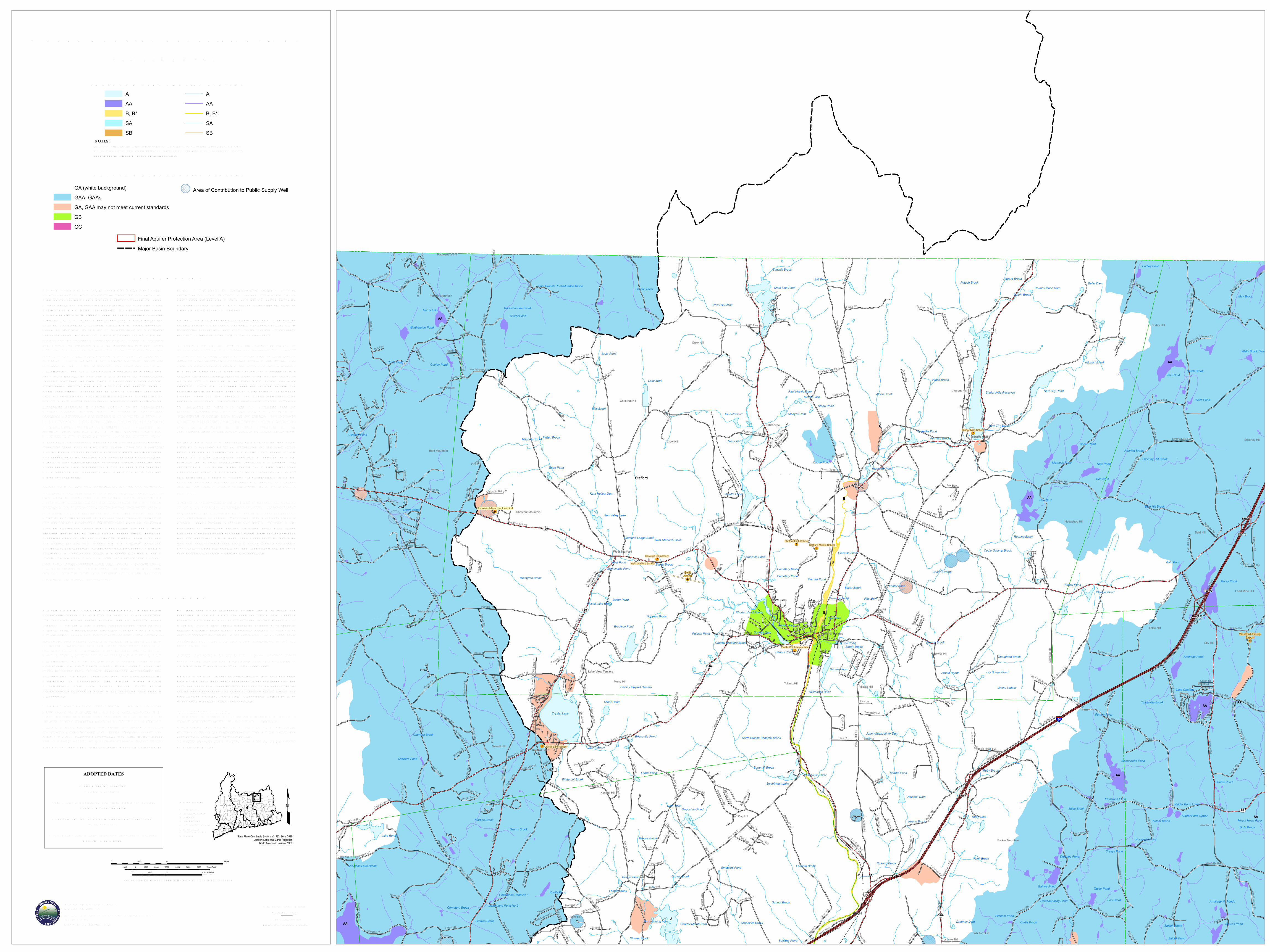
W ATER Q UALITY CLAS S IFICATIONSS TAFFOR D, CT
SCALE 1:24,000 (1 inch = 2000 feet) when map is printed at original size
1 0 10.5 Miles
1 0 10.5 Kilometers
1000 0 1000 2000 3000 4000 5000 6000 7000 Feet
ADOPTED DATES
W ater Q uality S tandardsFebruary 25, 2011
Thames R iver, Pawcatuck R iver and Southeast CoastalBasins: December 1986
Connecticut R iver and South Central Coastal Basins:February 1993
Housatonic R iver, Hudson R iver and Southw est CoastalBasins: March 1999
S TATE OF CONNECTICUTDEPAR TMENT OFENER GY & ENV IR ONMENTAL PR OTECTION79 Elm S treetHartford, CT 06106-5127
State Plane Coordinate System of 1983, Zone 3526Lambert Conformal Conic Projection
North American Datum of 1983
MAJOR BASINS1 Paw catuck2 Southeast Coast3 Thames4 Connecticut5 South Central Coast6 Housatonic7 Southw est Coast8 Hudson
£
S UR FACE W ATER Q UALITY CLAS S ES
Final Aquifer Protection Area (Level A)Major Basin Boundary
GR OUND W ATER Q UALITY CLAS SES
NOTES:S urface W ater Classifications beginning w ith S refer to Coastal and Marine S urface W ater.B* is a subset of Class B where no direct w astew ater discharges are allow ed other than thoseconsistent with Class AA, A and SA surface w aters.
GA (white background)GAA, GAAsGA, GAA may not meet current standardsGBGC
Area of Contribution to Public Supply Well
AAAB, B*SASB
AAAB, B*SASB
EX PLANATIONW ATER Q UALITY CLAS S IFICATIONS (W Q C) MAPS are oneof the elements of the W ater Q uality S tandards (W Q S ) for theS tate of Connecticut. The W Q S are a part of Connecticut's cleanw ater program and are essential for protecting and improving waterquality. The W Q S follow the principles of Connecticut's CleanW ater Act which is in Chapter 446K of the Connecticut GeneralS tatutes. The W Q S provide policy guidance in many areas, forexample decisions on acceptable discharges to water resources,siting of landfills, remediation or prioritization of municipalsew erage system projects. The first two elements of the W Q S arethe S tandards, which set an overall policy for management of waterquality, and the Criteria, which are descriptive and numericalstandards that describe the allowable parameters and goals forvarious water quality classifications. A discussion of these twoelements is found in the W ater Q uality S tandards documentavailable on the CT DEEP website. The third element is theClassifications and the W ater Q uality Classification Maps whichshow the Classification assigned to each surface and groundw aterresource throughout the S tate. The W Q S are adopted using a publicparticipation process. The W Q C maps are also adopted using apublic participation process but go through hearings separatelyfrom the S tandards and Criteria hearings. R evision and adoption ofthe W Q C data occurs in accordance with the public participationprocedures contained in S ection 22a-426 of the ConnecticutGeneral S tatutes. Ground W Q C is subject to Connecticutregulation and changes must be review ed and adopted. All changesto the S urface W Q C require an adoption process which is subjectto federal review and approval in addition to CT regulation. Theadoption dates for the W Q C by major drainage basin are:Housatonic R iver, Hudson R iver and Southw est Coastal Basins -March 1999; Connecticut R iver and South Central Coastal Basins -February 1993; Thames R iver, Pawcatuck R iver and SoutheastCoastal Basins - December 1986. S urface W ater Classifications donot change after the adoption date until the next major revision.Ground W ater Classifications may change after the adoption dateunder specific circumstances. The map may have more than oneW Q C adoption date because a town may be in more than onemajor drainage basin.SUR FACE W ATER S in Connecticut are divided into freshw aterclassified as AA, A, B or B* and saline waters classified as SA orSB. Class AA designated uses are existing or proposed drink ingw ater supplies; habitat for fish and other aquatic life and wildlife;recreation; and water supply for industry and agriculture. Class Adesignated uses are habitat for fish and other aquatic life andw ildlife; potential drink ing water supplies; recreation; navigation;and water supply for industry and agriculture. Class SA designateduses are habitat for marine fish, other aquatic life and wildlife;shellfish harvesting for direct human consumption; recreation;industrial water supply; and navigation. Class B designated usesare habitat for fish and aquatic life and wildlife; recreation;navigation; and industrial and agricultural water supply. Class B*,applicable to Candlewood Lak e, is a subset of Class B and isidentical in all ways to the designated uses, criteria and standardsfor Class B waters except for the restriction on direct discharges.Class SB designated uses are habitat for marine fish and aquaticlife and wildlife; commercial shellfish harvesting; recreation;industrial water supply; and navigation.
S urface waters which are not specifically classified shall beconsidered as Class A or Class AA. S urface waters in GA groundw ater areas are assumed Class A or Class SA unless otherwiseindicated. S urface waters in GAA ground water areas are assumedClass AA unless otherwise indicated.On the W Q C map a surface water quality goal of A is representedby blue colored water bodies. S urface water quality goal of AA isrepresented by purple colored water bodies. S urface water qualitygoal of B is represented by gold colored water bodies.GR OUND W ATER S in Connecticut are classified as GAA, GA,GB and GC. Class GAA designated uses are existing or potentialpublic supply of w ater suitable for drink ing without treatment andbaseflow for hydraulically-connected surface water bodies. TheClass GAAs is a subclass of GAA for ground water that is tributaryto a public water supply reservoir. The area of contribution to apublic water supply well is represented by a 500-foot radius aroundthe well and is assumed to be Class GAA unless otherwiseclassified. Class GA designated uses are existing private andpotential public or private supplies of water suitable for drink ingw ithout treatment and baseflow for hydraulically-connectedsurface water bodies. All ground waters not specifically classifiedare considered as Class GA. Class GB designated uses areindustrial process water and cooling waters and baseflow forhydraulically-connected water bodies and is presumed not suitablefor human consumption without treatment. Class GC designateduses are assimilation of discharges authorized by theCommissioner pursuant to S ection 22a-430 of the General S tatutes.On the W Q C map GA is represented by white colored land areas.Class GAA and class GAAs are represented by blue colored landareas. The area of contribution to a public water supply well isshown by a blue cross-hatch overprint. A notation of GAAfollowed by a state abbreviation indicates a watershed thatcontributes to the public water supply for a state other thanConnecticut. Class GA or Class GAA areas that currently may notbe meeting the GA or GAA standards are represented on the W Q Cmaps by tan colored land areas. Class GB is represented by greencolored land areas. Class GC is represented by magenta coloredland areas.FINAL AQ UIFER PR OTECTION AR EAS (Level A) are includedon the W Q C maps for informational purposes. These areas areanticipated to be reclassified GAA during the next major basinupdates, subject to public participation. The Aquifer ProtectionProgram helps protect Connecticut’s public drink ing waterresources by delineating aquifer protection areas (also calledw ellhead protection areas) for public supply wells and establishingland use regulations within these areas. These areas represent theland area contributing ground water to active public water supplywells or well fields that serve more than 1000 people and are set insand and gravel aquifers (stratified drift deposits).
DATA SOUR CESW ATER Q UALITY CLAS S IFICATIONS DATA – W ater qualityclassifications shown on this map are based on information fromthe following digital spatial datasets that are typically showntogether – Ground W ater Q uality Classifications Poly, S urfaceW ater Q uality Classifications Line, and S urface W ater Q ualityClassifications Poly. The map legend above reflects the content ofthese three data sources. These W Q C data were initially compiledon 1:24,000-scale 7.5 minute USGS topographic quadrangle mapsand later digitized at 1:24,000 scale. For example, the S urfaceW ater Q uality Classifications Line and S urface W ater Q ualityClassifications Poly digital data assigns surface water qualityclassifications to water bodies such as rivers, streams, reservoirs,lak es, ponds and coves found in 1:24,000-scale hydrography dataavailable from CT DEEP. The hydrography may not include all thew aterbodies in Connecticut. The Ground W ater Q ualityClassifications Poly data assigns ground water qualityclassifications, at 1:24,000 scale, to the remaining land areas inConnecticut.AQ UIFER PR OTECTION AR EA DATA – Aquifer ProtectionAreas shown on this map are from the Aquifer Protection Areadigital dataset which contains polygon data intended to be used at1:24,000 scale. The dataset contains regulated areas classified asLevel A Aquifer Protection Area (Final) and Level B AquiferProtection Area (Preliminary). The Level B areas are not shown onthe W Q C maps. The data was collected from 1991 to the presentand is actively updated as Final area mapping replaces earlierPreliminary areas. The Aquifer Protection Areas are delineated by
the individual water companies owning the well fields andsubmitted to the CT DEEP for approval. Preliminary mappingprovides a general estimate of the area contributing ground waterto the well field. Final mapping is based on extensive, site-specific,detailed modeling of the ground water flow system. CT DEEP mayadjust Final area boundaries to be consistent with 1:24,000 scaletopography and base map data where appropriate during theapproval process.MAJOR DR AINAGE BASIN DATA – Major drainage basinsshown on this map are from Major Basin Line data developed byCT DEEP and intended to be used at 1:24,000 scale.BASE MAP DATA - Based on data originally from 1:24,000-scaleUSGS 7.5 minute topographic quadrangle maps published betw een1969 and 1992. It includes political boundaries, railroads, airports,hydrography, geographic names and geographic places. S treets andstreet names are from Tele Atlas® copyrighted data. Base mapinformation is neither current nor complete.R ELATED INFOR MATIONThis map is intended to be printed at its original dimensions inorder to maintain the 1:24,000 scale (1 inch = 2000 feet).W ATER Q UALITY S TANDAR DS - Go to the CT DEEP websitefor a summary and the full text of the “W ater Q uality S tandards”and for other information on water quality.AQ UIFER PR OTECTION AR EAS - Go to the CT DEEP websitefor more information.
Map created by CT DEEPOctober 2017Map is not colorfast