Lower Paleozoic configuration of the Quebecreentrant based on improved along-strikepaleogeography
Pierre A. Cousineau and Hugues Longuépée
Abstract: An improved paleogeography of the Quebec reentrant has been achieved by examining the nature and distributionof major sediment buildups within this reentrant. The Quebec reentrant has one side produced by rift faults and oneside by a major transform fault. The Oak Hill Group was deposited near a triple-rift zone. Clastic sediments of thisgroup formed a large delta that was fed by a major river flowing in the rift valley of the Ottawa graben. The deltamust have prograded on a gentle slope platform. No other thick deltaic deposits are known towards the northeast. Instead,facies analyses favor the existence of a promontory near Québec. Still farther to the northeast, the Saguenay grabenwas not the product of a triple-rift junction. However, it served to funnel sediments to a deep-sea fan, and the adjacentplatform was narrow with a steep slope. The lateral distribution of sediments from the Ordovician Taconic orogeny canbe explained by this improved paleogeographic reconstruction. The configuration of the Quebec reentrant required thearc to move into the reentrant. The Taconian tectonic wedge progressively accreted the thick sediment buildups thatwere the Oak Hill delta and the Bas-du-Fleuve deep-sea fan. This allowed them to act as new barriers to orogenic sedimentdispersal as the orogeny proceeded.
Résumé : La paléogéographie du rentrant de Québec a été améliorée par l’examen de la nature et la distributiond’accumulations majeures de sédiments dans ce rentrant. Un côté du rentrant de Québec a été formé par des faillesd’effondrement et un autre côté a été formé par une faille transformante majeure. Le Groupe de Oak Hill a été déposéprès d’une zone à effondrement triple. Les sédiments clastiques de ce groupe ont formé un large delta qui était nourripar une grande rivière s’écoulant dans la vallée d’effondrement du graben d’Ottawa. Le delta devait avancer sur uneplate-forme à faible pente. Aucun autre dépôt deltaïque épais n’est connu vers le nord-est. Au lieu, les analyses de facièsfavorisent l’existence d’un promontoire à proximité de la Ville de Québec. Situé encore plus vers le nord-est, le grabendu Saguenay ne résulte pas d’une jonction d’effondrement triple. Toutefois, il servait à canaliser des sédiments vers unéventail marin profond et la plate-forme adjacente était étroite avec une pente abrupte. La distribution latérale des sédimentsde l’orogenèse taconienne (Ordovicien) peut être expliquée par cette reconstruction paléogéographique améliorée. Laconfiguration du rentrant de Québec exige que l’arc ait bougé pour se déplacer dans le rentrant. Le coin tectonique taconiena progressivement accrété les accumulations épaisses de sédiments qui formaient le delta de Oak Hill et l’éventail marinprofond de Bas-du-Fleuve. Cela leur a permis d’agir comme de nouvelles barrières à la dispersion des sédiments orogéniquesalors que l’orogenèse était en cours.
[Traduit par la Rédaction] Cousineau and Longuépée 219
Introduction
The major promontories and reentrants of the Appalachianshave long been recognized and interpreted to reflect aspectsof the original configuration of the Laurentian craton followingcontinental breakup at the end of the Precambrian (Rankin1976; Thomas 1977; Thomas 1991) (Fig. 1). Location ofmajor promontories have been used to explain the distributionof specific rock types, such as ophilolites (e.g., Cawood andSuhr 1992). However, detailed paleogeography within reentrantsis poorly known. Critical to along-strike correlations are the
location of thick coarse clastic sediment buildups and slopeangles of the continental edge. Sedimentary buildup go thoughperiods of progradation and avulsion that allow tabular bodiesof coarse clastic rocks to lie laterally at different stratigraphicpositions. Understanding this can help to resolve long-standingcorrelation problems (eg., Marvinney et al. 1999). Slope anglesat the edge of continental platform are also important sincethey have a direct bearing on the nature and distribution ofcarbonate and terrigenous sediments that accumulate both onthe slope surface and at its toe (Stow 1986; Coniglio and Dix1992). Several features can act as barriers to lateral dispersal of
Received 23 January 2002. Accepted 26 November 2002. Published on the NRC Research Press Web site at http://cjes.nrc.ca on20 February 2003.
Paper handled by Associate Editor B. Chatterton.
P.A. Cousineau1 and H. Longuépée. Centre d’étude sur les Ressources minérales (CERM), Sciences de la Terre, Université duQuébec à Chicoutimi, Chicoutimi, QC G7H 2B1, Canada.
sediments, particularly in narrow basins such as foredeeps.Consequently, identifying the position of major sedimentbuildups and basement promontories within major reentants,such as the Quebec reentrant, is critical because they canaccount for lateral changes in sedimentation and stratigraphy,as well as explain the shifts of depocenters in successorbasins.
Major rivers tend to flow parallel to or within rift valleysand should thus produce characteristically thick sedimentarybuildups, such as deltas and deep-sea fans that extendoutboard of reentrants (Sengör 1995). Areas between majoralluvial rivers will consist of topographic highs. These mayextend outboard of the coast to form promontories that arestarved of sedimentation. Consequently, the goal of this paperis to present a paleogeographic reconstruction of the Quebecreentrant based on along-strike changes in Cambrian andOrdovician stratigraphy. This will locate major sedimentbuildups and document their influences on subsequent Taconianorogenic flysch distribution.
Limits of the Quebec reentrant
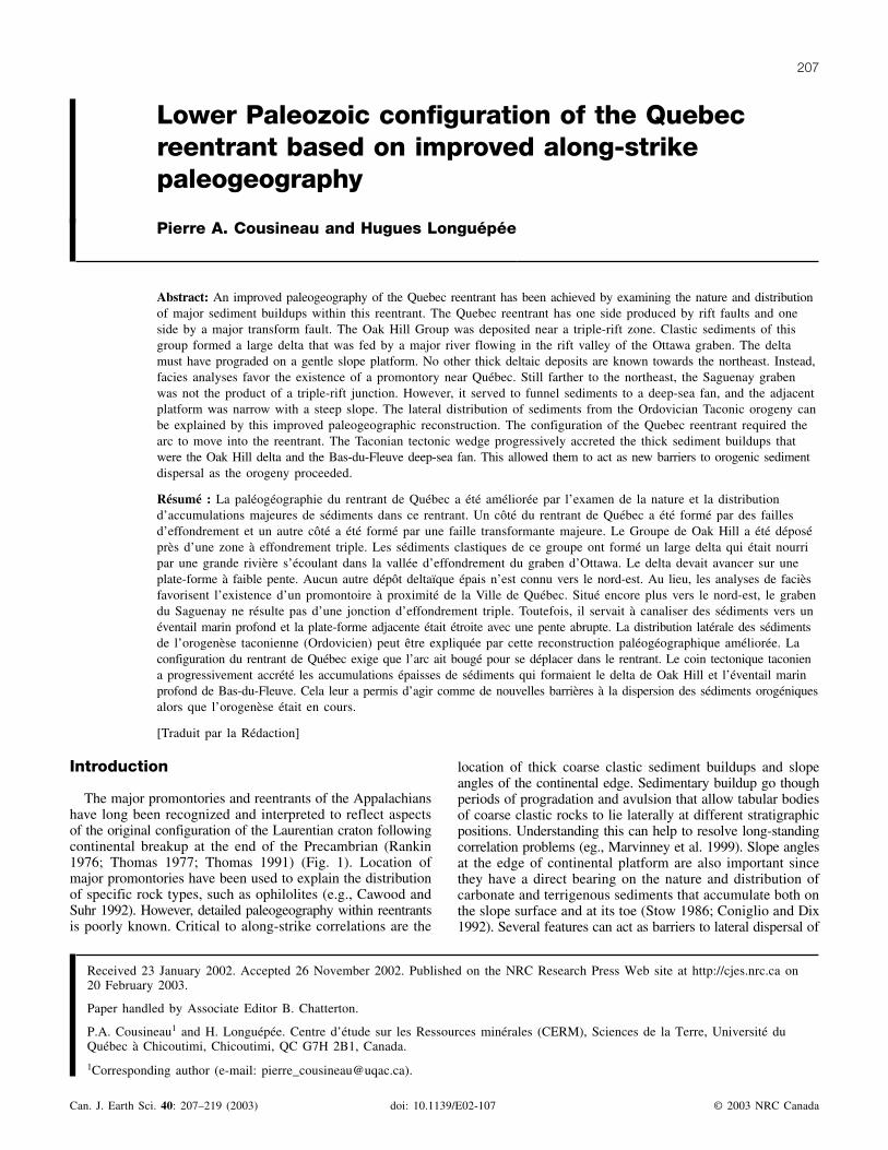
The Quebec reentrant has a shape akin to a trapeze (Fig. 1).Its southern limits are well known and comprise the volcanicrocks of the Tibbit Hill Formation that were formed along
the edge of a triple-rift margin (Kumarapeli 1985). The OttawaGraben, a failed-rift valley, evolved into a major alluvialvalley that fed a large delta, now part of the Oak Hill Group(Marquis and Kumarapeli 1993).
Less well known are the position and nature of the northernlimits of the Quebec reentrant. There, the Iapetus rift axishas been displaced more than 500 km eastward, in presentcoordinates (Thomas 1977). No thick volcanic pile is knownin the adjacent Appalachians miogeocline, as in the case ofthe Tibbit Hill Formation. Volcanic rocks are present (i.e.,Shickshock Group; Fig. 1), but they are located more outboard,within the Taconian internal zone, and they are not interpretedas triple-rift products (Camiré et al. 1993). However, the 565 Maold (Higgins and van Breeman 1997) Sept-Îles layered maficintrusion (SILMI; Fig. 1) could be related to the same mantleplume activity as the slightly younger 554 Ma Tibbit Hillvolcanics (Kumarapeli et al. 1989).
Sedimentary rocks adjacent to Sept-Îles do not support theexistence of an aulacogen rift-valley, as in the case of theOttawa Graben. There are no thick delta deposits in themiogeocline rocks located in front of Sept-Îles and no alluvialdeposits within the platform deposits near Sept-Îles. Platformrocks only crop out currently in a small area further east(Desrochers 1988) and extend to the Anticosti platform.Clasts of fossil-bearing Cambrian limestone found in Upper
Fig. 1. Limits and features of the Quebec reentrant. Thick dashed lines represent the rifts and transform faults at the onset of continentalrifting. Thick solid lines show the limits of the faulted Laurentian margin. Thin dashed lines show basement arches active during thePaleozoic. Shaded areas are aeromagnetic anomalies that locate the extensions of mafic volcanic rocks of the Tibbit Hill Formation andShickshock Group (SS) and of the Sept-Îles layered mafic intrusion (SILMI). Main features shown are the Ottawa graben, an aulacogenformed in front of the Tibbit Hill triple-rift zone and the Sept-Îles transform fault (proposed to explain the large offset with the St. Lawrencepromontory). Also shown are the Saguenay graben and the Montmorency and Adirondack promontories. BDF, Bas-du-Fleuve; GP,Gaspé Peninsula.
Cambrian to Lower Ordovician deep-sea fan deposits of theAppalachian miogeocline between Québec and the tip of theGaspé Peninsula, however, support the existence of a platformduring the lower Paleozoic. Thus, action of the plume, includingthe intrusion and slow cooling of the SILMI, induced an upliftof the overlying Laurentian margin and favored erosion ofthat platform rather than the formation of an alluvial valley.
The cumulative differences between the Sept-Îles andTibbit Hill areas do not support the idea that both areas aretriple-rift junctions. Instead, it is best to view the area betweenSept-Îles and the tip of the Newfoundland promontory as theresult of a transform fault, as suggested by Thomas (1977).The trace of this fault could be a currently seismogenic featurethat extends in a south-southeast direction into the St. LawrenceRiver from Sept-Îles and that is interpreted to have been activeduring the Paleozoic (Sandford and Grant 1990).
Cambrian to Lower Ordovician miogeoclinesediment buildups within the QuebecAppalachians
Two major clastic sediment buildups are located withinthe miogeocline of the Quebec Appalachians. They are part
of the Oak Hill Group and of the Quebec Supergroup locatedin the Bas-du-Fleuve area. Their stratigraphy differs signifi-cantly, implying that they represent different sedimentaryenvironments. Other along-strike differences in stratigraphyare known, but not their cause and significance.
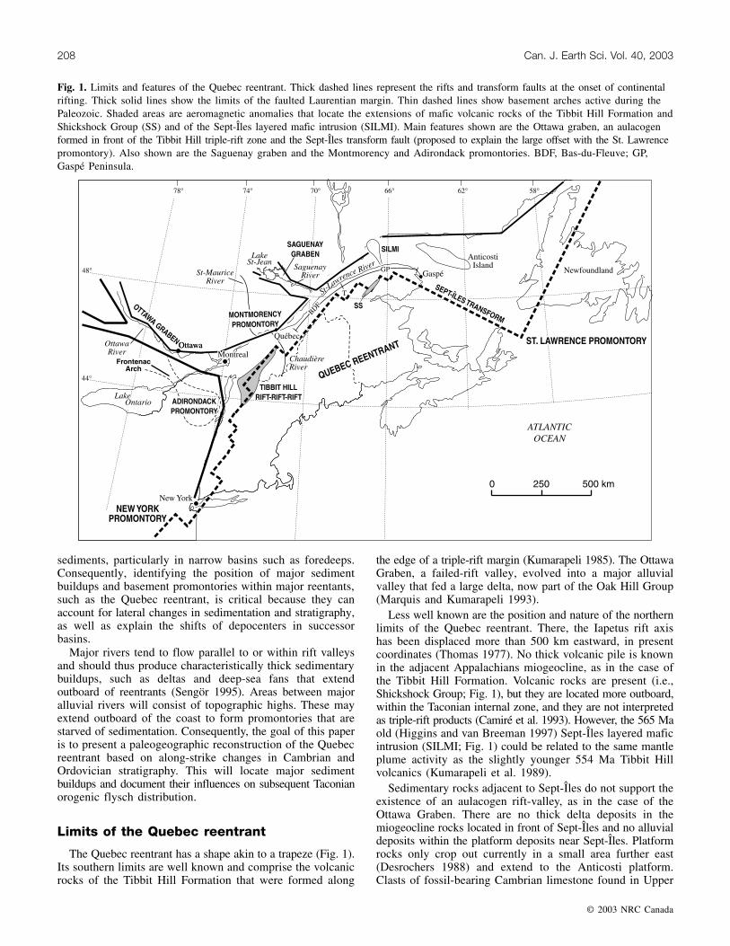
Rocks of the Quebec miogeocline have been placed withinlarge-scale assemblages (St-Julien and Hubert 1975; St-Julienet al. 1983). The Oak Hill Group belongs to a unique assemblage,the clastic–carbonate assemblage, that is centered on thetriple-rift zone (Fig. 2). Volcanic rocks of the Tibbit HillFormation form the base of the Oak Hill Group. Theoverlying siliciclastic rocks evolved from rift-related alluvialdeposits to coastal and deltaic deposits (Marquis and Kumarapeli1993). Carbonate rocks within this group are interpreted assediments prograding from an adjacent carbonate platformduring transgressive events. The uppermost deposits recordthe onset of orogenic sedimentation from the growing Taconianmountains (Marquis 1992).
There is a progressive decrease in abundance and thicknessof coarse clastic rocks of the Oak Hill Group from the southeastto the northeast. The Oak Hill Group itself does not extendto the northeast beyond the Chaudière River (facing Québec).To the southwest, in Vermont, coastal and deltaic sandstones
Fig. 2. Simplified geological map of the Cambrian and Ordovician miogeocline (autochthonous domain and Humber zone) of the QuebecAppalachians. BBL, Baie Verte – Brompton Line; C, Carboniferous cover rocks; CL, Chain Lakes Massif; D, Dunnage zone; G,Grenville sliver (Complexe de Saint-Marguerite) and mafic volcanic rocks of the Montagne de Saint-Anselme Formation; S-D, Silurianand Devonian cover rocks. NY, New York; VT, Vermont; NH, New Hampshire; ME, Maine; NB, New Brunswick.
persist because of coastal currents (Dowling 1988). Severalbarriers must have acted to limit the extent of the Oak HillGroup. The lower volcanic rocks acted in part in this manner,possibly favoring sediment buildup behind a chain of volcanoesbefore they could prograde farther oceanward (Colpron 1990).
Barriers of a different nature must also have been presentto limit the lateral extent of the Oak Hill sediments. Thesemust have been the outboard extension of the topographichighs that were located on both sides of the Ottawa Graben. TheAdirondack, to the southwest (Fig. 1), is a basement featureknown to have been active during the Paleozoic (Sanford1993). Basement domes in the adjacent New EnglandAppalachians were originally horsts of Grenvillian basementrocks. They acted as topographic highs (Lister et al. 1986)and influenced nearby early marine sedimentation and laterorogenic deformation (Stanley and Ratcliffe 1985).
Near Québec, to the northeast, the existence of a secondorder promontory, known as the Montmorency promontoryhas been proposed (Belt et al. 1979). Basement domes arenot present in the adjacent Appalachians, but deep thrustscarry polydeformed and metamorphosed rocks and also cutthrough basement rocks (Castonguay et al. 2001b). All thesefeatures acted to limit the extent of the Oak Hill sediments.
The second clastic sediment buildup is not as well knownas the first one. It includes rocks of both the feldspathicsandstone and shale assemblage (FSSA) and the overlyingshale – limestone conglomerate – orthoquartzite assemblage(SLOA) located in the Bas-du-Fleuve area (Fig. 2). Bothassemblages are interpreted as distal equivalents of most ofthe clastic–carbonate assemblage (i.e., the Oak Hill Group).The FSSA is interpreted as rift- to drift-related sediments(St-Julien and Hubert 1975; Vallières 1984). Coarse clasticsediments and volcanic rocks are more common at the base,and varicoloured mudstones are at the top of the assemblage.Most of the FSSA was deposited within deep-sea fans(Lajoie et al. 1974; Tawadros 1977; Cousineau 1990). Theserocks are widespread and fairly uniform in composition acrossthe Quebec reentrant. Conglomerate beds are few, and togetherwith sandstones, are more abundant near the Montmorencypromontory, both to the northeast and to the southwest.Assuming a near-orthogonal thrust transport direction, con-glomerates located just south the Montmorency promontorycould reflect erosion from this source area (Ogunyomi1980). However, conglomerate beds farther to the northeast,in front of the Saguenay River were derived from anothersource (Lajoie et al. 1974; Vallières 1984).
The SLOA is lithologically more diverse. It has beeninterpreted as deep-sea fan deposits (Hendry 1978; Hein andKarl 1983; Vallières 1984). It is stratigraphically most complete,thickest, and richest in conglomerate beds in the Bas-du-Fleuvearea facing the Saguenay River. Muddy (distal) facies becomeincreasingly more abundant towards the internal part of theAppalachians. They also become more abundant towards theMontmorency Promontory, to the southwest. Still farther tothe southwest, near the international border and beyond theyoften form only a narrow band located more internally withinthe miogeocline deposits, adjacent to the Oak Hill Group(e.g., Ottauqueche Formation). To the northeast, towards theGaspé Peninsula, the succession also becomes muddier. Somethick conglomerate beds are still present, but they are distributedmore sporadically. Carbonate rocks and marls increase in
abundance in the upper part of the assemblage towards theeast, suggesting an active and persistent transport from anadjacent carbonate platform, such as the Anticosti platform(Fig. 2).
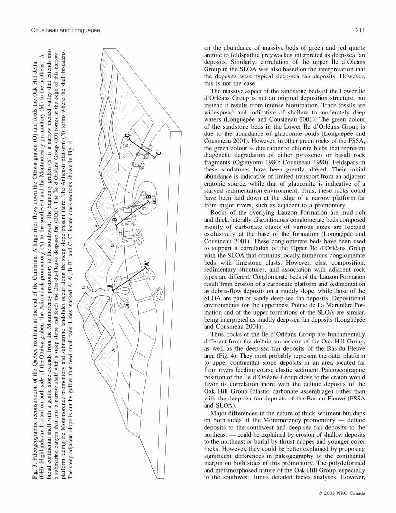
Conglomerate beds in both the FSSA and SLOA areinterpreted as proximal deep-sea fan channel facies andsupport the existence of a major upstream submarine canyonin the vicinity. The canyon that channeled the sediment tothis deep-sea fan must have been located in an area facingthe present day Saguenay River (Fig. 3). The basal part ofthe St. Lawrence platform succession near the Montmorencypromontory is absent, and platformal rocks consist mostly ofcarbonates with few, thin sandstone beds (Globensky 1987;Lavoie 1994). Platformal rocks are rare northeast of theMontmorency promontory (Rondot 1972; Belt and Bussière1981). However, those located farther to the northeast, andthus closest to the Saguenay River, contain beds several metresthick rich in quartz or feldspar. Facies analyses of theseclastic rocks suggest they were deposited in a fluvial toestuarine environment (Rondot 1972; McNichols 1995). Thisalso supports the existence of a large river flowing east ofthe Montmorency Promontory, possible channeled by theSaguenay graben, that fed a second major sediment buildup.
Thus, the first major clastic-sediment buildup of themiogeocline of the Quebec Appalachians is interpreted as amajor delta deposit, whereas the second is interpreted as amajor deep-sea fan deposit. Deep-sea fan deposits to thesouthwest of the Montmorency promontory, especially thoserelated to the SLOA, apparently only form a narrow band lo-cated between the polydeformed and metamorphosed rocks ofthe Oak Hill Group and the rocks of the Dunnage zone.However, this does not rule out their existence at depthbelow rocks of the Dunnage zone and of the Silurian andDevonian cover rocks of the Connecticut Valley – GaspéBelt, but it is unlikely that they form a thick sedimentbuildup as seen northeast of the Montmorency promontory.Similarly, no sediment buildups of deltaic nature are knownnortheast of the Montmorency promontory. Again, deltaicdeposits could lie at depth below the Bas-du-Fleuve thrustnappes, but they most probably also do not form a thicksediment buildup. Consequently, this could point out to asignificant difference in the lower Paleozoic configuration ofthe Quebec reentrant on both sides of the Montmorencypromontory.
The Île d’Orléans Group is fault bounded and restricted toa few tens of kilometres adjacent to the northeast side of theMontmorency promontory (Fig. 2). The lowermost formationof the Île d’Orléans Group (i.e., Anse Maranda Formation)has been correlated with the FSSA, while the two upperformations (i.e., Lauzon and Pointe de La Martinière forma-tions) have been put with the SLOA (St-Julien and Hubert1975; St-Julien et al. 1983). Thus, rocks of this group arealso correlative to the clastic–carbonate assemblage of theOak Hill Group. The southwest end of the Île d’OrléansGroup is near, but not in contact with, the northeast end ofthe Oak Hill Group. Rocks of the Sainte-Hénédine Formationare in fault contact with both the Île d’Orléans and Oak Hillgroups and is interpreted as a muddier correlative of the Îled’Orléans Group (Castonguay et al. 2001a). Thus, both groupscould lie at the same structural level. The original correlationof the lower Île d’Orléans Group with the FSSA was based
on the abundance of massive beds of green and red quartzarenite to feldspathic greywackes interpreted as deep-sea fandeposits. Similarly, correlation of the upper Île d’OléansGroup to the SLOA was also based on the interpretation thatthe deposits were typical deep-sea fan deposits. However,this is not the case.
The massive aspect of the sandstone beds of the Lower Îled’Orléans Group is not an original deposition structure, butinstead it results from intense bioturbation. Trace fossils arewidespread and indicative of shallow to moderately deepwaters (Longuépée and Cousineau 2001). The green colourof the sandstone beds in the Lower Île d’Orléans Group isdue to the abundance of glauconite ooids (Longuépée andCousineau 2001). However, in other green rocks of the FSSA,the green colour is due rather to chlorite blebs that representdiagenetic degradation of either pyroxenes or basalt rockfragments (Ogunyomi 1980; Cousineau 1990). Feldspars inthese sandstones have been greatly altered. Their initialabundance is indicative of limited transport from an adjacentcratonic source, while that of glauconite is indicative of astarved sedimentation environment. Thus, these rocks couldhave been laid down at the edge of a narrow platform farfrom major rivers, such as adjacent to a promontory.
Rocks of the overlying Lauzon Formation are mud-richand thick, laterally discontinuous conglomerate beds composedmostly of carbonate clasts of various sizes are locatedexclusively at the base of the formation (Longuépée andCousineau 2001). These conglomerate beds have been usedto support a correlation of the Upper Île d’Orléans Groupwith the SLOA that contains locally numerous conglomeratebeds with limestone clasts. However, clast composition,sedimentary structures, and association with adjacent rocktypes are different. Conglomerate beds of the Lauzon Formationresult from erosion of a carbonate platform and sedimentationas debris-flow deposits on a muddy slope, while those of theSLOA are part of sandy deep-sea fan deposits. Depositionalenvironments for the uppermost Pointe de La Martinière For-mation and of the upper formations of the SLOA are similar,being interpreted as muddy deep-sea fan deposits (Longuépéeand Cousineau 2001).
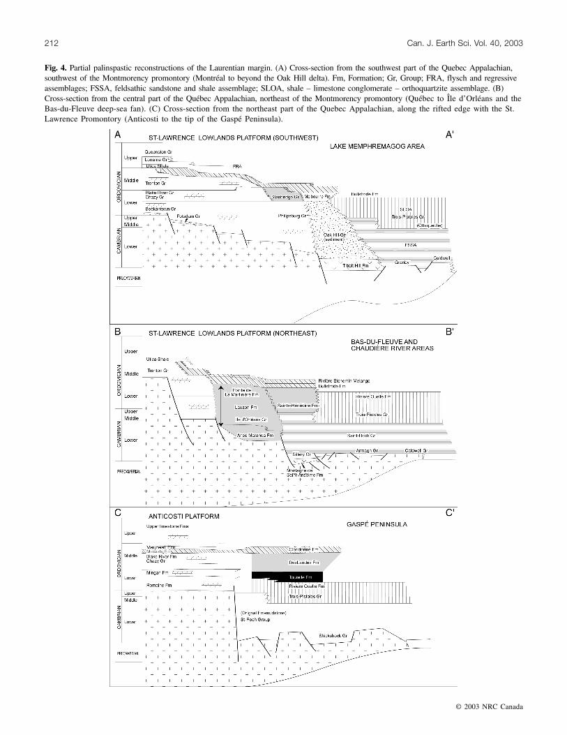
Thus, rocks of the Île d’Orléans Group are fundamentallydifferent from the deltaic succession of the Oak Hill Group,as well as the deep-sea fan deposits of the Bas-du-Fleuvearea (Fig. 4). They most probably represent the outer platformto upper continental slope deposits in an area located farfrom rivers feeding coarse clastic sediment. Paleogeographicposition of the Île d’Orléans Group close to the craton wouldfavor its correlation more with the deltaic deposits of theOak Hill Group (clastic–carbonate assemblage) rather thanwith the deep-sea fan deposits of the Bas-du-Fleuve (FSSAand SLOA).
Major differences in the nature of thick sediment buildupson both sides of the Montmorency promontory — deltaicdeposits to the southwest and deep-sea-fan deposits to thenortheast — could be explained by erosion of shallow depositsto the northeast or burial by thrust nappes and younger coverrocks. However, they could be better explained by proposingsignificant differences in paleogegraphy of the continentalmargin on both sides of this promontory. The polydeformedand metamorphosed nature of the Oak Hill Group, especiallyto the southwest, limits detailed facies analyses. However,F
Fig. 4. Partial palinspastic reconstructions of the Laurentian margin. (A) Cross-section from the southwest part of the Quebec Appalachian,southwest of the Montmorency promontory (Montréal to beyond the Oak Hill delta). Fm, Formation; Gr, Group; FRA, flysch and regressiveassemblages; FSSA, feldsathic sandstone and shale assemblage; SLOA, shale – limestone conglomerate – orthoquartzite assemblage. (B)Cross-section from the central part of the Québec Appalachian, northeast of the Montmorency promontory (Québec to Île d’Orléans and theBas-du-Fleuve deep-sea fan). (C) Cross-section from the northeast part of the Quebec Appalachian, along the rifted edge with the St.Lawrence Promontory (Anticosti to the tip of the Gaspé Peninsula).
large deltas along passive margins tend to prograde on ashallow platform and contribute to the extension of a broadand gentle-sloped continental margin. To the northeast of theMontmorency promontory, the submerged continental platformseems much less extensive than to the southwest. The broadcontinental shelf could have been replaced by a narrowramp-type platform, itself cut by at least one major canyonin front of the present-day Saguenay River, which wouldhave fed an important deep-sea fan. This change inconfiguration might relate to the presence of a transfer faultseparating two blocks with underlying extension surfacesdipping in opposing directions, as in the lower-plate andupper-plate rifted margin models of (Lister et al. 1986;Bosworth 1987).
Conglomerate beds in the Lauzon Formation may indicatethe existence of slump scars and gullies that funneled sedimentsto the deeper part of the basin between the deep-sea fan and theMontmorency promontory. Similarly, the increasing abundanceof mudstone, marl, and carbonate (including conglomeratebeds with carbonate clasts) relative to coarse clastic sedimentsfarther to the northeast of the Bas-du-Fleuve deep-sea fan inthe FSSA and SLOA support the absence of any other largecanyons in that area (Figs. 3, 4).
The Maquereau Group is an inlier of FSSA located at thesouthern tip of the Gaspé Peninsula. It is fault bounded andsome breccias found along its edge contain clasts of Grenvillianrocks (De Broucker 1987). It was displaced by several hundredkilometres along a senestral strike-slip fault during theDevonian Acadian orogeny (Malo and Bourque 1993). Itsoriginal position could thus have been close to the St. Lawrencepromontory.
Influence of promontories and sedimentbuildups on the distribution of TaconianOrdovician rocks
Orogenic sedimentation on the Laurentian platform ofNewfoundland and Quebec is strongly diachronous (Lavoie1994), suggesting that the St. Lawrence promontory had asignificant impact on colliding terrane and plate configuration(Stockmal et al. 1987; Cawood and Suhr 1992; Malo et al.1995). The New York promontory probably also had a sig-nificant impact on the Taconian and subsequent orogenies.Several features within the Quebec reentrant must also haveacted as barriers to orogenic sediment dispersion. First arethe Montmorency and Adirondack promontories. Thicksediments buildups along the Quebec reentrant, such as theOak Hill delta and the Bas-du-Fleuve deep-sea fan surelyalso played a similar role. These will modify the geometryof the accreting tectonic wedge, leading to various scenarios,such as subduction – erosion or thickening of the orogenicwedge as to maintain a critical taper angle (von Huene andLallemand 1990; Boyer 1995). They will greatly influence,thus, the structural style and metamorphic grade of theaccreted sediments during orogeny. All these barriers alsolimited the catchment areas for orogenic sediments shedfrom the growing Taconian mountains.
Sedimentary environments in an active margin setting maybe dominated by tectonically induced allocyclic processes(Miall 1995). These lead to closure of former passages forsediment dispersal by uplift of new barriers and rapid shiftsin depocenters related to fault-induced foundering or upliftof basins. Thus, facies distribution of active margin basinswill be complex, and along-strike and contemporaneousorogenic basins may thus follow different evolutionary paths,while retaining only some broad common features.
Rocks of the miogeocline (i.e., Humber zone) derived fromthe growing Taconian mountains have been grouped into theshale calcareous argillite assemblage (SCAA) in the QuebecAppalachians (St-Julien and Hubert 1975; St-Julien et al.1983). They are found only in the external zone of the Taconianorogeny and show marked differences in composition andextension whether they are located southwest or northeast ofthe Montmorency Promontory.
Rocks of the SCAA southwest of the MontmorencyPromontory typically include Arenig to Caradoc calcareousmuddy turbidites deposits that form an elongated sigmoidallens that is thickest mid-way between the promontory andthe former Oak Hill delta, and extend well into Vermont(parautochthonous flysch of Hiscott 1995). These rocks include,from the northeast to the southwest, the Citadelle, Bourret,Bullstrode, and Melbourne formations, the Standbridge Group,and correlative units, as well as some mélanges interpretedas olistostromes (Rivière Etchemin, Drummondville). Marquis(1992) has demonstrated that the Melbourne Formation liesconformably on the Sweetsburg Formation and that it is partof the Oak Hill Group. This indicates that the site of the formerdelta was covered by distal orogenic clastic sediments derivedfrom the growing Taconian mountains (Figs. 4, 5).
There are no rocks of the SCAA to the northeast betweenthe Montmorency promontory and the Bas-du-Fleuve deep-seafan. Rocks of the SCAA located farther to the northeast, beyondthe Bas-du-Fleuve deep-sea fan, include the Des LandesFormation and (part of) the Cloridorme Formation (St-Julien1987; Prave et al. 2000), to which can be added the TourelleFormation. The Tourelle Formation (allochthonous Arenig –“Llanvirn”2 flysch of Hiscott 1995; Figs. 2, 4, 5) is a sandy,deep-sea fan deposit (Hiscott 1978, 1980). It is correlative toother chromite-bearing greenish-gray sandy turbidite successionspresent in the Dunnage zone of the Quebec Appalachians(Frontière, Neckwick, and Arsenault formations) (Cousineauand St-Julien 1994). Rocks of the Tourelle Formation at JerseyCove, near the tip of the Gaspé Peninsula, even share commonfauna with some of them (Neckwick and Arsenault formations),indicating they all could have been interconnected basins(Riva and Malo 1988). Still, the Tourelle Formation doesdiffer slightly from the chromite-bearing formations in theDunnage zone by (1) thicker and more extensive sandstonepackets, (2) sandstone richer in quartz and sedimentary rockfragments, (3) slightly older in age (late Arenig to early“Llanvirn” age at Sainte-Anne-des-Monts and Rimouski;late “Llanvirn” to early “Llandeilo” age at Rivière-du-Loup)(Vallières 1984). The Tourelle Formation either conformablylies on rocks of the Humber zone (Rivière Ouelle Formation,
Cousineau and Longuépée 213
2 It has been recommended that the Llandeilo Stage be dropped. It is currently proposed to replace both the Llanvirn and the former Llandeilostages by a new stage named Darriwilan. However, the Llandeilo and Llanvirn are here used, with quotation marks, because all previouswork has extensively used these names.
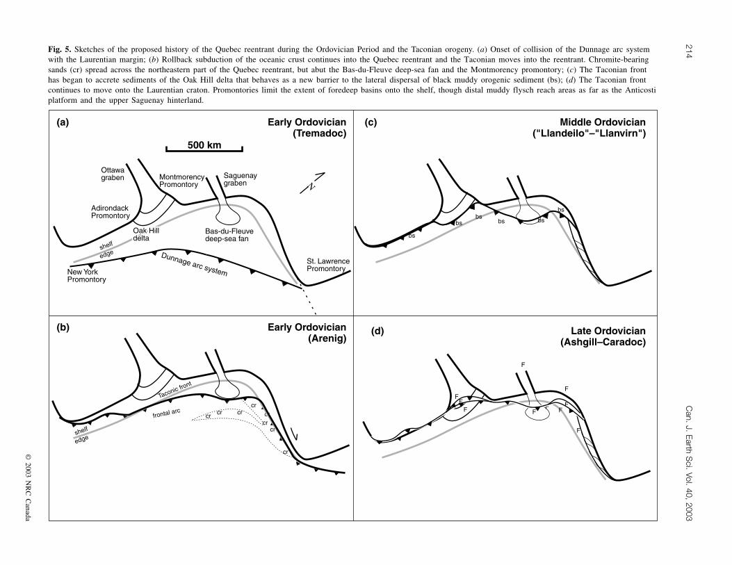
2003Fig. 5. Sketches of the proposed history of the Quebec reentrant during the Ordovician Period and the Taconian orogeny. (a) Onset of collision of the Dunnage arc systemwith the Laurentian margin; (b) Rollback subduction of the oceanic crust continues into the Quebec reentrant and the Taconian moves into the reentrant. Chromite-bearingsands (cr) spread across the northeastern part of the Quebec reentrant, but abut the Bas-du-Fleuve deep-sea fan and the Montmorency promontory; (c) The Taconian fronthas began to accrete sediments of the Oak Hill delta that behaves as a new barrier to the lateral dispersal of black muddy orogenic sediment (bs); (d) The Taconian frontcontinues to move onto the Laurentian craton. Promontories limit the extent of foredeep basins onto the shelf, though distal muddy flysch reach areas as far as the Anticostiplatform and the upper Saguenay hinterland.
upper part of the SLOA) or forms blocks within the CapChat Mélange (Cousineau 1998). No chromite-bearing,green-coloured sandy turbidite formation is known withinthe SCAA southwest of the Bas-du-Fleuve deep-sea fan and,consequently southwest of the Montmorency promontory.
The Des Landes Formation (allochthonous “Llandeilo”–Caradoc flysch of Hiscott 1995), though in fault contactswith all adjacent units, is similar in age and composition toother formations of SCAA (Figs. 2, 4, 5). It consistspredominantly of black shale, in places calcareous, thoughradiolarian-bearing green and black siliceous rocks are alsopresent at the base of the formation (Prave et al. 2000). TheCaradocian Cloridorme Formation (Enos 1969; Riva and Malo1988; Slivitzky et al. 1991; Prave et al. 2000) is locatednortheast of the Bas-du-Fleuve deep-sea fan (Figs. 2, 4, 5)and lies in fault contact with the Des Landes Formation ofthe SCAA. It is presumed to be part of the Parautochthonousflysch (Hiscott 1995) in the northern Gaspé Peninsula. TheCloridorme Formation consists of different members of finerand coarser grained turbidites. The sandstones are rich inquartz and sedimentary rock fragments and, hence, similarin composition to Late Ordovician flyschs of both theautochthonous foredeep basin and Dunnage zone. Becauseof this, it is included with other Taconian flysch sedimentationtypical of the SCAA.
The existence of sandy turbidites to the northeast indicatesthat the adjacent Taconian mountains close to the St. Lawrencepromontory had reached dimensions such as to become asignificant source area for coarse clastic sedimentation.Differences in composition among the Tourelle Formationand the various Dunnage zone chromite-bearing sandstonessupport a model in which debris spread from a magmatic arcand quickly filled the fore-arc basins (Frontière, Neckwick,and Arsenault formations) (Cousineau and St-Julien 1992,1994). Once ponded, these sediments poured into basins onthe accretionary wedge, possibly as far as the trench itself.Thus, the Tourelle Formation came to rest on the accretedsediments of the Humber zone farther away. Differences insandstone composition would then result from the destructionof delicate volcanic debris over greater distances and theirdilution by addition of debris from the tectonic wedge. Thechromite-bearing sandstone event was rapid and morewidespread in the Dunnage zone than in the Humber zone,where it is limited to an area located to the northeast of theBas-du-Fleuve deep-sea fan. This can be interpreted asindicative that sediments of the Bas-du-Fleuve deep-sea fanhad been accreted to the growing Taconian tectonic wedge,thus forming a barrier that limited the lateral distribution oforogenic sediments shed from the Taconian mountains.
Sedimentation of SCAA orogenic black, often calcareous,shales seems to have been a widespread event throughout theNorthern Appalachians. Consequently, the Montmorencypromontory, the Oak Hill delta, and the Bas-du-Fleuvedeep-sea fan do not appear to have acted as significant barriersto the lateral distribution of these sediments (Fig. 5). However,several of the Middle to Upper Ordovician black shale sedimentscould have been deposited during a period of known highsea-level, such as the one that prevailed during theN. gracilis graptolite biozone (Lenz et al. 1993). In whichcase, the above-mentioned barriers could have had limitedinfluence on the distribution of fine-grained clastic and
carbonate debris. The carbonaceous nature of these shales,both southwest of the Montmorency promontory and to thenortheast of the Bas-du-Fleuve, also point to the continuousexistence of carbonate platforms in both areas (the St. Lawrenceplatform to the southwest and the Anticosti platform to thenortheast).
Absence of sediments belonging to the SCAA in the areabetween the Bas-du-Fleuve and the Montmorency promontorycould be due to their removal by later erosion. It could alsobe indicative of an original limited distribution of orogenicsediments in that area. In which case, this could signify thatthe combined Bas-du-Fleuve deep-sea fan and the Montmorencypromontory acted as an effective barrier to sediment dispersalin this area. It could also confirm the narrow width of thecontinental platform in the area, thus making it a poor sourcefor carbonate debris within the orogenic basin.
Influence on the distribution of Ordovicianrocks in adjacent foredeep basins andplatforms
The time-equivalent clastic rocks of the SCAA depositedin the foredeep (foreland) basins developed on the Laurentianplatform are referred to as the flysch and regressive assemblages(FRA) (St-Julien and Hubert 1975; St-Julien et al. 1983).
Rocks of the FRA in the St. Lawrence platform includeCaradoc clastic rocks of the Utica Shale (distal muddyturbidites) and Lorraine Group (more proximal muddy tosandy turbidites), and of the Ashgill Queenston Group(muddy to sandy molasse), and correlative units (autochthonousflysch of Hiscott 1995). These rocks are part of theautochthonous domain and form a broad lens within theChambly–Fortierville syncline, centered mid-way betweenthe Montmorency promontory and the former Oak Hill delta(Figs. 2, 4). Equivalent rocks in a narrow parautochthonousdomain are known as the Sainte-Rosalie Group and correlativeunits and are part of the SCAA.
On the Anticosti platform (autochthonous domain), theorogenic record consists of the Macasty Formation, a thinunit of black mudstone encountered only in wells offshore ofAnticosti island, that passes upsection into the calcareousVauréal Formation (Waldron et al. 1998). These rocks arecorrelatives of the lower part of the FRA. However, coarsergrained flysch and molasse deposits as in the St. Lawrenceplatform do not overlie the Macasty and Vauréal formations.Instead, carbonate platform conditions were reestablished,and limestone was deposited without interruption from theLate Ordovician to the Early Silurian (Fig. 2).
Only restricted platformal sediments crop out in the arealocated between both major platforms, and the narrowparautochthonous domain is also nearly absent. Just northeastof the Montmorency promontory only the lower flyschformations are present (Saint-Irénée, Beaupré, Lotbinièreformations and correlative units). It is not known if thesandy flysch and the molasse deposits were removed by latererosion or were never present in the area. The Pointe-BleueShales (Desbiens and Lespérance 1989) are a calcareousmudstone located at the head of the Saguenay River (Fig. 2)that is a correlative to the lower flysch of the FRA (Harlandet al. 1985). However, it is conformably overlain by a coral-bearing limestone (Île-aux-Couleuvres formation) rather than
by coarser flysch or molasse deposits. Both formations arecorrelative to formations found on the Anticosti platform(Macasty Shale, Riva 1974; Vauréal Formation, Desbiensand Lespérance 1989). This stratigraphy is consequently moresimilar to that of the Anticosti platform (Fig. 4), locatednortheast of the Montmorency promontory, than with that ofthe Lower St. Lawrence platform, located to its southwest.Deposition of the Pointe-Bleue Shales could indicate that thecanyon that fed the Bas-du-Fleuve deep-sea fan was usedduring the Taconian Orogeny to funnel clastic sediment uplandonto the Laurentian craton.
The amount of later orogenic sedimentation removed bysubsequent erosion is unknown. It is also difficult to determinethe original lateral extent of the FRA. Albeit, it is proposedthat their distribution and composition in the QuebecAppalachians can be explained also by the persistence ofOak Hill delta, the Montmorency promontory, and the Bas-du-Fleuve deep-sea fan, which acted as barriers to orogenicsediment dispersal (Fig. 5). Thus, the doubly plungingChambly–Fortierville syncline that holds the thickest accu-mulation of the FRA is interpreted as an original depocenterlocated between the Oak Hill delta and the Montmorencypromontory. The same holds for the FRA and SCAA depositsin the northern Gaspé Peninsula. They would have accumulatedin and later been thrust from an area located the farthestfrom the northeast edge the Quebec reentrant. The lack ofextensive and thick FRA deposits in the area between theMontmorency promontory and the Bas-du-Fleuve deep-seafan support the existence of a narrow platform there. Thisnarrow platform represented only a limited area for orogenicsedimentation, forcing FRA-related deposits to be spilledinto the Montmorency, or funnel upstream a major valley.
Paleogeographic reconstructions
The configuration of the magmatic arc margins that collidedwith the Laurentian margin at the onset of the Taconianorogeny is difficult to ascertain (Fig. 5a). The Iapetus oceaniclithosphere that was still attached to the Laurentian marginwithin the Quebec Reentrant continued to be gravitationallyunstable and to sink into the asthenosphere forcing the upperplate to advance farther into the Quebec reentrant by a slabrollback process (LePichon and Alvarez 1984; Dvorkin et al.1993). This process favored formation of a strike-slip faultalong the northern margin of the Quebec reentrant with St.Lawrence promontory.
It is proposed that a broad shelf existed southwest of theMontmorency promontory with a gentle slope that allowed agradual transition to a low-angle continental rise, while anarrow shelf attached to a continental rise with a steep angleexisted northeast of this promontory. The gentle-slope geometryextended probably to the southwest at least up to the Adirondackpromontory. To the northeast, the shelf did broaden to allowthe Anticosti platform to develop. However, the edge of theplatform must have been steep along most of the length ofthe northern limit of the Quebec reentrant with the St. Lawrencepromontory, since it was the site of a former transform fault.
The speed with which the Taconian tectonic wedgeadvanced onto the Laurentian margin depended partly on theslope angle on which it had to climb, and the nature of
“obstacles” it encountered. The first obstacles encounteredwere the New York and St. Lawrence promontories. Thiscan be recognized by the diachronous migration of theunconformity that marks the migration of the peripheralbulge related to the subducting plate. This unconformity isolder along the promontories and is younger within thereentrants (Washington 1992; Lavoie 1994).
The next obstacle encountered was the Bas-du-Fleuvedeep-sea fan (Fig. 5b). This is suggested by the age anddistribution of the first (chromite-bearing) orogenic flyschs.There, accreting the Bas-du-Fleuve deep-sea fan required theTaconic front to increase in size and height, thus creating abarrier to southeast dispersal of these chromite-bearing sands.The Anticosti carbonate platform continued to be active andto shed debris onto the accreted miogeocline sediments ofthe Quebec reentrant. Consequently, farther to the northeast,along the edge with the St. Lawrence promontory, the lateraldisplacement of the Taconic front along a major strike-slipfault must have limited the rise of the Taconic montains atfirst.
The Taconic front continued to advance onto the shelf andthe tectonic wedge continued to rise during the MiddleOrdovician. The carbonate platforms foundered and shalebegan to invade the basin as the foredeep basins wereprogressively overridden by the Taconian allochthons(Bradley and Kusky 1986). By this time, new obstacles en-countered included the Oak Hill delta and the Montmorencypromontory. A concurrent eustatic high sea level probablydrowned a substantial part of the growing orogen, thus alsofavoring muddy sedimentation to prevail and disperse widelyby limiting the efficiency of the barriers to sediment dispersal(Fig. 5c). In the Humber zone southwest of the MontmorencyPromontory, muddy sediments of the SCAA (St-Julien andHubert 1975) poured in front of the advancing thrust sheets(Melbourne, Bourret, and Bullstrode formations in Quebecand their correlative to the southwest; Des Landes Formationto the northeast).
During the Upper Ordovician, the Taconic front had advancedacross a large part of the continental platform. Flyschsedimentation of the FRA became widespread (Fig. 5d),first in basins of the parautochthonous domain and then inthe autochthonous domain (Sainte-Rosalie Group, Utica Shale,Lorraine Group) (Globensky 1987) southwest of theMontmorency Promontory. The high grounds of both theAdirondack and the Montmorency promontories again actedas barriers to sediment dispersal. The subsequent molassesedimentation was restricted to the deepest part of the forelandbasins (Queenston Group) (Globensky 1987).
Imbrication of the Bas-du-Fleuve deep-sea fan not onlyenhanced its role as a barrier, but could also have allowederosion of previously deposited sedimentary basins duringthe Upper Ordovician. Sandier sediments of the lower partof the Cloridorme Formation were succeeded by a secondcycle of fine to coarse flysch in the upper part of the formation.These were derived from the west instead of the east, as inthe lower part of the formation (Hiscott et al. 1986; Prave etal. 2000). Carbonaceous debris continued to flow from theAnticosti platform into the adjacent basin, except briefly atthe peak of the orogeny, when black shales of the MacastyFormation spread across the Anticosti platform and when
similar black shales were deposited far inland at the head ofthe Saguenay River.
No Silurian sediments are known in the Lower St. Lawrenceplatform. On the Anticosti platform, however, the carbonatesedimentation rapidly reestablished itself by early Ashgilland continued well into the Silurian. This could confirm theexistence of a steep slope at the edge of this platform thatacted as an efficient barrier to orogenic sediment dispersal inthe area.
Conclusion
Lateral changes in stratigraphy along the Humber zone ofthe Quebec Appalachian are used to define a betterthree-dimensional paleogeographic model of the Quebecreentrant during the rift and drift phases. Already knownwas that the Oak Hill Group represents a large delta fed by amajor river that flowed in the rift valley of the Ottawagraben. This delta formed in front of a triple-rift junctionidentified by voluminous basalt flows that acted as barrier tothe progradation of the sediments. Lateral distribution wasalso limited by submerged basement highs adjacent to theMontmorency and Adirondack promontories. It is shownhere that the Saguenay graben, though not the product of atriple rift junction, also served to funnel sediments, but to adeep-sea fan instead of a delta. Also, the Montmorencypromontory, located midway between the two sedimentbuildups, is characterized by distinctive glauconitic andmuddy sediments that reflect limited, impoverished coarseclastic sedimentation. This enables us to propose that thedelta prograded on a gentle slope shelf while the deep-seafan developed in front on a narrow and steep margin shelf.As the Taconian orogeny evolved, the accretion of thicksediment buildups that were the Oak Hill delta and theBas-du-Fleuve deep-sea fan in the Taconian tectonic wedgeallowed them to act as barriers to orogenic sediment dispersalas the orogeny proceeded.
Better understanding of sedimentary processes and structuralcontrols on the location of stratigraphic units has led andwill continue to lead to better paleogeographic reconstructionwithin the Quebec reentrant. These, in turn, account betterfor along-strike changes in local stratigraphies. It would besurprising if the Ottawa and Saguenay grabens contained theonly two major rivers flowing on the East Coast of Laurentiaduring the lower Paleozoic. Stratigraphic units characterizedby thick clastic sedimentary rocks in the New England sectionof the Quebec reentrant, as well as in adjacent reentrants,such as the Newfoundland reentrant, should be furtherinvestigated to recognize if they belong to a major delta ordeep-sea fan. Similarly, stratigraphic units characterized byimpoverished coarse clastic sedimentation should also beinvestigated to identify possible basement promontories.Position of these barriers could then be checked with that ofmajor depocenters and paleocurrent data of orogenic depositsin both the Humber zone and adjacent Dunnage zone. Suchwork could only benefit our understanding of the evolutionof the Appalachian chain.
Acknowledgments
A first draft of this paper was written while PAC was on
sabbatical at Pacific Geoscience Centre (PGC). Discussions withseveral colleagues at PGC and Institut National de la RechercheScientifique-Géoressource, particularly Michel Malo, havesharpened our ideas. Reviews by Dr. A.D. McCraken and byan anonymous reviewer are graciously acknowledged. C.Dallaire (Centre d’Étude sur les Ressources Minérales atUniversité du Québec à Chicoutimi) did the excellent art-work. This work is part of the Centre Geoscientifique duQuébec NATMAP project. It was financially supported by aNational Science and Engineering Research Council operat-ing grant (OGP0037226) to the first author (PAC) and by aPetro- Canada bursary to HL.
References
Belt, E.S., and Bussière, L. 1981. Upper Middle Ordovician submarinefans and associated facies northeast of Québec City. CanadianJournal of Earth Sciences, 18: 981–994.
Belt, E.S., Riva, J., and Bussière, L. 1979. Revision and correlationof late Middle Ordovician stratigraphy northeast of Québec City.Canadian Journal of Earth Sciences, 16: 1467–1483.
Bosworth, W. 1987. Off-axis volcanism in the Gregory rift, eastAfrica: Implications for models of continental rifting. Geology,15: 397–400.
Boyer, S.E. 1995. Sedimentary basin taper as a factor controllingthe geometry and advance of thrust belts. American Journal ofScience, 295: 1220–1251.
Bradley, D.W., and Kusky, T.M. 1986. Geologic evidence for rateof plate convergence during the Taconic arc–continent collision.Journal of Geology, 94: 667–681.
Camiré, G., LaFlèche, M.R., and Malo, M. 1993. Géochimie desroches volcaniques cambro-ordoviciennes du Groupe de Shickshock:incidences sur la stratigraphie et le contexte géotectonique de laGaspésie septentrionale. In Recherches en cours, partie E.Commission géologique du Canada, Étude 93-1E, pp. 281–290.
Castonguay, S., Lemieux, Y., Marcotte, B., and Tremblay, A. 2001a.Structural style and tectonostratigraphy of the external /internalHumber zone boundary in the Sainte-Marie / Saint-Sylvestrearea, Québec Appalachians. In Current research. Geological Surveyof Canada, 2001-D13.
Castonguay, S., Ruffet, G., Tremblay, A., and Féraud, G. 2001b.Tectonometamorphic evolution of the southern QuébecAppalachians: 40Ar/39Ar evidence for Middle Ordovician crustalthickening and Silurian–Early Devonian exhumation of the internalHumber zone. Geological Society of America Bulletin, 113:144–160.
Cawood, P.A., and Suhr, G. 1992. Generation and obduction ofophiolites: constraints from the Bay of Islands Complex, westernNewfoundland. Tectonics, 11: 884–897.
Colpron, M. 1990. Rift and collisional tectonics of the EasternTownships Humber zone, Brome Lake area, Québec. M.Sc. thesis,University of Vermont, Burlington, Vt.
Coniglio, M., and Dix, G.R. 1992. Carbonate slopes. In Faciesmodels: response to sea level change. Edited by R.G. Walkerand N.P. James. Geological Association of Canada, pp. 349–373.
Cousineau, P.A. 1990. Le Groupe de Caldwell et le domaine océaniqueentre Saint-Joseph-de-Beauce et Sainte-Sabine. Ministère del’Energie et des Ressources du Québec, MM 87-02.
Cousineau, P.A. 1998. Large-scale liquefaction and formation ofthe Cap Chat Mélange, Quebec Appalachians. Canadian Journalof Earth Sciences, 35: 1408–1422.
Cousineau, P.A., and St-Julien, P. 1992. The Saint-Daniel Mélange:
Evolution of an accretionary complex in the Dunnage terrane ofthe Québec Appalachians. Tectonics, 11: 898–909.
Cousineau, P.A., and St-Julien, P. 1994. Stratigraphie etpaléogéographie d’un bassin d’avant-arc ordovicien, Estrie-BeauceAppalaches du Québec. Canadian Journal of Earth Sciences,31: 435–446.
De Broucker, G. 1987. Stratigraphie, pétrographie et structure de laboutonnière de Maquereau–Mictaw. Ministère de l’Énergie etdes Ressources du Québec, Mémoire MM 86-03.
Desbiens, S., and Lespérance, P.J. 1989. Stratigraphy of the Ordovicianof the Lac Saint-Jean and Chicoutimi outliers, Quebec. CanadianJournal of Earth Sciences, 26: 1185–1202.
Desrochers, A. 1988. Stratigraphie de l’Ordovicien de la région del’archipel de Mingan. Ministère de l’Énergie et des Ressourcesdu Québec, Mémoire MM87-01.
Dowling, W.M. 1988. Depositional environment of the lower OakHill Group: implications for the late Precambrian breakup ofNorth America in the Quebec reentrant. M. Sc. thesis, Universityof Vermont, Burlington, Vt.
Dvorkin, J., Nur, A., Mavko, G., and Ben-Avraham, Z. 1993. Narrowsubducting slabs and the origin of backarc basins. Tectonophysics,227: 63–79.
Enos, P. 1969. Cloridorme Formation, Middle Ordovician Flysch,Northern Gaspe Peninsula, Quebec. Geological Society of America,Special Paper 117.
Globensky, Y. 1987. Géologie des Basses-Terres du Saint-Laurent.Ministère de l’Énergie et des Ressources du Québec, MémoireMM 85-02.
Harland, T.L., Pickerill, R.K., and Fillion, D. 1985. Ordovicianintracratonic sediments from the Lac-St-Jean and Chicoutimi areas,Quebec, eastern Canada. Canadian Journal of Earth Sciences,22: 240–255.
Hein, J.R., and Karl, S.M. 1983. Comparisons between open-oceanand continental margin chert sequences. In Siliceous deposits ofthe Pacific region. Edited by A. Ijima, J.R. Hein, and R. Siever.Developments in sedimentology. Elsevier, Amsterdam, pp. 25–43.
Hendry, H.E. 1978. Cap des Rosiers Formation at Grosses Roches,Quebec — deposits of mid-fan region on an Ordovician submarinefan. Canadian Journal of Earth Sciences, 15: 1472–1488.
Higgins, M.D., and van Breeman, O. 1997. The age of the Sept Ileslayered mafic intrusion, Canada: implications for the LateNeoproterozoic / Cambrian history of southeastern Canada. Journalof Geology, 106: 421–431.
Hiscott, R.N. 1978. Provenance of Ordivician deep-water sandstones,Tourelle Formation, Quebec, and implication for initiation of theTactonic orogeny. Canadian Journal of Earth Sciences, 15:1579–1597.
Hiscott, R.N. 1980. Depositional framwork of sandy mid-fan com-plexes of Tourelle Formation, Ordovician, Quebec. American As-sociation of Petroleum Geologists Bulletin, 64: 1052–1077.
Hiscott, R.N. 1995. Middle Ordovician clastic rocks of the HumberZone and the St. Lawrence Platform. In Geology of theAppalachian–Caledonian orogen in Canada and Greenland.Edited by H. Williams. Geological Survey of Canada, Ottawa,Ont., Geology of Canada, no. 6, Chap. 3, pp. 86–98.
Hiscott, R.N., Pickering, K.T., and Beede, D.R. 1986. Progressivefilling of a confined Middle Ordovician foreland basin associatedwith the Taconic Orogeny. In Foreland basins. Edited by P.A.Allen and P. Homewood. International Association of Sedimen-tologists, pp. 309–325.
Kumarapeli, P.S. 1985. Vestiges of Iapetan rifting in the cratonwest of the Northern Appalachians. Geoscience Canada, 12: 54–59.
Kumarapeli, P.S., Dunning, G.R., Pintson, H., and Shaver, J. 1989.Geochemistry and U–Pb zircon age of comenditic metafelsites
of the Tibbit Hill Formation, Quebec Appalachians. CanadianJournal of Earth Sciences, 26: 1374–1383.
Lajoie, J., Héroux, Y., and Mathey, B. 1974. The Precambrianshied and Lower Paleozoic shelf, the unstable provenance of theLower Paleozoic flysch sandstones and conglomerates of theAppalachian between Beaumont and Bic, Quebec. Canadian Journalof Earth Sciences, 11: 951–963.
Lavoie, D. 1994. Diachronous tectonic collapse of the Ordoviciancontinental margin, eastern Canada: comparison between the QuebecReentrant and the St. Lawrence Promontory. Canadian Journalof Earth Sciences, 31: 1309–1319.
LePichon, X., and Alvarez, F. 1984. From stretching to subductionin back-arc regions: dynamic considerations. Tectonophysics,102: 343–357.
Lister, G.S., Etheridge, M.A., and Symonds, P.A. 1986. Detachmentfaulting and the evolution of passive margins. Geology, 14: 246–250.
Longuépée, H., and Cousineau, P.A. 2001. New depositionalenvironements for the Île d’Orléans Group, Québec Appalachains.In Current research. Geological Survey of Canada, 2001-D14.
Malo, M., and Bourque, P.-A. 1993. Timing of the deformationevents from Late Ordovician to Mid-Devonian in the GaspéPeninsula. In The Acadian Orogeny: recent studies in NewEngland, Maritime Canada, and the Autochthonous foreland.Edited by D.C. Roy and J.W. Skehan. Geological Society ofAmerica, Boulder, Colo., pp. 101–122.
Malo, M., Tremblay, A., Kirkwood, D., and Cousineau, P. 1995.Along-strike Acadian structural variations in the QuébecAppalachians: consequence of a collision along an irregularmargin. Tectonics, 14: 1327–1338.
Marquis, R. 1992. Géologie de la région de Windsor (Estrie).Ministère de l’Énergie et des Ressources du Québec, ET 90–11.
Marquis, R., and Kumarapeli, P.S. 1993. An Early Cambriandeltaic–fluvial model for an Iapetan rift-arm drainage system,southeastern Quebec. Canadian Journal of Earth Sciences, 30:1254–1261.
Marvinney, R.G., Moench, R.H., Marquis, R., Cousineau, P.A., andBothner, W.A. 1999. Resolved Silurian–Devonian stratigraphiccorrelation across the Québec–Maine–NH borders and its bearingon Silurian extension. Geological Society of America, Abstractwith Programs, 31: A-32.
McNichols, D. 1995. Sédimentologie d’une zone d’estran ordovicienne.Undergraduate thesis, Université du Québec à Chicoutimi.
Miall, A.D. 1995. Collision-related foreland basins. In Tectonics ofsedimentary Basins. Edited by C.J. Busby and R.V. Ingersoll.Blackwell Science, Cambridge, U.K., pp. 393–424.
Ogunyomi, O. 1980. Diagenesis and deep-water environments ofthe Lower Paleozoic continental margin sediments in the QuébecCity area, Canada. Ph.D. thesis, McGill University, Montréal.
Prave, A.R., Kessler II, L.G., Malo, M., Bloechl, W.V., and Riva,J.F.V. 2000. Ordovician arc collision and foredeep evolution inthe Gaspé Peninsula, Québec: the Taconic Orogeny in Canadaand its bearing on the Grampian Orogeny in Scotland. Journalof Geological Society, London, 157: 393–400.
Rankin, D.W. 1976. Appalachian salients and recesses: LatePrecambrian continental breakup and the opening of the Iapetusocean. Journal of Geophysical Research, 81: 5605–5619.
Riva, J. 1974. A revision of some Ordovician graptolites of EasternNorth America. Paleontology, 17: 1–40.
Riva, J., and Malo, M. 1988. Age and correlation of the HonoratGroup, southern Gaspé Peninsula. Canadian Journal of EarthSciences, 25: 1618–1628.
Rondot, J. 1972. La transgression ordovicienne dans le Comté de
Charlevoix, Quebec. Canadian Journal of Earth Sciences, 9:1187–1203.
Sandford, B.V., and Grant, A.C. 1990. Bedrock geological mappingand basin studies in the Gulf of St. Lawrence. In Currentresearch. Geological Survey of Canada, Paper 90-1B, pp. 33–42.
Sanford, B.V. 1993. The St. Lawrence Platform — Geology; Chapter11. In Sedimentary cover of the craton in Canada. Edited byD.F. Stott and J.D. Aitken. Decade of North American Geology,Vol. D-1. Geological Survey of Canada, Ottawa, Ont., pp. 725–798.
Sengör, A.M.C. 1995. Sedimentation and tectonics of fossil fifts.In Tectonics of sedimentary basins. Edited by C.J. Busby andR.V. Ingersoll. Blackwell Science, Cambridge, U.K., pp. 53–117.
Slivitzky, A., St-Julien, P., and Lachambre, G. 1991. Synthèsegéologique du Cambro-Ordovicien du nord de la Gaspésie.Ministère de l’Énergie et des Ressources du Québec, ET 88-14.
St-Julien, P. 1987. Géologie des régions de Saint-Victor et deThetford (moitié est). Ministère de l’Énergie et des Ressourcesdu Québec, MM 86-01.
St-Julien, P., and Hubert, C. 1975. Evolution of the Taconic orogenin the Québec Appalachians. American Journal of Science,275-A: 337–362.
St-Julien, P., Slivitzky, A., and Feininger, T. 1983. A deep structuralprofile across the Appalachians of southern Québec. In Contri-butions to the tectonics and geophysics of mountain chains.Edited by R.D. Hatcher, H. Williams, and I. Zietz. GeologicalSociety of America, pp. 103–112.
Stanley, R.S., and Ratcliffe, N.M. 1985. Tectonic synthesis of theTaconian orogeny in western New England. Geological Societyof America Bulletin, 96: 1227–1250.
Stockmal, G.S., Colman-Sadd, S.P., Keen, C.E., O’Brien, S.J., andQuilan, G. 1987. Collision along an irregular margin: a regional
plate tectonic interpretation of the Canadian Appalachians. CanadianJournal of Earth Sciences, 24: 1098–1107.
Stow, D.A.V. 1986. Deep clastic seas. In Sedimentary environmentsand facies. Edited by H.G. Reading. Blackwell ScientificPublications, Oxford, England, pp. 399–444.
Tawadros, E. 1977. Étude pétrographique des grès cambriens duGroupe de Caldwell de la région du lac Etchemin. M. Sc. thesis,Université de Montréal, Montréal, Que.
Thomas, W.A. 1977. Evolution of Appalachian–Ouachita salientsand recesses from reentrants and promontories in the continentalmargin. American Journal of Science, 277: 1233–1278.
Thomas, W.A. 1991. The Appalachian–Ouachita rifted margin ofsouthern North America. Geological Society of America Bulletin,103: 415–431.
Vallières, A. 1984. Statigraphie et structure de l’orogène taconiquede la région de Rivière-du-Loup. Ph. D. thesis, Université Laval,Québec, Que.
von Huene, R., and Lallemand, S. 1990. Tectonic erosion along theJapan and Peru convergent margins. Geological Society of AmericaBulletin, 102: 704–720.
Waldron, W.F., Anderson, S.D., Cawood, P.A., Goodwin, L.B., Hall,J., Jamieson, R.A., Palmer, S.E., Stockmal, G.S., and William,P.F. 1998. Evolution of the Appalachian Laurentian margin:Lithoprobe results in western Newfoundland. Canadian Journalof Earth Sciences, 35: 1271–1287.
Washington, P.A. 1992. Stratigraphic relations in the central ChamplainValley: recurring estuarine deposits and a retreating shelf margin.In Field Conference of Taconic Geologists, Geology of theTaconic Orogen: a sesquicentennial field conference, pp. 1–47.