ORIGINAL PAPER Manuel Martı´n-Martı´n Iva´ n Martı´n-Rojas Jesu´s E. Caracuel Antonio Este´ vez-Rubio Agustı´n Martı´n Algarra Jose´ Sandoval Tectonic framework and extensional pattern of the Malaguide Complex from Sierra Espun ˜ a (Internal Betic Zone) during Jurassic–Cretaceous: implications for the Westernmost Tethys geodynamic evolution Received: 15 June 2005 / Accepted: 11 November 2005 / Published online: 13 January 2006 ȑ Springer-Verlag 2006 Abstract Mapping, lithostratigraphic, biostratigraphic and structural detailed analyses in Sierra Espun˜a area (Internal Betic Zone, SE Spain) have allowed us to reconstruct the Jurassic–Cretaceous evolution of the Westernmost Mesomediterranean Microplate palaeo- margin and, by correlation with other sectors (Northern Rift, central and western Internal Betic Zone), to pro- pose a geodynamic evolution for the Westernmost Tethys. Extension began from Late Toarcian, when listric normal faults activated; these faults are arranged in three categories: large-scale faults, separating hecto- metric cortical blocks; main faults, dividing the former blocks into some kilometre-length blocks; and secondary faults, affecting the kilometric blocks. This fault ensemble, actually outcropping, in the Sierra Espun˜a area, broke the palaeomargin allowing the westerly Tethyan Oceanic aperture with an extension at about 17.2%. Extension was not homogeneous in time, being the Late Toarcian to the Dogger–Malm boundary the period when blocks underwent the greatest movement (rifting phase), leading to the drowning of the area (8.2% extension). During the Malm (drifting phase) extension followed (5.7%), while during the Cretaceous a change to pelagic facies is recorded with an extension of about 3.3% (post-drift stage). This evolution in the Westernmost Tethys seems to be related to areas out of the limit of significant crustal extension in the hanging wall block of the main cortical low-angle fault of the rifting. Keywords Westernmost Tethys oceanic opening Jurassic–Cretaceous Normal fault categories Extensional rates Palaeomargin Introduction After the Hercynian orogeny, the western part of the present Mediterranean region was part of a coherent continental block called Pangea, comprising Africa, Europe and North America (Channell et al. 1979; Win- terer and Bosellini 1981) with the oceanic regions being constrained to the eastern region (palaeo-Tethys). Start- ing from the Triassic, the Central Atlantic Ocean began to open, and the western Mediterranean region was frag- mented by rifting and transform faulting, giving rise to the Western Tethyan Ocean, and several new lithospheric plates (Biju-Duval et al. 1977). One of these lithospheric plates was the Mesomediterranean Microplate (Guerrera et al. 1993), comprising the internal zones of the Betic– Rif, Tellian, Kabylian, Calabria–Peloritani and Southern Apennine chains, built up after the alpine compressive Tertiary phase related to the Mediterranean opening. In the Westernmost Tethys a complicate palaeogeography with junction of two oceanic branches occurs (Guerrera et al. 2005). These branches (Nevado-Fila´ bride Ocean to the North and Maghrebian Flysch Basin to the South) would separate three continental margins (S-Iberian, N-African and W-Mesomediterranean Microplate margin, respectively). The evolution of the Westernmost Tethyan area is closely related to the Betic–Rif Cordillera (Fig. 1). This mountain belt has classically been divided into Internal and External Zones separated by the western Tethyan (Nevado-Fila´bride Ocean of Guerrera et al. 2005) oce- anic aperture since Early Jurassic (Martı´n-Algarra 1987). The External Zones belong to the South Iberian Palaeomargin (Vera 1988) and consist of post-Palaeo- zoic non-metamorphic rocks. On the contrary, the Internal Betic–Rif Zone is nowadays built up by the M. Martı´n-Martı´n (&) I. Martı´n-Rojas J. E. Caracuel A. Este´vez-Rubio Dpto. Ciencias de la Tierra y del Medio Ambiente, Univ. Alicante, Apdo. 99, 03080 San Vicente del Raspeig, Alicante, Spain E-mail: [email protected]Tel.: +34-965-903400 Fax: +34-965-903552 A. M. Algarra J. Sandoval Dpto. Estratigrafı´a y Paleontologı´a, Univ. Granada, Av. Fuentenueva s/n, 18002 Granada, Spain Int J Earth Sci (Geol Rundsch) (2006) 95: 815–826 DOI 10.1007/s00531-005-0061-7
Transcript
ORIGINAL PAPER
Manuel Martın-Martın Æ Ivan Martın-Rojas
Jesus E. Caracuel Æ Antonio Estevez-Rubio
Agustın Martın Algarra Æ Jose Sandoval
Tectonic framework and extensional pattern of the Malaguide Complexfrom Sierra Espuna (Internal Betic Zone) during Jurassic–Cretaceous:implications for the Westernmost Tethys geodynamic evolution
Received: 15 June 2005 / Accepted: 11 November 2005 / Published online: 13 January 2006� Springer-Verlag 2006
Abstract Mapping, lithostratigraphic, biostratigraphicand structural detailed analyses in Sierra Espuna area(Internal Betic Zone, SE Spain) have allowed us toreconstruct the Jurassic–Cretaceous evolution of theWesternmost Mesomediterranean Microplate palaeo-margin and, by correlation with other sectors (NorthernRift, central and western Internal Betic Zone), to pro-pose a geodynamic evolution for the WesternmostTethys. Extension began from Late Toarcian, whenlistric normal faults activated; these faults are arrangedin three categories: large-scale faults, separating hecto-metric cortical blocks; main faults, dividing the formerblocks into some kilometre-length blocks; and secondaryfaults, affecting the kilometric blocks. This faultensemble, actually outcropping, in the Sierra Espunaarea, broke the palaeomargin allowing the westerlyTethyan Oceanic aperture with an extension at about17.2%. Extension was not homogeneous in time, beingthe Late Toarcian to the Dogger–Malm boundary theperiod when blocks underwent the greatest movement(rifting phase), leading to the drowning of the area(8.2% extension). During the Malm (drifting phase)extension followed (5.7%), while during the Cretaceousa change to pelagic facies is recorded with an extensionof about 3.3% (post-drift stage). This evolution in theWesternmost Tethys seems to be related to areas out ofthe limit of significant crustal extension in the hangingwall block of the main cortical low-angle fault of therifting.
After the Hercynian orogeny, the western part of thepresent Mediterranean region was part of a coherentcontinental block called Pangea, comprising Africa,Europe and North America (Channell et al. 1979; Win-terer and Bosellini 1981) with the oceanic regions beingconstrained to the eastern region (palaeo-Tethys). Start-ing from the Triassic, the Central Atlantic Ocean began toopen, and the western Mediterranean region was frag-mented by rifting and transform faulting, giving rise totheWestern Tethyan Ocean, and several new lithosphericplates (Biju-Duval et al. 1977). One of these lithosphericplates was the MesomediterraneanMicroplate (Guerreraet al. 1993), comprising the internal zones of the Betic–Rif, Tellian, Kabylian, Calabria–Peloritani and SouthernApennine chains, built up after the alpine compressiveTertiary phase related to the Mediterranean opening. Inthe Westernmost Tethys a complicate palaeogeographywith junction of two oceanic branches occurs (Guerreraet al. 2005). These branches (Nevado-Filabride Ocean tothe North and Maghrebian Flysch Basin to the South)would separate three continental margins (S-Iberian,N-African and W-Mesomediterranean Microplatemargin, respectively).
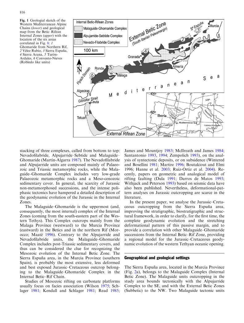
The evolution of the Westernmost Tethyan area isclosely related to the Betic–Rif Cordillera (Fig. 1). Thismountain belt has classically been divided into Internaland External Zones separated by the western Tethyan(Nevado-Filabride Ocean of Guerrera et al. 2005) oce-anic aperture since Early Jurassic (Martın-Algarra1987). The External Zones belong to the South IberianPalaeomargin (Vera 1988) and consist of post-Palaeo-zoic non-metamorphic rocks. On the contrary, theInternal Betic–Rif Zone is nowadays built up by the
M. Martın-Martın (&) Æ I. Martın-Rojas Æ J. E. CaracuelA. Estevez-RubioDpto. Ciencias de la Tierra y del Medio Ambiente,Univ. Alicante, Apdo. 99, 03080 San Vicente del Raspeig,Alicante, SpainE-mail: [email protected].: +34-965-903400Fax: +34-965-903552
A. M. Algarra Æ J. SandovalDpto. Estratigrafıa y Paleontologıa, Univ. Granada,Av. Fuentenueva s/n, 18002 Granada, Spain
Int J Earth Sci (Geol Rundsch) (2006) 95: 815–826DOI 10.1007/s00531-005-0061-7
stacking of three complexes, called from bottom to top:Nevadofilabride, Alpujarride–Sebtide and Malaguide–Ghomaride (Martın-Algarra 1987). The Nevadofilabrideand Alpujarride units are composed mainly of Palaeo-zoic and Triassic metamorphic rocks, while the Mala-guide–Ghomaride Complex includes very low-gradePalaeozoic metamorphic rocks and a Meso-cenozoicsedimentary cover. In general, the scarcity of Jurassicnon-metamorphosed successions, and the intense poli-phasic tectonics have hampered a detailed description ofthe geodynamic evolution of the Jurassic in the InternalZones.
The Malaguide–Ghomaride is the uppermost (and,consequently, the most internal) complex of the InternalZones (coming from the south-eastern part of the Wes-tern Tethys). This Complex outcrops mainly from theMalaga Province (westward) to the Murcia Province(eastward) in the Betics and in the northern Rif (Mor-occo; Maate 1996). Contrary to the Alpujarride andNevadofilabride units, the Malaguide–GhomarideComplex includes post-Triassic sedimentary covers, andthus can be considered the clue for recognizing theMesozoic evolution of the Internal Betic Zone. TheSierra Espuna area, in the Murcia Province (southernSpain), is probably the most extensive, less deformedand best exposed Jurassic–Cretaceous outcrop belong-ing to the Malaguide–Ghomaride Complex in theInternal Betic–Rif Chain.
Studies of Mesozoic rifting on carbonate platformsusually focus on facies association (Wilson 1975; Sch-lager 1981; Kendall and Schlager 1981; Read 1985;
James and Mountjoy 1983; McIlreath and James 1984;Santantonio 1993, 1994; Zempolich 1993), on the anal-ysis of syntectonic deposits, or on subsidence (Winteredand Bosellini 1981; Martire 1996; Boutakiout and Elmi1996; Hanne et al. 2003; Ruiz-Ortiz et al. 2004). Re-cently, papers on geometric and analogical model ofrifting faulting (Dula 1991; Darros de Matos 1993;Withjack and Peterson 1993) based on seismic data havealso been published. Nevertheless, deformational-pat-tern analyses on Jurassic outcropping are scarce in theliterature.
In the present paper, we analyse the Jurassic–Creta-ceous outcropping from the Sierra Espuna area,improving the stratigraphic, biostratigraphic and struc-tural framework, in order to clarify, for the first time, thecomplete geodynamic evolution and the stretchingdeformational pattern of this passive margin, and toprovide a correlation with other Malaguide–Ghomaridesuccessions from the Internal Betic–Rif Zone, providinga regional model for the Jurassic–Cretaceous geody-namic evolution of the western Tethyan oceanic opening.
Geographical and geological settings
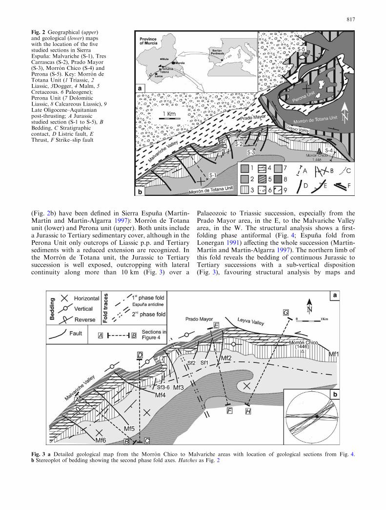
The Sierra Espuna area, located in the Murcia Province(Fig. 2a), belongs to the Malaguide Complex (InternalBetic Zone). The Malaguide units outcropping in thestudy area bounds tectonically with the AlpujarrideComplex to the SE, and with the External Betic Zones(Subbetic) to the NW. Two Malaguide tectonic units
Fig. 1 Geologial sketch of theWestern Mediterranean AlpineChains (lower) and geologicalmap from the Betic–RifeanInternal Zones (upper) with thelocation of the six areascorrelated in Fig. 8: 1Ghomaride from Northern Rif,2 Velez Rubio, 3 Sierra Espuna,4 Sierra Arana, 5 Turon-Ardales, 6 Convento-Nieves(Robledo like units)
816
(Fig. 2b) have been defined in Sierra Espuna (Martın-Martın and Martın-Algarra 1997): Morron de Totanaunit (lower) and Perona unit (upper). Both units includea Jurassic to Tertiary sedimentary cover, although in thePerona Unit only outcrops of Liassic p.p. and Tertiarysediments with a reduced extension are recognized. Inthe Morron de Totana unit, the Jurassic to Tertiarysuccession is well exposed, outcropping with lateralcontinuity along more than 10 km (Fig. 3) over a
Palaeozoic to Triassic succession, especially from thePrado Mayor area, in the E, to the Malvariche Valleyarea, in the W. The structural analysis shows a first-folding phase antiformal (Fig. 4; Espuna fold fromLonergan 1991) affecting the whole succession (Martın-Martın and Martın-Algarra 1997). The northern limb ofthis fold reveals the bedding of continuous Jurassic toTertiary successions with a sub-vertical disposition(Fig. 3), favouring structural analysis by maps and
Fig. 2 Geographical (upper)and geological (lower) mapswith the location of the fivestudied sections in SierraEspuna: Malvariche (S-1), TresCarrascas (S-2), Prado Mayor(S-3), Morron Chico (S-4) andPerona (S-5). Key: Morron deTotana Unit (1 Triassic, 2Liassic, 3Dogger, 4 Malm, 5Cretaceous. 6 Paleogene);Perona Unit (7 DolomiticLiassic, 8 Calcareous Liassic), 9Late Oligocene–Aquitanianpost-thrusting; A Jurassicstudied section (S-1 to S-5), BBedding, C Stratigraphiccontact, D Listric fault, EThrust, F Strike–slip fault
Fig. 3 a Detailed geological map from the Morron Chico to Malvariche areas with location of geological sections from Fig. 4.b Stereoplot of bedding showing the second phase fold axes. Hatches as Fig. 2
817
aerial photos. An open, sub-vertical axis synclineaffecting the entire study area constitutes a second-phasefold, producing a Type 2 interference pattern (Ramsayand Hubbert 1987). Both folding phases have been as-cribed to lower Miocene by Martın-Martın and Martın-Algarra (1997).
In this area, the structural features and five strati-graphic sections (spaced 2–5 km from each other in aW–E direction) were analysed. Except for the pioneerwork by Fallot (1929), the main papers on the Mesozoicof Sierra Espuna are from the 1960s and 1970s (Peyreand Peyre 1960; Mac Gillavry et al. 1963; Navarro andTrigueros 1963; Paquet 1962, 1969; Geyer and Hinkel-bein 1971, 1974; Kampschuur et al. 1974; Seyfried 1978among others). Recent studies have been made on thebiostratigraphy and the palaeogeographic evolution ofthe Jurassic–Cretaceous series of Sierra Espuna(Caracuel et al. 2001, 2005; Martın-Rojas et al. 2002).
Remarks on the palaeoenvironmental evolutionof the Malaguide Complex in Sierra Espuna
Five more-or-less complete stratigraphic Jurassic sec-tions were studied in Sierra Espuna: Malvariche (S-1),Tres Carrascas (S-2), Prado Mayor (S-3), Morron Chico(S-4) and Perona (S-5) from Figs. 2, 5 to 6. The sectionshomogeneously cover the Jurassic from the Sierra Es-puna area, enabling us to propose a synthetic strati-graphic column (Fig. 5). Biostratigraphy and faciesanalysis were approached using more than 140 thinsections and more than 500 ammonite specimens.
Lower Jurassic
Over the thick Triassic succession, after a gradual pas-sage, the Jurassic appears. The lower part of the Jurassic
succession is composed of dolostones and oo-oncolitic,evolving to crinoidal limestones, showing decametricthickening and coarsening upward parasequences. Mi-crofacies are mainly grainstones to packstones (occa-sionally rudstones) with oolites, pisolites, oncolites andbenthic micro- and macrofauna. This lower part of thesuccession is interpreted as restricted inner-shelf depositsof oolitic shoals, near algal and/or crinoidal meadows.
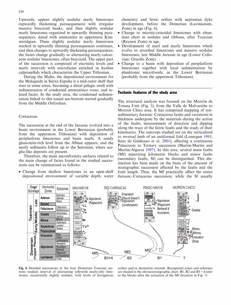
The upper part of the Lower Jurassic succession isbuilt up by 2–12 m of alternating yellowish marly/siltylimestones, occasionally slightly nodular, with levels offerruginous oolites and/or decimetric Fe–Mn oncoids;these being constituted by concentric laminae aroundthe nucleus. This level is constrained between twounconformity surfaces, the lower one presenting Nep-tunian dykes. This upper part of the successions is, un-like the lower one, rich in well-preserved macrofauna.The ammonite assemblages enable the characterizationof discrete and discontinuous horizons within theDomerian (Lavinianum, Algovianum and EmaciatumZones) to the bottom, and the Toarcian (Polymorphum,Sepentinum, Bifrons, Gradata and Reynesi Zones) tothe top (Caracuel et al. 2005).
This interval appears to record the platform break-up, leading to an open shelf-depositional environmentwith variable depth, water chemistry and hydrodynam-ics, due to the intricate bottom topography (blockfaulting and tilting), allowing the dated level to specifythe timing of this break-up.
Middle Jurassic
The Middle Jurassic, some 140 m thick, is composed ofwell-stratified micritic/crinoidal limestones with abun-dant chert in nodules and ribbons, increasing toward theupper part. At the base, the micritic/crinoidal limestonesalternate with thick oolitic limestones levels, which
resemble those of the Lower Jurassic. Toward the upperpart, some levels composed of micritic limestone showincipient nodularization, with abundant trace fossils,developing two multiple hardgrounds at the top, withaccumulations of glauconite or ferruginous crusts andfaunal concentrations (ammonites and occasionallyoriented belemnites).
This level is composed of hierarchized, upwardlythickening and coarsening parasequences, with stackingof upwardly thicker parasequences. Microfacies rangefrom wackestones to packstones (occasionally crinoidalgrainstones) with crinoids, along with thin-shelled biv-alves (filaments), radiolaria, benthic and planktonicforaminifera, and diverse macroinvertebrate fragments.Apart from disarticulated crinoid knuckles, benthicmacrofauna are almost absent in the Middle Jurassic, incontrast to the situation in the Lower Jurassic. Plank-tonic macrofauna is also scarce, but in the top of somelevels, especially toward the upper part, cephalopods arewidespread (ammonites and belemnites).
In these levels, better developed in the Malvarichesection, ammonite assemblages were collected, enablingthe recognition of the Lower Bajocian, based on therecord of a specimen of Skirroceras sp. The MiddleJurassic succession ended with a multiple Fe–Mn crustsdated as Lower Callovian (Gracilis Zone: Caracuel et al.2005).
As in other western Tethyan palaeomargins, duringthe Dogger, widespread pelagic or hemipelagic sedi-ments (gravity flows and periplatform ooze), enriched inchert were deposited, originating from siliceous plank-tonic organisms (radiolaria) due to the drowning of thearea.
Upper Jurassic
The succession is composed of 80–90 m of finely strati-fied marls and marly limestones evolving to stratifiedlimestones stacked in upwardly thickening parase-quences. Next, massive nodular limestones alternatewith stratified limestones and marls, arranged in up-wardly thinning parasequences. Textures and microfa-cies are highly variable, ranging from pelloidalmudstones to intraclastic packstones (occasionally cri-noidal grainstones) with Globuligerina (at the base), fil-aments, Saccocoma, radiolaria, Globochaete,Stomiosphaera, Cadosina and calpionellids.
Over the multiple Fe–Mn crusts dated as LowerCallovian (Gracilis Zone) an interval of marly lime-stones and marls crops out, composed of finely stratified,and texturally mudstones to wackestones rich in Glob-uligerina, dated with ammonites as Middle Oxfordian(Transversarium Zone) to the Lower Kimmeridgian.
Fig. 5 Synthetic Jurassic stratigraphic, biostratigraphic and palaeoenvironmental reconstruction from succession at Sierra Espuna
819
Upwards, appear slightly nodular marly limestones(upwardly thickening parasequences) with irregularmassive breccioid banks, and then slightly nodularmarly limestones organized in upwardly thinning para-sequences, dated with ammonites as uppermost Kim-meridgian. These slightly nodular marly limestonesstacked in upwardly thinning parasequences continues,and then changes to upwardly thickening parasequences;the facies change gradually to alternating marly/calcar-eous nodular limestones, often breccioid. The upper partof the succession is composed of encrinitic levels andmarly intervals with microfacies enriched in hyalinecalpionellids which characterize the Upper Tithonian.
During the Malm, the depositional environment forthe Malaguide in Sierra Espuna is a mid-outer shelf thatrises in some areas, becoming a distal pelagic swell withsedimentation of condensed ammonitico rosso, and re-lated facies. In the study area, the condensed sedimen-tation linked to this raised sea-bottom started graduallyfrom the Middle Oxfordian.
Cretaceous
The succession at the end of the Jurassic evolved into abasin environment in the Lower Berriasian (probablyfrom the uppermost Tithonian) with deposition ofperiplatform limestones and basin marls. A sandyglauconite-rich level from the Albian appears, and themarly sediments follow up to the Senonian, where sca-glia-like deposits are present.
Therefore, the main unconformity surfaces related tothe main change of facies found in the studied succes-sions can be summarized as follows:
• Change from shallow limestones to an open-shelfdepositional environment of variable depth, water
chemistry and ferric oolites with neptunian dykedevelopment, before the Domerian (Lavinianum,Zone) in age (Fig. 6).
• Change to micritic/crinoidal limestones with abun-dant chert in nodules and ribbons, after Toarcian(Reynesi Zone) in age.
• Development of marl and marly limestones whichevolve to stratified limestones and massive nodularlimestones, late Middle Jurassic in age (Lower Callo-vian: Gracilis Zone).
• Change to a basin with deposition of periplatformlimestones together with local sedimentation byplanktonic microfossils, in the Lower Berriasian(probably from the uppermost Tithonian).
Tectonic features of the study area
The structural analysis was focused on the Morron deTotana Unit (Fig. 3), from the Valle de Malvariche toMorron Chico area. It has comprised mapping of syn-sedimentary Jurassic–Cretaceous faults and variations inthickness undergone by the materials during the actionof the faults, measurement of direction and dippingalong the trace of the listric faults and the study of theirkinematics. The outcrops studied are on the verticalizedto reversal limb of an antiformal fold (Lonergan 1991;Sanz de Galdeano et al. 2001), affecting a continuousPalaeozoic to Tertiary succession (Martın-Martın andMartın-Algarra 1997). In this area, several main faults(Mf) separating kilometric blocks and minor faults(secondary faults, Sf) can be distinguished. This dis-tinction has been made on the basis of the amount ofstratigraphic succession affected by the faults and thefault length. Thus, the Mf practically affect the entireJurassic–Cretaceous succession, while the Sf usually
Fig. 6 Detailed successions in the four Domerian–Toarcian sec-tions studied; interval of alternating yellowish marly/silty lime-stones, occasionally slightly nodular, with levels of ferruginous
oolites and/or decimetric oncoids. Recognized zones and subzonesare shaded in the chronostratigraphic chart. B1, B2 and B3+4 referto the blocks after the actuation of the Mf (location in Fig. 7)
820
partially affect the succession, showing minor lengths.There are six Mf called (from E to W) Mf1–Mf6 (Fig. 3).These faults divide the zone into six blocks (named B1–B6 from E to W) 1–2 km wide, with the only exceptionbeing B1, which is about 3 km wide (Fig. 3). The Mf2–Mf6 faults are normal, measuring 2–3 km long, andaffect the entire Jurassic and Cretaceous succession,being sealed by the Tertiary. Meanwhile, Mf1 is a re-verse fault affecting the Triassic to Tertiary succession; itis probably a Jurassic main normal fault inverted into areverse fault during the Tertiary after the tectonicinversion. The five main normal faults affecting theJurassic and Cretaceous succession can be divided intofour westwardly oriented (Mf2, Mf4, Mf5 and Mf6), andone eastwardly oriented (Mf3).
Secondary faults, about 200–500 m long, can also bedistinguished, being westwardly oriented (Fig. 3). Theseminor faults break the blocks with minor displacement.Six evident Sf have been mapped, called (from E to W)Sf1–Sf6. The Sf1 and Sf2 affect the entire Jurassic toCretaceous succession of B2, while the Sf3–Sf6 affectonly the Liassic of B3.
According to the stratigraphic data presented earlier,together with previous palaeogeographic data (Martın-Martın 1996), continental areas seem to be locatedeastward, respecting the present coordinates. Therefore,
if fracturation uplifted the present east area, the west-wardly dipping faults can be considered synthetic, whileeastwardly oriented ones must necessarily be antithetic.These faults are relict from the Mesozoic geodynamicevolution, as deduced from the Tertiary sealing (Fig. 3).
In addition to the above data, other evidence of syn-sedimentary tectonics can be gathered from the SierraEspuna area outcropping. The data can be divided intodirect evidences (neptunian dykes related to jointing,and faults sealed by upper bed) and indirect evidences(slumping, rotated beds, significant thickness changes(see Fig. 7) and lateral distribution of facies).
Deformational pattern: fault activation and subsidence
A prior treatment was made in order to obtain a crosssection reflecting the original geometry preceding theTertiary compressional alpine tectonics. We used thePrado Mayor-Morron Chico sector as a reference area(central-eastern part), and therefore the western part ofthe study area was rotated until the azimuth of thebedding was parallel to the one in the reference area,using the axis of the second-phase fold as rotation axis(Fig. 3), giving a total length of 10.43 km. We considerthat the direction for the cross-section obtained is
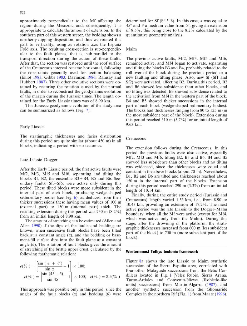
Fig. 7 Restored cross section from Malvariche to Prado Mayor area for the Cretaceous–Tertiary boundary and following deformationalevolutionary analysis for the Cretaceous period, Malm period, and Late Liassic–Dogger period
821
approximately perpendicular to the Mf affecting theregion during the Mesozoic and, consequently, it isappropriate to calculate the amount of extension. In thesouthern part of this western sector, the bedding shows anortherly dipping disposition, and thus we rotated thispart to verticality, using as rotation axis the EspunaFold axis. The resulting cross-section is sub-perpendic-ular to the fault planes, that is, sub-parallel to thetransport direction during the action of these faults.After that, the section was restored until the roof surfaceof the Cretaceous interval became horizontal, followingthe constraints generally used for section balancing(Elliot 1983; Gibbs 1983; Davinson 1986; Ramsay andHubbert 1987). Three other evolutive sections were ob-tained by restoring the rotation caused by the normalfaults, in order to reconstruct the geodynamic evolutionof the margin during the Jurassic times. The length ob-tained for the Early Liassic times was of 8.90 km.
This Jurassic geodynamic evolution of the study areacan be summarized as follows (Fig. 7):
Early Liassic
The stratigraphic thicknesses and facies distributionduring this period are quite similar (about 450 m) in allblocks, indicating a period with no tectonics.
Late Liassic–Dogger
After the Early Liassic period, the first active faults wereMf2, Mf3, Mf5 and Mf6, separating and tilting theblocks B1, B2, the ensemble B3+B4, B5 and B6. Sec-ondary faults, Sf3–Sf6, were active only during thisperiod. These tilted blocks were more subsident in theinternal part of each block, producing wedge-shapedsedimentary bodies (see Fig. 6), as deduced from theirthicker successions these having mean values of 100 m(external part) to 150 m (internal part) thick. Theresulting extension during this period was 730 m (8.2%)from an initial length of 8.90 km.
The amount of stretching can be estimated (Allen andAllen 1990) if the dips of the faults and bedding areknown, when successive fault blocks have been tiltedback at a constant angle (a), and the bedding or base-ment-fill surface dips into the fault plane at a constantangle (h). The rotation of fault blocks gives the amountof stretching of the brittle upper crust, calculated by thefollowing mathematic relation:
e(% ) ¼ sin ( a þ h )
sin a� 1
� �� 100;
e(% ) ¼ sin (45þ 5)
sin 45� 1
� �� 100; e(% ) ¼ 8.5(% )
This approach was possible only in this period, since theangles of the fault blocks (a) and bedding (h) were
determined for Sf (Sf 3–6). In this case, a was equal to45� and h a medium value from 5�, giving an extensionof 8.5%, this being close to the 8.2% calculated by thequantitative geometric analysis.
Malm
The previous active faults, Mf2, Mf3, Mf5 and Mf6,remained active, and Mf4 began to activate, separatingand tilting the blocks B3 and B4, probably related to theroll-over of the block during the previous period or anew faulting and tilting phase. Also, new Sf (Sf1 andSf2) were activated, affecting B2. During this period, B2and B6 showed less subsidence than other blocks, andno tilting was detected. B3 showed subsidence related tothe activation from Mf4 in the western part of the block.B4 and B5 showed thicker successions in the internalpart of each block (wedge-shaped sedimentary bodies).The blocks had thicknesses ranging from 80 to 125 m (inthe most subsident part of the block). Extension duringthis period reached 510 m (5.7%) for an initial length of9.63 km.
Cretaceous
The extension follows during the Cretaceous. In thisperiod the previous faults were also active, especiallyMf2, Mf3 and Mf6, tilting B2, B3 and B6. B4 and B5showed less subsidence than other blocks and no tiltingwas evidenced, since the thicknesses were equal andconstant in the above blocks (about 70 m). Nevertheless,B1, B2 and B6 are tilted and thicknesses reached about150 m in the internal part of the blocks. Extensionduring this period reached 290 m (3.3%) from an initiallength of 10.14 km.
Finally, during the entire study period (Jurassic andCretaceous) length varied 1.53 km, i.e., from 8.90 to10.43 km, providing an extension of 17.2%. The mostactive period was the late Liassic to the Dogger–Malmboundary, when all the Mf were active (except for Mf4,which was active only from the Malm). During thisstage, after the drowning of the platform, the strati-graphic thicknesses increased from 600 m (less subsidentpart of the block) to 750 m (more subsident part of theblock).
Westernmost Tethys tectonic framework
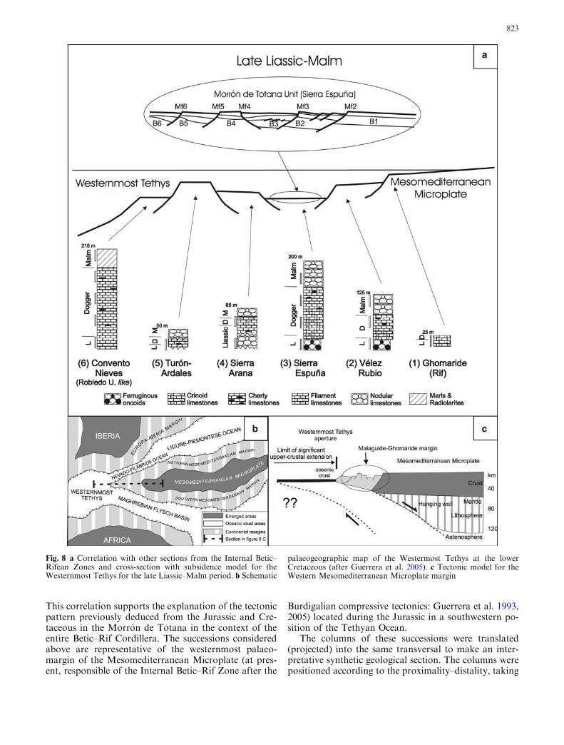
Figure 8a shows the late Liassic to Malm syntheticsuccession of the Sierra Espuna area, correlated withfour other Malaguide successions from the Betic Cor-dillera located in Fig. 1 [Velez Rubio, Sierra Arana,Turon-Ardales and Convento-Nieves (Robledo-likeunits) successions] from Martın-Algarra (1987), andanother synthetic succession from the GhomarideComplex in the northern Rif (Fig. 1) from Maate (1996).
822
This correlation supports the explanation of the tectonicpattern previously deduced from the Jurassic and Cre-taceous in the Morron de Totana in the context of theentire Betic–Rif Cordillera. The successions consideredabove are representative of the westernmost palaeo-margin of the Mesomediterranean Microplate (at pres-ent, responsible of the Internal Betic–Rif Zone after the
Burdigalian compressive tectonics: Guerrera et al. 1993,2005) located during the Jurassic in a southwestern po-sition of the Tethyan Ocean.
The columns of these successions were translated(projected) into the same transversal to make an inter-pretative synthetic geological section. The columns werepositioned according to the proximality–distality, taking
Fig. 8 a Correlation with other sections from the Internal Betic–Rifean Zones and cross-section with subsidence model for theWesternmost Tethys for the late Liassic–Malm period. b Schematic
palaeogeographic map of the Westermost Tethys at the lowerCretaceous (after Guerrera et al. 2005). c Tectonic model for theWestern Mesomediterranean Microplate margin
823
into account the lithofacies, the stratigraphic series andthe palaeogeographic models proposed by Martın-Al-garra (1987) and Maate (1996). These models are basedon the presence or absence of a Palaeozoic basement, onthe Palaeozoic and Triassic sedimentary successions, aswell as the Jurassic–Cretaceous facies (pelagic–neriticcharacter and thickness). As can be deduced fromFig. 8a Convento–Nieves can be considered to be thethickest succession (215 m for the Late Liassic–Malmseries) and the Ghomaride succession the thinnest(about 25 m). The presence of radiolarites in the Con-vento–Nieves also indicates a distal position (basinal)for this succession, while the Ghomaride successionmust be located according to their nerithic facies in aproximal position near to the emerged lands (Me-somediterranean Microplate). The other successionsconsidered, must be located between the above two, withthe Sierra Espuna series the thickest among them(200 m). The period when the entire succession showedthe greatest thickness was the Late Liassic–Dogger,when faults should be more active.
The thickness variation for the succession consideredindicates great differences in the subsidence rates foreach sector, suggesting a narrow and swell submarinetopography. This distinctive topography can be inter-preted as being caused by fault activity separating andtilting different blocks to create the Tethyan Oceanwestward during the Jurassic, according to Schlager(1981), Kendall and Schlager (1981) and Santantonio(1993).
As a result, for the westward opening of the Tethyanocean, three kinds of faults were active: large-scale faults(Lf) separating hectometric cortical blocks, allowinggreat differences in the thickness of the successions (first-order fragmentation); and Mf and Sf, allowing the sec-ond-order fragmentation of each palaeogeographicblock into kilometric blocks. All the faults (Lf, Mf andSf) seem to be listric, since the blocks show wedge-shaped sedimentary bodies.
Discussion
The analyses made on the Morron de Totana Unitindicate an extension for the entire Jurassic–Cretaceousperiod at about 17.2%, although the cortical extensionalmodels generally indicate an extension of 25%(McKenzie 1978), at about the 100% (Wernicke 1985;Debelmas and Mascle 1991; Houseman and England1986) of the initial length.
Nevertheless, extension rates are quite differentaccording to the position considered in the rifting zone.The Wernicke’s model (1985) proposes a zonation ofrifting areas according to the extensional rates. It con-sists of an asymmetric model with a main low-anglenormal fault where the hanging wall is also faulted byhigh-angle normal faults. These cortical faults producelarge blocks (large fault block) with minor rotations,creating emergent (ranges) and subsident (basins) con-
tiguous areas. These blocks, at about 10–15 km long, arelocated according to Wernicke (1985) out of the ‘‘limit ofsignificant crustal extension’’ where faults are usuallyhighly dipping with a minor capacity of stretching. Inanother way, the bottom wall is faulted by minor low-angle faults, giving greater extension, with high, rotatedblocks in the ‘‘significant crustal extension area’’ (duringthe drifting phase), where the crust becomes thinned andwhere magmatic and metamorphic processes take place.
The fact that the extension rates established in theMorron de Totana Unit are lower than those of thecurrent model could be related to the different extensioncapacity from the large-scale compartmentalization (Lf)to the second-order fragmentation (Mf and Sf), higher inthe first case and lower in the second one. Therefore, theLf separating palaeogeographic crustal blocks wereresponsible for larger extensions, while second-orderfragmentation, located into palaeogeographic blocks,was responsible for minor extension rates of close to17%. Moreover, the general framework of the westernTethys (Malaguide–Ghomaride Domain) appears to berelated to areas outside the ‘‘limit of significant crustalextension’’ in the hanging wall of the main low-anglefault of the rifting (Fig. 8b), since neither magmatic normetamorphic processes have been recognised in theSierra Espuna area, either here or in previous work inthe Betic–Rif Chains (Sanz de Galdeano 1997 and ref-erences therein). This implies that the main corticalnormal low-angle fault should be palaeogeographicallylocated in a western position in the opening of theTethyan but with an eastern dipping, according to thecurrent coordinates (Fig. 8b).
Models for the temporal evolution of passive margins(National Research Council 1979; Winterer and Bosel-lini 1981) divide the history into several phases: first apre-rift quiet period, followed by a ‘‘rifting and trans-forming’’ faulting phase with drowning of the area; later,a ‘‘drifting’’ phase when continental crust and oceaniccrust accretion separate with rapid tectonic subsidenceand opening of the ocean; finally, a post-drift phase withthermal subsidence when oceanographic effects, such assea-level changes, oxygenation and current regimens,dominate over the effects of the tectonics.
The dating of these phases is difficult since they areusually hetero-chrones in widespread basins (Wintererand Bosellini 1981; Vera 1988), but the bounds of thesephases usually coincide with unconformities and chan-ges in sedimentary facies. The change from the pre-rift torifting phase, and from the rifting to drifting stagecoincides with erosive surfaces, the second one beingcalled the ‘‘break-up unconformity’’ (Falvey 1974). Fi-nally, the change from the drifting to post-drifting phaseusually coincides with a less marked unconformitywhere a change to pelagic and/or siliceous rocks be-comes widespread.
In the study area (a part of the western Tethys) theextensional evolution can also be divided into fourstages according to the fault activation, subsidence-ratevariation, the occurrence of unconformity surfaces and
824
the facies evolution. Also, the biostratigraphic andstratigraphic study enables the dating of the unconfor-mity surfaces related to the changes among the differenttectonic phases of the oceanic opening:
• Pre-rifting phase: the Triassic to Early Liassic quietperiod took place before the Domerian (AlgovianumZone), when a relative sea-level fall occurred, evi-denced by an important unconformity with palaeok-arst developing
• Rifting phase: this can be divided in two stages: first,the platform break-up (faulting and transforming) anddrowning of the area until the Toarcian (ReynesiZone), where a notable change in the sedimentaryfacies to ferro-manganese oolites and pelagic faunastook place; second, the Late Liassic–Dogger stagewith subsidence developing with high variability fromblock to block.
• Drifting phase: the unconformity surface related to therifting-to-drifting change (‘‘break-up unconformity’’according to Falvey 1974) must be Dogger–Malmboundary in age (Lower Callovian: Gracilis Zone),where a homogenisation of the subsidence rates re-corded are related to another unconformity.
• Post-drift phase: the change from drift to post-driftingmust be Jurassic to Cretaceous boundary in age(Lower Berriasian, probably from the uppermostTithonian), related to minor subsidence rates (thermalsubsidence) in all the blocks and developing of pelagicand siliceous rocks.
Conclusions
The study of the Malvariche-Prado Mayor area has al-lowed us to analyse the structural extensional pattern ofthe Sierra Espuna Malaguide Complex. This analysis,included in a general frame, gives three kinds of listricfaults for the westward opening of the Tethyan ocean:macro-scale faults separating hectametric cortical blocks(Lf); and Mf and Sf separating kilometric and hecta-metric blocks, respectively (second-order fragmenta-tion). This extensional analysis shows a variation oflength from 8.90 to 10.43 km for the entire Jurassic toCretaceous period, providing an extension at about17.2%. The most active period was the late Liassic to theDogger–Malm boundary when the extension was atabout 730 m (8.2%) from an initial length of 8.90 km
Furthermore, the stratigraphic and biostratigraphicstudy made in the area has enabled the recognition offour main unconformity surfaces related to changes insedimentary facies: Domerian late Liassic (AlgovianumZone), Toarcian late Liassic (Reynesi Zone), Dogger–Malm boundary (Lower Callovian: Gracilis Zone) andLower Berriasian (probably already from the uppermostTithonian). These surfaces could be related to theboundary of the four stages of the western Tethysextensional evolution: Triassic to Early Liassic pre-rif-ting phase, rifting and transforming phase at the
beginning of the late Liassic, late Liassic–Dogger riftingphase, Malm drifting phase and Cretaceous post-driftphase with thermal subsidence.
The picture of this part of the western Tethys seemsto be related to areas outside the ‘‘limit of significantcrustal extension’’ in the hanging wall of the main low-angle fault of the rifting, taking into account the struc-tural architecture and the extensional percentage found.Therefore, the main cortical normal low-angle fault,where cortical thinning is greatest, should be palaeoge-ographically located in a western position in the Tethyanopening with an eastern dipping, according to thepresent coordinates.
Acknowledgements This research was economically co-financed bythe research projects BTE2001-3020, BTE2001-3029, BTE2003-01113 and CGL2005-03887 (Spanish Ministry of Education andScience) and Research Groups and project of the GeneralitatValenciana in the CTMA department (IGA) from the AlicanteUniversity, and Junta de Andalucıa (RNM-178). We also thankconstructive criticism and accurate reviews by Dr. Guerrera andDr. Sanz de Galdeano. The English revision effectuated by Dr.David Nesbitt to the manuscript is also acknowledged.
References
Allen PA, Allen JR (1990) Basin analysis: principles and applica-tions.. Blackwell, Oxford, pp 1–451
Biju-Duval B, Dercourt J, Le Pichon X (1977) From the Tethysocean to the Mediterranean seas: a plate tectonic model of theevolution of the western Alpine system. In: Biju-Duval B,Montadert L (eds) International symposium on the structuralhistory of the Mediterranean basins, Split (Yugoslavia), 1976.Editions Technip, Paris, pp 143–164
Boutakiout M, Elmi S (1996) Tectonic and eustatic controls duringthe lower and middle Jurassic of the South Rif Ridge (Mor-occo) and their importance for the foraminifera-communities,vol 1–2. Geo-research Forum, Transtec Publications, Zurich,pp 237–248
Caracuel JE, Sandoval J, Martın-Martın M, Estevez A, Martın-Rojas I (2001) Datos preliminares del Jurasico del perfil deMalvariche en Sierra Espuna (Complejo Malaguide; ZonasInternas Beticas). XVII Jornadas de Paleontologıa S.E.P. SE-PAZ 5.1, 271–278
Caracuel JE, Sandoval J, Martın-Martın M, Martın-Rojas I, Est-evez A (2005) Jurassic biostratigraphy and paleoenvironmentalevolution of the Malaguide Complex from Sierra Espuna(Internal Betic Zone, SE Spain). Geobios (in press)
Channell JE, D’Argento BD, Horvath F (1979) Adria, the Africanpromontory in Mesozoic Mediterranean palaeogeography.Earth Sci Rev 15:213–292
Darros de Matos RM (1993) Geometry of the hanging wall above asystem of listric normal faults. A numerical solution. Am AssocPet Geol Bull 77(11):1831–1859
Davinson I (1986) Listric normal fault profiles: calculation usingbed-length balance and fault displacement. J Struct Geol8(2):209–210
Debelmas J, Mascle G (1991) Les grandes structures geologiques.Masson, Paris, pp 1–299
Dula WF (1991) Geometric model of listric normal faults androllover folds. Am Assoc Pet Geol Bull 75(10):1609–1625
Elliot D (1983) The construction of balanced cross-sections. JStruct Geol 5(2):101
Fallot P (1929) Esquisse geologique du Massif de la Sierra Espuna(Prov. de Murcia). Bol R Soc Esp Hist Nat 29:199–215
Falvey DA (1974) The development of continental margins in platetectonic theory. J Aust Pet Explor Assoc 14:95–106
825
Geyer OF, Hinkelbein K (1971) Eisenoolithische Kondensations-Horizonte im Lias der Sierra de Espuna (Provinz Murcia,Spanien). Neues Jahr Geol Palaontol Monatshefte 10:398–414
Geyer OF, Hinkelbein K (1974) Las Oolitas ferruginosas del Jur-asico de la Sierra de Espuna (prov. de Murcia). Acta GeolHispan 9–3:102–106
Gibbs AD (1983) Balanced cross-section construction from seismicsections in areas of extensional tectonics. J StructGeol 5:153–160
Guerrera F, Martın-Algarra A, Perrone V (1993) Late Oligocene–Miocene syn-/late-orogenic successions in Western and CentralMediterranean chains from Betic Cordillerra to Southern A-pennines. Terranova 5:525–544
Guerrera F, Martın-Martın M, Perrone V, Tramontana M (2005)Tectono-sedimentary evolution of the southern branch of theWestern Tethys (Maghrebian Flysch Basin and LucanianOcean): consequences for Western Mediterranean geodynamics.Terranova 17(4):358–367
Hanne D, White N, Lonergan L (2003) Subsidence analyses fromthe Betic Cordillera, southeast Spain. Basin Res 15(1):1–23
Houseman G, England PC (1986) A dynamical model of litho-sphere extension and sedimentary basin formation. J GeophysRes 91:719–729
James NP, Mountjoy EW (1983) Shelf-slope break in fossil car-bonate platform. In: Stantely, Moore (eds) ‘‘The shelf-break:critical interface on continental margin’’. Special Publication ofSociety Economy Paleontology and Minery 33:189–212
Kampschuur W, Langerberg CW, Baena J, Velando F, Garcıa-Monzon F, Paquet J, Rondeel HE (1974) Mapa y MemoriaExplicativa del Mapa Geologico de Espana 1/50000, Hoja deCoy (932). Instituto Geologico y Minero de Espana, pp 1–32
Kendall CG, Schlager W (1981) Carbonates and relative changes insea-level. In: Cita, Ryan (eds) ‘‘Carbonate platforms of thepassive-type continental margins, present and past’’. Mar Geol44:181–212
Lonergan L (1991) Structural evolution of the Sierra Espuna, BeticCordillera, SE Spain. Thesis, Oxford University, pp 1–154
Maate A (1996) Estratigrafıa y Evolucion Paleogeografica alpinadel Dominio Gomaride (Rif Interno, Marruecos). Tesis, Uni-versidad de Granada, pp 1–399
MacGillavry HJ, Geel T, Roep Th B, Soediono H (1963) Furthernotes on the geology of the Betic of Malaga, the Subbetic, andthe Zone Between these two Units, in the Region of VelezRubio (Southern Spain). Geol Rundsch 53:233–259
McKenzie DP (1978) Some remarks on the development of sedi-mentary basins. Earth Planet Sci Lett 40:25–32
Martın-Algarra A (1987) Evolucion geologica alpina del contactoentre las Zonas Internas y las Zonas Externas de la CordilleraBetica. PhD Thesis, Universidad de Granada, pp 1–1171
Martın-Martın M (1996). El Terciario del area de Sierra Espuna.PhD Thesys, Universidad Granada, 297 p
Martın-Martın M, Martın-Algarra A (1997) La estructura del areade Sierra Espuna (Contacto Zonas Internas-Externas, sectororiental de la Cordillera Betica). Estud Geol 53:237–248
Martın-Rojas I, Caracuel JE, Estevez A, Martın-Martın M,Sandoval J (2002) Jurassic stratigraphy of the MalaguideComplex from Sierra Espuna (Internal Betic Zone, SE Spain).In: STRATI 2002 – 3eme Congress Francais de Stratigraphie.Documents STU Lyon 156:156–157
Martire L (1996) Stratigraphy, facies and synsedimentary tectonicsin the Jurassic Rosso Ammonitico Veronese (Altopiano diAsiago, NE Italy). Facies, Erlangen 35:209–236
National Research Council (1979) Ad hoc panel to investigate thegeological and geophysical research needs and problems ofcontinental margins. Natural Academy Science, WashingtonDC, pp 1–302
Navarro A, Trigueros E (1963) Estudio Geologico del Borde Or-iental de la Sierra Espuna. Notas y Comunicaciones InstitutoGeologico y Minero de Espana 70:205–210
Paquet J (1962) Contribution a l¢etude geologique de la SierraEspuna (Prov. de Murcia, Espagne). Ann Soc Geol Nord 32:9–17
Paquet J (1969) Etude geologique de lOuest de la province deMurcia (Espagne). Memoires du Bureau de RecherchesGeologiques et Minieres, Paris, 48, 111, pp 1–270
Peyre N, Peyre Y (1960) Observaciones Geologicas Sobre SierraEspuna (Murcia). Notas y Comunicaciones Instituto Geologicoy Minero de Espana 59:3–23
Ramsay JG, Huber MI (1987) Modern structural geology. Aca-demic, London, pp 1–700
Read JF (1985) Carbonate facies models. Bull Am Assoc Pet Geol69:1–12
Ruiz-Ortiz PA, Bosence DWJ, Rey J, Nieto LM, Castro JM,Molina JM (2004) Tectonic control of facies architecture, se-quence stratigraphy and drowning of a Liassic carbonateplatform (Betic Cordillera, Southern Spain). Basin Res16:235–257
Santantonio M (1993) Facies associations and evolution of pelagiccarbonate platform/basin systems: examples from the ItalianJurassic. Sedimentology 40:1039–1067
Santantonio M (1994) Pelagic carbonate platforms in the geologicrecord: their classification, and sedimentary and paleotectonicevolution. Am Assoc Pet Geol 78:122–141
Sanz de Galdeano C (1997) La Zona Interna Betico-Rifena (An-tecedentes, unidades tectonicas, correlaciones y bosquejo dereconstruccion Paleogeografica). Monografica Tierras del Sur,Universidad de Granada, pp 1–316
Sanz de Galdeano C, Martın-Martın M, Estevez A (2001) Unid-ades tectonicas y estructura del sector meridional de SierraEspuna (Cordillera Betica, Murcia). Estud Geol 56(5–6):269–278
Schlager W (1981) The paradox of drowned reefs and carbonateplatforms. Bull Geol Soc Am 92:197–211
Seyfried H (1978) Der subbetische Jura von Murcia (Sudost-Spa-nien). Geol Jahrb 29:3–201
Vera JA (1988) Evolucion de los sistemas de deposito en el MargenIberico de la Cordeillera Betica. Rev Soc Geol Espana 1(3–4):373–391
Wernicke B (1985) Uniform-sense normal simple shear of thecontinental litosphere. Can J Earth Sci 22:108–125
Wilson JL (1975) Carbonate facies in geological history. Springer,Berlin Heidelberg New York, pp 1–517
Winterer EL, Bosellini A (1981) Subsidence and sedimentation onJurassic passive continental margin, Southern Alps, Italy. J AmAssoc Pet Geol 65:394–421
Withjack MO, Peterson ET (1993) Prediction of normal-faultgeometries—a sensitivity analysis. J Am Assoc Pet Geol77:1860–1873
Zempolich WG (1993) The drowning succession in Jurassic Car-bonates of the Venetian Alps, Italy: a record of supercontinentbreakup, gradual eustatic rise, and eutrophication of shallow-water environments. AAPG Memoir 57, Carbonate SequenceStratigraphy, pp 63–105