The Moín High, East Costa Rica: Seamount, laccolith or contractional structure? Christian Brandes a, * , Allan Astorga b , Jutta Winsemann a a Institut für Geologie, Leibniz Universität Hannover, Callinstr. 30, 30167 Hannover, Lower Saxony, Germany b Escuela Centroamericana de Geología, San José, Costa Rica article info Article history: Received 11 May 2007 Accepted 11 February 2009 Keywords: Costa Rica Limón Basin Moín High Contractional structure Central America abstract The back-arc area of the southern Central American arc–trench system in East Costa Rica is characterized by a complex basin system. An extensional back-arc area (the North Limón Basin) and a compressional retro-arc foreland basin (the South Limón Basin) are closely related. Both basins are separated by an approximately 50 km long and 30 km wide mound-shaped structure referred to as Moín High, which evolved in Eocene times. The Moín High has previously been interpreted as a basement structure or paleo-high. The modern geothermal gradient is 3 °C/100 m. There is no evidence for thermal anomaly or higher heat flow in that area. A mean heat flow of 56–60 mW/m 2 implies that an origin as a volcanic seamount or magmatic intrusion is unlikely. 3D static models show that the Moín High trends NNE–SSW and has an antiformal shape in cross-section and an elliptic outline in map view. The trend of the Moín High coincides with the orientation of folds in West Costa Rica that formed in response to an Eocene deformation phase. The seismic lines show that Miocene reflectors onlap against the structure. Based on this data set it is likely that the Moín High is an anticline formed due to contraction. Ó 2009 Elsevier Ltd. All rights reserved. 1. Introduction The Limón back-arc basin extends along the Caribbean Coast of Costa Rica. In the central and northern part of this basin large mound-shaped structures occur (Fig. 1), which have been inter- preted as basement structures (Sheehan et al., 1990) or paleo-highs (Barboza et al., 1997). One of these structures is referred to as Moín High, which is located close to the present-day coastline north of Puerto Limón, next to the Trans Isthmic Fault System at the bound- ary of the undeformed North Limón Basin and the deformed South Limón Basin. The Moín High evolved in Eocene times (Barboza et al., 1997), has an elliptic outline in map view and represents a four-way dip closed area. In general such a structure is an interest- ing exploration target because it can retain oil and gas. In the past the Limón Basin was regarded as prolific hydrocarbon province and several wells were drilled (e.g., Sheehan et al., 1990; Barboza et al., 1997; Petzet, 1998). Archer et al. (2005) showed the importance of a careful and multi-disciplinary examination of such a structure to avoid a misinterpretation and to minimize the risk for hydrocarbon exploration. Based on the shape and outline, there are different possibilities to explain the evolution of the Moín High: (1) a volca- nic seamount, (2) a magmatic intrusion, (3) a salt pillow/diapir, (4) an uplifted basement block, (5) an inversion structure or (6) an anticline (Fig. 2). Seismic sections and well data made available by the Costa Rican Ministry of Environment and Energy (MINAE) allow a detailed reconstruction of the geometry and temporal evo- lution of the structure. Pre-growth, growth and post-growth strata was analysed to reconstruct the uplift history of the Moín High. The combination of seismic lines, well data, 3D static models and basin modelling techniques helps to verify the different possibili- ties for its mode of origin. 2. Geological setting The geology of Central America is characterized by the interac- tion of five lithospheric plates, namely the oceanic Cocos, Nazca and Caribbean Plates and the continental North and South Ameri- can Plates (Fig. 3a). Tectonics processes in this region are domi- nated by the subduction of the Cocos and Nazca Plates beneath the Caribbean Plate along the NW–SE trending Central America trench. The present-day subduction velocity off Costa Rica, relative to the Caribbean Plate, is 8.5 cm/yr (DeMets, 2001). The Central American subduction zone is characterized by strong along-trench variations in the dip angle of the Wadati–Benioff zone. Protti et al. (1995) observed an angle of 84° under Nicaragua, 60° under Cen- tral Costa Rica and a flat slab with no Wadati–Benioff zone under South Costa Rica. The Central American land-bridge above this sub- duction zone is a complex assemblage of distinct crustal blocks (Fig. 3a) including, from NW to SE, the Maya, Chortis, Chorotega and Choco Blocks (Donnelly, 1989; Weinberg, 1992; Di Marco et al., 1995; Campos, 2001). The Maya and Chortis Blocks have a continental basement, whereas the Chorotega and Choco Blocks comprise island-arc segments underlain by Mesozoic oceanic crust 0895-9811/$ - see front matter Ó 2009 Elsevier Ltd. All rights reserved. doi:10.1016/j.jsames.2009.02.005 * Corresponding author. Tel.: +49 5117624391; fax: +49 5117622172. E-mail address: [email protected](C. Brandes). Journal of South American Earth Sciences 28 (2009) 1–13 Contents lists available at ScienceDirect Journal of South American Earth Sciences journal homepage: www.elsevier.com/locate/jsames
Transcript
Journal of South American Earth Sciences 28 (2009) 1–13
The Moín High, East Costa Rica: Seamount, laccolith or contractional structure?
Christian Brandes a,*, Allan Astorga b, Jutta Winsemann a
a Institut für Geologie, Leibniz Universität Hannover, Callinstr. 30, 30167 Hannover, Lower Saxony, Germanyb Escuela Centroamericana de Geología, San José, Costa Rica
a r t i c l e i n f o
Article history:Received 11 May 2007Accepted 11 February 2009
Keywords:Costa RicaLimón BasinMoín HighContractional structureCentral America
0895-9811/$ - see front matter � 2009 Elsevier Ltd. Adoi:10.1016/j.jsames.2009.02.005
The back-arc area of the southern Central American arc–trench system in East Costa Rica is characterizedby a complex basin system. An extensional back-arc area (the North Limón Basin) and a compressionalretro-arc foreland basin (the South Limón Basin) are closely related. Both basins are separated by anapproximately 50 km long and 30 km wide mound-shaped structure referred to as Moín High, whichevolved in Eocene times. The Moín High has previously been interpreted as a basement structure orpaleo-high. The modern geothermal gradient is 3 �C/100 m. There is no evidence for thermal anomalyor higher heat flow in that area. A mean heat flow of 56–60 mW/m2 implies that an origin as a volcanicseamount or magmatic intrusion is unlikely. 3D static models show that the Moín High trends NNE–SSWand has an antiformal shape in cross-section and an elliptic outline in map view. The trend of the MoínHigh coincides with the orientation of folds in West Costa Rica that formed in response to an Eocenedeformation phase. The seismic lines show that Miocene reflectors onlap against the structure. Basedon this data set it is likely that the Moín High is an anticline formed due to contraction.
� 2009 Elsevier Ltd. All rights reserved.
1. Introduction
The Limón back-arc basin extends along the Caribbean Coast ofCosta Rica. In the central and northern part of this basin largemound-shaped structures occur (Fig. 1), which have been inter-preted as basement structures (Sheehan et al., 1990) or paleo-highs(Barboza et al., 1997). One of these structures is referred to as MoínHigh, which is located close to the present-day coastline north ofPuerto Limón, next to the Trans Isthmic Fault System at the bound-ary of the undeformed North Limón Basin and the deformed SouthLimón Basin. The Moín High evolved in Eocene times (Barbozaet al., 1997), has an elliptic outline in map view and represents afour-way dip closed area. In general such a structure is an interest-ing exploration target because it can retain oil and gas. In the pastthe Limón Basin was regarded as prolific hydrocarbon province andseveral wells were drilled (e.g., Sheehan et al., 1990; Barboza et al.,1997; Petzet, 1998). Archer et al. (2005) showed the importance ofa careful and multi-disciplinary examination of such a structure toavoid a misinterpretation and to minimize the risk for hydrocarbonexploration. Based on the shape and outline, there are differentpossibilities to explain the evolution of the Moín High: (1) a volca-nic seamount, (2) a magmatic intrusion, (3) a salt pillow/diapir, (4)an uplifted basement block, (5) an inversion structure or (6) ananticline (Fig. 2). Seismic sections and well data made availableby the Costa Rican Ministry of Environment and Energy (MINAE)
ll rights reserved.
: +49 5117622172.C. Brandes).
allow a detailed reconstruction of the geometry and temporal evo-lution of the structure. Pre-growth, growth and post-growth stratawas analysed to reconstruct the uplift history of the Moín High.The combination of seismic lines, well data, 3D static models andbasin modelling techniques helps to verify the different possibili-ties for its mode of origin.
2. Geological setting
The geology of Central America is characterized by the interac-tion of five lithospheric plates, namely the oceanic Cocos, Nazcaand Caribbean Plates and the continental North and South Ameri-can Plates (Fig. 3a). Tectonics processes in this region are domi-nated by the subduction of the Cocos and Nazca Plates beneaththe Caribbean Plate along the NW–SE trending Central Americatrench. The present-day subduction velocity off Costa Rica, relativeto the Caribbean Plate, is 8.5 cm/yr (DeMets, 2001). The CentralAmerican subduction zone is characterized by strong along-trenchvariations in the dip angle of the Wadati–Benioff zone. Protti et al.(1995) observed an angle of 84� under Nicaragua, 60� under Cen-tral Costa Rica and a flat slab with no Wadati–Benioff zone underSouth Costa Rica. The Central American land-bridge above this sub-duction zone is a complex assemblage of distinct crustal blocks(Fig. 3a) including, from NW to SE, the Maya, Chortis, Chorotegaand Choco Blocks (Donnelly, 1989; Weinberg, 1992; Di Marcoet al., 1995; Campos, 2001). The Maya and Chortis Blocks have acontinental basement, whereas the Chorotega and Choco Blockscomprise island-arc segments underlain by Mesozoic oceanic crust
Fig. 1. Map of the Costa Rica back-arc area, showing main faults, structural highs and sediment thickness (based on Barboza et al. (1997)).
2 C. Brandes et al. / Journal of South American Earth Sciences 28 (2009) 1–13
(Escalante and Astorga, 1994). The Chorotega Block, which repre-sents the Costa Rican part of the island-arc, can be subdivided intoa northern and a southern arc segment (Seyfried et al., 1991). Thenorthern arc segment is bounded to the north by the Hess Escarp-ment and to the south by the Trans Isthmic Fault System (Fig. 3b).The Hess Escarpment is a NE–SW trending bathymetric feature inthe Caribbean Sea, which separates the continental Chortis Blockfrom the oceanic Colombia Basin (Krawinkel and Seyfried, 1994;Campos, 2001). The Hess Escarpment has been interpreted as anUpper Mesozoic Plate boundary, acting as a strike-slip zone tocompensate the movements between the Chortis and ChorotegaBlocks and the Caribbean Plate (Krawinkel, 2003). The Trans Isth-mic Fault System is an E–W trending active lineament. It showsmainly sinistral movements (Krawinkel and Seyfried, 1994; Kra-winkel, 2003). The southern Costa Rican arc segment is locatedsouth of this lineament and belongs to the Panama Microplate.
The Limón back-arc basin is situated beneath the present-daycoastal plain and continental shelf of eastern Costa Rica (Fig. 3b)(Weyl, 1980). Its northern boundary is the Hess Escarpment, tothe west and south the basin is bounded by the volcanic arc. Theeastward extent is defined by the 200 m bathymetric contour lineof the Caribbean Sea in the north and by the extent of the Limónfold-and-thrust belt in the south (Fig. 3b). The Limón Basin canbe subdivided into a northern and a southern sub-basin, separatedby the Moín High and the Trans Isthmic Fault System (Fig. 3b). TheMoín High is located north of Puerto Limón (Fig. 3c). The NorthLimón Basin belongs to the North Costa Rican arc segment, andin contrast to the South Limón Basin, is undeformed. The NorthLimón Basin is filled with up to �7 km of Upper Cretaceous to Re-cent deep-marine and continental volcaniclastic rocks and lime-stones (Sheehan et al., 1990; Bottazzi et al., 1994), and stillundergoes subsidence today (Mende, 2001). The South Limón Ba-sin, located on the South Costa Rican arc segment, is filled withup to �8 km of Upper Cretaceous to Recent deep-marine to conti-nental volcaniclastic rocks (Sheehan et al., 1990; Coates et al.,1992, 2003; Amann, 1993; Bottazzi et al., 1994; Fernandez et al.,1994; McNeill et al., 2000; Mende, 2001; Campos, 2001). Deposi-
tion of carbonates occurred during Late Cretaceous, Eocene andOligocene times (Fig. 3d). In southern Costa Rica conditions changefrom steep low stress subduction to flat high stress subduction. Theisland-arc shows a deformed and uplifting fore-arc and back-arcarea, separated by the Talamanca Range with a height of 3.8 kmand a width of 60 km. In the Talamanca Range the highest peaksof southern Central America occur, but there are no active volca-noes in that region. The back-arc is dominated by the Limónfold-and-thrust belt (Barboza et al., 1997). The internal part of thisfold-and-thrust belt is characterized by thick-skinned tectonics.Deep earthquake loci provide evidence for active, deep seatedthrusts (Suárez et al., 1995). In contrast, the external part of theLimón fold-and-thrust belt adjacent to the Caribbean Coast is dom-inated by thin-skinned tectonics. Seismic reflection lines show thatall thrusts sole into a common detachment at a depth of 3.7–4 km(Brandes et al., 2007). Since the Middle Miocene the fill of the on-shore South Limón Basin was affected by intense folding andthrusting (Campos, 2001). Recent earthquake activity indicatesongoing deformation in this region (Protti and Schwartz, 1994;Suárez et al., 1995).
3. Database and methods
The data used in this study include a grid of 2D seismic reflec-tion lines, comprising NE–SW directed in-lines and NW–SE direc-ted cross-lines (Fig. 3c). The seismic lines were acquired duringonshore and offshore seismic campaigns in the 1970s and 1980s.Stratigraphic and lithologic control for the seismic interpretationis derived from one onshore well (Well 1). This well penetratesPleistocene to Eocene sandstones, shales and limestones. Data froma second offshore well (Well 2) were also integrated. Seismic inter-pretation was performed with the software package KingdomSuite�. The seismic interpretation was used as a basis for the 3Dinterpretation of the Moín High and the surrounding basin-fill.Key seismic reflectors (base Middle Miocene, base Late Miocene,base Pliocene, base Quaternary and sea-floor) were identified and
(1) Volcanic seamount
(2) Laccolith
(3) Diapir/pillow
(4) Basement-uplift
(6) Anticline
(5) Inversion structure
Fig. 2. Different modes to explain the evolution of the Moín High: (1) a volcanicseamount, (2) a magmatic intrusion, (3) a salt pillow/diapir, (4) an upliftedbasement block, (5) an inversion structure or (6) an anticline structure.
C. Brandes et al. / Journal of South American Earth Sciences 28 (2009) 1–13 3
mapped in detail throughout the study area. 3D static models werecreated to visualize the geometry of the Moín High. From the seis-mic data it was also possible to identify different deformationphases, which can be correlated with the deformation phases thathad previously been recognized in the onshore area of Costa Rica.Basin modelling was carried out with the software PetroMod� 1Dto reconstruct the burial history of the Moín High. A depth conver-
sion was performed on the basis of interval velocities to infer thereal geometry of the structure.
4. Seismic interpretation and well data
Several seismic lines allow insight into the Moín area (Fig. 3c).Well 1 was drilled onshore, north of Puerto Limón on the northernflank of the Moín High close to the present-day coastline and pro-vides the necessary stratigraphic and lithologic control for the seis-mic interpretation. On the seismic sections, the Moín High has amound-like, antiformal shape. The length of the structure isapproximately 50 km, the width is approximately 30 km. Thesouthern flank is steeper than the northern one. The seismic line(a), shown in Fig. 4a) displays a package of strong reflectors, whichseparates the Moín High from the surrounding and overlying sed-imentary rocks. Especially the upper reflectors are very distinctand continuous. The reflector package has a constant thicknesseven on the crest of the structure. Below this reflector packagethe Moín High shows a weakly layered reflector pattern with singleslightly stronger reflectors, which are not continuous. The centralpart of the structure is characterized by a very diffuse reflector pat-tern. There is no reliable information for these parts of the MoínHigh and the presence of artefacts can not be ruled out. On theseismic section (b) shown in Fig. 5 the reflector package on thenorthern flank of the structure is less distinct, but a set of strongreflectors are present, which delineate the Moín High from the sur-rounding and overlying sedimentary rocks. These strong reflectorsmay result from an increase in the acoustic impedance. Data qual-ity of the in-lines is limited and the internal structure is not visu-alized very well on these sections. A small graben structure isvisible in the crestal area of the Moín High (Fig. 4b). The fill ofthe North Limón Basin is characterized by laterally continuousreflectors, which can be traced along section (b) (Fig. 5). Thesereflectors form packages with a constant thickness. The individualpackages are bounded by high amplitude reflectors. Some of thehigh amplitude reflectors can be correlated with lithologicalchanges. The strong reflector at 2.3 s in Fig. 4a) corresponds to achange from shale to limestone at the boundary Early Miocene–Middle Miocene in Well 1.
Well data in combination with the seismic lines provide impor-tant information about the temporal evolution of the Moín High.Well 1 penetrates Pleistocene to Middle Eocene sandstones, shalesand limestones (Fig. 4). The terminal depth is 3356 m. At a depth of2910 m Middle Eocene limestones are directly overlain by LowerMiocene limestones. Upper Eocene and Oligocene deposits are ab-sent. The interpreted time gap is at least 15 Ma. Early Miocene andEarly Middle Miocene deposits show a clear onlap against the MoínHigh. This is indicated by several onlapping reflectors (Figs. 4b and5). Late Middle Miocene and Late Miocene reflectors drape theMoín High. The wedging of reflector packages against the MoínHigh implies that the missing Upper Eocene and Oligocene unitsare present in the deeper parts of the basin. The unconformity onthe flank of the Moín High is interpreted as a local feature, it isnot present in the deeper parts of the basin. Middle Miocene andPliocene to Lower Pleistocene deposits show an increased thick-ness above the crestal graben structure.
The depth converted section without vertical exaggeration dis-plays the true geometry of the Moín High (Fig. 4d). After the depthconversion, the structure has a much lower relief than on the seismicsection in two-way-travel time, but the convex shape is still present.
From the seismic lines, 3D static models were created. Thesemodels clearly show that the structure has an elliptic outline andtrends NNE–SSW (Fig. 6a). An axis can be reconstructed thatplunges towards NNE. In plan view the Moín High is elongated.The northwest and southeast flanks are steep compared to the
Changuinola Formationpelagic carbonates and volcaniclasticsediments
Pacific Ocean
CaribbeanSea
11°00´
9°00´
10°00´
11°00´
200 m
84°00´ 83°00´
10°00´
9°00´
San José TurrialbaPuerto
Limón
Nicaragua
Back-arc
Intra-arc
NicaraguaGraben
Volcanic ArcFore-arc
Hess Escarpment
San CarlosBasin
North LimónBasin
South LimónBasin
SarapiguíHigh
Trans Isthmic Fault SystemMoín High
Limón FTB
Panama
Outer-arc
Fore-arc
Volcanic Arc
Costa Rica
CocosPlateM
HG
B
ES
PC
N
CR
Cocos Ridge
84°00´ 83°00´85°00´
100 km
(b) (d)
North AmericanPlate
SouthAmericanPlateNazca Plate
Coco
sRi
dge
HessEsca
rpment
Cocos Plate
Caribbean Plate
100°
8.5
2.7
5
1
3.1
80°
0°
20°90°100°
20°
0°
Middle America Trench
Tehuantepec
Ridge
Carnegie Ridge
Cayman Trough
Maya Block
Chortis Block
Chorotega Block
Choco
Block
80°
36
32
PuertoLimón
Río Matina
Seismic line a) Fig 4
Río Pacuare
10°
83°
Well 1Well 2
(c)(a)
Northern arcsegment
Southern arcsegment
2.1 s
2.5 s
2.8 s
3.1 s
3.5 s
3.8 s3.8 s
4.1 s
25 km
Seismic line
b)
Fig. 5
Fig. 3. (a) Plate tectonic setting of the Caribbean region (modified after Ross and Scotese, 1988; Donnelly, 1989; Meschede and Frisch, 1998). (b) Geological map of Costa Rica.The Moín High is situated at the Caribbean Coast (modified after Barboza et al., 1997; Fernandez et al., 1997; Campos, 2001). (c) Seismic grid of the study area. The red boxesindicate the seismic sections shown in Figs. 4 and 5. (d) Stratigraphy of the Limón Basin (modified after Mende, 2001). (For interpretation of the references to colour in thisfigure legend, the reader is referred to the web version of this article.)
4 C. Brandes et al. / Journal of South American Earth Sciences 28 (2009) 1–13
gently dipping northeast one. Due to the lack of onshore data thesouthwestward extent of the structure is unknown.
5. Basin modelling
Basin modelling is a numerical method to simulate the complexprocesses, which occur during the formation and evolution of asedimentary basin (Hermanrud, 1993). The term basin modellingis mainly used for reconstructing the burial history and tempera-ture evolution of a basin (Poelchau et al., 1997). The basin model-ling part of this project was carried out with the softwarePetroMod� 1D, which was developed by the IES GmbH, Germany.PetroMod� allows to study the burial history and temperature evo-lution of a sedimentary basin.
A basin modelling study with PetroMod� follows a standardworkflow. At first a conceptual model must be created, which isbased on the results of a basin analysis. The conceptual model is
the description of the geologic evolution of a basin (Poelchauet al., 1997). For such a conceptual model the complex real systemmust be simplified and reduced to a few fundamental parameters(Welte and Yükler, 1981). The depositional history of the basin isdivided into distinct events. Each event can represent a phase ofdeposition, non-deposition or erosion. It is necessary to reconstructthe complete evolution of a sedimentary basin. Therefore episodesof non-sedimentation or even erosion must be quantified (Poel-chau et al., 1997). Absolute ages and, in a second step, lithologiesmust be assigned to each event. The absolute age is important toreconstruct the temporal evolution.
In this study basin modelling was performed to reconstruct theburial history of the Moín area. The input for the simulation is de-rived from Well 1. The most important input parameters are theage and thickness of the sediments as well as their lithology. Theage is important to reconstruct the temporal evolution. The lithol-ogy determines the behaviour during compaction. The geohistory
1 km
1 km
Acoustic Basement
Acoustic Basement
Crestal collapse graben
Mid to Upper Miocene
Miocene
16 km
Quaternary
Quaternary
Pliocene
Pliocene
1s
TWT
TWT
SE
SE
2s
3s
4s
NW
NW
Cretaceous
Cretaceous
Paleocene to Mid Eocene
Paleocene to Mid Eocene
Acoustic Basement
Paleocene to Mid Eocene
Crestal collapse graben
Mid to Upper Miocene
16 km
16 km
Quaternary
Post-growth strata
Pliocene
1 km
TWT
2 km
3 km
4 km
5 km
6 km
Cretaceous
Pre-growth strata
Growth strata
SENW
(a)
1s
2s
3s
4s
1s
2s
3s
4s
(c)
(d)
(b)
Holocene
LatePleistocene
EarlyPleistocene
Late Pliocene
EarlyPliocene
Late Miocene
MiddleMiocene
Early Miocene
Middle Eocene
0
500
1000
1500
2000
2500
3000
3356
Age
Key: Shale
Sandstone
Limestone
Volcanics
Depth in m Lithology
V
V
V
V
V
V
V
V
V
V
V
V
V
V
V
V
V
V
V
V
V
V
V
V
Fig. 4. (a) Seismic section and well data of Well 1. The section is 16 km long and trends NW–SE. It covers parts of the northwestern flank and the crest of the Moín High. (b)Interpreted section showing the convex Moín High with the onlapping reflectors. A pronounced graben is visible on top of the Moín High. (c) Seismic section subdivided inpre-growth, growth and post-growth strata. The growth strata have a distinct wedge-shaped geometry. (d) Depth converted version of seismic line. The section has no verticalexaggeration and displays the true geometry of the Moín High. After the depth conversion, the structure has a much lower relief than on the seismic sections in two-way-travel time, but the convex shape is still present. The thickness variations in the Cretaceous unit are probably an artefact from the depth conversion.
C. Brandes et al. / Journal of South American Earth Sciences 28 (2009) 1–13 5
hgiHnío
M
taprotcelferesuffiD
nret
rtsfoegakcaP
srotcelfergnoygolohpro
mroolf-aestnecerB
nómiL
htroNnisa
s1 s2 s3 s4TWT
mk61
enecoiM
elddiM
esaB
enecoiM
etaLesaB
enecotsielPesaB
SEN
Ws1 s2 s3 s4TWT
mk61
SEN
W
Fig. 5. NW–SE orientated section, parallel to the seismic line shown in Fig. 4, displaying the complete northwestern flank of the Moín High. A strong reflector packageseparates the Moín High from the surrounding and overlying sedimentary rocks of the North Limón Basin.
6 C. Brandes et al. / Journal of South American Earth Sciences 28 (2009) 1–13
20 km
N
Well 1
Well 2
1.8-2.1 s
2.1-2.5 s
2.5-2.8 s
2.8-3.1 s
3.1-3.5 s
3.5-3.8 s
3.8-4.1 s
4.1-4.5 s
> 4.5 s
2.1 s
2.5 s
2.8 s
3.1 s
3.5 s
3.8 s3.8 s
4.1 s
1.2 s
2.6 s
2.2 s
1.7 s
1.9 s
1.4 s
2.4 s
1.0 s
0.9 s
2.4 s
1.9 s
1.4 s
1.7 s
1.2 s
2.2 s
0.7 s
Top Moín High Base Pliocene Base Pleistocene
(a)
(b) (c) (d)
Fig. 6. (a) 3D Static model of the Moín High. The model shows that the structure has an elliptic outline and trends NNE–SSW. An axis can be reconstructed that plungestowards NNE. The northwest and southeast flanks are steep compared to the gently dipping northeast one. (b) Contour plot of the Moín High. (c) Contour plot of the BasePliocene reflector. (d) Contour plot of the Base Pleistocene reflector.
C. Brandes et al. / Journal of South American Earth Sciences 28 (2009) 1–13 7
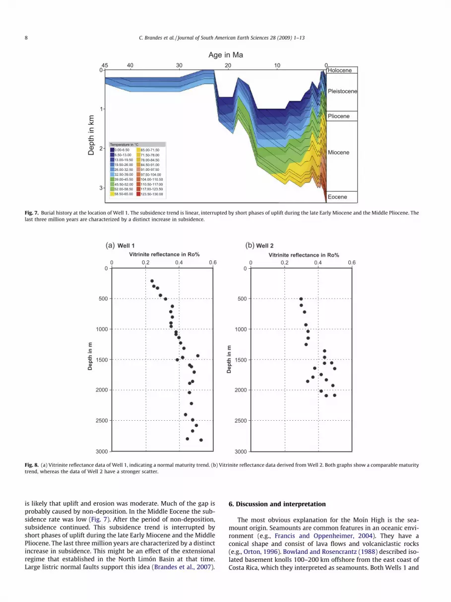
curve at the location of Well 1 shows a linear subsidence trendinterrupted by periods of up lift and non-deposition/erosion(Fig. 7).
Results derived from thermal basin simulations point towards amean heat flow of 56–60 mW/m2 (Brandes et al., 2008). From inde-pendent calculations based on Fourier’s law a heat flow of 51 mW/m2 was reconstructed. Vitrinites-depth plots derived from rocks ofWell 1 indicate a maturity of 0.53 Ro% in a depth of 2820 m(Fig. 8a). In Well 2 a maturity of 0.45–0.50 Ro% was measured ina depth of 2080 m (Fig. 8b).
A long gap in the subsidence trend is visible. This gap is markedby the unconformity between the Middle Eocene and the EarlyMiocene. It is not clear whether the Upper Eocene and Oligocenesediments were eroded or whether they were never deposited inthe Moín area. It is also difficult to estimate the amount of verticaluplift of the Moín High. To quantify the amount of erosion in a sed-imentary basin, the method of Yamaji (1986) has been established.
In this method, vitrinite reflectance data from a well will be plottedagainst the depth. The intersection of the abscissa and the ordinateis set at 0.2 Ro%. This value is characteristic for fresh vitrinites,which were not alternated. The abscissa with the vitrinite reflec-tance values has a logarithmic scale. Then the regression graphthrough all vitrinite reflectance values will be lengthened to 0.2Ro%. The eroded sediment thickness can be read from the ordinate.For Well 1, 750 m of erosion is estimated with the Yamaji-method.For Well 2 the eroded thickness is 0 m. These results are problem-atic, as they would indicate the absence of erosion on the top of theMoín High but 750 m of erosion at the flank. The vitrinite dataseems to be reliable, but such a trend can be disturbed by hot fluidsor the presence of resedimented vitrinite derived from erosion ofolder rocks as has been described by Radke et al. (1997) and Tayloret al. (1998).
Based on the concentric shape of the Moín High, the onlap pat-tern and the wedging of reflector packages against the structure it
Age in Ma
Dep
th in
km
Holocene45
0
1
2
3
40 30 20 10 0
Eocene
Miocene
Pliocene
Pleistocene
Temperature in °C0.00-6.506.50-13.0013.00-19.5019.50-26.0026.00-32.5032.50-39.0039.00-45.5045.50-52.0052.00-58.5058.50-65.00
Fig. 7. Burial history at the location of Well 1. The subsidence trend is linear, interrupted by short phases of uplift during the late Early Miocene and the Middle Pliocene. Thelast three million years are characterized by a distinct increase in subsidence.
Vitrinite reflectance in Ro%
Dep
th in
m
Dep
th in
m
0 0.2 0.4 0.60
500
1000
1500
2000
2500
3000
Vitrinite reflectance in Ro%0 0.2 0.4 0.6
0
500
1000
1500
2000
2500
3000
(a) (b)Well 1 Well 2
Fig. 8. (a) Vitrinite reflectance data of Well 1, indicating a normal maturity trend. (b) Vitrinite reflectance data derived from Well 2. Both graphs show a comparable maturitytrend, whereas the data of Well 2 have a stronger scatter.
8 C. Brandes et al. / Journal of South American Earth Sciences 28 (2009) 1–13
is likely that uplift and erosion was moderate. Much of the gap isprobably caused by non-deposition. In the Middle Eocene the sub-sidence rate was low (Fig. 7). After the period of non-deposition,subsidence continued. This subsidence trend is interrupted byshort phases of uplift during the late Early Miocene and the MiddlePliocene. The last three million years are characterized by a distinctincrease in subsidence. This might be an effect of the extensionalregime that established in the North Limón Basin at that time.Large listric normal faults support this idea (Brandes et al., 2007).
6. Discussion and interpretation
The most obvious explanation for the Moín High is the sea-mount origin. Seamounts are common features in an oceanic envi-ronment (e.g., Francis and Oppenheimer, 2004). They have aconical shape and consist of lava flows and volcaniclastic rocks(e.g., Orton, 1996). Bowland and Rosencrantz (1988) described iso-lated basement knolls 100–200 km offshore from the east coast ofCosta Rica, which they interpreted as seamounts. Both Wells 1 and
C. Brandes et al. / Journal of South American Earth Sciences 28 (2009) 1–13 9
2 terminate in Middle Eocene tuffs. Well 2 also penetrates twobasaltic lava flows of Eocene age, which both have a thickness ofapproximately 10 m. The strong reflectors that envelope theMoín High indicate an increase in the acoustic impedance. This in-crease might result from the lithological change from sedimentaryrocks to much denser basaltic rocks of the Moín High. In additionthe strong reflector pattern on the northern flank of the structuremay reflect an intercalation of lava flows and tuffs. The basalticrocks in combination with the seismic data from the Moín High,fit very well to a volcanic seamount. Furthermore several sea-mounts like the Quepos Plateau are known from the west coastof southern Costa Rica (Lonsdale and Klitgord, 1978; Ranero andvon Huene, 2000; Barckhausen et al., 2001). Though the seamountorigin is very likely, there are also strong arguments against theseamount interpretation. The first one is the general absence ofseamounts in East Costa Rica. The bathymetric maps from theCaribbean Sea show that there are no pronounced seamounts inthe back-arc area (Smith and Sandwell, 1997). The seafloor of theadjacent Colombia Basin is also relatively smooth without a signif-icant topography (Smith and Sandwell, 1997). Furthermore thevolcanic activity that led to the formation of a seamount shouldhave a pronounced thermal influence on the basin-fill. The paleoheat flow is reconstructed on the basis of vitrinite reflectance data.Vitrinites derived from Eocene sedimentary rocks of Well 1 indi-cate a normal maturity (Fig. 8a). The shape of the vitrinite profilesrepresents a normal sublinear trend. Thermal basin simulationspoint towards a constant mean heat flow of 56–60 mW/m2 in thearea of the Moín High (Brandes et al., 2008). There is no evidencefor a higher heat flow or any thermal pulse during the evolutionof the Moín High. Despite the occurrence of the basaltic rocks inthe well, an origin as a volcanic seamount is very unlikely. In addi-tion the tuffs and lava flows recorded in Wells 1 and 2 are consis-tent with observations of Mende (2001). Volcaniclastic rocks withintercalations of pyroclastic flows occur in different locations inthe Limón Basin. Following Mende (2001) these rocks representEocene slope apron deposits, shed from the westward volcanicarc. Campos (2001) also described volcaniclastic breccias and con-glomerates with intercalated basaltic lava flows from the EoceneTuís formation. The outcrops are present along the front of theTalamanca Range in the area of Turrialba. Following these authorsvolcaniclastic rocks and basaltic flows were wide spread in theLimón back-arc area in Eocene times and do not necessarily reflecta seamount origin of the Moín High.
Another possibility to explain the origin of the Moín High is alaccolith that intruded into the fill of the Limón Basin in post Mio-cene times. The Talamanca Range in the west shows wide spreadintrusive rocks (De Boer et al., 1995). Laccoliths are common inareas with magmatic activity and the convex shape of the MoínHigh would fit to an intrusion. If the structure is a laccolith is mustbe a young feature. At least post-Eocene. Such a young magmaticactivity can be ruled out, because of the vitrinite profiles derivedfrom Wells 1 and 2. There is no evidence for extensive thermalactivity, which would be caused by the emplacement of a lakkolith.In a depth of 2820 m, Lower Miocene sedimentary rocks host vitri-nites with a maturity of 0.53 Ro%. This maturity level coincideswith the burial depth. The same is valid for Well 2. In a depth of2084 m a maturity of 0.45 Ro% was measured (Fig. 8b). The pres-ent-day geothermal gradient in Well 1 is 3 �C/100 m (Astorgaet al., 1991). The seismic data also provides arguments against alaccolith origin. A laccolith intrudes into a pre-existing sedimen-tary succession and as a consequence the sediments above theintrusion level will be warped up. As described above, the seismicdata show a wedging of reflector packages against the structure. Inaddition clear onlaps are developed. These geometries are typicalfor a paleo-topography or a growing structure that was succes-sively buried by younger sediments. Dengo (2007) identified fring-
ing reefs on the flanks of the Moín High. This observation is alsodifficult to explain with a laccolith origin.
A salt pillow/diapir can be easily ruled out because of the lack ofsalt and shale in the Cretaceous and Lower Tertiary successions ofthe Limón Basin. The Cretaceous is represented by limestones(Mende, 2001; Campos, 2001) The Paleocene deposits are domi-nated by sandstones and conglomerates, which are interpreted asslope apron deposits (Mende, 2001). A diapir should also haverim synclines, which are not developed in the vicinity of theMoín High (Fig. 4a).
A package of strong reflectors envelopes the Moín High and sep-arates it from the surrounding and overlying sedimentary rocks(Fig. 4a). The reflector package has a constant thickness and main-tains it even on the crest of the structure. Therefore this unit can beinterpreted as pre-growth strata. Well data show that Upper Eo-cene and Oligocene deposits lack on the northern flank of theMoín High. Middle Eocene deposits are directly overlain by LowerMiocene rocks. The wedging of reflector packages against the MoínHigh implies that the missing units might be present in the deeperparts of the basin. Because of their wedge-shaped geometry theseunits can be interpreted as growth strata (Fig. 4c). The lack ofUpper Eocene and Oligocene deposits can be interpreted as a re-sponse to folding and uplift. From the growth strata geometrythe evolution of the Moín High can be reconstructed (Fig. 9). Creta-ceous to Lower Eocene deposits are pre-growth strata. During theMiddle Eocene the first motions at the Moín High occured. UpperEocene units show an onlap against the structure. In Oligocenetimes the vertical movements continued. Then deformationstopped and Lower Miocene deposits draped the structure. Slightvertical movements occurred during the Middle and Late Miocene.From the 3D static models it can be derived that the Moín High hasan elliptic outline and a NNE plunging axis. This points towards aWNW–ESE directed compression.
Gursky (1986) described an Eocene deformation phase that cre-ated NE–SW trending folds on the Nicoya peninsula in West CostaRica. A deformation phase of the same age is known from the CaboBlanco Basin (Winsemann, 1992) and the Malpaís Basin (Schmidtand Seyfried, 1991). These basins are located on the North CostaRica arc segment. South of the Trans Isthmic Fault System, the Eo-cene deformation phase can be observed in the Tarcóles Basin andthe Parrita Basin (Campos, 2001). Reason for this deformationphase can be found in a convergence between North and SouthAmerica that started in Eocene times (Gursky, 1986; Barrientoset al., 1997). Seyfried et al., 1991 pointed out that an increase inplate coupling between the Farallón and the Caribbean Plate mighttook place at that time and caused the observed deformation anduplift. Malfait and Dinkelmann (1972) gave a comprehensive over-view of the tectonic evolution of the Caribbean region. They de-scribed a major reorganization of the tectonic plates in theMiddle Eocene. The Caribbean Plate was decoupled from the EastPacific Plate (Malfait and Dinkelmann, 1972). Bowland (1993)showed that there was a strong sediment input into the ColombianBasin at that time. This underlines the impact of this deformationphase. Regarding age and geometry, it is likely that the Moín Highevolved as a consequence of the Eocene deformation phase.
The seismic data show that the Lower Miocene unit also wedgesout against the structure and that the Early Middle Miocene has areduced thickness on top of the Moín High. Upper Miocene depos-its still have a slightly reduced thickness on the crest. This patternprobably indicates the decline of the deformation. The Pliocene hasa constant thickness in the North Limón Basin and on top of theMoín High and drapes the structure. Pliocene units above the cres-tal graben structure show an increased thickness, which might berelated to ongoing subsidence of this graben. Quaternary depositsdrape the whole area with a constant thickness. There is no evi-dence for vertical movements of the Moín High and large listric
CretaceousBasement
Paleocene
Early to Mid Eocene
Middle Eocene
Cretaceous
Paleocene
Early to Mid EoceneLate EoceneOligoceneEarly Miocene
Early to Middle Miocene
Basement
Cretaceous
Paleocene
Early to Mid EoceneLate EoceneOligoceneEarly Miocene
Early Miocene
Basement
Cretaceous
Paleocene
Early to Mid EoceneLate EoceneOligocene
Oligocene
Basement
Cretaceous
Paleocene
Early to Mid EoceneLate Eocene
Late Eocene
Basement
Cretaceous
Paleocene
Early to Mid EoceneLate EoceneOligoceneEarly MioceneMid MioceneLate MiocenePlioceneQuaternary
Present-dayWell 1
Basement
Cretaceous
Paleocene
Early to Mid EoceneLate EoceneOligoceneEarly MioceneMid Miocene
Middle Miocene
Basement
Fig. 9. The evolution of the Moín High derived from the growth strata geometry. Cretaceous to Lower Eocene deposits are pre-growth strata. They maintain a constantthickness even on the crest of the structure. During the Middle Eocene the first motions at the Moín High occured. Upper Eocene units show an onlap against the structure. InOligocene times the vertical movements continued. Then deformation stopped and Lower Miocene deposits draped the structure. Slight vertical movements occurred duringthe Middle and Late Miocene. The crestal graben showed activity in Middle Miocene to Pliocene times.
10 C. Brandes et al. / Journal of South American Earth Sciences 28 (2009) 1–13
C. Brandes et al. / Journal of South American Earth Sciences 28 (2009) 1–13 11
NW–SE trending normal faults in the North Limón Basin give evi-dence for an extensional phase at that time (Brandes et al.,2007). Pliocene and Quaternary deposits are interpreted as post-growth strata. The seismic data imply that the Moín High is a con-tractional structure. Therefore the existence of an anticline is themost convincing explanation that takes all observations intoaccount.
Regarding the compressional origin, the Moín High is possiblyan inversion structure. Inversion is defined as a reactivation of nor-mal faults as reverse faults. At least two deformation phases arenecessary to create an inversion structure. First, an extensionalphase with intense normal faulting has to affect the basin and latera compressional phase that reactivates the faults and transformsthem into reverse faults. Inversion structures are well-known fromsedimentary basins with a complex and multiple-phase historylike the Central European basin system (e.g., Kockel, 2003; Mazuret al., 2005). Mende (2001) described a Paleocene extensionalphase in the Limón Basin. With respect to the subsequent Eocenecompressional deformation phase, inversion was possible, butthere are no other true inversion structures described in Costa Ricaso far. The seismic data also does not allow to verify this idea.
Several studies have shown that in southern Central Americafore-arc and back-arc basins were affected by the low angle sub-duction of the Cocos Ridge (Protti and Schwartz, 1994; Kolarskyet al., 1995; Silver et al., 1995; Gräfe et al., 2002). Kolarsky et al.(1995) compared the Cocos Ridge with an indenter that hits the is-land-arc. Suárez et al. (1995) concluded that the Cocos Ridge doesnot subduct but collides with the trench. The present-day horizon-tal stress field in southern Costa Rica fits to an indenter scenario(Montero, 1994). Recent studies have shown that the subductionof the Cocos Ridge is very young. MacMillian et al. (2004) describedan onset of subduction of the Cocos Ridge not before 2–3 Ma. Suchan onset around 2 Ma, fits to the Plio-Pleistocene deformationphase observed in the external part of the Limón fold-and-thrustbelt (Brandes et al., 2007). As shown above, the Moín High evolvedin Eocene times. Because of the large time gap of c. 40 Myr, there isno relationship between the subduction of the Cocos Ridge and theevolution of the Moín High.
It can be also ruled out that the Moín High is related to theSouth Limón fold-and-thrust belt. The offshore part of the fold beltevolved in Plio-Pleistocene times (Brandes et al., 2007c). The on-shore part is interpreted to have formed in the Miocene (Campos,2001). A Miocene origin of the onshore part of the fold-and-thrustbelt is supported by the timing of transforming the South LimónBasin from a back-arc basin to a retro-arc foreland basin (Brandeset al., 2008). The Moín High is clearly older than the South Limóndeformed belt. In fact the Moín High acts as an obstacle for thepropagation fold-and-thrust belt and causes the strong bend ofthe thrust in the northwestern corner (Brandes et al., 2007b,c).
The quality of the seismic data is not good enough to visualizethe inner parts of the Moín High. Below the strong and continuousreflector pattern of the northern flank, the structure shows a moreweakly layered pattern (Figs. 4a and 5). The central part shows avery diffuse reflector pattern that might reflect the limits of resolu-tion. The diffuse pattern can be also interpreted as an indicator forbasement rocks. Probably the Moín High is a basement-cored anti-cline, but there is no real evidence for this. The crustal structure ofthe southern Central American island-arc was described by Fluehand von Huene (2007). Velocity analyses indicate that the CentralAmerican land-bridge in the area of Costa Rica rests on oceanicbasement of the Caribbean Plate (Sallarès et al., 1999). This meansthat the area of the Moín High is underlain by thickened oceaniccrust of the Caribbean Large Igneous Province. If the Moín High isbasement-cored, it would probably consist of basalt.
Regarding the closely related Trans Isthmic Fault System it islikely that the origin of the Moín High is somehow linked to this
strike-slip fault. The Trans Isthmic Fault System is an E–W trendingactive strike-slip fault with major sinistral movements (Krawinkeland Seyfried, 1994; Krawinkel, 2003). Weinberg (1992) proposedthat the Trans Isthmic Fault System is a former plate boundaryand should be regarded as the southern boundary of the ChortisBlock. Marshall and Fisher (2000) provided a comprehensive kine-matic analysis of this fault system. They used the expression Cen-tral Costa Rica Deformed Belt for the east–west trending diffusefault zone. Driving mechanisms for the evolution of the CentralCosta Rica Deformed Belt are basal traction from the shallow sub-duction, shear and horizontal shortening due to the subduction ofthe Cocos Ridge and uplift caused by seamount subduction (Mar-shall and Fisher, 2000). Following Krawinkel and Seyfried (1994)the Trans Isthmic Fault System was active since the structuringof the earliest island-arc units. Large anticlines related to wrenchtectonics are known from Panama (Wilcox et al., 1973). Marshalland Fisher (2000) observed transpression and crustal thickeningin the back-arc area, related to the Trans Isthmic Fault System. Thisfits to the Moín High. There is no direct evidence on the seismicsections that the Moín High is, e.g., a positive flower structure,but the strong bend of the Trans Isthmic Fault System south ofthe Moín High might point to a transpressional origin in general(Fig. 3b). The Moín High is probably a transpression related anti-cline, which formed as a consequence of the movements alongthe fault zone. This interpretation also coincides with the geometryof the Moín High and the uplift history described above.
7. Conclusions
The Moín High is a large Eocene contractional structure locatedin the back-arc area of Central Costa Rica. The integration of seis-mic interpretation, well data, 3D static models and basin modellingtechniques implies that the Moín High is an Eocene anticline struc-ture. Support for an anticline origin is the vertical movements,which are recorded for the structure and the NNE–SSW trendingaxis, that fit to the Eocene deformation phase of the island-arc. Inaddition pre-growth, growth and post-growth strata can be clearlydistinguished on the seismic sections. Probably the Moín High is apressure ridge that is caused by transpression due to activity alongthe Trans Isthmic Fault System. A seamount origin can be ruled outbecause phases of uplift are unusual for a seamount. An origin as amagmatic intrusion is very unlikely because of the observed heatflow and vitrinite reflectance data. An evolution as a salt pillow/diapir can be ruled out because of the lack of salt in the back-arcarea of southern Central America. The Moín High clearly is not re-lated to younger events like the evolution of the Limón fold-and-thrust belt (Plio-Pleistocene) or to the subduction of the CocosRidge.
Acknowledgements
The authors would like to thank the Costa Rican Ministry ofEnvironment and Energy (MINAE) for providing the data base. Spe-cial thanks to Alvaro Aguilar and Gustavo Segura for logistic help.Financial support was provided from the German Research Foun-dation (DFG) Project Wi 1844/6-1 and a graduate scholarship fromthe University of Hannover. Seismic Micro Technology Inc. is grate-fully acknowledged for the sponsoring of Kingdom Suite�. Wewould like to thank James Kellogg for editorial work and two anon-ymous reviewers for their constructive and helpful reviews, whichhelped to improved the manuscript. Ralf Littke is greatly thankedfor help with basin modelling. We would like to thank Ulrich Asp-rion, Stefan Back, Franz Binot, Lolita Campos, Christoph Gaedicke,Daniel Le Heron, Andreas Mende and Imke Struß for discussionand help with seismic interpretation.
12 C. Brandes et al. / Journal of South American Earth Sciences 28 (2009) 1–13
References
Amann, H., 1993. Randmarine und terrestrische Ablagerungsräume des neogenenInselbogensystems in Costa Rica (Mittelamerika). Profil 4, p. 161.
Archer, S.G., Bergmann, S.C., Iliffe, J., Murphy, C.M., Thornton, M., 2005. Palaeogeneigneous rocks reveal new insights into the geodynamic evolution andpetroleum potential of the Rockall Trough, NE Atlantic Margin. Basin Research17, 171–201.
Astorga, A., Fernandez, J.A., Barboza, G., Campos, L., Obando, J., Aguilar, A., Obando,L.G., 1991. Cuencas sedimentarias de Costa Rica: evolucion geodinamica ypotencial de hidrocarburos. Revista Geológica de América Central 13, 25–59.
Barboza, G., Fernández, A., Barrientos, J., Bottazzi, G., 1997. Costa Rica: petroleumgeology of the Caribbean margin. Leading Edge 16, 1787–1794.
Barckhausen, U., Ranero, C.R., von Huene, R., Cande, S.C., Roeser, H.A., 2001. Revisedtectonic boundaries in the Cocos Plate off Costa Rica: implications for thesegmentation of the convergent margin and for plate tectonic models. Journal ofGeophysical Research 106, 19207–19220.
Barrientos, J., Bottazzi, G., Fernández, A., Barboza, G., 1997. Costa Rican datasynthesis indicates oil, gas potential. Oil Gas Journal 12, 76–80.
Bottazzi, G., Fernandez, A., Barboza, G., 1994. Sedimentología e historia tectono-sedimentaria de la cuenca Limón Sur. In: Seyfried, H., Hellmann, W. (Eds.),Geology of an Evolving Island Arc. The Isthmus of Southern Nicaragua, CostaRica and Western Panamá, Profil 7, pp. 351–389.
Bowland, C.L., 1993. Depositional history of the western Colombian Basin,Caribbean Sea: revealed by seismic stratigraphy. GSA Bulletin 105, 1321–1345.
Bowland, C.L., Rosencrantz, E., 1988. Upper crustal structure of the westernColombian Basin, Caribbean Sea. Geological Society of America Bulletin 100,534–546.
Brandes, C., Astorga, A., Blisniuk, P., Littke, R., Winsemann, J., 2007a. Anatomy ofanticlines, piggy-back basins and growth strata: a case study from the Limónfold-and-thrust belt, Costa Rica. In: Nichols, G., Williams, E., Paola, C. (Eds.),Sedimentary Processes, Environments and Basins, vol. 38. IAS SpecialPublication, pp. 91–110.
Brandes, C., Astorga, A., Back, S., Littke, R., Winsemann, J., 2007b. Fault controls onsediment distribution in the Limón back-arc basin, Costa Rica. Journal ofPetroleum Geology 30 (1), 25–40.
Brandes, C., Astorga, A., Back, S., Littke, R., Winsemann, J., 2007c. Deformation styleand basin-fill architecture of the offshore Limón back-arc basin (Costa Rica).Marine and Petroleum Geology 24, 277–287.
Brandes, C., Astorga, A., Littke, R., Winsemann, J., 2008. Basin modelling of the Limónback-arc basin (Costa Rica): burial history and temperature evolution of anisland arc-related basin system. Basin Research 20 (1), 119–142.
Campos, L., 2001. Geology and Basins History of Middle Costa Rica: An IntraoceanicIsland Arc in the Convergence between the Caribbean and the Central PacificPlates. Tübinger Geowissenschaftliche Arbeiten, Reihe A, Band 62, p. 138.
Coates, A.G., Jackson, J.B.C., Collins, L.S., Cronin, T.M., Dowsett, H.J., Bybell, L.M., Jung,P., Obando, J.A., 1992. Closure of the Isthmus of Panama: the near-shore marinerecord of Costa Rica and western Panama. Geological Society of AmericaBulletin 104, 814–828.
Coates, A.G., Aubry, M.-P., Berggren, W.A., Collins, L.S., Kunk, M., 2003. EarlyNeogene history of the Central American arc from Bocas del Toro, westernPanama. Geological Society of America Bulletin 115, 271–287.
De Boer, J.Z., Drummond, M.S., Bordelon, M.S., Defant, M.J., Bellon, H., Maury, R.C.,1995. Cenozoic magmatic phases of the Costa Rican island arc (Cordillera deTalamanca). In: Mann, P. (Ed.), Geologic and Tectonic Development of theCaribbean Plate Boundary in Southern Central America, vol. 295. GeologicalSociety of America Bulletin Special Publication, pp. 35–55.
DeMets, C., 2001. A new estimate for present-day Cocos-Caribbean plate motion:implications for slip along the Central American volcanic arc. GeophysicalResearch Letters 28, 4043–4046.
Dengo, C.A., 2007. Petroleum geology. In: Bundschuh, J., Alvarado, G.E. (Eds.),Central America, Geology, Resources and Hazards, pp. 895–916.
Di Marco, G., Baumgartner, P.O., Channell, J.E.T., 1995. Late Cretaceous–earlyTertiary paleomagnetic data and a revised tectonostratigraphic subdivision ofCosta Rica and western Panama. In: Mann, P. (Ed.), Geologic and TectonicDevelopment of the Caribbean Plate Boundary in Southern Central America, vol.295. Geological Society of America Bulletin Special Publication, pp. 1–27.
Donnelly, T.W., 1989. Geologic history of the Caribbean and Central America. In:Bally, A.W., Palmer, A.R. (Eds.), The Geology of North America – An Overview.Geological Society of America Bulletin Special Publication, pp. 299–321.
Escalante, G., Astorga, A., 1994. Geología del este de Costa Rica y el norte de Panama.Revista Geológica de América Central Vol. esp. Terremoto de Limón, 1–14.
Fernandez, J.A., Bottazzi, G., Barboza, G., Astorga, A., 1994. Tectónica y estratigrafiade la Cuenca Limón Sur. Revista Geológica de América Central Vol. esp.Terremoto de Limón, 15–28.
Fernandez, J., Alvaro, A., Guillermo, B., Bottazzi, G., Campos, L., Obando, J., Tejera, R.,Arrieta, L., Barrientos, J., Bustos, I., Escalante, G., Pizarro, D., Valerín, E., Astorga,A., Bolanos, X., Calvo, C., Laurito, C., Rojas, J., Valerio, A., 1997. Mapa Geológicode Costa Rica. Ministerio del Ambiente y Energía, Costa Rica.
Flueh, E.R., von Huene, R., 2007. Crustal structure. In: Bundschuh, J., Alvarado, G.E.(Eds.) Central America, Geology, Resources and Hazards, pp. 268–276.
Francis, P., Oppenheimer, C., 2004. Volcanoes, p. 534.Gräfe, K., Frisch, W., Villa, I.M., Meschede, M., 2002. Geodynamic evolution of
southern Costa Rica related to low-angle subduction of the Cocos Ridge:constraints from thermochronology. Tectonophysics 348, 187–204.
Gursky, M.M., 1986. Tektonische und thermische Deformation im ophiolithischenNicoya-Komplex und seinem sedimentären Auflager (Nicoy-Halbinsel, CostaRica) und ihre Bedeutung für die geodynamische Entwicklung im südlichenZentralamerika. PhD thesis, University of Marburg, p. 230.
Hermanrud, C., 1993. Basin modelling techniques – an overview. In: Doré, A.G. (Ed.),Basin Modelling: Advances and Applications, vol. 3. NPF Special Publication, pp.1–34.
Kockel, F., 2003. Inversion structures in Central Europe – expressions and reasons,an open discussion. Netherlands Journal of Geosciences/Geologie en Mijnbouw84 (4), 367–382.
Kolarsky, R.A., Mann, P., Montero, W., 1995. Island arc response to shallowsubduction of the Cocos Ridge, Costa Rica. In: Mann, P. (Ed.), Geologic andTectonic Development of the Caribbean Plate Boundary in Southern CentralAmerica, vol. 295. Geological Society of America Bulletin Special Publication, pp.235–262.
Krawinkel, J.J., 2003. Struktur und Kinematik am konvergenten Plattenrand dersüdlichen Zentralamerikanischen Landbrücke (Zentral- und Süd-Costa Rica,West-Panamá). Profil 20, p. 36.
Krawinkel, J., Seyfried, H., 1994. A review of plate-tectonic processes involved in theformation of the southwestern edge of the Caribbean plate. In: Seyfried, H.,Hellmann, W. (Eds.), Geology of an Evolving Island Arc. The Isthmus of SouthernNicaragua, Costa Rica and Western Panamá, Profil 7, pp. 47–61.
Lonsdale, P., Klitgord, K.D., 1978. Structure and tectonic history of the EasternPanama Basin. Geological Society of America Bulletin 89, 981–999.
MacMillian, I., Gans, P.B., Alvarado, G., 2004. Middle Miocene to present tectonichistory of the southern Central American volcanic arc. Tectonophysics 392,325–348.
Malfait, B.T., Dinkelmann, M.G., 1972. Circum-Caribbean tectonic and igneousactivity and the evolution of the Caribbean Plate. GSA Bulletin 83, 251–272.
Marshall, J.S., Fisher, D.M., 2000. Central Costa Rica deformed belt: kinematics ofdiffuse faulting across the western Panama block. Tectonics 19 (3), 468–492.
Mazur, S., Scheck-Wederoth, M., Krzywiec, P., 2005. Different modes of the lateCretaceous–early Tertiary inversion in the North German and Polish basins.International Journal of Earth Science 94, 782–798.
McNeill, D.F., Coates, A.G., Budd, A.F., Borne, P.F., 2000. Integrated paleontologic andpaleomagnetic stratigraphy of the Upper Neogene deposits around Limon, CostaRica: a coastal emergence record of the Central American Isthmus. GeologicalSociety of America Bulletin 112, 963–981.
Mende, A., 2001. Sedimente und Architektur der Forearc- und Backarc-Becken vonSüdost-Costa Rica und Nordwest-Panamá. Profil 19, p. 130.
Meschede, M., Frisch, W., 1998. A plate tectonic model for the Mesozoic and earlyCenozoic history of the Caribbean Plate. Tectonophysics 296, 269–291.
Montero, W., 1994. Neotectonics and related stress distribution in a subduction-collisional zone. In: Seyfried, H., Hellmann, W. (Eds.), Geology of an EvolvingIsland Arc. The Isthmus of Southern Nicaragua, Costa Rica and Western Panamá,Profil 7, pp. 125–142.
Orton, G.J., 1996. Volcanic environments. In: Reading, H.G. (Ed.), SedimentaryEnvironments, Processes, Facies and Stratigraphy, third ed., pp. 485–567.
Petzet, G.A., 1998. Costa Rica awards blocks on Caribbean Coast. Oil Gas Journal 12,76–80.
Poelchau, H.S., Baker, D.R., Hantschel, T., Horsfield, B., Wygrala, B., 1997. Basinsimulation and the design of the conceptual model. In: Horsfield, D.H., Baker, B.,Welte, D.R. (Eds.), Petroleum and Basin Evolution. Springer Verlag, pp. 3–70.
Protti, M., Schwartz, S.Y., 1994. Mechanics of back arc deformation in Costa Rica:evidence from an aftershock study of the April 22, 1991, Valle de la Estrella,Costa Rica, earthquake (Mw = 7.7). Tectonics 13, 1093–1107.
Protti, M., Güendel, F., McNally, K., 1995. Correlation between the age of thesubducting Cocos Plate and the geometry of the Wadati–Benioff zone underNicaragua and Costa Rica. In: Mann, P. (Ed.), Geologic and TectonicDevelopment of the Caribbean Plate Boundary in Southern Central America,vol. 295. Geological Society of America Bulletin Special Publication, pp. 309–326.
Radke, M., Horsfield, B., Littke, R., Rullkötter, J., 1997. Maturation and petroleumgeneration. In: Welte, D.H., Horsfield, B., Baker, D.R. (Eds.), Petroleum and BasinEvolution. Springer, Berlin, pp. 169–230.
Ranero, C.R., von Huene, R., 2000. Subduction erosion along the Middle Americaconvergent margin. Nature 404, 748–752.
Ross, M.I., Scotese, C.R., 1988. A hierarchical tectonic model of the Gulf of Mexicoand the Caribbean region. Tectonophysics 155, 139–168.
Sallarès, V., Danobeitia, J.J., Flueh, E.R., Leandro, G., 1999. Seismic velocity structureacross the north American landbridge in northern Costa Rica. Journal ofGeodynamics 27, 327–344.
Schmidt, H., Seyfried, H., 1991. Depositional sequences and sequence boundaries inForearc Coastal Embayments: case studies from Central America. In:MacDonald, D.I.M. (Ed.), Sea-level Changes at Active Plate Margins, vol. 12.IAS Special Publication, pp. 241–258.
Seyfried, H., Astorga, A., Amann, H., Calvo, C., Kolb, W., Schmidt, H., Winsemann, J.,1991. Anatomy of an evolving island arc: tectonic and eustatic control in thesouth Central American forearc area. In: MacDonald, D.I.M. (Ed.), Sea-levelChanges at Active Plate Margins: Processes and Products, vol. 12. IAS SpecialPublication, pp. 273–292.
Sheehan, C.A., Penfield, G.T., Morales, E., 1990. Costa Rica geologic basins lurewildcatters. Oil Gas Journal 30, 74–79.
Silver, E.A., Galewsky, J., McIntosh, K.D., 1995. Variation in structure, style, anddriving mechanism of adjoining segments of the North Panama deformed belt.In: Mann, P. (Ed.), Geologic and Tectonic Development of the Caribbean Plate
C. Brandes et al. / Journal of South American Earth Sciences 28 (2009) 1–13 13
Boundary in Southern Central America, vol. 295. Geological Society of AmericaBulletin Special Publication, pp. 309–326.
Smith, W.H.F., Sandwell, D.T., 1997. Global seafloor topography by satellitealzimetry and ship depth sounding. Science 277, 1956–1962.
Suárez, G., Pardo, M., Domínguez, J., Ponce, L., Montero, W., Boschini, I., Rojas, W.,1995. The Limón, Costa Rica earthquake of April 22, 1991: back arc thrustingand collisional tectonics in a subduction environment. Tectonics 14, 518–530.
Taylor, G.H., Teichmüller, M., Davis, A., Dissel, C.F.K., Littke, R., Robert, P., 1998.Organic Petrology. Borntraeger, Berlin. p. 704.
Weinberg, R.F., 1992. Neotectonic development of western Nicaragua. Tectonics 11,1010–1017.
Welte, D.H., Yükler, M.A., 1981. Petroleum origin and accumulation in basinevolution – a quantitative model. AAPG Bulletin 65, 1387–1396.
Weyl, R., 1980. Geology of Central America. Borntraeger, Berlin. p. 371.Wilcox, R.E., Harding, T.P., Seely, D.R., 1973. Basic wrench tectonics. AAPG Bulletin
57, 74–96.Winsemann, J., 1992. Tiefwasser-sedimentationsprozesse und-produkte in den
Forearc-Becken des mittelamerikanischen Inselbogensystems: einesequenzstratigraphische Analyse, Profil 2, 218 pp.
Yamaji, A., 1986. Analysis of vitrinite reflectance–burial depth relations in dynamicgeological settings by the integration method. Journal of Japanese Associationfor Petroleum Technology 51, 197–204.