277
ACID SULFATE SOIL MANUAL New South Wales Acid Sulfate Soil Management Advisory Committee August 1998

ACID SULFATE SOIL
MANUAL
New South Wales Acid Sulfate Soil Management Advisory Committee
August 1998

ACID SOIL ACTION An Initiative of the NSW Government
The Acid Sulfate Soils Manual (ASS Manual) forms part of an ‘all of government’ approach to the management of acid sulfate soils in New South Wales. The ASS Manual has been published by:
Acid Sulfate Soils Management Advisory Committee. NSW Agriculture Wollongbar Agricultural Institute Bruxner Highway WOLLONGBAR NSW 2477
Acid Sulfate Soils Management Advisory Committee (ASSMAC) is pleased to allow this material to be reproduced in whole or in part, provided the meaning is unchanged and the source is acknowledged. ISBN 0 7347 0000 8 Title: Acid Sulfate Soils Manual 1998 Published 26 August, 1998. Citation in this publication should take the form:
Stone, Y, Ahern C R, and Blunden B (1998). Acid Sulfate Soils Manual 1998. Acid Sulfate Soil Management Advisory Committee, Wollongbar, NSW, Australia.
Illustrations
Background image: Scanning electron photomicrography of typical framboidal clusters of pyrite within a root remnant taken by Richard Bush, University of NSW from a sample from Belmore Swamp, Kempsey, NSW.
1. Planning Guidelines. Tributary of the Hastings River discharging iron rich sediment resulting from the disturbance of acid sulfate soils from drainage
2. Assessment Guideline. Glenn Atkinson, Department of Land and Water Conservation monitoring the pH of a drain at Maclean during an Acid Sulfate Soil Workshop. Note pH is 3.7 and the black monosulfide material in the bottom left hand corner.
3. Management Guideline. A severe iron floc resulting from oxidisation of a backswamp area at Catti Creek on the Manning Catchment as a result of deep drains.
4. Laboratory Methods Guidelines. Characteristic yellow mottle of jarosite, a classic indicator of acid sulfate soil
5. Drainage Guidelines. Milky green estuarine waters with aluminium hydroxide leached from the clay by acid water
6. Groundwater Guidelines. Bruce Blunden, Environment Protection Authority and the University of Wollongong checking the groundwater levels at his trial site at Berry. The trial is to monitor the relationship between drainage, groundwater and acid production.
7. Management Plan Guidelines. Strategic planning to remediate an acid scald area at Seven Oaks in the Clybucca River Catchment.
8. Industry Guidelines. A soil core being taken from a sugar cane farm on the Richmond River as part of an acid sulfate soil survey of all 700 NSW cane farms.
Disclaimer These guidelines aim to provide guidance in assessing and managing development in areas of acid sulfate soils. The guidelines are not exhaustive in dealing with this complex subject. While the guidelines have been prepared exercising all due care and attention, no representation or warranty, expressed or implied, is made as to the accuracy, completeness or fitness for the purpose of the guidelines in respect of any user’s purpose. Any representation, statement, opinion or advice, expressed or implied in this publication is made in good faith and on the basis that the State of New South Wales, its agents

and employees are not liable (whether by reason of negligence, lack of care or otherwise) to any person for any damage or loss whatsoever which has occurred or may occur in relation to that person taking or not taking (as the case may be) action in respect of any representation, statement or advice referred to above.

Acid Sulfate Soils Acid sulfate soils is the common name given to naturally occurring soil and sediment containing iron sulfides. When these natural occurring sulfides are disturbed and exposed to air, oxidation occurs and sulfuric acid is ultimately produced. For every tonne of sulfidic material that completely oxidises, 1.6 tonnes of pure sulfuric acid is produced. This sulfuric acid can drain into waterways and cause severe short and long term socio-economic and environmental impacts. In NSW, acid sulfate soils have been found in every coastal estuary and embayment between the Victorian and Queensland border. It is estimated that there are over 400,000 hectares of acid sulfate soils in NSW being impacted by existing and new activities. The NSW Department of Land and Water Conservation (DLWC) mapped landscapes with high probability of having acid sulfate soils in 1995. These maps have been updated in 1998 and adapted for planning purposes. The most common activities that disturb acid sulfate soils are:
agricultural activities that involve land drainage, works to prevent flood and tidal inundation (levees, drains and floodgates) and the use of groundwater – industry sectors especially implicated are sugar cane, tea tree, dairying, grazing, cropping and aquaculture
infrastructure works especially flood management (levees, floodgates) drainage works, maintenance dredging, laying of utilities (water, sewerage, communications) roads and railways
urban and tourism development – housing, resorts, marinas extractive industries – sand and gravel extraction from rivers or the floodplain
While all activities that disturb acid sulfate soils are of concern, past drainage and flood mitigation works principally associated with agriculture are thought to have contributed around 95% to the current environmental problem in NSW. Flood mitigation and management as well as drainage works have been disturbing acid sulfate soils since the turn of the century. However, during the 1950s to the 1970s, major flood and drainage works were undertaken by the State Government with these works now owned and operated by councils, county councils and drainage unions. The floodgates, levees, drains, and other structures erected as part of these schemes have artificially lowered watertable levels which in many cases has triggered the oxidation of acid sulfate soils. In most cases, there has been significant agricultural investment made in the wake of the altered flood and drainage conditions. The impacts of acid sulfate disturbance constitute the most acute water based environmental problem in the coastal areas of NSW. The problem is comparable to the environmental impacts of salinity in inland waters. The environmental impacts of acid drainage can include fish kills, fish disease, oyster damage and mortality, adverse effects on aquatic ecosystems, release of heavy metals from contaminated sediments, human and animal health impacts from polluted water, adverse impacts on soil structure and arability and damage to built structures such as bridges. It is now recognised that the environmental effects of the disturbance of acid sulfate soils can last hundreds or thousands of years. Acid sulfate soils have economic impacts on most industries on the NSW coastal zone, including tourism, recreational fishing, commercial fishing, oyster and other aquaculture industries, sugar cane, tea tree, grazing and dairy, extractive industries as well as urban development industries. The costs associated with the damage to public and private infrastructure is also significant (eg corrosion of drinking water pipes, bridge footings and floodgates). Community awareness of and concern about the socio-economic and environmental impacts of acid sulfate soils is rapidly increasing. This has resulted in a heightened focus on the roles and responsibilities of land and water users in the management and monitoring of acid sulfate soils.

Acid Sulfate Soils Management Advisory Committee The Acid Sulfate Soils Management Advisory Committee (ASSMAC) was formed in 1994 to coordinate a whole of government response to acid sulfate soil issues. The committee reports to the Minister for Agriculture and comprises representatives of NSW Agriculture, Department of Land and Water Conservation, Department of Urban Affairs and Planning, Environment Protection Authority, NSW Fisheries, Local Councils, the scientific community, NSW Fishing Industry, NSW Farmers Association and the Nature Conservation Council. ASSMAC has functioned as a coordinating committee whose strategies are implemented through relevant government agencies. The ASSMAC Strategic Plan for the Management of Acid Sulfate Soils in NSW includes the following:
Increase community awareness of the impacts from disturbance of acid sulfate soils, particularly in relation to drainage
Educate key stakeholders about acid sulfate soil management Prevent or reduce disturbance of acid sulfate soils by encouraging and assisting industry in the
development and adoption of sustainable practices for their industry (self regulation) Research and develop sustainable land management practices to reduce the generation or export
of acid Research and develop practices to remediate and rehabilitate degraded acid sulfate soils areas Research and develop an improved methodology for the identification and analysis of acid
sulfate soils Encourage the development and implementation of strategic plans for the better co-ordination
and management of acid sulfate soils in catchments. ASSMAC which is chaired by John Williams, NSW Agriculture is supported by the ASSMAC Technical Committee (ASSMAC TC) made up of scientists and other experts from NSW and Queensland Government agencies and academia. The ASSMAC TC is responsible for providing technical advice on acid sulfate soils to ASSMAC and for coordinating research and development and reviewing new technology associated with the management of acid sulfate soils. The ASS Manual was edited by Yolande Stone (Department of Urban Affairs and Planning), Col Ahern (Queensland Department of Natural Resources) and Bruce Blunden (Environment Protection Authority) with the technical assistance from the Acid Sulfate Soils Management Advisory Committee Technical Committee (ASSMAC TC). Members of the Acid Sulfate Soils Management Advisory Committee Technical Committee are:
Chairman Professor Ian White, Australian National University Col Ahern, Department of Natural Resources QLD Glenn Atkinson, Department of Land and Water Conservation Bruce Blunden, Environment Protection Authority and University of Wollongong Dr Phil Gibbs, NSW Fisheries Ian Kelly, Consultant Dr Andrew Nethery, Environment Protection Authority Roy Lawrie, NSW Agriculture Associate Professor Mike Melville, University of NSW Dr Jesmond Sammut, University of NSW Yolande Stone, Department of Urban Affairs and Planning Jon Woodworth, NSW Agriculture

For further information and contacts Enquires Enquires should be directed to: for NSW and other States
The Acid Sulfate Soil Information Officer Wollongbar Agricultural Institute Bruxner Highway Wollongbar NSW 2477 Australia email: [email protected]
for Queensland The Qld Acid Sulfate Soil Information Officer Department of Natural Resources Meiers Road Indooroopilly Qld 4068 email: [email protected]
The NSW Acid Sulfate Soils Information Officer who is funded by the Federal Natural Heritage Trust, distributes a free quarterly newsletter ASSAY and maintains a self nominated database ASSIST of government agency and council officers, industry representatives, consultants and laboratories with expertise or interest in acid sulfate soils. For copies of both these documents contact the officer. Acid Sulfate Soils Risk Maps A maps identify the degree of risk of disturbing acid sulfate soils in NSW were updated in 1998. These are available from the regional offices of the Department of Land and Water Conservation in digital and paper form. Each coastal council in NSW has copies of these maps. Acid Sulfate Soils Planning Maps The risk maps have been adapted for planning purposes and are available from the regional offices of the Department of Land and Water Conservation in digital and paper form. Each coastal council in NSW will have copies of these maps. To order copies of the ASS Manual Copies of this manual can be purchased from
The Information Centre Department of Urban Affairs and Planning Governor Macquarie Tower Box 3927 GPO Sydney 2001 Telephone (02) 9391 2222.

Table of Contents 1. PLANNING GUIDELINES
1. Introduction 2. Local Environmental Plans and Strategic Planning 3. Rezoning land in acid sulfate soil areas 4. Management of acid sulfate soils within existing land use zones 5. Assessing developments affecting acid sulfate soils 6. Section 149 Planning Certificates 7. The Acid Sulfate Soils Planning Maps 8. Circular F11 - Acid Sulfate Soils Advisory Circular Appendix 1: Acid Sulfate Soils Model LEP
1. ASSESSMENT GUIDELINES
1. Introduction 2. The preliminary assessment 3. Applying the mitigation principles 4. Designing a soil assessment program 5. Designing a water assessment program 6. Managing acid sulfate soils 7. Making an application for an approval 8. Determination by the approval authority Appendix 1 Field pH test for potential acid sulfate soils
1. MANAGEMENT GUIDELINES
1. Mitigation and management strategies 2. Management Strategies 3. Applying the techniques to manage extracted acid sulfate materials 4. Applying the techniques to remediate degraded areas 5. Selecting neutralising material 6. Neutralising acid sulfate soils using lime 7. Neutralising acid leachate and drain water using lime 8. Precautionary comments
1. LABORATORY METHODS GUIDELINES
1. Introduction 2. Designing a soil sampling and analysis program 3. Codes for acid sulfate soils analytical methods 4. Peroxide oxidation combined acidity & sulfate - Method 21 5. Total oxidisable sulfur Method 20 6. Acid neutralising capacity methods Method 19 7. Moisture content, bulk density, specific gravity, pore space relationships 8. Acid volatile sulfur 9. Chromium reducible sulfur 10. Volumetric peroxide methods

5. DRAINAGE GUIDELINES
1. Introduction 2. Approvals to construct drains 3. Principles for drainage in acid sulfate soils 4. Drainage of storm and flood water 5. Drainage of sub-surface water 6. Floodgates 7. Landforming and improved drainage 8. Drain maintenance Fish Kills - Protocol For Investigating and Reporting
6. GROUNDWATER GUIDELINES
1. Understanding groundwater 2. Relationship between groundwater and acid sulfate soils 3. Monitoring groundwater with piezometers 4. Measuring water levels 5. Measuring water quality 6. Recording groundwater data 7. Interpretation of results.
7. MANAGEMENT PLAN GUIDELINES
1. Management of acid sulfate soils through strategic planning 2. The phases in developing a strategic Plan 3. Undertaking Phase 1 Deciding what we want to achieve? 4. Undertaking Phase 2: coming up with a plan to achieve the objectives 5. Undertaking Phase 3: Implementing the plan and reviewing the outcomes 6. Summary of general principles in preparing a plan
Potential sources of funding for management plans and remediation works
8. INDUSTRY GUIDELINES
Extractive Industries and Dredging Grazing and Dairy industries Sugar Cane Farming Tea Tree Plantations Urban Development

Complying and Exempt Development
in Acid Sulfate Soil July 1999
Exempt & complying Development Certain types of development which have minimal impacts on the environment can be categorised as being “exempt” and “complying” development under an environmental planning instrument such as a State Environmental Planning Policy (SEPP) or Local Environment Plan (LEP). Approval of these types of development has been streamlined under the July 1998 provisions of the Environmental Planning and Assessment (EP&A) Act 1979. Exempt development is development that must be of “minimal environmental impact” which can be carried out without development consent, and which is not subject to Part 5 of the EP&A Act. It includes very minor developments such as certain types of building alterations, some change of uses and small ancillary development like barbecues, fences and garden sheds. Complying development is a subcategory of local development that can be carried out if it meets pre-set standards (to address potential impacts). The approval of these types of development is not through the normal development application process but via a fast track process for gaining a “deemed consent”. A complying development certificate (ie a “deemed consent”) can be gained if the standards set specifically for the complying development in an environmental planning instrument are met. The normal provisions in the development application (DA) process, such as the consideration in section 79C, do not apply for complying development. The only provisions are those set down specifically for complying development in a SEPP or LEP. If the standards for complying development are not met, then a DA can be lodged for the proposal to be assessed on its merits as a normal local development.
Model Acid Sulfate Soils LEP The Model Acid Sulfate Soils LEP requires that if works: ♦ involve disturbance of more than one (1) tonne of
soil or lowering of the watertable; and ♦ trigger the criteria relating to the land (see the ASS
Planning Maps which are based on the level of risk associated with the soil characteristics and the depth and type of works).
a preliminary test must be undertaken to determine if an ASS Management Plan is required. If an ASS Management Plan is required, a development application must be lodged for the works. The Model ASS LEP clauses only apply to works likely to result in environmental impacts from the disturbance of acid sulfate soil. Model Exempt and Comply LEP Exempt and comply development can only be implemented by an environmental planning instrument such as a LEP or SEPP. In December 1998, the Department of Urban Affairs and Planning (DUAP) released a Model Exempt and Comply LEP which councils are encouraged to adopt. The Model LEP lists typical developments that can be considered to be exempt or complying development. It also identifies acid sulfate soils (ASS) as a possible constraint to exempt & complying development indicating that
Exempt & complying development cannot be development that requires an ASS Management Plan.
The provisions ensure that any ASS LEP clauses take precedent over LEP clauses for exempt & complying development. An Exempt & complying SEPP based on the LEP Model will come into effect in December 1999 to apply to Councils that have not prepared their own LEPs for exempt & complying development. It is proposed that the SEPP will address acid sulfate soils in the same way as the Model LEP.

ASSMAC
Exempt & complying Development July 1999
Exempt & Complying Development and ASS The provisions of the ASS LEP only apply to works that a preliminary test indicates that an ASS Management Plan should be prepared. If the works trigger the need for a management plan, then these works can not be considered to be exempt or complying development. Exempt Development and acid sulfate soils Many types of works undertaken in areas mapped as likely to have acid sulfate soils could be exempt development provided that they meet all other criteria in the relevant Exempt & complying LEP (or SEPP) and do not trigger the need for an ASS Management Plan. Examples of exempt development in areas mapped as likely to have acid sulfate soils include: ♦ internal changes or non-structural external changes
to existing buildings ♦ demolition with earthworks which do not disturb
more than 1 tonne of acid sulfate soils or trigger the need for an ASS Management Plan,
♦ limited boundary adjustments, ♦ some changes of use, ♦ advertising structures, ♦ small ancillary developments like barbecues, fences
and garden sheds not disturbing more than 1 tonne of acid sulfate soils or trigger the need for an ASS Management Plan,
♦ Public meetings. Complying development and acid sulfate soils The category of complying development is targeted primary at new detached dwellings, industrial and warehouse buildings, swimming pools, temporary buildings and certain changes of use. However the provisions also may include major alterations and additions for a full range of existing residential, commercial and industrial developments.
Complying development cannot include: ♦ State significant development, ♦ designated development, ♦ local development that requires the concurrence of a
body other than National Parks and Wildlife Services
♦ local development on land that is critical habitat, a wilderness area or the site of a heritage item.
Developments in areas mapped as likely to have acid sulfate soils can be considered to be complying development provided that they meet the “complying development” criteria in relevant planning instrument and do not trigger the need for an ASS Management Plan. Examples of complying development in areas mapped as likely to have acid sulfate soils include: ♦ development where the earth works or foundations
do not disturb more than 1 tonne of acid sulfate soils of trigger the need for an ASS Management Plan including
♦ new dwellings or commercial, retail or industrial buildings or works,
♦ temporary buildings ♦ swimming pools ♦ external changes to existing development ♦ the addition of ancillary development
♦ change of use eg from a shop to an office or visa versa or to allow bed and breakfast accommodation,
♦ internal changes to existing dwellings or industrial, commercial or retail buildings.
ACID SOIL ACTION An initiative of the NSW Government.
For further information on the assessment and management of acid sulfate soils, consult the ASS Manual. This leaflet has been produced by NSW ASSMAC. Inquiries: Jon Woodworth, Acid Sulfate Soils Information Officer, Acid Sulfate Soils Management Advisory Committee, NSW Agriculture, Wollongbar Agricultural Institute, Bruxner Highway, WOLLONGBAR NSW 2477 Telephone 02 6626 1340, Fax 02 6628 1744 Disclaimer: Any representation, statement, opinion or advice, expressed or implied in this publication is made in good faith and on the basis that the State of New South Wales, its agents and employees are not liable (whether by reason of negligence, lack of care or otherwise) to any person for any

ASSMAC
Exempt & complying Development July 1999
damage or loss whatsoever which has occurred or may occur in relation to that person taking or not taking (as the case may be) action in respect of any representation, statement or advice referred to above.

Acid Sulfate Soils
Planning Guidelines

ASSMAC Planning Guidelines
August 1998
New South Wales Acid Sulfate Soils Management Advisory Committee
August 1998
1

ASSMAC Planning Guidelines
August 1998
ACID SOIL ACTION An Initiative of the NSW Government
The Acid Sulfate Soils Planning Guidelines as a component of the ASS Manual form part of an ‘all of government’ approach to the management of acid sulfate soils in New South Wales. The ASS Manual have been published by:
Acid Sulfate Soils Management Advisory Committee. NSW Agriculture Wollongbar Agricultural Institute Bruxner Highway WOLLONGBAR NSW 2477
Acid Sulfate Soils Management Advisory Committee (ASSMAC) is pleased to allow this material to be reproduced in whole or in part, provided the meaning is unchanged and the source is acknowledged. Title: Acid Sulfate Soils Planning Guidelines ISBN 0 7347 0001 6 26 August, 1998 This guideline is to be referenced as:
Stone, Y, and Hopkins G (1998). Acid Sulfate Soils Planning Guidelines. Published by the Acid Sulfate Soil Management Advisory Committee, Wollongbar, NSW, Australia.
Disclaimer These guidelines aim to provide guidance in assessing and managing development in areas of acid sulfate soils. The guidelines are not exhaustive in dealing with this complex subject. While the guidelines have been prepared exercising all due care and attention, no representation or warranty, expressed or implied, is made as to the accuracy, completeness or fitness for the purpose of the guidelines in respect of any user’s purpose. Any representation, statement, opinion or advice, expressed or implied in this publication is made in good faith and on the basis that the State of New South Wales, its agents and employees are not liable (whether by reason of negligence, lack of care or otherwise) to any person for any damage or loss whatsoever which has occurred or may occur in relation to that person taking or not taking (as the case may be) action in respect of any representation, statement or advice referred to above.
i

ASSMAC Planning Guidelines
August 1998
About the guidelines The Acid Sulfate Soils Management Advisory Committee (ASSMAC) was established in 1994 to coordinate a whole of government response to acid sulfate soil issues. The committee reports to the Minister of Agriculture and comprises representatives of NSW Agriculture, Department of Land and Water Conservation, Department of Urban Affairs and Planning, Environment Protection Authority, NSW Fisheries, Local Councils, the scientific community and NSW Fishing Industry, NSW Farmers Association and the Nature Conservation Council.
The ASS Manual developed by ASSMAC provides advice on best practice in planning, assessment and management of activities in areas containing acid sulfate soils. A draft of the ASS Manual, called the ASS Workshop Resource Manual was released in November 1997 for use in a series of workshops on acid sulfate soils. The Model LEP in the Planning Guideline section in the Resource Manual was based on the LEP developed by Hastings Council in 1997. Following a year of experience in Hastings, the Acid Sulfate Soils Model LEP and the Planning Guidelines in the ASS Manual has been slightly modified. Acknowledgment The Acid Sulfate Soils Planning Guidelines (1998) were prepared by Yolande Stone and Garry Hopkins (Department of Urban Affairs and Planning) with technical assistance from members of the Acid Sulfate Soils Management Advisory Committee (Technical Committee).
Chairman Professor Ian White, Australian National University Col Ahern, Department of Natural Resources QLD Glenn Atkinson, Department of Land and Water Conservation Bruce Blunden, Environment Protection Authority and University of Wollongong Dr Phil Gibbs, NSW Fisheries Ian Kelly, Consultant Dr Andrew Nethery, Environment Protection Authority Roy Lawrie, NSW Agriculture Associate Professor Mike Melville, University of NSW Dr Jesmond Sammut, University of NSW Yolande Stone, Department of Urban Affairs and Planning Jon Woodworth, NSW Agriculture
The contribution of David Pensini and Deborah McKenzie of Hastings Council and Linda Agresti of Department of Urban Affairs and Planning is acknowledged.
ii

ASSMAC Planning Guidelines
August 1998
Table of Contents
Acknowledgment ii
1. Introduction 1
2. Local Environmental Plans and strategic planning 1
3. Rezoning land in acid sulfate soil areas 2 3.1 Strategic approach to a change of land use 2 3.2 Factors to be considered when a change in land use is proposed 2 3.3 Section 117 Directions 3
4. Management of acid sulfate soils within existing land use zones 3 4.1 The LEP a key regulatory mechanism for sustainable management 3 4.2 Model LEP to trigger development consent for works that affect acid sulfate soils 3 4.3 Adopting the model LEP 5
5. Assessing developments affecting acid sulfate soils 6 5.1 Assessing development affected by the model LEP 6 5.2 Acid sulfate soils and designated development 6 5.3 SEPP 14 - Coastal Wetlands and other planning instruments 7
6. Section 149 Planning Certificates 7
7. The Acid Sulfate Soils Planning Maps 7
8. Circular F11 - Acid Sulfate Soils Advisory Circular 8
Appendix 1: Acid Sulfate Soils Model LEP 9
iii

ASSMAC Planning Guidelines
August 1998
1. Introduction
The landuse controls in Local Environmental Plans (LEP) are a key regulatory mechanism to ensure the sustainable management of acid sulfate soils in the coastal zone. The zoning and development control provisions in LEPs provide councils with the opportunity to ensure that land uses are carried out in an appropriate manner and that any intensification of land use does not pose unacceptable risks to the environment.
These guidelines provide advice to assist in strengthening provisions in LEPs when new comprehensive plans are being made, when changes in land use are proposed as well as provisions relating to existing zones. The guidelines should be read in conjunction with the Acid Sulfate Soils Manual (ASS Manual) which provide information on the formation of acid sulfate soil, the likely effects if it is to be disturbed and best practice in the assessment and management of works undertaken in acid sulfate areas. The Acid Sulfate Soils Assessment Guidelines in the ASS Manual provide details on how to undertaken a preliminary assessment to confirm if acid sulfate soils are present, and if present, how to assess the potential impacts of works. The Assessment Guidelines also outline appropriate management strategies and identify issues for an approval authority to consider when evaluating a development application that may affect acid sulfate soils. The Acid Sulfate Soils Management Guidelines provide details on management options and the Acid Sulfate Soils Laboratory Methods Guidelines detail the recommended methods for analysis.
To assist in managing acid sulfate soils, the Department of Land and Water Conservation has prepared Acid Sulfate Soil Risk Maps for the coastal areas in the State. These maps predict the distribution of acid sulfate soils based on an understanding of the factors that led to their formation reinforced by extensive soil surveying. The Acid Sulfate Soil Risk Maps have also been converted into Acid Sulfate Soil Planning Maps for use with Local Environmental Plans. The process of preparing an Acid Sulfate Soils LEP utilising Acid Sulfate Soils Planning Maps is outlined in these guidelines.
Knowledge of the assessment and management of acid sulfate soils continues to evolve and management plans and development and assessment protocols should be structured so that they can accommodate new techniques and approaches as they emerge.
2. Local Environmental Plans and strategic planning
Because of the complex interrelationships between drainage, flooding and land use in the sustainable management of acid sulfate soils, planning should be undertaken on a catchment basis so all relevant aspects of the human and biophysical environment can be considered together. Integrated management plans provide a useful tool for holistic planning with an opportunity to consider land and water issues as well as land use, infrastructure, biodiversity, social and economic factors. Integrated management plans may be prepared by councils, government agencies and catchment management committees. Other agencies or organisations which may need to be involved in the preparation of integrated management plans include drainage unions, flood mitigation authorities, estuary management committees and other natural resource management committees. Where more than one local government area is involved, special consideration should be given to ensuring that a catchment approach is adopted, for example, by establishing joint council committees.
1

ASSMAC Planning Guidelines
August 1998
These types of integrated plans provide a sound basis for the preparation of Local Environmental Plans. They can provide a framework for the future management of existing land uses, including rehabilitation where necessary, as well as providing input as to acceptable or appropriate future changes in land uses. It is important that these plans take into consideration, as far as possible, the cumulative impacts of urban, agricultural and other development on catchment hydrology and on acidity and toxicity levels in drains, creeks, rivers or lakes associated with disturbance of acid sulfate soils. Guidance on the consideration of environmental factors in the preparation of integrated plans is included in the Acid Sulfate Soils Management Guidelines in the ASS Manual.
3. Rezoning land in acid sulfate soil areas
3.1 Strategic approach to a change of land use Councils are advised to take a strategic approach when considering the rezoning of land that contains acid sulfate soils for more intensive land uses or purposes which will result in disturbances of acid sulfate soils. Once an area is rezoned for a land use, it can be expected that development proposals will follow with the potential for ecologically unsustainable cumulative impacts on water systems and biodiversity. This advice applies in the case of both “spot” and comprehensive rezoning proposals.
It is preferable that only landuses that will minimise the likelihood of disturbance of the soil or groundwater be undertaken in acid sulfate soil areas. Avoiding disturbance of acid sulfate soils is often the best and in some cases, the only practical and economic management option. Environmental protection or ecotourism zones may be preferable to urban or even rural (agriculture land use) zoning in areas where there is a high level of risk to the surrounding ecosystems if acid should leach into the environment. Particular attention should be given to the rezoning of areas already degraded because of acid sulfate soil disturbance in the past. Consideration should be given to providing incentives to rehabilitate these areas.
3.2 Factors to be considered when a change in land use is proposed An Acid Sulfate Soils Study should be prepared when any intensification of land use on acid sulfate soils is proposed. Where studies have been undertaken in the preparation of an integrated plan applying to the area, this information should be considered in deciding on the acceptability of changing the land use and in preparing the Acid Sulfate Soils Study.
Where rezoning is proposed in an area mapped as having a probability of acid sulfate soils, councils should consider:
any existing integrated management plan or related environmental studies verification of the existence, locations and extent of acid sulfate soils the capacity of land to sustain the proposed land uses having regard to:
potential impacts on surface and ground water quality and quantity potential impacts on ecosystems and on biodiversity potential impacts on agricultural, fisheries and aquaculture productivity any likely engineering constraints and impacts on infrastructure cumulative impacts.
Advice in the ASS Manual on the identification of acid sulfate soils and on their management should be considered in preparing the plan. In circumstances where it has been identified that the proposed
2
ASSMAC Planning Guidelines
August 1998
change of land use could pose a significant risk to the environment, council should consider alternative options such as:
reducing the area to be rezoned making the areas which pose the greatest environmental risks (because of the characteristics
of acid sulfate soils) a “conservation zone” introducing provisions into the LEP or related DCP limiting the type of activities in the zone
eg the depth of disturbance or drains, limits on pumping of groundwater, limits on discharge of water off-site.
3.3 Section 117 Directions Under section 117 (2) of the Environmental Planning and Assessment Act 1979, the Minister for Urban Affairs and Planning may give directions to councils on how to implement state and regional policies through local environmental plans. A new section 117 (2) direction applying to acid sulfate soils will be made.
4. Management of acid sulfate soils within existing land use zones
4.1 The LEP a key regulatory mechanism for sustainable management Strengthening the provisions in existing LEPs can provide councils with the opportunity to ensure that existing and future development which is likely to affect acid sulfate soils is undertaken in a sustainable manner. While not changing the existing zoning, additional provisions should be applied to these zones to achieve improved environmental outcomes by requiring:
development consent for works (which may not otherwise require consent), including some agricultural-related works, in localities identified as having acid sulfate soils so as to minimise impacts on natural waterbodies and wetlands and on agricultural, fishing, aquaculture, urban and infrastructure activities
a special assessment of these works because of the risks associated with the disturbance of acid sulfate soils.
4.2 Model LEP to trigger development consent for works that affect acid sulfate soils A model LEP has been developed to assist councils to introduce provisions into their LEPs to better manage works that are likely to disturb acid sulfate soils. This model is based on Acid Sulfate Soil Planning Maps that have been developed by the Department of Land and Water Conservation for coastal areas. The Maps establish five classes of land based on the probability of acid sulfate soils occurrence and the type of works that might disturb them.
The model LEP contains provisions requiring development consent for works that might disturb acid sulfate soils as defined by the Planning Maps (Appendix 1) – including works which may not need consent based on the existing provisions in the LEP. These works, including agricultural drains and works by councils, county councils and drainage unions, are subject to environmental assessment under Part 4 of the Environmental Planning and Assessment (EP&A) Act, 1979.
Where existing LEPs have adopted the Environmental Planning and Assessment Model Provisions 1980 (or equivalent provisions developed by council in their LEP), activities such as drainage and flood management works normally do not require development consent. A clause in the model LEP is used to override this exception so that works, whether for urban development, agriculture or infrastructure, are treated consistently. This provision is comparable to the provisions introduced in 1995 under Division 4 Part 5 of the EP&A Act where the State government “planning” agency
3

ASSMAC Planning Guidelines
August 1998
assesses and approves environmental aspects of proposed works undertaken by the State government “engineering” agencies.
4

ASSMAC Planning Guidelines
August 1998
The effect of adopting the model LEP on different types of development and activities are outlined in Table 1.
Table 1. Effect of adopting model LEP
Type of works Current position After adopting model LEP
Works currently requiring development consent
Assessment under Part 4. Statement of Environmental Effects (SEE) required unless designated under Schedule 3 or otherwise (eg. SEPP 14, SEPP 26). If designated, an Environmental Impact Statement (EIS) required
No change in LEP provisions.
Acid sulfate soils assessment criteria specified in Acid Sulfate Soils Assessment and Management Guidelines.
Works currently not requiring development consent but requiring an approval
Assessment under Part 5 if council, county council, drainage union or
Works that meet criteria in LEP require development consent.
Acid sulfate soils assessment criteria specified in LEP and Acid Sulfate Soils Assessment and Management Guidelines.
Ancillary and incidental development (as defined in SEPP 4)
government funding or if a government or council approval required.
Review of Environmental Factors (REF) to determine if an EIS required. The impacts of disturbance of acid sulfate
Works that meet criteria in LEP require development consent.
Acid sulfate soils assessment criteria specified in LEP and Acid Sulfate Soils Assessment Guidelines.
Works by councils, drainage unions or county councils currently exempted from consent under the Model Provisions
soils should be considered in making this decision.
Works by councils, county councils and drainage unions that meet criteria in LEP require development consent.
Acid sulfate soils assessment criteria specified in LEP and Acid Sulfate Soils Assessment Guidelines.
SEPP 35 No change
4.3 Adopting the model LEP Once Acid Sulfate Soil Planning Maps have been obtained, councils can prepare a draft LEP in the usual manner under sections 54–71 of the Environmental Planning and Assessment Act, 1979. The Department of Urban Affairs and Planning will review proposed draft LEPs prior to exhibition to ensure consistency with the model LEP.
The proposed changes have the potential to be controversial unless understood by those they will potentially affect. It is recommended that councils seek to effectively engage with all potentially affected landholders and that consultation is undertaken to explain the reasons for and effects of the proposed changes. The involvement of groups such as catchment management committees, industry associations and estuary management committees is recommended.
It has been found that a well-informed community will make very significant contributions to the ongoing management of acid sulfate soils and improved environmental outcomes within an area. It is therefore recommended that information be disseminated to the community on the problems associated with acid sulfate soils and the need for responses such as the LEP.
5

ASSMAC Planning Guidelines
August 1998
5. Assessing developments affecting acid sulfate soils
5.1 Assessing development affected by the model LEP The Acid Sulfate Soils Assessment Guidelines which complement these Acid Sulfate Soils Planning Guidelines, provide guidance for applicants in the development of a sustainable project and in the preparation of a development application which provides council with sufficient information on which to make a decision. This guideline also provides assistance to councils on the evaluation of the development application when deciding on its acceptability.
The Model LEP establishes a two-stage assessment.
1. Prior to undertaking works in an area mapped as having a likely risk that acid sulfate soils are present, a person may: accept that acid sulfate soils are present and proceed to preparing a development application
and an acid sulfate soils management plan or
undertake a Preliminary Assessment to confirm whether an acid sulfate soils management plan is required. The ASS Assessment Guidelines set out the steps in a preliminary assessment. After the person has completed the preliminary assessment and ascertained that an acid sulfate soils management plan is not required, they must present their preliminary assessment to their local council seeking agreement with their decision. If council agrees in writing that an acid sulfate soils management plan is not required, then a development application is not required. If not, then the person must submit an acid sulfate soils management plan and obtain development consent prior to undertaking the works.
2. Where required, an acid sulfate soils management plan must be prepared in accordance with the ASS Assessment Guidelines and is to be reviewed by both the council and the Department of Land and Water Conservation.
5.2 Acid sulfate soils and designated development Under Schedule 3 of the Environmental Planning and Assessment Regulation 1994, acid sulfate soils may trigger the requirement for an EIS. Where the following types of development are proposed, Schedule 3 should be examined to determine if an EIS is required:
agricultural produce industries (eg. sugar cane mills, milk / butter factories, tea–tree oil plants) aquaculture or mariculture artificial waterbodies breweries or distilleries extractive industries livestock intensive industries livestock processing industries (eg. abattoirs, tanneries, pet food plants) sewerage systems or works turf farms waste management facilities or works.
The characterisation of a proposal is important in deciding if a particular development is designated. Under normal circumstances, agricultural drains would be considered to be ancillary and subsumed in the dominant purpose of agriculture and would not be categorised as an extractive industry or as an artificial waterbody. It is only when, because of their scale and nature, they can be considered to be ancillary and independent of the dominant purpose that they will be categorised as both agriculture and also extractive industry/artificial waterbodies. As all development proposals for artificial waterbodies larger than 0.5 ha surface area in acid sulfate soils and extractive industries in
6

ASSMAC Planning Guidelines
August 1998
acid sulfate soils are designated, then the drain would also be considered to be designated development.
5.3 SEPP 14 - Coastal Wetlands and other planning instruments It should also be noted that for land mapped by SEPP 14 - Coastal Wetlands, the following developments are designated development pursuant to Section 29 of the Environmental Planning and Assessment Act:
clearing of the land constructing a levee on the land draining the land filling the land.
Other environmental planning instruments may also designate development. For example, Sydney Regional Environmental Plan No. 20 (No. 2 1997) makes certain development in wetlands mapped under that Sydney REP designated development. SEPP 26 – Littoral Rainforests also makes certain development in rainforest mapped under this SEPP, which may be in areas of acid sulfate soils, designated development.
6. Section 149 Planning Certificates In order to increase the awareness of present and future landowners, councils should make suitable notations on section 149 Planning Certificates applying to land in areas mapped as classes 1-4 in the Acid Sulfate Soils Planning Maps.
7. The Acid Sulfate Soils Planning Maps The Department of Land and Water Conservation has adapted Acid Sulfate Soil Risk Maps (Series 1998) for planning and development control process. The Acid Sulfate Soil Planning Maps establish five classes of land based on the probability of acid sulfate soils occurrence and the type of works which might disturb them. The five classes in the Acid Sulfate Soils Planning Maps were developed by:
amalgamating risk classes in the Acid Sulfate Soils Risk Maps and relating them to the expected depth of occurrence of acid sulfate soils materials based on geomorphology; in amalgamating these classes the precautionary principle was applied with a conservative estimation of expected depths
matching the expected depth of occurrence of acid sulfate soil materials with the depths that works would be expected to disturb soils by excavation or reduction in water table depths
including areas marked on the Acid Sulfate Soils Risk Maps as disturbed terrain. Where disturbed terrain occurred, the likely level of the natural ground surface was determined by stereoscopic examination of air photo pairs of adjacent lands. Disturbed terrain is land where soil, or other material, has been either removed or imported to significantly change the ground surface.
The information from the Land Information Centre digital cadastre database was modified and integrated into the Acid Sulfate Soils Planning Maps to enable easy identification of parcels of land. The Acid Sulfate Soils Planning Maps can be incorporated into a local environmental plan to facilitate the assessment and approval of activities likely to affect acid sulfate soils.
7

ASSMAC Planning Guidelines
August 1998
The Acid Sulfate Soils Planning Maps have been prepared using NSW Land Information Centre 1:25000 topographic maps as a base and the title at the top of the map corresponds to the 1:25000 base map. In several cases, where appropriate, adjoining 1:25000 maps have been joined for ease of use.
Special considerations apply to land mapped as Class 5. Activities on this land which have the potential to alter groundwater levels in adjacent Class 1–4 require assessment even though the Class 5 land is not mapped as having a probability of containing acid sulfate soils. A figure of 500 metres distance from Class 1–4 land has been assigned as a threshold beyond which proposed works in Class 5 will not trigger the LEP. As the maps currently extend Class 5 land beyond the 500 metres threshold, Councils should ensure that unnecessary requirements for development consent are not placed on proposals in Class 5 land at a greater distance from Class 1-4 land. However, any proposal in Class 5 land that may result in alterations to the level of the watertable should be viewed with caution. To aid application of the LEP to Class 5 land Councils may wish to augment their maps with a line 500 metres from any adjacent Class 1–4 land.
A hard copy of the Planning Maps can be viewed at the Department of Urban Affairs and Planning and the local council. Copies of the digital information can be obtained from the Regional Offices of the Department of Land and Water Conservation.
8. Circular F11 - Acid Sulfate Soils Advisory Circular The circular has been updated recommending that coastal councils consider acid sulfate soils in any strategic planning undertaken. It also recommends that councils introduce acid sulfate soil provisions to apply to any existing zoning and consider acid sulfate soils when rezoning any land identified in the Acid Sulfate Soils Planning Maps. The circular recommends that councils follow the Model LEP in this guideline when making changes to their LEPs or developing new LEPs.
The recommendations in Circular F11 and this guideline are consistent with the provisions in the NSW Government’s Coastal Policy 1997.
8

ASSMAC Planning Guidelines
August 1998
Appendix 1: Acid Sulfate Soils Model LEP
(name of council's area) Local Environmental Plan 19XX (Amendment No X)
under the
Environmental Planning and Assessment Act 1979
I, the Minister for Urban Affairs and Planning, make the following local environmental plan under the Environmental Planning and Assessment Act 1979. (S9X/XXXXX/XX)
Minister for Urban Affairs and Planning
Sydney, 199X _________
1. Citation
This plan may be cited as the (name of council's area) Local Environmental Plan 19XX (Amendment No X).
2. Aims This plan aims: (a) to provide environmental planning controls that will result in the management of
any disturbance to acid sulfate soils in the (insert name) local government area so as to minimise impacts on natural waterbodies and wetlands and on agricultural, fishing, aquaculture, urban and infrastructure activities, and
(b) to require development consent for works, including some agricultural-related works, that would disturb soils or groundwater levels in localities identified as having acid sulfate soils, and
(c) to require special assessment of certain development on land identified as being subject to risks associated with the disturbance of acid sulfate soils.
3. Land to which the plan applies This plan applies to land within the (insert name ) local government area classified as Class 1, 2, 3, 4 or 5 on the map marked “(name of council's area) Local Environmental Plan 19XX (Amendment No X)—Acid Sulfate Soil Planning Map” deposited in the office of (insert name) Council.
4. Amendment of other environmental planning instruments This plan amends: (a) (name of council's area) Local Environmental Plan 19XX as set out in Schedule 1,
and (b) State Environmental Planning Policy No 4—Development Without Consent as set
out in Schedule 2.
9

ASSMAC Planning Guidelines
August 1998
Schedule 1 Amendment of (name of council’s area) Local Environmental Plan 19xx
(Clause 4 (a)) [1] Clause W Definitions Insert the following definitions in alphabetical order in clause W (1):
acid sulfate soils means actual or potential acid sulfate soils, as defined in the Acid Sulfate Soils Assessment and Management Guidelines.
Acid Sulfate Soils Assessment Guidelines means the Acid Sulfate Soils Assessment Guidelines as published from time to time by the NSW Acid Sulfate Soils Management Advisory Committee and adopted by the Director.
Acid Sulfate Soils Planning Maps means the series of maps marked “(name of council's area) Local Environmental Plan 19XX (Amendment No X) Acid Sulfate Soils Planning Maps” kept in the office of the council.
[2] Clause Y
After clause X, insert:
Y Development on land identified on Acid Sulfate Soils Planning Maps
(1) Consent usually required A person must not, without the consent of the council, carry out works described in the following table on land of the class specified for those works, except as provided by subclause (3).
Class of land as shown on Acid Sulfate Soils Planning Maps
Works
1 Any works
2 Works below natural ground surface Works by which the watertable is likely to be lowered
3 Works beyond 1 metre below natural ground surface Works by which the watertable is likely to be lowered beyond 1 metre below natural ground surface
4 Works beyond 2 metres below natural ground surface Works by which the watertable is likely to be lowered beyond 2 metres below natural ground surface
5 Works within 500 metres of adjacent Class 1, 2, 3 or 4 land which are likely to lower the watertable below 1 metre AHD on adjacent Class 1, 2, 3 or 4 land
(2) For the purposes of the table to subclause (1), works includes:
(a) any disturbance of more than one (1) tonne of soil (such as occurs in carrying out agriculture, the construction or maintenance of drains, extractive industries, dredging, the construction of artificial waterbodies (including canals, dams and detention basins) or foundations, or flood mitigation works), or
(b) any other works that are likely to lower the watertable.
10

ASSMAC Planning Guidelines
August 1998
(3) Exception following preliminary assessment This clause does not require consent for the carrying out of those works if:
(a) a copy of a preliminary assessment of the proposed works undertaken in accordance with the Acid Sulfate Soils Assessment Guidelines has been given to the council, and
(b) the council has provided written advice to the person proposing to carry out works confirming that results of the preliminary assessment indicate the proposed works need not be carried out pursuant to an acid sulfate soils management plan prepared in accordance with the Acid Sulfate Soils Assessment Guidelines.
(4) Considerations for consent authority The council must not grant a consent required by this clause unless it has considered:
(a) the adequacy of an acid sulfate soils management plan prepared for the proposed development in accordance with the Acid Sulfate Soils Assessment Guidelines, and
(b) the likelihood of the proposed development resulting in the discharge of acid water, and
(c) any comments received from the Department of Land and Water Conservation within 21 days of the council having sent that Department a copy of the development application and of the related acid sulfate soils management plan.
(5) Public authorities not excepted This clause requires consent for development to be carried out by councils, county councils or drainage unions despite:
(a) clause 35 and items 2 and 11 of Schedule 1 to the Environmental Planning and Assessment Model Provisions 1980, as adopted by this plan (or insert a reference to the equivalent provisions in the local environmental plan being amended), and
(b) clause 10 of State Environmental Planning Policy No 4—Development Without Consent.
Schedule 2 Amendment of State Environmental Planning Policy No 4 – Development Without Consent
(Clause 4 (b)) [1] Clause 10 Certain ancillary or incidental development At the end of clause 10 (3) (h), insert:
, or (i) to development specified in Schedule 1.
[2] Schedule 1 Insert at the end of the Policy:
Schedule 1 Ancillary or incidental development involving acid sulfate
soils excepted from clause 10 (Clause 10 (3) (i))
Development for which the following provisions require consent is excepted from clause 10:
Clause Y of (Council area) Local Environmental Plan 19XX.
11

ASSMAC Planning Guidelines
August 1998
Explanatory Notes
The Model LEP clauses are based on LEP amendments developed and adopted by Hastings Council to require development consent for works, including agricultural related works, that could disturb soils or groundwater levels in areas identified as having potential for acid sulfate soil conditions.
GENERAL
Various places require insertion of the name of the local government area and dates.
Clause 4 The clauses in the model LEP are designed to amend council’s comprehensive LEP. When there is no comprehensive LEP, the council should amend all relevant environmental instruments covering the mapped areas. Alternatively, a single Acid Sulfate Soils LEP may be made which overrides existing and future LEPs applying to all areas mapped as containing acid sulfate soils.
The amendment to SEPP 4 – Development Without Consent is necessary to remove any contradiction and inconsistency between the provisions of the model LEP requiring consent for certain works and the provisions of SEPP 4 which remove the requirement for consent for certain works.
SCHEDULE 1
Clause W refers to the definitions clause of council’s LEP.
Clause Y is designed to be inserted at an appropriate place in Council’s comprehensive LEP.
Clause Y (1) Gives effect to the Acid Sulfate Soils Planning Maps by requiring development consent when certain activities within the various classes of land are undertaken.
Clause Y (2) Describes works that may require development consent, including agricultural works. Note that minor disturbances of soil are excluded.
Clause Y (3) Exempts works from the need for development consent if a preliminary assessment undertaken in accordance with the Acid Sulfate Soils Assessment Guidelines indicate that the proposed works do not need an acid sulfate soils management plan. Councils are required to verify the results of the preliminary assessment in writing.
Clause Y (4) Outlines the assessment criteria for development applications required under Clause Y. The criteria are expanded on in the Acid Sulfate Soils Assessment Guidelines.
Clause Y (5) Where a council’s existing LEP has adopted Clause 35 and Schedule 1(2) and (11) of the EP&A Model Provisions or the LEP contains equivalent provisions, drainage, flood mitigation and other works are exempted from the requirement for consent. For greater consistency in the management of acid sulfate soils and improved protection of the environment, these clauses should be overridden so that works undertaken by councils, county councils or drainage unions that fall under clause 6 will need consent from council. This override of the Model Provisions represents a justifiable inconsistency with s.117 direction G6 and should be discussed in the report on the draft LEP prepared for the purposes of s.68 (4) (d) (iii) and s.69 of the EP&A Act. SCHEDULE 2
Modifies SEPP 4 – Development Without Consent so that it does not override the effect of the LEP. Clause [1] and the establishment of Schedule 1 in Clause [2] will only be required by the first council to amend SEPP 4. Following the establishment of Schedule 1, Councils will only need to add an appropriate notation to the end of Schedule 1.
12

Acid Sulfate Soils
Assessment Guidelines
NSW Acid Sulfate Soils Management Advisory Committee
August 1998

ACID SOIL ACTION An Initiative of the NSW Government
The Acid Sulfate Soils Assessment Guidelines is a component of the ASS Manual which forms part of an ‘all of government’s approach to the management of acid sulfate soils in New South Wales. The ASS Manual has been published by:
Acid Sulfate Soils Management Advisory Committee. NSW Agriculture Wollongbar Agricultural Institute Bruxner Highway WOLLONGBAR NSW 2477
Acid Sulfate Soils Management Advisory Committee (ASSMAC) is pleased to allow the material in this guideline to be reproduced in whole or in part, provided the meaning is unchanged and the source is acknowledged. Title: Acid Sulfate Soils Assessment Guidelines ISBN 0 7347 0002 4 26 August, 1998 This guideline is to be referenced as:
Ahern C R, Stone, Y, and Blunden B (1998). Acid Sulfate Soils Assessment Guidelines Published by the Acid Sulfate Soil Management Advisory Committee, Wollongbar, NSW, Australia.
Disclaimer These guidelines aim to provide guidance in assessing and managing development in areas of acid sulfate soils. The guidelines are not exhaustive in dealing with this complex subject. While the guidelines have been prepared exercising all due care and attention, no representation or warranty, expressed or implied, is made as to the accuracy, completeness or fitness for the purpose of the guidelines in respect of any user’s purpose. Any representation, statement, opinion or advice, expressed or implied in this publication is made in good faith and on the basis that the State of New South Wales, its agents and employees are not liable (whether by reason of negligence, lack of care or otherwise) to any person for any damage or loss whatsoever which has occurred, or may occur, in relation to that person taking, or not taking (as the case may be), action in respect of any representation, statement or advice referred to in the Guidelines.

ASSMAC
Assessment Guidelines August 1998
About the guidelines The Acid Sulfate Soils Assessment Guidelines outline best practice in assessing the impacts of proposed works in areas likely to contain acid sulfate soils. The guidelines should be read in conjunction with the Management Guidelines and the Laboratory Methods Guidelines. These three guidelines update and expand on the Environmental Guidelines: Assessing and Managing Acid Sulfate Soils published by the Environment Protection Authority (EPA) in 1995. Numerous technical innovations in the sampling, assessment and management of acid sulfate soils have occurred since the publication of the EPA guidelines, in particular, standardised acid sulfate soils analytical testing protocols developed by the Acid Sulfate Soils Management Advisory Committee (Technical Committee). The ASSMAC guidelines will facilitate uniform assessment and reporting of actual and potential acid sulfate soils. As local councils introduce planning and development controls to manage acid sulfate soils, there is an increasing need for standardised efficient procedures and methodology to ensure that the appropriate level of assessment is undertaken and that effective controls are put in place to prevent degradation of the water quality of coastal estuaries. These guidelines aim to provide information for proponents, councils, government agencies and the community to encourage sustainable development in the coastal area. Acknowledgment The Acid Sulfate Soils Management Guidelines (1998) were prepared by Col Ahern (Queensland Department of Natural Resources), Yolande Stone (Department of Urban Affairs and Planning) and Bruce Blunden (Environment Protection Authority), with technical assistance from the Acid Sulfate Soils Management Advisory Committee (Technical Committee):
Chairman Professor Ian White, Australian National University. Col Ahern, Department of Natural Resources QLD Glenn Atkinson, Department of Land and Water Conservation Bruce Blunden, Environment Protection Authority and University of Wollongong Dr Phil Gibbs, NSW Fisheries Ian Kelly, Consultant Dr Andrew Nethery, Environment Protection Authority Roy Lawrie, NSW Agriculture Associate Professor Mike Melville, University of NSW Dr Jesmond Sammut, University of NSW Yolande Stone, Department of Urban Affairs and Planning Jon Woodworth, NSW Agriculture
The contribution of Phil Mulvey, Robert Smith, Bernie Powell, Garry Hopkins, Julie Anorov, Hastings Council and Richmond River Council is acknowledged.
Joint Project of NSW ASSMAC Technical Committee
and Queensland Acid Sulfate Soils Investigation Team (QASSIT)
ii

ASSMAC
Assessment Guidelines August 1998
Table of Contents 1. Introduction 1
1.1 Purpose of the Guidelines 1 1.2 What are Acid Sulfate Soils? 1 1.3 Why are acid sulfate soils an issue? 4 1.4 When do the Guidelines apply? 4 1.5 Statutory Considerations 5
2. The Preliminary Assessment 8
2.1 Establish the general parameters of the proposed works 8 2.2 Establish whether acid sulfate soils are present on the site 10 2.3 Reporting on the Preliminary Assessment 16
3. Applying the mitigation principles 18
3.1 Early consideration of alternatives 18 3.2 Staging the assessment while developing mitigation strategies 19 3.3 Identifying the level of potential risk 19
4. Designing a soil assessment program 21
4.1 Designing a soil sampling or monitoring program 21 4.2 Analysing the soil samples 26 4.3 Interpretation of the results - Action criteria triggering a management plan 28 4.4 Impacts associated with the physical characteristics of acid sulfate soils 33 4.5 Consider the precautionary principle 33
5. Designing a water assessment program 34
5.1 Surface water issues 34 5.2 Assessment of impacts on acid sulfate soils 34 5.3 Water quality issues 35 5.4 Groundwater issues 38 5.5 Consider the precautionary principle 39
6. Managing Acid Sulfate Soils 40
6.1 The need for an Acid Sulfate Soil Management Plan 40 6.2 The Acid Sulfate Soil Management Plan 41 6.3 Pilot Project or Field Trial 41 6.4 Monitoring Programs 42 6.5 Contingency Plan 43 6.6 Consider the precautionary principle 44
7. Making an application for an approval 45
7.1 Check what approvals are required 45 7.2 Strategic approach 46 7.3 Information required with an application 46
8. Determination by the approval authority 55
8.1 Factors to consider when making a determination 55 8.2 Concluding Recommendations 56
APPENDIX 1 Field pH and the Peroxide Test
iii
ASSMAC
Assessment Guidelines August 1998
1. Introduction
1.1 Purpose of the Guidelines The Assessment Guidelines have been developed primarily for proponents of activities that are likely to disturb acid sulfate soils, and for councils and government authorities responsible for assessing these proposals. The guidelines outline a stepwise process for site assessment and management of proposals in areas containing acid sulfate soils. The guidelines recommend the adoption of best management practice in the planning, design and undertaking of activities that disturb acid sulfate soils. When intending to undertake any activities in areas where acid sulfate soils may occur, the local council and government agencies should be contacted at the outset. In most cases, gaining early assistance from soil scientists or other relevant technical experts with experience in assessing and managing acid sulfate soils can save time and money in the long term. The guidelines set out:
how to decide if acid sulfate soils are present on the site, if the works are likely to disturb the soils and if an acid sulfate soil management plan should be prepared because of the level of risk to the environment (Section 2)
how to develop mitigation strategies for a particular proposal (Section 3,4, 5 and 6 in conjunction with the Management Guidelines in the ASS Manual)
steps in the assessment and approval process and matters that should be included in an application for approval of works disturbing acid sulfate soils (Figure 1.2 and Section 7)
matters that approval authorities should consider in making a decision in relation to works disturbing acid sulfate soils (Section 8).
Not all the recommendations in the guidelines are relevant to all proposals. The level of assessment undertaken, or the complexity of an acid sulfate soils management plan, should match the level of risks to the environment from the proposed activity. The proponent must ensure that those matters that are relevant are considered when formulating the proposal, and are addressed in any application for an approval in relation to the proposal.
1.2 What are Acid Sulfate Soils? Acid sulfate soils are the common name given to sediments and soils containing iron sulfides which, when exposed to oxygen generate sulfuric acid. The majority of acid sulfate sediments were formed by natural processes when certain conditions existed in the Holocene geological period (the last 10,000 years). Formation conditions require the presence of iron-rich sediments, sulfate (usually from seawater), removal of reaction products such as bicarbonate, the presence of sulfate reducing bacteria and a plentiful supply of organic matter). It should be noted that these conditions exist in mangroves, salt marsh vegetation or tidal areas , and at the bottom of coastal rivers and lakes. The relatively specific conditions under which acid sulfate soils are formed usually limit their occurrence to low lying parts of coastal floodplains, rivers and creeks. This includes areas with saline or brackish water such as deltas, coastal flats, backswamps and seasonal or permanent freshwater swamps that were formerly brackish. Due to flooding and stormwater erosion, these sulfidic sediments may continue to be re-distributed through the sands and sediments of the estuarine floodplain region. Sulfidic sediment may be found at any depth in suitable coastal sediments – usually beneath the watertable.
1

ASSMAC
Assessment Guidelines August 1998
Figure 1.1 Schematic cross section of a typical coastal estuary
RIVER LEVEE LEVEE TOE BACKSWAMP
Potential acid sulfate soils Actual acid sulfate soils Peaty layer Alluvium
Any lowering in the watertable that covers and protects potential acid sulfate soils will result in their aeration and the exposure of iron sulfide sediments to oxygen. The lowering in the watertable can occur naturally due to seasonal fluctuations and drought or by human intervention, in particular agricultural drainage and excavation for development. Potential acid sulfate soils can also be exposed to air during physical disturbance with the material at the disturbance face, as well as the extracted material, both potentially being oxidised. The oxidation of iron sulfide sediments in potential acid sulfate soils results in actual acid sulfate soils.
2
The Definition of Acid Sulfate Soils Acid sulfate soils are the common name given to naturally occurring sediments and soils containing iron sulfides (principally iron sulfide or iron disulfide or their precursors). The exposure of the sulfide in these soils to oxygen by drainage or excavation leads to the generation of sulfuric acid. “acid sulfate soils” include actual acid sulfate soils or potential acid sulfate soils. Actual and potential acid sulfate soils are often found in the same soil profile, with actual acid sulfate soils generally overlying potential acid sulfate soil horizons.
“actual acid sulfate soils” are soils containing highly acidic soil horizons or layers resulting from the aeration of soil materials that are rich in iron sulfides, primarily sulfide. This oxidation produces hydrogen ions in excess of the sediment’s capacity to neutralise the acidity resulting in soils of pH of 4 or less when measured in dry season conditions. These soils can usually be identified by the presence of pale yellow mottles and coatings of jarosite.
“potential acid sulfate soils” are soils which contain iron sulfides or sulfidic material which have not been exposed to air and oxidised The field pH of these soils in their

ASSMAC
Assessment Guidelines August 1998
3

ASSMAC
Assessment Guidelines August 1998
Not all acid soils in coastal areas are acid sulfate soils. It is important to note that acidic soil and water conditions can occur with other soils that do not contain iron sulfide sediments. Organic acids (for example humic acid) are common in coastal ecosystems and can produce acid water and sediments. The pH of these sediments are usually around 4.5-5.5. As they do not have the ability to generate additional acid when exposed to air, they do not exhibit the same kinds of environmental risks that are associated with acid sulfate sediments. These guidelines only deal with acid sulfate materials.
1.3 Why are acid sulfate soils an issue? There are increasing, often competing, demands on coastal land resources from urban development, agriculture, forestry, aquaculture, fisheries, mining and conservation. Acid sulfate soils can be a major constraint on planning at the regional and local level and on land use and development options. Acid sulfate soils can have considerable effects on:
engineering and landscaping works (including affecting the type of concrete or steel required, the design of roads, buildings, embankment and drainage system, extractive materials specifications, maintenance programs for drains, water and sewage pipelines and other structures)
agricultural and tea tree management practices (including the choice of crops, liming practices, fertiliser requirements, drainage practices, laser levelling)
aquaculture management practices (including choice of site, pond design and management practices, liming practices)
the management of contaminated soil (particularly in relation to mobility of metals) the conservation of biodiversity and protection of wetlands and shallow freshwater aquifer systems
(in relation to the degradation of habitat or water quality, killing or disease of fish and other aquatic organisms).
Successful management of areas with acid sulfate soils is possible but must take into account the specific nature of the site and the environmental consequences of development. While it is preferable that sites exhibiting acid sulfate characteristics not be disturbed, management techniques have been devised to minimise and manage impacts in certain circumstances. It is necessary to design cost-effective management strategies prior to undertaking the works, and to implement these at appropriate stages so that on-site and off-site impacts are managed. Consideration of alternatives should always include the “no action” or “status quo” option. In some high-risk instances, the only cost effective strategy may be to avoid disturbing acid sulfate soils.
1.4 When do the Guidelines apply? The following activities undertaken in areas likely to affect or use coastal sediments, warrant an assessment of the risk of exposing acid sulfate soil:
excavation or disturbance of acid sulfate soil For example: construction of roads, foundations, drainage works, laser levelling, land forming works, flood mitigation works, dams and aquaculture ponds, sand or gravel extraction, dredging. When acid sulfate materials are being excavated, attention must be given to the excavation site as well as the location where the excavated material is placed or used.
lowering the watertable For example: new drainage works or deepening of existing drains, use of groundwater, de-watering of dams, wetlands or quarries, dredging works lowering the bed of a river
use of acid sulfate soil For example: aquaculture pond walls, dams, flood mitigation works, imported fill material, reclamation or foreshore works
physical habitat modification for mosquito control For example: runnelling, drainage and selective ditching to remove water or allow predatory fish access to tidal pools.
4

ASSMAC
Assessment Guidelines August 1998
Appropriate management procedures require an understanding of acid sulfate soils, their distribution and severity as well as the nature of the proposed activity. The procedures identified in the guidelines for the assessment and management of acid sulfate soils will be regarded as a minimum requirement for environment protection and provide a basis for the formulation of approval and licence conditions.
1.5 Statutory Considerations
a. Planning controls It is recommended that all coastal councils develop acid sulfate soil planning controls in their Local Environmental Plans (LEP) consistent with the Acid Sulfate Soils Model LEP and based on Acid Sulfate Soil Planning Maps. The Acid Sulfate Soil Planning Maps were developed by Department of Land and Water Conservation (DLWC) based on the Acid Sulfate Soils Risk Maps and identify the types of works which are likely to disturb acid sulfate soils in particular zones. The ASS Model LEP and Planning Maps recognise five classes of works based on the level of risk associated with the particular works and the probable distribution of acid sulfate soils. When proposing to undertake works likely to disturb acid sulfate soils or the associated watertable, a preliminary assessment should be undertaken and advice sought from the local council as to whether a development consent is required. Even if development consent is not required, an environmental assessment under Part 5 of the Environmental Planning and Assessment (EP&A) Act 1979 may be required. In circumstances where no approval or consent is required, as good practice and part of a general civic responsibility for the environment, individuals or organisations undertaking works likely to disturb acid sulfate soils should follow the assessment and management procedures in these guidelines. Figure 1.1 provides a flow chart of the steps in assessing proposals.
b. If development consent is required from Council If development consent is required, a development application must be lodged with council accompanied by either a Statement of Environmental Effects (SEE) (if not designated) or an Environmental Impact Statement (EIS) (if designated). Under the provisions of the EP&A Act, the environmental impacts of a proposal must be considered prior to development consent being granted. To determine if an EIS is required, Schedule 3 of the EP&A Regulation (1994) must be consulted. This schedule lists a number of types of developments that, if undertaken in acid sulfate soil areas, will require an EIS. In addition, if the proposal involves disturbance of an area mapped under State Environmental Planning Policy (SEPP) - No 14 Coastal Wetlands, development consent under the provisions of this policy may be required and an EIS will be triggered. If an EIS is required, advice should be sought from the Department of Urban Affairs and Planning on matters to be addressed in the EIS. Irrespective of whether a SEE or EIS is prepared, the level of assessment of impacts from the disturbance of acid sulfate soils should match the level of risk to the environment. In both cases, the type of activity and the acid sulfate soil characteristics will affect the level of assessment, management and monitoring required.
5

ASSMAC
Assessment Guidelines August 1998
c. If development consent is not required If development consent is not required but an approval is required:
for any licence, lease or any other approval under any other government legislation (such as those listed in Table 1.1); or
for funding or financial accommodation from a public authority (this includes budgets for agency, councils, county councils and drainage unions for their own projects or maintenance programs or for projects undertaken by others funded by the public authority)
then the potential environmental impacts of granting the approval for the activity must be assessed by the responsible authority under Part 5 of the EP&A Act. Advice should be sought from the responsible authority regarding the need for an approval and the appropriate level of environmental assessment. Usually a Review of Environmental Factors (REF) is prepared by the proponent, so that the responsible authority can decide if an EIS is required based on the factors in Department of Urban Affairs and Planning (DUAP) Guideline “Is an EIS Required?” (1995). If the activity is likely to significantly affect the environment, under Part 5 of the EP&A Act, an Environmental Impact Statement (EIS) must be prepared and assessed prior to the approval being granted. If an EIS is not required, the responsible authority should make a decision based on the issues assessed in the REF.
Table 1.1 Approvals that trigger the provisions of Part 5 of the EP&A Act
Legislation Type of activity requiring approval Responsible authority
Local Government Act 1993
• carrying out of water supply, stormwater drainage or sewerage works
• connecting a private drain or sewer to a public drain or sewer controlled by council
• works on public land vested in a council
Council
Rivers & Foreshores Improvement Act 1948
• works within 40 metres of the high bank of a natural waterbody
DLWC
Water Act 1912 • the extraction of water from a natural waterbody • installation of wells or bores or extraction of
groundwater
DLWC
Crowns Land Act 1989 • works on public land (eg road reserves, the bed of most rivers or estuaries or other Crown land)
DLWC
Protection of the Environment Operations Act 1997 and related pollution control legislation
• works that are likely to discharge pollutants into natural waterbodies. A pollution control approval or licence provides for licensing of activities that are likely to pollute the waters
EPA
Fisheries Management Act 1995
• works involving dredging • works likely to affect fish habitat • install or maintain floodgates
NSW Fisheries
Any Act • approval of funding or financial accommodation by a public authority for any “activities” undertaken by the authority or by others (such as capital works, maintenance programs, grants etc by government agencies, councils, county councils or drainage unions)
Relevant authority eg Council, Drainage Union, County Council, DLWC
6

ASSMAC
Assessment Guidelines August 1998
Figure 1.2 Flowchart for assessment of proposals affecting Acid Sulfate Soils
Preliminary Assessment Phase
Assessment Phase
Approval Phase
Implementation
Proposed Works in Coastal areas
No further consideration of ASS required in approval of works
Best practice in managing quality of any water leaving the site
seek advice from
State and Local Govt
Proposal proceeds in accordance with
ASS Management Plan
Refused pilot project not successful
pilot project successful
Deferred Approval subject to results of a pilot project
•Undertake soil and water analysis program (Section 4 & Section 5)
• Prepare an ASS Management Plan (Section 6)
• Assess potential risks from disturbance of ASS (Section 7)
ASS confirmed and ASS
Management Plan required
ASS not present
Undertake Preliminary Assessment (Section 2)
consider alternative
sites, layout, designs
and other mitigation strategies
(Section 3)
ASS confirmed but no ASS Management Plan required
Seek approval (Section 1.5 & Section 7) • If consent required, lodge DA with SEE or EIS • If approval required, make application with REF or EIS
Approved
Phase
7
ASSMAC
Assessment Guidelines August 1998
2. The Preliminary Assessment When works involving the disturbance of soil or the change of groundwater levels are proposed in coastal areas, a preliminary assessment should be undertaken to determine whether acid sulfate soils are present and if the proposed works are likely to disturb these soils. The purpose of the preliminary assessment is: 1. to establish the characteristics of the proposed works 2. to establish whether acid sulfate soils are present on the site and if they are in such
concentrations so as to warrant the preparation of an acid sulfate soils management plan (and trigger the need for development approval if an ASS LEP applies)
3. to provide information to assist in designing a soil and water assessment program 4. to provide information to assist in decision making The steps in a preliminary assessment are set out in Figure 2.1.
2.1 Establish the general parameters of the proposed works At this preliminary stage, the general parameters of the proposed works should be described so as to ascertain whether the works are likely to affect acid sulfate soils if they are present.
i) Earthwork issues If earthworks are to be undertaken, then the depth and nature of the disturbance should be identified. At this stage the principle issue with regard to triggering the need for a management plan and development consent is “what is the depth of disturbance of the soil”. Other factors described below should also be considered at this early stage in relation to developing mitigation strategies:
What is the volume of the soil to be disturbed? What is the depth of disturbance of any construction or operational works Is the disturbance likely to be short term or permanent? Can the disturbance be staged so as to
minimise exposure of disturbed soil to the air? How are the disturbed area and any excavated soils to be managed in the short or long term? Do
the landscape or soil characteristics make mitigation easy or difficult? Is there sufficient area available to undertake any mitigation treatment? Can any leachate be easily contained and neutralised?
Is there an existing acid sulfate soil problem in the area? Will the proposed works improve or exacerbate the problem in the short or long term? Is there information available on oxidisable sulfur values from other adjoining or local areas? Will they exceed the Action Criteria (Table 4.4)?
ii) Groundwater issues At this stage of the preliminary assessment, the other principle issue with regard to triggering the need for an management plan and development consent is “is the groundwater level likely to be lowered and by how much”. In coastal areas where there are acid sulfate soils and shallow groundwater, altering the watertable (as a direct or indirect outcome of the proposed activity) can result in oxidation of the sulfidic material and acidification of both surface and groundwater. Depending on the works, a temporary or permanent lowering of the watertable may result. It can be assumed that any of the following types of works undertaken in areas mapped as Class 1-3 on the Acid Sulfate Soils Planning Maps will have an effect on acid sulfate soils and should be considered in the assessment of impacts:
the use of groundwater from shallow aquifers or changes to groundwater recharge areas the construction or modification of drains, floodgates, levees and barrages
8

ASSMAC
Assessment Guidelines August 1998
dredging or other changes to rivers flow patterns dewatering of quarries or major construction sites
For works in areas mapped as Class 4 or as Class 5 (within 500 metres of Class 1-4 areas), a preliminary hydrology study should be undertaken to determine if the activity is likely to affect the groundwater levels. A Preliminary hydrology study should consider:
current groundwater depth and flow direction in relation to any acid sulfate soils in the vicinity the likely draw-down rate as a result of the activity the resulting permanent or temporary change in the watertable depth.
Works within 500 metres of adjacent Class 1,2, 3 or 4 land which are likely to lower the watertable to below 1 metre AHD in adjacent Class 1,2, 3 or 4 land, will normally require a management plan and development consent from council.
Figure 2.1 Preliminary Assessment Phase
PRELIMINARY SITE ANALYSIS What is the class of land in the ASS Planning
Maps? What are the site landscape characteristics? Section 2.2
Is a preliminary soil assessment triggered by the ASS LEP? (Section 2.2 Step 1) Should a preliminary soil assessment be undertaken
because of the site characteristics? (Section 2.2 Step 2)
Consider soil and water indicators
(Section 2.2 Step 3)
ASS likely to be disturbed
Clear indication that ASS not present
Undertake limited chemical analysis to determine if ASS
present or needs an ASS Management Plan
(Section 5 & Table 5.4)
ASS levels do not trigger need for
Management Plan
Prepare an ASS Management Plan (Section 6)
Development consent required (Section 7)
Best practice in managing any off-site water quality impacts
Development consent not required
Confirm conclusions with Council
Yes
Proceed to detail soil/water analysis as a precursor to a
management plan (Section 4 & 5)
No
ASS levels triggers need for Management
Plan
Not clear whether ASS present or if ASS Management Plan is
needed (Section 2.3)
ASS clearly triggers an ASS Management
Plan
No further action required in relation to managing ASS
ASS not likely to be disturbed
PRELIMINARY PROJECT ANALYSIS What is the depth of soils disturbance? What
depth will the groundwater be lowered? Section 2.1
9

ASSMAC
Assessment Guidelines August 1998
2.2 Establish whether acid sulfate soils are present on the site
Reference to acid sulfate soils planning maps should be the first step in any investigation. This information should be supported by field tests, soil and water sampling and laboratory analysis to validate the likely environmental risks of undertaking the proposal. A desktop study should always be undertaken prior to proceeding to field assessments or soil and water analysis. This study can assist in designing an efficient investigation so there will be a high level of confidence with the results.
Step 1: Check the acid sulfate soils maps As a first step, Acid Sulfate Soils Planning Maps should be consulted to determine if the works will be undertaken in an area where there are known acid sulfate soils risks. In 1995, the Department of Land and Water Conservation (DLWC) published Acid Sulfate Soils Risk Maps for NSW coastal areas that identified where acid sulfate soils may be found with a high, low or zero probability. In 1998, these risk maps were updated by DLWC and adapted for planning purposes. The Acid Sulfate Soils Planning Maps establish five classes of land (see Table 2.1) based on the probability of the acid sulfate soils being present. The Acid Sulfate Soils Planning Maps are available from the regional offices of DLWC in digital and paper form. Local councils should have copies of both types of maps for their area.
Table 2.1 Classification scheme in the Acid Sulfate Soils Planning Maps
Class of land as shown on Acid Sulfate Soils Planning Maps
Works
1 Any works
2 Works below natural ground surface
Works by which the watertable is likely to be lowered
3 Works beyond 1 metre below natural ground surface
Works by which the watertable is likely to be lowered beyond 1 metre below natural ground surface
4 Works beyond 2 metres below natural ground surface
Works by which the watertable is likely to be lowered beyond 2 metres below natural ground surface
5 Works within 500 metres of adjacent Class 1, 2, 3, or 4 land which are likely to lower the watertable below 1 metre AHD on adjacent Class 1, 2, 3 or 4 land.
The maps do not describe the actual severity of acid sulfate soils in a particular area but provide a first indication that acid sulfate soils could be present on the site. For each class of land, the maps identify the type of works likely to present an environmental risk if undertaken in the particular class of land. If these types of works are proposed, further investigation is required to determine if acid sulfate soils are actually present and whether they are present in such concentrations as to pose a risk to the environment. If the concentration meets or exceeds the “action criteria” in Table 4.4, an acid sulfate soils management plan must be prepared and development consent must be obtained from council.
10

ASSMAC
Assessment Guidelines August 1998
Action following Step 1: If the works are in an area identified in the ASS Planning Maps as presenting a risk to the
environment, and the works are likely to disturb these soils proceed to Step 3. Step 2 can help confirm if ASS are in the mapped area and identify areas of highest risk.
If the works are near to any area mapped as having a risk of acid sulfate soils being present, proceed to Step 2 to confirm that acid sulfate soils are not likely to be present based on geomorphic or site criteria.
If the works are not in or near a mapped area, proceed without further consideration of acid sulfate soils.
Step 2: Check to see if the area meets the geomorphic or site criteria Due to the scale of the acid sulfate soils maps and the local variability (associated with the processes under which acid sulfate soils was formed or deposited), some Class 3, 4 and 5 areas in the Acid Sulfate Soils Planning Maps which have been mapped as having lower risks of acid sulfate soils being present, may have deposits or lenses of highly sulfidic material. If a proposal is to be undertaken in these areas, a desktop assessment should be undertaken to check if the location meets the geomorphic or site description criteria outlined below. This step provides a quick backup procedure to the maps to ensure that areas where acid sulfate soils may occur (but were missed in the mapping process because of local variability) are not inadvertently disturbed without appropriate management measures. As a precursor to considering these criteria, a site description should be compiled from topographic maps and/or aerial photographs. As a minimum, a site description should include a delineation of the area to be disturbed on an appropriately scaled map. Further information from maps describing the soil landscapes/attributes, geology, hydrogeology/groundwater, tidal limits, vegetation communities and topography could also be used to provide a preliminary evaluation of the site. A recent colour or high quality black and white aerial photo will assist in identifying vegetation communities and other site characteristics. The following geomorphic or site criteria should be used to determine if acid sulfate soils are likely to be present:
sediments of recent geological age (Holocene) soil horizons less than 5 m AHD marine or estuarine sediments and tidal lakes in coastal wetlands or back swamp areas; waterlogged or scalded areas; interdune swales or
coastal sand dunes (if deep excavation or drainage proposed) in area where the dominant vegetation is mangroves, reeds, rushes and other swamp-tolerant or
marine vegetation such as swamp mahogany (Eucalyptus robusta), paperbark (Melaleuca quinquenervia) and swamp oak (Casuarina glauca)
in areas identified in geological descriptions or in maps as bearing sulfide minerals, coal deposits or former marine shales/sediments (geological maps and accompanying descriptions may need to be checked)
deep older estuarine sediments >10 metres below ground surface, Holocene or Pleistocene age (only an issue if deep excavation or drainage is proposed).
11

ASSMAC
Assessment Guidelines August 1998
Action following Step 2: If the proposal is likely to disturb areas which meet any of the criteria (or are mapped as
having a probability of acid sulfate soils being present), soil and water indicators (step 3) should be checked to determine if acid sulfate soils are likely to be present.
If activities are proposed in locations which do not meet these geomorphic or site criteria and are not in areas mapped as class 1-4 on the planning maps, proponents can be confident that acid sulfate soils will not be present in the landscape. Soils of older geological age or those not derived from sedimentary deposition can be excluded from further investigation (unless very deep disturbance is proposed).
Table 2.2 provides a summary of the preliminary “desktop” assessment to this point. If the proposed works are in an area mapped as possibly having acid sulfate soils, the proponent can agree that there are acid sulfate soils present which meet the “action criteria” and proceed to preparing a management plan and obtaining development consent. Or the proponent can undertake soil and water analysis to determine whether acid sulfate soils are present and if they occur in such concentrations as to warrant the preparation of a management plan and hence trigger the need for development consent.
Table 2.2 Summary of typical desktop assessment options and outcomes
Location of works likely to disturb ASS with reference to ASS Planning Maps
Assessment options and outcomes
In a mapped area Class 1-4 and high probability of acid sulfate soils being present based on geomorphology
accept that there will be disturbance of acid sulfate soils, and proceed to assess the potential impacts of disturbing acid sulfate soils prior to developing a management strategy (and obtaining development consent)
In a mapped area Class 1-4 but a lower probability of acid sulfate soils being present based on geomorphology
undertake Step 3 and 4 to verify whether acid sulfate soils are present on the land in question and whether a management plan is required or not. • If not, proceed with the proposal. • If an acid sulfate soils management plan is required, proceed to
assess the potential impacts of the activity prior to developing a management strategy (and obtaining development consent)
In an area mapped Class 5 and within 500 metres of an adjacent Class 1-4 land and involving an activity likely to affect groundwater of adjacent Class 1-4
undertake Step 3 and Step 4 to verify whether acid sulfate soils are present or not on the land in question or the adjacent Class 1-4 land. • If not present, proceed with the proposal • If acid sulfate soils are present, proceed to assess the potential
impacts of the activity prior to developing a management plan (and obtaining development consent)
Not in any of the above mapped areas but a probability of acid sulfate soils being present based on landscape characteristics
undertake a Step 3 and Step 4 to verify whether acid sulfate soils are present or not. • If acid sulfate soils are present and a management plan is justified,
proceed to assess the potential impacts of the activity prior to developing a management plan
12

ASSMAC
Assessment Guidelines August 1998
Step 3: Analyse soil and water indicators The investigation should include a field inspection to consider soil and surface and sub-surface water characteristics and if necessary, limited groundwater analysis (Melville et al 1996). The landscape analysis undertaken at Step 2 should be used to ensure that a thorough examination is undertaken of the areas most likely to have acid sulfate soils.
Table 2.3 Deciding if acid sulfate soils are present based on soil or water field indicators
Soil type Indicators
acid sulfate soils
Landscape characteristics • dominance of mangroves, reeds, rushes and other marine/estuarine or swamp-tolerant
vegetation • low lying areas, back swamps or scalded/bare areas in coastal estuaries and floodplains • sulfurous smell after rain following a dry spell or when the soils are disturbed
actual acid sulfate soil
Soil characteristics • field pH ≤4 in soils (see Appendix 1) • presence of shell • any jarositic horizons or substantial iron oxide mottling in auger holes, in surface
encrustations or in any material dredged or excavated and left exposed. Jarosite is a characteristic pale yellow mineral deposits which can be precipitate as pore fillings and coatings on fissures. In the situation of a fluctuating watertable, jarosite may be found along cracks and root channels in the soil. However, jarosite is not always found in actual acid sulfate soils.
Water characteristics • water of pH < 5.5 in adjacent streams, drains, groundwater or ponding on the surface • unusually clear or milky blue-green drain water flowing from or within the area (aluminium
released by the acid sulfate soils acts as a flocculating agent.) • extensive iron stains on any drain or pond surfaces, or iron-stained water and ochre deposits Landscape and other characteristics • scalded or bare low lying areas • corrosion of concrete and/or steel structures.
potential acid sulfate soils
Soil characteristics • waterlogged soils - unripe muds (soft, buttery, blue grey or dark greenish grey) or estuarine
silty sands or sands (mid to dark grey) or bottom sediments of estuaries or tidal lakes (dark grey to black)
• presence of shell • soil pH usually neutral but may be acid - positive Peroxide Test (see Appendix 1) Water characteristics • water pH usually neutral but may be acid
i) Field soil and water characteristics as indicators of acid sulfate soils As many of the indicators for actual and potential actual acid sulfate soils are quite different, the field inspection should investigate for the presence of both soils. Commonly actual acid sulfate soils are found overlaying potential acid sulfate soils and both are usually covered by non-acid sulfate alluvial topsoil. If soils or associated waterbodies demonstrate one or more of the following indicators in Table 2.3, it can be assumed acid sulfate soils are present and a full assessment should be undertaken. Soil field pH provides a useful quick indication of the likely presence and severity of “actual” acid sulfate soils. In undertaking field pH testing at this preliminary assessment phase, as a minimum, the sampling frequency should be similar to that outlined in Section 4.1 with a concentration of testing in areas where the site characteristics indicate that acid sulfate soils may be present.
13

ASSMAC
Assessment Guidelines August 1998
Field pH readings should be taken at regular intervals down the soil profile.
pH readings of pH ≤4, indicates that actual acid sulfate soil are present with the sulfides having been oxidised in the past, resulting in acid soils (and soil pore water).
pH readings of pH >4 may indicate the absence of “actual” acid sulfate soils but does not give any indication as to the presence of “potential” acid sulfate soils.
In order to test for “potential” acid sulfate soils which contain unoxidised sulfides, 30% hydrogen peroxide is used to rapidly oxidise the sulfide, resulting in the production of acid with a corresponding drop in pH. Appendix 1 provides more details on the Peroxide Test and the use of field pH results as an indicator of the presence of acid sulfate soils. A positive peroxide test may include one but preferably more of the following:
change in colour of the soil from grey tones to brown tones effervescence the release of sulfur smelling gases such as sulfur dioxide or hydrogen sulfide a lowering of the soil pH by at least one unit a final pH < 3.5 and preferably pH <3.
ii) Groundwater analysis as indicators of acid sulfate soils The analysis of groundwater or drain water for the soluble chloride: soluble sulfate (Cl-:SO4
2-) ratio can indicate that sulfidic material in the vicinity of the site is being, or has been, oxidised. In order to undertake this test, water samples should be submitted for laboratory analysis. The location of each borehole or sampling site should be clearly marked on a map with grid references for each sample site and elevation (m AHD). As seawater has a SO4
2- concentration of approximately 2,700 mg/L and Cl- concentration of approximately 19,400 mg/L, the ratio of Cl1-SO4
2- on a mass basis is 7.2. As the ratios of the dominant ions in saline water remains approximately the same when diluted with rainwater, estuaries, coastal saline creeks and associated groundwater can be expected to have similar ratios to the dominant ions in seawater (Mulvey, 1993). Where the analysis indicates that there is an elevated level of sulfate ions relative to the chloride ions, these results provide a good indication of the presence of acid sulfate soils in the landscape. A Cl-:SO4
2- ratio of less than four, and certainly a ratio less than two, is a strong indication of an extra source of sulfate from previous sulfide oxidation (Mulvey, 1993). Caution must be exercised in interpreting Cl-:SO4
2- ratio results. The Cl-:SO42- ratio becomes less
predictive in freshwater or as brackish water approaches that of freshwater. Care must also be taken with the interpretation of data in tropical areas during the wet season or where large freshwater inputs occur. With groundwater, as the layer supplying most of the water within a hole will influence the final analysis outcomes, properly installed ‘nested’ piezometers, accessing particular strata or horizon/depth intervals, will assist in overcoming sampling limitations and improve the reliability of results (Mulvey 1997). The Groundwater Guidelines in the ASS Manual should be consulted for the correct installation, sampling and monitoring of groundwater.
iv) Microscopic soil analysis Soil suspensions/slurries can be examined under a microscope for sulfide framboids and individual crystals. As a further confirmation, the reaction of the sulfide to peroxide can be observed on the slide. If effervescence is observed, this provides a positive test to confirm the presence of sulfide. However, failure to see crystals or framboids is not evidence that sulfide is absent as sulfidic crystals may have been lost in the sampling or slide preparation. Caution is required with the use of this
14

ASSMAC
Assessment Guidelines August 1998
technique as it requires acquired skills. False positives are common when high levels of organic material or manganese are present.
v) Consideration of preliminary soil, water and groundwater indicators In making a preliminary determination as to whether acid sulfate soils are present or not, all field soil and water indicators, the peroxide test results and any groundwater Cl-: SO4
2- ratio results must be considered in combination to arrive at an interpretation. Table 2.4 contains a summary of the likely outcomes and the possible interpretation of the results and suggests when further investigations may be required to clarify the presence or absence of acid sulfate soils. There are circumstances where these general indicators do not apply because of the soil, geology or water characteristics.
Table 2.4 Deciding if acid sulfate soils may be present based on soil and water indicators Field pH of water
Water analysis Cl1-:SO4
2-
(by mass)
Field soils or water indicators
Typical soil reaction to 30%
H2O2
Preliminary Assessment
6-8 approx 7 but may be
nil nil reaction and no drop in pH
no sulfidic material present
between 5-9 ASS indicators mild to strong effervescence
and drop in pH
sulfide present but probably has not been oxidised at any time
<5 approx 7 but may be
nil nil reaction and no drop in pH
no sulfidic material present and low pH can be attributed to other causes
between 5-9 ASS indicators mild effervescence
and drop in pH
sulfide has probably not been oxidised at any time and low pH can be attributed to other causes
6-8 2 - 5 unclear indicators mild effervescence
and drop in pH
presence of sulfidic material is uncertain; must be verified by chemical analysis or visual observation of crystals
<2 indicators of actual or potential
ASS
mild to strong effervescence
and drop in pH
presence of sulfidic material plus the presence of a buffering agent
< 5 2 - 5 unclear indicators mild effervescence
and drop in pH
presence of sulfidic material is uncertain; must be verified by chemical analysis or visual observation of crystals
< 5 <2 indicators of actual or potential
ASS
mild to strong effervescence
and drop in pH
presence of sulfidic material with little buffering agent
Action following Step 3: If based on the indicators in Table 2.3 and 2.4, it is clear that acid sulfate soils
are present, proceed to chemical analysis to determine the likely level of risk or assume the risks are high and proceed with preparing a management plan (section 4, 5 and 6). Table 4.4 will assist with determining if action criteria are exceeded and Table 4.5 will assist with determining the treatment category.
are not present, proponents can proceed with the works without further consideration of acid sulfate soil management considerations. If the works are of the type that are identified in the ASS Planning Maps as requiring preliminary investigation, a copy of the preliminary assessment and a letter from Council agreeing with the conclusion must be obtained prior to undertaking the works.
If based on the indicators in Table 2.3 and 2.4 it is not clear one way or the other that acid sulfate soils are present, proceed with limited chemical analysis to determine the likely presence of sulfidic material.
15

ASSMAC
Assessment Guidelines August 1998
Step 4 Chemical analysis to confirm acid sulfate soils and “action levels”
Section 5 of the Guidelines provides the details for soil sampling, analysis and interpretation of the results. At this stage a full sampling and analysis program may not be warranted. However representative sampling should be taken in all areas identified in Step 2 or Step 3 as having the highest probability of acid sulfate soils being present. Judgement will need to be exercised in deciding how many samples will be needed to provide proof that a management plan is required or not. In making a decision, the risks associated with the type of disturbance proposed should also be taken into consideration. Samples for analysis should be selected from the profiles that have:
the lowest pH highest drop in pH after oxidation soil containing jarosite or iron mottling dark grey/green muds or dark grey sands from below the water table
Chemical analysis of these samples should be undertaken to ascertain if sulfidic material is present and the oxidisable sulfur concentrations. Ascertaining which soil layers are clear of acid sulfate soils is just as important as finding those with a problem. Table 4.4 sets out the “Action Criteria” which triggers the need for a management plan to be prepared.
2.3 Reporting on the Preliminary Assessment In justifying the conclusion that acid sulfate soils are present or absent from the site and if present, whether they occur at such concentrations to justify the preparation of a management plan, the preliminary assessment should document the field investigations and any analysis undertaken. The preliminary assessment should report on the following:
the characteristics of the proposed works and the likelihood of them disturbing acid sulfate soils or lowering the groundwater
the physical characteristics as well as the pH for soil and groundwater tabulated by depth. The location of each borehole or sampling site should be clearly marked on a map with grid references and height (m AHD)
the reaction to peroxide and pH after peroxide oxidation if water analysis is required as an indication of the presence or absence of acid sulfate soils, the
pH and ratio Cl1-:SO42- concentrations for each borehole site
if groundwater hydrological studies are required as an indication of the likely impacts of lowering of the watertable on acid sulfate soils, the piezometer locations and depths and any flow analysis are required.
Table 2.5 provides a summary of matters that should be considered to draw conclusions with regard to acid sulfate soils. Not all matters will need to be investigated for sites. If works are identified in an ASS Planning Map as requiring a preliminary assessment, and the investigation concludes that acid sulfate soils will not be disturbed, then a management plan and development consent is not required. After the proponent has completed the preliminary assessment and ascertained that an acid sulfate soils management plan is not required, they must present their preliminary assessment to their local council seeking agreement with their decision. If council agrees in writing that an acid sulfate soils management plan is not required, then a development application is not required. If not, then the proponent must submit an acid sulfate soils management plan and obtain development consent prior to undertaking the works.
16

ASSMAC
Assessment Guidelines August 1998
Table 2.5 Report on the Results of Preliminary Assessment
Characteristics Sample no Sample no Sample no Sample no Sample no Sample no
Location or bore site
Map class
Landscape characteristics
Depth
Field indicators
pH - field
peroxide reaction
pH after peroxide
Cl-:SO42- ratio (if necessary)
Pyrite crystals (if necessary)
Soil analysis S%
(confirmation)
Initial Assessment Of Soils
Based on the preliminary assessment, a decision can be made as to whether acid sulfate soils are likely to be disturbed and the risks to the environment from that disturbance.
If there is sufficient certainty that acid sulfate soils will not be disturbed, no further assessment will be required. It should be noted that in most circumstances, some laboratory analysis will be required to confirm the absence of acid sulfate soil in an area which has been mapped as having a risk of acid sulfate soils being present.
In areas where an ASS LEP applies, the person must submit to Council prior to undertaking the works, a copy of the preliminary assessment justifying the conclusion that “no acid sulfate soils management plan is required”. No work should proceed until a letter has been received from council agreeing with the conclusion. It should be noted that Council is likely to respond more quickly if the preliminary assessment is undertaken in a systematic manner as set out in this guideline and some laboratory analysis is undertaken to confirm the “action levels” are not triggered.
If there is still a level of uncertainty or if it is clear that an acid sulfate soils management plan is required, more detailed investigations will be required.
Before proceeding to the expense of more detailed investigations, mitigation strategies should be considered which may result in disturbance being avoided or reduced.
3.
17

ASSMAC
Assessment Guidelines August 1998
Applying the mitigation principles to manage potential impacts
3.1 Early consideration of alternatives All alternative approaches that present the lowest risk to the environment should be considered at the preliminary investigation phase prior to finalising the design of the proposal. Where possible the project should be designed or redesigned to minimise the disturbance of acid sulfate soils. If an evaluation of the soil attributes indicates areas of high sulfide concentration (hot spots) where the impacts may be difficult to manage, consideration should be given to reconfiguring the proposal to avoid these areas as much as possible. In the early stages of the project design and environmental assessment, it will be cost effective to consider:
alternative sites. For example, if an aquaculture project is proposed at a site with high acid sulfate soils potential, consideration should be given to alternative sites where the ongoing acid sulfate soils management costs would be less of an issue.
alternative uses of the land. For example, if an urban subdivision is proposed on land that contains acid sulfate soils, consider reserving the highest risk areas for environmental protection and not disturbing them.
alternative site layouts. For example, when identifying routes for pipelines or roads, avoid hot spot areas especially if close to wetlands or areas where the management of any acid generated, as a result of construction works, could be difficult.
alternative management strategies. For example, with farm management, consider laser levelling with alternative drainage designs, liming rates, vegetation types or cropping rates.
alternative drainage and flood design or management strategies. For example, consider wider shallower drains, alternative design of levees or floodgates or alternative operation regimes for the floodgates during variable flow conditions.
alternative groundwater use or management strategies. For example, consider using alternative sources of water rather than groundwater, or alternative operation of floodgates or levee levels to maintain existing groundwater levels.
alternative sources of extractive material. For example, consider the use of clean imported fill rather than acid sulfate soils sourced on site.
While all the mitigation strategies in Management Guidelines in the ASS Manual and others are theoretically possible, some are largely unproven and often have practical difficulties when implemented on a large scale or with marine mud/clay soils. It should be noted that if a proposed mitigation strategy is largely unproven or potentially higher risk, site specific experiments or pilot projects will be required prior to proceeding with the mitigation strategy. The pilot study (and full project if approved) will have an ongoing requirement for close site supervision, extensive bunding on the site and a long term monitoring program. When making decisions regarding assessment of and selection of project options, consideration should be given to the principles of Ecologically Sustainable Development (ESD) and best practice environmental management. In particular, with regard to the precautionary principle, where there are risks to the environment, careful evaluation should be given to avoiding wherever practicable, serious or irreversible damage to the environment. In these circumstances, a full assessment of the risk-weighted consequences of various options should be undertaken prior to proceeding with design and implementation of the proposed works.
18

ASSMAC
Assessment Guidelines August 1998
3.2 Staging the assessment while developing mitigation strategies Alternative mitigation strategies should be evaluated as early as possible, so an appropriate soil sampling and assessment program can be developed. Development of these alternative mitigation strategies should be an adaptive process in response to soil and water analysis information and any trials undertaken (Figure 3.1). For larger projects especially in high risk areas or those involving new or untested mitigation options, it may be appropriate to stage the assessment program so that an appropriate level of information is available for the level of detail required for the feasibility study and design development.
3.3 Identifying the level of potential risk Table 3.1 has been developed to assist in identifying the likely level of risk associated with a
proposal. The higher the level of risk, the more detailed the soil and water field survey and the more
Following the preliminary assessment, a more detailed soil and water analysis program is required to understand the nature of the acid soil properties and to appreciate the extent of risk from undertaking
the proposed works. This will facilitate the development of feasible mitigation strategies.
Figure 3.1 Staging the assessment to provide information for the design of the project
Preliminary assessment Limited ationsf tigield inves
Undertake preliminary design and identify possible mitigation
strategies
Not enough information Refine design of works and mitigation strategy
Refine design of works and mitigation strategy Not enough information Assessment
Detailed field survey and soils and water sampling
Additional field sampling may be required
Adequate information to
develop mitigation strategies to
manage ASS with certainty and for
the decision maker to make a decision
Unable to design project to satisfactorily manage ASS or to
satisfy the decision maker
Refine design of works and mitigation strategy Soil and water
analysis Additional analysis
Additional analysis
Not enough information
Preliminary assessment Limited field investigations
Undertake preliminary design and identify possible mitigation
strategies
Not enough information
Refine design of works and mitigation strategy
Refine design of works and mitigation strategy
Not enough information
Assessment Detailed field survey and soils and water sampling
Soil and water analysis
Additional field sampling may be required
Additional analysis
Not enough information
Additional analysis
Refine design of works and mitigation strategy
Unable to design project to satisfactorily manage ASS or to
satisfy the decision maker
Adequate information to
develop mitigation strategies to
manage ASS with certainty and for
the decision maker to make a decision
19

ASSMAC
Assessment Guidelines August 1998
intense the analysis program. The table provides an indication only of the types of factors that should be considered. No attempt should be made to tally-up scores but a professional opinion can be made on the basis of these factors about the potential significance of the likely impacts. To fully understand the risks for disturbing a site, a soil survey should be undertaken with soil and water analysis as described in section 4 and 5. Once these assessments have been completed, costs and benefits of management options can be fully evaluated.
Table 3.1 Early indication of the likely environmental risks from proposed works
LEVEL OF ENVIRONMENTAL RISK
FACTORS IN DECIDING THE LEVEL RISK
nil or positive
low risk
increasing risks
high risks
volume of material to be disturbed
< 1 tonne 1- 10 tonne 11- 50 > 50 tonne
Project ranking
Distance between acid sulfate soils and depth of disturbance
>2 metres >1 metres 0.5 - 1 metres 0 metres
Project ranking
change of surface drainage
nil or reduction in depth of
existing drains
shallow drainage well above the level of acid sulfate soils
mid level drains within 0.5 metres
of acid sulfate soils
deep drains
Project ranking
duration of disturbance nil < 1 day 1-7 days >7 days
Project ranking
level of certainty with mitigation strategy
no mitigation as no disturbance
high certainty with method
certainty with method but in
clay soils
method untested
Project ranking
likely severity of acid sulfate soils based on peroxide reaction and final pH
nil
pH>4.5
mild after 5 minutes
pH <4.5
medium
pH <3.5
vigorous
pH<3
Project ranking
connection to natural waterbodies or wetlands
nil Areas totally bunded to
prevent untreated discharge
Levees or flood gates provide some control
Connected directly to creek, drain, wetlands or near wetlands
Project ranking
20

ASSMAC
Assessment Guidelines August 1998
4. Designing a soil assessment program
4.1 Designing a soil sampling or monitoring program to understand and manage the risks If the preliminary assessment confirms the presence of acid sulfate soils on the site, a sampling program should be designed to understand the extent and characteristics of the soils. If the soils sampling program establishes that a management plan is required, additional soil surveying and sampling may be required to provide information to develop a management strategy. The level of investigation will depend on the characteristics of the site particularly site variability, the type of disturbance proposed and the sensitivity of the surrounding environment. The resulting soil sampling and laboratory analysis will also provide baseline data for any monitoring program. The onus is on the proponent to justify that sufficient sampling has been undertaken to understand and manage the site without causing environmental harm. Many proposals have site specific issues that are not possible to cover in generic guidelines. Early consultation with relevant technical experts and government authorities helps to reduce later delays because of inadequate or technically unsound assessment or management strategies. It can often be cost efficient to stage the soil investigation for large or complex projects. When the results of the initial sampling and analysis are known, the sampling program can be refined so the most efficient and cost effective sampling regime can be developed to complete the acid sulfate soil assessment. Consultation with key government authorities at this stage can assist in focusing the investigations.
a. Number of soil sampling sites The location of each borehole or sampling site must be clearly marked on a map or overlaid on an aerial photograph. Grid references for each sample site and elevation (m AHD) must be documented. The frequency of sampling and inspection locations should conform to the Australian Soil and Land Survey Handbook (McDonald et al., 1990). The number of sampling points will depend on the area of land and variability of soil characteristics, but should give a comprehensive coverage of the area. It is important to structure the sampling regime to take into consideration the intended future landuse. Professional judgement will be necessary to ensure the sampling programs identify any actual or potential acid sulfate soil "hot spots" on the site.
Table 4.1 Minimum number of sampling holes
Area of site Number of holes
Up to 1 ha 4 holes
1-2 ha 6 holes
2-3 ha 8 holes
3-4 ha 10 holes
> 4 ha 2 holes/ha
21

ASSMAC
Assessment Guidelines August 1998
The following general principles for soil sampling relating to extensive, linear and dredging projects are set out below.
i) Extensive projects For projects proposing to disturb a large area of acid sulfate soils (eg. subdivisions, agriculture, golf courses, highway construction) sampling should cover the whole area with intensive sampling in areas of significant soil disturbance, high environmental sensitivity and areas of likely high sulfide concentrations. As a guide for extensive developments, the minimum number of sampling holes/profiles sufficient to characterise the acid sulfate soils constraint is described in Table 4.1. However, additional samples may need to be taken in areas of more intensive disturbance or in potential hot spots. In these areas, sampling may be required on a 50-75 metre grid. This sampling intensity is not expected on areas of the site where the likelihood of acid sulfate soils occurring is low eg located above 5 m AHD or soils on hard rock. However, justification for reduced sampling intensity and some confirmatory sampling and laboratory analysis will still be required for these areas.
ii) Linear projects Where disturbance of the acid sulfate soil will be confined to a linear path (eg. services trench, narrow road, drain), soil profiles should be sampled along the line of the disturbance where the proposal will affect acid sulfate soils, in for example, every 50 to 100 metre intervals, depending on the soils characteristics and type of disturbance. Sampling should also target likely "hot spots" or sensitive areas. In addition, some linear developments (eg, major roads or drains) can severely affect groundwater regimes requiring soil sampling well beyond the area impacted by soil disturbance. In these cases, sampling as for extensive projects may be more appropriate.
iii) Dredging projects Sampling of material to be dredged from coastal rivers, lakes, dams and wetlands should be undertaken according to the transect spacing described above. Samples should be collected to at least one (1) metre below the maximum depth of expected material extraction, ensuring that samples from all sedimentary layers are included. Careful attention must be paid in collecting underwater sediment samples to ensure that all sediment particle sizes are collected. The fine silt and clay fraction of the dredged material may contain high concentrations of sulfide but this material can easily drain from the sample during collection. In some wet dredging operations, acid sulfate material (usually silt and clay) can separate from the bulk material (sand) during stockpiling. Assessment of such dredged material may require that the constituent fractions of the resource be separated and tested accordingly. Interpretation of soil analysis on the dredge material may be complicated due to the neutralising influences of shell or seawater in the sample.
b. Sampling depth The depth of investigation should usually be at least one (1) metre beyond the depth of the proposed excavation or the estimated drop in watertable height, or to a minimum two (2) metres below the land surface, whichever is the greatest. Professional judgement will be necessary to ensure the sampling program provides representative and adequate samples to understand the risks and to develop a management strategy. Soil samples should be collected for every soil layer or every half (0.5) metre. The depth of the sample within the layer must be recorded, along with the upper and lower horizon depths. Where distinct soil layers or horizons occur in the soil profile, sampling intervals should be adjusted to take account of these horizons. Sampling intervals must not be taken across two (2) or more different horizons and should not be combined. If sampling is being staged then a number of complete soil
22

ASSMAC
Assessment Guidelines August 1998
profiles should be analysed for all depths irrespective of the field tests showing negative results for some depths.
c. Sample size Ideally, samples of soil should constitute at least 0.5 kg each to allow sufficient sample for chemical and physical analyses. Soil samples should not be bulked.
d. Soil sampling equipment Various manual and mechanical sampling equipment may need to be employed. Choice of equipment will depend on site access and environmental sensitivities, soil texture, wetness and depth of layers in the profile. Details of the drilling/sampling equipment used, together with the drilling operator’s name and contact phone numbers should be provided in the assessment report. Commonly used equipment is listed in Table 4.2 with comments on the suitability for sampling of acid sulfate material. As a general rule, augers should have a diameter greater that fifty (50) millimetres to ensure representative soil sampling. Care should be taken to ensure that sampling equipment is washed down and cleaned between samples. A high pressure washing system is essential for mechanical drilling equipment. Trace amounts of sulfidic material from previous sampling may contaminate a sample that has no sulfides present, resulting in a false positive test. This can lead to unnecessary and costly earthworks and liming application to soils with no acid producing potential. An acid sulfate soil consultant or a trained soils technician must be present to supervise all drilling and sampling. Extreme care must be taken with sampling coarse material such as sand and gravels, as low detection limits are required. Sample collection of these types of materials from below the watertable is difficult, particularly for gravel layers. The further the sampling is below the watertable, the more difficult and hazardous it is likely to be. In addition, gravel and sand fractions immersed in a ‘sulfidic soup’ have been found to contain sulfide framboids in their fine pores and fractures or as mud coatings (White and Melville, 1993). These materials are difficult to sample representatively and require modified sample preparation before laboratory testing. At present sampling using an excavator is recommended for gravels. If sampling from a pit, relevant workplace health and safety practices need to be followed for pit height and size. A minimum of two people is required for pit sampling because of the possibilities of poisonous or suffocating gases as well as wall collapse. The person in the pit should have a harness attached to a rope leading to the other person who should remain outside the pit at all times and be ready to haul up should difficulties arise. Soils with high levels of organic matter are also challenging to sample. Particular care is required in the sampling of these materials to ensure that representative samples are taken. Care should also be taken when drilling below the watertable in coffee rock as it may cause significant damage to aquifers. Prior to drilling through coffee rock, it is recommended that advice be obtained from the Department of Land and Water Conservation concerning local aquifer characteristics.
23

ASSMAC
Assessment Guidelines August 1998
Table 4.2 Soil sampling equipment and their suitability for sampling acid sulfate soils
Manual sampling equipment
Jarret auger use only to sample the upper profile of dry and moist soil not generally suitable for sands
Tapered gouge auger suitable for soft muds, but not sands Push tube with tapered tip limited use due to sample loss as suction is created on extraction
(adding a sealable cap before extraction improves retention) limited use with sticky soils as it is hard to remove sample from the
tube generally not suited for saturated sands
Piston sampler acceptable for many wet soils good for saturated sands but limited by the length of the piston as
walls collapse as it is withdrawn. Using a suitable size poly pipe for casing can increase the depth of excavation on saturated sands but care is needed to limit contamination or sample mixing.
allows only one extraction per hole
Mechanical sampling equipment
Hydraulic push tube limited use due to sample loss as suction is created on extraction (adding a sealable cap before extraction improves retention)
limited use on sticky soils because hard to remove sample from tube limited use on wet sands because of sample loss
Spiral auger generally unsatisfactory as it mixes the sample Hollow flight screw auger incorporating an internal ‘split tube’ sampler. In addition a Standard Penetration Test (SPT) sampler or thin walled 50 mm diameter tube designated U50 (undisturbed, 50mm diameter) can sample within the hollow auger.
acceptable for most soils some difficulties may be experienced with compression of muds some difficulties may be experienced with saturated sands with loss
of sample on sands below the watertable. A catcher may improve sand retention.
Wash bore drilling combined with a driven Standard Penetration Test (SPT) split tube sampling
may have a limited use for deep drilling particularly on saturated sands
with a bentonite and polymer solution continually pumped under pressure, the borehole walls may remain sufficiently intact for reasonable sampling.
contamination of samples can be a problem even when the upper part of the core is rejected
Core sampling employing a suction and vibrating technique
recommended and ideal on wet sands, muds and soft soils, giving accurate depths and intact cores. Compressed air is used to remove the sample from the tube into a ‘clean plastic sausage’.
If the upper profile is hard and dry, a hydraulic push tube or auguring device may be required until soft moist material lower in the profile is encountered.
24

ASSMAC
Assessment Guidelines August 1998
e. Soil sample handling, transport and storage Large shells, stones and fragments of wood, charcoal or other matter should be noted and then removed from the samples in the field. Small roots may contain sulfides and should not be removed from the soil sample. The use of composite samples is not acceptable. Upon collection in the field, soil samples should be immediately placed in leakproof containers that minimise the sample’s contact with air and avoid moisture loss from the sample. The samples should be kept cold (ideally less than 4oC) in the field to reduce the possibility of oxidation of sulfidic compounds. A portable freezer or dry ice are the most efficient coolers but where not available ‘frozen bricks’ or ordinary ice should be employed for cooling. It is most important that sample labelling and documentation remain with the samples at all times. Labels should be water- and ovenproof (85oC). Waterproof paper has been found effective. It is preferable that samples be sent to the engaged laboratory within 24 hours of collection. For transport and short-term storage during transit, samples should be chilled and stored in an insulated container so that they reach the laboratory at less than 4oC. If samples cannot be received at the laboratory within 24 hours then the samples must be managed to minimise the oxidation of sulfides before laboratory analysis. Methods of minimising sulfide oxidation in soil include:
quick oven drying the sample at 80-85oC in a forced convection, large capacity oven (care must be taken not to overload the oven’s moisture removal capacity). The dried samples must then be stored in a low humidity environment.
freezing the sample in a sealed, plastic microwaveable container. Samples containing high concentrations of iron monosulfides, (usually black in colour and associated with bottom sediments and/or decaying vegetation), may generate acidity on oven-drying. Special sampling, storage and freeze drying techniques may be used to overcome this problem. To avoid delays in sample processing and the potential for the oxidisation of sulfides in soil samples, it is important to contact the laboratory to let the laboratory manager know that samples will soon be delivered for analysis. It is important that the laboratory confirm the receipt of the samples. If samples are not stored appropriately during transport or at the laboratory, analysis results may be affected because of the change in oxidation state between collection and laboratory analysis. This is of particular concern when samples are delayed during transport. There is no legal requirement to submit a Chain of Custody declaration to the relevant State or Local Government authorities. However, auditable sample records should be maintained at all times.
f. Preparing samples for audit purposes Representative portions of all dried soil samples collected for acid sulfate soils investigations should be well marked and retained for possible future audit purposes. Special arrangement may need to be made with the laboratory to retain at least 50g of sample, as most commercial laboratories would discard samples about a month after results are reported. Storage in an oven-dried state is the safest and preferred approach. A less desirable method of storage is freezing. These samples should be retained until the end of the project unless they become an unreasonable impost. The appropriateness of discarding of any samples should be discussed with the regulatory authority. Stored samples can be important in defence of legal actions.
25
ASSMAC
Assessment Guidelines August 1998
g. Selection of consultants to undertake acid sulfate soil investigations A suitably qualified and experienced consultant should be engaged to develop and undertake acid sulfate soil investigation program. Preferably, consultants should have qualifications in agricultural or environmental soil science with specialisation in soil chemistry and hydrology, be experienced in acid sulfate soils management and be accredited by a professional organisation such as the Australian Society of Soil Science. When calling tenders for acid sulfate soil investigations, proponents should request quotations based on the number of sites/cores drilled, a sample every 0.5m interval down a soil profile and detailed laboratory analyses. Without a sample-based approach, the cheapest quote often involves insufficient sites, samples or analysis, resulting in costly delays and the need for further supplementary investigations and costs. For large projects, staging the soil analysis program is recommended as the sampling design can be adjusted and refined as a result of earlier site information. Savings can be considerable, particularly where stage 1 shows acid sulfate soils are minor or insignificant or if as a result of stage 1 analysis, mitigation strategies can be adopted so as to avoid disturbance of acid sulfate soils. In addition the level of analysis required at later stages will be dependent on the particular mitigation strategy selected, which may not be known until stage 1 analysis has been completed. It is therefore preferable that a staged approach be taken with the tendering and appointment of consultants to undertake acid sulfate soil investigations .
4.2 Analysing the soil samples Standard methods have been developed for routine laboratory analysis of soil samples and are in Laboratory Methods Guidelines in the ASS Manual. The principle analytical methods are:
TOS - Total Oxidisable Sulfur (Method 20) POCAS - Peroxide Oxidation Combined Acidity & Sulfate (Method 21)
The Laboratory Methods Guidelines outline other methods that can be used to complement the POCAS and TOS methods. Electron Microscopy can be used to visually confirm the presence of sulfidic framboids. The TOS - Total Oxidisable Sulfur (Method 20) procedure is a useful, low cost screening tool for sulfide levels but does not take into account actual acidity. The TOS method is generally not suitable for accurate analysis of soils with low levels of sulfidic material such as sands and gravels. Field pH, conducted at the time of sampling, can assist identifying soil acidity but not the quantification of actual soil acidity. For assessment purposes and for the development of effective management strategies, TOS results will need to be complemented with the POCAS method for a fuller understanding of the oxidisable sulfur content of the soil (particularly where the pH of the soil is less than 5.5 and particularly less than 4.5). For this reason, a percentage of samples should be analysed by POCAS (method 21) to understand the “sulfur trail” and the “acid trail”, assisting in interpretations. Each case needs careful consideration. Where clear relationships between the ‘acid trail’ and the ‘sulfur trail’ have been established during the initial analytical testing for a particular project, it may be appropriate to use only the ‘acid trail’ of the POCAS method for the management and monitoring of impacts during the earth works/construction stage. This will allow for a quicker turn around of analytical results, allowing earlier liming calculations and management of exposed potential acid sulfate material.
26

ASSMAC
Assessment Guidelines August 1998
Table 4.3 Example of the types of analysis for Acid Sulfate Soils Samples supplied by: ........................................................... Date: ........................ Lab Job No:......................
Sample Size Site No.
Depth interval (m)
Soil Description texture
pHF pHFOX Conductivity Lab BulkDensity
Total Sulfur %S
ST SHCl STOS SP SKCl SPOS TPA TAA TSA STSA Potential Neutralising requirement
27

ASSMAC
Assessment Guidelines August 1998
28
This approach should be discussed with relevant authorities, so the appropriate sampling regime including what percentage of samples must be submitted for full laboratory assessment to monitor the calibration, can be established. If physical separation is proposed as a management method, analysis of the particle size of the material, in particular the fines associated with the sulfidic material, will also need to be undertaken. The typical information required following soil analysis is presented in Table 4.3. When presenting laboratory results, the method names and codes as described in the laboratory Methods Guidelines should be recorded. If variations in the approved methods are used, the methodology must be clearly documented in the assessment report along with the justification for the variation. The provision of additional data and the use of other methods or techniques, may be necessary in some situations.
4.3 Interpretation of the results - Action criteria triggering the need for a management plan The Action Criteria in Table 4.4 trigger the need to prepare a management plan and are based on the percentage of oxidisable sulfur (or equivalent TPA, TAA) for broad categories of soil types. Works in soils that exceed these action criteria must prepare a management plan and obtain development consent. For projects that disturb >1000 tonnes of ASS soils with ≥ 0.03 % oxidisable sulfur or equivalent existing acidity, a detailed management plan and development consent will be required.
Table 4.4. Action criteria based on ASS soil analysis for three broad texture categories Type of Material
Action Criteria
1-1000 tonnes disturbed Action Criteria if more than
1000 tonnes disturbed Texture
range.McDonald et al. (1990)
Approx. clay content
(%<0.002 mm)
Sulfur trail % S oxidisable (oven-dry basis) eg STOS or SPOS
Acid trail mol H+/ tonne (oven-dry basis) eg, TPA or TSA
Sulfur trail % S oxidisable (oven-dry basis) eg STOS or SPOS
Acid trail mol H+/ tonne (oven-dry basis) eg, TPA or TSA
Coarse Texture Sands to loamy sands
≤5 0.03 18 0.03 18
Medium Texture Sandy loams to light
clays
5 - 40 0.06 36 0.03 18
Fine Texture Medium to heavy
clays and silty clays
≥40 0.1 62 0.03 18
Table 4.5 provides an indication of the treatment or risk category a disturbance of acid sulfate soils would entail. This table allows estimation of the quantity of lime involved if the total volume/mass of acid sulfate soils to be disturbed is known and soil analysis has been performed. The table was developed based on the quantity of lime required to neutralise the acid that could potentially be produced and includes the minimum industry safety factor of 1.5.

ASSMAC
August 1998
Assessment Guidelines
29
TABLE 4.5 Treatment categories and lime required to treat a weight of disturbed acid sulfate soils – based on soil analysis The tonnes (t) of pure fine lime required to fully treat the total weight/volume of ASS can be read from the table at the intersection of the weight of disturbed soil (row) with the soil sulfur analysis (column). Where the exact weight or soil analysis figure does not appear in the heading of the row or column, use the next highest value (or calculate values exactly using factors from Table 4.6).
Disturbed soil
Soil Analysis - Oxidisable Sulfur (S %) or equivalent TPA/TAA
(tonnes) 0.03 0.06 0.1 0.2 0.4 0.6 0.8 1 1.5 2 2.5 3 4 5
1 0.05 0.05 0.05 0.05 0.05 0.05 0.05 0.05 0.1 0.1 0.1 0.1 0.2 0.2
5 0.05 0.05 0.05 0.05 0.1 0.1 0.2 0.2 0.4 0.5 0.6 0.7 0.9 1.2
10 0.05 0.05 0.05 0.1 0.2 0.3 0.4 0.5 0.7 0.9 1.2 1.4 1.9 2.3
15 0.05 0.05 0.1 0.1 0.3 0.4 0.6 0.7 1.1 1.4 1.8 2.1 2.8 3.5
20 0.05 0.1 0.1 0.2 0.4 0.6 0.7 0.9 1.4 1.9 2.3 2.8 3.7 4.7
25 0.05 0.1 0.1 0.2 0.5 0.7 0.9 1.2 1.8 2.3 2.9 3.5 4.7 5.9
35 0.05 0.1 0.2 0.3 0.7 1.0 1.3 1.6 2.5 3.3 4.1 4.9 6.6 8.2
50 0.1 0.1 0.2 0.5 0.9 1.4 1.9 2.3 3.5 4.7 5.9 7.0 9.4 11.7
75 0.1 0.2 0.4 0.7 1.4 2.1 2.8 3.5 5.3 7.0 8.8 10.5 14.0 17.6
100 0.1 0.3 0.5 0.9 1.9 2.8 3.7 4.7 7.0 9.4 11.7 14.0 18.7 23.4
200 0.3 0.6 0.9 1.9 3.7 5.6 7.5 9.4 14.0 18.7 23.4 28.1 37.5 46.8
500 0.7 1.4 2.3 4.7 9.4 14.0 18.7 23.4 35.1 46.8 58.5 70.2 93.6 117.1
750 1.1 2.1 3.5 7.0 14.0 21.1 28.1 35.1 52.7 70.2 87.8 105.3 140.5 175.6
1,000 1.4 2.8 4.7 9.4 18.7 28.1 37.5 46.8 70.2 93.6 117.1 140.5 187.3 234.1
2,000 2.8 5.6 9.4 18.7 37.5 56.2 74.9 93.6 140.5 187.3 234.1 280.9 374.6 468.2
5,000 7.0 14.0 23.4 46.8 93.6 140.5 187.3 234.1 351.2 468.2 585.3 702.3 936.4 1170.5
10,000 14.0 28.1 46.8 93.6 187.3 280.9 374.6 468.2 702.3 936.4 1170.5 1404.6 1872.8 2341.0
L Low treatment: (<0.1 t lime). Apply 0.05 t (1 bag) or 0.1 t (2 bags) of lime to prevent some soil acidity from the ASS disturbance.
M Medium treatment: (>0.1 to 1 t lime).
H High treatment:(>1 to 5 t lime).
VH Very High treatment: (>5 tonne lime).
A detailed management plan is required if disturbing > 1,000 tonnes of ASS (oxidisable S ≥ 0.03 %S or equivalent TPA or TAA.) Lime rates are for pure fine CaCO3 using a safety factor of 1.5. A factor that accounts for Effective Neutralising Value is needed for commercial grade lime (see Management Guidelines). An approximate volume (cubic m) can be obtained by dividing weight (tonne) by bulk density (t/m3).

ASSMAC
Assessment Guidelines August 1998
31
For example, 100 tonnes of clay material with 1.0 % oxidisable sulfur is to be disturbed, the landowner should observe best practice, bund any extracted material, fully mix at least 4.7 tonnes of lime and return it into anaerobic conditions as soon as possible. This example would fall into the ‘High Treatment category’ on Table 4.5. A management plan and development consent would be required. If 1,000 tonnes of the same material is to be disturbed, a more detailed management plan will be required, along with development consent before the works can be undertaken. In these circumstances approximately 46.8 tonnes of lime will be required to treat the material. This latter example would be in the ‘Very High treatment category’ of Table 4.5.
Notes on assessment of risks based on the level of oxidisable sulfur Levels of oxidisable sulfur within a soil or sediment can indicate the level of risk to the environment if the soil is disturbed. For all soils with oxidisable sulfur values greater than the “Action Criteria” in Table 4.4, a management plan must be developed to manage the potential harm to the environment. As a general rule, the highest result (by either the “sulfur “or the “acid” trail) should be used as the action criteria. Existing acidity (TAA) needs to be included in the assessment. If it is proposed to use the lower result of the ‘acid’ or ‘sulfur’ trail, this will need to be justified in advanced, eg the acid trail may be higher than the sulfur trail for organic rich surface material.
Notes on assessment of risks based on the type of material to be disturbed The potential impacts from disturbance of acid sulfate soils can vary considerably depending upon its texture and mineralogy eg. The fineness of the soil particles and reactivity of naturally occurring neutralising material such as shell. In addition, because of the natural buffering capacity of clay soils, the level of clay in the soil can also influence the net level of sulfuric acid likely to be produced when the soil is disturbed. As a result, the potential impacts from the disturbance of soil with a particular level of oxidisable sulfur can be moderated by this buffering process. Therefore, the levels of oxidisable sulfur that warrants management action will vary with the clay content. For assessment purposes, the criteria (based on oxidisable sulfur) which should trigger management action are grouped into three broad texture categories in Table 4.4. Lower criteria may be necessary if large quantities are to be disturbed as in Table 4.5. Soil samples that meet or exceed these criteria present a risk if disturbed and require management action if disturbance is to be undertaken. Extreme care must be taken with interpretation of results from the analysis of ‘coarse material’, particularly low sulfur sands as lower detection limits are required. Sands have a lower action level because they can oxidise rapidly and usually have little or no pH buffering capacity. Preferably, more than one analytical method may be needed when analysing sands with the ‘POCAS’ method the recommended approach. The interpretation of results of samples from peaty soils, high organic material, coffee rock and indurated sands can also be difficult. Sulfides commonly occur inside old root channels and its formation is usually closely associated with organic matter, which if abundant, may form sulfidic peats. However, it may be possible to get a positive laboratory result on peats, by both the sulfur and acid trail testing methods where there is no identifiable mineral sulfide under the electron microscope. The positive oxidisable sulfur result in these cases may be attributed to a high organic sulfur content in the organic matter. Such organic sulfur compounds are less of an environmental risk. Coffee rock is expected to be fully oxidised due to its pedological and geomorphological history and in many circumstances do not pose environmental risks. However, this is not the case for all coffee rock. The chromium reducible sulfur method (Method 22 B) Chapter 9 of the ASS Laboratory Methods

ASSMAC
Assessment Guidelines August 1998
Guidelines may be useful in assisting to improve information on the contribution of organic sulfur to these complex situations.
Notes on the assessment of risks based on the maximum level of acid which could be produced The analysis of the oxidisable sulfur in the soil samples can be used to calculate the theoretical maximum amount acid that can be generated as result of the complete oxidation of sulfides. The assumption is that all the oxidisable sulfur in the sample is pyrite (FeS2) and it produces 2 mol of sulfuric acid per mol of pyrite and no soil buffering is available. A number of methods of determining oxidisable sulfur are available (eg S TOS and S POS) and their result is normally expressed as % S or kg H2SO4 / t (Table 4.6). Methods for titrating acidity (TAA TPA) are usually expressed in mole of acidity / t and approximate conversions between the various units are shown in Table 4.6. This analysis can provide an indication of the quantity of lime that could be required to neutralise all the acid and the data in Table 4.6 includes a 1.5 safety factor.
Table 4.6 Acid sulfate soil conversions (based on 1 mol sulfide producing 2 mol sulfuric acid and corresponding liming rates)
Oxid. sulfur S (%)
moles H+ / kg (S % x0.6237)
moles H+ / t or moles H+
/m3
(S % x 623.7)
kg H2SO4/tonne or kg H2SO4
/m3
(S % x 30.59)
kg lime/tonne soil
or kg lime/ m3 Safety factor
=1.5
Approx. lime cost/tonne soil or Cost/ m3
of soil $
Cost/ha/m depth of soil @ $50/t of
lime $
0.01 0.0062 6.237 0.306 0.47 0.02 234
0.02 0.0125 12.47 0.61 0.94 0.05 468
0.05 0.0312 31.19 1.53 2.3 0.12 1,170
0.1 0.0624 62.37 3.06 4.7 0.23 2,340
0.2 0.1247 124.7 6.12 9.4 0.47 4,680
0.3 0.1871 187.1 9.18 14.0 0.70 7,020
1.0 0.6237 623.7 30.6 46.8 2.34 23,410
5.0 3.119 3119 153.0 234.0 11.70 117,000 Note 1: Assumes a bulk density of 1.0 g /cm3 or 1 tonne/m3 (range can be 0.7-2.0 and as low as 0.2 for peats). Where bulk density is > 1 g /cm3 or 1 tonne/m3 then the safety factor will increase for lime rates/m3 soil (eg. if BD=1.6, then 1 m3 of soil with 1.0 % S POS will require 75 kg lime/m3 instead of 47 kg). It is essential to provide adequate neutralising material to neutralise all acid that may be produced and to bring the pH of the soil to above 5.5. In most cases, there is only limited for raising the soil pH to neutrality (pH 7) as a pH above 5.5 is enough to avoid most acid sulfate problems (Dent, 1992). However the pH of leachate should be above pH of 5.5 at all times and should ideally be in the range 6.5-8.5 to remove toxic forms of aluminium and other heavy metals. Table 4.6 provides an indication of the quantities of lime required and the likely financial implications and practicability of managing the disturbance of the soil. Even when an “oxidation” mitigation strategy is not proposed, the quantity of lime required provides a signal as to the likely environmental hazards from undertaking the proposed works. Using a cost of $50 per tonne for lime, (the actual cost of lime could vary from $40 to $150 per tonne depending on the location and quality), a rough understanding of the likely economic costs from disturbance of the soils (earthworks not included) can be gained.
32

ASSMAC
Assessment Guidelines August 1998
Notes on the assessment of risks based on the quantity of material to be disturbed The amount of lime required to neutralise a certain quantity of acid sulfate soil can be used as a crude calculator to determine the degree of risk associated with disturbing acid sulfate soil. Where the volume of acid sulfate soil is small and the concentration of oxidisable sulfur is low, the risks are considered to be relatively low. Conversely, where large volumes of acid sulfate soils are to be disturbed then the potential cumulative risks are high. A treatment rating has been developed in Table 4.5 based on the calculated quantities of lime required per tonne of soil. This table provides a rough guide. It is a useful tool for those proposing the project and an aid to the regulators in deciding the acceptability of the project.
Considerable care should be taken when using Table 4.5 to justify activities that disturb acid sulfate soil. Table 4.5 is intended to provide as a rough indicator between projects with differing levels of soil disturbance and different concentrations of oxidisable sulfur. Individual works have their own environmental characteristics and should always be assessed on all the information available for that site and proposed works.
Impacts associated with the physical characteristics of acid sulfate soils For projects (such as extensive landfilling, heavy structures such as roads, bridges, dams or major buildings) the physical characteristics of the subsoils and the potential for compaction and subsidence of unripe acid sulfate clays should be considered. As some potential acid sulfate soil clays have the consistency of a gel with up to 80% water content and hence low bearing capacity considerable lateral movement or subsidence can be expected under load. For these types of projects, geotechnical data should be analysed to consider the extent of possible movement of the sulfidic material under load and appropriate management strategies developed. Preloading of the site may need to be considered. If preloading or loading of the site is to be undertaken, hydrological analysis should also be undertaken to consider the effects of compaction on groundwater levels and clay gel material flows and the potential for discharge of acid. The material used for preload should be non ASS and if to be removed in the future, it should be separated by some geotech fabric to allow final removal without ASS contamination.
4.5 Consider the precautionary principle When designing a soil sampling program or undertaking soil analysis, the precautionary principle should be considered. Where there are doubts, be conservative. Always follow best practice. If there are uncertainties, analyse extra samples. In interpreting the results, err on the side of caution. There is a responsibility on those proposing to undertake the works, the consultants advising them and any approval authority in making a decision, to ensure that if there are uncertainties, both the short and long term implications of the worst case scenarios are considered.
33

ASSMAC
Assessment Guidelines August 1998
Designing a water assessment program
5.1 Surface water issues Changes in drainage have implications for the likely generation of acid. When acid sulfate soils are drained, the sulfide can become exposed to oxygen producing sulfuric acid. The sulfuric acid can dissolve clay and release toxic concentrations of aluminium and iron into estuarine and groundwater systems leading to poor water quality and the death or disease of vegetation and aquatic organisms. Changes in hydrology can also result in the drying out of unripened potential acid sulfate soils causing shrinkage, surface subsidence and sulfide oxidation. Impacts can result if the proposal involves the modification of the drainage pattern and surface runoff yield and hydrologic flow regimes.
Table 5.1 Works that are likely to change hydrological characteristics
Type of works Potential impacts
vegetation clearance soil compaction or the sealing of land
surfaces with buildings or pavement laser levelling construction and operation of culverts,
drains, floodgates or other works
potential to increase surface runoff yields and flow regimes with likely increases in flooding, water logging and soil erosion with the potential to directly affect acid sulfate soils or indirectly through groundwater changes
watercourse abstraction construction of on-stream storages,
weirs, barrages, floodgates or other instream temporary or permanent obstructions to flow
construction of ditches, drains or runnels for mosquito control near urban areas
potential to decrease surface runoff yields and flow regimes with accelerated sediment deposition in the stream or drains, water quality deterioration, degradation of the aquatic/riparian environment, inhibit breeding cycles and the movement of aquatic fauna and lowering of groundwater levels with the potential to affect acid sulfate soils
Wetland hydrological regimes can be affected by changes in the watertable, the surface runoff yield, hydrologic flow regimes or drainage pattern. If natural wetlands are used for water or flood storage, both the average water level and the pattern of seasonal fluctuations is likely to change. This will directly affect the ecology of the wetland, the generation and export of acid from acid sulfate soils and the drainage pattern of any out-flowing streams. It may also have indirect hydrological effects through groundwater connections. The magnitude of the impact is dependent on such factors as the duration and frequency that the wetland is used for storage and the quality of the water to be stored, the drainage or levee systems affecting the flow through or away from the wetlands and the tidal exchange. It should be noted that the use of a natural wetland for water storage is deleterious to wetland functions and is inconsistent with the principles of the NSW Wetlands Management Policy.
Assessment of impacts on acid sulfate soils Consideration of potential changes to the hydrologic regime may be necessary to predict the magnitude of the impacts on acid sulfate soils, and in the design/redesign of drainage or flood management systems. Factors to be considered include:
the likely volume of the river or drain flows (sub-catchment or whole of catchment flows), the existing channel capacity and run-off routes, the likely flow conditions in the receiving waters; the timing of the flood or storm event (ie. whether flows changes are likely to occur during known fish movement periods), the likely duration and frequency of the event, and the likely extent of flooding under relevant flood regimes;
34

ASSMAC
Assessment Guidelines August 1998
the likely changes to the channel capacity and run-off routes as a result of the works, and the likely change in the extent and behaviour of flood or storm water under relevant regimes; the likely waterlogging or drying out of areas as a result of changes in run-off patterns and levels; and
the assessment of potential changes to the hydrological regime in the context of any relevant flood, estuary or drainage management plans for the catchment or sub-catchment.
Reliable data are required to assess the drainage capacity requirements and any likely hydrologic changes as a result of the works. In some circumstances when significant changes are expected, eg if there is to be a major change in flood mitigation works or a drainage network, flow history analysis should be performed on historical data and hydrological processes simulated. A range of methods is used for the characterisation of impacts associated with changes in the flow regime and with the shape of the hydrograph (Pilgrim 1993). The assessment of hydrological changes may involve flow duration curve analysis, flow-exceedence frequency duration analysis and analysis of the flood frequency and rates of rise and fall. Application of commercially available surface and groundwater hydrology models may be appropriate for the assessment of new or modified works.
5.3 Water quality issues
a. Designing a water quality sampling or monitoring program A systematic sampling strategy should be developed to understand the river or drainage system and its vulnerability to impacts. The appropriate number of sampling locations and frequency will be defined by the scale of the works, the characteristics of the waterbody and the nature of the potential impacts. The sampling locations may be needed both upstream and downstream of the site as well as adjacent to any site where discharge or seepage is likely to occur. Where there are potential impacts as a result of wet weather run-off, seepage or discharge, a wet weather sampling should be included in the program with sampling frequencies influenced by rainfall pattern and drain or creek flow characteristics. If suitable field equipment is available, pH and EC should be measured in the field as soon as the sample is collected. Automatic event-controlled sampler or submersible dataloggers are more appropriate for monitoring of water quality during wet weather, whereas grab samples may be adequate for monitoring of water quality during dry weather. The water samples should be representative of the water column of the water body being investigated and may require sampling from different depths within the water column (Sammut et al 1994). Where stratification is likely, samples should not be bulked. Water samples should be at least 0.5 litre each to allow a full range of analyses. With water samples, containers should be filled to the top to exclude air and chilled immediately to minimise chemical activity. If iron analysis is required, a separate sample should be collected and acidified with nitric acid to prevent iron precipitation that can occur due to oxidation of a disturbed sample. Water quality measurements should routinely include the following indicators:
pH total dissolved solids or electrical conductivity soluble Cl- and SO4
2- concentration for groundwater or drain water calculation of Cl:SO4 ratio.
Only in certain circumstances will samples need to be submitted for analysis of Fe, Al, CO3
2- and HCO3--. and
dissolved oxygen. Soluble aluminium and iron in acid sulfate soils leachate can contribute to poor water quality and have significant detrimental impacts on the ecosystem. However analysis for soluble aluminium and iron is expensive and the results are difficult to interpret.
35

ASSMAC
Assessment Guidelines August 1998
These tests should not be routinely required. Iron and aluminium analysis should be only required in circumstances where there is a level of
uncertainty with mitigation strategies, if major volumes of material containing high concentrations of sulfide are to be disturbed or if drainage from the site is like to directly affect commercial aquaculture, fish breeding grounds or highly valued ecosystems.
Carbonate, bicarbonate and dissolved oxygen analysis should be undertaken if mitigation strategies are likely to result in the significant changes in carbonate levels or if drainage from the site is likely to directly affect commercial aquaculture or natural wetlands.
b. Interpretation of the results The baseline data should provide an indication of:
the general health of the system and the extent to which the system is already impacted by acid sulfate soils; and
the likely short and long term effects on the system from the proposed works the likely impacts on the health of the ecosystem, people or animals from poor water quality.
See next page for information on water quality performance criteria.
Minimising the risks from poor water quality For acid sulfate soils, the principle water quality issues of concern are acidity, soluble iron, aluminium and other heavy metal levels, and changes in bicarbonate, carbonate and dissolved oxygen levels. All potentially “polluted” water should be:
contained and managed within the site boundary; or treated to acceptable levels prior to discharge to a natural /external water body.
Controlling the pH of all ‘site water’ is the least expensive and easiest control. As a standard procedure, site management plans should include the bunding or containment of the area to be disturbed using non-acid sulfate soil material in the bunds or levees. All water should be treated to an acceptable level prior to release. The discharge of any acid leachate with dissolved toxic forms of aluminium is not acceptable. When water discharge is proposed, the discharge must only occur when pH is in the approved range (usually 6.5-8.5). Raising the pH well above pH 5.2 (eg. pH>6.5) ensures a substantial reduction in the total soluble aluminium concentration and a reduction in the potentially toxic ionic species. Preferably an automatic recording system should monitor any discharge point for pH and EC.
36

ASSMAC
Assessment Guidelines August 1998
WATER QUALITY PERFORMANCE CRITERIA Specific performance criteria Where Interim or Final Environmental Water Quality Objectives for a particular river system have been established as a result of the Water Reform Agenda, these criteria should be used as a basis for assessing the current health of the system and for estimating the potential effects of the proposal. Aquatic ecology criteria Where these objectives have not been established, the water quality criteria for protection of aquatic ecosystems in the ANZECC Australian Water Quality Guidelines for Fresh and Marine Waters (1992) should be paramount. The Guidelines recommend that the water quality criteria for the indicators in Table 5.2 be met for the discharge of water into the environment.
Table 5.2 ANZECC Water Quality Criteria for protection of aquatic ecosystems
Indicator Fresh Water Marine Water
pH 6.5-9.0 < 0.2 unit change
Fe (total) 500 µg/L NA
TDS 0-1500 mg/L > 1500 mg/L
Al (total) 5 µg/L for pH < 6.5
100 µg/L for pH > 6.5
NA
Most natural fresh water has a pH between 6 and 7 and marine water close to pH 8.2. The ANZECC Guidelines recommend that changes of more than 0.5 pH units from the natural seasonal maximum or minimum should be investigated, and that in marine waters, the pH should not be permitted to vary by more than 0.2 units from the normal values. As marine waters are strongly buffered, even small changes in the pH levels indicates a major change to the system. Total alkalinity of seawater is 115-120 mg/L (as CaCO3). Research has demonstrated that the chemistry of aluminium in natural waters is complex and the solubility of aluminium species is pH dependent. If the pH is at or below 5.2, the total soluble aluminium concentration increases with an increase in the range of dissolved ionic species present. Aluminium species are toxic to fish over a pH range of 4.4-5.4 and are most toxic when the pH of water is 5.0 - 5.2 (Sammut et al. 1996, ANZECC Guidelines). Under very acid conditions, the toxic effects of the high H+ concentrations appear to be more important than the effects of aluminium. Where iron is precipitating from the acidic water, very low dissolved oxygen levels may result. The ANZECC Guidelines recommend that dissolved oxygen should not normally be permitted to fall below 6 mg/l or 80-90% saturation, having been determined over at least one diurnal cycle. Where ever possible, dissolved oxygen should be measured over the full diurnal cycle for a period of a few days to establish the diurnal range in concentration. Drinking water criteria In circumstances when drinking water is likely to be affected (eg groundwater aquifers used for drinking water) references should also be made to the National Water Quality Management Strategy: Australian Drinking Water Guidelines (1996). The water quality criteria for the indicators in Table 5.3 should be met.
Table 5.3 Australian Drinking Water Guidelines Water Quality Criteria
Indicator Health Aesthetic
pH * 6.5-8.5
Fe (total) * 0.3 mg/L
TDS ** 500 mg/L
Arsenic 0.007 mg/L
sulfate 500 250
H2S * 0.05
Al (acid soluble) * 0.2 mg/L * insufficient data for health guidance ** no health based guideline required
37

ASSMAC
Assessment Guidelines August 1998
Groundwater issues Changes in groundwater levels can have major impacts on the generation and export of sulfuric acid.
Table 5.4 Works that are likely to change watertable levels
Types of works Potential impact
• irrigation and effluent disposal schemes • clearing of trees • raising of water levels in drains • filling in drains • maintenance of natural wetlands
raise groundwater levels
• extraction of groundwater • excavations to or below the watertable • dewatering of dams, quarries, construction sites or landfills • construction of deep drains • dredging and the lowering of the bed of river • growing of trees on previously cleared land
lower groundwater levels
Raising the groundwater level can result in waterlogging and changes in the hydrology and ecology of an area. Works which lower the watertable result in the oxidation of acid sulfate soils leading to the degradation of groundwater quality with reduced pH and increased levels of soluble metals. Exposure or near exposure of the groundwater from excavation increases the potential threat of contamination from the oxidation of sulfide. Reducing the unsaturated zone thickness as well as increasing evaporation losses places a limit on the potential storage of groundwater for an unconfined aquifer and may impact on the existing groundwater flow system. Impacts on groundwater will vary according to the material properties of the aquifer, the characteristics of the proposed works and its interaction with the surrounding environment. Information on the existing groundwater characteristics can be obtained from the DLWC groundwater data system, bore records groundwater data system and relevant Groundwater Vulnerability Maps. DLWC should also be consulted regarding the existence of any existing licensed groundwater users and their licence conditions. Australian Standards 2368 - 1990 Test pumping of water wells; Archiving of groundwater dependent environments in the area; slug testing should be consulted regarding test wells.
a. Hydrological issues The level of investigation to determine the likely generation and export of acid from any changes to the groundwater will depend on the duration and extent of the impacts on groundwater levels. If groundwater impacts are likely to be significant, the following site specific investigations may be required:
determine the depth to the watertable with an indication of the seasonal variation. The greater the groundwater depth the less likely is the potential for impacts to the groundwater or for watertable levels to change as a result of the proposal;
identify adjoining groundwater related environments eg wetlands, springs, rivers and creeks and any likely recharge areas eg areas of waterlogging. Sites that contain surface water linkages to the groundwater increase the likelihood of groundwater being affected;
identify the hydraulic characteristics of the aquifer - hydraulic conductivity (aquifer thickness, type, porosity, transmissibility), groundwater gradient and flow direction, soil permeability and attenuation/sorption characteristics (soils with high permeability increase the potential for infiltration to the groundwater), pumping test; and
38
ASSMAC
Assessment Guidelines August 1998
identify any existing groundwater users, density of bores, uses of groundwater extraction - the impact on existing users is likely to be low if the existing groundwater use is low, however the aquatic environment needs to be considered in this assessment. If groundwater is not linked to the surface water environment, the impact of groundwater extraction on the aquatic environment is likely to be minimal
Modelling of the changes to the groundwater system and possible groundwater interaction scenarios may be required if adverse impacts on acid sulfate soils are indicated.
b. Water quality issues A systematic sampling strategy should be developed to understand the groundwater system and its vulnerability to impacts. The appropriate number of sampling locations and frequency will be defined by the scale of the works, nature of the potential impacts and the vulnerability of the groundwater resource. For groundwater, if a major disturbance of acid sulfate soils is likely, piezometers should be established to monitor both the groundwater movements and water chemistry. Where large scale disturbance over the long term is proposed, semi-continuous water level recorders should be installed. Prior to installing piezometers, DLWC should be consulted about the most appropriate type of piezometers, monitoring regimes and whether an approval is required. The guideline A practical guide for groundwater sampling (1992) should also be consulted. Water samples will be required from different depths within the water column and should be representative of the strata in the water column being investigated. Samples should not be bulked. Water samples should contain at least 0.5 litre each. With water samples, containers should be filled to the top to exclude air and chilled immediately to minimise chemical activity. If iron analysis is required, a separate sample should be collected and acidified with nitric acid to prevent iron precipitation that can occur due to oxidation of a disturbed sample. The water analysis and criteria for surface water also apply for groundwater.
Consider the precautionary principle When designing a water sampling program or undertaking water analysis, the precautionary principle should be considered. Where there are doubts, be conservative. Always follow best practice. If there are uncertainties, analyse extra samples. In interpreting the results, err on the side of caution. There is a responsibility on those proposing to undertake the works, the consultants advising them and any approval authorities in making a decision, to ensure that if there are uncertainties, both the short and long term implications of worst case scenarios are considered.
39

ASSMAC
Assessment Guidelines August 1998
Managing Acid Sulfate Soils
6.1 The need for an Acid Sulfate Soil Management Plan An Acid Sulfate Soil Management Plan must be prepared in all circumstances when the Action Criteria in Table 4.4 are met or exceeded. The Plan should be based on the acid sulfate soil mitigation principles set out in the Management Guidelines of the ASS Manual. The plan should provide a framework for the on-going management and monitoring of the impacts throughout the construction and operation phases of any project. An acid sulfate soil management plan is a fundamental component of any proposal application. The approval authority should assess the adequacy of the management plan before approving a development application, a licence or a lease, and should require the implementation of the plan as a condition of approval. The acid sulfate soil management plan should consider both the on-site and off-site impacts of the disturbance of the soil, with any acid leachate being managed in a coordinated and pro-active manner. The acid sulfate soil management strategy should be integrated into the design, layout and engineering of each component of the proposal and the procedures and schedules of the construction or operational phases of the proposed works. Where practicable, the proposal should be staged so that the area disturbed at any one time is restricted, so that any potential impact can be limited and easily managed. This is particularly important when disturbing acid sulfate soils near water bodies or wetlands. The plan should also provide a description of the contingency procedures to be implemented at the site if the management procedures prove to be unsuccessful and acid leachate problems occur. The plan should demonstrate how these contingency strategies could be integrated into the procedures and schedules of the construction or operational phases of the proposed works. The acid sulfate soil management plan should be developed in consultation with relevant Councils and government agencies. To develop appropriate management strategies, it may be necessary to consider other environmental issues such as hydrology, aquatic and terrestrial ecology, social issues and economic factors. It is important to collaborate with consultants preparing the assessment of these other issues so that their assessment considers the impact from the disturbance of acid sulfate soils and the management strategy for acid sulfate soils considers other relevant environmental factors. The level of detail in the management plan will depend on:
the size and complexity of the project and the level of risk associated with the proposed works; the level of certainty associated with the proposed mitigation strategy; and the sensitivity of the environment likely to be affected.
There is no set “formula” for managing acid sulfate soils and each case must depend on the particular circumstances. In addition, there is no set prescription as to what should be in a management plan as the level of detail should reflect the level of risk from the potential disturbance of acid sulfate soils. Prior to preparing an acid sulfate soil management plan, the acid-producing potential of the soil needs to be quantified and evaluated in the context of the local environment. In most cases, a detailed soil survey needs to have been undertaken with analysis of the sulfide content across the soil profiles. Additionally, there should be an understanding of the sensitivity of the local environment including an understanding of the hydrology of the surface and groundwater including their key chemical, physical and biological characteristics.
40

ASSMAC
Assessment Guidelines August 1998
6.2 The Acid Sulfate Soil Management Plan The plan should pull together all the mitigation measures to protect the soils, surface and groundwater, ecology and the community. It should outline the staging of works so that the impacts can be minimised and managed. As a minimum it should contain the following: 1. an overview of environmental attributes of the site and surrounds (see Section 5 and 6) 2. an overview of the proposed works 3. a description of the acid sulfate soils mitigation strategies (see Section 3 and 4) incorporating a
schedule of construction and operational phases to minimise impacts from : a) the disturbance (including excavation or changes in surface or subsurface water systems) b) any excavated soils (including storage, treatment or use) c) any acid leachate produced (including storage, treatment, discharge or use)
4. a monitoring program for soils and the surface and subsurface water quality (see Section 7.4) outlining:
a) what parameters will be monitored b) monitoring locations c) monitoring frequency d) analyses to be conducted e) laboratory conducting analyses f) procedures to be undertaken if monitoring indicates that thresholds are being exceeded g) reporting procedures to relevant authorities and the community (if appropriate).
5. a description of the pilot project or field trial (if new mitigation strategies are being used or a pilot is required by the determining authority) (see Section 7.3) to:
a) prove the effectiveness and feasibility of new technology, or selected management procedures to deal with the acid sulfate soils and other environmental impacts
b) demonstrate that the proponent has the capability to implement those management procedures effectively
c) demonstrate the ability to comply with agreed standards and performance targets 6. a description of the contingency procedures to be implemented at the site to deal with unexpected
events or in the event of failure of management procedures (see Section 7.5) including a Remedial Action and Restoration Action Plan related to:
a) any failure to implement any proposed acid sulfate soil management strategies b) any mitigation strategies being ineffective so that the project fails to meets agreed standards
or performance levels.
6.3 Pilot Project or Field Trial When the outcomes from a proposed management strategy are unclear or not generally accepted the successful completion of a trial to test these strategies on a small scale should be undertaken before the proposal commences. The trials could test options for mitigating impacts, for example:
alternative neutralising agents especially if the use of commercial waste material is proposed; methods for separating and managing fines containing sulfide; and methods to fully oxidise certain types of soils.
A well-designed trial can assist in identification of the most efficient and economical management approach for the proposal. A trial may not provide information on the potential long-term impacts of a management strategy or treatment option. For projects that present significant environmental risks, monitoring of the long-term effects will usually also be required. The pilot project usually consists of two phases - a laboratory 'bench top' phase followed by a small-scale field trial. Before any field trials, all relevant State and Local government authorities should be consulted and in some cases, planning or other approvals may be required.
41

ASSMAC
Assessment Guidelines August 1998
The pilot project proposal must describe: 1. the mitigation options being tested; 2. the monitoring program and performance standards to be achieved; 3. the precise description of the location and scale; 4. the proposed timeframe for the trial with the commencement and completion date; and 5. a full outline of restoration works to be undertaken if the pilot demonstrates that the project
should not proceed as proposed On completion of the pilot project , the outcomes should be assessed by the relevant government authorities and the proponent, to determine:
whether to proceed with the project as proposed, or to review alternatives, or to abandon the proposal with restoration of the trial area.
If the trial demonstrated that the impacts could be managed with a degree of certainty, the monitoring data and a review of the operational efficiency of the works should be used to refine the proposed management plan.
6.4 Monitoring Programs The monitoring program should be designed to provide feedback on the effectiveness of the management strategy and to provide an early warning of the development of any environmental degradation or impact. The monitoring program must be tailored to the specific proposal and should reflect the level of disturbance, and the chemical and physical properties of acid sulfate soil and surrounding surface and groundwater. It is important that the monitoring programs are carried out objectively in a way that is clearly auditable. Depending on the type or scale of the proposal and the sensitivity of the location, the following should be monitored:
surface, ground and leachate water associated with any disturbance of acid sulfate soils for parameters including pH, EC or total dissolved solids; pH monitoring of treatment ponds should be a high priority. As a precaution against major accidents, pH controls should be undertaken in small treatment ponds before discharge back to the main pond(s);
hydrological factors including freshwater inflows (including peak flows), tidal water levels and watertable fluctuations to ensure development is not affecting maintenance of an adequate water cover over acid sulfate soil horizons; and
any soils stockpiled on site should be the subject of an ongoing assessment of the status of any oxidation occurring within the soils. Regular testing of soil and water by approved laboratory methods.
During and immediately after the disturbance of acid sulfate soil, parameters may need to be monitored daily or more frequently. Automatic data logging of pH and EC may be required to establish background data prior to the construction phase, during construction and post-construction. Automatic data logging systems should be capable of initiating an alarm or management procedure should pH fall below an agreed value. Sites involving substantial disturbance such as dredging, levee construction, sand extraction, etc. may require more than one automated recording device, with pH monitoring of treatment ponds being a high priority. Significant projects should consider automated monitoring of any run-on water source (or upstream) in addition to their discharge points. As the impact of the proposal becomes more predictable, the frequency of monitoring may be able to be reduced. A greater frequency of monitoring may be required to assess the impact of events such as heavy rains, droughts and tides, so that management strategies can be adjusted. However acid sulfate leachate may take years to develop. It is important to maintain an on-going monitoring program for an
42

ASSMAC
Assessment Guidelines August 1998
agreed period. Depending on the level of acid sulfate soils disturbance, this post-monitoring period may range from two to greater than five years. All monitoring data should be compiled and reviewed regularly against baseline data, appropriate standards and agreed performance targets. Monitoring should ensure that all water discharged from a site complies with the requirements of the relevant water quality legislation, the ANZECC Australian Water Quality Guidelines (1992) and any specific water quality objectives set for receiving waters (for example any Interim (or Final) Objectives for the river system developed under the Water Reform Agenda). Performance outside these standards or targets will require remedial action. This remedial action may involve changes to the management plan or more significant changes to the design or operation of the proposal. If acid sulfate soil management has been successful, the monitoring information will be important in requesting an early release of any relevant outstanding bonds or acid sulfate soil management obligations.
6.5 Contingency Plan A contingency plan must be developed to manage impacts should the management strategies fail. The contingency plan should be developed on a site-specific basis in consultation with the relevant government authorities. The contingency plan is an integral component of the acid sulfate soil management plan that must be developed prior to approval or commencement of the project. The contingency plan may have two phases. Phase 1: Remedial Action If monitored results indicate the agreed standards or performance indicator levels are not being achieved due to failure or ineffectiveness of the management strategy, then immediate remedial action will be required. These remedial actions may apply to individual components of the construction or operation stage of the project that are responsible for the breach of agreed standards. For instance remedial action may include storage of additional lime on site during construction with access to appropriate application equipment that can be engaged for immediate use should pH levels fall in any affected waterbodies on site. Phase 2: Restoration Action When remedial action fails or monitoring results identify severe failure of the management strategy to meet agreed standards, the project should cease to operate and action taken to restore the site to a condition equivalent to that prior to the commencement of the project. The decision to implement contingency plans may be triggered by the proponent or by relevant government agencies. Prior to the actions being implemented, an assessment should be undertaken as to whether the problem is: a) related to ineffective implementation of acid sulfate soil management strategies;
If this is the case, the management plan should be audited to ensure that it can be implemented effectively. Monitoring should increase to ensure compliance with standards or performance levels.
b) related to management strategies themselves being ineffective; If this is the case, the management plan should be reviewed, including an assessment of the outcomes of remedial actions. Consultation with relevant government agencies should occur if changes to the management plan are proposed.
c) due to there being no suitable management strategies that can be implemented so that the project meets agreed standards or performance levels.
43

ASSMAC
Assessment Guidelines August 1998
If this is the case, rehabilitation actions should be undertaken and regular monitoring at agreed intervals should continue until the rehabilitation action has been completed and the situation poses no significant risk to the environment.
Should management strategies require modifications, the relevant government authorities should be provided with the following information:
Details of the changes Why the changes have occurred Plan for their implementation.
In some cases a change to the management strategy may require a change to the approval.
6.6 Consider the precautionary principle When designing an acid sulfate soil management plan, the precautionary principle should be considered. Where there are doubts, be conservative. Always follow best practice. Where there are uncertainties, undertake trials or pilot studies to increase knowledge and the predicability of outcomes. There is a responsibility on those proposing to undertake the works, the consultants advising them and any approval authority in making a decision, to ensure that if there are uncertainties, both the short and long term implications of the worst case scenarios are considered.
44

ASSMAC
Assessment Guidelines August 1998
Making an application for an approval
7.1 Check what approvals are required Before undertaking any works which disturb acid sulfate soils, it is the responsibility of those undertaking the works to check to determine if an approval is required from council. The SEPP 14 - Coastal Wetlands Maps should be checked to determine if any protected wetland areas are likely to be disturbed requiring an approval and the preparation of an EIS. Schedule 3 of the EP&A Regulation should also be checked to see if the proposed works are designated under this regulation triggering the need for an EIS. A Statement of Environmental Effects (SEE) or Environmental Impact Statement (EIS) should accompany any development application for an approval to undertaken works that disturb acid sulfate soils. Even when an approval is required from council, other approvals may also be required from other relevant agencies. Applicants should check with council staff prior to lodging an application (or commencing works) to determine what other approvals are required. Government authorities may need to be consulted regarding approvals to undertake the works. If a development application is required as well as an approval listed in Table 7.1, after July 1 1998, the application may be considered to an “integrated development” and the integrated development provisions of Part 4 of the EP&A Act will apply.
Table 7.1 The approval that has been integrated with development approvals
Agency Approval
Environment Protection Authority
Licensing of activities that are likely to pollute waters
Department of Land and Water Conservation
Water licences, bore licences and levee approvals or approval of works within 40m of a river or creek bank
National Parks and Wildlife Service
Consents to destroy known Aboriginal artefacts or Aboriginal Places
The Heritage Council Approval to undertake works to an item protected by a Permanent Conservation Order or an Interim Conservation Order
The Roads and Traffic Authority Approval to undertake work in a road corridor, including new connections
Mine Subsidence Board Works in a Mine Subsidence District NSW Fisheries Approval to cut marine vegetation or dredge or undertake aquaculture
If government agencies, councils, county councils or drainage unions are undertaking works which do not need development consent from councils, a Review of Environmental Factors (REF) should be prepared to determine if significant impacts are likely, and if likely, then a full EIS must be prepared and considered prior to undertaking the works. No works should be undertaken until the likely environmental consequences of the works have been properly considered by the relevant authority. The onus is on those undertaking the works to ensure that adequate information is provided with the application for the approval authority to make a decision. If there is inadequate information or unsubstantiated claims are made about the proposal, delays may result when the proponent is requested to undertake additional investigations. For most proposals which disturb acid sulfate soils, as a minimum, it is recommended that liaison be undertaken with the local offices of Department of Land and Water Conservation, Environment Protection Authority, NSW Fisheries and NSW Agriculture (where the development specifically relates to agricultural land or purposes). To expedite the approval process, a copy of correspondence from these agencies should accompany application for approval. Where major projects are proposed, it may be more efficient to convene a meeting involving council,
45

ASSMAC
Assessment Guidelines August 1998
all relevant government agencies and key industry or community representatives at the outset to ensure all concerns are properly addressed in the application.
7.2 Strategic approach
a. Joint applications Where a development involves or may impact upon a number of properties in an area, proponents should investigate the feasibility of preparing and lodging a joint application for the proposed works and ongoing management. This approach is particularly recommended where a number of property owners are jointly responsible for a drainage system or where flood mitigation works impact on a number of properties. However proponents should be aware that if an amendment is required subsequently to the approval, written support will be required from each of the applicants who were parties to the original joint application.
b. Property approach rather than individual works Where a property is likely to involve a number of works (eg a number of drains, laser levelling, dams, roads) over a period of time, rather than seeking approval for each individual work or activity, it is recommended that the proponent prepares a strategy for managing the property as a whole and submit a single application for the whole property or farm plan. It is recommended that the plan should also include maintenance plans and rehabilitation works to restore any degraded components of the property. This approach is recommended as it promotes better overall management of the property and provides council with a more complete overview of the likely cumulative impacts with other drains and works as well as the ongoing maintenance and management.
7.3 Information required with an application If acid sulfate soils are found at a proposed site and are likely to be disturbed, the information from the preliminary assessment phase should be used to develop a soil and water assessment program. An assessment will need to be made of the potential for acid generation, the likely quantities of acid which may be generated, whether it is likely to be discharged to any natural waterways or wetlands and the vulnerability of those wetlands and water systems. This information along with a description of the proposed works to be undertaken, is necessary for the proponent to understand the potential on-site and off-site environmental risks arising from the proposal and for the decision maker to decide on the acceptability of those risks prior to giving an approval. The information to accompany an application for an approval of works that affect acid sulfate soils should include the following:
a) a description of the general location - baseline information b) a description of the proposed works with an outline of an acid sulfate soil management plan c) a assessment of potential impacts d) a justification for undertaking the works
a. Description of the general location In order to understand the overall context within which the proposal is to be undertaken so that an appropriate assessment and management strategy can be designed, an understanding should be gained of the existing environment including: 1. an overview of the topography of the site and surrounding area
a) an overview of the past, current and likely future landuse in the area b) identify the extent, distribution and characteristics of acid sulfate soils likely to be affected c) an indication of any existing soils issues or degradation d) the rainfall characteristics
46

ASSMAC
Assessment Guidelines August 1998
2. an overview of the terrestrial or aquatic ecology in the areas a) present dominant communities; if land clearing has occurred, an indication of past
vegetation characteristics if known b) any fishing and aquaculture industries including fish habitat areas
47

ASSMAC
Assessment Guidelines August 1998
3. an overview of the natural and constructed drainage systems affecting the site including:
a) the general hydrology of the area including water flows, tidal and flooding patterns b) the function and purpose of any drains, levees, floodgates or dams likely to affect the site c) an outline of any stormwater or flood management plans or works likely to affect the site d) any existing users of the drains or natural waterbodies in the vicinity of the site e) any existing land uses or activities which may be drawing down the groundwater f) an overview of the general water quality in any natural or constructed drainage or natural
system likely to be affected by the works If risks to the environment are moderate to high, then detailed baseline information will be required. Table 7.2 provides a summary of the types of information that should be provided.
Table 7.2 Baseline site, soil and water characteristics Site conditions landform element; elevation (m AHD) with assessment of the reliability of the elevation data
(eg, surveyed from known benchmark, topographical map) climatic information (rainfall, evapotranspiration) acid scalds or other forms of land degradation
Soils Soil profile description or bore log. It is recommended that soil profile description be reported in accordance with the NSW Soil Data Card system (available from DLWC). For soil layers or horizons (minimum thickness 0.1m), record at least: upper and lower depth of soil layers texture, structure, ripeness, colour (refer Munsell Soil Colour Charts), amount, colour and
character of mottles, jarosite mottles, presence and type of concretions, segregations or coarse fragments (eg, shells, gypsum)
field pHF, peroxide pHFOX and /or approved laboratory ASS laboratory methods, conductivity, bulk density, neutralising requirements (kg lime/tonne or m3), soil moisture status
Surface water surface drainage patterns; depth; flow rates and direction of flow; fluctuations (tidal influences, flooding, seasonal)
discharge capacity of surface drains and water interchange with natural waterbodies likely to be affected by disturbance of acid sulfate soils on site
natural wetland systems pH; Total Dissolved Solids [TDS] or Electrical Conductivity [EC], Cl-:SO4
2- Groundwater groundwater depth; direction of groundwater movement
seasonal variability and fluctuations (tidal influence, seasonal) location of recharge zones pH, Total Dissolved Solids [TDS] or Electrical Conductivity [EC], Cl-:SO4
2-) Ecology existing terrestrial vegetation communities and their general condition; Note the presence of
acid tolerant plants, marine vegetation or mangroves existing aquatic ecology and their general condition
Socio-economic
past and present land and water use characteristics of the community in the area likely trends in land use and economic activity in the future
Based on this information, a soil map should be prepared indicating the distribution and sulfide content of the acid sulfate soil across the area to be disturbed and/or influenced by changes in groundwater level. Additional information on soil survey and data collection can be found in the NSW Department of Land and Water Conservation’s Environmental Impact Assessment Practice Guidelines: Soil and Landscape (1997). Surface natural or built drainage systems should be mapped summarising basic hydrological information including flood and tidal characteristics and any interrelationship to the natural wetlands. The general health of these drainage systems should be indicated along with the location of any
48

ASSMAC
Assessment Guidelines August 1998
aquaculture industries and important fishing areas. If groundwater is to be affected, a groundwater map should be provided summarising depths, quality and flow information.
b. Description of proposed works In order to undertake an assessment of the likely impacts of the proposal, a clear description including maps and diagrams of the proposed works should be provided. Details of all works that involve land formation, excavation or extraction of soil or extractive material or the lowering of the watertable which have the potential to affect acid sulfate soils should be provided. The types of information required so an assessment can be undertaken include the following: 1. a clear statement as to the purpose or need for the proposed works 2. outline the alternatives considered to achieve the “purpose” and justify the selection of the
proposed strategy or works 3. outline the intended land use or strategy and the proposed short and long term management 4. describe the location, scale and nature of any works to be undertaken which will disturb acid
sulfate soils a) outline the proposed timetable for undertaking the works (including measures to minimise
opportunities for the unintentional oxidation of sulfidic material) b) the total volumes of materials (soil or water) to be excavated or disturbed
i) if disturbed material is to be retained on site, the locations where it will be placed and its potential use
ii) if disturbed material is to be removed from the site, identify its proposed use and the locations where it will be placed or used
5. describe the Acid Sulfate Soils Management Plan a) describe the proposed measures to mitigate against potential effects of acid sulfate soils on
the works including any engineering or landscaping issues b) describe the proposed measures to mitigate against potential effects of acid sulfate soils on
the environment c) describe the proposed measures to remediate any existing acid sulfate soils problems on the
site d) describe the proposed monitoring program e) outline any proposed field of pilot trials to validate the proposed mitigation strategy f) outline any contingency plans to remediate or restore the area should the mitigation strategy
fail to comply with performance objectives.
c. Assessment of potential impacts The assessment of potential impacts on the environment should focus on issues critical to the sustainable management of the proposal and to provide adequate information to decision-makers. The level of assessment should match the likely level of impacts on the environment and the community. In the assessment of the impacts, the flow-on, indirect or cumulative impacts associated with the disturbance of acid sulfate soils may also need to be considered. If relevant, consultation should be undertaken with experts in terrestrial and aquatic ecology, economics, social and transport disciplines to ensure that a comprehensive assessment is undertaken of all key issues. Issues that may need to be investigated and reported on include the following: 1. Acid sulfate soils
a) identify the extent, distribution and characteristics of acid sulfate soils b) assess the total potential for generation of acid taking into consideration the scale and nature
of the works c) estimate the likely acid to be generated taking into consideration the proposed mitigation
strategy
49

ASSMAC
Assessment Guidelines August 1998
i) if disturbed material is to be retained on site, consider the locations where it will be
placed and its potential use ii) if disturbed material is to be removed from the site, consider the likely off-site
impacts from the proposed use and the locations where it will be placed or used d) assess the adequacy of mitigation strategies taking into consideration the level of certainty in
relation to the proposed mitigation technique and site characteristics i) to manage the acid sulfate soil over the short and long term ii) to manage any acid produced so that water quality performance criteria will be met
and maintained. 2. Water issues
a) Surface water hydrological issues i) identify any works likely to change the surface water drainage patterns over the short
and long term ii) describe the relationship of the works to the drain, natural waterbody or wetland and
the likely extent in the changes in hydrology iii) consider the extent of the generation and export of acid leachate as a result of the
works iv) consider the likely impact on the water quality in the drain, natural waterbody or
wetland v) outline proposed mitigation measures to manage any adverse impacts vi) assess the likely effectiveness of the measures in mitigating impacts
b) Groundwater issues
i) identify any works likely to disturb the watertable over the short and long term as a direct or indirect result of the works
ii) describe the relationship of the works to any aquifer and any likely changes in the groundwater levels or flows as a result of the works
iii) consider the likely impacts of any changes in groundwater on the generation and export of acid leachate
iv) consider the likely impact on the groundwater quality v) consider the likely impact of a degradation in water quality on any users (including
any interrelated wetlands) vi) outline proposed mitigation measures to manage any adverse impacts vii) assess the likely effectiveness of the measures in mitigating impacts
c) Water leachate issues
i) outline measures to collect, treat and discharge/use the water likely to be generated as a result of the works
ii) outline the proposed performance criteria for the treatment iii) consider the likely impacts from the treatment, storage, discharge or use of the
treated water iv) if treated water is to be discharged, clearly identify any discharge points and
proposed time of discharge in relation to any tidal movement, flood gate opening or environmental flow levels
v) identify any cumulative water quality impacts resulting from other urban, infrastructure or agricultural activities affecting the drainage system
vi) outline proposed mitigation measures to manage any adverse impacts vii) assess the likely effectiveness of the measures in mitigating impacts
3. Ecology issues
a) Terrestrial ecology issues i) describe the relationship of the proposed works to any existing vegetation on the site
50

ASSMAC
Assessment Guidelines August 1998
ii) identify any areas where vegetation is to be cleared and where vegetation is to be
planted; describe the characteristics of the vegetation, in particular in relation to groundwater levels.
iii) if threatened species, populations or ecological communities or their habitats or critical habitats are likely to be affected, an 8 Part Test will need to be undertaken, and a Species Impact Statement if the impacts are likely to be significant
iv) consider the impact on acid generation of the change in vegetation regimes v) consider the likely impact on any ecological community from changes in groundwater
levels or water quality as a result of the proposed works vi) outline measures to protect any existing peat communities/layers overlaying potential
acid sulfate soils especially from bushfires, drying or shrinking vii) outline proposed mitigation measures to manage any adverse impacts viii) assess the likely effectiveness of the measures in mitigating impacts
b) Aquatic ecology issues
i) describe the relationship of the proposed works to any aquatic vegetation, instream aquaculture industries, fish breeding grounds or other important aquatic habitats
ii) identify any areas where the aquatic ecology is likely to be affected by the works or changes in water quality; describe the characteristics of the aquatic ecology
iii) if threatened species, populations or ecological communities or their habitats or critical habitats are likely to be affected, an 8 Part Test will need to be undertaken, and a Species Impact Statement if the impacts are likely to be significant
iv) consider the likely impact on any aquatic community from changes as a result of the proposed works - in water quality, aquatic habitat quality, changes in stream or drain flows or patterns, changes in tidal patterns and regimes, etc
v) outline proposed mitigation measures to manage any adverse impacts vi) assess the likely effectiveness of the measures in mitigating impacts
4. Strategic issues
i) outline the relationship of the works to any drainage network or natural waterway system
ii) outline the relationship of the works to any drainage, estuary, flood, river or catchment management plan
iii) consider the cumulative impacts of activities in the vicinity of the site and the past history of the waterways
iv) assess the contribution of the proposed works to increase or decrease any regional acid sulfate soil problem
5. Other issues which may need to be considered
a) Economic factors Consider the potential impacts
i) on the economic potential of the land directly affected by the works ii) on local industries and employment directly or indirectly affected by the proposal, for
example commercial fishing industries, tourism and recreational fishing, agriculture or aquaculture
iii) on the property value of the land directly affected by the works or on adjoining land or leases
iv) on water users from any degradation of water quality (ground or surface) v) from the need to upgrade, construct or maintenance infrastructure such as flood
gates, drain maintenance etc vi) from the rehabilitation of degraded areas vii) from funding arrangements, rate relief or other incentives
51

ASSMAC
Assessment Guidelines August 1998
52

ASSMAC
Assessment Guidelines August 1998
b) Community issues Consider the potential impacts
i) on human health associated with change in water quality ii) from any increased amenity from the rehabilitation of degraded areas iii) from any change in community cohesion.
c) Transport and chemical issues
If large quantities of neutralising agent are required for management, consider the potential impacts from the transport and storage of the material.
d) Approvals and standards All activities associated with the management of acid sulfate soil must comply with all relevant legislation and standards.
d. Project justification The application for approval of a proposals must provide a justification for disturbing acid sulfate soils including:
a) justify undertaking the works in the manner proposed b) justify the selection of the proposed site over other alternatives and a weighing up of the
relative beneficial and adverse impacts. Issues to be considered include: i) the long term implications for sustainable management of acid sulfate soils on the
site ii) the likely affects on aquatic or terrestrial ecology iii) the level of risks associated with construction and operational management of the
works iv) the equity of impacts - who benefits and who pays in the short and long term
c) a statement justifying the undertaking of the works in relation to in the broader context, for example in relation to any strategic plan for the property or catchment, any existing cumulative water quality problem or remediation action program.
In justifying the undertaking of the proposal, the principles of ecologically sustainable development should be taken into consideration
53

ASSMAC
Assessment Guidelines August 1998
THE PRINCIPLES FOR ECOLOGICALLY SUSTAINABLE DEVELOPMENT
In 1997, the Environmental Planning and Assessment (EP&A) Act was amended making one of the objectives of the Act ecologically sustainable development. In exercising any responsibilities under the Act, as an applicant or as consent authority, the four principles should be kept in mind. The following expands on the definition in the EP&A Act. Ecologically sustainable development requires the effective integration of economic and environmental considerations in decision making processes. Ecologically sustainable development can be achieved through the implementation of the following principles and programs: Precautionary principle: Where there are threats of serious or irreversible environmental damage, lack of full scientific certainty should not be used as a reason for postponing measures to prevent environmental degradation. In the application of the precautionary principle, public and private decisions should be guided by:
a) careful evaluation to avoid, where practicable, serious and irreversible damage to the environment; and
b) an assessment of the risk-weighted consequences of various options Intergenerational equity: The present generation should ensure that the health, diversity and productivity of the environment is maintained or enhanced for the benefit of future generations. Conservation of biodiversity and ecological integrity: The conservation of biological diversity (including genes, species, populations and their communities) and ecological integrity should be a fundamental consideration. Improved valuation and pricing of environmental resources: Environmental factors should be included in the valuation of assets and services, such as:
a) “polluter pays” that is those who generate pollution and waste should bear the cost of containment, avoidance or abatement
b) the user of goods and services should pay prices based on the full life cycle costs of providing goods and services, including the use of natural resources and assets and the ultimate disposal of any wastes
c) environmental goals, having been established, should be pursued in the most cost effective way, by establishing incentive structures, including market mechanisms which enable those best placed to maximise benefits and to minimise costs to develop their own solutions and responses to environmental problems.
54

ASSMAC
Assessment Guidelines August 1998
8. Determination by the approval authority
8.1 Factors to consider when making a determination If development approval is required under Part 4 of the Environmental Planning and Assessment Act, the consent authority must consider the heads of consideration under section 79C (under the recent amendment to the Act). These heads require consideration:
a) the provisions of any planning instruments (such as LEPs or DCPs) or matters prescribed in a regulation
b) likely impacts of the development, including environmental impacts on both the natural and built environment and social and economic impacts.
c) the suitability of the site for the proposed development d) any issues raised in submissions e) any other relevant matters
If the proposal is assessed under Part 5 of the Act, then consideration must be given to all matters “likely to significantly affect the environment”, in making a determination. In either case, the approval authority has to consider the likelihood of the works resulting in the oxidation of acid sulfate soils and the adequacy of any management strategy. It is recommended that a performance-based approach be taken, as the management of acid sulfate soils and their potential effects can be achieved in a number of ways.
a. Confirming the presence of acid sulfate soils All proposed works complying to the criteria in an Acid Sulfate Soils Planning Map must:
a) verify the existence and extent of acid sulfate soils on the site b) provide an assessment of the impacts of the proposal on acid sulfate soils c) provide an acid sulfate soils management plan (if triggered by the action criteria), and d) provide council with sufficient information to assess the proposal.
The assessment should be performed in accordance with Sections 3-7 of the guidelines. The use of existing soil assessments for a particular site is acceptable provided that the previous soil assessment meets the requirements of the guidelines and fully consider the area to be disturbed by the proposed development.
b. Acceptability of the risk from disturbing acid sulfate soils The following issues should be considered in assessing the acceptability of potential environmental risks of a project proceeding and whether to approve the proposal: 1. how acceptable are the impacts considering their scope, extent and duration taking into
consideration biophysical, social and economic factors? 2. how sensitive is the environment to the impacts?
a) natural sensitivity eg biodiversity issues relating to aquatic and terrestrial threatened species, populations or communities and their habitats or other areas of natural heritage significance
b) induced sensitivity because of cumulative impacts of acid sulfate soil disturbance 1. what is the level of certainty in predicting outcomes? Was the soil and water assessment
adequate to determining the presence of acid sulfate soils? What was the level of certainty with regard to engineering or hydrological constraints? Are the provisions in the acid sulfate soil management plans adequate?
2. how reversible are the impacts? (consider factors relating to type of impacts and sensitivity of the receiving environment)
55

ASSMAC
Assessment Guidelines August 1998
3. does the proposal and the potential impacts conform with existing plans, policies, standards and
programs or meet the requirements of all standards and regulations 4. is the proposal in line with community values? What is the level of public concern or outrage?
Will one sector of the community be disadvantaged to the advantage of others? What will be the impact of the proposal on future generations?
5. is the proposal using environmental resources efficiently in terms of renewable and non-renewable inputs to the project and outputs from the project? Is the proposal adding value to the community resources for present and future generations?
Applicants should consider these performance based assessment criteria when submitting applications for approval.
c. Engineering and landscaping issues Engineering and landscaping constraints associated with acid sulfate soils should be properly considered as they relate to: 1. foundations of buildings, underground water and sewerage pipes, pier and bridge pylons,
concrete slabs, steel fence posts; any other concrete, iron, steel and aluminium alloys; 2. the use of acid sulfate soils for landfill and landscaping and the potential impacts on plant growth
in relation to erosion control and landscaping; 3. the load bearing capacity of acid sulfate soils including the potential affect of subsidence on road
and building foundations and the potential impacts of compaction on groundwater levels.
d. Consideration of the strategic context The proposal should be consistent with any strategic initiatives developed for the area such as criteria established to consider regional, catchment or cumulative issues. The project assessment and design should have regard for any relevant:
1. integrated management plans prepared to manage acid sulfate soils in an area 2. interim or final water quality objectives for the river system 3. catchment or subcatchment estuary, flood or drainage management plan.
e. Project justification The application for approval of a proposal that will disturb acid sulfate soils must provide a justification for disturbing acid sulfate soils. The justification should include: 1. a statement of the objective and purpose of the works to be undertaken 2. a statement justifying the selection of the proposed works over other alternatives and a weighing up
of the relative beneficial and adverse impacts. 3. a statement justifying the undertaking of the works in relation to in the broader context for example
any strategic plan for the property or catchment.
8.2 Concluding Recommendations The approval authority and the proponent must assess the potential risk(s) that the proposal may pose to the environment in accordance with the principles of Ecologically Sustainable Development. Caution is urged where uncertainty exists about the ability of a proposal to adequately manage acid sulfate soils or where sensitive environments may be adversely affected by acid discharges. It may be necessary to refuse consent to proposals in accordance with the precautionary principle where risks are unacceptably high or the environmental impact may be significant.
56

ASSMAC
Assessment Guidelines August 1998
References Acid Sulfate Soils Management Advisory Committee (1997) ASS Workshop Resource Manual Anderson, H., Ahern, C.R. and Weinand-Craske, M.M.G. (1996) ‘Oops, I’ve gone too deep’!
‘Proceedings of the 2nd National conference of Acid Sulfate Soils’. Robert J. Smith and Associates and ASSMAC, Australia.
Australian and New Zealand Environment and Conservation Council. (1992) Australian Water
Quality Guidelines for Fresh and Marine Waters. Australian and New Zealand Environment and Conservation Council. (1996) The National Water
Quality Management Strategy: Australian Drinking Water Guidelines Bowman, GM (1993) Case studies of acid sulfate soil management. In; Bush, R. (ed) Proceedings
of the First National Conference on Acid Sulfate Soils. 24-25 June. Coolangatta. Bush, R.T. and Sullivan, L.A. (1997) Morphology and behaviour of greigite from a Holocene
sediment in Eastern Australia. Australian Journal of Soil Research 35, 853-61. Callinan R.B., Sammut, J and Fraser, G.C. (1996) Epizootic ulcerative syndrome (red spot disease)
in estuarine fish - confirmation that exposure to acid sulfate soil runoff and invasive aquatic fungus, Aphanomyces sp., are causative factors. In: Proceedings of the 2nd National Conference on Acid Sulfate Soils, 5-6 September 1996, Coffs Harbour, ASSMAC, p145-151
Dent, D.L (1992) Reclamation of acid sulfate soils. Advances in Soil Science, 17, 70-122.
Springer-Verlag, New York. Department of Land and Water Conservation (1992) A practical guide for groundwater sampling
Technical Services Division Department of Land and Water Conservation (1996) The NSW Wetlands Management Policy Department of Urban Affairs and Planning (1995) Is an EIS Required? Sydney Eyre B and Smith R (1995) Management strategy for acid water generated during construction of
Bribie Island haul road. Consulting report prepared for Maunsell Pty Ltd. Fergussion, A and Eyre B (1995) Local and regional impacts of acid runoff from acid sulfate soil
environments in the Lower Richmond River catchment. Final report prepared for Environmental Research Trust
Lin, C. and Melville, M.D. (1993) Control of soil acidification by fluvial sedimentation in an
estuarine floodplain, eastern Australia. Sedimentary Geology 85, 1-13. McConchie, D. and Clark, M.W. (1996) An innovative neutralising treatment for acid sulfate soils. ‘Proceedings 2nd National Conference of Acid Sulfate Soils’ Robert J Smith and Associates and ASSMAC, Australia. McDonald, R.C., Isbell, R.F., Speight, J.G., Walker, J. and Hopkins, M.S. (1990) Australian Soil
and Land Survey. Inkata Press. Sydney.
57

ASSMAC
Assessment Guidelines August 1998
Melville M.D., White I., Sammut J., Lin C., and Van Oploo P. An overview of the field identification of acid sulfate soils in Australia ‘Proceedings 2nd National Conference of Acid Sulfate Soils’ Robert J Smith and Associates and ASSMAC, Australia. Mulvey,P. (1993) Pollution, prevention and management of sulfuric clays and sands. In; Bush, R.
(ed) Proceedings of the First National Conference on Acid Sulfate Soils. 24-25 June. Coolangatta.
Mulvey,P. (1997) Conceptual model for groundwater monitoring around tailings dams evaporation
ponds and mills Proceedings of the Minerals Council of Australia Environmental Workshop Adelaide 1997
Naylor, S.D., Chapman, G.A., Atkinson, G., Murphy, C.L., Tulau, M.J., Flewin, T.C., Milford,
H. B. and Morand, D.T. (1998). Guidelines for the use of acid sulfate soils risk maps. NSW Soil Conservation Service, Department of Land and Water conservation, Sydney.
NSW EPA. (1995) ‘Assessing and managing acid sulfate soils: Guidelines for land management in
NSW coastal areas’. EPA 95/41. Environmental Protection Authority, Chatsworth, NSW. Pilgrim D.H. (1993) Australian Rainfall and Runoff: A guide to flood estimation The Institution of
Engineers Australia, Barton Raupach, M. and Tucker, B.M. (1959) The field determination of soil reaction. Journal Australian
Institute of Agricultural Science 25: 129-33. Saffigna, P.G., Holland, G.L., Joyce, A.S., Cordwell, G.B., Cordwell, B.A. and Covey, N.R.
(1996) Distribution of pyrite in silt, sand, gravel and wood in a soil profile near Yandina, Queensland. ‘Proceedings of the 2nd National conference of Acid Sulfate Soils’. Robert J. Smith and Associates and ASSMAC, Australia.
Sammut,J. (1996). Amelioration and management of shrimp ponds in acid sulfate soils: key
researchable issues. In Proceedings of the Workshop for Key Researchable Issues in Sustainable Shrimp Aquaculture, 28 October Hat Yai, Thailand. Unpublished paper
Sammut,J. and Mohan,C.V. (1996). Processes and impacts of estuarine acidification: Richmond
River, Northern NSW and Karnataka, India. Acid Sulfate Soils - Causes, Management, effects, Rehabilitation, Prevention? Issues for Eastern Australia and Asia: a One Day Symposium on Acid Sulfate Soils. Sydney University 29 July 1996 Earth Sciences Foundation, Department of Geology and Geophysics, Sydney University Sydney
Sammut,J., White,I. and Melville,M.D. (1994). Stratification in acidified coastal floodplain drains.
Wetlands (Australia) 13:49-64 Sammut, J., Callinan, R.B. and Fraser, G.C. (1996) An overview of the ecological impacts of acid
sulfate soils in Australia. ‘Proceedings of the 2nd National conference of Acid Sulfate Soils’. Robert J. Smith and Associates and ASSMAC, Australia.
Sammut, J. and Lines-Kelly, R (1996) An introduction to acid sulfate soils. (Available from phone 066 261 319 or view a copy at your local Council office). Sammut,J., Melville,M.D., Callinan, R.B. and Fraser,G.C. (1995) Estuarine acidification: impacts
on aquatic biota of draining acid sulfate soils. Australia Geographical Studies 33: 89-1000
58

ASSMAC
Assessment Guidelines August 1998
Sammut,J., White,I. and Melville,M.D. (1996). Acidification of an estuarine tributary in eastern
Australia due to drainage of ASS Marine and Freshwater Research 47: 699-684 Sammut,J., Callinan, R.B. and Fraser,G.C. (1996) An overview of the ecological impacts of acid
sulfate soils in Australia. In: Proceedings of the 2nd National Conference on Acid Sulfate Soils, 5-6 September 1996, Coffs Harbour, ASSMAC, p145-151
Smith, R.J. and Ahern, C.R. (1996) Acid sulfate soils a constraint to Queensland coastal
developments? In ‘Land Management for Urban Development’. (Ed. S.A. Waring), pp 55-69. Australian Society of Soil Science Incorporated, Queensland Branch.
White,I. and Melville,M. (1993) Treatment and containment of potential acid sulfate soils. Report
to the Roads and Traffic Authority. Technical Report No. 53. CSIRO, Centre for Environmental Mechanics.
White, I., Melville, M.D., Sammut, J., van Oploo, P., Wilson, B.P. and Yang, X. (1996) Acid
sulfate soils: facing the challenges. Earth Foundation Australia Monograph 1. White, I., Melville, M.D., Lin, C., Sammut, J., van Oploo P. and Wilson, B.P. (1995) Fixing
problems caused by acid sulfate estuarine soils. In ‘Saving our Natural Heritage: The role of science in managing Australia’s ecosystems’. (Ed. C. Copeland and Lewis D). Halstead Press, Sydney.
White, I., Melville, M.D., Lin, C., Sammut, J., Wilson, B.P. and Bowman, G.M. (1996)
Downstream impacts from acid sulfate soils In “Downstream effects of land use” (Ed M. Hunter, A. G. Eyles and G.E. Raument) pp165-172 Queensland Department of Natural Resources, Brisbane
59
ASSMAC
Assessment Guidelines August 1998
APPENDIX 1. Field pH and the Peroxide Test 1. Field pH Test The field pH (pHF) of actual acid sulfate soils tends to be ≤ 4 while the field pH of potential acid sulfate soils tends to be neutral. Field pH provides a useful quick indication of the likely presence and severity of “actual” acid sulfate soils. The field pH is a qualitative method only that cannot be used as a substitute for laboratory analysis in the identification of acid sulfate soils for assessment purposes. Field pH readings should be taken at regular intervals down the soil profile. It is recommended this test be done every 0.25 m down the profile but at least every 0.5 m interval or horizon whichever is the lesser.
pH readings of pH ≤4, indicates that actual acid sulfate soil are present with the sulfides having been oxidised in the past, resulting in acid soil (and soil pore water) conditions.
pH values >4 and <5.5 are acid and may be the result of some previous or limited oxidation of sulfides, but is not confirmatory of actual ASS. Substantial exchangeable/soluble aluminium and hydrogen ions usually exist at these pH values. Other factors such as excessive fertiliser use, organic acids or strong leaching can cause pH >4 - <5.5. Field pH alone cannot indicate potential ASS as they may be neutral to slightly alkaline when unoxidised.
In order to test for potential acid sulfate soils that contain unoxidised sulfides, peroxide is used to rapidly oxidise the iron sulfides (usually pyrite), resulting in the production of acid with a corresponding drop in pH.
Notes on pH equipment Preferably a battery powered, field pH meter with a robust, spear point, double reference pH electrode should be used. The probe can be inserted directly into soft wet soils or soil mixed up into a paste with deionised water. Care must be exercised not to scratch the electrode on sandy or gravely soils. The probe should be standardised prior to use and regularly during use against standard solutions according to the manufacturers instructions. Alternatively, an approximate 1:5 soil:deionised water suspension can be made up in small tubes, hand shaken and pH of the solution measured. pH test strips can be used to give an approximate value (pH +/- 0.25). Raupach soil pH test kits should be used with caution as they can give erroneous results. Both these latter methods are based on mixed indicator solutions that give a pH dependant colour and are subject to interferences .
60
ASSMAC
Assessment Guidelines August 1998
2. Field Peroxide pH Test To test for the presence of unoxidised sulfides and therefore potential acid sulfate soils, the oxidation of the soil with 30% (100 volume) hydrogen peroxide can be performed in the field. The most common method is:
a small sample of soil is placed in a small glass container (eg short clear centrifuge tubes or clear tissue culture clusters) and a small volume of peroxide is dropped onto the soil.
Note: Allow the digested solution to cool after the reaction.
A pH probe will only measure to 60°C. The reaction should be observed and rated. In some cases, the reaction may be instantaneous; in others, it may take 10 minutes or more. Heating over hot water or in the sun may be necessary to start the reaction on cool days, particularly if the peroxide is cold. Potentially positive reactions includes one or more of the following:
change in colour of the soil from grey tones to brown tones effervescence the release of sulfurous odours a substantial depression in pH below pHF pH < 3
The strength of the reaction is a useful indicator. The peroxide test is most useful and reliable with clays and loams containing low levels of organic matter. It is least useful on coffee rock, sands or gravels, particularly dredged sands with low levels of sulfidic material (eg <0.05 % S). With soils containing high organic matter (such as surface soils, peats, mangrove/estuarine muds and marine clays), care must be exercised when interpreting the reaction as high levels of organic matter and other soil constituents particularly manganese oxides can also cause a reaction.
Note of caution with the use of peroxide
30 % hydrogen peroxide is a strong oxidising agent and should be handled carefully with appropriate eye and skin protection. This test should be only undertaken by trained operators. The pH of analytical grade peroxide may be as low as 3 as manufacturers stabilise technical grade peroxide with acid, The peroxide pH should be checked on every new container and regularly before taking to the field and adjusted to 4.5 - 5.5 with a few drops of 0.1M NaOH if necessary. False field pH FOX readings could result if this step is not undertaken.
61

ASSMAC
Assessment Guidelines August 1998
3. pH after oxidation The measurement of the change in the pH FOX following oxidation can give a useful indication of the presence of sulfidic material and can give an early indication of the distribution of sulfide down a core/ profile or across the site. The pH after oxidation test is not a substitute for analytical test results. If the pH FOX
value is at least one unit below field pH F, it may indicate potential acid sulfate soils. The greater the difference between the two measurements, the more indicative the value is of a potential acid sulfate soils. The lower the final pH FOX value is, the better the indication of a positive result.
If the pH FOX < 3 and there was a strong reaction to the peroxide, there is a high level of certainty of a potential acid sulfate soils. The more the pH FOX drops below 3, the more positive the presence of sulfides.
A pH FOX 3-4 is less positive and laboratory analyses are needed to confirm if sulfides are present. Sands particularly may give confusing field test results and must be confirmed by laboratory analysis.
For pH FOX 4-5 the test is neither positive nor negative. Sulfides may be present either in small quantities and be poorly reactive under quick test field conditions. In some cases, the sample may contain shell/carbonate that neutralises some or all acid produced by oxidation. In other cases, the pH FOX value may be due to the production of organic acids and there may be no sulfides present. In these cases, analysis for sulfur using the POCAS method would be the best to check for the presence of oxidisable sulfides.
For pH FOX >5 and little or no drop in pH from the field value, little net acid generating ability is indicated. Again, the sulfur trail of the POCAS method should be used to check some samples to confirm the absence of oxidisable sulfides.
Care is needed with interpretation of the result on highly reactive soils. Some soil minerals other than pyrite react vigorously with peroxide, particularly manganese but may only show small pH changes. When selecting soil for testing it is advisable to avoid material high in organic matter as the oxidation of organic matter can lead to the generation of acid. However, pH of soils containing organic matter and no pyrite do not generally stay below 4 on extended oxidation. In general, positive tests on ‘apparently well drained’ surface soils should always be treated with caution and followed up with laboratory confirmation. The field peroxide tests can be made more consistent if a fixed volume of soil (using a small scoop) is used, a consistent volume of peroxide is added and left to react for an hour, and the sample is made up to a fixed volume with deionised water before reading. However, such procedures take time in the field and are more suited to a ‘field shed’ situation. When effervescence (sometimes violent) has ceased, a few additional mL of peroxide should be added until the reaction appears complete. If the reaction is violent, it is recommended that deionised water be added to cool and dilute the reaction. The test may have to be repeated with a small amount of water added to the soil prior to peroxide addition. The pH FOX of the resultant mixture is then measured. 4. Reporting the results All pH F and pHFOX results along with the strength of reaction should be tabulated by site and depth and reported in the ASS report. An example of a recording sheet is attached.
62

ASSMAC
Assessment Guidelines August 1998
Table A1.1 Field pH and peroxide results
Proj/Experiment: OFFICER: Date Collected: Profile ID:
Oven No. Date In Oven: Date Out: Date In Freezer: Description:…
Lab SAMPLE Core SAMPLE SAMPLED DEPTH pH F pHFOX Eff. EC F Segr/Frag
No.mm NO DEPTH (Must Tick) pH Duplicate Reaction SS = shell J = Jarosite R= roots
0-0.1 0.1 0.2-0.3 0.3 0.5-0.6 0.6 0.8-1.0 1.0 1.3-1.5 1.5 1.8-2.0 2.0 2.3-2.5 2.5 2.8-3.0 3.0 3.3-3.5 3.5 3.8-4.0 4.0 4.3-4.5 4.5 4.8-5.0 5.0
Final Water Height: Water EC (dS/m=mS/cm): (1000uS/cm= 0.1dS/m)
63

Acid Sulfate Soils
Management Guidelines
New South Wales Acid Sulfate Soils Management Advisory Committee
August 1998

ASSMAC
Management Guidelines August 1998
ACID SOIL ACTION An Initiative of the NSW Government
The Acid Sulfate Soils Management Guidelines as a component of the ASS Manual, form part of an ‘all of government’ approach to the management of acid sulfate soils in New South Wales. The ASS Manual have been published by:
Acid Sulfate Soils Management Advisory Committee (ASSMAC) NSW Agriculture Wollongbar Agricultural Institute Bruxner Highway WOLLONGBAR NSW 2477
Acid Sulfate Soils Management Advisory Committee is pleased to allow this material to be reproduced in whole or in part, provided the meaning is unchanged and the source is acknowledged. Title: Acid Sulfate Soils Management Guidelines 1998 ISBN 0 7347 0003 2 26 August, 1998 These guidelines should be referred to as:
Ahern C R, Stone, Y, and Blunden B (1998). Acid Sulfate Soils Management Guidelines Published by the Acid Sulfate Soil Management Advisory Committee, Wollongbar, NSW, Australia.
Enquires and request for copies should be directed to: for NSW and other States
The Acid Sulfate Soil Information Officer Wollongbar Agricultural Institute Bruxner Highway Wollongbar NSW 2477 Australia email: [email protected]
for Queensland The Qld Acid Sulfate Soil Information Officer Department of Natural Resources Meiers Road Indooroopilly Qld 4068 email: [email protected]
Disclaimer While the Acid Sulfate Soils Management Advisory Committee Technical Committee and authors have prepared this document in good faith, consulting widely, exercising all due care and attention, no representation or warranty, express or implied, is made as to the accuracy, completeness or fitness of the document in respect of any user’s circumstances. Users of the methods should undertake their own laboratory quality controls, standards, safety procedures and seek appropriate expert advice where necessary in relation to their particular situation or equipment. . Any representation, statement, opinion or advice, expressed or implied in this publication is made in good faith and on the basis that the State of New South Wales, its agents and employees are not liable (whether by reason of negligence, lack of care or otherwise) to any person for any damage or loss whatsoever which has occurred or may occur in relation to that person taking or not taking (as the case may be) action in respect of any representation, statement or advice referred to above.
i

ASSMAC
Management Guidelines August 1998
About the guidelines The Acid Sulfate Soils Management Guidelines outline best practice in managing the impacts of proposed works in areas likely to contain acid sulfate soils. The guidelines should be read in conjunction with the Assessment Guidelines and the Laboratory Methods Guidelines. These three guidelines update and expand on the Environmental Guidelines: Assessing and Managing Acid Sulfate Soils published by the Environment Protection Authority (EPA) in 1995. Numerous technical innovations in the sampling, assessment and management of acid sulfate soils have occurred since the publication of the EPA guidelines, in particular, standardised acid sulfate soils analytical testing protocols developed by the Acid Sulfate Soils Management Advisory Committee (Technical Committee). The ASSMAC guidelines will facilitate uniform assessment and management of actual and potential acid sulfate soils. Acknowledgment The Acid Sulfate Soils Management Guidelines (1998) were prepared by Col Ahern (Queensland Department of Natural Resources), Yolande Stone (Department of Urban Affairs and Planning) and Bruce Blunden (Environment Protection Authority) and with technical assistance from the Acid Sulfate Soils Management Advisory Committee (Technical Committee).
Professor Ian White (Chairman), Australian National University Col Ahern, Department of Natural Resources QLD Glenn Atkinson, Department of Land and Water Conservation Bruce Blunden, University of Wollongong Dr Phil Gibbs, NSW Fisheries Mr Ian Kelly, Consultant Dr Andrew Nethery, Environment Protection Authority Roy Lawrie, NSW Agriculture Associate Professor Mike Melville, University of NSW Dr Jesmond Sammut, University of NSW Yolande Stone, Department of Urban Affairs and Planning Mr Jon Woodworth, NSW Agriculture
The contribution of Phil Mulvey, Robert Smith, Bernie Powell, Garry Hopkins, Neil Sutherland, Julie Anorov, Victorian State Chemistry Laboratory and the Limestone Association of Australia is acknowledged.
Joint Project of NSW ASSMAC Technical Committee
and Queensland Acid Sulfate Soils Investigation Team (QASSIT)
ii

ASSMAC
Management Guidelines August 1998
Table of Contents
1. Mitigation and management strategies..................................................................... 1 1.1 Early consideration of mitigation strategies............................................................. 1 1.2 Principles for mitigating impacts from acid sulfate soils .......................................... 1
2. Management Strategies....................................................................................... 3
2.1 Avoid land where acid sulfate soils occur............................................................... 3 2.2 Avoid disturbing acid sulfate soils if present on the land............................................. 3 2.3 Prevent the oxidation of sulfide........................................................................... 5 2.4 Oxidation of sulfide and neutralising acid as it is produced.......................................... 7 2.5 Separate out and treat the sulfidic component......................................................10
3. Applying the techniques to manage extracted acid sulfate materials.................................11 4. Applying the techniques to remediate degraded areas ..................................................12 5. Selecting neutralising material ..............................................................................13
5.1 Factors when selecting neutralising materials ........................................................ 13 5.2 Lime (including dolomite) and other neutralising by-products of industry ...................... 17 5.3 Caution in the use of neutralising agents............................................................20
6. Neutralising acid sulfate soils using lime ................................................................21
6.1 Calculating the quantity of lime......................................................................... 21 6.2 Application of lime .....................................................................................24
7. Neutralising acid leachate and drain water using lime .................................................25
7.1 Calculating the quantity of lime.......................................................................25 7.2 Application of lime to water ..........................................................................26
8. Precautionary comments ....................................................................................27
iii

ASSMAC
Management Guidelines August 1998
1
1. Mitigation and management strategies
1.1 Early consideration of mitigation strategies
Having established from a preliminary assessment that acid sulfate soils are present on a proposed site, early consideration should be given to approaches to minimise the disturbance of these soils and to mitigate any impacts if disturbance is necessary. The safest strategy is usually avoidance of disturbance of acid sulfate soils. However, if detailed investigation, professional design and comprehensive management programs are implemented, there is the potential to successfully manage most works that are likely to disturb acid sulfate soils and to ensure that adverse impacts do not occur. However in some circumstances, acid sulfate soils are best left undisturbed, both on economic and environmental grounds.
1.2 Principles for mitigating impacts from acid sulfate soils
The prime objective of acid sulfate soil mitigation strategies is to prevent or minimise the potential for on-site and off-site impacts, using the most cost-effective and environmentally benign methods. The selection of appropriate mitigation strategies will depend on the nature and scale of the works to be undertaken, the soil characteristics (eg concentration of sulfide, the variability of the material, the soil's physical characteristics and inherent neutralising capacity), the surface and sub-surface hydrology, the sensitivity of the surrounding environment and the past history of the site. The following is an outline of the most common mitigation approaches.
avoid disturbing acid sulfate soils by not undertaking works on land where they are located if acid sulfate soils are present on the land, avoid disturbing them by not digging up the soil or
lowering the watertable if acid sulfate soils are to be disturbed, manage the acid generation potential, neutralise any acid
produced, prevent any acid water leaving the site and use acid resistant construction materials if acid sulfate soils have previously been disturbed, undertake works which will manage any acid
already being produced, will minimise further production and will remediate any degradation in the long term
avoid using acid sulfate soils for land formation - if these soils are to be used, manage the acid generation potential before the material leaves the site where it originates.
if material is very sandy, separation of pyrite by sluicing burial below the permanent water table
As acid sulfate soils can vary in their physical and chemical characteristics, they do not all respond to mitigation strategies in a consistent way. To avoid costly mistakes both environmentally and financially, soil investigations should be undertaken and the distribution of acid sulfate soils mapped prior to developing mitigation strategies. These detailed investigations are necessary not only to understand the risks from disturbing the soils but also to determine the most feasible mitigation options (Figure 1). The first half of this guideline deals with the various management approaches, the second half provides information on lime and other neutralising agents and their use.

ASSMAC
Management Guidelines August 1998
2
Figure 1 Mitigation Options
Full Assessment required to understand the risks and to develop a sustainable management plan
If ASS is to be disturbed, or remediation undertaken
Can acid generation by any extracted acid sulfate
soil material be mitigated?
OPTIONS include: 1. prevent oxidation of sulfide 2. by staging projects, place acid sulfate soil
below water, raise the watertable or flood 3. allow gradual oxidation but manage acid 4. provide sufficient neutralising agent to
neutralise any acid produced by the sulfide over time
5. fully oxidise sulfide and neutralise leachate 6. separate out the sulfide from material, and
manage it by one of the above methods
OPTIONS include: 1. collect, contain and neutralise water prior to
discharge or use 2. dilute with neutraliser and sea water under
controlled conditions (experimental, requiring careful monitoring and management)
Can the acid water generated by the disturbance of acid sulfate soil material be sustainably managed?
Can acid generation at the site of disturbance
be mitigated?
No
mitigation measures required
No
No
OPTIONS include: 1. shallow soil disturbance 2. shallow drains 3. no watertable disturbance 4. cover acid sulfate soil with
fill 5. set aside acid sulfate soil
areas with no disturbance
Can land with acid sulfate soil be avoided?
OPTIONS include: 1. alternative sites 2. alternative design layouts
Proposed works
If land has acid sulfate soil, can disturbing it be avoided? Yes
Yes
Preliminary Assessment Phase

ASSMAC
Management Guidelines August 1998
3
2. Management Strategies
2.1 Avoid land where acid sulfate soils occur
If the preliminary soil survey indicates that the site contains high levels of acid sulfate soils, the most environmentally responsible action may be to investigate alternative feasible sites that meet the operational needs of the applicant. In these circumstances, the most sensible option may be to find an alternative site because of the risks of long term pollution from the discharge of acidic water, the potential for degradation of aquatic and lowland environments, the costs in gaining approvals and the likely long term management and monitoring requirements with the on-going associated expenses. This principle applies equally when selecting routes for drains, roads or pipelines or for individual sites for residential developments, infrastructure projects, agricultural enterprises or quarries. In the case of quarries, dredging or other operations which have the potential to result in moving acid sulfate soils problems on to another site, the onsite mitigation measures prior to transport plus the cost of quality assurances programs will need to be factored into the project along with the costs associated with the liability for damages if acid is generated at the other site.
2.2 Avoid disturbing acid sulfate soils if present on the land
To develop effective avoidance strategies, a more detailed investigation is required to understand the soils, surface and sub-surface water characteristics on the site and the sensitivity of the surrounding environment. In many cases, the site should be mapped indicating the depth to sulfide material and groundwater and the variation in the soil characteristics including the concentration of the sulfidic material. The advantage of an “avoidance” approach is that there is no ongoing mitigation required. Possible avoidance mitigation options include the following options.
a. Undertake shallow soil disturbance so as not to disturb acid sulfate soils. Soil investigations should be undertaken to determine the spatial distribution and depth of acid sulfate soils. These investigations may indicate that the acid sulfate soils are consistently at a depth that will allow the proposed works to proceed without disturbing these soils. The proposal may need to be redesigned to reliably avoid disturbance of the acid sulfate soil material.
b. Redesign existing drains so they are shallow and do not disturb acid sulfate soils. Soil investigations should be undertaken to determine the spatial distribution and depth of acid sulfate soils as above and hydrological studies to determine the performance capacity required for removing flood or stormwater water from the site. Smart ‘acid sulfate soil friendly’ design such as site levelling (eg laser levelling) and other engineering works can increase the surface drainage efficiency and reduce the existing drain density and depth. Wider and shallower drains that limit the disturbance of acid sulfate soils are needed to carry water off site. A holistic approach should always be taken with drainage management including where possible, the management of the upland catchment.
c. Avoid activities which result in the fluctuation of groundwater, in particular the lowering of groundwater
Lowering of the groundwater exposes acid sulfate soils to air resulting in the production of acid. When the groundwater rises again, it brings the generated acid to the surface. As these types of fluctuations can result in massive flushes of acid, it is preferable to maintain the groundwater levels at a steady level and not to lower the

ASSMAC
Management Guidelines August 1998
4
level in an uncontrolled manner. Works which are likely to change groundwater levels, especially lower the groundwater, should be avoided. Soils and groundwater investigations should be undertaken to determine the depth and characteristics of acid sulfate soils and groundwater. Practices or works to be avoided include:
the construction of deep drains which unnecessarily draw down groundwater in the vicinity the operation of drains which do not have gates or ‘drop boards’ to maintain the drain water at the
groundwater level the operation of drains so that the water levels fluctuates greatly during dry periods the installation and use of new groundwater bores in acid sulfate soil areas the drawing down of groundwater levels beyond the daily inflow rates the dewatering of construction sites, mines or quarries, wet construction or extraction methods in acid
sulfate soils should be used the change of vegetation type from pasture to trees will increase transpiration rates and the drawing
down of groundwater during dry periods the clearing of native vegetation and replacement with vigorous crops such as sugar cane. the construction of on-farm water storages or sediment/nutrient ponds in acid sulfate soil. (Where
avoidance is not possible or the works needs to be implemented for other overriding reasons, management will be required).
d. Cover acid sulfate soils with clean fill material so as not to disturb them Where soil investigations indicate that acid sulfate soils are close to the surface, particularly in low lying areas, a preferable strategy to disturbing the acid sulfate soils may be, the covering the land with clean fill to provide an adequate depth for the foundations (and related utilities) of a proposed development or infrastructure project. With all soils, but particularly clayey or peaty materials, some degree of subsidence after covering or filling can be anticipated, because of compaction through de-watering with potential to affect surrounding groundwater levels and flow patterns. Pre-loading of these materials is likely to be necessary. In the case of potential acid sulfate clays, loading these materials is problematic because of their inherent water content (70 to 80% on a volume basis), their gel-like nature, and extremely low hydraulic conductivity. Loading these materials will cause subsidence at the load point, most likely associated with lateral displacement of the clay gel material as well as dewatering of the material. Some of the displaced material can be pushed upwards outside the load area with the potential for oxidation. In extreme situations the fill material may totally sink into the ‘mud’/mire. Geotechnical and hydrological investigations should be undertaken to develop appropriate management strategies including the need for pre-loading and the management of potential impacts on groundwater levels and acidity.
e. Set aside acid sulfate soil areas and not disturb them If soil investigations indicate that acid sulfate soils are not evenly distributed across the site with some areas free of acid sulfate soils, the areas where acid sulfate soils occur, could be set aside and not disturbed, with the proposed works occurring on the “free” areas. For example, in the designing of subdivisions on some sites, it may be possible to set aside as “open space” the acid sulfate soils areas, while using the remainder for housing.
f. Set aside highest sulfide areas and disturb only the lowest If it is not possible to avoid all acid sulfate soil and the project must go ahead, then the areas with the highest sulfide content, should not be disturbed. A detailed map of spatially distributed sulfide levels is needed to plan and implement this approach.

ASSMAC
Management Guidelines August 1998
5
2.3 Prevent the oxidation of sulfide
In circumstances when the disturbance of acid sulfate soils cannot be avoided, mitigation strategies can be used to prevent the sulfide (in partially oxidised acid sulfate soils or potential acid sulfate soils) from oxidising and producing acid. These mitigation strategies depend on maintaining the sulfidic material in an anaerobic environment. However, soils or soil layers with existing acidity from previous oxidation of sulfide (indicated by field pHF < 4.5) are more difficult to prevent further oxidation by denial of oxygen alone, as oxidation may proceed by electron transfer between compounds at different oxidation states. Usually some addition of a neutralising agent will also be necessary when acidity has already been produced.
a. Stage projects to prevent oxidation When disturbing acid sulfate soils, reducing the time when the sulfide material is exposed to the air is critical in preventing the generation of acid. The time between disturbance and acid leaching from the soils will depend on the texture, mineralogy, temperature, moisture content and bacterial activity of the soil. Particular care should be taken with allowing air to penetrate sandy sediments as they have little natural buffering capacity. These materials can oxidise and leach very rapidly. With clays, the time between when the material is exposed and when it starts producing significant quantities of acid may be a few days. With sandy sediments, it may be a few hours. To minimise the cost of mitigation and long term supervision, the careful staging of all disturbances is recommended. As a general rule, wherever possible, sulfidic sediments and potential acid sulfate soils should be held in anaerobic conditions with the minimum of time spent outside this condition. Projects that involve the short-term disturbance of acid sulfate soils (eg pipe laying) should be staged to minimise the costs of mitigation and the risk to the environment. In these situations, the sulfidic material can be reburied back into anaerobic conditions as quickly as possible prior to the generation of acid generation (for example, in sandy soils within a day and in clay soils within a couple of days). Neutralising agents should be incorporated with the excavated material to neutralise any acid that may have been or will be produced because of aeration. Analysis should be undertaken to determine the quantity of lime plus a safety factor. In circumstances where the material is returned immediately into an anaerobic environment, the additional lime safety factor may not be needed.
b. Place any excavated sulfidic material immediately under water Mitigation strategies may involve the disposal of the excavated material before it has had a change to oxidise by one of the following options.
the over-excavation of a site to provide capacity for disposal of the sulfidic material at the bottom of a constructed void preferably below a permanent watertable. Cut and fill budgets should be prepared to ensure that there is adequate capacity to maintain the sulfidic material in anaerobic conditions in the void
the construction of an artificial wetland or water body into which excavated acid sulfate soils may be placed below the watertable. This management option is only practical when an appropriate water balance occurs or can be artificially maintained indefinitely so the anaerobic reducing environment can be permanently maintained.
If immediate disposal is not possible, the material should be capped to limit oxidation prior to disposal. As a safety measure, some lime should usually be added with the material and the water needs to be monitored and treated if the pH drops below 6.5.

ASSMAC
Management Guidelines August 1998
6
c. Raise the watertable to maintain potential acid sulfate soils in a saturated state In some circumstances, the soils can be maintained in a reducing environment by the raising of the watertable or flooding the soils to create a surface saturated layer. This option is only practical when an appropriate water balance can be artificially maintained indefinitely - even in drought conditions. Measures should be developed to neutralise any acidity generated and to prevent the breeding of mosquitoes.
Options include:
installation of levees, drop-gates or floodgates (or repair of existing leaking gates) so that the water in the drains, wetlands or pastures can be maintained at a high level. This option would have implications for fish and water passage, water quality maintenance, crop management and weed control. Early discussions should be held with NSW Fisheries and DLWC or relevant authorities in other states regarding the feasibility of this approach
irrigation of pastures and other crops to raise the watertable. To provide greater certainty of maintaining a reducing environment, the management system should involve regular moisture monitoring. In some cases, the use of treated effluent (from industry or sewage treatment plants) may provide a guaranteed supply of water to maintain the saturated layer)
modify the drainage or tidal management system so that the land is permanently underwater. This approach to the management could result in the establishment of water and acid-tolerant pastures or regenerated wetland system. A great deal of care should be exercised if a “flooding” option is being considered as a significant increase in acid production in both the short and long term could result. However, in some cases, the approach could result in a viable long-term solution. Due to the limited research associated with this option, early discussions should be held with DLWC regarding its feasibility in the particular situation. A high level of supervision and monitoring will be necessary. Early indications suggest that it may be beneficial to incorporate agricultural lime and organic matter onto the surface some months prior to flooding.
d. Cap the acid sulfate soil material In some circumstances, the capping of the sulfidic material with non-porous clay soils (engineered to <5 % porosity and >0.5 m thick, White and Melville 1996) can prevent oxidation. Canadian acid mine drainage research shows that unless oxygen is virtually totally denied, (for example as when placed under a permanent water cover), capping sulfidic materials will not normally prevent the production and leaching of acid water in the long term. Any permanent capping system must consider the long-term management implications and should include detailed site-specific experimental evidence as to the effectiveness of the capping layer and any neutralising agents to be incorporated to neutralise any acid that may be produced. The capping approach also has a role in the short-term management of extracted potential acid sulfate soil material to minimise oxidation prior to treatment or reburying and water entry causing leaching. Artificial liners may be appropriate for this approach.
2.4

ASSMAC
Management Guidelines August 1998
7
Oxidation of sulfide and neutralising acid as it is produced
The most common acid sulfate soils mitigation methods relies on providing sufficient neutralising agent to neutralise acid as it is produced over time due to the gradual oxidation of acid sulfate soils. Most mitigation strategies will result in a certain amount of oxidation of acid sulfate soils either deliberately or inadvertently. In most cases, the natural buffering capacity of the system will initially contribute to the neutralisation of acid produced. However, depending on the sulfide content, substantially more neutralising material usually needs to be added as shown in Table 6.2 particularly as the oxidisable sulfur levels exceed the action limits for the texture class.
Conversions between various units for expressing laboratory data such as moles H+/ kg or S % etc. are given in Table 6.1 along with factors for calculating lime requirements based on laboratory analysis. The details of approved laboratory methods are given another document, Laboratory Methods Guidelines.
a. Oxidation of sulfide and neutralising using lime or similar agents Most frequently fine agricultural lime with a pH of about 8.2 is the lowest cost, most widely used and the safest neutralising material. When estimating lime requirements, a safety factor of at least 1.5 to 2 should be applied to allow for inefficient mixing of the lime and its low reactivity. The purity and effective neutralising value also need to be incorporated in calculations (Section 5). The practical aspects of using lime and other neutralising agents are discussed in Section 5. It should be noted that over the longer term, iron, aluminium and gypsum are likely to coat the neutralising agents, reducing their effectiveness. Precautionary site management would normally include bunding and the provision for the collection and treatment of the leachate from the oxidation of the sulfidic material should such leachate occur.
i) Inadvertent or opportunistic oxidation In agricultural and many other situations, the sulfidic material is not usually deliberately oxidised but may occur inadvertently as groundwater levels fluctuate or during normal agricultural practices. Lime should be incorporated into the soil from time to time as part of ploughing activities and can assist to neutralise some of the acid as it is generated. The main problem is that lime is quite insoluble and is only effective to the depth of incorporation. The surface application of lime therefore, cannot fix subsoil acidity and slow acid production. Subsurface drainage of acid sulfate soil areas will require interception of the acid in drains or treatment sumps. Liming the banks of shallow drains at 4 tonnes/ha has been shown to reduce acid export in the Tweed sugar areas (White and Melville, 1996). Reapplication is required at 1-2 year intervals.
ii) Full lime treatment and gradual oxidation With a full lime treatment method, the quantity of lime required to neutralise all the sulfidic material present (based on soil analysis) plus a safety factor of 1.5, is incorporated with the acid sulfate soils. Table 6.2 provides a quick estimate of the amount of lime likely to be required. Reference should however be made to Sections 6 and 7 which provide a more detailed account of how to calculate the amount of neutralising material required. A common treatment method involves spreading out acid sulfate soils in thin layers (0.15-0.3 m) over a thin bed of lime, air drying and mechanically breaking up clods as drying proceeds. When soil is sufficiently dry, lime is applied and thoroughly mixed. The material is then compacted prior to treatment of the next layer. Effective drying and mixing of lime with clay is often very difficult. In addition, the sulfide distribution in some soils can be highly variable making the treatment programming difficult. The drying rate is very dependent on the temperature and in cooler climates the methods may be too slow to be practicable. Trials in high rainfall areas, such as Cairns, North Queensland, show that it is extremely difficult to sufficiently air-dry, thinly-spread marine clays to thoroughly mix lime.

ASSMAC
Management Guidelines August 1998
8
The advantage of this method is that although some oxidation occurs during the drying phase, the presence of an excess quantity of lime tends to prevent extreme acidity developing in the soil. Where disturbed, un-limed sulfidic soils have a pH < 4, favourable conditions for the build up of oxidising bacteria exist. Under such conditions, chemical oxidation processes may be accelerated by factors greater than a thousand fold. A reduced or slow background acid production rate favours the complete neutralisation of acid with the added lime, reducing risk of acid leachate. When the mixed layer is compacted, air and water entry is also reduced, assisting the slowing of oxidation. With this method, as with other treatment methods, if the material is being stored prior to treatment, precautionary site management is very important. As with the treatment area, the storage site should be impervious and bunded with adequate leachate collection and treatment systems.
iii) Hastened oxidation Hastening of oxidation without lime incorporation is a treatment that involves regular moistening of sulfidic soil to enhance bacterial oxidation processes and effectively aerating the soil by mechanical disturbance. It can be used to treat excavated acid sulfate sandy/loamy material with low concentrations of sulfidic material prior to its use in land formation. The method has the potential for a permanent treatment of the sulfidic material but may take an unacceptable period of time, especially in non-sandy materials. The use of this method with marine clays or materials containing high concentrations of sulfidic material is very problematic. When treating large quantities of acid sulfate soils, the treatment should be staged for effective management. The acid sulfate soils should be separated from other soils during the excavation, to reduce the quantity of soil requiring treatment. The acid sulfate material is usually spread out thinly (about 0.15-0.30 m thick) to achieve the maximum exposure to the air and dried. As the soil dries, the sulfide is oxidised and sulfuric acid forms. Rainfall or irrigation can be used to leach the acid from the soil. All runoff and drainage waters should be contained and treated prior to release into any waters, including groundwater. The rate of the oxidation process is determined by the soil or sediment characteristics particularly the permeability of the material and the sulfidic content. If the concentration of sulfide within the soil is great, under natural circumstances, the process could take many years (decades). However, management techniques can greatly speed up the oxidation rate. One technique involves regular ploughing and wetting of the material to promote bacterial activity and leaching. Due to difficulties associated with the thorough incorporation and mixing of lime into the surface and subsoil, neutralising reagents must be used to treat the acid leachate as it is produced. The collection system of the acid leachate must be carefully designed to prevent leaching into groundwater or any natural water systems and should involve effective water monitoring. The neutralisation site should be a bunded impervious pad with a leachate collection and storage system. The leachate system should be designed to account for local climatic conditions including local storm and flooding frequencies. The barriers or liners which form part of the leachate system must be able to contain all acidic leachate produced and must be neutralised as soon as possible, to prevent the risk of acid release if the site is flooded. The leachate must be treated to acceptable water quality standards and tested prior to release. Strict conditions of release and or licensing will probably be involved. The approach of hastened oxidation without lime incorporation and neutralising the leachate has greater environmental risks than the complete lime mixing method. During and after oxidation, the leachate and the soil usually contain toxic quantities of aluminium, iron and manganese, in addition to acidity. Other heavy metals or contaminants can also be made soluble by the acid leachate. Once the soil has been properly treated by this method, it cannot be considered to be “free” of acid generation potential until fully tested. Confirmatory soil analysis will be required to show that no future acid generation potential remains and to calculate liming requirements if actual acidity persists (soil pH less than pH 5.5).

ASSMAC
Management Guidelines August 1998
9
b. Neutralisation using the buffering capacity of estuarine water There is increasing interest in using the natural buffering capacity of seawater to neutralise water acidified by works associated with agriculture, infrastructure or urban development. Estuarine water has dissolved carbonate and bicarbonate which can effectively neutralise significant quantities of acidity (up to about 2 moles of acidity per cubic metre of water). However, in so doing, it deprives the aquatic ecosystem particularly crustacea, of an essential component of its nutrient environment. When acid is produced as a result of the fluctuations in climate and landform changes in coastal estuary systems, the carbonate resources in the estuaries are used to minimise the naturally occurring impacts on the system. However, there is an ethical issue associated with applicants being able to rely on this natural neutralising capacity to manage the impacts from works resulting in acid water. While the applicant will gain significant benefits from the use of this method (at little financial cost), there may be significant environmental costs, particularly in closed or partly closed estuarine systems. In these systems, the use of the systems carbonate resources may result in changes in nutrient levels and the chemical balance. In addition, the cumulative impacts from a number of proposals relying on the natural buffering capacity in an estuary system could result in significant impacts, even though the individual contribution of acid from individual works may be minor. ASSMAC TC is currently undertaking a review, and probably some follow up research, on the environmental implications as a precursor to making a recommendation to ASSMAC on the acceptability of this mitigation method. Until this research is completed, this method is not recommended and is considered to be “experimental”.
c. Vertical mixing and neutralisation using the buffering capacity of soil Vertical mixing of soils has become a standard management technique for the management of soils contaminated with certain agricultural chemicals. In some quarters, interest is now being directed towards the use of a similar approach with acid sulfate sands and loams, using the buffering capacity of the non-acid sulfate soil upper layers to dilute and neutralise the low analysis acid sulfate soil layers. The method would need to incorporate lime at the time of mixing, especially in sands. While this approach is only at the “experimental” stage, initial indications suggest that a high level of skill is required to effectively manage the acid sulfate soils and that monitoring of surface and groundwater will be required to follow the likely long term effects. Because of the level of uncertainty about the long-term viability of the method, this approach should not be considered if there is likely to be any soil contamination on the site. Because of its experimental nature, close supervision, long term monitoring and isolation of surface leachate and treatment if necessary would need to be a component of this method.
2.5

ASSMAC
Management Guidelines August 1998
10
Separate out and treat the sulfidic component
With some types of sediments extracted by dredging, it may be possible to partially or fully separate the acid sulfate fines from the sand resource by mechanical methods such as sluicing or hydrocycloning techniques. The method is a particularly attractive mitigation option when full separation can be easily achieved, as the resource can be considered to be “clean” and require the addition of little or no neutralising agent prior to use. To determine the feasibility of using a separation method, an analysis of the characteristics including the particle size of the dredged material should be undertaken. Usually the fines (smaller particle size) are associated with sulfidic material and can be separated out. Based on this information, trials should be undertaken to demonstrate the effectiveness of the proposed separation method. Generally sluicing can be effective on sandy material (<20% silt and clay) with low organic content. The dredging process needs to completely smash up and suspend all clayey or organic material prior to sluicing or hydrocycloning. If ‘clay balls’ are found they usually contain sulfide material and result in failure of the process. The management plan would also need to address:
quality controls at the dredge site to ensure sulfidic muds underlying the dredge material or monosulfide material overlaying the dredge material are not mixed into the resource
the neutralisation of any residual sulfidic material in the dredge resource following mechanical separation the storage, treatment and management of the concentrated acid sulfate fine material the storage, treatment and management of the acid leachate. for proposals in estuarine waters, the management of salinity in the acid leachate and fines must also be
considered
3.

ASSMAC
Management Guidelines August 1998
11
Applying the techniques to manage extracted acid sulfate materials Where acid sulfate material is extracted as part of the proposal, the short and long-term management of the material should be considered. Ideally, the extracted acid sulfate material should immediately be managed so that :
the sulfidic material is not able to be oxidised (eg placed back in an anaerobic environment preferably below the watertable) or.
the reduced volume of more concentrated sulfidic material is encouraged to oxidise quickly under a controlled situation with neutralisation of all leachate produced during treatment or
the sulfidic material is allowed to oxidise slowly under a controlled situation with neutralisation of all leachate produced during treatment or
the sulfidic material is separated out and managed by one of the above methods. Usually a precautionary low rate lime application is made to the existing soil surface prior to placement of the sluiced sand.
If it is necessary to stockpile the soils prior to treatment or disposal, provision should be made to safely store the material. Stockpiles of acid sulfate soils should be located in settings that ensure minimal environmental impact from any acidic leachate produced. The design of stockpile(s) should:
establish leachate collection and treatment systems including an impervious pad on which to place the stockpile
minimise the surface area exposed to oxidation - consider using some form of artificial capping if storage is for longer than a few weeks
minimise the amount of infiltration of water - consider using some form of artificial capping establish diversion banks upslope to prevent run-on water establish sediment control structure to ensure sulfidic material is not eroded - consider using some form
of capping All stockpiles should be bunded and leachate collection and treatment systems should be installed. If an impervious pad has not been established under the stockpile, as a precautionary measure, an apron of fine lime should be applied when stockpiling materials for any length of time. In addition, to ensure acid groundwater movements off site are contained or neutralised, an apron of limestone should be buried at least 0.5 m below the current watertable level. The infiltration and movement of surface acid water out of the bund area is likely to be intercepted by the apron of limestone. Over the longer term, iron, aluminium and gypsum are likely to coat the limestone, reducing its effectiveness. If material is to be moved to another site, eg, landfill, then it must be fully treated with lime using at least a safety factor of 1.5 and tested to show success. Relevant approval from authorities will also be required. In general, direct return of concentrates to below the water table and covering with a layer of non-sulfidic material is the safest method. Most of the other methods have a greater risk component.
4.

ASSMAC
Management Guidelines August 1998
12
Applying the techniques to remediate degraded areas The remediation of acid scalds or other degraded areas are receiving increasing attention. Techniques under consideration involve one or more of the following:
incorporating neutralising materials in surface layers increasing the organic matter content in surface layers planting acid and salt-tolerant species raising groundwater levels by re-engineering drains, levees and floodgates. removing floodgates, barrages and levees to allow flooding and inundation of the area
Raising groundwater levels, altering existing drainage and particularly altering and removing floodgates, barrages and levees can modify the existing ecology of an area. A fresh water swamp, for example, may become a salt-water swamp dominated by mangroves and salt-water couch. In addition, salt-water inundation can lead to soil salinity rendering the land unproductive for most agriculture uses and have a drastic effect on the existing vegetation ecosystem. The flooding of exposed actual acid sulfate soils or degraded areas as a remediation method should still be considered to be experimental requiring a high level of supervision and monitoring. Care should be taken as flooding of actual acid sulfate soils without appropriate neutralising material may lead to the export of significant volumes of acid water high in aluminium and iron content in the short and long term.
At this stage, the preferred reflooding method appears to involve the following steps:
incorporate lime some months before reflooding increase the organic matter content by incorporating composted green waste, sugar cane waste, treated
sewage sludge (providing it does not contain heavy metals or excessive salt) or other composted materials into the surface of the soil
modifying the drains and bunding the site so that the water movement onto and off the site can be controlled thereby providing a permanent cover of water. This option is only practical when an appropriate water balance can be maintained indefinitely. This will need to be established through an appropriate hydrological assessment
manage water so that all water leaving the bunded area is treated to an acceptable standard. encourage the growth of water couch and other water and acid tolerant species that will assist in building
up an organic peat layer. consult with DLWC or relevant authority in other states to establish a monitoring program to track the
changes in the soil and water.
5.

ASSMAC
Management Guidelines August 1998
13
Selecting Neutralising Material Agricultural lime with a pH of about 8.2, is the most widely used and the safest material. Other more caustic neutralising agents such as magnesium hydroxide (pH 12) or slaked lime (pH 12) impose environmental risks from overdosing with the potential to damage estuarine ecosystems (Bowman, 1993). Currently, there is interest in using industrial by-products or wastes from the cement, lime and smelting industries as acid neutralising agents. Prior to the use of industrial by-products as acid neutralising agents, trials should be run to determine their effectiveness in the field and analysis undertaken to check for the presence of contaminants such as heavy metals. Workplace, health and safety issues need to be considered when dealing with neutralising agents that are strongly alkaline.
5.1 Factors when selecting neutralising materials
A variety of neutralising agents are available to add to soil or water to increase the pH to acceptable levels or to allow for future neutralisation of any acid produced from oxidation of sulfides. Depending on the circumstances, factors such as those listed below should be considered in selecting neutralising agents.
neutralising value (NV) and effective neutralising value (ENV) solubility pH, chemical constituents, moisture content and contaminants or impurities grades of lime, fineness rating or particle size purchase price per tonne, delivery costs and size of a full load spreading costs
From an environmental point of view, the most critical factors in managing outcomes are the pH of the neutralising agent, effective neutralising value (ENV) and solubility. Generally the slightly alkaline, very low solubility products such as agricultural lime can be safely used on soil without risk of leaching and contaminating the ground water or local waterways. The main issues associated with using these products involve limiting wind or water erosion of stockpiles and the practical difficulties in effectively incorporating or mixing the lime with often wet or lumpy acid sulfate soil material. Commonly available agricultural limes are very stable chemically and take years to influence soil pH beyond the depth of mixing. Its controlled use should not normally present environmental risks. Results from a 79 year old trial indicate that lime moves down the profile at around 0.005 m (5 mm) per year (Ridley et al. 1990). Because of the difficulty in mixing lime with acid sulfate soil and the low reactivity of even fine lime, safety factors of 1.5 – 2 are usually required. Such a safety factor is in addition to any correction factors for purity or particle size discussed later. It is important that product specifications be sought from the supplier and are confirmed prior to purchase or application. Acid sulfate soil management plans usually require acid sulfate affected water to be treated to a pH of 6.5, if it is to be discharged from a site. However, low solubility safe products such as agriculture lime are inefficient at treating water. While the solubility is usually substantially increased in extremely low pH water, it becomes less soluble as the pH rises. As a result, it can be difficult to reach pH 6.5 in a reasonable time scale. Temperature is another important factor influencing the solubility of these products in water. Most solubility data quoted in Table 5.5 refers to a temperature of 20-250C only.

ASSMAC
Management Guidelines August 1998
14
The more soluble neutralising materials, such as hydrated lime, provide a quicker response in treating acid water but carry a potential risk due to their solubility and more alkaline pH. The acid sulfate soil management plan needs to address any potential risk from higher pH products to the environment as well as to workers. Provided due care and a responsible management plan is developed, there are circumstances where it may be more efficient to use a soluble alkaline product on soil, for example, to neutralise acidity at depth where excavation and mechanical mixing are not feasible. Rehabilitation of an existing acid affected area may be an example. A mixed lime or a hydrated lime may be used with an injection or slotting technique provided there is no leakage to groundwater, vegetation or other environmental considerations.
a. Risk management with the more soluble neutralising materials The more soluble, strongly alkaline, neutralising materials may carry a significant risk to the environment and to workers. These products may be subject to workplace health and safety restrictions with requirements for the use of goggles, gloves, protective clothing, and appropriate breathing protection. Secure on-site storage is required usually in large plastic containers or tanks which should be stored above maximum flood level and be protected from vandalism. Quantities in excess of the projected requirements should not be stored on site. These types of materials are normally used for treatment of acidified water or as part of the contingency plan. Because of their high pH, they should be dissolved and thoroughly mixed before incremental addition to water bodies. Extreme care must be exercised to prevent overshooting the desired pH. Despite the precautionary warnings, the soluble strongly alkaline neutralisers have an important role in water treatment and have been successfully used in acid mine drainage, other commercial applications as well as in private swimming pools. When the use of these products are well managed, the quick response time achieved with application to water bodies, make the soluble neutralising products effective tools that provide added insurance in achieving environmentally acceptable outcomes.
b. Neutralising Value (NV) Neutralising Value (NV) is a term used to rate the neutralising power of different forms of materials relative to pure, fine calcium carbonate which is designated NV = 100. For example, 1 mole of CaCO3 will neutralise 2 moles of acidity (H+) or 1 mole of sulfuric acid (H2SO4). The calcium carbonate equivalent is calculated from the calcium and magnesium carbonates, oxides and hydroxides analysis. The labelling of a particular product should indicate the proportion of these chemicals. It can also determined by titration of the lime against acid.
Table 5.1 Example of moderately alkaline pH neutralising agents Neutralising agent molecular
weight (g)
No. moles neutralising
capacity
Common neutralising
values of ‘pure products’
Correction factor to
calculate to NV=100
lime CaCO3 100.089 2 98 1.02 magnesia MgO 40.304 2 180 0.55 dolomite MgCO3.CaCO3 184.40. 4 85 1.18
It is important to use a correction factor (based on the label’s Neutralising Value) to calculate the extra amount of neutralising agent required to be equivalent to pure fine CaCO3. For example, if fine agricultural lime has a manufacturer’s Neutralising Value of 98, then the correction factor for purity is 100/98 = 1.02 to reach the equivalent of pure fine CaCO3. If a dolomite has a Neutralising Value of 85, the correction factor for the amount of dolomite required is 100/85 or 1.18 times that of pure CaCO3. If magnesia with a Neutralising Value of 180 is used, then the correction factor becomes 100/180 = 0.55 times that of pure CaCO3.

ASSMAC
Management Guidelines August 1998
15
c. Effective Neutralising Value (ENV) The size of the particle is very important in determining the potential effectiveness of a particular material. For example, if all the particles of fine lime are not<= 0.3 mm or 300 micron, then additional lime will be required based on the lime particle size. Effective Neutralising Value (ENV) can be calculated to provide a measure of a particular lime product’s reactivity in soil and is an index of quality and fineness. ENV recognises the difference in reactivity of particle size differences. Agricultural lime The ENV of agricultural lime can be calculated by the addition of the percentage of material of particle size less than 300 micron (<0.3 mm) multiplied by NV%, the percentage of material greater than or equal to 300 micron but less than 850 micron (0.3 - <0.85 mm) multiplied by 0.6 times NV% and the percentage of material greater than 850 micron (>0.85 mm) multiplied by 0.1 times NV%. An example is shown in Table 5.2
Table 5.2. Example of calculating ENV from particle size ranges and NV for agricultural lime Material Size fractions Proportion
% Utilisation Factor % Value
Agricultural lime Stated Neutralising Value = 95 %
>0.850mm 15 0.1 1.5
0.300 – 0.850mm 20 0.6 12 <0.300mm 65 1.0 65
Sum
100
78.5 ENV = NV x (sum of proportion particle ranges x utilisation factors)/100 = 95 x 78.5/100 = 74.6%
Thus in this example, a lime with Neutralising Value of 95 % has an ENV of 74.6 %. The proportion (%) is then divided by the ENV so that a factor of 100/74.6 = 1.34 parts of this product would need to be used to be equivalent to one part of pure fine CaCO3. Calcined lime Similarly the ENV of calcined lime can be calculated using different utilisation factors. Calcined lime refers to limestone that has been heated to drive off carbon dioxide to form calcium oxide (and magnesium oxide if any MgCO3 is present). It has also been referred to commercially as quick lime. Unlike agricultural lime it is very alkaline and reacts exothermically with water.
Table 5.3. Example of calculating ENV from particle size ranges and NV for calcined lime Material Size fractions Proportion
% Utilisation Factor % Value
Calcined Lime Stated Neutralising
Value = 160%
>0.850mm 60 0.9 54
<0.850mm 40 1.0 40
Sum
100
94 ENV = NV x (sum of proportion particle ranges x utilisation factors)/100 = 160 x 94/100 = 150.4 %
Thus in this example, a calcined lime with Neutralising Value of 160 % has an ENV of 150.4 % and hence a factor of 100/150.4 = 0.66 would need to be used for this product to be equivalent to pure fine CaCO3. Therefore only 0.66 t of the calcined product would be required if the calculated pure lime requirement was 1.0 t.

ASSMAC
Management Guidelines August 1998
16
d. Estimating effectiveness and comparative costs of lime As coarse particles of limestone are less reactive than fine material and more prone to insoluble coatings, factors such as the particle size, fineness and cost must be considered when estimating the effectiveness of a neutralising material. Consideration should be given to the product with the lowest comparative cost (ie cost per unit of efficiency) and NOT the product with the lowest cost per tonne. It pays to check the Neutralising Value (NV), fineness and fineness proportion, Effective Neutralising Value (ENV) and moisture content of the various neutralising agents, prior to developing an overall treatment budget. Case Study: Table 5.4 provides a comparison of the efficiency of two hypothetical lime materials. When purity, effectiveness and moisture are taken into account, Lime 1 ($72.60/t effective) is cheaper than Lime 2 ($111/t effective) even though Lime 2 is the cheapest delivered cost per tonne. Further variations in cost may apply to the spreading within a site. If an additional 79% more of lime 2 is required compared to lime 1 to be spread to achieve the same effectiveness, the differences in effectiveness are appreciable (96.4 /54 = 1.79). In these circumstances, the extra spreading costs may also need to be factored into the overall treatment budget.
Table 5.4 Case study of comparison of costs of lime from two hypothetical suppliers SPECIFICATIONS COMPARISON
Lime 1 Lime 2
Neutralising Value (NV) 98 74.1 Moisture content (MC%) 1.0 10 Percentage particle sizes
<0.3 mm 98.4 65 <0.85 mm - >=0.3 mm 1.6 25 >0.85 mm 0 10
Delivered cost/tonne $70 $60 COST COMPARISON
Percentage particle sizes <0.3 mm 98.4 x 1.0 = 98.4 65 x 1.0 = 65 <0.85 mm and >=0.3 mm 1.6 x 0.6 = 0.96 25 x 0.6 = 15 >0.85 mm 0 x 0.1 = 0.0 10 x 0.1 = 1
Sum % value 99.36 81 ENV = sum value x NV 99.36 x 98 % = 97.4 % 81 x 74.1=60% Moisture corrected ENV ENV% x (1 - MC/100 )
97.4 (1 - 0.01) = 96.4 % 60 x (1 - 0.1) = 54 %
Factor to convert to ENV=100 % 100/96.4 = 1.04 100/54 x 1.85 EFFECTIVE PRICE / TONNE Delivered cost x 100/ENV%
$70 x 1.04 $72.60/t
$60 x 1.85 $111.11/t

ASSMAC
Management Guidelines August 1998
17
e. General comments on selecting neutralising agents Fineness and ENV are extremely important in acid sulfate soil management because, in addition to gypsum coatings, by-products of sulfidic oxidation, particularly iron and aluminium compounds, form insoluble coatings on larger limestone particles, rendering their neutralising capacity ineffective. It is important to check the Neutralising Value, ENV (or calculate it), fineness (and fineness proportions) and moisture content in estimating treatment requirements and costs. The amount of lime proposed to be used then needs to be increased (or decreased if ENV >100) by a correction factor, taking into account moisture content and ENV, as shown in the case study. Cartage is a significant cost in many cases and consideration should be given to the costs of the cartage of water and inert material associated with the neutralising material. In most cases, it is more economical to choose the product with the lowest comparative cost or cost per unit of efficiency and not the lowest price per tonne.
5.2 Lime (including dolomite) and other neutralising by-products of industry
The Limestone Association of Australia Incorporated supplies data and information on lime and liming material, particularly Neutralising Values, nomenclature, gradings and Effective Neutralising Value. Lime As a minimum, “lime” should contain a minimum Effective Neutralising Value of 50% and contain calcium and/or magnesium carbonates or oxides or hydroxides. Label or advice notes should state the NV (%), ENV (%), Calcium carbonate equivalent, Magnesium carbonate equivalent and the grade of lime. Generally, there are three grades of lime:
Grade 1 Minimum 80% Effective Neutralising Value Grade 2 Minimum 65% Effective Neutralising Value Grade 3 Minimum 50% Effective Neutralising Value
Liming Material Liming material does not meet the specifications of lime, has an Effective Neutralising Value <50 % and contains calcium and/or magnesium carbonates or oxides or hydroxides. The commercial and common names used in the descriptions of materials may vary with suppliers. Information on pH values and solubility data presented in Table 5.5 has been sourced from scientific literature, commercial product specification or from the Limestone Association of Australia fact sheets. Various by-products from industry have acid neutralising properties and may be available at the cost of transport. In some cases, material which is an environmental problem for industry, such as the disposal of cement plant washings or kiln dust, can be used at low cost to solve another environmental issue (acid drainage) resulting in a ‘win-win’ situation. A further example of such an approach involves the use or red mud from alumina production (McConchie and Clark 1996). Other considerations such as heavy metal content, Neutralising Values and material variability need to be checked before using industrial by-products or wastes. A pilot project would usually be required to affirm the use of these types of materials.

ASSMAC
Management Guidelines August 1998
18
Table 5.5 Summary of the characteristics of neutralising materials Neutralising
materials Compositio
n Approx
pH Approx
NV Mol.
weight Comments
LOW SOLUBILITY MATERIALS - “SAFER OPTIONS”
Agricultural lime/ aglime
CaCO3 8.5-9 95-98 100.08 • insoluble in pure water/slight soluble (1 kg/ 4,000 L )in water saturated with CO2 commonly 95-98% pure
• cheapest option for soils • must be finely ground
Dolomite CaCO3/ MgCO3
8.5-9 60-75 • the proportion of calcium/ magnesium carbonate varies depending on the deposit
Magnesite MgCO3 8.5-9 pure = 119 commercial = 95-105
84.32 • 1kg soluble in 3330 litres water, more soluble in CO2 saturated water
Magnesite (basic form)
(MgCO3)4. Mg(OH)2. 5H2O
8.5-9 486
Burnt magnesite or magnesia
MgO Forms Mg(OH)2
in water
8.5-9 pure = 250 commercial = 180-220
40.32 • very slightly soluble in water, increased solubility in CO2 saturated water
• Takes up CO2 from the air reverting to carbonate
MORE SOLUBLE MATERIALS - REQUIRING RISK MANAGEMENT
Sodium bicarbonate
NaHCO3 8.2 84.0 • 1kg soluble in 10 litres of water • low risk high cost material • if excess quantities used, gives a higher
buffering capacity against flushes of acid water
• negative: dispersing effect on soils and water of sodium ions
Mixed Limes CaCO3/ Ca(OH)2/ CaO
11+ • quick action • can be spread with a normal lime spreader • smaller tonnages required so savings on
freight and spreading costs • protective clothing and goggles should be
worn Soda Ash Anhydrous
Na2CO3
11+ 105.99 • 1kg is soluble in 3.5litres of water • evolves heat on combining with water • negative: sodicity effects on soils
Washing soda Na2CO3. 10H2O
11+ 286.15 • 1kg soluble in 2litres water • negative: sodicity effects on soils
Hydrated lime or slake lime
Ca(OH)2 12.5-13.5
pure = 135 commercial = 105-120
74.10 • 1kg soluble in 630litres of water • absorbs CO2 from the air forming CaCO3
which may form a film on the water • cheapest form of water treatment • protective clothing and goggles should be
worn Quicklime or burnt lime
CaO 12.5-13.5
pure = 179 commercial = 120-150
56.08 • 1kg soluble in 835 litres of water converting to Ca(OH)2 generating considerable heat
• hazardous, protective clothing and goggles should be worn
• store away from moisture Burnt dolomite CaO MgO 12.5 pure = 214
commercial + 80-160
• hazardous, protective clothing and goggles should be worn
• store away from moisture

ASSMAC
Management Guidelines August 1998
19
5.3

ASSMAC
Management Guidelines August 1998
20
Caution in the use of neutralising agents
If lime contains calcium oxide, the label or advice notice should provide a health warning:
WARNING Avoid contact with eyes and skin
The dust from this product may irritate the eyes and skin. Avoid inhaling dust.
Do not swallow product.
Some lime material may contain heavy metals such as cadmium, mercury or lead. The following limits of impurities have been set by the industry with a tolerance of 10% Excess of Standards
Cadmium 10mg/kg Lead 100mg/kg Mercury 2mg/kg*
For limes containing more than 1mg of Cadmium per kilogram, 0.2mg Mercury per kilogram or 20mg lead per kilogram, the following warning applies:
WARNING Continued use of this product may result in (cadmium, mercury, lead) residues in excess of the Maximum Permissible Concentration (MPC) in plant and animal products and may also
result in accumulation of these residues in soils.
6.
ASSMAC
Management Guidelines August 1998
21
Neutralising acid sulfate soils using lime Soil neutralisation methods are most economical and practicable when there is a low sulfide content, the volume is small or the lime can be easily incorporated because of the physical characteristics of the soil, (for example in sands, gravels or loams). Proposals to neutralise acid sulfate soils where there is a high concentration of sulfide, very large volume or heavy clay soils are more problematic. While there are a range of neutralising agents available, generally agricultural lime with a pH of about 8.2, is the most widely used and the safest. In the assessment of impacts of proposals where very large quantities of neutralising agent are required, consideration should be given to
the potential impacts from the transport of lime to the site (eg the number of truck movements, impacts on local roads, traffic safety issues etc)
the storage of the material on or near the site the practicalities of incorporating the material into the soil.
6.1 Calculating the quantity of lime
Sulfide laboratory assays can be used to calculate the maximum acid that can be theoretically generated by the complete oxidation of a sample (See Table 6.1). This table can provide an indication of the maximum acid that will be produced and the financial feasibility of managing the disturbance of the soil. For the initial assessment (unless more expensive fractionating analyses are undertaken), it is assumed that all SPOS or STOS sulfur occurs as iron-disulfide (or sulfide) and that the oxidation of this iron-disulfide proceeds according to the complete reaction:
FeS2 + 15/4 02 + 7/2 H2O → Fe(OH)3 + 2H2SO4sulfide iron floc sulfuric acid
It is important to provide adequate neutralising material to reduce the potential for environmental damage. The amounts of neutralising agent needed may be very large and should be calculated from the soil analysis. The acidity from one part by mass of oxidisable sulfur is balanced by approximately three parts (3.121) by mass of pure calcium carbonate (CaCO3). The lime requirement may be estimated in kg CaCO3/tonne material.
Lime required (kg CaCO3/tonne material) ≅ kg H2SO4/tonne of material x safety factor
≅ (oxidisable S % x 30.59) x 1.5
For example, based on the stoichiometry of this reaction, the maximum amount of acid that could be produced by a sample containing 1% S as sulfide would be 30.59 kg H2SO4/tonne or 623.7 moles H+/tonne of soil. Such a soil, if fully oxidised and unbuffered, would require 31.21 kg of pure fine lime per tonne of soil to neutralise the acidity generated if all sulfides were completely oxidised (ie. management by the “complete oxidation” method). With acid sulfate soil management strategies that involve gradual oxidation and liming to neutralise acid as it is produced over time, a safety factor of at least 1.5 to 2 times the theoretical lime requirements needs to be used, to allow for the slow reactivity of lime and non-homogenous mixing in the field. As even the best grade agricultural fine lime is not pure, a correction factor (based on ENV, Section 5.1c) to compensate upwards for the neutralising value of the lime and its fineness or reactivity also needs to be included in calculations. Coating of the lime grain surface with low solubility gypsum, insoluble iron or aluminium compounds can also limit the effectiveness of the material.

ASSMAC
Management Guidelines August 1998
22
When using neutralising agents, the rate of application must be calculated according to their neutralising value (Section 5.1 b). The fineness of the neutralising agent will influence the effectiveness and reactivity of the agent (see Table 5.4). As a rule of thumb, the minimum safety factor of 1.5 only applies for good quality fine agricultural lime (CaCO3) with neutralising value of 100. If the neutralising value is less than 100, then the factor must be increased, similarly, if the neutralising value is greater than 100 (eg. MgO), then the factor may be reduced accordingly. Coarse grade limestone will require calculation of Effective Neutralising Value (Section 5.1 c). Higher safety factors may be required for environmentally sensitive sites. Using a cost of $50 per tonne for lime as in Table 6.1, (the actual cost of lime could vary from $40 to $150 per tonne depending on the location and quality), a rough estimation can be gained of the likely economic costs from disturbance of the soils (earthworks not included).
Table 6.1 Acid sulfate soil conversions (based on 1 mol pyrite (FeS2) producing 2 mol sulfuric acid and corresponding liming rates)
Oxid. S (%)
moles H+ / kg (S % x 0.6237)
moles H+ / t or moles H+ /m3
(S % x 623.7)
kg H2SO4/tonne or kg H2SO4 /m3
(S % x 30.59)
kg lime/tonne soil or kg lime/ m3
Safety factor =1.5
Approx. lime cost/tonne soil or Cost/ m3 of
soil $
Cost/ha/m depth of soil
@ $50/t of lime $
0.02 0.0125 12.47 0.61 0.94 0.05 468
0.03 0.0167 18.71 0.92 1.4 0.07 702
0.06 0.0374 37.43 1.84 2.8 0.14 1,404
0.1 0.0624 62.37 3.06 4.7 0.23 2,340
0.2 0.1247 124.7 6.12 9.4 0.47 4,680
0.3 0.1871 187.1 9.18 14.0 0.70 7,020
1.0 0.6237 623.7 30.6 46.8 2.34 23,410
5.0 3.119 3119 153.0 234.0 11.70 117,000 Note:
Assumes a bulk density of 1.0 g /cm3 or 1 tonne/m3 (bulk density range can be 0.7-2.0 g/cm3 and as low as 0.2 for peats). Where bulk density is > 1 g /cm3 or 1 tonne/m3 then the correction factor for bulk density will increase for lime rates/m3 soil (eg. if BD=1.6, then 1 m3 of soil with 1.0 % S POS will require 75 kg lime/m3 instead of 47 kg).
Correction factors for lime purity, neutralising value or effective neutralising value where some particle size > 0.03 mm are also required.
The amount of lime required to neutralise the acid in a quantity of acid sulfate soil can be used as a crude estimate of the risks associated with disturbing acid sulfate soil. Where the volume of acid sulfate soil is small and the concentration of oxidisable sulfur is low, then the risks are considered to be relatively low. Conversely, where large volumes of acid sulfate soils are to be disturbed then the potential cumulative risks are high. A risk rating associated with the level of treatment has been developed in Table 6.2 based on the calculated quantities of lime required per tonne of soil. This table provides an approximate guide that may be useful to those proposing a project and/or regulators in deciding the acceptability of the project. It should be noted that the actual lime requirements will vary with the specific characteristics of the project and the neutralising material. Each case should always be assessed based on all the information available for that site and proposed works.

ASSMAC
Management Guidelines August 1998
23
Table 6.2 Treatment categories and lime required to treat a weight of disturbed acid sulfate soils – based on soil analysis
L Low treatment level: <0.1 t lime M Medium treatment level: >0.1 to 1 t lime H High treatment level:>1 to 5 t lime
VH Very High treatment: >5 tonne lime The tonnes (t) of pure fine lime required to fully treat the total weight/volume of acid sulfate soil can be read from the table at the intersection of the weight of disturbed soil (row) with the soil sulfur analysis (column). Where the exact weight or soil analysis figure does not appear in the heading of the row or column, use the next highest value (or calculate values exactly). Lime rates are for pure fine CaCO3 using a safety factor of 1.5. A factor that accounts for Effective Neutralising Value is needed for commercial grade lime. An approximate volume (cubic m) can be obtained by dividing weight (tonne) by bulk density (t/m3).
Disturbed soil
Soil Analysis - Oxidisable Sulfur (S %) or equivalent TPA/TAA
(tonnes) 0.03 0.06 0.1 0.2 0.4 0.6 0.8 1 1.5 2 2.5 3 4 5
1 0.05 0.05 0.05 0.05 0.05 0.05 0.05 0.05 0.1 0.1 0.1 0.1 0.2 0.2
5 0.05 0.05 0.05 0.05 0.1 0.1 0.2 0.2 0.4 0.5 0.6 0.7 0.9 1.2
10 0.05 0.05 0.05 0.1 0.2 0.3 0.4 0.5 0.7 0.9 1.2 1.4 1.9 2.3
15 0.05 0.05 0.1 0.1 0.3 0.4 0.6 0.7 1.1 1.4 1.8 2.1 2.8 3.5
20 0.05 0.1 0.1 0.2 0.4 0.6 0.7 0.9 1.4 1.9 2.3 2.8 3.7 4.7
25 0.05 0.1 0.1 0.2 0.5 0.7 0.9 1.2 1.8 2.3 2.9 3.5 4.7 5.9
35 0.05 0.1 0.2 0.3 0.7 1.0 1.3 1.6 2.5 3.3 4.1 4.9 6.6 8.2
50 0.1 0.1 0.2 0.5 0.9 1.4 1.9 2.3 3.5 4.7 5.9 7.0 9.4 11.7
75 0.1 0.2 0.4 0.7 1.4 2.1 2.8 3.5 5.3 7.0 8.8 10.5 14.0 17.6
100 0.1 0.3 0.5 0.9 1.9 2.8 3.7 4.7 7.0 9.4 11.7 14.0 18.7 23.4
200 0.3 0.6 0.9 1.9 3.7 5.6 7.5 9.4 14.0 18.7 23.4 28.1 37.5 46.8
500 0.7 1.4 2.3 4.7 9.4 14.0 18.7 23.4 35.1 46.8 58.5 70.2 93.6 117.1
750 1.1 2.1 3.5 7.0 14.0 21.1 28.1 35.1 52.7 70.2 87.8 105.3 140.5 175.6
1,000 1.4 2.8 4.7 9.4 18.7 28.1 37.5 46.8 70.2 93.6 117.1 140.5 187.3 234.1
2,000 2.8 5.6 9.4 18.7 37.5 56.2 74.9 93.6 140.5 187.3 234.1 280.9 374.6 468.2
5,000 7.0 14.0 23.4 46.8 93.6 140.5 187.3 234.1 351.2 468.2 585.3 702.3 936.4 1170.5
10,000 14.0 28.1 46.8 93.6 187.3 280.9 374.6 468.2 702.3 936.4 1170.5 1404.6 1872.8 2341.0

6.2 Application of lime
It is recommended that projects involving the treatment of large quantities of acid sulfate soils be undertaken in stages for effective neutralisation management. The acid sulfate soils should be separated from other soils during the excavation, to reduce the quantities of soil requiring treatment. The rate of production of the acid in situ will need to be considered to determine the rate and manner in which the neutralising agent should be applied and when and if it should be reapplied to effectively neutralise the acid as it is produced. Where there is a level of uncertainty with the method, further investigations and field trials to assess the effectiveness will be required. The success of the neutralisation method relies on the effectiveness of the incorporation of the neutralising agents in the soil. It should be noted that over the longer term, iron, aluminium and gypsum are likely to coat the neutralising agents, reducing their effectiveness. Examples of application methods include:
broadscale mechanical application methods, such as rotary hoeing and tillage can be used to mix lime into the soil over a large area. During the period of mixing, aeration and rate of acid production is likely to increase. However the lime should prevent a substantial lowering of soil pH and the proliferation of bacteria which accelerate acid production. The method is useful in the treatment of agricultural land and stockpiled extracted material to make it suitable for use in land formation or construction
when dredging, lime may be added through hydraulic methods by injecting agricultural or hydrated lime into the dredging pipeline. With heavy clay soils, there are practical difficulties in achieving effective integration of the neutralising materials.
establishing a “lime buffer” so that stormwater containing acid from soil has to pass through the buffer where it is neutralised prior to reaching a drain, groundwater or natural waterbody. An example of this approach is the use of limestone on roads adjacent to drains to neutralise field water as it sheets towards the drain. The slow reactivity of lime is however a limitation of this method. Moreover, preferred pathways may develop effectively washing away or depleting lime in those pathways.
establishing a “lime buffer” at the face of any recent excavation which exposes acid sulfate soils (eg walls of drains, earth works or quarries etc) by sandbagging the face and incorporating lime under and in the sandbag so that the acid leachate flows through the sandbags; backfilling the face with clean fill mixed with lime/sand mix; and excavating a trench behind the face and incorporating a lime/sand mix or barrier so that the acid water must pass through. Insoluble coatings and preferred pathways may limit effectiveness.
Monitoring of pH should be carried out regularly during and after the neutralisation procedures to establish the effectiveness of the treatment.

ASSMAC
Management Guidelines August 1998
25
7. Neutralising acid leachate and drain water using lime The liming rate for treating acid water should be carefully calculated to avoid the possibility of "overshooting" the optimum pH levels of 6.5 - 8.5. This can occur quite easily if more soluble or caustic neutralising agents such as hydrated lime (pH 12) or magnesium hydroxide (pH 12) are used. Overdosing natural waterways results in alkaline conditions and can impose environmental risks similar to acid conditions, with the potential to damage estuarine ecosystems (Bowman, 1993). It should be noted that when neutralising acid water, no safety factor is used. However, monitoring of pH should be carried out regularly during neutralisation procedures. Agricultural lime (pH 8.2) is the safest and cheapest neutralising agent. It equilibrates around a pH of 8.2 that is not generally harmful to plants, stock or humans and most aquatic ecology species. The main shortcoming associated with the use of lime is its insolubility in water. When using alkaline materials, strict protocols must be established for the use, handling and monitoring of these materials
7.1 Calculating the quantity of lime
The current pH is measured preferably with a recently calibrated pH detector. The desired pH is usually between 6.5 and 8.5 with pH 7 is normally targeted. The volume of water can be calculated by assuming 1 cu metre of acid water is equivalent to 1 kilolitre (1000 litre) and 1,000 cu metre is equivalent to 1 megalitre (ML).
Note: neutralising agents such as lime CaCO3, hydrated lime Ca(OH)2 , CaO, MgO neutralise 2 mol of acidity (H+), while sodium bicarbonate and sodium hydroxide neutralise only 1 mol of acidity.
As a general guide, Table 7.1 shows minimum quantities of pure lime, hydrated lime or sodium bicarbonate needed to treat dams or drains of 1 ML (1,000 m3) capacity.
Table 7.1 Quantity of pure neutralising agent required to raise from existing pH to pH 7 for 1 megalitre of low salinity acid water.
Current Water
pH
[H+]
{mol/L}
H+ in 1 Megalitre
{mol}
Lime to neutralise 1 Megalitre
{kg pure CaCO3}
Hydr. lime to neutralise 1 Megalitre
{kg pure Ca(OH)2}
Pure NaHCO3/ 1 Megalitre
{kg } 0.5 .316 316,228 15,824 11,716 26,563 1.0 .1 100,000 5,004 3705 8390 1.5 .032 32,000 1,600 1185 2686 2.0 .01 10,000 500 370 839 2.5 .0032 3,200 160 118 269 3.0 .001 1,000 50 37 84 3.5 .00032 320 16 12 27 4.0 .0001 100 5 4 8.4 4.5 .000032 32 1.6 1.18 2.69 5.0 .00001 10 0.5 0.37 0.84 5.5 .0000032 3.2 0.16 0.12 0.27 6.0 .000001 1 0.05 0.037 0.08 6.5 .00000032 .32 0.016 0.12 0.027

ASSMAC
Management Guidelines August 1998
26
Notes on Table 7.1: 1 m3 = 1,000 litre = 1 Kilolitre = 0.001 Megalitre Agricultural lime has very low solubility and may take considerable time to even partially react. Hydrated lime is more soluble than aglime and hence more suited to water treatment. However, as
Ca(OH)2 has a high water pH, incremental addition and thorough mixing is needed to prevent overshooting the desired pH. The water pH should be checked regularly after thorough mixing and time for equilibration before further addition of neutralising product.
Weights of lime or hydrated lime are based on theoretical pure material and hence use of such amounts of commercial product will generally result in under treatment.
To more accurately calculate the amount of commercial product required, the weight of lime from the table should be multiplied by a purity factor (100/ Neutralising Value for aglime) or (148/ Neutralising Value for hydrated lime).
Calculations are based on low salinity water acidified by hydrogen ion, H+ (acid) and do not take into account the considerable buffering capacity or acid producing reactions of some acid salts and soluble species of aluminium and iron. For example, as the pH increases towards 4, the precipitation of soluble ferric ion occurs, liberating more acid:
Fe3+ + 3H2O → Fe(OH)3 + 3H+ If neutralising substantial quantities of acid sulfate soil leachate, full laboratory analysis of the water
will be necessary to adequately estimate the amount of neutralising material required.
7.2 Application of lime to water
The biggest practical problem associated with using agricultural lime to treat acid water is getting it into solution so it can neutralise the acidity. Being crushed limestone, lime is difficult to dissolve. Without specialised application methods, lime has only limited effectiveness in treating acid water because of its low solubility (except at very low pH). Lime applied directly to water in a solid form will sit on the bottom and have little or no effect on the water pH. Irrespective of the methods used to apply the agricultural lime, a change in pH will not be instantaneous. The rate of neutralisation will vary with the solubility, fineness of the lime, the application technique and the acidity (pH) of the water. The finer the lime (preferably microfine with the consistency of white dust) and the more agitated the water, the faster the lime will dissolve and become effective. The pH must be carefully monitored even after the desired pH has been reached. If the water has not reached the desired pH within two weeks, more lime may need to be added. Before additional lime is added, the lack of success should be investigated. Issues to consider may include:
the quality of the lime being used the effectiveness of the application technique the existence of additional sources of acid leaching into the water body further acidifying the water. the lime has become lumpy and is sitting on the bottom
Neutralisation may be faster if higher rates are used, but is not recommended as it is expensive and resource wasteful. Moreover, over-dosing may result, though this is unlikely to be a concern with agricultural lime. To increase the efficiency, lime should be mixed into a slurry before adding. A slurry can be prepared in a concrete truck, cement mixer or large vat with an agitator. Methods of application of the slurry include:
spraying the slurry over the water with a dispersion pump pumping the slurry into the waterbody with air sparging (compressed air delivered through pipes)
to improve mixing once added to water pouring the slurry out behind a small motorboat and letting the motor mix it in incorporating the slurry into the dredge line (when pumping dredge material)

ASSMAC
Management Guidelines August 1998
27
using mobile water treatment equipment such as the ‘Neutra- mill’ and ‘Aqua Fix’ to dispense neutralising reagents to large water bodies.
In some circumstances lime in its solid form can be used, for example by:
placing lime in a porous bag of jute or hessian and tying the bag to drums so that it floats in the water. The material will then gradually disperse. This technique should only be considered where there is water movement
passing water across a bed of coarse granulated lime or through a buffer of granulated lime or sand bags containing lime. However, this is unlikely to be effective in the long term as the lime granules may become coated.
When the pH of ASS leachate has been below 4.5, it usually contains soluble iron and aluminium salts. When the pH is raised above 4.5, the iron precipitates as red-brown solid which can coat plants, monitoring equipment, the base or walls of dams, drains, pipes, piezometers and creeks. In addition, the soluble aluminium is a good flocculent and may cause other minerals to precipitate or suspended clay particles to sediment. Where the water contains considerable soluble iron, large quantities of acid can be generated as the pH is raised and non-hydroxides are precipitated. It is important to let any sludge settle before using treated water, otherwise it will block pipes and pumps. Chemicals can be used to reduce the settlement time, if it does not settle quickly enough for the staging of the works. The large-scale dosing of waters to alter the chemical characteristics, such as may be the case in the mining industry, is a specialised and highly technical task that requires considerable expertise and experience. Professional guidance should be obtained in these situations. The pH of the water should be checked daily during the first two weeks following application or until the pH has stabilised and then on a regular basis according to the Acid Sulfate Soils Management Plan.
8. Precautionary comments Any management strategy must be based on a sound understanding of the level of risk associated with disturbing acid sulfate soils in a particular location, and the likely implications if acid is generated. As a minimum, a preliminary assessment should be undertaken in accordance with the Assessments Guidelines in the ASS Manual. The higher the risks, the more detailed the soil survey and hydrology study will be required. In developing a management strategy, the precautionary principle should be kept in mind. Where there are uncertainties about the effectiveness of a management strategy conduct a trial either in the laboratory or in the field. In many cases, staging the earthworks is preferable, so an adaptive management approach can be taken. When the project is likely to disturb significant quantities of acid sulfate soils, seek advice from more than one expert. The management of acid sulfate soils is an evolving discipline with various schools of thought on management and remediation. Where the risks are high, the management strategy should be “peer reviewed” preferably by a panel of experts representing a range of disciplines and schools of thought. Where there are doubts about the likely success of the mitigation strategy, find an alternative site or mitigation approach. Particular care should be taken when developing remediation or rehabilitation strategies for areas where there is existing soil degradation from the disturbance of acid sulfate soils. In some cases, the short-term impacts from implementing a rehabilitation strategy may result in an increased export of acid. Any

ASSMAC
Management Guidelines August 1998
28
remediation strategy should involve a high level of monitoring and an “adaptive” management approach with contingencies such as being able to isolate the site if necessary, being developed at the outset. In most circumstances, if the characteristics of the soil and water systems on the site are understood, the disturbance of sulfate soils can be successfully managed. However depending on the proposal, the costs may not be justified. In many cases, it may be preferable from an environmental as well as a financial point of view for the acid sulfate soils to be left undisturbed or flooded. An informed decision is essential. References Acid Sulfate Soils Management Advisory Committee (1997) ASS Workshop Resource Manual Anderson, H, Ahern, CR and Weinand-Craske, MMG (1996) ‘Oops, I’ve gone too deep’! ‘Proceedings of
the 2nd National conference of Acid Sulfate Soils’ Robert J. Smith and Associates and ASSMAC, Australia.
Australian and New Zealand Environment and Conservation Council (1992) Australian Water Quality
Guidelines for Fresh and Marine Water. Australian and New Zealand Environment and Conservation Council (1996) The National Water Quality
Management Strategy: Australian Drinking Water Guidelines Bowman, GM (1993) Case studies of acid sulfate soil management In; Bush, R (ed) Proceedings of the
First National Conference on Acid Sulfate Soils 24-25 June Coolangatta. Dent, DL (1992) Reclamation of acid sulfate soil. Advances in Soil Science, 17, 70-122 Springer-Verlag,
New York. Eyre B and Smith R (1995) Management strategy for acid water generated during construction of Bribie
Island haul road. Consulting report prepared for Maunsell Pty Ltd Lin, C and Melville, MD (1993) Control of soil acidification by fluvial sedimentation in an estuarine
floodplain, eastern Australia Sedimentary Geology 85, 1-13 McConchie, D and Clark, MW (1996) An innovative neutralising treatment for acid sulfate soils
‘Proceedings 2nd National Conference of Acid Sulfate Soils’ Robert J Smith and Associates and ASSMAC, Australia.
Mulvey, P (1993) Pollution, prevention and management of sulfuric clays and sands. In; Bush, R (ed)
Proceedings of the First National Conference on Acid Sulfate Soils 24-25 June Coolangatta. NSW EPA (1995) ‘Assessing and managing acid sulfate soils: Guidelines for land management in NSW
coastal areas’ EPA 95/41. Environmental Protection Authority, Chatsworth, NSW Ridley, AM, Slattery, WJ, Helyar, KR and Cowling, A (1998). The Importance of the carbon cycle to
acidification of a grazed annual pasture The Australian Journal of Experimental Agriculture, 30: 529-37

ASSMAC
Management Guidelines August 1998
29
Sammut, J (1996). Amelioration and management of shrimp ponds in acid sulfate soils: key researchable issues. In Proceedings of the Workshop for Key Researchable Issues in Sustainable Shrimp Aquaculture, 28 October Hat Yai, Thailand Unpublished paper
Sammut, J and Mohan, CV (1996. Processes and impacts of estuarine acidification: Richmond River,
Northern NSW and Karnataka, India Acid Sulfate Soils - Causes, Management, effects, Rehabilitation, Prevention? Issues for Eastern Australia and Asia: a One Day Symposium on Acid Sulfate Soils Sydney University 29 July 1996, Earth Sciences Foundation, Department of Geology and Geophysics, Sydney University, Sydney
Sammut, J and Lines-Kelly, R (1996) An introduction to acid sulfate soil. (Available from phone 066 261 319 or view a copy at your local Council office) Sammut, J, White, I and Melville, MD (1996) Acidification of an estuarine tributary in eastern Australia
due to drainage of ASS Marine and Freshwater Research 47: 699-684 Smith, RJ and Ahern, CR (1996) Acid sulfate soils a constraint to Queensland coastal developments? In
‘Land Management for Urban Development’ (Ed. S A Waring), pp 55-69 Australian Society of Soil Science Incorporated, Queensland Branch
White, I and Melville, M (1993) Treatment and containment of potential acid sulfate soils. Report to the
Roads and Traffic Authority Technical Report No. 53 CSIRO, Centre for Environmental Mechanics White, I, Melville, MD, Sammut, J, van Oploo, P, Wilson, BP and Yang, X (1996) Acid sulfate soils:
facing the challenges Earth Foundation Australia Monograph 1 White, I, Melville, MD, Lin, C, Sammut, J, van Oploo P and Wilson, BP (1995) Fixing problems
caused by acid sulfate estuarine soil. In ‘Saving our Natural Heritage: The role of science in managing Australia’s ecosystems’ (Ed. C. Copeland and Lewis D) Halstead Press, Sydney
White, I, Melville, MD, Lin, C, Sammut, J, Wilson, BP and Bowman, GM (1996) Downstream impacts
from acid sulfate soils In “Downstream effects of land use” (Ed M. Hunter, A G Eyles and GE Raument) pp 165-172 Queensland Department of Natural Resources, Brisbane

Acid Sulfate Soils
Laboratory Methods
New South Wales Acid Sulfate Soils Management Advisory Committee
August 1998

ASSMAC
Laboratory Methods Guidelines August 1998
ACID SOIL ACTION An Initiative of the NSW Government
The Acid Sulfate Soils Laboratory Methods Guidelines as a component of the ASS Manual, forms part of an ‘all of government’ approach to the management of acid sulfate soils in New South Wales. The ASS Manual have been published by:
Acid Sulfate Soils Management Advisory Committee. NSW Agriculture Wollongbar Agricultural Institute Bruxner Highway WOLLONGBAR NSW 2477
Acid Sulfate Soils Management Advisory Committee (ASSMAC) is pleased to allow this material to be reproduced in whole or in part, provided the meaning is unchanged and the source and authors are acknowledged. This guideline is to be referenced as:
Ahern CR, Blunden B and Stone Y (Eds) (1998). Acid Sulfate Soils Laboratory Methods Guidelines Published by the Acid Sulfate Soil Management Advisory Committee, Wollongbar, NSW, Australia.
Citation of Individual authored chapters:
Author(s) Name(s). (1998) Title of chapter. In Ahern CR, Blunden B and Stone Y (Eds) (1998). Acid Sulfate Soils Laboratory Methods Guidelines Published by the Acid Sulfate Soil Management Advisory Committee, Wollongbar, NSW, Australia.
Title: Acid Sulfate Soils Laboratory Methods Guidelines 1998 ISBN 0 7347 0004 0 26 August, 1998 Disclaimer While the Acid Sulfate Soils Management Advisory Committee Technical Committee and authors have prepared this document in good faith, consulting widely, exercising all due care and attention, no representation or warranty, express or implied, is made as to the accuracy, completeness or fitness of the document in respect of any user’s circumstances. Users of the methods should undertake their own laboratory quality controls, standards, safety procedures and seek appropriate expert advice where necessary in relation to their particular situation or equipment. . Any representation, statement, opinion or advice, expressed or implied in this publication is made in good faith and on the basis that the State of New South Wales, its agents and employees are not liable (whether by reason of negligence, lack of care or otherwise) to any person for any damage or loss whatsoever which has occurred or may occur in relation to that person taking or not taking (as the case may be) action in respect of any representation, statement or advice referred to above.
i

ASSMAC
Laboratory Methods Guidelines August 1998
ABOUT THE GUIDELINE The methods in the Laboratory Methods Guidelines provide a standardised approach to routine laboratory determination of actual and potential acid production from oxidation of iron sulfides, mainly pyrite (FeS2) in estuarine and coastal sediments. The methods are not exhaustive in dealing with this complex subject but represent a consultative compromise reached with the industry, acid sulfate soil regulators and acid sulfate soil researchers. This publication on analytical methods for acid sulfate soils is endorsed by the Acid Sulfate Soil Management Advisory Committee Technical Committee (ASSMACTC), July 1998. This guideline replaces the methodology in the Environmental Guidelines: Assessing and Managing Acid Sulfate Soils (NSW EPA 1995), the Interim Acid Sulfate Soils Analytical Method (ASSMACTC 1996) and the Analytical Methods in the ASS Workshop Resource Manual (1997). The Laboratory Methods Guidelines should be used in conjunction with the Assessment Guidelines and the Management Guidelines in the ASS Manual. Because of the diversity, nature and oxidation states of the sulfur minerals and organic sulfur materials present in acid sulfate soils, it is unlikely there will be a universal low cost analytical procedure that provides all required information. However to assist standardisation and interpretation by authorities, the Peroxide Oxidation Combined Acidity & Sulfate (POCAS) method has been adopted as the standardised method for determining acid sulfate soil potential risk for general environmental impact assessment (EIA). The POCAS method follows both the ‘acid and sulfur trail’ on the same solution and allows a measure of both existing acidity and potential acidity. The calcium determinations (CaP, CaKCl, and CaA) on the POCAS extracts are strongly recommended; (optional Mg and Na determinations can also be useful in some situations). The multiple results from the POCAS method assist in greater understanding of the complex nature of many acid sulfate soils. By comparing results from the acid and sulfur trail under the same extractant and ‘digestion’ conditions, this method allows for easier detection of ‘false positives’ from the presence of organic material and ‘false negatives’ from coarse neutralising materials. An alternative method - Total Oxidisable Sulfur (TOS), based on the sulfur trail only, has been approved as a low cost method for calculating potential acidity from pyrite oxidation. The TOS method does not measure existing acidity, and on actual acid sulfate soils will usually need to be supplemented with Total Actual Acidity (TAA) measurements from the POCAS method. Both methods can have difficulty on low analysis samples and highly organic material such as peat. Actual acidity (indicated by low field or laboratory pH <5.5 or measured TAA) needs to be taken into account in liming calculations or other treatments methods. Other methods, such as acid volatile sulfur and chromium reducible sulfur, may be undertaken in addition to the standard methods where appropriate and may be necessary in some cases to fully understand the soil components. In general, calculations from laboratory results of acid risk should take into account the need to neutralise with a safety factor, both existing acidity and potential acidity from the eventual complete oxidation of all iron sulfides or their partially oxidised products. Initially, the calculation of potential acidity risk should be presented based on the sulfur trail (usually S POS or S TOS) rather than acid trail determinations (TPA or TSA). Stoichiometric calculations based on oxidisable sulfur normally assume pyrite (FeS2) as the main potential acid source with one mole of pyrite producing two mole of H2SO4 or four mole of H+. It is appropriate to further identify acid risk based on other analytical results such as the POCAS ‘acid trail’, further sulfur species fractionation/identification (eg acid volatile monosulfides), compensating neutralising sources and site characteristics.
ii

ASSMAC
Laboratory Methods Guidelines August 1998
In developing the overall site management plan the following factors provide a basis for negotiating a reduction in the assessment and management requirement calculated from the sulfur analysis only:
Data on differences between the sulfur and acid trail (if shown by POCAS analysis) Substantially lower or no risk indicated by the acid trail (TPA or TSA = 0) Significant ANC results (with data on the neutralising material’s effectiveness, reactivity, shell
size, quantity, etc.). The calcium result from POCAS will help confirm this. Net acid generation potential (NAGP) calculations or other acid base accounting techniques
suggesting no risk. Significant organic sulfur content.
The methods for acid neutralising capacity (ANC) are less developed and somewhat left to the discretion of the laboratory. The acid neutralising methods based on back titration of unreacted acid after strong acid application to the soil give an artificially higher ANC than can be expected under field conditions, and can not be consistently relied upon. Until further research is completed on the reactivity of shells, soil carbonates and the effect of strong mineral acids on soil, ASSMACTC have not approved the automatic calculation of Net Acid Generation Potential (NAGP) for use as the risk indicator. Whether ANC can be subtracted from the oxidisable sulfur result need to be considered on a site by site basis, taking into account fineness and distribution of shell or carbonate in the soil profile. Further research is underway. Where disturbances could benefit substantially by allowing for the ANC in calculations, pilot projects or further kinetic studies may be necessary. REVIEWING AND UPDATING THE GUIDELINE It is expected that this guideline will be updated from time to time to strengthen and refine the acid sulfate soil analytical methods as a result of experience and research. Any updates will aim to make the methods more effective in understanding the risks and improve the economics of providing information for management options. Technical questions may be discussed with Col Ahern (email [email protected]) or the authors of the individual methods, with an information copy for Col Ahern. Any suggestions or recommendations should be directed in writing (with supporting data) to the Chairman, ASSMACTC c/o ASS Information Officer email: [email protected]. ASSMACTC will be responsible for organising refereeing, reviewing and approving changes to the guideline, in consultation with other relevant professional organisations, industry and government departments. Enquires should be directed to: for NSW and other States
The Acid Sulfate Soil Information Officer Wollongbar Agricultural Institute Bruxner Highway Wollongbar NSW 2477 Australia
email: [email protected]
for Queensland The Qld Acid Sulfate Soil Information Officer Department of Natural Resources Meiers Road Indooroopilly Qld 4068
email: [email protected]
It is recommended that users of the guideline register with the ASS Information Officer on the registration form provided so they can be notified when changes to the methods have occurred.
iii
ASSMAC
Laboratory Methods Guidelines August 1998
CONSULTATION AND ACKNOWLEDGMENTS The scientists listed below met in Sydney 17 October 1996 and agreed on the main components of a total sulfur based approach (TOS, Method 20) and the peroxide oxidation based approach- (POCAS, Method 21) for acid sulfate soil routine methods for environmental assessment purposes. Their contribution of ideas and their participation in the review of drafts are gratefully acknowledged. Members of NSW ASSMAC Technical Committee
I. White, Chair Australian National University C. Ahern, Qld Department Natural Resources (DNR) G. Atkinson, NSW Department Water and Land Conservation B. Blunden, NSW Environmental Protection Authority M. Melville, University of NSW R. Lawrie, NSW Agriculture J. Sammut, University of NSW Y. Stone, NSW Department Urban Affairs Planning
and G. Bowman and W. Hicks, CSIRO Land and Water I. Willett, Australian Centre for International Agricultural Research. (ACIAR) C. Lin and R. Bush, University of NSW G. Lancaster, Southern Cross University G. Rayment, Australian Soil & Plant Analysis Council (ASPAC) and Qld DNR P. Hazelton, Australian Society of Soil Science, University of Technology Sydney D Hill and C. Waring, Australian Nuclear Science and Technology Organisation (ANSTO) P. Mulvey, Environmental Earth Science - N. Sutherland, Gilbert and Sutherland
Appreciation is also expressed to the following organisations or programs: Acid Action Program, an initiative of the NSW Government, National Heritage Trust, Qld Department of Natural Resources, NSW Department of Urban Affairs and Planning NSW Environment Protection Authority Geography Department, University of NSW.
Joint Project of NSW ASSMAC Technical Committee
and Queensland Acid Sulfate Soils Investigation Team (QASSIT)
iv
ASSMAC
Laboratory Methods Guidelines August 1998
Register of Users of the Laboratory Methods To receive future updates to the Acid Sulfate Soils Laboratory Methods and information on new methods, please complete the form and mail or fax to: The Acid Sulfate Soil Information Officer Wollongbar Agricultural Institute Bruxner Highway Wollongbar NSW 2477 Australia phone: 02 6626 1344 fax: 02 6628 1744 email: [email protected]
Name ................................................................................................... Position ............................................................................................... Organisation ....................................................................................... Testing Laboratory? Yes No Mailing Address .................................................................................. ................................................................................................................. Telephone ................................ Fax .............................................. Email ..................................................................................................... Interest in methods .............................................................................. ......................................................................................................
v
ASSMAC
Laboratory Methods Guidelines August 1998
Table of Contents
1. Introduction 1 1.1 The purpose of the guideline 1 1.2 Chemical properties of acid sulfate soils 1 1.3 Acid sulfate soil conversions 4
2. Designing A Soil Sampling And Analysis Program 1 2.1 Introduction 1 2.2 Responsibility of those undertaking the field survey 1
a. Number of soil sampling sites 1 b. Samples 1 c. Field pH testing 2 d. Soil sample handling, transport and storage 3
2.3 Responsibility of those undertaking the laboratory analysis 3 a. Notification of sample dispatch and receipt 3 b. Oven drying - routine approach 4 c. Sample preparation 4 d. Storing and retaining samples for audit purposes 5
2.4 Selection of consultants and laboratories 5
3. Codes for Acid Sulfate Soils Analytical Methods 1 3.1 Introduction 1 3.2 Codes for Peroxide Oxidation Combined Acidity & Sulfate (POCAS) - Method 21 1 3.3 Total Oxidisable Sulfur (TOS) - Method 20 3 3.3 Acid Neutralising Capacity – Method 19 4 3.4 Moisture codes 4 3.5 Acid Sulfate Soils ‘Miscellaneous Acid Sulfate Soils Methods’- Code 22 5
4. Peroxide Oxidation Combined Acidity & Sulfate - Method 21 1 4.1 Overview of the POCAS method 2 4.2 The POCAS method 2
a. KCl Extraction 2 b. KCl Extractable Sulfur (S KCl % ) 3 c. KCl extractable acidity - TAA Titration: 4 d. Peroxide digest (oxidation) 4 e. Peroxide digest, Sulfur determination (S P) 6 f. Peroxide digest, Total Potential Acidity (TPA) titration 6 g. Modifications to sample weight for sandy material 8 h. Quick Residual Neutralising Capacity 8 i. Peroxide Oxidisable Sulfur (S POS % ) 9 j. Total Sulfidic Acidity (TSA) 9
4.3 General comments on the POCAS method 10 a. What methods to use? 10 b. Sample size 10 c. Extraction ratio 11 d. Molarity of titrants 11 e. Titration end point 11 f. Difficult materials 11
4.4 Outline of POCAS method for laboratory use 14 a. KCl Extraction 15 b. KCl extractable Sulfur determination 15
vi

ASSMAC
Laboratory Methods Guidelines August 1998
c. KCl extractable acidity -TAA Titration: 15 d. Peroxide digest (oxidation) 16 e. Peroxide digest, Sulfur determination (S P) 16 f. Peroxide digest, TPA Titration: 17 g. Quick Residual Neutralising Capacity 17 h. Peroxide Oxidisable Sulfur (S POS) 18 i. Total Sulfidic Acidity (TSA) 18
5. Total Oxidisable Sulfur Method 20 1 5.1 Overview of the TOS method 1
a. Method 20 C - Difference between total sulfur and extractable sulfur 1 b. Method 20 D - Direct determination 1
5.2 Method 20 C - Difference between total sulfur and extractable sulfur 2 a. Method 20A1 - X-Ray Fluorescence 2 b. Method 20A2 - Leco Furnace with infrared detection 2 c. Method 20A3 - Combustion with titration end point 3 d. Method 20A4, - Combustion with conversion to sulfate 3 e. Method 20A5 - Oxidation with sodium hypobromite 3 f. Method 20A6 - Mixed acid digest 3 g. Method 20A7 - Bromine - nitric acid oxidation 3 h. Method 20A9 - Total S by summation of S TOS + S HCl 3 i. Extraction and determination of sulfur/sulfate 5 j. Finishing steps for Ca, Mg, Na and K determination 5
5.3 Method 20 D - Total Oxidisable Sulfur (S TOS% ) pre-treated 4M HCl 6
6. Acid Neutralising Capacity Methods Method 19 1 6.1 Carbonate rapid titration of CaCO3 equivalent - Method 19A1 2 6.2 Carbonate content (inorganic carbon) - Method 19A2 3 6.3 Carbonates manometric method - Method 19B1 4 6.4 Neutralising gravimetric loss of carbon dioxide (NG) - Method 19C1 4 6.5 Neutralising curve (titration) (NC) - Method 19D1 4
7. Moisture Content, Bulk Density, Specific Gravity, Pore Space Relationships 1 7.1 ‘As received’ moisture content dried at 1050C - Method 2B1 1 7.2 As received’ moisture content dried at 850C - Method 2B2 1 7.3 Laboratory bulk density and gravimetric water content 1 7.4 Specific gravity of soil 4 7.5 Calculation of Pore Space Relationship (PSR) 4
8. Acid Volatile Sulfur 1 8.1 Procedure: 2 8.2 Calculation of the Acid Volatile Sulfur (S AV %) content 3 8.3 General comments 4
9. Chromium Reducible Sulfur 1 9.1 Procedure: 2 9.2 Calculation of the Chromium Reducible Sulfur (S CR %) content 3 9.3 Comments on the quantiry of soil material to digest 3
10. Volumetric Peroxide Methods 1
vii
ASSMAC
Laboratory Methods Guidelines August 1998
1. INTRODUCTION
C R Ahern and B Blunden
1.1 The purpose of the guideline This guideline sets out the standard methods for routine laboratory analysis of soil samples to provide information for the assessment and management of acid sulfate soils. This guideline also recommends best practice methods in the sampling, handling and transport of soil samples. The extent of analysis undertaken for any proposal will depend on the level of risk associated with the soil characteristics and the type of disturbance proposed. The sampling and analysis program should be developed to provide sufficient information to ensure the proposal can be managed in a sustainable manner.
1.2 Chemical properties of acid sulfate soils To interpret results from the analysis of acid sulfate soils, it is necessary to have a sound knowledge of the chemical processes involved. Some fundamental processes and properties of acid sulfate soils, particularly with regard to iron disulfide (FeS2) or pyrite oxidation are listed below.
a. Oxidation of pyrite Acid sulfate soils are acidic soil horizons or layers resulting from the aeration of materials that are rich in iron sulfides, primarily pyrite (FeS2). Potential acid sulfate soils are typically waterlogged soils rich in pyrite that have not been oxidised. Any disturbance which exposes potential acid sulfate soil to the air (oxygen) will lead to the development of extremely acidic, actual acid sulfate soil layers with pH < 4. The identification and assessment of the distribution and severity of acid sulfate soil conditions is the first step for land use assessment. However, acid sulfate soils are highly variable and have extremely dynamic characteristics. Also, the source of the acid (sulfides) has a very heterogeneous distribution. These characteristics can make identification in the field and quantification of the problem extremely difficult. Therefore the identification and assessment of acid sulfate soil conditions is highly dependent on appropriate assessment of these soils by survey, field and laboratory analysis and sound interpretation of the results. Oxidation of pyrite, the main source of the acidity, can be described by the following equations. The initial step in pyrite oxidation is the production of elemental sulfur and ferrous iron II (White and Melville 1993):
FeS2 + 1/2O2 + 2 H + → Fe 2+ + S02 + H2O (1)
The sulfur is then oxidised to sulfate and acid (sulfuric acid):
So 2 + 3O2 + H2O → 2SO4
2- + 2H+ (2) The complete reaction of pyrite to ferrous iron II and sulfate can be written as:
FeS2 + 7/2O2 + H2O → Fe2+ + 2H+ + 2SO42- (3)
The soluble ferrous ion may then be oxidised further from iron II (ferrous) to iron III (ferric):
Fe2+ + H+ + 1/4O2 → Fe3+ + 1/2H2O (4)
1

ASSMAC
Laboratory Methods Guidelines August 1998
If the pH is greater than 4, the final step is the precipitation of ferric hydroxide and the liberation of more acid in a reaction known as hydrolysis:
Fe3+ + 3H2O → Fe(OH)3 + 3H+ (5) If the pH is less than 4, iron III can remain in solution. The dissolved iron III greatly accelerates the oxidation process of pyrite (by electron transfer) and does not require oxygen to oxidise pyrite.
FeS2 + 14Fe3+ + 8H2O → 15Fe2+ + 16H+ + SO42- (6)
The reaction can result in considerable acid production when existing acid sulfate soils containing iron III are re-flooded or buried under water without lime treatment. This is because oxidation-reduction processes involve electron transfer and do not necessarily need oxygen for oxidation of pyrite to occur as popularly believed. The soluble ferrous iron (Fe2+) can easily be transported downstream where the reaction removes dissolved oxygen from the water during the oxidation process to produce more acid.
Fe2+ + 1/4O2 + 3/2 H2O → FeOOH + 2H+ (7) The overall reaction for the complete oxidisation of pyrite can be given as Dent (1986):
FeS2 + 15/4O2 + 7/2 H2O → Fe(OH)3 + 2SO42- + 4H+ (8)
b. Iron oxidation products Frequently, there are characteristic iron oxidation reactions associated with the development of actual acid sulfate soils and the transport of acidic leachate (White and Melville 1993). For example, in streams the secondary oxidation of Fe2+ can produce characteristic goethite (FeOOH) flocs. The oxidation of Fe2+ can liberate large amounts of acid, often at a significant distance away from the oxidation of pyrite in the acid sulfate soil. Partial oxidation products are also observed in the soil such as the characteristic yellow mottles of jarosite, KFe3 (SO4)2 (OH)6, a mineral that forms at pH below 3.7 under strongly oxidising conditions (White and Melville 1993). Such salts can act as a store of acidity.
c) Monosulfides Modern sediments may contain reactive sulfur phases (such as Fe-monosulfides) which oxidise readily on air contact. These include ‘amorphous FeS’, mackinawite (≅ FeS) and greigite (≅ Fe3S4) (Bush and Sullivan 1997). These compounds are often referred to as acid volatile sulfides. Due to their high reaction rates in air, special drying procedures such as freeze-drying are required when preparing these samples for analysis. The routine laboratory methods of this manual are designed primarily to determine pyrite sulfide. Most calculations are based on the assumption that non-sulfate sulfur is present as iron disulfide, so monosulfides interfere with stoichiometric calculations. Generally, monosulfides are usually absent or present in only minor amounts in most acid sulfate soils. However, they are significant in bottom sediments of lakes and drains. Organic sulfur compounds may also interfere with laboratory analysis and making analyse and the interpretation of results difficult. Elemental sulfur may occur as intermediate products of the oxidation of sulfides.
c. Soil texture The soil’s texture and characteristics are extremely important factors governing the buffering capacity of the soil. Sandy pyritic deposits, for example, in the absence of significant quantities of shell material, have little self-buffering capacity due to a lack of cation exchange sites on the soil minerals.
2

ASSMAC
Laboratory Methods Guidelines August 1998
d. Acid neutralising capacity of soil material The in situ buffering capacity of soil material is the soil’s ability to counteract acidity and lowering of the soil pH. The buffering capacity of a soil may include calcium carbonate deposits (eg shell), reaction with the organic fraction (eg peat layer) or cation exchange and reaction with the soil clay fraction (White and Melville 1993). The effectiveness of the buffering capacity however, and the actual pH which is produced in the soil, depends on the types and quantities of clay minerals, the form of the carbonates (fine or coarse) and the rate of oxidation and acid production. The presence of carbonate deposits in excess of potential acidity does not necessarily prevent soil acidification if the carbonates are locked up in shells or as unreactive coarse fragments. It is extremely important to know the in situ form of the carbonates for a correct interpretation of analytical results and the identification of appropriate management techniques. It should be noted that normal laboratory preparation methods of grinding the soil affects the fineness and reactivity of shell and may artificially increase the apparent acid neutralising capacity of a soil. Finely divided CaCO3 is a source of neutralising capacity (Dent and Bowman 1993). One mole of CaCO3 will neutralise two moles of acidity (H+).
1 mole CaCO3 will neutralise 2 moles H+ (1 mole CaCO3 = 100.0872 g) 1 mole H2SO4 is equivalent to 2 moles H+ (1 mole H2SO4 = 98.0795 g)
So, 1 part CaCO3 ≈ 1 part H2SO4 (by weight) The reaction of acid produced from pyrite with calcium carbonate results in precipitates of calcium sulfate, usually gypsum, and carbon dioxide.
CaCO3 + 2H+ + SO42- + H2O → CaSO4.2H2O + CO2
In most of the acid sulfate soils in Australia, there are insufficient shell deposits, carbonates or natural clay buffering capacity to neutralise the acid produced by pyrite oxidation (White and Melville 1993). Details on neutralising materials are provided in the Management Guidelines in the ASS Manual.
1.3
3
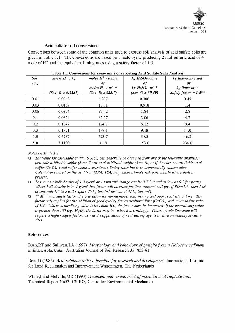
ASSMAC
Laboratory Methods Guidelines August 1998
Acid sulfate soil conversions Conversions between some of the common units used to express soil analysis of acid sulfate soils are given in Table 1.1. The conversions are based on 1 mole pyrite producing 2 mol sulfuric acid or 4 mole of H+ and the equivalent liming rates using a safety factor of 1.5.
Table 1.1 Conversions for some units of reporting Acid Sulfate Soils Analysis SOX (%)
moles H+ / kg
(SOX % x 0.6237)
moles H+ / tonne or
moles H+ / m3 * (SOX % x 623.7)
kg H2SO4/tonne or
kg H2SO4 /m3 * (SOX % x 30.59)
kg lime/tonne soil or
kg lime/ m3 * Safety factor =1.5**
0.01 0.0062 6.237 0.306 0.45
0.03 0.0187 18.71 0.918 1.4
0.06 0.0374 37.42 1.84 2.8
0.1 0.0624 62.37 3.06 4.7
0.2 0.1247 124.7 6.12 9.4
0.3 0.1871 187.1 9.18 14.0
1.0 0.6237 623.7 30.5 46.8
5.0 3.1190 3119 153.0 234.0 Notes on Table 1.1
The value for oxidisable sulfur (S OX %) can generally be obtained from one of the following analysis: peroxide oxidisable sulfur (S POS %) or total oxidisable sulfur (S TOS %) or if they are not available total sulfur (ST %). Total sulfur could overestimate liming rates but is environmentally conservative. Calculations based on the acid trail (TPA, TSA) may underestimate risk particularly where shell is present.
*Assumes a bulk density of 1.0 g/cm3 or 1 tonne/m3 (range can be 0.7-2.0 and as low as 0.2 for peats). Where bulk density is > 1 g/cm3 then factor will increase for lime rates/m3 soil (eg. if BD=1.6, then 1 m3 of soil with 1.0 % S will require 75 kg lime/m3 instead of 47 kg lime/m3).
** Minimum safety factor of 1.5 to allow for non-homogeneous mixing and poor reactivity of lime. The factor only applies for the addition of good quality fine agricultural lime (CaCO3) with neutralising value of 100. Where neutralising value is less than 100, the factor must be increased. If the neutralising value is greater than 100 (eg. MgO), the factor may be reduced accordingly. Coarse grade limestone will require a higher safety factor, as will the application of neutralising agents in environmentally sensitive sites.
References Bush,RT and Sullivan,LA (1997) Morphology and behaviour of greigite from a Holocene sediment in Eastern Australia Australian Journal of Soil Research 35, 853-61 Dent,D (1986) Acid sulphate soils: a baseline for research and development International Institute for Land Reclamation and Improvement Wageningen, The Netherlands White,I and Melville,MD (1993) Treatment and containment of potential acid sulphate soils Technical Report No53, CSIRO, Centre for Environmental Mechanics
4

ASSMAC
Laboratory Methods Guidelines August 1998
2. DESIGNING A SOIL SAMPLING AND ANALYSIS PROGRAM
C R Ahern and B Blunden
2.1 Introduction A sampling and analysis program should be designed to understand the risks of disturbing acid sulfate soils and to provide information to develop a management strategy. The level of investigation and analysis will depend on the characteristics of the site (particularly site variability), the type of disturbance proposed and the sensitivity of the surrounding environment. The resulting soil and water sampling and laboratory analysis will also provide baseline data for any monitoring program. Due to the nature of their formation, acid sulfate soils are likely to have substantial variation within the landscape and by depth (down the profile). As a result, the selection of sample sites to represent the various soils, vegetation, geomorphic and geological unit combinations in the landscape is a highly skilled task. The reliability of the investigation results is greatly dependent on the quality of the sampling program. The designing of valid sampling programs for sites that have been previous disturbed can be very difficult. The onus is on the proponent to justify that sufficient sampling and analysis has been undertaken to understand and manage the site without causing environmental harm. It can often be cost efficient to stage the soil investigations for large or complex projects. When the results of the initial sampling and analysis are known, the sampling program can be refined so the most efficient and cost effective regime can be developed to complete the acid sulfate soil assessment. Consultation with key government authorities at this stage can assist in focusing the investigations.
2.2 Responsibility of those undertaking the field survey
a. Number of soil sampling sites The frequency of sampling locations should conform to Assessment Guidelines in the ASS Manual. This requires, for general disturbance, a minimum of 4 holes for a site up to 1 ha, 6 for 2 ha, 7 for 3 ha and then 2 holes per ha for areas >4 ha. Greater intensity of sampling, such as sampling every 50 metres will be required for significant trench or canal excavations. Professional judgement will be necessary to ensure the sampling program identifies any actual or potential acid sulfate soil "hot spots" on the site. The location of each borehole or sampling site must be clearly marked on a map or overlaid on an aerial photograph. Grid references for each sample site and height (m AHD) must be documented.
b. Samples Professional judgement will be necessary to ensure that the sampling program provides representative and adequate samples to understand the risks and to develop a management strategy. The advice in the Assessment Guideline in the ASS Manual on the recommended soil sampling methods should be noted. Soil samples should be collected for every soil layer or at least every half (0.5) metre. The depth of the sample within the layer must be recorded, along with the upper and lower horizon depths. Where distinct soil layers or horizons occur in the soil profile, sampling intervals should be adjusted to take account of these horizons. Sampling intervals must not be taken across two (2) or more
1

ASSMAC
Laboratory Methods Guidelines August 1998
different horizons. The depth of investigation should be at least one (1) metre beyond the depth of the proposed excavation or estimated drop in watertable height, or to a minimum two (2) metres below the land surface, whichever is the greatest. Where depth of disturbance has not been definitely decided, it is strongly recommended to extend the sampling depth to avoid the need for costly re-drilling and to provide for more potential management or planning options - such as over-excavation and burial of highly sulfidic material below the water table. Full sampling and analysis of at least 3 sites or 25% of the profiles to 2-3 metres beyond the proposed disturbance is strongly advocated to understand the site characteristics, soil layering, drainage and geomorphic history. Where the deeper sampling has been undertaken and patterns are established, often an overall sampling intensity less than the guidelines may be approved. Ideally, samples of soil should be at least 0.5 kg each. Large shells and other large fragments such as wood, charcoal, stones and the like, should be noted and removed from the samples in the field. Biological remnants such as small roots may contain sulfides and should not be removed from the soil sample. The bulking or use of composite samples is not acceptable. Gravels associated with acid sulfate soils or from below the water table, have been known to contain sulfides in the weathered rind (Saffigna et al. 1996). White and Melville (1993) found oxidation of sulfidic mud balls or fines coating gravel extracted from a river, were the cause of vegetation and fish kills after a rainfall event. It is also possible that sulfides may be a component of the gravel or rock. Yellow jarosite coatings on gravel or rocks can indicate that follow up laboratory analysis is required. Gravel and sand fractions immersed in a ‘pyritic soup’ have been found to contain pyrite framboids in their fine pores and fractures (Saffigna et al., 1996) or as mud coatings (White et al., 1993). These materials are difficult to sample representatively and require modified sample preparation before laboratory testing. For estimating both field moisture and bulk density, a ‘volumetric sample’ can be taken in the field, using a large cut off syringe or suitably designed instrument. This is strongly recommended for peats and other low bulk density samples, as earthworks are often estimated on a cubic metre basis. However, in taking volumetric samples, compression of the sample or inclusion of air pocket can substantially affect the results. Chapter 7 provides greater detail on bulk density and moisture methods.
c. Field pH testing At the time of sampling, soil texture, field pH (pH F ; Method 21Af ) and field pH after oxidation with 30% hydrogen peroxide (pH FOX ; Method 21Bf) should be determined within regular depth intervals (eg. 0.25 m, maximum 0.5 m) or horizons in the profile and at least on all depths sampled for further laboratory analyses. These field tests together with the strength of the peroxide reaction can indicate those depths where sulfides are most likely to occur. This may assist in allocating similar samples to particular batches in the laboratory, which can assist in optimising procedures and improve the accuracy and detection limits. The field pH can be measured on saturated soil using a spear point pH probe and field pH meter. If pH KCl is substantially lower than pH F then some oxidation of the sample during transport or drying may have occurred. (For more details see Assessment Guidelines)
d.
2

ASSMAC
Laboratory Methods Guidelines August 1998
Soil sample handling, transport and storage Upon collection in the field, soil samples should be immediately placed in leak proof containers that minimise the sample’s contact with air and avoids moisture loss from the sample. The samples should be kept cold (ideally less than 4oC) in the field to reduce the possibility of oxidation of sulfidic compounds. A portable freezer and cold box (esky) containing dry ice are the most efficient coolers but if not available, at least ‘frozen bricks’ or ordinary ice should be employed for cooling. It is most important that sample labelling and documentation remain with the samples at all times. Labels should be water and ovenproof. It is preferable that samples be sent to the selected laboratory within 24 hours of collection. For transport and short-term storage during transit, samples should be chilled and stored in an insulated container so that they reach the laboratory at less that 4oC. If samples cannot be received by the laboratory within 24 hours of collection, the samples must be managed to minimise the oxidation of sulfides. Methods include:
quick oven drying the sample at 80-85oC in a forced convection large capacity oven (care must be taken not to overload the oven’s moisture removal capacity). The dried samples must then be stored in a low humidity environment
freezing the sample in sealed, plastic microwaveable container. Samples containing high concentrations of iron monosulfides, usually associated with bottom sediments and/or decaying vegetation, may generate acidity on oven drying. Special sampling, storage and freeze drying techniques may be used to overcome this problem. Bush and Sullivan (1997) showed that greigite readily oxidises within hours at room temperature and oxidises in minutes on drying at 88 °C. Special precautions to prevent oxidation at sampling and drying are costly and laborious and generally used for research rather than routine analysis. Provided the monosulfide content is low then any oxidation on drying should be detectable by a significant lowering (>1 unit) of laboratory pH compared to field pH. The change would not be easily detectable using the sulfur trail but the acid trail would show a high TAA result. Dioxane replacement of moisture (Crockford and Willet 1995) may be useful where no freeze-drying facilities are available. Greigite is relatively stable once dried (Bush and Sullivan 1997).
2.3 Responsibility of those undertaking the laboratory analysis
a. Notification of sample dispatch and receipt To avoid delays in sample processing and the potential for the oxidisation of sulfides in soil samples, it is important that the laboratory is contacted so that the laboratory manager knows that samples will soon be delivered for analysis. It is important that the laboratory confirm the receipt of the samples. In the past, the analysis of samples which were delayed or temporarily lost during transport or were not stored appropriately once having reached the laboratory, resulted in incorrect conclusions because of the change in state which occurred between collection and laboratory analysis. There is no legal requirement to submit a Chain of Custody declaration to the relevant State or Local Government authorities. However, auditable sample records should be maintained at all times.
3

ASSMAC
Laboratory Methods Guidelines August 1998
b. Oven drying - routine approach On arrival at the laboratory, samples should dried preferably in a quick drying, fan forced, air extracting oven at 80-85 °C for at least 48 hours, to prevent further oxidation of pyrite (Ahern et. al, 1996). If an estimate of field moisture is required then retain a representative portion of the soil in a sealed polyethylene bag or ‘moisture container’. An ‘as received moisture’ determination can be made as per Chapter 7. Laboratories should examine the drying capacity of their ovens and only apply appropriate loading. If the oven is overloaded particularly with large frozen samples, it may not be able to maintain the required temperature or its drying efficiency may be reduced. As a result, some oxidation of sulfide and substantial reduction in pH may occur (Hicks and Bowman, 1996).
Note: Typically, pH decrease of 0.25 to 1 unit have been recorded on oven drying, without any measurable oxidation of sulfides, although Hicks and Bowman (1996) have recorded substantial pH drops on drying large samples and some oxidation averaging 2% of average TPA. Oxidation of black iron monosulfides and other unstable sulfide and some reduced iron compounds commence on disturbance and specialised sampling equipment is required to prevent oxidation. Fortunately such compounds rarely occur in significant amounts in most acid sulfate soils but may be an appreciable component of drain, lake or stream bottom sediments. Wet/volumetric sampling methods may be more suitable when highly unstable compounds are expected. Immediate freezing with dry ice pellets followed by freeze drying in the laboratory is required for samples containing unstable sulfide compounds.
c. Sample preparation After drying, any coarse material not previously removed (especially shell and gravel) should be picked out or removed by preliminary sieving (2 mm). The weight of the residual coarse material (>2 mm) may need to be measured and calculated as a percentage of the total sample weight. Samples which do not easily break up after oven drying (such as some heavy clays), should be rolled/crushed/ground to pass through a 2 mm sieve. It is recognised that grinding equipment is laboratory specific but it is recommended that samples for acid sulfate soil analyses be fine-ground (<0.5 mm) to ensure greater homogeneity. This means a smaller sample weight and less volume of reagents can be used during analysis, reducing costs. The sample should be stored in a cool dry place in an airtight plastic or other inert container for subsequent laboratory use. It may be necessary to also analyse the gravel component as a separate sample as gravels in acid sulfate soils have been known to contain sulfides in the weathered rind or even as a total component of the rock. Generally gravely soils or sediments are extremely variable in particle size and sulfide content. Sampling of gravel material is a challenge requiring large sample volumes, separation via sieves and weighing the various components. Depending on the equipment available, the separation may be done in the field or the laboratory. The gravel components will normally need grinding with specialised equipment and should be analysed separately to the finer fractions. As dried acid sulfate soils may contain dusty, strongly acidic substances such as jarosite, workers involved in grinding these soils should use eye protection, a dust mask and carry out the operation in a dust extraction cabinet.
d.
4
ASSMAC
Laboratory Methods Guidelines August 1998
Storing and retaining samples for audit purposes Representative soil samples collected for acid sulfate soil investigations should be well marked and retained for possible future call or audit purposes. Storage in an oven-dried state is the safest and preferred approach. A less desirable method of storage particularly when conducting a staged approach is freezing. Accredited laboratories (eg. NATA registered, Certified Laboratory Practice and ISO 9000) will normally have their own registering and management system for keeping track and storing of samples. As most commercial laboratories would discard samples about a month after results are reported, special arrangement may need to be made with the laboratory to retain at least 50 g of sample until approvals have been finalised. Most laboratories will charge a fee for drying and storing samples. When the retention of representative samples becomes an unreasonable impost; the appropriateness of discarding of samples should be discussed with the regulatory authority. Stored samples could be important in defence of legal action.
2.4 Selection of consultants and laboratories NATA accredited, Certified Laboratory Practice, or ISO 9000 laboratories that use the methods in this guideline and who successfully participate in the acid sulfate soil quality assurance program under the supervision of the ASSMAC Technical Committee, are recommended. Non-accredited laboratories may be acceptable, provided that they have successfully participated in the acid sulfate soil quality assurance program. It is strongly recommended that consultants with qualifications in agricultural or environmental soil science (specialising in soil chemistry, hydrology or pedology), experienced in acid sulfate soils management and accredited with a professional organisation such as the Australian Society of Soil Science be engaged to undertake soil investigations. When calling tenders for acid sulfate soil investigations, proponents should request a sampling and analysis program with a break down based on a sample-based approach including the proposed number of sites/cores to be drilled, samples taken down the profile and proposed laboratory analyses. Without a sample-based approach, the cheapest quote often involves insufficient sites, samples and analysis, resulting in costly delays and the need for further supplementary investigations and costly variations. For large complex projects or where the level of acid sulfate risks are not known, consultants should be encouraged to submit a staged approach. A staged investigation enables the sampling design to be adjusted and refined as a result of earlier site information. As a result, savings can be considerable, particularly where stage 1 shows acid sulfate soils are minor or insignificant.
5

ASSMAC
Laboratory Methods Guidelines August 1998
References Ahern,CR, McElnea,A and Baker,DE (1996) To dry or not to dry? That is the question for sulfidic soils. In Proceedings of the Australian and New Zealand National Soils Conference, 1-4 July 1996. Australian Soil Science Society, Melbourne Bush,RT and Sullivan,LA (1997) Morphology and behaviour of greigite from a Holocene sediment in Eastern Australia. Australian Journal of Soil Research 35, 853-61 Crockford,RH and Willett,IR (1995) Drying and oxidation effects on the magnetic properties of sulfidic material during oxidation. Australian Journal of Soil Research 33, 19-29 Hicks,WS and Bowman,GM (1996) Practical aspects of the quantitative assessment of acid sulfate soils. ‘Proceedings 2nd National Conference of Acid Sulfate Soils’ Robert J Smith and Associates and ASSMAC, Australia Saffigna,PG, Holland,GL, Joyce,AS, Cordwell,GB, Cordwell,BA and Covey,NR (1996) Distribution of pyrite in silt, sand, gravel and wood in a soil profile near Yandina, Queensland. ‘Proceedings of the 2nd National conference of Acid Sulfate Soils’ Robert J. Smith and Associates and ASSMAC, Australia White,I and Melville,MD (1993) Treatment and containment of potential acid sulphate soils. Technical Report No. 53 CSIRO Centre for Environmental Mechanics
6

ASSMAC
Laboratory Methods Guidelines August 1998
3. CODES FOR ACID SULFATE SOILS ANALYTICAL METHODS
C R Ahern and G E Rayment
3.1 Introduction Method codes have been established for the principal analytical methods for the analysis of acid sulfate soils. These methods are:
Peroxide Oxidation Combined Acidity & Sulfate POCAS - Method 21 Total Oxidisable Sulfur (TOS) - Method 20 Acid Neutralising Capacity - Method 19
The method codes have been negotiated for addition to existing codes in the Australian Laboratory Handbook of Soil and Water Chemical Methods (Rayment and Higginson 1992). These codes are compatible with the system established in the handbook.
3.2 Codes for Peroxide Oxidation Combined Acidity & Sulfate (POCAS) - Method 21 The codes for POCAS are in Table 3.1 (Analytical Methods) and Table 3.2 (Supplementary Finishing Steps).
Table 3.1 Analytical Method Codes for Method 21 Analysis
Code Symbol &
Units Analysis and description
pH measurements 21A pH KCl pH of filtered 1:20, 1M KCl extract, overnight shake (TAA)
21Af pH F pH done in the field on saturated soil sample using pH probe 21B pH OX pH of filtered 1:20 1M KCl after peroxide digestion 21Bf pH FOX pH measured in the field - 30 % peroxide reaction, pH probe Sulfur methods 21C S KCl % KCl extractable S (additional codes added for S determination) 21D S P % Peroxide sulfur after peroxide digestion 21E S POS % Peroxide oxidisable S [21D minus 21C] Acidity methods 21F TAA (mol H+/tonne) Total Actual Acidity in 1M KCl titrated to pH 5.5 21G TPA (mol H+/tonne) Total Potential Acidity in 1M KCl peroxide digest titrated to pH 5.5 21H TSA (mol H+/tonne) Total Sulfidic Acidity [21G-21F] 21J S TAA % TAA calculated as equivalent pyrite S % for comparison purposes 21K S TPA % TPA calculated as equivalent pyrite S % for comparison purposes 21L S TSA % TSA calculated as equivalent pyrite S % for comparison with 21E
using the same units. Calcium values from POCAS to estimate additional Ca from acid-shell/carbonate reaction 21V Ca KCl (Ca %) Ca extracted in 1M KCl (TAA) 21W Ca P (Ca %) Ca in peroxide digest (TPA) 21X Ca A (Ca %) Ca reacted with acid generated by peroxide digest (21W-21V) Magnesium values from POCAS to estimate additional Mg from acid-shell /dolomite/carbonate reaction 21S Mg KCl (Mg %) Mg extracted in 1M KCl (TAA) 21T Mg P (Mg %) Mg in peroxide digest (TPA) 21U Mg A (Mg %) Mg reacted with acid generated by peroxide digest (21T-21S)
1

ASSMAC
Laboratory Methods Guidelines August 1998
Sodium values from POCAS 21M Na KCl (Na %) Na extracted in 1M KCl (TAA) 21N Na P (Na %) Na in peroxide digest (TPA) 21P Na A (Mg %) Na difference (21N-21M) Neutralising methods 21Q NQ (CaCO3 %) Quick residual neutralising capacity 21R NQ S (S R %) Quick residual neutralising capacity 21Q, calculated as equivalent S %
Supplementary Finishing Step Codes Supplementary Finishing Step Codes for sulfur (21C, 21D, 21E), calcium (21V, 21W, 21X) magnesium (21S, 21T, 21U) and sodium (21M, 21N, 21P) are in Table 3.2.
For example, Method Code 21Ce is KCl extractable sulfur with Inductively Coupled Plasma Atomic Emission Spectrometry (ICPAES) Finishing Step to determine S.
Table 3.2: Codes for the Supplementary Finishing Steps for the POCAS Methods
Supplement code
Analyte and finishing step Similar to Rayment & Higginson (1992) method
Sulfur a sulfate, turbidimetric J1a b sulfate, gravimetric J1b c sulfate, automated colour J1c d sulfate, ion chromatography J1d e sulfur, ICPAES J2a f sulfate, automated turbidimetric J1a g sulfate, indirect, barium remaining by AAS Calcium h calcium, ICPAES L1c j calcium, atomic absorption (AAS) L1b k calcium, titration EDTA L1a Magnesium m magnesium, ICPAES L2c n magnesium, atomic absorption (AAS) L2b p magnesium, titration EDTA L2a Sodium s sodium, ICPAES L4c t sodium, atomic absorption L4b u sodium, flame emission L4a
3.3
2

ASSMAC
Laboratory Methods Guidelines August 1998
Total Oxidisable Sulfur (TOS) - Method 20 Two approaches for deriving total oxidisable sulfur is provided in Method 20
Method 20 C = Method 20 A (Total Sulfur) - Method 20B (Hydrochloric Acid Extractable Sulfur) Method 20 D (Pre-washed Hydrochloric Acid Extractable Sulfur)
The codes for Method 20A for Total Sulfur (S T %) are given in Table 3.3. For example, Method Code 20A1 represents total sulfur by X-ray fluorescence.
Table 3.3 Codes for Method 20A - Total Sulfur (S T %) Code Analysis and Description 1 X-ray fluorescence (similar to method 10A1 Rayment and Higginson 1992) 2 Leco (the older model Leco furnace is unsuitable) 3 Combustion, titration end-point 4 Combustion, dry ashing sodium bicarbonate, silver oxide (Steinbergs et al., 1962) 5 Alkaline sodium hypobromite oxidation + reduction hydriodic acid reduction (Tabatabai and
Bremner 1970) 6 Acid oxidation using nitric, perchloric, phosphoric, hydrochloric acids (Arkley, 1961) 7 Bromine - nitric acid oxidation (Vogel 1978) 9 Total Sulfur by Summation (S TOS + S HCl )
Supplementary Finishing Step Codes Table 3.4 lists Supplementary Finishing Step Codes for Method 20B for hydrochloric acid (4M) extractable sulfur (calcium, magnesium, sodium and potassium).
For example, Method Code 20Be is Hydrochloric Acid (4m) Extractable Sulfur (S HCl %), using an ICPAES Finishing Step to determine S.
Table 3.4 Codes for Method 20B; Hydrochloric Acid Extractable Sulfur (S HCl %),
Supplement code
Analyte and finishing step Similar to Rayment & Higginson (1992) method
Sulfur a sulfate, turbidimetric J1a b sulfate, gravimetric J1b c sulfate, automated colour J1c d sulfate, ion chromatography J1d e sulfur, ICPAES J2a f sulfate, automated turbidimetric J1a g sulfate, indirect, barium remaining by AAS Calcium h calcium, ICPAES L1c j calcium, atomic absorption (AAS) L1b k calcium, titration EDTA L1a Magnesium m magnesium, ICPAES L2c n magnesium, atomic absorption (AAS) L2b p magnesium, titration EDTA L2a Sodium s sodium, ICPAES L4c t sodium, atomic absorption L4b u sodium, flame emission L4a Potassium v potassium, ICPAES L3c w potassium, atomic absorption (AAS) L3b x potassium, flame emission L3a
3

ASSMAC
Laboratory Methods Guidelines August 1998
The ‘full code’ for Method 20C involves addition of the appropriate numeral from table 3.3 to define the total S method and addition of the appropriate lower case alphabetic character from Table 3.4 to define the method used to determine S HCl %. Some examples are shown in Table 3.5.
Table 3.5 Examples of ‘Full Codes’ for Method 20C; Total Oxidisable Sulfur (S TOS%) Code Analysis methods [20A - 20B] 20C1e Total S by X-ray (1) - HCl extractable S by ICP (e) 20C2e Total S by LECO (2) - HCl extractable S by ICP (e) 20C2a Total S by LECO (2) - HCl extractable S by Turbidimetric (a) The codes for Method 20D; Total Oxidisable Sulfur (S TOS%) after pre-washed 4M HCl and water are provided in Table 3.6.
For example, Method Code 20D2 is Total Oxidisable Sulfur after HCl pre-wash determined by Leco (2).
Table 3.6 Codes for method 20D; Total oxidisable sulfur after HCl pre-wash (S TOS%)
Code Analysis and Description 1 X-ray fluorescence (similar to method 10A1 Rayment and Higginson 1992) 2 Leco (the older model Leco furnace is unsuitable) 3 Combustion, titration end-point 4 Combustion, dry ashing sodium bicarbonate, silver oxide (Steinbergs et al., 1962) 5 Alkaline sodium hypobromite oxidation + reduction hydriodic acid reduction (Tabatabai and Bremner (1970) 6 Acid oxidation using nitric, perchloric, phosphoric, hydrochloric acids (Arkley, 1961) 7 Bromine - nitric acid oxidation (Vogel 1978)
3.3 Acid Neutralising Capacity – Method 19
Table 3.7 Acid neutralising capacity codes Code Symbol & units Analysis and description
Acid Neutralising methods (non-POCAS) from Rayment and Higginson (1992) 19A1 NT (CaCO3 %) Neutralising –Titration Carbonates - back titration expressed as CaCO3 % 19B1 NV (CaCO3 %) Neutralising –Volumetric Carbonates - manometric expressed as CaCO3 % Methods to be added to Rayment and Higginson (1992) 19A2 NTL (CaCO3 %) Neutralising –Titration Carbonates (Lewis & McConchie) CaCO3 % 19C1 NG (CaCO3 %) Neutralising – Gravimetric loss of CO2 expressed as CaCO3 % 19D1 NC (CaCO3 %) Neutralising – Curve (titration) expressed as CaCO3 %
3.4 Moisture codes Table 3.8 Acid Sulfate Soil Moisture codes
Code Symbol & units Analysis and description Moisture Content methods from Rayment and Higginson (1992) 2B1 W105 (%) As received moisture 105°C
Methods to be added to Rayment and Higginson (1992) 2B2 W85 (%) As received water moisture content 85°C
4

ASSMAC
Laboratory Methods Guidelines August 1998
3.5 Acid Sulfate Soils ‘Miscellaneous’ Acid Sulfate Soils Methods- Code 22 Method 22A: Acid Volatile Sulfur (SAV %) Method 22B: Chromium Reducible Sulfur (SCR %) Method 22C: Scanning Electron Microscopic methods
References ArkleyTH (1961) Sulfur compounds of soil systems PhD thesis, California University, Berkeley Rayment,GE and Higginson,FR (1992) Australian Laboratory Handbook of Soil and Water Chemical Methods. (Inkata Press, Melbourne) Steinbergs,A, Iismaa,O, Freney,JR and Barrow,NJ (1962) Determination of total sulphur in soil and plant material Anal.Chim.Acta 27:158-164 Tabatabai,MA, and Bremner,JM (1970) An alkaline oxidation method for determination of total sulfur in soils Soil Science Society Am.Proc. 34:62-65 Vogel (1978) Vogel’s Textbook of Quantitative Inorganic Analysis. 4th edition, Longman, London
5

ASSMAC
Laboratory Methods Guidelines August 1998
4. PEROXIDE OXIDATION COMBINED ACIDITY & SULFATE
POCAS – METHOD 21
CR Ahern, A. McElnea and DE Baker
Introduction The POCAS method aims to standardise laboratory procedures for determining the potential acidification of acid sulfate soils by combining two commonly used peroxide oxidation methods. Peroxide Oxidisable Sulfuric Acidity (POSA) (Lin and Melville, 1993) follows the ‘sulfur trail’ and the method of Dent and Bowman (1996) follows the ‘acidity trail’ measuring total actual acidity [TAA], total potential acidity [TPA] and by difference, total sulfidic acidity [TSA]. The combined method1 is essentially similar to the Ahern et al. (1996) ‘combined peroxide method’ slightly modified by further research and in response to the ASSMACTC Methods Workshop, October 1996. After trials by Government, University and private laboratories, POCAS was approved at a further specially convened ASSMACTC meeting on 29 August 1997. In some cases, neither the ‘sulfur trail’ nor the ‘acidity trail’ method supply enough information. For more complete interpretation of acid sulfate soils, results from both trails are an advantage. The POSA method takes no account of carbonate content or the buffering capacity of the soil. An earlier version of the TPA method has been shown to record ‘false positives’ in some laboratories (Clarke et al. 1996), although the updated double oxidation TPA method is claimed to have no such difficulties provided digestion conditions are closely adhered to (Dent and Bowman, 1996). On some soils, TPA may underestimate the potential risk of acid leakage to the environment because not all the shell in the soil is immediately available for neutralisation of acid, due to low surface area and insoluble coatings forming on the shells. The combination method also includes pH measurements in 1M KCl (pH KCl) before and after oxidation (pH OX), providing additional information to assist in better defining the potential environmental risk. The combined method is not meant to be a research scientist’s tool. It is intended to be a standardised set of procedures to help assess the potential environmental impact of soils suspected of containing pyrite and other iron sulfides. The combined method is designed to suit most routine private, governmental and institutional laboratory facilities by supplying sufficient information for quality acid sulfate soils environmental assessment and management decisions at the lowest possible cost. Cheaper screening methods are available but often lead to incorrect conclusions. Laboratories not equipped for sulfate analyses should still follow the procedure to determine TAA and TPA. (They have the option of sending the extraction/digested solutions to other laboratories for sulfate analyses). Similarly, where only the sulfur trail or POSA has been requested, the analyst should follow the combined procedure, only omitting the TAA and TPA titration components. Codes compatible with the ‘Green Book’ Australian Laboratory Handbook of Soil and Water Chemical Methods (Rayment and Higginson 1992) have been allocated for the various individual components of the combined method (Chapter 3). These codes define the procedures followed, and
1 The comparative work of Lin et al. (1996), laboratory analyses and method comparisons data on a range of soils prepared by A. McElnea, D. Baker and laboratory staff of the Resource Sciences Centre, Analytical Centre, Indooroopilly Queensland along with the comments or advice of various individuals, laboratories and ASS consultants is acknowledged in the development of this method, particularly Graham Lancaster, Warren Hicks, Greg Bowman, Mike Melville, Steve Dobos, David Dent, Peter Edmiston, Sharon Denny, Errol Best and Dave Mazlen.
1

ASSMAC
Laboratory Methods Guidelines August 1998
allow concise reference and use in databases or reporting formats. They should be strictly followed and new codes should not be invented. Recommended changes or additions should be made to ASSMAC for consideration of the ASSMACTC. The Total Oxidisable Sulfur (TOS) Method 20 should be regarded as predominantly a ‘screening method’. The TOS method follows the sulfur trail only. It provides a measure of pyrite content at a cheaper price, but gives no estimate of ‘actual acidity’ from previous or partial oxidation of sulfides. It usually has higher detection limits, does not provide as much data on the sample and often needs supplementing with the POCAS method, particularly in partially oxidised soil layers. However, if used in combination with the POCAS method in a soil analysis program, it can be used to minimise the cost of analysis.
4.1 Overview of the POCAS method The procedure is comprised of three distinct parts: Step 1. extraction with 1M KCl to determine soluble and adsorbed sulfur (S KCl %) and the total
actual acidity (TAA) of the soil. Step 2. oxidation of the soil with hydrogen peroxide to produce maximum acidity from any reduced
sulfidic material, determining the sulfur (sulfate) content (S P %) of the digested solution, and titration of the total potential acidity (TPA) of the solution.
Step 3. calculating the differences between steps 2 and 1, the sulfur trail is used to predict the potential acid risk from unoxidised (peroxide oxidisable) sulfur compounds (S POS %) or the acid trail is used to predict total sulfidic acidity (TSA) .
Section 4.2 details the complete steps in the POCAS method while Section 4.3 provides a discussion of the method. Section 4.5 provides an outline of the method for ease of laboratory use. The complete method in addition to the discussion in Section 4.3 should be read and understood before proceeding to analyse or interpret the data.
4.2 The POCAS method
Step 1. KCl Extractable Sulfur (S KCl ) and Acidity (TAA) The step involves the extraction of the sample with 1M KCl to determine soluble and adsorbed sulfur (S KCl %) and the total actual acidity (TAA) of the soil.
a. KCl Extraction (i) Weigh accurately a minimum of 2.5 g of fine-ground, oven-dry sample (ii) Make a 1:20 suspension with 50 mL of 1M KCl. (for a <2 mm, coarsely ground sample, a
minimum of 5 g is required and correspondingly larger volumes of reagents to achieve the same 1:20 soil:solution ratio). Prepare a blank.
Note: Larger volumes and weights should be used for samples with low concentration of pyrite (such as sands) with the 1:20 ratio being maintained.
(iii) Extract the solution on reciprocal or end-over-end shaker for 1hr and let stand overnight (16 hr).
Note: A 1:20 suspension was selected as a compromise between keeping the soil:solution ratio as low as possible and having a solution ratio which will dissolve the gypsum crystals that can occur naturally in acid sulfate soils. The overnight stand is intended to suit routine laboratory procedures and achieve equilibrium closer to the 24 hr standing after titration used by Dent and Bowman (1996). There are suggestions that some pyrite oxidation of low analysis dredged sands may occur
2

ASSMAC
Laboratory Methods Guidelines August 1998
on prolonged shaking or standing and hence standing time may have to be reduced on such samples. This is under further investigation and is only expected to be significant on low analysis sands.
Gypsum has a solubility of only 0.2% in water but a greatly enhanced solubility in 1M KCl. However, samples with very high gypsum contents may require a 1:50 ratio of soil:extractant ratio to dissolve all the gypsum, particularly if the analysed sulfur content approaches 3.15%.(McElnea and Baker 1998); (see general comments section 4.3).
(iv) Re-shake briefly after overnight standing then filter the suspension or centrifuge at an
appropriate speed to obtain a clear solution. Take a 25 mL aliquot for titration of acidity and an aliquot for sulfate determination (the aliquot size depends on the sulfate method employed).
Note: Measuring TAA on a filtered or centrifuged extract generally produces a lower value than from titrating the entire suspension. However, use of the clear extract makes the titration end-point more abrupt, (Figure 1, Ahern et al. 1996) with less pH drift and avoids the need for a correction factor usually applied when a suspension is used.
b. KCl Extractable Sulfur (S KCl % ) (i) Determine KCl extractable sulfur (generally sulfate) by making up the aliquot to suitable
volume for sulfate determination. This final volume will depend on the particular laboratory’s technique and/or equipment for measuring sulfate.
(ii) Report KCl extractable S result on a dry soil basis as S KCl % (Method 21C).
Note: Extractable sulfur may be determined by ICPAES spectrometer commonly called ICP, or as sulfate using automated or manual turbidimetry or gravimetry. If an HPLC is to be used then a chloride reduction pre treatment is needed. The ICP has the advantage of reading solution sulfur, including any extracted organic S compounds, in addition to the sulfate. This effectively reduces some of the contribution to S POS% of organic sulfur. Additionally, if ICP is used, then calcium (Method 21Vh) and magnesium (Method 21Sm) can usually be determined on the aliquot at little extra cost. See ‘general comments on the method’ section 4.3 for their use. A lower case alphabetic character (as shown in Table 3.2) is added to the Method 21C code to indicate the laboratory’s sulfur/sulfate method. The finishing codes generally follow that of Rayment and Higginson (1992) for sulfate water analyses with some additions eg. 21Ce is KCl extractable sulfur using an ICP finish.
c.
3

ASSMAC
Laboratory Methods Guidelines August 1998
KCl extractable acidity - TAA Titration: (i) Measure and record pHKCl (Method 21A) of aliquot prior to ‘TAA’ titration. (ii) If pH KCl is ≥ 5.5 then TAA is zero. (iii) if pH KCl is less than 5.5, titrate a 25 mL aliquot with standardised 0.05M NaOH (or NaOH
prepared from an ampoule according to manufacturer’s instructions) to pH 5.5 while stirring the solution.
Note: NaOH solutions should be prepared fresh each day or stored in an apparatus capable of excluding CO2. Titrations should be carried out using an autotitrator, or manually using an A-grade 10 mL burette graduated to 0.02 mL. If titrating manually, record a pH and alkali volume at a pH close to but just below 5.5 for accurate endpoint volume interpolation if the endpoint pH is slightly exceeded. Other molarity NaOH solutions may be prepared to suit the range of samples encountered. If an accurate result is required on a low analysis sample (or those suspected of being low because pH KCl is close to 5.5) a lower molarity NaOH solution may be used, but the increased accuracy thus achieved must be balanced against the risk of CO2 contamination. It may be preferable to initially use 5 g of fine ground sample (remembering to keep the extraction ratio constant at 1:20) and hence be able to titrate double the aliquot of extractant.
(iv) Record the volume of alkali required to reach pH 5.5, calculate result and express as mol
H+/tonne of dry soil (Method 21F). Step 2. Peroxide oxidation Sulfur (S P%) and Acidity (TPA) This step involves the oxidation of the soil with hydrogen peroxide to produce maximum acidity from any reduced sulfidic material, determining the sulfur (sulfate) content (S P %) of the digested solution, and titration of the total potential acidity (TPA) of the solution.
d. Peroxide digest (oxidation) (i) Weigh accurately 2.5 g of fine-ground oven-dry sample (for a coarsely ground (<2 mm)
sample a minimum of 5 g is required and correspondingly larger volumes of reagents are required to achieve the same soil:extractant ratio).
Note: for sandy materials (samples with ≤5 % clay) a minimum of 5 g fine-ground or 10 g coarse sample will be required to provide greater volume of sample for titration, thereby enhancing accuracy on low analyses samples. Please see ‘Method Variation for Sandy Material’ section 4.2 g) and the slight alteration in the method).
(ii) Record the total weight of flask plus sample for later use in making up accurate final
volumes of extractant. (iii) Make a homogenous 1:5 suspension with 12.5 mL 2M KCl. A 1:5 ratio is initially selected
to enhance peroxide oxidation but the final ratio is 1:20 as in the TAA / S KCl procedure (iv) Completely oxidise samples with 5 mL aliquots of analytical grade (or equivalent) 30 %
hydrogen peroxide (H2O2). Care needs to be taken to avoid samples bubbling/frothing-over when the initial aliquot of peroxide is added. If the reaction is too vigorous, add more deionised water to the sample. It is recommended that after addition of the initial aliquot of
4

ASSMAC
Laboratory Methods Guidelines August 1998
peroxide, samples should be left standing at room temperature for at least 2 hours before they are gently heated. Some laboratories prefer to add most of the peroxide in one addition, but careful management including cooling with ice for reactive samples is required.
(v) Swirl, and if necessary, gently heat (max. 55-60 oC) samples between additions of peroxide
aliquots until oxidation is complete. Record the number (or total volume) of H2O2 aliquots used for calculating blank corrections where necessary. Blanks should always be included with every batch of samples.
Note: Complete oxidation of the sample is vital to avoid erroneous TPA results. Complete oxidation has occurred when addition of peroxide produces no further reaction on prolonged standing, the mineral soil has become grey to light brown, and the supernatant is clear and transparent (though not necessarily colourless). Generally, around two days of room temperature oxidation is required. Some samples do not easily fit this description, so extra time and care is needed to ensure complete oxidation. Peaty soils and those with high organic matter may froth initially and require considerably more peroxide (and time) than mineral soils for complete oxidation. Samples containing jarosite, goethite or gypsum and very little or no pyrite may continue to react very slowly for a number of days without appreciable acid generation.
Caution must be exercised when digesting these samples to avoid adding excessive volumes of peroxide which will prolong the following boiling stage. Use of heat to speed up the oxidation procedure may lead to excessive peroxide usage and incomplete oxidation of the sample as peroxide is easily decomposed on heating. Substantial loss of sample volume and subsequent crystallisation of gypsum or other sparingly soluble salts must be avoided. Experienced operators may develop their own laboratory oxidation procedures to match the types of samples being analysed (with a minimum of 24 hours required even under accelerated oxidation conditions) but reagents and ratios must be consistent with the approved method. Appropriate internal laboratory quality control samples should be run with each batch to ensure complete oxidation. The oxidation step is the most difficult to standardise and describe at this stage. As details from the exchange sample system and further research data come to hand, some modifications of the above description may be required. There is much conflicting information from laboratories but probably the biggest problems are created from the use of technical grade peroxide and attempts to adjust pH or correct for blanks. Possibly, some AR grade peroxide supplies are also problematic. For low sulfur analysis of sands, sulfur blanks may have to be run on batches of peroxide and AR grade KCl before use.
(vi) When oxidation is complete add 12.5 mL 2M KCl and if total volume is < 50 mL add
sufficient deionised water to make volume approximately 50 mL. Note: Water addition is necessary to dissolve any gypsum originally present in the sample and/or formed as a result of the digestion process. It is also very important to keep the volume close to 50 mL during the following heating stage by addition of deionised water when necessary.
5

ASSMAC
Laboratory Methods Guidelines August 1998
(vii) Decompose excess peroxide by heating between 85oC and 95°C until bubbling has stopped
and solutions have cleared. If total volume exceeds 50 mL (1:20 ratio) reduce volume of sample, by further heating.
Note: Do not allow solution to boil at this stage. Boiling will remove excess volume quickly but precautions must be taken to prevent excessive loss of solution.
(viii) Allow to cool to room temperature. Weigh flask plus contents and add de-ionised H2O until
weight coincides with original weight + a constant weight (equivalent to the weight of 50 mL 1M KCl).
Note: The weighing approach provides better accuracy than making up the solution to 50 mL in a flask. Samples with very high gypsum contents may require a 1:50 ratio of soil:extractant to dissolve all gypsum this includes the original gypsum in the sample or gypsum produced by reaction of the sulfuric acid with any fine shell material, calcium carbonate or other calcium source in the sample. If the result of the acidity trail exceeds the result of the sulfur trail on samples showing high sulfide content, the solubility of gypsum may be implicated in giving a lower sulfur trail result. In these circumstances a repeat analysis using 1:50 ratio may be required. (See ‘general comments in Section 4.3).
(ix) Filter the suspension or centrifuge at a sufficient speed to obtain a clear solution. Take a 25
mL aliquot for titration of acidity (TPA) and an appropriate aliquot for sulfur determination, depending on the method employed (see (b)(i) below).
e. Peroxide digest, Sulfur determination (S P) (i) Determine total solution sulfur (which should all be sulfate if the sample has been
completely oxidised by the peroxide) by taking an aliquot of suitable volume for sulfate determination. This volume will depend on the laboratory’s technique and/or equipment for measuring sulfate.
(ii) Determine sulfate on the blank and adjust results if necessary, according to the volume of
peroxide used for each sample. (iii) Express results on dry soil basis as peroxide sulfur (S P%) (Method 21D) and indicate the
method of sulfur determination in the code using Table 3.1 and 3.2. (iv) If ICP is used, then calcium (Method 21Wh) and magnesium (Method 21Tm) can usually
be determined on the same aliquot at little extra cost. See ‘Section 4.3’.
f. Peroxide digest, Total Potential Acidity (TPA) titration (i) Measure and record pHOX (Method 21B) of aliquot prior to ‘TPA’ titration. (ii) If the pHOX is >5.5 after peroxide oxidation then the TPA is zero and the Quick Residual
Neutralising Capacity (Method 21Q – NQ CaCO3 %) may be determined (see Section 4.2 h)
6

ASSMAC
Laboratory Methods Guidelines August 1998
(iii) If pHOX is less than 5.5, titrate a 25 mL aliquot of solution with 0.05M NaOH (for sands and
expected low pyrite soils) or 0.25M NaOH (on suspected highly pyritic soils/muds) to pH 5.5 with stirring. Once again record pH and volume of alkali at a pH near to but below pH 5.5 for interpolation purposes.
Note: Where prior knowledge of expected sulfide levels of the soil is not available, the value of pH OX in combination with soil texture can be used to assist in estimating the concentration of NaOH used in the titration. Marine clays and clayey soils usually have good buffering capacity, so a low pHOX indicates that a large volume of titrant is needed. On the other hand, sandy soils have little buffering capacity and usually require a small volume of titrant compared to clays for the same low pHOX values. Additionally, sandy soils are usually low in sulfide content. As a general rule, sands and samples with a pH OX of ≥ 3 should be titrated with lower concentration NaOH.
(iv) Record the volume and concentration of alkali used. (v) ‘Double oxidation’ Step - immediately add an aliquot (2.5 mL) of 30 % peroxide with
stirring and record this pH. (If you are using 5 g of sample add a 5 mL aliquot of peroxide). If pH drops below 5.5, titrate with stirring back to pH 5.5 with NaOH. If using an auto-titrator, 0.05M NaOH can be used even if 0.25 M NaOH has been used in the first part of the titration. Once again record pH and alkali volume just below endpoint.
Note: The ‘double oxidation’ step developed by Dent and Bowman, (1996) is required to ensure complete iron oxidation and subsequent acid generation. Complete oxidation of Fe2+ to Fe3+ is inhibited by very low pH after peroxide treatment.
(vi) Record the volume of alkali added. Add this to the volume used in the first part of the
titration (checking that the two molarities are compatible). (vii) Use the blank result to correct titrations according to the volume of peroxide used in each
particular sample. Use of analytical grade peroxide usually results in negligible blanks. Note: Some laboratories have found substantial blanks using technical grade peroxide which is generally unreliable, variable between containers and may be stabilised with phosphoric or sulfuric acid. The pH and sulfur content of each container of peroxide must be checked. Generally AR grade peroxide has a pH of >4 and a change of supply should be considered if substantial blanks occur. Stock peroxide should be stored in the refrigerator and decanted into smaller containers for laboratory use. This does not remove the need for having a blank in every batch of samples.
(viii) Calculate the TPA result and express as mol H+/tonne of dry soil (Method 21G) or TPA equivalent S TPA % (Method 21K) assuming that all acidity generated is from pyrite.
g.
7

ASSMAC
Laboratory Methods Guidelines August 1998
Modifications to sample weight for sandy material As a general rule for sandy material with low organic content, a minimum sample of 5 g fine-ground (<0.5mm) or 10 g (<2mm) is required to provide an adequate volume for titration of low analysis samples. Variation 1 ‘TPA’ procedure for 5 g of fine-ground sample (i) Add 12.5 mL 2M KCl initially and proceed with oxidation (ii) When oxidation is complete, add 37.5 mL (3 × 12.5 mL) 2M KCl and sufficient deionised
water to make total volume approximately 100 mL. (iii) After heating to remove excess peroxide, cool and add deionised water until the weight of
flask and contents equals original flask + sample + weight of 100 mL 1M KCl. (iv) Titrate a 75 mL aliquot for the TPA and add 5 mL peroxide for the ‘double oxidation’ step.
Note: Sluiced sands with a very low sulfide content, may require 5 g or 10 g of fine-ground sample to a final volume of 50 mL ie. a 1:10 or 1:5 ratio of soil to extractant to improve the lower limit of detection. With these exceptions, the extraction ratios on samples must be kept at 1:20 for comparability.
Variation 2 ‘TPA’ procedure for 10g coarse-ground sample (i) Add 25 mL 2M KCl initially and proceed with oxidation (ii) When oxidation is complete, add 75 mL (6 × 12.5 mL) 2M KCl and add sufficient
deionised water to make total volume approximately 200 mL. (iii) After boiling to remove excess peroxide, cool and add deionised water until the weight of
flask and contents equals original flask + sample + weight of 200 mL 1M KCl. (iv) Titrate a 150 mL aliquot for the TPA and add 5 mL peroxide for the ‘double oxidation’ step
Note: Calculations will need to be adjusted accordingly.
h. Quick Residual Neutralising Capacity If pH is >5.5 after peroxide oxidation then an optional step is to determine residual quick neutralising capacity (Dent and Bowman, 1996). (i) titrate the 25 mL aliquot (V9) with standardised HCl (0.05M) (M4) to pH 5.5 while stirring
and record the titre (T5) (ii) calculate the result and express as CaCO3 % (Method 21Q). NQ (CaCO3 %) = (V5/V9) x M4 x T5 x (100.087 x 0.05/W2)
for 0.05M HCl and suggested weights, volumes and dilutions this reduces to NQ (CaCO3 %) = T5 x 0.2002
8

ASSMAC
Laboratory Methods Guidelines August 1998
Step 3. Peroxide Oxidisable Sulfur (S POS) and Total Sulfidic Acidity (TSA) This step involves calculating the differences between the determinations on the peroxide extract (Step 2) and the KCl extract (Step 1). The result for the sulfur trail and the acid trail can be compared when converted to the same units.
i. Peroxide Oxidisable Sulfur (S POS % ) Peroxide oxidisable sulfur is the difference between the sulfur determined in the peroxide digest (Method 21D) and the sulfur extracted by 1M KCl (Method 21C).
S POS = S P - S KCl (%) or
Method 21E = Method 21D – Method 21C
Note: Peroxide oxidisable sulfur results should yield similar values to the often used POSA method of Lin and Melville (1993). The essential difference is that the POCAS method uses a KCl solution instead of water to displace adsorbed and soluble sulfates in the extraction stage. Also samples with high gypsum content or those containing excess lime/shell and produce substantial gypsum during the peroxide digest are better catered for in POCAS because of the greater extraction ratio (1:20).
j. Total Sulfidic Acidity (TSA) Total sulfidic acidity is the acidity attributed to the complete oxidation of all the remaining sulfidic compounds in the soil by hydrogen peroxide. The existing acidity or TAA from previous oxidation does not contribute to TSA . TSA is calculated as:
TSA = TPA - TAA (mol H+ / tonne) or
Method 21H = Method 21G – Method 21F
Note: TSA values by this method should give values similar to the double oxidation method of Dent and Bowman (1996) although the POCAS method employs KCl instead of NaCl as extractant and uses filtered or centrifuged solutions rather than titration of the soil suspension. Additionally, POCAS results are expressed on a dry weight basis (mol H+ / tonne) rather than an as sampled (wet) volumetric basis (mol H+ / m3).
4.3
9

ASSMAC
Laboratory Methods Guidelines August 1998
General comments on the POCAS method
a. What methods to use? It should be noted that no single method (including this combined method) will provide all the answers to the complex chemistry involved in reactions of acid sulfate soils. For some samples, it can be expected that various methods may give different results due to partially oxidised or complex salts, gypsum, organic matter or neutralising materials. Organic matter in the environment is variable in composition and its effects on both the sulfur and acid trail are difficult to quantify. The peroxide sulfur trail can overestimate the complete acid generating potential in partially oxidised layers. The common, pale yellow partial oxidation product, jarosite, K(Fe)3(OH)6(SO4)2 is not extracted by 1M KCl but may be analysed in S P% (Method 21D) under very acid conditions and hence included in the peroxide oxidisable sulfur (S POS%) result (Method 21E). One mole of jarosite slowly oxidises to produce only one mole H+. Significant shell or neutralising material lowers the acidity trail result but does not affect the sulfur trail (unless saturated solutions of gypsum are formed). In such cases (unless the shell in the original unground sample is very fine), the acidity trail can substantially underestimate the potential environmental risk. All the shell in the fine ground laboratory sample is likely to react with any significant acid produced by peroxide treatment, reducing the TPA or S TPA% result. In contrast, in the actual soil environment most shells become coated with gypsum or insoluble iron compounds preventing short-term neutralising action. At disturbed sites, highly acidic water has been found running past and through substantial pockets of shell with a neutralising capacity many times that required to account for all potential acid production from pyrite (without significant consequent neutralisation). The proposed volumetric procedure does not suffer as much from the effect of shell as no grinding is involved, but achieving representative samples using a 10 mL syringe in soils with appreciable shell is likely to be a problem. Determination of calcium, magnesium or sodium on the KCl extract (Method 21V, 21S, 21M) and peroxide digest (Method 21W, 21T, 21N) can assist calculations on the amount of shell or lime that may have reacted with the acid produced by peroxide oxidation of pyrite. This is an easy, low cost addition when analysing for sulfur on the same extract using some ICP instruments. Analysis 21X, the difference between 21W and 21V (when multiplied by 0.8 to convert Ca % to equivalent S %), often accounts for the difference between the acidity trail (21L) and sulfur trail (21E) when all results are expressed in the equivalent S units (eg. S %). Sometimes the magnesium result also needs to be taken into account (factor = 1.319). The 1:20 extraction with 1M KCl for Ca, Mg, and Na gives an estimate of soluble plus exchangeable cations. The calcium result of Method 21W and the sulfur result of Method 21D also allow for easy checking on whether calcium and sulfate concentrations are approaching the solubility product of gypsum for a 1:20 KCl extract (≈3.15 % S, 3.9 % Ca; McElnea and Baker 1998). A repeat analysis using more dilute extraction/digestion ratio such as 1:50 is required as a precaution when this occurs, because the sulfur trail can be underestimated when gypsum (CaSO4.2H2O) precipitates out of solution.
b. Sample size For fine-ground homogenous samples (<0.5mm), 2.5 g is recommended as the minimum sample weight. Fine-ground samples will give more reproducible results, and possibly faster and more complete peroxide oxidation. Where ground material principally <2mm is available, 5 g is the minimum sample weight required and the soil:extractant ratios must remain at 1:20.
10

ASSMAC
Laboratory Methods Guidelines August 1998
c. Extraction ratio The 1:20 ratio is a compromise and balances the need to keep extractions as close as practicable to saturated soil solution ratios with the need to obtain sufficient volumes of extract for laboratory analysis and the dissolution of sulfate salts. It should be noted that for soils with high gypsum levels (>5 % gypsum - equivalent to >1 % S) the gypsum content of the soil may exceed the amount that can be dissolved in a 1:20 extract. In such cases, the procedure may need to be repeated using a wider extraction ratio (eg. 1:50) to determine the sulfate before and after oxidation. The titrated TAA and TPA values should be taken from the 1:20 extraction procedure. Where electrical conductivity (EC) and chloride values of a 1:5 soil:water extract are available, high EC together with low chloride indicate the possible presence of substantial sulfate salts.
d. Molarity of titrants The molarity of NaOH or HCl used for the various titrations may be altered to suit individual equipment (auto-titrators, etc.) or batches of sample being analysed. In general, the use of the higher molarity titrants on low acidity samples will be accompanied by an increase in error and loss of precision. This should be balanced against the potential confusion to operators of recording volumes of different molarity solutions and the possibility of gross errors in the calculations. A well-designed laboratory recording sheet and spreadsheet software would minimise these risks and simplify calculations and the reporting of results.
e. Titration end point Results from the comparison of a range of soil samples from Queensland and New South Wales (Table 1, Attachment 1 of Ahern et al. 1996) show that slightly lower TAA, TPA and TSA values are generally obtained from the clear solution (centrifuged or filtered) than from the suspension (soil + extractant). Greater proportional differences and variation occurred with the TAA determinations than with TPA determinations. Advantages of the clear solution titrations were a sharp end-point (Figure 1, Ahern et al. 1996b). In contrast, the TAA titrations on suspensions have poor end-points and drift substantially over time. Re-titrating 24 hours later is considered an impost by many routine laboratories and has been overcome by Dent and Bowman’s, 1996 modification of a 24 hour stand. However, it has been suggested that a 24 hour stand has the potential to allow some minor pyrite oxidation (yet to be proven) and possible carbon dioxide effects. The 1 hour shake and overnight stand (16 hour) for the TAA procedure is somewhat of a compromise, which may not guarantee immunity from these potential complications. TAA titration curves (Attachment, Fig 1, Ahern et al. 1996) of 1M NaCl and 1M KCl extracts showed a general trend of KCl Susp > NaCl Susp > KCl Clear >NaCl Clear. This clearly illustrates the necessity of a standard approach for acid sulfate soils methods throughout Australia for environmental samples. Standardised techniques assist regulators and consultants to avoid confusion between results supplied by the many laboratories using a myriad of permutations on the POSA, TPA, TAA and TSA methods. The NSW EPA (1995) guidelines and the ‘Interim Acid Sulfate Soils Analytical Methods, June 1996’ of the NSW Acid Sulfate Soils Advisory Committee (ASSMAC) were a significant step in the standardisation process. This combined peroxide method builds on that process and takes advantage of most recent findings on laboratory methods.
f. Difficult materials Care should be exercised in interpreting results of samples from peaty soils, high organic material, coffee rock and indurated sands. Pyrite commonly occurs inside old root channels and its formation
11

ASSMAC
Laboratory Methods Guidelines August 1998
is usually closely associated with organic matter, which if abundant enough, may form sulfidic peats.
12

ASSMAC
Laboratory Methods Guidelines August 1998
However some positive results, by both the sulfur and acid trail, have been found in samples with no identifiable mineral pyrite under the electron microscope. The positive oxidisable sulfur result in such cases may be attributed to high organic sulfur content in the organic matter. Such organic sulfur compounds are not expected to produce significant amount of acid on disturbance and hence pose little to no environmental risk. Research to find a more appropriate method for use on these difficult samples is continuing. Coffee rock is expected to be fully oxidised due to its pedological and geomorphic history (Bowman pers. comm.). While the chief reason for positive TSA results is claimed to be insufficient oxidation with peroxide (Dent and Bowman, 1996), positive results by both the acid and sulfate trail have been recorded on a number of low lying (ie. below watertable) coffee rock samples from the Sunshine Coast, Queensland. As sulfidic layers are usually associated with such occurrences, this coffee rock and its significance is being further investigated. In the mean time, it should not be assumed that all coffee rock has no environmental risk. If significant quantities of the monosulfide (FexSy) are expected (such as can occur in sediments from drains, lakes and estuaries) then analyses of freeze dried samples may be required as the monosulfides and other compounds such as greigite (Fe3S4) are likely to rapidly oxidise on oven drying. References Acid Sulfate Soil Management Advisory Committee (1996) Interim acid sulfate soils analytical methods, June 1996 Wollongbar Agricultural Institute, Wollongbar 2477, Australia. Ahern, CR, McElnea, A, Hicks, W and Baker, DE (1996) A combined routine peroxide method for analysing acid sulfate soils. ‘Proceedings 2nd National Conference of Acid Sulfate Soils’ Robert J Smith and Associates and ASSMAC, Australia. Clarke, MW, Lancaster, G and McConachie, D (1996) What does your TSA reading mean? ‘Proceedings 2nd National Conference of Acid Sulfate Soils’ Robert J Smith and Associates and ASSMAC, Australia. Dent, DL and Bowman, GM (1996) Quick quantitative assessment of the acid sulfate hazard. CSIRO Division of Soils, Divisional Report 128. Lin, C and Melville, MD (1993) Control of soil acidification by fluvial sedimentation in an estuarine floodplain, eastern Australia. Sedimentary Geology 85, 1-13. Lin, C, Melville, MD White, I, Hsu, YP (1996) Comparison of three methods for estimation of the reduced-S content in estuarine sediments. The Science of the Total Environment 187, 1-9. McElnea, A and Baker, D (1998) Solubility of Gypsum in 1M KCl solutions at various pH values – implications for acid sulfate soil analysis, pp 540-43. National Soils Conference 1998 Australian Society of Soil Science Incorporated NSW EPA (1995) Assessing and managing acid sulfate soils: Guidelines for land management in NSW coastal areas EPA 95/41 Environmental Protection Authority, Chatsworth, NSW. Rayment, GE and Higginson, FR (1992) Australian Laboratory Handbook of Soil and Water Chemical Methods. (Inkata Press, Melbourne).
4.4
13

ASSMAC
Laboratory Methods Guidelines August 1998
Outline of POCAS method for laboratory use
REAGENTS 2M Potassium Chloride (KCl) Dissolve 149.1 g of AR grade potassium chloride and make up to 1.0 L with deionised water. 1M Potassium Chloride (KCl) Dissolve 74.55 g of AR grade potassium chloride and make up to 1.0 L with deionised water or make up 500 mL of 2M KCl to 1.0 L with deionised water. 0.25M Sodium Hydroxide (NaOH) Dissolve 10.0 g A.R. sodium hydroxide (NaOH) pellets in deionised water and make up to 1.0 L. Standardise against potassium hydrogen phthalate (KHC8H4O4) using a similar procedure to Method 4D1 (Rayment and Higginson, 1992). Alternatively make up stock solution from ampoule, standardise and dilute accurately to final concentration. Special precautions to exclude carbon dioxide prior to standardisation and for storage are necessary. Method for Standardisation of 0.25M Sodium Hydroxide • Dry primary standard grade potassium hydrogen phthalate (F.W. 204.223) in an oven at 110 °C for 2 hours and store in a desiccator. • Weigh accurately three samples of between 0.45 and 0.50 g (analytical balance) solid potassium hydrogen phthalate and dissolve each in ~ 25 mL deionised water. Add 3 drops of phenolphthalein indicator solution. Titrate with sodium hydroxide solution until endpoint is reached. Between 8.8 and 9.8 mL of ~ 0.25M NaOH should be required. Calculate actual concentration of sodium hydroxide using titre values. 0.05M Sodium Hydroxide (NaOH) Accurately dilute recently standardised 0.25M NaOH. Alternatively, accurately diluted standardised stock solution made from ampoule. Use immediately, do not store. 0.05M Hydrochloric Acid (HCl) Commercial standard solutions may be used or add 5 mL of AR grade concentrated hydrochloric acid (10M ) to deionised water and make volume to 1.0 L. Standardise against sodium tetraborate (Na2B4O7.10H2O) using a similar procedure to Method 7A1 (Rayment and Higginson, 1992). 30 % Hydrogen Peroxide (H2O2) Use only AR grade hydrogen peroxide. Check the pH of the peroxide and determine a blank TPA and blank sulfur content before use. Blanks should be virtually negligible. Technical grades are not recommended as they are usually acid stabilised and vary considerably between bottles in both sulfur content and pH.
14

ASSMAC
Laboratory Methods Guidelines August 1998
Step 1. KCl Extractable Sulfur (S KCl ) and Acidity (TAA)
a. KCl Extraction (i) weigh accurately a minimum of 2.5 g (W1) of fine-ground (<0.5 mm) oven-dry sample (ii) make 1:20 suspension with 50 mL (V1) of 1M KCl; prepare a blank (iii) extract solution on reciprocal or end-over end shaker for 1 hour and let stand overnight
(16hr) (iv) re-shake briefly after overnight standing then filter the suspension or centrifuge at an
appropriate speed to obtain a clear solution. Take a 25 mL aliquot (V2) for titration of acidity and a 10 mL initial aliquot (V3) for sulfur determination (the aliquot size depends on sulfur method employed).
b. KCl extractable Sulfur determination (i) Determine KCl extractable sulfur (generally sulfate) by making up the aliquot (V3) to
suitable volume (V4) for sulfate determination. This final volume will depend on your technique and/or equipment for measuring sulfate.
(ii) By using an appropriate range of standards for the method employed, calculate sulfur (S1) (mg S/L). Also determine S on a blank (S2). Indicate using codes from Table 3.2 which sulfur finishing step was employed. Calculate KCl extractable S (Method 21C) as below:
S KCl (%) = (S1-S2) (mg S/L) x (V4/V3) x (V1/W1) /10000
Note: Calcium and magnesium may be determined on the same solution (Methods 21V, 21S) and is strongly recommended for samples containing shell material, carbonate or gypsum. Sodium may also be determined on the extract (Method 21M).
c. KCl extractable acidity -TAA Titration: (i) Measure and record pH KCl (Method 21A) of the aliquot prior to ‘TAA’ titration. (ii) If pH KCl is greater than 5.5, then TAA is zero (iii) If pH KCl is less than 5.5, titrate 25 mL aliquot (V2) with standardised 0.05 M NaOH (or
NaOH prepared from an ampoule according to manufacturer’s instructions) to pH 5.5 with stirring.
(iv) Record molarity (M1) and titre (T1, mL) of alkali added in titration to reach pH 5.5. (v) Titrate a blank sample (T2) using the same molarity NaOH (vi) Calculate result and express as mol H+ / tonne of dry soil (Method 21F) TAA (mol H+ / t) = (V1/V2) x (T1-T2) x M1 x (1000/W1)
for NaOH molarity M1 = 0.05M, zero blank and suggested weights/volumes/dilutions as above, this reduces to TAA (mol H+ / t) = 40 x T1
15

ASSMAC
Laboratory Methods Guidelines August 1998
Step 2. Peroxide oxidation Sulfur (S P) and Acidity (TPA)
d. Peroxide digest (oxidation) (i) weigh accurately a minimum of 2.5 g (W2) of fine-ground (<0.5 mm) oven-dry sample into
a conical flask. (ii) record the total weight of flask plus sample, for later use in accurately making up final
volume of extractant. (iii) make an homogenous 1:5 suspension with 12.5 mL 2M KCl. A 1:5 ratio is initially selected
to enhance peroxide oxidation but the final ratio is 1:20 as in the TAA titration. (iv) completely oxidise samples with 5 mL aliquots of analytical grade (or equivalent) 30 %
hydrogen peroxide (H2O2). Care needs to be taken to avoid samples bubbling/frothing-over when the initial aliquot of peroxide is added. If the reaction is too vigorous, add more deionised water to the sample. It is recommended that after addition of the initial aliquot of peroxide, samples should be left standing at room temperature for at least 2 hours before they are gently heated.
(v) swirl, and if necessary, gently heat (max. 55-60 oC) samples between additions of peroxide aliquots until oxidation is complete. Record the number (or total volume) of H2O2 aliquots used, for calculating blank corrections where necessary.
(vi) When oxidation is complete add 12.5 mL 2M KCl and if total volume is < 50 mL add sufficient deionised water to make volume approximately 50 mL.
(vii) Remove excess peroxide by heating between 85 and 95°C until bubbling has stopped and solutions have cleared. If total volume exceeds 50 mL (1:20 ratio) reduce volume of sample, by further heating. Boiling will remove excess volume quickly but precautions to prevent potential loss of solution are needed.
(viii) Allow to cool to room temperature. Weigh flask plus contents and add de-ionised water until weight coincides with original weight + a constant weight (equivalent to the weight of 50 mL of 1M KCl) to give a final volume of 50 mL (V5) .
(ix) Filter the suspension or centrifuge at a sufficient speed to obtain a clear solution. Take a 25 mL aliquot (V6) for titration of acidity (TPA) and a 10 mL aliquot (V7) for sulfate determination. (The aliquot depends on sulfur method employed).
e. Peroxide digest, Sulfur determination (S P) (i) Determine total solution sulfur after oxidation by diluting an aliquot (V7) to suitable volume
(V8) for sulfate determination (S3) (mg/L). The final volume will depend on the technique and equipment for measuring sulfate.
(ii) Determine sulfate on the blank (S4) and use an adjusting factor (F1) if necessary, for the volume of peroxide used for each sample compared to volume used in the blank.
(iii) Calculate results as sulfur percentage (S P %) (Method 21D) as shown below: S P % = (S3 - F1 x S4) x (V8/V7) x (V5/W2) / 10000
Note: Optionally, calcium and magnesium may be determined on the same solution (Methods 21W, 21T) and is strongly recommended for samples containing shell material or gypsum. Sodium may also be determined on the extract (Method 21N).
16

ASSMAC
Laboratory Methods Guidelines August 1998
f. Peroxide digest, TPA Titration: (i) Measure and record pH OX (Method 21B) of aliquot prior to ‘TPA’ titration (ii) If pH is >5.5 after oxidation then the TPA is zero and quick neutralising capacity may be
determined see Section 4.5 g). (iii) If pH KCl is less than 5.5, titrate aliquot of solution with 0.05M NaOH (M2) for sands and
expected low pyritic soils or 0.25M NaOH (M3) on suspected highly pyritic soils/muds to pH 5.5 while stirring the solution.
(iv) Record the titre and molarity of alkali used. (v) ‘Double oxidation’ step - immediately add an aliquot (2.5 mL) of 30 % peroxide with
stirring and note pH. If pH drops below 5.5, titrate with stirring back to pH 5.5 with NaOH.
(vi) Record the total titre (T3) and molarity (M2 or M3) of alkali added. Use the blank (T4) result to correct titration volumes according to the volume of peroxide used in each particular sample (factor F1).
(vii) Calculate TPA result and express as mol H+/tonne of soil (Method 21G). TPA (mol H+ /t) = (V5/V6) x (M2 or M3) x (T3- F1 x T4) x (1000/W2)
for 0.05M NaOH (M2), zero blank, suggested weights, volumes and dilutions this reduces to TPA (mol H+ /t) = 40 x T3
for 0.25M NaOH (M3), zero blank, suggested weights, volumes and dilutions this reduces to TPA (mol H+ /t) = 200 x T3
g. Quick Residual Neutralising Capacity If pH is >5.5 after peroxide oxidation then an optional step is to determine residual quick neutralising capacity (Dent and Bowman, 1996).
titrate the 25 mL aliquot (V9) with standardised HCl (0.05M) (M4) to pH 5.5 while stirring and record the titre (T5)
calculate the result and express as CaCO3 % (Method 21Q). NQ (CaCO3 %) = (V5/V9) x M4 x T5 x (100.087 x 0.05/W2)
for 0.05M HCl and suggested weights, volumes and dilutions this reduces to NQ (CaCO3 %) = T5 x 0.2002
17

ASSMAC
Laboratory Methods Guidelines August 1998
Step 3. Peroxide Oxidisable Sulfur (S POS) and Total Sulfidic Acidity (TSA)
h. Peroxide Oxidisable Sulfur (S POS) Peroxide oxidisable sulfur is the difference between the sulfur determined in the peroxide digest (Method 21D) and the sulfur extracted by 1M KCl (Method 21C).
S POS = S P - S KCl (%) or
Method 21E = Method 21D - Method 21C
i. Total Sulfidic Acidity (TSA) Total sulfidic acidity is the acidity attributed to the complete oxidation of all the sulfidic compounds in the soil by hydrogen peroxide. Any existing acidity or TAA from oxidation prior to sampling is not included. TSA is calculated as:
TSA = TPA - TAA (mol H+ / tonne) or Method 21H = Method 21G - Method 21F
18

ASSMAC
Laboratory Methods Guidelines August 1998
5. TOTAL OXIDISABLE SULFUR
TOS - METHOD 20
CR Ahern, A. McElnea and DE Baker Introduction The Total Oxidisable Sulfur (TOS) method2 is aimed at providing a standardised, low-cost measure of total oxidisable sulfur for evaluation of the potential environmental risk from acid produced by the oxidation of sulfides, predominantly pyrite or iron disulfide (FeS2). The main approach recommended is determination of total sulfur minus 4M HCl extractable sulfur to give what is termed ‘total oxidisable sulfur’ (TOS). This term is used to distinguish it from peroxide oxidisable sulfur (Method 21E). The TOS method is a useful screening approach to determine pyrite levels in soils providing a low cost measure of pyrite content but gives no estimate of ‘actual soil acidity’ from previous or partial oxidation of sulfides. The method’s main disadvantages are that it follows only the sulfur trail, usually has higher detection limits and does not provide as much data on the sample. For this reason, a percentage of samples should be analysed by POCAS (method 21) to assist interpretations, particularly in partially oxidised soil layers. Also the soil should be checked for any significant neutralising capacity. The TOS method is generally not suitable for accurate determinations on soils with low sulfidic levels, for example sands. The XRF and LECO instruments usually have higher detection limits than the POCAS method. Codes compatible with the ‘Green Book’ Australian Laboratory Handbook of Soil and Water Chemical Methods (Rayment and Higginson 1992) have been allocated for the various individual components of the TOS method (Tables 3.3 -3.5). These codes define the procedures followed, and allow concise reference and use in databases or reporting formats. They should be strictly adhered to and new codes should not be invented without the agreement of ASSMACTC and the authors of Rayment and Higginson (1992).
5.1 Overview of the TOS method There are two recommended procedures: a. Method 20 C - Difference between total sulfur and extractable sulfur
Step 1. Determination of total soil S by one of a number of approved methods including X-Ray fluorescence (XRF), Laboratory Equipment Corporation (Leco) Sulfur Analyser as well as other rigorous chemical methods. (Method 20 A)
Step 2. Extraction of the soil with 4M HCl to remove soluble and exchangeable sulfates and sparingly soluble sulfates such as gypsum (CaSO4.2H2O) and jarosite, KFe3(SO4)2(OH)6. (Method 20B)
Step 3. Calculating the difference between total sulfur and extractable sulfur to measure total oxidisable sulfur (STOS%), (Method 20C). The result can used to predict the potential acid risk from oxidation of pyrite.
b. Method 20 D - Direct determination Pre-treated with 4M HCl to remove HCl soluble sulfur and water washed to remove the HCl followed by direct determination of total sulfur on the remaining sample, usually by Leco .
2 The comparative work of Lin et al. (1996) is acknowledged. S. Dobos, G. Lancaster, B. Blunden, M. Melville, I. Willett, P. Mulvey and NSW ASSMAC Technical Committee members provided valuable discussion and comment.
1

ASSMAC
Laboratory Methods Guidelines August 1998
5.2 Method 20 C - Difference between total sulfur and extractable sulfur Step 1. Method 20A - Determination of total soil sulfur - Total S (S T%) For determination of total S in soils, the various sulfur forms are converted to a single form (usually sulfate) by methods such as oxidation with mineral acids (eg. HNO3/HClO4) or NaOBr, fusion with Na2CO3 + oxidising agent, or oxidation in an induction furnace (eg. Leco) (Tabatabai, 1982). Alternatively, the non-destructive XRF method can be used.
a. Method 20A1 - X-Ray Fluorescence The XRF is a suitable technique for routine total S determination in soils. However, Brown and Kanaris-Sotiriou (1969) reported that a correction for matrix effects needs to be applied for organic soils (soils with loss on ignition > 30%). Darmody et al. (1977) noted that the mineralogical and the physical chemical form of the S may markedly affect the element’s X-ray spectrographic response. For this reason, interpretation of the TOS method on highly organic soil or acid peats is difficult without other analysis. (i) Preparation of pellet for X-ray fluorescence (XRF) Oven dry (at 65 oC) approximately 10 g of previously dried and ground soil, add 0.5 g H3BO3 to serve as a binder, place into a clean 100 g capacity ring and pluck head and grind in a ‘shatterbox’ for a minimum of 2 minutes, or until soil particle size is <2 µm. Pellet approximately 2 g of the above soil mix (<2 µm) into a 45 mm diameter disc with a H3BO3 backing, using a hydraulic press of around 25 tonne total force. All grinding equipment should be thoroughly cleaned as contamination between samples can cause a false positive result. Grinding a small quantity of acid-washed silica between each sample can avoid cross contamination. (Refer Method 9A1, Rayment and Higginson 1992). (ii) Preparation of standard pellets Prepare solid standards of known S% by adding gypsum or volumes of (NH4)2SO4 or CaSO4.2H2O solution to weighed quantities of silica (Refer Method 9A1 and 10A1, Rayment and Higginson 1992). Sulfur contents are measured by comparing the intensity of their X-ray fluorescence with that of the sulfur standards and reported as S % on an oven dry basis.
b. Method 20A2 - Leco Furnace with infrared detection Originally Laboratory Equipment Corporation (Leco) Sulfur Analyser was designed to determine sulfur in steel using low weights <1g, though recently models are now available for soils which can take up to 3g of soil. Older model Leco’s were designed on the assumption that the technique quantitatively converted S to SO2. The titration procedure did not however, recover S evolved as SO3 (Tabatabai, 1982). In more recent Leco models (eg. Leco CNS-2000 Analyser) the SO3 complication has been overcome. Lin et al. (1996) reported high reproducibility in measurement of total S in sulfidic soil and sediments using such an instrument. The manufacturer’s instructions for the particular model should be consulted to optimise procedures for the range of sulfur values expected. Preferably, a resistance furnace should be used which employs a horizontal open ended combustion tube heated by silicon carbide elements. Samples of up to 3 grams are placed in reusable ceramic
2
ASSMAC
Laboratory Methods Guidelines August 1998
boats then into the hottest part of the furnace. A stream of oxygen is passed over the sample and the gas evolved is measured by an infra-red detector.
Note: Kaplan et al. (1963) found that ‘Leco’ did not give reproducible results for total S of marine sediments. They also found Leco results were lower than those obtained by a wet combustion method. Moreover, Lowe (1969) found that Leco resulted in poor recovery of total soil S and had poor precision, especially for samples of low S content. Fortunately, the Leco instrument has changed considerably in recent times.
c. Method 20A3 - Combustion with titration end point The manufacturer's instructions for the particular model of equipment should be consulted to optimise procedures for the range of sulfur values expected. Samples are heated to about 1600 °C in an induction furnace in a stream of pure oxygen, liberating SO2. The sulfur dioxide evolved is collected in dilute HCl containing starch, KI and a trace of KIO3 and titrated with standard KIO3 solution.
Note: The technique assumed that the combustion process quantitatively converted S to SO2, however, conversion to SO3 is possible which was not recovered by the titration (Tabatabai and Bremner 1970, Tabatabai 1982).
d. Method 20A4, - Combustion with conversion to sulfate Various techniques exist for high temperature combustion with dry ashing/fusion with sodium carbonate (or sodium bicarbonate) combined with an oxidising agent to form sulfate, see dry ashing sodium bicarbonate, silver oxide (Steinbergs et al., 1962). Once converted to sulfate, the determination can follow one of the many sulfate methods, depending on the laboratory’s equipment and preference.
e. Method 20A5 - Oxidation with sodium hypobromite This technique involves the alkaline sodium hypobromite NaOBr oxidation followed by hydriodic acid reduction (Tabatabai and Bremner, 1970).
f. Method 20A6 - Mixed acid digest This technique involves acid oxidation using nitric, perchloric, phosphoric or hydrochloric acids (Arkley, 1961) or variations.
g. Method 20A7 - Bromine - nitric acid oxidation This technique involves bromine - nitric acid oxidation (Vogel 1978).
h. Method 20A9 - Total S by summation of S TOS + S HCl
This method involves the calculation of total sulfur by the summation of acid washed Leco sulfur (method 20D) and acid soluble sulfur if the washings are collected and analysed similarly to Method 20B. The method saves having to do another Leco sulfur on a non-acid treated sample. It is mainly used where the sulfur is determined on the Leco after pre-washing with HCl and water. A pre-wash with HCl is required to remove carbonate before determining organic carbon. (See comments in Section 5.3 as to why some laboratories may do LECO sulfur after acid treatment).
3

ASSMAC
Laboratory Methods Guidelines August 1998
Step 2. Method 20 B - HCl (4M) acid extractable Sulfur (S HCl %) To get a measure of oxidisable S (principally as pyrite S) an indirect method is used. The sulfate/sulfur extracted by 4M HCl is subtracted from the total S determined on a separate sub-sample. Begheijn et al. (1978) used successive extractions of 0.1 M EDTA.3Na (3 hours) (to remove water soluble + exchangeable and gypsum sulfate) and hot 4M HCl (to remove jarosite). Lin et al. (1996) found that a single boiling 4M HCl extraction achieved very similar results to the slower EDTA-HCl process. Providing a wide extraction ratio is used (eg. 1:40) strong HCl will dissolve gypsum and jarosite. Ahern et al (1998) compared sulfur extracted by boiling 4M HCl with that extracted by overnight shaking at room temperature, for a range of samples (including; reduced, oxidised, gypsic and jarositic acid sulfate soils and mine spoil). No significant difference (P< 0.05) using F and t tests were found between the two treatments. Thus the cold extraction overnight (16 hr.) has been adopted as a convenient routine method for removing the common non-sulfidic sulfate sources except organic sulfur. Highly organic or peaty soils may contain significant amounts of organic S in a variety of organic compounds, which will not all be extracted by HCl. Thus Total Oxidisable Sulfur (STOS %) results may contain an organic sulfur component. This may be significant for peaty soils, which if fresh water peats, may not contain any detectable pyrite. The test is not suitable for low analysis samples particularly sandy soils as the detection limit on total analysis methods is usually too high. Hydrochloric acid will digest the so-called acid volatile sulfides (AVS) or iron monosulfides such as amorphous FeS, mackinawite (FeS0.9) and greigite (Fe3S4) (partially) evolving hydrogen sulfide gas (H2S) which may then be lost (a fume cupboard should be used for safety as H2S is highly poisonous). While marine sediments from the bottom of some lakes may contain some monosulfides and elemental S, sulfidic soils usually contain quantities too small to be significant (Bloomfield and Coulter, 1973). These monosulfides are metastable and oxidise rapidly on air exposure, thus are lost in the drying process anyway. Freeze drying or volumetric sampling (method 22) may be more appropriate for samples containing monosulfides. The hydrochloric acid will also dissolve carbonates, fine shell material, and any gypsum (CaSO4.2H2O) adhering to it. Thus, if Ca and Mg are determined on the extract some upper estimates of carbonate content or potential neutralising material can be made. These estimates will be best on non- gypseous samples or low salinity samples (indicated by electrical conductivity, EC). As potassium is usually a minor constituent of salts in soils, determination of potassium in the HCl extract, in addition to sulfur, will give an upper estimate on jarosite content of the sample. Potassium content of jarosite is 7.81 % and the K:S ratio is 1:1.64 by weight.
i.
4

ASSMAC
Laboratory Methods Guidelines August 1998
Extraction and determination of sulfur/sulfate (i) Weigh accurately a minimum of 2.5 g fine-ground oven dried sample into an acid resistant
plastic extraction container. With <2 mm ground samples use a minimum of 5 g and a correspondingly larger volume to keep the extraction ratio at 1:40.
(ii) Make 1:40 soil suspension with 100 mL of 4M HCl (prepared by diluting AR concentrated
HCl 2.5 times) (iii) Extract on reciprocal or end-over-end shaker overnight (16 hours) (iv) Obtain a clear extract by filtering, or centrifuging at an appropriate speed
(iv) Treat sample accordingly for laboratory’s sulfur/sulfate method used
Methods for sulfate determination The samples may require dilution or pH adjustment before following a standard sulfate method such as: a. Turbidimetric determination b. Gravimetric determination c. Automated colour d. Ion chromatography e. ICPAES f. Automated turbidimetric g. Indirect - precipitation with barium and reading remaining barium by AAS
(iv) Subtract the contribution of the blank run with samples (vii) Calculate percentage S in oven dry soil
j. Finishing steps for Ca, Mg, Na and K determination A recommended step is the measurement of calcium, magnesium and optionally other elements soluble in 4M HCl in the extract and coded as per Chapter 3, Table 3.4. When combined with similar data from the POCAS method some coarse fractionating of potential neutralising material can be made.
Calcium h calcium, ICPAES j calcium, atomic absorption (AAS) k calcium, titration EDTA Magnesium m magnesium, ICPAES n magnesium, atomic absorption (AAS) p magnesium, titration EDTA Sodium s sodium, ICPAES t sodium, atomic absorption u sodium, flame emission Potassium v potassium, ICPAES w potassium, atomic absorption (AAS) x potassium, flame emission
5

ASSMAC
Laboratory Methods Guidelines August 1998
Step 3. Method 20 C - Total Oxidisable Sulfur (S TOS%) by difference The determination of the total oxidisable sulfur can be made by subtracting the 4M HCl extractable sulfur from the total sulfur. Calculate: S TOS % = S T % - S HCl % or
Method 20C = Method 20A – Method 20B
5.3 Method 20 D - Total Oxidisable Sulfur (S TOS% ) pre-treated 4M HCl This approach is useful for removing carbonates from samples before determining Total S and Total C on the Leco instrument. It gives a single result S TOS % directly without the need to determine sulfur on the HCl and deionised water leachate. The same codes as Method 20A and 20B apply
1 X-ray fluorescence (similar to method 10A1 Rayment and Higginson 1992) 2 Leco (the older model Leco furnace is unsuitable) 3 Combustion, titration end-point 4 Combustion, dry ashing sodium bicarbonate, silver oxide (Steinbergs et al., 1962) 5 Alkaline sodium hypobromite oxidation + reduction hydriodic acid reduction (Tabatabai and Bremner, 1970) 6 Acid oxidation using nitric, perchloric, phosphoric, hydrochloric acids (Arkley, 1961) 7 Bromine - nitric acid oxidation (Vogel 1978)
For example Method 20D2 is Total oxidisable sulfur by Leco, pre-treated HCl
Note: Care must be exercised with this method as it is less suited to routine laboratories that the “Difference” method because of the need to ensure no loss of clay particles during sample pre-treatment with 4M HCl and subsequent washing, filtering/centrifuging and drying. In addition substantial leaching/washing times are required on some dispersed soils. Where samples contain significant quantities of acid soluble salts such as jarosite and gypsum or carbonates (eg. in mine spoils or calcareous soils) this component will be dissolved and removed in the leachate. This reduces the sample weight and effectively concentrates the pyrite in the remaining sample resulting in inflated S % values.
Any acid volatile sulfides will also be lost by this procedure. Use of a fume cupboard for the leaching step is recommended due to the possibility of some poisonous H2S gas emissions.
It is also possible to determine sulfur on the combined HCl and water leachate, S HCl % (Method 20B) and by addition of S TOS % (Method 20D) to calculate total sulfur (S T %) (Method 20A7). The procedure has not been detailed here as it may differ from lab to lab due to instrument requirements.
6

ASSMAC
Laboratory Methods Guidelines August 1998
References Acid Sulfate Soil Management Advisory Committee (1996) Interim acid sulfate soils analytical
methods, June 1996 Wollongbar Agricultural Institute, Wollongbar 2477, Australia. Ahern, CR, McElnea, A and Baker, DE (1998) A low cost analysis for potential acid sulfate soils,
pp 369-372. National Soils Conference 1998 Australian Society of Soil Science Incorporated
Ahern, CR, McElnea, A and Baker, DE (1996) To dry or not to dry? That is the question for
sulfidic soils In Proceedings of the Australian and New Zealand National Soils Conference, 1-4 July 1996 Australian Soil Science Society, Melbourne.
Arkley, TH (1961) Sulfur compounds of soil systems PhD thesis, California University, Berkeley. Begheijn, LTh, van Breemen, N and Velthorst, EJ (1978) Analysis of sulphur compounds in acid
sulphate soils and recent marine soils Comm. Soil Sci. Plant Anal. 9:873-882 Bloomfield, C and Coulter, JK (1973) Genesis and management of acid sulfate soils Advances in
Agronomy 25:265-326. Brown, G and Kanaris-Sotiriou, R (1969) The determination of sulphur in soils by X-ray
fluorescence analysis The Analyst 94:782-786. Kaplan, IR, Emery, KO, Rittenberg, SC (1963) The distribution of isotopic abundance of sulphur in
recent marine sediments off southern California Geochim. Cosmochim. Acta 27:297-331. Lin, C, Melville, MD, White, I and Hsu, YP (1996) Comparison of three methods for estimation of
the reduced-S content in estuarine sediments. The Science of the Total Environment 187, 1-9.
Lowe, LE (1969) Sulfur fractions of selected Alberta profiles of the gleysolic order Can. J. Soil
Sci. 49:375-381. Rayment, GE and Higginson, FR (1992) Australian Laboratory Handbook of Soil and Water
Chemical Methods . (Inkata Press, Melbourne) Tabatabai, MA (1982): Sulfur p501-538. In: Methods of Soil Analysis 2nd Edition Part 2
Chemical and Microbiological properties (Eds: Page, AL, Miller, RH and Keeney, DR) American Society of Agronomy: Soil Sci. Soc. Am. Inc Madison, Wisconsin.
Tabatabai, MA, and Bremner, JM (1970) An alkaline oxidation method for determination of total
sulfur in soils Soil Sci Soc Am Proc 34:62-65. Vogel (1978) Vogel’s Textbook of Quantitative Inorganic Analysis . 4th edition, Longman,
London.
7

ASSMAC
Laboratory Methods Guidelines August 1998
6. ACID NEUTRALISING CAPACITY METHODS
METHOD 19
CR Ahern, A. McElnea and DE Baker Introduction At this stage the methods for acid neutralising capacity (ANC) are less developed for application in acid sulfate soils. As a result, the methodology, to some extent, has been left to the discretion of the laboratory. The amount of acidity leached to the environment depends not only on the amount of acid generated but also on the acid neutralising capacity (ANC) of the soil and of the environment (Dent and Bowman, 1993). Coarse shell fragments in the soil may have little neutralising capacity due to its small surface area to volume ratio. Therefore, methods of measuring acidity and neutralising capacity in sediments must not involve the crushing of coarse shell material in the sample preparation. Consequently, a separate large, unground sample is necessary for credible ANC analysis. This is rarely practised by routine laboratories and such samples are hard to homogenise. Methods that add acid very slowly, producing a titration curve, are more likely to correlate to field reactivity than those that add excess strong acid and back titrate. As slow titration curves are rarely produced commercially, the common ANC data supplied is usually an overestimate and may be of limited value. Until further research is completed on the reactivity of shells and soil carbonates, ASSMACTC have not approved the use of acid sulfate soils risk analysis based solely on the calculation of Net Acid Generation Potential (NAGP). Whether ANC (adjusted to the same units) can be subtracted from the oxidisable sulfur result need to be considered on a site by site basis, taking into account fineness and distribution of shell or carbonate in the soil profile. Confirmatory pilot projects or kinetic studies may also be necessary to confirm the ANC calculations. In general, risk analysis and management approaches based on adding neutralising agents should be based on calculations using the sulfur trail initially, with arguments for the reduction of management requirements based on soil and site characteristics. In developing the overall site management plan, the following factors are a legitimate basis for negotiating a reduction in the neutralising requirement calculated from the sulfur analysis only: • Data on differences between the sulfur and acid trail (if shown by POCAS analysis) • No risk indicated by the acid trail (TPA or TSA = 0) • Significant ANC results (with data and comment on neutralising material’s effectiveness) • NAGP calculations or acid base accounting. The acid neutralising capacity of the soil is usually expressed as %CaCO3 equivalent or kg CaCO3/tonne soil. If bulk density is known this can be converted into kg CaCO3 / m3 .
1

ASSMAC
Laboratory Methods Guidelines August 1998
6.1 Carbonate rapid titration of CaCO3 equivalent - Method 19A1 The ANC method 19A1 described in Rayment and Higginson (1992) is applicable, though dilute titrants may be required for soils with low carbonate concentrations. This is a rapid titration procedure developed from the method of Piper (1944) as compiled by van Reeuwijk (1986). In this titration procedure, soil is treated with dilute HCI and residual acid is titrated. Results are referred to as “CaCO3 equivalent” since the reaction is not selective for calcite; other carbonates including dolomite will be included to some extent. It yields approximate values only.
Reagents 1M Hydrochloric Acid 0.5M Sodium Hydroxide Dissolve 20.0 g sodium hydroxide (NaOH pellets) in deionised water and make to 1.0 L Standardise against potassium hydrogen phthalate (KHC8H4O4 ) as described in Method 4D1 of Rayment and Higginson (1992). Special precautions to exclude carbon dioxide (CO2) prior to standardisation are unnecessary. Phenolphthalein Indicator 0.1%) Dissolve 100 mg phenolphthalein (C20H16O4) in 100 mL, ethanol (C2H5OH).
a. Procedure: (i) Weigh 5.0 g dry soil (<2 mm) into a 250 mL wide-mouth plastic extracting bottle. Include
two blanks (no soil) plus either a reference sample or 0.5 g CaCO3 powder. Use 2.5 g air-dry soil (<2 mm) if the soil is known to contain >30% carbonate.
(ii) Add 100 mL 1 M HCI and swirl. Cover in a manner that permits release of any CO2 and
swirl occasionally for 1 h at 25°C. Allow to stand overnight, cap securely, then mechanically shake for 2 h. Let the suspension settle, then filter or centrifuge.
(iii) Take 10 mL supernatant into a 100 mL Erlenmeyer flask and add 25 mL deionised water.
Add 2-3 drops phenolphthalein indicator and titrate with standard 0.5M NaOH. (iv) Report CaCO3 equivalent (%) on an oven-dry (850C) basis.
b. Calculation % CaCO3 equivalent = M x (a - b) x 50
S where a = mL standard 0.5M NaOH used for blank (mean of 2 blanks). b = mL standard 0.5M NaOH used for sample. S = weight (mg) of dry soil. M = molarity of standard NaOH (usually 0.5M). 50 = 50 x 10-3 x 10 x100% (where 50 ≈ equivalent wt of CaCO3).
6.2
2

ASSMAC
Laboratory Methods Guidelines August 1998
Carbonate content (inorganic carbon) - Method 19A2 This procedure was developed by Lewis and McConchie (1994) and modified by the use of weaker acid. (i) Crush dried sample material to <300µm (remove large shells first) and weigh 1.0g into a
250 mL flask. Weigh out three sub-samples (the analysis should be carried out in triplicate). (ii) Add 50 mL of analytical grade water and 25 mL of standardised 0.1M HCI to each flask. (iii) Prepare a blank (water and acid only) and a pure 0.1 g calcium carbonate reference. (iv) Boil all flasks for two minutes, cool to room temperature, and add a few drops of
phenolphthalein indicator. (v) Titrate the unused acid in the flasks with pre-standardised 0.1M sodium hydroxide solution
(ie. colour change to pink or pH 9). The blank should require 25 mL of sodium hydroxide solution and the calcium carbonate reference, 0.1 g of pure calcite (CaCO3) reacts with 20 mL of 0.1M HCI.
(vi) Determine the volume of acid used as:
25 mL - the volume of sodium hydroxide used. (vii) Calculate the calcium carbonate equivalent of the sample as:
%CaCO3 equivalent = 0.5 x volume of acid used (mL) sample weight
Note: The CaCO3 standard should give 100% CaCO3 equivalent when calculated Soil suspensions will probably need filtering through GFA to detect endpoint or preferably use a pH meter to detect pH change (ie. pH 7 titration). Negative results (recorded as 0% CaCO3 equivalent) are not unusual with acid sulfhate soils due to the actual acidity of soils. The reduced acid strength also allows an increased detection limit of 0.05% CaCO3 equivalent but a maximum detection of 10% CaCO3 equivalent with the 1g sample weight. In some circumstances the 1M acid/ hydroxide may be more suitable. When using 1M HCI and NaOH use the following calculation:
%CaCO3 equivalent = 5 x volume of acid used (mL) sample (or standard) weight
6.3
3

ASSMAC
Laboratory Methods Guidelines August 1998
Carbonates manometric method - Method 19B1 This method developed by GE Rayment and FR Higginson (1992) is a manometric procedure with the ability to give satisfactory results for both calcitic and dolomitic minerals (Martin and Reeve 1955, Skinner and Halstead 1958, Skinner et al. 1959). The approach performed well in slightly modified form in comparative tests of four methods for soil carbonates (McKeague and Sheldrick 1976). This method is based on measurement of pressure change with time (constant temperature) in a closed system, as CO2 is evolved following the reaction of carbonate with a solution of HCl-FeCl2. The ferrous chloride (FeCl2) is incorporated to prevent interference from reactions of manganese dioxide (MnO2) with organic matter in the presence of HCl (Martin and Reeve 1955). Calcite (or limestone) can be estimated separately from dolomite because the reaction rate of the former is more rapid. For full method description refer to pages 207-209 Rayment and Higginson (1992).
6.4 Neutralising gravimetric loss of carbon dioxide (NG) - Method 19C1 (Under development)
6.5 Neutralising curve (titration) (NC) - Method 19D1 (Under development) This approach is based on slow titration of a soil with mineral acid. The titration curve is used to estimate the neutralising capacity of the soil. This approach generally gives a lower neutralising value than the traditional adding of excess acid and back titrating the excess, unreacted acid with alkali. The titration curve approach better reflects the pH values found in field soils and hence the solubility of neutralising materials such as shells.
References Lewis and McConchie (1994) Analytical Sedimentology Chapman and Hall, New York Martin, AE and Reeve, R (1955) A rapid manometric method for determining soil carbonate. Soil
Sci. 79, 187-97 McKeague, JA and Sheldrick, BH (1976) A comparison of some methods for determining
carbonates in soils. Can. J. Soil Sci. 56, 125-7 Piper, CS (1944) Soil and Plant Analysis. (University of Adelaide.) pp. 135-6 Rayment, GE and Higginson, FR (1992) Australian Laboratory Handbook of Soil and Water
Chemical Methods. (Inkata Press, Melbourne) Skinner, S I M and Halstead, RL (1958) Note on rapid method of determination of carbonates in
soils. Can. J. Soil Sci. 38, 187-8 Skinner, S I M, Halstead, R.L. and Brydon, J E (1959) Quantitative manometric determination of
calcite and dolomite in soils and limestones. Can. J. Soil Sci. 39, 197-204 Van Reeuwijk, LP (ed) (1986) Procedures for Soil Analysis (International Soil Reference and
Information Centre, Wageningen.) pp. 21-2
4

ASSMAC
Laboratory Methods Guidelines August 1998
7. MOISTURE CONTENT, BULK DENSITY, SPECIFIC GRAVITY, PORE SPACE RELATIONSHIPS
M. D. Melville School of Geography, University NSW, Sydney, 2057, Australia
Introduction Mass-based measurements can be converted to volumetric measures for contractors (eg. m3) by dividing by the bulk density. Additionally, a measure of moisture content is often required for calculations.
7.1 ‘As received’ moisture content dried at 1050C - Method 2B1 The ‘as received’ moisture content of soils dried at 1050C can be easily calculated by the addition of two weighings to the drying procedure. A representative sub-sample is placed in a dish of known mass and weighed before and after drying. The sample dried at 1050C is normally discarded and not used for further analysis Procedure: (i) Confirm the mass of each clean, dry weighing/drying container (W1 g). Place the sub-sample
10-50 g ‘as received’ soil into the container and record mass (W2 g ). With lids removed, dry at 105°C to constant mass then quickly transfer to a dry desiccator (no desiccant) to cool.
(ii) When cool, replace relevant lids and re-weigh ( W3 g ).
To calculate mass of water (W4 g) = ( W2 – W3)
As received moisture content (1050C) (%) = Wt of water (g) x 100% Wt of dry soil (g)
= W4 x 100% ( W3 - W1 )
(iii) Report as received moisture content (1050C).
7.2 As received’ moisture content dried at 850C - Method 2B2 If as received moisture content (850C) of the soils is required, take the entire sample and place in a large dish of known mass and proceed as Section 7.1 above, noting that the laboratory oven is set at 85°C instead of 105°C or use. The sample dried at 850C can be used for normal acid sulfate soils analysis. Alternatively, take a sub-sample and follow the same procedure.
7.3 Laboratory bulk density and gravimetric water content The pore space relationship (PSR) of soil is a description of the volumetric proportions of a soil material. The determination of PSR requires the measurement of the bulk density, the gravimetric water content, and the specific gravity of the soil solids. The first two of these measurements are made together, the third can be approximated or measured using the material from the second measurement.
1

ASSMAC
Laboratory Methods Guidelines August 1998
The determination of bulk density and gravimetric water content requires the measurements of the mass of water and the mass of oven-dried soil (1050C) in a measured volume of the soil. Three methods are possible. If sampling from a pit or in surface soil, stainless steel coring rings are suitable for determining the soil volume after trimming and then measure the water content. Approximate bulk density: In very uniform sand or soil, a bulk excavation of a precisely measured volume of soil can be weighed and the gravimetric water content of a subsample measured after oven-drying at 1050C. An approximate bulk density on soft moist samples may be achieved by sampling with a large bore plastic syringe (with a cut off end.) or other appropriate push sampler of known volume. The known volume of soil and sample container is weighed wet, oven dried at 105OC to constant mass, (normally 48 hours ) and re-weighed. Subtractions are made for container mass and the bulk density is calculated by:
bulk density (g/cm3) = [oven-dry mass of sample] / volume of sample
Measurements of Pore Space Relationships (PSR) in very soft materials (eg. clay gels) or saturated material from below the watertable is often a problem. Such materials can be sampled without significant disruption of their PSR (eg. by compaction) from samples taken below the watertable in an auger hole using a Russian D-section corer of diameter > 100mm. The material from this corer can be wrapped in plastic film and transported to the laboratory in split PVC tubing. Large bulk blocks of soil can also be taken from below the watertable in a pit after pumping or bailing out the water and ensuring all necessary safety precautions against wall-collapse are met. Assume that we have an irregular-shaped sample of soil or clay gel in the laboratory, say about 30 cm3, with minimal compaction or water loss. About half the soil is used to determine the gravimetric water content by weighing before and after the drying at 1050C. This oven-dried soil can be retained for measuring the specific gravity (see later). The bulk density is then measured on the other part of the original irregular-shaped block. Procedure: (i) Attach cotton thread to the block of soil and weigh the block.
(ii) Quickly dip the block in and out of molten paraffin wax held at a temperature just above its melting point. The sample must be completely sealed with the wax; any small holes left after dipping can be sealed with molten wax from a glass rod.
(iii) Re-weigh the waxed block to determine the mass of wax that has been added. The density of this wax should have been measured by applying Archimedes’ Principle, noting that since its density (≈ 0.9 g/cm 3) is less than that of water, it will tend to float. The mass and density give the volume of wax added (i.e. V = mass/density).
(iv) Half fill a 600 mL beaker with water and note total mass.
(v) Suspend the wax block in the water without allowing it to touch the sides or the base of the beaker. The apparent increase in mass (g) equals the volume of the waxed block (cm3) (i.e. applying Archimedes’ Principle).
(vi) The volume of the waxed block less the volume of the wax gives the volume (cm3) of the part sample prior to its waxed coating.
(vii) The mass of oven dried soil in this part block is calculated from its original wet mass and the gravimetric water content measured on the other part of the original block.
oven-dry mass (g) in block = wet mass of block / [1+ gravimetric water content (g/g)]
2

ASSMAC
Laboratory Methods Guidelines August 1998
The bulk density is calculated by:
bulk density (g / cm3 or tonnes / m3 ) = [oven-dry mass of block] / volume of block
3

ASSMAC
Laboratory Methods Guidelines August 1998
7.4 Specific gravity of soil The oven-dry soil after having been used for determining the gravimetric water content can be used to measure specific gravity of soil. If air-dry soil is used, its gravimetric water content must be known so as to determine the oven-dry mass of a measured air-dry mass. Procedure: (i) Add about 50 g of oven-dry soil to a clean, dry 250 mL beaker and determine its exact mass. (ii) Add approximately 100mL of deionised water to the soil and boil the contents for several
minutes until the soil is completely disrupted and any entrapped air is removed. (iii) Weigh a clean, dry 250 mL volumetric flask. Choose one with a large neck opening to
better enable filling with the soil slurry. Assume that the contained volume up to the mark is exactly 250 mL but this can be checked by weighing and using de-aired, deionised water.
(iv) Quantitatively add the cooled beaker contents to the 250 mL volumetric flask using a large
orifice funnel and caution to allow air escape while pouring in the soil slurry. (v) Wash all contents into the volumetric flask and make up volume with distilled water exactly
to the mark. If froth obstructs this measurement add a couple of drops of butyl alcohol to the flask neck.
(vi) Weigh the flask and its contents. The volume of the soil equals the volume of water
displaced by the soil, which equals the mass of water displaced by the soil.
Volume of soil solids (cm3) = 250 + mass of flask + oven-dry soil mass - (mass of flask + slurry)
(vii) Specific Gravity (g/cm3 ) = oven dry soil mass / volume of soil solids
Note: The measured specific gravity will usually lie between 2.5 and 2.7 g/cm3 and could be assumed equal to that of quartz (2.65 g/cm3).
7.5 Calculation of Pore Space Relationship (PSR) The measured values of gravimetric water content, the bulk density and the specific bulk density are used to calculate the PSR (volume proportions of solid, liquid and gas phases). (i) % solid (by volume) = [bulk density/specific gravity] x 100 (ii) % water (by volume) = gravimetric water content (g/g) x bulk density x 100 (iii) % air = 100 - (i) - (ii)
4

ASSMAC
Laboratory Methods Guidelines August 1998
8. ACID VOLATILE SULFUR
SAV - METHOD 22A
Miscellaneous Research Methods
R. T. Bush School of Geography, University of NSW, Sydney and L. A. Sullivan Resource Science and Management, Southern Cross University, Lismore
Introduction Acid volatile sulfur is far more reactive than pyrite (Bloomfield 1972) and its presence in acid sulfate soils has important implications for soil and land management (Bush and Sullivan, 1998). Additionally, acid volatile sulfur minerals such as greigite (Fe3S4), mackinawite (FeS0.94) and amorphous sulfide (FeS) are important in the formation of pyrite (FeS2)(Sweeney and Kaplan 1973; Rickard 1975; Schooner and Barnes 1991; Wang and Morse 1996) and the oxidation of acid sulfate soils (Bloomfield 1972; Evangelou 1995). The sulfur in these minerals is readily reduced to H2S by hydrochloric acid and is referred to as ‘acid volatile sulfur’, whereas a stronger reducing reagent like acidified chromous chloride, (see Sullivan et al. Chapter 9 this book) is required to reduce pyrite (FeS2) and elemental sulfur (So). Most acid volatile sulfur methods are based on the decomposition of sulfur to H2S by a HCl solution; the evolved H2S is carried by a nitrogen gas flow into a trapping solution where it is precipitated as a metal sulfide. The metal sulfide in the trapping solution is quantified by iodometric titration, potentiometric titration, colorimetric spectrophotometry, or gravimetrically. Morse and Cornwell (1987) examined the selectivity of numerous acid volatile, sulfur distillation procedures for synthetic minerals and found cold 6N HCl best discriminated acid volatile sulfur from pyrite. They favoured this technique because stronger reducing procedures (eg. heating with HCl and/or the addition of catalysts) resulted in some pyrite reduction (ie. < 5 % total pyrite). Where high pyrite and low acid volatile sulfur concentrations occur, the contribution of sulfur from even a small fraction of pyrite could result in a significant over-estimation of acid volatile sulfur. For Australian acid sulfate soil materials tested so far we have found cold 12N HCl extracts far more acid volatile sulfur than does 6N HCl and yet does not recover any pyrite sulfur. Therefore, we recommend distillation with cold 12N HCl. However, only 75% acid volatile sulfur is recovered with HCl, the difference remaining in the reaction vessel as elemental sulfur, formed by the oxidation of H2S by ferric iron (III) liberated from the dissolution of iron oxides and greigite (Morse and Cornwell 1987). Therefore, acid volatile sulfur concentrations extracted using HCl need to be corrected for iron (III) interference. Acid volatile sulfur requires special pre-cautions to ensure the preservation of these materials during sampling and sample preparation. Freezing samples immediately in the field with liquid nitrogen followed by freeze-drying can preserve acid volatile sulfur (Bush and Sullivan 1997). Oven drying procedures recommended for pyrite preservation (Ahern et al. 1996) enhance the oxidation of acid volatile sulfur minerals and should be avoided (Bush and Sullivan 1997). Our experience shows that normal sample grinding procedures can cause substantial loss of acid volatile sulfur (eg. up to 50 % losses) and therefore, only a gentle hand crush is recommended. An additional advantage of freeze-drying over other sample dehydration techniques is that freeze-dried sediments tend to shatter readily making freeze-dried samples easy to crush.
1

ASSMAC
Laboratory Methods Guidelines August 1998
Alternatively, field analysis of wet samples or laboratory analysis of frozen samples thawed in a N2 atmosphere can avoid the oxidation of sulfides during storage and drying. However, soil pore waters can contain considerable amounts of dissolved H2S (eg. up to 10 mM H2S (Rickard 1997)) which may erroneously contribute to the acid volatile sulfur mineral fraction when field wet samples are used. For this reason freeze-drying is recommended. Duplicate analyses using 5g of sample is recommended to minimise error due to heterogeneous acid volatile sulfur distribution.
Reagents Ethanol (95 %) (wetting agent) 12N Hydrochloric acid (concentrated HCl)(digesting solution) 3% Zinc Acetate / 25% Ammonium Hydroxide (trapping solution) Dissolve 60 g of zinc acetate in 1.5 L of deionised water. Add 200 mL of concentrated (28%) ammonium solution and make volume up to 2 L with deionised water. Standard 0.025N Sodium Thiosulfate solution This solution may be obtained commercially or prepared by dissolving 6.205 g of Na2S2O3.5H2O in deionised water in a 1.0 L volumetric flask. Add 1.5 mL 6M NaOH and make to volume with deionised water. Starch Indicator Dissolve 2g starch and 0.2g salicylic acid in 100 mL hot deionised water. Iodine solution Dissolve 22.500g of potassium iodide in water and add 3.2g iodine. After the iodine has dissolved, dilute to 1.0 L with deionised water and standardise against the standard 0.025M Na2S2O3 solution using the starch solution as an indicator. Standardisations should be performed daily.
8.1 Procedure: (i) Weigh 5g of sample into the digestion flask and add 10 ml of ethanol solution to wet the
sample.
(ii) Attach the stopper to the flask, ensuring an airtight seal. Attach the pipette to the vacuum outlet. Put the pipette in a 40 mL test tube containing 30 mL of the zinc acetate/ammonium hydroxide trapping solution.
(iii) Draw 20 mL 12N HCl into the syringe and attach syringe to a prepared port in the stopper. Start the N2 gas source and adjust gas flow rate to obtain a bubble rate in the zinc acetate solution of about 3 bubbles per second. Allow the N2 gas to purge the system (around 3 minutes).
(iv) Inject the HCl solution from the syringe into the flask and carefully agitate the contents by swirling 2-3 times. Leave digesting for 1 hour, repeat agitation every 10 minutes.
2

ASSMAC
Laboratory Methods Guidelines August 1998
(v) Remove the test tube and wash any ZnS on the pipette into the test tube. Transfer the
solution for the test tube into a 100 mL Erlenmeyer flask and add 1 mL of the starch indicator solution. Add 20 mL of 6M HCl via a pipette and titrate the trapping solution using the standardised iodine solution to a permanent blue end-point
Figure 8.1 Schematic representation of the apparatus used for
the determination of acid volatile sulphur
8.2 Calculation of the Acid Volatile Sulfur (S AV %) content The concentration of acid volatile sulfur (SAV) % (w/w) is given by the following equation:
SAV % = (A – B) x C x 1600 x 1.33(correction for FeIII) Soil mass (mg) Where:
A = The volume of iodine (mL) used during the titration of the zinc acetate trapping solution following soil digestion. B = The volume of iodine (mL) used for the titration of the zinc acetate trapping solution following a blank digestion. C = The molarity of the iodine solution as determined by the titration of this solution with the standard 0.025M Sodium Thiosulfate (Na2S2O3.5H2O) solution as below: C = 0.025 x titration volume of standard Na2S2O3.5H2O solution (mL) Volume of iodine solution used for the titration (mL)
8.3
3

ASSMAC
Laboratory Methods Guidelines August 1998
General comments a) Detection limits Using a micro-burette (ie. 0.01 mL graduations), and assuming typical C values of 0.025, the theoretical detection limit of method is around 0.001%S. b) Correction factor for iron (III) interference Only around 75 % of AVS is recovered when using pure HCl reactant (Morse and Cornwell 1987) because Fe (III) from the dissolution of iron oxides (Fe2O3) and from greigite oxidises H2S to elemental sulfur, preventing it from being liberated. Stannous chloride has been used to eliminate iron (III) interference, however, such additions also cause the recovery (eg. 10 – 18 % (Morse and Cornwell 1987)) of pyrite sulfur. Therefore, to account for around 25% H2S loss from iron (III) interference, acid volatile sulfur results obtained using 12 M HCl are corrected upward by a factor of 1.33. References Ahern, CR, McElnea, A, and Baker, DE (1996) To analyse wet or dry? - That is the question for
sulfidic soils In 'Proceedings of the Australian and New Zealand National Soils Conference'. 1-4 July, 1996, Melbourne. Vol. 2, pp1-2. (Melbourne, Australia.)
Bush, R. T. and Sullivan, L. A. (1997) Morphology and behaviour of greigite from a Holocene
sediment in eastern Australia Australian Journal of Soil Research 35, 853-61. Bush, R. T., and Sullivan, L. A. (1998) Acid volatile sulfur distribution in acid sulfate soil and
some implications for management. In Proceedings of the National Soils Conference. 27 –29 April, 1998, Brisbane, Australia. Australian Society of Soil Science Incorporated. pp.1-6.
Evangelou, VP (1995) Pyrite oxidation and its control.' CRC Press: New York Morse, JW and Cornwell, JC (1987) Analysis and distribution of iron sulfide minerals in recent
anoxic marine sediments. Marine Chemistry 22, 55-69 Rickard, DT (1975) Kinetics and mechanisms of pyrite formation at low temperatures. American
Journal of Science 275, 636-52 Rickard, DT (1997) Kinetics of pyrite formation by the H2S oxidation of iron (II) monosulfide in
aqueous solutions between 25 and 125 0C: The rate equation. Geochimica et Cosmochimica Acta 61, 115-134
Schoonen, M A A, and Barnes, HI (1991) Reactions forming pyrite and marcasite from solutions: II.
via FeS precursors below 100oC. Geochemica et Cosmochimica Acta 55, 1505-14 Sweeney, RE and Kaplan, IR. (1973) Pyrite framboid formation: Laboratory synthesis and marine
sediments. Economic Geology 68, 618-34 Wang, Q and Morse, JW (1996) Pyrite formation under conditions approximating those in anoxic
sediments. I. Pathway and morphology. Marine Chemistry 52, 99-121
4

ASSMAC
Laboratory Methods Guidelines August 1998
9. CHROMIUM REDUCIBLE SULFUR
S CR - METHOD 22B
Miscellaneous Research Methods
L.A. Sullivan, R. Bush, D. McConchie, G. Lancaster, M. Clark, N. Norris, R. Southon and P. Saenger,
Resource Science and Management, Southern Cross University, Lismore Introduction The use of chromium reduction to measure reduced inorganic sulfur compounds in sediments was proposed by Zhabina and Volkov (1978). It was evaluated for its efficacy and selectivity by Canfield et al. (1986) and Morse and Cornwell (1987), and has since been widely used in research (e.g. Raisewell et al. 1988; Luther et al. 1992; Rice et al. 1993; Holmer et al. 1994; Moeslund et al. 1994; Wilkin and Barnes 1996; Habicht and Canfield 1997; Rickard 1997). Reduced inorganic sulfur compounds in acid sulfate soil are of environmental concern due to their acid-generating potential. Our examination of the utility of this procedure for acid sulfate soil materials in Australia confirms this method is specific to these compounds and is not measurably affected by sulfur in organic matter or sulfates (see also Canfield et al. 1986; Morse and Cornwell 1987). The chromium reduction method is based on the conversion of reduced inorganic sulfur to H2S by a hot acidic CrCl2 solution; the evolved H2S is trapped in a zinc acetate solution as ZnS. The ZnS may be quantified by iodometric titration. The reduced inorganic sulfur compounds measured by this method are 1) pyrite and other iron disulfides, 2) elemental sulfur and 3) acid volatile sulfides (e.g. greigite and mackinawite). The chromium reduction method can be made specific to the iron disulfide fraction if pre-treatments are used to remove the acid volatile sulfides and elemental sulfur fractions.
Reagents Zinc Acetate solution Dissolve 60 g of zinc acetate in 1.5 L of deionised H2O. Add 200 mL of 28% ammonia solution and make up to 2 L with deionised H2O. Standard 0.025M Sodium Thiosulfate solution This solution may be obtained commercially or prepared by dissolving 6.205 g of Na2S2O3.5H2O in deionised H2O in a 1.0 L volumetric flask. Add 1.5 mL 6M NaOH and make to volume with deionised water. Starch solution Dissolve 2 g starch and 0.2 g salicylic acid in 100 mL of hot deionised water. Iodine solution Dissolve 22.500 g of potassium iodide in water and add 3.2 g iodine. After the iodine has dissolved, dilute to 1 L with deionised H2O and standardised against the standard 0.025M Na2S2O3 solution using the starch solution as an indicator. Standardisations should be performed daily.
1

ASSMAC
Laboratory Methods Guidelines August 1998
Chromium Reducible Sulfur is an alternative measure to Peroxide Oxidisable Sulfur (Method 21D) and, unlike Peroxide Oxidisable Sulfur, is not subject to significant interference from sulfur in either organic matter or sulfate minerals (e.g. gypsum). This is especially important for sediments with low concentrations of reduced inorganic sulfur compounds where an erroneous estimate of the reduced inorganic sulfur content may lead to the recommendation of costly and/or inappropriate and environmentally-damaging management practices. Our experience with the chromium reduction method indicates that it is a quick, accurate and low-cost method for measuring reduced inorganic sulfur compounds in sediments and soils.
Figure 9.1 Schematic representation of the apparatus used in the chromium reduction method for determination of reduced inorganic sulphur
9.1 Procedure: (i) Weigh 1 gram of sample into a double-neck round-bottom digestion flask. (See discussion
below for suggested optimum sample weights). Add 2.059g of Chromium powder and then 10 mL ethanol (95% concentration) to digestion flask and swirl to wet sample. Place digestion flask in heating mantle and connect to lower condenser. Digestion apparatus should be set up in a fume cupboard.
(ii) Attach pressure equalising funnel making sure the gas flow arm is facing the condensers and
the solution tap is shut. Attach pasteur pipette to top hose. Place 50 mL Erlenmeyer flask containing 40 mL zinc acetate solution into position and lower the pasteur pipette into this solution.
(iii) Turn on the water flow around the condensers. Make sure that all ground glass fittings are
tight to avoid losses. Add 60 mL of 5.65M HCl to the glass dispenser. Connect the N2 flow to the pressure equalising funnel and adjust gas flow rate to obtain a bubble rate in the zinc acetate solution of about 3 bubbles per second. Allow the N2 gas to purge the system (around 3 minutes).
2

ASSMAC
Laboratory Methods Guidelines August 1998
(iv) Slowly release the 5.65M HCl from the dispenser. (Note: the 5.65M HCl should be added
to the sediment and chromium powder very slowly in a fume cupboard). Wait for 2 minutes before turning on the heating mantle and adjust the heat so that a gentle boil is achieved. Check for efficient reflux in the condensers. Allow to digest for 60 minutes.
(v) Remove the Erlenmeyer flask and wash any ZnS on the pasteur pipette into the Erlenmeyer
flask with a wash bottle containing deionised water. Add 20 mL of 5.65M HCl down the pipette into the solution. (N.B. Care should be exercised when using the 5.65M HCl). Add 1 mL of the starch indicator solution to the zinc acetate solution and gently mix on a magnetic stirrer. Titrate the zinc acetate trapping solution with the iodine solution to a permanent blue end-point.
9.2 Calculation of the Chromium Reducible Sulfur (S CR %) content The concentration of Chromium Reducible Sulfur (S CR) in % is calculated as follows:
S CR % = (A – B) x C x 1600
mass soil (mg)
Where A = The volume of iodine (in mL) used to titrate the zinc acetate trapping
solution following the soil digestion. B = The volume of iodine (in mL) used to titrate the zinc acetate trapping solution following a blank digestion.
C = The Molarity of the iodine solution as determined by titration of this solution with the standard 0.025M Na2S2O3 solution (see below).
C = 0.025 x titration volume of standard Na2S2O3 solution (in mL)
volume of iodine solution titrated (in mL)
9.3 Comments on the quantiry of soil material to digest The optimum weight of soil material to digest depends on the reduced inorganic sulfur content and is a compromise between: (i) if too much reduced inorganic sulfur is digested then too much H2S will be supplied to the
trapping solution. This may result in either the capacity of the solution to trap the H2S as ZnS being exceeded or (more likely) the need to use excessive amounts of iodine titrant.
(ii) if too little reduced inorganic sulfur is digested then only very small quantities (if any) H2S will be supplied to the trapping solution. In samples with very low reduced inorganic sulfur contents, insufficient quantities of sediment being used for the analysis will result in very small quantities of iodine titrant being used and low analytical precision.
Where the likely reduced inorganic sulfur contents can be assessed we have found the following guidelines useful for determining the optimum sediment weights to use.
Note: For samples with likely reduced inorganic sulfur contents >1%, about 500 mg of dry
powdered sample is recommended. For samples with likely reduced inorganic sulfur contents of <1% but > 0.5%, 1 g of
dry powdered sample is recommended. For samples with likely reduced inorganic sulfur contents of < 0.5%, 3 g of dry
powdered sample is recommended.
3
ASSMAC
Laboratory Methods Guidelines August 1998
A guide to the likely reduced inorganic sulfur contents can be gained by the total oxidisable sulfur method (Method 20C). (The total oxidisable sulfur is the difference between the total sulfur content (Method 20A) and the acid extractable sulfur content (Method 20B)). Of course, total oxidisable sulfur includes some organic sulfur as well as reduced inorganic sulfur. If the likely reduced inorganic sulfur content is not known then at least 1 g of dry powdered sample should be used to ensure adequate analytical precision. Although Canfield et al. (1986) recommended the use of 10% ammonium hydroxide in the zinc acetate solution, we have found that a 2.8% concentration of ammonium hydroxide in this solution produces clearer iodometric titration endpoints without compromising H2S trapping efficiency. References Canfield, DE, Raiswell, R, Wetsrich, JT, Reaves, CM and Berner, RA (1986) The use of chromium reduction in the analysis of reduced inorganic sulfur in sediments and shales. Chem. Geol., 54:149-155. Habicht, KS.and Canfield, DE (1997) Sulfur isotope fractionation during bacterial sulfate reduction in organic-rich sediment. Geochim. Cosmochim. Acta, 61:5351-61 Holmer, M, Kristensen, E, Banta, G, Hansen, K, Jensen, MH and Bussawarit, N (1994) Biogeochemical cycling of sulfur and iron in sediments of a south-east Asian mangrove, Phuket Island, Thailand. Biogeochem., 26: 145-161 Luther (III), GW, Kostka, JE, Church, TM, Sulzberger, B and Stumm, W (1992). Seasonal iron cycling in the salt-marsh environment: the importance of ligand complexes with Fe(II) and Fe(III) in the dissolution of Fe(III) minerals and pyrite, respectively. Marine Chem., 40: 81-103 Moeslund, L, Thamdrup, B and Jorgensen, BB (1994) Sulfur cycling in a coastal sediment: radiotracer studies and seasonal dynamics. Biogeochem., 27: 129-52 Morse, JW and Cornwell, JC (1987). Analysis and distribution of iron sulfide minerals in recent anoxic marine sediments. Marine Chem., 22: 55-69 Raisewell, R, Buckley, F, Berner, RA and Anferson, TF (1988) Degree of pyritization of iron as a paleoenvironmental indicator of bottom-water oxidation. J. Sediment. Petr., 58 :812-9. Rice, CA, Tuttle, ML and Reynolds, RL (1993) The analysis of forms of sulfur in ancient sediments and sedimentary rocks: comments and cautions Geol. Chem., 107: 83-95 Rickard, D (1997) Kinetics of pyrite formation by the H2S oxidation of iron (II) monosulfide in aqueous solutions between 25 and 125oC: The rate equation Geochim Cosmochim Acta, 61:115-34 Wilkin, RT and Barnes, HL (1996) Pyrite formation by reactions of iron monosulfide with dissolved inorganic and organic sulfur species Geochim. Cosmochim. Acta, 60: 4167-79 Zhabina, N N and Volkov, I I (1978). A method of determination of various sulfur compounds in sea sediments and rocks. In: W.E. Krumbein (Editor), ‘Environmental Biogeochemistry: Methods, Metals, and Assessment’ Vol. 3 Ann Arbor Science Publishers, Ann Arbor, Michigan pp. 735-745 Acknowledgements: The chromium reduction method evaluation was partly funded as part of Project 1.4 "Coastal soil processes and their management for sustainable tourism development" of the CRC for Sustainable Tourism.
4

ASSMAC
Laboratory Methods Guidelines August 1998
10. VOLUMETRIC PEROXIDE METHODS
To be developed At the stage of printing this document, development and evaluation of some proposed volumetric methods and a volumetric variation of POCAS are incomplete.
1

Acid Sulfate Soils
Drainage Guidelines
New South Wales Acid Sulfate Soils Management Advisory Committee
August 1998

ASSMAC
Drainage Guidelines August 1998
ACID SOIL ACTION An Initiative of the NSW Government
The Acid Sulfate Soils Drainage Guidelines as a component of the ASS Manual form part of an ‘all of government’ approach to the management of acid sulfate soils in New South Wales. The ASS Manual have been published by:
Acid Sulfate Soils Management Advisory Committee. NSW Agriculture Wollongbar Agricultural Institute Bruxner Highway WOLLONGBAR NSW 2477
Acid Sulfate Soils Management Advisory Committee (ASSMAC) is pleased to allow this material to be reproduced in whole or in part, provided the meaning is unchanged and the source is acknowledged. Title: Acid Sulfate Soils Drainage Guidelines ISBN 0 7347 0005 9 26 August, 1998 These guidelines should be referred to as:
Robertson, G, Creighton, G, Porter, M, Woodworth, J and Stone, Y (1998). Acid Sulfate Soils Management Guidelines Published by the Acid Sulfate Soil Management Advisory Committee, Wollongbar, NSW, Australia.
Disclaimer These guidelines aim to provide guidance in assessing and managing development in areas of acid sulfate soils. The guidelines are not exhaustive in dealing with this complex subject. While the guidelines have been prepared exercising all due care and attention, no representation or warranty, expressed or implied, is made as to the accuracy, completeness or fitness for the purpose of the guidelines in respect of any user’s purpose. Any representation, statement, opinion or advice, expressed or implied in this publication is made in good faith and on the basis that the State of New South Wales, its agents and employees are not liable (whether by reason of negligence, lack of care or otherwise) to any person for any damage or loss whatsoever which has occurred or may occur in relation to that person taking or not taking (as the case may be) action in respect of any representation, statement or advice referred to above.
i

ASSMAC
Drainage Guidelines August 1998
About the guidelines The Acid Sulfate Soils Management Advisory Committee (ASSMAC) was formed in 1994 to coordinate a whole of government response to acid sulfate soil issues. The committee reports to the Minister for Agriculture and comprises representatives of NSW Agriculture, Department of Land and Water Conservation, Department of Urban Affairs and Planning, Environment Protection Authority, NSW Fisheries, Local Councils, the scientific community, NSW Fishing Industry, NSW Farmers Association and the Nature Conservation Council. The ASS Manual developed by the Acid Sulfate Soils Management Advisory Committee Technical Committee (ASSMAC TC), provides advice on best practice in planning, assessment and management of activities in areas containing acid sulfate soils. The manual also provides advice on best practice in drainage, groundwater monitoring and management as well as the management of sugar cane and tea tree farming in acid sulfate soils. Acknowledgment The Acid Sulfate Soils Drainage Guidelines (1998) have been prepared by Graeme Robertson and Gary Creighton, Irrigation Officers, NSW Agriculture, Mark Porter, NSW Department of Land and Water Conservation, Jon Woodworth, NSW Acid Sulfate Soils Information Officer and Yolande Stone NSW Department of Urban Affairs and Planning, with technical assistance from members of the Acid Sulfate Soils Management Advisory Committee Technical Committee.
Professor Ian White (Chairman), Australian National University Col Ahern, Department of Natural Resources QLD Glenn Atkinson, Department of Land and Water Conservation Bruce Blunden, University of Wollongong Dr Phil Gibbs, NSW Fisheries Ian Kelly, Consultant Dr Andrew Nethery, Environment Protection Authority Roy Lawrie, NSW Agriculture Associate Professor Mike Melville, University of NSW Dr Jesmond Sammut, University of NSW Yolande Stone, Department of Urban Affairs and Planning Jon Woodworth, NSW Agriculture
ii

ASSMAC
Drainage Guidelines August 1998
Table of contents 1. Introduction 1
1.1 Problems with drainage in acid sulfate soils 1 1.2 Why drain? 1
2. Approvals to construct drains 3
2.1 Consult with council 3 2.2 Consult with government agencies 3 2.3 Consult the neighbours 3
3. Principles for drainage in acid sulfate soils 5 4. Drainage of storm and flood water 6
4.1 Average runoff 6 4.2 Peak storm design 6 4.3 Drain dimension 7
5. Drainage of sub-surface water 8
5.1 Maintaining high watertables 8 5.2 Lowering the watertable 8 5.3 Design criteria for subsurface drainage 8
6. Floodgates 10
6.1 System and design 10 6.2 Environmental effects 10 6.3 Benefits of modifying the operation of the floodgates 10 6.4 Need for a strategic approach 11
7. Landforming and improved drainage 13
7.1 Benefits of improved drainage and landforming 13 7.2 Steps in undertaking the works 14
8. Drain maintenance 17
8.1 Farm or drain management plan 17 8.2 The maintenance of floodgates and other structures in the drains 17 8.3 Sediment removal 18 8.4 Weed removal 19
a. remove weeds 19 b. weeding with chemicals 19 c. killing weeds with salt water 19
8.5 Management of the drain banks and surrounds 20 8.6 Monitoring 20
iii

ASSMAC
Drainage Guidelines August 1998
1. INTRODUCTION
Drainage in coastal areas for agricultural, industrial or urban development requires extreme care because large tracts of estuarine land are underlain by acid sulfate soils. Over the last hundred years, many of the low-lying coastal areas have been drained for agricultural or other purposes. Many of the larger drains were dug as part of back swamp drainage programs at the turn of the century. Other major drains have been dug and maintained by drainage unions over the last 50 years. In addition major drains and levees which have had major impacts on the hydrology and acid sulfate soils were developed for flood mitigation in the 1950s to 1970s.
1.1 Problems with drainage in acid sulfate soils The draining of low-lying land has enabled landowners to grow crops and pastures with varying degrees of success. However, in many areas the drainage has resulted in the lowering of the watertable, with the land becoming acidified, loosing productivity and in extreme cases becoming scalded and an environmental hazard. The water draining from these soils can be extremely acidic. Potential sources of acid include:
surface run-off of acid water from the acidified land. As the drain can lower the watertable, the iron sulfide layer in the adjoining land can dry out and produce acid even though the land itself has not been disturbed. This can also happen in droughts when the watertable drops. With rain the acid washes into the drain.
acid groundwater seepage through the drain wall into the drainwater from land that has been drained and acidified.
the excavator digging into the iron sulfide layer and piling the material on the side of the drain during construction. The acid sulfate soils exposed on the walls of the drain and in the spoil layer can become extremely acidic and leach acid water into the drains. As vegetation will not establish on these spoil heaps beside the drains, the sulfidic sediment can also erode back into the drain.
drain maintenance resulting in sulfidic material being scraped up when weeds and sediment are being cleaned from the drain. When these are left on the sides of the drains, they acidify and leach acid water as well as nutrients back into the drain.
1.2 Why drain? Heavy rainfall events can result in water in excess of the plant’s requirements with the soil profile filling until the soil is saturated. The longer the water stays on the surface, the more likely the pasture or crop will suffer. When soils become waterlogged, water replaces the air in the soil profile. Root growth is shallow and less density or they get root rot, resulting in reduced crop respiration, nutrient uptake and slower growth. Waterlogging can reduce crop productivity by 20%, often without detection. Waterlogging of pastures can lead to a change of composition with the invasion of rush and other undesirable plans. While drainage systems may be essential for coastal landowners to continue to earn their living from the land, the drains should be carefully designed and managed to ensure the long-term productivity of the land and continued health of the associated waterways. Over draining and poorly designed drains can permanently damage the land and lead to the loss of productivity and property value. Many areas of valuable drought reserve have been drained and ruined for grazing or any other agriculture purpose because acid sulfate soil issues were not understood. Because of the risks to the environment and the productivity of the land and rivers, there must be a very strong justification for the construction of any new drains or the deepening or extension of any
1

ASSMAC
Drainage Guidelines August 1998
existing drainage works. A preference should be given to the reduction in the number and depth of drains and wherever possible a reconfiguration of existing drains to reduce the impact on the environment. When planning where drains should be located and considering their design and management, it is important to understand where the water to be exported is coming from and why it needs to be removed. Is the water originating from the property (from say from a 2-year flood), or from rising groundwater or from the upper catchment with large volumes of water passing across or backing up onto the property only during larger flood events. The drainage strategy to deal with each of these types of situations may need to be different.
The drains need to be carefully designed to achieve the particular flood or storm water performance objectives without causing an acid sulfate soils problem. The depth of the drain will also be influenced by the proposed land use. However the landowner should also consider the constraints associated with the presence of acid sulfate soils when deciding on the future use for their land. About 30 per cent of all NSW caneland is now landformed with the drains redesigned. This has resulted in many field drains being filled in with the advantage of extra rows being available for planting and the drains managed to reduce the export of sulfuric acid generated by oxidisation.
As there may be good quality native swamp pastures that will tolerate waterlogging, drains may not be required at all for some grazing country particularly if there is high land (natural or built) for the animals. Improved beef and diary pasture generally require 30 – 60 cm of soil above the watertable and will tolerate up to two days waterlogging. For example, the production of pasture crops such as ryegrass, kikuyu, clover or cough will not be affected if the watertable is maintained at a maximum of 50 cm to 60 cm below the soil surface. Sugar cane has in the past, been thought to require up to 120 cm freeboard, but research is now demonstrating that less freeboard is well tolerated. As it is a native swamp species, tea tree will tolerate quite a high watertable.
Figure 1.1 Drains using natural drainage lines
2

ASSMAC
Drainage Guidelines August 1998
2. Approvals to construct drains
2.1 Consult with council Before undertaking any drainage works, it is essential that the landowner checks with the local council about whether any approvals may be required (see Figure 2.1). The Assessment Guidelines of the ASS Manual outlines when works which disturb acid sulfate soils are likely to require consent. All government agencies, county councils, drainage unions and councils undertaking new drainage works or changing or maintaining existing drainage works must consider the likely implications of their actions and in most cases prepare a management plan prior to undertaking these works. Irrespective of whether approvals are required or not, as best practice, the environmental impacts of the drains or any earthworks in acid sulfate soil areas should be assessed and an environmental management plan developed in accordance with the ASS Manual before they are undertaken. Drainage unions, county councils, councils as well as individual property owners may need to lodge a development application with council before commencing any drainage work. If the drain affects a wetland mapped under SEPP 14 – Coastal Wetlands, then development consent is required from council and an environmental impact statement must be prepared.
2.2 Consult with government agencies There are other approvals that may also apply. When constructing or maintaining major drains or undertaking dredging or reclamation works, an approval may be required from the Minister for Fisheries under the NSW Fisheries Management Act. This provision does not apply if the works are authorised by a relevant public authority or under the Crown Lands Act 1989. If the works are within 40 metres of a natural creek or river, an approval may be required under the Rivers and Foreshore Improvement Act from the Department of Land and Water Conservation (DLWC). If a drain crosses a public road, permission may be required from DLWC or from council. Approvals may also be required under section 68 of the Local Government Act, for example, if a private drain connects to a public drain or if the works are considered to be stormwater drains. In some circumstances, the Protection of Environment Operations Act, Coastal Protection Act 1997 or Native Vegetation Conservation Act (1998) may also apply. Check with both the local council and relevant government agencies before doing any works.
2.3 Consult the neighbours Changes to farm drainage can affect the environment and have positive or negative effects on adjoining landowners’ properties. It is important to consult neighbours and other landholders and any catchment management committee prior to undertaking any drainage works which may have impacts on the catchment or other property owners. In many cases, surrounding landowners may be able to undertake joint drainage projects with the advantage that a more strategic approach can be undertaken to improving the drainage management in the subcatchment. In these circumstances joint applications can be made to councils and other agencies streamlining the assessment and approval process.
3

ASSMAC
Drainage Guidelines August 1998
Figure 2.1 Dealing with Drains in Acid Sulfate Soils
Is the drain legal? does the drain affect SEPP 14 Wetlands? Was DA approved? was the drain constructed prior to the planning approvals being required? If require, was a DA approved under the LEP? Were relevant approvals/ licence gained from council, DLWC, NSW Fisheries or EPA? was a Part 5 assessment
i d d d k ?
May need to lodge a DA with council
Are other approvals required?
Fisheries Management Act, Local Govt Act, Rivers and Foreshore Improvement Act, Native Vegetation Act, Protection of the Environment Act?
Does the drain need cleaning only?
remove plants using salt water
mechanically remove plants
chemically remove plants
mechanically remove soil &
plants
Yes No
Does the drain need changing or enlarging?
Yes No
Is the drain lawful? Check with councils
Is a drain required? needed as part of catchment, flood or drainage scheme? affecting groundwater levels or nearby wetlands? affecting the water quality in the creek? reducing/increasing the productivity of the land? affected by floodgates? are they maintained?
No
Not sure
Is the drain still required?
Yes
As part of the property/farm management plan, integrate into the
management of the property the filling in of drains as soon as possible
No approval required
Obtain licence
4

ASSMAC
Drainage Guidelines August 1998
3. Principles for drainage in acid sulfate soils
When designing drains, the relationship between surface and subsurface drainage should be considered. Drains can collect surface, as well as ground water depending upon the depth of the drain and the topography. The drainage system may need to consider a combination of:
surface drainage to remove flood and storm water subsurface drainage to manage waterlogging and intercept subsurface flows levees to divert or contain flow landforming to increase the efficiency of drainage or irrigation systems.
The following generally objectives should be met for existing drain or new drains unless there is research to demonstrate that an alternative strategy is preferable:
to maintain the ground watertable at or above the sulfidic sediment. to prevent waterlogging and remove excess water within a reasonable period of time to ensure that any acid produced as a result of drainage is responsibly managed in
accordance with the Management Guidelines in the ASS Manual. Rules of thumb Once the presence and depth of sulfidic sediment has been determined from the Acid Sulfate Soil Risk Maps and preliminary soil assessment, and then from a series of tests boring over the site (see the relevant section in the ASS Manual), a number of general principles should apply. 1. Where areas are “scalded” or degraded and devoid of vegetation, no further drainage should be
undertaken. Remediation strategies should be developed which may include alternative drainage management including the removal of existing drains.
2. Where the sulfidic layers is at a depth below the soil surface of less than 0.5 metres, these areas should be left undrained as any drainage will produce acid. (White et al 1997). Generally these areas are best-left waterlogged and planted with species such as swamp grasses.
3. Where the sulfidic layer is between 0.5 and 2.0 m from the surface, drainage should only be attempted with properly designed drains and treatment of any acidic discharge.
if the sulfidic layer is 0.5 to 1 metre below the soil surface, then surface drainage and landgrading should be limited to cuts less than 30 mm. Irrigated pastures or crops should be considered.
if the sulfidic layer is 1 metre to 1.5 metres below the soil surface, then surface drainage and landgrading should be limited to cuts less than 0.5 m. Subsurface drainage may also be possible in heavy clay soils and should be limited to 0.5 m depth.
if sulfidic layers more than 1.5 metres below the surface, surface drainage, subsurface drainage and landgrading should be limited to cuts no greater than 1 metre.
In specific situations, variation from the “rule of thumb” will only be justified if a full environmental assessment has been undertaken by a suitably qualified consultant and a plan of management prepared demonstrating that an acid sulfate soils problem will not result and that any potential impacts can be managed. However, the drainage design should avoid drainage of soil layers that contain deposits of jarosite. Jarosite is a store of acid. Any drainage of jarositic soil will result in acid drainage waters. Drainage design is a developed engineering practice in which crop, soil and climatic factors are combined to calculate drainage requirements. It is important to seek advice from qualified drainage specialists before commencing drainage works.
5

ASSMAC
Drainage Guidelines August 1998
4. Drainage of storm and flood water
Drainage design is acid sulfate areas should use wide shallow drains which meet the following criteria:
Large enough to remove excess storm or flood water from the area within 2 days To prevent erosion, the grade should be between 1 in 600 and 1 in 2000 with design velocities
less than 0.6 m/s for loam and silty soils and less than 1.2 m/s for clay and gravel soils Designed to have a minium impact on farming operations
Figure 4.1 Cross section of a trafficable field drain
Drain bed 1
5 Natural surface
Acid sulfate soils
Batter 5:1
4.1 Average runoff A drainage system is designed to remove excess rainfall (runoff) within a specific period of time. The approximate volume of runoff can be calculated using the following formula. V = K x R x A/100
where V = volume of runoff in megalitres K = runoff co-efficient which varies from 0.5 for well drained loam soils to 0.7
for heavy clay soils R = rainfall for the selected inundation period in (mm). A = catchment area drained in hectares
The value of R (rainfall for selected period) depends on the selected period of inundation.
The maximum 24 hours rainfall for the highest daily rainfall event for the last 30 years of rainfall data should be determined from available data (longer if data is available) and ranked in order of magnitude. The 24-hour rainfall event with a 1 in 5-year probability should be selected. If the selected period of time T = 48 hours then the 1 in 5 year probability is determined for a two day rainfall event.
4.2 Peak storm Design The peak storm design criteria should be used for high value crops or crops susceptible to water damage and for industrial development or urban development. The design is determined by using the Intensity/Frequency Duration Design Rainfall in accordance with the algebraic procedures presented in “Australian Rainfall and Runoff” (1987). Generally a 1 in 5 year to 1 in 20 year probability rainfall intensity is adequate depending upon the situation.
6

ASSMAC
Drainage Guidelines August 1998
As most crops can withstand some form of inundation, the drainage need not be designed for a peak storm. Designing for an average runoff storm is adequate. However peak storm design may be applicable for high value crops or drainage for industrial or urban development.
4.3 Drain dimension To design the drain, a detailed landscape and soil survey of the area to be drained should be undertaken. This survey should indicate the slope, the soil layers and their characteristics and the depth to the sulfidic soils (See ASS Manual). An estimate of the volume of the water to be removed from the site is also required. The following formula can be used to calculate the required drain capacity. Q = 1/n x A x R2/3 x S1/2
where Q = Drain capacity in cumecs (m3/s) A = Area to be drained in hectares
R = Hydraulic Radius which is equivalent to the cross sectional area of the drain divided by the wetted perimeter of the drain
S = Slope of the drain (usually between 1 in 600 and 1 in 2000) n = roughness co-efficient for various types of drain surfaces.
Generally n = 0.04 for well grassed drains and n = 0.02 for bare earth drains The base width of most major drains should be no less than 3 metres wide. This allows construction by a scraper. Side slopes greater than say 5:1 will resist erosion where the runoff enters the drains from the side and allows machinery to cross drains. This also allows the drains to be slashed and maintained. Where the drain is along a fence line the side batter against the fence may be 2:1.
Figure 4.2 Drains in flat country
7

ASSMAC
Drainage Guidelines August 1998
5. Drainage of sub-surface water
Sub-surface drainage is mostly used in conjunction with surface drainage or landforming to lower the water level beneath the root zone of the crop and improve productivity. Subsurface drainage should generally not be considered in pyritic sediment. Where the depth of overlying material is deep enough to permit subsurface drainage the drains should be placed so as not to lower the watertable below the pyritic sediment.
5.1 Maintaining high watertables The watertable in some areas may need to be “artificially” maintained above the sulfidic layer during drought conditions or periods of excess crop water usage to reduce or prevent oxidation. A series of simple piezometers should be installed to monitor the watertable to assist in managing the watertable. Depending on the circumstances, there are a number of alternative management options to maintain the watertable above the sulfidic layer.
In some areas, surface irrigation for example when part of an effluent disposal scheme can help maintain high watertables. In areas with shallower drains, groundwater levels away from the drain will be governed more by evapotranspiration from soil and crops than drain management and hence irrigation can play an important role.
In some areas, ponding of areas and using the stored water to maintain the water levels once the watertable starts to drop.
In areas with deep drains, maintenance of levees or dropgates in the drains so the drain level is high will assist in maintaining high water levels in the soil.
When working in acid sulfate soil areas that have previously been drained and exposed to oxygen, it is important to realise that there may be a large reserve of acid stored in the soil. Ponding these areas can release this large reserve of very low pH water. This water if discharged untreated into the environment, can cause very significant acid problems downstream.
5.2 Lowering the watertable Relief drains are deep narrow drains dug below the watertable and are used to export groundwater that flows into them. Interception drains consists of open ditch type drains or buried pipe system drains usually at the boundary between hill slopes and the estuarine flats which intercepts seepage before it can reach low-lying waterlogged areas. The inappropriate use of relief or interception drains in acid sulfate soils can lead to rapid lowering of the watertable, poor drain water quality and degradation of the surrounding land.
5.3 Design criteria for subsurface drainage The design of a subsurface drainage system relies on a number of complex factors and advice should be sought from a drainage consultant. The following issues may need consideration:
a. Hydraulic conductivity and soil permeability Subsurface drainage systems are dependent upon the soil type, hydraulic conductivity and soil permeability. There are several methods of determining hydraulic conductivity. The simplest methods include well permiameter test and auger hole methods though gulf permiameter or disc permiameter are other useful methods. These methods involve sinking a 100 mm bore hole test to depths below the watertable and either measuring the volume of water added to the hole or removed from the hole to maintain a predetermined water level. The hydraulic conductively is then calculated from this information.
8

ASSMAC
Drainage Guidelines August 1998
b. Drain Spacing There are several methods of calculating the drain spacing in subsurface drainage all requiring the hydraulic conductivity, soil texture and depth of soil layers to be known. Groundwater usually moves through coarse textured soils quicker then through fine textured soils, so more drains may be needed at closer intervals in finer textured soils. Maintaining the watertable at 0.50 m to 0.60 m below the soil surface will not usually affect production of most crops.
c. Gradients The grade of the subsurface drainage should generally be about 1 in 1000 minimum with grade of 1 in 100 desirable, the velocity when fully flowing should be 0.3 m/s minimum with maximum velocity up to 2 m/s depending on the soil type and drain outlet conditions.
d. Filters and envelopes Filters and envelopes are permeable coarse grained materials placed around the drains (buried pipe drains) to prevent fine grained materials in the surrounding soil from entering the drain and/ or to improve flow conditions in the area surrounding the drain and improve bed conditions. A minimum thickness of 75 mm gravel (10-20 mm) around the pipe drain provides an adequate filter and envelope. In some areas geotextile fabrics can be used.
Figure 5.1 Typical relief drain layouts (from USDA 1973)
parallel herringbone
double main random
6.
9
ASSMAC
Drainage Guidelines August 1998
FLOODGATES
Most farms on low-lying coastal areas will have one or more floodgates. Floodgates are designed to prevent floodwater and / or tidal waters moving on to the farmland and to control the water in the drain which may have originated from upland flows or from groundwater. Most drainage systems on coastal floodplains have several types of floodgates, varying from single gates on small creeks and local drains usually managed by landholders, to large multi-gated systems on rivers, creeks and trunk drains. A flood mitigation authority, drainage unions or the local council usually manages these larger structures.
6.1 System and design Floodgates are simple structures that prevent water moving within the drain. Most floodgates have a top-hinged flap. The weight of this flap and the pressure of water on the downstream side seal it against a vertical or near vertical mating face. When downstream levels fall, the water head behind the floodgate forces the floodgate open to permit drainage. Some floodgates can be kept closed when required, to retain water on farmland. However, in this case, the floodgate is often fitted with dropboards that can be manually lifted or lowered by landholders. The salinity levels in the tidal sections of the coastal waterways will depend on the distance from the ocean and the flow in the river. The lower the salinity, the more options landowners have to open floodgates without salt water affecting their land. Land use also determines the degree to which salinity can be tolerated. Wetland pastures and cattle can tolerate a higher degree of salinity than horticulture or humans.
6.2 Environmental Effects Floodgates prevent downstream water moving upstream and drain upstream water to the level of the floodgate base. The protection of some low-lying farmlands is a key function of floodgates. However, this manipulation of the drainage system can have a range of impacts on the environment. These include:
lowering of the watertable drying out of wetlands changed plant species proliferation of weed species restriction of fish passage reduction in drought-proof pasture refuges exposure to air of acid sulfate soils and production of acid reduced water quality
6.3 Benefits of modifying the operation of the floodgates In many cases, by making changes to the operation of floodgates, the detrimental environmental impacts can be minimised. These changes which may be as simple as opening the floodgate at certain times, can lead to improved soil and water quality and increased productivity.
10

ASSMAC
Drainage Guidelines August 1998
Possible options for change to the operation of the floodgate will depend on local rainfall, salinity, tide levels, and land use and include:
opening except in times of flood or increased salinity temporary opening to flush drains, or to kill weeds growing in drains closing after heavy rain to keep fresh water on low-lying farmland, particularly where
pasture growth is poor and there is evidence of acid sulfate soils. There are many potential benefits from opening floodgates during non-flood times and allowing water upstream.
a. Improved water quality Flushing in-drain water using the normal tidal cycle can improve water quality. The quality of water behind farm floodgates is often the main reason for opening floodgates. Poor water quality can be due to low flow, lack of oxygen, nutrients, turbidity, or acidity. Crystal clear or milky green water or red iron stains on drain banks may indicate acid conditions.
b. Reduced exotic drain vegetation With even minor salt incursions, exotic plant species that have become a problem in drains decline rapidly. Care is needed with the tide levels and amount of water let in or unwanted saline flooding of land may occur.
c. Enhanced native vegetation When exotic pasture species intolerant of waterlogging are flooded, they die. The decaying vegetation leads to loss of oxygen from water that in turns leads to fish kills. Introducing tidal water on a regular basis encourages native wetlands pastures that can withstand flooding and provide pasture refuges in times of drought. As a result, the frequency of fish kills may also be reduced.
d. Increased fish passage Opening floodgates allows fish and other marine life to move between the main stream and the floodgated section and has potential benefits for the whole area. However, it is important that fish do not become isolated behind the floodgates in potentially toxic low oxygen or high acid conditions.
e. Improved soil and pasture In some coastal areas, the lowered watertable have exposed acid sulfate soils to air so that they produce sulfuric acid. This acid affects soil so that pasture growth is poor. In acid sulfate soil areas, consider either
opening the floodgates to raise the watertable and encourage native pastures species that survive in brackish conditions, or
use drop boards to ensure that rainfall is contained and does not drain away, keeping the watertable in the adjoining paddocks higher.
6.4 Need for a strategic approach While opening floodgates can benefit on-farm soil and water quality, and pastures, it is not a decision that can be taken by a single landholder. Most coastal floodplains have been drained for decades, and as a result, land in some areas has subsided. If floodgates were opened in an uncontrolled manner, previously dry areas could be inundated. This means that opening floodgates requires planning and consultation with neighbouring landholders and natural resources authorities. Currently, there is debate about the issue of opening floodgates on NSW coastal floodplains. Landholders should discuss with their neighbours, any
11

ASSMAC
Drainage Guidelines August 1998
relevant drainage union, council or county council and the NSW Department of Land and Water Conservation whether and how floodgate management should be changed in their area. Monitoring of salinity and acidity both downstream and upstream will help decide whether to open floodgates. Make regular measurements at the same time in relation to the tidal cycle. Some simple testing is also needed to assess the impacts of any changes to the operation of floodgates. For example, determining how far the saline water will enters the system when the floodgates are opened is vital. The movement of the entering water can be estimated by recording changes in the water height in the drain behind the floodgate during high rain periods. As a next step, the height of intrusion can be measured on an average tidal cycle. However, if water begins to enter areas where it is not desired, the system should be closed down immediately. Where salinity and acidity are issues, their levels can be measured with simple, hand-held instruments available from scientific suppliers. Regularly recorded visual observations of changes in water quality, vegetation and other physical changes can provide useful information to help modify the operation of the floodgates.
7.
12

ASSMAC
Drainage Guidelines August 1998
Landforming and improved drainage
7.1 Benefits of improved drainage and landforming To increase the efficiency of drainage or irrigation schemes, land should be laser levelled to remove isolated depressions and achieve an adequate slope (eg a minium grade of 1 in 1500). During the wet season on the north coast of NSW, excess water has drained very efficiently from vast tracts of levelled pasture, sugar cane and tea tree country reducing potential damage to crops and reducing the time before access can be gained to the land. This is particularly important for sugar cane and other crops where earlier access can be gained for harvesting with less compaction caused by machinery. Prior to replanting any paddocks with crops, it is advisable to review the performance of existing drainage and productivity trends on the land. On pasture country, it may be possible to undertake landforming as part of pasture improvement programs. With semi-permanent crops such as tea tree, it is important that laser levelling is undertaken prior to layout and grading and installation of any infrastructure. To evaluate the most cost efficient options and plan the works, it is essential that the area be surveyed and both operational and financial constraints be considered when finalising the design. Landforming requires the services of experts, both to design and undertake the earthworks. This makes it expensive. But a well-designed drainage system will make the land more productive and environmentally sound. Research undertaken in the Red River Valley, Texas U.S.A. has shown that increased crop production is achieved after landforming, and a benefit/cost ratio (a measure of the number of dollars returned for every dollar invested) of up to 1.36 was reached. For example, production increased by 14.3% with soybeans, 18.9% with sugarbeets and 16.5% with corn following laser levelling.
Figure 7.1 Typical conceptual landforming layout plan
13

ASSMAC
Drainage Guidelines August 1998
7.2 Steps in undertaking the works
a. First step – a soil survey To provide adequate information to design the land formation works, a survey should be undertaken on a grid pattern that will vary from 25 to 40 metres, depending on the topography. If the Acid Sulfate Soil Risk Maps or preliminary soil assessment identify that acid sulfate soils may be present, a detailed soil investigation should be undertaken. Samples holes must be dug with the aid of an earth auger or backhoe pits along drainage lines at 200 metre intervals to a depth of at least 0.5 metres below the projected depth of any drain or land formation cut. Any pit made in ASS may be unstable and it is unsafe for people to climb into such pits. The procedure for the identification of acid sulfate soils is described in the ASS Manual “Assessment Guideline”. In the advent of locating highly sulfidic soils, a finer soil survey 50 metre grid may be needed to locate the extent of these soils. Soil consultants who specialise in acid sulfate soils should be engaged as professional judgement is required in the development of a credible soil investigation and management strategy.
b. Second step – The design Once the soil investigation has been completed, a conceptual design can be developed. It is important that the final design suits the landowner’s business plan and provides flexibility as well as meeting the objectives for flood, tidal, storm and subsurface water management on the property. The plan should be realistic in terms of likely future returns from increased productivity and the finances of the property owner. In some cases, the works can be staged to meet any budget constraints. It is preferable that all design options are looked at on paper, and their costs and benefits explored at an early stage as it much more expensive to change the design once construction has commenced in the paddock. The plan should be designed so that the sulfidic layer is not exposed during land forming. Areas where there are existing scalds or the sulfidic layers is less than 0.5 metres below the surface should be treated with extreme care. No drainage or “cutting” should occur in these areas but the use of “fill” over these areas may be an option (depending on the particular circumstances). The professional advice of a soil consultant should be sought. Where the sulfidic layers are between 0.5 and 2.0 m from the surface, drainage should only be attempted with properly designed drains and treatment of any acidic discharge. Again extreme care should be exercised with any land formation works to ensure that no sulfidic layers are exposed. In areas with sulfidic layers at or below 2.0 m below the surface, drains and land formation of up to a 1.0 metre in depth could be considered. It may be possible to terrace landformed blocks to minimise the depth of cuts, as excessive cuts may lead to loss of production and may risk exposing acid sulfate soils. Normally it is best to adopt a grade to suit the “plane of best fit” and not to exceed 1 in 1200. Where possible bay lengths should be kept to less than 600 metres, as furrows may over top with longer bays. Sugar cane bay lengths are usually kept between 300 and 400 metres. It is also preferable to design blocks so they contain the same or similar soil types as different soil types have different structure and water infiltration characteristics. In designing the layout, the removal of native vegetation should be avoided and shelterbelts should be maintained wherever possible. Drains should be designed to be wide and shallow so as not to encounter acid sulfate soils with batters of 1 in 5 or flatter, which will allow the drain to be maintained with a slasher. The layout should include adequate elevated or padded laneways to improve access.
14

ASSMAC
Drainage Guidelines August 1998
The designer (or contractor) may use one of the many computer-based programs to ascertain the amount of earthworks that may need to be moved. With these programs, it will be possible for the landowner to compare a number of alternative scenarios, before making a decision on a design. In the landforming calculations, the plane is selected so that there is a balance between the volume of cut above the plane and the volume required to fill up to the plane. The density of natural earth changes due to the excavation, cultivation and its moisture content. The final density after compaction compared to the density prior to excavation varies greatly and is difficult to quantify. The comparison is expressed as the “cut/fill” ration and relates to volumes of naturel earth (cut) and the compacted earth (fill). The ultimate soil density is affected by the soil type, organic matter, soil moisture, cultivation history, number of passes and type of machinery used. Calculated volumes can also be affected by the method of computation. The cut/fill ratio can vary from 1.2 to 1.6. When deciding on the best layout, consideration should be given to
size of paddocks/blocks/bays accessibility during wet and dry weather number, location, shape, widths and gradient of drains affect on the neighbours affect on native vegetation.
The design should be layed out with the preferred orientation and location of an accurate grid survey, with reference pegs, and permanent bench marks for later work. The basic layout options for drains are parallel, herringbone, and double main and random drainage systems. Due to the accuracy needed, the following survey standards should be adopted.
Vertical accuracy to 3rd order survey to the nearest millimetre on both bench marks and reference pegs, and to the nearest centimetre for other grid levels,
Horizontal accuracy to +/-0.5 metres on bench marks and reference pegs, and +/1-2 metres on grid levels.
A grid spacing of between 10 and 40 metres should be used depending on the slope and undulation of the land for example
where land is flat with few variations in slope 40 x 40 metres grid where the land is relatively flat and minor undulations 30 x 30 metres grid where the land has significant slope and there are substantial
undulations which would not be picked up by a coarser grid 20 x 20 metres grid where the land is undulating and there is need for greater
accuracy in calculating the earthworks 10 x 10 metres grid. Every endeavour should be made to have levels reduced to Australian Height Datum (AHD) and provide at lease one bench mark every 40 hectares. All design maps should have sufficient detail for the farmer to interpret finished surface levels, quantities and dimensions. The design plan should include the following features:
a) Bench marks location and features b) North direction c) Scale d) Easement locations e) All topographical features such as fences, lanes, etc that will aide setting out the works f) reference to natural drainage lines g) drainage channels locations, slopes, bed elevations and other critical measurements h) changes in grade need to be shown on the plan i) changes top drainage system to be shown on the plan j) areas that require top soiling and areas to cut and fill that exceed 80 millimetres
15

ASSMAC
Drainage Guidelines August 1998
k) cuts and fills at each grid point l) a design summary detailing the total area, block areas, block slopes, earth work quantities,
the source of earth for channels, lanes and storages
c. Third Step – any approvals It is wise to check with the local council to determine if any approvals are required for any proposed drainage works. If necessary gain the required approvals.
d. Fourth step – the earth works Prior to undertaking the earth works affecting acid sulfate soils, it is recommended that a construction management plan or protocols including a contingency plan be developed to manage the construction and potential impacts in a systematic manner. (See Assessments Section of the ASS Manual). Landforming should not be undertaken in wet conditions as this leads to the compaction of the soil. To improve the efficiency of land formation, it is recommended that paddocks be prepared well in advance with the removal of vegetative growth.
e. Fifth step – adjusting the drain or farm management plan At this stage, the implication for the drain or property’s management should be considered and adjustments made to the farm or drain management plans.
8.
16

ASSMAC
Drainage Guidelines August 1998
Drain Maintenance
NSW has thousands of kilometres of drains in acid sulfate soil (ASS) areas that require regular maintenance and weed clearing. Drain maintenance and weed clearing activities have the potential to cause significant impacts on the water quality in the drain and adjoining creeks and rivers, if the works are not undertaken with due diligence. Care should also be taken to ensure that maintenance works do not result in the deepening or widening of drains, with the potential to affect groundwater levels and increase the export of acidity. The original drain profile should be maintained or reduced. Any reshaping of drains may require council approval or approvals under other legislation.
8.1 Farm or Drain Management Plan Acid sulfate soils vary greatly and can present different management problems depending on soil type, drainage design, location, temperature and upstream and downstream factors. It is strongly recommended that those responsible for drains develop a maintenance program as a component of the management plan of the drain. The maintenance plan should develop protocols for excavator operators or those responsible for:
removal of weeds and management of any material removal of sediment and management of any material maintenance of the banks of the drains, any side roads or vegetation maintenance of any “in-drain” structures such as floodgates, drop boards or levees monitoring of water quality during maintenance works.
For drainage union, county councils or councils, the drain management plan may be a stand-alone plan. For farmers and other property owners, the drain plan may be a component of a whole of property plan that includes crop, native vegetation and groundwater management. In some circumstances, a number of property owners may develop a joint management plan for all the drains in a sub-catchment. Both the sugar cane and tea tree industries are recommending as best practice, that plans of management be prepared for all farms especially those in acid sulfate soil areas.
8.2 The maintenance of floodgates and other structures in the drains The maintenance of any device affecting the flow of water in the drain is an important component of drain maintenance. In some cases, where floodgates or drop boards are leaking and have not been maintained, consideration should be given to the usefulness of the structure and whether it should be maintained or removed. Any decision made with regard to these structures should be made in consultation with all landowners and relevant councils or government authorities. In some cases, approvals may be required to remove or significantly alter the functioning of the structure especially if it affects SEPP 14 Wetlands. If a drain is floodgated, the floodgate should be kept closed during maintenance works until all disturbed material has settled. This will prevent turbid sediment flowing from the drain and will enable any acidity in the drain water to be treated with a lime slurry to a recommended pH of 6.5 (see the Management Guidelines in ASS Manual). If a floodgate is not fitted to a drain, other measures may need to be taken to prevent turbidity or acidity reaching waterways. A temporary levee may need to be inserted in the drain while the works are being undertaken. If the drain dries out (naturally or because of the operation of floodgates or levees), the opportunity should be taken to undertake remediation works. These works could include liming the bed of the
17

ASSMAC
Drainage Guidelines August 1998
drain, undertake weed control, re-configuring sections of deep drain or fixing and liming eroded banks.
8.3 Sediment removal If a drain management plan has not been prepared, then before undertaking any sediment removal from a drain, adequate soil samples should be taken from the built up sediment at the base of the drain to calculate the volume and characteristics of the material to be removed. This will allow the operator to estimate the amount of lime or alternative neutralising agent required to neutralise the sediment to be removed from the drain. The soil sampling and analysis should be undertaken in accordance with the ASS Manual. Sediment removal and drain clearing is best done during dry spells when drains are easier to work. This will reduce the risk of turbid or acidic water inadvertently entering downstream waterways. It is preferable that the drain be isolated from any natural water body during maintenance periods with the floodgate shut or with a temporary levee. If it is necessary to add lime to water in a drain, it is preferable to add agricultural lime in a slurry form. However if hydrated lime is being used extreme care should be taken not to “overshoot” the pH of the water. Cane farmers on the Tweed Valley have developed special machines that can straddle drains to apply lime to farm drains to raise pH levels. While drains should never be deepened or widened during cleaning operations, sediment built up as a result of erosion of topsoil into the drain may need to be removed. If the sulfidic layer is more than one metre below the drain base it may be safe to dragline the drain to clean the sediment and weeds. However even scraping a little mud each year will tend to deepen the drain over time, exposing the sulfidic material. Generally it is preferable to consider drain maintenance options which do not disturb the drain base. Any extracted sediment will usually need to be limed, especially if it has been mixed with iron monosulfide material. Iron monosulfide is a very unstable material often associated with decomposing organic matter and fine mud on the bottom of drains. This material has a black oily appearance and may contain hydrogen sulfide, which gives off an unpleasant “rotten egg gas” smell. This material needs to be handled very carefully as it can begin to oxidise and generate sulfuric acid within minutes of exposure to air (as opposed to hours or days for acid sulfate soils material). Some cane farmers remove iron monosulfide from drains and spread a thin layer on a paddock before it hardens. It is immediately limed at recommended rates and ploughed or rotary hoed into the topsoil. Care should be taken to ensure that iron monosulfide are not flushed from recently cleaned drains, as there is a risk that monosulfide can deposit in oysters in any nearby commercial oyster farm and subsequently cause damage to the oysters on exposure at low tide. Drain clearing operators and equipment Excavator operators or those responsible for undertaking maintenance, should ask for a drainage plan of management before commencing works on drains in acid sulfate soils areas (as identified in the Acid Sulfate Soils Risk Maps or Planning Maps). Specialised excavator skills are required as the base of the drain is very mobile and almost impossible to “feel” via the controls. Also, the machine buckets operate out of sight almost entirely underwater. With the high cost of transporting excavators to drain sites, it can be more economical for several farmers to have their drains cleared at the same time. This would allow for joint management of the drain water quality during the period of drain maintenance, and the purchase of bulk quantities of lime for treatment. However, if drain maintenance plans have not previously been prepared, co-
18

ASSMAC
Drainage Guidelines August 1998
ordinated drain maintenance would only be possible if testing for lime requirements and other management considerations had been undertaken before the excavator is booked.
8.4 Weed removal The build up of weeds in drains will reduce their efficiency to remove water during flood periods. Modern drains are shallow and broad allowing tractor-drawn slashing equipment to keep the grass or weed under control. However with older-style deep drains, weed maintenance is an ongoing issue. More regular clearing of drains will prevent the build up of plant material and the subsequent settling of iron monosulfide in the base of drains. While regular drain maintenance is expensive, the cost of irregular maintenance may be much higher - the cost of lime treatments associated with larger scale irregular maintenance, dealing with long term accumulation of material and bank erosion and the loss of drainage ability are economic factors to consider.
a. Remove weeds When removing debris and plant material from drains, care should be taken not to remove the iron monosulfide or “bottom” sediments. There are various approaches including several innovative pieces of equipment specifically designed for efficient plant removal with the minimum disturbance of the sediments. For example, the drainage or reed buckets can be used as a broom to sweep along the drain as well as a scoop across the drain. With this equipment, the tynes which are made of spring steel allow soil, rock and sediment material to be shaken through leaving mostly organic matter for removal. For details about the hire or purchase of Excavator Reed Buckets, please contact the NSW Acid Sulfate Soils Information Officer on 0266 261 344 or email [email protected]. Ideally, all plant material should be removed from the drain and be deposited well back from the bank so that the material does not drain back into the drain. Rotting vegetation from nutrient rich drains will release phosphate and nitrogen. It is better to have this absorbed in nearby soil and taken up in plant growth, rather than running into the drain and promoting further weed growth. If mechanical cutting bars on dredges are being used to remove vegetation in major drains, it is best to undertake these works during times when there is a fresh flow in the drains to remove the floating vegetation.
b. Weeding with chemicals Some weed maintenance programs may need to combine mechanical and chemical treatments. The use of chemicals can be expensive and is not generally recommended. Their use can lead to rotting vegetation in drains causing low dissolved oxygen levels as well as the chemicals themselves causing environmental damage in the drain or when any water is released from the drain. Many herbicide chemical sprays are not suitable for use in or near watercourses. If chemical spraying of plants is necessary, check with chemical suppliers for details of specialised treatments. Any spray will have to comply with relevant environmental legislation including the Fisheries Management Act.
c. Killing weeds with salt water In many circumstances weeds can be kept at a manageable level by allowing occasional or permanent intrusion of salt water into drains. If there is a severe weed problem, the rotting of vegetation in the drains can cause low dissolved oxygen levels which can have a detrimental effect on any fish trapped in the drain. The timing of the intrusion should be carefully planned to ensure damage is not done to adjoining crops. If the drains or land of other landowners are likely to be affected when salt-water intrusion is
19

ASSMAC
Drainage Guidelines August 1998
occurring, consultation must occur before the floodgates are opened. With major drains, NSW Fisheries should also be consulted.
8.5 Management of the drain banks and surrounds Often the original material that was excavated when digging the drains has remained dumped on the side of the drain where it has oxidised and continues to leach acid even though the works were undertaken many years previously. This material should be limed and preferably capped or removed to reduce acid leaching into the drain (See the ASS Manual for liming rates). Plants or grass growing on drain banks should not be disturbed as they will help prevent soil erosion on the banks of the drain. If it is proposed to disturb the native vegetation which has recolonised the banks, the provisions of the Threatened Species Conservation Act or Native Vegetation Act may need to be considered. The maintenance of a gentle slope on drain batters helps to reduce the risk of erosion and the banks collapsing into drains. Where the surrounding land has been laser levelled, levees may need to be redesigned to allow for an efficient movement of runoff from the fields into the existing drains. The levees or drain banks may need to be lowered at selected points. Any drain bank material which is moved or spread over paddocks will need to be laboratory tested and limed at the appropriate rate (see ASS Laboratory Methods and ASS Assessment Guidelines).
8.6 Monitoring Ongoing testing of water is advised during drain clearing or construction. Monitoring requirements and methods are in the ASS Manual. Large projects may need to use a datalogger to ensure pH levels are stabilised correctly. References Batter, E F and King, H W (1976) Handbook of hydraulics for the solution of hydraulic engineering
problems (6th edition) Creagh, C (1991) Preventing acid spills form farmland. Reprint from Ecos 70 Summer 1991/1992 Naylor, SD, Chapman GA, Atkinson, G Tulau MJ, Milford HB, Morand, DT (1998), Guidelines for
the use of acid sulfate soil risk maps (2nd ed) Department of Land and Water Conservation, Sydney
Jensen, M.E. (1983). Design and Operation of Farm Irrigation Systems. American Society of
Agricultural Engineers. Jobling G A and Horton A J (1984) Farm water supplies design manual (2nd ed) Vol 3, Ch 6
Drainage. Queensland Water Resources Commission, Department of Primary Industries Rolfe, C. (1990). Drainage - the key to maintaining pasture growth through the wet season in the
Richmond Valley. Agdex 130/550, February 1990.
20

FISH KILLS
PROTOCOL FOR INVESTIGATING AND REPORTING
All fish kills are important and should be investigated
as soon as possible
Notification of a fish kill Information on any fish kill should be recorded on the Fish Kill Notification & Investigation Report form [Part A]. Officers of NSW Fisheries who receive this information will notify the nearest Environment Protection Authority (EPA) office. If the EPA is initially notified they will inform the nearest NSW Fisheries office. Completed Part (A) forms should be sent to the relevant Office of Conservation regional office of NSW Fisheries and relevant EPA office. Each office will be responsible for information exchange within their respective departments. Early assessment of a fish kill The officer responsible for investigating the fish kill will decide whether a field investigation (Part B) is warranted. This decision will be made following discussions with other staff (eg. NSW Fisheries or EPA biologists) and knowledge of the area, public interest, size of kill, species affected etc. If NSW Fisheries or EPA officers are not available, the department (NSW Fisheries or EPA) responsible for the investigation will organise an inspection by the local council or another government department, whichever is most appropriate. Generally, NSW Fisheries officers will investigate fish kills in non-metropolitan areas unless a joint inspection can be arranged. In Sydney, Newcastle and Wollongong, EPA officers will investigate fish kills unless a joint inspection can be arranged. Regardless of the area, EPA officers will be responsible for investigating fish kills that appear to be pollution or contaminant-related. Investigation of fish kill Investigating officers will inspect the site and complete the Notification & Investigation Report form [Part B]. If required, sampling of water will be carried out according to Environment Protection Authority guidelines. Sampling of fish should be discussed with NSW Fisheries Conservation Managers or EPA staff (see Contact List). Without such guidance, ten individuals of each species affected should be placed in plastic bags and frozen, ensuring that specimens remain frozen until analysis. Analysis of a fish kill If officers of a Council or a department other than EPA or NSW Fisheries investigate a fish kill, the investigating officer should discuss the fish kill with NSW Fisheries Conservation Managers. Completed Part B forms should be sent to the relevant NSW Fisheries Office of Conservation office and EPA office, or EPA staff (see Contact List). If samples are taken, the EPA will be responsible for organising transportation and analysis of samples and any further investigation of the fish kill. Reporting of laboratory analysis The EPA officer responsible for organising transportation and analysis of water and fish samples will report results of the analysis to the appropriate Regional Manager of NSW Fisheries and to any department or council previously involved with the fish kill. Media contact Prior to any response to the media, a common view should be established between EPA and NSW Fisheries officers. At that time an agreed co-ordinator for media contact will be established. Database Following of this protocol will result in all completed Investigation Report forms and results of analyses being forwarded to NSW Fisheries offices. It will be the responsibility of NSW Fisheries officers to provide all such information to the Conservation Manager -Southern Region, for inclusion on the fish kill database. Information from the database will be made available as a report on a yearly basis or otherwise on request for special purposes.

FISH KILLS
Notification & Investigation Report
Part A – Notification Office receiving report: Name of waterbody: Type of waterbody: (please circle a and b):
(a) freshwater, estuarine, marine; (b) stream, river, anabranch, lake, impoundment, bay, lagoon, ocean beach, ocean rocks, open ocean, other
Catchment (specify, eg. Murray river, sydney harbour, tuggerah lakes) Precise location: Reported by (name, address, tel. No.): Time/date reported: Time/date kill first observed: Weather conditions prior to observation of kill: Tidal state/water level at time of kill (if applicable): General observations of reporting person: Numbers of fish affected? (circle one): less than 10, 10 to 100, 100 - 1000, more than 1000 Species of fish affected (specify): Extent of kill (hectares or metres of shoreline) affected: Were any other forms of wildlife affected? (specify): Other individuals & authorities notified:
Individuals Department Location Comments
Reported to: Position: Organisation : . DATE:
REMINDER
Please send copies of Parts A and B to NSW Fisheries, Office of Conservation, PO Box 456 NOWRA 2541 (fax (02) 4423 2007).

FISH KILLS
Notification & Investigation Report Part B - Investigation Note: If possible please attach map/diagram showing total area of fish kill and sample sites. Colour photographs would also assist analysis and identification. Time/date kill investigated: Habitat description (specify): Adjacent land uses (specify): Physical evidence of pollution (or algal blooms) observed:
Water samples collected: yes ? no ?
Water sample results 1 2 3 4 5 6
Name of sampling site
pH
Temp. (oc)
Dissolved oxygen (mg/l)
Others (specify)
Were any sick or dying fish observed? Yes ? no ? Suspected cause of fish kill:
Fish affected
Species Length range (cm)
Numbers Samples collected
Other comments: (eg appearance of affected fish)
Yes/no
Yes/no
Yes/no
Yes/no
Analysis requested by: Despatched to: To be tested for: Investigated by: Position: Organisation: Date: Recommendation(s) for future action:

Fish Kills Contacts
NSW Fisheries For advice on disease outbreaks and sampling procedures, contact Dick Callinan, 02 6626 1294 Office of Conservation Staff Northern 02 6686 2018 Central (Port Stephens) 02 4982 1311 Southern 02 4423 2080 Far West 02 6845 4439 Sydney Area 02 9566 7844 Regional Managers (for reports) Northern Fax: 02 6686 8907 Central Fax: 02 4982 1014 Southern Fax: 02 4423 2007 Fisheries Officers Albury 02 6021 2954 Ballina 02 6686 2018 Batemans Bay 02 4472 4032 Bathurst 02 6845 4439 Broken Hill 08 8087 6483 Brooklyn 02 9985 7256 Buronga 03 5023 5204 Coffs Harbour 02 6652 3977 Cooma 02 6452 3996 Deniliquin 03 5881 6036 Eden 02 6496 1377 Gosford 02 4329 1819 02 4329 1810 Inverell 02 6722 1129 Jindabyne 02 6456 2115 Lake Illawarra South 02 4295 1809 Maclean 02 6645 2147 Narooma 02 4476 2072 Narrandera 02 6959 1393 Nelson Bay 02 4982 1014 Newcastle 02 4929 3801 Nowra 02 4423 2200 Port Macquarie 02 6583 1102 Swansea 02 4971 1201 Sydney Metropolitan 02 9438 5046 02 9439 3148 Sydney S.Metro 02 9529 6021 02 9529 4293 Tamworth 02 6765 4591 Taree 02 6552 6799 The Entrance 02 4332 2147 Tumut 02 6226 2199 Tuncurry 02 6554 6078 Tweed Heads 07 5523 1822 Wellington 02 6845 4439 Yass 02 6226 2199
Environment Protection Authority Pollution Line 24 hrs service 13 15 55 Water Science 02 9795 5331 Ecotoxicology 02 9514 4050 Sydney Region 02 9795 5364 Marine & Estuarine Studies 02 9795 5331 Laboratories 02 9795 5033 Regional Offices Albury 02 6041 4963 Armidale 02 6773 7133 Bathurst 02 6332 1838 Dubbo 02 6881 1390 Gosford 02 4323 9875 Grafton 02 6642 0535 Griffith 02 6964 1880 Newcastle 02 4926 9971 Queanbeyan 02 6299 3330 Wollongong 02 4226 8100
Acid Sulfate Soils
Groundwater Guidelines
New South Wales Acid Sulfate Soils Management Advisory Committee
August 1998

ASSMAC
Groundwater Guidelines August 1998
ACID SOIL ACTION An Initiative of the NSW Government
The Acid Sulfate Soils Groundwater Guidelines as a component of the ASS Manual, form part of an ‘all of government’ approach to the management of acid sulfate soils in New South Wales. The ASS Manual have been published by:
Acid Sulfate Soils Management Advisory Committee. NSW Agriculture Wollongbar Agricultural Institute Bruxner Highway WOLLONGBAR NSW 2477
Acid Sulfate Soils Management Advisory Committee (ASSMAC) is pleased to allow this material to be reproduced in whole or in part, provided the meaning is unchanged and the source is acknowledged. Title: Acid Sulfate Soils Groundwater Guidelines ISBN 0 7347 0006 7 26 August, 1998 These guidelines should be referred to as:
Schmidt, J, Blunden, B, Macdonald, F, and Stone, Y (1998). Acid Sulfate Soils Groundwater Guidelines Published by the Acid Sulfate Soil Management Advisory Committee, Wollongbar, NSW, Australia.
Disclaimer These guidelines aim to provide guidance in assessing and managing development in areas of acid sulfate soils. The guidelines are not exhaustive in dealing with this complex subject. While the guidelines have been prepared exercising all due care and attention, no representation or warranty, expressed or implied, is made as to the accuracy, completeness or fitness for the purpose of the guidelines in respect of any user’s purpose. Any representation, statement, opinion or advice, expressed or implied in this publication is made in good faith and on the basis that the State of New South Wales, its agents and employees are not liable (whether by reason of negligence, lack of care or otherwise) to any person for any damage or loss whatsoever which has occurred or may occur in relation to that person taking or not taking (as the case may be) action in respect of any representation, statement or advice referred to above.
i

ASSMAC
Groundwater Guidelines August 1998
About the guidelines The Acid Sulfate Soils Management Advisory Committee (ASSMAC) was formed in 1994 to coordinate a whole of government response to acid sulfate soil issues. The committee reports to the Minister for Agriculture and comprises representatives of NSW Agriculture, Department of Land and Water Conservation, Department of Urban Affairs and Planning, Environment Protection Authority, NSW Fisheries, Local Councils, the scientific community, NSW Fishing Industry, NSW Farmers Association and the Nature Conservation Council. The ASS Manual developed by the Acid Sulfate Soils Management Advisory Committee Technical Committee (ASSMAC TC), provides advice on best practice in planning, assessment and management of activities in areas containing acid sulfate soils. The manual also provides advice on best practice in drainage, groundwater monitoring and management as well as the management of sugar cane and tea tree farming in acid sulfate soils. Acknowledgment The Acid Sulfate Soils Groundwater Guidelines (1998) have been prepared by John Schmidt, NSW Department of Land and Water Conservation, Bruce Blunden, NSW Environment Protection Authority, Fiona Macdonald, NSW Agriculture and Yolande Stone, NSW Department of Urban Affairs and Planning (editor), with technical assistance from members of the Acid Sulfate Soils Management Advisory Committee Technical Committee.
Professor Ian White (Chairman), Australian National University Col Ahern, Department of Natural Resources QLD Glenn Atkinson, Department of Land and Water Conservation Bruce Blunden, University of Wollongong Dr Phil Gibbs, NSW Fisheries Ian Kelly, Consultant Dr Andrew Nethery, Environment Protection Authority Roy Lawrie, NSW Agriculture Associate Professor Mike Melville, University of NSW Dr Jesmond Sammut, University of NSW Yolande Stone, Department of Urban Affairs and Planning Jon Woodworth, NSW Agriculture
Illustrations by Jeni Binns, Graphiti Design Lismore NSW
ii

ASSMAC
Groundwater Guidelines August 1998
Table of contents 1. Understanding groundwater 1 2. Relationship between groundwater and acid sulfate soils 1
2.1 effects of drainage on groundwater 2 2.2 effects of agriculture on groundwater 2 2.3 effects of excavation on groundwater 2
3. Monitoring groundwater with piezometers 3
3.1 what are they and how do piezometers work? 3 3.2 where to locate the piezometer 4 3.3 installing a piezometer 4
4. Measuring water levels 5 4.1 topographic survey 5 4.2 measurement device 5 4.3 frequency of measurement 5
5. Measuring water quality 6 6. Recording groundwater data 6 7. Interpretation of results. 7
iii
ASSMAC
Groundwater Guidelines August 1998
1. Understanding groundwater Understanding groundwater is the key to better management of acid sulfate soils, especially in drained sub-catchments. Groundwater refers to all water held beneath the ground. Compared with surface water, groundwater moves very slowly through soils, sediments and rocks. Groundwater and surface water of wetlands and other low lying coastal land interact in various ways and can influence the characteristics of the vegetation and water quality in these areas. Sometimes groundwater can be the major source of water to a wetland. Likewise wetlands and other low lying areas can be a major source of recharge water to the groundwater system. Groundwater interactions with wetlands and similar areas can be grouped into three categories that focus on the gains and losses of water between the two systems. The three categories are as follows:
recharge where the water seeps from the surface water into the groundwater discharge where the water leaves the groundwater system and enters the surface waters of
the wetlands or other low lying areas flow-through where the water seeps through the up-slope side and base of the wetland and
seeps back into the groundwater on the down-slope side of the wetlands. The influence of these interactions on the low-lying coastal areas varies according to natural factors such as topography, water table levels and climate as well as human influence such as groundwater pumping, artificial drainage to and from these areas and rising watertables. In addition, wetlands are affected by the quality of the groundwater discharging into them. Likewise, groundwater is affected by the water quality that enters it. Management of wetlands and other similar areas therefore involves consideration of both the surface and groundwater system. Groundwater extractions can affect the interaction between the groundwater and the surface water systems and any related wetlands. Where discharge from the groundwater into the wetlands is occurring naturally, groundwater extraction may result in a reduced amount of water entering the low-lying areas. Where the rate of extraction or drainage exceeds the rate of natural recharge, groundwater levels will fall, exposing acid sulfate soils and putting the ecology of the wetlands at risk.
2. Relationship between groundwater and acid sulfate soils In coastal areas underlain by potential acid sulfate soils, it is important to maintain the groundwater level above the potential acids sulfate soils layer so that it does not dry out. If the watertable drops below the top of this layer, air can enter the potential acid sulfate soils, oxidise them and produce sulfuric acid. After rain, the watertable rises and washes the sulfuric acid out of the oxidised acid sulfate soil layer. In undisturbed wetlands and lowlands, this acid water tends to remain in the areas and is gradually neutralised by the natural buffering capacity of the peaty and other material or is gradually diluted by additional rainfall. In areas where drains have been constructed, the acid can be quickly carried out of the area into waterways where it can kill fish and other aquatic organisms and reduce their habitat and breeding grounds. It is therefore essential that shallow groundwater in areas containing acid sulfate soils is managed to minimise the generation and transportation of acid. Ground water is a major source of water for humans and stock in many areas of Australia. If an aquifer becomes acidified, it can affect local and regional water supplies for an extended period. As acid water usually contains high levels of aluminium and other metals, it may be unsuitable for human or animal consumption.
1

ASSMAC
Groundwater Guidelines August 1998
2.1 Effects of drainage on groundwater In undisturbed estuarine floodplains the watertable is naturally high, and the potential acid sulfate soils (PASS) are covered by water. Oxidation of potential acid sulfate soils only occurs in drought with the watertable drops. Acid produced in these conditions is usually neutralised by the natural buffering capacity of the wetlands or by tidal flows of alkaline seawater. Construction of drains and excavation in potential acid sulfate soils lowers the watertable so that the sulfidic material is oxidised and sulfuric acid is produced. After heavy rain the watertable rises and wets the oxidised acid sulfate soil layers, making the groundwater acid. The acid groundwater can also flows sideways through the oxidised layer into the drains. The drain networks carried the acid water into waterways where it can affect water quality and fish health.
2.2 Effects of agriculture on groundwater In undisturbed wetlands, the watertable remains high in wet periods because rainfall exceeds evaporation. In drier months, the watertable drops, particularly in vegetated areas where roots take up groundwater. Air can then enter the potential acid sulfate soil layers and oxidises the sulfidic material that generates sulfuric acid. However under natural conditions, little acid water flows into the waterways because there are few natural drains. In dry periods, crops or tea tree plantations growing above potential acid sulfate soils use so much groundwater that they can lower the watertable and expose the potential acid sulfate soils layer to air, causing it to oxidise and generate acid. Often, the watertable may be higher in the drain where the water level is maintained by the creek or estuary that the drain flows into. In wet periods, the watertable rises closer to the surface, bringing with it sulfuric acid from the oxidised acid sulfate soil layer. The acid groundwater flows into the drains either through the soil or along the soil surface and affects both soil and water quality. The oxidised acid sulfate soil layer has a higher hydraulic conductivity than the potential acid sulfate soils, so groundwater flows more rapidly into the drains and waterways. The extensive drain networks in crop results in large volumes of acid water discharging into waterways.
2.3 Effects of excavation on groundwater In undisturbed wetlands and back swamp areas, the watertable is naturally high, with fresh groundwater flowing naturally towards the dune system and the sea. The potential acid sulfate layer (PASS) is covered with water. Excavation of the floodplain areas overlying acid sulfate soil may lower the watertable exposing potential acid sulfate layers to air and creating acid sulfate soils and sulfuric acid. Excavated potential acid sulfate material left on the banks will oxidise and produce sulfuric acid which will wash back into the drain, pond or dam. Excavation of floodplain soil to use as fill for residential subdivisions or house slabs can also acidify groundwater. If the soil is potential acid sulfate soil, it will oxidise and form sulfuric acid that will drain off the raised site into the soil. The acid may corrode the concrete slab and footings on which the house is sited as well as attack fence footings, water and sewerage pipes.
2

ASSMAC
Groundwater Guidelines August 1998
3. Monitoring groundwater with piezometers
3.1 What are they and how do piezometers work? Groundwater monitoring is an essential part of understanding and managing acid sulfate soils. It usually involves monitoring existing bores and if necessary drilling groundwater monitoring bores called piezometers. Both the elevations of the groundwater and its quality can be routinely checked using either manual measurements or more sophisticated (and expensive) electronic devices. A piezometer is a pipe in which the elevation of the water level or potentiometric surface of the groundwater can be determined. The pipe is sealed along its length and open to water flow at the bottom. It is usually a length of slotted PVC pipe placed into an augured hole which is then backfilled with gravel or coarse sand, clay and a bentonite plug and seal. Bentonite is used so rainfall cannot flow down the outside of the pipe and falsely influence readings. A typical piezometer is shown in Figure 2.1. Piezometers can show the level of the local watertable and provide a warning as to when the watertable has moved below the iron sulfide layer and oxidisation of the potential acid sulfate layer is likely. The piezometer indicates the hydrostatic pressure of the groundwater – though in coastal lowlands this hydrostatic pressure equals the elevation of the groundwater table. As the groundwater elevation rises and falls, the groundwater in the piezometer flows into and out of the pipe so that it is in equilibrium with the surrounding groundwater level.
Figure 2.1 Water Monitoring bores
(Agric & Resource Management Council 1997)
3

ASSMAC
Groundwater Guidelines August 1998
3.2 Where to locate the piezometer Groundwater levels are affected by climatic factors (eg, rainfall, evapotranspiration), the soil properties (eg, permeability) and activities such as drains, bores, irrigation and vigorous crops. To get an understanding of how these things affect the groundwater level, it is important to site piezometers correctly. Groundwater, like all water, flows downhill – or from areas of high elevation to lower elevations. So a network or transect of piezometers should be installed:
along and perpendicular to the suspected direction of groundwater flow where changes in the slope of the groundwater table is suspected near drains, streams, dams etc and along transects perpendicular to them in areas of groundwater extraction or high irrigation in low-lying areas or areas where there are scalds.
It is important to space piezometers closer together where large changes in the elevation of the groundwater are expected (eg, close to a large flood mitigation drain) and further apart where no significant change in groundwater elevation is expected (eg, in the middle of a paddock). So a transect of piezometers that are used to determine the influence of a drain on the surrounding groundwater elevation might be located in a perpendicular direction from the drain and spaced at 1, 10, 20, 50, 100 metres from the drain. Piezometer can also be installed in areas representative of the surrounding landuse. Ensure piezometers are more than 30m away from:-
permanent or semi permanent water bodies (eg. dams) buildings individual or clumps of trees unless the effect of the trees is being monitored.
Try to install piezometer in areas of easy access (eg. near fencelines) and where stock will not damage them. The piezometer may need to be protection from stock and other farming activities.
3.3 Installing a piezometer Advice should be sought from the Department of Land and Water Conservation or experienced groundwater consultant about the most appropriate design and location of piezometers for the particular situation. The design of the piezometer will vary depending on whether it is needed for temporary or permanent monitoring of the groundwater and the depth of groundwater and the subsurface material characteristics. Materials often used to constructing simple piezometers include:
3m length of 40mm PVC pipe Class 6 pipe 2 x PVC 40mm end caps. (1 of the 2 caps will have either a drilled a 15mm hole large
enough to allow flag to float up and down or alternatively a 5mm breather hole for instances when flags are not being uses).
80-100mm soil auger with extension filter sock (80mm) duct tape coarse sand or gravel (5mm) and fine dry powdered soil (loamy texture) granular bentonite.
An alert flag which floats on the water surface is optional but is an effective awareness tool in highlighting the depth to watertable without having to measure it. Flags are usually located in piezometers in prominent public areas and along roadways. Farmers are encouraged to measure the depth of groundwater themselves as they obtain an understanding of groundwater behaviour and at the same time are able to extract a water sample for pH testing.
4

ASSMAC
Groundwater Guidelines August 1998
a. Preparing the pipe Piezometers are easily made from 40mm diameter PVC pipe. Often PVC pipe can be purchased in 6m lengths - a good piezometer length is 3m. Thin slots (2mm diameter) are cut across the pipe with a hacksaw or circular saw for distance of 0.5-1.5m. A length of filter sock is placed around the slots to prevent them becoming clogged with sediment. A knot is tied in one end of the sock and slid over the PVC pipe. The sock is attached to the PVC pipe with duct tape. A 40mm PVC end cap is used to secure the sock to the end of the pipe.
b. Drill the hole and place the pipe Use a manual or drill rig mounted auger to drill a 100mm diameter hole to about 2.8m deep. Pour some sand into the hole to make a solid base for the pipe to sit on. Place the pipe into the hole and hold the top of the pipe about 0.2m above the ground surface.
c. Backfill the hole Backfill the hole with course sand or small gravel until it covers the slotted part of the pipe. Use a dowel rod to pack the sand or gravel tightly in the hole. Backfill a further 0.2m with bentonite or dry clay to minimise surface water running down through the hole. Keep backfilling with material excavated from the hole until it is about 0.1m from the ground surface. Complete the backfilling with bentonite, concrete or clay to prevent surface water running down the hole.
4. Measuring water levels
4.1 Topographic survey The height of the piezometers must be determined relative to some know point (preferably a know survey benchmark). Measurements of the groundwater elevation can then be accurately made and the measurements compared on the same height scale. Where possible, it is best to use the Australian Height Datum (AHD) as the reference. Measurement of the distance of the groundwater below the unsurveyed land surface is of little use because the elevation of the land surface will change across a site.
4.2 Measurement device All that needs to be measured is the distance from the top of the piezometer to the groundwater surface. A range of devices can do this, including:
simple measurement stick with a tape measure attached. Note the distance on the tape at the top of the piezometer and subtract the wetted length shown on the measurement stick. This method can be difficult if the measurement stick discolours or stays wet between measurements.
a measurement stick or tape with a “plopper” attached. The “plopper” is a small enclosed tube (small PVC pipe end caps work well) that makes a “plopping” sound when it hits the groundwater in the piezometer. The stick or tape with the plopper if lowered into the piezometer until the plopping sound is heard. Stop lowering the measurement device and read the tape measure at the top of the piezometer.
electronic water level recorders. These devices can be installed and left in the field to record the elevation of the groundwater on a regular interval (eg, hourly, and daily). They are expensive.
4.3 Frequency of measurement A wide range of factors that are site specific determines the elevation of the watertable. In early stages of the groundwater monitoring program it is useful to monitor the groundwater elevation reasonably frequently and on a routine basis (weekly). Once an understanding of how rapidly changes occur in the watertable has been gained, less frequent measurement may be able to be made
5

ASSMAC
Groundwater Guidelines August 1998
except during unusual climatic conditions. It is also important to measure changes in the groundwater elevation (and quality) caused by rainfall events.
5. Measuring water quality In acid sulfate soils water quality monitoring programs, pH and electrical conductivity (EC) are the most common parameters measured. Both pH and EC can be easily measured in the field with inexpensive electronic probes. It is important to calibrate these probes each time a set of measurements are to be carried out in the field. Groundwater samples can also be collected and sent to water quality testing laboratories for determination of other water quality parameters (eg dissolved iron, aluminium, chloride, and sulfate). See the Assessment Guidelines in the ASS Manual for more discussion about water quality parameters. The stagnant water in the piezometer should be removed and allowed to recharge to the original groundwater level. This is done so that “fresh” groundwater will be used in the measurement of pH and EC. Groundwater can be removed from the piezometer with a bailer, weighted sampling bottle or suction pump. A volume of about 200 ml is usually adequate to measure pH and EC in the field. Make sure that the measurement container is clean and rinsed out between measurements.
6. Recording groundwater data The best way to record groundwater data is to make up a standard groundwater recording sheet for the site. An example is shown in Figure 6.1.
Figure 6.1 Typical Field Groundwater Data Sheet Site Name: Date: Recent rainfall information: Notes about the site: Piezometer
No. Piezometer elevation
(m AHD) (A)
Distance to groundwater (m)
(B)
Groundwater elevation (m AHD)
(A-B)
pH EC
These data can be easily transferred to computer spreadsheets or databases for plotting or further analysis. It is also important to record the amount of rainfall that falls on a regular basis. The relationship between rainfall and the elevation of the groundwater can then be monitored.
6

ASSMAC
Groundwater Guidelines August 1998
7. Interpretation of results. The easiest way to interpret groundwater data is to plot them on a graph. The elevation and quality of the groundwater along a piezometer transect or through time can be plotted and analysed. The elevation of acid sulfate soil layers can also be plotted to see when the groundwater elevation falls below the acid sulfate soils. This data will provide the basis for monitoring the effect of climatic variations and the changes in management strategies (eg. floodgate management, changes in drain depth, changes in crop management). Reference should be made to the Assessment Guidelines and Management Guidelines of the ASS Manual on developing monitoring strategies and on management options. References Agriculture and Resource Management Council of Australia and New Zealand (1997) Minimum
construction requirements for water bores in Australia Queensland Department of Natural Resources, Brisbane
Australian and New Zealand Environment and Conservation Council. (1992) Australian Water
Quality Guidelines for Fresh and Marine Waters. Australian and New Zealand Environment and Conservation Council. (1996) The National Water
Quality Management Strategy: Australian Drinking Water Guidelines Australian Water Resource Council (1995) Guidelines for Groundwater Protection Strategy Paper 8 Department of Land and Water Conservation (1992) A practical guide for groundwater sampling
Technical Services Division Department of Land and Water Conservation (1996) The NSW Wetlands Management Policy Mulvey,P. (1997) Conceptual model for groundwater monitoring around tailings dams evaporation
ponds and mills Proceedings of the Minerals Council of Australia Environmental Workshop Adelaide 1997
7

Management Plans in
Acid Sulfate Soils
New South Wales Acid Sulfate Soils Management Advisory Committee
August 1998

ASSMAC
Management Plan Guidelines August 1998
ACID SOIL ACTION An Initiative of the NSW Government
The Acid Sulfate Soils Management Plan Guidelines as a component of the ASS Manual, form part of an ‘all of government’ approach to the management of acid sulfate soils in New South Wales. The ASS Manual have been published by:
Acid Sulfate Soils Management Advisory Committee (ASSMAC) NSW Agriculture Wollongbar Agricultural Institute Bruxner Highway WOLLONGBAR NSW 2477
Acid Sulfate Soils Management Advisory Committee is pleased to allow this material to be reproduced in whole or in part, provided the meaning is unchanged and the source is acknowledged. Title: Acid Sulfate Soils Management Plan Guidelines 1998 ISBN 0 7347 0007 5 26 August, 1998 This guideline is to be referenced as:
Stone, Y and White I (1998). Acid Sulfate Soils Management Plan Guidelines. Published by the Acid Sulfate Soil Management Advisory Committee, Wollongbar, NSW, Australia.
Disclaimer While the Acid Sulfate Soils Management Advisory Committee Technical Committee and authors have prepared this document in good faith, consulting widely, exercising all due care and attention, no representation or warranty, express or implied, is made as to the accuracy, completeness or fitness of the document in respect of any user’s circumstances. Users of the methods should undertake their own laboratory quality controls, standards, safety procedures and seek appropriate expert advice where necessary in relation to their particular situation or equipment. . Any representation, statement, opinion or advice, expressed or implied in this publication is made in good faith and on the basis that the State of New South Wales, its agents and employees are not liable (whether by reason of negligence, lack of care or otherwise) to any person for any damage or loss whatsoever which has occurred or may occur in relation to that person taking or not taking (as the case may be) action in respect of any representation, statement or advice referred to above.
i

ASSMAC
Management Plan Guidelines August 1998
About the ASS Manual The Acid Sulfate Soils Management Advisory Committee (ASSMAC) was established in 1994 to coordinate a whole of government response to acid sulfate soil issues. The committee reports to the Minister of Agriculture and comprises representatives of NSW Agriculture, Department of Land and Water Conservation, Department of Urban Affairs and Planning, Environment Protection Authority, NSW Fisheries, Local Councils, the scientific community, NSW Fishing Industry, NSW Farmers Association and the Nature Conservation Council. The ASS Manual developed by ASSMAC provides advice on best practice in planning, assessment and management of activities in areas containing acid sulfate soils. A draft of the ASS Manual, called the ASS Workshop Resource Manual was released in November 1997 for use in a series of workshops on acid sulfate soils. This Manual supersedes the previous manual. Acknowledgment The Acid Sulfate Soils Manual (1998) was prepared by the members of the Acid Sulfate Soils Management Advisory Committee (Technical Committee).
Chairman Professor Ian White, Australian National University Col Ahern, Department of Natural Resources QLD Glenn Atkinson, Department of Land and Water Conservation Bruce Blunden, Environment Protection Authority and University of Wollongong Dr Phil Gibbs, NSW Fisheries Ian Kelly, Consultant Dr Andrew Nethery, Environment Protection Authority Roy Lawrie, NSW Agriculture Associate Professor Mike Melville, University of NSW Dr Jesmond Sammut, University of NSW Yolande Stone, Department of Urban Affairs and Planning Jon Woodworth, NSW Agriculture
ii

ASSMAC
Management Plan Guidelines August 1998
Table of Contents
1. Management of acid sulfate soils through strategic planning 1 1.1. Taking a strategic approach 1 1.2. Tiered approach to planning and decision making 1 1.3. Strengthening the interrelationships between plans 2 1.4. Integrating environmental factors into the plan making process 3
2. The phases in developing a strategic Plan 5 2.1. Three phases in the development and implementation of a plan 5 2.2. The twelve steps 5
3. Undertaking Phase 1 Deciding What we want to achieve? 7 3.1. Review existing situation Step 1 7 3.2. Decide what needs to be achieved Step 2: 8
4. Undertaking Phase 2: coming up with a plan to achieve the objectives 9 4.1. Identify alternative ways of acheiving goals Step 3 9 4.2. Decide on the level and type of environmental assessment Step 4 10 4.3. Preliminary evaluation of alternatives and selection of preferred options Step 5 11 4.4. Selection of preferred alternatives Step 6 11 4.5. Preparation of an Interim Plan Step 7 12 4.6. Assessment of the Plan Step 8 12 4.7. Assessment of the acceptability of the plan Step 9 13
5. Undertaking Phase 3: Implementing the plan and reviewing the outcomes 14 5.1. Decision Step 10 14 5.2. Implementation Step 11 14 5.3. Review Step 12 14
6. Summary of general principles in preparing a plan 15
7. Outline of a Plan of Management 15
iii

ASSMAC
Management Plan Guidelines August 1998
1. MANAGEMENT OF ACID SULFATE SOILS THROUGH STRATEGIC PLANNING
1.1. Taking a strategic approach The sustainable management of coastal areas requires an integrated approach to deal with the complex interrelationships between acid sulfate soils, surface and sub-surface water, ecosystems, industry and urban settlement. While it is important that individual landowners develop management plans to properly manage acid sulfate soils on their land, the management of the cumulative natural and man-induced impacts from acid sulfate soils in the catchment as a whole is best achieved through an integrated management plan. Very often it is the cumulative impacts of many small discharges of acid which is the issue rather than a single large slug of acid from a single source. In addition, a strategic approach is required in developing remediation plans to deal with extensive degraded acid sulfate areas involving a number of landowners. In planning to manage acid sulfate soils within an area or catchment, it is important that the plan takes a holistic “systems-based” approach with environmental, community and economic factors considered in a balanced way. There are a number of existing planning mechanisms that could provide a suitable framework for considering acid sulfate soils, for example estuary or river management plans, catchment management or settlement strategies. However in the past these types of plans have tended to focus on a limited number of issues rather than taking a holistic approach necessary for the effective management of acid sulfate soils.
1.2. Tiered approach to planning and decision making Management plans for a catchment are based on a number of tiers or layers of planning and policy decision making. At the highest tier, State and National policies set the agenda for the management of issues such as water quality, environmental flows, flood risk, stormwater management, vegetation and wetlands conservation, bushfire management and economic development. At the regional, catchment or sub-catchment level, these higher level policies are implemented through a series of plans, programs or actions by stage agencies, local councils, county councils, drainage unions or committees. At times the tiers may not be clearly identified as one may merge into another. At other times, there may be very clearly defined decision points. At the property or project level, plans provide for the on-ground implementation of the higher level plans or policies by individual landowners or project proponent. However to be most effective in achieving sustainable outcomes, the plans for the catchment where the project or property is located should also be based on sustainable principles. For example, if the drainage or flood management scheme affecting the whole subcatchment is exacerbating the acid sulfate soil problem, the options for an individual property owner to improve water and soil outcomes will be limited and will be more costly than if the subcatchment scheme was designed to reduce acid sulfate soil impacts. Ideally, the environmental implications including the potential social, economic and environmental factors, should be considered in all plans along with an appropriate level of consultation within the community. In circumstances where this has occurred, the potential for controversial or unsustainable outcomes is greatly diminished.
1

ASSMAC
Management Plan Guidelines August 1998
What should be in a farm/property plan? In addition to those aspects of the plan dealing with farm production and management as a business, the plan should also provide for the ongoing management of the following environmental issues:
Surface and sub-surface water drainage management and maintenance – including storm, flood, ground and tidal waters - their flows, quantity and quality
Land and soil management associated with cropping regimes, erosion control, soil improvement and laser levelling
Vegetation management including cropping regimes, native vegetation and fauna habitat conservation and management, weed and pest controls, bushfires strategies especially in wetland areas.
The plan should be based on adequate information initially from a survey of the property and then from monitoring. It should usually be fully reviewed on a 5-year cycle but may need to be adjusted if a strategic plan is developed for the whole catchment or sub-catchment or if major changes in management of the property are proposed. If subcontractors are to undertake works on the property, the property plan should include protocols for undertaking these works. This is particularly important if drainage construction or maintenance works are to be undertaken by a contractor.
Figure 1.1 Relationship between plans Land use Planning
REGIONAL
ENVIRONMENT PLAN
Environmental assessment
integrated into the plan making
process
Regional Environment
Study
LOCAL ENVIRONMENT
PLAN
DEVELOPMENT CONTROL
PLAN
SEE or
EIS
FARM / PROPERTY MANAGEMENT PLAN
PROJECT MANAGEMENT PLAN
Environmental assessment
integrated into the plan making
process
Flood Mitigation Plan
Bushfire Plan Recovery & Vegetation Management Plans
Sub- or Catchment Plan Management
Acid Sulfate Soils Management or
Rehabilitation Plans
Estuary or River
Management Plan
Local Environment
Study
1.3. Strengthening the interrelationships between plans To be most effective in managing acid sulfate soils, all plans or programs in coastal catchments should consider acid sulfate soils. The plans should consider large scale and cumulative issues relating to acid sulfate soils and may involve issues relating to land, water or conservation management, and economic development or settlement strategies. For effective acid sulfate soil
2

ASSMAC
Management Plan Guidelines August 1998
management, the plans or programs would need to apply to both public and private land and have the support or “ownership” of private landowners as well as those using and responsible for the management of public land. In a number of areas, landowners, councils and government agencies are currently developing strategic subcatchment or catchment plans specifically dealing with the complex land and water issues in relation to acid sulfate soils management. Plans relating to vegetation, biodiversity, bushfire and river management within the same catchment also need to consider the implications to the sustainable management of acid sulfate soils. Between these plans there are overlaps. Benefits could be gained from the sharing of information and, where possible, integrating the objectives and actions of each of these plans (Figure 1.1).
1.4. Integrating environmental factors into the plan making process An ecological systems approach should be taken to achieve the desired balance of environmental, social and economic outcomes. By integrating environmental assessment procedures into the plan making process, the plan is more likely to be scientifically valid with appropriate weighting given to community values and preferences. This process is sometimes called “strategic environmental assessment”. The approach can strengthen both the environmental performance of the plan and fulfils the commitment made by all Australian Governments in the Intergovernmental Agreement on the Environment (1992) to consider the environment and ecological sustainable development (ESD) principles in the plan making process. An overriding role of all plans is to contribute to ecological sustainable development (ESD) of the area, state or Australia. These principles include: Precautionary principle
Where there is a threat of serious or irreversible environmental damage, individuals and organisations will not use the lack of full scientific certainty as a reason to postpone or neglect measures to prevent environmental degradation. In the application of the precautionary principle, public and private decisions should be guided by:
a) careful evaluation to avoid, where practicable, serious and irreversible damage to the environment; and
b) an assessment of the risk-weighted consequences of various options Intergenerational equity.
Plans and projects will be developed and implemented in such a manner as to maintain or enhance the health, diversity and productivity of the environment for the benefit of present and future generations.
Conservation of biodiversity and ecological integrity Plans and projects will be developed and implemented in such a manner as to maintain or improve the diversity of genes, species, populations and their communities, ecosystems and habitat.
Improved valuation and pricing of environmental resources. Individuals and organisations will seek a greater understanding of the biophysical, social and economic costs and benefits of undertaking activities and factor them into their planning and decision making processes including
a) environmental factors being included in the valuation of assets and services b) polluter pay so that those who generate pollution should bear the cost of containment,
avoidance or abatement c) the user of goods and services should pay prices based on the full life cycle costs of providing
goods and services, including the use of natural resources and assets and the ultimate disposal of any wastes
d) environmental goals, having been established, should be pursued in the most cost effective way, by establishing incentive structures, including market mechanisms which enable those best placed to maximise benefits and/or minimise costs to develop their own solutions and responses to environmental problems.
3

ASSMAC
Management Plan Guidelines August 1998
2.
4

ASSMAC
Management Plan Guidelines August 1998
THE PHASES IN DEVELOPING A STRATEGIC PLAN
2.1. Three phases in the development and implementation of a plan There are three basic steps in developing and implementing plans such as catchment or acid sulfate soils rehabilitation plans. These include: Phase 1: deciding what needs to be achieved based on a review of the existing conditions and
existing plans and strategies Phase 2: formulating how it will be done having considered a range of alternatives and the
opportunities and constraints presented by the existing or likely future conditions Phase 3: implementing the plan and reviewing how effective the plan has been in achieving the
desired outcomes.
Figure 1 Three phases in developing a plan
Phase 3 How well are we achieving?
Phase 2 How are we going to achieve it?
Phase 1 What do we want to achieve?
Objectives & goals
What is attainable
in the near and long term?
What performance criteria?
Purpose, Needs, Vision What do we need? Where do we want
to be? What is the
preferred future?
Existing conditions What is the
existing environmental
situation? What existing
plans, strategies prevail?
Identify Alternatives
What alternatives will best achieve the objectives and
meet environmental performance
criteria?
Develop the Plan
Integrate preferred
alternatives into a sustainable plan
Assess the acceptability of
the plan
Implement the Plan
Undertake works and management strategies outlined in the provisions
of the plan
Review the Plan
How well is the
plan achieving the objectives?
What needs to be changed to improve the
effectiveness?
2.2. The twelve steps It is essential that a systematic approach be taken when developing a plan to ensure that environmental considerations are integrated into the process from the outset. These considerations should include biophysical, social and economic aspects. By integrating the environment into all steps of the process, trade-offs can be made between operational and financial considerations taking into consideration effects on the environment, industry and urban settlement pressures, so that opportunities to shape the formation of sustainable outcomes can be maximised. Environmental constraints, along with land and water use imperatives should be reflected in the objectives and goals for the plan.
5

ASSMAC
Management Plan Guidelines August 1998
For ease of implementation, the three phases for developing and implementing the plan have been broken up into twelve steps. The series of step provides an adaptive approach that allows the environment, financial and operational implications to be considered and responded to in the numerous decision-making steps in the development of the management plan. Table 1 provides a summary of the steps that are outlined in more detail in the following sections of the guideline. These steps can be adapted to be used in the development and implementation of most land or water management or rehabilitation plans, whether it relates to a comprehensive new plan or an increment review or adaptation of an existing plan or program.
Table 1 Twelve steps in developing the plan
PHASE 1 Deciding what we
Step 1: Review existing situation
want to achieve? Step 2: Decide what needs to be achieved
If relevant - Produce an Issues Paper PHASE 2 Steps in
Step 3: Identify alternative ways of achieving goals
making a plan to achieve the
Step 4: Decide on the level and type of environmental assessment
objectives Step 5: Preliminary evaluation of alternatives
Pre-feasibility phase
Step 6: Selection of preferred options
If relevant - Produce an Alternatives Paper
Step 7: Preparation of a plan/draft interim plan
If relevant - Produce a Draft Interim Plan
Step 8: Assessment of the plan – is it likely to achieve what is intended
Feasibility phase
Step 9: Evaluate the acceptability of the plan – does it conform with government policies and community needs
PHASE 3
Implementing the plan
Step 10: Decision
Finalise the Interim Plan and checking how
well it is achieving the Step 11: Implementation
objectives Step 12: Review
Update the Plan If significant changes required, return to Step 1 or 3
The next three sections provide more details on undertaking these step. The explanatory information for each step is divided into “What needs to be done” actions as well as “How to do it” actions. The “How to do it” actions principally outlines consultation steps. It is important that an appropriate level of consultation with the community to be affected by the plan be undertaken in the preparation of the plan.
6

ASSMAC
Management Plan Guidelines August 1998
3. UNDERTAKING PHASE 1:______________________________ DECIDING WHAT WE WANT TO ACHIEVE?
3.1. Review existing situation Step 1
What needs to be done a) Identify the boundaries for the plan. Is it the catchment, sub-catchment or a smaller area?
b) Undertake a preliminary review of environmental parameters and existing land use and conservation management in the area. Are there any existing databases or sources? Are there existing degraded areas? Identify areas of high conservation or economic value?
c) Review any related plans applying in the area eg in relation to agriculture, river management, wetlands, coastal, flood management, vegetation management. How do these plans relate to the area or constrain actions relating to this new plan? Should a new plan be developed or simply an existing plan revised or extended to deal with acid sulfate soils more effectively?
d) Formulate possible future scenarios for land use and conservation management in the area. eg. Are agricultural practices changing in the area? Is urban development encroaching on lowland areas? Is there increasing support for lowland to be made conservation areas?
How to do it e) Identify the organisation or committee who will be responsible for preparing and signing off on the plan. It is usually better for an existing established committee to prepare the plan rather than develop a special ad-hoc committee. If the organisation is not the council or an agency, are they incorporated? There is an advantage if the body is incorporated especially if applying for funding.
f) Identify who will implement the plan. If the plan is likely to involve major works over a number of years, consideration should be given at the outset to how the proposed works could be staged (for funding and other purposes)
g) Establish a project team who will undertake/or will co-ordinate the preparation of the plan. Appoint a team leader
h) Produce a preliminary work program i) Identify stakeholders; establish parameters for consultation j) Consult key stakeholders k) Establish a reference group with representatives of stakeholders,
relevant government agencies and academics.
7

ASSMAC
Management Plan Guidelines August 1998
3.2. Decide what needs to be achieved Step 2:
What needs to be done a) Clarify the purpose of the plan b) Establish achievable objectives for one/ two/ five/ 10 years in
relation to environmental (biophysical, social or economic), financial or engineering factors; this may include the development of qualitative or quantitative performance indicators as well as long term performance goals
c) Review to gauge consistency and compatibility with ecologically sustainable principles existing environmental strategies (wetlands, flooding, vegetation
etc) any other river/estuary or vegetation management strategies under
development How to do it a) Produce an “Issues Paper” as an internal reference document or for
(g) and (h) below: Include an overview of the existing condition proposed purpose of the plan achievable objectives, preliminary performance indicators or goals proposed future outcomes potential implications in terms of time and resources in proceeding
with plan preparation phase (consider the cost of collecting data and predicting outcomes) and the implement phase (consider the likely costs of any likely works)
b) Identify potential sources of funds to prepare the plan Implement the plan.
This may involve more than one source. a) Develop a preliminary budget for the preparation of the plan b) Consult with relevant stakeholders to modify or endorse the proposed
purpose and achievable objectives, performance indicators and goals; c) Gain “commitment in principle” from relevant local and state
government authorities and land owners and managers to an integrated, strategic approach to managing the area. At this stage don’t get bogged down in details – work from general principles.
8

ASSMAC
Management Plan Guidelines August 1998
4. UNDERTAKING PHASE 2:_______________________________ COMING UP WITH A PLAN TO ACHIEVE THE OBJECTIVES
4.1. Identify alternative ways of acheiving goals Step 3
What needs to be done a) Generate a broad range of alternative ways of achieving the plan’s objectives. These alternatives should meet the future needs for the community eg land use, water quality and conservation management requirements; the alternatives may involve actions by council, government agencies, drainage unions or individual property owners, industry associations or the broader community: For example:
changes in land use eg from agriculture to conservation, from one type of agriculture to another, from agriculture to urban
specific new works amendments to existing works restoration works changes to management or maintenance programs eg
irrigation practices or bushfire prevention strategies specific non-works actions such as alterative management of
flood gates or drains mechanisms to encourage a change in land use or practices
such as incentives, rate relief, regulations, self regulation, education and training, etc
How to do it a) Consult with council, government agencies, drainage unions or
individual property owners, industry associations or the broader community in identifying alternatives
b) Review alternatives with reference group
9

ASSMAC
Management Plan Guidelines August 1998
4.2. Decide on the level and type of environmental assessment Step 4
What needs to be done a) Identify what are the existing environmental issues (biophysical, social or economic)
b) Identify all the potential environmental issues likely to be associated with each of the alternatives
c) Identify those issues which are most important for each of the alternatives – the “key” issues
d) Decide on what methodology will be used to predict the likely outcomes in relation to the key issues if each of the alternatives were implemented
e) Establish baseline information for the key issues – always check to see what information already exists before embarking on a complex expensive data collection program. Remember:
The baseline data for a strategic plan does not have to be to “research” standards.
Sufficient data must be gathered to be confident that the plan is valid and the outcomes can be estimated with a level of confidence.
If the baseline data is more than 18 months old when the plan is implemented, the assumptions made based on the data may need to be reviewed.
d) Always design the data collection program keeping in mind the purpose of collecting the data –
Firstly to predict what the likely outcome of implementing the plan will be. This is necessary so that a decision can be made to proceed or not
Secondly to provide data against which to monitor the outcomes of the plan as it is implemented
e) If relevant, identify performance indicators for the key issues if they do not already exist
How to do it f) Consult with stakeholders in prioritising and deciding on the issues g) Gather existing relevant information and data sets h) Consult experts especially in the relevant government agencies
when designing a data collection program.
10

ASSMAC
Management Plan Guidelines August 1998
4.3. Preliminary evaluation of alternatives and selection of preferred options- Step 5
What needs to be done a) Predict the likely outcome from implementing the various alternatives in relation to the key issues
b) Consider the resource implications of the alternatives - for councils, government agencies, land owners, TCM, etc
c) Review funding options; consider options such as rate relief, S94 contributions, grants etc
d) Consider the interrelationships between various alternatives eg options relating to groundwater management and soil management
e) Consider the interrelationship between the alternatives and any existing or proposed plans (eg estuary, river etc)
How to do it f) Establish working groups to undertake particular tasks:
decide on who will undertake what studies how will they be managed how their work will be reviewed update the budget if relevant, appoint consultants
g) If relevant, prepare a report detailing the strengths, weaknesses, opportunities and threats posed by each of the alternatives with a conclusion to outline the preferred combination of alternatives
4.4. Selection of preferred alternatives Step 6
What needs to be done a) Compare predicted outcomes for all alternatives in terms of: potential environmental impacts including biophysical, social
and economic factors identified objectives (and performance indicators and goals)
(see step 2) existing environmental policies, plans or programs to identify
any inconsistency or constraints community values and preferences established through
consultation b) Having considered the strengths, weaknesses, opportunities and
threats of each alternative, cull least appropriate alternatives c) Refine and further develop the details of preferred alternatives
considering measures to minimise any adverse impacts and to maximise benefits
How to do it d) Consult with stakeholders and reference group in culling alternatives
e) If necessary, hold conciliation meetings to resolve any outstanding issues or conflict
f) Monitor the budget NOTE: Steps 3, 4, 5 and 6 may need to be repeated to arrive at a set of alternatives which are likely to result in a sustainable strategy which meets the community’s land use and conservation needs.
11

ASSMAC
Management Plan Guidelines August 1998
4.5. Preparation of an Interim Plan Step 7
What needs to be done a) Combine preferred alternatives into an integrated plan; Check the effect of combining preferred options and any potential adverse indirect or cumulative impacts
b) Consider the financial implication and potential funding sources for implementation of the plan
How to do it c) The Draft Interim Plan should form the basis for further consultation and environmental assessment;
d) Consult with stakeholders and reference group in refining preferred alternatives and identifying issues which require further environmental studies
4.6. Assessment of the Plan Step 8
What needs to be done a) Scope further environmental studies required to assess the likely impacts of the plan as a whole especially in relation to key issues
b) Predict the likely implications of implementing the plan; if there are likely to be unacceptable impacts, identify mitigation measures.
c) Predict likely impacts considering proposed mitigation measures; identify areas where uncertainty exists.
d) Evaluate potential outcomes against: identified objectives (and performance indicators and goals)
(see step 2) existing environmental policies, plans or programs to identify
any inconsistency or constraints community values and preferences established through
consultation How to do it a) Have the steering committee or relevant consultants bring
together the various alternatives into a comprehensive plan b) Provide brief to consultants on any further studies required to
assess the likely impacts of the plan c) Have the reference group review the outcomes d) Monitor the budget implications
12

ASSMAC
Management Plan Guidelines August 1998
4.7. Assessment of the acceptability of the plan Step 9
What needs to be done a) Assessment of the likely acceptability of the plan considering: The effectiveness of the plan in delivering the goals and in
meeting the performance objectives The ability of the plan to meet environmental criteria
including ESD The level of uncertainty or risks about outcomes the existing environmental degradation compared with the
proposed benefits funding constraints and the proposed staging of the
implementation the ease of implementation and monitoring of outcomes
b) Refine the plan and commence identifying implementation steps or stages.
c) If there are many stakeholders which will be implementing aspects of the plan, commence developing implementation protocols
How to do it d) Consult with stakeholders in establishing conditions for operation of the plan
e) If necessary, hold conciliation meetings to resolve any outstanding conflict
f) Refine plan incorporating recommended operating conditions g) Develop a budget for implementation
13

ASSMAC
Management Plan Guidelines August 1998
5. UNDERTAKING PHASE 3:_______________________________ IMPLEMENTING THE PLAN AND REVIEWING THE OUTCOMES
5.1. Decision Step 10
What needs to be done a) Formally seek endorsement of the plan from council(s), relevant government agencies and relevant TCMs, industry associations and community organisations
b) Submit application for funding of the implementation phase How to do it c) Prepare submissions to council(s), relevant government agencies
and relevant TCMs, industry associations and community organisations
5.2. Implementation Step 11
What needs to be done a) Prepare an implementation program describing steps, time-frame, responsibilities, protocols, budgets and resources
b) If relevant, undertake design development and prepare construction timetables
c) If relevant, property owners prepare farm or property plans in accordance with the strategy
d) If relevant, introduce amendments in the LEP applying to the plan area and develop a DCP
e) Undertake actions in accordance with the strategy How to do it f) Review the project team, and decide on the level and skills of the
team for the implementaiton phase g) If revelant, consult with propoerty owners to assist in the
prepareation of property or farm management plans
5.3. Review Step 12
What needs to be done a) Monitoring of success in delivering objectives b) Monitoring and post auditing of environmental performance c) Survey community to establish level of satisfaction with the
outcomes of the strategy d) Feedback results into review of the strategy e) Review strategy every 3 to 5 years or when monitoring indicates
the need to revise the strategy How to do it f) Prepare progress reports for distribution to all stakeholders; this
report may be included in the council or EPA State of the Enviornemtn Report
g) Have the progress report reviewed by reference group; if revelant have them recommend any necessary adjustment to the plan in the light of monitoring results
h) Prepare reports for the funding organisations i) Start thinking about what needs to be considered in the review.
14

ASSMAC
Management Plan Guidelines August 1998
6. SUMMARY OF GENERAL PRINCIPLES IN PREPARING A PLAN The following general principles provide for an effective and efficient process:
1. The objectives for the plan should be based on ecologically sustainable principles
2. For consistency between various plans which affect the same area, the compatibility of the objectives and preferred alternatives for implementing the proposed plan should be compared against other existing policies, plans or programs where there is overlapping responsibilities
3. The people affected by the plan should be involved from the outset and in all phases: in identifying the objectives for the plan in identifying the community values in identifying alternative approaches for achieving the objectives in deciding on community preferences in implementing and monitoring the plan
4. In developing the plan, appropriate consideration and weighting should be given to social, economic and environmental factors along with other relevant financial and engineering criteria
5. The major part of the plan making process should be focused on identifying and considering alternatives. In developing a plan, alternatives for achieving the plan’s objectives should be identified and assessed in terms of their contribution to achieving ecological sustainability outcomes.
6. A balance should be struck between the level of information required to develop and monitor a scientifically valid plan and that required for research purposes. Don’t use the project's budget on complex data collection and analysis programs, as funds will also be needed for modelling or predicting the likely outcomes from implementing the various alternatives.
7. Where there is uncertainty about the methodology proposed, it may be preferable to develop stage 1 as an interim plan/ pilot study, implement this stage of the plan and use the monitoring data for the development of the second stage or the final plan.
8. There are likely to be some who will benefit more than others as a result of the implementation of many plans. If it is perceived that there are “winners” and “losers”, an integral part of the plan making process is the resolution of these types of equity.
9. If plans take more than 9 – 18 months to develop, you probably have received poor advice. There is a strong likelihood that the catchment will have changed during the 18 months period and the validity of the assumptions used in preparing the plan may need to be reviewed.
10.There should be adequate provision to review the effectiveness of the plan and to review of the outcomes. There should be an expectation built in at the outset that the plan is not set in concrete and it must be adjust in response to monitoring information or with changes in the catchment over time.
15

ASSMAC
Management Plan Guidelines August 1998
7. OUTLINE OF A MANAGEMENT PLAN
7.1. Remediation Management Plans for Acidified Broadacre Areas The principal source of acid outflow into coastal streams and embayments is drainage from broadacre, actual acid soil areas. Usually, these areas contain more than one landholding and planning is normally carried out at the local government, drainage union or community resource management committee level. Planning is simplified if the area is an easily defined subcatchment region but still requires extensive consultation with stakeholders and the community. Remediation of acidified areas requires careful assessment, clear objectives and coordinated planning. The following assumes that adequate resources are available to carry out the remediation project. Issues that may need to be considered in a management plan for the remediation of acidified regions are outlined below.
a. Problem Statement (i) Clearly identify the problems and their location (eg. non-productive scalded areas,
impacts on oyster leases). (ii) Provide a brief history of the problem on the site (When were problems first
noticed? When was the site cleared or drained? When were flood levees constructed or raised? When were floodgates installed or changed? Was there a bushfire on the site?).
b. Remediation Goals (i) Clearly identify practical, short and long term goals for remediation (eg. 80%
reduction in acid discharge in 3 years, 95% in 6 years; increase in oyster production; increase in pasture production)
(ii) Identify simple performance indicators to measure progress against goals (eg. flux of acid at discharge point; pH at particular locations; effort of fish catch; oyster production; crop production).
c. Review the Existing Situation Social and Economic Issues
(i) Review current and possible future trends in land and water uses (agricultural activities; estuary fishing; aquaculture; reserves; national parks; urban developments)
(ii) Review the economics of site land use and waterway production
Ecology – terrestrial and aquatic (i) Identify important aquatic and terrestrial ecological communities within the site
and surrounding affected waterways or wetlands (ii) Review the condition of these communities; identify any stressed communities
Site Hydrology and Water Quality
(i) Identify the climatic conditions (mean monthly rainfall; mean maximum and minimum monthly temperatures; mean monthly sunshine hours)
16

ASSMAC
Management Plan Guidelines August 1998
(ii) Identify the distribution of acid sulfate soils in the area (topographic map; risk
maps; soil profile sampling and survey); Identify “hot spots” and scalded areas (iii) Describe the surface drainage system (floodplain area, area of upland
contribution, stream and drainage network, width and depth of main drains, drainage structures)
(iv) Describe the groundwater drainage system and the relationship to the surface water
(v) Estimate the discharge from the site (estimated total monthly discharge; estimated upland discharge; estimated floodplain discharge)
(vi) Identify the water quality in principle drainage systems (pH, EC, and possibly DO, SO42-, Cl-, Ca2+, Mg2+, Al3+, Fe2+)
(vii) Estimates of flux of acidity (mean monthly and annual discharges) (viii) Estimates of buffering capacity and exchange rates of receiving waters
d. Management Options (i) Develop options for a strategy to meet goals (eg. drain redesign; weirs; capping;
liming; floodgate operation; change of land use; reflooding) (ii) Examine the landuse implications of the options; consult to determine consistency
with any strategic plans for the area (iii) Examine the ecological implications of various options; check any existing vegetation
or biodiversity plans for the area (iv) Examine the likely water quality, water flow or flooding implications of the various
options within the site and off site; check against any river, catchment, flood or estuary management plan for the area
(v) Examine the likely soil quality outcome in terms of productivity and the likely future production or export of acid
(vi) Examine costs of options (eg. structures; flooding; water logging; crop production; salinisation; insects; fish access; wetlands; native vegetation)
(vii) Rank options based on environmental, social and economic criteria.
e. Consultation (i) Circulate management options paper to all stakeholders (ii) Review responses and refine management options and costs (iii) Recirculate to stakeholders (iv) Review responses and identify feasible options consistent with legislative
requirements
f. Develop Remediation Management Plan (i) Develop management plan from stakeholder approved options (ii) Refine costs and seek funding
g. Submit Remediation Plan for final approval
h. Implement Remediation Plan (i) Monitor implementation (ii) Monitor expenditure (iii) Identify participants in the remediation and monitoring phases and assess training
requirements; Provide training where required (eg. identification of acid sulfate soils; drain maintenance in acid sulfate soils)
(iv) Monitor environmental performance
17

ASSMAC
Management Plan Guidelines August 1998
18

Potential Funding for management plans
and remediation works in Acid Sulfate Soil
August 1998
Acid Sulfate Soil Program - ASSPRO The NSW government has allocated a total of $2.1 million over three years for Acid Sulfate Soils (ASS) projects to assist industry, community and government to improve the water quality associated with the management of acid sulfate soils. This program is known commonly as ASSPRO and is part of a broader program of Acid Soil Action in NSW. The ASSPRO funding program is managed by the NSW Acid Sulfate Soils Management Advisory Committee (ASSMAC) which comprises representatives of relevant government agencies, local government, industry and community groups. Of the total $2.1 million approximately $350,00 was allocated in 1998/1999 with $550,000 in 1999/2000 to fund further projects. The program will provide funding in four key areas:
Industry and community education, awareness, training, investigation and demonstration
Industry and community participation in acid sulfate soil management
Development of management techniques to control acid formation and or discharge into waterways
Catalytic funding of proven measures to control acid formation and/or discharge into waterways.
For further information on ASSPRO funding contact The Project Coordinator Agricultural Research Institute Private Mail Box Wagga Wagga NSW 2650 Tel: 02 6938 1906
Funding projects which add value When developing projects for funding, the following should be considered:
Can clear objectives of the project be identified? Are they achievable in the short or longer term; If the objectives will be achieved in the longer term, can the project be staged so sections can be funded now?
Is the project likely to provide measurable benefits? Will the project complement or value-add to
existing projects or knowledge? Is the project well planned? Have all steps been
identified including any approval required? Will the project be managed efficiently so the
maximum outcome will be received? Is the project technically sound? It is wise to
discuss the project with local council, CMCs or other relevant government agencies. In some cases it may be advisable to consult with the ASSMAC Technical Committee or a consultant to ensure that the project is designed so that the maximum benefits can be achieved.
Will the project involve relevant industries and/or the community so that there will be flow-on benefits from the outcomes of the project?
Will the project be supported by those proposing it? Is there intent to contribute to the project either in cash or in kind?
Will there be adequate monitoring to enable the outcomes to be evaluated and the benefits passed on to others?
Other Potential funding sources A number of potential funding sources for acid sulfate soil projects undertaken by councils, county councils, incorporated bodies or individuals are listed in the attached table. It is important to contact the government body responsible for the administration of the fund to find out whether your project is likely to meet the criteria for receiving funding and when funding applications must be submitted.

POTENTIAL FUNDING SOURCES for Acid Sulfate Soils projects
Program Current
Funding allocation $M
Priorities Funding Criteria
Acid Soil Action ASSPRO
0.77 Improve knowledge and awareness Prevent degradation or rehabilitate degraded areas
Direct
Floodplain Management
16.75
Urban Flooding Ongoing projects
Various
Estuary Management
1.8 Estuary Management Plans Environmental Restoration • soft • hard
1:1
Clean Seas 5.0 (Nationwide)
Ocean Water Quality • urban pollution • wastewater (include Stormwater) • maritime and industrial pollution
1:1
Coastcare 1:0 Community Groups on Public Land 2:1 Wetland Action 0.1 Implementation of the NSW
Wetlands Management Policy Various
Sect 10 Soils 0.66 Catchment based • Extend beyond property
boundaries • Provide catalyst for further
activity • Demonstrate special techniques • Rehabilitate/prevent future
degradation
Direct
TCM Enhancement
3.0 Primarily to existing projects Minimal new
1:1
TCM Small Projects
30,000 per CMC
<$5,000 per project 1:1
NHT (NLP.NRI) 18.5 As per guidelines Some acid sulfate soil projects funded
2:1 Probably
1:1 in future

Extractive Industries and Dredging
in Acid Sulfate Soil August 1998
Extractive industries and acid sulfate soils Extractive industries such as quarrying and dredging often occur in areas that contain acid sulfate soils. Inappropriate management of these materials can affect the environment, contaminate the extracted material and damage engineering structures. Suppliers of extracted material contaminated by acid sulfate soils have had to pay compensation. Financial penalties may occur if these materials are not identified and treated prior to sale or use. The cost of their treatment should be included in the cost of extracting this material from the outset. Extractive industries can disturb acid sulfate soils by
excavating or disturbing soil (eg dredging, gravel extraction)
lowering the watertable (eg dewatering of quarries or lowering the bed of rivers)
using extracted material (eg used for reclamation works, as fill material, for foundations or in concrete)
What are acid sulfate soils? Acid sulfate soils contain iron sulfides. Iron sulfides are found underneath the watertable or in a waterlogged condition. While under water, these sulfides do not cause a problem. When the sulfides are exposed to air, however, they form sulfuric acid. When waterlogged mud, gravel or sand containing iron sulfides is disturbed by excavation, dredging or dewatering and exposed to air, the generated acid leaches from the soil. Acid leachate can cause severe environmental degradation and contaminate the extracted material.
The pH of water is usually around neutral approximately pH 7-8. When water has a pH of 5.5 or below, it can kill fish, restrict plant growth and reduce agricultural productivity, and corrode metal and damaging concrete foundations and engineering structures. Each unit of pH represents a 10 fold change in the concentration of acidity. For example, pH 5 is 10 times more acid than pH 6. Where do acid sulfate soils occur? Acid sulfate soils occur naturally in low-lying areas generally less than five metres above the high tide level. They are associated with coastal river, estuarine or marine sediments laid down generally in the past 10,000 years. Extensive tracts of low-lying coastal land in NSW and other States contain acid sulfate soils. Careful selection of resource material and management is required to minimise the impact of acid leachate from these soils What do you need to do if acid sulfate soils are present Where extractive industry or dredging are proposed in coastal areas likely to contain acid sulfate soils, a preliminary assessment should be made to determine if acid sulfate soils would be disturbed. If likely, an acid sulfate soils management plan should be developed. This information sheet outlines how
to recognise and confirm the presence of acid sulfate soils
to minimise the impact on the environment during extraction
to minimise the impact from the use of extracted material.
This document does not attempt to fully describe the soil sampling, testing and assessment required to develop an acid sulfate soils management strategy. If acid sulfate soils are identified in proposed, new or existing quarry or dredging operations, obtain a copy of the ASS Manual, engage a consultant with an understanding of soil science, and seek advice from the appropriate government agencies. .
ASSMAC
Extractive Industries and Dredging Guidelines August 1998
Preliminary assessment to identify acid sulfate soils
All extractive material resources on coastal floodplains have the potential to carry acid sulfate material. This particularly includes material dredged from tidal rivers and estuaries. You can identify the presence and approximate distribution of acid sulfate soils by using existing mapping information and on-site indicators and field tests. This information is necessary as a first step in developing management strategies for acid sulfate soils. Desktop assessment Desktop assessments of acid sulfate soil maps, topographical maps and aerial photographs can help determine the likely presence of acid sulfate soils. The acid sulfate soil planning and risk maps for coastal areas in NSW (Department of Land and Water Conservation) should be the first step in the investigation. These maps can provide a useful indicator as to the likely presence or absence of acid sulfate soil by identifying areas of high, low or no probability of finding acid sulfate soils in the landscape. The maps do not describe the actual severity of acid sulfate soils (ie the percentage of iron sulfides). Other indicators for the presence of acid sulfate soils include:
soils deposited in estuarine or marine settings, river and estuary floodplains below approximately 5-10 m AHD (NB: the acid sulfate layer may have up to 10 metres of alluvial material above it.)
coastal wetlands or back swamp areas; waterlogged or scalded areas; interdune swales or underlying coastal sand dunes
area where the dominant vegetation is mangroves, reeds, rushes and other swamp-tolerant or marine vegetation such as swamp mahogany, paper bark and swamp oak
areas identified in geological descriptions or in maps as bearing sulfide minerals, coal deposits or former marine shales/sediments
Surface inspection Actual acid sulfate soils occur where the sulfides in the soils have been exposed to the air and acid is currently being generated. A field inspection for indicators of actual acid sulfate conditions can confirm that acid sulfate material is present on the site. The indicators include soils with pH less than 4; unusually clear or milky green drain water with a pH of less than 5.5; extensive rust-coloured iron stains on any drain surfaces, or iron-stained drain water and ochre deposits; butter-coloured jarosite present in surface spoil, on any material excavated and left exposed or in augured material showing yellow jarositic horizons or red, iron oxide mottling or corrosion of concrete and/or steel structures.
However, just because there are no indicators for actual acid sulfate soils, it doesn’t mean that acid sulfate soils are not present. Where the iron sulfides have not been exposed to oxygen, then visual identification may prove difficult. These “potential” acid sulfate soils have the potential to generate acid after they are disturbed and exposed to air. Potential acid sulfate soils are typically waterlogged estuarine sands or silty sands; mid to dark grey to dark greenish grey in colour; soft, buttery consistency of a clay; or pH neutral. Sub-surface inspection and sampling The next step is to examine the soil profile by using an auger or backhoe pit. (Caution: take care when digging backhoe pits to ensure they do not slump). (see ASS Manual).
sample the soil to at least the depth of the proposed excavation or estimated drop in watertable height if dewatering. Due to the uneven distribution of iron sulfides in the soil, take at least five samples in any one area to understand the likely distribution
when sampling of dredge material, attention should be paid when collecting sediment samples to ensure that fine silt and clay fraction containing high concentrations of iron sulfides do not drain from the sample during collection.
The pH of the samples should be tested in the field using a pH meter. If the pH is less than 4, it confirms the presence of actual acid sulfate soils. The Peroxide Test (described in the ASS Manual) provides a field test for potential acid sulfate soils. If any of the preliminary assessment indicates that acid sulfate soils could be present, engage a consultant to undertake a more rigorous soil survey and sampling program. Laboratory Analysis The conclusions drawn from the desk-top assessment or field inspection should always be confirmed with laboratory analysis. Representative samples should be send for laboratory analysis, to confirm if acid sulfate soils are present and at what concentrations. It is recommended that qualified consultants do the sampling and a laboratory using methods in the ASS Manual undertake the analysis. Further information for determining the concentration of acid sulfate soil, its potential acid generation potential and management options can be found in the ASS Manual.

ASSMAC
Extractive Industries and Dredging Guidelines August 1998
Sustainable management of acid sulfate soils Acid sulfate soils are manageable. It is important to recognise the constraints they pose to extractive industries and to manage the resource accordingly. The most sensible way to manage these soils is to incorporate their management into the operational plan for the extraction of the resource. Know your resource The best way to minimise the impacts is to understand the distribution and characteristics of the extractive material and acid sulfate material. You need to know:
where the acid sulfate soils occur (both laterally and with depth)
the likely volume of actual acid sulfate soils the quantity of iron sulfides (the potential to
generate acid) the size fractions of the resource and what type of
material the iron sulfide is associated with (silt, sand, gravel or clay)
Deciding on a Management Strategies Once you understand the characteristics of acid sulfate and extractive material, you can make informed management decisions to reduce the risks to the environment and your liability. Options include:
avoid disturbing acid sulfate soils by avoiding extraction where they are located
if acid sulfate soil locations cannot be avoided, design the extraction program to avoid disturbing the material or lowering the watertable
if acid sulfate soils are to be disturbed, neutralise the acid generation potential, neutralise any acid produced and prevent any acid leaving the site
if acid sulfate soils have previously been disturbed, design the extraction program to manage any acid already being produced and minimise further production
ensure that the extractive material is managed so that if it is to be used off-site for any purpose, acid will not be generated at another site.
Outline of Management Options
Avoid acid sulfate soils If a soil survey identifies areas containing acid sulfate soils within the excavation site, the most environmentally responsible approach is to avoid the disturbance of these resources. Selection of alternative non-acid sulfate sites in most cases is a preferable alternative to costly remediation of environmental impacts caused by disturbing acid sulfate.
Place iron sulfide sediments under water If you do excavate potential acid sulfate material, one option is to place this material or the iron sulfide components that have been separated from the extractive material immediately below the watertable. This may
involve over-excavation of an area to provide a disposal site. This option is only practical when an appropriate water balance can be maintained indefinitely and it does not result in turbidity in natural waterbodies.
Collect and treat acid leachate If the iron sulfide content of soil is very low, you may be able to oxidise the sulfides by exposing the soil to air and collect and treat the acid produced following exposure to air. If you decide on this approach which may take months to reach completion, the runoff and drainage waters must be contained so as not to contaminate any waters including groundwater. You will need to design containment structures which incorporate barriers or liners to contain all the acid leachate produced from the oxidised sulfides. The design of these structures needs to take local climatic conditions into account. The leachate needs to be neutralised to pH 6.5 - 7.5 using lime before disposal.
Neutralising acid soil Traditional methods of ameliorating acid soils have relied on the addition of lime (CaC03). The ability of the soil itself to neutralise the acid (buffering capacity) depends on the amount of exchangeable bases, carbonates and easily weatherable silicate minerals in the soil. However, even though a soil may have buffering capacity, it could be exceeded by the acid-generating capacity of the soil. The soil's buffering capacity is not related solely to the quality of buffering materials present but, more importantly, to the available surface area and distribution in the soil. In many cases, the buffering agents (naturally occurring marine shell or added lime) may be too coarse to neutralise the acid before it is leached. Any liming material must be thoroughly mixed with the soil if all the acid generated by oxidation of iron sulfides is to be neutralised. The amounts of lime needed may be very large.
Separation of acid sulfate material In wet dredging operations, it may be possible to separate the acid sulfate fines from the 'clean' excavated material by sluicing or hydrocycloning techniques. The concentrated acid sulfate fine material can then treated using the methods described above (if appropriate), In estuarine locations, the iron sulfide fraction can contain very high concentrations of salt reducing the possible disposal or treatments options.

ASSMAC
Extractive Industries and Dredging Guidelines August 1998
Prepare an Acid Sulfate Soils Management Plan The management plan should outline how acid sulfate soils will be managed during all stages to minimise impacts on the environment, including the establishment of the extraction operation, during extraction, processing and stockpiling of the material and the rehabilitation of the site. It should include contingency measures to deal with unpredicted occurrences and monitoring to demonstrate that mitigation measure are effective and no un-acceptable impacts occur. The Management Plan Prior to undertaking works in acid sulfate soils, a management plan should be developed setting out
how the extraction will be staged to minimise impacts
how any acid at the extraction site will be managed measures to remove or neutralise any acid
generating potential in the extracted material quality control on the extracted material to
minimise off-site impacts and operator liability the management of the extracted material storage
and processing areas the leachate and sediment control procedures and
protocols contingency measures in case unexpected acid
related incidents occur monitoring program
Where acid sulfate material is extracted as part of the proposal, the short and long-term management of the material should be considered. Ideally, the extracted acid sulfate material should immediately be managed so that: 1. the sulfidic material is not able to be oxidised (eg
placed back in an anaerobic environment preferably below the watertable) or.
2. the sulfidic material is encouraged to oxidise quickly under controlled situation with neutralisation of all leachate produced during treatment or
3. the sulfidic material is allowed to oxidise slowly under controlled situation with neutralisation of all acid leachate produced during treatment or
4. the sulfidic material is separated out and managed by one of the methods above.
If it is necessary to stockpile the extracted material or fines prior to treatment or disposal, provisions should be made to safely store the material. Stockpiles of acid sulfate soils should be located in settings that ensure minimal environmental impact from any acidic leachate produced. The design of stockpile(s) should:
establish leachate collection and treatment systems including an impervious pad on which to place the stockpile
minimise the surface area exposed to oxidation - consider using some form of capping if storage is for longer than a few weeks
minimise the amount of infiltration of water - consider using some form of capping
establish diversion banks upslope to prevent run-on water
establish sediment control structure to ensure sulfidic material is not eroded - consider using some form of capping
The time between excavation and acid generation depends on the texture, mineralogy, temperature and bacterial activity of the excavated material. Take particular care with sand sediments, which oxidise and leach rapidly. Oxidation in clays is often slower than in sands because air does not penetrate as quickly. All stockpiles should be bunded with leachate collection and treatment systems. If an impervious pad has not been established under the stockpile, as a precautionary measure, an apron of crushed limestone should be installed when stockpiling materials for any length of time. In addition to ensure acid groundwater movements off site are contained or neutralised, the apron of limestone should be buried at least 0.5 m below the current watertable level. Acid surface water infiltration and movement out of the bund area will be likely to be intercepted by the apron of limestone. Over the longer term, iron, aluminium and gypsum are likely to coat the limestone, reducing its effectiveness. Monitoring is most important Monitoring is most important when dealing with acid sulfate material. Discharged water must have a pH between 6 5-8.5 and be licensed (in NSW by the Environment Protection Authority). The impact of salinity and turbidity may also need to be regularly monitored for many disposal options.
ACID SOIL ACTION An initiative of the NSW Government.
For further information on the assessment and management of acid sulfate soils, consult the ASS Manual. This leaflet has been produced by NSW ASSMAC. Inquiries: Jon Woodworth, Acid Sulfate Soils Information Officer, Acid Sulfate Soils Management Advisory Committee, NSW Agriculture, Wollongbar Agricultural Institute, Bruxner Highway, WOLLONGBAR NSW 2477 Telephone 02 6626 1340, Fax 02 6628 1744 Disclaimer: Any representation, statement, opinion or advice, expressed or implied in this publication is made in good faith and on the basis that the State of New South Wales, its agents and employees are not liable (whether by reason of negligence, lack of care or otherwise) to any person for any damage or loss whatsoever which has occurred or may occur in relation to that person taking or not taking (as the case may be) action in respect of any representation, statement or advice referred to above.

Grazing and Dairy Industries in Acid Sulfate Soil
August 1998
Grazing and dairy industries in acid sulfate soils In recent years there has been increased recognition of the need for grazing and dairy industry to actively manage acid sulfate soils both to increase the productivity of the land and to reduce the impacts on the waterways. These guidelines have been prepared to alert and inform pastoralists and dairy farmers of the issue and to provide advice on how to minimise the impacts of drainage works in acid sulfate soil areas. It is important that the industry acts responsibly to minimise any possible contribution by their drainage works on water quality and the productivity of the catchment. What are acid sulfate soils Acid sulfate soils contain iron sulfides. Iron sulfides are found underneath the watertable or in a waterlogged condition. While under water, these soils are stable and the sulfides do not cause a problem. When the sulfides are exposed to air as a result of drainage, the earth works or deep cultivation, they form sulfuric acid. In addition to reducing the productivity of the land the acid leachate can acidify adjoining drains, wetlands, creeks and estuaries leading to severe environmental damage as well as loss of fisheries productivity.
The pH is a measure of acidity. Each unit of pH represents a 10 fold change in the concentration of acidity. For example, pH 5 is 10 times more acid than pH 6. The pH of water is usually around neutral approximately pH 7-8. When water has a pH of 5.5 or below, it can kill fish, restrict plant growth and reduce agricultural productivity, and corrode metal and damaging concrete foundations and engineering structures.
Where do acid sulfate soils occur? Acid sulfate soils occur naturally in low-lying areas generally less than five metres above the high tide level. These soils are common on coastlines throughout the world, including the coastline of Australia associated
with coastal river, estuarine or marine sediments laid down generally in the past 10,000 years. What do you need to do if acid sulfate soils are present For the sustainable management of grazing or dairy properties in coastal areas, a preliminary assessment should be undertaken to determine if acid sulfate soils are likely to be disturbed by drainage, dams, levees and other earthworks. If likely, an acid sulfate soils management plan should be developed. This information sheet outlines how
to recognise and confirm the presence of acid sulfate soils
to minimise the impact on the environment from drainage and other works
to improve the productivity of the farm. The acid sulfate soil planning and risk maps for coastal areas in NSW (Department of Land and Water Conservation) should be the first step in the investigation. These maps can provide a useful indicator as to the likely presence or absence of acid sulfate soil by identify areas of high, low or no probability of finding acid sulfate soils in the landscape. The maps do not describe the actual severity of acid sulfate soils (ie the percentage of iron sulfides). Are approvals required? Prior to undertaking any works which are likely to affect acid sulfate soils, you should consult with the local council to determine what approvals may be required. If the works affect wetlands protected under SEPP 14 – Coastal Wetlands, development consent will be required from council and an environmental impact statement (EIS) must be prepared.

ASSMAC
Grazing and Dairy Industry Guidelines August 1998
This document does not attempt to fully describe the soil sampling, testing and assessment required to develop an acid sulfate soils management strategy. If acid sulfate soils are identified on dairy or grazing properties, obtain a copy of the ASS Manual, engage a consultant with an understanding of soil science, and seek advice from the appropriate government agencies.

ASSMAC
Grazing and Dairy Industry Guidelines August 1998
Preliminary assessment to identify acid sulfate soils
Many of the locations on coastal floodplains where used for grazing and dairying are likely to contain acid sulfate material. You can identify the presence and approximate distribution of acid sulfate soils by using existing mapping information, on-site indicators and field surveys. This information is necessary as a first step in developing sustainable management strategies for acid sulfate soils. Desktop assessment Desktop assessments of Acid Sulfate Soil Risk Maps, topographical maps and aerial photographs can help determine the likely presence of acid sulfate soils. Other indicators for the presence of acid sulfate soils include:
soils deposited in river and estuary floodplains below approximately 5-10 m
coastal wetlands or back swamp areas; waterlogged or scalded areas; interdune swales or coastal sand dunes
area where the dominant vegetation is mangroves, reeds, rushes and other swamp-tolerant or marine vegetation such as swamp mahogany, paper bark and swamp oak
Surface inspection Actual acid sulfate soils occur where the sulfides in the soils have been exposed to the air and acid is currently being generated. A field inspection for indicators of actual acid sulfate conditions can confirm that acid sulfate material is present on the site. The indicators include soils with pH less than 4; unusually clear or milky green drain water with a pH of less than 5.5; extensive rust-coloured iron stains on any drain surfaces, or iron-stained drain water and ochre deposits; butter-coloured jarosite present in surface spoil, on any material excavated and left exposed or in augured material showing yellow jarositic horizons or red, iron oxide mottling or corrosion of concrete and/or steel structures. However, just because there are no indicators for actual acid sulfate soils, it does not mean that acid sulfate soils are not present and have the potential to generate acid in the future. Where the iron sulfides have not been exposed to oxygen, then visual identification may prove difficult. Potential acid sulfate soils are typically waterlogged estuarine sands or silty sands; mid to dark
grey to dark greenish grey in colour; soft, buttery consistency of a clay; or pH neutral. These “potential” acid sulfate soils will generate acid if they are disturbed and exposed to air. Sub-surface inspection and sampling The next step is to examine the soil profile by using an auger or backhoe pit. (Caution: take care when digging backhoe pits to ensure they do not slump - see ASS Manual). Sample the soil to at least the depth of the proposed earthworks (eg drainage, dams or land formation works). Due to the uneven distribution of iron sulfides in the soil, take at least five samples in any one area to understand the likely distribution. The pH of the samples should be tested in the field using a pH meter. If the pH is less than 4, it confirms the presence of actual acid sulfate soils. The Peroxide Test (described in the ASS Manual) provides a field test for potential acid sulfate soils. If any of the preliminary assessment indicates that acid sulfate soils could be present, engage a consultant to undertake a more rigorous soil survey and sampling program. Laboratory Analysis The conclusions drawn from the desk top assessment or field inspection should always be confirm with laboratory analysis. Representative samples should be sent for laboratory analysis, to confirm if acid sulfate soils are present and at what concentrations. It is recommended that qualified consultants do the sampling and a laboratory using methods in the ASS Manual undertake the analysis. Further information for determining the concentration of acid sulfate soil, its potential acid generation potential and management options can be found in the ASS Manual.

ASSMAC
Grazing and Dairy Industry Guidelines August 1998
Sustainable management of acid sulfate soils Acid sulfate soils are manageable. It is important to recognise the constraints they pose to sustainable pasture management at the outset. The most sensible way to manage these soils is to incorporate their management into the farm management plan. GRAZING OR DAIRY PROPERTIES The best way to minimise the impacts of acid sulfate soil both on and off-site is to responsibly manage the soils from the outset. You need to know whether acid sulfate soils are present, and if they are, where they occur in relation to proposed earthworks (drains, dams, laser levelling, and levees). You can then plan the layout of the works so that you do not disturb acid sulfate soils. In developing the design and layout of any new works or the redesign of any existing, you need to consider.
the depth and fluctuation of the watertable surface water hydrology – storm and flood patterns. acid sulfate soils characteristics – location, depths
and concentrations - the depth from the ground surface to the acid sulfate soil layer
any existing scalded or degraded areas the likely change in watertable resulting from
pastures compared with the existing vegetation. Drainage Principles The following “rules of thumb” should apply when considering drainage of new areas or reviewing the performance of existing cane land drains: 1. Where areas are “scalded” or degraded and devoid
of vegetation, no further drainage should be undertaken. Remediation strategies should be developed which may include alternative drainage management including the removal of existing drains.
2. Where the sulfidic layers is at a depth below the soil surface of less than 0.5 metres, these areas should be left undrained as any drainage will produce acid. Generally these areas are best left waterlogged and planted with species such as swamp grass or managed as irrigated pastures
3. Where the sulfidic layer is between 0.5 and 2.0 m from the surface, drainage should only be attempted with properly designed drains and treatment of any acidic discharge.
if the sulfidic layer is 0.5 to 1 metre below the soil surface, surface drainage and landgrading should be limited to cuts less than 30 mm. Irrigated pastures or crops should be considered
if the sulfidic layer is 1 metre to 1.5 metres below the soil surface, surface drainage and landgrading should be limited to cuts less than 0.5 m. Subsurface drainage may also be
possible in heavy clay soils and should be limited to 0.5 m depth.
if sulfidic layers more than 1.5 metres below the surface, surface drainage, subsurface drainage and landgrading should be limited to cuts no greater than 1 metre.
Deciding on a Management Strategies Once you understand the characteristics of acid sulfate and hydrology, you can make informed management decisions to improve the productivity of the land and to reduce the risks to the environment and your liability. Options include:
avoid disturbing locations where acid sulfate soils occur
if acid sulfate soils areas cannot be avoided, design the drains, dams or earthworks to avoid disturbing the material or lowering the watertable
if acid sulfate soils are to be disturbed, treat any extracted soil, neutralise any acid produced and prevent any acid leaving the site
if acid sulfate soils have previously been disturbed, manage any acid already being produced and minimise further production
ensure that the ongoing management of the farm will minimise the disturbance of acid sulfate soils and will manage any acid generated.
Animal health risks Good water quality is an essential component of successful livestock production. There could be animal health implications if the principal water supply in drains or dams is acidic with high levels of aluminium, iron and other heavy metals. The maintenance of pH levels above pH 5.5 would reduce the risks to the stock and to the natural ecology of the waterbodies. Outline of Management Options
Avoid acid sulfate soils If a soil survey identifies areas containing acid sulfate soils, the most environmentally responsible approach is to avoid the disturbance of the area. Selecting alternative non-acid sulfate sites for drains or dams, in most cases is a preferable alternatives as it avoids the need for costly remediation measures.
Take care when disturbing the soil Avoid disturbing potential acid sulfate soils during laser levelling, drain or dam construction. Avoid extensive cut or fill operations. Make use of the natural contour of the land to assist surface drainage. The deeper the

ASSMAC
Grazing and Dairy Industry Guidelines August 1998
potential acid sulfate soil layer is in the profile, the less likely it is to be disturbed.
Use shallow drains Use shallow, wide spoon drains to remove surface water from the land. This type of drain can transport the same volume of water as deeper drains if properly designed. They also can be easily maintained. See the Drainage Principles.
Improve drainage efficiency The drainage system should be reviewed to determine if all the drains are justified and if they can be reconfigured to achieve the required performance. Laser levelling of pasture improvement areas or areas to be irrigated should be considered.
Neutralise any acid produced Lime any areas where acid sulfate soils were disturbed or have become acidic. These areas may include pasture country, spoil from drainage or dam works or the walls of drains and dams or levee banks.
Keep the watertable high By maintaining high water levels in the drain, you keep air out of the potential acid sulfate soil layer, so the production of acid can be minimised. This can result in increased pasture productivity
Consider irrigated pastures Maintaining higher moisture levels can reduce the production of acid and improve the productivity of pasture country. In some cases, it may be possible to use effluent from near-by industry or wastewater treatment plants.
Don’t burn off near wetlands and prevent strategies bushfires reaching wetlands.
If the peat layer burns, the natural buffering capacity important in reducing the impacts of acid sulfate soils in peaty areas, swamps or wetlands will be lost. As a result the area can become highly acidic and degraded and useless for grazing. Steps such as firebreaks around these areas and fuel reduction by slashing should be considered.
Monitoring the pH It is important to measure the pH of water before it is discharged from drainage systems. To reduce the impact on the environment and agricultural productivity
the pH of the water should be between 6.5 and 8.5. If you detect acid water in drains or collection ponds some form of treatment is necessary before it can be discharged safely.
Develop maintenance strategies As part of the property management plan, develop maintenance strategies for the pasture and back swamp country, drains, dams and other works that involve the disturbance of acid sulfate soils. Include Acid Sulfate Soils in the Property Management Plan The management of acid sulfate soils should be included in the property management plan. It should include procedures for maintenance of all drains, dams and pastures in areas affecting acid sulfate soils. It should include contingency measures to deal with unpredicted occurrences and monitoring of water quality. For further information This information sheet outlines how to recognise and confirm the presence of acid sulfate soils. It also discusses management techniques to minimise the soils’ impact on the environment and farm productivity. For more details on the assessment and management of acid sulfate soils, see the ASS Manual. NSW Agriculture NSW Agriculture provides advice on agronomy, farm planning, drainage, irrigation and production systems important in the sustainable management of acid sulfate soils.
Casino 02 6662 2288 Coffs Harbour 02 6651 9040 Grafton 02 6642 0420 Kempsey 02 6562 6244 Kyogle 02 6632 1900 Murwillumbah 02 6672 2770 Taree 02 6552 7299 Wollongbar 02 6626 1200
ACID SOIL ACTION An initiative of the NSW Government.
For further information on the assessment and management of acid sulfate soils, consult the ASS Manual. This leaflet has been produced by NSW ASSMAC. Inquiries: Jon Woodworth, Acid Sulfate Soils Information Officer, Acid Sulfate Soils Management Advisory Committee, NSW Agriculture, Wollongbar Agricultural Institute, Bruxner Highway, WOLLONGBAR NSW 2477 Telephone 02 6626 1340, Fax 02 6628 1744 Disclaimer: Any representation, statement, opinion or advice, expressed or implied in this publication is made in good faith and on the basis that the State of New South Wales, its agents and employees are not liable (whether by reason of negligence, lack of care or otherwise) to any person for any damage or loss whatsoever which has occurred or may occur in relation to that person taking or not taking (as the case may be) action in respect of any representation, statement or advice referred to above.

Sugar Cane Farming in Acid Sulfate Soil
August 1998
Cane growing in acid sulfate soils In recent years there has been increased recognition of the need for cane growers to actively manage acid sulfate soils both to increase the productivity of their land and to reduce the impacts on the waterways. These guidelines have been prepared to alert and inform cane growers of the issue and to provide advice on how to minimise the impacts of drainage works in acid sulfate soil areas. It is important that the sugar industry acts responsibly to minimise any possible contribution by their drainage works on water quality and the productivity of the catchment. What are acid sulfate soils? Acid sulfate soils contain iron sulfides. Iron sulfides are found underneath the watertable or in a waterlogged condition. While under water, these soils are stable and the sulfides do not cause a problem. When the sulfides are exposed to air as a result of drainage, the construction of levees or even deep cultivation, they form sulfuric acid. In addition to reducing the productivity of the land the acid leachate can acidify adjoining drains, wetlands, creeks and estuaries leading to severe environmental damage as well as loss of fisheries productivity.
The pH is a measure of acidity. Each unit of pH represents a 10 fold change in the concentration of acidity. For example, pH 5 is 10 times more acid than pH 6. The pH of water is usually around neutral approximately pH 7-8. When water has a pH of 5.5 or below, it can kill fish, restrict plant growth and reduce agricultural productivity, and corrode metal and damaging concrete foundations and engineering structures.
Where do acid sulfate soils occur? Acid sulfate soils occur naturally in low-lying areas generally less than five metres above the high tide level. These soils are common on coastlines throughout the world, including the coastline of Australia. They are associated with coastal river, estuarine or marine sediments laid down generally in the past 10,000 years. They are estimated to occur below approximately one
half of Condong cane land and a smaller proportion of Broadwater and Harwood cane lands.
ASSMAC
Sugarcane Guidelines August 1998
Identify acid sulfate soils on your farm The first step is to consult the ASS Risk Maps (1997 edition) prepared by the Department of Land and Water Conservation which provides an indication of where acid sulfate soils are likely to occur. The NSW Sugar Milling Co-operatives Ltd are also soil surveying every farm to provide more detailed information of the likely concentration and depth of acid sulfate soils on each property. For further information, growers should contact the Mill’s Agriculture Officer. In areas where acid sulfate soils have never been disturbed, the best way to confirm their presences is with soil analysis. Where the soils have been previously been disturbed typical indicators include:
the drain spoil inhibits growth of cane and weeds and pale yellow deposits or jarosite are found along cracks and root channels in the soil
drain water pH is less than 5 and blue-green milky colour or very clear or there are extensive iron stains or iron deposits on drain surfaces, or iron-stained drain water or the drain water contains no fish life
very high sulfur levels occur in soil analysis or the soil acidity is below pH 4 or sulfurous gas or rotten-egg gas is present after soil disturbance.
Minimising the risks on existing cane land As a first step, in consultation with the Mill’s Agriculture Officer, a soil survey of the farm should be undertaken to understand where the acid sulfate soils are, their depths and concentrations. It would then be possible, to integrate an acid sulfate soils management strategy into the Farm Management Plan. In the short term The following options to improve the environmental performance of the cane farm should be considered:
Review cane cultivation and harvesting practices Cultivation, liming and harvesting practices may need to be modified to improve productivity and reduce disturbance of acid sulfate soils and the production and discharge of acid.
Deal with any acid drain spoil Apply lime to areas where drain spoil is placed. In some circumstances burying acidic drain spoil or cap it
with 300 mm of non acidic material may be an option if it is to be used for construction of headlands. In some cases, acidic drain spoil can be spread over cane land and neutralised with applications of lime. A soil test before spreading of the spoil will indicate the amount of lime required, for example 1.5 tonnes of lime/10m3 of spoil.
Review drain management practices The management of water levels in the drains and in-drain structures should also be discussed with the Agriculture Officer. It may be possible for adjoining farmers to change the management of the floodgates or other in-drain structure for the mutual benefit of the landowners and the improved quality of the water. Before any changes are proposed, discussions should be held with NSW Fisheries and the local council.
Review drain maintenance practices The maintenance program should include the removal of weeds and sediment and the management of this material, maintenance of drain banks and in-drain structures and the monitoring of water quality in the drain. Drains must not be deepened or widened as a result of maintenance. Any spoil material should always be treated and properly managed. Alternative weed control methods may need to be considered such as reed buckets, salt-water intrusion or in extreme cases, herbicides. The use of chemicals is not preferred. The Drainage Guidelines in the ASS Manual provides further information on drain maintenance.
In the longer term For a more sustainable approach to growing cane on acid sulfate soils, the farm drainage system should to be reviewed taking into consideration the “Drainage Principles”. The number and depth of all drains should be reviewed. By changing the configuration of the drains in conjunction with laser levelling, increased efficiency in drainage can be achieved. This will result in fewer drains using less land, making more land available to grow cane. In addition shallow wide drains can be slashed reducing maintenance costs. Advice should be sought from the Mill Agriculture Officer as to appropriate consultants or contractors to plan and undertake the works. The Drainage Guidelines in the ASS Manual provides further information on reconfiguring drains. Prior to undertaking any works to reconfigure drains, check with the local council regarding what approvals may be required. Minimising the risks on new cane land Manage acid sulfate soils from the start. When proposing new areas for cane production, highly acidic areas should be avoided. The ASS Risk Maps by Department of Land and Water Conservation identify areas where acid sulfate soils are likely to occur. If the land is in a mapped area, a soil survey should be undertaken to provide details on actual location, depth and concentration of the acid sulfate soils on the land. It may be necessary to avoid areas where practical management options are not available for controlling acidic runoff. Based on the soil

ASSMAC
Sugarcane Guidelines August 1998
survey, the farm layout and drainage system should be designed to minimise and manage any impacts at the outset. You can do this by:
avoiding highly acidic areas using shallow drains – see Drainage Principles laser levelling cane blocks treating any extracted material establishing a drain maintenance and monitoring
program integrating the management of acid sulfate soils into
the Farm Management Plan. Prior to undertaking any new drainage works, check with the local council, NSW Fisheries and DLWC regarding what approvals may be required. Drainage Principles The following “rules of thumb” should apply when considering drainage of new areas or reviewing the performance of existing cane land drains: 1. Where areas are “scalded” or degraded and devoid
of vegetation, no further drainage should be undertaken. Remediation strategies should be developed which may include alternative drainage management including the removal of existing drains.
2. Where the sulfidic layers are at a depth below the soil surface of less than 0.5 metres, these areas should be left undrained as any drainage will produce acid. Generally these areas are best left waterlogged.
3. Where the sulfidic layer is between 0.5 and 2.0 m from the surface, drainage should only be attempted
with properly designed drains and treatment of any acidic discharge.
if the sulfidic layer is 0.5 to 1 metre below the soil surface, surface drainage and landgrading should be limited to cuts of less than 30 mm.
if the sulfidic layer is 1 metre to 1.5 metres below the soil surface, surface drainage and landgrading should be limited to cuts less than 0.5 m. Subsurface drainage may also be possible in heavy clay soils and should be limited to 0.5 m depth.
if sulfidic layers more than 1.5 metres below the surface, surface drainage, subsurface drainage and landgrading should be limited to cuts no greater than 1 metre.
For further information This document does not attempt to fully describe the soil sampling, testing and assessment required to develop an acid sulfate soils management strategy. For further advice on sustainable management of acid sulfate soils see the ASS Manual and contact your Agricultural Officer at: HARWOOD MIL Don Parsons (02) 6640 0423 CONDONG MILL Tony Hayes (02) 6672 2244 BROADWATER MILL Peter Nielsen (02) 6620 8257
ACID SOIL ACTION An Initiative of the NSW Government This leaflet has been produced by NSW ASSMAC. Inquiries: Acid Sulfate Soils Information Officer, ASSMAC, NSW Agriculture, Wollongbar Agricultural Institute, WOLLONGBAR NSW 2477 Telephone 02 6626 1340, Fax 02 6628 1744

Tea Tree Plantations in Acid Sulfate Soil
August 1998
Tea Tree farming in acid sulfate soils Tea Trees are often grown in areas that contain acid sulfate soils. Inappropriate management of acid sulfate soils (ASS) can lead to loss of productivity of the land, severe off-site environmental impacts and damage to infrastructure and engineering structure. For example land formation and drainage works to reduce waterlogging to enable harvesting operations, can modify the hydrology, allowing acid sulfate soils to oxidise and generate sulfuric acid. What are acid sulfate soils Acid sulfate soils contain iron sulfides. Iron sulfides are found underneath the watertable or in a waterlogged condition. While under water, these soils are stable and the sulfides do not cause a problem. When the sulfides are exposed to air as a result of drainage, the earth works or deep cultivation, they form sulfuric acid. In addition to reducing the productivity of the land the acid leachate can acidify adjoining drains, wetlands, creeks and estuaries leading to severe environmental damage as well as loss of fisheries productivity.
The pH is a measure of acidity. Each unit of pH represents a 10 fold change in the concentration of acidity. For example, pH 5 is 10 times more acid than pH 6. The pH of water is usually around neutral approximately pH 7-8. When water has a pH of 5.5 or below, it can kill fish, restrict plant growth and reduce agricultural productivity, and corrode metal and damaging concrete foundations and engineering structures.
Where do acid sulfate soils occur? Acid sulfate soils occur naturally in low-lying areas generally less than five metres above the high tide level. These soils are common on coastlines throughout the world, including the coastline of Australia associated
with coastal river, estuarine or marine sediments laid down generally in the past 10,000 years. What do you need to do if acid sulfate soils are present If a tea tree plantation is proposed in coastal areas, a preliminary assessment should be undertaken to determine if acid sulfate soils are likely to be disturbed. If likely, an acid sulfate soils management plan should be developed. This information sheet outlines how
to recognise and confirm the presence of acid sulfate soils
to minimise the impact on the environment in the development of the tea tree plantation
to minimise the impact from the operation of the plantation.
The acid sulfate soil planning and risk maps for coastal areas in NSW (Department of Land and Water Conservation) should be the first step in the investigation. These maps can provide a useful indicator as to the likely presence or absence of acid sulfate soil by identifying areas of high, low or no probability of finding acid sulfate soils in the landscape. The maps do not describe the actual severity of acid sulfate soils (ie the percentage of iron sulfides). Are approvals required? Prior to undertaking any works which are likely to affect acid sulfate soils, you should consult with the local council to determine what approvals may be required. If the works affect wetlands protected under SEPP 14 – Coastal Wetlands, development consent will be required from council and an environmental impact statement (EIS) must be prepared.
This document does not attempt to fully describe the soil sampling, testing and assessment required to develop an acid sulfate soils management strategy. If acid sulfate soils are identified in proposed new or existing tea tree plantations, obtain a copy of the ASS Manual, engage a consultant with an understanding of soil science, and seek advice from the appropriate government agencies.

ASSMAC
Tea Tree Plantation Guidelines August 1998
Preliminary assessment to identify acid sulfate soils
Many of the locations on coastal floodplains where tea tree plantation are established or are likely to be established are likely to contain acid sulfate material. You can identify the presence and approximate distribution of acid sulfate soils by using existing mapping information, on-site indicators and field surveys. This information is necessary as a first step in developing management strategies for acid sulfate soils. Desktop assessment Desktop assessments of Acid Sulfate Soil Risk Maps, topographical maps and aerial photographs can help determine the likely presence of acid sulfate soils. Other indicators for the presence of acid sulfate soils include:
soils deposited in river and estuary floodplains below approximately 5-10 m
coastal wetlands or back swamp areas; waterlogged or scalded areas; interdune swales or coastal sand dunes
area where the dominant vegetation is mangroves, reeds, rushes and other swamp-tolerant or marine vegetation such as swamp mahogany, paper bark and swamp oak
Surface inspection Actual acid sulfate soils occur where the sulfides in the soils have been exposed to the air and acid is currently being generated. A field inspection for indicators of actual acid sulfate conditions can confirm that acid sulfate material is present on the site. The indicators include soils with pH less than 4; unusually clear or milky green drain water with a pH of less than 5.5; extensive rust-coloured iron stains on any drain surfaces, or iron-stained drain water and ochre deposits; butter-coloured jarosite present in surface spoil, on any material excavated and left exposed or in augured material showing yellow jarositic horizons or red, iron oxide mottling or corrosion of concrete and/or steel structures. However, just because there are no indicators for actual acid sulfate soils, it does not mean that acid sulfate soils are not present. Where the iron sulfides have not been exposed to oxygen, then visual identification may prove difficult. These “potential” acid sulfate soils have the potential to generate acid after they are disturbed and
exposed to air. Potential acid sulfate soils are typically waterlogged estuarine sands or silty sands; mid to dark grey to dark greenish grey in colour; soft, buttery consistency of a clay; or pH neutral. Sub-surface inspection and sampling The next step is to examine the soil profile by using an auger or backhoe pit. (Caution: take care when digging backhoe pits to ensure they do not slump - see ASS Manual). Sample the soil to at least the depth of the proposed earthworks (eg drainage or land formation works). Due to the uneven distribution of iron sulfides in the soil, take at least five samples in any one area to understand the likely distribution. The pH of the samples should be tested in the field using a pH meter. If the pH is less than 4, it confirms the presence of actual acid sulfate soils. The Peroxide Test (described in the ASS Manual) provides a field test for potential acid sulfate soils. If any of the preliminary assessment indicates that acid sulfate soils could be present, engage a consultant to undertake a more rigorous soil survey and sampling program. Laboratory Analysis The conclusions drawn from the desk top assessment or field inspection should always be confirmed with laboratory analysis. Representative samples should be send for laboratory analysis, to confirm if acid sulfate soils are present and at what concentrations. It is recommended that qualified consultants do the sampling and a laboratory using methods in the ASS Manual undertake the analysis. Further information for determining the concentration of acid sulfate soil, its potential acid generation potential and management options can be found in the ASS Manual.

ASSMAC
Tea Tree Plantation Guidelines August 1998
Sustainable management of acid sulfate soils Acid sulfate soils are manageable. It is important to recognise the constraints they pose to tea tree farming at the outset. The most sensible way to manage these soils is to incorporate their management into the farm management plan. NEW TEA TREE DEVELOPMENTS The best way to minimise the impacts of acid sulfate soil both on and off-site is to responsibly manage the soils from the outset. You need to know whether acid sulfate soils are present, and if they are, where they occur in relation to proposed earthworks (drains, laser levelling). You can then plan the layout of the plantation so that you do not disturb acid sulfate soils. In developing the design and layout for the plantation you need to consider.
the depth and fluctuation of the watertable surface water hydrology – storm and flood patterns. acid sulfate soils characteristics – location, depths
and concentrations - the depth from the ground surface to the acid sulfate soil layer
the likely change in watertable resulting from the draw-down effects of the tea trees compared with the existing vegetation
Drainage Principles The following “rules of thumb” should apply when considering drainage of new areas or reviewing the performance of existing cane land drains: 1. Where areas are “scalded” or degraded and devoid
of vegetation, no further drainage should be undertaken. Remediation strategies should be developed which may include alternative drainage management including the removal of existing drains.
2. Where the sulfidic layers is at a depth below the soil surface of less than 0.5 metres, these areas should be left undrained as any drainage will produce acid. Generally these areas are best left waterlogged.
3. Where the sulfidic layer is between 0.5 and 2.0 m from the surface, drainage should only be attempted with properly designed drains and treatment of any acidic discharge.
if the sulfidic layer is 0.5 to 1 metre below the soil surface, surface drainage and landgrading should be limited to cuts less than 30 mm.
if the sulfidic layer is 1 metre to 1.5 metres below the soil surface, surface drainage and landgrading should be limited to cuts less than 0.5 m. Subsurface drainage may also be possible in heavy clay soils and should be limited to 0.5 m depth.
if sulfidic layers more than 1.5 metres below the surface, surface drainage, subsurface drainage and landgrading should be limited to cuts no greater than 1 metre.
Deciding on a Management Strategies Once you understand the characteristics of acid sulfate and hydrology, you can make informed management decisions to reduce the risks to the environment and your liability. Options include:
avoid locations where acid sulfate soils occur if acid sulfate soils locations cannot be avoided,
design the drains or earthworks to avoid disturbing the material or lowering the watertable
if acid sulfate soils are to be disturbed, treat any extracted soil, neutralise any acid produced and prevent any acid leaving the site
if acid sulfate soils have previously been disturbed, manage any acid already being produced and minimise further production
ensure that the ongoing management of the farm will minimise the disturbance of acid sulfate soils and will manage any acid generated.
Outline of Management Options
Avoid acid sulfate soils If a soil survey identifies areas containing acid sulfate soils on the proposed plantation site, the most environmentally responsible approach is to avoid the disturbance of the area. Selection of alternative non-acid sulfate sites in most cases is a preferable alternative, both in terms of long term productivity and in avoiding the need for costly remediation measures.
Take care when disturbing the soil Avoid disturbing potential acid sulfate soils during laser levelling, land preparation and tillage operations. Plan shorter fields lengths that do not require extensive cut or fill operations. Make use of the natural contour of the land to assist surface drainage. The deeper the potential acid sulfate soil layer is in the profile, the less likely it is to be disturbed.
Use shallow drains Use shallow, wide spoon drains to remove surface water from the land. This type of drain can transport the same volume of water as deeper drains if properly designed. They also can be easily maintained. Based on the soil survey information, the drains should be designed to avoid disturbing the acid sulfate soil layer. See the Drainage Principles.
Neutralise any acid produced Treat any acid sulfate soils that have been disturbed with a neutralising agent such as lime.

ASSMAC
Tea Tree Plantation Guidelines August 1998
Keep the watertable high Maintain a high watertable to keep the potential acid sulfate soil layer waterlogged.
Develop maintenance and monitoring strategies As part of the plantation management plan, develop maintenance strategies for the drains and other works that involved the disturbance of acid sulfate soils during their construction. Regular monitoring of any freestanding water including the drains should also be factored into the plan with remediation actions if required. ESTABLISHED TEA TREE PLANTATIONS The above strategies can be used to improve the management of established tea tree plantations. If a soil survey has not already been prepared, it should be as a first step in developing a management plan for the plantation. Use the soil survey information to decide on immediate and longer-term management strategies that may include the following options:
Neutralise acidic soils Lime any areas where acid sulfate soils were disturbed during past construction works. These areas may include spoil from drainage or dam works the walls of drains and dams or exposed acid sulfate soils during laser levelling.
Neutralise acid water Acid water in ponds, dams or drains should be neutralised by the addition of lime before discharge or use for irrigation.
Maintain high water levels in drains By maintaining high water levels in the drain, you keep air out of the potential acid sulfate soil layer, so the production of acid can be minimised.
Improve drainage efficiency The drainage system should be reviewed to determine if all the drains are justified and if they can be reconfigured to achieved the required performance. Consider shortening field and furrow length in the plantation and reducing the depth and number of drains.
Monitoring the pH It is important to measure the pH of water before it is discharged from drainage systems. To reduce the impact on the environment and agricultural productivity
the pH of the water should be between 6.5 and 8.5. If you detect acid water in drains or collection ponds some form of treatment is necessary before it can be discharged safely. Prepare an Acid Sulfate Soils Management Plan The management plan should outline how acid sulfate soils will be managed during the establishment of the tea tree plantation and its operation to minimise impacts on the environment. It should include contingency measures to deal with unpredicted occurrences and monitoring to demonstrate that mitigation measures are effective and no un-acceptable impacts occur. For further information This information sheet outlines how to recognise and confirm the presence of acid sulfate soils. It also discusses management techniques to minimise the soils’ impact on the environment and farm productivity. For more details on the assessment and management of acid sulfate soils see the ASS Manual. Australian Tea Tree Industry Association ATTIA is the industry body representing tea tree growers and is committed to environmentally sound management practices.
P O Box 20 TWEED HEADS NSW 2485 Tel: 02 6674 2925 Fax: 02 6674 2475
NSW Agriculture NSW Agriculture provides advice on agronomy, farm planning, drainage, irrigation and production systems.
Casino 02 6662 2288 Coffs Harbour 02 6651 9040 Grafton 02 6642 0420 Kempsey 02 6562 6244 Kyogle 02 6632 1900 Murwillumbah 02 6672 2770 Taree 02 6552 7299 Wollongbar 02 6626 1200
ACID SOIL ACTION An initiative of the NSW Government. For further information on the assessment and management of acid sulfate soils, consult the ASS Manual. This leaflet has been produced by NSW ASSMAC. Inquiries: Jon Woodworth, Acid Sulfate Soils Information Officer, Acid Sulfate Soils Management Advisory Committee, NSW Agriculture, Wollongbar Agricultural Institute, Bruxner Highway, WOLLONGBAR NSW 2477 Telephone 02 6626 1340, Fax 02 6628 1744 Disclaimer: Any representation, statement, opinion or advice, expressed or implied in this publication is made in good faith and on the basis that the State of New South Wales, its agents and employees are not liable (whether by reason of negligence, lack of care or otherwise) to any person for any damage or loss whatsoever which has occurred or may occur in relation to that person taking or not taking (as the case may be) action in respect of any representation, statement or advice referred to above.
Urban Development in Acid Sulfate Soil
August 1998
Urban development and acid sulfate soils Urban development in the coastal zone is often undertaken in areas that contain acid sulfate soils (ASS). In the past, subdivisions have been developed in these areas without appropriate management measures resulting in the foundations of houses corroding, landscaping which would not grow, sewage and water pipes which needed replacing and iron stained drains running with acid water. The pressure of urban development as well as more intensive agricultural activities has resulted in increased disturbance of these soils with consequential degradation of the water quality in coastal waters. This has contributed to significant impacts on commercial and oyster industry productivity as well as on the recreational fishing and tourist industry. What are acid sulfate soils? Acid sulfate soils contain iron sulfides. Iron sulfides are found underneath the watertable or in a waterlogged condition. While under water, these soils are stable and the sulfides do not cause a problem. When the sulfides are exposed to air as a result of drainage, the construction of levees or even deep cultivation, they form sulfuric acid. In addition to reducing the productivity of the land the acid leachate can acidify adjoining drains, wetlands, creeks and estuaries leading to severe environmental damage as well as loss of fisheries productivity. The pH is a measure of acidity. Each unit of pH represents a 10 fold change in the concentration of acidity. For example, pH 5 is 10 times more acid than pH 6. The pH of water is usually around neutral approximately pH 7-8. When water has a pH of 5.5 or below, it can kill fish, restrict plant growth and reduce agricultural productivity, and corrode metal and damaging concrete foundations and engineering structures.
Acid sulfate soils contain pyrite which, when exposed to air, forms sulfuric acid. For every tonne of pyrite completely oxidised, 1.6 tonnes of pure sulfuric acid is produced. If the soils remain covered or waterlogged and air is excluded, no acid is generated. When the soils are excavated or drained by activities such as land formation, drainage, road and marina construction and the laying of pipes, acid is generated which can leach out acidifying soils resulting in severe off-site and on-site environmental impacts. Without appropriate management measures, impacts can include poor plant growth and failed landscaping with consequent erosion problems, corrosion of concrete drains, pipes and the foundations of buildings and bridges, and the degradation of water quality in lakes, creeks or rivers resulting in the killing of fish, increased mosquito populations and water unsuitable for recreational or drinking purposes. Where do acid sulfate soils occur? Acid sulfate soils are naturally occurring soils typically in low-lying coastal areas less than five metres above the high tide level. In NSW, acid sulfate soils has been found in every coastal estuary and embayment. The Acid Sulfate Soils Risk Maps developed by Department of Land and Water Conservation indicate the areas where acid sulfate soils are likely to be present. It is estimated that there are over 400,000 ha of acid sulfate soils already impacted by existing and new activities. What do you need to do if acid sulfate soils are present Where earthworks or dredging are proposed in coastal areas likely to contain acid sulfate soils, a preliminary assessment should be made to determine if acid sulfate soils would be disturbed. If likely, an acid sulfate soils management plan should be developed. This information sheet outlines how to recognise and confirm the presence of acid sulfate soils and to minimise the impact on the environment during construction and ongoing management of the development.

ASSMAC
Urban Development Guidelines August 1998
Preliminary assessment to identify acid sulfate soils
Acid sulfate material could be found at any low lying development sites on coastal floodplains particularly if adjacent a tidal rivers and estuaries. You can identify the presence and approximate distribution of acid sulfate soils by using existing mapping information and on-site indicators and field tests. This information is necessary as a first step in developing sustainable management strategies for acid sulfate soils. Desktop assessment Desktop assessments of acid sulfate soil maps, topographical maps and aerial photographs can help determine the likely presence of acid sulfate soils. The acid sulfate soil planning and risk maps for coastal areas in NSW (Department of Land and Water Conservation) should be the first step in the investigation. These maps can provide a useful indicator as to the likely presence or absence of acid sulfate soil by identifying areas of high, low or no probability of finding acid sulfate soils in the landscape. The maps do not describe the actual severity of acid sulfate soils (ie the percentage of iron sulfides). Other indicators for the presence of acid sulfate soils include:
soils deposited in river and on estuary floodplains below approximately 5-10 m
coastal wetlands or back swamp areas; waterlogged or scalded areas; interdune swales or underlying coastal sand dunes
areas where the dominant vegetation is mangroves, reeds, rushes and other swamp-tolerant or marine vegetation such as swamp mahogany, paper bark and swamp oak.
Surface inspection Actual acid sulfate soils occur where the sulfides in the soils have been exposed to the air and acid is currently being generated. A field inspection for indicators of actual acid sulfate conditions can confirm that acid sulfate material is present on the site. The indicators include soils with pH less than 4; unusually clear or milky green drain water with a pH of less than 5.5; extensive rust-coloured iron stains on any drain surfaces, or iron-stained drain water and ochre deposits; butter-coloured jarosite present in surface spoil, on any material excavated and left exposed or in augured material showing yellow jarositic horizons or red, iron oxide mottling or corrosion of concrete and/or steel structures. However, just because there are no indicators for actual acid sulfate soils, it doesn’t mean that acid sulfate soils are not present. Where the iron sulfides have not been exposed to oxygen, then visual identification may prove
difficult. These “potential” acid sulfate soils have the potential to generate acid after they are disturbed and exposed to air. Potential acid sulfate soils are typically waterlogged estuarine sands or silty sands; mid to dark grey to dark greenish grey in colour; soft, buttery consistency of a clay; or pH neutral. Sub-surface inspection and sampling The next step is to examine the soil profile by using an auger or backhoe pit. (Caution: take care when digging backhoe pits to ensure they do not slump). (See ASS Manual).
sample the soil to at least the depth of the proposed excavation or estimated drop in watertable height if the groundwater level is likely to be disturbed. Due to the uneven distribution of iron sulfides in the soil, take at least five samples in any one area to understand the likely distribution
if dredging is to be undertaken, when sampling of dredge material, attention should be paid when collecting sediment samples to ensure that fine silt and clay fraction containing high concentrations of iron sulfides do not drain from the sample during collection.
The pH of the samples should be tested in the field using a pH meter. If the pH is less than 4, it confirms the presence of actual acid sulfate soils. The Peroxide Test (described in the ASS Manual) provides a field test for potential acid sulfate soils. If any of the preliminary assessment indicates that acid sulfate soils could be present, engage a consultant to undertake a more rigorous soil survey and sampling program. Laboratory Analysis The conclusions drawn from the desk top assessment or field inspection should always be confirmed with laboratory analysis. Representative samples should be send for laboratory analysis, to confirm if acid sulfate soils are present and at what concentrations. It is recommended that qualified consultants do the sampling and a laboratory using methods in the ASS Manual undertake the analysis. Further information for determining the concentration of acid sulfate soil, its potential acid generation potential and management options can be found in the ASS Manual.
ASSMAC
Urban Development Guidelines August 1998
Sustainable management of acid sulfate soils Acid sulfate soils are manageable. It is important to recognise the constraints they pose to extractive industries and to manage the resource accordingly. The most sensible way to manage these soils is to incorporate their management into the operational plan for the extraction of the resource. Know your site The best way to minimise the impacts is to understand the distribution and characteristics of the acid sulfate material on the site. You need to know:
where the acid sulfate soils occur (both laterally and with depth)
the likely volume of actual acid sulfate soils to be disturbed and the likely quantity of iron
the size fractions of the resource and what type of material the iron sulfide is associated with (silt, sand, gravel or clay)
the surface and sub-surface hydrology of the site Deciding on a Management Strategies Once you know understand the characteristics of acid sulfate, you can make informed management decisions to reduce the risks to the environment and your liability. Options include:
avoid disturbing acid sulfate soils by avoiding excavation where they are located
if acid sulfate soil locations cannot be avoided, layout the site to avoid disturbing the acid sulfate material or lowering the watertable
if acid sulfate soils are to be disturbed, neutralise the acid generation potential, neutralise any acid produced and prevent any acid leaving the site
if acid sulfate soils have previously been disturbed on the site, design the extraction program to manage any acid already being produced and minimise further production
ensure that excavated material is managed so that if it is to be used on-site or off-site for any purpose, acid will not be generated.
Outline of Management Options
Avoid acid sulfate soils If a soil survey identifies areas containing acid sulfate soils within the excavation site, the most environmentally responsible approach is to avoid the disturbance of these areas. Selection of alternative non-acid sulfate sites in most cases is a preferable to costly remediation of environmental impacts caused by disturbing acid sulfate.
Place iron sulfide sediments under water If you do excavate potential acid sulfate material, one option is to place this material or the iron sulfide components that have been separated from the extractive
material immediately below the watertable. This may involve over-excavation of an area to provide a disposal site. This option is only practical when an appropriate water balance can be maintained indefinitely and it does not result in turbidity in natural waterbodies.
Collect and treat acid leachate If the iron sulfide content of soil is very low, you may be able to oxidise the sulfides by exposing the soil to air and collect and treat the acid produced following exposure to air. If you decide on this approach which may take months to reach completion, the runoff and drainage waters must be contained so as not to contaminate any waters including groundwater. You will need to design containment structures which incorporate barriers or liners to contain all the acid leachate produced from the oxidised sulfides. The design of these structures needs to take local climatic conditions into account. The leachate needs to be neutralised to pH 6.5 - 7.5 using lime before disposal.
Neutralising acid soil Traditional methods of ameliorating acid soils have relied on the addition of lime (CaC03). The ability of the soil itself to neutralise the acid (buffering capacity) depends on the amount of exchangeable bases, carbonates and easily weatherable silicate minerals in the soil. However, even though a soil may have buffering capacity, it could be exceeded by the acid-generating capacity of the soil. The soil's buffering capacity is not related solely to the quality of buffering materials present but, more importantly, to the available surface area and distribution in the soil. In many cases, the buffering agents (naturally occurring marine shell or added lime) may be too coarse to neutralise the acid before it is leached. Any liming material must be thoroughly mixed with the soil if all the acid generated by oxidation of iron sulfides is to be neutralised. The amounts of lime needed may be very large.
Separation of acid sulfate material In wet dredging operations, it may be possible to separate the acid sulfate fines from the 'clean' excavated material by sluicing or hydrocycloning techniques. The concentrated acid sulfate fine material can the treated using the methods described above (if appropriate), In estuarine locations, the iron sulfide fraction can contain very high concentrations of salt reducing the possible disposal or treatments options.

ASSMAC
Urban Development Guidelines August 1998
Prepare an Acid Sulfate Soils Management Plan The management plan should outline how acid sulfate soils will be managed during all stages to minimise impacts on the environment, including the clearing of the site, earth works and landscaping and the digging of foundations for any structures on the site. It should include contingency measures to deal with unpredicted occurrences and monitoring to demonstrate that mitigation measure are effective and no un-acceptable impacts occur. The Management Plan Prior to undertaking works in acid sulfate soils, a management plan should be developed setting out
how the extraction will be staged to minimise impacts; the quality controls to ensure operator reliability
the management of the excavated material, its temporary storage, treatment and use
the leachate and sediment control procedures and protocols
contingency measures in case unexpected acid related incidents occur
monitoring program Where acid sulfate material is excavated as part of the proposal, the short and long-term management of the material should be considered. Ideally, the extracted acid sulfate material should immediately be managed so that: 1. the sulfidic material is not able to be oxidised (eg
placed back in an anaerobic environment preferably below the watertable) or.
2. the sulfidic material may oxidise under controlled situation with all leachate produced neutralised or
3. the sulfidic material is separated out and managed by one of the methods above.
If it is necessary to stockpile the excavated material prior to treatment or disposal, provisions should be made to safely store the material. Stockpiles of acid sulfate soils should be located in settings that ensure minimal environmental impact from any acidic leachate produced. The design of stockpile(s) should:
establish leachate collection and treatment systems including an impervious pad on which to place the stockpile
minimise the surface area exposed to oxidation - consider using some form of capping if storage is for longer than a few weeks
minimise the amount of infiltration of water - consider using some form of capping
establish diversion banks upslope to prevent run-on water
establish sediment control structure to ensure sulfidic material is not eroded - consider using some form of capping
The time between excavation and acid generation depends on the texture, mineralogy, temperature and bacterial activity of the excavated material. Take particular care with sand sediments, which oxidise and leach rapidly. Oxidation in clays is often slower than in sands because air does not penetrate as quickly. Excavation and Drainage Principles The following “rules of thumb” should apply when considering excavation or drainage: 1. Where areas are “scalded” or degraded and devoid
of vegetation, no further drainage or excavation should be undertaken. Remediation strategies should be developed.
2. Where the sulfidic layers is at a depth below the soil surface of less than 0.5 metres, these areas should be left undrained with the minimum of disturbance. Generally these areas are best left waterlogged.
3. Where the sulfidic layer is between 0.5 and 2.0 m from the surface, drainage and excavation should only be attempted in accordance with a properly designed management plan.
if the sulfidic layer is 0.5 to 1 metre below the soil surface, excavation should be limited to cuts less than 30 mm.
if the sulfidic layer is 1 metre to 1.5 metres below the soil surface, excavation should be limited to cuts less than 0.5 m.
if sulfidic layers more than 1.5 metres below the surface, excavation should be limited to cuts no greater than 1 metre.
Monitoring is most important Monitoring is most important when dealing with acid sulfate material. Discharged water must have a pH between 6.5-8.5 and be licensed (in NSW by the Environment Protection Authority).
ACID SOIL ACTION An initiative of the NSW Government. For further information on the assessment and management of acid sulfate soils, consult the ASS Manual. This leaflet has been produced by NSW ASSMAC. Inquiries: Jon Woodworth, Acid Sulfate Soils Information Officer, Acid Sulfate Soils Management Advisory Committee, NSW Agriculture, Wollongbar Agricultural Institute, Bruxner Highway, WOLLONGBAR NSW 2477 Telephone 02 6626 1340, Fax 02 6628 1744 Disclaimer: Any representation, statement, opinion or advice, expressed or implied in this publication is made in good faith and on the basis that the State of New South Wales, its agents and employees are not liable (whether by reason of negligence, lack of care or otherwise) to any person for any

ASSMAC
Urban Development Guidelines August 1998
damage or loss whatsoever which has occurred or may occur in relation to that person taking or not taking (as the case may be) action in respect of any representation, statement or advice referred to above.


