24
The sign of a good place to live 12 www.builtforlifehomes.org By David Birkbeck and Stefan Kruczkowski Edited by Paul Collins and Brian Quinn BUILDING FOR LIFE

The sign of a good place to live
12www.builtforlifehomes.org
By David Birkbeck and Stefan Kruczkowski
Edited by Paul Collins and Brian Quinn
BUILDINGFOR LIFE

In originally producing the 1st edition of Building for Life 12 in 2012, The Partnership thanks Pam Alexander of Design Council for chairing their discussions, North West Leicestershire District Council for their assistance in developing and testing Building for Life 12 and a wide range of contributors and consultees including: Steve Bambrick (North West Leicestershire District Council), Matt Bell (Berkeley Group), Lord Carlile of Berriview QC (Design for Homes), Neil Deely (Metropolitan Workshop Architects) Ben Derbyshire (HTA Architects), the Design Network, Chris Elston (North West Leicestershire District Council), Christine Fisher (North West Leicestershire District Council), Garry Hall (Urban Forward Limited), Sue Haslett (North West Leicestershire District Council), Esther Kurland (Urban Design London), Nigel Longstaff (Barratt Developments), James Mattley (North West Leicestershire District Council), Kevin McGeough (Homes and Communities Agency), Sue McGlynn (Sue McGlynn Urban Design Limited), Bob Meanwell (David Wilson Homes), Lubaina Mirza (Design For Homes), Richard Mullane (Design for Homes), Ian Nelson (North West Leicestershire District Council), Afrieen Patel (South Cambridgeshire District Council), Tim Peach (Redrow Homes), Glenn Richardson (Cambridge City Council), Nick Rogers (Taylor Wimpey), Judith Salomon (St. George), Bridget Sawyers (Bridget Sawyers Limited), David Singleton (DSA Environment and Design), John Slaughter (Home Builders Federation), Julie Tanner (OPUN), David Tittle (MADE), Nigel Turpin (Nottingham City Council), Andrew Whitaker (Home Builders Federation), James Wilson (Davidsons Homes), Sarah Worrall (North West Leicestershire District Council), Bob White (Urban Design Consultant), Louise Wyman (Homes and Communities Agency), Dale Wright (Barratt Developments) and Liz Wrigley (Core Connections).
We also wish to thank all those who offered their time to respond to the online surveys, your views and opinions were invaluable in helping to shape Building for Life 12. The authors, editors and Building for Life Partnership apologise to those we have not been thanked by name, your support is greatly appreciated.
Photographs are used with permission of the owners. Photograph page 16 © Stephen McLaren.Before using an image, permission should be sought from the author or publisher.
Published by Nottingham Trent University: CADBE for the Building for Life Partnership
Copyright ©David Birkbeck and Stefan Kruczkowski 2015 ISBN 978-0-9576009-6-6
First edition published in 2012 by the Building for Life Partnership (Cabe at Design Council, Design for Homes and Home Builders Federation) with the assistance of Nottingham Trent University. First edition was edited by Brian Quinn of Cabe at the Design Council and Paul Collins of Nottingham Trent University. This (Third) edition edited by Garry Hall of Urban Forward, Brian Quinn of Cabe at the Design Council, and Paul Collins of Nottingham Trent University.

Building for Life 12 is a government-endorsed industry standard for well-designed homes and neighbourhoods. Local communities, local authorities and developers are encouraged to use it to guide discussions about creating good places to live.
Building for Life 12 (BfL12) is led by three partners:Cabe at the Design Council, Design for Homes and the Home Builders Federation, supported by Nottingham Trent University.
It was redesigned in 2012 to reflect the National Planning Policy Framework’s commitment not only to build more homes, but better homes, such as can be achieved when local communities participate in the place-making process and help identify how development can be shaped to accommodate both new and existing communities. The questions are therefore designed to help structure discussions between local communities, local planning authorities, developers and other stakeholders*.
BfL12 is also designed to help local planning authorities assess the quality of proposed and completed developments; it can be used for site-specific briefs and can also help to structure design codes and local design policies.
Based on BfL12’s ‘traffic light’ system, developments that achieve 9 ‘greens’ are eligible for ‘Built for Life™’ accreditation. ‘Built for Life™’ accreditation is a quality mark available immediately after planning approval, offering developers the opportunity to promote the quality of their developments during sales and marketing activity. It will also help those seeking a home to find a place to live which has been designed to have the best possible chance of becoming a popular and desirable neighbourhood.
Built for Life™ quality mark is the sign of a good (or better) place to live but the ambition of the Built for Life partnership is to encourage hundreds of developments built across the country to use this standard for their design. Some of these will be good enough to achieve 12 greens or the Built for Life ‘Outstanding’ and these will form the basis for an awards programme honouring the ‘best of the best’.
In April 2014, builtforlifehomes.org was launched to help homebuyers find their ideal place to live and to showcase developments that have achieved Built For Life™.
* According to the Farrell Review (2014), a government-commissioned inquiry into design quality by an independent panel of notable experts, BfL12 can help in creating a “collective vision shaped in collaboration with local communities, neighbourhood forums and PLACE Review Panels.”www.farrellreview.co.uk Accessed 31.3.2014
1

Securing Built for Life™ Accreditation
The Building for Life campaign is about guiding the better planning of new development through urban design that is safe and provides everything that should be expected of a new community.
Urban design is about the spaces between and around new homes that can sometimes be overlooked by focusing on the building and its interior, but which are vital to the quality of a place, its attractiveness, functionality and feelings of safety.
The Built for Life™ criteria represent a Q&A checklist for the quality of placemaking and, when done well, are a clear indicator of a development’s potential to grow into a popular new address.
The spaces around new homes and other buildings, often known as the public realm, have to be designed intelligently, treated with the same attention as the homes and made safe and attractive.
We believe most of the 12 urban design criteria we promote with Building for Life should be readily achievable. Developers which achieve at least 9 of them are eligible for our special Built for Life™
Simple, transparent, efficient
quality mark that indicates the scheme has been assessed as achieving these placemaking essentials. Here’s a quick introduction to some of the themes we believe are fundamental to successful new development:
The development should have obvious character, based either on contemporary architecture or local traditions in building materials and landscaping (Q5).
Car parking should be adequate and located where it is accessible and likely to be well used (Q10).
Footways and paths should always be located in places where homes overlook them so no-one feels at risk when using them, especially after dark (Q1, Q7, Q8).
Bus stops and car parking should not be placed remotely where a lack of overlooking might make crime easier to get away with. Closer bus stops also encourage shifts to more sustainable forms of transport (Q1, Q3, Q10).
Clean, contemporary architecture combined with convenient parking and a pedestrian-friendly street helped Manor Kingsway, Derby win one of our first Built for Life™ ‘outstanding’ awards.
2
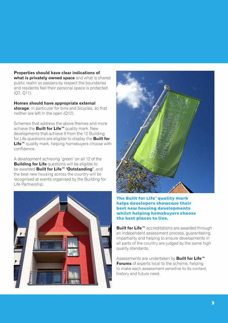
Properties should have clear indications of what is privately owned space and what is shared public realm so passers-by respect the boundaries and residents feel their personal space is protected (Q7, Q11).
Homes should have appropriate external storage, in particular for bins and bicycles, so that neither are left in the open (Q12).
Schemes that address the above themes and more achieve the Built for Life™ quality mark. New developments that achieve 9 from the 12 Building for Life questions are eligible to display the Built for Life™ quality mark, helping homebuyers choose with confidence.
A development achieving ‘green’ on all 12 of the Building for Life questions will be eligible to be awarded Built for Life™ ‘Outstanding’, and the best new housing across the country will be recognised at events organised by the Building for Life Partnership.
The Built for Life™ quality mark helps developers showcase their best new housing developments whilst helping homebuyers choose the best places to live.
Built for Life™ accreditations are awarded through an independent assessment process, guaranteeing impartiality and helping to ensure developments in all parts of the country are judged by the same high quality standards.
Assessments are undertaken by Built for Life™ Forums of experts local to the scheme, helping to make each assessment sensitive to its context, history and future need.
3

How to use BfL12BfL12 comprises of 12 easy to understand questions that are designed to be used as a way of structuring discussions about a proposed development. There are four questions in each of the three chapters:
• Integrating into the neighbourhood• Creating a place• Street and home
Based on a simple ‘traffic light’ system(red, amber and green) we recommend that proposed new developments aim to:
• Secure as many ‘greens’ as possible, • Minimise the number of ‘ambers’ and; • Avoid ‘reds’.
The more ‘greens’ that are achieved, the better a development will be.
A red light gives warning that a particular aspectof a proposed development needs to be reconsidered.
A proposed development might not achieve12 ‘greens’ for a variety of reasons4. What is important is to always avoid ‘reds’ and challenge ‘ambers’ - can they be raised to a ‘green’? Local circumstances such as the need for housing for local people in rural locations (for example, rural exception
sites) may justify waivering the requirement for ‘greens’ against the relevant questions. Third party land ownership issues may prevent ideal connectivity from being achieved, however all developments should seek to ‘future proof’ connections to allow the opportunity to provide these links at some point in the future. Waivers should be supported by the local planning authority and highlighted early in the design process. We would not recommend that any scheme is permitted a waiver against any questions within the ‘Creating a place’ and ‘Street and home’ chapters.
For these reasons, whilst we encourage local authorities to adopt BfL12, we recommend that they avoid explicitly setting a requirement for all proposed developments to achieve 12 ‘greens’. Instead, we recommend that local policies require all proposed developments to use BfL12 as a design tool throughout the planning process with schemes performing ‘positively’ against it.
We also recommend that local authorities consider expecting developments to demonstrate they are targeting BfL12 where applications for outline planning permission is granted. A useful way to express this expectation is through either a condition or ‘note to applicant’.
Homes facing the street, with public and private spaces clearly defined by a retained and sensitively restored stone wall (DeLacy Court, Castle
Donnington)

Simpler, easier and betterEach headline question is followed by a series of additional questions that we suggest are useful to ask at the start of the design process. We’ve also provided five recommendations for how you might respond with the aim of offering a range of responses.
Recommendations are designed to stimulate discussion with local communities, the project team, the local authority and other stakeholders to help you find the right solution locally.
We’ve travelled the country visiting hundreds of residential developments. During these visits, we found common problems. Our avoidance tips help you avoid these pitfalls. We also discovered many well-designed developments, their qualities have been captured in our recommendations.
Finally, we’ve added endnotes providing further detail, clarity and where appropriate, references that you may find useful.
Integrating into the neighbourhood
1 Connections Does the scheme integrate into its surroundings by reinforcing existing connections and creating new ones, while also respecting existing buildings and land uses around the development site?
2 Facilities and servicesDoes the development provide (or is it close to) community facilities, such as shops, schools, workplaces, parks, play areas, pubs or cafes?
3 Public transport Does the scheme have good access to public transport to help reduce car dependency?
4 Meeting local housing requirements Does the development have a mix of housing types and tenures that suit local requirements?
Creating a place
5 CharacterDoes the scheme create a place with a locally inspired or otherwise distinctive character?
6 Working with the site and its contextDoes the scheme take advantage of existing topography, landscape features (including water courses), wildlife habitats, existing buildings, site orientation and microclimates?
7 Creating well defined streets and spacesAre buildings designed and positioned with landscaping to define and enhance streets and spaces and are buildings designed to turn street corners well?
8 Easy to find your way aroundIs the scheme designed to make it easy to find your way around?
Street & home
9 Streets for allAre streets designed in a way that encourage low vehicle speeds and allow them to function as social spaces?
10 Car parking Is resident and visitor parking sufficient and well integrated so that it does not dominate the street?
11 Public and private spacesWill public and private spaces be clearly defined and designed to be attractive, well managed and safe? 12 External storage and amenity spaceIs there adequate external storage space for bins and recycling as well as vehicles and cycles?
5

Connections1Does the scheme integrate into its surroundings by reinforcing existingconnections and creating new ones, while also respecting existing buildings and land uses around the development site?
1a Where should vehicles come in and out of the development?
1b Should there be pedestrian and cycle only routes into and through the development? If so, where should they go?
1c Where should new streets be placed, could they be used to cross the development site and help create linkages across the scheme and into the existing neighbourhood and surrounding places?
1d How should the new development relate to existing development? What should happen at the edges of the development site?
We recommend
Thinking about where connections can and should be made; and about how best the new development can integrate into the existing neighbourhood rather than creating an inward looking cul-de-sac development.
Remembering that people who live within a new development and people who live nearby may want to walk through the development to get somewhere else, so carefully consider how a development can contribute towards creating a more walkable neighbourhood.
Thinking carefully before blocking or redirecting existing routes, particularly where these are well used.
A choice of safe, direct and attractive routes can encourage walking and cycling, particularly for shorter journeys
Creating connections that are attractive, well lit, direct, easy to navigate, well overlooked and safe.
Ensuring that all streets and pedestrian/cycle only routes pass in front of people’s homes, rather than to the rear of them.
We recommend that you avoid
Not considering how the layout of a development could be designed to improve connectivity across the wider neighbourhood.
Not considering where future connections might need to be made - or could be provided - in the future.
6

Facilities and services2Does the development provide (or is it close to) community facilities, such as shops, schools, workplaces, parks, play areas, pubs or cafes?
2a Are there enough facilities and services in the local area to support the development? If not, what is needed?
Where new facilities are proposed:2b Are these facilities what the area needs?
2c Are these new facilities located in the right place? If not, where should they go?
2d Does the layout encourage walking, cycling or using public transport to reach them?
We recommend
Planning development so that everyday facilities and services are located within a short walk of people’s homes. The layout of a development and the quality of connections it provides can make a significant impact on walking distances and people’s travel choices.
Providing access to facilities through the provision of safe, convenient and direct paths or cycle routes. Consider whether there are any barriers to pedestrian/cycle access (for example, busy roads with a lack of crossing points) and how these barriers can be removed or lessened.
Locating new facilities5 (if provided) where the greatest number of existing and new residents can access them easily, recognising that this may be at the edge of a new development or on a through route; but consider whether existing facilities can be enhanced before proposing new ones.
Where new local centres6 are provided, design these as vibrant places with smaller shops combined with residential accommodation above (rather than a single storey, single use supermarket building). Work to integrate these facilities into the fabric of the wider development to avoid creating an isolated retail park type environment dominated by car parking and highways infrastructure.
Creating new places within a development where people can meet each other such as public spaces, community buildings, cafes and restaurants. Aim to get these delivered as early as possible. Think carefully about how spaces could be used and design them with flexibility
in mind, considering where more active spaces should be located so as to avoid creating potential conflict between users and adjacent residents.
We recommend that you avoid
Locating play areas directly in front of people’s homes where they may become a source of tension due to potential for noise and nuisance. Carefully consider the distance between play equipment and homes in addition to the type of play equipment selected and the target age group.
Creating the potential for future conflict if residential uses and commercial premises are not combined thoughtfully.
A mix of uses including homes, shops and other facilities in Lawley, Telford
7

Public transport3Does the scheme have good access to public transport to help reduce car dependency?
3a What can the development do to encourage more people (both existing and new residents) to use public transport more often?
3b Where should new public transport stops be located?
We recommend
Maximising the number of homes on sites that are close to good, high frequency public transport routes, but ensure that this does not compromise the wider design qualities of the scheme and its relationship with its surroundings. ‘Hail and ride’ schemes agreed with public transport providers can help reduce the distance people need to walk between their home and public transport.
Carefully considering the layout and orientation of routes to provide as many people as possible with the quickest, safest, attractive and most convenient possible routes between homes and public transport.
Considering how the layout of the development can maximise the number of homes within a short walk from their nearest bus, tram or train stop where new public transport routes are planned to pass through the development. Locate public transport stops in well used places, ensuring that they are accessible for all, well overlooked and lit.
Considering how the development can contribute towards encouraging more sustainable travel choices, for example by establishing a residents car club, providing electric car charging points, creating live/work units or homes that include space for a home office.
Exploring opportunities to reduce car miles5 through supporting new or existing park and ride schemes or supporting the concept of transit orientated developments (where higher density and/or mixed use development is centred on train or tram stations).
We recommend that you avoid
Thinking about development sites in isolation from their surroundings. For example, bus only routes (or bus plugs) can be used to connect a new development to an existing development and create a more viable bus service without creating a ‘rat run’ for cars.
People will use buses if bus stops are close to their homes
8

Meeting local housing requirements4
Does the development have a mix of housing types and tenures that suit local requirements?
4a What types of homes, tenure and price range are needed in the area (for example, starter homes, family homes or homes for those downsizing)?
4b Is there a need for different types of home ownership (such as part buy and part rent) or rented properties to help people on lower incomes?
4c Are the different types and tenures spatially integrated to create a cohesive community?
We recommend
Demonstrating how the scheme’s housing mix is justified with regard to planning policy, the local context and viability.
Aiming for a housing mix that will create a broad-based community.
Considering how to incorporate a range of property sizes and types6, avoiding creating too many larger or too many smaller homes from being grouped together.
Providing starter homes and homes for the elderly or downsizing households. People who are retired can help enliven a place during the working day. Providing for downsizing households can also help to rebalance
the housing market and may help reduce the need for affordable housing contributions over time.
Designing homes and streets to be tenure-blind, so that it is not easy to differentiate between homes that are private and those that are shared ownership or rented.
We recommend that you avoid
Developments that create homes for one market segment unless the development is very small.
Using exterior features that enable people to easily identify market sale from rented/shared ownership homes, such as the treatment of garages or entrances.
Reducing the level of parking provision for rented/shared ownership homes.
A mix of homes can help to provide a more balanced community
9

Character5Does the scheme create a place with a locally inspired or otherwise distinctive character?
5a How can the development be designed to have a local or distinctive identity?
5b Are there any distinctive characteristics within the area, such as building shapes, styles, colours and materials or the character of streets and spaces that the development should draw inspiration from?
We recommend
Identifying whether there are any architectural, landscape or other features, such as special materials that give a place a distinctive sense of character as a starting point for design. It may be possible to adapt elevations of standard house types to complement local character.
Distinctiveness can also be delivered through new designs that respond to local characteristics in a contemporary way7.
Exploring what could be done to start to give a place a locally inspired identity if an area lacks a distinctive character or where there is no overarching character.
Architecture and green space works together to generate character in Bristol
Landscaping traditions are often fundamental to character, especially boundary treatments.Introducing building styles, details and landscaping features that can be easily expressed to someone visiting the development for the first time. Where an area has a strong and positive local identity, consider using this as a cue to reinforce the place’s overall character8.
Varying the density, built form and appearance or style of development to help create areas with different character within larger developments. Using a range of features9 will help to create town and cityscape elements that can give a place a sense of identity and will help people find their way around. Subtle detailing can help reinforce the character of areas and in doing so, provide a level of richness and delight.
Working with the local planning and highway authority to investigate whether local or otherwise different materials can be used in place of standard highways surface materials and traffic furniture. Be creative and adventurous by exploring the potential to innovate - develop new ideas and build with new materials.
We recommend that you avoid
Using the lack of local character as a justification for further nondescript or placeless development.
Ignoring local traditions or character without robust justification.
Too many identical or similar house types (where there is no benefit to the overall architectural integrity of the scheme from repetition).
10

Working with the site and its context6
Does the scheme take advantage of existing topography, landscape features (including water courses), trees and plants, wildlife habitats, existing buildings, site orientation and microclimate?
6a Are there any views into or from the site that need to be carefully considered?
6b Are there any existing trees, hedgerows or other
features, such as streams that need to be carefully designed into the development?
6c Should the development keep any existing building(s) on the site? If so, how could they be used?
We recommend
Being a considerate neighbour. Have regard to the height, layout, building line and form of existing development at the boundaries of the development site. Frame views of existing landmarks and create new ones by exploiting features such as existing mature trees to create memorable spaces. Orientate homes so that as many residents as possible can see these features from within their homes10. Carefully consider views into the development and how best these can be designed.
Assessing the potential of any older buildings or structures for conversion. Retained buildings can become instant focal points within a development. Where possible, avoid transporting building waste and spoil off site by exploring opportunities to recycling building materials within the development11.
Working with contours of the land rather than against them, exploring how built form and detailed housing design can creatively respond to the topographical character; thinking carefully about the roofscape. Explore how a holistic approach can be taken to the design of sustainable urban drainage by exploiting the topography and geology12.
Exploring opportunities to protect, enhance and create wildlife habitats. Be creative in landscape design by creating wildflower meadows rather than closely mown grassland and, where provided, creating rich habitats within balancing lagoons, rainwater gardens, rills and swales.
Considering the potential to benefit from solar gain through building orientation and design where this can be achieved without compromising good urban design or creating issues associated with over heating13. Finally have regard to any local micro-climate and its impact.
We recommend that you avoid
Leaving an assessment of whether there are any views into and from the site that merit a design response until late in the design process.
Transporting uncontaminated spoil away from the site that could be used for landscaping or adding level changes where appropriate.
Not carefully considering opportunities for rainwater attenuation both on plot and off
Not carefully thinking about what balancing lagoons will look like and how people could enjoy them as attractive features within an open space network. Careful thought in the design process can eliminate the need for fenced off lagoons that are both unsightly and unwelcoming.
Existing mature trees on this site in Exeter add character and quality
11

Creating well defined streets and spaces7
7a Are buildings and landscaping schemes used to create enclosed streets and spaces?
7b Do buildings turn corners well?
7c Do all fronts of buildings, including front doors and habitable rooms, face the street?
Are buildings designed and positioned with landscaping to define and enhance streets and spaces and are buildings designed to turn street corners well?
We recommend
Creating streets that are principally defined by the position of buildings rather than the route of the carriageway.
Designing building that turn corners well, so that both elevations seen from the street have windows to them, rather than offering blank walls to the street14. Consider using windows that wrap around corners to maximise surveillance and bring generous amounts of natural light into people’s homes.
Using a pattern of road types to create a hierarchy of streets and consider their enclosure, keeping to the well proportioned height to width ratios relative to the type of street15.
Respecting basic urban design principles when designing layouts. For example, forming strong perimeter blocks16.
Orientating front doors to face the street rather than being tucked around the back or sides of buildings.
Minimum Maximum
Minor streets, e.g mews 1: 1.15 1:1Typical streets 1:3 1:1.5Squares 1:6 1:4
Source: Manual for Streets (2007) p.54
We recommend that you avoid
Streets that lack successful spatial enclosure by exceeding recommended height to width ratios.
Over reliance on in front of plot parking that tends to create over wide streets dominated by parked cars and driveways unless there is sufficient space to use strong and extensive landscaping to compensate the lack of built form enclosure. Homes that back on to the street or offer a blank elevation to the street.
Locating garages and/or driveways (or service areas and substations) on street corners or other prominent locations, such as the ‘end point’ of a view up or down a street.
Think carefully about what you will see at the end of the street
12

Easy to find your way around8
Is the development designed to make it easy to find your way around?
8a Will the development be easy to find your way around? If not, what could be done to make it easier to find your way around?
8b Are there any obvious landmarks?
8c Are the routes between places clear and direct?
We recommend
Making it easy for people to create a mental map of the place by incorporating features that people will notice and remember. Create a network of well defined streets and spaces with clear routes, local landmarks and marker features. For larger developments it may be necessary to create distinct character areas. Marker features, such as corner buildings17 and public spaces combined with smaller scale details such as colour, variety and materials will further enhance legibility*.
Providing views through to existing or new landmarks and local destinations, such as parks, woodlands or tall structures help people understand where they are in relation to other places and find their way around.
Making it easy for all people to get around including those with visual or mobility impairments.
Identifying and considering important viewpoints within a development, such as views towards the end of a street. Anticipate other, more subtle viewpoints, for example a turn or curve in the street and how best these can be best addressed.
Creating a logical hierarchy of streets. A tree lined avenue through a development can be an easy and effective way to help people find their way around.
We recommend that you avoid
Creating a concept plan for a scheme that does not include careful consideration as to how people will create a mental map of the place.
Layouts that separate homes and facilities from the car, unless the scheme incorporates secure underground car parking.
Creating overly long cul-de-sac developments, rather than a connected network of streets and spaces.
Blocking views to landmarks or notable landscape features.
Terminating views down streets with garages, the rear or side of buildings, parking spaces, boundary fences or walls.
*Legible features include: distinct character areas (for larger developments), framing views of existing or proposed new landmarks (and/or landscape features) both on- and off- the development site, a well-defined street hierarchy (for example, tree lined avenues can help establish the character of a principle street within a hierarchy) and creating new marker buildings and spaces.
Marker buildings and spaces can help people create a ‘mental map’ of a place(Manor Kingsway, Derby)
13
Streets for all99a Are streets pedestrian friendly and are they designed to
encourage cars to drive slower and more carefully?
9b Are streets designed in a way that they can be used as social spaces, such as places for children to play safely or for neighbours to converse?
Are streets designed in a way that encourage low vehicle speeds and allow them to function as social spaces?
We recommend
Creating streets for people where vehicle speeds are designed not to exceed 20 mph18. Work with the Highways Authority to create developments where buildings and detailed street design is used to tame vehicle speeds. Sharp or blind corners force drivers to slow when driving around them while buildings that are closer together also make drivers proceed more cautiously19. 20mph zones are becoming increasingly popular with local communities and are a cost effective way of changing driver behaviour in residential areas.
Thinking about how streets can be designed as social and play spaces, where the pedestrians and cyclists come first, rather than simply as routes for cars and vehicles to pass through20.
Using the best quality hard landscaping scheme that is viable without cluttering the streets and public spaces.
Designing homes that offer good natural surveillance opportunities; carefully considering the impact of internal arrangement on the safety and vitality of the street21. Consider maximising the amount of glazing to ground floor, street facing rooms to enhance surveillance opportunities creating a stronger relationship between the home and the street .22
Creating homes that offer something to the street23, thinking carefully about detail, craftsmanship and build quality. Afford particular attention to the space between the pavement and front doors24. A thoughtful and well designed entrance area and front door scheme will enhance the kerb appeal of homes whilst also contributing towards creating a visually interesting street. Carefully
consider changes in level, the interface between different materials, quality finishing and the discreet placement of utility boxes.
We recommend that you avoid
20mph speed limits enforced with excessive signage or expensive compliance systems or features.
Designing a scheme that allows drivers to cross pedestrian footpaths at speed to access their driveways. Consider how hard and soft landscaping can be used to make drivers approach their street and home more cautiously and responsibly.
Minimise steps and level changes to make them as easy as possible for pushchairs and wheelchairs. A pavement that has lots of variation in levels and dropped kerbs to enable cars to cross it can encourage unofficial parking up on the kerb and may make movement less easy for those pushing a pushchair, in a wheelchair or walking with a stick or walking frame.
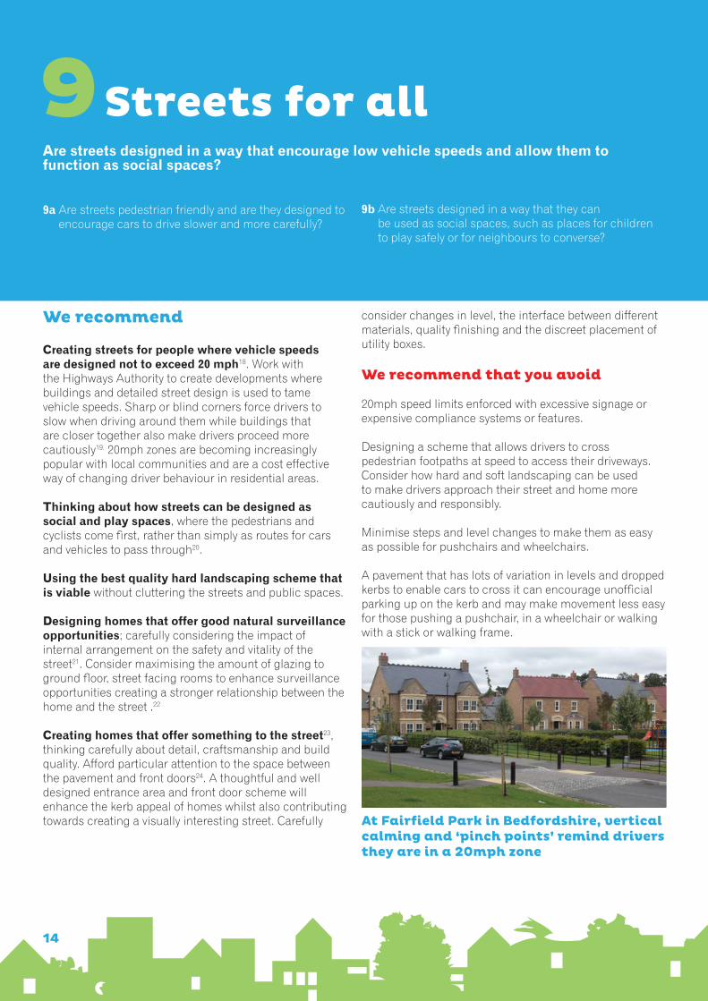
At Fairfield Park in Bedfordshire, vertical calming and ‘pinch points’ remind drivers they are in a 20mph zone
14

Car parkingIs resident and visitor parking sufficient and well integrated so that it does not dominate the street?
10a Is there enough parking for residents and visitors?
10b Is parking positioned close to people’s homes?
10c Are any parking courtyards small in size (generally no more than five properties should use a parking
courtyard) and are they well overlooked by neighbouring properties?
10d Are garages well positioned so that they do not dominate the street scene?
10
We recommend
Anticipating car parking demand taking into account the location, availability and frequency of public transport together with local car ownership trends. Provide sufficient parking space for visitors.
Designing streets to accommodate on street parking but allow for plenty of trees and planting to balance the visual impact of parked cars and reinforce the spatial enclosure of the street. On street parking has the potential to be both space efficient and can also help to create a vibrant street, where neighbours have more opportunity to see and meet other people.
Prevent anti-social parking. Very regular and formal parking treatments have the potential to reduce anti-social parking. People are less prone to parking in places where they should not be parking, where street design clearly defines other uses, such as pavements or landscape features.
Parking near front doors and softened with landscaping help this parking in Oxford integrate well with the street
Making sure people can see their car from their home or can park it somewhere they know it will be safe. Where possible avoid rear parking courts25. Using a range of parking solutions appropriate to the context and the types of housing proposed. Where parking is positioned to the front of the property, ensure that at least an equal amount of the frontage is allocated to an enclosed, landscaped front garden as it is for parking to reduce vehicle domination. Where rows of narrow terraces are proposed, consider positioning parking within the street scene, for example a central reservation of herringbone parking26. For higher density schemes, underground parking with a landscaped deck above can work well.
We recommend that you avoid
Relying on a single parking treatment. A combination of car parking treatments nearly always creates more capacity, visual interest and a more successful place.
Large rear parking courts. When parking courts are less private, they offer greater opportunity for thieves, vandals and those who should not be parking there.
Parking that is not well overlooked.
Using white lining to mark out and number spaces. These are not only costly, but unsightly. It can be cheaper and more aesthetically pleasing to use small metal plates to number spaces, and a few well placed block markers to define spaces.
Not providing a clear and direct route between front doors and on-street parking or not balancing the amount of parking in front of plots with soft relief.
15

Public & private spaces
11a What types of open space should be provided within this development?
11b Is there a need for play facilities for children and teenagers? If so, is this the right place or should the
developer contribute towards an existing facility in the area that could be made better?
11c How will they be looked after?
Will public and private spaces be clearly defined and designed to have appropriate access and be able to be well managed and safe in use?
11
We recommend
Clearly defining private and public spaces with clear vertical markers, such as railings, walling or robust planting. Where there is a modest building set back (less than 1m), a simple change in surface materials may suffice. Select species that will form a strong and effective boundary, such as hedge forming shrubs rather than low growing specimens or exotic or ornamental plants. Ensure sufficient budget provision is allocated to ensure a high quality boundary scheme is delivered.
Creating spaces that are well overlooked by neighbouring properties. Check that there is plenty of opportunity for residents to see streets and spaces from within their homes. Provide opportunities for direct and oblique views up and down the street, considering the use of bay, oriel and corner windows where appropriate. Designing balconies can further increase opportunities for natural surveillance.
Thinking about what types of spaces are created and where they should be located. Consider how spaces can be designed to be multi-functional, serving as wide an age group as possible and how they could contribute towards enhancing biodiversity27. Think about where people might want to walk and what routes they might want to take and plan paths accordingly providing lighting if required. Consider the sun path and shadowing throughout the day and which areas will be in light rather than shade. Areas more likely to benefit from sunshine are often the most popular places for people to gather.
Exploring whether local communities would wish to see new facilities created or existing ones upgraded. Think how play can be approached in a holistic manner, for example by distributing play equipment or playable spaces and features across an entire open space.
Providing a management and maintenance plan to include a sustainable way to fund public or shared communal open spaces.
We recommend that you avoid
Informal or left over grassed areas that offer no public or private use or value and do little or nothing to support biodiversity.
Avoid creating small fenced play areas set within a larger area of open space where the main expense is the cost of fencing.
Landscaping that is cheap, of poor quality, poorly located and inappropriate for its location. Low growing shrubs rarely survive well in places where people are likely to accidentally walk over them (such as besides parking bays).
Sometimes recreation space can double up as a formal landscaping feature(Gun Wharf, Plymouth)
16

External storage and amenity space
Is there adequate external storage space for bins and recycling, as well as vehicles and cycles?
12
We recommend
Providing convenient, dedicated bin and recycling storage where bins and crates can be stored out of sight. Check with the local authority to determine exactly what space is required and minimise the distance between storage areas and collection points. Where terraced housing is proposed, consider providing integral stores to the front of the property (such as within an enclosed section of a recessed porch) or by providing secure ginnels between properties that provide direct access to the rear of properties28.
Designing garages and parking spaces that are large enough to fit a modern family sized car and allow the driver to get out of the car easily. Where local authorities have requirements for garage sizes, parking spaces and circulation space design these into your scheme from the outset. If garages do not meet local requirements, do not count these as a parking space.
Considering whether garages should be counted as a parking space. If garages are to be counted as a parking space, ensure that sufficient alternative storage space is provided for items commonly stored in garages. Consider extending the length of the garage to accommodate storage needs or allowing occupants to use the roof space for extra storage29.
Anticipating the realistic external storage requirements of individual households. Residents will usually need a secure place to store cycles and garden equipment. A storage room could be designed to the rear of the property (either attached or detached from the home), reviving the idea of a traditional outhouse. More creative solutions may be needed to satisfy the cycle storage requirements of higher density apartment accommodation.
Thinking carefully about the size and shape of outside amenity space. It is a good idea to ensure that rear gardens are at least equal to the ground floor footprint of the dwelling. Triangular shaped gardens rarely offer a practical, usable space30. Allow residents the opportunity to access their garden without having to walk through their home.
12a Is storage for bins and recycling items fully integrated, so that these items are less likely to be left on the street?
12b Is access to cycle and other vehicle storage convenient and secure?
We recommend that you avoid
Bin and recycling stores that detract from the quality of the street scene.
Locating bin and recycling stores in places that are inconvenient for residents, or they might find it easier to leave their bin and containers on the street.
Designing garages that are impractical or uncomfortable to use.
Cycle storage that is not secure or is difficult to access.
Poorly integrated bin storage erode the quality of this street in Oxford
17

Using Building For Life 12 in more urban locations
1 Connections and scaleDoes the scheme respond to the scale of its surroundings, respect existing view corridors (or create new ones), and reinforce existing connections and make new ones where feasible?
Design rationale:To emphasise visual connectivity whilst ensuring that where possible, the opportunity is taken to make physical connects that are going to be well-used and of benefit to residents and the wider community.
8 Easy to find your way in and aroundIs the scheme designed to make it easy to understand the
links between where people live and how you access the building, as well as how you move through it?
Design rationale:To emphasise the importance of creating a well defined entrance(s) to a development. Is it easy to find the front door? 9 Active Streets Does the development engage with the street so passers-by will understand the movement between the building and the street, and is there an obvious visual link between inside and outside?
Supplementary design prompts were introduced in November 2014 in response to feedback from users about the need to better address design issues in more urban locations.
Building for Life 12’s core focus is on street and urban issues in schemes of between about 25-50 homes to the hectare, such as those typical of more suburban or rural locations. This supplement deals with issues found where apartment blocks of three or more storeys create new developments with few, if any, new streets and where key design issues are how blocks respond to their locality, existing streets and movement. Six of the twelve questions now have an alternative prompt to suit urban situations. Whilst the ethos of each question remains the same the emphasis and considerations reflect better the challenges and considerations associated with more urban locations and higher density developments. We recommend that design teams agree with the local authority which version of the questions are most appropriate to any proposed development.
18

Design rationale:To emphasise the importance of creating active edges to a development at street level, carefully consider how the building relates to the street, how vehicle and servicing is designed and to avoid dead elevations.
10 Cycle and car parking Will the development be likely to support and encourage cycling by providing cycle storage which people can use with confidence? Where parking is provided, is this easy to use? Are accesses to car parking designed not to impact on those not in cars? Are entrances to car parks over-engineered, visually obtrusive or obstructive to pedestrians and cyclists?
Design rationale: To emphasise the modal emphasis on bikes in more urban development where people are more likely to live close enough to work and leisure to cycle. Seeks to also promote well-designed entrances to parking areas whether at grade or underground.
11 Shared spacesIs the purpose and use of shared space clear and it is designed to be safe and easily managed? Where semi-private or private spaces are created, are these clearly demarcated from the public realm?
Design rationale:To emphasis the importance of designing such spaces to be functional, attractive and well used.
12 Private amenity and storageAre outdoor spaces, such as terraces and balconies, large enough for two or more people to sit? Is there opportunity for personalisation of these spaces? Is waste storage well integrated into the design of the development so residents and service vehicle access it easily whilst not having an adverse impact on amenity for residents.
Design rationale:To focus on practical balcony sizes and well designed communal waste facilities that are well resolved in relation to building entrances and screened from publicly accessible routes.
19

Notes
1 Department for Communities and Local Government (2011)‘Laying the Foundations: A Housing Strategy for England’, HMSO
Further supported by the National Planning Policy Framework (2012) and the Localism Act and Planning Practice Guidance.
2 To find out more about obtaining Built for Life quality mark please visit www.builtforlifehomes.org. Building for Life training and support (including facilitation of community workshops using BfL12) is available locally through the Design Network www.designnetwork.org.uk
3 Visit www.builtforlifehomes.org for further information. 4 For example, local concerns relating to crime and anti-social behaviour or cost prohibitive ransom strips may prevent the best connections being provided between a new development and its surroundings.
5 For strategic developments, such as sustainable urban extensions.
6 On larger developments.
7 A simple test is to ask how the architecture whether traditional or modern acknowledges and enhances its context. But there is no benefit in recycling tradition if treatments are not locally authentic.
8 However, this does not require pastiche. The aim is to exploit qualities in the character of local stock and link to them, not replicate them, but at the same time recognising that in some circumstances there is a need for a step change in approach to overall design ethos and approach.
9 Such as landscaping, tree lined streets, parks, greens, crescents, circuses, squares and a clear hierarchy of streets such as principal avenues, lanes, mews and courtyards, as well as colour, landscaping and detailing.
10 Consider using windows where appropriate to frame views from within the home.
11 Weathered materials can help add instant character whether within retained structures or reused as to create boundary walls, plinths or surface treatments.
12 For example by using permeable paving and creating a network of rills, swales, rain gardens and green roofs where suitable.
13 East-facing bedrooms are very popular for morning sun, while west-facing or south-facing patio gardens and living rooms boost their appeal in spring and autumn. In higher density schemes endeavour to have at least one principal room being able to receive sunlight through some of the day.
14 These windows need to serve habitable rooms where occupants tend to spend a lot of their day rather than bathrooms, hallways, stairwells and cloakrooms.
15 These may need to be varied within medium to higher density schemes.
16 Where buildings create the outside edge of the block and interlocked back gardens and/or shared amenity spaces create the middle.
17 Perhaps incorporating commercial premises where viable or designing flexible units that could be easily remodelled to accommodate commercial premises in the future.
18 By restricting forward visibility, using vertical features such as raised plateaus and/or designating Home Zones. Carefully consider the impact
of features such as over engineered corner radii on vehicle speeds and pedestrian safety and comfort. See www.20splentyforus.org.uk.
20 Shared surfaces may be appropriate in low traffic areas though carefully consider how shared environments can still be navigable by those with visual impairments.
21 First floor living rooms can be very effective for this purpose, even more so with bay or corner windows and balconies. The key attribute is that windows that face the street should be from habitable rooms where occupants are likely to spend a lot of their day.
22 Whilst also maximising the amount of natural light penetrating internal spaces.
23 Such as colour, detail, craftsmanship or other form of artistic expression and creativity.
24 Or shared access for apartment accommodation.
25 If rear parking courtyards are used, keep them small, so that residents know who else should be using it. Make sure at least one property is located at the entrance to the parking courtyard to provide a sense of ownership and security. Avoid multiple access points. Allow sufficient budget for boundary walls, surface treatments, soft landscaping and lighting to avoid creating an air of neglect and isolation. Contact the local Police Architectural Liaison Officer to determine whether local crime trends justify securing the courtyard with electric gates.
26 To avoid a car dominated environment, break up parking with a tree or other landscaping every four bays or so but ensure that the landscaping still allows space for people to get into and out of their cars, without having to step onto landscaped areas.
27 Discussions with local police officers and local community groups can be a useful source of information on what works well and what does not in a particular area and can help guard against creating potential sources of conflict.
28 If storage is provided within the rear garden, think about how bins and containers can be discreetly stored out of sight.
29 Non solid garage doors can dissuade residents from using these spaces as storage areas, but this will only be effective where sufficient alternative storage space is provided and where Permitted Development Rights are removed and enforced. 30 Where balconies are provided, design these generously so that they are large enough for a small table and at least two chairs.
References:
Department for Communities and Local Government (2012)
National Planning Policy Framework, HMSO
Department for Communities and Local Government and
Department of Transport (2007) Manual for Streets, HMSO
The Institution of Highways and Transportation (2000) Guidelines for Providing for Journeys on Foot, London. www.ciht.org.uk
20
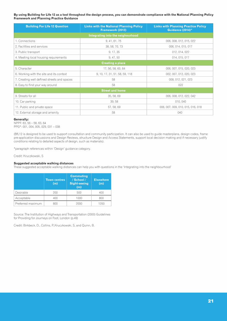
By using Building for Life 12 as a tool throughout the design process, you can demonstrate compliance with the National Planning Policy Framework and Planning Practice Guidance
Generally: NPPF: 63, 56 – 58, 63, 64PPG*: 001, 004, 005, 029, 031 – 038
(BfL12 is designed to be used to support consultation and community participation. It can also be used to guide masterplans, design codes, frame pre-application discussions and Design Reviews, structure Design and Access Statements, support local decision making and if necessary justify conditions relating to detailed aspects of design, such as materials).
*paragraph references within ‘Design’ guidance category.
Credit: Kruczkowski, S
Suggested acceptable walking distancesThese suggested acceptable walking distances can help you with questions in the ‘Integrating into the neighbourhood’
Source: The Institution of Highways and Transportation (2000) Guidelines for Providing for Journeys on Foot, London (p.49)
Credit: Birkbeck, D., Collins, P.,Kruczkowski, S, and Quinn, B.
Town centres (m)
Commuting / School /
Sight-seeing (m)
Elsewhere (m)
Desirable 200 500 400
Acceptable 400 1000 800
Preferred maximum 800 2000 1200
Building For Life 12 Question Links with the National Planning Policy Framework (2012)
Links with Planning Practice Policy Guidance (2014)*
Integrating into the neighourhood
1. Connections 9, 41, 61, 75 006, 008, 012, 015, 022
2. Facilities and services 38, 58, 70, 73 006, 014, 015, 017
3. Public transport 9, 17, 35 012, 014, 022
4. Meeting local housing requirements 9, 47, 50 014, 015, 017
Creating a place
5. Character 17, 56, 58, 60, 64 006, 007, 015, 020, 023
6. Working with the site and its context 9, 10, 17, 31, 51, 58, 59, 118 002, 007, 012, 020, 023
7. Creating well defined streets and spaces 58 008, 012, 021, 023
8. Easy to find your way around 58 022
Street and home
9. Streets for all 35, 58, 69 006, 008, 012, 022, 042
10. Car parking 39, 58 010, 040
11. Public and private space 57, 58, 69 006, 007, 009, 010, 015, 016, 018
12. External storage and amenity 58 040
21

Building for Life is the industry standard, endorsed by government for well-designed homes and neighbourhoods. It can help local communities, local authorities and developers work together to create good places to live, work and play.
‘Homes that sell for the highest amount and quicker than others have great kerb appeal. Built for Life schemes have this special kerb appeal. The streets and homes are better arranged - they are better designed places and will sell better in the future on the second hand market.’Mike Fallowell FRICS, Co-founder, Newton Fallowell.
‘Built for Life accreditation gives the consumer confidence in the quality of developments and the consideration that has gone into all aspects of the build.’Nick Boles MP, former Parliamentary Under Secretary of State for Planning.
‘This government recognises that what we build is just as important as how many homes we build.’HM Government (2011), Laying the Foundations: A Housing Strategy for England, HMSO, London.
www.builtforlifehomes.orgISBN 978-0-9576009-6-6


