Cocos (Keeling) Islands Geographic Information System System Documentation Prepared for the Territories Office, Commonwealth Department of Transport and Regional Services (DoTaRS) by Keith Porritt and Jonathon Conkey GEOSCIENCE AUSTRALIA June 2006 GA Catalogue #61840
Transcript
Cocos (Keeling) Islands Geographic Information System
System Documentation
Prepared for the Territories Office, Commonwealth Department of
Transport and Regional Services (DoTaRS)
by Keith Porritt and Jonathon Conkey GEOSCIENCE AUSTRALIA
June 2006
GA Catalogue #61840
Cocos (Keeling) Islands GIS System Documentation 2
2
Disclaimer
The data in this GIS were assembled by the Mineral Resources and Advice Project of Geoscience Australia (GA). In compiling the product, GA has translated and integrated data as received from many other sources. GA has undertaken initial checks as to the accuracy or completeness of these externally supplied datasets and the result of these examinations are reported throughout this documentation manual. It should be noted that the Cocos GIS datasets may contain information that is not totally accurate or complete. Therefore you should not rely solely on the information in this GIS when making a commercial decision. Please read the accompanying documentation and where further information is required please contact: Eddie West Territories Office Perth, Department of Transport and Regional Services. PO BOX Z5048, Perth, 6831 Ph: (08) 9225-1404 Fax: (08) 9225-1419
Cocos (Keeling) Islands GIS System Documentation 3
TABLE OF CONTENTS...................................................................................................................................... 3
LIST OF FIGURES AND TABLES .................................................................................................................... 5
COCOS GIS TEAM .................................................................................................................................6 COCOS GIS DATA .................................................................................................................................6
THE COCOS (KEELING) ISLANDS................................................................................................................. 7
GEOGRAPHY AND CLIMATE...................................................................................................................7 SOCIAL ASPECTS ...................................................................................................................................7
BACKGROUND.......................................................................................................................................8 GENERAL FEATURES .............................................................................................................................8 GETTING STARTED ................................................................................................................................8
THEMATIC LAYERS AND DATA.................................................................................................................... 9
Notes on Previous Versions........................................................................................................................... 16 CADASTRE AND GROUND AUDIT.........................................................................................................22
Notes of Previous Versions............................................................................................................................ 23 Data derived from topography ...................................................................................................................... 26
DETAILED SURVEY..............................................................................................................................26 MARINE ENVIRONMENT ......................................................................................................................27 PLANNING ...........................................................................................................................................28 WATER RESOURCES ............................................................................................................................30 NATIONAL ESTATE..............................................................................................................................31 OTHER DATA ......................................................................................................................................32
FURTHER WORK ............................................................................................................................................. 33 Annotation Capture ....................................................................................................................................... 33 Cadastre Updates .......................................................................................................................................... 33 Geographic Names and Road Names ............................................................................................................ 33 Other Data Improvements ............................................................................................................................. 33
Cocos (Keeling) Islands GIS System Documentation 4
4
APPENDIX 2: CD-ROM HTML DOCUMENTATION.................................................................................. 37
APPENDIX 3: GROUND AUDIT AND CADASTRE TABLES .................................................................... 38
APPENDIX 4: MEMORANDUM OF ARRANGEMENT – PARTICULARS OF SERVICES .................. 39
APPENDIX 5: DATA LICENSING AND AGREEMENTS............................................................................ 41
COMMONWEALTH COCOS GIS DATA LICENCE ....................................................................................42 LICENSE FOR USE OF SATELLITE IMAGERY..........................................................................................46
MULTIPLE ORGANIZATION END USER LICENSE AGREEMENT .......................................................... 46 REGISTERED USERS................................................................................................................................... 49
ENVIRONMENT AUSTRALIA MARINE DATA LICENCE. .........................................................................50 TERRITORIES OFFICE—DLI ARRANGEMENT FOR CADASTRE ..............................................................58
APPENDIX 6: LAND USE PLAN 1992 DATA DOCUMENTATION .......................................................... 59
APPENDIX 7: ECOWISE ENVIRONMENTAL REPORT OF WATER RESOURCES COMPONENT, COCOS (KEELING) ISLANDS GIS. ............................................................................................................... 60
APPENDIX 8: COCOS GIS DATA CD-ROMS............................................................................................... 61
Cocos (Keeling) Islands GIS System Documentation 5
5
List of Figures and Tables Table 1: Registered users of the satellite imagery bundled with this manual........................................................ 13 Figure 3: Data from the Utilities directory includes water supply and power infrastructure points, lines and
polygon.......................................................................................................................................................... 14 Figure 4: Examples of utilities legends in ArcView after installation of the font containing the GHD symbol set.
....................................................................................................................................................................... 15 Figure 5: An image captured from the Cocos (Keeling) Islands GIS orthophotography at approximately 1:500
scale, showing clarity and resolution of land and underwater features. Of all the datasets in the GIS, the orthophotography (created from aerial photography flown in 1987) is considered to have the highest overall spatial accuracy. ............................................................................................................................................ 17
Figure 6: Layout of all 105 1Km X 1Km orthophotography tiles created for the Cocos GIS from the 1987 aerial photographs. .................................................................................................................................................. 19
Figure 7: Flight lines and photo centres of the 1987 aerial photographs used for the Cocos GIS orthophotography. Flight lines are numbered at one end of the line. ........................................................... 20
Figure 8: Index of the orthophotography showing the names and extents of each orthophotograph tile. Each ‘.tif’ file is associated with a ‘.tfw’ file which georeferences the image. The index file is stored as a shapefile (‘orthindx.shp’) for use within ArcView and ArcExplorer projects. ............................................................. 21
Figure 3: Cadastre.shp and Lodged.shp overlayed on satellite imagery of Home Island. ..................................... 23 Topography and Culture........................................................................................................................................ 25 Figure 11: Topography and culture data from LandInfo Canberra (on behalf of AUSLIG). Labels refer to
vegetation polygons (extracted and corrected by GA). These codes cannot be sensibly decoded by reference to the AUSLIG code sheets; they will probably require someone with local knowledge to add a description........................................................................................................................................................................ 25
Figure 12: Screen capture of part of Home Island showing poor spatial accuracy for some housing features of the detail survey data. The right hand row of houses has features offset by approximately 2.5 metres compared to the orthophotography. Many of the houses also have very different shapes in the data when compared to the orthophotography. It seems probable that these features are not surveyed but retrieved from an earlier, perhaps conceptual, plan. .............................................................................................................................. 27
Figure 13: Data from ERIN include marine environmental data, some marine infrastructure and management zones.............................................................................................................................................................. 28
Figure 14: Data from NCPA include the 1992 Planning Scheme, together with over twenty supporting layers — all documented to a high standard. ................................................................................................................ 29
Figure 45: Water resources data supplied by ECOWISE Environmental Ltd includes freshwater lens extents, galleries and other water resources infrastructure. ........................................................................................ 30
Figure 16: Data from the Register of the National Estate includes point and polygon representations of registered significant sites (historic and natural)............................................................................................................ 31
Figure 17: Cocos GIS GA Catalog entry (#61840).- ............................................................................................. 35 Table 2: Full listing of cadastre.shp and lodged.shp.............................................................................................. 38 Table 5: Registered users of the satellite imagery bundled with this manual........................................................ 49
Cocos (Keeling) Islands GIS System Documentation 6
6
Acknowledgments
Cocos GIS Team The Mineral Resources and Advice Project of Geoscience Australia would like to acknowledge the support of Ms. Debra Blaskett and Mr. Peter Lawler of Territories Office whose efforts made the undertaking of this work possible. A number of people from GA contributed to the Cocos (Keeling) Islands GIS. Jane Bryan processed the satellite imagery and utilities data, projected the data to UTM(WGS84) and provided documentation updates. Martin Sholtez developed a substantial proportion of the HTML documentation and contributed data edits and documentation for a number of datasets. Dr. William McKay provided management support and advice and reviewed the 2001 release of this documentation. Neal Evans advised on and checked data and documentation issues. Geoff Lawford contributed quality assurance and quality control checks. Through this team effort valuable spatial and attribute data, that over time may have become lost, are now readily accessible in one integrated system.
Cocos GIS Data Data capture was commissioned by Territories Office in a variety of projects over the last fifteen years for all data sets except for the November 2003 satellite image which is from the Department of Environment and Heritage under a limited multi-user licence: LandInfo Canberra generated orthophotography from aerial photography flown by the Australian Survey Office Canberra on 5-Apr-87. The Australian Land Information Group (AUSLIG) digitised cultural and topographic themes for the Cocos (Keeling) Islands at both Canberra and Western Region offices in the early 1990's on behalf of Territories Office. The National Capital Planning Authority (NCPA) was commissioned by the Commonwealth Government to carry out a planning study that assembled the Land Use Plan and Planning Scheme data dated February 1992. The Western Australian Department of Lands Administration (DoLA) extracted the cadastre snapshot packaged on this CD-ROM set from the DoLA database on 30-Dec-99. Responsibility for the cadastral information passed from AUSLIG to DOLA in 1992. On-going maintenance of cadastre is undertaken by DLI under a Memorandum of Arrangement with Territories Office. AUSLIG, DOLA and the Australian Valuation Office (AVO) jointly developed data underpinning the March 1996 ground audit of Cocos (Keeling) Islands through Australian Estate Management (AEM) as consultants to Territories Office. Environment Australia is the custodian of the marine environment data referred to as Environment Australia (1998) Whelans Cocos GIS (1998). A separate licence agreement applies to this data set (see Chapter 8). Gutteridge Haskins &Davey (GHD) Pty Ltd assembled the utilities data and the 2003 cadastre from Computer Assisted Drawing (CAD) over a period from 1994 to 25-03-2003.
Cocos (Keeling) Islands GIS System Documentation 7
7
The Cocos (Keeling) Islands
The Cocos (Keeling) Islands are one of Australia's Indian Ocean Territories. They are located in the Indian Ocean 2,950 kms north-west of Perth, 3,700 kms west of Darwin, and 900 kms south west of Christmas Island (96° 52' East' 12° 10' South). There are 27 coral islands in the group, with a total land area of approximately 14km2.
Geography and Climate Apart from North Keeling Island, which is approximately 30kms from the main group, the islands form a typical horseshoe-shaped atoll surrounded by a coral reef. Each island has rough coral beaches to seaward and sandy beaches or mudflats on the lagoon side. The Islands are low lying and most are thickly covered with coconut palms. Wildlife consists mainly of seabirds, such as frigatebirds and booby birds, which are restricted to uninhabited islands, especially North Keeling. Land crabs are common on all islands. The climate is tropical with high humidity. Temperatures range from 20°C to 30°C. The average rainfall is 2000mm per annum, falling mainly from January to August. The south-east trade winds blow most of the year, producing pleasant weather conditions.
Social Aspects The population of the Cocos (Keeling) Islands was estimated at 675 persons in November 1998. This represents a slight increase from the figure of 655 persons reported at the 1996 census. The 1998 population comprised 552 persons on Home Island and 123 persons on West Island. Home Island is the location of the Cocos Malay community. The Cocos Malays have significant social and cultural links to communities in Asia (particularly Sabah) and Western Australia. West Island's population comprises mainland-based public servants and contractors, long term residents and their families. Copra provided an initial base for the Cocos (Keeling) Islands economy. The public sector is now the largest area of economic activity, although contracting out of activities has provided increased opportunities for the private sector. Tourism is potentially a significant area of economic activity in the Cocos (Keeling) Islands. Local attractions include diving, fishing and wind-surfing.
Cocos (Keeling) Islands GIS System Documentation 8
8
Chapter
1 Introduction
Background This documentation accompanies the delivery of the Cocos (Keeling) Islands Geographic Information System (Cocos GIS) to the Department of Transport and Regional Services (Territories Office), on completion of Stage 2 (October 2000). The major tasks and activities associated with the project are as set out in the Memorandum of Arrangement (MoA) with Territories Office dated 10th October 1999 (Chapter 7).
General Features The Cocos (Keeling) Islands Geographic Information System is a collection of spatial data, viewing and analysis tools dealing with the Cocos (Keeling) Islands. The data include orthophotography, topographic, cultural and environmental features both of the islands and the ocean immediately surrounding them. Compilation of data and its organisation into a GIS together with documentation was undertaken by the Geoscience Australia (GA) at the request of the Territories Office, Department of Transport and Regional Services (DoTaRS). The data are presented in both ESRI ArcView and ArcExplorer projects. The ArcView projects require a licensed copy of ArcView. ArcExplorer is a free viewer and is distributed with the Cocos GIS CD-ROM. Data are stored as ESRI shapefiles and therefore readily useable with most modern GIS applications. Data were received from a variety of custodians and in many cases had no accompanying documentation. Lack of documentation made it increasingly difficult for GA with interpretation, translation and documentation of data. GA has attempted to include metadata for all datasets to ANZLIC core metadata standards, but the value of this is limited by the poor initial documentation. In addition to limited documentation, many datasets had inconsistent spatial accuracy. In some cases further work could be done by GA to improve the value of the data, but this would be beyond the scope of the current MoA.
Getting Started CD-ROM # 1 automatically runs a web (HTML) document containing details and tools for getting started with the Cocos (Keeling) Islands GIS. A hard copy of this document is included with this documentation in Chapter 5.
Cocos (Keeling) Islands GIS System Documentation 9
9
Chapter
2 Thematic Layers and Data
Viewers The Cocos GIS CD-ROM # 1 contains ESRI’s free data viewer ArcExplorer 2.0. This enables viewing of all the vector data and the TIFF versions of the raster data. If editing or more complex GIS analysis is required, ArcView GIS should be used. GA has made every effort to correct errors in the source data. Use in ArcInfo or most other available GIS software packages should be straightforward.
Data Formats The Cocos GIS uses ESRI shapefiles as its major vector format. This enables editing within ESRI ArcView GIS rather than requiring a more expensive software package. It also allows preservation of 3-D data components. The existence of a 3-D component, which enables easy viewing in a 3-D viewer such as ArcView’s 3-D Analyst, was preserved wherever possible to maximise data value. In cases where this may limit shapefile portability to other software packages, the 3-D component can be removed by saving as a 2-D shapefile from ArcView. The primary format for raster data is uncompressed Tagged Image File Format (TIFF) full colour. A secondary format is Enhanced Compressed Wavelet (ECW) format (a compressed format distributed with ERMapper and viewable in ArcView after the installation of a plug-in). This format significantly reduces file size and is quick to view. GA has observed some spatial accuracy variability at higher resolutions with some ECW format images. Source files are in a variety of formats, as received from the data custodian. Source formats include Microstation Design Files (DGN), ESRI Shapefiles, ESRI Coverages, ESRI ArcInfo Export (E00), MapInfo (TAB, MID/MIF) as well as various tabular and database formats.
Projection The 2006 Cocos GIS stores data in the UTM(WGS84) projection. Previous versions of the Cocos GIS used the Cocos (Keeling) Islands Grid 1992 (CKIG92). This data has been projected to UTM(WGS84) Zone 47 using the ArcView projection wizard, and the ERMapper Geocoding wizard.
Cocos (Keeling) Islands GIS System Documentation 10
10
COCOS (KEELING) ISLAND GRID 1992 (CKIG92)
Projection: Universal Transverse Mercator Zone 47 South Datum: WGS 1984 Spheroid: WGS 1984 False Easting: 500000 False Northing: 10000000 Central Meridian: 99 Latitude of Origin: 0, 0 Scale Factor: 0.9996 Units: metres.
For more information about projecting using ArcView, refer to ‘CocosGIS\document\ reprojecting_shapefiles_arcview.doc’ located on cd-rom#1. For more information about adding the CKIG92 projection to ERMapper , refer to ‘CocosGIS\\document\Adding_CKIG92_to_ERmapper.txt’ located on cd-rom#1. If creating ArcView projection files (PRJ), be aware that this can cause problems with loading shapefiles into ArcExplorer 2.
Cocos (Keeling) Islands GIS System Documentation 11
11
Satellite Imagery
Quickbird satellite imagery of Cocos (Keeling) Islands was commissioned by the Department of Environment and Heritage in mid 2003. All of the Southern Atoll was supplied to the Australian Government by DigitalGlobe in November 2003 and North Keeling Island was sensed in January 2004. The Quickbird satellite recorded reflectance data of the islands in the red, green, blue, near infra-red and panchromatic bands, in 11 bit format. The resolution of the sharpened satellite imagery is 0.6m/pixel. Geoscience Australia was supplied with the full multi-spectral data for the Cocos (Keeling) Islands in the form of an 8 bit TIFF image containing the red, green, blue and near infra-red bands. The panchromatic band was also supplied as an 8-bit TIFF. DigitalGlobe undertook pan-sharpening of the satellite imagery, in the process dividing the imagery into four sections. Four 8-bit pan-sharpened TIFFs, one for each of the four sections, containing the red, green and blue bands was supplied to GA. Each pixel on the pan sharpened imagery represents 0.6m. Further details regarding the satellite imagery can be viewed in the full DigitalGlobe documentation ‘CocosGIS\data\sat_imagery\ DigGlobe_productguide_2003.pdf’.
Figure 1: The Cocos (Keeling) Islands as reprojected as one whole image.
Please read the license for terms and conditions of using the satellite imagery contained on cd-rom #1. It is located in the ‘/CocosGIS/document/licenses’ directory under the name of ‘MULTIPLE_ORGANIZATION.TXT’. There is also a copy in Chapter 8: Data Licensing and Agreements of this manual. If you are unsure whether you are a registered user of the satellite imagery please consult the ‘registered_users.pdf’ file in the same directory. Alternately there is a list of registered organisations at the end of this section and also in Chapter 8: Data Licensing and Agreements.
Cocos (Keeling) Islands GIS System Documentation 12
12
All satellite images were supplied to Geoscience Australia in UTM WGS84 Geographics. GA joined the images using ER Mapper 6.4 and then using the ER Mapper Geocoding Wizard GA reprojected the full image into UTM GDA94. [Previously due to restrictions in computer processing power and a file size limit in ER Mapper 6.3 the four pan sharpened images were reprojected separately which led to gaps appearing at the joins in the four sections.] Also received from Digital Globe was a satellite image of North Keeling Island. As with the other satellite imagery this was supplied as a multi-chromatic, a pan-chromatic image and a pan sharpened. Using the ER Mapper Geocoding Wizard Geoscience Australia reprojected the image into UTM GDA94. DigitalGlobe advise that the positional accuracy of the imagery is +/-14.7m RMSE (Root Mean Square Error). Due to this low level of positional accuracy, an XY shift was also applied to more accurately position the imagery by correlation with the lodged cadastre on screen as follows: Before cadastral re-alignment (see cadastre section of manual): X=16.9m East Y=6.9m South After cadastral re-alignment X=2.4m West Y=3.14m South This shift brought the imagery inline with the current cadastre and reprojected orthophotography.
Figure 2: North Keeling Island satellite imagery after reprojection. Notice that shallow waters around the island become obvious.
Cocos (Keeling) Islands GIS System Documentation 13
13
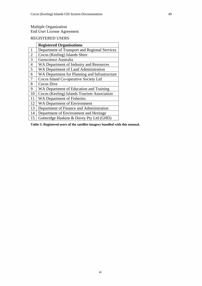
Due to disk space limitations these images are stored in ECW (Enhanced Compressed Wavelet) format. The main Cocos Island group is stored in the ‘CocosGIS\data\sat_imagery\ecw’ directory under the filename of ‘cocos_satim.ecw’. The North Keeling Island ECW is located in the same directory with the filename ‘nth_keeling.ecw’ Registered Organisations 1 Department of Transport and Regional Services 2 Cocos (Keeling) Islands Shire 3 Geoscience Australia 4 WA Department of Industry and Resources 5 WA Department of Land Administration 6 WA Department for Planning and Infrastructure7 Cocos Island Co-operative Society Ltd 8 Cocos Dive 9 WA Department of Education and Training 10 Cocos (Keeling) Islands Tourism Association Table 1: Registered users of the satellite imagery bundled with this manual.
Full Notes from The Cocos GIS 2003 release The satellite imagery was supplied in UTM WGS84 Geographics. Due to limitations of software and hardware Geoscience Australia projected the four 8 bit pan-sharpened TIFF images of the main atoll into UTM WGS84. The four reprojected TIFFs were then joined. As a result gaps between the four sections of imagery were apparent. The image in it’s entirety was saved as an Enhanced Compressed Wavelet (ecw) image, where each pixel represented 0.6 metres. Nineteen 1km x 1km TIFF images, and two 1.5km x 1km TIFF images covering Home, West and Direction Island were created from the image and are included with the 2006 release of the Cocos GIS. Geoscience Australia shifted the ecw image (X +16m, Y – 7m) to match the more accurately positioned 2003 cadastre shapefile and the orthophotography. The TIFFs over Home and Direction Islands (X +16m, Y -7m) and West Island (X +14m, Y -9m) were also shifted to align with the orthophotography and 2003 cadastre.
Cocos (Keeling) Islands GIS System Documentation 14
14
Utilities GHD Surveys supplied waste water, water supply, gas, fuel, power, and telecommunications data in ESRI shapefile format as well as Computer Assisted Drawing (CAD) file format. The utilities data were supplied in the CKIG92 projection. The CAD files are not stored in the GIS CDs due to disk space limitations. GA projected the utilities data to UTM(WGS84) using ArcView and the shapefiles are stored in the ‘CocosGIS\data\utilities’ directory. Data manipulation prior to receipt by GA can be seen in the original documentation by opening the file ‘CocosGIS\document\GHD_meta_util.pdf’ located on cd-rom #1.
Figure 3: Data from the Utilities directory includes water supply and power infrastructure points, lines
and polygon.
The cd-rom supplied by GHD contained a number of customisations to enhance ArcView’s interface. These included a ‘metatool’ (for viewing the utilities metadata sheet), hotlinks to CAD files and a GHD special font set. The GHD-supplied custom font allows ArcView to generate point theme legends with custom symbols preferred by GHD. Examples of these can be seen in Figure 4. GA considers that GHD did not adequately document how to implement this special font.
Cocos (Keeling) Islands GIS System Documentation 15
15
Some of the GHD enhancements required registry edits, installation of DLLs in addition to ArcView extension (AVX) files. This is requires a level of system access not available on most public service PCs. Consequently these particular enhancements were not implemented by GA. The font used for GHD symbology is stored on CIGIS CD1 as ‘CocosGIS\data\utilities\Ghdsym.ttf’. In order to view the symbols as GHD intended, install this font by opening your windows font directory (eg. C:\winnt\fonts), clicking ‘File|Install New Font…’, navigating to ‘cd-rom #1 CocosGIS\data\utilities’, selecting 'GHD Utilities Geocomp Symbols (TrueType)' and pressing ‘OK’.
Figure 4: Examples of utilities legends in ArcView after installation of the font containing the GHD
symbol set.
Cocos (Keeling) Islands GIS System Documentation 16
16
Orthophotography The current release of the Cocos (Keeling) Islands GIS includes repositioned and reprojected versions of the orthophotography matching the included satellite imagery. Using ERMapper a mosaic of the orthophotography was projected into GDA94 in BIL (Band Interleaved by Line) format. This was then sliced into separate tiles using the ‘erswarp’ utility which comes included with ER Mapper. An example of usage is shown on the left. The full batch file used to create the tiles has been included on cd-rom #1 under CocosGIS\document\cocos_tiles.bat.
Notes on Previous Versions Digital orthophotography has been prepared from aerial photography flown on the 5th April 1987 by the Australian Survey Office Canberra. GA commissioned LandInfo Canberra to generate orthophotography from the 1987 aerial photography as a component of this Cocos GIS project that GA undertook on behalf of Territories Office. The orthophotography has a 25cm on-the-ground pixel size. A ‘pixel’ or ‘picture element’ is the smallest component in a digital image — a pixel is an individual square of colour. The quality of the orthophotography is impressive, with acceptable resolution down to 1:400 scale.
erm_run erswarp -j 269529.8070216110 -k 8661242.5412299900 -l 270519.8070216110 -m 8660242.5412299900 -t map -z G:\\atlas\\anima~aq\\cocos~h_\\home_~dq.ers G:\\atlas\\anima~aq\\cocos~h_\\output\\home2.ers This command must be run from the ‘\ERMapperX\bin\win32’ folder. Note that due to changes in version of ERMapper to 6.4, the erm_run command must be used to initialise erswarp. To access a full list of usage commands for erswarp run the following in the ‘\ERMapperX\bin\win32’ folder: erm_run erswarp -u
Cocos (Keeling) Islands GIS System Documentation 17
17
Figure 5: An image captured from the Cocos (Keeling) Islands GIS orthophotography at approximately
1:500 scale, showing clarity and resolution of land and underwater features. Of all the datasets in the GIS, the orthophotography (created from aerial photography flown in 1987) is considered to have the highest overall spatial accuracy.
The orthophotography is considered to be the most accurately located dataset overall. This high quality locational accuracy results from the use of surveyed ground control points in conjunction with recognisable features and a 3D model. In addition, the southern atoll is bridged by an intersecting flight line pattern, which also underpins the high positional accuracy. The triangulation report for the survey control is stored on cd-rom #2 at ‘CocosGIS\data\orthphto\source\control\aig_ls3.doc’ (Microsoft® Word 97 format — a text only version is also stored at that location) and shows there was a good fit of the control from a mathematically rigorously method and pattern. Hardcopy sketches of the survey ground control points are held in archive and are available for inspection. Orthophotography was generated in Cocos (Keeling) Islands Grid 1992 (CKIG92) by transforming the aerial photography survey control to CKIG92. This involved a projection of the survey control file "aig.ctl" (cd-rom #2
Cocos (Keeling) Islands GIS System Documentation 18
18
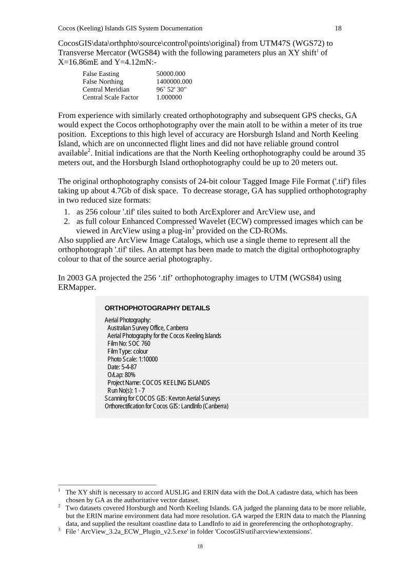
CocosGIS\data\orthphto\source\control\points\original) from UTM47S (WGS72) to Transverse Mercator (WGS84) with the following parameters plus an XY shift1 of X=16.86mE and Y=4.12mN:-
False Easting 50000.000 False Northing 1400000.000 Central Meridian 96˚ 52' 30" Central Scale Factor 1.000000
From experience with similarly created orthophotography and subsequent GPS checks, GA would expect the Cocos orthophotography over the main atoll to be within a meter of its true position. Exceptions to this high level of accuracy are Horsburgh Island and North Keeling Island, which are on unconnected flight lines and did not have reliable ground control available2. Initial indications are that the North Keeling orthophotography could be around 35 meters out, and the Horsburgh Island orthophotography could be up to 20 meters out. The original orthophotography consists of 24-bit colour Tagged Image File Format ('.tif') files taking up about 4.7Gb of disk space. To decrease storage, GA has supplied orthophotography in two reduced size formats:
1. as 256 colour '.tif' tiles suited to both ArcExplorer and ArcView use, and 2. as full colour Enhanced Compressed Wavelet (ECW) compressed images which can be
viewed in ArcView using a plug-in3 provided on the CD-ROMs. Also supplied are ArcView Image Catalogs, which use a single theme to represent all the orthophotograph '.tif' tiles. An attempt has been made to match the digital orthophotography colour to that of the source aerial photography. In 2003 GA projected the 256 ‘.tif’ orthophotography images to UTM (WGS84) using ERMapper.
ORTHOPHOTOGRAPHY DETAILS
Aerial Photography: Australian Survey Office, Canberra Aerial Photography for the Cocos Keeling Islands Film No: SOC 760 Film Type: colour Photo Scale: 1:10000 Date: 5-4-87 O/Lap: 80% Project Name: COCOS KEELING ISLANDS Run No(s): 1 - 7 Scanning for COCOS GIS: Kevron Aerial Surveys Orthorectification for Cocos GIS: LandInfo (Canberra)
1 The XY shift is necessary to accord AUSLIG and ERIN data with the DoLA cadastre data, which has been
chosen by GA as the authoritative vector dataset. 2 Two datasets covered Horsburgh and North Keeling Islands. GA judged the planning data to be more reliable,
but the ERIN marine environment data had more resolution. GA warped the ERIN data to match the Planning data, and supplied the resultant coastline data to LandInfo to aid in georeferencing the orthophotography.
3 File ' ArcView_3.2a_ECW_Plugin_v2.5.exe' in folder 'CocosGIS\util\arcview\extensions'.
Cocos (Keeling) Islands GIS System Documentation 19
19
Figure 6: Layout of all 105 1Km X 1Km orthophotography tiles created for the Cocos GIS from the 1987
aerial photographs.
Cocos (Keeling) Islands GIS System Documentation 20
20
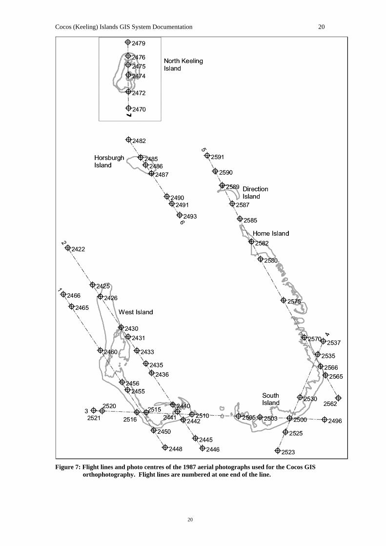
Figure 7: Flight lines and photo centres of the 1987 aerial photographs used for the Cocos GIS
orthophotography. Flight lines are numbered at one end of the line.
Cocos (Keeling) Islands GIS System Documentation 21
21
Figure 8: Index of the orthophotography showing the names and extents of each orthophotograph tile.
Each ‘.tif’ file is associated with a ‘.tfw’ file which georeferences the image. The index file is stored as a shapefile (‘orthindx.shp’) for use within ArcView and ArcExplorer projects.
Cocos (Keeling) Islands GIS System Documentation 22
22
Cadastre and Ground Audit In December 2004 Geoscience Australia received the scheduled cadastral update from Tony Yeomans of the Department of Land Information (DLI, formerly DoLA). This update consisted of two ESRI shapefiles and two access databases. One of the ESRI shapefiles contains current property boundary information and the other contains lodged changes to property boundaries. Both ESRI shapefiles arrived at Geoscience Australia pre-projected in UTM (GDA94). The reason for differences between the lodged cadastre and the current cadastre is that current data could have been calculated or digitized, etc. When lodged data is integrated into current, the area is spatially upgraded with the new survey data (lodged data) as this would be more accurate4. One access database contained data relating to tenure information including address. The other contained data on reserves. In January 2005 Geoscience Australia also obtained ground audit data from Peter Brockmulen of the Department for Planning and Infrastructure (DPI, formerly DoLA). This ground audit was conducted in 2004 at the request of the Department of Territories and Rural Services (DoTaRS) in Western Australia. It contains data describing land use and reserve usage. To produce the final cadastral information the files were modified and combined as follows. Due to initial consultation with users of the Cocos GIS it was decided to keep the cadastre containing current property boundaries and the cadastre containing lodged changes to property boundaries separate. As such the following changes were made to each file separately. Additionally the cadastral boundary for North Keeling Island, taken from the last version of the cadastre, was joined to the current cadastre shapefile. From discussion with users of the Cocos GIS it became apparent that the field LOT_TYPE was causing confusion with it’s meaning. This is because it is a computer generated field that does not reflect the tenure of the land. Instead land tenure is derived from the PI_PARCEL field. To avoid this problem GA removed the LOT_TYPE field and replaced it with a TENURE field derived from the PI_PARCEL field and based on the definitions from the NORM manual5 as supplied by DLI. Using tenure information from the database supplied by DLI and from the land audit information supplied by Peter Brockmulen, GA joined on the fields ADDRESS, ZONING, RESERVE, PURPOSE and MANAGEMENT were joined on lot number. For multiple instances of lot numbers information was entered manually based on the land audit information supplied by Peter Brockmulen. From reserve data supplied by DLI the fields RSV_VESTIN, RESERVE_US and LGA were joined using the PIN field. Finally GA made the decision to move the cadastral data to be in line with previous data such as orthophotography. As such the following XY shift was used on both the cadastre and the
4 Email from Tony Yeomans of DLI, 14th February 2005. 5 NORM files are a series of sequential files which DLI (formerly DoLA) uses to disseminate spatial and tenure
data. Each of the files contains attribute data for a single tenure or spatial entity. The content of the NORM files is generally normalised, with data from different files related through common key attributes. Taken from ‘NORM files’ September 2—2, by DoLA
Cocos (Keeling) Islands GIS System Documentation 23
23
lodged shape files: X+3.26m Y-1.04m This set cadastre data within 0.1m of older versions. In the future GA plans to asses the positioning of the cadastre based on the GPS ground control station on West Island and the satellite imagery. In the ‘CocosGIS\cadastre\cadastre_dli’ folder is the lodged and cadastre shape files as projected by DLI but with all data joined.
Figure 3: Cadastre.shp and Lodged.shp overlayed on satellite imagery of Home Island.
Notes of Previous Versions In August of 2004 DoLA supplied GA with the scheduled update to the cadastre in the form of and ESRI shapefile. The data was supplied to GA pre-projected in UTM (GDA94). Through observation this was found to be accurate and as such GA did not reproject this data. For the first time this included a positioned cadastral outline of North Keeling Island. Also for the first time the dataset included both the current cadastral tenure boundaries and the lodged changes to tenure boundaries. To produce the final cadastre the current tenure boundaries and the lodged tenure boundaries were combined (this is no longer the case). Data from previous cadastral tables was then joined using pin number. In 2003, GHD Surveys Pty Ltd provided GA with an updated cadastre in ESRI shapefile format. This cadastre was supplied in the CKIG92 projection. GA projected the 2003 cadastre to UTM (WGS84) using ArcView. The 2003 cadastral data cover most of the main group of islands. Horsburgh Island and North Keeling Island were not included in the cadastre.
Cocos (Keeling) Islands GIS System Documentation 24
24
By observation spatial accuracy was good across all the islands. This can be difficult to check, since cadastral boundaries do not usually correspond to natural features. When compared to the orthophotography (which should be spatially accurate for the southern atoll), features matched well on all the islands. For previously supplied datasets (eg 30-DEC-99) GA confirmed the coordinate system to be geographic (World Geodetic System 1984). DoLA are confident of the transformation of the original WGS72 data to WGS84 but note earlier co-ordinates are based on a doppler survey and so may not be so accurate6. The cadastre is however the most rigorously surveyed vector dataset and so the cadastre was selected by GA to be the authoritative vector dataset. GA projected the cadastral dataset to CKIG92 using the ArcView 3.2, a projection utility. The cadastral data cover most of the main group of islands. Horsburgh Island and North Keeling Island were not included in previous versions of the cadastre. By observation spatial accuracy is variable (the cadastre is difficult to check, since cadastral boundaries do not usually correspond to natural features). When compared to the orthophotography (which should be spatially accurate for the southern atoll), West Island features match well over the whole island. Home Island matches well for the majority of the island, but with significant offset of features at the northern end of the island. Direction Island matches well. The cadastre for South Island and the small islands of southeast Cocos appears poorly located. For this area, different groups of islands in similar vicinities have different offsets from the orthophotography, suggesting erroneous positioning of the cadastre rather than a general projection error. For the final cadastre version, GA moved some of these individual small islands, and occasionally stretched the features in an X and/or Y direction. The majority of this work was done at a scale of 1:2500. South Island required warping to get a reasonable match to the orthophotography. GA used the ArcView Extension ShapeWarp to register and warp this island and small islands surrounding it. Movements of cadastre features for southeast Cocos tend to be up to 20 meters, but can be around 40 meters. The original shapefile had some erroneous polygons (43 regions), which had small visible representations and large areas. As these areas did not have attributes and in all cases checked were not unique, they were deleted from the projected shapefile. The majority of attributes in the final cadastre shapefile are from the Ground Audit data, which were joined to the cadastre using the Pin field.
6 Pers Comm and e-mail; Linda Morgan, DOLA 21&27/1/00, Ph 08 9273 7135.
Cocos (Keeling) Islands GIS System Documentation 25
25
Topography and Culture
Data representing topography and culture were received from LandInfo Canberra (on behalf of the Australian Surveying and Land Information Group (AUSLIG)) in design file format (DGN). Documentation was not supplied with this data and is apparently not available. Coverage is restricted to Home and West Islands. It is probable that the nominal scale of this data is 1:1000 as similar data collected by AUSLIG for Christmas Island are of this scale. Evaluation of the data suggests that the probable source coordinate system is Universal Transverse Mercator (UTM) Zone 47 (World Geodetic System 1972 (WGS72)). Using this input coordinate system, projection to CKIG92 resulted in a mismatch of coordinates. Using similarly digitised features in the coastlines, GA found that an X-shift (16.86mE) and a Y-shift (4.12mN) of the AUSLIG data resulted in a match with the cadastre for West Island. Home Island did not match as well and a further X-shift of 2.22 metres East matched the centre of the township on Home Island to ± 0.25 metres. The far Northern end of Home Island is the worst located with features approximately 5 metres West of the orthophotography. In the wharf area, features are approximately 1.5 metres West of the orthophotography. The road features in the far East of the island are approximately 2.5 metres East of the orthophotography, and the South-West of the island matches the orthophotography to ± 0.5 metres. Attempts to warp Home Island features to match the orthophotography were not acceptable.
Figure 11: Topography and culture data from LandInfo Canberra (on behalf of AUSLIG). Labels refer to
vegetation polygons (extracted and corrected by GA). These codes cannot be sensibly decoded by reference to the AUSLIG code sheets; they will probably require someone with local knowledge to add a description.
Cocos (Keeling) Islands GIS System Documentation 26
26
Data derived from topography Two coverages have been derived from the AUSLIG topography by GA in order to enhance the useability of the data in a GIS. These are a vegetation layer (vegetatn.shp) and a road centrelines layer (roads.shp). There are a number of features in the original topography data that do not have valid AUSLIG codes. Comparison with the orthophotography indicates that all these codes represent vegetation. GA has extracted these codes and created a polygon layer (in ArcInfo) by including common lines as well as those coded as a particular type. The resulting layer is coded according to the erroneous codes in the original data. Because the level of detail is different from the vegetation layers in the planning data, correlation was not conclusive. Re-coding according to actual vegetation types is recommended if this layer is to be used for analysis. The vegetation appears to match the 1987 orthophotography, and would therefore be out of date in some areas due to the fact that the 1992 planning data documentation reveals that areas have been cleared since the 1987 air photos. For GIS analysis using a road network, GA has created a road centreline layer based on the topographic data. This was accomplished using the ArcInfo 8.0.2 CENTERLINE command and then manually correcting (in ArcEdit) at intersections and elsewhere based on the original dataset and, to a lesser extent, the orthophotography. Converting to ArcInfo format necessitated dropping the third dimension from the data. GA did not attempt to digitise road features from the orthophotography where digital data did not exist. Users should be aware that the road centreline coverage is therefore incomplete. It would be useful if future work included the addition of further attributes (especially road names — which none of the available topographic and cultural data include). In 2003 GA projected the topography and culture data to UTM(WGS84) using ArcView.
Detailed Survey LandInfo Perth supplied detail survey data on behalf of AUSLIG. No documentation was available for this data except for working notes on the CD-ROM. The spatial component of the data was supplied in design file format (DGN). As Ground Audit databases were also supplied with this data, it is possible that the detail survey was associated with the ground audit, which would date it at around 1996. This dataset is valuable in that it contains features such as services (utilities) that are not available in other datasets. Coverage is restricted to the populated areas of Home and West Islands for the detailed data, with lower resolution data for general coverage of Home and West Islands. It was assumed that the data was supplied in the UTM Zone 47 (WGS72) coordinate system. Projection to CKIG92 with the addition of an X-shift of 16.86 metres East and a Y-shift of 4.12 metres North appears to confirm this. This is the same XY shift that was applied to both the Topography & Culture dataset and to the Marine Environment dataset. In contrast to other datasets, a good match of features with the orthophotography at the northern end of Home Island has been achieved (this area matches the cadastre). Inside the detail survey area features generally match the orthophotography locationally to within ±0.25 metres. Outside the detail survey area features may be up to ±7.5 metres displaced with respect to the orthophotography. Many building shapes do not match the orthophotography, to the extent that their shapes are not even close to a match. One row of buildings is consistently displaced by approximately three metres. Many features are mislabelled. For example, map tic marks are labelled as
Cocos (Keeling) Islands GIS System Documentation 27
27
drainage pipes. It appears that this dataset is incomplete and has certainly not gone through rigorous quality control. Some housing shapes appear to be from an early conceptual plan rather than a survey of housing at the time of this data’s creation. Although there is a lot of potentially useful data in this dataset, the logical consistency of both the spatial and attribute components appears flawed. In 2003, GA projected the Detailed Survey data to UTM(WGS84) using ArcView.
Figure 12: Screen capture of part of Home Island showing poor spatial accuracy for some housing
features of the detail survey data. The right hand row of houses has features offset by approximately ± 2.5 metres compared to the orthophotography. Many of the houses also have very different shapes in the data when compared to the orthophotography. It seems probable that these features are not surveyed but retrieved from an earlier, perhaps conceptual, plan.
Marine Environment Marine environment data were obtained from the Environmental Resources Information Network (ERIN). ERIN refers to this dataset as Environment Australia (1998) Whelans Cocos GIS (1998). This includes coastlines, bathometric contours, coral outcrops and other features. This data is now supplied on CD-ROM #2 of the Cocos (Keeling) Islands GIS. The data were supplied as ArcInfo export files, but relevant documentation was not available. Documentation provided by ERIN with the data actually referred to a different dataset, namely the Cocos (Keeling) Islands Land Use Plan of 1992. Evaluation of the marine environment data established a match with the cadastre on West Island using a projection from UTM Zone 47 (WGS72) to CKIG92 plus an X-shift of 16.86 metres East and a Y-shift of 4.12 metres North. This is the same XY shift that was applied to
Cocos (Keeling) Islands GIS System Documentation 28
28
both the Topography & Culture dataset and to the Detailed Survey dataset. However all other islands are significantly mis-located. Attempts to warp these features or to derive a coordinate transformation were not successful. The actual marine zone features appear to be of a relatively low resolution anyway, defining approximate rather than exact boundaries. Interestingly they seem to match the spot image. In 2003 GA projected the Marine Environment data to UTM(WGS84) using ArcView.
CAUTION
It is recommended that the use of the Marine Environment data be restricted to broad-scale applications and that caution be exercised (especially away from West Island) due to poor spatial accuracy.
Figure 13: Data from ERIN include marine environmental data, some marine infrastructure and
management zones.
Planning The Cocos (Keeling) Islands Land Use Plan and Planning Scheme (June 1992) was prepared for the Cocos (Keeling) Islands Council by the National Capital Planning Authority (NCPA) and the Commonwealth Department of Arts, Sport, Environment and Territories (ref). As part of the planning study, a geographic information system (GIS) database was established in order to prepare base and thematic maps and to enable the production of high quality figures to illustrate the planning report and to present the plans for public consultation.
Cocos (Keeling) Islands GIS System Documentation 29
29
The GIS data was stored by NCPA as ESRI coverages and includes planning-related cultural and environmental layers. The data coverage is primarily for the southern atoll, but some include North Keeling Island.
Figure 14: Data from NCPA include the 1992 Planning Scheme, together with over twenty supporting
layers — all documented to a high standard.
The source coordinate system is UTM Zone 47 (WGS72). In 2003, GA projected the data to UTM(WGS84). Data accuracy is variable depending on the dataset and location. Documentation for this dataset is of a high standard (hard copy only was supplied) and includes attribute descriptions and metadata for each dataset. (Chapter 4 is a digital version created by GA of the original 1992 GIS data documentation). Although this data is often broad scale in nature, it has a large range of useful layers. Some of the NCPA marine data boundaries are more detailed than those received from Environment Australia. The original digital data includes numeric feature codes whose descriptions were stored in the hard-copy documentation and for some in ArcInfo look-up tables. In some cases the look-up tables’ code definitions were different from the hard copy. GA has added fields to the shapefile attribute tables to contain these feature codes and descriptions.
Cocos (Keeling) Islands GIS System Documentation 30
30
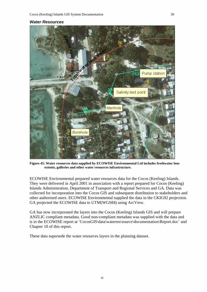
Water Resources
Figure 45: Water resources data supplied by ECOWISE Environmental Ltd includes freshwater lens
extents, galleries and other water resources infrastructure.
ECOWISE Environmental prepared water resources data for the Cocos (Keeling) Islands. They were delivered in April 2001 in association with a report prepared for Cocos (Keeling) Islands Administration, Department of Transport and Regional Services and GA. Data was collected for incorporation into the Cocos GIS and subsequent distribution to stakeholders and other authorised users. ECOWISE Environmental supplied the data in the CKIG92 projection. GA projected the ECOWISE data to UTM(WGS84) using ArcView. GA has now incorporated the layers into the Cocos (Keeling) Islands GIS and will prepare ANZLIC compliant metadata. Good non-compliant metadata was supplied with the data and is in the ECOWISE report at ‘CocosGIS\data\waterres\source\documentation\Report.doc’ and Chapter 10 of this report. These data supersede the water resources layers in the planning dataset.
Cocos (Keeling) Islands GIS System Documentation 31
31
National Estate
Figure 16: Data from the Register of the National Estate includes point and polygon representations of
registered significant sites (historic and natural).
The Australian Heritage Commission, Environment Australia, supplied data of sites on the Register of the National Estate in May 2001. The data were supplied as a polygon shapefile and a point shapefile. The data cover the whole island group, including North Keeling Island. This was supplied in the geographic coordinate system (WGS84). No other metadata was supplied with the data. However the Australian Heritage Commission (AHC) have a website (http://www.ahc.gov.au/register) which contains detailed descriptions of each heritage site and, in most cases, a photograph of the site. After projection, the majority of polygon boundaries closely match the cadastral boundaries. If they are derivatives, they may have similar positional accuracy. The points, however, have very variable accuracy. Some seem to be based on centroids of cadastral polygons, but many appear to represent the general vicinity of a site. This dataset includes a number of points and areas which do not appear in the 1992 planning data. The planning data includes a number of points “of heritage interest” which do not appear in this dataset, including Direction Island’s cable station ruins, the wrecks of the Phaeton and the RCL, West Island’s cemetery and the Twiss Memorial.
Cocos (Keeling) Islands GIS System Documentation 32
32
Other Data There are a number of other datasets and digital products supplied on the Cocos GIS CD-ROMs. The 'graphics' directory contains a spot-derived image covering the entire Cocos (Keeling) Islands in JPG format (Cocos_Spot.jpg). Because the original image was very large and had a substantial proportion of featureless ocean, a 256 colour clipped image covering just the southern atoll has been supplied (‘CocosGIS\data\misc\spot\sthaspot.tif’). It is recommended that this clipped image be used in the GIS as a backdrop only - the positional accuracy is not sufficient for full GIS use. This is a scan of a DoTaRS poster, with the scanned image pixel size representing about 5 metres on the ground. Poster printing, scanning and JPEG resampling have degraded colour information. It is not recommended for scales closer than 1:50,000. This image does however give some indication of marine features in the central lagoon beyond the extent of the orthophotography. The ‘data/misc/property’ directory (cd-rom #2) contains spreadsheets with property information. GA has converted these Microsoft® Excel format spreadsheets to Dbase V tables for use in ArcView. This involved changing some field names to comply with Dbase limitations. The DBF tables can be added to ArcView as tables, and where a Pin or Loc/Lot No exists in the table, can be joined or linked (for 1 to many relationships) to the cadastre attribute table. The 'CocosGIS\data\misc\oceansub' directory contains data relating to an Expression of Interest and subdivision proposal for the Oceania House lot on Home Island. This is an example of use of the Cocos GIS prior to its completion. Of most interest in this directory is a CAD (DXF) file of the subdivision. This file is supplied in ‘CocosGIS\data\misc\oceansub\Lot14.dxf’. It is not geographically located so cannot be overlayed on Cocos GIS layers. GA could easily do the geolocation as part of future work, but future Department of Land Inforamtion (DLI) cadastre updates should reflect the new subdivision. The data can be viewed in ArcView if the Cad Reader extension is enabled. In the ‘CocosGIS\graphics’ directory are digital copies of several maps and posters. The maps are stored as postscript (EPS) and Adobe® Acrobat (PDF) files. The poster is stored as a JPEG image file.
Cocos (Keeling) Islands GIS System Documentation 33
33
Chapter
3 Further Work GA has identified areas where improvement could be made in several datasets. These could be addressed in future work if required.
Annotation Capture Some datasets have annotation that is yet to be captured as attributes. The capture of annotation as attributes is useful for full GIS functionality. An important example is the contour labels in the detail survey, which are the only height information stored in that dataset. A height attribute for this data would vastly improve the value of the data. A particular example is the wreck of the Emden, which is identified only as a shipwreck in the attributes but as the Emden in annotation.
Cadastre Updates The digital cadastre will need regular updates to maintain currency. DoLA has indicated that revision of the cadastral layer is ongoing. These should be incorporated into the system as resources allow. In addition further entries and updates could be made in the ground audit table.
Geographic Names and Road Names Probably the most authoritative feature layers (the cadastre and the topography/culture data) do not have geographic names as attributes or annotation. The planning scheme data does have some named features (eg. island names in English and in Malay) and these could be transferred as attributes to more detailed feature layers if this is appropriate. Most road names are missing from all datasets that are currently in the Cocos GIS.
Other Data Improvements A number of other limitations and weaknesses in the current datasets could be addressed in future. Some important potential improvements are:
joining of the contour lines where broken (ideally completion of the contour coverage of the islands);
improved spatial accuracy of orthophotography over North Keeling Island and Horsburgh Island (this would require authoritative coastline and/or recognisable survey marks);
checking and correction of erroneous attribution in detail survey data; update of metadata to ANZLIC version 2, and storage as XML files; proper coding of vegetation layer and resurveying if and where necessary; and surveying of authoritative coastlines (especially south of Home Island and east of West
Island, North Keeling Island and Horsburgh Island), remaining aware that the coastline in detail is variable over time.
Cocos (Keeling) Islands GIS System Documentation 34
34
References National Capital Planning Authority and the Commonwealth Department of the Arts, Sport,
the Environment and Territories, 1992, Cocos (Keeling) Islands Land Use Plan and Planning Scheme (June 1992). Prepared for the Cocos (Keeling) Islands Council.
National Capital Planning Authority (P. Kendall) and the Commonwealth Department of the
Arts, Sport, the Environment and Territories, 1992, Geographic Information System Database Accompanying Documentation for the Cocos (Keeling) Islands Land Use Plan and Planning Scheme (June 1992). Prepared for the Cocos (Keeling) Islands Council.
Australian Estate Management with input from AUSLIG, AVO and AGS, 1996, Indian Ocean
Territories Ground Audit Module 1 Final Report. Prepared for the Territories Office, Commonwealth Department of the Environment, Sport, and Territories.
Department of The Arts, Sport, The Environment, Tourism and Territories 1991, TERR BCH
– COCOS (K) ISLANDS DEVELOPMENT PLAN – MAPPING. Unclassified file no. 91/06398
Department of Land Administration (DoLA), 1992, Christmas Island & Cocos (Keeling)
Islands Land Tenure System Project Planning & Detailed Costing Report Bureau of Transport Economics 1998, Cocos (Keeling) Islands Regional Analysis Report
prepared for the Indian Ocean Territories Review ECOWISE Environmental Ltd, 2001, Report on Water Resources Component, Cocos
(Keeling) Islands GIS, by Tanya Whiteway and Tony Falkland, prepared for Cocos Island Administration, Department of Transport and Regional Services & the Australian Geological Survey Organisation April 2001
Cocos (Keeling) Islands GIS System Documentation 35
35
GA Catalog details for the Cocos GIS (#61840): Cat # : 61840 Flags Product : Y Publication : N Dataset : N Resource : N WWW : N Title : Cocos (Keeling) Islands GIS Medium : Scale : Contact : Keith Porritt Type : One-Off Product Sub Type : No Subtype Available Project Id : Pub'n Source : Pub'n Year : 2005 Vol / Part : ISBN : Abstract : The Cocos (Keeling) Islands Geographic Information System (Cocos GIS) is a collection of spatial data, viewing and analysis tools dealing with the Cocos (Keeling) Islands. The data include orthophotography, topographic, cultural and environmental features both of the islands and the ocean immediately surrounding them. ------------ Bounding Rectangle ----------------------------------------------------------------------------------- N Latitude : -11.8 S Latitude : -12.25 W Longitude : 96.8 E Longitude : 96.95 Comments : Data projection is Cocos (Keeling) Islands Grid 1992. Data scale is variable, due to the data being collated from various sources. ------------ List of Authors ------------------------------------------------------------------------------------------- Name :
1 Porritt, K.P. 2 Petersons, S.I.
Theme : GIS culture information management topography
Figure 17: Cocos GIS GA Catalog entry (#61840).-
Cocos (Keeling) Islands GIS System Documentation 36
36
Chapter
4 Appendix 1: Metadata Hard copy versions of the electronic metadata sheets. These metadata sheets comply with ANZLIC core metadata standards.
Cocos (Keeling) Islands GIS System Documentation 37
37
Chapter
5 Appendix 2: CD-ROM HTML documentation Hard copy print of the HTML pages comprising the autorun content for CD-ROM # 1.
Cocos (Keeling) Islands GIS System Documentation 38
38
Chapter
6 Appendix 3: Ground Audit and Cadastre Tables Table 2: Full listing of cadastre.shp and lodged.shp
Table 3: The following two spreadsheets list 60 fields of data from ‘cocos_cadastre_june2006.xls’ and ‘cocos_lodged_june2006.xls’ that are displayed in the attribute table. Records are sorted by the ‘PIN’ field. The page order for columns is ‘Down, then over’.
Cocos (Keeling) Islands GIS System Documentation 39
39
Chapter
7 Appendix 4: Memorandum of Arrangement – Particulars of Services
Cocos (Keeling) Islands GIS System Documentation 40
40
Memorandum of Arrangement – Particulars of Services
" To develop a Geographic Information System (GIS) for Cocos (Keeling) Islands. GA's proposals, dated 17 November 1998 and 6 May 1999 for the development of the GIS, form part of this MOA. (Attachment 1) The Services include the provision of detailed orthophotography and feature datasets based on a two stage approach as follows: Stage 1. � The creation of a sample of the orthophotography similar to Christmas Island GIS (CIGIS) resolution standards; � The retrieval and integration of available line and point data held by AUSLIG, the WA Department of Land Administration (DOLA), or the Commonwealth Environmental Resource Information Network covering Cocos (Keeling) Islands; � The installation and demonstration of the Stage 1 version of the Cocos (Keeling) Islands GIS (CKIGIS) on the Territories Office GIS PC; and � The provision of sample colour maps, posters and an interim CD backup. Stage 2. � The creation of the remainder of the orthophotography; � The integration of ground audit data with DOLA cadastral boundaries; � The integration to the extent possible of existing datasets that come to light through the process of carrying out Stage 1; � The documentation of the system to the CIGIS standards; � The publishing of the whole system on CD-ROM and delivery of five copies to the Department; and � The installation and demonstration to the Contact Officer of the GIS at the Department's PC GIS location The Timetable for the Services is: Milestone Due Date Stage 1 completed 2 months from execution of MOU Stage 2 completed 3 months after acceptance of Stage 1
Cocos (Keeling) Islands GIS System Documentation 41
41
Chapter
8 Appendix 5: Data Licensing and Agreements
Cocos (Keeling) Islands GIS System Documentation 42
42
Data Licensing and Agreements The collection of nearly all the data sets on the four CD-ROMs comprising the Cocos GIS was commissioned by the Territories Office (Commonwealth Government) under a series of consultancy arrangements with various data suppliers over the past fifteen years. An exception is the Environment Australia Marine Environment data layer. The Cocos GIS is an assembly of multiple data collections (each of which may comprise some man-years of work) into a single easy-to-use integrated system and so represents a valuable Commonwealth asset.
Commonwealth Cocos GIS data licence The copyright for all the data in the Cocos GIS resides with the Commonwealth (see data acknowledgments on page 6). Legal advice to Geoscience Australia and Territories Office recommends the protection of the Commonwealths interests in any distribution of the Cocos Islands GIS by way of a licence agreement. Following are a one-page licence agreement and an associated covering letter. A key purpose of the Cocos GIS licensing is that the user organisation signifies their acceptance that the data is not error free. This licence relates to all the data except the original content of the Environment Australia (EA) marine data for which a separate EA licence must be used. To simplify usage of the Cocos GIS, the EA data has been moved to CD-ROM 4, which is not included in the standard Cocos GIS distribution. Risks of not licensing the data include: -
• allegations of liability for damages as a result of errors in the data, • commercialisation of the data, • proliferation of faceless data variants, • inequitable government support between competing businesses, • perceived breaches of privacy, and • potential future denial of access by the Commonwealth to the data.
Arguments against licensing include: -
• it may in some cases stultify legitimate and effective use of the data for public good purposes, and
• it introduces a cumbersome overhead for both the data supplier and the data user. On receipt, this data should have been received with two copies of the license agreement. One original signed copy of the Commonwealth Cocos GIS data licence is to be retained by the licensee and one original signed copy is to be posted back. An electronic copy of the Commonwealth Cocos GIS data licence (for reference) is stored on the Cocos GIS CD-Rom #1 at directory '\document\licenses' in file 'cocosgis_license.doc '.
A generic covering letter is also stored in this directory (file 'generic_licensecover.doc' and together the two documents comprise the licensing advice to each stakeholder. The covering letter should be edited to correctly describe the particular proposed licensee and two copies of both documents printed for packaging with the data. One original signed copy of the Commonwealth Christmas Island GIS data licence is to be retained by the licensee and one original signed copy is to be posted back.
The covering letter is only half a page. The Licence Terms are just over one page in length. It is important to retain this brevity. Experience indicates that long-winded licence agreements are often not read and their conditions are consequently at a greater risk of being ignored. Some users are put off using the data when there is a long and complex licence agreement to come to grips with. Consequently an important public-good benefit that might be delivered by the use of the data may never be realised.
Cocos (Keeling) Islands GIS System Documentation 43
43
REPLACE THIS PAGE WITH COPY OF LICENSE COVERING LETTER
Cocos (Keeling) Islands GIS System Documentation 44
Error! Unknown document property name. 44 Data Licence
TERMS OF A LICENCE CONCERNING DIGITAL DATA
from the Territories Office of the Commonwealth Department of Transport and Regional Services
('Licence')
IMPORTANT NOTES ‘Territories Office’ means the Commonwealth of Australia represented by the Territories Office of the Commonwealth Department of Transport and Regional Services. ‘Data‘ means the Licensed Data, including any copy, reproduction, modification, adaptation, digital manipulation or graphical representation of the Licensed Data made by the User in any form, including electronic or hard-copy form. ‘Fee’ means the fee payable to Territories Office for the right to use the data in accordance with this Licence. ‘including‘ is not a word of limitation. ‘Licensed Data’ means Territories Office’s data, including metadata and documentation, supplied by Territories Office under the letter from Territories Office to which these Licence Terms are attached. ‘Use’ as a noun means any use or disclosure, and, as a verb, has an equivalent meaning. ‘User’ means any person who Uses the Data, or, if the Use is in connection with the person’s employment, the person’s employer. The Data is intended for use only by people who have professional knowledge of the use and application of geographic information system (GIS) data. TERMS The User: (a) must pay the Fee to Territories Office in accordance with
Territories Office’s directions; (b) may, on a non-exclusive basis, use and disclose the Data
only for the User's internal business purposes carried out in person by its employees, or by the User's consultants exclusively for work on the User's internal business, or, if the User is an individual, the User's personal use ('Purpose');
(c) may make back-up copies of the Data; and (d) must not, except as provided under paragraph (b),
distribute or transmit the whole or any part of the Data, whether alone or in combination with any other data or information in any form, to any person.
Nothing in this Licence affects ownership of any person’s rights in the Data. WARRANTY To the full extent allowed by the applicable law Territories Office excludes from this Licence all warranties, express or implied, including any warranty of fitness of the Data for any purpose. If Territories Office breaches any warranty that, by the applicable law, cannot be excluded, then Territories Office's sole liability to the User for that breach will be, at its choice, to resupply the Data without additional charge to the User or refund the Fee. ASSUMPTION OF RISK The User assumes sole risk and responsibility for its Use of the Data. Territories Office does not warrant or make any representations: (a) that the Data will be complete, accurate, reliable or error
free; (b) as to the accuracy, reliability or content of any
information obtained from Using the Data.
Territories Office disclaims any and all liability for any injury, damage or loss (including, but not limited to, economic loss) howsoever arising out of any Use of the Data. Territories Office is not responsible for any failure to carry out its obligations under this Licence if that failure is for any cause beyond Territories Office's reasonable control. TERMINATION Territories Office may terminate this Licence immediately by written notice if the User breaches this Licence or for convenience on 30 days notice. When this Licence ends the User must return or destroy all copies of the Data in its possession or under its control. APPLICABLE LAW This Licence will be interpreted according to the laws of the Australian Capital Territory, Australia. ALTERATION This Licence be altered only in writing signed by Territories Office and an authorised representative of the User. WAIVER Waiver of any provision or right under this Licence: (a) must be in writing signed by the party entitled to the
benefit of that provision or right; and (b) is effective only to the extent set out in the written waiver. ENTIRE AGREEMENT This Licence: (a) constitutes the entire agreement between Territories
Office and the User as to its subject matter; and (b) in relation to that subject matter, supersedes any prior
understanding or agreement between Territories Office and the User and any prior condition, warranty, indemnity or representation imposed, given or made by Territories Office or the User.
UN CONVENTION Territories Office and the User agree that the provisions of the United Nations Convention on Contracts for the International Sale of Goods are expressly excluded from this Agreement. DISPUTE RESOLUTION The parties (meaning Territories Office and the User) must attempt to resolve any dispute or difference that may arise between them in relation to this Agreement (‘Dispute’) through amicable consultation, based on principles of mutual benefit, equality, cooperation and trust. Accordingly, a party must not start arbitration or court proceedings (except proceedings seeking interlocutory relief) about a Dispute unless it has complied with the following paragraphs (a) - (e): (a) A party claiming that a Dispute has arisen must notify the
other party to the Dispute giving details of the Dispute (‘Notification’);
(b) On receipt of a Notification each party must negotiate in good faith to resolve the Dispute and, if necessary to resolve the Dispute, involve the Chief Executive Officers
Cocos (Keeling) Islands GIS System Documentation 45
45
or other senior officers of the parties directly in those negotiations;
(c) If the Dispute involves technical matters and has not been resolved by negotiations under paragraph (b) within a reasonable time, then the parties will refer the Dispute for determination by an independent expert agreed by the parties in the technical field the subject of the Dispute;
(d) If the Dispute is not resolved under paragraph (b) or (c) within thirty days (or longer period agreed between the parties), and if the User's principal address is in Australia, then the parties must refer the Dispute for mediation by the Australian Commercial Dispute Centre Limited (‘ACDC’) for resolution in accordance with the Mediation Rules of the ACDC;
(e) If the Dispute is not resolved under paragraph (b) or (c) within thirty days (or longer period agreed between the parties), and if the User's principal address is not in Australia, then the parties must refer the Dispute to arbitration for resolution in accordance with the UNCITRAL Model Law on International Commercial Arbitration. Notwithstanding any provision of the UNCITRAL rules to the contrary, the parties agree that:
(i) the number if arbitrators shall be one; (ii) the place of arbitration will be Canberra,
Australian Capital Territory, Australia; (iii) all proceedings will be conducted in the English
Language; (iv) the applicable law is the law of the Australian
Capital Territory; and (v) the determination of the arbitrator shall be final
and binding on the parties and the costs of the arbitration shall be borne and paid for as the arbitrator directs.
(f) If the Dispute is not resolved under paragraph (d) or (e) within sixty days after referral (or longer period agreed between the parties) either party may initiate proceedings in a court
FURTHER INFORMATION Historical information may be contained in the Data, metadata or documentation of the Data. If the User requires further information about the Data or it's history, then contact
Territories Office Perth, Department of Transport and Regional Services. Ph: (08) 9225-1400 Fax: (08) 9225-1429
Cocos (Keeling) Islands GIS System Documentation 46
46
License for use of Satellite Imagery. Copied here is the text file ‘MULTIPLE_ORGANIZATION.TXT’ which contains the license agreement for the use of the satellite imagery bundled with this manual. Please read before continuing. Also here is a copy of the table of registered users, found in the ‘registered_users.pdf’.
MULTIPLE ORGANIZATION END USER LICENSE AGREEMENT DigitalGlobe, Inc. ("DigitalGlobe") provides to the "End User" the DigitalGlobe products under the terms of this license which accompany the products unless the End User has signed a contract which may supersede this license. 1 AUTHORIZED USERS. The multiple organization license applies to multiple users solely within the corporations or government agencies at multiple locations within a single country identified at the time of ordering (e.g. corporations, corporate subsidiaries, county governments (all departments), federal agencies (non Title-50, below cabinet level in the U.S.), state or provincial government agencies, or city governments (all departments)). For the purposes of this license, the European Union is treated as a single country. 2 LICENSE ACCEPTANCE. The End User may accept and agree to the terms of this License by doing any one of the following: (a) entering into a contract with DigitalGlobe which contains these terms; (b) accepting, in whole or in part, a quotation describing the Product by any means (including the use of Customer's purchase order, whether or not that purchase order contains inconsistent terms and conditions); (c) installing or manipulating the Product on any computer hardware; (d) damaging or destroying the Product; or (e) retaining the Product for more than 15 days following receipt. If the License is not accepted, End User may receive a full refund for the purchase price of the Products by returning the Products, unopened to DigitalGlobe within 14 calendar days of receipt. Please contact DigitalGlobe at (800) 496-1225 or (303) 702-5561 to arrange for a merchandise pick-up. 3 LICENSE GRANTED AND PERMITTED USES. By accepting the terms of this license, the End User is permitted the rights to use the Products internally at its facilities within its country of residence and to:
i. Make an unlimited number of copies for the internal use of the End User. ii. Modify the Products or use the Products to create derived works.
iii. Provide the Products to contractors for the development of a derived work for the internal use of the End User only.
iv. Release hardcopy prints on a limited non-commercial basis, contained in research reports or similar publication, provided that the End User conspicuously marks the copyright.
v. After notifying DigitalGlobe of the URL that will be used, post Products and derived works to Internet web sites, provided that downloading of image data and screen capture is precluded.
vi. After notifying DigitalGlobe of the URL that will be used, post derived works to Internet web sites and allow downloading provided that the quality is not better than 8 bit, the image is not georeferenced, the amount downloaded is not more than the amount which can be displayed on a screen at one time, and
Cocos (Keeling) Islands GIS System Documentation 47
47
the image is downloaded at the same resolution as displayed on the screen. Proper copyright must be conspicuously marked.
4 PROHIBITED USES. All rights not expressly granted to the End User are retained by DigitalGlobe. These include, but are not limited to the following:
i. Allowing the use of the Products in any manner inconsistent with this License Agreement.
ii. Copy or reproduce (even if merged with other materials), other than as consistent with the Permitted Uses.
iii. Sell, license, transfer, disclose, the Products or use them in any manner not expressly authorized by this Agreement.
iv. Alter or remove any copyright notice or proprietary legend contained in or on the Products. End User agrees that any embodiment of the Products permitted under this Agreement will contain the following notice: "Includes material (c) DigitalGlobe"
5 DERIVED WORKS. Derived works containing imagery data from the Products are covered by this License. Derived works that do not contain imagery data from the Products are not covered by this License. For example a vector map (features, buildings, waterlines, classification) derived from a Basic Product is outside of this license. 6 LIMITATIONS AND DISCLAIMER OF WARRANTY. DigitalGlobe provides a limited warranty for 30 days that the Products delivered will be of the area of interest ordered and the media used to carry the Products will be free from physical or material defects.Our sole liability shall be to replace the media if the media (not the software or data encoded thereon) is defective and the End User returns such to DigitalGlobe within 30 days of delivery. WITH THE EXCEPTION OF THE PROCEEDING WARRANTY, THE PRODUCTS ARE PROVIDED WITHOUT WARRANTY OF ANY KIND, AND ALL WARRANTIES OF MERCHANTABILITY AND FITNESS FOR A PARTICULAR PURPOSE ARE DISCLAIMED. DIGITALGLOBE DOES NOT WARRANT THAT THE PRODUCTS WILL MEET THE END USER'S NEEDS OR EXPECTATIONS, OR THAT OPERATIONS OF THE PRODUCTS WILL BE ERROR FREE OR UNINTERRUPTED. NO INFORMATION PROVIDED BY DIGITALGLOBE OR ITS AGENTS, EMPLOYEES, OR ITS RESELLERS OR DISTRIBUTORS SHALL CREATE A WARRANTY, OR IN ANY WAY INCREASE THE SCOPE OF THIS LIMITED WARRANTY, AND THE END USER IS NOT ENTITLED TO RELY ON ANY SUCH INFORMATION. 7 NO CONSEQUENTIAL DAMAGES. IN NO EVENT SHALL DIGITALGLOBE BE LIABLE FOR ANY CLAIM OR LOSS INCURRED BY THE END USER, INCLUDING WITHOUT LIMITATION, COMPENSATORY, INCIDENTAL, INDIRECT, SPECIAL, CONSEQUENTIAL, EXEMPLARY OR OTHER NONCOMPENSATORY DAMAGES, SUCH AS LOST PROFITS, LOSS OF GOODWILL, OPPORTUNITY COSTS, COST OF COVER, OR COST OF REPLACEMENT GOODS, IRRESPECTIVE OF WHETHER DIGITALGLOBE KNEW OR SHOULD HAVE KNOWN OF THE LIKELIHOOD OF SUCH DAMAGES. THE END USER ACKNOWLEDGES THAT NO REPRESENTATIONS MADE BY THIRD PARTY DISTRIBUTORS OR RESELLERS ARE BINDING UPON DIGITALGLOBE. THIS LIMITATION
Cocos (Keeling) Islands GIS System Documentation 48
48
APPLIES TO ALL CAUSES OF ACTION INCLUDING BUT NOT LIMITED TO BREACH OF CONTRACT OR WARRANTY, NEGLIGENCE, STRICT LIABILITY, MISREPRESENTATION AND OTHER TORTS. IF DIGITALGLOBE'S LIMITATION OF LIABILITY SET FORTH IN THIS AGREEMENT IS FOR ANY REASON HELD UNENFORCEABLE OR INAPPLICABLE, DESPITE THE LIMITATIONS CONTAINED HEREIN, THE END USER AGREES THAT DIGITALGLOBE'S LIABILITY SHALL NOT EXCEED FIFTY PERCENT (50%) OF THE LICENSE FEES PAID BY THE END USER TO DIGITALGLOBE WITH RESPECT TO THE PRODUCTS AT ISSUE OVER THE SIX (6) MONTH PERIOD PRECEDING THE CLAIM. 8 MISCELLANEOUS.
i. The End User acknowledges, and will cause its employees and agents to acknowledge, that DigitalGlobe and its licensors will own all rights in any copy, translation, modification, adaptation or other Derived work that End User or its contractors may create that is covered by this license.
ii. This License Agreement constitutes the complete and exclusive agreement between DigitalGlobe and the End User relating to its subject matter. This License Agreement supersedes all prior and contemporaneous representations, correspondence, proposals or agreements relating to its subject matter, whether oral or written. This License Agreement may be modified only by a written amendment signed by both DigitalGlobe and the End User. If any provision is determined to be invalid or unenforceable, the remaining provisions of this License Agreement shall continue to be valid and enforceable. Neither this License Agreement nor any of the rights granted by it may be assigned or transferred by the End User without the prior written consent of DigitalGlobe. This restriction on assignments or transfers shall apply to assignments or transfers by operation of law, as well as by contract, merger or consolidation. Any attempted assignment or transfer in derogation of this prohibition is void.
iii. The End User shall be responsible for obtaining any and all required governmental authorizations, including but not limited to any export or import licenses, and foreign exchange permits.
iv. Except as noted in Paragraph 1, this is the exclusive and entire Agreement between DigitalGlobe and Customer regarding its subject matter, merging all prior or contemporaneous instruments or agreements and discussions between the parties. Customer may not assign any part of the Agreement without DigitalGlobe's prior written consent. This Agreement shall be governed by the internal laws of Colorado. Customer shall pay any taxes on the Product or transactions, except for those based on DigitalGlobe's income. If any provision of this Agreement is declared invalid or unenforceable, the remaining provisions of this Agreement shall remain in effect.
DigitalGlobe 1900 Pike Road Longmont, CO 80501 USA Rev. 11/19/02 CORP_SYS_454_F.doc
Cocos (Keeling) Islands GIS System Documentation 49
49
Multiple Organization End User License Agreement
REGISTERED USERS
Registered Organisations 1 Department of Transport and Regional Services 2 Cocos (Keeling) Islands Shire 3 Geoscience Australia 4 WA Department of Industry and Resources 5 WA Department of Land Administration 6 WA Department for Planning and Infrastructure7 Cocos Island Co-operative Society Ltd 8 Cocos Dive 9 WA Department of Education and Training 10 Cocos (Keeling) Islands Tourism Association 11 WA Department of Fisheries 12 WA Department of Environment 13 Department of Finance and Administration 14 Department of Environment and Heritage 15 Gutteridge Haskins & Davey Pty Ltd (GHD) Table 5: Registered users of the satellite imagery bundled with this manual.
Cocos (Keeling) Islands GIS System Documentation 50
50
Environment Australia Marine Data licence. For each organisation the current Cocos GIS cd-rom #4 is to be passed to, the following licence agreement with Environment Australia (EA) need first be signed by a representative of the organisiation. This license specifically relates to the marine data sourced from EA. The EA system refers to this data set as the ' Whelans Cocos GIS (1998)'. An electronic copy of the EA data licence is stored on the Cocos GIS CD-Rom #1 at directory '\document\licenses' in file 'ea_marine_data_licence.doc'. Details for the licensee organisation need be entered in the following fields on the document:- Name/Title: [enter your – Name] Company/Organisation: [enter your – Organisation] Address: [enter your – Address] Telephone: [enter your – Telephone] Facsimile: [enter your – Fax] E-mail Address: [enter your – Email] The Data will be used by the Licensee for: [enter your – Data Use] Licensees would generally need to fill the 'Data Use' item themselves. However, all the other items in the document could be edited in advance to correctly describe the particular proposed licensee and two copies printed for packaging with the data as per the advice in the covering letter. One original signed copy of the EA agreement is to be retained by the licensee and one original signed copy is to be posted to:-
Mr. Keith Porritt Geoscience Australia GPO Box 378, CANBERRA ACT 2601
in accordance with the current dispensation by Environment Australia for GA to distribute the revised Cocos GIS data on behalf of the Department of Transport and Regional Services, including the data for which Environment Australia is custodian.
Cocos (Keeling) Islands GIS System Documentation 51
51
Agreement for the Supply of Data Important: The completed Schedule and Licence Conditions set out below will constitute a legal agreement between the Commonwealth of Australia (“the Commonwealth”) and you (“the Licensee”) in relation to the data. If you agree with the Conditions, please tick the 'Agreed' box, sign and date beside it and ensure your licensee details are filled out below. If you are entering into this agreement on behalf of a company or organisation, you warrant that you have the authority to do so. Agreed Not Agreed
The Schedule Date: Commonwealth The Commonwealth of Australia is represented by the Department of the Environment and Heritage. The contact details are: Name/Title: Gavan Thomas, Project Officer Address: Environmental Resource Information Network (ERIN)
Environment Australia GPO Box 787 Canberra ACT 2601
Cocos (Keeling) Islands GIS System Documentation 52
52
Address: [enter your – Address] Telephone: [enter your – Telephone] Facsimile: [enter your – Fax] Email Address: [enter your – Email] The Data The data is referred to as the 'Marine Environment' data in the GA-DoTaRS Cocos GIS. The ERIN system refers to the data as the ' Whelans Cocos GIS (1998)'. This dataset contains point, line and polygon data of the marine environment surrounding the Cocos (Keeling) Islands. It includes coastlines, bathymetric contours, coral outcrops and other features. Coverage extends to the whole of Cocos Keeling Islands. The themes have been grouped by GA into the following shapefiles so as to increase the ease of use of the data:
These shapefiles retain all spatial and non spatial data as supplied to GA. Data are provided in shape file format and also as ERIN originally supplied in a zip of ARC export files. Both formats are supplied on CD-ROM No.1 of the Cocos GIS produced in 2000 by GA for Territories Office. Accompanying metadata for the data is also supplied. Contributors Item: 'Marine Environment' data referred to by ERIN as the ' Whelans Cocos GIS (1998)'. Contributor: GA Data was received by GA from ERIN as ArcInfo Export files. GA converted the data to shape file format. GA projected the data to CKIG92 with a coordinate shift to match the Cadastre (assuming it was received as UTM Zone 47 WGS72). The many individual layers were checked and those of similar themes were then grouped to provide a smaller set of layers, thus making the data more useable. The North Keeling atoll was translated and warped to more accurately match the orthophotography. Line themes were built into polygons to allow areas to be queried. Additional Conditions: The I.P. for work done on the data by GA is not covered in this licence agreement between your organisation and EA. A separate agreement with
Cocos (Keeling) Islands GIS System Documentation 53
53
the Commonwealth may apply to this particular component of I.P. in conjunction with the remainder of the GA-DoTaRS Cocos GIS data. Use The Data will be used by the Licensee for: [enter your – Data Use] Licence Conditions 1 Interpretation 1.1 In these Conditions, unless the contrary intention appears: “Commercialise” in respect of the Data or a product or service derived from the Data, includes distributing, giving away, selling, letting for hire, or by way of trade, offering or exposing for sale or hire any article embodying the Data or any product or service derived from or incorporating the Data; “Contributor” means: I. (in relation to the Commonwealth) an agency of the Commonwealth which is
custodian of a particular item of Data on behalf of the Commonwealth; or
II. third party contributors
identified in the Schedule to this Agreement as having provided particular items of Data which are the subject of this Licence Agreement; “Data” means the data to which access is made available, and which is listed in the Schedule and includes any Enhancements to the Data; “Enhancement”, in relation to the Data, includes any modification, adaptation or redevelopment of the Data, any work derived from the Data, machine readable representations of any of the foregoing and any associated material intended at the time of its creation to be used primarily in conjunction with the Data; “Intellectual Property” includes all copyright, and all rights in relation to registered and unregistered trademarks (including service marks), registered designs and confidential information (including trade secrets and know-how), and all other rights resulting from intellectual activity in the industrial, scientific, literary or artistic fields; “Licence” means the licence referred to in Condition 3. 2 Duration
Cocos (Keeling) Islands GIS System Documentation 54
54
2.1 The Licence commences on the date of the Agreement as set out in the Schedule, and continues in force for a period of five (5) years unless terminated in accordance with Condition 10.1. 3 Licence Conditions 3.1 The Commonwealth grants to the Licensee, a royalty-free, non-exclusive, non-transferable licence to use, reproduce, make Enhancements to and print the Data, and combine it with other data held by the Licensee. 3.2 The Licence is limited to personal use of the Data or use within the Licensee’s organisation only. 3.3 The Licensee shall not Commercialise the Data or any product or service derived from the Data. 3.4 The Commonwealth warrants that the grant of the Licence does not infringe the Intellectual Property rights of any person and that it is entitled to grant the licence in relation to the data of third party Contributors. 3.5 Data items identified in the Schedule as having been provided by individual Contributors are subject to the additional conditions (if any) set out in the Schedule. In the event of any conflict between the terms of the Licence Conditions and any additional condition set out in the Schedule, the terms of the Licence Conditions shall take precedence. 4 Intellectual Property Rights Reserved 4.1 All rights not expressly granted to the Licensee under Condition 3 are reserved. 4.2 The Licensee acknowledges that the Data is a special, unique and valuable product in which the copyright and other applicable Intellectual Property rights vest in the Contributors as listed in the Schedule. 4.3 The Contributors of items of Data retain ownership of that Data, whether in its original form or as modified by the Licensee and of the Intellectual Property rights therein. 4.4 Intellectual Property in any Enhancement to the Data vests, upon its creation, in the Contributor named in the Schedule in relation to the relevant item of Data. 5 Custody of the Data 5.1 The Licensee shall maintain the Data in safe custody. 5.2 The Licensee shall take all reasonable steps to ensure that any person given access to the Data is aware of these Conditions and uses the Data only in accordance with this Agreement. 6 Precautions
Cocos (Keeling) Islands GIS System Documentation 55
55
6.1 THE COMMONWEALTH CANNOT GUARANTEE THAT THE DATA, INCLUDING ANY THIRD PARTY DATA, IS FREE FROM ERRORS, AND DOES NOT WARRANT THE QUALITY, PERFORMANCE OR SUITABILITY OF THE DATA FOR ANY PURPOSE. 6.2 THE LICENSEE ASSUMES RESPONSIBILITY FOR SELECTION OF THE DATA TO ACHIEVE ANY INTENDED RESULTS, AND FOR ITS USE. 6.3 THE LICENSEE ASSUMES RESPONSIBILITY FOR THE INTERPRETATION OF ANY RESULTS OBTAINED FROM USE OF THE DATA, AND MUST EXERCISE ALL APPROPRIATE PRECAUTIONS BEFORE PLACING RELIANCE ON THOSE RESULTS. 7 Release and Indemnity 7.1 THE LICENSEE: A) RELEASES THE COMMONWEALTH, ITS OFFICERS, EMPLOYEES AND
AGENTS AND ALL CONTRIBUTORS IN RESPECT OF ALL LIABILITY FOR LOSS, DAMAGE OR INJURY, WHICH MAY BE SUFFERED BY THE LICENSEE OR ARISING FROM THE LICENSEE’S USE OF THE DATA; AND
B) INDEMNIFIES THE COMMONWEALTH, ITS OFFICERS, EMPLOYEES
AND AGENTS AND ALL CONTRIBUTORS IN RESPECT OF ALL LIABILITY FOR LOSS, DAMAGE OR INJURY, WHICH MAY BE SUFFERED BY ANY PERSON ARISING FROM THAT PERSON’S USE OF THE DATA.
8 Retention of Notices 8.1 The Licensee shall not remove, obscure or interfere with any copyright notice, trademark, warning or disclaimer incorporated in the Data. 9. Commercial Exploitation 9.1 The licensee shall not Commercialise the Data or any product or service derived from incorporating the Data without the prior written consent of the relevant Contributor(s). 9.2 A Contributor may grant or refuse consent in their absolute discretion and subject to any condition whatsoever, including payment of royalties. 9.3 Any of the Data or any product or service derived from incorporating the Data which is Commercialised in accordance with this clause, must be accompanied by or incorporate an appropriate acknowledgment of the Contributor as the source of the Data in the terms specified in the Schedule. 10 Termination
Cocos (Keeling) Islands GIS System Documentation 56
56
10.1 If the Licensee breaches any of these Conditions, the Commonwealth may terminate the Agreement immediately by notice in writing to the Licensee. 10.2 The termination of the Agreement under Condition 10.1 shall be without prejudice to the rights of either party accrued under the Agreement prior to termination. 10.3 The Licensee shall cease using the Data for any purpose from the date of termination of the Agreement and shall return the Data and any copies made of it to the Commonwealth within 30 days of the date of termination. 11 Entire Agreement 11.1 The Agreement supersedes all prior agreements and understandings between the parties relating to the Data and Data Products and constitutes the entire agreement between the parties. 12 Variation 12.1 No addition to or modification of any provision of the Agreement shall be binding unless in writing signed by both parties. 13 Assignment 13.1 The rights granted under the Licence are restricted solely to the Licensee and may not be assigned, transferred or sublicensed without the prior written consent of the Commonwealth. 13.2 The Commonwealth may grant or refuse consent in its absolute discretion and subject to any condition whatsoever. 14 Law 14.1 The Agreement shall be governed by and construed in accordance with the laws of the Australian Capital Territory. 15 Waiver 15.1 No forbearance, delay or indulgence by a party in enforcing the provisions of the Agreement shall prejudice or restrict the rights of that party, nor shall waiver of those rights operate as a waiver of any subsequent breach. 16 Severance 16.1 Any reading down or severance of a particular provision does not affect the remaining provisions of the Agreement. 17 Application
Cocos (Keeling) Islands GIS System Documentation 57
57
17.1 Where the Licensee is an agency of the Commonwealth of Australia, such that it is not permitted to enter into a binding legal agreement except as the Commonwealth, then the conditions shall be read as merely giving rise to an arrangement between the Department of the Environment and Heritage and the Licensee.
Cocos (Keeling) Islands GIS System Documentation 58
58
Territories Office—DoLA Arrangement for cadastre Through Territories Office, the Commonwealth pays the Western Australian Department of Lands Administration (DoLA) to maintain the cadastre as passed from Australian Land Information Group (AUSLIG) in 1992.
Cocos (Keeling) Islands GIS System Documentation 59
59
Chapter
9 Appendix 6: Land Use Plan 1992 Data Documentation Note: This land use plan was converted to digital form by GA by a scan/OCR process from a hard copy original: formatting will vary slightly and some errors may exist.
Cocos (Keeling) Islands GIS System Documentation 60
60
Chapter
10 Appendix 7: ECOWISE Environmental Report of Water Resources Component, Cocos (Keeling) Islands GIS. Note: Includes maps supplied with the report and data.
Cocos (Keeling) Islands GIS System Documentation 61