23
Project Update Stakeholder Meeting 4 July 29, 2021

Project Update
StakeholderMeeting 4July 29, 2021
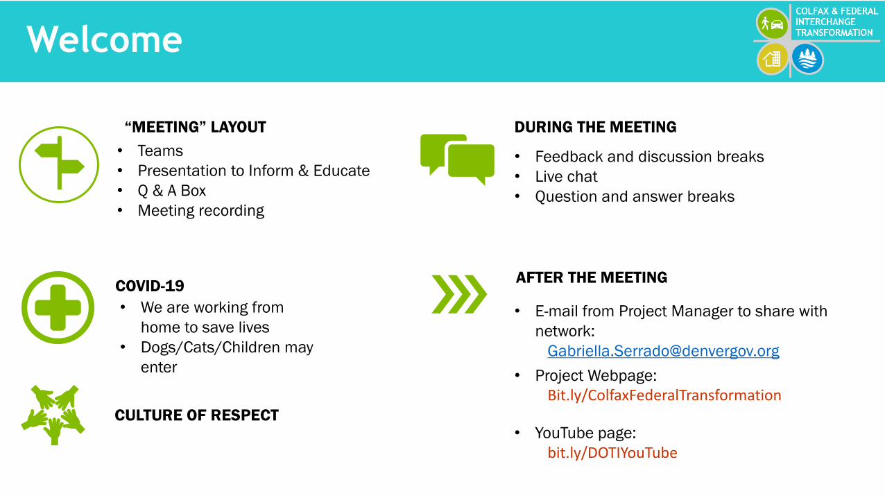
Welcome
“MEETING” LAYOUT
• Teams
• Presentation to Inform & Educate
• Q & A Box
• Meeting recording
COVID-19
• We are working from
home to save lives
• Dogs/Cats/Children may
enter
CULTURE OF RESPECT
DURING THE MEETING
• Feedback and discussion breaks
• Live chat
• Question and answer breaks
AFTER THE MEETING
• E-mail from Project Manager to share with
network:
• Project Webpage:
Bit.ly/ColfaxFederalTransformation
• YouTube page:
bit.ly/DOTIYouTube
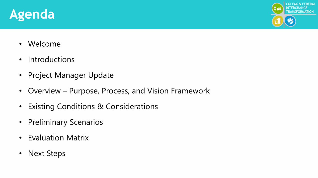
Agenda
• Welcome
• Introductions
• Project Manager Update
• Overview – Purpose, Process, and Vision Framework
• Existing Conditions & Considerations
• Preliminary Scenarios
• Evaluation Matrix
• Next Steps
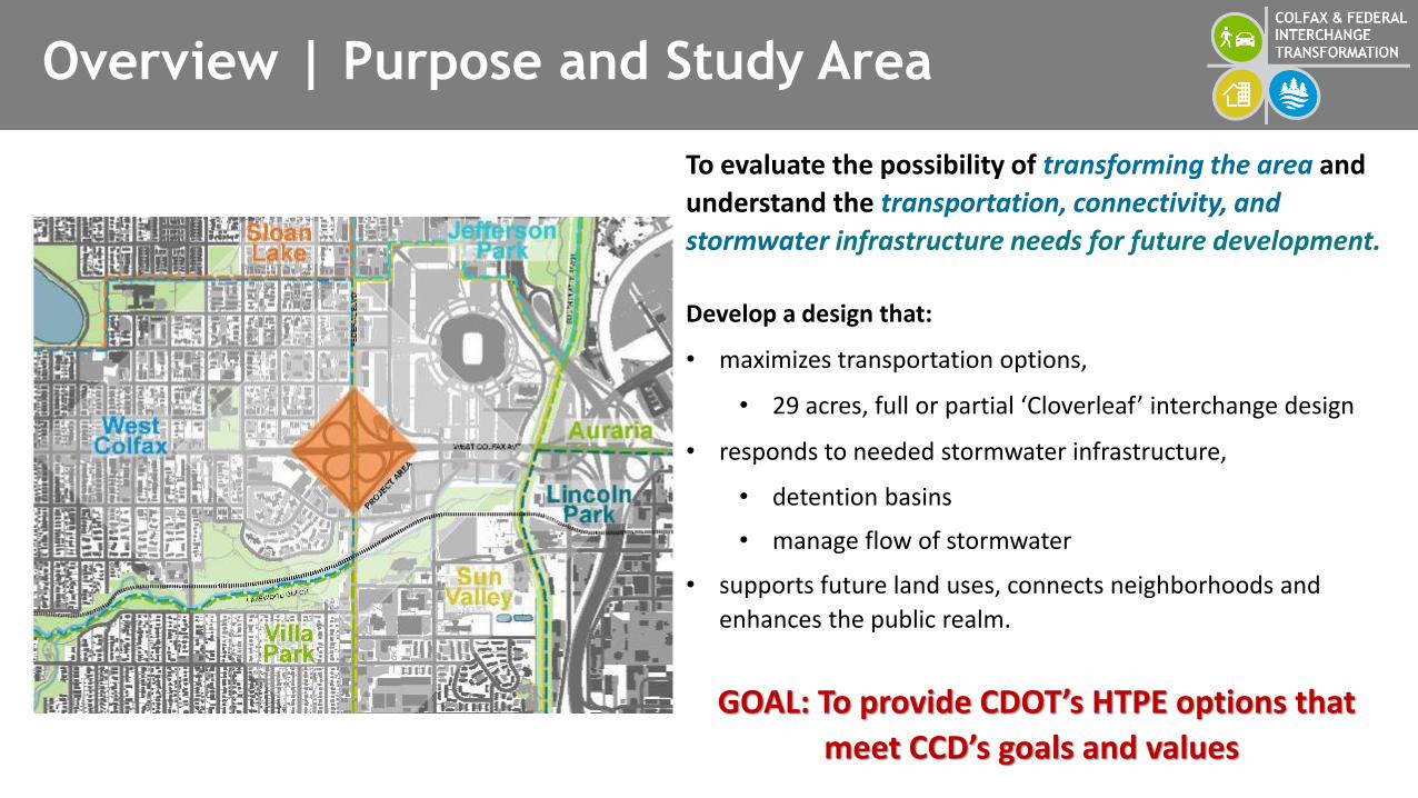
Overview | Purpose and Study Area
To evaluate the possibility of transforming the area and
understand the transportation, connectivity, and
stormwater infrastructure needs for future development.
Develop a design that:
• maximizes transportation options,
• 29 acres, full or partial ‘Cloverleaf’ interchange design
• responds to needed stormwater infrastructure,
• detention basins
• manage flow of stormwater
• supports future land uses, connects neighborhoods and
enhances the public realm.
GOAL: To provide CDOT’s HTPE options that
meet CCD’s goals and values
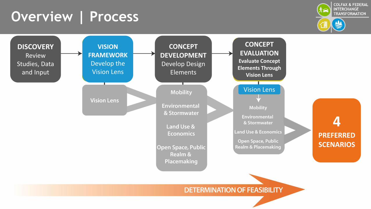
Overview | Process
DISCOVERYReview
Studies, Data and Input
VISION FRAMEWORKDevelop the Vision Lens
CONCEPT DEVELOPMENTDevelop Design
Elements
Vision Lens
CONCEPT EVALUATION
Evaluate Concept Elements Through
Vision Lens
4PREFERRED SCENARIOS
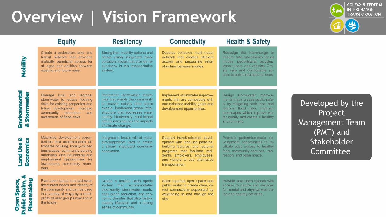
Overview | Vision Framework
Developed by the
Project
Management Team
(PMT) and
Stakeholder
Committee

Overview | Vision Framework
The Vision
Framework
informed the
scenario
development and
assessment
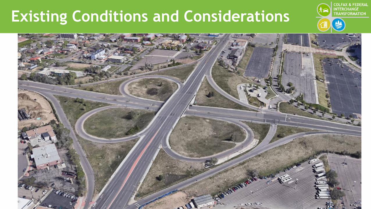
Existing Conditions and Considerations

Scenario Building Blocks
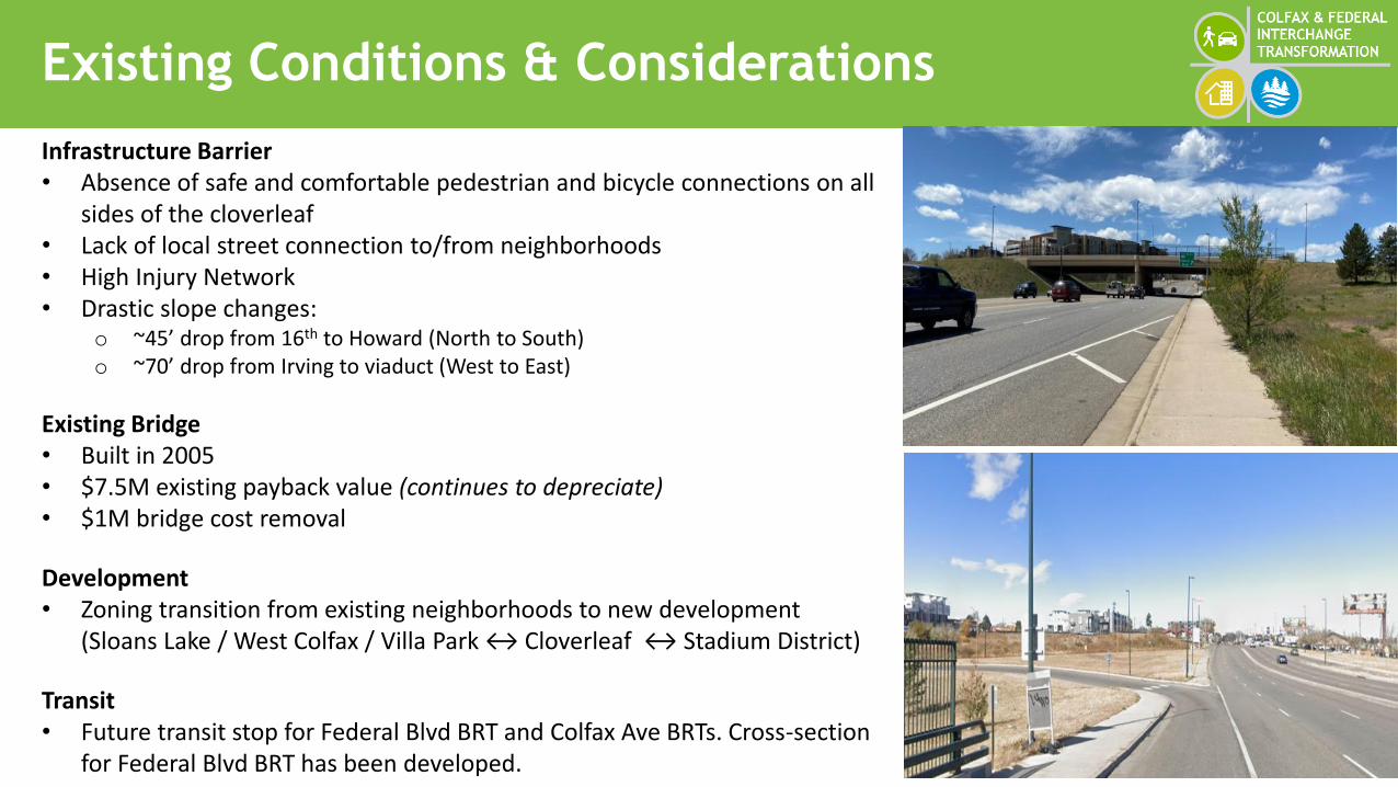
Existing Conditions & Considerations
Infrastructure Barrier• Absence of safe and comfortable pedestrian and bicycle connections on all
sides of the cloverleaf• Lack of local street connection to/from neighborhoods• High Injury Network• Drastic slope changes:
o ~45’ drop from 16th to Howard (North to South)o ~70’ drop from Irving to viaduct (West to East)
Existing Bridge • Built in 2005• $7.5M existing payback value (continues to depreciate)• $1M bridge cost removal
Development• Zoning transition from existing neighborhoods to new development
(Sloans Lake / West Colfax / Villa Park ↔ Cloverleaf ↔ Stadium District)
Transit• Future transit stop for Federal Blvd BRT and Colfax Ave BRTs. Cross-section
for Federal Blvd BRT has been developed.
BREAK #1
QUESTIONS?

Preliminary Scenarios
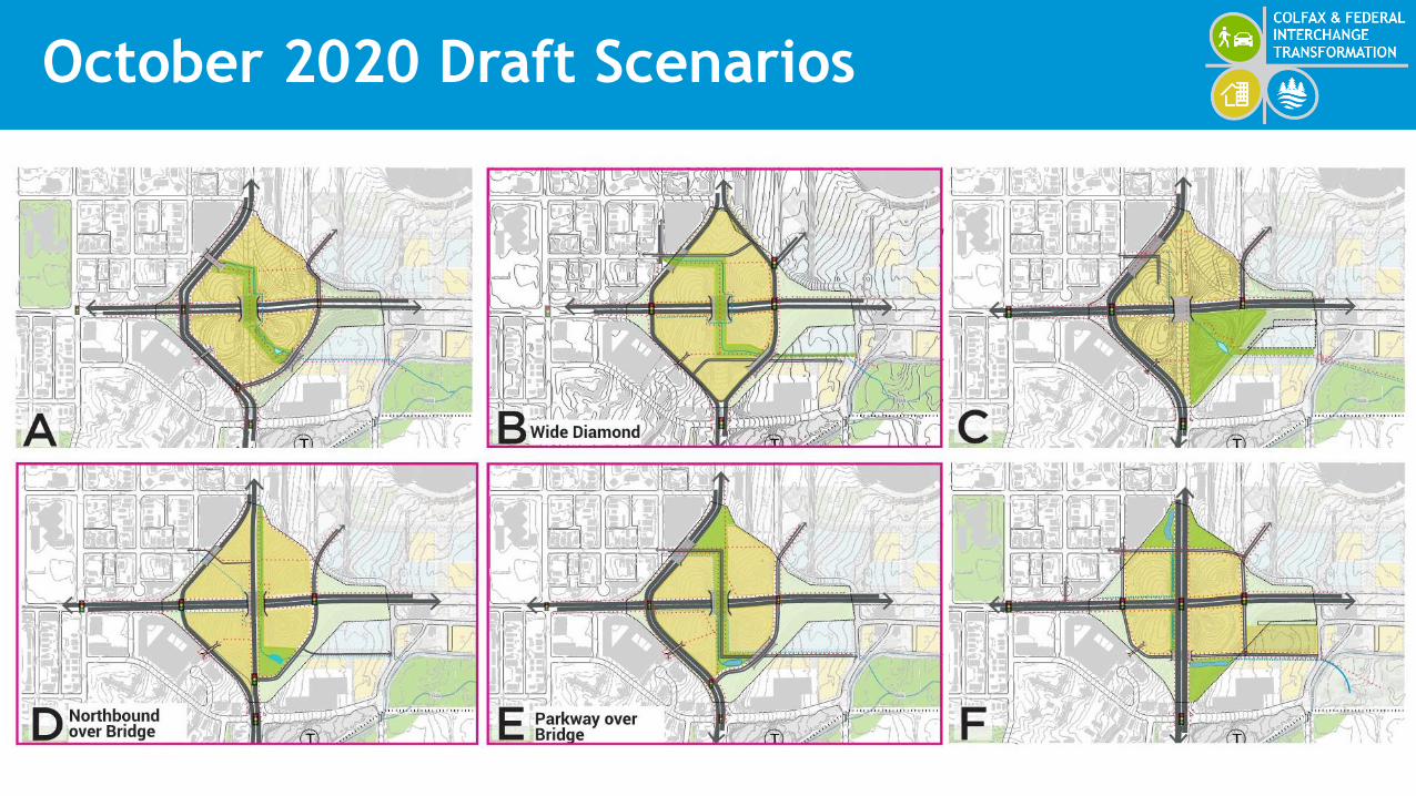
October 2020 Draft Scenarios
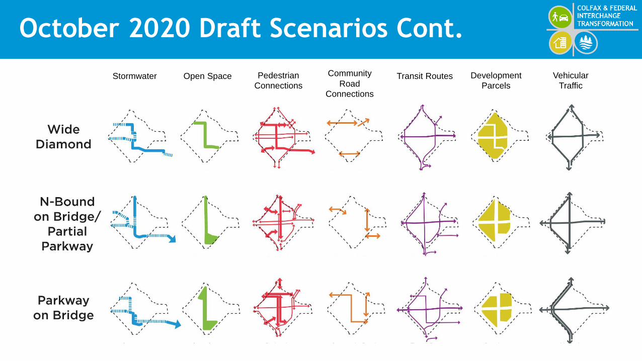
October 2020 Draft Scenarios Cont.
Stormwater Open Space Pedestrian
Connections
Community
Road
Connections
Transit Routes Development
Parcels
Vehicular
Traffic

PMT Discussions
DOTI• Scenarios do not meet the study’s
transformation vision• The bridge is a barrier to achieving the other
Framework goals• The costs for removing the bridge should not
hinder the development of a transformational vision
CDOT• Efforts must accommodate CDOT’s traffic
safety goals• Further analysis is needed that reflect a
transportation system for all modes• There needs to be an option that uses the
bridge with a portion of the state highway• HTPE funds could be used to conduct traffic
and safety analysis in the next phase
RTD• Easier access to Decatur-Federal Station from
the east through Decatur or Eliott (local buses)• There should be a stop/station at the
intersection where the future Federal and Colfax future BRTs
• There should be enough space for an enhanced stop/station: shelters, trash receptacles, etc.
• This station would not replace the Decatur-Federal transfer station
• Safety improvements are needed at Federal and Howard
PARKS & RECREATION• 10% of developable land must be allocated
towards a park• Park needs to be accessible to residents…it
cannot have too many infrastructure barriers• Open to flexible park-stormwater facility• Area does not need another regionally
significant park
COMMUNITY PLANNING & DEVELOPMENT
• The community does not want Federal Blvd to swing to the west - infrastructure barrier and environmental impact to established community
• Pedestrian safety is a big concern. Local street connectivity to Stadium District and Sun Valley is needed
• Scenarios need to account for new residents in the area and ensure that people can move through the project in multiple ways
PRIVATE DEVELOPERS• Small group discussion with developers
knowledgeable about area; earlier versions of scenarios
• General agreement about area attractiveness for development / affordable housing
• Bridge perceived as a connector; bringing bridge to grade may not achieve desired results
• East side more developable than west• Potential to stagger heights with higher on west and
lower on east for views• Conejos connection and connection from northwest
to southeast important
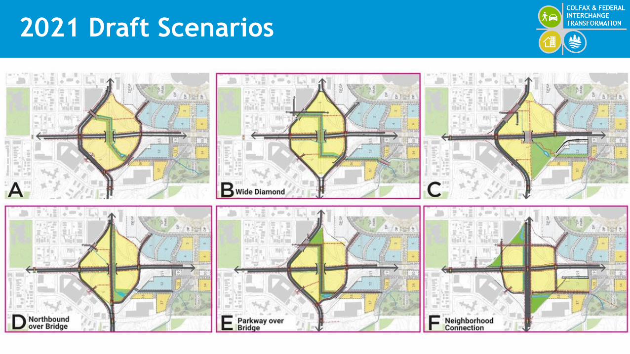
2021 Draft Scenarios
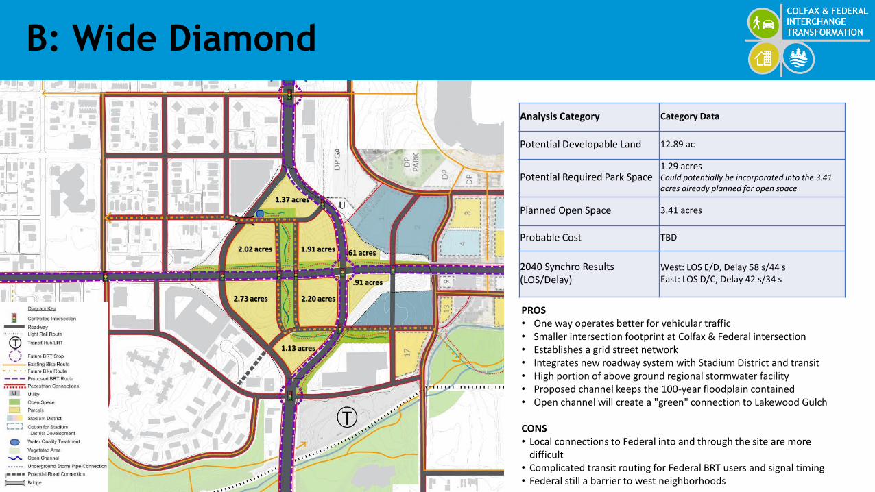
B: Wide Diamond
2.02 acres
2.73 acres
1.91 acres
2.20 acres
.61 acres
.91 acres
1.37 acres
1.13 acres
Analysis Category Category Data
Potential Developable Land 12.89 ac
Potential Required Park Space1.29 acres Could potentially be incorporated into the 3.41 acres already planned for open space
Planned Open Space 3.41 acres
Probable Cost TBD
2040 Synchro Results(LOS/Delay)
West: LOS E/D, Delay 58 s/44 sEast: LOS D/C, Delay 42 s/34 s
PROS• One way operates better for vehicular traffic• Smaller intersection footprint at Colfax & Federal intersection• Establishes a grid street network• Integrates new roadway system with Stadium District and transit• High portion of above ground regional stormwater facility• Proposed channel keeps the 100-year floodplain contained • Open channel will create a "green" connection to Lakewood Gulch
CONS• Local connections to Federal into and through the site are more
difficult• Complicated transit routing for Federal BRT users and signal timing• Federal still a barrier to west neighborhoods

D: Northbound Over Bridge
2.28 acres
3.09 acres
1.59 acres
2.51 acres
.61 acres
.91 acres
Analysis Category Category Data
Potential Developable Land 12.92 ac
Potential Required Park Space
1.29 acres Could potentially be incorporated into the 4.93 acres already planned for open space
Planned Open Space 4.93 acres
Probable Cost TBD
2040 Synchro Results (LOS/Delay)
West: LOS E/E, Delay 69 s/62 sEast: LOS A/F, Delay 6 s/86 s
THIS OPTION COULD ALSO BE RECONFIGURED FOR SOUTHBOUND TO REMAIN ON THE BRIDGE OR OTHER ALTERNATIVE THAT CONTINUE TO PARTIALLY USE THE BRIDGE AS STATE HIGHWAY TRAFFIC.PROS• One-way couple operates better for vehicular traffic• Smaller at-grade intersection at SB Federal and Colfax• Amenitized bridge could add placemaking value• Colfax & Federal intersection footprint would be smaller and easier to cross
as a pedestrian or cyclistCONS• No connection between northbound Federal and Colfax• Due to grades, limited/no local street network and pedestrian connection• Stormwater infrastructure will not be resilient• Existing bridge precludes open channel connection to Lakewood Gulch• Federal would still act as a barrier to west neighborhoods• One-way couple could limit access into developable parcels.• Complicated transit routing for users and signal timing• Existing site grades impact development and need for retaining walls

E: Parkway Over Bridge
2.76 acres
3.04 acres
4.02 acres
2.62 acres
.61 acres
.91 acres
Analysis Category Category Data
Potential Developable Land
13.97 ac
Potential Required Park Space
1.40 acCould potentially be incorporated into the 2.64 acres already planned for open space
Planned Open Space 2.64 ac
Probable Cost TBD
2040 Synchro Results(LOS/Delay)
LOS F/F, Delay 111 s/107 s
PROS• Amenitized bridge could add placemaking value• Second highest opportunity for developable land
CONS• Infrastructures acts as barrier to west neighborhoods• Grades impacts development and potential need for retaining walls• Grades will limit local street connection to Stadium District• East-West pedestrian flow is not improved• Does not provide RTD east access to Decatur-Federal Station• High portion of stormwater facilities must be undergrounded• Standard, large at-grade intersection at Colfax and Federal creates a
barrier for pedestrians and bicyclists as well as safety issues.• Existing bridge precludes an open channel connection to Lakewood
Gulch

F: Neighborhood Connection
1.59 acres
3.47acres
1.36acres
1.62acres 2.43 acres
.39 acres
1.9 acres
.82 acres
Analysis Category Category Data
Potential Developable Land
14.87 ac
Potential Required Park Space
1.49 acrCould potentially be incorporated into the 5.1 acres already planned for open space
Planned Open Space 5.61 ac
Probable Cost TBD
2040 Synchro Results(LOS/Delay)
LOS F/F, Delay 111 s/107 sQueuing problems are projected on all approaches and most movements
PROS• Best opportunities for developable land• Establishes a grid street network• Integrates new roadway system with Stadium District and transit• High portion of above ground regional stormwater facility• Proposed channel keeps the 100-year floodplain contained• Open channel will create a "green" connection to Lakewood GulchCONS• Costs associated with removal of bridge• Requires regrading of entire site• Standard, large at-grade intersection at Colfax and Federal• Increase of conflict points between vehicles and bikes/peds

Evaluation Matrix
Colfax and Federal Evaluation Matrix July 2021
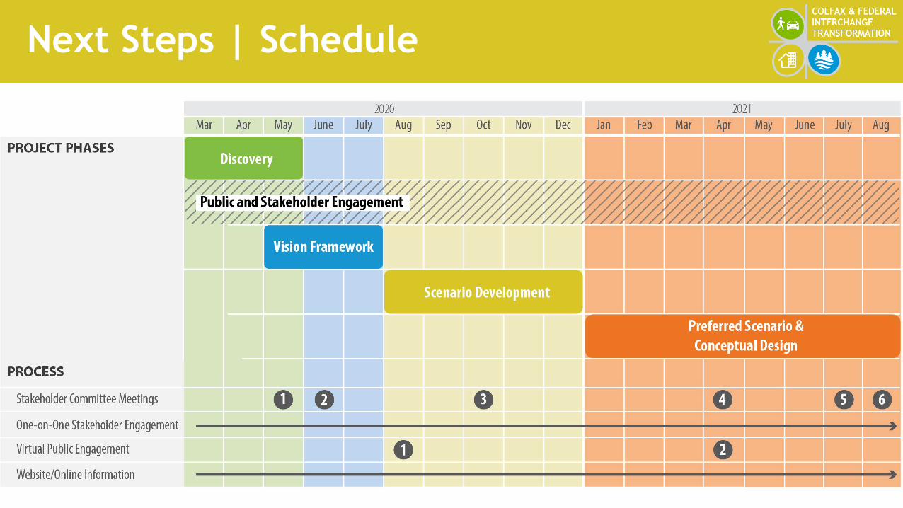
Next Steps | Schedule

Next Steps | Upcoming Meetings
• July 1st – Denver & CDOT project update
• Week of July 12th – PMT meeting & matrix ranking.
• Week of 29th – Stakeholder / Public Meeting
• Early August – PMT Review of scenario evaluation
• Mid-August – Stakeholder review of scenario evaluations
• Late August – Final report QUESTIONS?


