93
Dayton Greenway Conceptual Master Plan Prepared for the Town of Dayton, VA June 2016

Dayton Greenway Conceptual Master Plan
Prepared for the Town of Dayton, VA
June 2016

Dayton Greenway Conceptual Master Plan
2
Project funding provided in part by the US Forest Service in cooperation with the Virginia Department of Forestry Urban & Community Forestry Program
Dayton Greenway Conceptual Master Plan
3
PROJECT TEAM
Elizabeth GilboyDirector
Melissa PhilenLandscape Architecture Project Manager
Patricia StroudLandscape Designer
Andrea ThomasGIS Technician
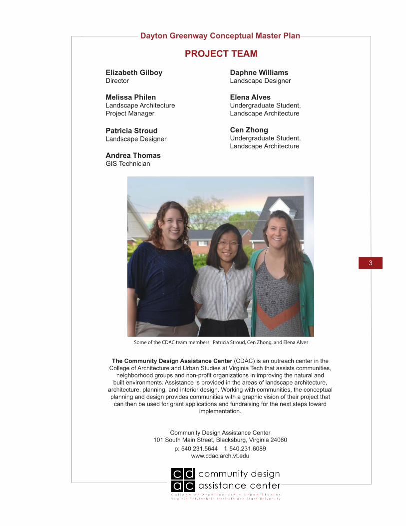
Some of the CDAC team members: Patricia Stroud, Cen Zhong, and Elena Alves
The Community Design Assistance Center (CDAC) is an outreach center in the College of Architecture and Urban Studies at Virginia Tech that assists communities,
neighborhood groups and non-profit organizations in improving the natural and built environments. Assistance is provided in the areas of landscape architecture,
architecture, planning, and interior design. Working with communities, the conceptual planning and design provides communities with a graphic vision of their project that
can then be used for grant applications and fundraising for the next steps toward implementation.
Community Design Assistance Center101 South Main Street, Blacksburg, Virginia 24060
p: 540.231.5644 f: 540.231.6089www.cdac.arch.vt.edu
Daphne Williams Landscape Designer
Elena AlvesUndergraduate Student, Landscape Architecture
Cen ZhongUndergraduate Student, Landscape Architecture

Dayton Greenway Conceptual Master Plan
4
ACKNOWLEDGMENTS
The CDAC team would like to acknowledge the following people for their contributions throughout the project.
Town of Dayton employees
Imagine Dayton Committee
Town residents
All those who participated in community meetings
Robert (Bobby) Popowicz Jr., Town Manager
Charles Long, Mayor
Brenda Stearn, Risk Management Coordinator
Shelley Newman, Councilperson
Robert Bersson

Dayton Greenway Conceptual Master Plan
5
TABLE OF CONTENTS
Project DescriptionOverviewTown Scale Map
Design Process
Part I: Final Conceptual Designs
Final Design: Dayton GreenwaySWOT AnalysisDesign DescriptionConceptual Master PlanPhasing Plan
Final Design: Silver Lake TrailInventory and Analysis Design DescriptionConceptual Master PlanPerspective RenderingsSectionMaterial/Inspiration PalettePlant Palette
Final Design: Historical DowntownInventory and Analysis Design DescriptionConceptual Master PlanPerspective RenderingPlant Palette
Final Design: Neighborhood TrailInventory and Analysis Design DescriptionConceptual Master PlanPerspective RenderingSectionMaterial/Inspiration PalettePlant Palette
Final Design: Dayton MarketInventory and Analysis Design DescriptionConceptual Master PlanPerspective RenderingMaterial/Inspiration PalettePlant Palette
77
10
11
1414161718
2121212223262728
303030313233
3535353637383940
42424243444546

Dayton Greenway Conceptual Master Plan
6
Part II: Information Gathering and Design Development
Inventory and AnalysisIntroductionTown Inventory MapTown Analysis MapSite Inventory & Analysis Map: Silver Lake TrailSite Inventory & Analysis Map: Historical DowntownSite Inventory & Analysis Map: Neighborhood TrailSite Inventory & Analysis Map: Dayton Market
Conceptual Design Development IntroductionTown Scale Preliminary Conceptual Master Plan Proposal 1Town Scale Preliminary Conceptual Master Plan Proposal 2Site Scale: Silver Lake Conceptual Design Proposals 1 & 2Site Scale: Historical Downtown Conceptual Design Proposals 1 & 2Site Scale: Neighborhood Trail Conceptual Design Proposals 1 & 2 Site Scale: Dayton Market Conceptual Design Proposals 1 & 2
Part III: Appendix
Stakeholders Meeting NotesFeedback From Imagine Dayton Committee After the Preliminary Design MeetingFinal Feedback From Imagine Dayton CommitteeSurvey ResultsRails to Trails Conservancy: SurfacesEasementsLand Conservation Information from the Virginia Department of Conservation and Recreation (DCR)Land Conservation in VirginiaAgricultural Conservation Easement Program GrantsVirginia DCR Conservation Reserve Enhancement ProgramVirginia Recreational Trails ProgramVirginia Department of Forestry Trees for CleanwaterTransportation Alternatives (TA) Set-AsideSafe Route to School Program
4949505152535455
56565758 59606162
64
6973757881
828890919191929293
TABLE OF CONTENTS
Dayton Greenway Conceptual Master Plan
7
PROJECT DESCRIPTION
Overview
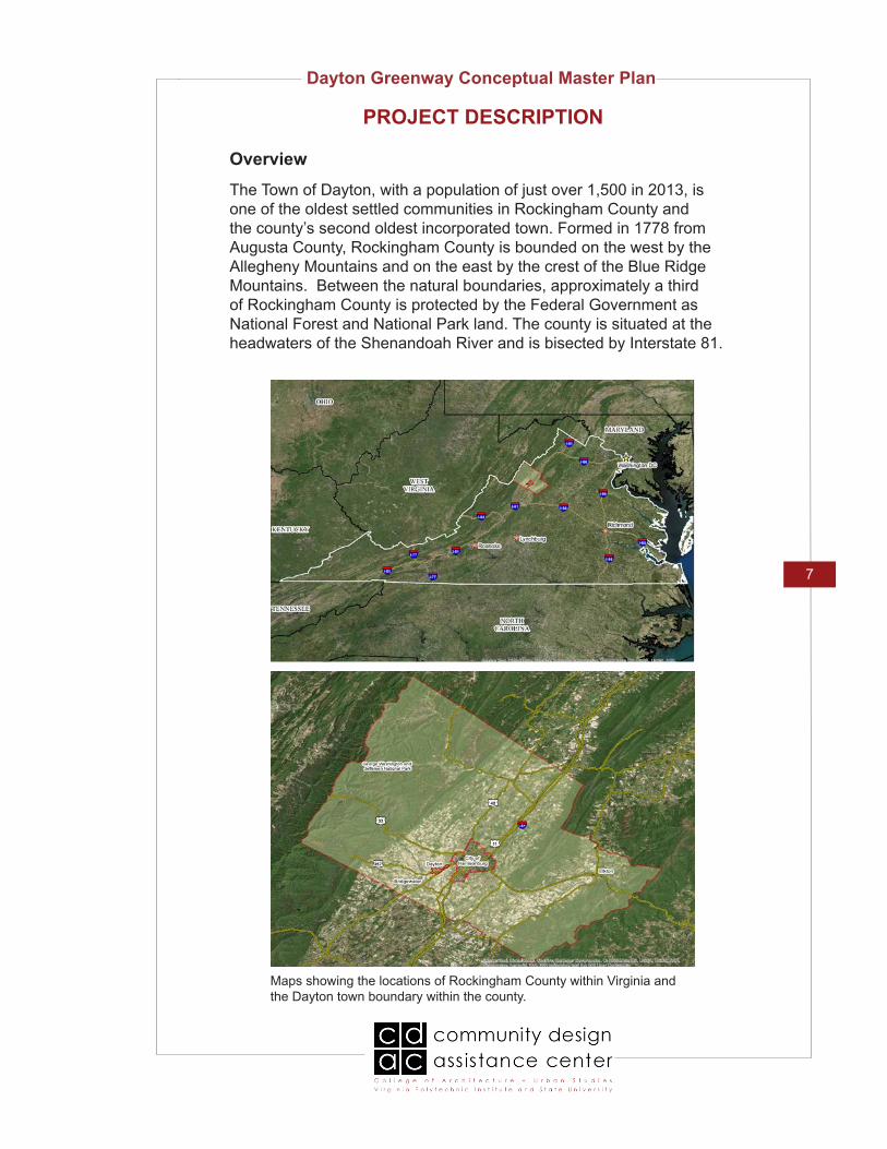
Maps showing the locations of Rockingham County within Virginia and the Dayton town boundary within the county.
The Town of Dayton, with a population of just over 1,500 in 2013, is one of the oldest settled communities in Rockingham County and the county’s second oldest incorporated town. Formed in 1778 from Augusta County, Rockingham County is bounded on the west by the Allegheny Mountains and on the east by the crest of the Blue Ridge Mountains. Between the natural boundaries, approximately a third of Rockingham County is protected by the Federal Government as National Forest and National Park land. The county is situated at the headwaters of the Shenandoah River and is bisected by Interstate 81.

Dayton Greenway Conceptual Master Plan
8
PROJECT DESCRIPTION
Dayton possesses a certain small-town charm. A large portion of the land surrounding the town limits is agricultural and maintained by a combination of Mennonite groups, known as the Plain People, as well as conventional farmers. The largest employer in the county is James Madison University, located a short distance down VA State Route 42 in Harrisonburg, the county seat of Rockingham County. The fourth largest employer in the county, Cargill Meat Solutions, a poultry processing facility, is located within Dayton’s town limits.
Included within the town limits are resources of significant cultural, social, and historic value. The town boasts 154 buildings and 1 significant site that contribute to the Dayton Historic District. Three community parks (College Street Pavilion, Sunset Park, and Cooks Creek Park) provide active and passive outdoor recreation opportunities.
Silver Lake, located in the county just outside of the town boundary, is a 10-acre body of water hosting a variety of plant and wildlife rests along the North River Loop of the Virginia Birding and Wildlife Trail and Virginia Civil War Trails. The Silver Lake Mill, renovated in 2000-2001 and also in the county, functioned historically as a community facility. This mill is connected by a millrace, a stream of water used to power the mill’s wheel, to Cooks Creek Park.
The Town of Dayton would like to develop a conceptual master plan for a multi-use greenway that traverses through a variety of areas in Dayton and connects various community assets throughout town, the downtown district, and Silver Lake.
Map showing the Dayton town boundary.

Dayton Greenway Conceptual Master Plan
9
PROJECT DESCRIPTION
It is envisioned that different segments of the greenway would each possess a distinct character. The character identified in each of the greenway’s segments would take into consideration the history, context, and peculiarities within Dayton and would be reflected in the design for each segment. The following were identified as nodes and districts making up the future proposed greenway: Silver Lake, Silver Lake Mill, The Heritage Museum, Fort Harrison, the Shops at Dayton Market, Dayton Historic District, residential back alleys, downtown alleys, community parks, and residential areas.
Where feasible, the town would like the greenway to have the following: small pockets of playground equipment along the trail; landscaping where appropriate; benches; labelled trees where appropriate for educational purposes; outdoor sculptures and murals; character fencing in some areas, and way-finding signage.
One specific segment for the greenway was identified at the start of the project, which is along the Silver Lake Mill Raceway. This particular segment rests upon a piece of property owned by an Old Order Mennonite farmer who will be providing an easement to the town for the greenway use. The town contracted a local engineering firm to consider locations for this trail segment and two bridge crossings; one to a parking lot near Silver Lake Mill and the other to Cooks Creek
Dayton Greenway Conceptual Master Plan
10
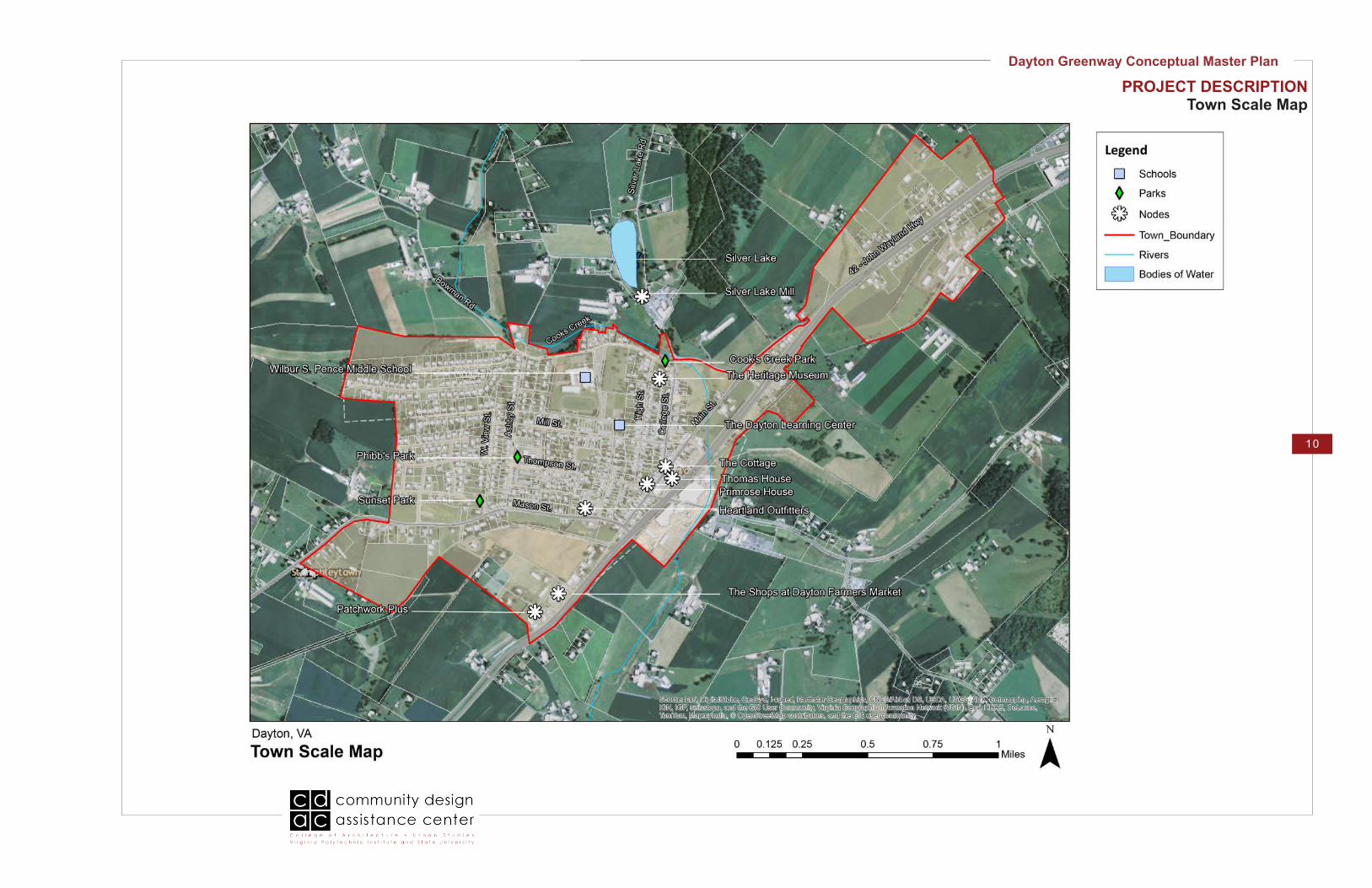
PROJECT DESCRIPTIONTown Scale Map

Dayton Greenway Conceptual Master Plan
11
The design process began with an initial site visit to Dayton in February 2016. The CDAC team met with the Stakeholders Committee, Imagine Dayton, and town representatives to hear initial ideas and thoughts; experience the area’s parks, downtown, and Silver Lake Mill; discuss and decide on up to 5 areas for which to develop focus area designs (described on next page); and discuss ideas for the format for the first community meeting.
The team then gathered mapping information about the town and various sites, documented existing conditions, and took photographs and measurements which helped the team to understand the opportunities and constraints of each area around town and specific sites. This background information influenced the preliminary conceptual designs.
Preliminary greenway location concepts, conceptual designs for specific sites, analysis, and ideas from similar projects were presented to the stakeholders and community members at a community meeting in March 2016. During this presentation, the CDAC team documented feedback from those in attendance related to the various options. A survey was also posted on the town’s Facebook page. The team also utilized survey feedback when revising the design concepts. The team later had further discussions with Imagine Dayton and town representatives, which helped toward final design work.
The CDAC team utilized the feedback and consolidated the initial concepts to create a final greenway master plan and focus area designs for Silver Lake Trail, Historical Downtown, Neighborhood Trail and Dayton Market Connection. The final drawings included the conceptual master plan, phasing plan, four site conceptual master plans, and supporting sketches and renderings. This final design work was presented at a community meeting in May 2016.
DESIGN PROCESS
CDAC team member, Cen Zhong, talks with an Imagine Dayton Committee member at the initial meeting in February 2016.
CDAC team member, Elena Alves, takes notes on site during the initial site visit.
CDAC staff member, Melissa Philen, discusses the goal for the greenway with Imagine Dayton Committee members at the initial meeting in February 2016.

Dayton Greenway Conceptual Master Plan
12
Comments and suggestions from all the previous surveys were incorporated into the final designs.
Following in Part I is a description of each of the final concepts. Part II includes inventory and analysis information, along with initial design concepts and precedent studies from other communities.
DESIGN PROCESS (CONT.)
CDAC team members, Elena Alves and Cen Zhong, present inventory, analysis, and conceptual preliminary designs at the first community meeting.
Dayton community members review the final design boards at the final community meeting.

Dayton Greenway Conceptual Master Plan
13
Part I:Final Conceptual Designs

Dayton Greenway Conceptual Master Plan
14
FINAL DESIGN: DAYTON GREENWAY
SWOT Analysis
Strengths:The great strengths of the town of Dayton are its historical context and many existing elements with historical, cultural, and ecological aspects, as well as many local nodes and districts, which could be featured and connected through design. The town has many historical and cultural events throughout the year and a picturesque surrounding agrarian landscape. Additionally, the town is included in a large network of biking trail systems and Dayton is featured as a major hub of the system.
Weaknesses:The major weakness in town is the lack of connections between existing historical and cultural elements, especially the weak connections for pedestrians on Mason St. and Bowman St, which are the two most dangerous streets for pedestrian crossing. The streets in downtown are narrow for bikers. Some other weaknesses are aging infrastructure, such as limited vehicle entrance view along/from Route 42 and sparse wayfinding guidance and signage for visitors and the local community.
Opportunities:With the natural characteristics of Silver Lake, there is a great opportunity to create a greenway around the lake and to connect to Cooks Creek Park. The existing building near the Silver Lake parking lot could be re-used for a trailhead service building. Another portion of the greenway can be designed as a connection trail from downtown to the Dayton Market. Maple Lane, Cherry Lane, and Elm Lane could be used as alternative trail routes for the local community and bikers. Taking advantage of the beautiful agrarian landscape, the unique history and culture of the town, local artists and businesses, these features can be incorporated into design ideas to encourage tourism and stimulate local economy. Threats (Challenges):The major challenge is to incorporate the major featured nodes and sites and to improve connections and pedestrian crossings on the busy and narrow streets. The connection segment from downtown to Dayton Market along Route 42 has challenging steep slopes as a visual block for vehicles. The alleys and College Street have limited physical space or right-a-way space, limited sight lines at some intersections, and have overhead utility lines, which constrain tree planting.

Dayton Greenway Conceptual Master Plan
15
FINAL DESIGN: DAYTON GREENWAY
SWOT Analysis (cont.)
Opportunity- Strength Strategies:(Use strengths to take advantage of opportunities)• Create a trail network of variety by linking similar featured locations
into theme trails such as local history, local business, or nature trails.
• Highlight biking routes for local and long-distance bikers with clear signage on streets and alleys.
• Feature Silver Lake with educational options and active recreational space.
• Dayton Market is a local hub and could attract visitors into the town.• Historical Downtown could provide nodes for a centralized network.• Utilize town events like Dayton Days, Redbud Festival and Wool,
Wheat, & Wine Festival in Bridgewater as opportunities to advocate Dayton and display the history, landscape, and arts of the town.
Opportunity- Weakness Strategies:(Overcome weaknesses by taking advantage of opportunities)• Improve streetscapes of related streets with shade trees and
lighting for pedestrian safety. Pedestrian connections could be made from Silver Lake Road to the trailhead as the main node.
• Showcase older buildings to promote town history. • Pedestrians and bikers may detour to back alleys which would need
to be improved with more infrastructure for comfort and safety. • Introduce a more appealing entrance and a scenic greenbelt along
Route 42 to attract more visitors. • Exhibit art work (i.e. murals or sculptures) in different places of
interest along the trails. • The “small town” culture could be used as a unifying element for
design. Simple and colorful signage for a wayfinding system could be easily memorized and used for town navigation.
Challenge-Strength Strategies: (Use strengths to avoid challenges)• Improve the streetscape. • Connect trails to lighter traffic streets including having limited
exposure along Route 42. • Take traffic-calming measures to avoid potential dangers for the
pedestrian.
Challenge-Weakness Strategies: (Minimize weaknesses and avoid challenges)• Reduce pedestrian traffic and disperse the crowd into different
lanes/routes of interests (theme trails)• Use the old railbed for the trail connection to the Dayton Market.

Dayton Greenway Conceptual Master Plan
16
FINAL DESIGN: DAYTON GREENWAY
Design Description
Conceptual Master Plan:The Dayton Greenway conceptual master plan aims at connecting the segmented areas of the town. The overall goal of the greenway is to create a pedestrian friendly trail throughout Dayton, whether that be a complete redesign of an area or simple infrastructural improvements. Silver Lake, located north of Dayton, provides many recreational activities and is an important linkage within the greenway design. The Dayton Market is another important element in connecting the downtown and residential areas of Dayton. The downtown section highlights the heritage of Dayton, emphasizing the landmark buildings and history. The neighborhood trail loop provides safe connections for children walking to school and paths for families to play outside and spend time together. In the future the Dayton Greenway could possibly connect to the nearby town of Bridgewater, the city of Harrisonburg, areas within Rockingham County, and the George Washington National Forest. Overall, the Dayton Greenway will connect this charming town and encourage residents and visitors alike to explore the rich opportunities around them.
Conceptual Phasing Plan:The Dayton Greenway conceptual phasing plan shows four phases and a possible future phase. The first phase is the Silver Lake Trail. The second phase includes the Historical Downtown, with connections to Fort Harrison House and Grammie’s Ice-cream, and the connection to Dayton Market. The third phase is the neighborhood trail and the fourth phase is the trail through the new neighborhood built along Dayton West. The future expansion phase includes the trail and sidewalk connections to Harrisonburg, George Washington National Forest, and Bridgewater.

Dayton Greenway Conceptual Master Plan
17
FINAL DESIGN: TOWN GREENWAY LOOPConceptual Master Plan

Dayton Greenway Conceptual Master Plan
18
FINAL DESIGN: TOWN GREENWAY LOOPPhasing Plan

Dayton Greenway Conceptual Master Plan
19
FINAL DESIGN: DAYTON GREENWAY
Design Description (cont.)
Focus Area Design Concepts: The master plan depicts the overall layout of the greenway throughout the town. Concepts for specific areas were also developed including: Silver Lake Trail, Historical Downtown, Neighborhood Trail, and Dayton Market.
Silver Lake Trail:The Silver Lake area provides the local community with a natural place for recreation, relaxation, and stress release. The design introduces a greenway trail loop around the lake and an extended trail linking to Cooks Creek Park. Parking is available alongside Silver Lake Road as well as at two parking lots near the trailhead. Boardwalks along Silver Lake provide opportunities for more interaction and activities with the water such as fishing and boating. A traffic calming green buffer is added for safety along Silver Lake Road. The trail along the farmland connects Silver Lake and Cooks Creek Park while providing more recreational opportunities for both local residents and visitors, such as a small water access point to interact with the water.
Historical Downtown:The main goal of the downtown trail is to highlight the heritage of Dayton by emphasizing historic buildings and creating public spaces for gathering. The trail meanders along the tree line and crosses Cooks Creek to reveal Fort Harrison. Greening the streets and improving sidewalk connections will improve the overall streetscape and encourage pedestrians to visit the downtown shops and cafes.
Neighborhood Trail:The neighborhood trail includes improvements on safety and walkability for pedestrians and provides connections from the residential zones to Dayton Market and the downtown area. The design introduces a community garden with educational signage and garden shed amenities. Wayfinding is provided along the street and around street corners to guide children to and from school. Traffic calming measures would be taken along Mason Street. The pedestrian walkway would be set back with a rain garden as a buffer to the street. The walkway weaves through a perennial garden with sculptures. Also, the residential area would have the book-sharing program, “Little Library”, which would have little libraries dispersed throughout the neighborhood from the school to the perennial garden as another wayfinding feature.
Dayton Market:The Dayton Market trail will emphasize local culture and artistry of

Dayton Greenway Conceptual Master Plan
20
FINAL DESIGN: DAYTON GREENWAY
Design Description (cont.)
Dayton. The proposed trailhead will encourage people to explore either the Market or downtown Dayton with helpful signage and accessible parking. The trail will more easily connect the residential area of Dayton and downtown Dayton to the Market, encouraging the community to walk when going shopping. A unique boardwalk design intermingles with stormwater management opportunities along the trail, which also provide a buffer zone from Route 42. This trail section provides an opportunity for recreation removed from the street and automobiles.
The following sections include a description of each focus area design, the corresponding conceptual master plan, sections, perspectives, material/inspiration palette, and a plant palette for each focus area.

Dayton Greenway Conceptual Master Plan
21
FINAL DESIGN: SILVER LAKE TRAIL
The existing building could be re-purposed as a trailhead service center.
Design Description
The design introduces a trail loop around Silver Lake and extends to Cooks Creek Park. The greenway trail loop features a boardwalk including several deck spots for water activities such as fishing, boating, and wildlife photography. In addition, parking is proposed alongside Silver Lake Road as well as at two parking lots near the trailhead. A traffic calming green buffer is added for safety along Silver Lake Road. The existing building can serve as a trailhead service center that connects the trail loop around the Silver Lake and the trail leading to the Cooks Creek Park.
The conceptual master plan for Silver Lake Trail can be found on the following page. A cross section and several perspectives of proposed aspects of the Silver Lake Trail follow the conceptual master plan.
Inventory and Analysis
The Silver Lake area has the natural landscape setting for a greenway around the lake, attracting people to come for a walk, fishing, or other activities. A study of ecological species should be conducted so that native plant species can be enouraged and invasive species to remove. Some plant species, such as milkweed, should be preserved due to its ecological value. There is a need for the trail to connect from the lake to Cooks Creek Park along the nearby farmland. The existing vacant building by the gravel parking lot could be re-purposed as a trailhead service center.
A basic inventory of animal species could be conducted as well and educational signage posted along the trail about the flora and fauna.
People like fishing along the edge of Silver Lake.

Dayton Greenway Conceptual Master Plan
22
FINAL DESIGN: SILVER LAKE TRAILConceptual Master Plan
Silv
er L
ake
Road
Silver Lake
Cooks Creek Park
Silver Lake Mill
Bowman Rd.
Dayton
Rockingham County
Future possible connection toGeorge Washington National Forest
Boardwalk
Fishing/Observation Decks
Native Vegetation
Parallel Parking
Existing Parking Lots
Proposed Trailhead
1
3
2
Proposed trail link from Silver Lake to Cooks Creek Park
Access area to Cooks Creek

Dayton Greenway Conceptual Master Plan
23
FINAL DESIGN: SILVER LAKE TRAILPerspective Rendering 1
Proposed entry to Silver Lake trail from Cooks Creek Park

Dayton Greenway Conceptual Master Plan
24
FINAL DESIGN: SILVER LAKE TRAIL Perspective Rendering 2
Proposed boardwalk and fishing/observation deck along Silver Lake

Dayton Greenway Conceptual Master Plan
25
FINAL DESIGN: SILVER LAKE TRAILPerspective Rendering 3
Proposed trailhead in existing re-purposed building

Dayton Greenway Conceptual Master Plan
26
FINAL DESIGN: SILVER LAKE TRAILSection
A A’
Proposed Improvements to Silver Lake Area Cross Section A-A’
Silver Lake Road with improved green streetscape and increased safety for pedestrians. The rain garden green buffer is proposed for traffic calming measures. A limited numer of parallel parking spaces would be provided instead of the unstructured gravel parking along the Silver Lake Road. Several wooden decks at the edge of Silver Lake provides more access and opportunities for recreational activites with the lake.
Locator Map

Dayton Greenway Conceptual Master Plan
27
Material/Inspiration Palette
FINAL DESIGN: SILVER LAKE TRAIL
A boat rental station is available for canoes and kayaks and an entry dock allows visitors to enter the lake.
Wooden boardwalks would preserve the natural setting, allow drainage, and impact the environment less than other options. However, it can be slippery when wet and expensive to install and maintain.
Signage along the trail should be added to provide wayfinding and educational information for visitors.
Seating is available along the entire trail loop.
Wooden fencing along farmland provides visual comfort and safety. A trail connection along the tree line south of Cooks Creek could provide pedestrian access to Fort Harrison and Grammie’s Ice Cream while creating a continuous pedestrian recreation space.
Crushed stone may be a good choice for the trail linking to Cooks Creek Park. It holds up well under heacy use, fits in with the natural setting, and can accommodate a variety of users (see Appendix for more information).

Dayton Greenway Conceptual Master Plan
28
Plant Palette
Theme:
Trees and Shrubs:
Amelanchier arborea (Serviceberry)A shrub or small tree prized for its brilliant orange-red fall color and disease resistance. Clusters of fragrant white flowers give way to small purplish black fruit often used in jams and jellies. Use in shrub borders or as a small tree. Deciduous.
Callicarpa Americana (Beautyberry)Callicarpa americana is an open-habit, native shrub of the Southern United States which is often grown as an ornamental in gardens and yards. The relatively insignificant flowers develop into prolific bright violet to magenta berry-like drupes which encircle the stem. These fruits remain attractive for a long time although they are generally gone before severe winter weather.
Rhus aomatica ‘GroLow’ (Fragrant Sumac)Tough groundcover for banks and areas of poor, dry soil. Divided leaves are fragrant when brushed against or crushed, foliage displays excellent red fall color. Deciduous. This fast-growing, durable plant is a good choice that requires little maintenance. “Gro-low” sumac is relatively tolerant of road salt. Prune any branches broken by snow piles and the plant will quickly fill back in. Though vigorous, it is not an invader.
FINAL DESIGN: SILVER LAKE TRAIL
Silver Lake is a wonderful asset to the community of Dayton. It allows for educational opportunities for children and adults, as well as an important emphasis on ecology and connection with nature within the area. Possible plant materials for the Silver Lake area would be Beautyberry, Serviceberry, Monarda, Asclepias, Juniper, Coneflowers, Soft rush, Cardinal Flower, Blue Flag Iris, Rhus and Chokeberry. All of these plants fall within the native, low maintenance, wetland, and wildlife attracting categories.

Dayton Greenway Conceptual Master Plan
29
Plant Palette (cont.)
Perennials and Grasses:
Asclepias tuberosa (Butterfly weed)Butterfly weed is a native perennial with flat-topped, orange or yellow flower clusters at the ends of its stems or in its leaf axils. From midsummer to autumn, it produces clusters of brightly colored flowers that attract insects, followed by fruit and showy seed. Plant in a border, meadow, butterfly garden, or wildflower garden.
Iris versicolor (Blue Flag Iris)Iris veriscolor, commonly called northern blue flag, is a clump-forming iris that is native to marshes, swamps, wet meadows, ditches and shorelines from Manitoba to Nova Scotia south to Virginia, Ohio, Illinois and Minnesota. It is a marginal aquatic plant that forms a clump of narrow, arching-to-erect, sword-shaped, blue-green leaves (to 24” long and 1” wide). Flowering stalks rise from the clump to 30” tall in late spring, with each stalk producing 3-5 bluish-purple flowers (to 4” wide) with bold purple veining.
Lobelia cardinalis (Cardinal Flower)A popular though short-lived perennial that produces a profusion of brilliant scarlet flowers atop 3- to 4-foot-tall plants. Native to wet areas in the eastern U.S., will tolerate full sun if soil is kept moist.
Juniper virginiana ‘Grey Owl’ (Juniper)Finely textured evergreen shrub with arching branches clothed with soft, silvery-gray needles. Very effective planted in masses as a tall groundcover. Best with partial sun in desert climates. Requires little maintenance. Drought tolerant when established.
Juncus effuses (Soft Rush)Juncus effusus is a clump forming wetland plant that is a striking vertical addition to any garden or container planting. Upright, fanning, deep green, rounded stems make a great accent in a container or water garden. Soft Rush can be planted at the edge of a pond or in up to 6” of standing water. Inconspicuous golden flowers appear atop the stems in summer. Native to most of North America, Soft Rush provides food and shelter for birds and other wildlife.
FINAL DESIGN: SILVER LAKE GREENWAY

Dayton Greenway Conceptual Master Plan
30
FINAL DESIGN: HISTORICAL DOWNTOWN
Design Description
Historical downtown includes College Street, where the design mainly focuses on emphasizing historic buildings and to creating public spaces for gathering in front of the Shenandoah College building. A trail is proposed along the fence line behind the pavilion then down along the tree line and across Cooks Creek to reveal and connect to Fort Harrison House. Greening the streets and improving sidewalk connections will improve the overall streetscape and encourage pedestrians to visit the downtown shops and cafes.
The following pages include the conceptual master plan for the historical downtown area and a perspective of proposed streetscape of College Street.
Inventory and Analysis
Historical downtown has the most signifigant heritage elements Dayton, especially on College Street. It is important to highlight those elements as well as increase walkability for pedestrians since there is currently only one narrow sidewalk on the Fort Harrison House side of College St. Fort Harrison is one of the important elements, yet it is separated away from the downtown by farmland and a creek. Fort Harrison House needs a way to be connected to the whole historical trail network.
View from the pavilion shows the Fort Harrison House with few connections.
Street view on College St. shows the one narrow sidewalk.

Dayton Greenway Conceptual Master Plan
31
FINAL DESIGN: HISTORICAL DOWNTOWNConceptual Master Plan
Open Public Space
Access along fence line
Fort Harrison
Proposed Street Trees
Connection through street right of way
Proposed Planting
A trail connection along the tree line south of Cooks Creek could provide pedestrian access to Fort Harrison and Grammie’s Ice Cream while creating a continuous pedestrian recreation space.
Trail Connection to Grammie’s Ice Cream
A formal welcome sign invites people into the historic downtown of Dayton.
Mai
n Str
eet
Col
lege
Stre
et
Museum
King Street
Eberly Road
42High
Stre
et
Rockin
gham C
ounty
Dayton
Future Possible Connection to Harrisonburg

Dayton Greenway Conceptual Master Plan
32
FINAL DESIGN: HISTORICAL DOWNTOWNPerspective Rendering
A perspective of proposed streetscape improvements looking north along College Street

Dayton Greenway Conceptual Master Plan
33
FINAL DESIGN: HISTORICAL DOWNTOWN
Plant Palette
Theme:
Trees:
Carpinus caroliniana (American hornbeam)A fine-textured tree that is related to the birches, American hornbeam is the only North American native of the genus Carpinus. The trunk and branches of this tree have ridges that look like muscles. American hornbeam is a wonderful addition to a natural landscape. It will tolerate flooding. Songbirds are attracted to its forked branches, dense crown and tasty seeds. Its fall foliage can be beautiful.
Cornus mas (Cornelian Cherry Dogwood)Valued for early spring bloom, this dogwood can be grown as a low-branching, multi-stemmed shrub or small garden tree. Showy, small yellow flowers appear before green foliage emerges in spring. Makes an ideal hedge, screen, or trained as a specimen in shrub borders. Deciduous.
Syringa reticulata ‘Ivory Silk’ (Japanese Tree Lilac)Japanese tree lilac adapts well to difficult or urban sites. Trees are excellent for use as specimens, in group planting as a screen, and as street trees.
Within the downtown areas of Dayton low maintenance plants featuring drifts of continuous color as well as sturdy shrubs and rain water capturing plants are important. These plants could be heirloom species that have proven stability from early on in the establishment of Dayton and serve as educational opportunities on the history of Dayton. Plants such as ‘Annabelle’ Hydrangea, Sweetshrub, Flowering Almond, ‘Alaska’ Shasta daisy, Yarrow, and Fountain Grasses have been around since the late 1890’s and early 1900’s. These would be beautiful additions along with evergreen, dwarf hollies and Korean boxwoods, and with small street trees such as the Japanese tree lilac, Cornus mas (Cornelian Cherry Dogwood), and American Hornbeam.

Dayton Greenway Conceptual Master Plan
34
FINAL DESIGN: HISTORICAL DOWNTOWN
Plant Palette (cont.)
Shrubs:
Hydrangea arborescens ‘Annabelle’ (Smooth Hydrangea)Annabelle features stunning pure white flowers, much larger than the species- up to 12 inches across! Flowers appear in late spring to summer, often continuing into fall. Strong, straight stems hold the huge flower heads up well, despite heavy rain. This full, lush shrub needs plenty of room to show off its spectacular beauty. Deciduous.
Buxus x‘Glencoe’ (Hybrid Boxwood)A cold resistant boxwood that holds its green color well in winter. A superior low hedge both sheared and informal. Excellent foundation plant or as background for perennials.
Perennials and Grasses:
Pennisetum alopecuroides ‘Little Honey’ (Dwarf Fountain Grass)This fountain grass features an upright clump of arching, glossy, variegated green and white foliage typically growing only 6-12” tall. Showy, wheat-like flower spikes rise in late summer just above the foliage. Flower spikes mature to the color of gold-dust. This cultivar is a sport of the popular P. a. ‘Little Bunny’.
Achillea x‘Moonshine’ (Yarrow)Easy-to-grow and beautiful perennial with upright, canary-yellow flower clusters. Attractive addition to the landscape in borders or massed plantings. Flowers may be cut and dried for bouquets. Good host plant for ladybugs.
Leucanthemum xsuperbum ‘Alaska’ (Shasta Daisy)No sunny border would seem complete without the familiar presence of Shasta Daisies. This is one of the most popular selections, and perhaps the best for colder regions. Flowers are large single white daisies with a yellow eye, showy in the garden and excellent for cutting.
Dayton Greenway Conceptual Master Plan
35
Inventory and Analysis
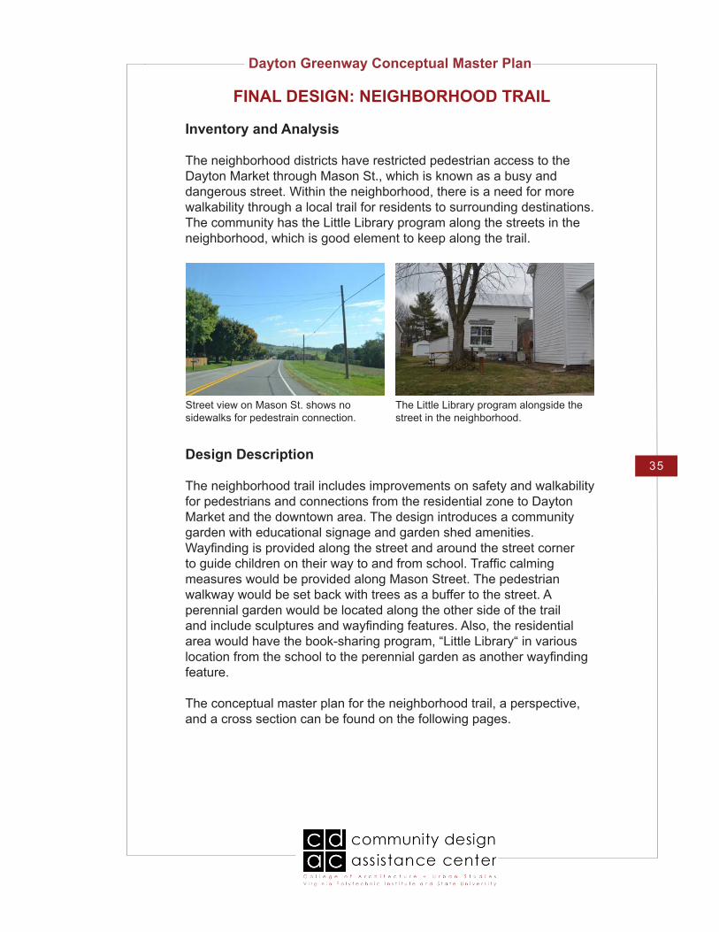
The neighborhood districts have restricted pedestrian access to the Dayton Market through Mason St., which is known as a busy and dangerous street. Within the neighborhood, there is a need for more walkability through a local trail for residents to surrounding destinations. The community has the Little Library program along the streets in the neighborhood, which is good element to keep along the trail.
FINAL DESIGN: NEIGHBORHOOD TRAIL
Design Description
The neighborhood trail includes improvements on safety and walkability for pedestrians and connections from the residential zone to Dayton Market and the downtown area. The design introduces a community garden with educational signage and garden shed amenities. Wayfinding is provided along the street and around the street corner to guide children on their way to and from school. Traffic calming measures would be provided along Mason Street. The pedestrian walkway would be set back with trees as a buffer to the street. A perennial garden would be located along the other side of the trail and include sculptures and wayfinding features. Also, the residential area would have the book-sharing program, “Little Library“ in various location from the school to the perennial garden as another wayfinding feature.
The conceptual master plan for the neighborhood trail, a perspective, and a cross section can be found on the following pages.
The Little Library program alongside the street in the neighborhood.
Street view on Mason St. shows no sidewalks for pedestrain connection.

Dayton Greenway Conceptual Master Plan
36
FINAL DESIGN: NEIGHBORHOOD TRAILConceptual Master Plan
Community gardens along the route to the middle school will provide outdoor activities for both children and adults. Educational signage throughout the garden will help children learn about gardening. A greenhouse and shed provide amenities for gardening space.
Thompson St.
Mill St.
Suns
et D
r.
W V
iew
St.
E. V
iew
St.
Mason St.
Mai
n St.
Ash
by S
t.
Middle School
Proposed Street Trees
Trail separating pedestrians from road
Pencil-shaped fence as wayfinding
Art/Sculpture Perennial Garden

Dayton Greenway Conceptual Master Plan
37
FINAL DESIGN: NEIGHBORHOOD TRAILPerspective Rendering
A perspective view looking east on Mason Street. Trees provide a buffer between vehicular traffic and pedestrians.

Dayton Greenway Conceptual Master Plan
38
FINAL DESIGN: NEIGHBORHOOD TRAILSection
Locator Map
B
B’
Proposed Mason St. Cross Section B-B’
Street improvements on Mason Street would include the addition of sidewalks on both sides, a bike lane, tree plantings along road, lamp posts, and crosswalks on the straight away for safe pedestrian crossing. An art and sculpture perennial garden along Mason Street’s south side will provide a beautiful backdrop.

Dayton Greenway Conceptual Master Plan
39
FINAL DESIGN: NEIGHBORHOOD TRAIL
Material/Inspiration Palette
The art and sculpture garden along Mason Street will be planted with native wildflowers.
A pencil-shaped fence leads children to and from school as a bright, easy to locate wayfinding opportunites.
Little Free Libraries could be located throughout the neighborhood.

Dayton Greenway Conceptual Master Plan
40
Plant Palette
Theme:
Perennials:
Stachys byzantina ‘Big Ears’ (Lamb’s Ear)‘Big Ears‘ is noted for its silver-green foliage which forms an attractive ground cover. Dense rosettes of thick, soft, velvety, silver-green leaves (to 8” long) form a mat approximately 8” off the ground. Soft and fuzzy to the touch, it is a good choice for children’s gardens.
Lavandula angustifolia ‘Hidcote’ (Lavender)This versatile, fragrant perennial shrub has many uses beyond the herb garden! Deep purple flower spikes above mounds of gray-green foliage provide great color to the front of shrub borders or spotted into the rock garden. Highly effective in mass plantings. Useful for perfumes, sachets, oils, and medicinal purposes.
Agastache ‘Heatwave’ (Hummingbird Mint)Eye-catching spikes of lavender-pink blooms contrast handsomely with blue-green foliage, providing vibrant color, summer through fall. Often called Hummingbird Mint, it attracts hummingbirds and butterflies with its tubular flowers and spicy fragrant licorice-scented foliage. Mass toward the rear of perennial borders for striking effect. Herbaceous.
Tropaeolum (Nasturtium)Nasturtiums are warm weather annuals that have been popular in herb gardens, cottage gardens, and flower gardens for many years. Flowers have a spicy fragrance. Flowers bloom from spring to fall.
FINAL DESIGN: NEIGHBORHOOD TRAIL
Entice community involvement with the town’s agricultural roots through community edible and educational gardens. Possible plant materials include herbs, strawberries and other fruits, nasturtiums, and plants that offer educational opportunities with butterfly and bird gardens, rain gardens, and native plant education such as butterfly weed, juniper, winterberry holly, Echinacea, and Serviceberry. Signage can be incorporated along the walkway with plant information as well as example species of wildlife that the plant may attract along with fun facts.

Dayton Greenway Conceptual Master Plan
41
Plant Palette (cont.)
Edible plants:
Vaccinium corymbosum ‘Bluecrop’ (Blueberries)‘Bluecrop‘ is a midseason (July 15-August 15) variety that produces high yields of large, bright blue berries that are very firm. Large clusters with excellent flavor, fresh or frozen. ‘Bluecrops‘ are vigorous, spreading and consistently productive. Excellent fall foliage color.
Fragaria ananassa ’Earliglow’ (Strawberries)Introduced years ago, Earliglow still retains the high strawberry flavor of the heirloom varieties. Good sized berries and the earliest. Deep red color fruit and plants are disease resistant.
FINAL DESIGN: NEIGHBORHOOD TRAIL

Dayton Greenway Conceptual Master Plan
42
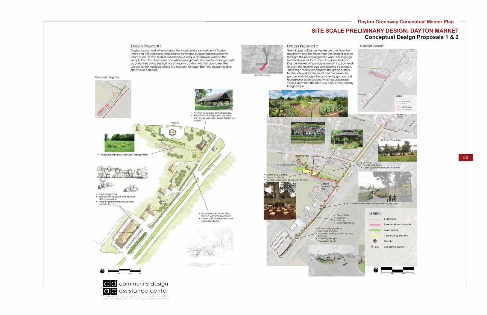
FINAL DESIGN: DAYTON MARKET
Design Description
The Dayton Market trail will emphasize local culture and artistry of Dayton. The proposed trailhead will encourage people to explore either the Market or downtown Dayton with helpful signage and accessible parking. The trail will more easily connect the residential areas of Dayton and downtown Dayton to the Market, encouraging the community to walk when going shopping. A unique boardwalk design intermingles with stormwater management opportunities along the trail, which also provide a buffer zone from Route 42. This trail section provides an opportunity for recreation removed from the street and automobiles.
The following pages include the conceptual master plan and a perspective.
The green field where the rail bed is located provides an opportunity for a trail connection to the Dayton Market.
The view looking to the Dayton Market from the north end of Main St. with a steep slope.
Inventory and Analysis
Dayton Market is a popular destination, but has no pedestrian connection. A trail through the green field where the old railroad bed was located could be an option. There is a steep slope and several large evergreen trees on the side of Route 42 blocking the view to the Dayton Market while looking from the north end of Main St. The former discount store and the triangle land could be re-purposed as a trailhead or welcoming visitor center.

Dayton Greenway Conceptual Master Plan
43
FINAL DESIGN: DAYTON MARKETConceptual Master Plan
Proposed vegetation as a screen from road
Proposed vegetation to
separate pedestrian trail from roads
Proposed Parking
ExistingCommunity
Garden
The former discount store could serve as a trailhead and visitors center. The lot provides parking and signage for easy connections to the Market and downtown. This location is easily accessible from Route 42 and visitors coming into town.
Dayto
n M
arke
t
Mason St.
Cafe Main
St.
42

Dayton Greenway Conceptual Master Plan
44
FINAL DESIGN: DAYTON MARKETPerspective Rendering
Proposed trail to Dayton Market

Dayton Greenway Conceptual Master Plan
45
FINAL DESIGN: DAYTON MARKET
Material/Inspiration Palette
An aesthetic wetland planting provides additional stormwater management for Mason Street and reveals natural processes in a pleasurable and interactive way.
Improved and additional parking allow for more business at the Dayton Market and additional vegetation acts as visual and safety barrier from the street.

Dayton Greenway Conceptual Master Plan
46
Plant Palette
Theme:
Trees:
Cercis canadensis (Redbud Tree)Known for their winding branch structure and stunning magenta flowers from spring through summer. This large shrub or small tree is also a superb iconic tree for the town of Dayton, which are shown at the entrance of the town by the Dayton market.
Shrubs:
Ilex glabra ‘Shamrock’ (Inkberry Holly)Selected for its compact habit and bright, glistening new foliage, this dwarf grower makes an excellent hedge or border plant. The dense twiggy habit displays an abundance of black berries through winter. Evergreen.
Viburnum dentatum ‘Blue Muffin’ (Arrowwood Viburnum)Blue Muffin™ is a useful viburnum variety. More compact than other Arrowwood viburnum, it fits easily into the residential landscape. Clean white flowers make for a crisp contrast with the glossy green leaves in early to mid-summer. The remarkably intense blue fruit that inspired the Blue Muffin™ name appear in late summer and fall. The fruit add interest to the fall landscape, and attract songbirds to the garden. Berries are not edible.
Perennials:
Paeonia (Peony)Plants in the genus Paeonia are clump-forming perennials and deciduous shrubs or sub-shrubs grown for their large, colorful, and sometimes fragrant flowers. Blooms are usually upright and solitary, sometimes several to a stem. Use in mixed, herbaceous, or shrub borders. Herbaceous cultivars bloom in late spring and early summer. Tree peonies bloom in mid-spring and late spring.
FINAL DESIGN: DAYTON MARKET
Plant emphasis within the Market connection from the town of Dayton would be species that are low maintenance, dynamic, able to withstand high volumes of water for stormwater management as well as drought and other challenging conditions. Possible plant materials include Redbud trees, Monarda, Peony, Viburnum, ornamental grasses, and Inkberry Hollies.

Dayton Greenway Conceptual Master Plan
47
Plant Palette (cont.)
Grasses
Calamagrostis acutiflora ‘Karl Foerster’ (Feather Reed Grass)Creating stunning vertical effects with feathery stalks that emerge reddish-brown in spring, and turn golden in fall. Stalks make attractive cut flowers. Foliage has white center and green margins. Herbaaceous perennial.
FINAL DESIGN: DAYTON MARKET

Dayton Greenway Conceptual Master Plan
48
Part II:Information Gathering
and Design Development

Dayton Greenway Conceptual Master Plan
49
Introduction
As part of the design process, the CDAC team inventoried key locations and nodes at the town scale, the possible connection between these areas, and the condition of these connections. This included, in part, noting widths of sidewalks, streets, unsafe intersections, and views. The same steps were then conducted for each site the team developed designs for.
Maps with this information follow.
INVENTORY AND ANALYSIS

Dayton Greenway Conceptual Master Plan
50
TOWN INVENTORY MAP
Town Scale: Dayton Inventory
Dayton Greenway Conceptual Master Plan
51
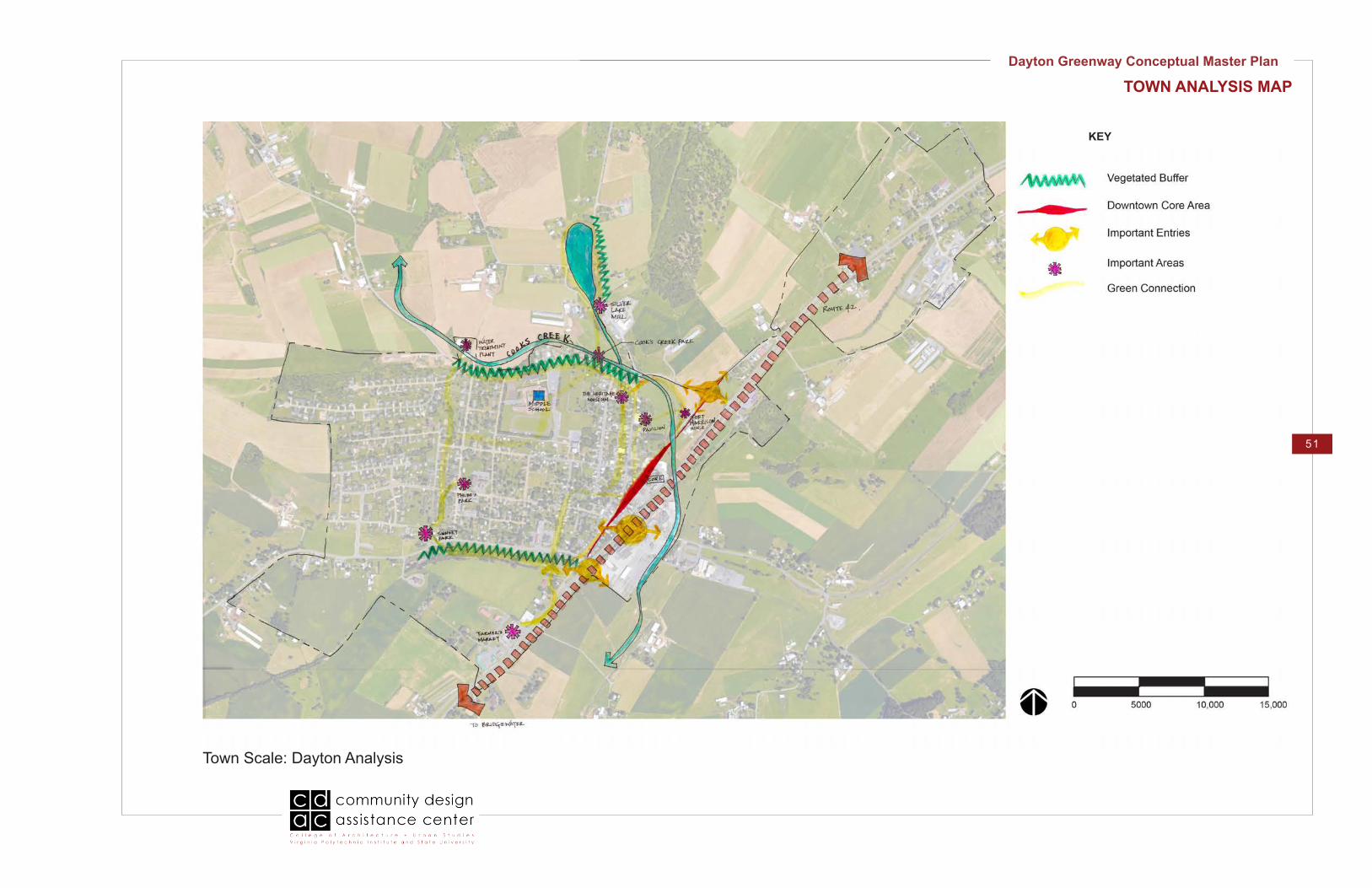
TOWN ANALYSIS MAP
Town Scale: Dayton Analysis
KEY

Dayton Greenway Conceptual Master Plan
52
SITE INVENTORY & ANALYSIS MAPSSilver Lake Trail
Site Scale: Silver Lake to Cooks Creek Analysis Site Scale: Silver Lake to Cooks Creek Inventory

Dayton Greenway Conceptual Master Plan
53
SITE INVENTORY & ANALYSIS MAPSHistorical Downtown
Site Scale: Cooks Creek Park to Thomas House Inventory Site Scale: Cooks Creek Park to Thomas House Analysis

Dayton Greenway Conceptual Master Plan
54
SITE INVENTORY & ANALYSIS MAPS: Neighborhood Trail
Site Scale: Thomas House to Sunset Park Inventory and Analysis

Dayton Greenway Conceptual Master Plan
55
SITE INVENTORY & ANALYSIS MAPS: Dayton Market
Site Scale: Thomas House to Dayton Market Inventory Site Scale: Thomas House to Dayton Market Analysis

Dayton Greenway Conceptual Master Plan
56
CONCEPTUAL DESIGN DEVELOPMENT
Introduction
After the inventory and analysis was completed, the CDAC team had an in-house design charette and developed two preliminary conceptual design proposals, which were presented at a community meeting for feedback.
The conceptual master plan and site scale preliminary options can be found on the following pages.

Dayton Greenway Conceptual Master Plan
57
TOWN SCALE PRELIMINARY DESIGNConceptual Master Plan Proposal 1
Initial Conceptual Trail Plan

Dayton Greenway Conceptual Master Plan
58
TOWN SCALE PRELIMINARY DESIGNConceptual Master Plan Proposal 2
Town Scale: Program Diagram Town Scale: Conceptual Diagram Town Scale: Circulations For Bike and Pedestrians

Dayton Greenway Conceptual Master Plan
59
SITE SCALE PRELIMINARY DESIGN: SILVER LAKEConceptual Design Proposals 1 & 2

Dayton Greenway Conceptual Master Plan
60
SITE SCALE PRELIMINARY DESIGN: HISTORICAL DOWNTOWNConceptual Design Proposals 1 & 2

Dayton Greenway Conceptual Master Plan
61
SITE SCALE PRELIMINARY DESIGN: NEIGHBORHOOD TRAILConceptual Design Proposals 1 & 2
Dayton Greenway Conceptual Master Plan
62
SITE SCALE PRELIMINARY DESIGN: DAYTON MARKETConceptual Design Proposals 1 & 2

Dayton Greenway Conceptual Master Plan
63
Part III: Appendix

Dayton Greenway Conceptual Master Plan
64
STAKEHOLDERS MEETING NOTES
Dayton Municipal Building, the Assembly Room125-B Eastview St., (Mason St. entrance at the flagpole)Dayton, VA 22821
Tuesday, February 23, 2016, 10am – 12 noon
Dayton, VA: Greenway and Focus Area DesignsStakeholder Committee Meeting
Introductions: Name and your vision of Dayton’s Greenway
Penny Imesom: Vision for greenway is to connect the community, Dayton market, downtown, historical sites, Main Street, and Historical Museum. Greenspace is essential for communities to relax and reconnect to nature. Shelley Newman- Town of Dayton: Town Council, Park Committee, Economic Development, Imagine Dayton Community Group; Know events in the town. Lauree Purcell- see a lot of walking and biking around Dayton. Mill pride, history, walk to mill, around lake and connect to town, enjoy the beautiful community; have a day tour around the town. Dana Fenner- moved 2.5 years ago from Pittsburgh, rails-to-trails, greenway would be a wonderful asset community to community. Shows vibrancy of the community. Connection for bikes community: Sunset Park-Bowman, Cooks Creek, cut through cemetery, High Street, up Bowman, Willow West, down to South Breeze Estates (3 mile biking loop route). In Pittsburgh, there are community gardens, people out walking and in-line skating, dogs, lots of things to look at= choose Imagine Dayton, Garden Designer. Leon Rohrer- As a child remembers mill as functioning Mill and time when Mill stood still. Potential for walkway along stream. Sees danger with running and jogging. Need safety for pedestrians crossing roads from College to the mill, Silver Lake Road, Bowman at College. One-lane bridge walk over to get to the Mill is dangerous. Area of land is wet/ cattle out of area. College St. Pavilion is where 5K begins, concerts, movies, moviesTown Events: Dayton days (15,000-20K) Mud Run, Red bud Festival (give free saplings), Easter Egg hunt, Light trees and float on lake- Shelley will send list of festivals

Dayton Greenway Conceptual Master Plan
65
STAKEHOLDERS MEETING NOTES
Susan Smith- Zoning Administrator: Family time back and get people out of house. Safe way for the whole families together to get out and enjoy, holding families together, connect to encompass whole community, financial aspect, implement in phases.
Connect town in a loop; Marc’s Bike Shop- Mole Hill, Gerald Nicely. Eberly Road- 25-50-100 mile events; Shenandoah Bicycle Company; they also organize event locations; ie: Bridgewater, start at bike parks.
Brenda Stearn- Risk management coordinator, provide recreation, provide for middle school, walk to water plant for tours, go to Cooks Creek, to mill with school field trips. Cheryl Lyon- use the Silver Lake Mill, Imagine Dayton, great desire to use the lake on Wildlife Birding trail, 70 different birds on lake, library of photographs of weeds, source materials to apply to lake, beauty about lake that they get to enjoy at the mill, can see it shared with others. From mill to Bowman Rd is very dangerous!
Lake used as recreation- State stocks with trout, very busy fishing, “Children Fishing Day”- April 9th; Needs help, but not formalized too much; Lake owned by Harrisonburg, VA; Private Landowners to edge of lake- riprap along lake, fishing piers.
Abandoned Rails-to-trails: Dayton to Stokesville abandoned in 1928 and Dayton to Bridgewater. 27 acres SW of Dayton available owned by of Chesapeake/ Dayton to Bridgewater chopped up and sold to adjacent landowners. Sewer line easements- sewer/water/utilities easements used for trails. New B&B on Silver Lake Road- SilverlakeBandB.com. Dry River Road- 3 miles west of town, Clear Spring B&B, Everything west of Dayton is a huge area, Primrose house used to belong to Mia Laberge- artist who painted mural of Mole Hill Rockingham Harrisonburg Artison Trail- Central connect to other counties (maps can be found in Harrisonburg)
Braithwaite Studios & Coffee Shop easements-Muddy trails- along easement used to go to Dayton Market, Computer business, and auto detailing. Elevated walkway on bank to Dayton Market Community garden- Community Garden potatoes, onion, people, Dayton Go Green – donate to local food pantries, berry shrubs, along café.

Dayton Greenway Conceptual Master Plan
66
STAKEHOLDERS MEETING NOTES
French and Indian war- Fort Harrison, cross streamChurch Cemetery on Bowman Rd. Historic Mill, Creek park, Harrison and to town
Phase 1: Silver Lake to Cooks Creek Park and Museum-Sculptures at Garden/Courtyard rotate at least a year for exhibition, may purchase them
Phase 2: Dayton Market to downtownPhase 3: Sunset park to Braithwaite Studios & CaféPhase 4: Mill to Town
Vacant land on NW corner of easement across new neighborhood to water treatment plant. water treatment plant loop back to Cooks Creek. North Park behind South Breeze Estates. Rhodes Hill Subdivision, land that town owns first couple of lots, thin lot. Easy to access drop behind gazebo. – Children and parents go there. Follow creek back to Cooks Creek.
Connect community- greenway getting family- getting family out. Get out in nature, encourage them out, residents.Bridgewater town residents can skate for free at ice skating rink at the restaurant/ Dayton MarketBridgewater arboretum Massanaten Resort
Statues murals, events to celebrate- Small town, logo/ history- Fort Harrison/ horse and buggy/Whimsical murals- things that interact with whimsical muralsStreetscape design- Greenway connectors, alleyways former rail-bedsSigns for wayfinding- Frazier & Associates Architects proposal, green signs that match logo, here is heritage, Initial design that does not meet VDOT standardsNeed a hierarchy of signage- we have not gotten that the with Frazier signs. Pink posts away from town/ blue back to town (Bermuda)Wall grey (whitish to grey)Green of town logoRedbud pinkSwansKingfisher on wire above historical museumBlack-crown Night herons- 2 families nesting in trees above creek at Cooks Creek Park

Dayton Greenway Conceptual Master Plan
67
Red Brick, Bluestone, brickyardExisting walking tour, history walking townBroad community participation: walking, dog walkingBike rental station (easy partnership with Mole Hill Bikes) Multi-use along connectors and benches, Hook-up at artisan courtyard- Ice cream truckConnect to Dayton West. Grills, picnic tablesTown restaurant- community development- Main St. next to mini-mart, behind post officeLa Favorita Bakery- Mexican baked goods
Vision:- Connection: separate nodes; need unity- Active green space- Accentuate town pride (the mill)- Easy access to biking, people afraid to bike on Route 42- Create vibrancy throughout town- Separation from car traffic, make greenway separate entity- History of the mill is important- Fix dangerous zones, Silver Lake Road has no sidewalks and people are afraid to walk on it, one lane bridge is scary to cross on foot- Get people and families out of the house with safe, viable options- Possible loop trail- Provide programmed recreational space- Educational purposes for the middle school (flora/fauna at Silver Lake)- Abandoned rail line and sewer easements as trails (look into possibility)
Further Research:- Rockingham County Artisan Trail- Quilting Trail- Regional Biking Trail (contact bike store in Dayton)- Abandoned Railway line
Themes:- Existing community gardens- Natural food growth- wildlife - Historical preservation
High Priority (due to biggest lack of connections):- Silver Lake to Cooks Creek- Dayton Market to Downtown
STAKEHOLDERS MEETING NOTES

Dayton Greenway Conceptual Master Plan
68
STAKEHOLDERS MEETING NOTES
Important Symbolism:- The Dayton logo- Horse and buggy- Fort Harrison- The old college- Interactive art and sculpture (things people can take pictures with)- Wayfinding and signage (another company has begun this work but they did not have budget for it)
Important Materials:- Bluestone and redbrick are common
Dayton Greenway Conceptual Master Plan
69
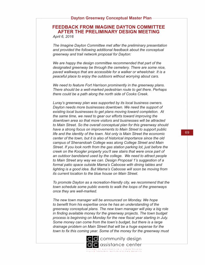
FEEDBACK FROM IMAGINE DAYTON COMMITTEE AFTER THE PRELIMINARY DESIGN MEETING
April 6, 2016
The Imagine Dayton Committee met after the preliminary presentation and provided the following additional feedback about the conceptual greenway and trail network proposal for Dayton:
We are happy the design committee recommended that part of the designated greenway be through the cemetery. There are some nice, paved walkways that are accessible for a walker or wheelchair. It is a peaceful place to enjoy the outdoors without worrying about cars.
We need to feature Fort Harrison prominently in the greenway plans. There should be a well-marked pedestrian route to get there. Perhaps there could be a path along the north side of Cooks Creek.
Luray’s greenway plan was supported by its local business owners. Dayton needs more businesses downtown. We need the support of existing local businesses to get plans moving toward completion. At the same time, we need to gear our efforts toward improving the downtown area so that more visitors and businesses will be attracted to Main Street. So the overall conceptual plan for this greenway should have a strong focus on improvements to Main Street to support public life and the identity of the town. Not only is Main Street the economic center of the town, but it is also of historical importance since the old campus of Shenandoah College was along College Street and Main Street. If you look north from the gas station parking lot, just before the creek on the Koogler property you’ll see stairs that were once part of an outdoor bandstand used by the college. We need to attract people to Main Street any way we can. Design Proposal 1’s suggestion of a formal patio space outside Mama’s Caboose with dining tables and lighting is a good idea. But Mama’s Caboose will soon be moving from its current location to the blue house on Main Street.
To promote Dayton as a recreation-friendly city, we recommend that the town schedule some public events to walk the loops of the greenways once they are well-marked.
The new town manager will be announced on Monday. We hope to benefit from his expertise once he has an understanding of the greenway conceptual plans. The new town manager will play a big role in finding available money for the greenway projects. The town budget process is beginning on Monday for the new fiscal year starting in July. Some money can come from the town’s budget, but there is a large drainage problem on Main Street that will be a huge expense for the town to fix this coming year. Some of the money for the greenway must

Dayton Greenway Conceptual Master Plan
70
FEEDBACK FROM IMAGINE DAYTON COMMITTEE AFTER THE PRELIMINARY DESIGN MEETING
come from competitive grants. Engineering firms have given estimates of the cost of the two pedestrian bridges, but we do not recall the exact numbers. We need to revisit that issue.
We know that some property owners will be resistant to granting easements for the improvements proposed for the greenway. We need more information about tax credits available for land owners when they donate land for a conservation easement. Bob has contact the interim town manager about this. Any monetary incentive may help attract cooperation from land owners. Do current owners continue to own the property? Does a conservation easement provide a tax credit to the owner? Would the owner be giving up property? How is that handled? What sort of legal document is required? Would the greenway be there permanently? What if the land owner sells and the new owner wants to put cows back on that part of his property?
We understand that one design proposal focuses on connectivity while the other focuses on programming. There are good elements in both and we do not see them as mutually exclusive. There are a few places where we must decide on one or the other, but we hope to benefit from elements of both. The proposal should refer to the Dayton Market rather than the Farmers Market. We do not have an actual farmer’s market in Dayton. Since Sunset Park is just a short walk west of Route 42 on Mason Street, and contains a nice picnic shelter, we do not need to invest in a Pavillion near the corner of Rt 42 and Mason. The lot where the food trucks park that was proposed in Design 1 might be better used for a different business – just about any business that can be attracted to open there.
Design Proposal 2 focuses on Maple Lane for improvements that would attract pedestrians. Some committee members wondered what makes Maple Lane a better location for a walk than Elm Lane and Walnut Lane. Should they be looked at for improvements, too? Guyer Drive may be a good place to walk, too.
What will be the delineation that shows where the greenway is? Please suggest a wayfinding scenario. Where would pedestrians see directions, signage, paint on roadway, or other types of delineation? What is possible and what is preferable given that the town doesn’t own its streets. They are controlled by VDOT. What will bring attention and focus to the lanes and roads considered part of the greenway to make

Dayton Greenway Conceptual Master Plan
71
FEEDBACK FROM IMAGINE DAYTON COMMITTEE AFTER THE PRELIMINARY DESIGN MEETING
it clear that they are part of trail system? There is a residential trail loop and the community walking route. How will that be designated? How would a resident know where to walk given that locals would not go get a map to find out?
We love the idea of a boardwalk on the side of Silver Lake. Long ago, someone rented rowboats and paddleboats and sold bait next to the lake. It would be neat if that were possible again.
Cheryl once considered putting a gazebo in next to the Mill’s wheel. That may still be an option in the future. Aesthetically, some members like the idea of a gazebo but don’t see them actually getting much use. Design 1 shows a gazebo near the museum while Design 2 shows a gazebo and picnic area just north of Cooks Creek Park. The committee does not think either of these locations would be a good place to put a gazebo. The one near the museum would require a lot of extra landscaping and maintenance by town employees and would not be used much. The other one is on private land.
The committee does not want to encourage pedestrians to grill out and picnic on Leon’s land. We want to respect his privacy. He is granting an easement so that anyone can enjoy walking and biking to and from the lake. But it would be better if that part of the trail was not a destination in and of itself. It should just be a trail and not a play park there. There is a shelter with tables at Cooks Creek Park, and it would be redundant to have more so close to the north just over the pedestrian bridge. The trail between Cooks Creek Park and Silver Lake should have interpretive signs about healthy water, wildlife, and nature. Town property is better for grilling and picnics.
Bathrooms at Cooks Creek Park are a great location. There may not need to be bathrooms at the trailhead further north next to the parking lot.
Two buildings within Cooks Creek Park could be used for something. On the west side of the sculpture gardens, there is a brown building about 12’x18’. It may have electricity. Not sure. What would be a good use for that? A second small building by the bathroom has electricity and lighting. It is grey and about 8’x10’. Both are currently vacant.
The current conceptual plans are too overwhelming. We would like to focus mainly on just the greenway, at least at first. Some of the other details about things we don’t have to have could be taken out of the plans. That would help make the plans seem more manageable. We would like to simplify the whole design and break it down into proposed

Dayton Greenway Conceptual Master Plan
72
FEEDBACK FROM IMAGINE DAYTON COMMITTEE AFTER THE PRELIMINARY DESIGN MEETING
stages or phases of completion. Once people see some improvements getting accomplished, interest will build. We just need to make the plans more manageable for a town our size.
While the committee’s top interest is in creating safe pedestrian access from Cooks Creek Park up to, and around, Silver Lake, we understand that there may be other improvements that can be easily attained while waiting for that big paved trail to be completed. Since the walkways are loops within the current road system that don’t require new pavement, establishing their pedestrian use with improvements should be relatively inexpensive and easily attained. Going behind Braithwaite Studios & Café should also be easy since the property owner is supportive. We can build momentum as people see things getting done. The mayor is very excited about all the proposed improvements to Dayton.

Dayton Greenway Conceptual Master Plan
73
The Imagine Dayton Committee and Brenda Stearn met for about 1.5 hours on April 27th to discuss the conceptual drawings submitted by Virginia Tech this week.
Here are the committee’s recommendations for those plans before the May 11th community meeting:
The presentation should emphasize up front that this is a vision plan subject to owners being willing to participate. Taking land by eminent domain is not on the table. We are just beginning to ask property owners if they would be willing to let this greenway happen, but those important discussions will continue.
The presentation on May 11th should start out with photos of the Luray Greenway with verbal explanations. It is so impressive and will give a better idea of what we are trying to achieve. Shelley Newman and Dana took pictures during our Luray tour last Friday that could be used during the presentation if Virginia Tech doesn’t have enough good photos of Luray. The photos in the brochure are okay, but they don’t really do it justice. It is such an amazing accomplishment. We need to emphasize how successful it is and the fact that Elkton and other communities are following Luray’s example and starting greenways now, too.
We would like the paved trail to go ALL the way around the lake. There is a proposed boardwalk on the left side, so why is there not a boardwalk on the right side as well? Why is a sidewalk proposed there instead? If a boardwalk were on the east side, space for street parking would be freed up because the boardwalk could go closer to the lake than a sidewalk. We’re confused about where the parking for Silver Lake will be. A handicap accessible fishing pier on the lake would be great. We saw at least one in Luray.
We recommend turning the fruit market into an Information Center (with parking, a bathroom, and water fountain) for the greenway.
In addition to the other paths shown, we would like a larger greenway loop that follows the north side of Cooks Creek from the park all the way west past the water tower to the new neighborhood being built along Dayton West. The water plant grounds could be used as part of the greenway. The trail would continue west through that neighborhood along the easement on the north side. Then it would go south into the South Breeze Estate’s neighborhood and east to Sunset Park. Then it would cross Route 257 and continue toward Braithwaite’s Café.
FINAL FEEDBACK FROM IMAGINE DAYTON COMMITTEE

Dayton Greenway Conceptual Master Plan
74
Non-essential things like the community garden and gazebo should be shown in a transparency of secondary ideas that can be pulled over the official plans. We need to focus on what we want to apply for grants this year. What details are most important? Phase 1 should be Silver Lake to Cooks Creek Park. Phase 2 should include the Eberly loop around Fort Harrison down College Street to downtown to Dayton Market.
When possible, off-street greenway trails are better than walkways right beside the streets. We would like a paved walkway along the north side of Cooks Creek between College Street and Main Street. It would be a natural way to enjoy Fort Harrison and the cows. The cattle are going to need to be fenced off from the creek eventually anyway to help save the Chesapeake Bay. The plan should emphasize the riparian buffer zone that will require fencing off Cooks Creek to keep the cows from getting it dirty. Perhaps the path could branch when the creek heads south so that pedestrians could walk down toward Fort Harrison or continue on toward Route 42 and Grammies Ice Cream.
We can take out the note about expanding the one-lane bridge to two lanes because that isn’t part of this greenway project. That is a different VDOT issue.
We still don’t have a clear picture of how pedestrians will be able to know that certain streets are part of the greenway. What are the way finding cues?
Use a different word than “alternate” when discussing the alternative trail path through alley lanes. “Connector” sounds more official.
The City of Harrisonburg should be consulted. They’re going to own the edge of the lake by the road, the entire lake, and the berm area. Since Harrisonburg residents can also enjoy walking around the lake, perhaps the City of Harrisonburg would help fund the greenway there.
King Street is a town-owned alley, so the town would not need VDOT’s permission to make improvements along it. In fact, all of the alleys are town-owned and maintained. They are not heavily used by traffic, so they wouldn’t need to be closed to vehicles if people are encouraged to walk along them.
Anything that uses state or federal funding here in Dayton has to have Virginia historical commission review and approval because properties on the historical registry are visible.
FINAL FEEDBACK FROM IMAGINE DAYTON COMMITTEE

Dayton Greenway Conceptual Master Plan
75
SURVEY RESULTS
Dayton, VA: Preliminary Design Presentation: Thursday, March 31 2016 from 5:30pm – 7:30pm
SURVEY QUESTIONS:Which of the design proposals best promote the following (please list reasons) and what ideas would you like to see in the final design:
1. CONNECTIVITY at the regional and local scale:• Appreciate connection (looking) from western sector residential to the business (Main St.) area• We like the connectivity proposal between Dayton Market & the town. We also like greater accessibility to Silver Lake.• Connect Cooks Creek with Fort Harrison - Doable along edge of Road that goes by stone wall – opposite side• Love the idea of connecting Silver Lake• I don’t think sidewalks are needed internally, only Mason/Bowman. I wouldn’t allow sidewalks into my yard.• Try to connect Mole Hill and Fort Harrison• Your idea about the trail through farms is great!• Proposal #2• The sidewalk along Bowman is extremely important. As opposed to taking land, encourage residents to plant particular plants & vegetation in certain locations.
2. SAFETY along roads and crosswalks:• Safety at present along Mason St. in non existent. Need much improvement.• Talk to more people who are already walking + biking in Dayton including old order Mennonites• Many of the town’s sidewalks are very safe to walk on, but many on the North & South sides of the town are not safe for bikers or walkers.• Need a sidewalk on Bowman Rd, especially near Cooks Creek Park. Sidewalk along Mason St also needed.• Check right of way along Mason & Bowman Streets to see if wide enough to install sidewalks• Intersections of College St. & Mill, and College St & King are dangerous, we cannot see traffic coming on College, Mirrors on poles would be helpful for safety.
3. WAYFINDING through town:• We like the wayfinding for children to walk to school.• Maple Lane could be restricted to no through traffic but we definitely oppose pedestrian walkway exclusively. Residences need

Dayton Greenway Conceptual Master Plan
76
SURVEY RESULTS
access to yards. We also move our vehicles off the street into our yards when there are special events. We are happy to do so.
4. Promotes Dayton’s Cultural And Historic Character• More walkers thru the historic distinct would help visitors see our many assets.• Keep culture & historical character• Connecting museum downtown & Fort Harrison• Proposal #2• Please do more to enhance music history on College St.; Adding more traditional musical ensembles will add to the historical significance. Barber shop quartet, acoustic string ensemble, wind ensemble.
5. Are the designs missing opportunities? If so, please explain:• Bike racks @ downtown, city buildings, Dayton Market, and Silver Lake• Also consider parking for people coming in from out of town• Maximizing pedestrian & biking• Fort Harrison• The current vegetation around Silver Lake supports important ecosystem. Ex: Milkweed already attracts Monarch butterfly on west side. Please be careful what you remove.
6. What design ideas do you like the least, or see as least feasible? Please explain:• Proposed 1 at the Mill trail had seen more conducive to walking us to lake/ mill without walking through middle of parking lot.• Good ideas in both proposals• I embrace all of them!
7. How do you see yourself and/or your family using the Dayton Greenway and Trail Network?• Walking for recreational & business reasons• I would definitely use a walking path around Silver Lake• I would walk on at least some of the greenway• Walking• Walking, running & biking. We love being outdoors in our town.• Walking & biking• Using it for exercise & relaxation (I am handicapped)
8. Are there any trail amenities you would like to see added to the plan? (For example more benches, bike stores/ maintenance facilities, covered shelters, water fountains, more greenspace, along trail, etc.)• If the town develops this plan, I hope that storm water can be

Dayton Greenway Conceptual Master Plan
77
SURVEY RESULTS
channeled to water gardens and keep water out of Cooks Creek.
9. Are there any additional comments you would like to add about the design options?• Utilize old C&W Railroad bed at a walking trail• I’d like to see a tree community garden – vegetable plots for community residents – located near Dayton Learning Center• Love the use for Cemetery Drive
10. Check all that apply: I am a Town of Dayton Resident √√√√√√√ I would likely walk the designed trails if it provided connectivity and safety √√√√√ I would not likely walk the trails. This is why: I walk with a family √√ I walk with a dog √ I walk by myself √√√√√√ I bike √ My destination would be the following: Town, a dog park, a playground, Silver Lake, a restaurant, a friend’s house, a business in the downtown district, the Dayton Markets, or list your destination: • West side of the town to Main St. business• I’d like to see walking trail as distinct from biking trail, but I’m hearing people want both trails ok too.• Town, Silver Lake, the Dayton Markets.• Silver Lake, love to bike, love to see every effort to make biking a priority• Town, Silver Lake, restaurant, friends’ house, business in downtown, the Dayton Market.
Other Questions, Concerns Feedback:• How does the walk route around town differ from Intersect site the route for truck traffic (e.g. milk trucks) in west over in particular?• Will town employees be responsible for the upkeep of all the new areas? How would this impact the budget? Not enough information concerning overall finances.• Please Come to Braithwalk Studio 415 Mason St. to tour the spring & stream area. Email: glasscarver@comcast• Great work – noticed that Thomas Harrison House connection was not considered. Would be nice to connect the Thomas Harrison House and museum.

Dayton Greenway Conceptual Master Plan
78
RAILS TO TRAILS CONSERVANCY: SURFACES
Surfaces
GCNP Greenway Trail Construction - Photo CC Grand Canyon National Park via Flickr
When choosing a surface for your trail, consider the following:• User acceptance and satisfaction• Accessibility• Cost to purchase and install materials• Cost of maintaining the surface• Life expectancy• Availability of material
Before you choose a specific trail surface, you should also consider the pros and cons of hard surfaces and soft surfaces. While hard-surface trails are more accommodating, require less maintenance and can withstand frequent use, they are also significantly more expensive. On the other hand, soft-surface trails cost less, but generally do not hold up well under heavy use or varying weather conditions.
Hard Surfaces
AsphaltAsphalt works well for bicycle commuters and inline skaters, which is a reason it is often used in urban areas. It typically can’t be used by equestrians. It also requires regular, minor maintenance such as crack patching, yet has a life expectancy of 7 to 15 years. Asphalt is a flexible surface that requires use to remain pliable and will last longer with heavy use. However, those installing asphalt should be conscious of the possibility of environmental contamination during construction.
ConcreteConcrete is usually the longest lasting of the hard surface materials, but it is also one of the most expensive. Well-maintained concrete can last 25 years or more. The surface is appropriate for urban areas with severe climate swings and a susceptibility to flooding. However, the

Dayton Greenway Conceptual Master Plan
79
RAILS TO TRAILS CONSERVANCY: SURFACES
hard surface is taxing on runners’ lower limbs, and is thus unpopular with that significant user group. Adjacent soft-surface treads can accommodate runners and equestrians where concrete is necessary for the main trail.
Crushed StoneCrushed stone is popular as a trail surface because it holds up well under heavy use and can complement the aesthetic of the natural landscape. It can also accommodate nearly every trail user (with the exception of inline skaters) if crushed and compacted properly. Because crushed stone can be made of nearly any type of rock, including limestone and sandstone, it is one of the most accessible trail surface types.
Soil CementSoil cement is a mixture of pulverized native soil, Portland cement and water, rolled and compacted into very dense surface. It is cheaper than asphalt, but drainage is very important to prevent erosion.
Resin-Based Stabilized MaterialResin is a tree product that binds aggregate or soil particles together. A resin-based trail surface impacts the environment less than asphalt and can be cheaper. The aesthetics also better match the surrounding environment.
BoardwalkBoardwalk is most often used as a trail surface for segments through wetlands, as it allows adequate drainage and impacts the fragile ecosystem less than other surface types. However, it can be slippery when wet and is quite expensive to install and maintain.
Recycled MaterialsVarious recycled materials, such as old rubber tires worked into concrete on Florida’s Withlacoochee State Trail, are becoming more popular, but there hasn’t yet been extensive testing to know their longevity or wear tendencies.
Soft Surfaces
Natural EarthTrails with a natural earth surface offer inexpensive maintenance costs limited primarily to fixing drainage problems, repairing eroded areas and removing vegetation. The trail can usually be built and maintained by volunteers.

Dayton Greenway Conceptual Master Plan
80
RAILS TO TRAILS CONSERVANCY: SURFACES
Wood ChipsWood chips blend well with the natural environment and can work well as a parallel tread for runners and equestrians next to an asphalt or concrete trail. However, the surface decomposes rapidly, cannot accommodate wheelchair use and requires constant maintenance to keep the width and surface steady. The entire surface needs replacement every two years, but maintenance and installation can be performed by volunteers.
The cost of surfacing a trail with asphalt or concrete may be prohibitive in the beginning stages of trail building. This initial expense shouldn’t deter your plans if you need to start trail development right away. You may be able to upgrade from a softer surface like dirt or crushed stone to a harder surface like asphalt or concrete once you have secured funding. For example, the Cannon Valley Trail in Minnesota began as crushed stone, and was then upgraded to asphalt to accommodate commuting cyclists and to attract touring cyclists.
http://www.railstotrails.org/build-trails/trail-building-toolbox/trail-building-and-design/surfaces/

Dayton Greenway Conceptual Master Plan
81
EASEMENTS
Based on the conceptual master plan and trail development, some personal properties are potentially involved in the plan. Following are the possible locations that would require property owner permission and easements. Information about easement follows.
Leon’s Property Easement for the trail connecting Silver Lake and Cooks Creek Park
Braithwaite Studios & Café Property Easement for the trail connecting Neighborhood Trail and Dayton Market
Leon’s Property Easement BoundaryLeon’s Property Easement Area
Braithwaite Studios & Café Property Easement Area

Dayton Greenway Conceptual Master Plan
82
EASEMENTS
Department of Conservation and Recreation
Land Conservation For landowners• Why should I protect my land?• What land should be protected?• How do I protect my land?
• Fee simple donations, gifts and bargain sales• Conservation and open-space easements• Natural Area Dedications
• Who can help me protect my land?• What benefits do I receive by protecting my land?
• Land Preservation Tax Credit (LPTC)• How much will protecting my land cost?
• The Virginia Outdoors Foundation (VOF)
Why should I protect my land?Land. They’re not making any more of it, but there are more and more people. Virginia’s population in particular has mushroomed. It grew more than 75 percent from 4.6 million in 1970 to more than 8.3 million in 2014.
Such growth is flattering, even enviable, but it strains on our land resources. It necessitates careful planning and intelligent conservation. There are special places here, lands that have witnessed America’s greatest human triumphs and tragedies. Our state’s open spaces, farms, parks, battlefields and other areas of cultural significance attract people from around the globe. Virginia’s natural habitats, some found nowhere else on earth, provide homes to some extraordinary plant and animal inhabitants as well.
Few would argue that Virginia’s natural and cultural resources are less than astonishing. With such unmatched resources, however, comes responsibility; the responsibility to conserve and protect these special places for future generations. That’s where you come in.
As a landowner, you can establish a permanent conservation easement on your open space land, protecting the unique natural, historic, recreational, scenic and cultural resources of Virginia. Or, you can donate all or some of your land to a state agency, local government, land trust or conservation organization. In doing so, not only do you assure the protection of the land for future generations, but you also may qualify for substantial tax benefits. See tax advantages, incentives and laws related to land conservation for details. (Link: http://www.dcr.virginia.gov/land-conservation/tools03)

Dayton Greenway Conceptual Master Plan
83
EASEMENTS
What land should be protected?Lands that should be protected should benefit the public and possess unique and significant natural, historic, recreational, scenic and cultural resources. This includes:• Recreational and park lands• Lands with rare, threatened, or endangered species, fish and
wildlife habitat• Agricultural and forestal lands• Historic areas• Open space land
There are many traits that make particular properties special and worthy of protection. Here are a few such characteristics.• River corridors• Viewsheds• Public access points• Blueways and greenways• A need identified in the Virginia Outdoors Plan• Support of a local or regional plan• Adjacent to a Virginia Scenic River, Road or Byway• Adjacent to parks• Adjacent to wildlife management areas• A need identified in the Virginia Natural Heritage Plan• Unique species• Biodiversiity• Listed on the Virginia Landmarks Register• Historic district• Prime and important soils and farmland• Wetlands• Contiguous forest parcels• Timber value• Unique geological features• Cultural geography• Relationship to development patterns and land use planning
How do I protect my land?As a landowner, you have certain rights regarding the use of your land. These property rights are collectively known as your bundle of rights, which typically includes the rights to live on your land and to use it for recreation, your home, farming, timber harvesting, mining and other activities. With your ownership also comes the right to subdivide property and sell the lots, or sell all of the property, which may lead to its development. However, if you wish to protect your land as it is today for future generations, you can give or sell your land or conservation easement to a state agency, local government, land trust,

Dayton Greenway Conceptual Master Plan
84
EASEMENTS
or conservation organization that is qualified to accept or acquire your land for conservation purposes. Here are several ways to protect your land.
• Fee simple donations, gifts and bargain salesYou can donate all of the ownership rights by giving or selling the “fee simple title” or deed to your property to a conservation organization. You can simply donate all or part of your land as a gift now or later, in a will. If you donate land, you will be eligible for a tax credit for the value of your donation and potentially reduced real estate taxes. For more on tax advantages and incentives, see tax incentives related to land conservation.
You could also sell your property to a land conservation organization at a price below fair market value. This is called a “bargain sale.” The difference between the sale price and the fair market value is considered a charitable donation, hence you could enjoy an income tax deduction or a reduction in estate taxes. In addition, a bargain sale is useful in minimizing the liability of a long-term capital gains tax associated with the sale of a large estate.
• Conservation easementsYou could also give or sell some property rights to your land to a conservation organization. This can be done in lieu of donating or selling all of the land, i.e., instead of turning over the fee simple ownership. This way you’d relinquish most development rights to the land while retaining ownership and traditional use of the land. This is typically done through placing a conservation easement on the deed to the property. (Conservation easements, when they are held by government entities, are sometimes called open space easements.)
A conservation or open space easement is a legal document made between a landowner and a public body or qualified conservation organization. The easement limits present and future property development rights. It allows you to live on the property and use it for its traditional use, e.g., as a farm, forest, open space, and/or natural area, but protects it as well. The easement is legally recorded and bound to the deed of the property permanently.
Each easement is tailored to the specific characteristics and uses of the given property. Timber harvesting, farming, primary residences and other uses may continue while the land’s unique characteristics - prime soils, endangered species habitat, wetlands, etc. - are protected. The easement protects the property’s natural or open space values, assuring the land’s availability for agriculture, forestry, recreation,

Dayton Greenway Conceptual Master Plan
85
EASEMENTS
open-space use, thus protecting natural resources, maintaining or enhancing air or water quality, or preserving historical, architectural or archaeological aspects of the property.
Easements rarely allow public use of your property. The “holder” of the easement, i.e., the land conservation organization with whom the landowner entered into the easement, is responsible for enforcing the protective covenants of the easement and is therefore allowed to conduct periodic inspections of the property. The landowner retains all rights to the property except for restrictions on future development rights specified in the easement.
A landowner may also donate or sell their property to a land conservation organization but continue to live on it until his or her death. This is called a “life estate.” This way land is protected while the owner continues to enjoy the property during his or her lifetime.
See the following to learn more about open-space and conservation easements:www.virginiaoutdoorsfoundation.orgwww.landtrustalliance.org/conservation/landownersFor details on tax advantages, see tax incentives related to land conservation.
• Natural Area DedicationsNatural Area Dedications are a conservation option available to landowners of highly significant natural areas. Dedication is the placement of natural areas, both privately and publicly owned, into Virginia’s Natural Area Preserve System, administered by DCR. The landowner retains ownership and transfer rights of the land while voluntarily restricting land uses that are incompatible with the conservation needs of the natural area.
To be eligible, a property must include one or more of these natural values: habitat for rare, threatened for endangered plant or animal species; rare or state significant natural communities; and rare or state significant geologic sites. If your property qualifies for Natural Area Dedication, a legal document known as an “instrument of dedication” will be written and signed by you and DCR. The document will be recorded with the deed of the property thereby ensuring permanent protection of the natural area against conversion to inappropriate uses.
You may receive financial incentives for dedicating your land. Examples include possible reduced assessment for real estate purposes, reduction of federal estate and Virginia inheritance taxes,

Dayton Greenway Conceptual Master Plan
86
EASEMENTS
and a charitable deduction for state and federal income tax purposes. For details on tax advantages, see tax incentives related to land conservation.
See the following for more information on natural area dedications:http://www.dcr.virginia.gov/natural-heritage/dedicate
Who can help me protect my land?• Land trusts in VirginiaA land trust is a nonprofit organization that actively works to conserve land by undertaking or assisting in land or conservation easement acquisition or by its stewardship of such land or easements.
• Virginia Outdoors Foundation (VOF)Although Virginia has many nonprofit land trusts that assist landowners and help with the acquisition of easements, few actually hold the conservation easements. The Virginia Outdoor Foundation (VOF), which is the commonwealth’s land trust, holds most of the conservation easements in Virginia.
For more information on the Virginia Outdoors Foundation (VOF), please visit their website at www.virginiaoutdoorsfoundation.org.
• Land trust directory search toolLink to look up land trusts by locality: http://www.dcr.virginia.gov/land-conservation/whereto4#tooltipmap
What benefits do I receive by protecting my land?If you donate any or all of the rights to your land to protect its unique characteristics, you will protect the land for future generations. In so doing, you may also be eligible for substantial state and federal tax credits and reductions. These may include reduced property and estate taxes, charitable gift tax benefits, and tax deductions for the value of the donated land. Visit tax incentives related to land conservation for more information.
While funding for purchases is often limited, in certain cases local governments, state agencies and land trusts can purchase land or conservation easements from landowners. Contact the Office of Land Conservation at (804) 225-2048 to learn about other opportunities for landowners to sell easements or land.
• Land Preservation Tax CreditVirginia allows an income tax credit for 40 percent of the value of donated land or conservation easements. Taxpayers may use up to

Dayton Greenway Conceptual Master Plan
87
EASEMENTS
$20,000 per year in 2015 and 2016 and then $50,000 per year in subsequent tax years. Tax credits may be carried forward for up to 13 years. Unused credits may be sold, allowing individuals with little or no Virginia income tax burden to take advantage of this benefit.
To be eligible for tax credits, the easement must qualify as a charitable deduction under the IRS Code and meet additional requirements under the Virginia Land Conservation Incentives Act.
DCR is responsible for verifying the conservation value of Land Preservation Tax Credits for all donations of land or conservation easements for which the donor claims a state tax credit of $1 million or more. These applicants must meet the Conservation Value Review Criteria adopted by the Virginia Land Conservation Foundation Board (VLCF). Donors claiming less than $1 million in tax credits should apply directly to the Virginia Department of Taxation, not through DCR.
Website: http://www.dcr.virginia.gov/land-conservation/lpcFor information about DCR’s review of Land Preservation Tax Credit applications, call 804-371-5218.
How much will protecting my land cost?Most land protection costs are associated with legal documents and tax or financial planning. The Open-Space Land Preservation Trust Fund can help landowners with costs of conveying conservation easements and the purchase of all or part of the value of the easements. The fund may reimburse legal and appraisal costs and all or part of the easement’s value. Priority may be given to applicants seeking only cost reimbursement, demonstrating financial need, or covering a family owned or operated farm.
Visit www.virginiaoutdoorsfoundation.org for details on the Open-Space Lands Preservation Trust Fund.

Dayton Greenway Conceptual Master Plan
88
EASEMENTSLand Conservation in Virginia

Dayton Greenway Conceptual Master Plan
89
EASEMENTSLand Conservation in Virginia

Dayton Greenway Conceptual Master Plan
90
EASEMENTS
Agricultural Conservation Easement Program (ACEP)NRCS provides financial assistance to eligible partners for purchasing Agricultural Land Easements that protect the agricultural use and conservation values of eligible land. In the case of working farms, the program helps farmers and ranchers keep their land in agriculture. The program also protects grazing uses and related conservation values by conserving grassland, including rangeland, pastureland and shrubland. Eligible partners include Indian tribes, state and local governments and non-governmental organizations that have farmland or grassland protection programs.
Under the Agricultural Land component, NRCS may contribute up to 50 percent of the fair market value of the agricultural land easement. Where NRCS determines that grasslands of special environmental significance will be protected, NRCS may contribute up to 75 percent of the fair market value of the agricultural land easement.NRCS also provides technical and financial help directly to private landowners and Indian tribes to restore, protect and enhance wetlands through the purchase of a wetland reserve easement.
Website: http://www.nrcs.usda.gov/wps/portal/nrcs/main/va/programs/easements/Contact: Diane Dunaway, USDA Natural Resources Conservation Service (NRCS), 1606 Santa Rosa Rd., Richmond, VA 23229, (804) 287-1634For more information click on the following link:

Dayton Greenway Conceptual Master Plan
91
GRANTS
Virginia Department of Conservation and Recreation600 East Main Street | Richmond, VA 23219-2094 | 804-786-6124
Conservation Reserve Enhancement Program (CREP)The Conservation and Recreation EnhancementProgram aims to improve Virginia’s water quality and wildlife habitat by offering rental payments to farmers who voluntarily restore riparian buffers, filter strips and wetlands through the installation of approved conservation practices. State cost-share payments are administered through local Soil and Water Conservation District (SWCD) offices. The state will reimburse up to 25 percent, not to exceed $200 per acre of restored buffer or wetland, of conservation practice costs deemed eligible by the local SWCD. There is also a 25 percent state income tax credit for out-of-pocket expenses, thus further reducing the landowner’s cost. Federal reimbursement is made through the Farm Service Agency (FSA) for up to 50 percent of a participant’s eligible expenses for implementing best management practices (BMP), such as fencing or alternative watering systems.
Website: www.dcr.virginia.gov/soil-and-water/crepContact: Gary Moore, Virginia Department of Conservation and Recreation, 600 E. Main St., 24th Floor, Richmond, VA 23219, (804) 692-0070, email [email protected]
Virginia Recreational Trails Program (RTP)The Recreational Trails Program (RTP) is a matching reimbursement grant program for the building and rehabilitation of trails and trail related facilities. DCR partners with the Federal Highway Administration to run the program.
Funding may be awarded to city, county, town or other government entities or registered nonprofit groups partnering with a governmental body. The Recreational Trails Program and Virginia Recreational Trails Program Advisory Committee steer project selections after a competitive call for applications.
Deadline for this program is July 21, 2016
Website: http://www.dcr.virginia.gov/recreational-planning/trailfnd

Dayton Greenway Conceptual Master Plan
92
GRANTS
Virginia Department of Forestry 900 Natural Resources Drive, Suite 800 Charlottesville, Virginia 22903 Phone: (434) 977-6555 Website: www.dof.virginia.gov
Urban and Community ForestryVirginia Trees for Clean Water Grant ProgramWebsite: http://dof.virginia.gov/financing/grants.htm
Transportation Alternatives (TA) Set-Aside The Fixing America’s Surface Transportation (FAST) Act was signed into law on Dec. 4, 2015. It is the first long-term transportation bill passed since SAFETEA-LU and will run through Fiscal Year 2020.
The legislation converts the long-standing Surface Transportation Program (STP) into the Surface Transportation Block Grant Program (STBG), aligning the program’s name with how the Federal Highway Administration (FHWA) has historically administered it. The STBG promotes flexibility in state and local transportation decisions and provides flexible funding to best address state and local transportation needs.
Previously in SAFETEA-LU, there were 12 eligible Transportation Enhancement (TE) activities. Under MAP-21 and now with the FAST Act, there are four defined categories for the TA Set-Aside including: 1) Transportation Alternatives, 2) Safe Routes to School, 3) Recreational Trails and 4) Boulevards from Divided Highways. Within the Transportation Alternatives category itself, there are ten qualifying TA activities.
The program is intended to help local sponsors fund community based projects that expand nonmotorized travel choices and enhance the transportation experience by improving the cultural, historical and environmental aspects of the transportation infrastructure. The program does not fund traditional roadway projects or provide maintenance for these facilities. Instead it focuses on providing pedestrian and bicycle facilities, community improvements and mitigating the negative impacts of the highway system.
For more information please click on the following links:http://www.virginiadot.org/business/prenhancegrants.asp (DUE 11/1/16)
Dayton Greenway Conceptual Master Plan
93
GRANTS
http://www.ctb.virginia.gov/resources/2012/sept/pres/Presentation_Agenda_Item_6_Transportation_Alternatives.pdf
Safe Routes To School Program (SRTS)Schools and communities are hosting amazing Walk and Bike to School Day events of all sizes.There’s more than one way to get to school...
SRTS activities can be an opportunity to try taking more active trips on foot or bicycle. They can be a family’s gateway to transportation choice.
Choosing an active mode of transportation means:• Less traffic & a safer route to school• Fewer cars & fewer emissions• More active & healthier children• More active, involved parents
For more information click on the following link: http://www.saferoutesinfo.org/
Virginia Coordinator Information:Robert WilliamsSafe Routes to School Program Coordinator
Address:Virginia Department of Transportation1401 East Broad Street, 1st FloorRichmond, VA 23219
Phone Number: 804-371-4868Fax Number:Email: [email protected]
State Website URL:http://www.vdot.virginia.gov/programs/ted_Rt2_school_pro.asp


