8 Study Background January 2013 2 Study Background The Study Area for the Eubanks Road Park-and-Ride Expansion Feasibility Study consists of the area bound by the following: Mt. Sinai Road and NC 86 to the North, Martin Luther King Jr. Boulevard to the east, Old NC 86 to the west and Homestead Road and to the South. The project location map in Figure 2-1 presents the Study Area, highlighting the intersections and the existing Park-and-Ride facility. 2.1 Previous Studies and Data Sources The Eubanks Road Park-and-Ride facility is on the north side of Eubanks Road between Millhouse Road and Martin Luther King, Jr. Boulevard. The current surface parking occupies about seven acres owned by the Town of Chapel Hill and serviced by Chapel Hill Transit. Over the last few years, CHT has explored opportunities to increase its Park-and-Ride capacity. The current lot was built in 1995 with FTA funds. It provides 400 parking spaces. On a typical week day it is occupied to 89% of capacity. CHT and its partners recognized the need for preparing expansion of the facility in 2007 as part of long-range planning for CHT. This need was confirmed through the due diligence for the Carolina North development as indicated in 2009 with The Carolina North Transportation Impact Analysis Update. The following important corridor and area planning efforts are relevant to the Eubanks Road Park- and-Ride Feasibility Study. 2.1.1 Town of Chapel Hill Comprehensive Plan The Town of Chapel Hill Comprehensive Plan suggests a new approach to transportation, it promotes: walking, biking, transit and Park-and-Ride. Increased usage of Park-and-Ride services will be crucial to minimize traffic impact on major corridors. The Comprehensive Plan recommends developing a master plan for an expanded Park-and-Ride system. Structured parking is encouraged where feasible as part of a comprehensive parking strategy.
Transcript
8 Study Background January 2013
2 Study Background
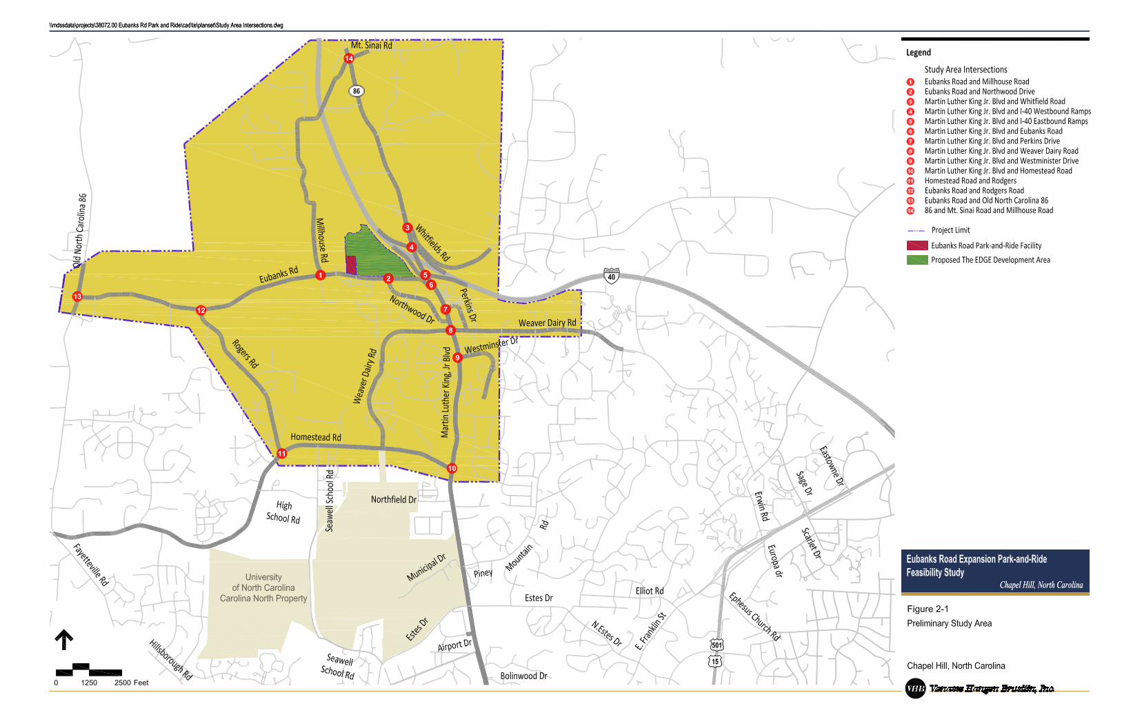
The Study Area for the Eubanks Road Park-and-Ride Expansion Feasibility Study consists of the area bound by the following: Mt. Sinai Road and NC 86 to the North, Martin Luther King Jr. Boulevard to the east, Old NC 86 to the west and Homestead Road and to the South. The project location map in Figure 2-1 presents the Study Area, highlighting the intersections and the existing Park-and-Ride facility.
2.1 Previous Studies and Data Sources
The Eubanks Road Park-and-Ride facility is on the north side of Eubanks Road between Millhouse Road and Martin Luther King, Jr. Boulevard. The current surface parking occupies about seven acres owned by the Town of Chapel Hill and serviced by Chapel Hill Transit. Over the last few years, CHT has explored opportunities to increase its Park-and-Ride capacity. The current lot was built in 1995 with FTA funds. It provides 400 parking spaces. On a typical week day it is occupied to 89% of capacity. CHT and its partners recognized the need for preparing expansion of the facility in 2007 as part of long-range planning for CHT. This need was confirmed through the due diligence for the Carolina North development as indicated in 2009 with The Carolina North Transportation Impact Analysis Update.
The following important corridor and area planning efforts are relevant to the Eubanks Road Park-and-Ride Feasibility Study.
2.1.1 Town of Chapel Hill Comprehensive Plan
The Town of Chapel Hill Comprehensive Plan suggests a new approach to transportation, it promotes: walking, biking, transit and Park-and-Ride. Increased usage of Park-and-Ride services will be crucial to minimize traffic impact on major corridors. The Comprehensive Plan recommends developing a master plan for an expanded Park-and-Ride system. Structured parking is encouraged where feasible as part of a comprehensive parking strategy.
10 Study Background January 2013
2.1.2 Chapel Hill / Carborro Long Range Transit Plan
The Chapel Hill/Carrboro Long Range Transit Plan (LRTP) provides a vision of the community and the public transit system in 2035. The LRTP recommendations are:
Introduction of higher level transit services along six “gateway” corridors; Expansion of local bus service to support the gateway services; Further study of impact of parking polices and land use polices to support transit
growth.
Analysis of 2035 travel demand indicates six main corridors will be used by commuters to access the Chapel Hill-Carrboro community:
NC 86 (Martin Luther King Jr., Boulevard; North US 15/501 (Franklin and North Fordham Boulevard); East NC 54 (Raleigh Road); Hillsborough Road; West NC 54 (Main Street); South US 15/501.
According to the Long Range Transit Plan, the growth in these corridors indicates an investment in a higher order of public transit is warranted. To improve the effectiveness of Park-and-Ride and through the collaborative planning effort involving the Town of Chapel Hill and Carrboro, 20 sites were identified as potential locations for Transit Supportive Development (TSD). At these sites, complementary land uses and transit facilities would be provided. Relevant to this study, properties on the north side of Eubanks Road between Millhouse Road and Martin Luther King, Jr. Boulevard are identified as potential locations for TSD.
2.1.3 Capital Area MPO/ Durham - Chapel Hill – Carrboro MPO 2035 Joint Long Range Transportation Plan
The 2035 Joint (DCHC/Capital Area MPO) Long Range Transportation Plan addresses the future direction of growth plans and transportation investments in Durham, Chapel Hill, and Carrboro. The plan addresses population growth, financing options, roadway improvements needs, transportation services, Park-and-Ride lot network, pedestrian and bicycle needs and environmental challenges. The Joint MPO plan included several findings and recommendations relevant to the current Feasibility Study:
A significant expansion of bus services throughout the Triangle, adding new routes to communities presently without service, and improvements to headways at existing transit agencies, enhanced service in Chapel Hill;
Expanded service hours – additional service hours to expand evening and weekend service on selected routes;
Light rail transit service connecting Chapel Hill, Durham, Research Triangle Park, Morrisville, Cary, Raleigh and North Raleigh with over 56 miles of guideway providing high frequency (every 10 minutes) short distance services linking major activity centers to regional and intercity rail services. Bus service will be re-aligned to connect with
11 Study Background January 2013
passenger rail services wherever possible (note: current plans for regional fixed-guideway have evolved since this recommendation);
Enhanced Martin Luther King, Jr. Boulevard corridor in Chapel Hill – the Martin Luther King, Jr. Boulevard corridor project will provide very frequent service and will provide buses a dedicated travel lane for part of the journey from Eubanks Road Park-and-Ride to downtown Chapel Hill;
Implementation of the 2035 LRTP continues. On November 8, 2011, voters in Durham County approved a half cent sales tax to fund transit as the Alternatives Analysis phase of the rail study is concluded.
2.1.4 Transportation Impact Analysis Fall 2009 Update for the Carolina North Development
Topics addressed by the Transportation Impact Analysis (TIA) include existing and future conditions assessment, trip generation and distribution, assessment of parking supply on transportation impacts, transit impacts, pedestrian and facility needs, potential mitigation measures and air quality and greenhouse gas analysis. Two development scenarios were defined: an 800,000 SF scenario for early phase analysis (2015) and a 3,000,000 SF scenario on a longer-term phase of development (2025). The goal of the study was to develop a long range solution to the problem of providing an efficient transportation system which promotes economic vitality and a high quality of life for the residents and visitors. Among the transit related recommendations for 2015 and 2025 were: route adjustments to provide stops within the site, fleet increases to support additional ridership and longer travel times, signal priority and potential bus lanes on Martin Luther King, Jr, Boulevard and Park-and-Ride increases.
2.1.5 Chapel Hill Northern Area Task Force Report
The Chapel Hill Northern Area Task Force Report provides background information on transit oriented development, transit corridors and the Chapel Hill Long Range Transit Plan. It also provides recommendations on development regulations, design standards and appearance guidelines for the implementation of transit-oriented development along Martin Luther King, Jr. Boulevard, Weaver Dairy Road and Eubanks Road.
Report recommendations for the area between Millhouse Road and Eubanks Road:
Transit oriented village with high density residential and mixed use retail/office Integration and expansion of existing Park-and-Ride facility vertically with new
development
2.1.6 Northern Study Area – Eubanks Site
The Northern Study Area – Eubanks Site was intended to facilitate neighborhood discussion for a potential Village Mixed-Use hamlet at the corner of Eubanks Road and Old NC 86. The goal for the workshop was to elicit neighborhood input on the form and look for a hamlet. The study site was a 30 acre tract. North Carolina Department of Transportation (NCDOT) has proposed realigning Eubanks Road to the north of its current alignment to provide longer site distances at the intersection with Old NC 86. Suggestions that came through from the workshop were:
12 Study Background January 2013
Neighborhood scale development Community square or green space No major thoroughfares Small parking lots House fronts open to the street Café, grocery store, restaurant, gas station, daycare facility, retirement community,
medical clinic, bakery Trees, sidewalk, street lamps, bicycle path
2.1.7 Data Sources
The data resources used in documenting existing conditions for the study include:
Town of Chapel Hill website Economic Development Strategy for Chapel Hill, June 2008 Retail Market Analysis, June 2009 Residential Market Study, 2011 Parking Study, December 2008 Chapel Hill Planning Department website Northern Area Taskforce Report, August 2007 Chapel Hill Land Use Plan, January 2008 Chapel Hill Northern Area Workshop: TOD Concept Plans, April 2008 Chapel Hill Comprehensive Plan, May 2000 Code of Ordinances City of Chapel Hill, April 2011 Chapel Hill Transit Comprehensive Operational Analysis, June 2010 Chapel Hill/Carrboro Long Range Transit Plan, September 2009 Office Market Study, April 2010 Transportation Impact Analysis Carolina North Development, 2009 Capital Area MPO Durham – Chapel Hill – Carrboro MPO 2035 Joint long Range
Transportation Plan, May 2009 Northern Study Area – Eubanks Site, June 2011 Orange County 2030 Comprehensive Plan, November 2008 The Economics of Chapel Hill, November 2007 Town of Chapel Hill Design Manual, 2005 N.C. Division of Water Quality website CLR search website Department of Housing & Urban Development (HUD) University of North Carolina – Chapel Hill Bureau of Labor Statistics