I I I I '2-· l ) ) ., UNITED STA, ES ENVIRONMENTAL PROTECTION A,iENCY DATE : April 10, 1981 SUBJECT: Trip Report - Yaworski Landfill, Canterbury, Connecticut FROI!h John F. Conlon, Chief 1 • Oil & Hazardous TO: John Hackler, Office of Uncontrolled Hazardous Waste Sites Steven Hitchcock, Connecticut DEP The enclosed report of the March 4, 1981 inspection of the Yaworski Lagoon by & Hazardous Material Section personnel is being for- warded to you for your information. Additional information on this inspection can be obtained from David Mcintyre of this office at (617) 861-6700, Ext. 216. Enclosure EPA FORM 1120·1 (REV. 3-71)
Transcript
I I I I
'2-· ~. l
) )., UNITED STA, ES ENVIRONMENTAL PROTECTION A,iENCY
FROI!h John F. Conlon, Chief ~1 • Oil & Hazardous Materi~s_,Section
TO: John Hackler, Office of Uncontrolled Hazardous Waste Sites Steven Hitchcock, Connecticut DEP
The enclosed report of the March 4, 1981 inspection of the Yaworski Lagoon by 0~1 & Hazardous Material Section personnel is being forwarded to you for your information. Additional information on this inspection can be obtained from David Mcintyre of this office at (617) 861-6700, Ext. 216.
Enclosure
EPA FORM 1120·1 (REV. 3-71)
YAWORSKI LANDFILL CANTERBURY, CONNECTICUT
TRIP REPORT MARCH 4, 1981
OIL AND HAZARDOUS MATEaiALS SECTION
DESCRIPTION OF SITEl
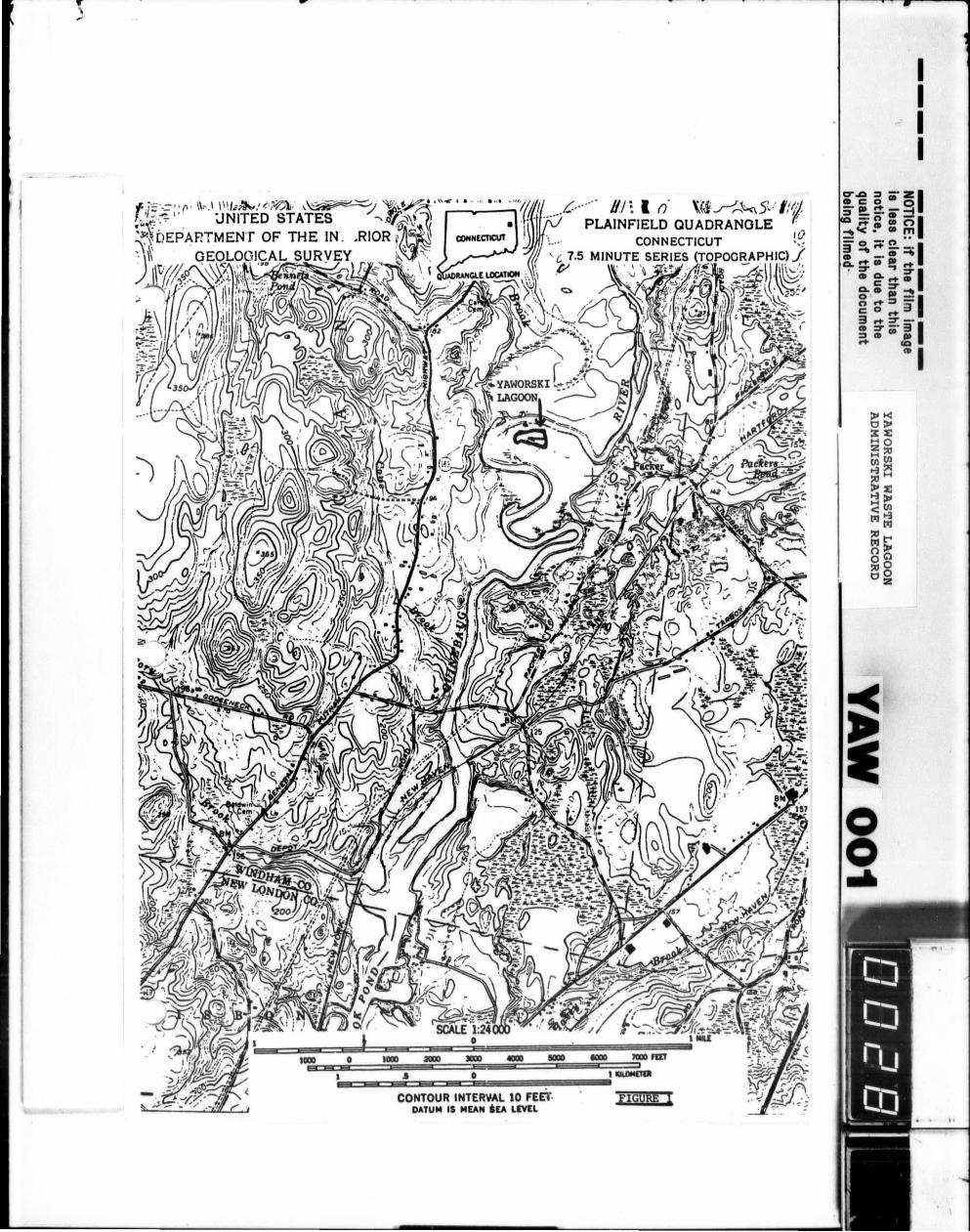
The Yaworski Waste Lagoon, owned by James Yaworski, is located on a 340 acre site in the town of Canterbury, Connecticut. Mr. · Yaworski also operates an act i ve solid waste disposal area on t he same property. The site is bordered on t he east by Packer Road , and on the west , north and south by the Quinebaug River (See Figure 1). The distance from the waste lagoon to t he river var ies f rom 20- 45 fee t . Approximate dimensions of t he l agoon are 700 feet cy 400 fee t by 12 feet deep. A six t o nine foot hi gh protective dike wall sur rounds t he lagoon.
The waste lagoon had been active for about 25 years prior to 1973. During that period, bulk and drummed wastes including textile dyes, solvents, resins, acids, caustics, still bottoms, and solvent-soaked rags were accepted. Standard operating procedure called for periodic, uncontrolled burning in order to reduce the volume of waste in the lagoon. This prac) tice continued until 4 August 1973, when the State of Connecticut's Air Compliance Unit issued an order closing the lagoon due to organic odors.
A plan to excavate the lagoon's contents using Connecticut Army National Guard equipment and personnel to transport the waste to a more stable location on Yaworski's property was proposed in 1973. The plan was abandoned by the Guard due to the inherent danger of the proposed activities.
The u.s. Environmental Protection Agency sampled the contents of the lagoon and the groundwater on May 27, 1980 to determine Section 311 appli cability. Laboratory analys is yielded four 311 compounds: benzene, ethyl benzene , toluene, and xylene. Subsequently, the State of Connecticut's Department of Environment al Protection ordered the owner to s tudy the sit.e stability and risks , and to propose mi t i gation procedures (See Attachment 1) .
PURPOSE OF FIELD TRIP - 4 MARCH 1981
Oil and Hazardous Materials Section personnel inspected the waste lagoon to observe the integrity of it's dike wal ls after a period of heavy rains.
1Information based on an EPA Air Compliance Section memorandum dated ' 21 August 1979.
I I I I
I I I I
-2
OBSERVATIONS
Dave Mcintyre and Bob Rein (TAT), EPA Region I, arrived at the site and detected a strong organic odor at a dis~ance of about 50 yards from the lagoon, necessitating the use of respiratory protection.
The eastern section of the waste lagoon, which contained most of the drums, was quite solidified with some green and yellowish liquid sporadically appearing between the drums. The solidified area was composed of disposed rags, by-products of combustion , and drums. The western end of the lagoon was mostly liquid, with dead trees within and along its confines. The liquid area was about BOt frozen. Mr. Rein observed a four i nch t urtle in one of the melted areas. This was the only visible sign of animal life around or wi thin the lagoon.
The dike wall surrounding the lagoon appeared to be inadequate in several spots (See Figure 2). Althoug~ i t was 6-9 feet high, there were several ar eas where the liquid and waste levels approached the wall's maximum height (See Figure 2). Several puddles of multi-colored leachate were observed near the base of the southern dike wall. At the western end, the liquid level was even with the top of the wall. One spot clearly showed where liquid had flowed over the top of the wall and had formed a plume leading westward into a swamp adjacent to the Quinebaug River (See Figure 2).
CONCLUSIONS
The waste lagoon's dike walls are inadequate to contain it's liquid volume. During heavy rains, the contaminants overflow into the swamp and eventually reach the Quinebaug River. In addition, there were several points along the perimeter of the southern dike wall that showed signs of either groundwater or lagoon content l eaching into the adjacent cornfield.
RECCI4MENDATIONS
In order to alleviate potential and on-going "surface" contamination of the Quinebaug River, the lagoon dike walls should be fortified to a height necessary to prevent any liquid from escaping the lagoon. In addition, groundwater monitoring should be undertaken in order to determine levels of contamination. Periodic inspections of the lagoon should also be made to monitor it's condition.
I I I I
1S.,• I\ T E ( >I~ <. () N N J! C.· 1 C U T
DEPARTMENT OF ENV1Jt<YJMEI'1 rAL PROTECTION
STATE OF CONNECTICUT vs. JAMES YAWORSKI, SR., AND ROSE YAWORSKI
IN THE MATTER OF AN ORDER TO JAMES YAWORSKI, SR., AND ROSE YAWORSKI TO ABATE POLLUTION
Having found that James Yaworski, Sr.• and Rose Yaworski owners of the industrial waste lagoon located at Map 62, Lot 12, Packer Road in the Town of Canterbury, Connecticut are maintaining a facility which reasonably can b1~ expected to create a soun;e of pollution of the waters of the State und~r the provisions of Chapter 474a of the Gene1·al Statutes as amended, the Commissioner of Environmental Protection acting under Section 25-54k hereby Orders James Yaworski, Sr., and Rose Yaworski to take such actions necessary to:
1} Investigate the extent of industrial waste disposal on the site and the effect of such disposal on subsurface and surface waters sun·oundi ng the di sposa1 site and detenni ne the corrective actions necessary and sufficient to eliminate pollution of these woters.
2} Detennine the existing structural stability of the lagoon) dikes and the flood inundation and erosion potential of the
lagoon; accomplish corrective actions as necessary to protect the lagoon from inundation from the 100 year flood and potential erosion and dike failure couditions that may accompany such flood event.
James Yaworski, Sr .• and Rose Yaworski are further Ordered to accomplish the above described program, except as may be revised by the recommendations of detailed engineering study and agreed to by the CDnmissioner of Environmental Protection in accordance with the following schedule:
A} On or before December 31, 1980 verify to the Conmissioner of Environmental Protection that a consulting engineer has been hired to prepare the required engineering evaluation.
B) On or before March 31, 1981 submit for the review and approvalof the C!llvnissioner of Environmental Protection a comprehensive engineering repo1·t defining the existing conditions of the site and of surfdce and subsurf<sce wat.e1·s including a hydrogeological and engineering investigation and define the facilities and/or procedures required to eliminate and/or prevent pollution of these waters.
ATTACHMENT 1
State Olficc Dutlding. lbnhrd, Con"c"1icul 06115
An F,q11al Of'Jlnrtur it)' f)np/·')'tr
.. .. ··./
Entered as an Order of the Con1nissinner of Environmental Protection this 20th day of November, 1980.
. // .·· I ,;·: . . • '" ( · . i{ <:.
Stan~ey.SJP~c ConVJn s s 1o~e-r'!!
I Order No . 2919 I
Canterbury
SENT CERTIFIED MAIL - RRR
cc: Town of Canterbury Director of Health
State Health Department Attn: Mr. Robert Rivard
j 1
i i; i : I;I I
I'
Ii I •
I I . '
! : I
I I !I d liI:I! II
ATTACHMENT 1 - CONT.
-2I I
I I I I
...- HI~ I (). ~Ji-~~5t : lf~·i PLAINFIELD QUADRANGLE '{(~
I!/CONNECTICUT ··:
POORAPHIC) ./
- .n~:· rth:'"*"''!>~ ~\);c.,
0 0..
l .J 0 l tiiLOMmJI&~~~~~~~~~de~~~~
CONTOUR INTERYAL 10 FEEl'· FIGURE l DATUM IS MEAN tEA LEVEL