15
( s MINISTRY OF COMMERCE, INDUSTRY AND WATER AFFAIRS ANNUAL REPORT OF THE GEOLOGICAL SURVEY DEPARTMENT FOR THE YEAR ENDED 31 ST DECEMBER 1968 •

( s
MINISTRY OF COMMERCE, INDUSTRY AND WATER AFFAIRS
ANNUAL REPORT OF THE
GEOLOGICAL SURVEY DEPARTMENT
FOR THE YEAR ENDED 31 ST DECEMBER 1968
•
I GENERAL
(a) Introduction
The Geological Survey Department in the Republic of Botswana is a "non-integrated" element of the Ministry of Commerce, Industry and Water Affairs. Its headquarters are at Lobatse in southeastern Botswana, 4-7 miles south of the Botswana Government administrative headquarters at Gaborone.
The fundamental aim of the Geological Survey is the assessment of the mineral resources and underground water supply resources of Botswana with the intention of stimulating the realisation of their economic poten~al. A necessary preliminary to the attainment of these objectives is a study of the rocks and the geological structure over the whole of the country. Regional geological mapping and the publication of maps and reports describing the geology of Botswana is thus the main, prime function of the Geological Survey Department. Mineral survey work is carried out and this includes field geological and geophysical survey of mineral occurrences supplemented by laboratory work; prospecting for new mineral deposits; rendering assistance to prospecting organisations and operating mines; and wherever possible furthering interest in Botswana's mineral potential. A third major task of the Geological Survey is the development of underground water supplies and general hydrogeological survey. In underground water development work the Geological Survey carries out the siting of water boreholes after geological and geophysical investigations and then controls drilling of the selected sites to the stage where productive boreholes can be passed to another Department within the Ministry, which is responsible for equipping boreholes and for the maintenance of Government pumping units. Hydrogeological research work is also carried out and the Geological Survey is gradually building up a considerable body of information about the nature and occurrence of underground water resources in Botswana. In underground water development work, borehole drilling is carried out by the Drilling Branch section of the Geological Survey, which has its headquarters at Gaborone and is under the control of a Drill Superintendent who is directly responsible to the Director of Geological Survey.
Besides these main activities, the Geological Survey undertakes special investigations where geological advice is required, such as in certain engineering problems, and also renders assistance to other Government Departments whenever required to do so. Special geological and geophysical investigations and research work are also undertaken where they are needed for a better understanding of the basic geology and geological structure of Botswana.
The Director of Geological Survey is Mining Commissioner for Botswana and the Department includes a Government Mining Engineer's division. Apart from specific functions the Geological Survey performs in relation to prospecting and mining this division is responsible for safe mining practices, the inspection of mines and machinery, and the implementation of explosives regulations. In the exercise of its dual functions as a Geological Survey and Mining Commissioner's office, the Department is responsible to Government for ensuring that mining company prospecting operations in Botswana are carried out energetically and efficiently with due regard to the provisions of the Mines and Minerals Act in force in the country.
The main costs of running the Geological Survey and the full costs of the development of underground water supplies in Botswana by drilling during 1968 were again borne on normal budget estimates. Funds were also provided from a special Development Project scheme to allow an expansion of the.Geological Survey by the formation of the Government Mining Engineer's division.
(b) SUDlInary of the Year's Work
Recruiting difficulties continued to be met with during 1968, and as a result of a number of resignations amongst both professional and technical staff the Geological Survey remained short-staffed throughout the year. The position in this regard was particularly serious during the second half of the year and even steps taken to provide an enh:nced entry point for Geologists did not assist recruitment. The staff shortage affected work in all spheres of Geological Survey activity.
Regional reconnaissance geological mapping was continued and a total of about 1,750 square miles of previously unmapped country was geologically surveyed on a scale of 1: 125,000. Mapping was completed on three quarter degree sheet areas. Revision geological mapping was continued in southeastern Botswana.
Owing to the staff position only a limited amount of work could be carried out on direct mineral survey projects. A regional survey of the mineral potential of an area in northern Botswana was initiated. Iron-ore and manganese-ore occurrences were investigated. Special investigations work in the sphere of mineral survey included case history geophysical studies on nickel deposits in northeastern Botswana using up to eight different ground geophysical techniques.
In addition to the case history studies over known ore bodies, which are the subject of detailed investigations by mining companies at the present time, ground geophysical work was also carried out on behalf of one company to evaluate certain geophysical anomalies resulting from airborne electromagnetic and magnetic surveys.
During the year 17 State Grants were issued conferring special prospecting licences over various areas of Botswana for a variety of minerals. At the end of 1968,21 grants of prospecting rights were in force. Brief summaries of the work carried out by mining and prospecting companies in terms of these Grants of prospecting rights are given under the section on mineral survey in Part II, ECONOMIC GEOLOGY, of this report. Six applications for the grant of special prospecting licences were under consideration at the end of the year.
In underground water development work, geological and geophysical surveys were again carried out in nearly all District Council areas. Considerable assistance was also rendered to World Bank consultants investigating water supply problems in connection with developing mines. This was carried out as a Government counterpart contribution. Ground-water research programmes were intensified in certain areas. .
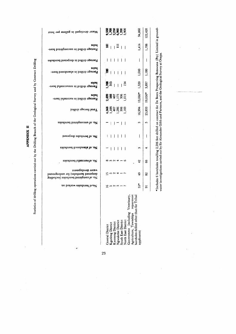
During 1968, a total of86 completed boreholes (both Government and for the private sector) were drilled on sites selected by officers of the Geological Survey. Of these boreholes, 70 were successful representing an overall success value of 81.5%' The Government Drilling Branch worked on 101 boreholes (including 16 cleaned and retested). The total footage drilled was 23,627 feet of which 16,844 feet were drilled in successful boreholes.
(c) Organization and staJl"
Certain minor changes were made in the schemes of service for professional officers. The two posts of Senior Geologist were retitled Principal Geologist. The post of Geologist was retitled Geologist/Senior Geologist with the title changing to Senior Geologist on entering the
2
(f) Q.uarter Degree Sheet 2022», Lake Ngaud
C.M. Thomas carried out a geological reconnaissance of this area during September prior to systematic mapping planned for 1969.
Representative samples of the main lithological types found in the Ghanzi Formation, the Kgwebe Porphyry Formation, the Bodibeng sandstone (Karro System) and other sedimentary rocks of uncertain age and correlation were collected for study.
IV UNDERGROUND WATER DEVELOPMENT
(a) Geological Survey Activities
The Geological Survey continued to be responsible for the control of all underground water development work in Botswana, including both the siting of boreholes following, geological and geophysical work, and the subsequent drilling of selected water borehole sites. .
In the course of this work geological and geophysical surveys were carried out in the Centra]" District; the North East District; Kgatleng District; Kweneng District; Ngwaketse District; South East District; Kgalagadi District; and Francistown and Lobatse township areas.
During 1968, a total of 86 completed water boreholes (both Government and private) were drilled on sites selected after geological and geophysical surveys carried out by officers of the Department. Of these 86 boreholes, 70 were successful representing an overall success value of 81.50/0 which compares well with that achieved during 1967 (81 %) The total number of completed boreholes, however, is about 180/0 lower than the number completed on Geological Survey drilling sites in 1967. This was due not only to the severe shortage of professional and technical staff experienced by the Geological Survey itself during 1968, but also because of a shortage of supervisory drilling personnel, due both to absences on enforced leave periods on completion of contracts and to resignations. A contributory factor as regards the number of completed boreholes was that m many areas the average depth drilled was well above that for previous years.
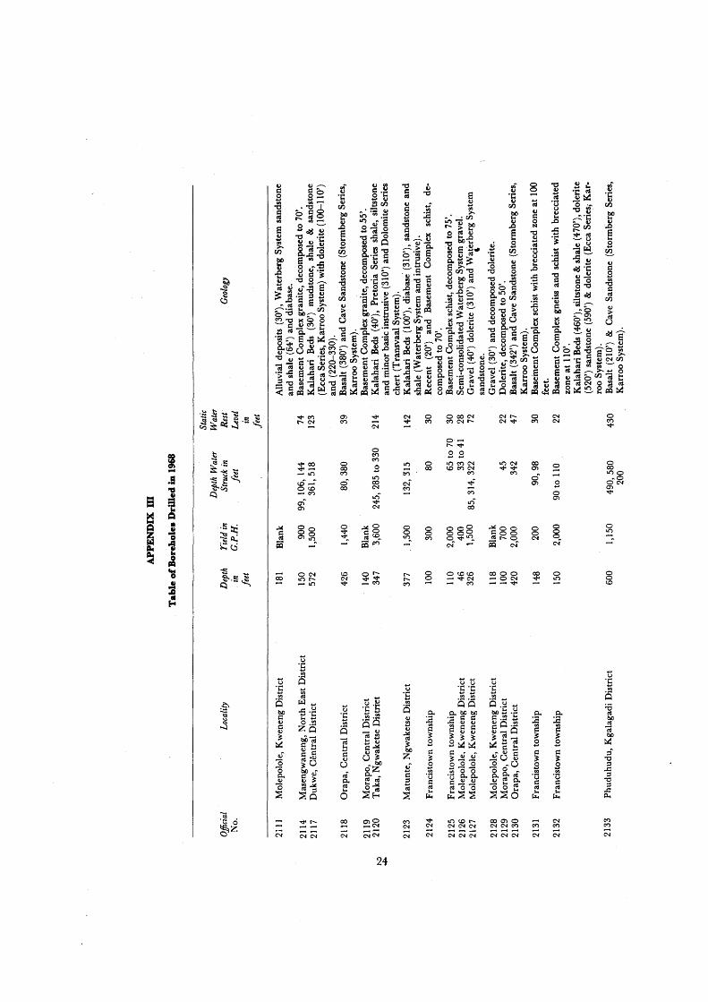
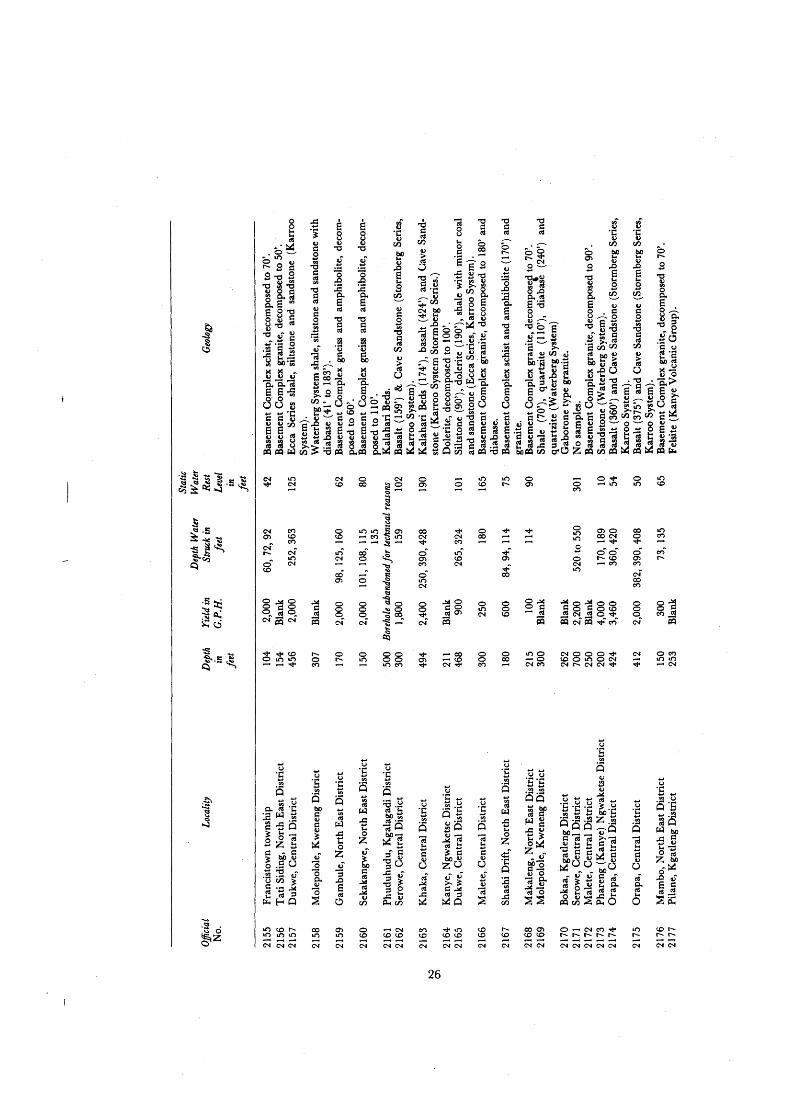
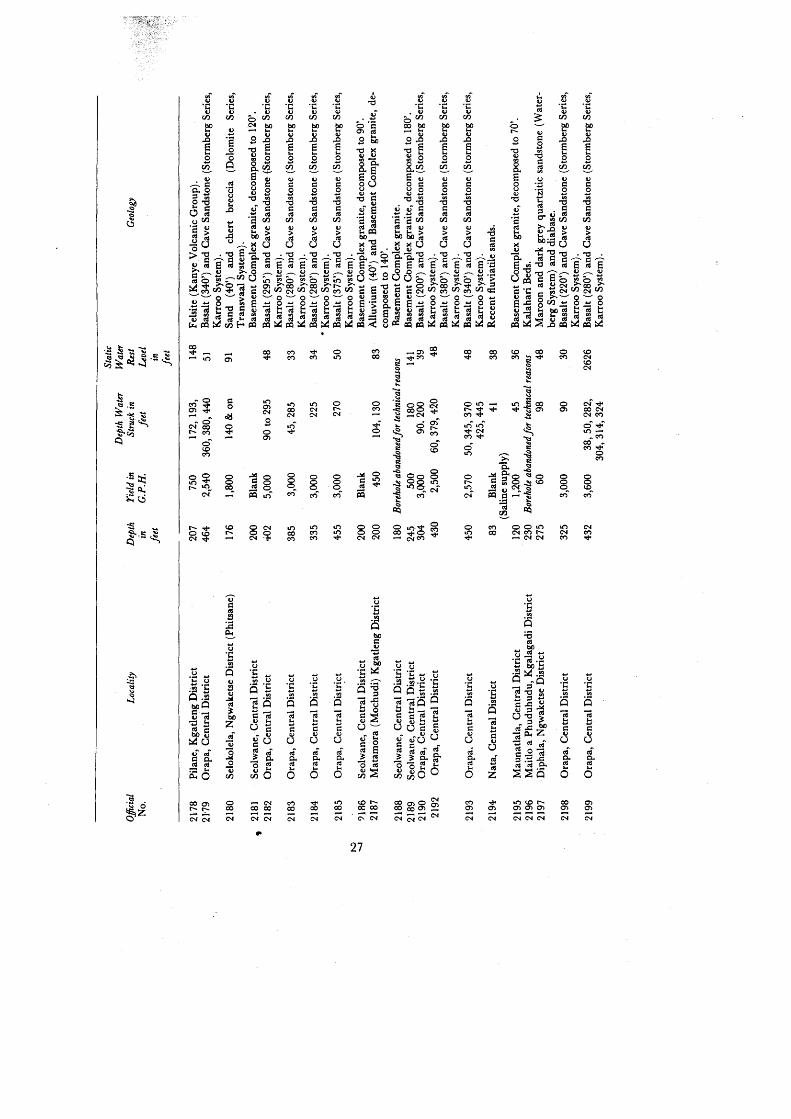
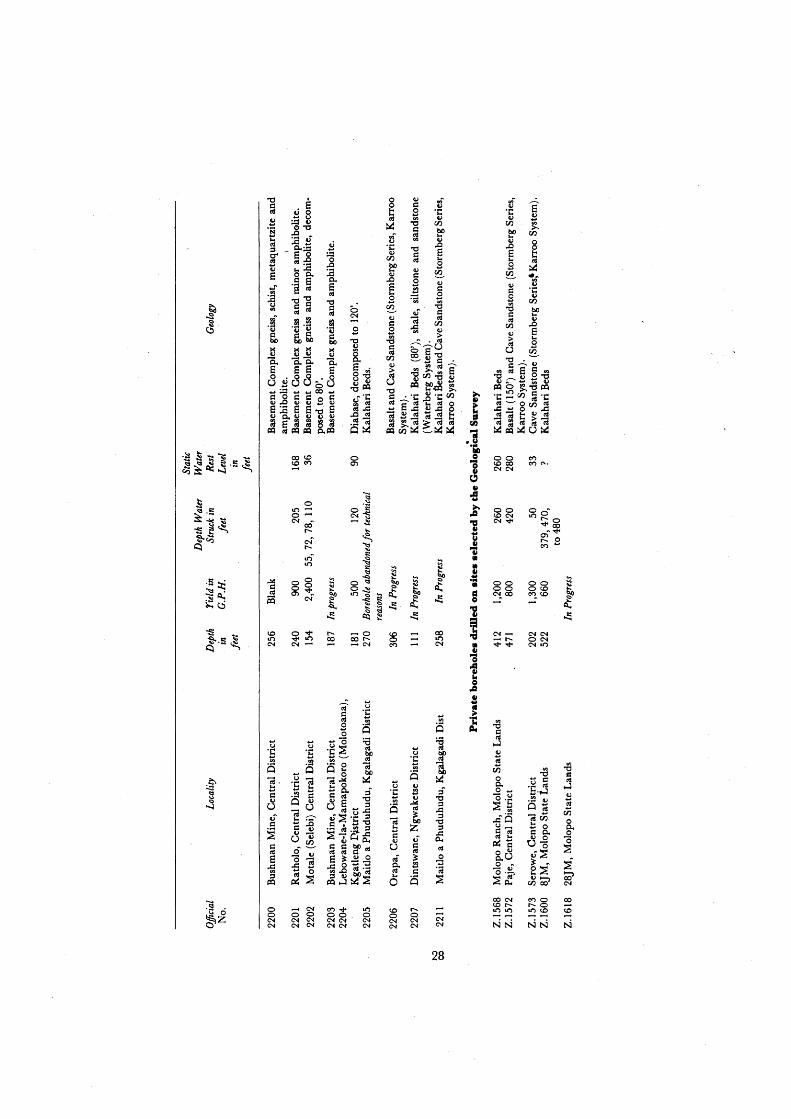
A tabulated list of boreholes drilled on sites selected by officers of the Geological Survey is given in Appendix IV.
(b) Drilling Branch Activities
During 196B, a total of23,627 feet was drilled by the Drilling Branch section of the Geological Survey in boreholes drilled for the development of underground water supplies. This footage is 8,236 feet less than the footage drilled in similar work during 1967, when a record footage was achieved. The reduced total is due not only to the shortage of staff referred to above, which meant that at certain times of the year the Drilling Branch was only operating at about 500/0 of its full strength, but also to the fact that two Drill Foremen were unable to carry out normal drilling duties for several weeks while assisting with detailed aquifer evaluation tests in the Orapa area.
During the year 101 boreholes (including 16 boreholes cleaned and retested) were worked on. Of the totalof85 new boreholes worked on, 4 boreholes totalling 1,180 feet had to be abandoned for technical reasons and 5 boreholes totalling 1,706 feet remained uncompleted at the end of the year. Of the total footage of 21,921 feet drilled in completed boreholes for underground water development purposes, 16,844 feet were drilled in successful boreholes.
14

In addition to this Government drilling, 6 successful boreholes totalling 2,206 feet were drilled on contract for De Beers Prospecting Botswana (Pty) Limited for aquifer evaluation tests carried out by Sir Alexander Gibb and Partners in collaboration with the Geological Survey in the Orapa area.
Apart from normal drilling for Government purposes and in various District Council areas, a considerable amount of assistance w~ again given to De Beers Prospecting Botswana (Pty) Limited in the Orapa area both to assist company prospecting operations and the aquifer evaluation tests being carried out there. Ten successful boreholes totalling 4,496 feet were completed and one borehole 306 feet deep was in progress at the end of the year. In addition, a Geological Survey Department test borehole, 921 feet deep, was in progress at the end of the year. The majority of these boreholes were drilled on a repayment basis.
In December a start was made with a drilling programme in the Selebi-Pikwe area to assist Bamangwato Concessions Limited in studies directed towards assessing available water reserves for water supplies which could be required in the mining and township construction stage should copper/nickel mines develop in this area.
Pre-occupation with work in the Orapa area for De Beers Prospecting Botswana (Pty) Limited curtailed th"e amount of work possible on boreholes drilled on repayment for private applicants in the various District Council areas. Only five successful boreholes were completed in connection with the borehole repayment scheme which will result in revenue amounting to R6,663 accruing to Government. '
(c) General Hydrogeological Research Work
The staff position again curtailed the amount of work possible on this important research programme, but it did prove possible to make a number of advances in this field.
A number of new automatic water level recorders were installed on suitable observation boreholes at such widely separated localities as Ghanzi, Nata, Francistown, Serowe, Orapa, Pikwe and Lobatse. A total of 16 automatic recorders are now in operation. In addition to these another 64 boreholes are monitored for changes in water level on a daily, weekly or monthly basis. Apart from at those centres listed above, these regular static water rest level measurements are made on observation boreholes in the Kalahari region, extending for over 100 miles west to the central Kalahari from Letlhakeng in the east, and from Serowe over 100 miles northwest "to the Letlhakane area near Orapa.
A grant was obtained during the year from the International Atomic En~rgy Agency in Vienna to carry out a research project on the effectiveness and application of environmental tritium as a ground-water tracer in Botswana to he carried out in collaboration with the Nuclear Physics Research Laboratory at the University of the Witwatersrand. This project will last for one year commencing in January 1969.
During the year detailed barometric levelling was carried out along a line of observation boreholes over a 120 mile long section from Serowe to Orapa and Lake Dow. A hydrogeological section was drawn up following the levelling.
The Geological Survey carried out detailed aquifer evaluation tests by controlled pumping methods in the Orapa area in collaboration with Sir Alexander Gibb and Partners, consultants appointed by the World Bank for this study, and De Beers Prospecting Botswana (Pty) Limited. The study was designed to make an assessment of the available water resources for the water ..
15

requirements for the proposed diamond mine on the AK I prospect at Orapa and, in particular, ground-water supplies available in the Cave Sandstone Stage (Stormberg Series, Karroo System) underlying the Stormberg Series basaltic lava in this area. The initial tests were carried out on 4- eight-inch diameter boreholes drilled on a diamond pattern with boreholes on the longer axis 5,000 feet apart and 3,000 feet apart on the .. horter axis. Diamond drill cored observation boreholes were sited at distances of 150 and 1,000 feet from each borehole on the extension of each axis. A fUFther· six-inch dialll@ter observation borehole was drilled in the centre of the diamond. Detailed tests carried out included step drawdown and equilibrium tests in all boreholes. Following these tests, coefficients of transmissibility (T) and storage (S) were calculated and were found to vary from 250 to 1000 gallons per day per foot and from 0.0009 toO.0006 respectively. Distance - drawdown diagrams were constructed for a hypothetical borehole in order to calculate long term effects of pumping without recharge and also to establish the probable economic costs and optimum spacing for a large well field. Further evaluation tests are planned on boreholes sited in relation to specific geological structures in the area.
Systematic sampling of ground waters for chemical analysis is being continued and to date over 2,000 full analyses have been carried out. Borehole waters in the Kweneng Di~trict were sampled in collaboration with Dr. J.C. Vogel, of the Council for Scientific and Industrial Research in the Republic of South Mrica, for C-14- age determination work.
The acquisition during the year of a borehole fluid salinity and temperature logger should prove to be of considerable assistance in locating entry points of water into boreholes. Extremely encouraging results were obtained at Orapa where entry points of water into a number of boreholes could be determined to within one. centimetre.
A Huntec FS-3 single channel facsimile percussion seismic instrument was also purchased and found to be of considerable use in shallow groundwater surveys and for engineering geology problems.
The self-potential (spontaneous polarisation) method is now being used as an adjunct to resistivity and magnetic surveys in areas of shallow ground water and where underground water supplies can be expected from fissure systems. Encouraging results have been obtained. It is also planned to use a variety of electromagnetic techniques, including Mmagin the future selection of water borehole sites. .
V SPECIAL INVESTIGATIONS
(a) Geophysical Studies
The main work in this sphere consisted of the initiation after April of a programme of detailed integrated case history geophysical studies of known or suspected ore deposits in various areas of Botswana. The geophysical methods employed included induced polarisation (time domain), Mm~g, vertical loop, electromagnetic, reconnaissance electromagnetic, gravimetric, magnetic, self potential and electrical resistivity.
A breakdown of geophysical work carried ~ut during the course of these studies is as follows:-
16
(c) Bulldings
A block of five additional offices was completed during the year. These offices will be used to house officers of the newly created Government Mining Engineer's Division as well as newly recruited Geologists. Plans are in hand to provide additional office accommodation for Geologists, when this block will revert entirely to the Government Mining Engineer's Division.
Staff houses were also under construction during the year for the Government Mining Engineer's Division and these should be completed during the first quarter of 1969.
VB CONFERENCES AND EXTRA- TERRITORIAL RELATIONS
R. Mason attended the annual congress of the Geological Society of South Africa held in Grahamstown in the Republic of South Africa in July. Mr. Mason presented two papers, "The Limpopo Mobile Belt in Eastern Botswana" and "The Metamorphic History of the Tati Schist Belt". He was also joint author of another paper entitled "A reappraisal of Some Aspects of Precambrian Shield Geology".
vm REPORTS AND PUBLICATIONS
(a) PublicatioDs
The Departmental Annual Report for 1967 was issued in December.
Publication of other material was delayed due to shortage of staff and hence the inability of more senior officers to pay attention to this work in view of their heavy commitments in other fields. Descriptions of all mapped areas are, however, available at Geological Survey headquarters at Lobatse, details of which can be supplied on request.
(b) Reports
The undermentioned, more important reports were prepared in addition to a number of short Departmental reports mainly concerning underground water supply investigations.
By C. Boocock
Annual Report of the Geological Survey Department for the year ended 31st December 1967.
By C.M.H. Jennings
Report on the ground-water storage capacity of the Lobatse area.
Note on hydrological research in Botswana with special emphasis on research in the hydrogeological field (to be published in the Journal of the South African Association for the Advancement of Science. )
By M.T.Jones
The geology of the. Molepolole Area (Quarter degree sheet 2425B).
19
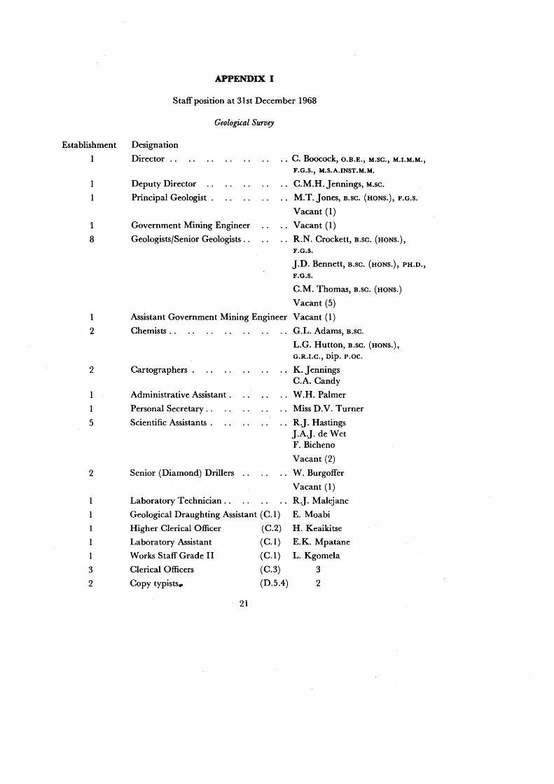
APPENDIX I
Staff position at 31st December 1968
Geological Survey
Establishment Designation
'I
8
Director ..
Deputy Director
Principal Geologist .
Government Mining Engineer
Geologists/Senior Geologists ..
.. C. Boocock, O.B.E., M.SC., M.I.M.M.,
F.G.S., M.S.A.INST.M.M.
C.M.H. Jennings, M.SC.
M.T. Jones, B.SC. (HONS.), F.G.S.
Vacant (1)
Vacant (1)
R.N. Crockett, B.SC. (HONS.),
F.G.S.
J.D. Bennett, B.SC. (HONS.), PH.D.,
F.G.S.
C.M. Thomas, B.SC. (HONS.)
Vacant (5)
1 Assistant Government Mining Engineer Vacant (1)
2 Chemists.. G.L. Adams, B.SC.
2
5
2
1
3
2
Cartographers .
Administrative Assistant .
Personal Secretary ..
Scientific Assistants .
Senior (Diamond) Drillers
Laboratory Technician ..
Geological Draughting Assistant (C.I)
Higher Clerical Officer (C.2)
Laboratory Assistant (C.I)
Works Staff Grade II (C. 1 )
Clerical Officers (C.3)
Copy typists.. (D.5.4)
21
L.G. Hutton, B.SC. (HONS.),
G.R.I.C., Dip. p.oc.
K.Jennings C.A. Candy
W.H. Palmer
Miss D.V. Turner
R.J. Hastings J.A.]. de Wet F. Bicheno
Vacant (2)
W. Burgoffer
Vacant (1)
R.J. Malejane
E. Moabi
H. Keaikitse
E.K. Mpatane
L. Kgomela
3
2

Artisan (C.2)
1 Tracer (C.2) 1
2 Laboratory Assistarits (C.3) 2
2 Tracers (C.3). 2
1 Storeman (C.4.3)
2 Field Assistants (C.3) 1
33 Motor Drivers (C.3) 21
Industrial Class not enumerated
Underground Water Development (Drilling Branch)
Drill Superintendent E.M.F. Owen
Assistant Drill Superintendent C.P. Hattingh
Senior Driller .. M.J. Swart
Scientific Assistant .. D.J.V. Pretorius
9 Drill Foremen . W.J. du Plessis P.H.F. Moll A.S.A. Pelser J.L. Bouwer F.C. Eloff F.H. Schutz
Vacant (3)
Higher Technical Officer (Works Staff Grade 1) .. C. Sterk
Clerk/Storekeeper (C.l) . L. Botlhole
Clerical Officer (C.3) 1
14- Motor Drivers (C.3) 10
Industrial Class not enumerated
22
AP
PE
ND
IX n
Sta
tist
ics
of
dril
ling
ope
rati
ons
carr
ied
out
by t
he D
rill
ing
Bra
nch
of
the
Geo
logi
cal
Sur
vey
and
by C
ontr
act
Dri
llin
g
bO"O
rJ
I
'"' c::
c:: ~
4J
=' ....
='
'"' I
'0
'"' 0
"0
0 4J
j
~
j 10
0 ..c:
: ..c:
: -=
t;,
'"' j
4J
'"' .S
~ j
~
'"' "0
4J
~ "0
j
~
~
----
"0
rJ ;Z
5
4J
-a 2
c:: ti
l c::
c:: "0
0
~
=' rJ
'0
" ..c:
: 0
4J
4J
4J
5 u
c:: e
~ "0
o
'"' '0
..c:
: c::
100
U
"0
g, 4J
-E
.g
4J
4J
.8 u
=' c::
0 ..c:
: '"'
u ..lo
C 4J
.B
~
u a
co:
4J
bO
'"' ~-;n _
'"' 4J
"0
ij1
,&l
4J
c:: 0
j 4J
"0
~
=' co:
"0
='
.S
~
~
c:: "0
"0
~
~
.S
.S
c:: .S
.S
~
~
"0
0 to
I
~
4J
rJ 4J
....
"0
u.c
E
c::
Q.
g, -t
olc
a.
0 '0
"0
"0
"0
"0
"0
"0
'0
-a
.8.£
5
-0
E
4J
4J
~
~
~
~
0 .c
c
.c
0 b
/)
~
~
QJ
u u
u CIS
·c
·c
·c
.8
e.,.,
~
u ..
'"' u
] "0
"0
"0
"0
"0
>
.D
.&
c
4J
o U
to
I ;
.. :s
to
I to
I to
I U
4J
"0
V
c'"
'-
'0 X
. t
'0
15
'0
.... tI
«)
tI«)
bO
be
bO
10
0 C
0
-;
s c
S I
S S
13 S
S
IS u
d o
t &;
0 0
ci 0
~ :]
l]
II
8 8
-;
z z.
,., ~
z
:z.
z z
(&..
(&..
,g
~
tV
~
2,4!
19
180
Cen
tral
Dis
tric
t 16
15
8
4.56
8 1,
708
181
9,55
0 K
gatl
eng
Dis
tric
t 5
5 3
1,10
3 58
8 51
5 1,
700
Kw
enen
g D
istr
ict
2 2
2 40
7 40
7 2,
250
Ngw
aket
se D
istr
ict
5 4
4 1,
286
1,17
5 11
1 6~960
Sou
th E
ast
Dis
tric
t 1
1 1
306
306
1,20
0 N
orth
Eas
t D
istr
ict
7 7
6 1,
169
1,01
5 15
4 5,
900
Gov
ernm
ent
(inc
ludi
ng
Vet
erin
ary,
A
gric
ultu
re,
Tow
nshi
ps
repa
ymen
t bo
reho
les
dril
led
othe
r th
an fo
r T
rib
al
appl
ican
ts)
55*
49
42
3 3
16,9
94
13,0
60*
1,52
0 1,
000
1,41
4 94
,860
91
82
66
4 5
25,8
33
19,0
50*
3,89
7 1,
180
1,70
6 12
2,42
0
*Inc
lude
s 6
bore
hole
s to
tall
ing
2,20
6 fe
et d
rill
ed o
n co
ntra
ct f
or D
e B
eers
Pro
spec
ting
Bot
swan
a (P
ty)
Lim
ited
in
grou
nd-
wat
er in
vest
igat
ions
car
ried
ou
t by
Sir
Ale
xand
er G
ibb
and
Par
tner
s, a
nd th
e G
eolo
gica
l Sur
vey
at O
rap
a.
AP
PE
ND
IX m
Tab
le o
f Bor
ehol
es D
rill
ed in
196
8
Stat
ic
Dep
th W
ater
W
ater
O
ffici
al
Loca
lity
Dep
th
riel
d in
St
ruck
in
Res
t G
eolo
gy
No.
.
in
G.P
.H.
feet
Le
vel
feet
in
fe
et
2111
M
olep
olol
e, K
wen
eng
Dis
tric
t 18
1 B
lank
A
lluv
ial
depo
sits
(30
'), W
ater
becg
Sys
tem
san
dsto
ne
and
shal
e (6
4')
and
diab
ase.
2114
M
asen
gwan
eng,
Nor
th E
ast
Dis
tric
t 15
0 90
0 99
, 10
6, 1
44
74
Bas
emen
t C
ompl
ex g
rani
te,
deco
mpo
sed
to 7
0'.
2117
D
ukw
e, C
entr
al D
istr
ict
572
1,50
0 36
1,51
8 12
3 K
alah
ari
Bed
s (3
0')
mud
ston
e,
shal
e &
sa
ndst
one
(Ecc
a Se
ries
, Kar
roo
Syst
em)
wit
h do
leri
te (
l00-
110'
) an
d (2
20-3
30).
21
18
Ora
pa,
Cen
tral
Dis
tric
t 42
6 1,
440
80,
380
39
Bas
alt
(380
') an
d C
ave
San
dsto
ne (
Sto
rmbe
rg S
erie
s,
Kar
roo
Sys
tem
).
2119
M
orap
o, C
entr
al D
istr
ict
140
Bla
nk
Bas
emen
t C
ompl
ex g
rani
te, d
ecom
pose
d to
55'
.
~
2120
T
aka,
Ngw
aket
se D
istr
ict
347
3,60
0 24
5, 2
85 t
o 33
0 21
4 K
alah
ari
Bed
s (4
0'),
Pre
tori
a Se
ries
sha
le,
silt
ston
e ~
and
min
or b
asic
inst
rusi
ve (
310'
) an
d D
olom
ite
Seri
es
cher
t (T
rans
vaal
Sys
tem
).
2123
M
atun
te,
Ngw
aket
se D
istr
ict
377
.1,5
00
132,
315
14
2 K
alah
ari
Bed
s (1
00'),
dia
base
(31
0'),
san
dsto
ne a
nd
sh
ale
(Wat
etbe
rg S
yste
m a
nd in
trus
ive)
. 21
24
Fra
ncis
tow
n to
wns
hip
100
300
80
30
Rec
ent
(20'
) an
d B
asem
ent
Com
plex
sc
hist
, de
-co
mpo
sed
to 7
0'.
2125
F
ranc
isto
wn
tow
nshi
p 11
0 2,
000
65 t
o 70
30
B
asem
ent
Com
plex
sch
ist,
deco
mpo
sed
to 7
5'.
2126
M
olep
olo1
e, K
wen
eng
Dis
tric
t 46
40
0 33
to
41
28
Sem
i-co
nsol
idat
ed W
ater
berg
Sys
tem
gra
vel.
2127
M
olep
olo1
e, K
wen
eng
Dis
tric
t 32
6 1,
500
85,3
14,
322
72
Gra
vel
(40'
) do
leri
te (
310'
) an
d W
ater
berg
Sys
tem
sa
ndst
one.
•
2128
M
olep
olol
e, K
wen
eng
Dis
tric
t 11
8 B
lank
G
rave
l (3
0')
and
deco
mpo
sed
dole
rite
. 21
29
Mor
apo,
Cen
tral
Dis
tric
t 10
0 70
0 45
22
D
oler
ite,
dec
ompo
sed
to 5
0'.
2130
O
rapa
, C
entr
al D
istr
ict
420
2,00
0 34
2 47
B
asal
t (3
42')
and
Cav
e S
ands
tone
(S
torm
berg
Ser
ies,
K
arro
o S
yste
m).
21
31
Fra
ncis
tow
n to
wns
hip
148
200
90
,98
30
B
asei
nent
Com
plex
sch
ist w
ith
brec
ciat
ed z
one
at 1
00
feet
. 21
32
Fra
ncis
tow
n to
wns
hip
150
2,00
0 90
to
110
22
Bas
emen
t C
ompl
ex g
neis
s an
d sc
hist
wit
h br
ecci
ated
zo
ne a
t 11
0'.
Kal
ahar
i Bed
s (4
60'),
silt
ston
e &
sha
le (
470'
), d
oler
ite
(520
') sa
ndst
one
(590
') &
dol
erit
e (E
cca
Seri
es,
Kar
-
2133
P
hudu
hudu
, K
gala
gadi
Dis
tric
t 60
0 1,
150
roo
Sys
tem
).
490,
580
43
0 B
asal
t (2
10')
&
Cav
e S
ands
tone
(S
torm
berg
Ser
ies,
20
0 K
arro
o S
yste
m).

Stat
ic
Dep
th W
ater
W
ater
O
ffici
al
Loca
lity
Dep
th
riel
d in
St
ruck
in
Res
t G
eolo
gy
No.
in
G
.P.H
. .fe
et
Leve
l Je
et
in
feet
2f35
L
obat
se t
own$
hip
200
2,00
0 14
6 11
:A
Che
rty
grav
el (
60'),
che
rt (
150'
) &
dol
omit
e (D
olo-
mIt
e Se
ries
, T
rans
vaal
Sys
tem
).
2136
L
obat
se t
owns
hip
135
3,00
0 11
9 90
C
hert
y &
che
rty
grav
el (
120'
) &
dol
omit
e (D
olom
ite
Seri
es,
Tra
nsva
al S
yste
m).
21
37
Franci~town t
owns
hip
215
1,20
0 92
51
B
asem
ent
Com
plex
sch
ist,
deco
mpo
sed
to 7
0'.
2138
F
ranc
isto
wn
tow
nshi
p 12
7 2,
000
60,
103,
125
B
asem
ent
Com
plex
sch
ist,
deco
mpo
sed
to 8
0'.
2139
M
olep
olol
e, K
wen
eng
Dis
tric
t 28
9 25
0 10
8 74
-D
oler
ite
(200
') de
com
pose
d to
12
0'
&
Wat
erbe
rg
t S
yste
m q
uart
ziti
c sa
ndst
one.
21
40
Mol
epol
ole,
K w
enen
g D
istr
ict
llB
2,
000
64
,82
, 10
9, 1
18
40
Wat
erbe
rg S
yste
m s
hale
, si
ltsto
ne &
qua
rtzi
tic
sand
-st
one.
21
41
Fra
ncis
tow
n to
wns
hip
130
2,00
0 66
, 70
, ll
2
40
Bas
emen
t C
ompl
ex s
chis
t, de
com
pose
d to
70'
. 21
42
Fra
ncis
tow
n to
wns
hip
130
2,00
0 70
to
114
30
Bas
emen
t Com
plex
sch
ist &
am
phib
olit
e, d
ecom
pose
d to
110
'. 21
43
Fra
ncis
tow
n to
wns
hip
200
4,00
0 67
, 10
2, 1
50
48
Bas
emen
t C
ompl
ex s
chis
t &
m
inor
dol
erit
e, d
ecom
-"-=
l po
sed
to 7
0'.
(J1
2144
-O
rapa
, C
entr
al D
istr
ict
450
1,80
0 38
9 49
B
asal
t (3
89')
and
Cav
e S
ands
tone
(S
torm
berg
Ser
ies,
K
arro
o Sy
stem
.)
2145
Se
row
.e,
Cen
tral
Dis
tric
t 66
2 B
lank
85
52
C
ave
San
dsto
ne (
Sto
rmbe
rg S
erie
s, K
arro
o Sy
stem
) (1
0 g.
p.h.
) to
270
' and
Wat
erbe
rg S
yste
m q
uart
ziti
c sa
ndst
one
&
shal
e.
2146
D
ukw
e, C
entr
al D
istr
ict
456
2,00
0 38
6 12
3 K
alah
ari B
eds
(40'
), m
udst
one
& s
hale
(10
0'),
dol
erit
e (1
70'),
car
bona
ceou
s sh
ale
and
coa
l (3
80')
and
sand
-st
one
(Ecc
a Se
ries
, K
arro
o S
yste
m).
21
47
Fra
ncis
tow
n to
wns
hip
300
4,00
0 6
4,8
4,
110
50
Bas
emen
t C
ompl
ex a
mph
ibol
ite,
bro
ken
& p
artl
y de
-co
mpo
see
to 1
40'.
2148
M
olep
olol
e, K
wen
eng
Dis
tric
t 32
0 B
lank
W
ater
berg
Sys
tem
sha
le,
silt
ston
e &
qua
rtzi
tic
sand
-st
one.
21
49
Fra
ncis
tow
n to
wns
hip
130
2,00
0 u6
0 36
B
asem
ent
Com
plex
sch
ist,
de(:
ompo
sed
to 6
0'.
2150
F
ranc
isto
wn
tow
nshi
p 11
0 2,
000
61,7
1 32
B
asem
ent
Com
plex
sch
ist,
dec:
ompo
sed
to 6
0'.
2.15
1 O
otsi
. S
outh
Ea$
t D
istri
<:t
306
1.20
0 80
& o
n 60
. 35
0 15
C
hert
y gr
avel
(70
1 ) &
Wat
erbe
rg S
yste
m s
hale
s.
2152
O
rapa
, C
entr
al D
istr
ict
423
3,60
0 6
0,3
50
,39
0
39
"Bas
alt
(330
') an
d C
ave
San
dsto
ne (
Sto
rmbe
rg S
erie
s,
Kar
roo
Sys
tem
).
2153
O
rap
a C
entr
al D
istr
ict
921
IN P
RO
GR
ESS
B
asal
t &
Cav
e S
ands
tone
(S
torm
berg
Ser
ies,
Kar
roo
Sys
tem
).
2154
O
rapa
, C
entr
al D
istr
ict
585
1,00
0 6
4,3
90
,52
0
45
Bas
alt
(288
') &
Cav
e S
ands
tone
(S
torm
berg
Ser
ies,
57
0 K
arro
o S
yste
m).
Stat
ic
Dep
th W
ater
W
ater
O
ffici
al
Loca
lity
Dep
th
riel
d in
St
ruck
in
Res
t G
eolo
gy
No.
in
G
.P.H
. fe
et
Leve
l fe
et
in
feet
2155
F
ranc
isto
wn
tow
nshi
p 10
4 2,
000
60
,72
,92
42
B
asem
ent C~mplex s
chis
t, de
com
pose
d to
70'
. 21
56
Tat
i S
idin
g, N
orth
Eas
t D
istr
ict
154
Bla
nk
Bas
emen
t C
ompl
ex g
rani
te,
deco
mpo
sed
to 5
0'.
. 21
57
Duk
we,
Cen
tral
Dis
tric
t 45
6 2,
000
252,
363
125
Ecc
a Se
ries
sha
le,
silts
tone
and
san
dsto
ne
(Kar
roo
Sys
tem
).
2158
M
olep
olol
e, K
wen
eng
Dis
tric
t 30
7 B
lank
W
ater
berg
Sys
tem
sha
le, s
iltst
one
and
sand
ston
e w
ith
diab
ase
(41'
to
183'
).
2159
G
ambu
le,
Nor
th E
ast
Dis
tric
t 17
0 2,
000
98,
125,
160
62
B
asem
ent
Com
plex
gne
iss
and
amph
ibol
ite,
dec
om-
pose
d to
60'
. 21
60
Sek
akan
gwe,
Nor
th E
ast
Dis
tric
t 15
0 2,
000
101,
108
, 11
5 80
B
asem
ent
Com
plex
gne
iss
and
amph
ibol
ite,
dec
om-
135
pose
d to
110
'. 21
61
Phu
duhu
du,
Kga
laga
di D
istr
ict
500
Bore
hole
aba
ndon
ed fo
r te
chm
cal r
easo
ns
Kal
ahar
i B
eds.
21
62
Ser
owe,
Cen
tral
Dis
tric
t 30
0 1,
800
159
102
Bas
alt
(159
') &
C
ave
San
dsto
ne (
Sto
rmbe
rg S
erie
s,
Kar
roo
Sys
tem
).
2163
K
haka
, C
entr
al D
istr
ict
494
2,40
0 25
0,39
0,42
8 19
0 K
alah
ari
Bed
s (1
74'),
bas
alt
(424
') an
d {J
ave
San
d-r-
.,j
ston
e (K
arro
o Sy
stem
Sto
rmbe
rg S
erie
s.)
0')
2164
-K
anye
, N
gwak
etse
Dis
tric
t 21
1 B
lank
D
oler
ite,
dec
ompo
sed
to 1
00'.
2165
D
ukw
e, C
entr
al D
istr
ict
468
900
265,
324
10
1 S
ilts
tone
(90
'), d
oler
ite
(190
'), s
hale
wit
h m
inor
coa
l an
d s
ands
tone
(E
cca
Seri
es,
Kar
roo
Sys
tem
).
2166
M
alet
e, C
entr
al D
istr
ict
300
250
180
165
Bas
emen
t C
ompl
ex g
rani
te,
deco
mpo
sed
to 1
80' a
nd
diab
ase.
21
67
Sha
shi
Dri
ft,
Nor
th E
ast
Dis
tric
t 18
0 60
0 84
,94,
114
75
B
asem
ent C
ompl
ex s
chis
t an
d am
phib
olit
e (1
70')
and
gran
ite.
21
68
Mak
alen
g, N
ort
hE
ast
Dis
tric
t 21
5 10
0 11
4 90
B
asem
ent
Com
plex
gra
nite
, dec
ompo
see
to 7
0'.
2169
M
olep
olol
e, K
wen
eng
Dis
tric
t 30
0 B
lank
S
hale
(7
0'),
qu
artz
ite
(110
'),
diab
ase
(240
') an
d
Bok
aa,
Kga
tlen
g D
istr
ict
quar
tzit
e (W
ater
berg
Sys
tem
) 21
70
262
Bla
nk
Gab
oron
e ty
pe g
rani
te.
2171
Se
row
e, C
entr
al D
istr
ict
700
2,20
0 52
0 to
550
30
1 N
o sa
mpl
es.
2172
M
alet
e, C
entr
al D
istr
ict
250
Bla
nk
Bas
emen
t C
ompl
ex g
rani
te, d
ecom
pose
d to
90'
. 21
73
Pha
reng
(K
anye
) N
gwak
etse
Dis
tric
t 20
0 4,
000
170,
189
10
S
ands
tone
(W
ater
berg
Sys
tem
).
2174
O
rapa
, C
entr
al D
istr
ict
424
3,46
0 36
0,42
0 54
B
asal
t (3
60')
and
Cav
e S
ands
tone
(S
torm
berg
Ser
ies,
K
arro
o S
yste
m).
21
75
Ora
pa,
Cen
tral
Dis
tric
t 41
2 2,
000
38
2,3
90
,40
8
50
Bas
alt
(375
') an
d C
ave
San
dsto
ne (
Sto
rmbe
rg S
erie
s,
Kar
roo
Sys
tem
).
2176
M
ambo
, N
orth
Eas
t D
istr
ict
150
300
73,
135
65
Bas
emen
t C
ompl
ex g
rani
te,
deco
mpo
sed
to 7
0'.
2177
P
ilan
e, K
gatl
eng
Dis
tric
t 25
3 B
lank
F
elsi
te (
Kan
ye V
olca
nic
Gro
up).
Stat
ic
Dep
th W
ater
W
ater
O
ffici
al
Loca
lity
Dep
th
riel
d in
St
ruck
in
Res
t G
eolo
gy
No.
in
G
.P.H
. fe
et
Leve
l fe
et
in
feet
2178
P
ilan
e, K
gatl
eng
Dis
tric
t 20
7 75
0 17
2, 1
93,
148
Fels
ite (
Kan
ye V
olca
nic
Gro
up).
21
'79
Ora
pa,
Cen
tral
Dis
tric
t 46
4 2,
:540
36
0,38
0,44
0 51
B
asal
t (3
40')
and
Cav
e S
ands
tone
(S
torm
berg
Ser
ies,
K
arro
o S
yste
m).
21
80
Selo
kole
la,
Ngw
aket
se D
istr
ict
(Phi
tsan
e)
176
1,80
0 14
0 &
on
91
San
d (4
0')
and
cher
t br
ecci
a (D
olom
ite
Seri
es,
Tra
nsva
al S
yste
m).
,
2181
S
eolw
ane,
Cen
tral
Dis
tric
t 20
0 B
lank
B
asem
ent
Com
plex
gra
nite
, de
com
pose
d to
120
'.
2182
O
rapa
, C
entr
al D
istr
ict
-t02
5,00
0 90
to
295
48
Bas
alt
(295
') an
d C
ave
San
dsto
ne (
Sto
rmbe
rg S
erie
s,
Kar
roo
Sys
tem
).
2183
O
rapa
, C
entr
al D
istr
ict
385
3,00
0 45
, 28
5 33
B
asal
t (2
80')
and
Cav
e S
ands
tone
(S
torm
berg
Ser
ies,
K
arro
o S
yste
m).
21
84
Ora
pa,
Cen
tral
Dis
tric
t 33
5 3,
000
225
34
Bas
alt
(280
') an
d C
ave
San
dsto
ne (
Sto
rmbe
rg S
erie
s,
• K
arro
o S
yste
m).
21
85
Ora
pa,
Cen
tral
Dis
tr~c
t 45
5 3,
000
270
50
Bas
alt
(375
') an
d C
ave
San
dsto
ne (
Sto
rmbe
rg S
erie
s,
t.,J
K
arro
o S
yste
m).
-..
...)
?lR
6 Se
olw
ane,
Cen
tral
Dis
tric
t 20
0 B
lank
B
asem
ent
Com
plex
gra
nite
, de
com
pose
d to
90'
. 21
87
Mat
amor
a (M
ochu
di)
Kga
tlen
g D
istr
ict
200
450
104,
130
83
A
lluv
ium
(40
') an
d B
asem
ent
Com
plex
gra
nite
, de
-co
mpo
sed
to 1
40'.
2188
S
eolw
ane,
Cen
tral
Dis
tric
t 18
0 Bo
reho
le a
band
oned
for
tech
nica
l rea
sons
R
asem
ent C
ompl
ex g
rani
te.
2189
Se
olw
ane,
Cen
tral
Dis
tric
t 24
5 50
0 18
0 14
1 B
asem
ent
Com
plex
gra
nite
, de
com
pose
d to
180
'. 21
90
Ora
pa,
Cen
tral
Dis
tric
t 30
4 3,
000
90.
200
39
Bas
alt
(200
') an
d C
ave
San
dsto
ne (
Sto
rmbe
rg S
erie
s,
2192
O
rapa
, C
entr
al D
istr
ict
430
2,50
0 60
, 37
9, 4
20
48
Kar
roo
Sys
tem
).
Bas
alt
(380
') an
d C
ave
San
dsto
ne (
Sto
rmbe
rg S
erie
s,
Kar
roo
Sys
tem
).
2193
O
rapa
. C
entr
al D
istr
ict
450
2,57
0 5
0,3
45
,37
0
48
Bas
alt
(340
') an
d C
ave
San
dsto
ne (
Sto
rmbe
rg S
erie
s,
425,
445
Kar
roo
Sys
tem
).
2194
N
ata,
Cen
tral
Dis
tric
t 83
B
lank
41
38
R
ecen
t flu
viat
ile
sand
s.
(Sal
ine
supp
ly)
2195
M
auna
tlal
a, C
entr
al D
istr
ict
120
1,20
0 45
36
B
asem
ent
Com
plex
gra
nite
, de
com
pose
d to
70'
. 21
96
Mai
tlo
a P
hudu
hudu
, K
gala
gadi
Dis
tric
t 23
0 Bo
reho
le a
band
oned
for
tech
nual
rea
sons
K
alah
ari
Bed
s.
2197
D
ipha
la,
Ngw
aket
se D
istr
ict
275
60
98
48
Mar
oon
and
dark
gre
y qu
artz
itic
san
dsto
ne (
Wat
er-
berg
Sys
tem
) an
d di
abas
e.
2198
O
rapa
, C
entr
al D
istr
ict
325
3,00
0 90
30
B
asal
t (2
20')
and
Cav
e S
ands
tone
(S
torm
berg
Ser
ies,
K
arro
o S
yste
m).
21
99
Ora
pa,
Cen
tral
Dis
tric
t 43
2 3,
600
38
,50
,28
2,
2626
B
asal
t (2
80')
and
Cav
e S
ands
tone
(S
torm
berg
Ser
ies,
3
04
,31
4,3
24
K
arro
o S
yste
m).
t-:)
CO
Offi
cial
N
o.
2200
2201
2202
2203
22
04
2205
2206
2207
2211
Z.1
568
Z.1
572
Z.1
573
Z.1
600
Z.1
618
Loca
lity
Dep
th
in
feet
Bus
hman
Min
e, C
entr
al D
istr
ict
256
Rat
holo
, C
entr
al D
istr
ict
240
Mot
ale
(Sel
ebi)
Cen
tral
Dis
tric
t 15
4
Bus
hman
Min
e, C
entr
al D
istr
ict
187
Leb
owan
e-la
-Mam
apok
oro
(Mol
otoa
na),
K
gatl
eng
D~st
rict
18
1 M
aido
a P
hudu
hudu
, K
gala
gadi
Dis
tric
t 27
0
Ora
pa,
Cen
tral
Dis
tric
t 30
6
Din
tsw
ane,
Ngw
aket
se D
istr
ict
III
Mai
tlo
a P
hudu
hudu
, K
gala
gadi
Dis
t 25
8
Dep
th W
ater
Yi
eld
in
Stru
ck i
n G
.P.H
. fe
et
Bla
nk
900
205
2,40
0 55
, 72
, 78
, 11
0
In p
rogr
ess
500
120
Bore
hole
aba
ndon
ed fo
r te
chni
cal
reas
ons
In P
rogr
ess
In P
rogr
ess
In P
rogr
ess
Stat
ic
Wat
er
Res
t Le
vel
in
feet
168 36
90
Geo
logy
Bas
emen
t C
ompl
ex g
neis
s, s
chis
t, m
etaq
uart
zite
and
am
phib
olit
e.
I
Bas
emen
t C
ompl
ex g
neis
s an
d m
inor
am
phib
olit
e.
Bas
emen
t C
ompl
ex g
neis
s an
d am
phib
olit
e, d
ecom
po
sed
.to 8
0'.
Bas
emen
t C
ompl
ex g
neis
s an
d am
phib
olit
e.
Dia
base
, de
com
pose
d to
120
'. K
alah
ari
Bed
s.
Bas
alt a
nd C
ave
San
dsto
ne (
Sto
rmbe
rg S
erie
s, K
arro
o S
yste
m).
K
alah
ari
Bed
s (8
0'),
sha
le,
silts
tone
and
san
dsto
ne
(Wat
erbe
rg S
yste
m).
K
alah
ari :
aeds
and
Cav
e S
ands
tone
(S
torm
berg
Ser
ies,
K
arro
o S
yste
m).
Pri
va
te b
ore
ho
les
dri
lled
08
sit
es s
elec
ted
by
th
e Ge
olog
i~al
Su
rvey
Mol
opo
Ran
ch,
Mol
opo
Sta
te L
ands
41
2 1,
200
260
260
Kal
ahar
i B
eds
Paj
e, C
entr
al D
istr
ict
471
800
420
280
Bas
alt
(150
') an
d C
ave
San
dsto
ne (
Sto
rmbe
rg S
erie
s,
Kar
roo
Sys
tem
).
Ser
owe,
Cen
tral
Dis
tric
t 20
2 1,
300
50
33
Cav
e S
ands
tone
(S
torm
berg
Ser
ies~
Karr
oo S
yste
m).
8J
M,
Mol
opo
Sta
te L
ands
52
2 66
0 37
9,47
0,
Kal
ahar
i B
eds
to 4
80
28JM
, M
olop
o S
tate
Lam
ds
In P
rogr
ess


!['GIS for Watershed Characterization and Modeling' in ......4 Hydrology,Groundwater,andSurfaceWater body of literature emerged debating [38, 39] and fur-thering the development of the](https://static.documents.pub/doc/80x56/5f443b6803a46f259f2fc257/gis-for-watershed-characterization-and-modeling-in-4-hydrologygroundwaterandsurfacewater.jpg)


