142
Gilt Edge Superfund Site Lawrence County, South Dakota Record of Decision for the Gilt Edge Superfund Site Operable Unit 1 (OU1) September 2008
Gilt Edge Superfund SiteLawrence County, South DakotaRecord of Decision for the Gilt Edge Superfund Site Operable Unit 1 (OU1)September 2008

This page intentionally left blank
RECORD OF DECISION FOR
GILT EDGE MINE SUPERFUND SITE OPERABLE UNIT 1
LAWRENCE COUNTY, SOUTH DAKOTA
September 2008

RECORD OF DECISION FOR
GILT EDGE MINE SUPERFUND SITE OPERABLE UNIT 1
LAWRENCE COUNTY, SOUTH DAKOTA
Part 1 Declaration

Section 1 Site Name, Location, and Description Confidential Internal Review Draft
2 A Document Code
D-1
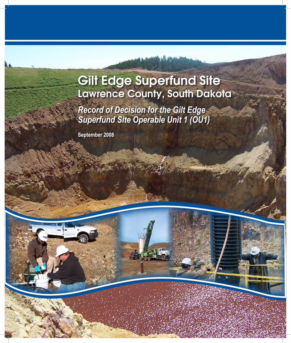
Site Name and Location The Gilt Edge Superfund Site (site) is located in the mining district in the Black Hills of South Dakota in Sections 4, 5, 6, 7, 8, and 9; Township 4 North; Range 4 East; Black Hills Meridian; Lawrence County, South Dakota. Site coordinates are 44° 19' 43" north latitude and 103° 44' 28" west longitude. The site is approximately 6 miles south-southeast of the towns of Lead and Deadwood, on county road FDR 170. This document represents the Record of Decision (ROD) for the Operable Unit No. 1 (OU1) remedial action. OU1 encompasses contaminant sources within the primary mine disturbance area, including waste rock, fills, spent ore, and sludge.
Statement of Basis and Purpose This decision document presents the Selected Remedy for OU1 of the site. The remedy selected in this ROD was chosen in accordance with the Comprehensive Environmental Response, Compensation and Liability Act (CERCLA) of 1980, as amended by the Superfund Amendments and Reauthorization Act of 1986 and the National Oil and Hazardous Substance Pollution Contingency Plan (NCP). The decision is based on the Administrative Record file for OU1 of the site. The U. S. Environmental Protection Agency’s (EPA) Comprehensive Environmental Response, Compensation, and Liability Information System (CERCLIS) identification number for the site is SDD987673985.
This document is issued by the EPA Region 8, the lead agency, and the South Dakota Department of Environment and Natural Resources (SD DENR). Both EPA and SD DENR concur on the Selected Remedy presented herein. The remedial action selected in this ROD is necessary to protect public health and welfare and the environment from actual or threatened releases of hazardous substances at the site.
Assessment of Site The response action selected in this ROD is necessary to protect the public health and welfare and the environment form actual or threatened releases of hazardous substances into the environment.
Description of Selected Remedy The Selected Remedy uses a remedial strategy that emphasizes site-wide consolidation and containment of contaminant sources to reduce exposure to hazardous substances and reduce the volume of acid rock drainage (ARD) generated. Removal, consolidation, and containment of acid-generating waste rock and fills are performed site-wide to facilitate covering of contaminant sources and creating clean water corridors within the Upper Strawberry and Hoodoo Gulch drainages. Cover systems are used at contaminant source consolidation locations to limit infiltration of precipitation and subsequent generation of ARD.
Part 1 Declaration
D-2
Sludge would be removed from Dakota Maid and Sunday Pits and the Stormwater Pond and placed adjacent to the wastewater treatment plant (WTP) sludge currently stored at the Heap Leach Pad (HLP) extension (whose entire surface would be available for future sludge generation from the WTP). WTP sludge would be disposed of at this location in disposal cells constructed as part of OU2. The Selected Remedy also relies on Land Use Controls (LUCs) to address risks posed to human receptors from unaddressed contaminant sources.
The Selected Remedy includes designation of Anchor Hill Pit as the primary ARD storage location for the site. In addition, the Selected Remedy includes installation of several ARD collection systems adjacent to contaminated fills left in place and at the Dakota Maid and Sunday Pit cover systems. The ARD capture and pumping systems at Strawberry Pond/Pond E and Hoodoo Gulch will be phased out as surface water quality within the Upper Strawberry Creek and Hoodoo Gulch drainages improves due to contaminant source removal within these drainages. Upgrades will be made to the WTP, as needed, to allow treatment of higher concentrations of sulfates from ARD stored in mine pits and ponds and to address potentially higher concentrations of sulfates in ARD from future discharges through pit backfill to the collection systems.
Statutory Determinations The Selected Remedy meets the mandates of CERCLA §121 and the National Contingency Plan. The remedy is protective of human health and the environment. It complies with all Federal and State requirements that are applicable or relevant and appropriate to the remedial action, is cost effective, and utilizes permanent solutions and alternative treatment technologies to the maximum extent practicable.
The remedy does not satisfy the statutory preference for treatment as a principal element of the remedy since it was determined that the source materials present in OU1 do not represent a principal threat, thus eliminating the expectation for treatment of these source materials. Although present in large volumes, source materials within OU1 are low in toxicity, can be reliably contained, and present only a relatively low risk in the event of exposure.
Because this remedy will result in hazardous substances, pollutants, or contaminants remaining on site above levels that allow for unlimited use and unrestricted exposure, a statutory review will be conducted within 5 years after initiation of remedial action to ensure that the remedy is, or will be, protective of human health and the environment.
D-1
RECORD OF DECISION FOR
GILT EDGE MINE SUPERFUND SITE OPERABLE UNIT 1
LAWRENCE COUNTY, SOUTH DAKOTA
Part 2
Decision Summary

i
Table of Contents Part 2 Decision Summary Section 1 Site Name, Location, and Description
1.1 Site Name and Location 1-1 1.2 Key Site Features 1-2
1.2.1 Open Pits 1-2 1.2.2 Underground Mine Workings 1-3 1.2.3 Heap Leach Pad 1-3 1.2.4 Waste Rock Dumps 1-4 1.2.5 ARD Water Management Systems 1-4
Section 2 Site History and Enforcement Activities
2.1 Site Background and History 2-1 2.1.1 Early Mining and Mineral Processing 2-1 2.1.2 BMC Operations 2-1
2.2 Regulatory Activities 2-3 2.2.1 Enforcement Actions and Documented Releases 2-3 2.2.2 Emergency Responses 2-5
2.2.2.1 State of South Dakota 2-5 2.2.2.2 EPA 2-5
2.3 Previous Remedial Actions 2-5 2.3.1 OU2 Water Treatment Early Action Interim ROD, 2-5
April 2001 2.3.2 OU2, Water Treatment, Interim ROD, November 2001 2-6 2.3.3 OU3, Ruby Gulch Waste Rock Dump, Interim ROD, 2-6
August 2001 2.4 Summary of Data Sources for the Remedial Investigation and
Feasibility Study 2-7 Section 3 Highlights of Community Participation 3.1 Summary Fact Sheet 3-1 3.2 Stakeholders Meeting 3-1 3.3 Release of a Proposed Plan 3-1 3.4 Display Advertisements 3-1 3.5 Public Comment Period 3-2 3.6 Site Tour 3-2 3.7 Public Hearing 3-2 3.8 EPA Web Site 3-2 3.9 Available Supporting Documents 3-2 3.10 Responsiveness Summary 3-2

Table of Contents
ii
Section 4 Scope and Role of OU or Response Action Section 5 Summary of Site Characteristics
5.1 Site Overview 5-1 5.1.1 Size 5-1 5.1.2 Climate 5-1 5.1.3 Areas of Archeological or Historical Importance 5-1 5.1.4 Acid Generation, Migration, and Mitigation Model 5-1 5.1.5 Geology and Major Fracture Zones 5-2
5.2 Site Conceptual Model 5-3 5.2.1 Affected Media 5-3 5.2.2 Source Materials 5-4 5.2.3 Migration Routes 5-4 5.2.4 Exposure Pathways 5-5 5.2.5 Populations that Are or Could Be Affected 5-5 5.2.6 Remediation Subareas 5-6
5.3 Sources of Contamination 5-8 5.3.1 Contaminant Concentrations 5-8
5.3.2 Acid Generation Potential 5-9 5.4 Surface Water 5-9 5.5 Groundwater 5-10
Section 6 Current and Potential Future Land and Resource Uses
6.1 Land Use 6-1 6.1.1 Current Onsite Uses 6-1 6.1.2 Current Adjacent or Surrounding Uses 6-1 6.1.3 Resonable Anticipated Future Land Uses 6-2
6.2 Groundwater and Surface Water Use 6-2 6.2.1 Current Groundwater Use 6-2 6.2.2 Current Surface Water Use 6-2 6.2.3 Potential Future Groundwater Use 6-3 6.2.4 Potential Future Surface Water Use 6-3
Section 7 Summary of Risk
7.1 Human Health Risk 7-1 7.1.1 Chemicals of Concern 7-1 7.1.2 Exposure Assessment 7-1 7.1.2.1 Exposure Points or Areas 7-2 7.1.2.2 Potential Receptors 7-3 7.1.3 Toxicity Assessment 7-3 7.1.3.1 Non-cancer Effects 7-3 7.1.3.2 Cancer Effects 7-4 7.1.3.3 Toxicity Values 7-5
Table of Contents
iii
7.1.3.4 Adjustments for Relative Bioavailability 7-5 7.1.4 Risk Characterization 7-6 7.1.4.1 EPA’s Approach for Calculating Risk 7-6 7.1.4.2 Risk Estimates 7-7 7.1.5 Uncertainty Analysis 7-8 7.1.5.1 Uncertainties Associated with Exposure 7-9 Assessment 7.1.5.2 Uncertainties in Toxicity Values 7-9 7.1.5.3 Uncertainties in Risk Estimates 7-10 7.16 Summary of Human Health Risk 7-10 7.2 Ecological Risk 7-11 7.2.1 Exposure Assessment 7-12
7.2.2 Risks to Aquatic Receptors 7-12 7.2.2.1 Direct Contact with Contaminants in Surface Water 7-14 7.2.2.2 Direct Contact with Contaminants in Sediments 7-14 7.2.2.3 Exposure of Fish 7-14 7.2.2.4 Remedial Actions Conducted Since Completion 7-15 of ERA 7.2.3 Risks to Terrestrial Plants and Soil Organisms 7-15 7.2.4 Risks to Wildlife Receptors 7-15 7.2.5 Uncertainties 7-17
7.2.5.1 Uncertainty in the Nature and Extent of 7-17 Contamination
7.2.5.2 Uncertainty in Exposure Assessment 7-17 7.2.5.3 Uncertainties in Effects (Toxicity) Assessment 7-18 7.2.5.4 Uncertainties in Risk Characterization 7-18 7.2.5.5 Summary of Uncertainties 7-18
7.2.6 Biological Monitoring Report 7-19 7.3 Basis of Action 7-19
Section 8 Remedial Action Objectives and Remediation Goals
8.1 Remedial Action Objectives 8-1 8.2 Preliminary Remediation Goals 8-2
Section 9 Description of Alternatives 9.1 Description of Remedy Components 9-1 9.1.1 Alternative 1 – No Action 9-2 9.1.1.1 Contaminant Sources 9-2 9.1.1.2 Contaminated Water 9-2
9.1.2 Alternative 3: Anchor Hill Pit ARD Collection/WTP 9-2 Upgrade/Limited Fill Removal, Consolidation, and Cover/LUCs
9.1.2.1 Contaminant Sources 9-2 9.1.2.2 Contaminated Water 9-3
Table of Contents
iv
9.1.3 Alternative 4: Anchor Hill Pit ARD Collection/WTP 9-4 Upgrade/Partial Fill Removal, Consolidation, and Cover/LUCs
9.1.3.1 Contaminant Sources 9-4 9.1.3.2 Contaminated Water 9-5
9.1.4 Alternative 5: Anchor Hill Pit ARD Collection/WTP 9-5 Upgrade/Fill Removal, Consolidation, and Cover/LUCs
9.1.4.1 Contaminant Sources 9-6 9.1.4.2 Contaminated Water 9-7
9.2 Common Elements and Distinguishing Features of Each 9-7 Alternative 9.2.1 Contaminant Sources 9-7
9.2.1.1 Consolidation and Containment of Sources 9-7 9.2.1.2 Covers 9-7 9.2.1.3 Sludge Removal, Containment, and Future Storage 9-8 9.2.1.4 LUCs 9-8 9.2.2 Contaminated Water 9-8 9.2.2.1 Collection, Handling, and Treatment of Water 9-9 9.2.2.2 Upgrades to the WTP 9-9 Section 10 Comparative Analysis of Alternatives 10.1 Threshold Criteria 10-1 10.1.1 Overall Protection of Human Health and the 10-1
Environment 10.1.2 Compliance with ARARs 10-2 10.2 Balancing Criteria 10-3 10.2.1 Long-Term Effectiveness and Permanence 10-3 10.2.2 Reduction of Toxicity, Mobility, or Volume Through 10-4
Treatment 10.2.3 Short-Term Effectiveness 10-4 10.2.4 Implementability 10-4 10.2.5 Present Value Cost 10-5 10.3 Modifying Criteria 10-6 10.3.1 State Acceptance 10-6 10.3.2 Public Acceptance 10-6 Section 11 Principal Threat Waste Section 12 Selected Remedy 12.1 Short Description of the Selected Remedy 12-1 12.2 Rationale for the Selected Remedy 12-2 12.3 Detailed Description of the Selected Remedy 12-3 12.3.1 Contaminant Sources 12-3

Table of Contents
v
12.3.2 Contaminated Water 12-4 12.4 Estimated Cost of the Selected Remedy 12-5
12.5 Expected Outcomes of the Selected Remedy 12-5 12.6 Performance Standards 12-6 12.7 Environmental Justice 12-6
Section 13 Statutory Determinations
13.1 Protection of Human Health and the Environment 13-1 13.1.1 Contaminant Sources 13-1 13.1.2 Contaminated Water 13-1
13.2 Compliance with ARARs 13-2 13.2.1 Contaminant Sources 13-2 13.2.2 Surface Water 13-3 13.2.3 Other ARARs 13-4
13.3 Cost Effectiveness 13-4 13.4 Utilization of Permanent Solutions and Alternative 13-5
Treatment (or Resource Recovery) Technologies to the Maximum Extent Practicable
13.5 Preference for Treatment as a Principal Element 13-5 13.6 Five Year Reviews 13-6
Section 14 Documentation of Significant Changes Section 15 References Cited List of Exhibits Exhibit 1-1................................................................................................ Location of Gilt Edge Site Exhibit 2-1 ..............................................Timeline of Mining and Regulatory Activities at the Site Exhibit 4-1........................................Conceptual Sequence of Events for OUs at the Gilt Edge Site Exhibit 5-1......................................................ARD Generation, Migration, and Mitigation Model Exhibit 5-2.............................. Remediation Subareas and Their Associated Contaminant Sources,
Surface Water Impacts and Groundwater Impacts Exhibit 7-1....................Summary of COCs and Medium-Specific Exposure Point Concentrations Exhibit 7-2.......................................................................................Non-Cancer Toxicity Summary Exhibit 7-3...................................................................................... Cancer Toxicity Data Summary Exhibit 7-4...................................................................... Ecological Exposure Pathways of Concern Exhibit 8-1............................... RGs and RALs for Recreational Hikers and Construction Workers Exhibit 10-1............................................................Comparative Analysis of Retained Alternatives Exhibit 13-1....................................... Evaluation of Compliance with ARARs for Selected Remedy
List of Figures Figure 1-1 ..................................... Aerial Photograph of Gilt Edge Site Showing Key Site Features Figure 1-2 .......................................................................................... Underground Mine Workings
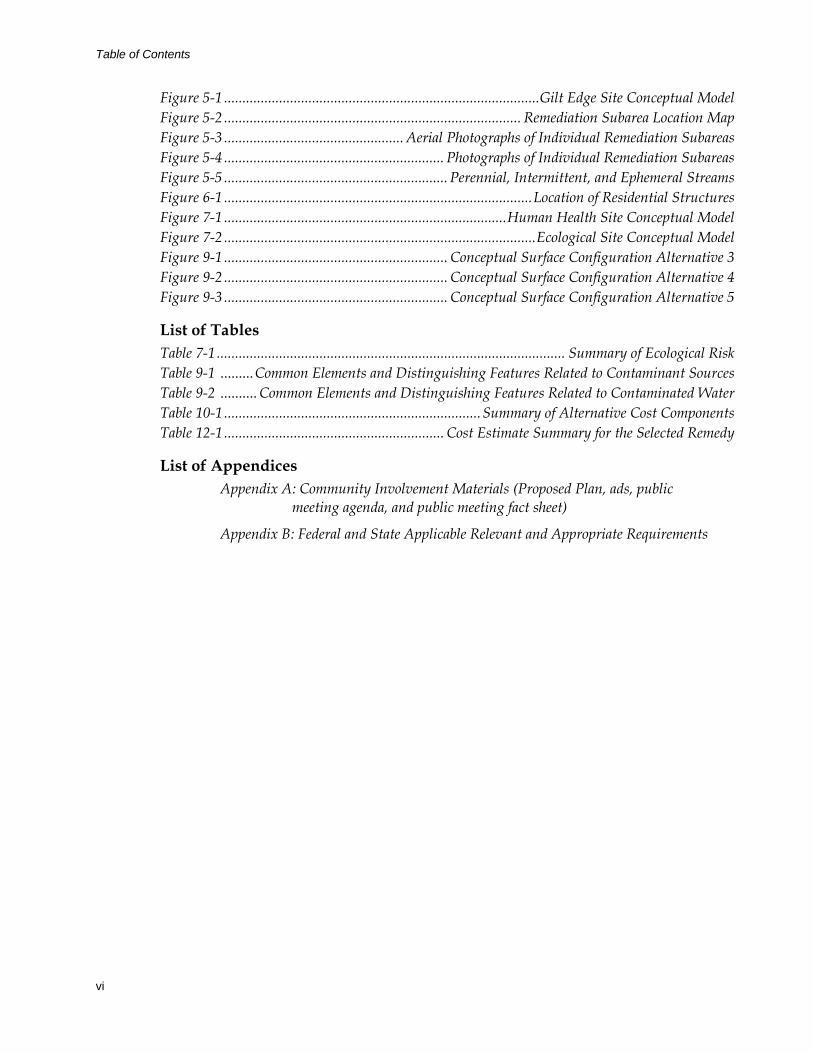
Table of Contents
vi
Figure 5-1 ......................................................................................Gilt Edge Site Conceptual Model Figure 5-2 ................................................................................. Remediation Subarea Location Map Figure 5-3 ................................................. Aerial Photographs of Individual Remediation Subareas Figure 5-4 ............................................................ Photographs of Individual Remediation Subareas Figure 5-5 ............................................................. Perennial, Intermittent, and Ephemeral Streams Figure 6-1 ....................................................................................Location of Residential Structures Figure 7-1 .............................................................................Human Health Site Conceptual Model Figure 7-2 .....................................................................................Ecological Site Conceptual Model Figure 9-1 ............................................................. Conceptual Surface Configuration Alternative 3 Figure 9-2 ............................................................. Conceptual Surface Configuration Alternative 4 Figure 9-3 ............................................................. Conceptual Surface Configuration Alternative 5
List of Tables Table 7-1 ............................................................................................... Summary of Ecological Risk Table 9-1 .........Common Elements and Distinguishing Features Related to Contaminant Sources Table 9-2 .......... Common Elements and Distinguishing Features Related to Contaminated Water Table 10-1 ...................................................................... Summary of Alternative Cost Components Table 12-1 ............................................................ Cost Estimate Summary for the Selected Remedy
List of Appendices Appendix A: Community Involvement Materials (Proposed Plan, ads, public
meeting agenda, and public meeting fact sheet)
Appendix B: Federal and State Applicable Relevant and Appropriate Requirements
Table of Contents
vii
Acronyms AHP .......................................................................................Anchor Hill and Pit exposure unit ARAR .....................................................applicable or relevant and appropriate requirement ARD ..................................................................................................................acid rock drainage ATV.....................................................................................................................all-terrain vehicle BLM .......................................................................................U.S. Bureau of Land Management BMC..................................................................................................Brohm Mining Corporation BMI ..................................................................................................... benthic macroinvertebrate BMPs..................................................................................................best management practices BRA............................................................................... baseline human health risk assessment CAMC ...................................................................................Cyprus Amax Minerals Company CDM .................................................................................CDM Federal Programs Corporation CERCLIS ............. Comprehensive Environmental Response, Compensation, and Liability
Information System CFR ..................................................................................................Code of Federal Regulations cfs ..................................................................................................................cubic feet per second COC ......................................................................................................... contaminant of concern COPC............................................................................................. chemical of potential concern CTE ..................................................................................................... central tendency exposure DI...................................................................................................................................daily intake DIL ................................................................................................................. daily intake lifetime EPA............................................................................... U.S. Environmental Protection Agency ERA......................................................................................................ecological risk assessment FS........................................................................................................................... feasibility study gpm.................................................................................................................. gallons per minute HEAST................................................................. Health Effects Assessment Summary Tables HI ............................................................................................................................... hazard index HLP......................................................................................................................... heap leach pad HQ ........................................................................................................................ hazard quotient IRIS .....................................................................................Integrated Risk Information System LP .................................................................................................................................. Langley Pit LUC....................................................................................................................... land use control MCL................................................................................................maximum contaminant level mg/kg ..................................................................................................... milligram per kilogram mg/kg-day ...............................................................................milligram per kilogram per day mg3/kg-day ................................................................. cubic microgram per kilogram per day µg/dL ......................................................................................................microgram per deciliter µg/L................................................................................................................ microgram per liter NCEA ............................................................ National Center for Environmental Assessment NCP ...................... National Oil and Hazardous Substances Pollution & Contingency Plan NOV...................................................................................................................notice of violation
Table of Contents
viii
NPDES........................................................National Pollutant Discharge Elimination System NPL............................................................................................................National Priorities List O&M................................................................................................. operation and maintenance OU.............................................................................................................................. operable unit PCA............................................................................................................ Pits and Crusher Area PDC............................................................................................................................. Pond C PCA PRP .................................................................................................potentially responsible party RAL...............................................................................................................remedial action level RAO .......................................................................................................remedial action objective RBA............................................................................................................ relative bioavailability RfD........................................................................................................................... reference dose RG ............................................................................................................................. remedial goal RI ................................................................................................................ remedial investigation RME ........................................................................................... reasonable maximum exposure ROD ................................................................................................................... record of decision SCM ............................................................................................................ site conceptual model SD DENR ..................... South Dakota Department of Environment and Natural Resources SF................................................................................................................................... slope factor site..........................................................................................................Gilt Edge Superfund Site TDS .............................................................................................................. total dissolved solids UCL............................................................................................................upper confidence limit USFS .................................................................................................................U.S. Forest Service WTP ..................................................................................................wastewater treatment plant
1-1
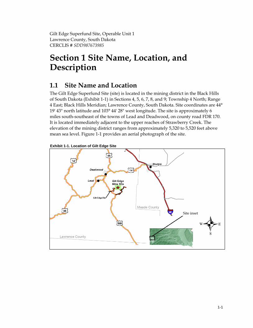
Gilt Edge Superfund Site, Operable Unit 1 Lawrence County, South Dakota CERCLIS # SDD987673985
Section 1 Site Name, Location, and Description 1.1 Site Name and Location The Gilt Edge Superfund Site (site) is located in the mining district in the Black Hills of South Dakota (Exhibit 1-1) in Sections 4, 5, 6, 7, 8, and 9; Township 4 North; Range 4 East; Black Hills Meridian; Lawrence County, South Dakota. Site coordinates are 44° 19' 43" north latitude and 103° 44' 28" west longitude. The site is approximately 6 miles south-southeast of the towns of Lead and Deadwood, on county road FDR 170. It is located immediately adjacent to the upper reaches of Strawberry Creek. The elevation of the mining district ranges from approximately 5,320 to 5,520 feet above mean sea level. Figure 1-1 provides an aerial photograph of the site.
Exhibit 1-1. Location of Gilt Edge Site
Site inset
Section 1 Site Name, Location and Description
1-2
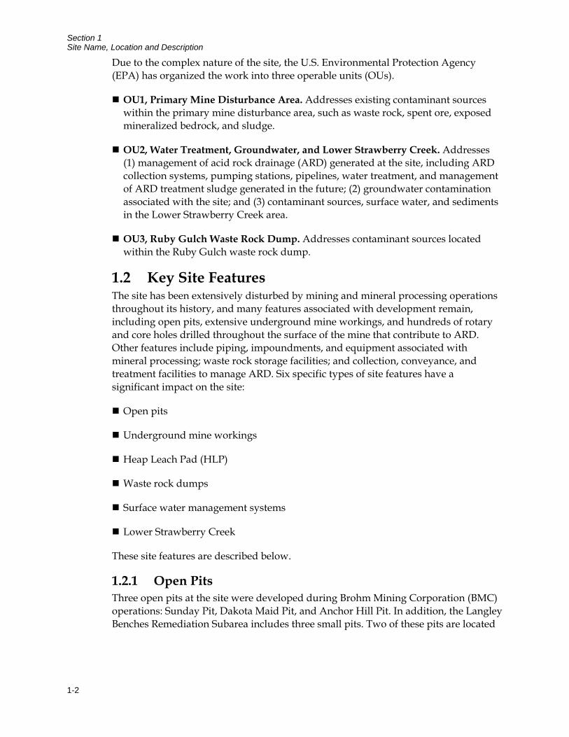
Due to the complex nature of the site, the U.S. Environmental Protection Agency (EPA) has organized the work into three operable units (OUs).
OU1, Primary Mine Disturbance Area. Addresses existing contaminant sources within the primary mine disturbance area, such as waste rock, spent ore, exposed mineralized bedrock, and sludge.
OU2, Water Treatment, Groundwater, and Lower Strawberry Creek. Addresses (1) management of acid rock drainage (ARD) generated at the site, including ARD collection systems, pumping stations, pipelines, water treatment, and management of ARD treatment sludge generated in the future; (2) groundwater contamination associated with the site; and (3) contaminant sources, surface water, and sediments in the Lower Strawberry Creek area.
OU3, Ruby Gulch Waste Rock Dump. Addresses contaminant sources located within the Ruby Gulch waste rock dump.
1.2 Key Site Features The site has been extensively disturbed by mining and mineral processing operations throughout its history, and many features associated with development remain, including open pits, extensive underground mine workings, and hundreds of rotary and core holes drilled throughout the surface of the mine that contribute to ARD. Other features include piping, impoundments, and equipment associated with mineral processing; waste rock storage facilities; and collection, conveyance, and treatment facilities to manage ARD. Six specific types of site features have a significant impact on the site:
Open pits
Underground mine workings
Heap Leach Pad (HLP)
Waste rock dumps
Surface water management systems
Lower Strawberry Creek
These site features are described below.
1.2.1 Open Pits Three open pits at the site were developed during Brohm Mining Corporation (BMC) operations: Sunday Pit, Dakota Maid Pit, and Anchor Hill Pit. In addition, the Langley Benches Remediation Subarea includes three small pits. Two of these pits are located
Section 1 Site Name, Location and Description
1-3
on the south side of Langley Peak and have been partly backfilled, but acidic bedrock exposures remain above the fill placement. The small pit located on the northeast side of Langley Peak was completely backfilled, covered with topsoil, and revegetated by the mining company. For purposes of this record of decision (ROD), these small backfilled pits are grouped into one remediation subarea. The large open pits are discussed below:
Sunday Pit. This 31-acre pit is located in the central/southeast portion of the mine area. At the highwall, it is about 240 feet deep. The pit is currently used as an ARD storage vessel. It currently contains approximately 20 million gallons of ARD. The pit also contains wastewater treatment plant (WTP) sludge generated during 1999 and 2000, areas of waste rock backfill, extensive underground mine workings, and a relic tailings repository.
Dakota Maid Pit. This 14-acre pit is located in the central portion of the site, northwest of the Sunday Pit. The pit is a side-hill pit with highwalls ranging from 50 feet to 320 feet in height. It has been used as part of the site water management system and contains about 6 million gallons of ARD. The pit is underlain by a network of underground mine workings that are accessed by the King Shaft, which is located in the base. Mine workings are also present west and south of the pit, and are accessed by several adits. The Dakota Maid also contains water treatment plant sludge, areas of waste rock backfill, and a relic tailings repository.
Anchor Hill Pit. This pit is located in the northwestern portion of the site. It covers 28.6 acres and has a maximum depth of 340 feet. It currently holds approximately 80 million gallons of ARD. It was part of a treatability study assessing passive ARD treatment from 2001 to 2006. The Anchor Hill Pit is currently also used as an ARD storage vessel.
1.2.2 Underground Mine Workings A complex network of shafts, adits, and stopes is present in the central portion of the site (Figure 1-2). These underground mine workings were developed prior to open pit mining. Most are located near the Dakota Maid or Sunday Pits. Some of these workings have been intersected during construction of the mine pits.
1.2.3 HLP The HLP is located in the north central portion of the mine area. The HLP and the HLP Extension cover an area of 37 acres and are estimated to contain approximately 2.2 million cubic yards of spent ore. A portion of the spent ore is currently acid generating. The HLP was an integral component of the mineral processing facilities at the site and was used to irrigate the ore with cyanide solutions to dissolve gold. Spent ore is rock that has been leached to remove the gold. The spent ore pile is approximately 150 feet high and is underlain by a multi-layer liner system. Flushing
Section 1 Site Name, Location and Description
1-4
and natural degradation have reduced cyanide concentrations in spent ore to trace levels.
1.2.4 Waste Rock Dumps Mine waste rock is found in numerous areas of the site where it was used as construction fills during mine development. Areas with significant volumes of waste rock fill include the Ruby Gulch, Hoodoo Gulch, Strawberry Gulch area, Stormwater Pond, and Anchor Hill remediation subareas.
The most significant accumulation of mine waste rock is located at the head of Ruby Gulch in the east central portion of the site. It covers an area of approximately 75 acres and is estimated to contain 20 million tons (12 million cubic yards) of acid generating waste rock and spent ore. The dump is approximately 400 feet high from its crest east of the HLP to the toe in Ruby Gulch. The majority of the Ruby Gulch waste rock dump has been remediated under the OU3 Interim ROD.
Other important mine wastes are relic tailings, which were produced at the mine site prior to 1942. Tailings have been placed in repositories located in the area immediately northwest of the Dakota Maid Pit and in the eastern part of Sunday Pit. The repository northwest of Dakota Maid Pit is currently covered by a soil stockpile. Relic tailings are also present on the banks of Lower Strawberry Creek.
1.2.5 ARD Water Management Systems Numerous ARD collection and conveyance facilities exist at the site. Generally, ARD is collected from the drainages within the site and pumped to the mine pits for storage prior to treatment. ARD is collected then transferred using pumping systems at Ruby Repository, Hoodoo Gulch, and Pond E (also known as Strawberry Pond). The ARD is pumped from these locations to the Sunday or Anchor Hill pits for storage or to the WTP for treatment.
A high-density sludge WTP was constructed and became operational in 2003. This WTP uses lime to increase pH of the water and precipitate metals as sludge. The sludge is disposed on site on the HLP Extension. The plant has a design treatment rate of 250 gallons per minute (gpm).
2-1
Section 2 Site History and Enforcement Activities
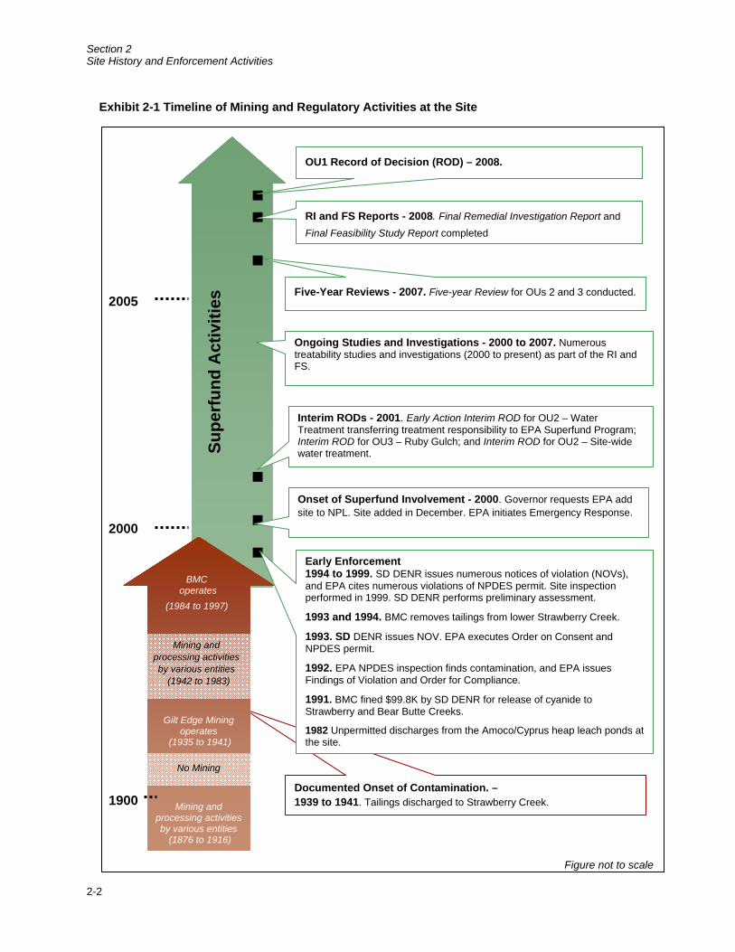
2.1 Site Background and History Mining and mineral processing have been conducted at the site since the late 1800s. Major periods of activity occurred from 1938 to 1941, when the site was operated by Gilt Edge Mining Company, and from the mid-1980s to approximately 1997, when the site was operated by the BMC. During other periods, a number of other owners and operators, including private individuals as well as companies, have conducted a range of mining and mineral processing activities at the site.
During the last period of mining, the site was operated as a large-scale open pit heap leach gold mine. The operator, BMC, abandoned the site in July 1999. At that time, there was an imminent risk of uncontrolled discharges of acid rock drainage from the site. The State of South Dakota immediately responded and took responsibility for collection and treatment of ARD. In 2000, EPA took over primary site responsibilities. The following subsections discuss:
Mining and mineral processing activities
State and federal regulatory activities undertaken to address the contamination
Exhibit 2-1 depicts a summary of these activities.
2.1.1 Early Mining and Mineral Processing Mining activities began at the site in 1876 when the Gilt Edge and Dakota Maid claims were founded. Historical underground mining operations extracted sulfide-bearing gold ores from irregular deposits in veins and fracture zones in the igneous rocks. Over the past century, a number of owners and operators have conducted a variety of mining and mineral processing activities at the site.
2.1.2 BMC Operations The South Dakota Board of Minerals and Environment issued Large Scale Mine Permit No. 439 in 1986, approving the open pit mining operation. Initial development included construction of a HLP, a Merrill-Crowe gold processing plant, process solution ponds, and ancillary mine infrastructure. The Sunday and Dakota Maid pits were mined from 1986 through 1992. Several conditions of the permit addressed mitigation of relic mine tailings.
Section 2 Site History and Enforcement Activities
2-2
Supe
rfun
d A
ctiv
ities
2000
2005
Ongoing Studies and Investigations - 2000 to 2007. Numerous treatability studies and investigations (2000 to present) as part of the RI and FS.
Five-Year Reviews - 2007. Five-year Review for OUs 2 and 3 conducted.
RI and FS Reports - 2008. Final Remedial Investigation Report and Final Feasibility Study Report completed
Interim RODs - 2001. Early Action Interim ROD for OU2 – Water Treatment transferring treatment responsibility to EPA Superfund Program; Interim ROD for OU3 – Ruby Gulch; and Interim ROD for OU2 – Site-wide water treatment.
Onset of Superfund Involvement - 2000. Governor requests EPA add site to NPL. Site added in December. EPA initiates Emergency Response.
OU1 Record of Decision (ROD) – 2008.
Documented Onset of Contamination. – 1939 to 1941. Tailings discharged to Strawberry Creek.
Exhibit 2-1 Timeline of Mining and Regulatory Activities at the Site
1900
Figure not to scale
Mining exploration activities
(1942 to 1983)
Early Enforcement1994 to 1999. SD DENR issues numerous notices of violation (NOVs), and EPA cites numerous violations of NPDES permit. Site inspection performed in 1999. SD DENR performs preliminary assessment.
1993 and 1994. BMC removes tailings from lower Strawberry Creek. 1993. SD DENR issues NOV. EPA executes Order on Consent and NPDES permit.
1992. EPA NPDES inspection finds contamination, and EPA issues Findings of Violation and Order for Compliance.
1991. BMC fined $99.8K by SD DENR for release of cyanide to Strawberry and Bear Butte Creeks.
1982 Unpermitted discharges from the Amoco/Cyprus heap leach ponds at the site.
Mining and processing activities by various entities
(1876 to 1916)
Gilt Edge Mining operates
(1935 to 1941)
BMC operates
(1984 to 1997)
No Mining
Mining and processing activities by various entities
(1942 to 1983)
Section 2 Site History and Enforcement Activities
2-3
In 1991, cyanide leaked from the mineral processing circuit and affected Strawberry and Bear Butte creeks. During an EPA inspection in 1992, unpermitted discharges of acidic and metal-laden waters containing aluminum, cadmium, copper, lead, and zinc were observed and recorded. As a result, in 1993 EPA issued a National Pollutant Discharge Elimination System (NPDES) permit to BMC addressing surface water discharges.
A large-scale mining permit for mining of undisturbed rock at the Anchor Hill deposit was issued by the South Dakota Board of Minerals and Environment in January 1996. The project was split into two phases. Mining of the Phase I deposit and the portions of the Phase II deposit was initiated in May of 1996 and completed by August of 1997. In addition, the Langley Area was mined between the first and third quarters of 1997 and was not part of either Phase I or Phase II.
Mining of a portion of Phase II was delayed because of the need for an environmental impact statement, which the USFS approved in November 1997. However, in response to appeals, USFS withdrew approval in February 1998. On May 21, 1998, BMC reported that it would abandon the mine in 1 week. The state filed for a temporary restraining order to prevent abandonment. The order was granted on May 29, 1998 and was followed by a preliminary injunction on June 5, 1998. BMC’s parent company, Dakota Mining Corporation, filed for bankruptcy in Canada in July 1999. As a result, SD DENR assumed water treatment operations under South Dakota’s Regulated Substance Response Fund.
2.2 Regulatory Activities 2.2.1 Enforcement Actions and Documented Releases Enforcement actions and the history of documented releases of hazardous substances are illustrated in Exhibit 2-1 and briefly described below:
1939 to 1941. Tailings discharged to Strawberry Creek.
May 1982. Amoco/Cyprus reports to SD DENR that the heap leach ponds overflowed during heavy rains.
June 20 to 21, 1991. Cyanide used in the heap leach process leaked and was discharged to Strawberry and Bear Butte Creeks. BMC was fined $99,800 and issued a Notice of Violation (NOV) and Order by SD DENR.
May 19, 1992. EPA conducted an NPDES inspection and found unpermitted contaminated water discharging from two areas. This included seepage from the toe of Ruby Gulch waste rock dump and pollutants from several point sources entering the Strawberry Creek diversion culvert through sedimentation ponds.
Section 2 Site History and Enforcement Activities
2-4
August 10, 1992. EPA transmitted an inspection report to BMC, requiring application for an NPDES permit (EPA 2000b).
November 24, 1992. EPA issued a Findings of Violation and Order for Compliance, setting forth monitoring requirements and interim performance standards for Strawberry Creek and Ruby Gulch (EPA 2000b).
April 19, 1993. Based on low pH and elevated concentrations of sulfate, aluminum, copper, iron, manganese, and zinc in Ruby Gulch discharge, an NOV was issued by SD DENR (EPA 2000b).
September 14 and 15, 1993. EPA executed an Order for Compliance on Consent, superseding the November 24, 1992 Order (EPA 2000b). EPA issued NPDES Permit Number SD-0026891 to BMC (EPA 2000b).
February 15, 1994. SD DENR issued a letter regarding NPDES permit violations at Compliance Point 002 in Ruby Gulch for pH, cadmium, copper, and zinc (EPA 2000b).
March 31, 1994. EPA issued a Notice of Proposed Assessment of Class II Civil Penalty on NPDES Permit Number SD-0026891 (EPA 2000b).
August 25, 1994. EPA issued a Consent Order based on permit violations, including February 1994 violations in Ruby Gulch (EPA 2000b).
February 20, 1997. SD DENR issued an NOV for the discharge of acid mine drainage into Strawberry Creek. BMC paid a total penalty of $5,400.
September 15, 1997. SD DENR issued an NOV for two discharges of acid mine drainage into Strawberry Creek. BMC paid a total penalty of $18,000.
September 5, 1998. SD DENR issued an NOV and Order for Compliance for NPDES permit violations (including cadmium, copper, and zinc) at Strawberry Creek Compliance Point 001 in 1996, 1997, and 1998 (EPA 2000b).
March 31, 1994 through January 31, 2000. Numerous violations of NPDES permit limits at Compliance Points 001 and 002 (EPA 2000b).
May 18, 1999. A preliminary assessment of the site was prepared by SD DENR.
1999. UOS prepared the site inspection. Soil, sediment, and surface water samples were collected and analyzed for heavy metals and cyanide.
February 2000. South Dakota requested that EPA propose the site for the National Priorities List (NPL) and provide emergency response, as well as remedial cleanup.
Section 2 Site History and Enforcement Activities
2-5
May 2000. Site proposed for NPL.
December 2000. Site listed on NPL.
2.2.2 Emergency Responses Both the State of South Dakota and EPA have conducted emergency response activities at the site to prevent or mitigate imminent environmental threats.
2.2.2.1 State of South Dakota After BMC abandoned the mine, the state immediately assumed site maintenance and water treatment activities using the South Dakota Regulated Substance Response Fund. The primary requirements were retaining critical staff to operate and maintain ARD collection, conveyance, and treatment systems; procuring reagents necessary for operation of the water treatment systems; and purchasing electrical power to run the ARD collection, conveyance, and treatment systems.
2.2.2.2 EPA In August 2000, EPA took over emergency response activities from the State of South Dakota and assumed primary responsibility for ARD collection, conveyance, and treatment, as well as general site operation and maintenance. These actions are noted in Section 2.3.
2.3 Previous Remedial Actions Three interim actions have been implemented at the site. They were intended to provide protection while investigations and studies were being conducted to determine the final remedial actions necessary to address environmental problems at the site. The interim remedial actions performed at the site are summarized below.
2.3.1 OU2, Water Treatment, Early Action Interim ROD, April 2001 This early action interim remedial action had four main objectives:
Maintain site control and operational infrastructures
Collect metal-laden toxic waters and ARD for treatment in existing WTP
Upgrade the WTP with a ferric iron addition
Implement optimized onsite sludge management using storage basins or sludge filtering equipment
Administrative building repairs were also made. Addition of ferric iron was needed to increase precipitation and co-precipitation of metals in sodium hydroxide sludge.
Section 2 Site History and Enforcement Activities
2-6
2.3.2 OU2, Water Treatment, Interim ROD, November 2001 The primary requirements of the interim remedial action under this interim ROD were to collect and divert ARD seep flows for treatment and to convert the existing sodium hydroxide water treatment plant to a less costly lime-based or metals-coordination treatment/filtration system.
The results of the interim action were:
Reduced migration of metal contaminants and acid water to Strawberry Creek from Hoodoo Gulch and Pond C
Reduced metals-contamination in surface water discharge to Strawberry Creek
Increased net amount of ARD treatment through the WTP system to 250 gpm, reducing the threat of contaminant release to downgradient water users
Reduced operating costs of the WTP system
Under this action, an ARD collection and conveyance system was constructed for Hoodoo Gulch and Pond C. The existing sodium hydroxide WTP was converted to a lime-based neutralization/precipitation process. The lime based, high-density sludge process was selected following pilot testing at the site. The ability of the WTP to meet total dissolved solids (TDS) and selenium water quality standards is uncertain. Because of this, these standards were waived for the short term, with the understanding that they will be addressed during final remedial actions.
2.3.3 OU3, Ruby Gulch Waste Dump, Interim ROD, August 2001 This action addressed contamination associated with what was the largest ARD source on the site at that time, the Ruby Gulch waste rock dump. It reduced the volume of contaminated materials exposed at OU3 and the infiltration that produces large quantities of ARD. Under the interim ROD, waste rock was regraded and placed in the upper Ruby Gulch drainage. A composite cap was constructed with a geomembrane liner, lateral drainage structures were installed, a protective layer was constructed for the liner and surface water controls, and surface water run-on diversion channels were constructed.
The results of the interim action were:
Controlled erosion of mine waste into local water courses
Controlled formation of ARD and leaching and migration of contaminants from mine waste into surface water
Section 2 Site History and Enforcement Activities
2-7
Controlled formation of ARD and leaching and migration of contaminants from mine waste into local groundwater
Significantly reduced quantity of ARD requiring containment and treatment
Reduced threat of release to downgradient water users
2.4 Summary of Data Sources for the Remedial Investigation and Feasibility Study Data from numerous sources were used in the site remedial investigation (RI) (CDM Federal Programs Corporation [CDM] 2008a), which formed the basis for the feasibility study (FS) (CDM 2008b). EPA conducted site investigations during 2000 to 2006 during both the removal phase and the remedial phase. Investigations during the removal phase were conducted by URS Corporation under the EPA Superfund Technical Assessment and Response Team 2 contract. Investigations during the remedial phase were conducted by CDM and others. Historical data generated by SD DENR, BMC, and BMC consultants were also considered in the RI/FS. Numerous remedial investigations, investigations by others, pilot studies, and treatability studies were also performed under the EPA Response Action Contract and included in the site database.

Section 2 Site History and Enforcement Activities
2-8
This page intentionally left blank
3-1
Section 3 Highlights of Community Participation
EPA conducted both required and additional community involvement and outreach activities in preparation for the release of the proposed plan. The components of EPA’s Community involvement activities are outlined below.
3.1 Summary Fact Sheet An 8-page fact sheet on the RI and the next steps (including the FS and Proposed Plan), entitled Remedial Investigation Report Available to the Public, was sent to EPA's Gilt Edge mailing list on February 28, 2008.
3.2 Stakeholders Meeting In February 2008, EPA extended an invitation to meet in Deadwood for a site update. EPA contacted representatives of the South Dakota Congressional delegation (Thune, Johnson, and Herseth-Sandlin); members of the South Dakota State Legislature with districts relevant to the mine area (Maher, Olson, Brunner, McNenny, Rhoden, Apa, Hills, Turbiville, Buckingham, Schmidt, and Van Etten); the Meade and Lawrence County Commissioners; the Mayors and City Commissioners and Town Administrators of Lead and Deadwood; the Mayor and City Council of Sturgis; and a few others. As a result, EPA met with stakeholders during the week of March 17, 2008 to discuss the results of the RI and upcoming FS and Proposed Plan.
3.3 Release of a Proposed Plan The Proposed Plan (Appendix A) was released to the public on May 23, 2008, after review and comment by SD DENR. It presented an overview of the site remedial alternatives and presented the preferred alternative for remediation. It also discussed the comment period, how to provide comment, and notice of the time and place of public meetings regarding the Proposed Plan.
3.4 Display Advertisements A display advertisement was prepared and placed in the local newspapers after the release of the Proposed Plan. The ad announced the release of the plan and upcoming public hearing (Appendix A). The ad ran on May 23, 2008 and again on June 9, 2008 – the day before the public meeting.
Section 3 Highlights of Community Participation
3-2
The ad ran in the following newspapers:
Black Hills Pioneer (daily) – Lead and Deadwood, SD
Prospector (weekly) - Lead, Deadwood and Spearfish, SD
Meade County Times (daily) – Sturgis, SD
Lawrence County Journal (daily) – Spearfish and Deadwood, SD
Rapid City Journal (daily) – Rapid City, SD and surrounding area
3.5 Public Comment Period The public comment period for the Proposed Plan was initially set at 30 days (from May 23 to June 23, 2008). It was subsequently extended by 30 days to July 23, 2008 at the request of Cyprus Amax Minerals Company (CAMC).
3.6 Site Tour On June 10, 2008, prior to the public hearing, EPA conducted a tour of the site for the Lawrence County Commissioners and other interested parties.
3.7 Public Hearing A public hearing was held in Deadwood, SD on June 10, 2008, from 6:30 to 8:30 pm, at the Hampton Inn (531 Main Street). The hearing focused on accepting formal oral comments from the public. A stenographer recorded the hearing and was available to record any oral comments but none were given. The hearing transcript is in the Administrative Record. The agenda and one-page fact sheet prepared for this meeting are included in Appendix A.
3.8 EPA Web Site The RI fact sheet, Proposed Plan, and public hearing date were published on the web page. The web address is www.epa.gov/region8/superfund/sites/sd.
3.9 Available Supporting Documents The Administrative Record, including the RI and FS, was available for public review during the Proposed Plan public comment period.
3.10 Responsiveness Summary A responsiveness summary is included as Part 3 of this ROD. EPA received five sets of comments on the Proposed Plan for OU1. EPA also received extensive comments from CAMC. EPA has organized its responses to both sets of comments by the issues raised by the commenters.
4-1
Section 4 Scope and Role of Operable Unit
The OU1 remedial action builds on the interim actions implemented at the site and will be integrated into the remedy for OU2, the final site remedy. Exhibit 4-1 illustrates how the proposed remedy for OU1 integrates into the OU2 and OU3 remedies.
The OU1 remedial action is designed as an earthwork remedy that focuses on preventing direct exposure to mine waste with elevated concentrations of metals and the reduction of ARD generation. This action for OU1 addresses source materials including contaminated waste rock fill materials, the HLP spent ore, exposed rock surfaces, amended tailings, sludge, and underground mine workings. The remedial strategy allows for removal of mine waste from the source areas and consolidation of this waste into onsite repositories located within Sunday and Dakota Maid Pits. The onsite repositories will be capped with a cover to limit infiltration, while areas that previously contained contaminated fill or other source material will be covered with enough topsoil to support vegetation.
Another objective of the OU1 remedial action is to prevent the catastrophic release of ARD to the environment. During large storm events, the current system is not sufficient to prevent a release of ARD to Strawberry Creek, adversely impacting aquatic life and potentially threatening drinking water supplies. The consolidation and capping of the mine waste will reduce the dependence of ARD capture systems in preventing the catastrophic release of ARD from the Site.
The planned source control/earthwork activities associated with OU1 will reduce ongoing contaminant discharge to groundwater from contaminant source materials in the Strawberry Creek and Hoodoo Gulch drainages. The planned source control/earthwork activities will also reduce recharge to groundwater in Sunday and Dakota Maid pit. However, continued collection and treatment of groundwater is expected from Sunday Pit, Dakota Maid Pit, and the Ruby Repository so new subsurface infrastructure for ARD collection within the covered consolidation areas is a component of the OU1 remedy. Institutional controls will also be established as a component of the OU1 remedy to prevent unacceptable uses of groundwater that pose human risks. After the OU1 remedy is implemented and the effectiveness of the remedy is determined, a final remedy for groundwater will be identified and implemented under OU2.
Conditions within Strawberry Creek will also be monitored before, during, and after the implementation of the OU1 remedial action. The collected data will assist decision makers in determining the remedial action required in the OU2 Final ROD, which will include the final water collection and treatment plan and groundwater monitoring

Section 4 Scope and Role of Operable Unit
4-2
plan for the site. Additionally, capping of the Upper Ruby South area as part of OU1 will complete the remedial action within OU3 and finalize the OU3 Interim ROD.
Exhibit 4-1. Conceptual Sequence of Events for OUs at the Gilt Edge Site
OU2 Water Treatment Operations Interim ROD
2001
2008 OU1 Site-Wide Earthwork ROD
Addresses contaminant sources and some pit lakes Completion will also finalize OU3 ROD
Final OU2 Site-Wide Water Treatment ROD
Final remedy decisions for water collection and treatment, groundwater, and contaminant sources along Lower Strawberry Creek
Final ROD for site
2012 Final OU3 Ruby Waste
Rock Dump ROD Completed by Upper South
Ruby capping as part of OU1 remedy
2001
2013
Monitoring and data gathering to measure impacts of OU1 RA on Strawberry Creek and
migrating groundwater
OU3 Ruby Waste Rock Dump Interim ROD
OU1 Site-Wide Earthwork Remedy Remedial design (2009) Construction of remedy (by 2012)
5-1
Section 5 Summary of Site Characteristics
This section begins with an overview of the site, including a general discussion of how acid mine drainage is generated and provides a mechanism for contaminants to migrate off site. Then the site conceptual model (SCM) and a summary of the results of the RI are presented.
5.1 Site Overview 5.1.1 Size The site encompasses an area of 1,516 acres. The primary mine disturbance area is the portion of the site that contains the contaminant sources and is the focus of the OU1 remediation. It is approximately 316 acres.
5.1.2 Climate The climate at the site and surrounding area includes cold winter temperatures and moderate summer temperatures, with an average daily temperature of 44.2 degrees Fahrenheit. In nearby Deadwood, South Dakota, the average high in July is 79.7 degrees Fahrenheit and the average low in January is 14.3 degrees Fahrenheit. Deadwood averages 226 sunny days per year.
The site receives an average annual precipitation of 29 inches. During the months of October through mid-April, precipitation is generally in the form of snow (about 130 inches per year). April, May, and June are the wettest months, with median monthly precipitation of 3.27, 3.61, and 3.33 inches, respectively. The growing season extends from May through early September, for an average of 130 days.
5.1.3 Areas of Archeological or Historical Importance There are no known areas of archeological or historical importance within the disturbed area of the site.
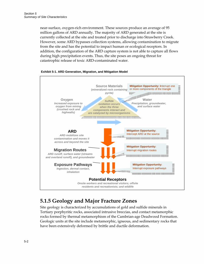
5.1.4 Acid Generation, Migration, and Mitigation Model ARD is the acidic, metal-laden water often found at abandoned gold mines. ARD is generated by the weathering of strongly mineralized rock, creating acidic water. Metals (e.g., cadmium, copper, and zinc) and metalloids (e.g., arsenic and selenium) associated with gold bearing ore are then mobilized by the acidic water. That metal-laden water then migrates into surface water and groundwater (Exhibit 5-1). ARD may often have concentrations of toxic metals that exceed acceptable standards by several orders of magnitude.
At the site, mining removed mineralized rock from deep in the oxygen-limited earth, increased its surface area through crushing and other processes, and placed it in a
Section 5 Summary of Site Characteristics
5-2
near-surface, oxygen-rich environment. These sources produce an average of 95 million gallons of ARD annually. The majority of ARD generated at the site is currently collected at the site and treated prior to discharge into Strawberry Creek. However, some ARD bypasses collection systems, allowing contamination to migrate from the site and has the potential to impact human or ecological receptors. In addition, the configuration of the ARD capture system is not able to capture all flows during high precipitation events. Thus, the site poses an ongoing threat for catastrophic release of toxic ARD-contaminated water.
5.1.5 Geology and Major Fracture Zones Site geology is characterized by accumulations of gold and sulfide minerals in Tertiary porphyritic rocks, associated intrusive breccias, and contact metamorphic rocks formed by thermal metamorphism of the Cambrian-age Deadwood Formation. Geologic units at the site include metamorphic, igneous, and sedimentary rocks that have been extensively deformed by brittle and ductile deformation.
Exhibit 5-1. ARD Generation, Migration, and Mitigation Model
Water Precipitation, groundwater,
and surface water
Source Materials(mineralized rock containing
pyrite)
Potential ReceptorsOnsite workers and recreational visitors; offsite
residents and recreationists; and wildlife
ARD ARD mobilizes site
contamination and moves it across and beyond the site
Sulfide oxidation occurs when the three
components interact and are catalyzed by microorganisms
Oxygen Increased exposure to oxygen from mining (crushed rock and
highwalls)
Migration Routes ARD runoff, surface water (streams
and overland runoff), and groundwater
Exposure Pathways Ingestion, dermal contact,
inhalation
Mitigation Opportunity: Interrupt one or more components of the triangle
Mitigation Opportunity: Intercept ARD at the source
Mitigation Opportunity: Interrupt migration routes
Mitigation Opportunity: Interrupt exposure pathways
Section 5 Summary of Site Characteristics
5-3
Structural geology is a major influence on groundwater movement. The site is located in an area where local and regional tectonic displacements occurred, and five major fractures zones have been identified with potential to contribute to off-site migration of contaminants in groundwater. These zones are approximately planar trends of numerous closely spaced and interconnected fractures. Major fracture zones cross-cut hydrogeologic units in the vicinity of Dakota Maid and Sunday Pit. These fracture zones provide potential conduits for groundwater flow. The zones are well developed in the relatively brittle intrusive units exposed in the pits.
In addition, manmade features on site (i.e., the underground mine workings and the hundreds of abandoned core and drill holes) also provide potential conduits for groundwater flow and ARD migration. Underground workings typically had no preventative measures taken against transmission of water from one area to another. Additionally, drill and core holes were often abandoned by backfilling with permeable cuttings. Surface plugs were sometimes used to slow infiltration of water from ground surface into the hole. However, surface plugs do not affect infiltration from fractures or transmissive zones penetrated by the hole.
5.2 Site Conceptual Model The SCM is shown in Figure 5-1. It incorporates the primary mechanisms that lead to release of contaminants from source materials, migration routes of contaminants in the environment, and exposure pathways and human/ecological receptors. A brief discussion of each element is provided below.
5.2.1 Affected Media As shown in the SCM, affected media at the site are: soil, surface water, sediment, groundwater and fish.
Soil. Soil has been (and continue to be) impacted by the migration of contaminants via airborne transport of contaminated dust, runoff of contaminated surface water, or mechanical transportation of source materials (e.g., waste rock).
Surface water and sediments. Surface water (Section 5.4) and sediment have been impacted by historic discharges of ARD, tailings, and sludge to onsite creeks, gulches, and ephemeral streams. Although most of these discharges have ceased, some discharge remains in the forms of runoff of contaminated stormwater. Strawberry Creek has been heavily impacted, although water quality and habitat are improving with operation of the WTP.
Groundwater. Groundwater is contaminated in the primary mine disturbance area and the contamination has the potential to extend eastward toward neighboring communities and aquifers (see Section 5.5).

Section 5 Summary of Site Characteristics
5-4
5.2.2 Source Materials Source materials are primarily sources of contaminants that pose a direct exposure risk and/or have the potential to produce ARD. They are:
Waste rock fill materials. Waste rock fill materials were created during construction, mine operation, and the initial phases of mine reclamation. The fills have been delineated into two groups based on ARD generating capacity (general fills and reclamation fills).
Exposed rock surfaces. Exposed rock surfaces have a high potential to generate ARD. Pit highwalls encompass large areas of exposed rock that include highwalls, safety benches, and unconsolidated rock that has spalled and built up on safety benches.
HLP spent ore. The HLP contains a large volume of acid-generating spent ore. This rock was processed to remove gold and is still in place on the liner system. The system reduces the potential for this rock to impact groundwater. ARD that is generated by the HLP is collected in a sump and pumped into the site water treatment circuit.
Amended tailings. Amended tailings are acid generating tailings that were mitigated by amendment with alkaline fly ash, placement in repositories, capping with a low permeability clay cover, and revegetation.
Sludge. Sludge is stored under varying conditions around the site. It is a source of contamination because it contains the toxic metals and metalloids that were removed from ARD during water treatment.
Underground mine workings. The lower level King workings (under the Dakota Maid Pit) and the Rattlesnake workings (under Sunday Pit) are flooded with ARD on a continuous basis. The upper level King workings, which are at various points connected to the lower level King workings and the pit lake, generate acid and convey ARD towards two outfalls that currently discharge ARD (the Wood Weir and the King Adit). Discharge flow rates of ARD from the King adit and the Wood Weir correlate to water levels at the Dakota Maid and Sunday pits. Both the Wood Weir and the King Adit discharge ARD into Pond E, which is pumped to the WTP for treatment before being released into Strawberry Creek. In addition, the Langely adit discharges ARD conveyed through the Langley mine workings into Pond E on an intermittent basis.
5.2.3 Migration Routes Three migration routes were evaluated:
Section 5 Summary of Site Characteristics
5-5
ARD runoff. ARD runoff occurs when precipitation interacts with ARD source materials and generates acidic metal laden water. ARD migrates from the site through the ground and over the surface.
Surface water migration. Surface water migration occurs when ARD reaches area streams as site runoff or through seeps and springs. Surface water is a migration route into sensitive karst aquifers downstream of the site, which serve as drinking water sources for residential and municipal wells.
Groundwater migration. Groundwater migration occurs when ARD-impacted groundwater travels through site aquifers.
5.2.4 Exposure Pathways Exposure pathways describe the processes by which a potential receptor could contact contaminated media. The exposure pathways are:
Ingestion of contaminated surface water, groundwater, soil, sediments, and fish
Inhalation of contaminated surface or subsurface soil
Dermal contact with contaminated surface water, groundwater, soil, and sediments
5.2.5 Populations That Are or Could Be Affected Receptors define groups of humans (or other organisms) that could be impacted by site contaminants via one of the exposure pathways. One to three exposure pathways were evaluated for each receptor.
The SCM includes eight potential receptors:
Offsite recreational fisherman
Offsite residents
Onsite residents
Onsite construction workers
Onsite commercial workers
Onsite all-terrain vehicle (ATV) riders
Onsite hikers
Wildlife
Section 5 Summary of Site Characteristics
5-6
Although exposure pathways were evaluated for onsite residents and ATV riders, those receptors were eliminated from the final land use at the site (Section 6) based on factors that included site characteristics and protection of the Selected Remedy.
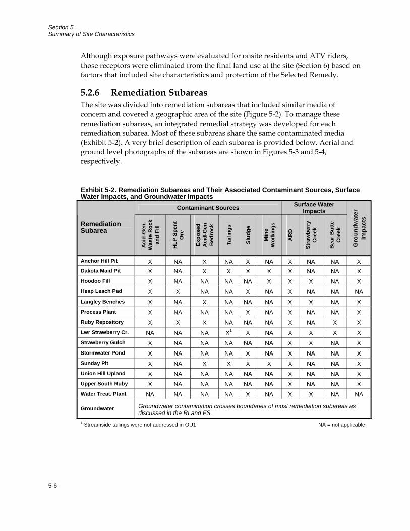
5.2.6 Remediation Subareas The site was divided into remediation subareas that included similar media of concern and covered a geographic area of the site (Figure 5-2). To manage these remediation subareas, an integrated remedial strategy was developed for each remediation subarea. Most of these subareas share the same contaminated media (Exhibit 5-2). A very brief description of each subarea is provided below. Aerial and ground level photographs of the subareas are shown in Figures 5-3 and 5-4, respectively.
Exhibit 5-2. Remediation Subareas and Their Associated Contaminant Sources, Surface Water Impacts, and Groundwater Impacts
Contaminant Sources Surface Water Impacts
Remediation Subarea
Aci
d-G
en.
Was
te R
ock
and
Fill
HLP
Spe
nt
Ore
Expo
sed
Aci
d-G
en
Bed
rock
Taili
ngs
Slud
ge
Min
e W
orki
ngs
AR
D
Stra
wbe
rry
Cre
ek
Bea
r But
te
Cre
ek
Gro
undw
ater
Im
pact
s
Anchor Hill Pit X NA X NA X NA X NA NA X Dakota Maid Pit X NA X X X X X NA NA X Hoodoo Fill X NA NA NA NA X X X NA X Heap Leach Pad X X NA NA X NA X NA NA NA Langley Benches X NA X NA NA NA X X NA X Process Plant X NA NA NA X NA X NA NA X Ruby Repository X X X NA NA NA X NA X X Lwr Strawberry Cr. NA NA NA X1 X NA X X X X Strawberry Gulch X NA NA NA NA NA X X NA X Stormwater Pond X NA NA NA X NA X NA NA X Sunday Pit X NA X X X X X NA NA X Union Hill Upland X NA NA NA NA NA X NA NA X Upper South Ruby X NA NA NA NA NA X NA NA X Water Treat. Plant NA NA NA NA X NA X X NA NA
Groundwater Groundwater contamination crosses boundaries of most remediation subareas as discussed in the RI and FS.
1 Streamside tailings were not addressed in OU1 NA = not applicable
Section 5 Summary of Site Characteristics
5-7
Anchor Hill Pit Remediation Subarea. This subarea contains a long and narrow (1,200 by 600 feet) pit, with a highwall on the northwest side that rises 300 feet above the pit floor.
Dakota Maid Pit Remediation Subarea. This subarea contains underground workings, exposed bedrock, deeply penetrating fracture zones, backfilled reclamation fills, unconsolidated fill and acid-contaminated colluvium, water treatment sludge, and contaminated sediments. There is also ARD in the pit and underground mine workings, which are connected by fractures to the Strawberry Creek alluvium and regional groundwater.
Hoodoo Fill Remediation Subarea. This subarea contains an 80-foot tall acid-generating fill embankment that was used to establish a haul road. There are also potentially buried underground mine workings.
HLP Remediation Subarea. This subarea contains the HLP and 2.2 million cubic yards of spent ore, stockpiles of construction material, sludge storage, and a multi-layer liner system (designed to collect and convey gold processing solutions and now used to collect ARD). The northeastern portion of the extension is used to store sludge generated at the WTP.
Langley Benches Remediation Subarea. This subarea contains benched areas south and east of Langley Peak, two open pits (North Langley and Southeast Langley), and fills used to construct access roads.
Process Plant Remediation Subarea. This subarea contains the Process Plant building, assay lab, pump house, outdoor storage areas, and several lined ponds. ARD seepage from this area flows to the Strawberry Gulch Remediation Subarea where it is captured for treatment.
Ruby Repository Remediation Subarea. This subarea contains 75 acres of the waste rock dump, with an internal cutoff wall and an outfall pipe that collects and conveys ARD seepage to a subsurface collection gallery for temporary storage prior to transfer to the Sunday Pit.
Lower Strawberry Creek Remediation Subarea. This subarea includes the lower section of Strawberry Creek from the WTP discharge outlet to the confluence with Boomer Gulch. It has been impacted by tailings and by WTP sludge that was deposited along the streambed and has become embedded in the substrate.
Strawberry Gulch Remediation Subarea. This subarea is the portion of the pre-mining drainage south of the Process Plant and Stormwater Pond remediation subareas west of the Dakota Maid Pit. It includes the main roadway along the former stream corridor of Upper Strawberry Creek, a series of water diversion channels and culverts, and ARD-conveyance culverts with flow regulation ponds.
Section 5 Summary of Site Characteristics
5-8
The ponds function as ARD capture and conveyance locations for site-wide water treatment.
Stormwater Pond Remediation Subarea. This subarea contains the lined Stormwater Pond, road and embankment fills, a road-cut excavation, topsoil stockpiles, and a piped diversion that captures and conveys unimpacted surface water runoff.
Sunday Pit Remediation Subarea. This subarea includes the Sunday Pit, underground mine workings, a tailings repository, exposed bedrock, reclaimed areas of backfilled amended tailings, and underground mine workings.
Union Hill Upland Remediation Subarea. This subarea includes remnants of Union Hill and the adjacent upland surfaces, as well as a fueling station used as the contractor staging area.
Upper South Ruby Remediation Subarea. This subarea includes the portion of the Ruby Gulch Waste Rock Dump that was not covered during construction of Ruby Repository.
WTP Remediation Subarea. This subarea includes a site-wide ARD collection, conveyance, and treatment system designed to collect and transfer site waters between impoundments (pits and ponds) and the WTP and to capture ARD for treatment in Strawberry and Hoodoo gulches.
Groundwater Remediation Subarea. This subarea was developed to organize potential remedial actions that address groundwater into one area in the FS. This strategy was adopted because groundwater contamination crosses boundaries of the previously defined remediation subareas and extends out of the primary mine disturbance area encompassed by the remediation subareas. Additional definition of the subarea will be developed based on considerations of groundwater characteristics, nature and extent of contamination, fate and transport, and risks.
5.3 Sources of Contamination During the RI, the materials in each of the remediation subarea were sampled to determine contaminant concentrations and acid generating potential.
5.3.1 Contaminant Concentrations Materials from each of the remediation subareas were sampled to determine the concentrations of metals and metalloids. These data were used during the risk assessment to evaluate the risks of exposure to these contaminates to human health and the environment.
Section 5 Summary of Site Characteristics
5-9
5.3.2 Acid Generation Potential ARD is generated by numerous source materials, including waste rock fill materials, HLP spent ore, exposed rock surfaces, tailings, sludge, and underground mine workings. Acid generation usually starts slowly and increases as pH decreases. This is a result of an increase in the rate of bacteriological catalysis of iron and sulfur oxidation and the presence of ferrous iron in solution at low pH. When rock containing unoxidized pyrite is mined, it may display a neutral paste pH, but, as the rock oxidizes and the products of sulfide oxidation build up, it becomes increasingly more acidic.
The materials within each source area were evaluated on the basis of their maturation. Those with higher concentrations of sulfide oxidation products and lower paste pH are deemed more mature than those with low concentrations of sulfide oxidation products and less acidic paste pH. Strongly acidic materials are known to be acid generating and a source of ARD. Rocks that display a less acidic pH were evaluated for their future acid potential using acid base accounting methodology. The RI found that all mine waste located within the mine site boundaries were either ARD generating or had the potential to generate ARD.
5.4 Surface Water The site is in mountainous terrain and drains toward Bear Butte Creek, a tributary of the Belle Fourche River that flows generally eastward toward the edge of the Black Hills. The site is in the headwaters of three tributaries draining into Bear Butte Creek (Strawberry Creek, Terrible Gulch, and Ruby Gulch). Strawberry Creek is a perennial stream, and Terrible Gulch and Ruby Gulch are intermittent streams. Tributary drainages contribute flow to Strawberry Creek, including Hoodoo Gulch, Boomer Gulch, Cabin Creek, and several ephemeral drainages. Surface water bodies on and near the site are shown on Figure 5-5 and described below:
Bear Butte Creek. The designated uses of this creek are coldwater permanent fish life propagation waters, limited contact recreation waters, fish and wildlife propagation waters, and irrigation waters. It is listed as impaired due to temperature. Flow is highest in April, May, and June (average flows of 18.8, 23.3, and 15.1 cubic feet per second [cfs], respectively). Lowest flows are from September to February (1.4 to 1.6 cfs). Three stream loss zones (4 cfs each) are downstream of the confluence with site tributaries. Generally, all of the flow in Bear Butte Creek enters one of the three loss zones. Water that enters the loss zones reports to the Madison and Minnelusa aquifers, important regional aquifers used for residential and municipal water supplies downgradient from the stream loss zones.
Strawberry Creek. This creek is located on the site’s south side. It flows 2.5 miles from the major disturbance area to the confluence of Bear Butte Creek. Designated uses vary depending upon location. Downstream of the Gilt Edge Mine office, uses
Section 5 Summary of Site Characteristics
5-10
are coldwater marginal fish life propagation; limited-contact recreation; fish and wildlife propagation, recreation, and stock watering; and irrigation. Upstream of the office, uses are fish and wildlife propagation, recreation, and stock watering and irrigation. It is listed as impaired due to metals, TDS, specific conductivity, and pH. It has been heavily impacted by mining activities. Water quality and habitat are improving with the operation of the WTP. Highest flows occur during April, May, and June (506 gpm, 801 gpm, and 273 gpm, respectively). Lowest flows are in September through February (66 to 90 gpm).
Hoodoo and Ruby Gulches. These intermittent streams flow only at certain times of the year in response to discharge from springs or short-term runoff events. The upper portions of both watersheds are contained in the site ARD collection, conveyance, and treatment system. This reduces flow in downstream portions of the streams. Flows in Hoodoo Gulch (50 feet upstream from the confluence of Hoodoo Gulch with Strawberry Creek) and in Ruby Gulch (500 feet below the Ruby Repository toe) are on the order of several gpm.
Ephemeral Drainages. Pond C Tributary and the Process Area and Anchor Hill Tributaries are upgradient of the site. Water in these drainages flows only in response to large precipitation events or rapid snow melt. The drainages are above the water table. Surface water diversions are used to capture most (but not all) unimpacted surface water from upgradient drainages and convey it directly to Strawberry Creek.
5.5 Groundwater Groundwater is contaminated in the primary mine disturbance area and ARD may be impacting groundwater in a broad area extending eastward toward Sturgis and encompassing regional aquifers (Madison and Minnelusa). These aquifers are used as private and municipal water sources. Site aquifers include bedrock and alluvial aquifers.
Bedrock aquifers are deep and occur in the four bedrock units (Layered Sedimentary and Igneous rocks, Deformation Zone Rocks, Igneous Crystalline Stocks, and Precambrian Rocks). Each unit has widely varying aquifer transmissivities. The potentiometric surface for the bedrock hydrogeologic units has been interpreted based on water level measurements (2000 to 2007). Maps show that groundwater generally flows southeast from the topographically higher portion of the site in the area of Anchor Hill toward Bear Butte Creek at a velocity of 50 to 100 feet per year.
Alluvial aquifers occur in unconsolidated Quaternary sediments located in the base of valleys, such as Strawberry Creek, Hoodoo Gulch, and Ruby Gulch. The alluvial aquifers are unconfined aquifers. The Strawberry and Hoodoo alluvial aquifers contribute to contaminant migration at the site. The alluvial aquifers are often perched above the deeper aquifers, with a zone of unsaturated rock between. These perched
Section 5 Summary of Site Characteristics
5-11
conditions are site specific, and the relationship between the alluvial and bedrock aquifers commonly changes in the downgradient direction.
Groundwater-surface water interactions are extensive and include natural interactions (e.g., groundwater discharges that support perennial flow in Strawberry Creek) and anthropogenic interactions created by various mine development and reclamation activities. The interactions provide important pathways for contaminant transport and are described in detail in the RI and FS reports.

Section 5 Summary of Site Characteristics
5-12
This page intentionally left blank
6-1
Section 6 Current and Potential Future Land and Resource Uses
6.1 Land Use Site land is mostly private, with some federally managed land and isolated parcels of state-owned land. Nearby private land is mostly residential, and nearby public land is used for recreation (hiking, hunting, and all-terrain vehicle operation) and industry (logging and forest management activities).
6.1.1 Current Onsite Uses Onsite uses are currently restricted to EPA-controlled Superfund activities related to the maintenance and remediation of the site.
6.1.2 Current Adjacent or Surrounding Land Uses The site is located in a rural area of Lawrence County about 6 miles south of the towns of Lead and Deadwood, South Dakota. Private land use near the site is primarily residential, with a few small ranches and businesses in the area. The town of Galena is located at the eastern site boundary, along Bear Butte Creek, and is home to several dozen families. Additional residences are dispersed to the south, west, and north (Figure 6-1).
Private lands are subject to zoning restrictions imposed by the county, and the site and the surrounding area are presently zoned as a Park Forest District. Authorized land uses within the Park Forest District include detached single-family dwellings, cabins, and summer homes; transportation and utility easements, alleys, and right-of-way; public parks and/or playgrounds; historical monuments or structures; utilities substations; plant nursery; tree or crop growing areas and grazing lands; and other uses approved under county conditional use permits.
The county includes large areas of public land managed by the USFS and the U.S. Bureau of Land Management (BLM). Public land use includes recreational (e.g., hiking, hunting, and all-terrain vehicle operation) and industrial (e.g., logging, hazardous fuel management, and other forest management activities). Most public land is open to future mineral development under the General Mining Law, including claim staking, mineral exploration, and potential mine development.
6.1.3 Reasonable Anticipated Future Land Uses Within the disturbed area of the site, EPA anticipates land use will be limited to those compatible with the remedy and long-term water treatment operations. If there were no remedy to consider, future recreational activities at the site might include snowmobiling, cross-country skiing, ATV use, hiking, hunting, and fishing (within

Section 6 Current and Potential Future Land and Resource Uses
6-2
the Strawberry Creek drainage). However, in evaluating potential future recreational activities at the site, the final condition of the remediated area must be considered. One of the primary methods to mitigate ARD is to limit infiltration of water into the source materials. Soil covers are an effective means for limiting water infiltration. Snowmobiling and ATV use could compromise soil covers. EPA has determined that engineered and institutional controls will be implemented to limit active recreational activities.
Based on current zoning of the site, plausible future uses also include low-density residential use. However, groundwater beneath the site is not suitable as a drinking water source without treatment. Further, steep features and capped areas at the site are not conducive to residential development. EPA has determined that it is not practical to remediate the site to meet residential use criteria because of these site conditions.
6.2 Groundwater and Surface Water Use OU1 does not address groundwater or surface water contamination issues at the site. These issues will be addressed in a future ROD for OU2. Information on groundwater and surface water use is provided below to give a complete picture of site land use.
6.2.1 Current Groundwater Use In the disturbed area of the site, groundwater is pumped from the Oro Fino mine shaft in the southern portion of the site for use as make-up water in the water treatment plant and for other general non-potable purposes. The estimated consumption of this groundwater is 14 to 20 gpm. There are no potential groundwater receptors within this area, as this water is not used for drinking water by site operations and maintenance personnel because of poor water quality. Bottled water is currently used on the site for drinking water.
Because of the scope of the OU1 RI/FS, no specific investigations have been conducted to evaluate current groundwater use within or near the site boundary. The location of residential structures on or near the site was identified and plotted on an aerial photo along with the site boundary on Figure 6-1. It is likely these residences use groundwater for drinking water or for irrigation. None of these residences are located near site related groundwater contamination.
6.2.2 Current Surface Water Use Current surface water uses may include any of the uses designated by South Dakota Water Quality Standards. Strawberry Creek’s designated uses are coldwater marginal fish life propagation, limited contact recreation, fish and wildlife propagation, recreation, stock watering, and irrigation. Bear Butte Creek’s designated uses are coldwater permanent fish life propagation, limited contact recreation, fish and wildlife propagation, and irrigation. Other surface waters are designated as fish and
Section 6 Current and Potential Future Land and Resource Uses
6-3
wildlife propagation waters and irrigation waters. The extent to which these waters are used for their designated purposes is unknown.
6.2.3 Potential Future Groundwater Use Future groundwater use within the site boundaries will likely be restricted based on the area that groundwater contamination is found. Institutional controls will be implemented to prevent the unacceptable uses of groundwater that pose human or ecological risks.
6.2.4 Potential Future Surface Water Use Future surface water use is expected to be similar to the current uses designated by South Dakota Surface Water Quality Regulations.

Section 6 Current and Potential Future Land and Resource Uses
6-4
This page intentionally left blank
7-1
Section 7 Summary of Site Risks
This section provides a brief summary of the relevant portions of the human health and ecological risk assessments that provide the basis for taking the remedial actions at OU1. The primary focus of this action is to address site risks associated with exposure with contaminated surface water, groundwater, and on-site soils.
7.1 Human Health Risk EPA completed a baseline human health risk assessment (BRA) in July 2006 to assess potential risks to humans (both present and future) from site related contaminants present in surface soil, surface water, sediment, and groundwater. The SCM presented in Figure 5-1 represents the various exposure pathways and potential receptors evaluated in the human health risk assessment for this site. The future use determined for the site will allow for low-intensity recreational visitors and site operation and maintenance workers. While risks to ATV riders and residential site users were also evaluated in the BRA, these uses are not viable future uses at the site since these uses could affect the integrity of caps constructed over mine wastes. Thus, the focus of this discussion will summarize risks associated with low-intensity recreational users and site operation and maintenance workers. In the human health risk assessment, the primary risks were found to be associated with contaminated on-site soils and groundwater.
7.1.1 Chemicals of Concern The chemicals of concern (COCs) identified in the human health risk assessment for groundwater and soils are presented in Exhibit 7-1. This table includes the COCs critical to this action, the range of concentrations and the frequency of detection for each COC, the exposure point concentrations, and the statistical measure for determining each COC. The data used in the risk assessment were collected during EPA’s RI. The data used in the BRA were validated, evaluated and determined to be usable in the RI.
7.1.2 Exposure Assessment The exposure assessment identified scenarios through which a receptor could contact COCs in site media and estimates the extent of exposure. The human health conceptual model (Figure 7-1) illustrates sources, potentially impacted media, exposure routes, and exposed populations at the site that were evaluated in the BRA. For this action, the primary media of human health concern are onsite soils and groundwater. This section summarizes the exposure assessment for these media.
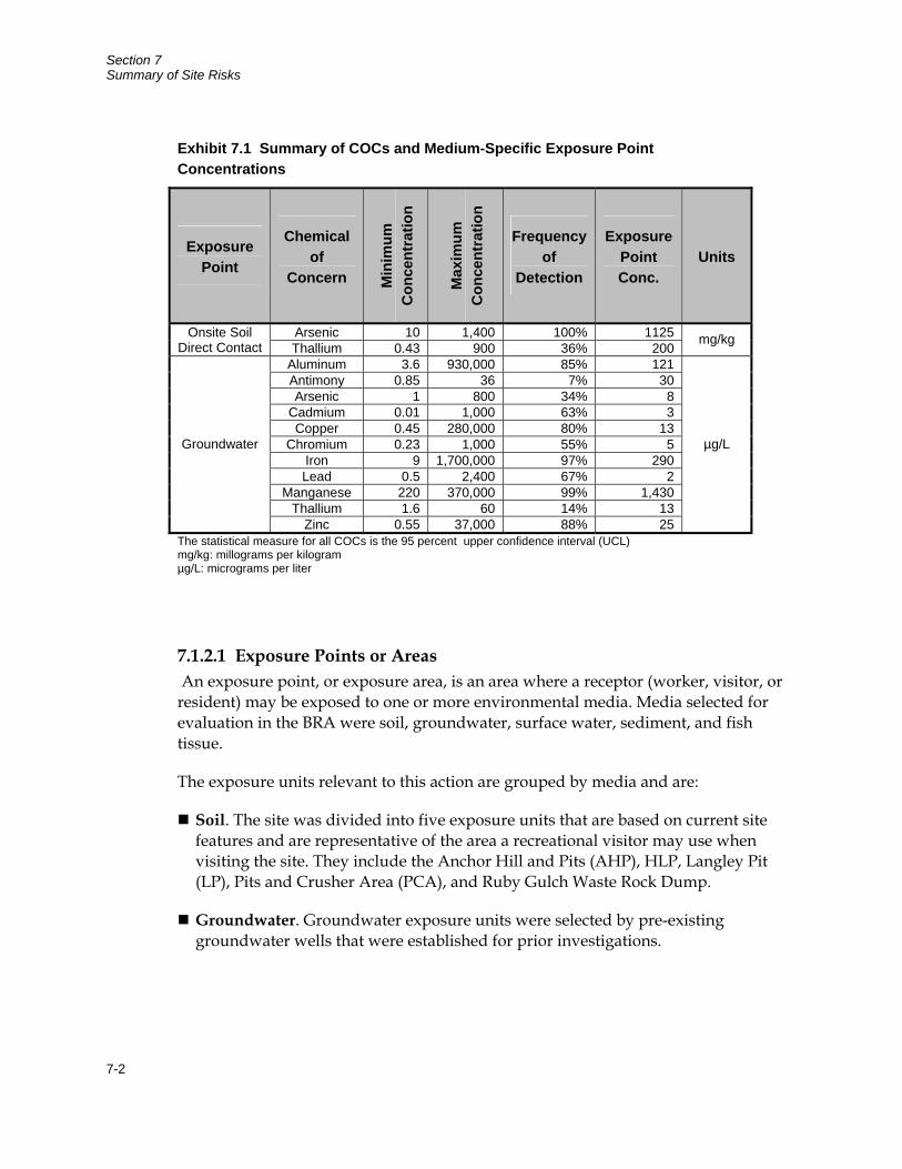
Section 7 Summary of Site Risks
7-2
7.1.2.1 Exposure Points or Areas An exposure point, or exposure area, is an area where a receptor (worker, visitor, or resident) may be exposed to one or more environmental media. Media selected for evaluation in the BRA were soil, groundwater, surface water, sediment, and fish tissue.
The exposure units relevant to this action are grouped by media and are:
Soil. The site was divided into five exposure units that are based on current site features and are representative of the area a recreational visitor may use when visiting the site. They include the Anchor Hill and Pits (AHP), HLP, Langley Pit (LP), Pits and Crusher Area (PCA), and Ruby Gulch Waste Rock Dump.
Groundwater. Groundwater exposure units were selected by pre-existing groundwater wells that were established for prior investigations.
Exhibit 7.1 Summary of COCs and Medium-Specific Exposure Point Concentrations
Exposure Point
Chemical of
Concern Min
imum
C
once
ntra
tion
Max
imum
C
once
ntra
tion
Frequency of
Detection
Exposure Point Conc.
Units
Arsenic 10 1,400 100% 1125 Onsite Soil Direct Contact Thallium 0.43 900 36% 200
mg/kg
Aluminum 3.6 930,000 85% 121 Antimony 0.85 36 7% 30 Arsenic 1 800 34% 8
Cadmium 0.01 1,000 63% 3 Copper 0.45 280,000 80% 13
Chromium 0.23 1,000 55% 5 Iron 9 1,700,000 97% 290 Lead 0.5 2,400 67% 2
Manganese 220 370,000 99% 1,430 Thallium 1.6 60 14% 13
Groundwater
Zinc 0.55 37,000 88% 25
µg/L
The statistical measure for all COCs is the 95 percent upper confidence interval (UCL) mg/kg: millograms per kilogram µg/L: micrograms per liter
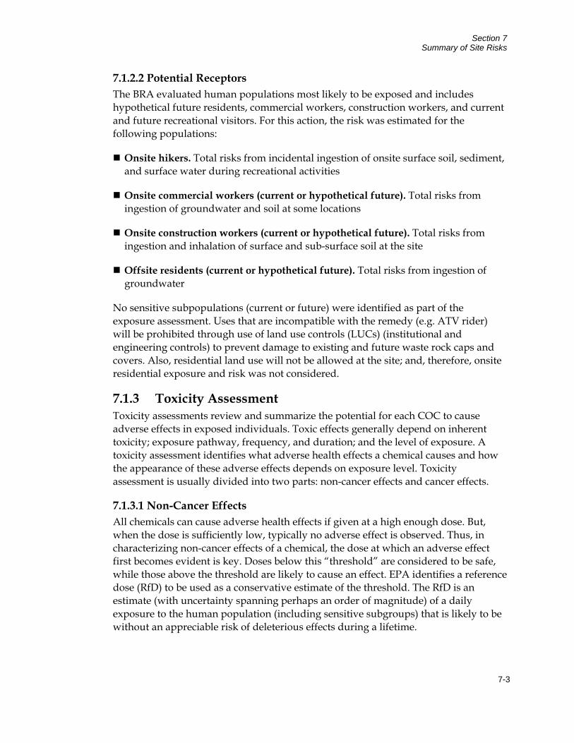
Section 7 Summary of Site Risks
7-3
7.1.2.2 Potential Receptors The BRA evaluated human populations most likely to be exposed and includes hypothetical future residents, commercial workers, construction workers, and current and future recreational visitors. For this action, the risk was estimated for the following populations:
Onsite hikers. Total risks from incidental ingestion of onsite surface soil, sediment, and surface water during recreational activities
Onsite commercial workers (current or hypothetical future). Total risks from ingestion of groundwater and soil at some locations
Onsite construction workers (current or hypothetical future). Total risks from ingestion and inhalation of surface and sub-surface soil at the site
Offsite residents (current or hypothetical future). Total risks from ingestion of groundwater
No sensitive subpopulations (current or future) were identified as part of the exposure assessment. Uses that are incompatible with the remedy (e.g. ATV rider) will be prohibited through use of land use controls (LUCs) (institutional and engineering controls) to prevent damage to existing and future waste rock caps and covers. Also, residential land use will not be allowed at the site; and, therefore, onsite residential exposure and risk was not considered.
7.1.3 Toxicity Assessment Toxicity assessments review and summarize the potential for each COC to cause adverse effects in exposed individuals. Toxic effects generally depend on inherent toxicity; exposure pathway, frequency, and duration; and the level of exposure. A toxicity assessment identifies what adverse health effects a chemical causes and how the appearance of these adverse effects depends on exposure level. Toxicity assessment is usually divided into two parts: non-cancer effects and cancer effects.
7.1.3.1 Non-Cancer Effects All chemicals can cause adverse health effects if given at a high enough dose. But, when the dose is sufficiently low, typically no adverse effect is observed. Thus, in characterizing non-cancer effects of a chemical, the dose at which an adverse effect first becomes evident is key. Doses below this “threshold” are considered to be safe, while those above the threshold are likely to cause an effect. EPA identifies a reference dose (RfD) to be used as a conservative estimate of the threshold. The RfD is an estimate (with uncertainty spanning perhaps an order of magnitude) of a daily exposure to the human population (including sensitive subgroups) that is likely to be without an appreciable risk of deleterious effects during a lifetime.
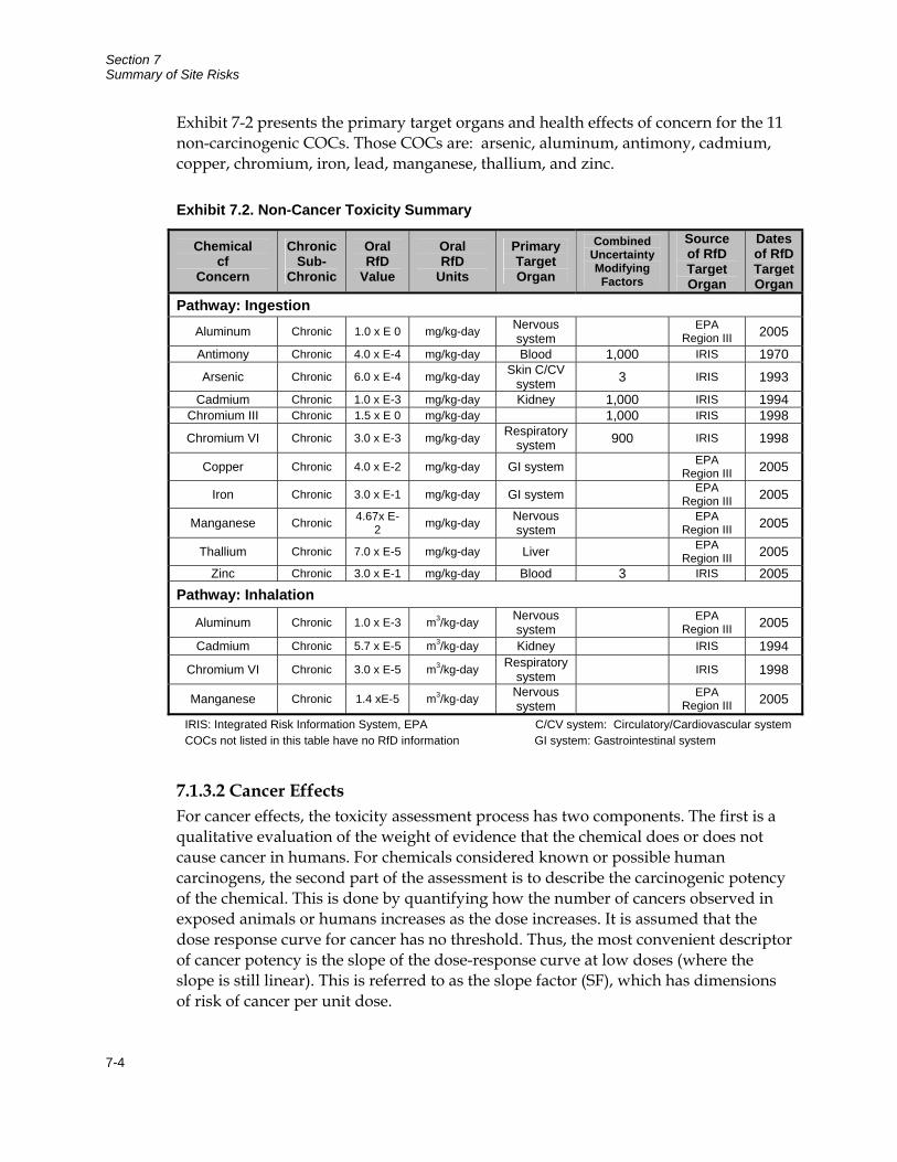
Section 7 Summary of Site Risks
7-4
Exhibit 7-2 presents the primary target organs and health effects of concern for the 11 non-carcinogenic COCs. Those COCs are: arsenic, aluminum, antimony, cadmium, copper, chromium, iron, lead, manganese, thallium, and zinc.
Exhibit 7.2. Non-Cancer Toxicity Summary
Chemical cf
Concern
Chronic Sub-
Chronic
Oral RfD
Value
Oral RfD
Units
Primary Target Organ
Combined Uncertainty Modifying
Factors
Source of RfD Target Organ
Dates of RfD Target Organ
Pathway: Ingestion Aluminum Chronic 1.0 x E 0 mg/kg-day Nervous
system EPA Region III 2005
Antimony Chronic 4.0 x E-4 mg/kg-day Blood 1,000 IRIS 1970
Arsenic Chronic 6.0 x E-4 mg/kg-day Skin C/CV system 3 IRIS 1993
Cadmium Chronic 1.0 x E-3 mg/kg-day Kidney 1,000 IRIS 1994 Chromium III Chronic 1.5 x E 0 mg/kg-day 1,000 IRIS 1998
Chromium VI Chronic 3.0 x E-3 mg/kg-day Respiratory system 900 IRIS 1998
Copper Chronic 4.0 x E-2 mg/kg-day GI system EPA Region III 2005
Iron Chronic 3.0 x E-1 mg/kg-day GI system EPA Region III 2005
Manganese Chronic 4.67x E-2 mg/kg-day Nervous
system EPA Region III 2005
Thallium Chronic 7.0 x E-5 mg/kg-day Liver EPA Region III 2005
Zinc Chronic 3.0 x E-1 mg/kg-day Blood 3 IRIS 2005 Pathway: Inhalation
Aluminum Chronic 1.0 x E-3 m3/kg-day Nervous system EPA
Region III 2005
Cadmium Chronic 5.7 x E-5 m3/kg-day Kidney IRIS 1994
Chromium VI Chronic 3.0 x E-5 m3/kg-day Respiratory system IRIS 1998
Manganese Chronic 1.4 xE-5 m3/kg-day Nervous system EPA
Region III 2005
IRIS: Integrated Risk Information System, EPA C/CV system: Circulatory/Cardiovascular system COCs not listed in this table have no RfD information GI system: Gastrointestinal system
7.1.3.2 Cancer Effects For cancer effects, the toxicity assessment process has two components. The first is a qualitative evaluation of the weight of evidence that the chemical does or does not cause cancer in humans. For chemicals considered known or possible human carcinogens, the second part of the assessment is to describe the carcinogenic potency of the chemical. This is done by quantifying how the number of cancers observed in exposed animals or humans increases as the dose increases. It is assumed that the dose response curve for cancer has no threshold. Thus, the most convenient descriptor of cancer potency is the slope of the dose-response curve at low doses (where the slope is still linear). This is referred to as the slope factor (SF), which has dimensions of risk of cancer per unit dose.
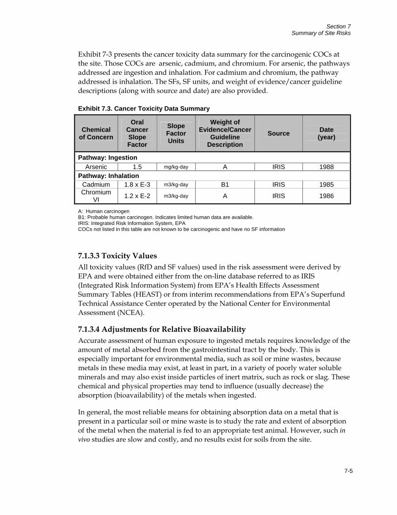
Section 7 Summary of Site Risks
7-5
Exhibit 7-3 presents the cancer toxicity data summary for the carcinogenic COCs at the site. Those COCs are arsenic, cadmium, and chromium. For arsenic, the pathways addressed are ingestion and inhalation. For cadmium and chromium, the pathway addressed is inhalation. The SFs, SF units, and weight of evidence/cancer guideline descriptions (along with source and date) are also provided.
Exhibit 7.3. Cancer Toxicity Data Summary
Chemical of Concern
Oral Cancer Slope Factor
Slope Factor Units
Weight of Evidence/Cancer
Guideline Description
Source Date (year)
Pathway: Ingestion Arsenic 1.5 mg/kg-day A IRIS 1988
Pathway: Inhalation Cadmium 1.8 x E-3 m3/kg-day B1 IRIS 1985 Chromium
VI 1.2 x E-2 m3/kg-day A IRIS 1986
A: Human carcinogen B1: Probable human carcinogen. Indicates limited human data are available. IRIS: Integrated Risk Information System, EPA COCs not listed in this table are not known to be carcinogenic and have no SF information
7.1.3.3 Toxicity Values All toxicity values (RfD and SF values) used in the risk assessment were derived by EPA and were obtained either from the on-line database referred to as IRIS (Integrated Risk Information System) from EPA’s Health Effects Assessment Summary Tables (HEAST) or from interim recommendations from EPA’s Superfund Technical Assistance Center operated by the National Center for Environmental Assessment (NCEA).
7.1.3.4 Adjustments for Relative Bioavailability Accurate assessment of human exposure to ingested metals requires knowledge of the amount of metal absorbed from the gastrointestinal tract by the body. This is especially important for environmental media, such as soil or mine wastes, because metals in these media may exist, at least in part, in a variety of poorly water soluble minerals and may also exist inside particles of inert matrix, such as rock or slag. These chemical and physical properties may tend to influence (usually decrease) the absorption (bioavailability) of the metals when ingested.
In general, the most reliable means for obtaining absorption data on a metal that is present in a particular soil or mine waste is to study the rate and extent of absorption of the metal when the material is fed to an appropriate test animal. However, such in vivo studies are slow and costly, and no results exist for soils from the site.
Section 7 Summary of Site Risks
7-6
Based on an analysis of relative bioavailability (RBA), which is the ratio of absorption from the study medium compared to absorption from site medium, in 26 test materials, an RBA of 0.5 was selected for use in the risk assessment and is considered a generally conservative default value for arsenic in soil. In the absence of site-specific data, the RBA for all chemicals in all media was assumed to be 1.0, with the exception of lead where EPA recommended a default RBA for lead in soil of 0.6.
7.1.4 Risk Characterization The BRA characterized risks to current and future human populations of concern, consisting of residents, commercial workers, construction workers, and recreational visitors. It was performed to estimate the likelihood and nature of the potential effects to human health that may occur as a result of exposure to the COCs at the site. Risks were separated into non-cancer and cancer risks.
The following provides information on:
EPA’s Approach for Calculating Risk
Onsite Risk Estimates
Offsite Risk Estimates
7.1.4.1 EPA’s Approach for Calculating Risk Non-Cancer Risk The potential for non-cancer effects is evaluated by dividing the estimated daily intake (DI) of the COC by the RfD for that chemical over similar exposure periods, as follows:
HQ = DI/RfD
where: HQ = Hazard quotient DI = Daily intake (milligrams per kilogram [mg/kg]-day) RfD = Reference dose (mg/kg-day)
If the HQ for a chemical is equal to or less than 1, it is believed that there is no appreciable risk that non-cancer health effects will occur. If an HQ exceeds 1, there is some possibility but not a certainty that non-cancer effects may occur. This is because of the margin of safety inherent in the derivation of all RfD values. The larger the HQ value, the more likely it is that an adverse effect may occur.
Section 7 Summary of Site Risks
7-7
If an individual is exposed to more than one chemical, a screening-level estimate of the total non-cancer risk is derived simply by summing the HQ values for that individual. This total is referred to as the hazard index (HI). If the HI value is less than 1, non-cancer risks are not expected from any chemical, alone or in combination with others. If the screening level HI exceeds 1, it may be appropriate to perform a follow-on evaluation in which HQ values are added only if they affect the same target tissue or organ system (e.g., the liver). This is because chemicals that do not cause toxicity in the same tissues are not likely to cause additive effects.
In the case of lead, risks are evaluated using a somewhat different approach. In brief, mathematical models are used to estimate the distribution of blood lead values in a population of people exposed to lead under a specified set of conditions. Health risks are judged to be acceptable if there is no more than a 5 percent chance that an exposed individual (a child or a woman of child-bearing age) will have a blood lead level that exceeds 10 micrograms per deciliter (μg/dL). For convenience, this probability is referred to as P10.
Cancer Risk The excess risk of cancer from exposure to a COC is described in terms of probability that an exposed individual will develop cancer because of that exposure by age 70. For each COC, this value is calculated from the DI of the chemical from the site, averaged over a lifetime (daily intake lifetime [DIL]), and the SF, as follows (EPA 1989):
Excess Cancer Risk = 1 - exp(-DIL • SF)
Excess cancer risks are summed across all chemicals of concern and all exposure pathways that contribute to exposure of an individual in a given population. The level of total cancer risk that is of concern is a matter of personal, community, and regulatory judgment. In general, EPA considers excess cancer risks that are below about 1 in 1,000,000 to be so small as to be negligible and risks above 1 in 10,000 to be sufficiently large that some sort of remediation is desirable. Excess cancer risks that range between 1 in 10,000 and 1 in 1,000,000 are generally considered to be acceptable although this is evaluated on a case by case basis.
7.1.4.2 Risk Estimates The risks are summarized below for individual receptor groups being addressed by this remedy.
Hikers. Risks from exposure to surface water, sediment, and surface soil are likely to be below a level of concern for most recreational visitors, but could be of potential concern to individuals with reasonable maximum exposure (RME) exposures, if exposure were to occur repeatedly in some locations. Non-cancer risks are driven by the incidental ingestion of metals in surface water and from the
Section 7 Summary of Site Risks
7-8
ingestion of thallium and arsenic in surface soils. Cancer risks are driven by arsenic in surface water with additional contributions from arsenic in sediment.
Commercial Workers. Arsenic, lead, and other metals in groundwater and thallium in surface soil are of concern to commercial workers. Non-cancer risks to a worker with both central tendency exposure (CTE) and RME exceed a level of concern at most locations. These risks are almost entirely due to ingestion of various metals in groundwater, with additional contributions from thallium in soil. Risks from lead exceed EPA’s health based goal (P10<5 percent) for a pregnant worker at three locations due to ingestion of lead in groundwater. Total cancer risks exceed 1E-04 at most locations for workers with RME to site media and at a few locations for an individual with CTE due to dissolved and total arsenic in groundwater.
Construction Workers. Thallium and arsenic in soil may pose a risk to onsite construction workers during future excavation or maintenance work at the site. Non-cancer risks are above a level of concern at all locations, while cancer risks are not of concern. Non-cancer risks are due almost entirely to ingestion of thallium, with additional contributions from arsenic at some areas. Risks from lead are below a level of concern at all locations.
Offsite Residents. Ingestion of groundwater from onsite wells located along creeks and channels that drain from the site is likely to pose unacceptable levels of non-cancer and cancer risk in most locations due to dissolved and suspended metals. Non-cancer risks are above a level of concern for many well locations (CTE and RME). This risk is due to numerous chemicals, including arsenic, cadmium copper, iron, manganese, antimony and thallium, with the relative contribution varying from well to well. Lead risks are not above a level of concern, with the exception of one well where the concentration of total lead exceeds EPA’s health based goal (P10 < 5 percent). Cancer risks exceed 1E-04 for RME receptors at a number of wells, with all values exceeding 1E-05. This risk is due to arsenic in groundwater.
7.1.5 Uncertainty Analysis Quantitative evaluation of the risks to humans from environmental contamination is frequently limited by uncertainty regarding a number of key data items, including concentration levels in the environment, the true level of human contact with contaminated media, and the true dose response curves for non cancer and cancer effects in humans. This uncertainty is usually addressed by making assumptions or estimates for uncertain parameters based on whatever limited data are available. Because of these assumptions and estimates, the results of risk calculations are themselves uncertain, and it is important for risk managers and the public to keep this in mind when interpreting the results of a risk assessment. The following sections review the main sources of uncertainty in the risk calculations performed at the site.
Section 7 Summary of Site Risks
7-9
7.1.5.1 Uncertainties Associated with Exposure Assessment. There are multiple sources of uncertainty in these exposure estimates. These include:
Uncertainties from exposure pathways not evaluated. Some pathways (e.g., dermal exposure to soil, sediment, surface water, inhalation of dust in air [wind erosion], and ingestion of terrestrial food items) were not evaluated because it is believed they pathways contribute only a small amount of risk compared to one or more other pathways that were evaluated.
Uncertainties from chemicals not evaluated. Some chemicals were not evaluated,, because they were not considered to be chemicals of potential concern (COPCs). These included chemicals that were not detected and chemicals (bismuth, gold, scandium, titanium, tungsten, yttrium, and zirconium) that have no toxicity factor.
Uncertainties in exposure point concentrations. Because the true mean cannot be calculated based on a limited set of measurements, EPA recommends that the exposure estimate be based on the 95% upper confidence limit (UCL) of the mean. When data are sparse or are highly variable, the exposure point concentration may be far greater than the mean of the available data and risk is overestimated.
Uncertainties in human exposure parameters. Accurate calculation of risk values requires accurate estimates of the level of human exposure. However, many exposure parameters are not known with certainty and must be estimated. For example, data on frequency and duration of exposures of current site visitors are unknown. In general, exposure parameters were chosen in a way that was intended to be conservative. Therefore, the values selected are thought to be more likely to overestimate than underestimate actual exposure and risk.
Uncertainties in Chemical Absorption (RBA). The risk from an ingested chemical depends on how much is absorbed from the gastrointestinal tract. This is important for metals in soil at mining sites, because some metals exist in poorly absorbable forms. Failure to account for this may result in a substantial overestimation of exposure and risk. The default approach is to assume that the RBA is 100 percent for most chemicals, with the exception of 50 percent for arsenic and 60 percent for lead in soil. This is more likely to overestimate than underestimate true exposures.
7.1.5.2 Uncertainties in Toxicity Values Toxicity information for many chemicals is often limited. Consequently, there are varying degrees of uncertainty associated with toxicity values (i.e., cancer slope factors, reference doses). For example, uncertainties can arise from extrapolation from animal studies to humans, extrapolation from high dose to low dose, and extrapolation from continuous exposure to intermittent exposure. In addition, in some cases, only a few studies are available to characterize the toxicity of a chemical, and
Section 7 Summary of Site Risks
7-10
uncertainties exist not only in the dose response curve, but also in the nature and severity of the adverse effects which the chemical may cause.
EPA typically deals with this uncertainty by applying an uncertainty factor of 10 to 100 to account for limitations in the database. Thus, in cases where available data do identify the most sensitive endpoint of toxicity, risk estimates will substantially overestimate true hazard. In general, uncertainty in toxicity factors is one of the largest sources of uncertainty in risk estimates at a site. Because of the conservative methods EPA uses in dealing with the uncertainties, it is much more likely that the uncertainty will result in an overestimation rather than an underestimation of risk.
7.1.5.3 Uncertainties in Risk Estimates A number of limitations are associated with the risk characterization approach for carcinogens and non-carcinogens. First, because risk estimates for a chemical are derived by combining uncertain estimates of exposure and toxicity (see above), the risk estimates for each chemical are more uncertain than either the exposure estimate or the toxicity estimate alone. However, even if the risk estimates for individual chemicals were quite certain, there is considerable uncertainty in how to combine risk estimates across different chemicals. In some cases, the effects caused by one chemical do not influence the effects caused by other chemicals. In other cases, the effects of one chemical may interact with effects of other chemicals, causing responses that are approximately additive, greater than additive (synergistic), or less than additive (antagonistic). In most cases, available toxicity data are not sufficient to define what type of interaction is expected, so EPA generally assumes effects are additive for non-carcinogens that act on the same target tissue and for carcinogens (all target tissues). Because documented cases of synergistic interactions between chemicals are relatively uncommon, this approach is likely to be conservative for most chemicals.
For non-carcinogens, summing HQ values across different chemicals is properly applied only to compounds that induce the same effect by the same mechanism of action. Consequently, summation of HQ values for compounds that are not expected to include the same type of effects or that do not act by the same mechanisms could overestimate the potential for effects. Thus, all of the HI values in this report, which sum HQ values across multiple metals, are likely to overestimate the true level of human health non-cancer hazard
7.1.6 Summary of Human Health Risk The site will be remediated to allow for low-intensity recreational and commercial/construction worker use, and exposure pathways are primarily limited to inhalation and/or ingestion of surface soil, surface water, and sediment. Total non-cancer and cancer risks to a CTE individual are below a level of concern at all locations, but exceed a level of concern to an RME individual at several locations.
Section 7 Summary of Site Risks
7-11
For recreational visitors (hikers), non-cancer risks are driven by incidental ingestion of metals in surface water, with additional contributions from ingestion of surface soil, or (in limited locations) by incidental ingestion of thallium and/or arsenic in surface soil. Cancer risks exceeding 1E-04 are driven by arsenic in surface water (and from sediment at some locations). Risks from lead are not of concern at any location. These results indicate that risks from exposure to surface water, sediment, and surface soil at the site are likely to be below a level of concern for most recreational visitors. However, they could be of potential concern to individuals with RME exposures if exposure were to occur repeatedly in some locations.
7.2 Ecological Risk The baseline ecological risk assessment (ERA) for the site assessed ecological risks through 2002. Major remedial actions at the site occurred after 2002, including construction of Ruby Repository, construction of a new WTP, construction of a new alluvial groundwater collection system at the toe of Ruby Repository, construction of a new ARD collection system in Hoodoo Gulch, and conveyance of ARD from Pond C into the site-wide ARD treatment circuit. Several of these remedial actions had beneficial effects on Strawberry Creek by improving the quality of treated water discharged into the creek, eliminating adverse effects caused by discharge of sludge into the creek, and eliminating the hard bucket treatment systems.
Results of the ERA do not reflect the beneficial effects of these remedial actions. As a result, EPA is in the process of evaluating the magnitude of ecological risks remaining at Strawberry Creek. An internal draft biological monitoring report was released in January 2007, which described results of ecological monitoring conducted in Strawberry Creek in 2004. EPA conducted additional ecological monitoring at Strawberry Creek in the Fall of 2007 and is currently evaluating the results.
The ERA considers potential impacts of exposures to site contaminants on ecological receptors other than humans. The evaluation considers impacts to fish, benthic aquatic organisms, vegetation, soil organisms, and terrestrial wildlife. Pathways evaluated in the ERA included direct contact with contaminants dissolved or suspended in surface water, direct contact with contaminants in sediments and soil, and exposure of fish by all pathways (based on evaluation of contaminant concentrations in fish tissue).
Several lines of evidence are used to evaluate ecological risks in the ERA. These lines of evidence include hazard quotients, site specific toxicity testing, and observation of populations and community structure. The hazard quotient method is similar to the approach used in evaluating human health risk for non-carcinogens where an estimated intake of a chemical for a given organism is compared to a reference dose that has been shown to have deleterious effects. Site specific toxicity testing consists of placing specific organisms into samples of surface water or sediment from the site and
Section 7 Summary of Site Risks
7-12
observing effects on the test organisms. Observations of population and community structures involve conducting surveys of population demographics for a group of organisms within an impacted stream reach and comparing the survey results with data collected from reference areas. This type of analysis is often completed for benthic organisms within stream reaches. A summary of the results of the ERA is presented in Table 7-1.
7.2.1 Exposure Assessment Available site data are divided into two conceptual categories: mine source area and riparian areas. Figure 7-2 presents the ecological site exposure model with sources, release mechanisms, secondary source mediums, exposure media, exposure routes, and ecological receptors. There are a number of complete exposure pathways by which ecological receptors may come into contact with site-related contamination.
Assessment endpoints are explicit statements of the characteristics of the ecological system that are to be protected. They are either measured directly or are evaluated indirectly. Measurement endpoints represent quantifiable ecological characteristics that can be measured, interpreted, and related to the valued ecological components chosen as the assessment endpoints. Exhibit 7-4 lists endpoints used to interpret potential ecological risks.
The lines of evidence used are: HQs, site-specific toxicity tests (SSTTs), and observations of population and community demographics. Each approach has advantages and limitations, and conclusions based on only one method of evaluation may be misleading. The best approach for deriving reliable conclusions is to combine the findings across all of the line-of-evidence methods for which data are available, taking the relative strengths and weaknesses of each method into account. If the methods all yield similar conclusions, confidence in the conclusion is greatly increased. If different methods yield different conclusions, then a careful review must be performed to identify the basis of the discrepancy and to decide which approach provides the most reliable information.
7.2.2 Risks to Aquatic Receptors Three exposure pathways were quantitatively evaluated using the various methods:
Direct contact with contaminants dissolved and/or suspended in surface water
Direct contact with contaminants in sediment
Exposure of fish by all pathways combined, based on tissue levels of contaminants in fish tissue
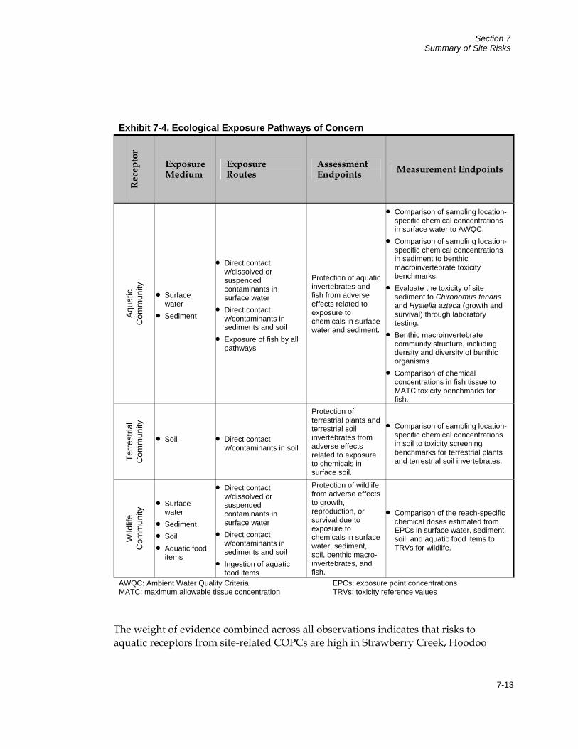
Section 7 Summary of Site Risks
7-13
Exhibit 7-4. Ecological Exposure Pathways of Concern R
ecep
tor
Exposure Medium
Exposure Routes
Assessment Endpoints Measurement Endpoints
Aqu
atic
C
omm
unity
• Surface water
• Sediment
• Direct contact w/dissolved or suspended contaminants in surface water
• Direct contact w/contaminants in sediments and soil
• Exposure of fish by all pathways
Protection of aquatic invertebrates and fish from adverse effects related to exposure to chemicals in surface water and sediment.
• Comparison of sampling location-specific chemical concentrations in surface water to AWQC.
• Comparison of sampling location-specific chemical concentrations in sediment to benthic macroinvertebrate toxicity benchmarks.
• Evaluate the toxicity of site sediment to Chironomus tenans and Hyalella azteca (growth and survival) through laboratory testing.
• Benthic macroinvertebrate community structure, including density and diversity of benthic organisms
• Comparison of chemical concentrations in fish tissue to MATC toxicity benchmarks for fish.
Terre
stria
l C
omm
unity
• Soil
• Direct contact w/contaminants in soil
Protection of terrestrial plants and terrestrial soil invertebrates from adverse effects related to exposure to chemicals in surface soil.
• Comparison of sampling location-specific chemical concentrations in soil to toxicity screening benchmarks for terrestrial plants and terrestrial soil invertebrates.
Wild
life
Com
mun
ity • Surface
water • Sediment • Soil • Aquatic food
items
• Direct contact w/dissolved or suspended contaminants in surface water
• Direct contact w/contaminants in sediments and soil
• Ingestion of aquatic food items
Protection of wildlife from adverse effects to growth, reproduction, or survival due to exposure to chemicals in surface water, sediment, soil, benthic macro-invertebrates, and fish.
• Comparison of the reach-specific chemical doses estimated from EPCs in surface water, sediment, soil, and aquatic food items to TRVs for wildlife.
AWQC: Ambient Water Quality Criteria EPCs: exposure point concentrations MATC: maximum allowable tissue concentration TRVs: toxicity reference values
The weight of evidence combined across all observations indicates that risks to aquatic receptors from site-related COPCs are high in Strawberry Creek, Hoodoo

Section 7 Summary of Site Risks
7-14
Gulch, and Ruby Gulch. Unacceptable risks do not extend downstream into Bear Butte Creek.
7.2.2.1 Direct Contact with Contaminants in Surface Water Potential risks to aquatic ecological receptors from direct contact in surface water were evaluated for Strawberry Creek, Hoodoo Gulch, Ruby Gulch, and Bear Butte Creek downstream of the site. The lines of evidence used in the analysis included estimation of hazard quotients, direct toxicity testing, population observations of benthic communities, and population observations of fish. The ERA concluded that site-related COPCs in surface water posed an unacceptable risk to aquatic receptors in Strawberry Creek based on multiple lines of evidence. Acute and chronic risks were identified based on the hazard quotient approach. Acute risks were associated with aluminum, cadmium, copper, zinc, chromium, manganese, and selenium. Chronic risks were associated with copper, manganese, aluminum, cobalt, copper, selenium, and sodium. Site specific toxicity testing identified a reduction in survival and growth of fathead minnows. Evaluation of population observations indicated that the benthic community of Strawberry Creek was moderately to severely impacted and that the fish community was also impaired.
Risks associated with COPCs in surface water in Bear Butte Creek downstream of the site were not predicted in the ERA. This conclusion is based on the observations that (1) the HQ values calculated for Bear Butte Creek do not predict risk, (2) toxicity tests do not demonstrate toxicity, and (3) the benthic macroinvertebrate community is only slightly impaired and this impairment may be associated with sediment contamination.
Risks were also identified in Hoodoo Gulch and Ruby Gulch based on the hazard quotient approach. For Hoodoo Gulch acute risks were associated with aluminum, cadmium, copper, and zinc and to a lesser extent manganese. Chronic risks were associated with aluminum and manganese and to a lesser extent beryllium, cadmium, cobalt, copper, and nickel. For Ruby Gulch, acute risk was associated with aluminum, cadmium, copper, and zinc although to a lesser extent compared to Strawberry Creek and Hoodoo Gulch. Chronic risk in Ruby Gulch was associated with cadmium.
7.2.2.2 Direct Contact with Contaminants in Sediments The pathway of direct contact with sediments is most applicable to benthic organisms, which live at the base of the stream in the upper portions of stream sediments. The ERA concluded that site-related COPCs in sediments were adversely impacting benthic organisms in Strawberry Creek. Risks resulting from direct contact with sediments in Bear Butte Creek were not considered to be significant.
Section 7 Summary of Site Risks
7-15
7.2.2.3 Exposure of Fish Cadmium risks to fish in Strawberry Creek and downstream Bear Butte Creek were identified to be severe based on fish tissue burdens. Risks related to lead and chromium were identified to be minimal.
7.2.2.4 Remedial Actions Conducted Since Completion of ERA Specific remedial actions completed after the 2002 ERA may have mitigated some of the risks identified. The ERA speculated that toxicity observed in Strawberry Creek may be related to the presence of residual polymers in the water. These polymers were added in the water treatment process to flocculate metal hydroxide and hydroxysulfate precipitates to promote settling of these precipitates in the WTP clarifier. Poor performance of the clarifier in the former sodium hydroxide WTP resulted in release of sludge and associated polymers to Strawberry Creek and was one reason that the plant was replaced in 2003. Strawberry Creek also received effluent from hard bucket sodium hydroxide treatment facilities at Pond C and Hoodoo Gulch in 2002. These systems have been removed, and the ARD collected at Hoodoo Gulch and Pond C is now pumped into the primary site ARD treatment system. A new ARD collection system was also installed in Ruby Repository to improve the effectiveness of Ruby Repository environmental control facilities in mitigating discharge of ARD from the site.
7.2.3 Risks to Terrestrial Plants and Soil Organisms The ERA evaluated potential risks to terrestrial plants and soil organisms based on a HQ approach. The following exposure pathways are selected for quantitative evaluation:
Direct contact of plant roots with chemicals in surface soils
Direct contact with soils by soil invertebrates
Risks in the Strawberry Creek riparian zone ranged from moderate to severe and were driven by copper, silver, selenium, thallium, and zinc. Risks in the Bear Butte Creek riparian zone were classified as moderate to high based on copper, zinc, silver, and thallium. Risks in mine area soils were also present and were driven by concentrations of arsenic, copper, lead, zinc, thallium, silver, and selenium.
7.2.4 Risks to Wildlife Receptors Exposure of wildlife receptors may occur through ingestion of contaminated surface water while drinking, ingestion of contaminated soil or sediment while feeding, and ingestion of contaminated food web items. It is not feasible to evaluate exposures and risks for each species potentially present, so specific species are identified as surrogates (representative species) for the purpose of estimation of exposure and risk. Exposure of wildlife receptors for Riparian Areas for each COPC in each medium
Section 7 Summary of Site Risks
7-16
within each exposure reach is based on the 95 percent upper confidence limit (UCL) of the mean concentration or the maximum concentration, whichever is lower. The 95 percent UCL is calculated based on the assumption that concentration values within each reach are distributed lognormally. Non-detects are evaluated by assuming a concentration value equal to one-half the detection limit. For exposures related to ingestion of plants and soil invertebrates, site-specific measurements of COPC concentrations in these food items are not available for the site. COPC concentrations in plants and soil invertebrates are estimated based on available equations that relate the soil concentration of the COPC to the concentration in food type.
Exposures for wildlife to the Mine Source Area (the mine workings) are evaluated in the same manner as risks for terrestrial receptors (plants and soil invertebrates) by sampling location. COPC concentrations in plants are estimated in the same manner as for the Riparian Areas.
Risks associated with HI calculations (based on COPC concentrations measured in soil, water, and diet) are:
For Strawberry Creek (Riparian Area), risks are above a level of concern for ingestion of aluminum in surface water; incidental ingestion of arsenic and lead in soil; ingestion of arsenic, cadmium, lead, selenium, and thallium in soil invertebrates; and ingestion of antimony, arsenic, lead, and thallium in plants
For Ruby Gulch (Riparian Area), risks are above a level of concern for ingestion of aluminum in surface water; ingestion of cadmium and chromium in soil invertebrates; and ingestion of antimony in plants
For Hoodoo Gulch (Riparian Area), risks are above a level of concern for incidental ingestion of aluminum in sediment
For downstream Bear Butte Creek, risks are above a level of concern for ingestion of antimony and lead in plants and ingestion of arsenic, cadmium, lead, and vanadium in soil invertebrates
Risks associated with HQ calculations (based on COPC concentrations measured in surface soil, subsurface soil, fill, waste rock, and plants) are:
For the Mine Source Area, risks are above a level of concern for ingestion of manganese, selenium, vanadium, lead, and zinc in plants and the incidental ingestion of arsenic in environmental media (soil, surface soil, waste rock, or fill material)
For the Mine Source Area, risks are above a level of concern for exposures to waste rock (but not other waste material types) for ingestion of antimony, chromium, and molybdenum in plants (growing on the waste rock) and the incidental ingestion of antimony and lead in waste rock.
Section 7 Summary of Site Risks
7-17
Based on this line of evidence, it is concluded that risks from COPCs in surface water and soil are of concern to wildlife receptors in the Riparian Area along Strawberry Creek, Ruby Gulch, and downstream Bear Butte Creek.
7.2.5 Uncertainties As with human health, quantitative evaluation of ecological risk is limited by uncertainty. Estimates or assumptions based on professional judgment are used when no reliable data are available. The following summarizes key sources of uncertainty influencing the results of the ERA.
7.2.5.1 Uncertainty in the Nature and Extent of Contamination Representativeness of Samples Collected. Samples collected may or may not fully
characterize spatial and temporal variability in concentrations. Samples were collected in accordance with sampling and analysis plans that sought to ensure representativeness. However, in some cases, the number of samples collected was relatively small. Thus, uncertainty remains as to whether samples collected provide an accurate representation of the distribution of concentration values actually present.
Accuracy of Analytical Measurements. Laboratory analysis is subject to technical difficulties, and values reported may not always be correct. However, all data used had sufficient accompanying quality assurance data to ensure that results were within acceptable bounds for accuracy and precision.
7.2.5.2 Uncertainty in Exposure Assessment Exposure Pathways Not Evaluated. Exposure pathways selected for evaluation do not
include all potential exposure pathways for all receptors. This tends to underestimate total risk. However, most of these pathways are likely to be minor compared to those evaluated, and the magnitude of the underestimation is not likely to be significant.
Contaminants Not Detected. Contaminants that were never detected in a site medium are not evaluated in exposures. However, in some cases, the detection limit was too high to expect detection. Although omission could result in an underestimation of risk, it is probably not large enough to cause a substantial underestimation of risk.
Exposure Area Concentration Values. Rather than using the sample mean, the ERA uses the 95 percent UCL of the mean or the maximum value (whichever was lower) to estimate exposure. This approach is much more likely to overestimate than underestimate true risk, and this is a source of conservatism in the risk estimates.
Wildlife Exposure Factors. Ingestion rates used to estimate exposure of wildlife are derived from literature reports which may or may not serve as appropriate models for the site. This uncertainty could either under- or overestimate actual exposures of wildlife to COPCs.
Section 7 Summary of Site Risks
7-18
Absorption from Ingested Doses. The 100 percent adsorption assumption used is expected to overestimate contaminant doses to wildlife, since absorption efficiencies for many contaminants (especially metals) are lower in site media (especially soil and sediment) than in most studies.
7.2.5.3 Uncertainties in Effects (Toxicity) Assessment Representativeness of Receptors Evaluated. Risks for aquatic receptors are based on a
generalized set of species found in freshwater aquatic communities. Thus, risks to species that are actually present at the site may be lower. Risks to wildlife are assessed for a small subset of the species likely to be present. The species selected may be either more or less sensitive to contaminant exposures than typical species located in the area.
Absence of Toxicity Data for Some Contaminants. No reliable toxicity benchmark could be located for a number of contaminants detected in one or more samples of site media. However, risks from those COPCs are likely not of substantial concern.
Extrapolation of Toxicity Data between Receptors. Toxicity data are not available for all of the species of potential concern at the site. Thus, it is sometimes necessary to estimate toxicity values for a receptor by extrapolating toxicity data across similar species. The direction of the error introduced by this extrapolation is unknown but could be significant in some cases.
Extrapolation of Toxicity Data across Dose or Duration. Sometimes, TRV data are available only for high-dose or short-term exposures. When extrapolations are necessary, an "uncertainty factor" is often included in the derivation of the benchmark. The uncertainty factor tends to be too large, so benchmarks are often over protective.
Extrapolation of Toxicity Data from Laboratory to Field Conditions. In some cases, site-specific factors may tend to modify (often decrease) the toxicity of contaminants in surface water, sediments, and soil. Thus, risks based on literature-derived toxicity factors may sometimes overestimate risk from site media.
7.2.5.4 Uncertainties in Risk Characterization Interactions among Contaminants. Exposures to ecological receptors usually involve
multiple contaminants, raising the possibility that synergistic or antagonistic interactions might occur. At this site, HQ values for each COPC are not added across different contaminants. If any of the other COPCs at the site act by a similar mode of action, total risks could be higher than estimated.
Estimation of Population-Level Impacts. Assessment endpoints for site receptors are based on exposed populations, and individual risks may be acceptable if the population is expected to remain healthy and stable. This relationship is complex, and risks are estimated for the individual organism in the ERA may overestimate risks for the population.
Section 7 Summary of Site Risks
7-19
7.2.5.5 Summary of Uncertainties Based on all of these considerations, the HQ and HI values calculated and presented in the ERA should be viewed as having substantial uncertainty. Because of the inherent conservatism in the derivation of many of the exposure estimates and toxicity benchmarks, the HQ and HI values should generally be viewed as being more likely to be high than low, and should be interpreted in a weight-of-evidence approach based on other types of available information as well.
7.2.6 Biological Monitoring Report In 2004, EPA conducted biomonitoring to evaluate if conditions have improved along Strawberry Creek as a result of remedial actions completed between 2002 and 2004. Data collected in 2004 were compared to biomonitoring data collected in 2000 and 2001. Data collected during the study included concentration of metals in surface water and sediment pore water samples, site-specific information on surface water and sediment toxicity, and population and community studies of the benthic invertebrates and fish. This approach was consistent with the three lines of evidence presented in the baseline ERA.
In general, downstream locations along Strawberry Creek have improved in surface water quality as demonstrated by HQ calculations and toxicity tests. Fish surveys indicate that the fish community is apparently healthy in the lowest reach of Strawberry Creek immediately above the confluence with Bear Butte Creek. The fish community is limited in Strawberry Creek above Boomer Gulch. However, the limited fish community may be a result of metal contamination, habitat factors (physical barriers, lack of adequate prey, etc.), or both. Data show that benthic communities have improved over time along the entire Strawberry Creek reach, except at SC-4 (upstream of Hoodoo Gulch confluence). The benthic community has not yet fully recovered and may reflect sediment as well as surface water conditions along Strawberry Creek.
Data collected during the 2004 investigation suggest that surface water quality in Strawberry Creek is tending to improve in reaches downstream of Cabin Creek but that some degree of impairment may still remain upstream from the confluence with Hoodoo Gulch. It should be noted that because the WTP was not discharging during the 2004 sampling event, questions exist regarding the comparability of data collected during 2004 to current still exist. EPA commissioned additional biomonitoring of Strawberry Creek that was performed in 2007. Data collected will be used to update the site model and will be used to further define preliminary remedial goals and remedial approaches, if any, for Strawberry Creek under OU2.
Section 7 Summary of Site Risks
7-20
7.3 Basis of Action The response actions selected for OU1 in this ROD are necessary to protect the public health and welfare and the environment from actual or threatened releases of hazardous substances into the environment and of pollutants or contaminants that may present an imminent and substantial endangerment to public health or welfare.
8-1
Section 8 Remedial Action Objectives and Remedial Goals
8.1 Remedial Action Objectives This ROD was prepared in accordance with EPA guidelines. The remedy outlined in the ROD is intended to be the remedial action for OU1. Remedial Action Objectives (RAOs) are goals developed by EPA to protect human health and the environment at the Gilt Edge Mine Site. These are the overarching goals that all cleanup activities selected for OU1 should strive to meet. EPA considers current and future use of the site when determining RAOs. Based on current zoning of the site, plausible future uses include low-density residential use. However, groundwater beneath the site is not suitable as a drinking water source without treatment. Further, steep features at the site are not conducive to residential development. EPA has determined that it is not practical to remediate the site to meet residential use criteria because of these site conditions. Institutional controls will be implemented to limit residential development on the site and to limit access to contaminated water sources.
Future recreational activities at the site might include snowmobiling, cross-country skiing, ATV use, hiking, hunting, and fishing (within the Strawberry Creek drainage). However, in evaluating potential future recreational activities at the site, the final condition of the remediated area must be considered. One of the primary methods to mitigate ARD is to limit infiltration of water into the source materials. Soil covers are an effective means for limiting water infiltration. Snowmobiling and ATV use could compromise soil covers. EPA has determined that engineered and institutional controls will be implemented to limit active recreational activities.
The RAOs for OU1 are presented below and are based on anticipated future recreational and ecological use of the site.
Manage ARD source materials to reduce the volume of ARD that requires onsite treatment
Reduce or eliminate the risk of an uncontrolled release of ARD from the site as a result of a 100-year, 24-hour storm event
Ensure that low intensity recreational site users and commercial workers have no more than a 1 X 10⁻⁴ chance of contracting cancer from ingestion and inhalation of onsite soils
Ensure that low intensity recreational site users and commercial workers are protected against non-cancer effects through inhalation and ingestion of surface soils for contaminants that exceed a hazard index of greater than or equal to one
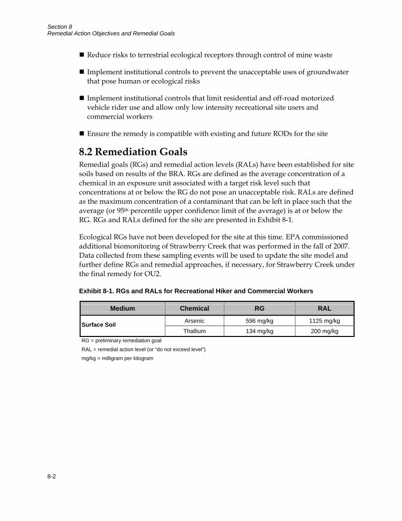
Section 8 Remedial Action Objectives and Remedial Goals
8-2
Reduce risks to terrestrial ecological receptors through control of mine waste
Implement institutional controls to prevent the unacceptable uses of groundwater that pose human or ecological risks
Implement institutional controls that limit residential and off-road motorized vehicle rider use and allow only low intensity recreational site users and commercial workers
Ensure the remedy is compatible with existing and future RODs for the site
8.2 Remediation Goals Remedial goals (RGs) and remedial action levels (RALs) have been established for site soils based on results of the BRA. RGs are defined as the average concentration of a chemical in an exposure unit associated with a target risk level such that concentrations at or below the RG do not pose an unacceptable risk. RALs are defined as the maximum concentration of a contaminant that can be left in place such that the average (or 95th percentile upper confidence limit of the average) is at or below the RG. RGs and RALs defined for the site are presented in Exhibit 8-1.
Ecological RGs have not been developed for the site at this time. EPA commissioned additional biomonitoring of Strawberry Creek that was performed in the fall of 2007. Data collected from these sampling events will be used to update the site model and further define RGs and remedial approaches, if necessary, for Strawberry Creek under the final remedy for OU2.
Exhibit 8-1. RGs and RALs for Recreational Hiker and Commercial Workers
Medium Chemical RG RAL
Arsenic 596 mg/kg 1125 mg/kg Surface Soil Thallium 134 mg/kg 200 mg/kg
RG = preliminary remediation goal RAL = remedial action level (or “do not exceed level”) mg/kg = milligram per kilogram
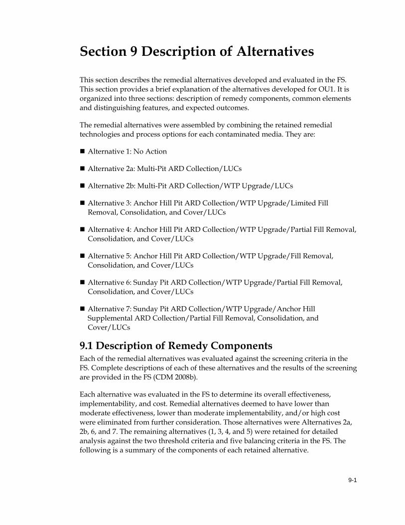
9-1
Section 9 Description of Alternatives
This section describes the remedial alternatives developed and evaluated in the FS. This section provides a brief explanation of the alternatives developed for OU1. It is organized into three sections: description of remedy components, common elements and distinguishing features, and expected outcomes.
The remedial alternatives were assembled by combining the retained remedial technologies and process options for each contaminated media. They are:
Alternative 1: No Action
Alternative 2a: Multi-Pit ARD Collection/LUCs
Alternative 2b: Multi-Pit ARD Collection/WTP Upgrade/LUCs
Alternative 3: Anchor Hill Pit ARD Collection/WTP Upgrade/Limited Fill Removal, Consolidation, and Cover/LUCs
Alternative 4: Anchor Hill Pit ARD Collection/WTP Upgrade/Partial Fill Removal, Consolidation, and Cover/LUCs
Alternative 5: Anchor Hill Pit ARD Collection/WTP Upgrade/Fill Removal, Consolidation, and Cover/LUCs
Alternative 6: Sunday Pit ARD Collection/WTP Upgrade/Partial Fill Removal, Consolidation, and Cover/LUCs
Alternative 7: Sunday Pit ARD Collection/WTP Upgrade/Anchor Hill Supplemental ARD Collection/Partial Fill Removal, Consolidation, and Cover/LUCs
9.1 Description of Remedy Components Each of the remedial alternatives was evaluated against the screening criteria in the FS. Complete descriptions of each of these alternatives and the results of the screening are provided in the FS (CDM 2008b).
Each alternative was evaluated in the FS to determine its overall effectiveness, implementability, and cost. Remedial alternatives deemed to have lower than moderate effectiveness, lower than moderate implementability, and/or high cost were eliminated from further consideration. Those alternatives were Alternatives 2a, 2b, 6, and 7. The remaining alternatives (1, 3, 4, and 5) were retained for detailed analysis against the two threshold criteria and five balancing criteria in the FS. The following is a summary of the components of each retained alternative.
Section 9 Description of Alternatives
9-2
9.1.1 Alternative 1: No Action Alternative 1 (No Action) is required by the National Oil and Hazardous Substances Pollution Contingency Plan (NCP) as a baseline for comparison against other remedial alternatives. No further action would be taken for contaminant sources at the site other than 5-year site reviews as required by the NCP.
9.1.1.1 Contaminant Sources Acid-generating waste rock and fills and exposed acid-generating bedrock in pit highwalls and upland areas across the site would be left unaddressed in their present configurations. Sludge in the bottom of mine pits and ponds and in surficial deposits (including the WTP sludge stored at the HLP extension) would also be left in place. WTP operations would be suspended under this alternative, so future sludge generation from the WTP would cease.
9.1.1.2 Contaminated Water Mine pits and ponds would be unaddressed. Collection, removal, and treatment of contaminated water in the mine disturbance area and discharge of treated water in Lower Strawberry Creek would continue using current discharge waivers for selenium and TDS (under OU2) until a final remedy for OU2 is selected.
9.1.2 Alternative 3: Anchor Hill Pit ARD Collection/WTP Upgrade/Limited Fill Removal, Consolidation, and Cover/LUCs Alternative 3 (Anchor Hill Pit ARD Collection/WTP Upgrade/Limited Fill Removal, Consolidation, and Cover/LUCs) contains the following elements (for ease of comparison of differences between alternatives italics are used to identify items that were not included in previous alternatives) (Figure 9-1):
9.1.2.1 Contaminant Sources Consolidation/Containment. Consolidation and containment of contaminant sources from the Upper Strawberry Creek corridor would be performed on a limited basis to reduce volume of ARD. Acid-generating waste rock and fills would be removed primarily from the Stormwater Pond and Strawberry Gulch remediation subareas to create surface water flow within Upper Strawberry Creek that would not require ARD collection and treatment. Portions of the Process Plant and Union Hill Upland remediation subareas would also be removed to increase surface water runoff to Upper Strawberry Creek not requiring capture or treatment. The excavated materials would primarily be placed into Dakota Maid Pit and covered. Any remaining waste rock and fill would be submerged within Sunday Pit or placed at the Upper South Ruby Remediation Subarea and covered. The disposal of contaminated fills in Dakota Maid Pit would be sequenced as much as practicable to place reclamation fills in the submerged portion of the pit and general fills in the vadose zone above the submerged fills. Spent ore on the HLP and acid-generating waste rock and fills across the remainder of the site would not be addressed.
Section 9 Description of Alternatives
9-3
Covers. A cover system would be used at the Dakota Maid Pit to reduce infiltration of precipitation and subsequent generation of ARD. Exposed acid-generating bedrock in the lower highwalls of Dakota Maid Pit and surficial sludge deposits at the Dakota Maid Pit and Sunday Pit would be addressed incidental to pit backfilling and covering. The Upper South Ruby Remediation Subarea would also be graded and covered (which would complete the OU3 remedy). Soil stockpiles currently stored within the HLP extension and topsoil and subsoil from the cover on the nearly level areas (plateaus) at the top of Ruby Repository would be used for reclamation or cover construction. Topsoil and subsoil resources remaining after cover construction would be used to cover and revegetate (reclaim) parent ground and fill zones exposed during contaminant source removal.
Sludge Removal, Containment, and Future Storage. Sludge in the bottom of Dakota Maid Pit and in the Stormwater Pond would be removed and placed adjacent to the WTP sludge currently stored at the HLP extension. Removal of soil stockpiles from the extension and the top of Ruby Repository for reclamation or cover construction would provide additional area for sludge disposal cells constructed as part of WTP operations under OU2. Removing sludge from the bottom of the pits and the pond reduces a source of very high contaminant mass loading which would be in contact with the groundwater in the submerged portions of the pits. Removal of the sludge also has implementability and safety benefits related to backfilling of the pit. Since the sludge has a low solids content, use of heavy equipment over the sludge in its current configuration is not feasible unless layers of coarse rock are placed in the sludge for stability before backfilling of reclamation fills could begin. Also, because the sludge currently obscures the underground workings within the submerged portions of the pit, there are safety concerns related to subsidence or collapse of bridged fill materials over the underground workings. Removal of the sludge will reduce or eliminate many of these implementability and safety issues.
LUCs. LUCs (a combination of institutional controls, such as community awareness and land use restrictions, and engineered controls, such as posted warnings and fencing) would be implemented as needed to address risks posed to human receptors from unaddressed contaminant sources.
9.1.2.2 Contaminated Water Collection, Handling, Treatment of Water. Collection, handling, and treatment of contaminated water in the mine disturbance area and discharge of treated water in Lower Strawberry Creek would continue using current discharge waivers for selenium and TDS (under OU2) until a final remedy for OU2 is selected. Because the Surge and Stormwater Ponds would be removed as part of the source removal in the Upper Strawberry Creek corridor, they would only be available for short-term ARD storage capacity. Collection systems would be installed at the base of the Dakota Maid Pit cover to maintain acceptable ARD levels in the submerged fills of the pit. ARD collection systems would also be placed along the east perimeter of the Process Plant Remediation Subarea and the west berm of the HLP Remediation Subarea to transfer ARD from contaminant sources left in place at those locations. The ARD capture and pumping system at Strawberry

Section 9 Description of Alternatives
9-4
Pond/Pond E would be phased out over time as surface water quality within the Upper Strawberry Creek drainage improves due to the contaminant source removal within that drainage.
Upgrades to WTP. Upgrades will be made, as needed, to allow treatment of higher concentrations of sulfates from ARD stored in mine pits and ponds (to facilitate consolidation and containment of contaminant sources in Dakota Maid Pit) and to address potentially higher concentrations of sulfates in ARD from future discharges through pit backfill to the collection systems.
9.1.3 Alternative 4: Anchor Hill Pit ARD Collection/WTP Upgrade/Partial Fill Removal, Consolidation, and Cover/LUCs Alternative 4 (Anchor Hill Pit ARD Collection/WTP Upgrade/Partial Fill Removal, Consolidation, and Cover/LUCs) contains the following elements (for ease of comparison of differences between alternatives italics are used to identify items that were not included in previous alternatives) (Figure 9-2):
9.1.3.1 Contaminant Sources Consolidation/Containment. Acid-generating waste rock and fills would be removed from remediation subareas across the site to consolidate contaminated fills within mine pits and create clean water corridors within Upper Strawberry Creek and Hoodoo Gulch. The excavated materials would primarily be placed into Dakota Maid and Sunday Pits and covered. Any remaining waste rock and fill would be placed at the Langley Benches and Upper South Ruby Remediation Subarea and covered. The disposal of contaminated fills within the Dakota Maid and Sunday Pits would be sequenced as much as practicable to place reclamation fills in the submerged portion of the pit and general fills in the vadose zone above the submerged fills. HLP spent ore would be partially excavated and graded to form stable slopes for covering.
Covers. Cover systems would be used at the Dakota Maid Pit, Sunday Pit, and the HLP to reduce infiltration of precipitation and subsequent generation of ARD. Covers would also be constructed over the Langley Benches and Upper South Ruby remediation subareas. Exposed acid-generating bedrock in the lower highwalls of the Dakota Maid Pit and Sunday Pit and surficial sludge within these pits would be addressed incidental to the backfilling and covering of the pits. The Upper South Ruby Remediation Subarea would also be graded and covered (which would complete the OU3 remedy). Soil stockpiles now stored in the HLP extension and topsoil and subsoil from the cover on the nearly level areas (plateaus) at the top of Ruby Repository would be used for reclamation or cover construction. Topsoil and subsoil resources remaining after cover construction would be used to cover and revegetate (reclaim) parent ground and fill zones exposed during contaminant source removal.
Section 9 Description of Alternatives
9-5
Sludge Removal, Containment, and Future Storage. Sludge in the bottom of Dakota Maid Pit, Sunday Pit, and in the Stormwater Pond would be removed and placed adjacent to the WTP sludge currently stored at the HLP extension. Removal of the sludge would have the same environmental, implementability, and safety benefits as discussed for Alternative 3. Removal of soil stockpiles from the extension and the top of Ruby Repository for reclamation or cover construction would provide additional area for sludge disposal cells constructed as part of WTP operations under OU2. Grading and covering of spent ore on the HLP and extension would reduce the overall useable area for sludge storage.
LUCs. LUCs (a combination of institutional controls, such as community awareness and land use restrictions, and engineered controls, such as posted warnings and fencing) would be implemented as needed to address risks posed to human receptors from unaddressed contaminant sources.
9.1.3.2 Contaminated Water Collection, Handling, Treatment of Water. Collection, handling, and treatment of contaminated water in the mine disturbance area and discharge of treated water in Lower Strawberry Creek would continue using current discharge waivers for selenium and TDS (under OU2) until a final remedy for OU2 is selected. Because the Surge and Stormwater Ponds would be removed as part of the source removal in the Upper Strawberry Creek corridor, they would only be available for short-term ARD storage capacity. Collection systems would be installed at the base of the Dakota Maid Pit and Sunday Pit covers to maintain acceptable ARD levels in the submerged fills of the pit. ARD collection systems would also be placed along the east perimeter of the Process Plant Remediation Subarea and the west berm of the HLP Remediation Subarea to transfer ARD from contaminant sources left in place at those locations. The ARD capture and pumping system at Strawberry Pond/Pond E and Hoodoo Gulch would be phased out over time as surface water quality within the Upper Strawberry Creek and Hoodoo drainages improves due to the contaminant source removal therein
Upgrades to WTP. Upgrades will be made, as needed, to allow treatment of higher concentrations of sulfates from ARD stored in mine pits and ponds (to facilitate consolidation and containment of contaminant sources in Dakota Maid and Sunday Pits) and to address potentially higher concentrations of sulfates in ARD from future discharges through pit backfills to the collection systems.
9.1.4 Alternative 5: Anchor Hill Pit ARD Collection/WTP Upgrade/Fill Removal, Consolidation, and Cover/LUCs Alternative 5 (Anchor Hill Pit ARD Collection/WTP Upgrade/Fill Removal, Consolidation, and Cover/LUCs) contains the following elements (for ease of
Section 9 Description of Alternatives
9-6
comparison of differences between alternatives italics are used to identify items that were not included in previous alternatives) (Figure 9-3):
9.1.4.1 Contaminant Sources Consolidation/Containment. Acid-generating waste rock and fills would be removed from remediation subareas across the site to consolidate contaminated fills within mine pits and create clean water corridors in Upper Strawberry Creek and Hoodoo Gulch. The excavated materials would primarily be placed into Dakota Maid and Sunday Pits and covered. Any remaining waste rock and fill would be placed at the Upper South Ruby Remediation Subarea and covered. The disposal of contaminated fills within the Dakota Maid Pit would be sequenced as much as practicable to place reclamation fills in the submerged portion of the pit and general fills in the vadose zone above the submerged fills. The majority of spent ore on the HLP would be removed and contained in Dakota Maid and Sunday Pits. Some ore would be left to protect the bottom liner from damage during removal of spent ore.
Covers. Cover systems would be used at the Dakota Maid and Sunday Pits to reduce infiltration of precipitation and subsequent generation of ARD. Covers would also be constructed over the Langley Benches and Upper South Ruby remediation subareas. Exposed acid-generating bedrock in the lower highwalls of the Dakota Maid Pit and Sunday Pit and surficial sludge within these pits would be addressed incidental to the backfilling and covering of the pits. Soil stockpiles now stored in the HLP extension would be used for reclamation or cover construction. Topsoil and subsoil resources remaining after cover construction would be used to cover and revegetate (reclaim) parent ground and fill zones exposed during contaminant source removal.
Sludge Removal, Containment, and Future Storage. Sludge in the bottom of Dakota Maid Pit, Sunday Pit, and in the Stormwater Pond would be removed and placed adjacent to the WTP sludge currently stored at the HLP extension. Removal of the sludge would have the same environmental, implementability, and safety benefits as discussed for Alternative 3. Removal of soil stockpiles from the extension would provide additional area for sludge disposal cells constructed as part of WTP operations under OU2. The surface of the entire HLP and extension would be available for future disposal of sludge generated at the WTP. WTP sludge would be disposed of at this location in disposal cells constructed as part of OU2. Removal of soil from the plateaus at the top of Ruby Repository to create additional sludge storage areas would not be required under this alternative.
LUCs. LUCs (a combination of institutional controls, such as community awareness and land use restrictions, and engineered controls, such as posted warnings and fencing) would be implemented as needed to address risks posed to human receptors from unaddressed contaminant sources.
Section 9 Description of Alternatives
9-7
9.1.4.2 Contaminated Water Collection, Handling, Treatment of Water. Collection, handling, and treatment of contaminated water in the mine disturbance area and discharge of treated water in Lower Strawberry Creek would continue using current discharge waivers for selenium and TDS (under OU2) until a final remedy for OU2 is selected. Because the Surge and Stormwater Ponds would be removed as part of the source removal in the Upper Strawberry Creek corridor, they would only be available for short-term ARD storage capacity. Collection systems would be installed at the base of the Dakota Maid and Sunday Pit covers to maintain acceptable ARD levels in the submerged fills of the pit. ARD collection systems would also be placed along the east perimeter of the Process Plant Remediation Subarea and the west berm of the HLP Remediation Subarea to transfer ARD from contaminant sources left in place at those locations. The ARD capture and pumping system at Strawberry Pond/Pond E and Hoodoo Gulch would be phased out over time as surface water quality within the Upper Strawberry Creek and Hoodoo Gulch drainages improves due to contaminant source removal therein.
Upgrades to WTP. Upgrades will be made, as needed, to allow treatment of higher concentrations of sulfates from ARD stored in mine pits and ponds (to facilitate consolidation and containment of contaminant sources in Dakota Maid and Sunday Pits) and to address potentially higher concentrations of sulfates in ARD from future discharges through the pit backfills to the collection systems.
9.2 Common Elements and Distinguishing Features of Each Alternative Common elements and distinguishing features in how the contaminant sources and contaminated water at OU1 are treated under remedial alternatives 1, 3, 4, and 5 are discussed below and summarized in Tables 9-1 and 9-2.
9.2.1 Contaminant Sources 9.2.1.1 Consolidation and Containment of Sources Alternative 1 does not physically address the contaminant sources themselves. Alternatives 3, 4, and 5 use a remedial strategy that emphasizes consolidation and containment of contaminant sources to reduce volume of ARD collected for storage and treatment under OU2. The primary difference is the degree of consolidation and containment. Alternative 3 addresses limited areas while Alternatives 4 and 5 address sources site-wide.
9.2.1.2 Covers Alternative 1 does not address source areas, so it does not require any covers. For the remaining alternatives, covers are used to reduce the infiltration of precipitation and subsequent generation of ARD.
Section 9 Description of Alternatives
9-8
Alternative 3 includes use of a cover system primarily at the Dakota Maid Pit. Alternative 4 adds covers over the graded HLP. Alternatives 4 and 5 have the addition of covers over Sunday Pit. Alternatives 4 and 5 also include covers at the Langley Benches remediation subarea. Alternatives 3, 4, and 5 address exposed acid-generating bedrock in the lower highwalls of Dakota Maid Pit and surficial sludge deposits at the Dakota Maid Pit incidental to pit backfilling and covering. Alternatives 4 and 5 also address exposed acid-generating bedrock in the lower highwalls and surficial sludge of Sunday Pit incidental to pit backfilling and covering.
For Alternatives 3, 4, and 5, the Upper South Ruby Remediation Subarea would also be graded and covered, which would complete the OU3 remedy. Additionally, topsoil and subsoil resources remaining after cover construction would be used to cover and revegetate (reclaim) parent ground and fill zones exposed during contaminant source removal.
9.2.1.3 Sludge Removal, Containment, and Future Storage Sludge removal and containment is common to Alternatives 3, 4, and 5 and each specifies some degree of sludge removal and containment. Alternative 3 removes sludge from the bottom of Dakota Maid Pit and the Stormwater Pond and places it adjacent to the WTP sludge currently stored at the HLP extension. Alternatives 4 and 5 also remove sludge from the bottom of the Sunday Pit and dispose of it at the HLP subarea. As discussed earlier, sludge removal has environmental, implementability, and safety benefits.
For Alternatives 3 and 4, the removal of soil stockpiles from the extension and the top of Ruby Repository provides additional area for sludge disposal cells constructed under OU2. Alternative 4 introduces grading and covering of spent ore on the HLP and extension, which reduces the overall useable area for sludge storage. For Alternative 5, the surface of the entire HLP and extension would be available for future sludge generation from the WTP. WTP sludge would be disposed of at this location in disposal cells constructed as part of OU2. Removal of soil from the plateaus at the top of Ruby Repository to create additional sludge storage areas would not be required under Alternative 5.
9.2.1.4 LUCs All alternatives except Alternative 1 use LUCs as needed to address risks posed to human receptors from unaddressed contaminant sources.
9.2.2 Contaminated Water All alternatives except Alternative 1 use some degree of collection, handling, and treatment of contaminated water and all except Alternative 1 include upgrades to the WTP. Alternatives 3, 4, and 5 focus on reducing the volume of ARD collected for storage and treatment under OU2, eventually phasing out some ARD capture and collection
Section 9 Description of Alternatives
9-9
elements as water volumes collected for treatment decrease and surface water quality within drainages improves.
9.2.2.1 Collection, Handling, and Treatment of Water All alternatives include the collection, removal, and treatment of contaminated water in the mine disturbance area and discharge of treated water within Lower Strawberry Creek using current discharge waivers for selenium and TDS (under OU2) until a final remedy for OU2 is selected.
This includes: short-term use of Stormwater and Surge Ponds, installation of ARD collection systems at the base of the Dakota Maid Pit cover and along the east perimeter of the Process Plant Remediation Subarea and the west berm of the HLP Remediation Subarea, and phase out of the ARD capture and pumping system at Strawberry Pond/Pond E over time as surface water quality within the Upper Strawberry Creek drainage improves due to the contaminant source removal within that drainage. Alternatives 4 and 5 also include phasing out of the ARD capture and pumping system at Hoodoo Gulch over time as surface water quality improves due to the contaminant source removal within that drainage.
Alternatives 3 through 5 designate Anchor Hill Pit as the primary ARD storage location for the site. Alternatives 4 and 5 include a collection system at the base of the Sunday Pit cover.
9.2.2.2 Upgrades to the WTP Alternatives 3, 4, and 5 have the same upgrades, as needed, to allow treatment of higher concentrations of sulfates from ARD stored in mine pits and ponds (to facilitate consolidation and containment of contaminant sources in pits) and to address potentially higher concentrations of sulfates in ARD from future discharges through pit backfill to the collection systems.

Section 9 Description of Alternatives
9-10
This page intentionally left blank
10-1
Section 10 Comparative Analysis of Alternatives
This section presents a summary of the remedial alternatives that were retained for detailed analysis against the two threshold criteria and five balancing criteria in the FS. Those were Alternatives 1, 3, 4, and 5. The results of the detailed analysis (Exhibit 10-1) allow a comparative analysis of the alternatives and identify the key tradeoffs between them. A discussion of the comparative analysis is provided below.
10.1 Threshold Criteria 10.1.1 Overall Protection of Human Health and the Environment Of the four alternatives, only one (Alternative 1 - No Action) fails to provide protection for human health and the environment and does not address the RAOs for OU1. Thus this alternative was given a rating of none.
Alternative 3 addresses the RAOs for contaminant sources through limited removal, transport, disposal, and containment of contaminant sources located within the Upper Strawberry Creek corridor and removal of sludge from Dakota Maid Pit. Risks of uncontrolled ARD releases are lessened through the limited action taken to address contaminant sources; however, the risks remain especially in portions of site drainages that have contaminant sources that are unaddressed such as Hoodoo Gulch. Exposure risks to human and terrestrial ecological receptors from unaddressed contaminant sources are mitigated through the use of engineered and institutional controls. Thus, this alternative was given a rating of moderate.
Alternatives 4 and 5 address the RAOs similarly to Alternative 3, but contaminant sources throughout the mine disturbance area are addressed and the risks of uncontrolled ARD releases are substantially reduced. The risks to human and terrestrial ecological receptors are also substantially reduced through the comprehensive actions taken for contaminant sources. Thus, these alternatives were given a rating of moderate to high.
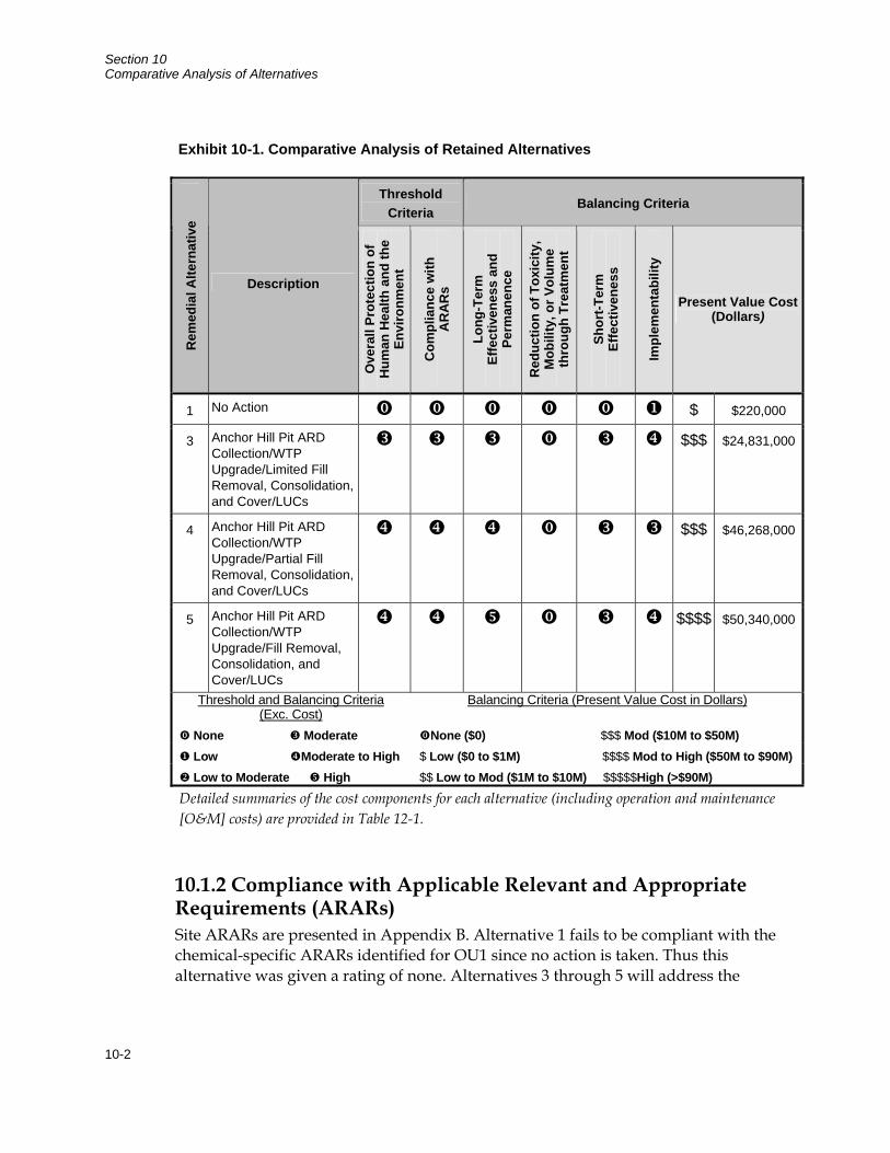
Section 10 Comparative Analysis of Alternatives
10-2
10.1.2 Compliance with Applicable Relevant and Appropriate Requirements (ARARs) Site ARARs are presented in Appendix B. Alternative 1 fails to be compliant with the chemical-specific ARARs identified for OU1 since no action is taken. Thus this alternative was given a rating of none. Alternatives 3 through 5 will address the
Exhibit 10-1. Comparative Analysis of Retained Alternatives
Threshold Criteria
Balancing Criteria R
emed
ial A
ltern
ativ
e
Description
Ove
rall
Prot
ectio
n of
H
uman
Hea
lth a
nd th
e En
viro
nmen
t
Com
plia
nce
with
A
RA
Rs
Long
-Ter
m
Effe
ctiv
enes
s an
d Pe
rman
ence
Red
uctio
n of
Tox
icity
, M
obili
ty, o
r Vol
ume
thro
ugh
Trea
tmen
t
Shor
t-Ter
m
Effe
ctiv
enes
s
Impl
emen
tabi
lity
Present Value Cost (Dollars)
1 No Action $ $220,000
3 Anchor Hill Pit ARD Collection/WTP Upgrade/Limited Fill Removal, Consolidation, and Cover/LUCs
$$$ $24,831,000
4 Anchor Hill Pit ARD Collection/WTP Upgrade/Partial Fill Removal, Consolidation, and Cover/LUCs
$$$ $46,268,000
5 Anchor Hill Pit ARD Collection/WTP Upgrade/Fill Removal, Consolidation, and Cover/LUCs
$$$$ $50,340,000
Threshold and Balancing Criteria (Exc. Cost)
Balancing Criteria (Present Value Cost in Dollars)
None Moderate None ($0) $$$ Mod ($10M to $50M) Low Moderate to High $ Low ($0 to $1M) $$$$ Mod to High ($50M to $90M) Low to Moderate High $$ Low to Mod ($1M to $10M) $$$$$High (>$90M)
Detailed summaries of the cost components for each alternative (including operation and maintenance [O&M] costs) are provided in Table 12-1.
Section 10 Comparative Analysis of Alternatives
10-3
chemical-, location-, and action-specific ARARs through adherence of the ARARs during implementation of the remedial action. Since Alternative 3 does not fully remediate all of the contaminant sources, it was given a rating of moderate. Alternatives 4 and 5 were given a rating of moderate to high since the remediation of contaminant sources is more comprehensive.
10.2 Balancing Criteria 10.2.1 Long-Term Effectiveness and Permanence Alternative 1 fails to provide long-term effectiveness and permanence since no action is taken to address contaminant sources. There are potential risks of uncontrolled ARD releases, especially during substantial precipitation events and exposure risks from contaminant sources to human and terrestrial ecological receptors. Thus, this alternative was given a rating of none.
Alternative 3 provides long-term effectiveness and permanence for contaminant sources through limited removal, transport, disposal, and containment of contaminant sources located within the Upper Strawberry Creek corridor and removal of sludge from Dakota Maid Pit. ARD volumes generated from contaminant sources and the risks of ARD releases due to large storm events are lessened as compared to Alternative 1; however, the risks remain especially in portions of site drainages that have contaminant sources that are unaddressed such as Hoodoo Gulch. Exposure risks to human and terrestrial ecological receptors from unaddressed contaminant sources are mitigated through the use of engineered and institutional controls; however engineered and institutional controls have reduced permanence over active measures to remediate contaminant sources. Thus, this alternative was given a rating of moderate.
Alternatives 4 and 5 provide long-term effectiveness and permanence similar to Alternative 3, but contaminant sources throughout the mine disturbance area are addressed. Thus, ARD volumes generated from contaminant sources and the risks of uncontrolled ARD releases during substantial precipitation events are significantly lessened as compared to Alternative 3. Exposure risks to human and terrestrial ecological receptors are also substantially reduced through comprehensive remediation of contaminant sources. Alternative 4 was given a ranking of moderate to high.
Since Alternative 5 also consolidates more contaminant sources within the mine pits (spent ore on the HLP), it also provides much more space for construction of sludge disposal cells under OU2. Thus, Alternative 5 was given a rating of high.
Section 10 Comparative Analysis of Alternatives
10-4
10.2.2 Reduction of Toxicity, Mobility, or Volume through Treatment None of the alternatives provide a reduction of toxicity, mobility, or volume through treatment since none of the alternatives include treatment of contaminant sources. Thus, all of the alternatives were given a rating of none.
10.2.3 Short-Term Effectiveness Alternative 1 fails to provide short-term effectiveness since no action is taken to address contaminant sources. Thus, this alternative was given a rating of none.
Alternative 3 address short-term risks to workers, the community, and the environment. Institutional and engineered controls would be quickly implemented to address human exposure to contaminant sources within the mine disturbance area. Alternatives 3 through 5 expose onsite workers to additional short-term risks through the removal, transport, disposal, and containment of contaminant sources. Short-term risks to workers would be mitigated through the use of safety procedures, monitoring equipment, and personal protective equipment.
There are also additional short-term risks to the community through delivery of quarry materials and construction materials. Delivery of borrow materials for subsoil and topsoil and quarry rock have limited impact to the community since these borrow sources are onsite or near onsite and would not use public roadways.
All three of these alternatives involve implementation durations over multiple years to complete construction; while the durations vary, the potential risks for short-term adverse impacts due to uncontrolled release of ARD from a substantial precipitation event are similar. Thus, all three of these alternatives were given a rating of moderate.
10.2.4 Implementability Alternative 3 has implementability issues related primarily to the treatment system upgrade for the WTP and the removal and consolidation of contaminant sources within the Upper Strawberry Gulch drainage. Institutional and engineered controls are easily implementable for Alternative 3 within a short period of time. Upgrades to the WTP would be implemented to increase the concentrations of sulfates within ARD that can be treated; this upgrade will assist in pit dewatering and future treatment of ARD from pit backfills. However, there may be difficulties encountered during construction and startup of the treatment system. Additionally, Alternative 3 has additional minor implementability issues due to the limited removal, transport, disposal, and containment of contaminant sources located within the Upper Strawberry Creek corridor. Since there are suitable quantities of onsite subsoil and topsoil resources, offsite borrow sources for these materials would not be required. However, there is a need for other offsite materials such as geosynthetic materials and lime for construction of covers. Other implementability issues include the relocation
Section 10 Comparative Analysis of Alternatives
10-5
of utilities and access roads within the areas of contaminant source removal and limited space for sludge disposal cells within the HLP extension and the plateaus on Ruby Repository. Thus, this alternative was given a rating of moderate to high.
Alternative 4 has similar implementability issues to Alternative 3. However, Alternative 4 has additional issues due to the removal, transport, disposal, and containment of contaminant sources throughout the site and geosynthetic multi-layer cover construction over the HLP. These issues include the need for a relatively large amount of additional borrow from near onsite or offsite sources for construction of covers, additional relocation of utilities, access roads, and infrastructure within the areas of contaminant source removal, and significant reduction of onsite sludge storage due to the grading of spent ore over the HLP extension and construction of a cover over the extension. Thus, this alternative was given a rating of moderate.
Alternative 5 has similar implementability issues to Alternative 4. However, Alternative 5 does not require near as much additional borrow from near onsite or offsite sources as Alternative 4 since the majority of spent ore on the HLP is removed and consolidated within Dakota Maid Pit and Sunday Pit. Since the majority of the HLP and extension spent ore is offloaded, this alternative provides more onsite sludge storage than any other alternative. Thus, this alternative was given a rating of moderate to high.
10.2.5 Present Value Cost A summary of the cost components for each alternative is presented in Table 10-1. The present value costs were evaluated over a 50-year period (Years 1 through 50).
Based on this information, the following ratings were made for the retained alternatives:
Present value cost for Alternative 1 is approximately $220,000 and is rated as low.
Present value cost for Alternative 3 is approximately $24,831,000 and is rated as moderate.
Present value cost for Alternative 4 is approximately $46,268,000 and is rated as moderate.
Present value cost for Alternative 5 is approximately $50,340,000 and is rated as moderate to high.
Section 10 Comparative Analysis of Alternatives
10-6
10.3 Modifying Criteria Based on the comparative analysis of alternatives, Alternative 5 was selected as the preferred remedy for OU1. The final criteria for evaluation of the alternatives are state acceptance and public acceptance and were applied after the conclusion of the public comment period. The following summarizes how the modifying criteria affected the selection of the remedy.
10.3.1 State Acceptance Representatives of the SD DENR participated in the development of the RI, FS, Proposed Plan, and ROD. Their comments were incorporated before the documents were released to the public. SD DENR supports the selection of Alternative 5 as the remedy for OU1.
10.3.2 Public Acceptance EPA received no oral or written comments at the public hearing on the Proposed Plan. Written comments were received during the public comment period were generally limited. Two comment submissions were from private citizens, one from the Lawrence country commissioners, one from a potentially responsible party (PRP) (CAMC), and one from a vendor of water treatment services.
The private citizens and the county commissioners both expressed support for EPA’s work at the site and the selection of the remedy. The water treatment vendor believes that remedy would unfairly preclude the use of his water treatment system in the future for OU2. The PRP has multiple concerns, but is primarily concerned about the decision to address contaminated groundwater in the future under OU2, rather than in OU1, and the potential impacts of the OU1 remedy on future remedies for OU2. These comments and EPA’s detailed responses are presented in the Responsiveness Summary of this ROD (Part 3). Based on these comments and the general tone of discourse in public meetings held to date, the public seems to be accepting of the choice of Alternative 5 as the remedy for OU1.
11-1
Section 11 Principal Threat Wastes
Principal threat wastes are source materials considered to be highly toxic or highly mobile that generally cannot be reliably contained or would present significant risk to human health or the environment should exposure occur. At the site, ARD-contaminated water that is in storage, or that is within the WTP circuit, is considered principal threat waste. This determination was made in the 2001 OU2 Interim Water Treatment ROD. That contaminated water will be addressed under the remedy for OU2.
Source materials at the site are not considered to be principal threat waste. These materials include contaminated waste rock fill, spent ore from the HLP, exposed acid-generating bedrock surfaces, amended tailings, and sludge. Exposure to metals concentrations (arsenic and thallium) within these media through ingestion or inhalation generally does pose a significant risk to either human or ecological receptors. However, the Selected Remedy will address exposure to this non-principal threat waste primarily through consolidation and containment and not treatment.
While groundwater in the underground mine workings is mobile and contains COCs, the OU1 selected remedy will address contaminant sources which will lessen impacts to groundwater in the primary mine disturbance area and LUCs will prevent exposure to this media. Migrating groundwater that could impact Strawberry Creek and downgradient drinking water sources will be addressed through the selected remedy for OU2.

Section 11 Principal Threat Wastes
11-2
This page intentionally left blank
12-1
Section 12 Selected Remedy
Based on consideration of the Comprehensive Environmental Response, Compensation, and Liability Act (CERCLA) requirements, the detailed analysis of remedial alternatives, State comments, and all public comments, EPA has determined that the preferred remedial alternative presented in the Proposed Plan for OU1 (Alternative 5: Anchor Hill Pit ARD Collection/WTP Upgrade/Fill Removal, Consolidation, and Cover/LUCs) is the appropriate remedy for OU1. The Selected Remedy includes components to address contaminant sources (acid-generating waste rock and fills, exposed acid-generating bedrock, and sludge) and contaminated water (surface water and groundwater). A detailed description of the Selected Remedy is presented in the sections below.
12.1 Short Description of the Selected Remedy The Selected Remedy is a containment remedy. It uses a remedial strategy that emphasizes site-wide consolidation and containment of contaminant sources to reduce the volume of ARD collected for storage and treatment under OU2. Removal, consolidation and containment of acid-generating waste rock and fills are performed site-wide to facilitate covering of contaminant sources and creating clean water corridors within the Upper Strawberry and Hoodoo Gulch drainages. Cover systems are used at contaminant source consolidation locations to limit infiltration of precipitation and subsequent generation of ARD. Waste rock and fill with a lower content of soluble contaminants (reclamation fills) will be placed within Dakota Maid and Sunday Pits before waste rock and fills with higher content of soluble contaminants (general fills). The sequencing reduces impacts to groundwater because the general fills would be placed in the vadose zone within the pits. Exposed acid-generating bedrock in lower highwalls of several pits and some surficial sludge deposits are addressed incidental to pit backfilling and covering.
The Selected Remedy reduces the long-term risk of exposure to COCs in source areas. It ensures that low intensity recreational site users and commercial workers have no more than a 1 x 10⁻⁴ chance of contracting cancer from ingestion and inhalation of onsite soils and that those users are also protected against non-cancer effects from inhalation and ingestion of surface soils for contaminants. The Selected Remedy also reduces risks to terrestrial ecological receptors through control of mine waste. Finally, it reduces or eliminates the risk of an uncontrolled release of ARD from the site as a result of a 100-year, 24-hour storm event.
LUCs will be used to minimize risks posed to human receptors from unaddressed contaminant sources and also to ensure that engineered elements of the remedy (e.g., covers) are not damaged. They will prevent the unacceptable uses of groundwater
Section 12 Selected Remedy
12-2
that pose human or ecological risks, limit residential and off-road motorized vehicle rider use, and allow only low intensity recreational site users and commercial workers. The LUCs will consist of a combination of both institutional controls and engineered controls. Prior to initiation of the remedial design, it is not possible to identify the precise makeup of the LUCs. However, EPA anticipates that the institutional controls would include community awareness programs (e.g., ads, handouts, and other educational materials) and land-use restrictions (e.g., deed restrictions, building permits, or zoning changes). Engineered controls would likely include posted warnings and fencing. EPA will work closely with the SD DENR and representatives of Lawrence County in the remedial design process to ensure that the LUCs selected will be implementable and will achieve the desired results.
Sludge would be removed from Dakota Maid and Sunday Pits and the Stormwater Pond and placed adjacent to the WTP sludge currently stored at the HLP extension (the entire HLP surface would be available for future sludge generation from the WTP). WTP sludge would be disposed of at this location in disposal cells constructed as part of OU2. The Selected Remedy also uses LUCs, as needed, to address risks posed to human receptors from unaddressed contamination.
The Selected Remedy includes designation of Anchor Hill Pit as the primary ARD storage location for the site. Collection, removal, and treatment of contaminated water in the mine disturbance area and discharge of treated water in Lower Strawberry Creek using current discharge waivers for selenium and TDS would continue to be performed as part of the OU2 interim remedy until a final remedy for OU2 is selected. In addition, the Selected Remedy includes installation of several ARD collection systems adjacent to contaminated fills left in place across the site, such as the west portion of the Process Plant subarea and the west berm of the HLP subarea. ARD collection systems would also be installed as part of the Dakota Maid and Sunday Pit cover systems. The ARD capture and pumping systems at Strawberry Pond/Pond E and Hoodoo Gulch will be phased out over time as surface water quality within the Upper Strawberry Creek and Hoodoo Gulch drainages improves due to contaminant source removal within these drainages. Upgrades will be made to the WTP, as needed, to allow treatment of higher concentrations of sulfates from ARD stored in mine pits and ponds and to address potentially higher concentrations of sulfates in ARD from future discharges through pit backfill to the collection systems.
12.2 Rationale for the Selected Remedy The Selected Remedy provides the best balance of tradeoffs among the alternatives and attains an equal or higher level of achievement of the threshold and balancing criteria than other site-wide alternatives that were evaluated. It achieves substantial risk reduction and is feasible, implementable, and has long-term cost-effectiveness. Residual risks are effectively eliminated, mitigated, or managed under the Selected Remedy. The successful performance of the remedy is demonstrated by past

Section 12 Selected Remedy
12-3
experience with consolidation and covering of contaminant sources at the site (under interim actions) and operation of the ARD collection and treatment systems (under OU2). Further rationale for the Selected Remedy is provided below.
12.3 Detailed Description of the Selected Remedy The Selected Remedy is described in detail below. Details of the remedy may be modified somewhat as a result of the remedial design and construction processes. Design changes will be documented.
12.3.1 Contaminant Sources Acid-generating waste rock and fills will be removed from remediation subareas across the site to consolidate contaminated fills in mine pits and create clean water corridors in Upper Strawberry Creek and Hoodoo Gulch.
All mine waste with arsenic concentrations above 1,125 mg/kg and/or thallium concentrations above 200 mg/kg will be managed though containment using covers or through engineered controls such as fencing.
The excavated waste rock and fill will primarily be placed into Dakota Maid Pit and Sunday Pit and covered.
Waste rock and fill will also be consolidated and covered at the Langley Benches and Upper South Ruby Remediation Subareas.
The disposal of acid-generating waste rock and fills in Dakota Maid Pit and Sunday Pit will be sequenced as much as practicable to place waste with lower ARD generation potential (reclamation fills) in the submerged portion of the pit and general fills in the vadose zone above the submerged fills.
The majority of spent ore on the HLP will be removed and contained in Dakota Maid and Sunday Pits. Some ore would be left to protect the bottom liner from damage during removal of spent ore. The remaining spent ore will be contained with a liner to reduce ARD generation and facilitate disposal of sludge as part of OU2.
Cover systems will be used at the Dakota Maid Pit, Sunday Pit, Langley Benches and the Upper South Ruby remediation subareas to reduce infiltration of precipitation and subsequent generation of ARD.
Exposed acid-generating bedrock in the lower highwalls of the Dakota Maid Pit and Sunday Pit and surficial sludge within these pits will be addressed incidental to the backfilling and covering of the pits.
Section 12 Selected Remedy
12-4
Soil stockpiles now stored in the HLP extension will be used for reclamation or cover construction.
Topsoil and subsoil resources remaining after cover construction will be used to cover and revegetate (reclaim) parent ground and fill zones exposed during contaminant source removal.
Sludge in the bottom of Dakota Maid Pit, Sunday Pit, and in the Stormwater Pond will be removed and placed on the HLP adjacent to the WTP sludge currently stored at the HLP extension.
Removal of soil stockpiles from the extension will provide additional area for sludge disposal cells constructed as part of WTP operations under OU2.
The surface of the entire HLP and extension will be available for future sludge generation from the WTP. WTP sludge would be disposed of at this location in disposal cells constructed as part of OU2.
LUCs (a combination of institutional controls (e.g., community awareness and land use restrictions) and engineered controls (e.g. posted warnings and fencing) would be implemented, as needed, to address risks posed to human receptors from unaddressed contaminant sources.
12.3.2 Contaminated Water Anchor Hill Pit will be designated as the primary ARD storage location at the site.
Collection, removal, and treatment of contaminated water in the mine disturbance area and discharge of treated water in Lower Strawberry Creek will continue using current discharge waivers for selenium and TDS (under the OU2 interim ROD) until a final remedy for OU2 is selected.
Because the Surge and Stormwater Ponds will be removed as part of the source removal in the Upper Strawberry Creek corridor, they would only be available for short-term ARD storage capacity.
Collection systems will be installed at the base of the Dakota Maid Pit and Sunday Pit covers to maintain acceptable ARD levels in the submerged fills of the pits.
ARD collection systems will also be placed along the east perimeter of the Process Plant Remediation Subarea and the west berm of the HLP Remediation Subarea to transfer ARD from contaminant sources left in place at those locations.
The ARD capture and pumping system at Strawberry Pond/Pond E and Hoodoo Gulch will be phased out over time as surface water quality within the Upper
Section 12 Selected Remedy
12-5
Strawberry Creek and Hoodoo Gulch drainages improves due to the contaminant source removal within those drainages.
Upgrades will be made, as needed, to the WTP to allow treatment of higher concentrations of sulfates from ARD stored in mine pits and ponds (to facilitate consolidation and containment of contaminant sources in Dakota Maid Pit and Sunday Pit) and to address potentially higher concentrations of sulfates in ARD from future discharges through pit backfills to the collection systems. The exact components and configuration of the WTP upgrade will be determined during design and implementation of the remedy. However, it is currently anticipated that the major upgrade components would include addition of a second reactor tank with mixer and a second solids contacting clarifier. Building expansion would also be required to house the new components.
12.4 Estimated Cost of the Selected Remedy As discussed in Section 10, present value cost for Alternative 5 is approximately $50,340,000. Table 12-1 presents the cost estimate summary for the Selected Remedy, including the present value analysis on a year by year basis.
12.5 Expected Outcomes of the Selected Remedy The Selected Remedy will achieve acceptable exposure risks through a combination of consolidation and containment of the most significant contaminant sources. The remedy is expected to address the most significant contaminant sources in terms of potential for generation of ARD. Risks to human health from direct contact and incidental ingestion of contaminated media will be eliminated or reduced to acceptable levels. Exposure to contaminated media at remaining areas of the site will be controlled by limiting access and use of LUCs to address potential future uses.
The Selected Remedy will also have a major impact on contaminated water at and beyond the site. Treatment of contaminated water will continue to be addressed under the OU2 interim ROD. However, the OU1 Selected Remedy will greatly reduce the amount of ARD generated, which will reduce ARD collection needs and treatment requirements and the risk of uncontrolled release of ARD. It is anticipated that collection in some parts of the site (the Upper Strawberry Creek and Hoodoo Gulch drainages) will be discontinued over time, as the surface water quality improves due to consolidation and containment of contaminant sources and reclamation of the remaining surfaces within those drainages. Although groundwater is not directly addressed under OU1, the reduction of ARD generation from the major contaminant sources on site and management of ARD within backfilled pits is expected to also have a positive effect on site groundwater.
The Selected Remedy will allow the site to be used for low-intensity recreational visitors and commercial workers. The use of snowmobiles and ATVs will be prohibited to protect the integrity of the soil covers used to limit infiltration.
Section 12 Selected Remedy
12-6
Acceptable low-intensity recreational activities could include hiking, hunting, fishing, and cross-country skiing (within the Strawberry Creek drainage). EPA has determined that it is not practical to remediate the site to meet residential use criteria because of site conditions (groundwater contamination and steep terrain). Thus, institutional controls will be implemented to limit residential development on site and to limit access to contaminated water sources.
12.6 Performance Standards This ROD defines performance standards for contaminant sources at OU1 that will be used to measure the overall effectiveness of the remedy over the long term. Performance standards are directly linked to the long-term protection of human health and the environment from contaminants of concern present at the OU and include the final ARARs for the site. Performance will be monitored through comprehensive and interrelated monitoring programs for each media, respectively. These monitoring programs will be planned, reviewed, and approved by EPA and SD DENR.
12.7 Environmental Justice In 1994, Executive Order 12898, “Federal Action to Address Environmental Justice in Minority Populations and Low-Income Populations,” became effective. The purpose of the Executive Order is to ensure that environmental actions or decisions do not result in disproportionately high and adverse human health or environmental effects by ensuring that the analysis of these effects includes the examination of secondary effects, cultural concerns, and cumulative impacts/effects. Achieving environmental protection for all communities is a fundamental part of EPA’s mission. However, because of the remote location of the site a formal environmental justice evaluation was not warranted.

13-1
Section 13 Statutory Determinations
Under CERCLA Section 121 and the NCP, EPA must select a remedy that is protective of human health and the environment, complies with or appropriately waives ARARs, is cost effective, and utilizes permanent solutions and alternative treatment technologies or resource recovery technologies to the maximum extent practicable. In addition, CERCLA includes a preference for remedies that include treatment that permanently and significantly reduces the volume, toxicity, or mobility of hazardous wastes as a principal element. The following sections discuss how the Selected Remedy meets these statutory requirements.
13.1 Protection of Human Health and the Environment The Selected Remedy includes components to address human health and environmental risks associated with source areas and contaminated water at OU1. Unacceptable human health or environmental risks identified in the risk assessment process will be addressed. The Selected Remedy will be monitored and maintained through comprehensive programs using institutional controls, monitoring, and maintenance. There are no short-term threats associated with the Selected Remedy that cannot be readily controlled through applicable health and safety requirements, monitoring, and standard construction practices. In addition, no adverse cross-media impacts are expected from the Selected Remedy.
13.1.1 Contaminant Sources
The Selected Remedy will protect human health and the environment through consolidation and covering to reduce infiltration of precipitation and subsequent generation of ARD and to prevent direct contact with contaminants in these areas. Engineering controls will effectively isolate waste materials and prevent human and environmental exposures. Protection will be maintained via a comprehensive O&M plan. Institutional controls (e.g., county zoning or other types of land use restrictions) will be implemented to ensure that the remedy is not disturbed inappropriately.
13.1.2 Contaminated Water The Selected Remedy will address human health and environmental risks to surface water in conjunction with the remedy at OU2. Surface water and groundwater would be protected through collection, removal, and treatment of contaminated water in the mine disturbance area using WTP operations under OU2. Discharge of treated water in Lower Strawberry Creek under OU2 would continue using current discharge waivers for selenium and TDS until a final remedy for OU2 is selected. ARD collection systems would maintain acceptable ARD levels in submerged fills and would transfer ARD generated from contaminant sources left in place at the Process Plant and HLP Remediation Subareas. The ARD capture and pumping system at
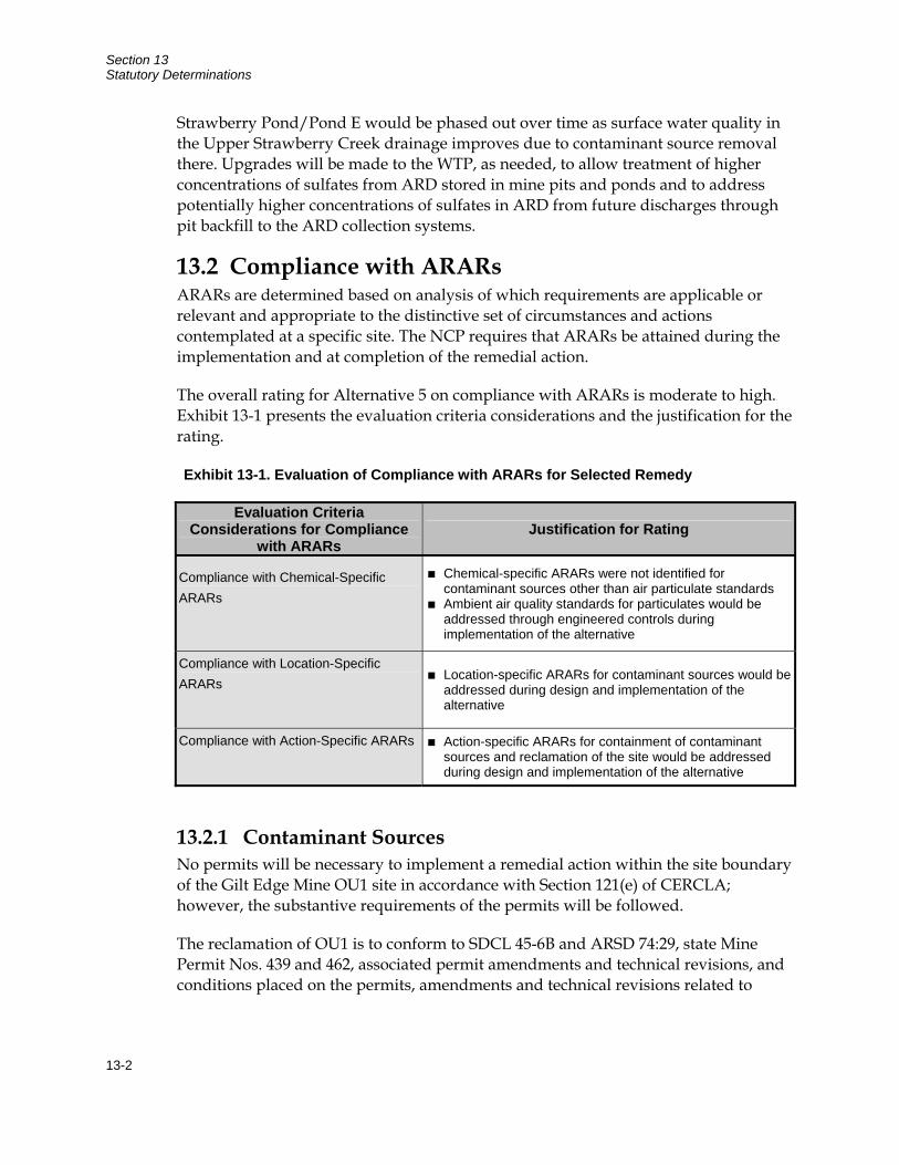
Section 13 Statutory Determinations
13-2
Strawberry Pond/Pond E would be phased out over time as surface water quality in the Upper Strawberry Creek drainage improves due to contaminant source removal there. Upgrades will be made to the WTP, as needed, to allow treatment of higher concentrations of sulfates from ARD stored in mine pits and ponds and to address potentially higher concentrations of sulfates in ARD from future discharges through pit backfill to the ARD collection systems.
13.2 Compliance with ARARs ARARs are determined based on analysis of which requirements are applicable or relevant and appropriate to the distinctive set of circumstances and actions contemplated at a specific site. The NCP requires that ARARs be attained during the implementation and at completion of the remedial action.
The overall rating for Alternative 5 on compliance with ARARs is moderate to high. Exhibit 13-1 presents the evaluation criteria considerations and the justification for the rating.
Exhibit 13-1. Evaluation of Compliance with ARARs for Selected Remedy
Evaluation Criteria Considerations for Compliance
with ARARs Justification for Rating
Compliance with Chemical-Specific ARARs
Chemical-specific ARARs were not identified for contaminant sources other than air particulate standards
Ambient air quality standards for particulates would be addressed through engineered controls during implementation of the alternative
Compliance with Location-Specific ARARs
Location-specific ARARs for contaminant sources would be addressed during design and implementation of the alternative
Compliance with Action-Specific ARARs Action-specific ARARs for containment of contaminant sources and reclamation of the site would be addressed during design and implementation of the alternative
13.2.1 Contaminant Sources No permits will be necessary to implement a remedial action within the site boundary of the Gilt Edge Mine OU1 site in accordance with Section 121(e) of CERCLA; however, the substantive requirements of the permits will be followed.
The reclamation of OU1 is to conform to SDCL 45-6B and ARSD 74:29, state Mine Permit Nos. 439 and 462, associated permit amendments and technical revisions, and conditions placed on the permits, amendments and technical revisions related to
Section 13 Statutory Determinations
13-3
cleanup under OU1. The reclamation goal for OU1 as set by state Mine Permit Nos. 439 and 462 is forest/forested meadows. The forest meadows reclamation type is to be used on covered areas and the forested type was to be used on areas where waste has been removed.
13.2.2 Surface Water The State of South Dakota has promulgated specific water quality standards applicable to the use designation of Bear Butte and Strawberry Creeks. Those standards will be applied to all contaminants of concern, both to point sources affected or created by the cleanup and to ambient water discharged as part of OU2 operations.
Surface water is impacted by contributions of contaminated groundwater and stormwater runoff. The Selected Remedy will reduce the generation of ARD from contaminant source areas which will be beneficial to both groundwater and surface water. It is not anticipated that the Selected Remedy will have an adverse impact on any floodplains or wetlands.
Stormwater discharge best management practices will be implemented during construction based on site-specific evaluation. These controls may include, but are not limited to: stormwater retention basins, rerouting, and engineered sediment controls. The stormwater BMPs, in conjunction with the water collection and treatment systems operated under OU2, will allow the state surface water ARARs to be met. This will require adherence to the substantive requirements of the general stormwater permits for certain activities and refer to the requirement of best management practices to minimize or prevent discharge that may adversely affect human health or the environment. The long-term collection and rerouting of stormwater runoff will continue under OU2 operations until levels of ARD are sufficiently reduced.
A monitoring program will evaluate the impacts of the stormwater BMPs on receiving water quality. Additional controls will be implemented if the monitoring program indicates further action is needed. The monitoring program may be implemented in conjunction with OU2 operations.
This combination of monitoring and controls is expected to gradually reduce concentrations of contaminants in surface water, allowing eventual achievement of the concentration-specific ARARs. The ARARs allow for the gradual attainment of requirements in already impacted streams, with the goal of eventual attainment of ARARs. The preferred remedies also specify the use of LUCs and an operation and maintenance program to ensure the success of the remedial actions.
Section 13 Statutory Determinations
13-4
13.2.3 Other ARARs Several federal location-specific ARARs are applicable to OU1 and will be met by the Selected Remedy through consultation with the appropriate state and federal agencies and other resources. These ARARs include a variety of acts designed to protect endangered species, bald eagles, and migratory birds and encourage historic, archeological, and antiquities preservation. EPA will involve the U.S. Fish and Wildlife Service and historical preservation agencies in remedial design to ensure compliance with these ARARs.
Federal and state standards for air1 are action-specific ARARs at OU1. These standards are applicable to releases of particulate matter during remediation. EPA anticipates that these ARARs can be met through the implementation of appropriate standard operating procedures and monitoring.
13.3 Cost Effectiveness In EPA’s judgment, the Selected Remedy is cost effective and represents a reasonable value for the money to be spent. In making this determination, the following definition was used: “A remedy shall be cost effective if its costs are proportional to its overall effectiveness” [NCP §300.430(f)(1)(ii)(D)]. This was accomplished by evaluating the overall effectiveness of the Selected Remedy and comparing that effectiveness to the overall costs. Overall effectiveness was evaluated by examining how the Selected Remedy meets three of the balancing criteria in combination – long-term effectiveness and permanence; reduction in toxicity, mobility, and volume; and short-term effectiveness. Overall effectiveness of the remedial alternatives was then compared to costs to determine cost effectiveness. The relationship of the overall effectiveness of the alternatives was not necessarily proportional to costs.
It is important to note that more than one cleanup alternative may be cost effective, and that Superfund does not mandate the selection of the most cost-effective cleanup alternative. In addition, the most cost-effective remedy is not necessarily the remedy that provides the best balance of tradeoffs with respect to the remedy selection criteria nor is it necessarily the least costly alternative that is both protective of human health and the environment and ARAR compliant.
Net present value costs for each alternative were compared in the FS, and a range of costs for each alternative was developed that represents the range and possible scope of actions. The cost of the Selected Remedy is expected to be $50,340,000. EPA believes an appropriate balance between cost effectiveness and adequate protectiveness is achieved in the Selected Remedy.
1 Federal Clean Air Act(40 CFR 50.6) and Clean Air Act of MT (ARM 17.8.233)
Section 13 Statutory Determinations
13-5
13.4 Utilization of Permanent Solutions and Alternative Treatment (or Resource Recovery) Technologies to the Maximum Extent Practicable
This determination looks at whether the Selected Remedy provides the best balance of trade-offs among the alternatives with respect to the balancing criteria set forth in NCP §300.430(f)(1)(i)(B), such that it represents the maximum extent to which permanence and treatment can be practicably utilized at this site. NCP §300.430(f)(1)(ii)(E) provides that the balancing shall emphasize the factors of “long-term effectiveness” and “reduction of toxicity, mobility, or volume through treatment,” and shall consider the preference for treatment and bias against offsite disposal. The modifying criteria were also considered in making this determination.
EPA has determined that the Selected Remedy represents the maximum extent to which permanent solutions and treatment technologies can be used in a cost-effective manner at OU1. Of those alternatives that are protective of human health and the environment and comply with ARARs, EPA has determined that the Selected Remedy provides the best balance of trade-offs in terms of the five balancing criteria, while also considering the statutory preference for treatment as a principal element and bias against offsite treatment and disposal, and considering State and community acceptance.
Mine wastes and contaminated soils at OU1 are generally of large volume and low contaminant of concern concentration, which is difficult to treat effectively. In addition, technical difficulties prevent effective treatment of various metals. Thus, active treatment was screened out as a potential option for the contaminant sources and long-term effectiveness is achieved through maintenance, monitoring, and engineered controls. Compared to the large-scale partial and total removal options, the Selected Remedy is expected to have greater short-term effectiveness with a lower level of risk to the community, cleanup workers, and the environment. The Selected Remedy was also among the more implementable of the remedial alternatives considered.
Water treatment is being conducted at the site, although not under OU1. Under the Selected Remedy (Alternative 5: Anchor Hill Pit ARD Collection/WTP Upgrade/Fill Removal, Consolidation, and Cover/LUCs) contaminated water from OU1 is collected, contained, and routed to the WTP for treatment and discharge under OU2.
13.5 Preference for Treatment as a Principal Element Treatment does not constitute a major component of the remedy for OU1 and the Selected Remedy does not satisfy the statutory preference for treatment as a principal element. EPA has determined that the source materials present in OU1 do not represent a principal threat, thus eliminating the expectation for treatment of these
Section 13 Statutory Determinations
13-6
source materials. Although present in large volumes, source materials within OU1 are low in toxicity, can be reliably contained, and present only a relatively low risk in the event of exposure.
13.6 Five-Year Reviews Because the Selected Remedy results in contaminants remaining on site above levels that allow for unlimited use and unrestricted exposure, a statutory review will be conducted pursuant to CERCLA §121(c) and NCP §300.430(f)(5)(iii)(C). EPA shall conduct a review of remedial actions no less often than each 5 years after the initiation of such remedial action to assure that the remedy is, or will be, protective of human health and the environment.
14-1
Section 14 Documentation of Significant Changes
The Proposed Plan for the Gilt Edge OU1 was released for public comment in May 2008. It identified Alternative 5 as the preferred alternative. That alternative is described herein as the Selected Remedy. The public comment period was extended from 30 to 60 days, and EPA reviewed all written and verbal comments submitted during that comment period. It was determined that no significant changes to the remedy, as originally identified in the Proposed Plan, were necessary.

Section 14 Documentation of Significant Changes
14-2
This page intentionally left blank
15-1
Section 15 References
CDM, 2008a. Gilt Edge Superfund Site, Lawrence County, South Dakota, Remedial Investigation Report for the Gilt Edge Superfund Site. February.
____, 2008b. Gilt Edge Superfund Site, Lawrence County, South Dakota, Feasibility Study for the Gilt Edge Superfund Site Operable Unit 1 (OU1). May.
United States Environmental Protection Agency (EPA). 2001a. Interim Water Treatment Plant Operations, Gilt Edge Mine NPL Site, Lawrence County, South Dakota. April.
____, 2001b. Interim Record of Decision, Operable Unit 3 (OU3), Ruby Gulch Waste Dump. Gilt Edge Mine NPL Site, Lawrence County, South Dakota August.
____, 2001c. Interim Record of Decision, Operable Unit 2 Interim Water Treatment Plant Operations, Gilt Edge Mine NPL Site, Lawrence County, South Dakota. November.

Section 15 References
15-2
This page intentionally left blank
RECORD OF DECISION FOR
GILT EDGE MINE SUPERFUND SITE OPERABLE UNIT 1
LAWRENCE COUNTY, SOUTH DAKOTA
Part 3
Responsiveness Summary

This page intentionally left blank

EPA Response to Public Comments
EPA received five sets of comments on the Proposed Plan for OU1. EPA has organized its response to these comments by the issues raised by the commenters.
Comments Related to Land Use Controls 1. Comment: The Lawrence County Commissioners support EPA’s preferred Alternative 5
in the Gilt Edge Mine Proposed Cleanup Plan. We support this because this alternative addresses the largest amount of contaminant sources, upgrades the water treatment plant, gets rid of the huge heap leach pad, and implements land use controls. As this site sits within our county boundaries, we want to be included in land use control discussions to insure compliance with our ordinances and regulations. Thank you for your cooperation and considering our comments.
Response: EPA plans to include representatives from Lawrence County in development of land use controls for the site.
Comments Related to Preferred Remedy Costs 2. Comment: I’m glad to see the US EPA has taken over this abandoned gold mine and is
trying to reclaim it. The document states that Alternative 5 will cost $58,541,000. I doubt this cost can be assessed to this level of accuracy because the acid rock drainage (ARD) is to be treated until the water emanating from Ruby Gulch meets South Dakota discharge standards. It seems like there are too many unknowns to predict this with great accuracy.
Response: Costs developed for the remedial alternatives (including the preferred alternative) presented in the Proposed Plan were developed in accordance with EPA cost estimating guidelines for feasibility studies to allow comparison of cost between alternatives, not to provide final construction costs. The accuracy range for these estimates is +50% to -30% of actual costs.
It should also be noted that costs presented for the preferred alternative (Alternative 5) are only for OU1 which doesn’t include water collection and treatment costs. Costs for the final water collection and treatment remedy will be developed as part of another operable unit (OU2).
Comments Related to OU1 Impacts on Water Treatment 3. Comment: The FS Appendix mischaracterized the objectives of the Anchor Hill pit lake
treatability study (conducted by Green World Science whose patents and technology are now owned by Alexco). The Treatability Study was undertaken to determine a) if the in-pit treatment could remove 90% of the toxic heavy metals from the water column, (an
objective that we attained easily), and b) the extent to which the removal of these toxic metals enabled consideration of other, more passive means of water treatment such as wetlands or bioreactors, methods that would substantially reduce costs of water treatment for the Site.
As this Proposed Plan only deals with OU1, and doesn’t purport to deal with water treatment, it isn’t clear to us why the supporting FS even addressed our patented technology for the Anchor Hill water treatment study? It seems improper to review a water treatment technology in the context of a Plan that doesn’t even purport to address water treatment issues. It also is ironic that the Anchor Hill Treatability Study was awarded the 2006 E3 Honors Award for “best small project” by the American Academy of Environmental Engineers, while this plan sweeps it aside without proper consideration of the site-wide potential beneficial impacts.
Response: The FS for OU1 was developed to identify and evaluate remedial alternatives for the contaminant sources (waste rock and fills, bedrock, and sludge). Contaminated water was evaluated in the OU1 FS only to determine relative risk reductions for uncontrolled releases of ARD through addressing the contaminant sources. Evaluation of alternatives for contaminated water collection and treatment will be addressed as part of the final remedy for another operable unit (OU2).
Appendix A of the FS included a summary of treatability studies completed at the site; the Anchor Hill Pit Treatability Study was one of several studies conducted at the site. The summaries were not included to suggest that potential water treatment remedies were either included or excluded from further evaluation; that evaluation will be performed as part of the final remedy for OU2.
4. Comment: This proposed plan prejudices the eventual selection of water treatment methodologies. By proposing to backfill the Sunday and Dakota Maid pits, they can never be used as open vessel water treatment reactors.
Response: The commenter is correct that remedial alternatives in the FS include the consolidation and containment of contaminant sources within mine pits, which would make them unavailable for open storage and/or treatment of ARD. One of the major contamination problems at the Gilt Edge site is the generation of large volumes of ARD that must be stored prior to treatment. The FS for OU1 evaluated consolidation of contaminant sources to reduce the volume of ARD generated. The only suitable locations with sufficient storage volume for consolidation of contaminant sources outside of drainages are the mine pits. It should be noted that the preferred alternative keeps Anchor Hill Pit left as an open location for ARD storage and/or treatment as part of OU2 water collection and treatment operations.
5. Comment: Because water collection and treatment will be required perpetually in this proposed scenario, it isn’t clear to me why this Plan has not fully disclosed the projected costs of perpetual water treatment (per the Interim Rod for water treatment, plus
upgrades to attain selenium, nitrate and TDS standards costing at least $1.6M – 2M+/yr)?
The citizens of South Dakota should be aware that this level of unfunded commitment will end up costing the State’s balance sheet over 40% of its entire unrestricted net assets (which are only about $165 million), thereby requiring an accounting adjustment that will dramatically increase their costs of borrowing, and restrict their flexibility to make other investments in any other projects. It isn’t right to make OU1 decisions that lock in choices for other Operable Units without disclosing the financial impacts of those decisions.
Response: The proposed plan for OU1 does not include water collection and treatment costs because they were evaluated by the previous Water Treatment Operations Interim Record of Decision (ROD) for Operable Unit 2. After the OU1 remedy is implemented and its results are fully analyzed, a final water treatment remedy will be selected and implemented through a final ROD for OU2 and the costs associated with such remedy will be fully assessed as part of this process.
EPA cannot comment on the status of State budgets, assets, or balance sheets. However it should be noted that South Dakota has concurred with EPA on proposing Alternative 5 as the preferred alternative for OU1. Also, Alternative 5 results in the greatest reduction of ARD generated and collected for treatment over time, so it is expected that related long-term water collection and treatment costs will be minimized through Implementation of this alternative relative to other alternatives evaluated for OU1.
5. Comment: Redevelopment opportunities for the site will be forever negatively impacted by these proposed actions. It is not necessary to leave the Anchor Hill pit filled with acid water. We [Green World Sciences] demonstrated that the water can be made good enough to drink – Ken Wangerud drank a glass from it (live on KOTA – TV news), as did I and numerous other site visitors. By leaving the pits filled with acid water and by necessity barb-wire fenced off (under the proposed institutional controls), the golden opportunity to create developable land for community growth, or any other community benefit, will have slipped away.
Response: The preferred alternative includes consolidation of contaminant sources from across the site and consolidation of these sources into mine pits that have limited utility for redevelopment opportunities. The preferred alternative likely provides more redevelopment opportunities than alternatives with unconsolidated contaminant sources and open mine pits, as the area of capped mine waste is minimized and the area where mine waste is removed and reclaimed is maximized. Further, EPA evaluated the Green World Sciences technology and determined that it would not be effective at this site given the large volumes of ARD that are continuously generated.
Extensive comments were submitted to EPA on behalf of Cyprus Amax Minerals Company (CAMC). EPA’s responses, organized by the issues raised by the commenter, are as follows.
Overview of CAMC’s Comments 6. Comment: The Proposed Plan does not adequately consider the interrelationship
between Operable Unit (OU) 1 and OU2; EPA should reevaluate and consider changes to the Proposed Plan for OU1. (CAMC pg. 2)
Response: Three OUs are currently defined at the site as presented in Section 1.2 of the Final FS Report:
OU1, Primary Mine Disturbance Area. Addresses existing contaminant sources within the primary mine disturbance area such as acid generating waste rock and fills, spent ore, exposed acid generating bedrock, and sludge.
OU2, Water Treatment, Groundwater, and Lower Strawberry Creek. Addresses (1) management of ARD generated at the site including ARD collection systems, pumping stations, pipelines, water treatment, and management of ARD treatment sludge generated in the future; (2) groundwater contamination associated with the site; and (3) contaminant sources, surface water, and sediments in the Lower Strawberry Creek area.
OU3, Ruby Gulch Waste Rock Dump. Addresses contaminant sources located within the Ruby Gulch waste rock dump.
The preferred alternative set forth in the Proposed Plan for OU1 is designed to reduce the likelihood of a catastrophic release of ARD, limit exposure to contaminated materials, and reduce the creation of ARD. The Final FS Report did consider the interrelationship between the three OUs, which is also reflected in the preferred alternative presented in the Proposed Plan. The preferred alternative for OU1 includes several components that will improve site conditions for implementation of the final remedy for OU2. These include:
(1) Removal and consolidation of contaminant sources to locations outside of drainages
(2) Removal of pit and pond sludge with greater potential for contaminant loads to lined upland disposal locations
(3) Placement of contaminant sources with relatively lower potential for contaminant loads within the submerged portions of pits (reclamation fill)
(4) Installation of covers over consolidated contaminant sources to reduce infiltration and leaching of contaminants to surface water and groundwater
(5) Control of groundwater within the submerged portion of the pits to reduce the groundwater gradient away from the pits and minimize contact with contaminant sources containing higher contaminant loads (general fills)
(6) Implementation of institutional controls to prevent unacceptable uses of groundwater that pose human or ecological risks
In the analysis of alternatives, EPA has addressed the interrelationships between OU1 and OU2 in terms of reductions in ARD yield at the site and the related reductions in the risk of an uncontrolled ARD release. EPA expects that the implementation of the OU1 remedy will significantly decrease the extent of groundwater contamination at the site both in volume and concentration. Further, EPA disagrees with CAMC’s recommendations for changes to the Proposed Plan for OU1 for the reasons set forth below.
1. CAMC RECOMMENDATION: Modify the OU approach for the Site and revised the FS for OU1 to comprehensively address not only source control/earthwork component of the remedy that were evaluated in the FS, but also groundwater remedy as well as planned upgrades to the water treatment plant.
EPA RESPONSE: The current OU approach is appropriate for the site because it allows EPA to remediate contaminate sources now, determine impacts to groundwater and surface water, and then propose remedies appropriate for groundwater and surface water as part of the final remedy for OU2. The approach advocated by CAMC could result in the consideration of alternatives that are not cost effective or fully protective of human health and the environment. Contaminated water (ARD and groundwater) is a component of every OU. All interim Records of Decision implemented at the site address control of contaminant transport in groundwater through continued operation and/or improvements to the ARD collection and treatment infrastructure.
The planned source control/earthwork activities associated with the Preferred Alternative for OU1 will reduce ongoing contaminant discharge to groundwater from onsite contaminant source materials in the Strawberry Creek and Hoodoo Gulch drainages. The planned source control/earthwork activities will also reduce recharge to groundwater in Sunday and Dakota Maid pit. This is expected to reduce the overall long-term costs of water collection and treatment at the site. A phased approach that next focuses on surface contamination and pit lakes makes the most sense because it will allow EPA to gather valuable data and information about contaminant concentrations and volume reductions before having to select a final remedy for groundwater and water collection and treatment. Previous remedial actions addressing groundwater associated with OU1, OU2, and OU3 will continue to be implemented until that time.
It should be noted that continued collection and treatment of groundwater is expected from Sunday Pit, Dakota Maid Pit, and the Ruby Repository so new subsurface infrastructure for ARD collection within the covered consolidation areas is a component of the OU1 remedy. If needed, groundwater can be treated in situ or ex situ. Consolidating and covering the contaminant sources do not preclude either of these treatments. Institutional controls will also be established as a component of the OU1 remedy to prevent unacceptable uses of groundwater that pose human or ecological risks.
Planned upgrades to the water treatment plant as a component of the Preferred Alternative for OU1 include increased clarifier capacity and other changes to facilitate treatment of ARD with higher mass loading as part of OU2 operations. Additional upgrades to the ARD collection and treatment system may be necessary after implementation of the OU1 remedy and would be part of the final remedy for OU2.
2. CAMC RECOMMENDATION: Develop more specific preliminary remedial action objectives including PRAOs for groundwater protection, against which modified or additional alternatives should be evaluated.
EPA RESPONSE: The current preliminary remedial action objectives (PRAOs) for OU1 adequately address groundwater protection through management of contaminant sources to reduce the volume of ARD generated and the use of institutional controls to prevent the unacceptable uses of groundwater that pose human health and ecological risks. Thus, EPA does not believe that more specific preliminary remedial action objectives including PRAOs for groundwater protection are warranted at this time.
Under the NCP, remediation may be conducted in operable units (OUs) when phased analysis and response is necessary or appropriate given the size or complexity of the site. This is the case at the Gilt Edge Mine Site. As previously stated, OU1 is a containment remedy that emphasizes site-wide consolidation and containment of contaminant sources to reduce the volume of ARD collected for storage and treatment under OU2. The information and data collected after implementation of OU1 will assist decision makers in determining the remedial action required in the OU2 Final ROD, which will include the final water collection and treatment plan, including a groundwater monitoring plan, for the site. At that time, specific PRAOs that address human health and ecological risks posed by residual groundwater contamination downgradient of the primary mine disturbance area and along Strawberry Creek will be developed.
3. CAMC RECOMMENDATION: Modify the existing alternatives or develop new alternatives to maximize the diversion of clean water around and through the Site to reduce the volume of water that comes in contact with ARD generating materials, thereby reducing the volume of ARD.
EPA RESPONSE: EPA evaluated alternatives that maximize the diversion of clean water around and through the Site. EPA evaluated the creation of clean water corridors for major drainages through the site by removing and consolidating contaminant sources to locations outside of these drainages for Alternatives 3, 4, and 5 (discussed in Sections 5.3.3 through 5.3.6 of the Final FS Report). EPA then determined that Alternative 5, the preferred alternative, was the appropriate remedy for the Gilt Edge OU1. It was chosen because it is protective of human health and the environment, complies with all Federal and State requirements, is cost effective, and utilizes permanent solutions and alternative treatment technologies to the maximum extent practicable. This approach also will reduce the volume of ARD generated and captured for treatment as compared to current conditions.
4. CAMC RECOMMENDATION: Evaluate ARD sources with regard to the relative mass loading of contaminants so that scarce non-acid generating materials available at the Site can be used to isolate the sources with the greatest contribution to mass loading.
EPA RESPONSE: EPA considered mass loading in the RI by evaluating both flow and chemistry of ARD sources. Pertinent sections of the RI include Sections 3.8 (Site Water Balance), 4.2 (Contaminant Sources) and 4.4 (Acid Rock Drainage). Mass loading is addressed for contaminant sources through evaluation of the load of stored water soluble contaminants and future potential to generate acid. Mass loading is evaluated in ARD through evaluation of the site water balance and evaluation of water chemistry of point sources of ARD and stored ARD.
The mass loading evaluation of the remedial investigation was used to develop remedial alternatives. Specifically, EPA evaluated the sequencing of fill placement within mine pits (general fills with high mass loading vs. reclamation fills with low mass loading) and the removal and isolation of sludge (high mass loading) from surface water and groundwater. Thus, the current level of investigations related to mass loading is adequate to support the alternative evaluations presented in the Proposed Plan.
5. CAMC RECOMMENDATION: Present an evaluation of the modified and/or new alternatives and present a new proposed plan that considers all of the factors required by the NCP, including effectiveness in protecting groundwater.
EPA RESPONSE: EPA does not need to modify and/or create new alternatives and present a new proposed plan, as CAMC suggests. Under the NCP, EPA is allowed to remediate a site in OUs. In the case at hand, EPA is adopting a containment remedy first (OU1), then will implement a final water collection and treatment plan, including a groundwater monitoring plan. These issues will be deferred to the final remedy for OU2 because EPA recognizes that additional remedial actions for contaminated water may be necessary in a future ROD and that implementation of the OU1 remedy will likely change the contaminant concentrations and reduce volume of contaminated water from current conditions.
Meanwhile, EPA has evaluated alternatives for OU1 that include components that reduce the volume of ARD and spread of groundwater contamination, in accordance with the NCP. These include:
(1) Removal and consolidation of contaminant sources to locations outside of drainages
(2) Removal of pit and pond sludge with greater potential for contaminant loads to lined upland disposal locations
(3) Placement of contaminant sources with relatively lower potential for contaminant loads within the submerged portions of pits (reclamation fill)
(4) Installation of covers over consolidated contaminant sources to reduce infiltration and leaching of contaminants to surface water and groundwater
(5) Control of groundwater within the submerged portion of the pits to reduce the groundwater gradient away from the pits and minimize contact with contaminant sources containing higher contaminant loads (general fills).
Comments Related to the Designation of Operable Units (OUs) 7. Comment: The approach taken in the Feasibility Study (FS) is inconsistent with EPA’s
description of how it intended to proceed with OU 1 as described in November 2001 Interim Action Record of Decision (ROD) for OU2 (CAMC pg. 3, paragraph 2).
Response: The Interim ROD for OU2 indicated that OU1 (Site-Wide Gilt Edge Mine) would address contamination of the overall sources and all components of the site including final water treatment plans (i.e. OU2) and the Ruby Waste Rock Dump (i.e. OU3). However, the OU definitions for the site were modified during completion of the remedial investigation/feasibility study (RI/FS) process in 2007-2008 to address the current understanding of site conditions and risks. These modifications consist of addressing ARD collection/treatment, groundwater, and contamination issues related to Lower Strawberry Creek as part of the final remedy for OU2.
OU1 is primarily oriented toward addressing contaminant sources (waste rock and fill, bedrock, and sludge). Contaminated water (ARD and groundwater) will be deferred to the final remedy for OU2 because EPA recognizes that additional remedial actions for contaminated water may be necessary in a future ROD and that implementation of the OU1 remedy will likely change the contaminant concentrations and reduce volume of contaminated water from current conditions. Lower Strawberry Creek was deferred to the final remedy for OU2 because biological monitoring indicates that aquatic communities are improving in Lower Strawberry Creek, reflecting beneficial effects of previous remedial actions. Deferring potential action in the Lower Strawberry Creek area facilitates evaluation of improving conditions (including beneficial impacts from the OU1 remedy) prior to a decision to address relic tailings and other issues in Lower Strawberry Creek.
8. Comment: The alternatives evaluated in the FS neglect to consider some critical options, including the movement of clean water around the site as a means of reducing the volume of ARD generated at the site. (CAMC pg. 5, paragraph 3)
One of the best ways to reduce groundwater impacts and to reduce the volume of ARD at the same time is to move clean water through and around the site… (CAMC pg. 5, paragraph 3)
Response: EPA has considered movement of clean water around the site as a means of reducing the volume of ARD generated at the Site. Movement of clean water around the site has been an important component of OU2 activities since remedial actions commenced at the site. Continued operation of these structures (without contaminant source removals) was evaluated as a component of Alternatives 2a and 2b of the OU1 FS (as discussed in Sections 5.3.2 and 5.3.3 of the final FS report).
Alternatives 3, 4, and 5 (as discussed in Section 5.3.4 through 5.3.6 of the Final FS report) would improve the movement of clean water around and through the site by establishing clean water corridors in the Strawberry Creek and Hoodoo Gulch drainages.
9. Comment: The lack of consideration of groundwater in the alternatives analysis for OU1 is in part due to the disconnection from the OU-2 analyses … and is indicative of poor characterization of subsurface hydrology and vadose-saturated zone interactions (CAMC pg. 12, paragraph 2)
Response: The level of consideration of groundwater in the OU1 alternatives analysis is directly related to the OU definitions set forth by EPA. OU1 primarily evaluates the remediation of contaminant sources.
EPA believes the level of characterization of subsurface hydrology and vadose-saturated zone interactions is adequate for the purposes of selecting a remedy for OU1. Information on the characterization specifically referenced in the comment is presented in Sections 3.6 and 3.7 of the Final RI report.
Comments Related to Potential Adverse Effects of OU1 Action on Future OU2 Actions 10. Comment: CAMC strongly believes that deferral of remedial action for groundwater
means that one of the most important implications for evaluation of the OU1 alternatives, protection of groundwater, is given no consideration…Groundwater at the site is connected to surface water, so it is unreasonable to attempt to evaluate risk reduction at the site with respect to surface water without considering how the alternatives will impact the extent and ability to control and contain groundwater contamination. (CAMC pg. 3 paragraph 4)
Response: As stated previously, groundwater issues at the site cross boundaries of all OUs and mitigation of contaminant transport in groundwater is a component of all previous remedial actions as well as the Proposed Action.
The Preferred Alternative provides for reduction of contaminant discharges from ARD source materials to groundwater through source material consolidation, reduction of infiltration in the Sunday and Dakota Maid pit areas through installation of low permeability covers, and ongoing collection and treatment of groundwater.
EPA has determined that it is most appropriate to evaluate final remedial actions related to groundwater as part of a subsequent OU2 remedial action.
11. Comment: The Proposed Plan does not adequately consider…the potential adverse effect of the proposed OU-1 remedial actions on OU-2 conditions and future remedial alternatives for OU-2. (CAMC pg.2, paragraph 1)
If EPA were to select and implement the OU1 remedy … it would likely result in both the expansion of groundwater contamination and preclusion of alternatives for collection and containment of groundwater contamination. (CAMC pg. 4, paragraph 1)
…Selection of a remedy for OU1, which clearly will affect groundwater cleanup ..., should address how the OU1 remedy is consistent with and will not preclude the expected final remedy for groundwater in the underground workings and elsewhere at the site. (CAMC pg. 4, paragraph 2)
CAMC believes that consideration also should be given to backfilling open pits in a manner that facilitates continued collection of groundwater from the open pits, if necessary. (CAMC pg. 6, paragraph 3)
Response: There is no basis to suggest that implementation of the OU1 remedial action would result in both expansion of groundwater contamination and preclusion of alternatives for collection and containment of groundwater contamination.
The Preferred Alternative would remove ARD source materials from large areas of the site within Strawberry Gulch and Hoodoo Gulch, which currently discharge ARD-related contaminants to underlying groundwater; it provides for removal of pit lakes at Dakota Maid and Sunday Pits which directly contribute to contaminant migration in groundwater; it removes water treatment plant sludge from the base of the pits, which contributes to current very high mass loading in ARD at base of the pit lakes; it provides for collection and treatment of groundwater in the Sunday and Dakota Maid pit areas; and it facilitates a reduction of groundwater recharge in the Sunday and Dakota Maid pit areas through diversion of a portion of the precipitation reporting to the basins with low permeability covers.
The Preferred Alternative does not preclude collection and containment of groundwater contamination in the Sunday and Dakota Maid pit areas, because the plan includes installation of groundwater collection facilities. The specific design of these facilities and the extent to which they dewater underground workings associated with the pits will be determined in remedial design.
EPA recognizes that groundwater issues will remain at the site after completion of OU1 remedial actions. These issues include the presence of small ARD seeps in Ruby Gulch and Strawberry Creek, which may require installation of additional ARD collection infrastructure. EPA has determined that these issues will be addressed in a subsequent OU2 remedial action and that the current OU1 remedial action will not adversely impact the selection or implementation of the OU2 remedial action.
12. Comment: CAMC suggests that sludges should not be removed (from the Dakota Maid and Sunday pits) because disturbance and removal likely would remobilize metals leaching, particularly in the short term. (CAMC pg. 8, paragraph 3)
Response: As described in the RI, it has been shown that the water treatment sludges in the base of the Sunday and Dakota Maid pits are not stable under strongly acidic conditions, and that these sludges contribute to increased mass loading in the base of the pit lakes and adjacent groundwater. Removal of the sludge also has implementability and safety benefits related to backfilling of the pit. Since the sludge has a low solids content, use of heavy equipment over the sludge in its current configuration is not
feasible unless layers of coarse rock are placed in the sludge for stability before backfilling of reclamation fills could begin. Also, because the sludge currently obscures the underground workings within the submerged portions of the pit, there are safety concerns related to subsidence or collapse of bridged fill materials over the underground workings. Removal of the sludge will reduce or eliminate many of these implementability and safety issues.
Removal of these sludges would be accomplished by pumping the sludge in a dedicated pipeline directly to a lined sludge storage facility located in the area of the HLP. It is unlikely that this process would result in significant remobilization of metals.
13. Comment: …if groundwater levels fluctuate in the Dakota Maid Pit and Sunday Pit areas, the interface of groundwater and air where much ARD is generated will move up and down though unconsolidated ARD-generating materials, resulting in significant ARD generation. (CAMC pg. 9, paragraph 3)
Response: EPA does not expect major fluctuations in the levels of groundwater in the Dakota Maid Pit and Sunday Pit areas when the preferred alternative to OU1 is implemented. A major purpose of the proposed groundwater collection facilities in the Sunday and Dakota Maid pit areas is maintaining a water table within the pit backfill that minimizes fluctuation. This is critical to remedy performance because intermittent saturation of ARD generating source materials would facilitate additional transport of ARD-related contaminants from fill rock into groundwater.
14. Comment: …there is no evidence or scientific analysis that determines that the flow of air through these systems will be reduced or eliminated (within backfills in Sunday and Dakota Maid pits), which promotes continued production and discharge of ARD into the groundwater system in perpetuity. (CAMC pg. 10, paragraph 2)
Response: The Preferred Alternative does not propose reduction or elimination of air flow into the backfills in Sunday or Dakota Maid pits. Generation of ARD requires three components: an oxygen source (or oxidized dissolved species such as ferric iron), water, and sulfide minerals such as pyrite. The Preferred Alternative relies on interception of precipitation and maintenance of a stable water table to reduce production and discharge of ARD.
15. Comment: …the current Ponds D and E will be removed as part of the reclamation plans (encompassed in the preferred alternative) offering no contingency for collecting ARD from the (King and Langley) adits (and the Wood Weir). This contradicts the reclamation goal of reducing sources of ARD generation. (CAMC pg. 10, paragraph 2)
The FS does not directly address control of the Wood Weir and King Adit discharges. However, the FS indicates that collection systems would be installed at the base of the Dakota Maid and Sunday Pit cover systems. It is unclear if these control systems are also meant to control flow from these adits. (CAMC pg. 14, paragraph 2)
Response: The rock used in construction of Ponds D and E is classified as general fill, which is shown to be a source of ARD generation in the remedial investigation. Therefore, removal of Ponds D and E does not contradict the reclamation goal of reducing sources of ARD generation, because the rock used in construction of the ponds is an ARD source. The area of the King and Langley adits and the wood weir would be encompassed by the planned repositories at Dakota Maid and Sunday pit. ARD collection in this area would be a component of the planned groundwater collection systems. The toe of the proposed pit backfills in Sunday and Dakota Maid pits would extend to the approximate location of the King and Langley adits and the Wood Weir. The groundwater collection system proposed for the Sunday and Dakota Maid pit area would provide for collection of ARD reporting to the King and Langley adits and the Wood Weir.
Comments Related to FS Alternatives and Preferred Alternative 16. Comment: The alternatives discussed in the FS do not emphasize the need to divert
clean surface water runoff around and/or through the site… (CAMC pg. 5, paragraph 4)
None of the alternatives appear to include concepts or designs for control structures that could route surface runoff away from the most ARD-generating materials…(CAMC pg. 5, paragraph 5)
In the absence of capturing and moving clean water around and through the site, one must assume that all water gets directed to Anchor Hill pit, both clean and ARD, and that all water becomes ARD as a result of mixing. (CAMC pg. 13, paragraph 3)
Response: Alternatives 3, 4, and 5 (discussed in Sections 5.3.3 through 5.3.6 of the Final FS Report) include creation of clean water corridors for major drainages through the site by removing and consolidating contaminant sources to locations outside of these drainages. This component of the alternatives will reduce the volume of ARD generated and captured for treatment as compared to current conditions.
17. Comment: The alternatives … fail to reflect all of the problems of the site being addressed, including other ways of reducing the volume of ARD and reducing and preventing the spread of groundwater contamination. (CAMC pg. 5, paragraph 2)
Response: Alternatives 3, 4, and 5 include components that reduce the volume of ARD and spread of groundwater contamination. These include:
(1) Removal and consolidation of contaminant sources to locations outside of drainages
(2) Removal of pit and pond sludge with greater potential for contaminant loads to lined upland disposal locations
(3) Placement of contaminant sources with relatively lower potential for contaminant loads within the submerged portions of pits (reclamation fill)
(4) Installation of covers over consolidated contaminant sources to reduce infiltration and leaching of contaminants to surface water and groundwater
(5) Control of groundwater within the submerged portion of the pits to reduce the groundwater gradient away from the pits and minimize contact with contaminant sources containing higher contaminant loads (general fills)
18. Comment: Other options for pit backfilling should have been considered, including backfilling only as necessary to achieve positive drainage … and in a manner that allows for some use of the open pits for groundwater capture and containment. (CAMC pg. 5, paragraph 3)
Another alternative that should be considered is to backfill open pits only as necessary to establish positive drainage from the open pit areas. (CAMC pg. 6, paragraph 2)
Response: Alternatives 3, 4, and 5 were structured to evaluate increasing degrees of contaminant source consolidation and containment within mine pits. Alternative 4 in particular was evaluated using partial backfills within Dakota Maid and Sunday Pits, as the HLP (a large volume of contaminant sources) is not offloaded in that alternative.
While these alternatives do not leave backfilled pits with open area for surface ARD storage, all three of the alternatives include use of ARD collection and pumping systems to capture and treat groundwater within the submerged fills in pits and reduce groundwater gradients away from the pits.
19. Comment: Assessment of reduction of ARD should consider reduction in mass loading as much as reduction in volume…the pollutant load and concentrations have a greater impact on water treatment plant design and water treatment costs than the volume of water requiring treatment. (CAMC pg. 7, paragraph 3).
EPA should include consideration of mass loading in its characterization of ARD sources in the FS … (CAMC pg. 13, paragraph 2)
Response: EPA considered mass loading from ARD sources to contaminated water in the RI and in the FS by evaluating both volume and concentrations. Alternatives 3, 4, and 5 addressed mass loading from contaminant sources to contaminated water in the following manner:
(1) Removal and consolidation of contaminant sources to locations outside of drainages
(2) Removal of pit and pond sludge with greater potential for contaminant loads to lined upland disposal locations
(3) Placement of contaminant sources with relatively lower potential for contaminant loads within the submerged portions of pits (reclamation fill)
(4) Installation of covers over consolidated contaminant sources to reduce infiltration and leaching of contaminants to surface water and groundwater
(5) Control of groundwater within the submerged portion of the pits to reduce the groundwater gradient away from the pits and minimize contact with contaminant sources containing higher contaminant loads (general fills)
Detailed assessment of reductions in mass loading of contaminates that will be attained by the Preferred Alternative are not addressed because of uncertainty in future chemical loads, final discharge limits, and ARD yield. The preferred alternative is expected to reduce ARD volumes generated and collected, which can potentially reduce mass loading. However, the degree of mass loading reduction is uncertain and difficult to quantify and remedy selection for OU1 is driven primarily by protection of human health and the environment from the risks posed by the contaminant sources, including the risk of an uncontrolled ARD release. Thus, tenuous forward-looking projections of reductions in mass loading are not necessary as part of OU1 evaluations.
20. Comment: CAMC is concerned that the Proposed Plan and FS do not account for potential short-term increases in ARD generation resulting from the movement and disturbance of ARD-generating materials during and after earthwork at the site. (CAMC pg. 7, paragraph 4)
The extensive movement of ARD-generating materials described in the preferred Alternatives 4 and 5 will re-expose reactive surfaces to air and water thereby increasing the ongoing problem of ARD production. (CAMC pg.8, paragraph 1)
During the estimated two to three year backfilling process, the ARD generating material will be exposed to precipitation and air. The FS and cost estimates do not indicate any funding for temporary, enhanced ARD collection, lining, or covers for the exposed fill before the final geosynthetic cover is installed. (CAMC pg. 8, paragraph 2)
Response: The Preferred Alternative will not result in significant short-term increases in the volume of ARD resulting from movement and disturbance of ARD-generating materials. Currently, all precipitation that falls in areas containing ARD source materials enters the ARD treatment circuit and becomes ARD either through interaction with ARD source materials or mixing with water that has interacted with source materials. During implementation of the Preferred Alternative, no ARD source materials will be moved to areas that do not currently contain ARD source materials. So there will be no significant short-term increase in the volume of ARD generated.
It is possible that movement of ARD generating source materials will result in a short-term increase in mass loading of ARD. This would be expected because disturbing the rock may expose secondary iron sulfate minerals and other products of sulfide oxidation to dissolution by infiltrating water. The proposed modifications to the water treatment plant included in the Preferred Alternative are designed to facilitate treatment of ARD containing higher mass loads.
21. Comment: The FS described a rinse-out ten years before ARD generation might decrease. However, the reasoning or justification for this ten year period is not provided nor the extent of decrease in ARD that would occur over ten years… Consolidation of materials

may seem a good idea, but disturbing material that has arguably made some progress towards equilibrium will exacerbate ARD and expose new sources of water quality degradation. (CANC pg. 8, paragraph 1)
Response: The 10 year rinse out period refers to the expected time required for secondary products of ARD generation to rinse from Strawberry Gulch and Hoodoo Gulch. EPA recognizes that after the ARD source materials are excavated and placed in consolidated backfills, runoff from Strawberry Gulch and Hoodoo Gulch will not immediately meet discharge standards. The 10-year period is based on analogy to excavation of the Spruce Gulch waste dump at the Richmond Hill mine site, which was a strongly acid generating valley-fill waste dump. The Richmond Hill mine is located in the northern Black Hills of South Dakota in similar climatic and geological conditions to the Gilt Edge site. At the Spruce Gulch waste dump, it took approximately 10 years before runoff met discharge standards.
22. Comment: Consolidation of source materials appears to be a primary feature of all of the retained alternatives (3, 4, and 5). However, each of these alternatives involves removing sludge from their current locations in the pits and containing it elsewhere, such as the heap leach pad, because the sludge has the potential to leach metals. At the same time, ARD rock, which also has the potential to leach metals, will be backfilled into the pits. This merely trades one potential source of metals for another in the pits…In fact the sludge may be potentially advantageous for slowing infiltration through the bottoms of the pits, thereby reducing flow to the groundwater system. (CAMC pg. 10, paragraph 3)
Response: As shown in the RI, the sludge stored in the base of the Sunday and Dakota Maid pits is not stable under saturated acidic conditions, and dissolution of the sludge contributes to the current very high mass loading of ARD in the base of the pit lakes and adjacent groundwater. Implementation of the Preferred Alternative would relocate this sludge into a lined storage facility at the HLP.
The Preferred Alternative would place a layered backfill within the Dakota Maid and Sunday pits. The lower portion of the backfill is expected to be exposed to saturated conditions and to be in communication with groundwater. The reclamation fills are proposed for this lower zone because they have the lowest ARD generating potential based on synthetic precipitation leaching procedure data presented in the RI. The use of reclamation fills in the saturated backfill zones reduces the risk of the backfill contributing to mass loading in groundwater.
Saturation of acid generating rock is a beneficial mitigation measure, which significantly reduces ongoing sulfide oxidation by minimizing the amount of oxygen available, relative to exposure to the atmosphere. Significant ongoing sulfide oxidation would not be expected in the saturated backfills. As mentioned previously, an important facet of the planned ARD collection system in Dakota Maid and Sunday pit is maintenance of a stable water table in the saturated backfills.
Available data suggest that the sludges do not provide a significant barrier to isolate the pit from the groundwater system. This is evidenced by very high mass loading in groundwater adjacent to the sludge zone in Sunday Pit.
23. Comment: Placement of all ARD collected from the site in the Anchor Hill pit for storage in advancement of treatment likely will make water quality conditions in the Anchor Hill Pit even worse. The Anchor Hill pit is believed to discharge to groundwater, which most likely moves down the Strawberry Creek drainage…Based on existing information, however, there may be significant discharges of ARD from the Anchor Hill Pit into groundwater under the Proposed Plan. (CAMC pg. 10, paragraph 5)
… addition of ARD water to the Anchor Hill Pit may result in a larger groundwater contamination plume … (CAMC pg. 13, paragraph 1)
… leakage from the Anchor Hill Pit could reintroduce ARD to Strawberry Creek. Further, leakage from Anchor Hill pit could also find its way to … major fracture zones … (CAMC pg. 14, paragraph 2)
Response: Anchor Hill Pit and Sunday Pit are the only two realistic options for storage of large volumes of ARD prior to treatment. Dakota Maid Pit is too small to hold large volumes of ARD-impacted water. The use of Anchor Hill Pit versus Sunday Pit for ARD storage was evaluated in Section 5 of the Final FS Report.
There are significant drawbacks to using Sunday Pit as a primary ARD storage location versus Anchor Hill Pit. These include:
(1) Long-term stability of the Sunday Pit dam due to seepage
(2) The potential of seepage to Strawberry Gulch even if the dam is upgraded due to potential fractures within rock below the dam
(3) Proximity and potential interconnectivity between underground workings and bedrock fractures in Sunday Pit with Dakota Maid Pit and Lower Strawberry Creek
Data presented in the RI do show that the Anchor Hill pit lake is in communication with groundwater. These data include water level data collected from the pit lake and adjacent monitor wells. However, the potential for ARD to discharge from the pit into groundwater is controlled by the relative water level of the pit lake in relation to the adjacent water table, and there are no underground workings within Anchor Hill Pit. Anchor Hill Pit also does not have the issue of unstable fills comprising the mouth of the pit.
The Preferred Alternative would mitigate the potential for migration of contaminants from the Anchor Hill pit lake into groundwater by maintaining the water level of the pit lake as low as possible, and therefore, reducing the gradient between the pit lake and the adjacent groundwater system. An ARD collection system is also proposed along the east end of the Process Plant Remediation Subarea to capture any ARD that potentially
migrates from Anchor Hill pit toward Strawberry Creek through unconsolidated materials at the Process Plant.
24. Comment: CAMC … is concerned with the proposed placement of sludge on the Heap leach Pad. There is evidence that the liner on the Heap leach pad may leak. (CAMC pg. 11, paragraph 1)
… addition of ARD containing sludge to the heap leach pad, which has a liner in questionable condition, may contribute to groundwater contamination.… (CAMC pg. 13, paragraph 1)
Response: The commenter is correct that there is historical evidence (presented in Section 3.1.4 of the Final RI report) that indicates the current primary liner system of the HLP has leaked in the past. The base of the HLP consists of a multi-layer liner system which includes secondary leak detection/containment cells.
Alternative 5 includes placement of a new geosynthetic liner on the base of the HLP after the majority of spent ore is removed and before placement of sludge from the WTP. This new liner system would be above the primary liner system currently on the HLP. Sludge placement (part of OU2 operations) would occur on the top of the new liner, and the metals are effectively sequestered in the WTP sludge as long as it is isolated from an acidic environment. If there were a leak through the proposed new liner and the existing primary liner system, the secondary leak detection/containment cells would capture the leachate and it would be transferred to Anchor Hill Pit. Thus, impacts to groundwater are not anticipated.
25. Comment: CAMC…questions the effectiveness of the Proposed Plan to reduce ARD generation from highwalls. Backfilling the pits to cover a portion of highwalls without establishing an effective cover that extends over the top of the highwalls, will not prevent infiltration of ARD from highwalls through cover and into consolidated acid generating materials. (CAMC pg. 11, paragraph 5)
Response: The commenter is correct that the proposed cover system in the Dakota Maid and Sunday pit backfills would not extend to the top of the highwall, and a portion of the highwall would remain exposed to oxidation and precipitation. This portion of the highwalls is expected to generate ARD, and the ARD may infiltrate into the pit backfills. This ARD would be collected and treated prior to discharge. Although it may be technically feasible to construct a cover over the top of the highwalls, it would require blasting/removal of a significant portion of Union Hill to provide for acceptable slopes to support construction of low permeability covers. This would cause generation of very large volumes of additional ARD source materials, which would increase the complexity and cost of site remediation. The additional mining of potentially ARD generating rock from Union Hill could also cause increased fracturing of acid-generating bedrock, additional exposure of ARD generating surfaces, and increased ARD migration pathways.
26. Comment: The water balance projections of short and long term effectiveness of Alternative 5 do not include groundwater that may have to be pumped from the pits and/or underground workings to prevent downgradient migration of ARD in the groundwater systems. (CAMC pg. 12, paragraph 2)
Response: The water balance calculations for Alternative 5 (Appendix G of the Final FS Report) include estimates of all ARD captured and collected for treatment within the mine disturbance area (including pumped groundwater from the pits) and compares to the baseline (which includes current capture and treatment of groundwater within the pits).
27. Comment: Exhibit 7-25 of the FS estimates that the preferred alternative will result in a “35 percent short-term and 73 percent long-term decrease of water collected for treatment as ARD.” Because the FS did not consider groundwater treatment, it is assumed that the calculated reduction in water treatment did not consider groundwater. (CAMC pg. 12, paragraph 3)
Response: The effectiveness evaluations that use water balance calculations for Alternative 5 (Appendix G of the Final FS Report) include projections of all ARD captured and collected for treatment within the mine disturbance area (including pumped groundwater from the pits).
28. Comment: The land zoning is described as “Residential-low density”…rezoning should be considered. (CAMC pg. 15, paragraph 1)
Response: Land zoning is a type of institutional control implemented by local government (i.e. Lawrence County). A component of the preferred remedy is institutional controls, which can conceivably include rezoning. EPA has been in contact with Lawrence County officials. The specific types of institutional controls to be implemented for the remedy will be determined by the various governmental agencies during implementation.
29. Comment: Alternatives 3, 4, and 5 call for land use controls to limit human exposure to “unaddressed contaminant sources”…. Specifically what are these sources and why are they not being addressed. (CAMC pg. 15, paragraph 1)
Response: The terms “unaddressed contaminant sources” refer to contaminant sources that are not consolidated and contained within mine pits or other mine waste consolidation areas that are covered and that pose risks to human health or the environment. Contaminant sources that potentially require land use controls include uncovered exposed pit highwalls (to be addressed by the OU1 ROD) and sludge relocated to the HLP (to be addressed through covering in OU2). Potential land use controls include fencing, posted warnings, and institutional controls to limit human contact with these sources.
30. Comment: A key question regarding implementability of the Proposed Plan is the availability of non-acid generating cover material at or near the site. It is unclear whether
EPA has given adequate consideration to the availability of onsite or nearby offsite borrow sources in evaluating the implementability of Alternatives 4 and 5…. Stockpiled topsoils were also found to contain potentially acid generating sulfides. Given these results, the there appears to be an absence of suitable materials located onsite that could be used for covers … (CAMC, pg. 15, paragraph 4)
EPA should consider that they may need to mine substantial volumes of non-acid generating material from a portion of the site to implement an effective remedy. (CAMC pg. 16, paragraph 1)
If consideration has been given, what specifically are the preferred top and subsoil sources and what is the availability of said sources? What characterization has been done to ensure that these sources are valid and exploitable? How was it determined that amendment would be necessary for certain cover material types? (CAMC pg. 15, paragraph 5)
Response: There are approximately 250,000 cubic yards of beneficial fill sources in stockpiles across the site that were generated during development and operation of the mine. These sources were investigated and characterized during the RI/FS process. In addition, there is a rock quarry (rock borrow area) near the slope toe of Ruby Repository that was used during OU3 construction which still contains large quantities of non-ARD generating rock. While some of the beneficial fill stockpiles contain sulfides, they are generally low in concentration relative to the general and reclamation fills (contaminant sources) and will be mitigated during placement though neutralization. Neutralization amendment rates are based on previous experience with the same stockpiles during construction of the Ruby Repository and data collected during the RI/FS from these stockpiles.
The FS considered the need to obtain (quarry) various volumes of non-ARD generating materials to implement the remedy. This was considered during evaluation of implementability and cost for Alternatives 3, 4, and 5. Alternative 5 provided the best balance of the three alternatives between need for additional borrow beyond the existing stockpiles and the extent of contaminant sources that could be consolidated and contained. While Alternative 5 may require obtaining additional borrow material, the volume needed is highly dependent on the type of covers chosen during implementation of the remedy, the final configurations of the covers, and the topography left for reclamation after removal and consolidation of contaminant sources.
31. Comment: CAMC understands that ARD water is currently being diluted to suppress the sulfate concentrations so the treatment plant can handle the load. The FS consistently mentions upgrades to the existing water treatment system to handle the sulfate load. What specifically is proposed? (CAMC pg. 16, paragraph 2)
Response: ARD water is not currently being diluted prior to treatment. However, water treatment plant influent is managed to maintain acceptable sulfate concentrations in
relation to seasonal variations in mass loading and concentrations of stored ARD in the pit lakes.
The exact components and configuration of the WTP upgrade will be determined during design and implementation of the remedy. However, it is currently anticipated that the major upgrade components would include addition of a second reactor tank with mixer and a second solids contacting clarifier. Building expansion would also be required to house the new components.
32. Comment: A criterion for alternative evaluation is reduction of ARD, but specific systems and methods for collecting and treating ARD from the Dakota Maid Pit and Sunday Pit are not included in the OU-1 FS. This disconnection makes it impossible to assess technical feasibility and cost calculations for ARD collection and treatment because only part of the potential reclamation plan for the entire site is described. (CAMC pg. 16, paragraph 4)
Response: Since OU1 is primarily an earthwork remedy and OU2 primarily addresses ARD collection and treatment, the FS for OU1 only addresses ARD collection and treatment components that would require installation concurrently with the consolidation and covering of the contaminant sources. These components include collection piping and vaults required to capture ARD for conveyance and treatment. The technical feasibility of installation and operation of these types of components was established during implementation of the OU3 interim remedy, as the proposed systems are similar to those currently in operation at the Ruby Repository. Costs for pumping and treatment of ARD are currently addressed under OU2 operations, and the final remedy for OU2 will address operations related to proposed ARD collection and treatment systems.
33. Comment: …the OU2 Final Interim Record of Decision selected Alternative 3A from the OU-2 FS. This alternative calls for the diversion of ARD from Hoodoo Gulch into Sunday Pit. Alternatives 4 and 5 call for dewatering of Sunday Pit; thus, the selected alternatives for OU-1 need to incorporate Hoodoo Gulch ARD. (CAMC pg. 16, paragraph 4)
Response: ARD currently directed from the collection system within Hoodoo Gulch to Sunday Pit would be rerouted to Anchor Hill Pit. After removal of contaminant sources within the Hoodoo Gulch drainage and creation of a clean water corridor, the expectation is that the Hoodoo Gulch collection and pumping system will be discontinued and clean runoff will be allowed to flow unimpeded to Strawberry Creek.
34. Comment: The FS for OU-1 indicates that the retained alternatives will cause a significant decrease in the extent and cost of water treatment; however, neither the volumetric or money savings are provided in the Feasibility Studies for OU-1 and OU-2…. The FS should have included a quantification of the reduction in water treatment costs associated with each OU-1 alternative. (CAMC pg. 16 paragraph 4, pg. 17, paragraph 1)
Response: The OU1 FS indicated that Alternatives 3, 4, and 5 will result in a decrease in the volume of ARD collected and stored for treatment under OU2 operations. Quantification of the reduction in ARD volumes collected for treatment has been
provided in this FS. Treatment costs for collected ARD are currently addressed under OU2 operations and will be further evaluated as part of the final remedy for OU2.
Comments Related to Remedial Investigation 35. Comment: In CAMC’s view, the primary human health issue, as well as ecological issue,
is the potential discharge of dissolved metals from ARD generated at the site to Bear Butte Creek and into drinking water aquifers recharged from Bear Butte Creek. Such discharges may occur from both overland/surface releases of ARD and ARD releases to groundwater that discharges to tributaries of Bear Butte Creek. (CAMC pg. 6, paragraph 5)
Response: EPA’s view is that inhalation and incidental ingestion hazards of exposed mine waste such as waste rock and spent ore are also of primary human health and ecological concern.
36. Comment: CAMC believes that there is a high risk that implementation of the Proposed Plan could result in a long term increase in the extent of groundwater contamination at and from the site. This concern is based upon the lack of a thorough hydrogeologic characterization of the site, particularly with respect to groundwater and groundwater/surface water interactions. (CAMC pg. 9, paragraph 2)
Surface to groundwater interactions in the Anchor Hill Pit and Heap leach Pad areas are not well understood. (CAMC pg. 12, paragraph 3)
CAMC firmly believes that to adequately address reduction of ARD from a site-wide perspective that the groundwater/surface water interaction must be more completely understood and controlled. (CAMC pg. 18, paragraph 1)
Without an adequate characterization of groundwater behavior in the vicinity of Dakota Maid and Sunday pits, particularly post reclamation, it is unclear whether the OU-1 alternatives effectively address ARD generation. (CAMC pg. 9, paragraph 3)
Response: Groundwater and groundwater/surface water interactions at the site have been evaluated. Data related to groundwater and groundwater/surface water interactions are described in the RI in Sections 3.3 (Climate), 3.4 (Geology), 3.5 (Surface Water), 3.6 (Groundwater), 3.7 (Groundwater/Surface Water Interaction), 3.8 (Site Water Balance), 4.3 (Nature and Extent of Contamination in Groundwater), 4.4 (Acid Rock Drainage), 4.5 (Strawberry Creek Area) and 4.6 (Groundwater Surface Water Interactions). Investigations related to groundwater/surface water interactions include a detailed United States Geological Survey (USGS) investigation that is published as USGS Scientific Investigation Report 2006-5006.
EPA believes that the current level of investigations related to groundwater and groundwater/surface water interactions is adequate to support the alternative evaluations presented in the Preferred Alternative/Selected Remedy.
37. Comment: The concern that implementation of the Proposed Plan could result in a long term increase in the extent of groundwater contamination at and from the site is heightened by the difficulty of capturing groundwater contamination from the site, as evidenced by continued seepage of groundwater to Strawberry Creek and Ruby Gulch. (CAMC pg. 9, paragraph 2)
Response: Contaminated groundwater is currently captured and treated from Ruby Repository, the Wet Well, Hoodoo Gulch and Pond C (Pond C includes a combination of surface water and groundwater). Excluding Pond C, groundwater capture accounts for approximately 27 million gallons per year of ARD treated at the site. Pond C accounts for an additional approximately 22 million gallons of ARD per year.
Continued ARD seepage from groundwater is present in lower Ruby Gulch and at Strawberry Creek in the area of the Oro Fino Shaft and Selway Northwest fracture zone. Seepage in Ruby Gulch is intermittent, with average monthly flows generally ranging from 0 gallons per minute (gpm) to 2.8 gpm. In their detailed investigation of groundwater/surface water interactions in Strawberry Creek, USGS determined that seepage at the Oro Fino shaft and Selway Northwest fracture zone did not appear to have a substantial impact on surface water quality.
EPA has determined that it is most appropriate to address final remedial actions associated with groundwater in a future OU2 remedial action. Mitigation of continuing seepage of groundwater into Ruby Gulch and Strawberry Creek may be a component of the future OU2 remedial action.
38. Comment: The water level within the Sunday Pit is currently controlled through the use of a leaky dam … there is no action to address the condition of the dam. (CAMC pg. 11, paragraph 2)
Response: The water level within Sunday Pit is not currently controlled by the dam, but rather through use of pumps to control the ARD at low elevations to reduce impacts to groundwater. The ARD elevations within Sunday Pit are generally kept well below the elevation of the Sunday Pit dam. Upon implementation of the remedy, the dam will be reworked as part of contaminant source consolidation and placement, and a permanent ARD collection system will be installed to regulate ARD elevations within the submerged fills of Sunday Pit.
39. Comment: The Proposed Plan relies upon covers to be placed over the consolidated ARD-generating materials to reduce generation of ARD. However, covers already installed at the site have not been proven effective in reducing the volume of ARD generated, particularly for the Ruby Gulch waste rock stockpile. (CAMC pg. 11, paragraph 3)
…the cover used on the Ruby Gulch Waste Rock Pile may not effectively limit the quantity of seepage at the toe of the pile .… (CAMC pg. 11, paragraph 4)

There has been essentially no change in the pre- and post-capping flow and pH at the Ruby Gulch collection facility. (CAMC pg. 13, paragraph 1)
Response: The low permeability cover at the Ruby Gulch waste rock stockpile (Ruby Repository) is the only cover that has been installed at the site to date.
Available information suggests that there has been a marked reduction in annual ARD volume generated from the Ruby Gulch Waste Rock dump after construction of the Repository; it has been difficult to quantify the volume reduction because flow instrumentation such as the H-flume was not installed until after the Repository was constructed and the higher pre-construction flows were difficult to measure without instrumentation.
Please note that the perimeter ditches at the Ruby Repository are not functioning as designed. EPA has identified above normal leakage in the perimeter clean water diversion ditches of the Repository. This leakage is currently being remedied through additional construction activities as part of OU3. This is an issue related to the Ruby Repository and not pertinent to evaluation of the preferred alternative for OU1.
40. Comment: … it does not appear that EPA has adequately quantified the relative magnitude of the various ARD sources. Exhibit 2-4 to the FS indicates that almost 40 percent of the ARD inflows to the site are categorized as “other sources.” EPA states that these sources “contribute to significantly to the site ARD yield.” (CAMC pg. 12, paragraph 1)
… nearly 40 percent of the ARD at the site is identified as coming from unknown sources…The projection of long-term effectiveness for Alternative 5 seems illogical in that the ARD volume is projected to be decreased by an amount that is almost twice as large as sources of ARD that are unknown and unmeasured. (CAMC pg. 12, paragraph 2)
Response: Evaluation of ARD inflows in the RI uses an empirical method that includes evaluation of point sources of ARD that are measured during routine operations and inflows classified as “other inflows.” Other inflows include non-point source inflows such as direct precipitation on pit lakes and lined process ponds, runoff from various disturbed and undisturbed areas of the site, and potential alluvial groundwater inflows that do not report to one of the point source ARD monitoring points. The magnitude of inflows classified as other inflows is measured by evaluating the difference between the site-wide ARD inflows and the sum of the point source ARD inflows. Therefore, it is not accurate to depict ARD inflows classified as other inflows as unknown and unmeasured.
The evaluation of reduction in ARD presented in the FS is based on a model that relies on estimates of evapotranspiration, pit lake evaporation, drainage basin size, precipitation, and other factors in relation to site modifications that would occur under the range of alternatives. This model calibrates well with empirically derived site conditions, but it must be recognized that this is a model. The purpose of the model is to provide relative comparison of reductions in the volume of ARD that would be generated at the site for
the range of alternatives. The model is not related to the empirical estimate of other inflows presented in the RI.
41. Comment: CAMC understands that a groundwater remediation subarea was developed for future use in the RI report for OU1 … the groundwater remediation subarea should be developed as part of the RI for OU1. (CAMC pg. 18, paragraph 1)
Response: The RI report was developed for all OUs of the site, not just OU1. As such the groundwater remediation subarea, especially in locations outside of the mine pits was developed for future evaluations related to OU2. However groundwater within the mine pits has been addressed and evaluated as part of OU1.
Comments Related to Preliminary Remedial Action Objectives (PRAOs) 42. Comment: EPA should revise its PRAO regarding reduction of the volume of ARD to
acknowledge the benefits of moving clean water through and around the site and should evaluate the alternatives with respect to the accomplishment of that objective. (CAMC pg. 4, paragraph 4)
Response: EPA does not agree that revision is necessary. The current PRAO states “Manage ARD source materials to reduce the volume of ARD that requires onsite treatment.”
A component of Alternatives 3, 4, and 5 includes removal and consolidation of contaminant sources to locations outside of major drainages. This component creates clean water diversions though the site and accomplishes this PRAO.
43. Comment: It is unclear what EPA means by the following preliminary remedial action objective (PRAO): “Reduce risks to terrestrial ecological receptors through control of mine waste.” (CAMC pg. 5, paragraph 1)
Response: The PRAO means that the alternatives address risks to terrestrial non-human receptors such as mammals and birds, from contaminant sources (primarily waste rock, fills, and sludge). Since the risks generally involve contact with the contaminant sources to complete the exposure pathway, the retained alternatives address these risks through consolidation and containment of contaminant sources under covers which effectively terminate the exposure pathway.
44. Comment: The FS fails to evaluate how the alternatives would protect groundwater…, fails to identify and evaluate compliance with ARARs for groundwater, and fails to assess the alternatives for reduction of risks to human health and environment through the groundwater pathway. (CAMC pg. 6, paragraph 4)
Response: EPA does not agree that the FS fails to evaluate how alternatives protect groundwater. Alternatives 3, 4, and 5 include components that protect groundwater, achieve compliance with ARARs for groundwater, and reduce risks to human health and
the environment through the groundwater pathway. Groundwater protection is achieved through:
Removal of pit and pond sludge with greater potential for contaminant loads to lined upland disposal locations
Placement of contaminant sources with relatively lower potential for contaminant loads within the submerged portions of pits (reclamation fill)
Installation of covers over consolidated contaminant sources to reduce infiltration and leaching of contaminants to groundwater
Control of groundwater within the submerged portion of the pits to reduce the groundwater gradient away from the pits and minimize contact with contaminant sources containing higher contaminant loads (general fills)
ARARs, human health risks, and ecological risks related to groundwater in the primary mine disturbance area are addressed through:
Institutional controls to prevent the unacceptable uses of groundwater that pose human health and ecological risks
Implementation of a water quality variance for groundwater beneath the site in accordance with South Dakota regulations
Human health and ecological risks posed by residual groundwater contamination downgradient of the primary mine disturbance area and along Strawberry Creek will be addressed as part of the final remedy for OU2.
45. Comment: One of the PRAOs listed in the FS is “Implement institutional controls to prevent the unacceptable uses of groundwater that pose human or ecological risks.” What groundwater does EPA envision that could pose a risk to ecological receptors and how would institutional controls be used to prevent such uses? (CAMC pg. 15, paragraph 3)
Response: Groundwater contamination beneath the site has been identified and delineated in the RI in Sections 3.5, 3.6, 3.7, 4.3, 4.4 and 4.5.4. Conceivably, groundwater within the delineated area of contamination could pose risks to human or ecological receptors. EPA will implement institutional controls to restrict groundwater withdrawal at the site other than for official use to facilitate remediation of the site (such as use in the water treatment plant backwash filters), unless the groundwater was first treated to reduce contaminant concentrations to levels protective of human and ecological receptors.
46. Comment: A reduction in ARD will benefit ARD control at the site, potentially by reducing the extent of ARD contamination and by reducing the necessary capacity of the water treatment plant. However, water treatment plant design is affected significantly by the pollutant load (i.e., concentration of contaminates) in the collected ARD.
Consequently, remedial action objectives should consider not only volume but mass loading. (CAMC pg. 4, paragraph 4)
Response: EPA does not propose adding a new or revised RAO to address mass loading of contaminants in ARD.
The PRAOs for OU1 address risks to human health and the environment posed primarily by the contaminant sources. The reduction in volume of ARD generated from contaminant sources is important to PRAOs for OU1 because the risks to human and ecological receptors related to contaminant sources are primarily from exposure to the sources and uncontrolled ARD releases caused by water in contact with the sources.
Potential ARD volume reductions for the remedial alternatives (Appendix G of the Final FS Report) were relatively simple to perform since a surface water hydrologic model was prepared for the site (Appendix F of the Final FS Report) and a site ARD water balance has been empirically developed using OU2 operations data. Thus achievement of the RAO for ARD volume reductions can be determined using quantitative information.
The FS did not quantify mass loading because of greater uncertainty in future chemical loads and ARD flows and yield. The determination of contaminant mass within sources is difficult to quantify due to the heterogeneity of the source materials, and the ARD flows within submerged source materials are difficult to quantify without an extensive subsurface hydrologic model. Thus it would be difficult to ascertain whether an RAO for reduction of mass loading had been met.
Steps to reduce mass loading to groundwater are included as components of the preferred alternative and have been previously discussed; however, EPA does not agree that an RAO is needed to evaluate these components from the mass loading perspective.
Other Comments 47. Comment: CAMC is curious that the existence and availability for review of the
Feasibility Study was not highlighted in the Proposed Plan and was not announced at the public meeting. (CAMC pg. 17, paragraph 3)
Response: The Proposed Plan was released to the public on May 23, 2008. EPA announced in the Proposed Plan and during the public meeting for the Proposed Plan that the FS was completed for OU1 and that the public was free to comment on the documents for the site. A copy of the FS was available at the local information repository located at the Hearst Public Library.

TABLES

This page intentionally left blank

FIGURES

This page intentionally left blank

APPENDICES

This page intentionally left blank


