Optimal Allocation of Water Resources (Proceedings of the Kxeter Symposium, July 1982). lAHSI'ubl. no. 135. Groundwater studies for Lima, Peru D. N. LERNER, M, MANSELL-MOULLIN, D, J, DELLOW Binnie & Partners, Artillery House, Artillery Row, London, SW1P 1RX, UK J. W. LLOYD Department of Geological Sciences, University of Birmingham, PO Box 363, Birmingham, B16 2TT, UK ABSTRACT Groundwater provides a large proportion of the domestic, agricultural and industrial water supplies for Lima, the capital of Peru, and surrounding extremely arid areas. As part of a regional water master plan study, the groundwater resources were investigated and alternative forms of further developments were examined during a 12 month period. These are outlined in the paper. A short programme of intensive fieldwork provided further information on aquifer inflows and outflows, the characteristics of the alluvial aquifers and the groundwater quality. A computer model of the aquifer system was calibrated and run to simulate alternative future developments, including direct supply schemes and groundwater pumping operated conjunctively with the partially-regulated surface water resources. Some of the important effects of Lima's urban growth on the groundwater resources are described. The benefits of fieldwork and modelling, despite the limited time now available for many project studies, are emphasized. INTRODUCTION The City of Lima, capital of Peru, is located near the mouth of the Rio Rimac on the Pacific coast and is underlain by the combined alluvial aquifers of the Rios Rimac and Chillon (Fig.l). These rivers, drainage basin areas of 3490 and 2310 km respectively, rise in the Andes mountains at elevations of over 4000 m, where the mean annual precipitation is 700-800 mm. At the coast it is only about lO mm. In 1980 the population of Lima, including the port and industrial area of Callao, was nearly five million and is forecast to rise to 10.3 million by the end of the century. The estimated average water demand in 1978 in Greater Lima (excluding the minor Lurin valley) was 33 m s - ; of which 19 m s - was for urban and industrial needs and 14 m s - was for irrigated agriculture and the urban parks, which are a feature of the City. By the year 2000 the estimated total 3 — 1 demand is 57 m s , due to increases in the non-agricultural demands. Estimates of future irrigation water needs are uncertain but one view is that decreases in the irrigated areas due to urban growth will be offset by higher cropping intensities. In 1978 the region's water was supplied from the two rivers 17
Transcript
Optimal Allocation of Water Resources (Proceedings of the Kxeter Symposium, July 1982). lAHSI'ubl. no. 135.
Groundwater studies for Lima, Peru
D. N. LERNER, M, MANSELL-MOULLIN, D, J, DELLOW Binnie & Partners, Artillery House, Artillery Row, London, SW1P 1RX, UK J. W. LLOYD Department of Geological Sciences, University of Birmingham, PO Box 363, Birmingham, B16 2TT, UK
ABSTRACT Groundwater provides a large proportion of the domestic, agricultural and industrial water supplies for Lima, the capital of Peru, and surrounding extremely arid areas. As part of a regional water master plan study, the groundwater resources were investigated and alternative forms of further developments were examined during a 12 month period. These are outlined in the paper. A short programme of intensive fieldwork provided further information on aquifer inflows and outflows, the characteristics of the alluvial aquifers and the groundwater quality. A computer model of the aquifer system was calibrated and run to simulate alternative future developments, including direct supply schemes and groundwater pumping operated conjunctively with the partially-regulated surface water resources. Some of the important effects of Lima's urban growth on the groundwater resources are described. The benefits of fieldwork and modelling, despite the limited time now available for many project studies, are emphasized.
INTRODUCTION
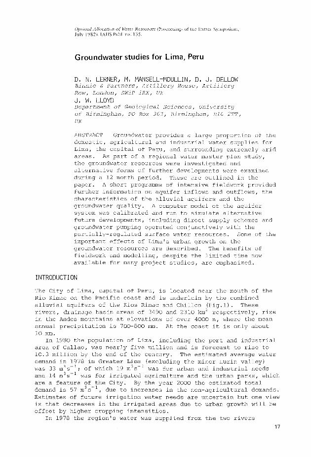
The City of Lima, capital of Peru, is located near the mouth of the Rio Rimac on the Pacific coast and is underlain by the combined alluvial aquifers of the Rios Rimac and Chillon (Fig.l). These rivers, drainage basin areas of 3490 and 2310 km respectively, rise in the Andes mountains at elevations of over 4000 m, where the mean annual precipitation is 700-800 mm. At the coast it is only about lO mm.
In 1980 the population of Lima, including the port and industrial area of Callao, was nearly five million and is forecast to rise to 10.3 million by the end of the century. The estimated average water demand in 1978 in Greater Lima (excluding the minor Lurin valley) was 33 m s- ; of which 19 m s- was for urban and industrial needs and 14 m s- was for irrigated agriculture and the urban parks, which are a feature of the City. By the year 2000 the estimated total
3 — 1
demand is 57 m s , due to increases in the non-agricultural demands. Estimates of future irrigation water needs are uncertain but one view is that decreases in the irrigated areas due to urban growth will be offset by higher cropping intensities.
In 1978 the region's water was supplied from the two rivers 17
18 D.N.Lerner et al.
FIG.l Location of study area.
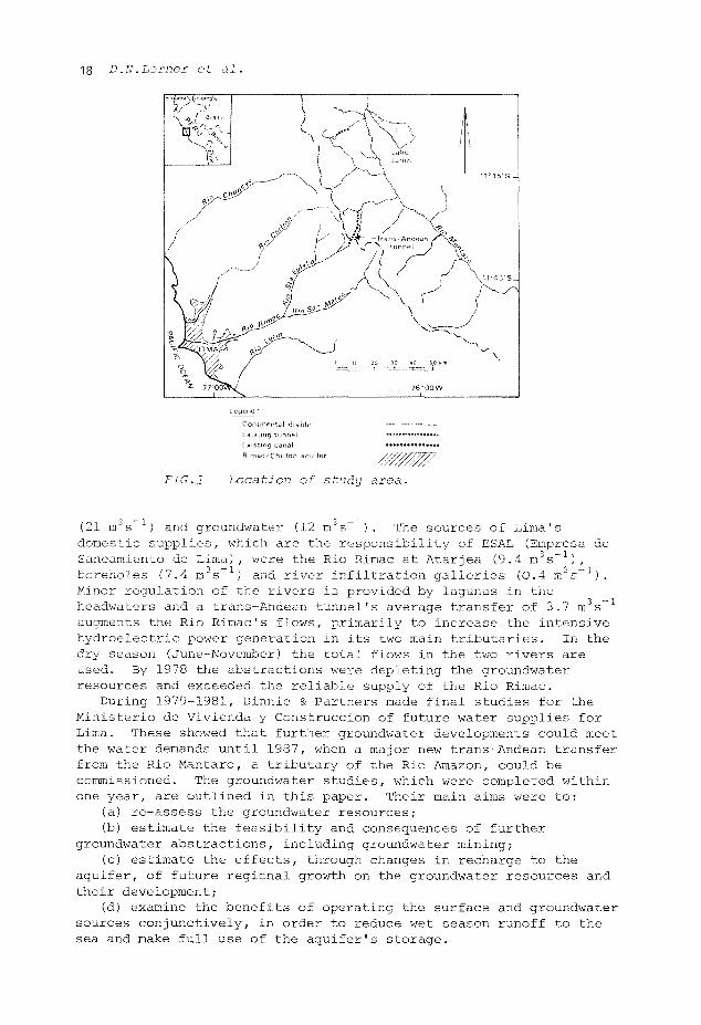
(21 m s ) and groundwater (12 m s - 1)- The sources of Lima's domestic supplies, which are the responsibility of ESAL (Empresa de Saneamiento de Lima), were the Rio Rimac at Atarjea (9.4 m s- ), boreholes (7.4 m s ) and river infiltration galleries (0.4 m s- ). Minor regulation of the rivers is provided by lagunas in the headwaters and a trans-Andean tunnel's average transfer of 3.7 m3s~ augments the Rio Rimac's flows, primarily to increase the intensive hydroelectric power generation in its two main tributaries. In the dry season (June-November) the total flows in the two rivers are used. By 1978 the abstractions were depleting the groundwater resources and exceeded the reliable supply of the Rio Rimac.
During 1979-1981, Binnie & Partners made final studies for the Ministerio de Vivienda y Construccion of future water supplies for Lima. These showed that further groundwater developments could meet the water demands until 1987, when a major new trans-Andean transfer from the Rio Mantaro, a tributary of the Rio Amazon, could be commissioned. The groundwater studies, which were completed within one year, are outlined in this paper. Their main aims were to:
(a) re-assess the groundwater resources; (b) estimate the feasibility and consequences of further
groundwater abstractions, including groundwater mining ; (c) estimate the effects, through changes in recharge to the
aquifer, of future regional growth on the groundwater resources and their development;
(d) examine the benefits of operating the surface and groundwater sources conjunctively, in order to reduce wet season runoff to the sea and make full use of the aquifer's storage.
Groundwater studies for Lima, Peru 19
Field investigations were made to supplement existing data and the studies were carried out using a digital groundwater computer model. The separate Rio Lurin basin, south of the Rio Rimac, was also studied but is not described in this paper.
HYDROGEOLOGY
The information given in this section is based largely on the results of the project studies.
Aquifer characteristics
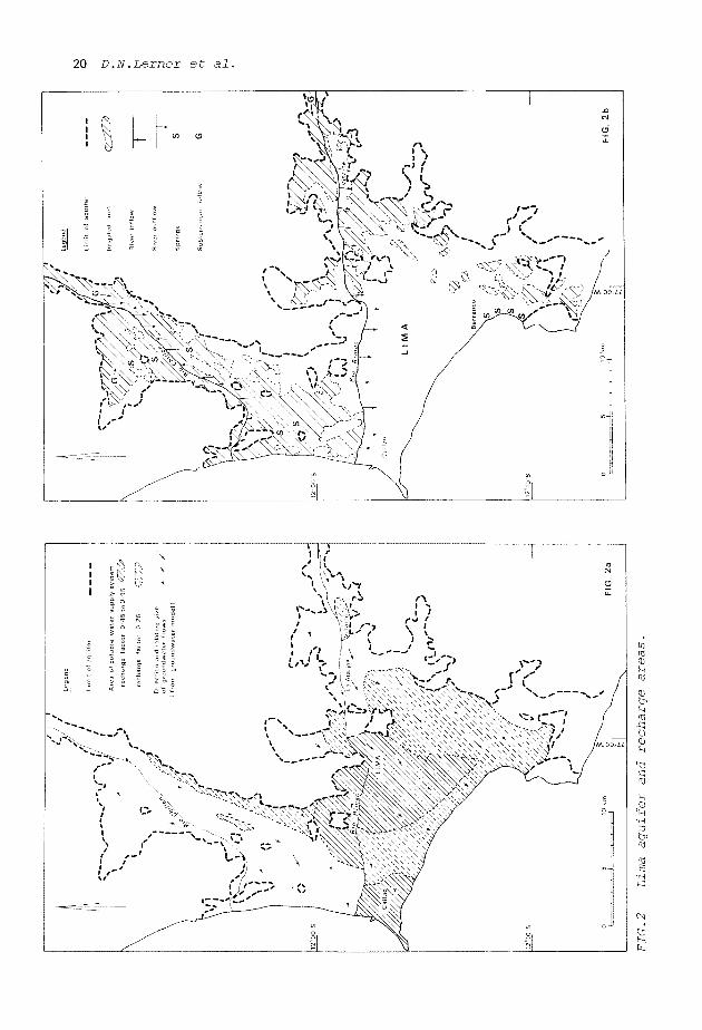
There is extensive groundwater in the Quaternary alluvial fan sediments which overlie an impermeable, Pre-Quaternary "basement" (Fig.2). The alluvium, which extends as stringers into the upper valleys, ranges from boulders to clay-size particles but consists mainly of sandy and silty gravels with a variable clay content. Surface resistivity studies, supported by other indications, suggest two broad sedimentary units. The lower unit contains a significant clay matrix and reaches thicknesses of up to 500 m at the coast. The upper unit contains very little clay, is less than 80 m thick and is well-defined by borehole logs. The two valley aquifers combine in the urban area.
The aquifer is mainly unconfined, except near Callao. Piezometric gradients from the upper valleys to the coast average about 1.7% and 1.2% in the Rimac and Chillon valleys respectively. The directions and relative sizes of the flows, derived from the groundwater model, are shown in Fig.2 (a). Groundwater levels are near the surface in the Chillon valley, at Callao and upstream of Vitarte in the Rimac valley (Fig.2(b)). Elsewhere they are 25-75 m below the surface.
2 — 1
Transmissxvities range up to 7000 m day , with the highest values in the upper valleys. Specific yields obtained from pumping tests are up to 0.06 although, during the calibration of the model, values of 0.10-0.15 were found necessary.
Groundwater balance
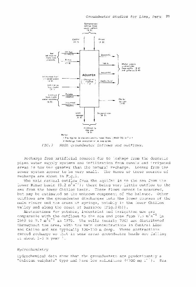
The components of the groundwater balance and their estimated or measured mean values (1969-1978) are shown in Fig.3.
Precipitation provides no recharge to the aquifer. Groundwater enters the aquifer as flows in the stringer deposits which are recharged by runoff in the upper parts of the two valleys. River channel infiltration is an important source of recharge and occurs mainly during January-April, although decreasing considerably during this period. The average annual flows (38 years) in the Rio Rimac at Chosica and Rio Chillon at Larancocha, upstream of the aquifer (Fig.4) are 31.5 m s (including transfers) and 7.5 m s respectively. The estimated mean infiltration from the Rio Rimac within the model area in February is 16 m s , although only 0.3 m s 1 from June to November. This seasonal recharge pattern causes significant changes in the groundwater heads near the rivers in the reaches shown in Fig.2. Infiltration downstream of Atarjea is affected by the major surface water supply abstraction there.
20 D.N.Lerner et al.
Q
J:? : - é ^ . <J \ - —
Groundwater studies for Lima, Peru 21
Subterranean inflows from upper valleys
( 2 6 )
œpi Leakage
from piped water systems/
(5-9)
Chillon 10-7}
Chillon ( v. small )
Rimac
(3 9)
Potable supplies
Industrial supplies
Clif spr (0-
'
AQUIFER
/ Change in \ I storage 1
ngs 3)
'
S
Rimac (1-9)
Domestic
Public
industrial
Agriculîurai
ubterranean ; s - 2 )
>
Water
from w and ga
supply
el ls (8 6) Series {0 4)
Outflows to the sea
(8 5! Notes
1 The figures in brackets are the mean flows (1969-78) m 3 s - '
2 Recharge from precipitation is negligible
FIG.3 Main groundwater inflows and outflows.
Recharge from artificial sources due to leakage from the domestic piped water supply systems and infiltration from canals and irrigated areas is now 66% greater than the natural recharge. Losses from the sewer system appear to be very small. The zones of these sources of recharge are shown in Fig.2.
The main natural outflow from the aquifer is to the sea from the lower Rimac basin (8.2 m3s~ ); there being very little outflow to the sea from the lower Chillon basin. These flows cannot be measured, but may be estimated as the unknown component of the balance. Other outflows are the groundwater discharges into the lower courses of the main rivers and the areas of springs, notably in the lower Chillon valley and along the coast at Barranco (Fig.2(b)).
Abstractions for potable, industrial and irrigation use are comparable with the outflows to the sea and rose from 7.5 m s in 1969 to 9.7 m s l in 1978. The wells (nearly 700) are distributed throughout the area, with the main concentrations in Central Lima and Callao and are typically 100-150 m deep. These abstractions exceed recharge so that in some areas groundwater heads are falling
at about 1-2 m year"
Hydrochemistry
Hydrochemical data show that the groundwaters are predominantly a "calcium sulphate" type and have low salinities (<700 mg l- ). Sea
22 D.N.Lerner et al.
water intrusion is present in the vicinity of Callao and "sulphate" waters with high concentrations (>1000 mg 1"1S04) occur in the lower Chillon valley. The minor ion chemistry indicates very small groundwater inflows from the basement granites and Mesozoic sediments. Overall, the groundwater chemistry supports the general hydraulic concepts developed for the aquifer and the major flow zones can be identified. Mineral saturation data show that large areas of the aquifer contain potentially encrusting waters.
/ /
/
*;
L e g e n d
P r o j e c t r i v e r f i o w s t a t i o n
R i v e r b e d i n f i l t r a t i o n t e s t r e a c h
R u n - o f - c a n a l i n f i l t r a t i o n t e s t r e a c h
S t a t i c c a n a l i n f i l t r a t i o n t e s t
T a m b o I n g a a r e a i n f i l t r a t i o n t e s t
S u r v e y o f s p r i n g f l o w s
S u r f a c e e l e c t r i c a l g e o p h y s i c a l A s u r v e y
W e l l t e s t s i t e s
O 1 I 1 1 I
J « & s
A
1. 63 wel l water samples were taken
chemical qual i ty analyses.
so at Chosit
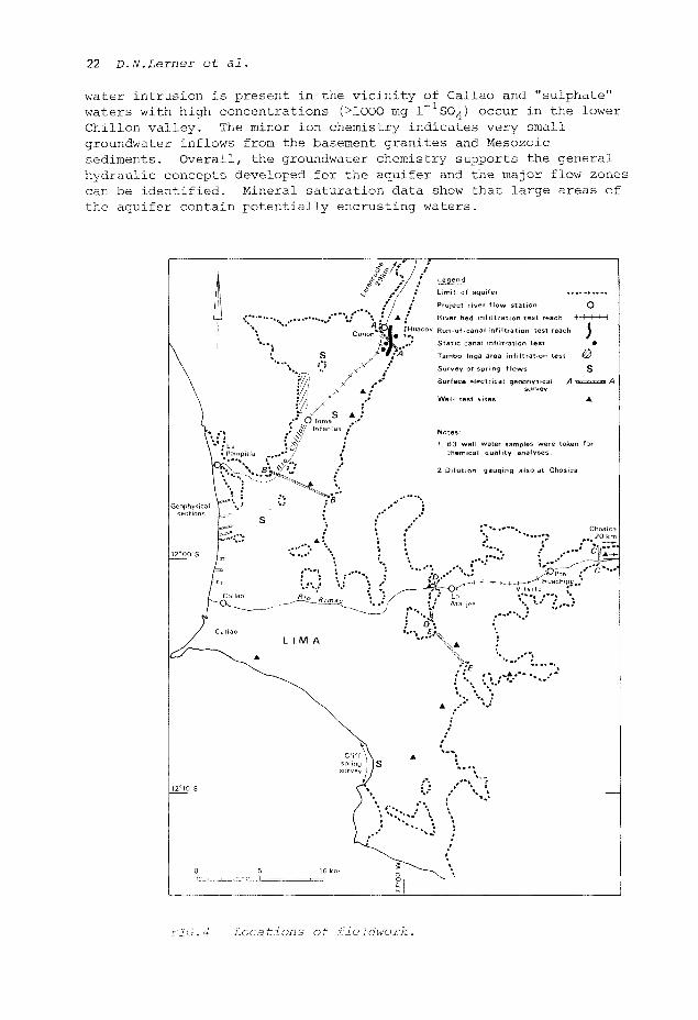
FIG . 4 Locations of fieldwork.
Groundwater studies for Lima, Peru 23
FIELDWORK
Scope of fieidwork
The information required to model an aquifer system reliably is considerable. Previous studies of Lima's groundwater resources, including several by Peruvian organizations, by the consultants and by previous advisers, had been based largely on theoretical estimates of several of the components of the groundwater balance and these had caused uncertainties in the results. However, those studies indicated the areas in which further data could lead to the greatest improvements, both in the physical understanding of the system and by providing information on specific aspects. The two main problems were in (a) the aquifer properties, particularly the variations of permeability with depth and (b) the water balance, due to the large, unmeasurable outflows to the sea. Therefore, despite the very limited time and resources available for fieidwork, a programme of selective investigations was carried out (Fig.4). The total input by hydrogeologists, hydrologists and a geophysicist was about eight man-months. The subsequent studies led to improvements in all the data needed for the modelling.
Hydrogeological fieidwork
The scope for hydrogeological fieidwork was limited, due partially to problems of access to production wells for testing, the few potential observation wells and well interference effects in the heavily-pumped aquifer. However, the fieidwork included:
(a) Surface electrical resistivity traverses to supplement
previous surveys. These defined selected aquifer cross sections,
suggested that bulk permeabilities decrease with depth and showed
that north of Callao there is some sea water intrusion at depth.
(b) Twelve well pumping tests to derive transmissivity values,
specific yields (where there were observation wells) and well loss
factors. These also gave a good practical insight into the aquifer's
very variable characteristics and the existing groundwater
developments.
(c) A well acidization test, which showed that falling yields
were due neither to screen encrustation nor collapse.
(d) Many well water level measurements to establish piezometric
gradients and, by comparison with previous measurements, to determine
trends.
(e) A hydrochemical survey to supplement existing data and to
relate the groundwaters' chemical characteristics with the flow
distribution, recharge from different sources and saline intrusion,
and to identify zones of possible well screen encrustation or
corrosion.
Water balance fieidwork
The components of the groundwater balance used in the modelling are shown in Fig.3. Subterranean outflows to the sea are the residual of the overall water balance. Routine measurements include surface water supplies treated at Atarjea, spring flows in the Chillon basin,
24 D.N.Lerner et al.
monthly flows in the principal irrigation canals, piezometric levels in some wells and well pumping data. River flows have been measured upstream of the area studied at Chosica (Rio Rimac) and Larancocha (Rio Chillon) since 1968 and were measured previously near their mouths for short periods. Unstable river beds, high velocities, turbulence and large sediment loads during floods and flashy flood characteristics cause severe practical problems in deriving reliable flow records. The timing of the fieldwork near the end of the rainy season meant that only low and medium flow measurements were possible.
The fieldwork carried out was intended mainly to improve recharge estimates and included:
(a) The installation and rating of six river gauging stations
and further flow measurements at two existing stations. In the Rio
Rimac, dye dilution gauging using rhodamine WT and pyranine
fluorescent dyes with Aminco continuous flow fluorimeters quickly
resulted in acceptable rating curves.
(b) Field flow surveys of all surface inflows and outflows
between river gauging stations. These included irrigation and water
supply diversions and irrigation and sewage return flows.
(c) Dynamic and static irrigation canal infiltration tests.
(d) A 60 h infiltration test on an irrigated area of 125 ha.
Hourly flow balances, crop surveys and water consumption estimates
resulted in an estimate that 34% of the net water supply infiltrated
to the aquifer. This was used to check theoretical infiltration
estimates.
(e) Surveys of flows in coastal and inland springs.
DATA ANALYSES
Monthly values of all groundwater recharges and outflows (except for those to the sea) during the 10-year period modelled were required for each of the 460 active nodes. The former include the recharges from rivers, irrigated areas and the water supply system, while the latter include abstractions from wells and galleries, spring discharges and discharges to the Rio Chillon. For each node, transmissivity and specific yield values were also needed, as well as the initial piezometric head values. The detailed quality control analyses and the preparation of the limited existing records into suitable input data required many initial studies. These represented a large proportion of the overall studies. The time required for them can easily be underestimated.
Some of the importa.nt analyses were: (a) A review, by re-analysis, of all existing well pumping tests
(60) to determine transmissivity and specific yield values.
(b) Calculations of mean daily flows at the river gauging
stations.
(c) The estimation of river and irrigation area infiltration from
historical data and the field investigations.
(d) The estimation of the important aquifer recharge from the
potable water supply system. Estimates of the historic supplies to
the various zones of Lima were related to estimated zonal leakage
factors, based on records, past production tests and factors such as
Groundwater studies for Lima, Peru 25
the ages and types of pipes, pressures and areas known to have problems.
Thus all data used in the modelling were reviewed in detail, were the results of the fieldwork or were the conclusions from new or updated analyses. This detailed knowledge of the aquifer was essential to ensure realistic adjustments during the calibration of the model.
AQUIFER MODELLING
The modelling was done in two phases; calibration and simulation. The calibration process combined the results of all the fieldwork, data analyses and interpretative studies into a single, consistent understanding of the aquifer and its water balance. In the simulation phase, the consequences of alternative developments to meet future water demands were determined.
The aquifer downstream of geophysical cross sections A-A and C-C (Fig.4) was modelled on a uniform 1 km grid using a one month timestep. This was an acceptable compromise between the needs of a resource planning study and the information available on this complex aquifer. The model's calculations were straightforward technically. However, a great deal of data handling was needed to determine the flow balances (Fig.3) at each node.
Model calibration
The adopted calibration period was 1969-1978. The only available piezometric map showed conditions in 1969. This map was used as the main calibration standard and provided a control for the transmissivity values and the locations of the various types of recharge (mean values). The estimated abstractions were not varied. A few, partial hydrographs from observation wells (8) were available and were used as controls on the storage coefficient values and on the timing and size of fluctuations in the recharge.
The 1969 piezometric map could not be matched without major changes in some variables. The field transmissivity estimates were the least reliable and increases in them of 100-300% were needed. This was due mainly to the partial penetration of the pumped wells and absence in most cases of observation wells. Some changes were made in recharge estimates and these reduced the estimated flow to the ocean (or the net resources of the aquifer) from 11.5 m s~ in the first calibration attempt to 8.2 m s- in the final calibration. This was due mainly to changes in the interpretation of the ways in which river recharge occurs. Changes in the other variables were within the ranges of accuracy of the estimates.
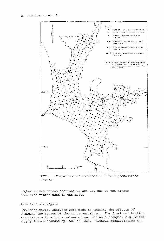
The final calibration followed 37 trials. The comparison with the observed conditions in 1969 is shown in Fig.5. Only 10% of the nodes had calibration errors greater than 5 m, which is reasonable in an aquifer where piezometric levels rise 350 m in the 18 km from the coast to Vitarte. Most of these errors are either along the edges of the aquifer or are near impermeable inliers and are not on major flow paths (Fig.2). The modelled groundwater flows across sections within the aquifer (Fig.4) compared well with the field estimates apart from
26 D.N.Lerner et al.
i
L
\\ \
12°00S
9j} /fi
- ^ - - - : ~ * ? v [
t * A ' •
9 C/.-W
- - " - s l
- j . . ~ - \ "
• /-/^/^^^Ç^l ?^r^*^s/'^
^\ * • • • *
12'10'S
0
\ . v • * \ . . ., * * \ * • \ . " v • . * .
\ * - .
Legend
4- Modelled levels are above field levels
— Modelled levels are below field levels
• Difference between levels is less than 2m
— + Difference between levels is in the range 2-6 m
— + Difference between leveis is in the range 6-10m
•— " 1 * Difference between leveis is greater than 10m
Note Modelled piezometnc leveis are taken from steady state simulation. Rield levels are taken from the piezometric map for 1969
\:"r~"*wp '- * * r' \
. - . * ;-- v
N. *-'] \.-\ )-
' '' 0 ^ [
\- • • - ,' \ * * • 1 * * / • * K . " * •;'•
W " v *•* ^
^^-^^ 5 10km -0~ ^ - — .
— ^ ~ i S|
;' A<% . ! • ' . . ' • •
— ' i
* /-->"' / \ 1 —
j c \
^ ^ \ FIG.5 Comparison of modelled and field piezometric levels.
higher values across sections DD and EE, due to the higher transmissivities used in the model.
Sensitivity analyses
Some sensitivity analyses were made to examine the effects of changing the values of the major variables. The final calibration was re-run with all the values of one variable changed, e.g. water supply losses changed by +50% or -33%. Without recalibrating the
Groundwater studies for Lima, Peru 27
model by altering the other variables, it was difficult to produce useful analytical results. As expected, no variable could be changed systematically without non-systematic changes in several others.
Interplay between field and model studies
Uncertainties in an aquifer water balance are much reduced by combining field and model studies. For example, the model quickly showed that the initial estimates of river recharge were much too high. A satisfactory calibration could have been achieved with the widely-distributed irrigation recharge altered by factors of +100% or -50%, but the results of the field investigations and data analyses provided reasonable estimates. Conversely, model calibration can clearly show what further data would lead to the greatest improvements. In the case of Lima, more information on the aquifer's properties would be valuable.
POSSIBLE GROUNDWATER DEVELOPMENTS
Constraints on further developments
The greatest constraint on possible new schemes is the apparent decrease in the aquifer's permeability with depth. This can only be proved satisfactorily by drilling and testing deep, stratigraphical boreholes. A further regional drawdown of 20 m would effectively dewater the upper aquifer in the vicinity of large abstractions and this was considered the maximum permissible in the light of present knowledge. Local interference between wells and individual well-loss drawdowns would lead to much greater "actual" drawdowns in production wells.
There is hydraulic continuity between the aquifer and the sea and some saline intrusion has occurred. It would be undesirable to induce further intrusion, particularly in the Callao area where many important existing boreholes could be affected. The risks of intrusion are a major constraint on developments in the Chillon valley.
The provision of replacement wells or supplies to offset reduced yields caused by the lowering of groundwater levels will be a major part of the costs of new developments. Analyses of a sample of the 700 existing wells suggested that a regional drawdown of 7 m would reduce output by 50%. The relative cost of groundwater compared with other sources may become an additional constraint when large numbers of compensation wells are needed.
Future aquifer recharge
The City of Lima will have grown considerably by the end of the century, both in area and population density. The main increases in
3 — 1
the urban water demand, estimated to be 25 m s greater than in 1978, will be in areas outside those which already have high demands. Both this aspect and the results of planned leak detection and rehabilitation programmes will change the pattern of recharge by
28 D.N.Lerner et al.
leakage from the water supply system, although the total recharge from this source is only likely to be slightly greater than at present.
The effects of urban encroachment on irrigated land will probably be offset by a greater intensity of cropping and by new parklands, resulting in a small overall change in this source of recharge.
The estimated net increase in recharge due to these developments is 1.0 m 3s _ 1 by the year 2000.
River recharge is only expected to increase if piezometric levels fall sufficiently to induce recharge where it does not occur at present. The most likely zone for this is in the Rio Rimac upstream of Vitarte, where an increase of up to 2 might occur.
Effects of existing and planned abstractions
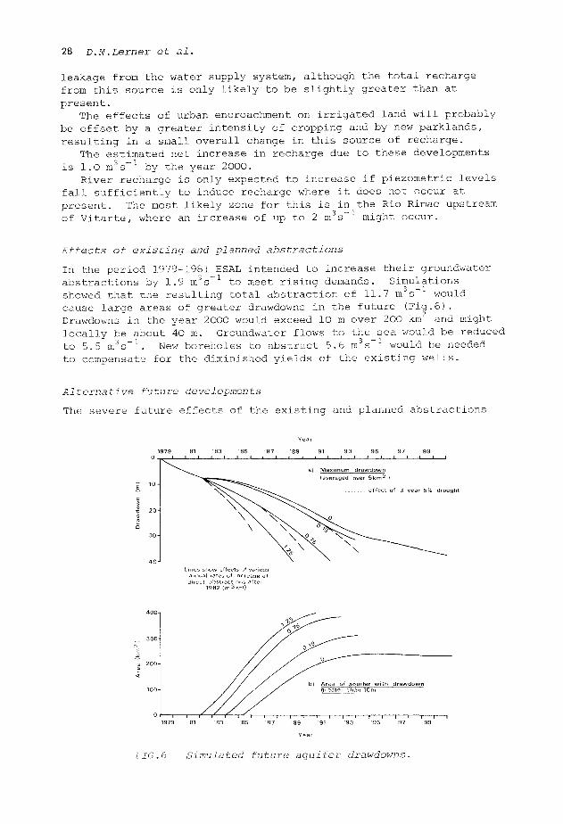
In the period 1979-1981 ESAL intended to increase their groundwater abstractions by 1.9 m 3s _ 1 to meet rising demands. Simulations showed that the resulting total abstraction of 11.7 i s" would cause large areas of greater drawdowns in the future (Fig.6). Drawdowns in the year 2000 would exceed lO m over 200 km and might locally be about 40 m. Groundwater flows to the sea would be reduced to 5.5 m s New boreholes to abstract 5.6 m3s 1 would be needed to compensate for the diminished yields of the existing wells.
Alternative future developments
The severe future effects of the existing and planned abstractions
effect of 3 year 5% drought
s show effects of varii ma! rates of increase •ct abstractions afte
1982 ( m 3 s - i )
1979 '81 '83
FIG.6 Simulated future aquifer drawdowns.
Groundwater studies for Lima, Peru 29
limit the scope for further groundwater developments. However, the model was used to study several alternatives, including increased direct abstractions and the conjunctive use of surface waters and groundwaters. In a later phase of the study the conjunctive use of groundwater with increased trans-Andean transfers was also examined.
The selection of possible areas for further groundwater developments was based on various criteria including small present and planned drawdowns, proximity to areas with growing demands, outside zones of possible saline intrusion, but within areas of high transmissivities and potential induced river recharge.
Simulations showed that drawdowns would increase rapidly over large areas if the direct groundwater abstractions are raised and these effects would be increased by a drought (Fig.6). However, short term increases in abstractions can be considered.
Greater use of groundwater would be possible if pumping from some of the wells were stopped whenever flows in the Rio Rimac are sufficiently large to allow a greater abstraction than at present, e.g. during January-March. The works at La Atarjea and their delivery system would have to be enlarged but, by resting the aquifer in this way whenever possible, more groundwater could be pumped when river flows are low. Simulations showed this kind of "conjunctive use" could meet demands until the year 1987 without causing further groundwater drawdowns greater than 20 m. After 1987, new sources would be needed and a trans-Andean transfer scheme is now being designed. When completed, the increased flow in the Rio Rimac will allow large initial reductions in the groundwater abstractions and thus the recovery of the low groundwater levels. These low levels may be reached again by the year 2000.
Simulations of conjunctive use schemes under average conditions showed some reductions in maximum drawdowns and reduced compensation requirements compared with comparable non-conjunctive schemes. This was due to the re-distribution of abstractions. However, the heavy pumping needed during droughts in conjunctive use schemes would cause greater drawdowns and thus compensation requirements. The conditions in droughts limit the extent to which such schemes are practical.
Artificial recharge
It may be possible to increase the groundwater resources by artificial recharge lagoons or by forming spreading basins in selected reaches of the Rio Rimac. In the former, considerable pre-treatment would be needed to remove the suspended solids. Recharging treated sewage may also be practical. Artificial recharge has not yet been tried in Lima and pilot schemes would be needed to assess its feasibility and practical limits.
ACKNOWLEDGEMENTS The authors are grateful to the Ministerio de Vivienda y Construccion, Peru and to the Direccion Ejecutiva del Proyecto Transvase Mantaro for giving their approval to the publication of this paper. They wish to acknowledge the valuable assistance and data provided by several Peruvian government organizations, particularly ESAL, Direccion de Aguas Superficiales y Subterraneas, Ministerio de Agricultura (DASS) and the Servicio
30 D.N.Lerner et al.
Nacional de Meteorologia e Hidrologia (SENAMHI): also the considerable help given by the Water Research Centre (Stevenage Laboratory), UK, in the river dilution gauging programme. They are also grateful to Binnie & Partners for their permission and encouragement, their Peruvian associates and their colleagues, particularly J.A.Hibbitt, who contributed to the studies.