44
Hidden Hazards A Call to Action for Healthy, Livable Communities December 2010 Los Angeles Collaborative for Environmental Health and Justice A project of Liberty Hill Foundation

Hidden HazardsA Call to Action for Healthy, Livable CommunitiesDecember 2010
Los Angeles Collaborative for Environmental Health and Justice A project of Liberty Hill Foundation


Los Angeles Collaborative for Environmental Health and Justice
The Los Angeles Collaborative for Environmental Health and Justice was formed in 1996 when environmental health advocates working at Communities for a Better Environment and the Liberty Hill Foundation joined forces with academic researchers to study, fund and support the burgeoning field of environmental justice.
At the intersection of environmentalism and civil rights, the Collaborative was born from a growing awareness of the adverse health impacts of the urban environment on people in low-income communities and communities of color. Residents’ accounts of cancers, birth defects and lung disease were backed up by rigorous research that demonstrated a regional pattern of clusters of polluting facilities, high concentrations of toxic air pollution, and high health risk all in low-income communities and communities of color. Over the past decade a growing number of community-based organizations have had significant success in cleaning up their communities and putting environmental health on the policy agenda.
The Collaborative now includes additional community-based organizations and research institutions that have contributed a growing sophistication and success in data analysis, community organizing and policy.
Collaborative members are:
• Coalition for a Safe Environment• Communities for a Better Environment• East Yard Communities for Environmental Justice• Liberty Hill Foundation• Occidental College • Pacoima Beautiful• University of California Berkeley, School of Public Health and Department of Environmental
Science, Policy and Management • University of Southern California, Program for Environmental and Regional Equity • Union de Vecinos
Supporters
Thank you to the generous supporters of the Collaborative who, along with the Liberty Hill Foundation, have made sustained commitments that make this work possible:
• The California Endowment• The Nathan Cummings Foundation• The Kresge Foundation

– Lisa Jackson, Administrator, U.S. Environmental Protection Agency, January 25, 2010 speech on environmental justice, air quality, goods movement and green jobs
“ We can talk about the need for more jobs and small businesses in our urban centers and metropolitan regions. But that conversation must also include the understanding that environmental challenges in our neighborhoods hold back economic growth. Poison in the ground means poison in the economy. . . And unhealthy air means an unhealthy atmosphere for investments.”
Letter from the Collaborative
The Los Angeles Collaborative for Environmental Health and Justice, which combines
the knowledge and skills of academic researchers with the practical experience of
community organizations, has been working since 1996 to advocate for clean air,
healthy communities and a robust economy. Specifically, our work is driven by a shared
perspective—based upon both scientific evidence and residents’ first-hand knowledge—
that the elevated risk and incidence of asthma, cancer and respiratory illnesses in
low-income communities of color are linked to the close proximity of low-income
communities of color to air pollution sources, such as factories, freeways and goods
movement corridors. With new technologies and a burgeoning consensus that businesses
should be incentivized to build green where land is affordable and labor is abundant,
the Collaborative is hopeful that our most vulnerable communities can be transformed
from toxic hot spots to vibrant neighborhoods.
In 2004, our Collaborative released its first report, Building a Regional Voice for Environmental Justice, taking important steps towards community-based participatory
research. In this groundbreaking work, the Liberty Hill Foundation, Communities for
a Better Environment, and a team of scholars (then based at Brown University, the
University of California Santa Cruz, and Occidental College), analyzed the demographic
patterns of air emissions using regulatory databases for the Los Angeles region. We
documented the clear relationship between toxic exposure and race and income
status, providing scientific evidence to corroborate residents’ first-hand knowledge
that they were disproportionately impacted by air pollution from such sources as
chemically-intensive manufacturing and fossil fuel-based transportation modes.
Our Collaborative has grown to include additional community-based partners as well as
scholars from University of California Berkeley and the University of Southern California.
Together, we have refined our research methodology while supporting community
organizing to strengthen health protective standards and safeguards at the local, state
and regional levels.
In Hidden Hazards, we provide new evidence of the high density of air pollution hazards
and exposure in certain areas of Los Angeles—hazards that are “hidden” from the
view of regulatory agencies because they are not contained in their official databases.
It is important for all Angelenos and their elected representatives to recognize that

while these hazards are concentrated in particular neighborhoods, the potential health
impacts are likely to be broader, affecting all the nearly 10 million residents of Los
Angeles County who also suffer from exposure to the same toxic emissions and their
related respiratory and cancer risks.
This report also points the way to some promising policy solutions that focus on
innovation and bold action rooted at the local level. We present suggestions for local
policy solutions that could be readily implemented by municipalities throughout the
region. In fact, many of these tools will be familiar to city planners and agencies that
already regularly use them in planning and decision-making to address neighborhood
development and public health concerns.
Our policy recommendations can promote the revitalization of these communities
with neighborhood-owned businesses and local jobs that advance the promise of the
green economy. As U.S. Environmental Protection Agency (EPA) Administrator Lisa
Jackson has noted, there is a profound and inextricable connection between health,
environmental quality and the economy. By modernizing and retooling many of these
hazardous industries, creating safe buffers for residential neighborhoods and schools,
and investing in new technologies that greatly reduce toxic pollutants, we will lay the
groundwork for sustainable, healthy and green economic growth.
What is good for the residents of Boyle Heights, Commerce, the Figueroa Corridor,
Maywood, Pacoima and Wilmington and other overburdened communities also improves
environmental quality for all the residents of Los Angeles. This is especially true for
children, the elderly, the poor—the most vulnerable among us. Clearing the air in these
highly impacted urban neighborhoods will go a long way toward improving the health of
all residents of the region and advancing a cleaner, greener future.
Michele Prichard
Director, Common Agenda, Liberty Hill Foundation

Executive Summary 1
The New Reality of Toxic Hot Spots 3• Pinpointing Toxic Hot Spots 4
• Responding to New Realities: Realistic and Relevant Policy Solutions 5
• Local Government Must Take Action and Lead 6
Los Angeles’ Environmental Health Riskscape 7• Pollutants Profile 9
• Pollution and Health Links: New National Attention 10
Ground Truthing Makes the Case for Overburdened Communities 11• Ground Truthing Methodology 12
– Data Collection and Analysis 13
• What Ground Truthing Found 14
– Finding 1: Hazards are More Numerous Than Regulatory Data Suggest 14
– Finding 2: Sensitive Receptors are More Numerous than Regulatory Data Suggest 15
– Finding 3: Numerous Sensitive Receptors are Located Too Close to Hazards 17
– Finding 4: Hazard Locational Errors in Regulatory Databases are Significant 19
– Finding 5: Air Pollution Levels Exceed Safe Standards 20
• Making the Case: Recommendations for Improved Data Collection and Analysis 21
A Call to Action for Healthy, Livable Communities 22• Policy Recommendations 22
• A Call to Action for the City of Los Angeles 23
• The Policy Framework: Prevention, Reduction and Revitalization 23
Appendix: Ground Truthing Teams 31
Appendix: Bibliography 32
Table of Contents

Peter Bennett/Green Stock Photos
Executive Summary
There is a critical need for sound effective policy to ensure a healthy and vibrant future
for communities overburdened with hazardous toxics and health risk. Such policies
require a complete, accurate and timely source of data that realistically identifies the
environmental exposure and health risks at the neighborhood level. However, data
collected by publicly available sources present only a partial picture of the toxic air
pollutants that exist in neighborhoods. The official record does not reflect the important
and invaluable local knowledge of community residents.
To fill this data gap the Los Angeles Collaborative for Environmental Health and Justice
conducted a community-based participatory research project called Ground Truthing
that documented residents’ concerns about toxic hazards “on the ground” in six Los
Angeles neighborhoods and the proximity to people who are most vulnerable to toxic
exposures: the elderly, young people, children and other “sensitive receptors.” Guided
by academic researchers, community members gathered local data about toxic emitters
and compared this to information in state government regulatory databases. This effort
produced new evidence about the clustering of dangerous facilities, high levels of air
pollution and elevated health risks in the neighborhoods studied.
Our key findings:
• Many more hazardous facilities are identified by neighborhood residents than are
recorded in state and federal government regulatory inventories.
• In addition to sensitive land uses contained in government databases, neighborhood
residents identified churches, family-based daycare and community centers as
additional places where sensitive populations congregate.
• There are significant violations of buffer zones as recommended by California Air
Resources Board (CARB) to protect the health of sensitive populations from air
pollution, where sensitive land uses are located in close proximity to air quality
hazards.
• Significant locational errors for emission sources were found in State databases,
complicating the task of assessing whether and where air quality hazards are located
too close to sensitive receptors.
• Air sampling for particulate matter (PM2.5) found that levels regularly exceed the
health protective standards established by the California Environmental Protection
Agency (Cal EPA).1
Executive Summary
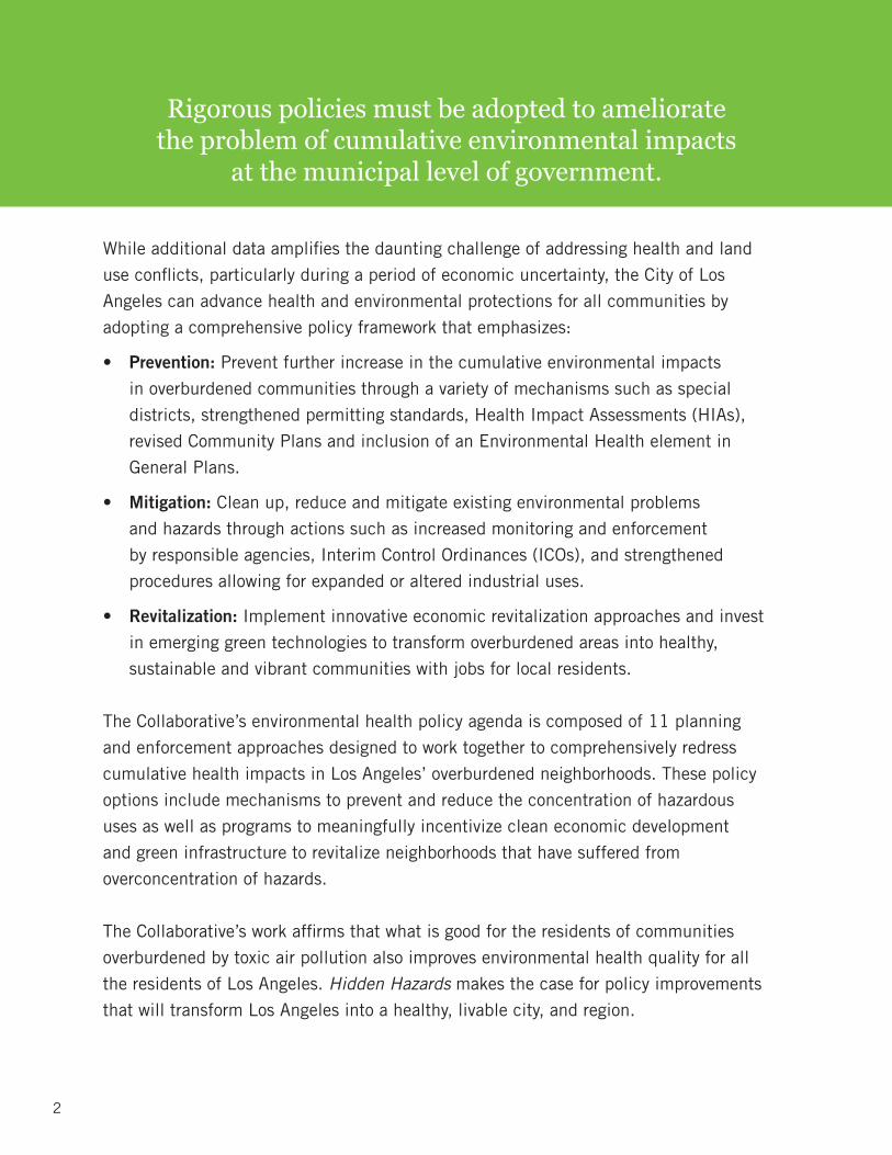
While additional data amplifies the daunting challenge of addressing health and land
use conflicts, particularly during a period of economic uncertainty, the City of Los
Angeles can advance health and environmental protections for all communities by
adopting a comprehensive policy framework that emphasizes:
• Prevention: Prevent further increase in the cumulative environmental impacts
in overburdened communities through a variety of mechanisms such as special
districts, strengthened permitting standards, Health Impact Assessments (HIAs),
revised Community Plans and inclusion of an Environmental Health element in
General Plans.
• Mitigation: Clean up, reduce and mitigate existing environmental problems
and hazards through actions such as increased monitoring and enforcement
by responsible agencies, Interim Control Ordinances (ICOs), and strengthened
procedures allowing for expanded or altered industrial uses.
• Revitalization: Implement innovative economic revitalization approaches and invest
in emerging green technologies to transform overburdened areas into healthy,
sustainable and vibrant communities with jobs for local residents.
The Collaborative’s environmental health policy agenda is composed of 11 planning
and enforcement approaches designed to work together to comprehensively redress
cumulative health impacts in Los Angeles’ overburdened neighborhoods. These policy
options include mechanisms to prevent and reduce the concentration of hazardous
uses as well as programs to meaningfully incentivize clean economic development
and green infrastructure to revitalize neighborhoods that have suffered from
overconcentration of hazards.
The Collaborative’s work affirms that what is good for the residents of communities
overburdened by toxic air pollution also improves environmental health quality for all
the residents of Los Angeles. Hidden Hazards makes the case for policy improvements
that will transform Los Angeles into a healthy, livable city, and region.
2
Rigorous policies must be adopted to ameliorate the problem of cumulative environmental impacts
at the municipal level of government.

3
In 2004 the Collaborative released a report, Building a Regional Voice for Environmental Justice, that drew on publicly available data and documented the clear patterns of disproportionate health and environmental risks faced by low-income communities of color. The report was among the first to address and document multiple sources of pollution, helping establish a research and policy framework that recognizes the “cumulative impact” of toxics and pollution at the neighborhood level.
Even more importantly, the research forged a path-breaking approach to cumulative impact research by analyzing the attendant health risks from this pollution in the context of everyday conditions residents face. By combining field observations collected by neighborhood residents with information from government regulatory data sources, researchers in partnership with communities were able to establish an important framework and analysis to inform local policymakers on how to address these conditions.
The report showed cumulative environmental impacts to be particularly acute in neighborhoods that we call “toxic hot spots.” These include East Los Angeles, Southeast Los Angeles, parts of the San Fernando Valley,
THE NEW REALITY OF TOXIC HOT SPOTS
and communities surrounding the Ports of L.A. and Long Beach. These areas have high levels of emissions from stationary and mobile sources of pollution, along with a wide variety of other environmental hazards, and face elevated health risks. These neighborhoods contain more industrially-zoned land uses and higher concentrations of facilities that emit toxic air pollutants. From diesel truck depots, warehouses and rail yards to small and large manufacturing facilities and refineries, these neighborhoods suffer from cumulative exposure to a long list of pollutants. These neighborhoods are also areas with a large proportion of sensitive land uses, such as schools and daycare facilities, which are located too close to air quality hazards as measured by the recommendations of CARB. Significantly, residents in these neighborhoods are also more vulnerable to the negative effects of air pollution, owing to poverty, lack of healthcare, low wages, and lack of affordable housing.
Building on nearly 15 years of work, the Collaborative has continued to produce research on toxic air pollution and its impact on the lives and health of residents living in the most impacted and vulnerable areas of the Los Angeles region. Combining scientific data analysis with community knowledge and analysis, the Collaborative has provided funding and research to a
The New Reality of Toxic Hot Spots

cadre of community-based organizations that have been successful in reducing specific environmental health hazards including:
• The defeat of the proposed Vernon Power Plant and legal challenge to the South Coast Air Quality Management District’s (SCAQMD) pollution credit trading proposal (Communities for a Better Environment)
• Expanding public participation and health safeguards related to the expansion of the I-710 freeway (East Yard Communities for Environmental Justice)
• Securing a Community Benefits Agreement with the Port of Los Angeles for the TransPacific Container Corporation expansion project, to pay container fees for off-port property air quality and community mitigation (Coalition for a Safe Environment)
The Collaborative’s work to advance cumulative impact analysis of toxic exposures as a focus of research and community organizing has influenced important policy advances at the state and local levels. For example, CARB has taken the lead in recognizing the critical relationship between air pollution and health and the important role land use planning has in protecting community and public health. In 2005 the agency published the Air Quality and Land Use Handbook that established state guidelines for land use planning that protects the health of communities. In 2005 as well, the SCAQMD published the Guidance Document for Addressing Air Quality Issues in General Plans and Local Planning. In the same year, the City of Los Angeles adopted a resolution establishing an Environmental Justice Improvement Area in Sun Valley, an area of the San Fernando Valley, to study the problem of hazardous land uses and to propose strengthened guidelines and standards for permit review. These are important steps forward, but much more needs to be done.
PINPOINTING TOXIC HOT SPOTSIt is crucial that policymakers have a complete, accurate and timely source of data that realistically identifies the environmental and health risks at the neighborhood level, and assesses the cumulative impacts of multiple facilities and hazards. While existing research provides important empirical evidence to inform the policy process, the Collaborative recognized from its experience that government regulatory databases do not contain a complete collection of air quality hazards that exist in many neighborhoods. Information collected by public agencies such as the U.S. Environmental Protection Agency (EPA), CARB and the California Department of Toxic Substances Control (DTSC) includes only those air quality hazards that fall under regulatory control.
To achieve a more complete understanding of cumulative impacts, the local knowledge of community residents who can observe the day-to-day activities of established facilities and often recognize new hidden hazards that are not recorded in government databases should be incorporated.
In order to fill this data gap, the Collaborative designed and implemented a community-based participatory research project called Ground Truthing to document community residents’ observations of conditions “on the ground.” Guided by the researchers, community partners and their members gathered data about toxic emitters and their proximity to “sensitive receptors”—concentrations of people who are most vulnerable to toxic exposures: the elderly, young children and people with respiratory disease. More than 60 community residents participated in research teams to collect Ground Truthing data in six different neighborhoods highlighted in this report: Boyle Heights, City of Commerce, Figueroa Corridor, Maywood, Pacoima and Wilmington.
The community effort generated data and local knowledge that, when combined with standardized governmental information, provide an in-depth, realistic
CUMULATIVE IMPACTS
“Cumulative impacts means exposures, public health or environmental effects from the combined emissions and discharges, in a geographic area, including environmental pollution from all sources, whether single or multi-media, routinely, accidentally, or otherwise released. Impacts will take into account sensitive populations and socio-economic factors, where applicable and to the extent data are available.”
– California Environmental Protection Agency
“What’s on record and what is in real life is problematic—the official
analysis does not reflect the true impact on communities.”
– Leonardo Vilchis, Union de Vecinos
Pinpointing Toxic Hot Spots
4

5
It is crucial that policymakers have a complete, accurate and timely source of data that realistically identifies the
environmental and health risk at the neighborhood level.
picture of the toxic hazards that exist at the neighborhood level. These findings verify what communities have said for a long time: that facility-by-facility regulation and controls are piecemeal, uncoordinated and inadequate in recognizing the cumulative impacts faced by these communities. The current system ultimately fails to adequately protect human health.
The Ground Truthing findings highlight how, considering the health protective guidelines of CARB, air pollution hazards are often located too close to homes and sensitive populations. They also point to concrete steps local governments can take to mitigate and protect community health, while laying the groundwork to green and revitalize Los Angeles’ neighborhoods in the process.
RESPONDING TO NEW REALITIES: REALISTIC AND RELEVANT POLICY SOLUTIONSAs the community findings that follow illustrate, adding a new layer of Ground Truthing data fills important gaps in governmental data sources and reveals a new and more detailed understanding of the day-to-day hidden hazards and exposures facing communities.
These in-depth findings indicate the need for more robust and comprehensive policy responses that recognize the cumulative impacts of multiple pollution sources in geographically defined districts. This framework for a healthier future is based on a holistic and comprehensive public health approach that uses land-use and planning tools to ensure a better life for those living in overburdened toxic hot spots.
Specific land use and planning policy recommendations are outlined in the last section (see page 22) to comprehensively address cumulative environmental impacts from stationary sources. The recommendations specifically address protections for over-burdened and under-regulated communities, but would also improve the health and quality of life for all who live in the Los Angeles region.
GAPS IN REGULATORY DATA
Regulatory databases and emissions inventories do not provide a synthesized analysis of the aggregate health impact made by all pollution sources. Examples that illustrate the failure of existing methodologies include:
• Different pollution sources are regulated by different agencies which makes data synthesis difficult.
• Multiple small polluters that are not required to report to emissions inventories collectively emit significant levels of air pollution locally when they are numerous or clustered together.
• Highly polluting small-scale businesses such as auto paint and body shops are not regulated at all.
• Locational errors of polluting sources often occur.
Responding to New Realities: Realistic and Relevant Policy Solutions
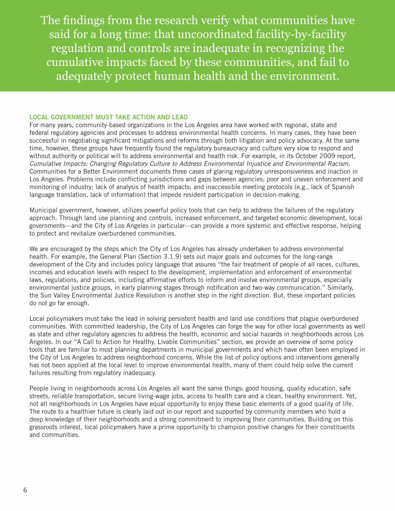
LOCAL GOVERNMENT MUST TAKE ACTION AND LEADFor many years, community-based organizations in the Los Angeles area have worked with regional, state and federal regulatory agencies and processes to address environmental health concerns. In many cases, they have been successful in negotiating significant mitigations and reforms through both litigation and policy advocacy. At the same time, however, these groups have frequently found the regulatory bureaucracy and culture very slow to respond and without authority or political will to address environmental and health risk. For example, in its October 2009 report, Cumulative Impacts: Changing Regulatory Culture to Address Environmental Injustice and Environmental Racism, Communities for a Better Environment documents three cases of glaring regulatory unresponsiveness and inaction in Los Angeles. Problems include conflicting jurisdictions and gaps between agencies; poor and uneven enforcement and monitoring of industry; lack of analysis of health impacts; and inaccessible meeting protocols (e.g., lack of Spanish language translation, lack of information) that impede resident participation in decision-making.
Municipal government, however, utilizes powerful policy tools that can help to address the failures of the regulatory approach. Through land use planning and controls, increased enforcement, and targeted economic development, local governments—and the City of Los Angeles in particular—can provide a more systemic and effective response, helping to protect and revitalize overburdened communities.
We are encouraged by the steps which the City of Los Angeles has already undertaken to address environmental health. For example, the General Plan (Section 3.1.9) sets out major goals and outcomes for the long-range development of the City and includes policy language that assures “the fair treatment of people of all races, cultures, incomes and education levels with respect to the development, implementation and enforcement of environmental laws, regulations, and policies, including affirmative efforts to inform and involve environmental groups, especially environmental justice groups, in early planning stages through notification and two-way communication.” Similarly, the Sun Valley Environmental Justice Resolution is another step in the right direction. But, these important policies do not go far enough.
Local policymakers must take the lead in solving persistent health and land use conditions that plague overburdened communities. With committed leadership, the City of Los Angeles can forge the way for other local governments as well as state and other regulatory agencies to address the health, economic and social hazards in neighborhoods across Los Angeles. In our “A Call to Action for Healthy, Livable Communities” section, we provide an overview of some policy tools that are familiar to most planning departments in municipal governments and which have often been employed in the City of Los Angeles to address neighborhood concerns. While the list of policy options and interventions generally has not been applied at the local level to improve environmental health, many of them could help solve the current failures resulting from regulatory inadequacy.
People living in neighborhoods across Los Angeles all want the same things: good housing, quality education, safe streets, reliable transportation, secure living-wage jobs, access to health care and a clean, healthy environment. Yet, not all neighborhoods in Los Angeles have equal opportunity to enjoy these basic elements of a good quality of life. The route to a healthier future is clearly laid out in our report and supported by community members who hold a deep knowledge of their neighborhoods and a strong commitment to improving their communities. Building on this grassroots interest, local policymakers have a prime opportunity to champion positive changes for their constituents and communities.
The findings from the research verify what communities have said for a long time: that uncoordinated facility-by-facility regulation and controls are inadequate in recognizing the
cumulative impacts faced by these communities, and fail to adequately protect human health and the environment.
Local Government Must Take Action and Lead
6
7
Over the past two decades, a significant body of scientific research has accumulated on whether community disparities exist regarding toxic exposures and health impacts. This issue has been hotly debated in a series of nationwide studies. The bulk of contemporary evidence strongly supports the view that these disparities exist along the dimensions of income and race, and even analysts critical of evidence for a nationwide pattern agree that minority communities in California do appear to bear a disproportionate share of the total burden of pollution exposure and attendant health risks.1
As a result of both research studies and long-standing community concerns, the general issue of environmental health has gained salience with state policymakers and regulators. CARB has used risk estimates to calculate that in California alone, air pollution exposure is responsible for:
• 19,000 annual premature deaths,2
• 280,000 annual cases of asthma symptoms,2
• 1.9 million annual lost work days,2
• More than 1 million annual respiratory-related school absences every year.3
Analysis of exposure to air toxics by the SCAQMD Multiple Air Toxics Exposure Study III (MATES III) demonstrates that residents in the Los Angeles area suffer from cancer risk that greatly exceeds the goals of the federal Clean Air Act, and that the areas of highest risk are located in neighborhoods with a residential population that is predominantly low-income people of color (see Figure 1). Recent USC research in California concluded that children living near freeway traffic have diminished lung function and higher rates of asthma4 and more school absences from acute
1 For a review of this issue: Bowen, William. “Environmental Justice through Research-Based Decision-Making.” New York: Garland, 2001. For specific data to support: Su, Jason G., etc. all. “An Index for Assessing Demographic Inequities in Cumulative Environmental Hazards with Application to Los Angeles, CA. Environmental Science and Technology. 2009:43. 7626-7634. Web. 12 July 2010. http://pubs.acs.org/doi/pdfplus/10.1021/es901041p.
2 “Quantified Health Impacts of Air Pollution Exposure.” California Air Resources Board. 23 November 2009. Web. 21 June 2010. www.arb.ca.gov/research/health/qhe/qhe.htm
3 Hricko, Andrea. “Global Trade Comes Home: Community Impacts of Goods Movement.” Environmental Health Perspectives. 116:2. (2008): A80. Web 25 June 2010. http://ehp03.niehs.nih.gov/article/info%3Adoi%2F10.1289%2Fehp.116-a78.
4 Gauderman, WJ, et al. “The Effect of Air Pollution on Lung Development from 10 to 18 Years of Age.” The New England Journal of Medicine. 9 September 2004. Web. 13 December 2010. http://www.nejm.org/doi/full/10.1056/NEJMoa040610#t=abstract.
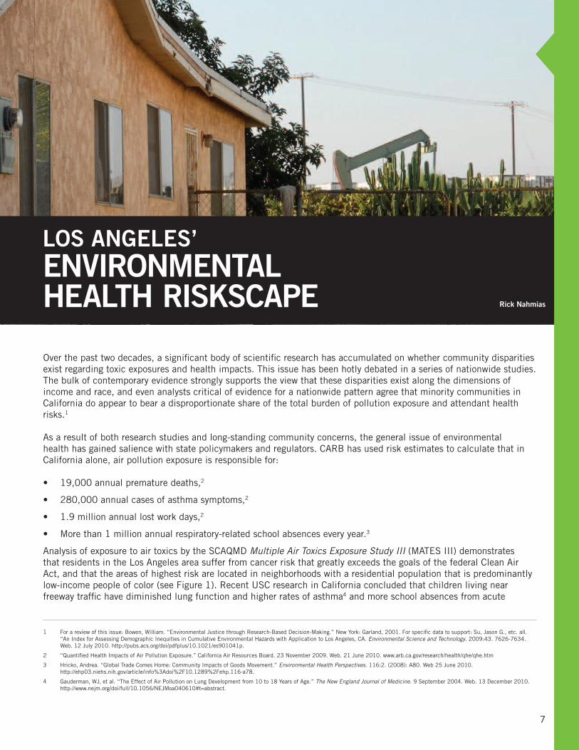
LOS ANGELES’ENVIRONMENTAL HEALTH RISKSCAPE
Los Angeles’ Environmental Health Riskscape
Rick Nahmias

respiratory problems.5 Similarly, research by UCLA/UC Irvine in California showed that pregnant women living near traffic have increased risk for low birth weight and premature babies.6
The federal government identified the elimination of health disparities as a top priority in U.S. Department of Health and Human Services’ website Healthy People 2020 (www.healthypeople.gov/hp2020), a set of national health objectives designed to identify the most significant preventable health threats and to establish national goals to reduce these risks. While community vulnerability and socioeconomics play important roles, environmental factors, including air pollution, that may contribute to disease are the specific focus of this report.
This is especially true in Los Angeles, where residents living in highly polluted working class neighborhoods adjacent to industrial areas bear most of the burden of exposure to air pollution and other environmental hazards. Most of this burden falls upon people of color and the poor—and significantly, the racial disparity seems to persist across various income levels, suggesting this is more than a matter of market forces. Indeed, both the income and race dynamics are related to larger social and political forces that can be addressed by informed and health-protective public policy.
Early studies of environmental health disparities in Los Angeles revealed that the location of hazardous facilities, such as hazardous waste sites and industrial facilities reporting to the federal Toxic Release Inventory, are located primarily in low-income communities of color. In fact, Black and Latino residents are more than three times as likely to live close to these hazards as are Anglos. Multivariate statistical analyses show that these relationships hold when one also considers other factors that might explain this pattern, such as land use and zoning, income, and property values. This pattern of exposure is mirrored by the pattern of health risks associated with air toxics.7
Analysis of data from the U.S. Environmental Protection Agency’s National Air Toxics Assessment shows that calculated lifetime cancer risk and respiratory hazard from ambient concentrations of 148 air pollutants listed under the federal Clean Air Act reveal a similar pattern of inequity, with people of color and the poor bearing a disproportionate risk of contracting cancer or suffering with respiratory diseases.8 In fact, population-weighted cancer risk estimates from air toxics exposure are consistently about 50% higher for people of color, as compared to Anglos, at every level of income. Just as disturbing is the fact that estimated cancer risk for high income residents of color is equivalent to the risk for low-income Anglo residents. Cancer risks from air toxics overall exceeded the Clean Air Act goal of one in a million by one or two orders of magnitude, and on average these risks are attributable mostly to transportation and small area source emissions.
These location-based and health-risk studies offer strong evidence of environmental health disparity in Los Angeles. Some have argued, however, that this pattern arises because depressed property values led low-income people of color to move into neighborhoods that contained existing hazardous facilities. This “field of bad dreams” scenario (“build it and they will come”) is not supported by analysis of temporal trends.9 For example, Los Angeles County census tracts where new hazardous waste facilities were sited between 1970-1990 had a higher proportion of people of color, were poorer and less well-educated with more blue-collar workers, had lower initial home values and rental values, and significantly fewer homeowners than the County overall. The percentage of residents of color in these tracts did increase after siting of these facilities, but the rate was no faster than for the rest of the County during this period.
Early studies of environmental exposure and risk disparity in Los Angeles revealed a clear pattern showing that the location of hazardous facilities, such as hazardous waste sites and facilities
reporting to the federal Toxic Release Inventory, are located primarily in low-income communities of color.
8
5 McConnell, et al. “Childhood Incident Asthma and Traffic-Related Air Pollution at Home and School.” Environmental Health Perspectives. (AOP). 22: (2010). Web. 21 June 2010. http://ehp03.niehs.nih.gov/article/info:doi%2F10.1289%2Fehp.0901232#Ahead%20of%20Print%20(AOP).
6 Wu J, Ren, et al. “Association between local traffic-generated air pollution and preeclampsia and preterm delivery in the South Coast air basin of California.” Environmental Health Perspectives. 11:17. (2009). Web. 25 June 2010. http://ehp03.niehs.nih.gov/article/fetchArticle.action?articleURI=info:doi/10.1289/ehp.0800334
7 Morello-Frosch, Rachel, Manuel Pastor and James Sadd. “Environmental Justice and Southern California’s ‘Riskscape’: The Distribution of Air Toxics Exposures and Health Risks among Diverse Communities.” Urban Affairs Review, vol. 36 no. 4 (2001) 551-578.
8 Manuel Pastor, Jr., Rachel Morello-Frosch and James Sadd. “The Air is Always Cleaner on the Other Side: Race, Space, and Air Toxics Exposures in California.” Journal of Urban Affairs. 27:2 (2005).
9 Manuel Pastor, Jr., James Sadd and John Hipp. “Which Came First? Toxic Facilities, Minority Move-in, and Environmental Justice.” Journal of Urban Affairs. 23:1 (2001). 1-21.

9
This pattern is of particular concern because it is likely that disparities in exposure to hazards contribute to health disparities. However, socio-economic status (SES) also contributes to this pattern, resulting in additional vulnerability for some communities. Socio-economic conditions affect access to care and to key health outcomes. The poor are generally less healthy than the rich, and people of color suffer disproportionately from chronic disease. However, research has shown that the direct effect of hazardous exposures can combine with various forms of psycho-social stress and amplify these
health disparities by enhancing community susceptibility to the effects of toxic substances.10 For example, prior studies have found evidence for differential effects of air pollution among different socioeconomic groups, such as maternal race and neighborhood SES. In the Los Angeles area, there is a clear pattern of inequality in terms of cumulative impacts of air pollution, with low-income communities of color bearing the greatest burden.11
POLLUTANTS PROFILEThis report deals with two of the pollutants (ozone is the third12) that represent the primary health threats from air pollution in the Los Angeles area:
Air Toxics are a class of chemicals widely recognized as priority pollutants by the State of California and federal government, and they have been identified as the cause of substantial health risks and early death nationwide. These 148 hazardous air pollutants are listed under the federal 1990 Clean Air Act (and its amendments) and have been targeted for regulatory action. The primary sources of air toxics are point sources, such as large chemical manufacturers and refineries; area sources, such as automobile paint and body shops and small manufacturing facilities; and a variety of mobile sources.
CARB13, the SCAQMD and US EPA14 use air quality modeling to estimate potential cancer and other health risks from exposure to ambient air toxics concentrations. For example, in the Los Angeles area the estimated regional cancer risk from air toxics is approximately 1,000 additional cancer cases per one million people, with “hot spots” where the risk is more than three times as high.15 Diesel exhaust, which includes both gaseous and particulate fractions, is associated with the largest share of this cancer risk. According to studies by CARB, diesel emissions are responsible for about 70 percent of the statewide excess cancer risk attributed to air pollution exposure.16 Exposure to air toxics is also responsible for other health effects, including respiratory, reproductive, neurological and developmental impacts.
Particulate matter (PM) air pollution is solid or liquid droplets largely formed by internal combustion engines (particularly diesel), dust from roadways, construction and agriculture, and burning carbon-based fuels, such as in power-plants, boilers and refineries, and fireplaces. PM is generally classified into two size fractions: PM2.5 for particles smaller than 2.5 microns (millionths of a meter,
10 Morello-Frosch Rachel and Edward Shenassa. 2006. “The environmental ‘Riskscape’ and social inequality: Implications for explaining maternal and child health disparities.” Environmental Health Perspectives. 114(8): 1150-1153.
11 Morello-Frosch, Rachel, Manuel Pastor and James Sadd. “Environmental Justice and Southern California’s ‘riskscape’: The distribution of air toxics exposures and health risks among diverse communities.” Urban Affairs Review. 36:4 (2001). 551–578.
12 Ozone: Ozone is an irritant that worsens asthma symptoms, and causes lung inflammation and breathing difficulty, particularly for people with lung disease, young children and the elderly, and people who are active outdoors. The primary contributors of ozone to urban air pollution are high temperature combustion and chemical reactions with other air pollutants that produce ozone.
13 California Air Resources Board, CHAPIS program, www.arb.ca.gov/ch/chapis1/chapis1.htm.
14 Environmental Protection Agency, National Air Toxics Assessment program, www.epa.gov/nata/.
15 Manuel Pastor, Jr., Rachel Morello-Frosch and James Sadd. “The Air is Always Cleaner on the Other Side: Race, Space, and Air Toxics Exposures in California.” Journal of Urban Affairs. 27:2 (2005).
16 “Risk Reduction Plan to Reduce Particulate Matter Emissions from Diesel-Fueled Engines and Vehicles.” California Air Resources Board. October 2000. Web. 4 August 2010. www.arb.ca.gov/diesel/documents/rrpfinal.pdf.
405
605
110
210
60
5
710
105
91
10
118
134
101
14
1702
5
405
710
118
14
Figure 1. Los Angeles’ Epicenter of Cancer Risk
Cancer risk from exposure to air toxics estimated using the Multiple Air Toxics Exposure Study III (MATES III) conducted in the South Coast Air Basin by the South Coast Air Quality Management District. (Data source: South Coast Air Quality Management District, MATES III: Multiple Air Toxics Study, 2008, www.aqmd.gov/prdas/matesIII/matesIII.html)
Pollutants Profile

or just slightly larger than the common e. coli bacteria) and PM10 between 2.5 and 10 microns in size. Finer particles generally pose a greater health risk because when inhaled they can lodge deep within the lungs. Many of the most toxic substances comprising PM pollution are in the PM2.5 fraction. PM2.5 is a significant health threat, contributing to premature mortality, aggravating a number of respiratory illnesses including asthma, and is associated with a substantial share of avoidable cardio-respiratory mortality.
According to the American Lung Association’s State of the Air 2010 report:
“ Short-term increases in particle pollution have been linked to: death from respiratory and cardiovascular causes, including strokes; increased mortality in infants and young children; increased numbers of heart attacks, especially among the elderly and people with heart conditions; inflammation of lung tissue in young, healthy adults; increased hospitalization for cardiovascular disease, including strokes and congestive heart failure; increased emergency room visits for patients suffering from acute respiratory ailments; increased hospitalization for asthma among children; and increased severity of asthma attacks in children.”17
POLLUTION AND HEALTH LINKS: NEW NATIONAL ATTENTIONUnderlying these findings are widely held concerns that pollution plays an important, albeit poorly understood, role in the complex pattern of disparate health status in diverse communities in the U.S. Yet causally linking the presence of environmental pollution with adverse health effects is an ongoing challenge, particularly in situations where populations are chronically exposed to complex chemical mixtures, and is further complicated by the lack of publicly available health data.
In its May 2010 report, the President’s Cancer Panel asserts that “the true burden of environmentally induced cancers has been grossly underestimated.”18 In addition to exposure from food, water and consumer products, the Panel also identified poor air quality—stemming from weak laws and regulations, poor enforcement, complex regulations and fragmented authority—as a contributing cause of avoidable exposures to cancer-causing agents that proliferate in the workplace and our communities. The Panel also found that existing regulations fail to take into account multiple exposures and exposure interactions—the conditions that result from the overconcentration of hazardous uses in a specific geographic area. This new, authoritative report provides additional compelling evidence that action is needed at all levels of government to address the alarmingly high levels of cancer deaths and disease.
17 “State of the Air 2010.” American Lung Association. 26. (2010). Web. 20 June 2010. www.stateoftheair.org.
18 President’s Cancer Panel. “Letter to the President.” Annual Report. (2008-2009). Web. 22 September 2010. http://deainfo.nci.nih.gov/advisory/pcp/annualReports/pcp08-09rpt/PCP_Report_08-09_508.pdf.
The President’s Cancer Panel report provides additional compelling evidence that action is needed at all levels of government to address
the alarmingly high levels of cancer deaths and disease.
Pollution and Health Links: New National Attention
10
11
In the summer of 2008, the partners in the Collaborative designed Ground Truthing, a community-based research project, to evaluate the cumulative impacts of air pollution in selected neighborhoods throughout the Los Angeles basin. The Ground Truthing project demonstrated that there are communities that are overburdened by the cumulative impacts from various sources of air pollution, many of which fall under the regulatory radar of state and local government and which are largely “hidden” from official oversight.
The Ground Truthing effort allowed the people who know an area best—local residents—to work with academic experts to methodically gather the evidence of air pollution threats and sensitive receptors in their community. This information is summarized in this report to demonstrate that a number of communities face a high density of toxic emitters that threaten air pollution-sensitive receptors in violation of CARB health protection guidelines, and make a strong case for immediate policy intervention.
Participatory action research involves community residents in research design, data collection and analysis, and ensures that the concerns and daily experiences of those most impacted by air pollution are considered. In this process, community residents located and recorded a number of air toxics emitters, such as areas where diesel trucks congregate and idle for long periods, auto paint and body shops, and manufacturing facilities. Many of these air toxics emitters do not require permits or are not regulated, and are generally not included in government regulatory databases. Nevertheless, they are significant contributors to the problem of cumulative impacts because they tend to cluster in certain communities.
GROUND TRUTHING
Community-based participatory research methods incorporate community knowledge into research design. Direct engagement in data collection and interpretation ensures that rigorous analysis is directly linked to policy outcomes and regulatory action.
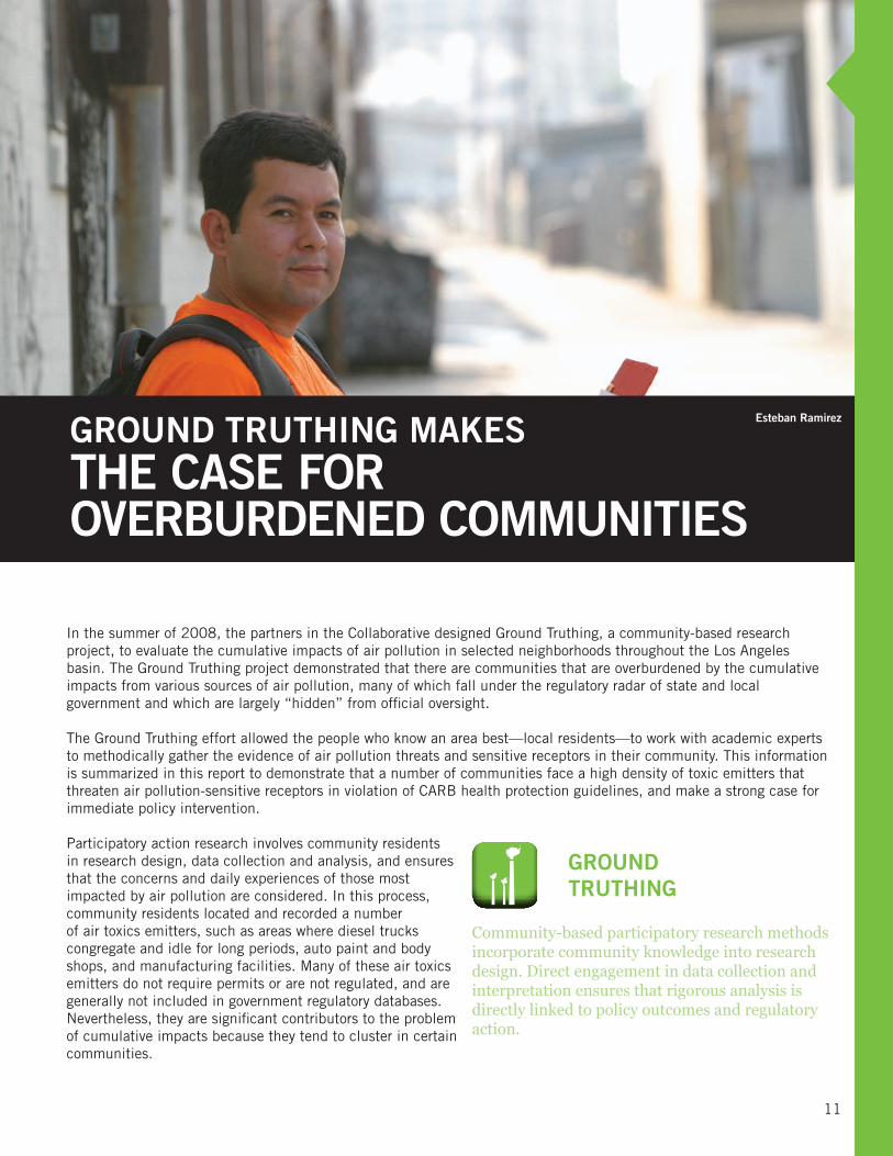
GROUND TRUTHING MAKESTHE CASE FOR OVERBURDENED COMMUNITIES
Ground Truthing Makes the Case for Overburdened Communities
Esteban Ramirez

Of the communities that participated in Ground Truthing, four are located within the City of Los Angeles— Boyle Heights, the Figueroa Corridor, Pacoima and Wilmington—while two others are separate cities within Los Angeles County—Commerce and Maywood. The map in Figure 2 shows the location of the studied areas.
GROUND TRUTHING METHODOLOGYThe study began with a May 2008 workshop in which community members were trained on the concepts and science of air pollution hazards, cumulative impacts and social vulnerability. Training also covered the various
databases maintained by state and federal regulatory agencies that contain the locations of air quality hazards that require permits and report emissions.
During the training, community members learned to identify traditional air quality hazards, and also agreed to a list of land uses and facilities that they considered “sensitive” or air pollution “hazards.” Participants practiced on-the-ground data collection techniques to locate and map these facilities by conducting a test run, walking in the surrounding community, locating facilities using maps and air photos, and verifying their observations for accuracy with regulatory databases.
At the workshop, community members defined the specific geographic boundaries in their respective neighborhoods where Ground Truthing would take place, reviewed maps showing air quality hazards and sensitive receptor land uses, and identified the additional hazards and receptors of concern to them. Figure 3 lists the hazard and sensitive receptor categories located and mapped by community participants. Many facilities of concern to residents are included in the state’s databases, but the community list also includes hazards and sensitive receptors not included in these data sources.
State regulatory agencies categorize hazards differently than a community does. The hazards recognized by the state are certain land use categories (high traffic freeways and roads, distribution centers, railyards, ports, refineries, chrome plating facilities, dry cleaners, large gas dispensing facilities) and facilities that qualify under regulatory law because of the type and quantity of air pollutants they emit such as industries falling under AB 2588, the 1987 legislation that requires stationary sources to report their emissions.19 Sensitive receptors are defined by CARB to include: new residences, schools, day care centers, playgrounds and medical facilities. However, not counted in this official definition are informal home-based day care sites, churches, senior centers and other places where vulnerable populations congregate.
19 “AB 2588 Air Toxics ‘Hot Spots’ Program.” California Air Resources Board. CARB. 14 January 2010. Web. 12 July 2010. http://www.arb.ca.gov/ab2588/ab2588.htm.
Figure 2. Ground Truthing Communities
Location of six project areas in the City of L.A. (dark grey) where Ground Truthing field work was accomplished for this study.
“We are number one but that is not always a good thing. Our community is on the frontline of pollution from the ports, the oil refineries and all
activities that support them. We live with the toxic conditions daily—and are now researching green zero emission technologies and innovative
alternative pollution control solutions for our survival.”
– Jesse Márquez, Communities for a Safe Environment
Ground Truthing Methodology
12

13
Data Collection and AnalysisOnce training was complete, each community member was equipped with notebooks containing maps, air photos and data entry forms needed to survey their community. Much of the focus was on verifying sources contained in CARB’s facility emissions inventory and also on identifying smaller polluting facilities not captured in current federal and state air pollution facility databases.
Worksheets contained step-by-step instructions on data collection, data entry forms, maps of known facilities and land uses from state government agency databases, aerial photos, and detailed street maps with address ranges. Using portable GPS receivers, users recorded locations on aerial photos with a street address, allowing for later verification of the location using address geocoding, a geographic information system (GIS) process by which street address locations are matched to their corresponding geographic location based on map coordinates.
Community leaders organized participants in field teams of two, with each team responsible for conducting street-by-street canvassing of a portion of the study area, identifying and locating both air quality hazards and sensitive receptors of concern. Overlaps at the boundaries were included to ensure that the census was
complete, and duplicate data were later omitted. Field work was completed during June and July 2008 and field teams were tasked to:
• verify the location and correct information of all air quality hazards recorded in state regulatory agency databases
• verify the location and correct information of all sensitive receptor land uses as defined by CARB (schools, childcare centers, playgrounds and urban parks, and healthcare facilities)
• locate and map any additional air quality hazards and sensitive receptors that were not included in the regulatory agency databases, using the types of facilities identified in the training workshop as guidance.
Air Quality HazardsType NumberAuto Paint and Body 9Auto/Truck Repair 149Dry Cleaners 5Manufacturing Using Air Toxics 69Metal Plating 3Printing 10Recycling 9Superfund Site 1Idling Trucks (Chronic) 8Sensitive ReceptorsType NumberChurch 61Community Center 7Daycare 24Health 27Park 3School 13Senior 9
REGULATORY DATA SOURCES
• The Community Health Air Pollution Information System (CHAPIS), California Air Resources Board, www.arb.ca.gov/gismo2/chapis_v01_6_1_04/
• Air Toxics “Hot Spots” Program, Southern California Air Quality Management District (Assembly Bill 2588, 1987), www.aqmd.gov/prdas/ab2588/ab2588.html
• Toxic Air Contaminant Hexavalent Chromium Activity (chrome plating facilities), California Environmental Protection Agency, www.arb.ca.gov/toxics/chrome/chrome.htm
• Treatment, Storage and Disposal Facilities, CA, Department of Toxic Substances Control, www.dtsc.ca.gov/HazardousWaste/#Treatment,_Storage_and_Disposal_Facility_Information
Figure 3: Community Findings—Air Quality Hazards and Sensitive Receptors
List of air quality hazards and sensitive receptors located and mapped by Ground Truthing teams. Number refers to total for all Ground Truthing communities.
Data Collection and Analysis

The name, type of business, address, intersection, category (hazard or sensitive receptor), and other notes about the land use were recorded in a field notes template sheet. This data was collected from information that could be obtained from signs and observations of what was occurring on the property. Teams also recorded observations about types of hazards to residents, specifically idling trucks, trucks passing through residential areas, and large containers on sites that may be filled with chemicals. Researchers also identified hazard locations recorded in state regulatory agency databases—CHAPIS facilities, chrome platers, DTSC hazardous waste facilities, and AB2588 “hot spots” emissions sources—to verify location accuracy.
The field data collected by community participants was later transferred to a GIS spatial database. Duplicates were identified and eliminated, and researchers subsequently visited and documented the location of each site recorded in state regulatory agency databases using GPS to verify location accuracy.
Mapping and spatial analysis was then performed, and the results reported back to participants in a subsequent workshop to allow them to compare their maps to those created using only state regulatory agency data, and to revisit their hypotheses and discuss their results.
WHAT GROUND TRUTHING FOUNDThe main findings of the Ground Truthing community-based participatory research and subsequent air testing can be summarized as follows:
Finding 1: Hazardous emission facilities are more numerous than regulatory data suggests.
Finding 2: Sensitive land uses are also more numerous.
Finding 3: Numerous sensitive receptors are located too close to hazards.
Finding 4: Hazard locational errors in regulatory databases are significant in both number and value.
Finding 5: PM2.5 air pollution levels regularly exceed safe standards recommended by State government.
Finding 1: Hazards are More Numerous Than Regulatory Data Suggest Communities are very concerned that all air quality hazards are not fully identified by government regulatory agencies. This is mostly because minimum reporting requirements are such that smaller facilities are not subject to regulatory reporting under AB2588. This statute applies only to facilities that emit a total of 5–10 tons per year of pollutants covered in the law. Because of this threshold, many polluting facilities—such as gas stations, print shops, auto body shops, and dry cleaners—are not included in the AB 2588 database.
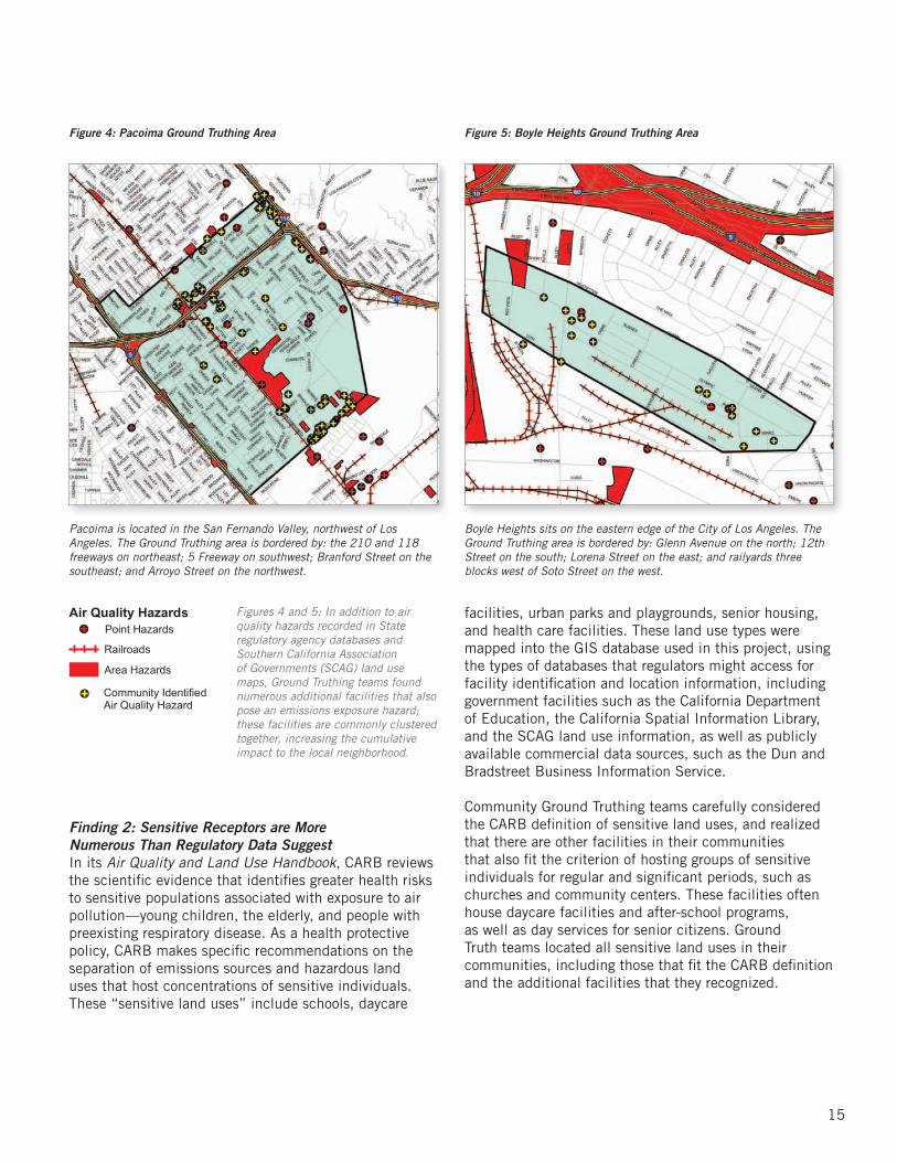
Ground Truthing showed that these types of facilities are much more numerous than AB 2588 data would suggest. For example, maps of Pacoima (see Figure 4) and Boyle Heights (see Figure 5) show these community-identified air quality hazards to be located in the same general area as those facilities recorded in regulatory databases, and that they are clustered together. The combined emissions of these clustered facilities represent a cumulative hazard that may be comparable to a larger facility. In the Pacoima Ground Truthing area, community members identified almost 50 sites that they considered environmental health hazards, while in the much smaller Boyle Heights Ground Truth area, Ground Truth teams located 16 additional hazardous sites not included in the regulatory record. Because of its limitations in identifying all air quality hazards that together contribute to cumulative impacts, many communities think that current regulatory practice is inadequate. This concern is supported by Ground Truthing evidence.
AIR QUALITY HAZARDS
Hazards are identified as stationary businesses known to use or emit hazardous chemicals in their processes as well as places generating diesel truck traffic.
What Ground Truthing FoundFinding 1: Hazards are More Numerous Than Regulatory Data Suggest
14
15
Figures 4 and 5: In addition to air quality hazards recorded in State regulatory agency databases and Southern California Association of Governments (SCAG) land use maps, Ground Truthing teams found numerous additional facilities that also pose an emissions exposure hazard; these facilities are commonly clustered together, increasing the cumulative impact to the local neighborhood.
Finding 2: Sensitive Receptors are More Numerous Than Regulatory Data SuggestIn its Air Quality and Land Use Handbook, CARB reviews the scientific evidence that identifies greater health risks to sensitive populations associated with exposure to air pollution—young children, the elderly, and people with preexisting respiratory disease. As a health protective policy, CARB makes specific recommendations on the separation of emissions sources and hazardous land uses that host concentrations of sensitive individuals. These “sensitive land uses” include schools, daycare
facilities, urban parks and playgrounds, senior housing, and health care facilities. These land use types were mapped into the GIS database used in this project, using the types of databases that regulators might access for facility identification and location information, including government facilities such as the California Department of Education, the California Spatial Information Library, and the SCAG land use information, as well as publicly available commercial data sources, such as the Dun and Bradstreet Business Information Service.
Community Ground Truthing teams carefully considered the CARB definition of sensitive land uses, and realized that there are other facilities in their communities that also fit the criterion of hosting groups of sensitive individuals for regular and significant periods, such as churches and community centers. These facilities often house daycare facilities and after-school programs, as well as day services for senior citizens. Ground Truth teams located all sensitive land uses in their communities, including those that fit the CARB definition and the additional facilities that they recognized.
Figure 4: Pacoima Ground Truthing Area Figure 5: Boyle Heights Ground Truthing Area
Pacoima is located in the San Fernando Valley, northwest of Los Angeles. The Ground Truthing area is bordered by: the 210 and 118 freeways on northeast; 5 Freeway on southwest; Branford Street on the southeast; and Arroyo Street on the northwest.
Boyle Heights sits on the eastern edge of the City of Los Angeles. The Ground Truthing area is bordered by: Glenn Avenue on the north; 12th Street on the south; Lorena Street on the east; and railyards three blocks west of Soto Street on the west.
Finding 2: Sensitive Receptors are More Numerous than Regulatory Data Suggest
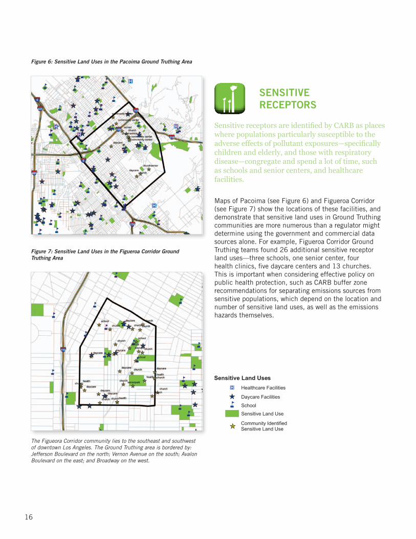
Maps of Pacoima (see Figure 6) and Figueroa Corridor (see Figure 7) show the locations of these facilities, and demonstrate that sensitive land uses in Ground Truthing communities are more numerous than a regulator might determine using the government and commercial data sources alone. For example, Figueroa Corridor Ground Truthing teams found 26 additional sensitive receptor land uses—three schools, one senior center, four health clinics, five daycare centers and 13 churches. This is important when considering effective policy on public health protection, such as CARB buffer zone recommendations for separating emissions sources from sensitive populations, which depend on the location and number of sensitive land uses, as well as the emissions hazards themselves.
SENSITIVE RECEPTORS
Sensitive receptors are identified by CARB as places where populations particularly susceptible to the adverse effects of pollutant exposures—specifically children and elderly, and those with respiratory disease—congregate and spend a lot of time, such as schools and senior centers, and healthcare facilities.
Figure 6: Sensitive Land Uses in the Pacoima Ground Truthing Area
Figure 7: Sensitive Land Uses in the Figueroa Corridor Ground Truthing Area
The Figueora Corridor community lies to the southeast and southwest of downtown Los Angeles. The Ground Truthing area is bordered by: Jefferson Boulevard on the north; Vernon Avenue on the south; Avalon Boulevard on the east; and Broadway on the west.
16
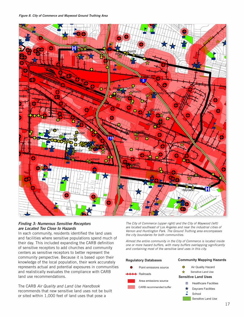
Figure 8. City of Commerce and Maywood Ground Truthing Area
17
Finding 3: Numerous Sensitive Receptors are Located Too Close to Hazards In each community, residents identified the land uses and facilities where sensitive populations spend much of their day. This included expanding the CARB definition of sensitive receptors to add churches and community centers as sensitive receptors to better represent the community perspective. Because it is based upon their knowledge of the local population, their work accurately represents actual and potential exposures in communities and realistically evaluates the compliance with CARB land use recommendations.
The CARB Air Quality and Land Use Handbook recommends that new sensitive land uses not be built or sited within 1,000 feet of land uses that pose a
!C!C!C!C!C!C!C!C
^̀!C !C !C
!C
!C!C!C!C
!C
!C!C
!C
!C
!C
!C
!C
!C
^̀
^̀
^̀ ^̀^̀^̀
^̀
^̀
^̀
^̀
^̀
^̀
^̀
^̀
^̀^̀
^̀^̀
^̀
^̀
^̀
^̀^̀
^̀̂̀
^̀
^̀
^̀
!C
!C
!C
!C
!C
!C
!C
!C
!C
!C
^̀
^̀
^̀̂̀
^̀
^̀
^̀
^̀^̀̀̂^̀
^̀
^̀^̀ !C
!C
!C
!C
!C
!C
!C!C
!C!C
!C
!C
!C
!C
!C
!C
!C
!C
!C
!C !C!C
!C
!C!C!C
!C!C
!C!C
!C
!C!C !C
!C
!C
!C!C!C!C
!C!C
!C!C
!C
!C
!C!C
!C
^̀̂̀^̀
^̀ ^̀^̀
^̀
^̀̂̀^̀
^̀
^̀
!C!C^̀̀̂
^̀
!C!C
!C!C
!C
!C
!C
!C!C
!C
!C^̀
^̀
^̀
^̀^̀
^̀
^̀^̀
^̀!C
!C
!C
!C
!C
!C !C
!C
!C
!C
!C
!C
!C
!C
!C
!C
!C
!C
!C
!C
!C
!C
!C
!C
!C!C
!C
!C
!C!C
!C
!C
!C
!C
!C
!C
!C
!C!C
!C
!C
!C
!C
!C!C
!C
!C
!C
!C
!C
!C
!C
!C
!C
!C
!C
!C
!C
!C
!C
!C
!C
!C
!C !C!C
!C
!C
!C
!C
!C
!C
!C
!C
!C
!C
!C!C
!C
!C
!C
!C
!C
!C
!C
!C
!C
!C!C
!C
!C
!C
!C
!C!C
!C
!C
!C
!C
!C
!C
!C
!C
!C
!C
!C
!C!C
!C
!C
!C
!C
!C
!C
!C
!C
!C
!C
!C
!C
!C
!C
!C
!C
!C
!C
!C !C
!C
!C
!C
!C
!C
!C
!C
!C
!C
!C
!C
!C
!C
!C
!C
!C
!C
!C
!C
!C
!C
!C
!C
!C
!C
!C
!C
!C
!C
!C
!C
!C
!C
!C!C!C
!C
!C
!C
!C
!C!C!C
!C
!C
!C
!C
!C !C
!C!C
!C !C
!C!C
!C!C!C!C
^̀
^̀
^̀
^̀
^̀
^̀
^̀^̀
^̀
^̀̂̀
^̀
^̀
^̀
^̀
^̀
^̀
^̀
^̀
^̀^̀
^̀
^̀
^̀
^̀
^̀
^̀^̀
^̀
^̀
^̀̂̀
^̀
^̀
^̀
^̀
^̀
^̀
^̀
^̀
^̀
^̀
^̀
^̀
^̀
^̀
^̀^̀
^̀
^̀
^̀
^̀
^̀
^̀
^̀
^̀^̀
^̀
^̀
^̀
^̀
^̀^̀
^̀
^̀
^̀
^̀
^̀
^̀
^̀
^̀
^̀
^̀
^̀
^̀
^̀
^̀
^̀
^̀^̀
^̀
^̀nn
nn
n
nn
n
n
n
n
n
nn
n
n
n
n
n
n
n
n
n
n
n
nn
n
nn
n
n
n
n
n
n
n
n
n
n
nnn
nnn
nn
n
n
n
n
n
n
n
n
n
n
n
n
n
n
n
n
nn
nn
n
n
n
n
n
n
n
n
n
n
n
n
n
n
n
n
n
n
n
n
n
n
n
n
n
n
n
nnn
n
n
n
n
n
n n
n
n
n
n
n
nn
n
n
n
n
n
n
n
n
nn
nn
n
n
nnn
n
n
n
n
n
n
nn
n
n
®v
®v
®v
®v
®v
®v ®v
§̈¦5
§̈¦710
senior
senior
senior
senior
school
school
school
school
school
healthhealth
church
churchchurch
church
church
churchchurch
healthhealth
healthhealth
health
health
health
health
healthhealth
health
health
church
churchchurch
church
church
church
churchchurch
church
church
church church churchchurch
church
churchdaycare
daycare
daycare
daycare
daycare
daycaredaycare
daycare
community center
Finding 3: Numerous Sensitive Receptors are Located Too Close to Hazards
The City of Commerce (upper right) and the City of Maywood (left) are located southeast of Los Angeles and near the industrial cities of Vernon and Huntington Park. The Ground Truthing area encompasses the city boundaries for both communities.
Almost the entire community in the City of Commerce is located inside one or more hazard buffers, with many buffers overlapping significantly and containing most of the sensitive land uses in this city.
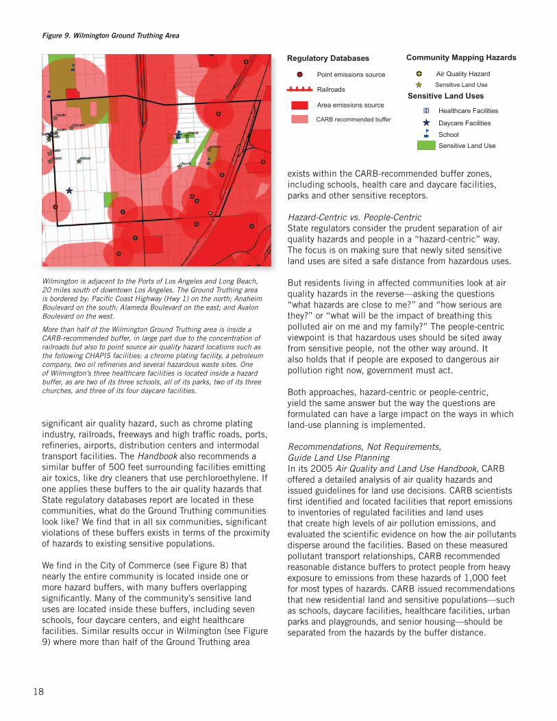
significant air quality hazard, such as chrome plating industry, railroads, freeways and high traffic roads, ports, refineries, airports, distribution centers and intermodal transport facilities. The Handbook also recommends a similar buffer of 500 feet surrounding facilities emitting air toxics, like dry cleaners that use perchloroethylene. If one applies these buffers to the air quality hazards that State regulatory databases report are located in these communities, what do the Ground Truthing communities look like? We find that in all six communities, significant violations of these buffers exists in terms of the proximity of hazards to existing sensitive populations.
We find in the City of Commerce (see Figure 8) that nearly the entire community is located inside one or more hazard buffers, with many buffers overlapping significantly. Many of the community’s sensitive land uses are located inside these buffers, including seven schools, four daycare centers, and eight healthcare facilities. Similar results occur in Wilmington (see Figure 9) where more than half of the Ground Truthing area
exists within the CARB-recommended buffer zones, including schools, health care and daycare facilities, parks and other sensitive receptors.
Hazard-Centric vs. People-CentricState regulators consider the prudent separation of air quality hazards and people in a “hazard-centric” way. The focus is on making sure that newly sited sensitive land uses are sited a safe distance from hazardous uses.
But residents living in affected communities look at air quality hazards in the reverse—asking the questions “what hazards are close to me?” and “how serious are they?” or “what will be the impact of breathing this polluted air on me and my family?” The people-centric viewpoint is that hazardous uses should be sited away from sensitive people, not the other way around. It also holds that if people are exposed to dangerous air pollution right now, government must act.
Both approaches, hazard-centric or people-centric, yield the same answer but the way the questions are formulated can have a large impact on the ways in which land-use planning is implemented.
Recommendations, Not Requirements, Guide Land Use PlanningIn its 2005 Air Quality and Land Use Handbook, CARB offered a detailed analysis of air quality hazards and issued guidelines for land use decisions. CARB scientists first identified and located facilities that report emissions to inventories of regulated facilities and land uses that create high levels of air pollution emissions, and evaluated the scientific evidence on how the air pollutants disperse around the facilities. Based on these measured pollutant transport relationships, CARB recommended reasonable distance buffers to protect people from heavy exposure to emissions from these hazards of 1,000 feet for most types of hazards. CARB issued recommendations that new residential land and sensitive populations—such as schools, daycare facilities, healthcare facilities, urban parks and playgrounds, and senior housing—should be separated from the hazards by the buffer distance.
18
Wilmington is adjacent to the Ports of Los Angeles and Long Beach, 20 miles south of downtown Los Angeles. The Ground Truthing area is bordered by: Pacific Coast Highway (Hwy 1) on the north; Anaheim Boulevard on the south; Alameda Boulevard on the east; and Avalon Boulevard on the west.
More than half of the Wilmington Ground Truthing area is inside a CARB-recommended buffer, in large part due to the concentration of railroads but also to point source air quality hazard locations such as the following CHAPIS facilities: a chrome plating facility, a petroleum company, two oil refineries and several hazardous waste sites. One of Wilmington’s three healthcare facilities is located inside a hazard buffer, as are two of its three schools, all of its parks, two of its three churches, and three of its four daycare facilities.
Figure 9. Wilmington Ground Truthing Area

The guidance from government agencies should require that, just as new sensitive populations should not be sited near existing hazards, new hazards should likewise not be sited if they are
within the buffer distance from sensitive land uses or residences.
19
CARB’s recommendations can help guide cities in health-protective decision-making. For example, when siting a new school, it must be demonstrated that the new site is not inside the hazard buffer. Unfortunately, cities and towns are not required to accept the CARB land use recommendations, despite the fact that doing so would lead to tangible public health benefits.
Even with CARB’s clear health-protective recommendations, hazards and sensitive land uses coexist in many communities. From a people-centric planning perspective, these already overburdened communities cannot tolerate the addition of more hazardous facilities and land uses. Sensitive receptors are already surrounded by hazards and buffer zones are routinely violated, placing large numbers of people at great risk for increased or aggravated disease and reduced quality of life.
Finding 4: Hazard Locational Errors in Regulatory Databases are Significant Communities are intensely interested in how government regulators view their neighborhood when considering cumulative impacts from air pollution, and in how their own observations and experience can help. In their
assessments, regulators use locations of emissions sources stored in various government databases. Ground Truthing field observations checked the accuracy of these locations using GPS receivers to locate air quality hazards and compared them to the published location. The locations of some of the point source air quality hazards did not coincide with reported locations in state regulatory databases. Figure 10 shows facilities in the Pacoima Ground Truthing study area with locational errors of over 200 feet. Other Ground Truthing communities have a similar number of significant locational errors.
A full list from the six Ground Truthing communities would show that most (77 of 122) of these facilities are inaccurately recorded on state databases by at least 200 feet. These distance errors are significant when compared to the recommended buffer distances for separation of sensitive receptors from air quality hazards in the CARB Handbook. If the location used to map the health protective buffer around an air quality hazard facility is not accurate, the buffer itself and land use decisions made using it will also be in error. This undermines the regulatory goal of environmental health protection of residents living in these communities.
Figure 10: Locational Errors of Hazards Within Pacoima
State Database Facility Name Distance Error In Feet Direction
Chrome Price Pfister Inc. 1310 SW
AB2588 Anthony Inc. 1140 SW
CHAPIS Price Pfister Inc. 750 SW
CHAPIS Anthony International 740 S
AB2588 California Technical Plating Corp. 630 NW
AB2588 All American Asphalt 630 NW
DTSC Valley Region High School No. 5 620 N
CHAPIS Whiteman 540 NW
DTSC Usarc Pacoima 460 SW
DTSC Holchem, Inc. 420 NW
AB2588 Precision Dynamics Corp. 250 NE
AB2588 Sequoia Shutters 240 NE
Finding 4: Hazard Locational Errors in Regulatory Databases are Significant

Finding 5: Air Pollution Levels Exceed Safe StandardsThe results of the community mapping study clearly show that the cumulative impacts, as measured by the number of air quality hazards and their proximity to sensitive receptors, could be a far more serious problem, largely hidden from official oversight. If this is true, one would also expect high air pollution levels in these neighborhoods.
To answer this question, community members measured actual air pollution levels using the same type of air pollution monitoring devices also used by state air quality regulators for field measurements. During March and April of 2010, community members systematically monitored PM2.5 levels using handheld monitoring equipment lent to the Collaborative for this study by
the CARB Exposure Assessment Program and the UCLA Center for Occupational and Environmental Health. The TSI Model 8520 DustTrak Aerosol Monitors are nephelometers that measure levels of ambient PM2.5 by sensing particle scattering of a laser beam which converts signals into a particle concentration.20
In five of these targeted communities, several test sites were identified by the teams of community members doing the air monitoring as representing locations of greatest concern either because they are areas of perceived high air pollution concentrations, or are near sensitive receptor land uses of particular importance to local residents.21 Trained and monitored by an experienced researcher, teams of community members organized themselves to systematically monitor each
In the communities studied… PM2.5 levels exceeded the state health standard about half the time.
20 CARB has used this equipment monitoring school bus emissions (Fitz, Winer et al. 2003; Sabin, Kozawa et al. 2005) in a manner similar to that of other investigators (Ramachandran, Adgate et al. 2000; Chung, Chang et al. 2001; Yanosky, Williams et al. 2002).
21 The Ground Truthing team from the City of Commerce was unable to participate in the D-Trak air testing experiment at the same time as other communities. However, community members employed P-Track monitors, which measure ultra fine particle pollution levels, to test air quality during November of 2008. The tests revealed similar results to those found in the five communities conducting D-Trak sampling.
20
Finding 5: Air Pollution Levels Exceed Safe Standards
Figure 11: DustTrak PM2.5 Monitoring Results for Boyle Heights
0
0.01
0.02
0.03
0.04
0.05
0.06
0.07
7th and Soto
8th and Camulos
8th and Lorena
Grande Vista and Olympic
Camulos and Glenn Ave
Pomeroy and Tremont
Fickett and Wabash
PM
2.5
mea
sure
men
t, m
g/m
³ California EPA Standard0.012 mg/m3

location six times each day for a full week. This allowed them to characterize PM concentrations on both weekdays and weekends, and during both low and high rush hour traffic periods between 6 a.m. and 10 p.m. During each monitoring session, the DustTrak monitor collected data for a 5-10 minute period to measure a time-weighted average PM2.5 concentration.
Results from the particulate air pollution monitoring done in Boyle Heights are shown in Figure 11. Measurements from each of seven test site locations are shown in vertical columns of data points. Each point represents one time-averaged measurement of PM2.5 at a given location, with a red horizontal line showing the California ambient air quality standard for fine particulate air pollution of 0.012 milligrams per cubic meter of air; points above the red dashed line exceed this health-based standard.
In all communities where air testing took place, the results were consistent with the Ground Truthing results. Measured PM2.5 concentrations exceeded the state health standard about half the time. In each community, the highest values were five to six times the air quality standard. Particulate air pollution concentrations tended to peak midday between 9 a.m. and 3 p.m., corresponding with morning rush hour and busy traffic during the period when children are playing at school and many residents are outside at work or play.
Monitoring was purposely done during a season when regional air quality was quite good compared to the rest of the year. This monitoring project further validates the concerns of residents and environmental justice advocates regarding cumulative impacts from multiple pollution sources. In the neighborhoods where multiple air pollution sources appear to be concentrated, air quality is chronically bad in terms of particulate air pollution. This is an issue that merits serious attention from policymakers. Regular tests of overburdened neighborhoods need to be conducted to monitor conditions that affect public health.
MAKING THE CASE: RECOMMENDATIONS FOR IMPROVED DATA COLLECTION AND ANALYSISPast efforts to engage academic researchers, regulatory agencies and community members have raised important issues of concern to residents and increased understanding of the regulatory process. The Ground Truthing effort documented in this report goes one step further by meaningfully engaging residents of overburdened communities both in defining the research to address their concerns, and in structured data collection activities.
In this study, residents demonstrated the extent to which government emission inventories inadequately capture the location and number of emission sources in relation to sensitive receptors in their communities, resulting in an underestimate of cumulative impacts in these areas. Ground Truthing found that air pollution hazards are more numerous than these regulatory data suggest and that locational errors in these data are numerous and significant; sensitive receptors are also more numerous and include some types of facilities that are not included in the CARB Handbook; and buffer zones around air pollution hazards recommended by CARB for protection of sensitive populations are violated consistently. Applying this standard of health protection, sensitive populations should not venture into more than half of these communities, yet these neighborhoods are home to well-established populations of people who deserve better protection from air pollution.
The Ground Truthing findings, while limited to six communities in relatively small geographic areas, clearly and consistently suggest that government agency data collection and analysis methods could be strengthened to more accurately reflect the reality of environmental health hazards. Our small-scale community mapping effort identified multiple data gaps and inaccuracies and supports the community concern that there are a number of “hidden hazards” that pose additional health risks. We recommend that the California Air Resources Board, its member divisions and the South Coast Air Quality Management District consider the following:
1. Enhance data collection methods to improve data accuracy related to the quantification and location of hazardous emission facilities and sensitive receptors.
2. Increase and improve onsite monitoring to ensure compliance with existing laws and regulatory requirements including minimum buffer zone distances.
3. Adopt a rigorous and evidence-based screening tool to identify neighborhoods and communities overburdened by cumulative impacts to better prioritize enforcement and policy intervention.
While the Collaborative looks forward to progress on these recommendations by state and regional agencies, we also maintain that local policy interventions are required to address the urgent situation faced by these Ground Truthing communities and others like them. However, a more comprehensive system for data collection at the state and regional levels will surely reinforce and strengthen the effectiveness of the local policy recommendations we make in the following section.
21
Making the Case: Recommendations for Improved Data Collection and Analysis
POLICY RECOMMENDATIONSThe conditions highlighted in this report underscore the fact that regional, state and federal agencies have not effectively documented, monitored, or regulated all of the polluting facilities impacting specific neighborhoods, nor addressed their cumulative environmental impacts on residents. After years of working to improve the quality of life in overburdened communities, the Collaborative is convinced that these failures can no longer be ignored. Rigorous policies must be adopted to ameliorate the problem of cumulative environmental impacts at the municipal level of government.
Municipal government, with its broad authority over land use across a jurisdiction, can play a significant and supportive role in safeguarding communities from over-concentration of industrial uses that pose a significant environmental hazard in an identified hot spot area. In fact, local planning, land use and effective permitting and enforcement policies provide the most promising avenues for cities and county governments to help overburdened communities deal with pervasive environmental problems.
A recent policy brief issued by the California Health Policy Forum asserts that policy changes by local governments and interventions outside of the health care sector can play a more powerful role than health services in improving health outcomes for people living in low-income communities of color, thereby reducing health inequities and resulting health disparities.22 The report also calls upon decision-makers at the community, state and national levels to implement policy solutions that address the root causes of health inequities, including improvements to air, water and soil quality.
A CALL TO ACTIONFOR HEALTHY, LIVABLE COMMUNITIES
“Policy and institutional practices are the key levers for change.
Consequently, we need to focus on these areas…in order to ‘unmake’
inequitable neighborhood conditions and improve health and
safety outcomes.”– A Time of Opportunity: Local Solutions to Reduce Inequities
in Health and Safety, Prevention Institute, May 2009
A Call to Action for Healthy, Livable CommunitiesPolicy Recommendations
22
22 Iton, T. [et al]. “Targeting Root Causes to Address Inequities and Improve Health: Implications for Health Reform.” California Health Policy Forum Policy Brief. Sacramento, CA: Center for Health Improvement, July 2009.

While state and federal agencies set standards for air and water quality and regulate polluters, municipal governments are in the unique position to enact innovative policies to address cumulative environmental impacts. Previous public health interventions using planning, land use and zoning mechanisms to regulate the proliferation of liquor stores and other problematic land uses in low-income communities of color have led to healthier, safer environments.
A CALL TO ACTION FOR THE CITY OF LOS ANGELESThe Collaborative has been an active proponent of the City of Los Angeles’ endeavors to become the cleanest and greenest big city in the United States. Achieving this ambitious goal and ensuring a healthful living environment for all residents requires the combined efforts of City government, residents, the business sector and the environmental community.
Inequities in exposure to environmental hazards in Los Angeles’ most vulnerable communities coupled with the limitations of existing regulatory infrastructure make it imperative for the City to develop and implement relevant policies and strategies so that all Angelenos can enjoy the health and economic benefits of improved environmental quality. We must create tools that help the City prioritize and address environmental hazards in the communities experiencing the most significant environmental degradation. Finally, we must be innovative in creating solutions that spur economic growth in the neediest communities while reducing pollution.
With the release of this report and corresponding efforts by residents, community organizations and other allies, we hope to create momentum for an affirmative and participatory process to inform, involve and engage all stakeholders in achieving environmental equity for all residents of Los Angeles. More specifically, we propose the creation of an evidence-based policy framework to substantially reduce cumulative environmental impacts.
THE POLICY FRAMEWORK: PREVENTION, REDUCTION AND REVITALIZATIONAs part of the Ground Truth effort, the Collaborative examined how municipal governments in California and elsewhere have adapted traditional planning and land use tools to address public health and safety problems associated with a concentration of industrial uses that persist despite regulation of individual establishments by state or federal agencies. A literature review and discussions with environmental health and justice organizations throughout the country enabled us to identify a range of approaches that have been used by local and regional governments (see pages 24-26). This information was compiled and presented to a distinguished group of environmental lawyers, land use experts and environmental health advocates in Los Angeles in late 2009 for their consideration. From this process, the policy options listed below were identified as the most promising for addressing cumulative environmental health impacts at the local level.
“Now that we have identified the problem, we have to identify some of the solutions. Our members may not use the term ‘cumulative impact’ but that doesn’t
mean that they don’t know what it is. It is what we see every day. People are eager to engage and reach
some sort of environmental justice.”
– Angelo Logan, East Yard Communities for Environmental Justice
A Call to Action for the City of Los AngelesThe Policy Framework: Prevention, Reduction and Revitalization
23

The complex problem of reducing exposure to toxic hazards in our communities can appear overwhelming and intractable to most policymakers and community residents. However, we have found the following framework helpful in conceptualizing the problem and identifying the steps that are necessary to lower health risk while moving towards resilient and vibrant local economies. The City of Los Angeles can advance livable, healthy communities by adopting a comprehensive policy framework that emphasizes:
• Prevention: Prevent further increase in the cumulative environmental impacts in overburdened communities.
• Mitigation: Clean up, reduce and mitigate existing environmental problems and hazards.
• Revitalization: Implement innovative economic revitalization approaches and invest in emerging green technologies to transform overburdened areas into healthy, sustainable and vibrant communities with jobs for local residents.
The Collaborative’s policy framework is comprised of 11 options designed to work together to comprehensively redress cumulative environmental impacts in Los Angeles’ overburdened neighborhoods. These policy options include mechanisms to prevent and reduce the concentration of hazardous uses as well as programs to meaningfully incentivize clean economic development and green infrastructure to revitalize neighborhoods that have suffered from the effects of over-concentration of toxic hazards.
Hazard Mapping and Screening Tool: Adopt a state of the art screening tool for planning and land use policy development and decision-making that allows the City to identify geographically defined areas that are most vulnerable and have a high concentration of hazardous land uses. A similar approach was used by the Los Angeles Department of City Planning to aid the Los
Angeles City Council with the preparation of a permanent medical marijuana ordinance. The Department utilized geographic information systems technology and data from multiple proprietary and public sources to map the relation of specific medical marijuana outlets to numerous sensitive land uses. The Los Angeles chapter of the American Planning Association recently presented the Department an award for this innovative use of GIS technology with broad applicability to land use regulatory approaches.
Special Districts: Using authoritative screening methods, along with community-identified hazards and concerns, create geographically defined special districts—also known as supplemental use districts—with specific community standards and guidelines to prevent and reduce environmentally hazardous land uses and promote economic development and community
revitalization. The City of Los Angeles has 13 different kinds of supplemental use districts ranging from oil drilling districts to mining districts and horse-keeping districts. The purpose of these districts, how they are created and relevant conditions are outlined in the Los Angeles Municipal Code.
Interim Control Ordinance (ICO): Establish a zoning designation that temporarily restricts new land uses that pose a significant environmental hazard to human health and safety in a specified geographic area. ICOs give policymakers the time required to develop comprehensive regulatory strategies while providing protections from problematic land uses. In 2008, the Los Angeles City
Council enacted an ICO that would prevent new fast-food restaurants from opening in a number of South and Southeast Los Angeles neighborhoods. The one-year moratorium was designed to give City planners an opportunity to study the economic and environmental effects of the overconcentration of fast-food restaurants in these communities and create policies to encourage grocery stores, sit-down restaurants and similar amenities to open their doors in South Los Angeles.
24
Qualified Conditions and/or Use Permits: Establish qualified (Q) conditions or use permit requirements that contain design standards for land uses that create environmental hazards in overburdened communities. New uses as well as existing uses that wish to significantly expand or change should be required to comply with the standards. The design standards should also
address the siting of new sensitive uses next to existing hazardous uses to ensure public health and safety. Q-conditions and use permits are well established City of Los Angeles planning tools that help the jurisdiction ensure the public’s health, safety and welfare and/or the integrity and character of a community. For example, Q-conditions are often used to ensure safe operation of large industrial and commercial projects in the City of Los Angeles. Moreover, the City of Los Angeles requires a use permit for the establishment of liquor stores in some South Los Angeles neighborhoods. Through the Q-condition or use permit process, municipalities can require certain kinds of businesses to meet specific conditions to harmonize the establishment with its surroundings, even though the service or product is regulated by another agency. A Q-condition or use permit process also allows jurisdictions to impose sanctions against operators who do not comply with required conditions and conduct public hearings, providing a mechanism for individuals and groups to have a voice in the decision-making process that shapes their community environment.
Health Impact Assessment: As part of the permitting process, require developers to undertake a health impact assessment to systematically judge the potential effects of a proposed project on the health of a population, the distribution of those effects within the population and possible alternatives to protect and promote health. Health impact assessment (HIA) is a process that
evaluates the impact of specific policies and projects on human health with the goal of reducing the harmful effects on health and increasing the beneficial effects. With roots in the practice of environmental impact assessment, HIA aims to inform the public and decision-makers when decisions about policies, programs, plans, and projects have the potential to significantly impact human health, and to advance equity, sustainable development and a comprehensive approach to health.
Community and Specific Plans: Amend existing Community Plans or Specific Plans to incorporate design standards, zoning changes, buffer zones and/or other relevant mechanisms to prevent further siting of hazardous uses, mitigate existing hazardous uses and eliminate current hazardous uses over time. The City has 35 community plans and 45 specific plans in place. A
community plan focuses on a particular area or community within the City and supplements the General Plan. A specific plan implements the General Plan in all or part of the area covered by the General Plan and specifies in detail the following: land uses, public and private facilities needed to support the land uses, phasing of development, standards for the conservation, development, and use of natural resources, and a program of implementation measures, including financing measures.
General Plan: Update the General Plan to include an environmental health and justice element that addresses the disproportionate concentration of land uses that pose a significant environmental hazard to human health and safety in Los Angeles’ most vulnerable communities. A general plan serves as the foundation for local land use planning and translates the vision for a
municipality’s future into goals and policies for its physical development. In California, general plans are required to have specific elements: land use, open space, circulation, noise, housing, safety, and conservation. A general plan may include any other elements or address any other subjects that, in the judgment of the legislative body, relate to the physical development of the county or city. For example, the City of Richmond, California, has added a health element to their General Plan and in National City, California, the City Council has authorized the development of a health and environmental justice element for inclusion in its General Plan, the first of its kind in the State (see pages 28-29).
25

Inspection and Enforcement: Develop protocols and provide resources for a comprehensive inspection and enforcement program to ensure compliance with applicable conditions, regulations and laws to prevent and reduce concentrations of environmentally hazardous land uses. The Los Angeles City Attorney Office’s lauded Environmental Justice Enforcement Unit or
Los Angeles Interagency Slum Housing Task Force are models for this program. Municipalities such as the City of Los Angeles utilize inspections to verify compliance with provisions of local building and safety codes or conditions placed upon specific land uses. Fees are established to cover the costs of inspections. Enforcement mechanisms, including noticing, citations and fines, ensure compliance by regulated entities with applicable provisions or conditions placed upon them.
Mitigation Fund: Create a structure of regulatory fees and fines/penalties for violations to enable associated permitting, inspection and compliance functions, as well as to provide a source of revenue to reduce environmental hazards through improvements to existing uses. It is well established for municipalities, including the City of Los Angeles, to use mitigation funds to
reduce impacts for intensive commercial or industrial activities. In many jurisdictions, fees or fines collected as part of the inspection and enforcement process are often put into trust funds (such as the City of Los Angeles Bradley Landfill Community Trust Fund) for specific kinds of mitigation with a nexus to project impacts, such as parks or environmental improvement projects.
Financial and Planning Assistance: Provide incentives that contribute to the overall economic vitality of designated special districts, retain and create jobs, and attract new business and industrial uses through improvements to the physical environment and quality of life amenities. In addition to utility and tax rebates, and permitting assistance:
• Prioritize incentive programs for existing businesses in target districts that enhance efficiency and financial stability, reduce pollution and increase safety. Place emphasis on financial assistance and other programs that help business owners “clean up and green up” existing operations and/or upgrade and transform current industrial practices.
• Prioritize fund development for beautification and other improvements to the physical environment as well as increased green and open spaces and other quality of life amenities to attract new, safe and clean businesses to the target districts, provide buffers between incompatible uses and mitigate certain pollutants.
Community Input and Participation in Decision-Making: Develop or reinforce existing mechanisms to ensure meaningful community notification, participation and input into the policy decision-making processes for the policy options outlined in the recommendations above including, but not limited to: the issuance of permits; inspection and enforcement;
updating community plans and specific plans; and the creation of an environmental justice element for the General Plan.
As the environmental justice movement has matured, so have the strategies used to protect vulnerable communities from environmental hazards. Recognizing the limitations of opposing environmentally flawed projects on a smokestack-to-smokestack basis, the field is moving towards proactive policy and community development strategies with broad impact while remaining true to the tenets of community organizing, participation and empowerment. The Ground Truth participatory action research project represents the initial efforts of the Collaborative to get ahead of the cumulative impacts curve through land use policy and economic revitalization strategies.
26

The Collaborative is proud to be advancing one of the first community-driven municipal policy initiatives to address cumulative environmental impacts in the nation. We urge the City of Los Angeles to embrace these innovative policy recommendations and partner with established local community-based organizations, economic development organizations, public health agencies, academic researchers and private funders to make measurable, tangible and positive changes in our most vulnerable communities.
The City of Los Angeles has a proven track record of policy innovation and the power to demonstrate the bold leadership required to make groundbreaking advances in environmental health. The City has already implemented a number of these approaches and policy interventions to address significant social and environmental issues: mapping medical marijuana outlets in relation to schools and other sensitive uses, establishing special districts for historic preservation, and requiring new liquor stores to go through a rigorous permitting process. Surely the City of Los Angeles can find a way to creatively apply these traditional planning tools to the overconcentration of industrial land uses that pose significant environmental hazards to human health and safety, not just in overburdened communities, but the region as a whole.
The Collaborative urges Los Angeles’ leaders to heed this call to action and take affirmative steps to transform overburdened neighborhoods into healthy, vibrant communities with strong local businesses and green jobs that will pave the way toward a sustainable future.
The Collaborative is proud to be advancing one of the first community-driven municipal policy initiatives to address cumulative environmental impacts in the nation.
27
“There are good businesses in our neighborhood. The challenge is helping them to clean up and green up so that the San Fernando Valley can become a
thriving and livable community.”– Nury Martinez, Pacoima Beautiful

National City, CaliforniaNational City is located just south of the City of San Diego. Two major freeways flank its nine square miles. Over the years, National City’s residential areas were transformed as warehouses, industrial facilities and other polluting uses located there.
Led by the Environmental Health Coalition, residents began to look for planning tools that would rectify these incompatible land uses. In 2005, the City began to develop the Westside Specific Plan, intended to change zoning designations that allowed the unhealthy mix of housing and hazardous industrial uses, and to guide development over the next 10 to 15 years. The Specific Plan changed zoning to reflect the residential nature of the community and encourage creative mixed use, such as residential and light commercial, while limiting or prohibiting manufacturing and heavy commercial uses. The City also utilized an amortization schedule that facilitates the phasing out of nonconforming land uses.
For more information: • National City Westside Specific Plan: www.ci.national-city.ca.us/index.aspx?page=498• Environmental Health Coalition: www.environmentalhealth.org/EBlast/EBlast_NatCityVictory.html
Richmond, California The City of Richmond has a long history as an important industrial center of the San Francisco Bay area. Much of the city’s land is zoned industrial and commercial although it is also home to low-income communities of color—African American, Latino, and Asian, including a large multi-ethnic Laotian community.
In 2006, the City of Richmond decided to include a specific Health Element into its General Plan. The California Endowment, through PolicyLink—a national research and policy organization—awarded the City of Richmond a $255,000 grant to develop a Health Policy Element for the General Plan. The inclusion of the Health Element in the General Plan was a major win for the Richmond Equitable Development Initiative (REDI), a coalition led by Urban Habitat, a nonprofit environmental justice organization based in Oakland, California.
With this Element, the General Plan now requires analysis of 10 categories of built and natural environmental factors: 1. Access to recreation and open space 2. Access to healthy foods 3. Access to health services 4. Access to daily goods and services 5. Access to public transit and safe, active transportation options 6. Environmental quality 7. Safe neighborhoods and public spaces 8. Access to affordable housing 9. Access to economic opportunities10. Green and sustainable building practices
28
EXAMPLES OF EFFECTIVE ENVIRONMENTAL HEALTH POLICY INTERVENTIONS

By including a specific Health Element in the General Plan, the City and residents of Richmond have the opportunity to assess the health impacts of all of the major features of development.
For more information: • For a full copy of the ordinance:
www.cityofrichmondgeneralplan.org/news.php?display=1&oid=1000000375• Richmond Equitable Development Initiative (REDI) c/o Urban Habitat.
http://urbanhabitat.org/richmond/gp• The California Endowment. www.calendow.org• PolicyLink. www.policylink.org• For a documentation of the campaign, see Corburn, Jason (2009). Toward the Healthy City:
People, Places, and the Politics of Urban Planning. MIT Press.
Cincinnati, OhioIn 2009, the Cincinnati City Council passed the nation’s first Environmental Justice Ordinance. The ordinance was the effort of the local government, city council, and three community-based organizations—the NAACP, The Sierra Club, and a community-based coalition. The policy directly addresses the long-term issues of pollution and land use in Cincinnati including chemical factories, industrial manufacturers, landfills and waste facilities.
As it is currently written, the ordinance will:• Amend City Municipal Code to establish an “environmental justice standard”• Require an environmental justice permit for new or expanding businesses with environmentally
significant impacts. Businesses must show they will not have a cumulative, material adverse impact on the community in which they locate. Steps include:
– Permit applications will be reviewed by the Office of Environmental Quality (OEQ). – The OEQ will send a notice of application to community stakeholders within one mile of the
project and the examiner may approve, reject or impose conditions on the project, such as the requirement of a bond.
– The Examiner’s decision can be appealed to a five-member Environmental Justice Board of Appeals appointed by the Mayor with approval of the City Council.
The Ordinance will take effect in February of 2011.
For more information:• For a full copy of the ordinance: See: www.cincinnati-oh.gov/cmgr/downloads/cmgr_pdf37622.pdf• Sierra Club—Miami Group. Marilyn Wall: [email protected]• www.ohio.sierraclub.org/miami • Environmental Community Organization. www.env-comm.org• Cincinnati Ohio—NAACP: www.naacpcincinnati.org
29

30

Thank you to the many community leaders and volunteers who conducted Ground Truthing:
APPENDIXGROUND TRUTHING TEAMS
BOYLE HEIGHTSTeam Leaders Leonardo Vilchis – Co-Director, Union de VecinosIsela Gracián – Director of Community Organizing,
East L.A. Community CorporationTeam MembersLeticia AndradeBlanca EspinosaJesús Gonzales HernándezLeonides LeónMaría Elena MezaPatricia OlveraJorge Parada Sr.María RodríguezElizabeth Rivera
CITY OF COMMERCETeam LeaderIsella Ramírez – Co-Director,
East Yard Communities for Environmental JusticeTeam MembersMaría BecerraMarta BecerraEdwin CervantesNathen MataMiguel Ortega
FIGUEROA CORRIDORTeam LeaderJosé García – Team Leader,
Figueroa Corridor Community Land TrustTeam MembersGuadalupe AcostaRomeo ÁngelHortencia FloresMiriam JaimesEduardo MartínezMaría Dolores PeralesEdward PérezMaría SánchezClicelia Velásquez
CITY OF MAYWOODTeam Leaders Leonardo Vilchis – Co-Director, Union de VecinosHector Alvarado – Comité Pro UnoTeam MembersMartha AguileraMiguel AlcarazYeredia GonzalesAlejandra HussmanCarlos HussmanMarcia LópezGuillermina MartínezMarcelina OrtizElda PeraltaJuanita Ramirez
PACOIMATeam LeaderNury Martinez – Executive Director, Pacoima BeautifulTeam MembersJosefina ÁlvarezVanessa CardielJudith CervantesDaniela EsparzaMaría GuzmanMarcela HerreraBlanca NúñezSandra OrellanaCelia TorresStephanie Torres-Cacho
WILMINGTONTeam Leaders Jesse N. Márquez – Executive Director,
Coalition for a Safe EnvironmentSofia Carillo – Community Organizer,
Coalition for a Safe EnvironmentJesús Torres – Wilmington Community Organizer,
Communities for a Better Environment (CBE)Jennifer Ganata – Youth Organizer,
Communities for a Better Environment (CBE)Team MembersMíriam GamaEnrique BarrazaJesús HoilAaron MarloweConsuelo MedinaAdriana Toledo
Appendix: Ground Truthing Teams
31
32
APPENDIXBIBLIOGRAPHY
Nationwide studies and reviews of environmental disparities in the United States:
Anderton, D. L., A. B. Anderson, et al. (1994). “Hazardous Waste Facilities: “Environmental Equity” Issues in Metropolitan Areas.” Evaluation Review 18(2): 123-140.
Anderton, D. L., A. B. Anderson, et al. (1994). “Environmental Equity: The Demographics of Dumping.” Demography 31(2): 229-248.
Lester, J. P., D. W. Allen, et al. Environmental Justice in the United States: Myths and Realities. Boulder, CO, Westview Press, 2001.
Ringquist, E. J. (2005). “Assessing evidence of environmental inequities: A meta-analysis.” Journal of Policy Analysis and Management 24(2): 223-247.
Mohai, P. and R. Saha. (2006). “Reassessing Racial and Socioeconomic Disparities in Environmental Justice Research.” Demography 43(2): 383-399.
California studies documenting that minority communities bear a disproportionate share of the total burden of pollution exposure and attendant health risks:
Pulido, L., S. Sidawi, et al. (1996). “An Archeology of Environmental Racism in Los Angeles.” Urban Geography 17(5): 419-439.
Boer, T. J., M. Pastor, et al. (1997). “Is there environmental racism? The demographics of hazardous waste in Los Angeles County.” Social Science Quarterly 78(4): 793-810.
Morello-Frosch, R., M. Pastor, Jr., et al. (2002). “Environmental justice and regional inequality in Southern California: implications for future research.” Environmental Health Perspectives 110 Suppl 2: 149-154.
Sadd, J., M. Pastor, et al. (1999). “‘Every Breath You Take...’: The Demographics of Toxic Air Releases in Southern California.” Economic Development Quarterly 13(2): 107-123.
Pastor, M., J. Sadd, et al. (2004). “Waiting to Inhale: The Demographics of Toxic Air Release Facilities in 21st-Century California.” Social Science Quarterly 85(2): 420-440.
Pastor, M., J. Sadd, et al. (2005). “The Air is Always Cleaner on the Other Side: Race, Space, and Air Toxics Exposures in California.” Journal of Urban Affairs 27(2): 127-148.
Morello-Frosch, R., T. Woodruff, et al. (2000). “Air Toxics and Health Risks in California: The Public Health Implications of Outdoor Concentrations.” Risk Analysis 20(2): 273-291.
Morello-Frosch R., M. Pastor, C. Porras, J. Sadd. (2002). “Environmental Justice and Regional Inequality in Southern California: Implications for Future Research.” Environmental Health Perspectives 110((Supplement 2).): 149-154.
Appendix: Bibliography

Brody, J., R. Morello-Frosch, et al. (Forthcoming). “Linking Exposure Assessment Science with Policy Objectives for Environmental Justice and Breast Cancer Advocacy: The Northern California Household Exposure Study.” American Journal of Public Health.
Burke, L. (1993). “Race and Environmental Equity: A Geographic Analysis in Los Angeles.” Geo-Info Systems October: 44-50.
California studies examining birth outcome effects from air pollution exposures:
Ritz, B., M. Wilhelm, et al. (2007). “Ambient air pollution and preterm birth in the environment and pregnancy outcomes study at the University of California, Los Angeles.” American Journal of Epidemiology 166(9): 1045-1052.
Ritz, B., F. Yu, et al. (2000). “Effect of air pollution on preterm birth among children born in Southern California between 1989 and 1993.” Epidemiology 11(5): 502-511.
Ritz, B. and F. Yu (1999). “The effect of ambient carbon monoxide on low birth weight among children born in Southern California between 1989 and 1993.” Environmental Health Perspectives 107(1): 17-25.
Ritz, B. and M. Wilhelm (2008). “Ambient air pollution and adverse birth outcomes: methodologic issues in an emerging field.” Basic and Clinical Pharmacology and Toxicology 102(2): 182-190.
Parker, J. and T. Woodruff (2008). “Influences of study design and location on the relationship between particulate matter air pollution and birthweight.” Paediatric and Perinatal Epidemiology 22: 214–227.
Parker, J., T. Woodruff, et al. (2005). “Air pollution and birth weight among term infants in California.” Pediatrics 115(1): 121-128.
33

Manal J. Aboelata, MPH, Prevention Institute
Dr. Rajiv Bhatia, MD, City of San Francisco’s Program on Health, Equity and Sustainability
Marianne P. Brown, MPH, past Director of the Labor Occupational Safety and Health program and retired Faculty of the Center for Occupational & Environmental Health, UCLA School of Public Health
Barbara Maynard, Maynard Consulting Services
Gideon Kracov, Attorney at Law
Barbara Osborn, Liberty Hill Foundation
Manuel Pastor, Ph.D., Program for Environmental and Regional Equity, University of Southern California
Rachel Morello-Frosch, Ph.D., UC Berkeley School of Public Health
Dr. Paul Simon, MD, MPH, Los Angeles County, Division of Chronic Disease and Injury Prevention, Public Health Department
EDITORIAL INFORMATIONProduced and Published by: Liberty Hill Foundation
Project Management: Amy Sausser Consulting
Primary Writers: Martha Matsuoka, Ph.D., Assistant Professor, Urban & Environmental Policy Institute, Occidental College Michele Prichard, Director, Common Agenda, Liberty Hill FoundationJames Sadd, Ph.D., Professor, Environmental Science, Occidental College
Contributors: Marcie Hale, Amy Sausser and Elva Yanez
Photos: Peter Bennett/Green Stock Photos, Jesse Marquez, Rick Nahmias and Esteban Ramirez
Design: 36 Branding
Printing: Harman Press
ACKNOWLEDGEMENTSThe Los Angeles Collaborative for Environmental Health and Justice thanks the following individuals for their assistance in preparing this report:
Acknowledgements


Liberty Hill Foundation2121 Cloverfield Boulevard, Suite 113
Santa Monica, CA 90404
phone (310) 453-3611 fax (310) 453-7806
www.LibertyHill.org


